an outline of shibuya s urban history
DESCRIPTION
urban historyTRANSCRIPT

REPORT
“An Outline of Urban History in Japan”
Class: Architecture and Cities in Japan A (2010-2011) / Lecturer: Prof. ITOU Takeshi
Name: Bebio AMARO / Dept. of Architecture
The University of Tokyo
In this report, I intend to present a brief summary of the urban history of the district of Shibuya. My
interest in this area comes from the high diversity and density of spatial functions. The entertainment and commercial
areas attached to the main roads create a kind of “wall of noise” (both in terms of sound and vision). But once we go
through this wall, we are faced with silent and dark residential pockets, with confusing road layouts, where it is easy
to get lost. Entertainment venues located in these areas make strong efforts to avoid disturbing the local residents, by
having their employees advise people passing in the street to speak softly. Having read “The Making of Urban Japan”
by Andre Sorensen, I learned of the chaotic process which led to haphazard urban sprawl and poor quality of urban
settings across the country. I was curious to see how this process took place in Shibuya.
Although the area of Shibuya contains remains of pre-historical occupation, for a long time it was merely
a group of scattered agricultural villages, of no significant historical importance. After the city of Edo was born, one
of the villages of Shibuya (中渋谷村) provided access to one of the main roads that led to the main castle in the
Chiyoda area (Images 2 and 3). But for most of the Edo period, this place remained untouched in the fringe of the
city, connected to a daimyo estate by means of a small commoner “machichi” (according to Sorensen’s map of Edo in
1859).
Edo was divided into three main areas, separated by caste: the samurai city, the temple city, and the
commoner city. Because the commoner cities were very dense, in the eighteenth century there is an expansion of
commoner areas towards the outer perimeter of the city, including Shibuya. As the topography is mostly dominated
by valleys (Image 1), the area available for occupation was tight, and therefore the grid pattern (characterized by the
“cho” block, which is written in Japanese as 町) that was typically found in the central commoner areas of Edo
(especially in the “shitamachi” zones) could not be applied here (Image 4).
According to Sorensen, urban governance during the Edo period had been relatively weak. And even
during the Meiji period, the application of building codes had largely failed. For the most part, city planning is
allowed only for certain projects such as waterworks and roads. Besides this, private development was largely free to
build in any way it wished.
This leads to the appearance of railways, which will come to have an essential role in the development of
Japanese cities. The Yamanote line opened in 1885, and the station of Shibuya became an important entry point for
people who lived southwest of Tokyo (Image 5). Gradually, commercial ventures begin to install themselves in the
periphery of the station (especially along the “Dougenzaka” road).
With the growth in population resulting from economic development (8,954 houses with 35,191
inhabitants), the area of Shibuya became a town in 1909. Still, for the most part, despite strong government activity, it

had low control over private projects, and investment in infrastructure was low. Due to lack of sewer drainage
systems, the collection of waste was experiencing difficulties. Farmers from outside Tokyo would regularly collect
night soil to serve as fertilizer, but road congestion (especially in Shinjuku) of waste-collecting cars was a common
sight, and Shibuya was no exception.
As we can see from the Taishou 15 map (Image 6), the area of Shibuya is almost unrecognizable, when
compared to the Edo period map. Although some main arteries such as Dougenzaka and a small portion of the river
still survive (the small river ends next to the station), most of the area has turned into a dense and chaotic cluster of
buildings, connected by tortuous and narrow roads (Images 7 and 8).
There were some attempts to correct urban problems within Tokyo: Land Zoning and Land Readjustment
plans were proposed, but for several reasons, had little effect in controlling the haphazard urban sprawl. In 1950, the
building Standards Law was introduced, along with the Road Location Designation System. These regulations were
even less demanding in terms of establishing good road networks (requiring only a minimum width of 4 meters, and
even this was not always achieved in practice), and land development advanced in small stages, mostly constituted by
private (and unplanned) land development, surrounded by some pockets of planned development.
Only during the period between 1959 and 1964 would Shibuya see some improvement. This was the
period when Tokyo was preparing for the Olympic Games. Since some of the competitions were taking place in
Yoyogi Park (north of Shibuya), there were several improvements in terms of roads (especially in terms of widening
streets and diminishing road congestion), expressways, and rail systems (especially subway and monorail). Another
important development took place on the west side of the station, with the creation of a large bus terminal.
In the meantime, more development plans were introduced, such as the Second National Capital Region
Development Plan (1968), and the New City Planning Law, as a response to fragmented urban sprawl and organized
protests from the civil society (since the level of pollution at that time was so high that it was causing widespread
diseases and deaths). Although strict regulation regarding pollution was passed, for the most part citizen participation
in urban planning was almost inexistent (which was also the case in many other countries). Some wards attempted to
introduce their own zoning plans, created with high public participation, only to be countered by Prime Minister
Nakasone’s plan around 1983, which in practice deregulated the process, encouraging the use of low-residential zones
for high-rise development.
From the late 70’s until the bubble period of the 80’s (a period of approximately 15 years), inflating land
prices led many people to leave the central areas towards the periphery, being replaced by companies and services. In
particular, the most affected area of Shibuya was in the “Udagawacho” area, since most of the increase in companies
and services took place there. If we compare with maps from the previous decade (the 60’s), we can see that several
roads in this area were widened and the space became somewhat less fragmented. It was also during this period that
the district of Shibuya began to obtain its reputation as an entertainment district, frequented by increasing numbers of
young people.
Finally, during the 90’s the ”machizukuri” system was gradually introduced (after the bubble had burst,
leaving the country in a very difficult situation of long-term debt, from which it has not yet fully recovered).
According to Sorensen, at this moment it represents the best opportunity to implement an effective method for citizen
participation in the urban planning process. Although it is still a work in progress, and each local government tends to
approach the process in different ways, in Shibuya’s case it is composed by a series of guidelines established by a
“Machizukuri Council” (itself composed of residents and other representatives from the district).
These guidelines (the most recent one was released in 2010) are mostly related to the establishment of
small projects related to basic urban equipment, such as the creation of parks and small gardens, improvement of bike
parking facilities, making the streets safer against fire or “barrier-free”, among other things. It is hoped that a large
number of integrated small-scale interventions can generate a clear improvement in the urban quality of the district.
In other words, incremental improvement might have more success than top-down large scale planning (due to lack
of space, and the abundant presence of private enterprises in the area, the urban tissue has for the most part become
consolidated: see images 9, 10 and 11).
One of the biggest difficulties relating to machizukuri is the relatively low power of enforcement that
these guidelines have. Depending on the situation, developers may be more or less free to ignore the guidelines
elaborated by the Council. The sanctions against uncooperative developers are rather weak, but in the case of Shibuya,
according to the online publications of the ward’s city hall, the results are encouraging. In order to continue attracting
visitors, and to guarantee the vitality of the district, it is in the best interest of everyone to cooperate in order to
improve the urban quality.
Images
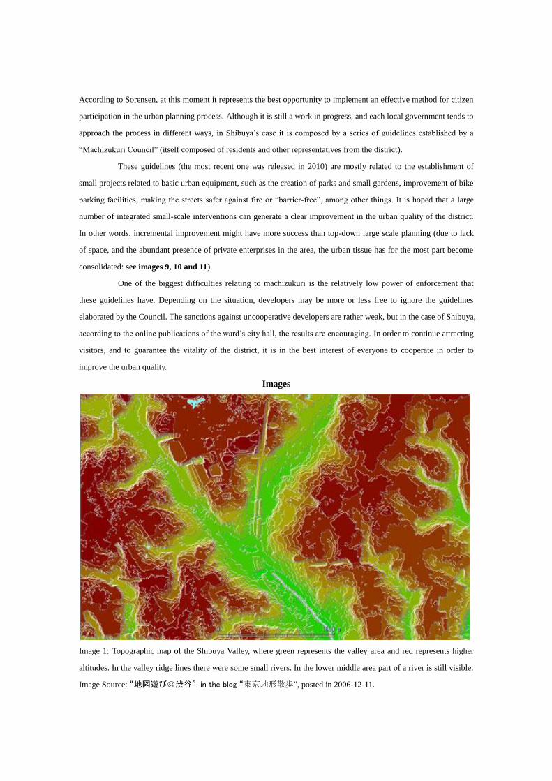
Image 1: Topographic map of the Shibuya Valley, where green represents the valley area and red represents higher
altitudes. In the valley ridge lines there were some small rivers. In the lower middle area part of a river is still visible.
Image Source: “地図遊び@渋谷”, in the blog “東京地形散歩”, posted in 2006-12-11.

Image 2: Location of Shibuya, just outside the limits of a Map of Tokyo made in 1680. Image Source: Google Earth
and Rumsey Historical Maps.
Image 3: Location of Shibuya, at the limit of a Map of Tokyo created in 1799. Image Source: Google Earth and
Rumsey Historical Maps.

Image 4: Shibuya during the late Edo period (1856). Here, only the central area of Shibuya is represented. Image
Source: “江戸明治東京重ね地図”.
Image 5: Shibuya at the west limit of a Tokyo Map created in 1889. Image Source: “東京市区改正全図”.

Image 6: Central Shibuya area, represented in a Tokyo map created in 1926. The fragmentation of the urban space is
clearly evident here. The Dougenzaka street is located in the left upper area of the image, crossing both the railway
and a large river perpendicularly. The old Edo period river is barely visible, located just next to the central station
(next to “大字渋谷”), and going along the railway line on the right side, towards the south.

Images 7 and 8: Map of Shibuya in 1930: development of companies and services in the west side of Shibuya station
(along Dogenzaka street). Image Source: Daisuke Nishioka et al. (2007).
Images 9 and 10: Map of Shibuya in 2000: development of services and commerce along the west side of Shibuya
station. Image Source: Daisuke Nishioka et al. (2007).
Image 11: Map of Shibuya in 2004. The remains of the old river are visible located east of the station, in the bottom
central area of the image. Image Source: “江戸明治東京重ね地図”.

Bibliography and Internet References
Nishioka Daisuke, et al. “A Study on The Urban Development around the West Gate of Shibuya Station from
Distribution of the Functions of the Commerce and Office buildings (1936-2004) Research on History of Urban and
Architecture about Market Places in Tokyo”, in 工学院大学研究報告, No. 102, April 2007, pp. 63-70, Kougakuin
University, Tokyo.
Sorensen, Andre. “The Making of Urban Japan: cities and planning from Edo to the twenty-first century”, The Nissan
Institute/Routledge Japanese studies series, CPI Antony Rowe, Eastbourne, 2002.
vv.aa. “渋谷駅中心地区まちづくり指針 2010”, Shibuya-Ku City Hall, Tokyo, 2010. Date Viewed: 2010-08-05.
http://www.city.shibuya.tokyo.jp/kurashi/machi/shibuya_shishin.html
vv.aa. “江戸明治東京重ね地図”, ABB Company (エーピーピーカンパニー), Tokyo, 2004.
“東京府豊多摩郡澁谷町平面圖”, produced in 1926 and in possession of the Kokusai Bunka Nihon Center (国際日
本文化研究センター). Date Viewed: 2010-08-05. http://tois.nichibun.ac.jp/chizu/santoshi_1231.html
“東京市区改正全図”, produced in 1889 and in possession of the National Archives of Japan (Digital Archive). Date
Viewed: 2010-08-05.
http://www.digital.archives.go.jp/gallery/view/category/categoryArchives/0300000000/0000000712
“地図遊び@渋谷”, in the blog “東京地形散歩”, posted in 2006-12-11. Date Viewed: 2011-08-04.
http://blog.goo.ne.jp/mushipan3/e/684a68a. 1300359da71fc8de7e4d6bd52