sediment quality assessment workplan
TRANSCRIPT

Southern California Bight
2018 Regional Marine Monitoring Program (Bight ‘18)
Sediment Quality Assessment Workplan
Prepared by: Bight’18 Sediment Quality Planning Committee
Prepared for: Commission of Southern California Coastal Water Research Project
3535 Harbor Blvd, Suite 110 Costa Mesa, CA 92626
June 7, 2018

Bight’18 Sediment Quality Assessment Workplan – Page 1
CONTENTS I. INTRODUCTION ...................................................................................................................... 2
Previous Regional Monitoring Studies ....................................................................................... 3
2018 Survey ................................................................................................................................ 4
II. STUDY DESIGN ...................................................................................................................... 8
A. Study Objectives .................................................................................................................... 8
B. Sampling Design .................................................................................................................... 9
B1. Sediment Quality Impacts ................................................................................................ 9
B2. Bioaccumulation............................................................................................................. 10
C. Indicators .............................................................................................................................. 11
C1. Contaminant Exposure Indicators .................................................................................. 12
C2. Biological Response Indicators ...................................................................................... 14
C3. Habitat Condition Indicators .......................................................................................... 14
C4. Bioaccumulation Indicators............................................................................................ 15
III. LEVERAGED STUDIES ....................................................................................................... 16
IV. REFERENCES ....................................................................................................................... 28
APPENDIX A ............................................................................................................................... 30
APPENDIX B ............................................................................................................................... 37
APPENDIX C ............................................................................................................................... 51
APPENDIX D ............................................................................................................................... 67
Screening for Contaminants of Emerging Concern in Southern California Bight ................... 68
Sediment Transport ................................................................................................................... 70
Characterizing Meiofaunal Assemblages in the Southern California Bight ............................. 72
CA Halibut Juvenile Index of Abundance, and Age at Length Relationships .......................... 75

Bight’18 Sediment Quality Assessment Workplan - Page 2
I. INTRODUCTION The Southern California Bight (SCB) is an important and unique ecological resource. This open embayment along the coast stretches from Point Conception to Punta Colonet (south of Ensenada), Baja California. The SCB is a transitional area that is influenced by currents from cold, temperate ocean waters from the north and warm, tropical waters from the south. In addition, the SCB has a complex topography, with offshore islands, submarine canyons, ridges and basins, bays and estuaries, which provide a variety of habitats. The mixing of currents and the diverse habitats in the SCB allow for the coexistence of a broad spectrum of species, including more than 500 species of fish and several thousand species of invertebrates. The SCB is also a major migration route, with marine bird and mammal populations ranking among the most diverse in north temperate waters. The coastal zone of the SCB is a substantial economic resource. Los Angeles/Long Beach Harbor is the largest commercial port in the United States, and San Diego Harbor is home to one of the largest US Naval facilities in the country. More than 100 million people visit Southern California beaches and coastal areas annually, bringing an estimated $9 billion into the economy. Recreational activities include diving, swimming, surfing, and boating, with tourism and recreational activities in Southern California valued at nearly $5 billon (Kildow and Colgan 2005). The SCB is also one of the most densely populated coastal regions in the country, which creates stress upon its marine environment. Over 21 million people inhabit coastal Southern California (US Census Bureau 2010). Population growth generally results in conversion of open land into non-permeable surfaces. More than 75% of Southern California’s bays and estuaries have already been dredged and filled for conversion into harbors and marinas (Horn and Allen 1985). This “hardening of the coast” increases the rate of runoff and can impact water quality through addition of sediment, toxic chemicals, pathogens and nutrients to the ocean. Besides the impacts of land conversion, the SCB is already home to fifteen municipal wastewater treatment facilities, eight power generating stations, 10 industrial treatment facilities, 4 desalinization plants, and 18 oil platforms that discharge to the open coast. Each year, local, state, and federal agencies spend more than $31M to monitor the environmental quality of natural resources in the SCB (Schiff et al. 2001). At least 75% of this monitoring is associated with National Pollutant Discharge Elimination System (NPDES) permits and is intended to assess compliance of waste discharge with the state and federal regulations, which set water quality standards for effluent and receiving waters. Some of this information has played a significant role in management decisions in the SCB. While these monitoring programs have provided important information, they were designed to evaluate impacts near individual discharges. Today, resource managers are encouraged to develop management strategies for the entire SCB. To accomplish this task, managers need regionally-based information to assess the cumulative impacts of contaminant inputs and to evaluate relative risk among different types of stressors. It is difficult to use local datasets to evaluate regional issues because the monitoring was designed to be site-specific and is limited to specific geographic areas. This place-based monitoring provides substantial data for

Bight’18 Sediment Quality Assessment Workplan - Page 3
some areas, but there is little or no data for the areas in between. Beyond the spatial limitations, data from these programs are not easily merged to examine relative risk. The parameters measured often differ among programs, and even when the same parameters are measured, the methodologies used to collect the data often differ and interlaboratory quality assurance (QA) exercises to assess data comparability are rare. As a result, the Southern California Bight Regional Marine Monitoring (Bight) Program was born from the frustration of environmental managers’ inability to answer regional questions about the SCB coastal environment (NRC 1990). Previous Regional Monitoring Studies There have been five previous regional monitoring efforts to address environmental concerns at larger spatial scales (Table 1). The first regional monitoring survey in 1994, called the Southern California Bight Pilot Project (SCBPP), was a compilation of 12 agencies that cooperatively sampled 261 sites along the continental shelf between Point Conception and the United States/Mexico border. The second regional monitoring survey, called the Southern California Bight 1998 Regional Monitoring Program (Bight ‘98), was comprised of 64 agencies that cooperatively sampled 416 sites between Point Conception and Punta Banda, Mexico and included new habitats such as ports, bays, and marinas. The third regional monitoring survey, called the Southern California Bight 2003 Regional Monitoring Program (Bight ‘03), was comprised of 65 agencies that cooperatively sampled 391 sites between Point Conception and the United States/Mexico border, and expanded the number of habitats from Bight ‘98 to include estuaries and deep ocean basins. The fourth regional monitoring survey, called the Southern California Bight 2008 Regional Marine Monitoring Program (Bight ‘08), was comprised of 61 organizations that sampled 383 sites between Point Conception and the United States/Mexico border, and included new contaminants of emerging concern. The fifth survey, the Southern California Bight 2013 Regional Marine Monitoring Program (Bight ‘13), was comprised of 34 organizations that sampled 397 sites between Point Conception and the United States/Mexico border, including the new habitats of submarine canyons and marine protected areas.
Benefits derived from the previous Bight Programs included the development of new useful technical tools that could only be developed with regional data sets and participation by multiple organizations. For example, the program produced iron-normalization curves for the SCB, allowing distinction between natural and anthropogenic contributions of metals in sediments (Schiff and Weisberg 1999). A Benthic Response Index was developed that integrates complex benthic infaunal data into an easily interpreted form that describes the degree of perturbation at a site (Smith et al. 2001). These types of tools have culminated in management tools such as the State of California’s Sediment Quality Objectives (SQOs; Beegan and Bay 2012). The Bight Regional Program have also improved the comparability among the monitoring organizations in the SCB. The quality assurance and quality control (QA/QC) significantly improved following laboratory intercalibration exercises for chemistry, group training for field crews, and taxonomic resolution for biologists. The Regional Monitoring Program has also produced a series of manuals containing standardized field, laboratory and data management activities that increased continuity of data and data reporting among participants, even after the regional monitoring surveys were completed. Many of these manuals are now mandated in NPDES monitoring and reporting programs region-wide.

Bight’18 Sediment Quality Assessment Workplan - Page 4
2018 Survey The proposed Southern California Bight 2018 Regional Monitoring Program (Bight ‘18) is a continuation of the successful cooperative regional-scale monitoring in Southern California. Bight ‘18 builds upon the previous successes and expands on the 2013 program by including new participants, answering additional questions, and measuring more parameters. Forty-six organizations, including international and volunteer organizations, have agreed to participate (Table I-2). The inclusion of multiple participants, many of them new to regional monitoring, provides several benefits. Cooperative interactions among many organizations with different perspectives and interests, including a combination of regulators and dischargers, ensure that an appropriate set of regional-scale questions will be addressed by the study. The Bight ‘18 Program is organized into five technical components: 1) Sediment Quality (formerly Contaminant Impact Assessment/ Coastal Ecology); 2) Microbiology; 3) Ocean Acidification; 4) Harmful Algal Blooms; and 5) Trash. The Sediment Quality component focuses on sediment contaminants and associated impacts on benthic infauna and demersal fish. This Workplan provides a summary of the sediment quality project design. The Workplan is supported by four companion documents including the Field Methods and Logistics Manual, Benthic Laboratory Manual, Toxicology Laboratory Manual, Information Management Plan, and Quality Assurance Plan (QAP). Separate Workplans are also available for the other elements of Bight ‘18.

Bight’18 Sediment Quality Assessment Workplan - Page 5
FIGURE I-1. Map of the Southern California Bight sampling domain.

Bight’18 Sediment Quality Assessment Workplan - Page 6
Table I-1. Summary of Bight Regional Marine Monitoring Programs.
Strata 1994 (Pilot
Project)
1998 (Bight ’98)
2003 (Bight ’03)
2008 (Bight ’08)
2013 (Bight ’13)
2018 (Bight ’18)
Inner Shelf X X X X X X Middle Shelf X X X X X X Outer Shelf X X X X X X Upper Slope X X X X
Lower Slope and Basin X X X X Submarine Canyons X
Channel Islands X X X X X Marine Protected Areas X
River Mouths X X Mexico X X
Marine Estuaries X X X X Brackish Estuaries X
Marinas X X X X X Ports X X X X X Bays X X X X X
POTWs X X

Bight’18 Sediment Quality Assessment Workplan - Page 7
TABLE I-2. Participants in the Bight ‘18 Regional Monitoring Program, Sediment Quality. AES Corporation Amec Foster Wheeler / Wood Anchor QEA Aquatic Bioassay and Consulting Laboratories (ABC) Bureau of Ocean Energy Management (BOEM) Calscience Environmental Laboratories, Inc. Channel Islands National Marine Sanctuary (CINMS) Chevron USA Products Company City of Los Angeles, Department of Water and Power (LADWP) City of Los Angeles Environmental Monitoring Division (CLA-EMD) City of Oceanside City of Oxnard City of San Diego Dominguez Channel Watershed Management Group (City of Los Angeles, Los Angeles County Flood Control District, Los Angeles County, City of Lomita, City of Carson, City of El Segundo, City of Hawthore, City of Inglewood, City of Lawndale) EcoAnalysts Encina Wastewater Authority Greater Los Angeles and Long Beach Harbor Waters Regional Monitoring Coalition (RMC) Los Angeles Regional Water Quality Control Board (LARWQCB) Los Angeles County Department of Public Works Los Angeles County Sanitation Districts (LACSD) MBC Aquatic Sciences National Oceanic and Atmospheric Administration (NOAA) Nautilus Environmental, Inc. Naval Facilities Engineering Command (NAVFAC) Southwest NES Energy, Inc. NRG Energy, Inc. Orange County Sanitation District (OCSD) Orange County Public Works Pacific EcoRisk Physis Environmental Laboratories, Inc. Port of Long Beach Port of Los Angeles Riverside County Flood Control and Water Conservation District San Diego County Dept. of Environmental Health and Municipal Co-permittees San Diego Regional Harbor Monitoring Program (RHMP) San Diego Regional Water Quality Control Board (SDRWQCB) San Diego Unified Port District San Elijo Joint Powers Authority Santa Ana Regional Water Quality Control Board Southern California Coastal Water Research Project (SCCWRP) Space and Naval Warfare (SPAWAR) Systems Center Pacific State Water Resources Control Board U.S. Fish and Wildlife Service (USFWS) U.S. Geological Survey (USGS) Vantuna Research Group, Occidental College Weck Laboratories, Inc. Weston Solutions, Inc.
Bight’18 Sediment Quality Assessment Workplan - Page 8
II. STUDY DESIGN
A. Study Objectives The overall goal of the sediment quality component of Bight ‘18 is to assess the condition of the benthic environment and the health of the biological resources in the SCB. To accomplish this goal, Bight ‘18 will focus on three primary questions:
1. What is the extent and magnitude of sediment quality impacts in the Southern California
Bight? 2. How does the extent and magnitude of sediment quality impacts vary over time in the
Southern California Bight? 3. What is the extent and magnitude of bioaccumulation of select contaminants in seafood
in the Southern California Bight?
Impacts refer to ecological changes resulting from exposure to contaminated sediment. The first question, estimating the area (i.e., number of square kilometers) in which ecological conditions differ from reference conditions, is a departure from traditional approaches to environmental monitoring that generally focus on estimating average condition. Estimating the areal extent of ecological change offers several advantages. First, it provides a more direct assessment of status. For instance, identifying that the average Shannon-Weiner (H’) benthic diversity in the SCB provides less useful information for environmental managers than does identifying what percentage of the area in the SCB has impaired biological communities. A corollary to this concept is the assessment of regional reference condition. Since most monitoring programs in the SCB are site specific, assessment of regional reference condition allows managers to compare individual sites to the breadth and depth of natural variation in the SCB. There are two sub-objectives within the areal extent and magnitude question. The first sub-objective is to determine if the areal extent and magnitude varies among geographic regions. If we answer this question, then managers can determine if specific areas are in worse condition than others, such as areas near anthropogenic inputs versus those areas distant from inputs. Therefore, Bight ‘18 will compare conditions among 11 geographic areas of interest (strata, Table II-1). These strata were selected to represent a range of natural and potentially affected habitats, and are inclusive of most of the habitats sampled in Bight ‘13, except for the submarine canyons and MPAs strata, which will not be sampled in Bight ‘18. However, Bight ‘18 has one new stratum never focused on previously; brackish estuaries (salinities less than 27ppt). Comparison of the relative condition among strata provides information about the geographic distribution of impacts and may indicate the relative risk among a variety of pollutant discharges. An assessment of conditions may be conducted by comparing the extent of area exceeding a threshold of concern or to a mean condition. The second sub-objective within the areal extent and magnitude question is to assess the relationship between biological responses and direct contaminant exposure. Such associations provide the information necessary for risk assessment, and for developing efficient regional strategies for protecting the environment by identifying the predominant types of stress in the SCB ecosystem. Therefore, this sub-objective will be accomplished by simultaneously collecting
Bight’18 Sediment Quality Assessment Workplan - Page 9
numerous measures of biological response, contaminant exposure and habitat condition (Table II-2) to better identify when exposure has reached a level of concern. Measuring multiple indicators also permits the identification of the most likely type of exposure leading to biological response. Furthermore, multiple indicators can be integrated into an overall index of impact using the SQO framework. The second primary question is to assess trends in estimates of areal extent and magnitude of sediment quality impacts. If habitats of concern improve over time, then this demonstrates the effectiveness of cumulative management actions. If habitats of concern worsen, then this demonstrates the need for management action. However, if some habitats improve and others worsen, then the average condition might not change. By estimating the areal extent of alteration, we will be better able to describe these changes. We have designed Bight ‘18 to build upon previous surveys to assess trends in areal extent and magnitude. This will be accomplished by revisiting a subset of randomly sampled sites from 1998 and 2003, which were revisited in 2008 and 2013. The third question is to assess bioaccumulation of select chemicals in higher-order predators, specifically species that are popular for human consumption. Bioaccumulation in seafood measured during the Bight ‘08 survey identified chlorinated hydrocarbons and metals in edible tissues and helped to identify locations of greatest concern in the SCB. This study question builds on the Bight ’08 study to investigate those species with tissue concentrations exceeding California Office of Environmental Health Hazard Assessment (OEHHA) Fish Advisory Tissue Levels. B. Sampling Design
The Sediment Quality sampling design for Bight ‘18 will be divided into two components. These include areal extent, magnitude, and trends in 1) sediment quality impacts and 2) bioaccumulation in sport fish.
B1. Sediment Quality Impacts The areal extent, magnitude, and trends component of Bight ‘18 will involve sampling a target of 330 sites for sediments in the SCB between July 1 and September 30, 2018. The summer period was chosen for the study because it represents a period of consistent weather during which the indicators measured are expected to remain stable. Maps of the sampling sites are provided in Appendix A. Sites were selected using a stratified random approach, with the strata corresponding to the habitats of interest in Table II-1. Stratification ensures that an appropriate number of samples are allocated to characterize each habitat of interest with sufficient statistical power. Thirty sites were allocated to each stratum because this yields a 90% confidence interval of about ± 10% around estimates of areal extent (assuming a binomial probability distribution and p= 0.2; Figure II-1). This level of desired precision was selected because differences in response of less than 10% among strata are unlikely to yield different management decisions.

Bight’18 Sediment Quality Assessment Workplan - Page 10
Sites were selected randomly within each stratum, rather than by investigator pre-selection, to avoid bias and to allow for extrapolation of the response for the entire stratum. Although sites were selected randomly, a systematic component was added to the selection process to minimize clustering of sample sites. The systematic element was accomplished by using an extension of the sampling design used in the SCBPP and in EPA’s Environmental Monitoring and Assessment Program (EMAP) (Stevens 1997). A hexagonal grid is randomly placed over a map of the sampling area, a subsample of hexagons is chosen from this population, and samples are obtained at randomly selected sites within grid cells. The hexagonal grid structure ensures systematic separation of the sampling, while the random selection of sites within grid cells ensures an unbiased estimate of ecological condition. One of the design attributes of Bight ‘18 is to maximize the coincidence of indicators, allowing us to relate biological response to chemical exposure and physical habitat condition. The number of sites sampled for each indicator type within each stratum is presented in Table II-3. To maximize overlap of indicators, sites that receive fewer indicator measurements were randomly chosen (with a systematic element) as a subset of the sites at which all indicators are measured. Approximately half of the sites in each of the eight strata are revisits of previously sampled sites to assess trends. These strata include the 5-30m, 30-120m, 120-200m, and 200-500m depth zones on the coastal shelf, as well as marinas, ports, bays and estuaries. One quarter of the sites will be from Bight ’98, one quarter will be from Bight ’03, all of which were revisted during the Bight ‘13 and will sampled again during Bight ’18. The remaining half will be new sites for Bight ‘18. Because field teams can sample any site within a radius of 100 meters, new sites selected for the Bight ’18 survey must fall outside of a radius of 200 meters from a revisit station to be considered an independent site. All sites were randomly selected and spatially unbiased so estimates of spatial extent are still valid. The number of revisit sites was based on an analysis of the spatial and temporal variance of the 105 revisited sites sampled over the previous three Bight surveys. Variance was evaluated for infauna as well as representative chemical parameters (total DDT, total PCBs, total PAHs, copper, zinc, total organic carbon, total nitrogen, and percent fines). Spatial variance was calculated as the average variance among sites within a stratum during a single survey. Temporal variance was calculated as the average variance of a single site across multiple sampling events. A variance ratio was calculated as the ratio of the spatial variance by the temporal variance (if these two measures of variance were equal, the ratio would be 1). The results indicated that spatial variance and temporal variance were similar, with space being slightly more variable than time, particularly in the offshore strata (Figures II-3 and II-4), thus revisiting half of the sites slightly favors trend detection. Given this analysis, the planning committee decided to maintain the previous ratio of revisits to new sites to maintain consistency between surveys.
B2. Bioaccumulation This component has both a spatial extent and magnitude component in its design. Preliminary trends may also be investigated using the previous fish bioaccumulation study from

Bight’18 Sediment Quality Assessment Workplan - Page 11
Bight ’08. For Bight ’18 we will use the Bight ’08 sampling design, which followed five basic guiding principles:
1. Make region-wide assessments 2. Target fish species that people eat 3. Sample locations where species are caught 4. Measure tissues that are consumed 5. Analyze constituents that represent potential risk to human consumers
Sampling locations for this study will be comprised of fishing zones, which are a subset of
the 68 state-wide zones defined by OEHHA. The use of the zone concept is consistent with the direction that OEHHA will take in the future development of fish consumption guidelines for coastal areas because previous Southern California advisories issued on a pier-by-pier basis were unsatisfactory. Fishing zones recognize that fish are mobile, which can result in variable contaminant exposure as well as a range of locations to be caught.
A targeted sampling design will be used to examine bioaccumulation in seafood. Twenty-
seven (27) fishing zones have been delimited from Point Conception to the US/Mexico International Border for this study (Figure II-2). The offshore extent of fishing zones was confined to 200 m depth (approximate shelf break), but most frequently extended only as far as 60 m depth since this is the limit of most recreational fishers. The longshore extent of fishing zones was selected using the following criteria:
1. Fishing pressure. Zones are smaller and more numerous in areas with more fishing
pressure. Popular fishing locations were identified from Jones (2004) and discussions with stakeholders.
2. Homogeneity of contamination. Fishing zones were delineated based on known gradients of contamination to ensure as consistent exposure as possible to fish species. Contamination gradients were defined using previous regional monitoring data (Schiff 2000).
3. Stakeholder interest. Some intensification was provided where stakeholders had specific interest and resources.
4. Complete coverage. The entire SCB coastline must be sampled.
Fishing will be conducted by the California Department of Fish and Wildlife under the auspices of the SWRCB’s Surface Water Ambient Monitoring Program (SWAMP). Fishing will occur between June 1 and September 30, 2018 by a variety of gear including seines, trawls, hook and line, trap, and spear (BOG 2009). C. Indicators
Bight ‘18 will measure multiple indicators (Table II-2) at each site to relate contaminant exposure, biological response, and habitat condition. Collecting measures of contaminant exposure with measurements of biological response at common sites allows investigators to identify and statistically model associations between altered ecological conditions and

Bight’18 Sediment Quality Assessment Workplan - Page 12
environmental stresses. Habitat indicators help discriminate between changes caused by anthropogenic and natural factors. These multiple metrics can be combined into an index of overall sediment quality impacts using the SQO framework. The probability-based sampling design provides a framework for integrating data into a comprehensive regional assessment, but the validity of such an assessment depends on ensuring that all the data that contribute to it are comparable. Therefore, under the Bight ’18 program, all indicators will be measured using consistent sampling methods throughout the SCB. Below, we present a short description of the methods used to measure the Bight ‘18 indicators; more detailed descriptions of the methods can be found in the accompanying Field Methods and Quality Assurance Manuals for the project.
C1. Contaminant Exposure Indicators
Contaminant exposure will have three components: sediment chemistry, marine debris, and harmful algal bloom toxins. The latter two will be coordinated with other Bight ’18 Elements (Trash and Harmful Algal Blooms, respectively). 1. Sediment Chemistry: Chemical analysis of sediment samples provides an assessment of contaminant exposure for bottom dwelling animals. Sediment samples will be collected from the top 2 cm (coastal sites) or top 5 cm (embayments) of a Van Veen grab sample, or a 6-inch sediment core (brackish estuaries). The chemical analyte list includes both inorganics and organics (Table II-4) and was developed to include comparisons to local programs and to state and national monitoring datasets such as California’s SWAMP or NOAA’s Status and Trends program. The constituent list and associated reporting limits were specifically developed for comparison to sediment quality guidelines such as the State of California’s SQOs (SWRCB 2008). All chemistry measurements will follow performance-based quality assurance guidelines described in the Bight ‘18 Quality Assurance Plan.

Bight’18 Sediment Quality Assessment Workplan - Page 13
1a. Organics Organic compounds in sediments will be extracted with solvents and cleaned to remove interfering substances. PAHs will be analyzed by GC/MS. Organochlorine pesticides and polychlorinated biphenyls will be analyzed by GC/ECD, GC/MS, or GC/MS/MS. The accuracy of PCB measurements will be enhanced by measuring 41 individual congeners in all samples with elevated concentrations. The PCB congener list was selected to include compounds that are abundant in the environment and compounds with a high potential for toxicity. Thirteen polybrominated diphenyl ethers (PBDEs) congeners will be analyzed by GC/ECD, GC/MS, or GC/MS/MS. The PBDE congener list was selected to include compounds that were present in the original technical mixtures, are abundant in the environment and compounds, and have a high potential for bioaccumulation. PAHs, chlorinated hydrocarbons, and PCBs will be measured in all strata. Pesticides (Pyrethroids and Fipronyl) will be measured in embayment strata only. PBDEs will be measured at all embayment strata and in a subset of offshore strata (those sites coinciding with the toxicology samples).
1b. Inorganics Metals in sediments will be analyzed by ICP, ICPMS, or atomic absorption spectrophotometry after strong acid digestion. Methyl mercury will be analyzed by cold vapor technique. In addition to trace metals, the reference elements iron and aluminum will also be measured in each sample. Normalization of the trace metal data to reference element concentrations will enable anthropogenic contamination to be distinguished from natural variations in background concentrations. Metals will be analyzed in all Bight strata.
2. Marine Debris: The amount of plastic, metal, and other debris on the ocean bottom is a measure of human impact. Debris captured in trawls will be classified by type (e.g., plant material, plastic, and cans, etc.) and scored according to relative abundance. For more detail on the marine debris assessment, please refer to the Bight ’18 Trash workplan. 3. Harmful Algal Bloom Toxin: Blooms of the marine diatom genus Pseudo-nitzschia that produce the neurotoxin domoic acid (DA) have been documented with regularity along the coast of Southern California (Smith et al., 2018) and cause major socioeconomic impacts, including prolonged closures of key fish, bivalve and crab fisheries, health advisories, and marine wildlife illness and mortalities. However, the fate and persistence of DA has been historically understudied. Fluxes of DA from the pelagic euphotic zone to deep waters and into sediment have been documented in Southern California (Sekula-Wood et al., 2009, 2011; Schnetzer et al., 2007) but there have been no regional studies to date focused on the long-term impacts and fate of DA to benthic communities. An event response survey conducted after a DA bloom in 2017 indicated DA in both sediment and benthic infauna samples collected from Los Angeles and Orange Counties. This Bight Program will investigate the regional extent of DA in sediments, which can be the source of contamination to the benthic communities. Sediment samples from the inner, mid, and outer shelf will be analyzed for domoic acid concentrations and presence of DA degradation products by LC-MS. For more detail on the sediment DA assessment, please refer to the Bight ’18 Harmful Algal Bloom workplan.
Bight’18 Sediment Quality Assessment Workplan - Page 14
C2. Biological Response Indicators
While indicators of contaminant exposure provide an important measure of the influence of anthropogenic materials on the marine and estuarine environments, it is the effect of this exposure upon biological processes that determines the significance of the contaminants. The effect of contaminant exposure will be examined through a variety of indicators: 1. Benthic Infauna: Benthic infauna (animals that live in the sediment) are an important part of the ocean food web. Because infauna generally reside in one location for most of their lives and can be chronically exposed to sediment contaminants, they are an excellent indicator of environmental quality. Samples for infaunal analysis will be taken with a 0.1-m2 modified Van Veen grab or 4-inch sediment core (brackish estuaries). Samples will be washed through a 1.0-mm mesh screen and preserved for identification to the lowest practical taxonomic unit. 2. Demersal fish and megabenthic invertebrate assemblages: Demersal fish and megabenthic invertebrates are more mobile than the benthic infauna, but are still closely associated with bottom sediments and chronically exposed to any contaminants therein. Demersal fish and megabenthic invertebrates will be collected with a semi-balloon otter trawl with 7.6 m headrope length and a 1.3 cm cod-end mesh. Trawls will be towed for 10 min at 0.8-1.0 m/s along depth isobaths (5 min in harbors). All fish and most invertebrates (>1.0 centimeters in any dimension) will be identified to species, counted, and weighed. 3. Gross fish pathology: The presence and extent of external diseases (e.g., fin rot and tumors) and anomalies (e.g. skeletal deformities or abnormal coloration) will be recorded from fish collected in the trawls for assemblage analysis. The presence of external parasites will also be noted. Specimens with unusual or unidentified conditions will be returned to the laboratory for detailed examination. 4. Sediment toxicity: Toxicity tests provide a direct measure of the effect of contamination on benthic organisms. These tests complement sediment chemistry measurements by providing a measure of the combined toxic effect of the complex mixture of contaminants present in surficial sediments or in the porewater between sediment grains (interstitial water). The toxicity of sediments will be assessed in two ways: 1) survival of the amphipod, Eohaustorius estuarius, after exposure to sediments for 10 days; and 2) the embryonic development of the bivalve, Mytilus galloprovincialis, using the sediment:seawater interface test. Both tests support the application of California’s SQOs. Both tests are performed in the embayment strata. The Eohaustorus test alone will be performed in a subset of the shelf strata (10 sites each inner, mid, and outer shelf).
C3. Habitat Condition Indicators The distribution of biota is also affected by natural habitat factors, such as grain size and the amount of organic matter present. Habitat indicators will be measured to help distinguish the relative effects of natural and anthropogenic factors on biotic distribution.

Bight’18 Sediment Quality Assessment Workplan - Page 15
1. Sediment grain size: Grain size will be measured with a laser diffraction technique, a method that provides sufficient resolution between particle size classes with less variability than other conventional techniques. 2. Sediment total organic carbon (TOC), total nitrogen (TN): TOC and TN will be measured with an Elemental Analyzer.
C4. Bioaccumulation Indicators 1. Species Selection
Selecting fish species to monitor is complicated due to the relatively high diversity of species, variation in habitat type and quality, variation in contamination, and the varying ecological attributes of potential indicator species. The following criteria were used to select target species:
1. Popular for consumption. These data were collated from the Recreational Fisheries Information Network (RecFIN), a product of the Pacific States Marine Fisheries Commission PSMFC), which integrates state and federal marine recreational fishery sampling efforts (www.recfin.org/forms/est2004.html).
2. Widely distributed. Range of preferred species will extend the length of the SCB. 3. Representative of different exposure pathways. Both benthic and pelagic feeders should
be included. 4. Continuity with previous monitoring efforts. This will increase the comparability with
existing monitoring programs.
A total of three species will be selected for chemical analysis per fishing zone. Three species have been selected as primary target species and additional species will be selected from a list of secondary species (Table II-6). Primary target species will be fished until sufficient numbers of specimens are caught. Secondary species will be kept as by-catch. The final selection of secondary species will be made at the end of the field effort. This will allow selection of the most widely distributed specie(s). The primary target species are White croaker (Genyonemus lineatus), Kelp Bass (Paralabrax clathratus), and Pacific Chub Mackerel (Scomber japonicus). White Croaker is predominantly an epibenthic feeder, often associated with soft-bottom sediments. Kelp Bass is predominantly a water column feeder, often associated with rocky substrate so their range is somewhat limited. Pacific Chub Mackerel are a water column feeder with a dynamically large range. One or more of these species are also the most frequently measured in NPDES monitoring programs bight-wide including the MSRP monitoring conducted in the Los Angeles margin. The secondary species are California Halibut (Paralichthys californicus), Shiner Surfperch (Cymatogaster aggregata), Yellowfin Croaker (Umbrina roncador), Barred Sand Bass (Paralabrax nebulifer), Spotted Sand Bass (Paralabrax maculatofasciatus), Olive Rockfish (Sebastes serranoides), California Scorpionfish (Scorpaena guttata). The California Halibut and Shiner Perch were selected because they are included in the SWRCB’s SQO program. The Croaker, Bass, and Rockfish were selected because they serve as ecological replacements for primary species (i.e., same ecological niche or guild). The Scorpionfish and Mackerel were selected because they are frequently caught in other monitoring programs.

Bight’18 Sediment Quality Assessment Workplan - Page 16
2. Tissue Composite Samples
Fish tissue will be saved for analysis in compliance with SQO guidance either as filet muscle tissue with the skin off or whole fish without head, tail or internal organs. Muscle filets are recommended by the USEPA (2000) for predator species and whole fish without head or organs for prey species (Amendments to the Water Quality Control Plan for Enclosed Bays and Estuaries of California). Upon collection, each fish collected will be tagged with a unique identification number and measured for total length (longest length from tip of tail fin to tip of nose/mouth), fork length (longest length from tail fork to tip of nose/mouth), and weight. During dissection, each fish will be sexed and the weight of tissue recorded. Dissection and compositing of tissue samples will be performed following USEPA guidance (USEPA 2016). A total of three composite samples per species will be targeted per fishing zone. A targeted total of five specimens will be collected per composite sample. Specimens of legal size or larger are preferred but not required. If more than five specimens are collected, then the middle 75% of the length distribution will be used for the composite. Specimens from this interquartile range will be selected at random for inclusion in each composite. 3. Contaminants
The State of California OEHHA has provided guidelines for the evaluation of contaminant data (Table II-5). Each composite sample will be analyzed for PCB congeners, DDT isomers and metabolites, mercury, and percent lipids (Table II-5), using analytical methods as described above in sediment chemistry. Reporting levels shall be consistent with OEHHA thresholds for comparative purposes. Quality assurance activities shall focus on accuracy, precision, sensitivity, and comparability. There will be an estimated 243 samples total for this element of Bight ‘18 (27 zones x 3 species x 3 replicates per species). The effort will be shared equally among organic and inorganic analytes.
III. LEVERAGED STUDIES The Bight Program represents an excellent opportunity to leverage studies and pilot research not routinely conducted for ongoing monitoring programs. Researchers are always looking to test new technology, evaluate new indicators, apply new methods, or explore unanswered questions in new locations. The Bight Program comprises an enormous platform of core measurements with indicators typically measured on a routine basis. The merging of the Bight Program with researchers provides a positive interaction for both parties. Researchers view the Bight Program as a cost-efficient vehicle to move their research forward. Bight participants get the added value of their research for nominal extra cost. Incorporating new measurements and methods into the Bight Program benefits regulated participants in the Bight Program because it is not part of a permit requirement and can help determine if a perceived issue is a widespread environmental problem. Incorporating their studies into the Bight Program benefits researchers because it allows their work direct access to the important environmental decision makers in the SCB.

Bight’18 Sediment Quality Assessment Workplan - Page 17
There are four leveraged studies planned for Bight ‘18 (Table II-7, Appendix D). The studies range across all 10 indicators being measured in Bight ‘18 incorporating contaminant exposure, biological response, and habitat condition. Leveraged studies supplement existing indicators already being measured as part of the Bight Program. For example, the bioassay work is a pilot project to explore new contaminants and may serve as a tool to link contaminants to toxicity. Individually, these indicators all provide useful information, but collectively they provide invaluable insight.

Bight’18 Sediment Quality Assessment Workplan - Page 18
FIGURE II-1. 90% Confidence Intervals about an estimate of percent of area changed as a function of sample size (binomial probability distribution and p= 0.2)

Bight’18 Sediment Quality Assessment Workplan - Page 19
Figure II-2. Map of fishing zones for Bioaccumulation component in Bight ‘18. Fishing zones are a subset of the 68 SWAMP BOG zones along the entire CA coast.
Point Conception to Palos Verdes Peninsula
Palos Verdes Peninsula to U.S. - Mexico Boarder

Bight’18 Sediment Quality Assessment Workplan - Page 20
Figure II-3. Spatial:Temporal Variance ratio across all indicators and strata in the SCB. Values less than 0 indicate time has greater variance, values larger than 0 indicate that space has the greater variance.
Figure II-4. Spatial:Temporal Variance ratio across all indicators for 3 strata categories (shelf = inner-, mid-, and outer-shelf), slope (upper and lower slope), and embayments (estuaries, marinas, bays, ports) in the SCB.

Bight’18 Sediment Quality Assessment Workplan - Page 21
TABLE II-1. Strata of interest in the areal extent, magnitude, and trends objectives of the Bight ‘18 Sediment Quality study. Offshore Areas a. Inner shelf (5-30 m) b. Mid-shelf (30-120 m) c. Outer shelf (120-200 m) d. Upper slope (200-500 m) e. Lower slope (500-1000 m) f. Channel Islands (30-120 m in Sanctuary) Embayment Areas a. Marine Estuaries (salinity ≥ 27 ppt) b. Brackish Estuaries (salinity < 27 ppt) c. Ports d. Bays e. Marinas

Bight’18 Sediment Quality Assessment Workplan - Page 22
TABLE II-2. Indicators to be measured in Bight ‘18. Contaminant exposure Sediment chemistry Debris Biological response Benthic infauna Fish assemblage Fish pathology Macroinvertebrate assemblage Sediment toxicity Habitat Grain size Sediment organic carbon

Bight’18 Sediment Quality Assessment Workplan - Page 23
TABLE II-3. Sample sizes in the strata for Bight ‘18. Sediment
Chemistry Infauna Trawl Sed Tox
Offshore Strata 5 to 30 m 30 30 30 Combined
30a 30 to 120 m 30 30 30 120 to 200 m 30 30 30 200 to 500 m 30 30 30 - 500 to 1000 m 30 30 - - Channel Islands 15 15 - - Embayment Strata Marinas 30 30 30b Ports 30 30 30b Bays/Harbors 30 30 30 30b Saline Estuaries/Lagoon 30 30 30b Brackish Estuaries/Lagoon 30 30 30b Target Sample Size 315 315 150 180 The three shelf strata are combined for sediment toxicity testing a1 species for toxicity (10-day amphipod test) b2 species for toxicity (10-day amphipod and 48-hour bivalve tests)

Bight ‘18 Sediment Quality Workplan - DRAFT Page 24
TABLE II-4. Constituents that will be measured in sediment during Bight ‘18.
Trace Metals PCB Congeners Polycyclic Aromatic
Hydrocarbons
PolyBrominated Diphenyl Ethers Aluminum Antimony Arsenic Barium
Beryllium Cadmium Chromium
Copper Iron Lead
Mercury Nickel
Selenium Silver Zinc
PCB 8 PCB 18 PCB 28 PCB 37 PCB 44 PCB 49 PCB 52 PCB 66 PCB 70 PCB 74 PCB 77 PCB 81 PCB 87 PCB 99
PCB 101 PCB 105 PCB 110 PCB 114 PCB 118 PCB 119 PCB 123 PCB 126 PCB 128 PCB 138 PCB 149 PCB 151 PCB 153 PCB 156
PCB 157 PCB 158 PCB 167 PCB 168 PCB 169 PCB 170 PCB 177 PCB 180 PCB 183 PCB 187 PCB 189 PCB 194 PCB 195 PCB 201 PCB 206
1,6,7-Trimethylnaphthalene 1-Methylnapthalene
1-Methylphenanthrene 2,6-Dimethylnaphthalene
2-Methylnapthalene Acenaphthene
Acenaphthylene Anthracene
Benz[a]anthracene Benzo[a]pyrene
Benzo[b]fluoranthene Benzo[e]pyrene
Benzo[g,h,i]perylene Benzo[k]fluoranthene
Biphenyl Chrysene
Dibenz[a,h]anthracene Fluoranthene
Fluorene Indeno[1,2,3-c,d]pyrene
Naphthalene Perylene
Phenanthrene Pyrene
BDE 17 BDE 28 BDE 47 BDE 49 BDE 66 BDE 85 BDE 99
BDE 100 BDE 138 BDE 153 BDE 154 BDE 183 BDE 190
Pyrethroids
Bifenthrin
Cyfluthrin (total)
Cypermethrin (total)
lambda-Cyhalothrin (total)
cis-Permethrin
Trans-Permethrin
Deltamethrin
Esfenvalerate
Chlorinated Hydrocarbons
4,4’-DDT 2,4’-DDT 4,4’-DDD 2,4’-DDD 4,4’-DDE 2,4’-DDE
4,4’-DDMU alpha-
Chlordane gamma-
Chlordane cis-nonachlor
trans-nonachlor oxychlordane
Other Constituents Total Organic
Carbon Total Nitrogen
Grain Size
Fipronils
Fipronil
Fipronil Desulfinyl
Fipronil Sulfide
Fipronil Sulfone
.

Bight ‘18 Sediment Quality Workplan - DRAFT Page 25
Table II-5. State of California Office of Environmental Health and Hazard Assessment Fish Contaminant Goal (FCG) and Advisory Tissue Level (ATL).
Contaminant (ng/wet g)
Number 8 oz Meals Per Week
<Three <Two <One
DDTs* 520 1000 2100
methylMercury (women 18-45, child 1-17) 70 150 440
methylMercury (women >45, men) 220 440 1310
PCBs* 21 42 120 *Congeners as listed in Table II-4

Bight ‘18 Sediment Quality Workplan - DRAFT Page 26
Table II-6. Primary and secondary target species for bioaccumulation study component. Common Name Scientific Name
Primary Target Spp. White Croaker Genyonemus lineatus Kelp Bass Paralabrax clathratus Pacific Chub Mackerel Scomber japonicus
Secondary Target Spp. Shiner Surfperch Cymatogaster aggregata California Halibut Paralichthys californicus Yellowfin Croaker Umbrina roncador Barred Sand Bass Paralabrax nebulifer Spotted Sand Bass Paralabrax maculatofasciatus Olive Rockfish Sebastes serranoides California Scorpionfish Scorpaena guttata

Bight ‘18 Sediment Quality Workplan - DRAFT Page 27
Table II-7. Integration of special studies with existing indicators. X=where there is overlap or correlation among measurements.
Leveraged Study
Sediment Chemistry Infauna Demersal
Fish Sediment Toxicity
Sediment Grain Size
Bioaccum- ulation
Cell Assays X X X
Sediment Transport X
CA Halibut Stock Assessment
X
Meiofaunal Assemblages X

Bight ‘18 Sediment Quality Workplan - DRAFT Page 28
IV. REFERENCES Beegan, C., S.M. Bay. 2012. Transitioning sediment quality assessment into regulations: Challenges and solutions in implementing California’s sediment quality objectives. Integrated Environmental Assessment and Management 8:586-588 Bioaccumulation Oversight Group (BOG). 2009. Sampling and Analysis Plan for a Screening Study of Bioaccumulation on the California Coast. State Water Resources Control Board, Sacramento, CA. Horn, M.H. and Allen, L.G., 1985. Fish community ecology in Southern California bays and estuaries. Fish community ecology in estuaries and coastal lagoons: towards an ecosystem integration, pp.169-190. Jones, K. 2004. Pier Fishing in California. Publishers Design Group, Roseville, CA. Kildow, J. and C. Colgan. 2005. California’s Ocean Economy. Report to the California Resources Agency. National Ocean Economics Program. California State University at Monterey Bay. Seaside, CA NRC. 1990. Managing troubled waters. National Research Council. National Academies Press. Washington, DC. 125 pp. Schiff, K., J. Brown and S. Weisberg. 2001. Model monitoring program for large ocean discharges in Southern California. Southern California Coastal Water Research Project Technical Report No. 357. Southern California Coastal Water Research Project, Westminster, CA. Schiff, K.C., S.B. Weisberg. 1999. Iron as a reference element in Southern California coastal shelf sediments. Marine Environmental Research 48: 161-176 Schnetzer, A., Miller, P.E., Schaffner, R.A., Stauffer, B.A., Jones, B.H., Weisberg, S.B., DiGiacomo, P.M., Berelson, W.M. and Caron, D.A., 2007. Blooms of Pseudo-nitzschia and domoic acid in the San Pedro Channel and Los Angeles harbor areas of the Southern California Bight, 2003–2004. Harmful algae, 6(3), pp.372-387. Sekula-Wood, E., Benitez-Nelson, C., Morton, S., Anderson, C., Burrell, C. and Thunell, R., 2011. Pseudo-nitzschia and domoic acid fluxes in Santa Barbara Basin (CA) from 1993 to 2008. Harmful Algae, 10(6), pp.567-575. Sekula-Wood, E., Schnetzer, A., Benitez-Nelson, C.R., Anderson, C., Berelson, W.M., Brzezinski, M.A., Burns, J.M., Caron, D.A., Cetinic, I., Ferry, J.L. and Fitzpatrick, E., 2009. Rapid downward transport of the neurotoxin domoic acid in coastal waters. Nature Geoscience, 2(4), p.272.

Bight ‘18 Sediment Quality Workplan - DRAFT Page 29
Smith, J., P. Connell, R.H. Evans, A.G. Gellene, M.D.A. Howard, B.H. Jones, S. Kaveggia, L. Palmer, A. Schnetzer, B.N. Seegers, E.L. Seubert, A.O. Tatters, D.A. Caron. (in press) A decade and a half of Pseudo-nitzschia spp. and domoic acid along the coast of Southern California. Smith, R.W., M. Bergen, S.B. Weisberg, D. Cadien, A. Dalkey, D. Montagne, J.K. Stull, R.G. Velarde. 2001. Benthic response index for assessing infaunal communities on the Southern California mainland shelf. Ecological Applications 11:1073-1087. State Water Resources Control Board (SWRCB) 2009. Water quality control plan for enclosed bays and estuaries; Part I: Sediment quality. State Water Resources Control Board. Sacramento, CA. Stevens, D.L., Jr. 1997. Variable density grid-based sampling designs for continuous spatial populations. Environmetrics 8:167-195 U.S. Census Bureau. 2010. 2010 Census data. http://2010.census.gov/2010census/data U.S. EPA. 2016. Guidance for Conducting Fish Consumption Surveys. EPA 823-B-16-002. Washington, DC: U.S. Environmental Protection Agency, Office of Water.

Bight ‘18 Sediment Quality Workplan - DRAFT Page 30
APPENDIX A
Sample Site Maps
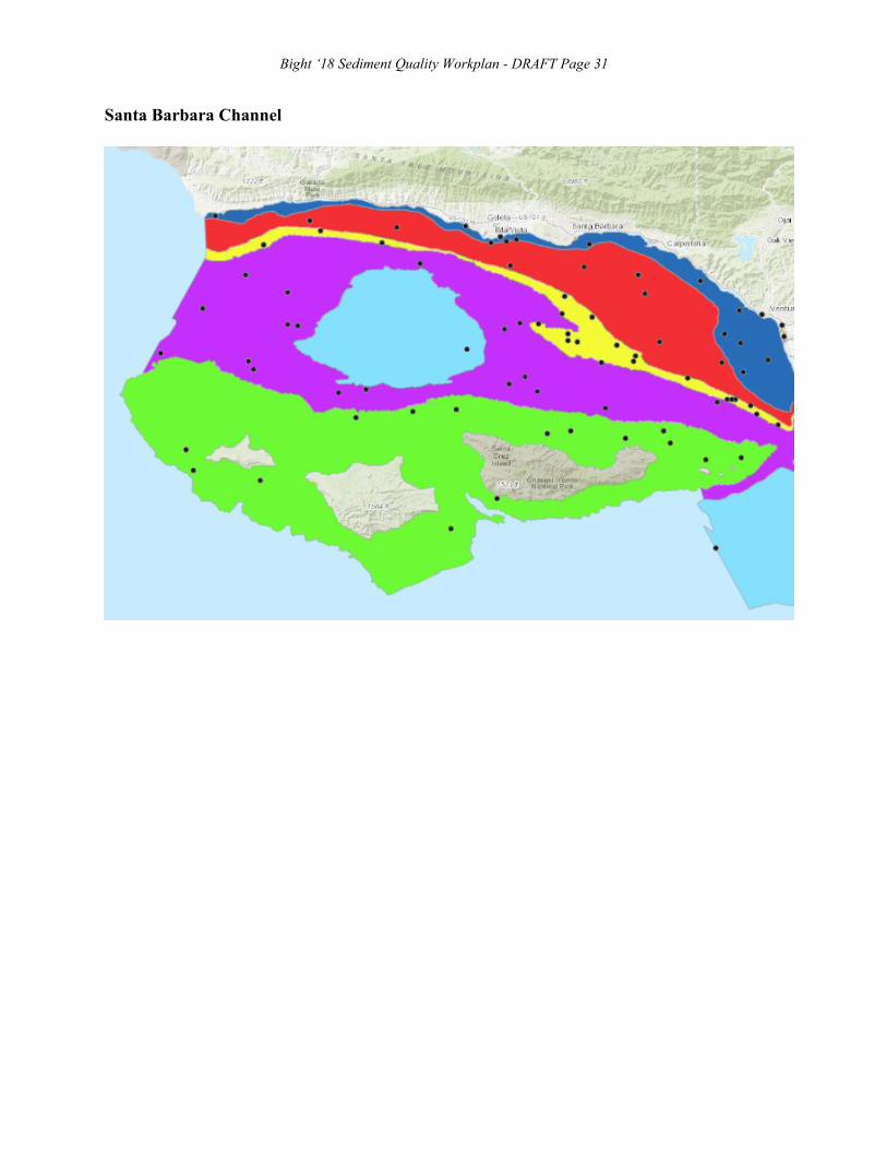
Bight ‘18 Sediment Quality Workplan - DRAFT Page 31
Santa Barbara Channel

Bight ‘18 Sediment Quality Workplan - DRAFT Page 32
Hueneme to Santa Monica Bay
Bight ‘18 Sediment Quality Workplan - DRAFT Page 33
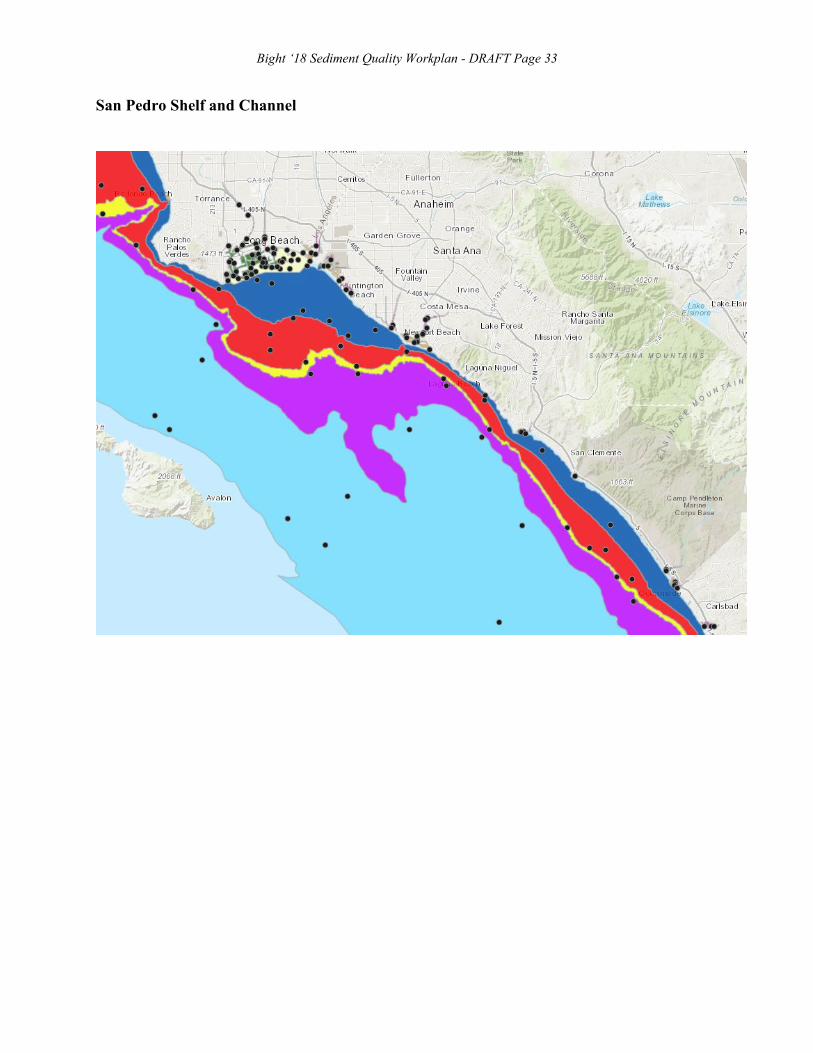
San Pedro Shelf and Channel

Bight ‘18 Sediment Quality Workplan - DRAFT Page 34
San Pedro Bay
Bight ‘18 Sediment Quality Workplan - DRAFT Page 35
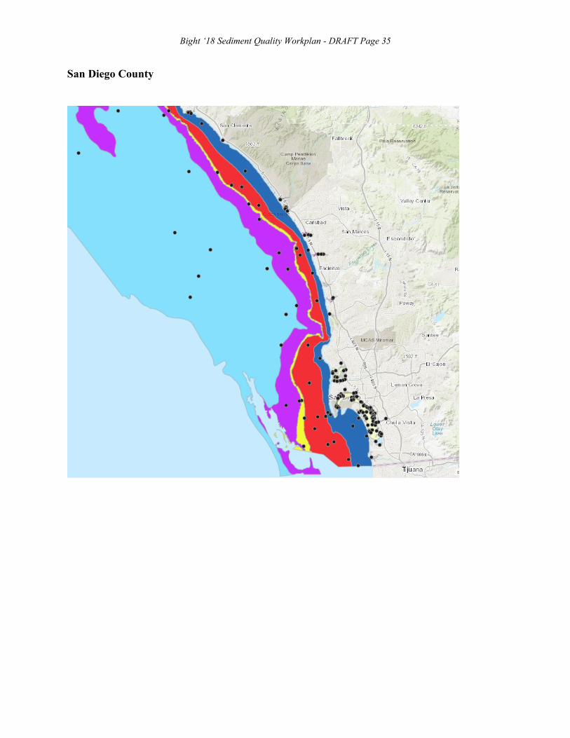
San Diego County

Bight ‘18 Sediment Quality Workplan - DRAFT Page 36
San Diego Bay

Bight ‘18 Sediment Quality Workplan - Page 37
APPENDIX B
Sample Site Information

Bight ‘18 Sediment Quality Workplan - Page 38 Table B1. Station locations and assignments
B18 Station ID
Target Latitude
Target Longitude
GIS Depth B18 Stratum Region Sed
Grab Agency Sed Grab Trawl Agency Trawl
B18-10000 33.7594 -118.162667 5 Bays Los Angeles/Long Beach Yes CLA-EMD Yes CLA-EMD
B18-10001 33.75298309 -118.1502215 9 Bays Los Angeles/Long Beach Yes CLA-EMD Yes CLA-EMD
B18-10002 33.744217 -118.168733 10 Bays Los Angeles/Long Beach Yes CLA-EMD Yes CLA-EMD
B18-10003 33.74379309 -118.1398563 8 Bays Los Angeles/Long Beach Yes RMC Yes CLA-EMD
B18-10004 33.742717 -118.1532 10 Bays Los Angeles/Long Beach Yes CLA-EMD Yes CLA-EMD
B18-10005 33.74081332 -118.1751432 14 Bays Los Angeles/Long Beach Yes RMC Yes CLA-EMD
B18-10006 33.7398 -118.171317 12 Bays Los Angeles/Long Beach Yes CLA-EMD Yes CLA-EMD
B18-10007 33.73370098 -118.2113542 20 Bays Los Angeles/Long Beach Yes CLA-EMD Yes CLA-EMD
B18-10008 33.73168 -118.20415 20 Bays Los Angeles/Long Beach No N/A Yes CLA-EMD
B18-10009 33.728683 -118.157 14 Bays Los Angeles/Long Beach Yes CLA-EMD Yes CLA-EMD
B18-10010 33.7282943 -118.1757358 16 Bays Los Angeles/Long Beach Yes CLA-EMD Yes CLA-EMD
B18-10011 33.72421 -118.22437 18 Bays Los Angeles/Long Beach Yes POLA/LB Yes CLA-EMD
B18-10012 33.71345 -118.24131 24 Bays Los Angeles/Long Beach Yes CLA-EMD Yes CLA-EMD
B18-10013 33.71242 -118.2579 25 Bays Los Angeles/Long Beach Yes CLA-EMD No N/A
B18-10014 33.70964533 -118.2791439 5 Bays Los Angeles/Long Beach Yes RMC No N/A
B18-10015 32.78719078 -117.2082639 0 Bays Mission Bay Yes RHMP No N/A
B18-10016 32.78486474 -117.2405215 1 Bays Mission Bay Yes RHMP Yes RHMP
B18-10017 32.784475 -117.215358 4 Bays Mission Bay Yes RHMP Yes RHMP
B18-10018 32.77081374 -117.2097002 1 Bays Mission Bay Yes RHMP No N/A
B18-10019 32.767905 -117.241481 7 Bays Mission Bay Yes RHMP Yes RHMP
B18-10020 32.7580708 -117.2441015 2 Bays Mission Bay Yes RHMP No N/A
B18-10021 32.73462213 -117.2105636 3 Bays San Diego Bay Yes Unassigned Yes Unassigned
B18-10022 32.724148 -117.182983 5 Bays San Diego Bay Yes RHMP Yes RHMP
B18-10023 32.71745595 -117.2159262 0 Bays San Diego Bay Yes RHMP Yes RHMP
B18-10024 32.714963 -117.182907 12 Bays San Diego Bay Yes RHMP Yes RHMP
B18-10025 32.7137 -117.1909 2 Bays San Diego Bay- NBC Yes Navy No N/A
B18-10026 32.7096 -117.187 2 Bays San Diego Bay- NBC Yes Navy No N/A
B18-10027 32.7079 -117.1850 2 Bays San Diego Bay- NBC Yes Navy No N/A
B18-10028 32.70658 -117.19 2 Bays San Diego Bay- NBC Yes Navy No N/A
B18-10029 32.701758 -117.15861 1 Bays San Diego Bay Yes RHMP No N/A
B18-10030 32.68796429 -117.2305094 1 Bays San Diego Bay Yes RHMP Yes RHMP

Bight ‘18 Sediment Quality Workplan - Page 39 B18 Station
ID Target
Latitude Target
Longitude GIS
Depth B18 Stratum Region Sed Grab Agency Sed Grab Trawl Agency Trawl
B18-10031 32.686984 -117.132959 1 Bays San Diego Bay Yes RHMP No N/A
B18-10032 32.675472 -117.143841 5 Bays San Diego Bay Yes RHMP No N/A
B18-10033 32.6752 -117.1670 3 Bays San Diego Bay- NAB Yes Navy No N/A
B18-10034 32.665184 -117.149804 4 Bays San Diego Bay Yes RHMP Yes RHMP
B18-10035 32.66074324 -117.1454935 3 Bays San Diego Bay Yes RHMP Yes RHMP
B18-10036 32.658339 -117.144218 5 Bays San Diego Bay Yes RHMP Yes RHMP
B18-10037 32.646936 -117.118238 10 Bays San Diego Bay Yes RHMP Yes RHMP
B18-10038 32.6428033 -117.1262292 3 Bays San Diego Bay Yes RHMP Yes RHMP
B18-10039 32.641654 -117.139188 2 Bays San Diego Bay Yes RHMP No N/A
B18-10040 32.64164436 -117.1164632 1 Bays San Diego Bay Yes RHMP No N/A
B18-10041 32.628574 -117.125565 2 Bays San Diego Bay Yes RHMP No N/A
B18-10042 32.6258071 -117.1115371 1 Bays San Diego Bay Yes RHMP Yes RHMP
B18-10043 32.6172124 -117.1022578 1 Bays San Diego Bay Yes RHMP Yes RHMP
B18-10044 32.61327 -117.098925 1 Bays San Diego Bay Yes RHMP No N/A
B18-10045 34.25841416 -119.2669992 0 Marinas Ventura Harbor Yes ABC No N/A
B18-10046 34.1712 -119.22348 3 Marinas Channel Islands Harbor Yes ABC No N/A
B18-10047 33.983083 -118.45075 2 Marinas Marina del Rey Yes LA Public Works No N/A
B18-10048 33.98015207 -118.4509405 0 Marinas Marina del Rey Yes LA Public Works No N/A
B18-10049 33.97524009 -118.4561531 0 Marinas Marina del Rey Yes LA Public Works No N/A
B18-10050 33.970367 -118.447683 5 Marinas Marina del Rey Yes LA Public Works No N/A
B18-10051 33.9647 -118.453517 5 Marinas Marina del Rey Yes LA Public Works No N/A
B18-10052 33.77738666 -118.2417289 0 Marinas Los Angeles/Long Beach Yes RMC No N/A
B18-10053 33.767 -118.24938 4 Marinas Los Angeles/Long Beach Yes RMC No N/A
B18-10054 33.76044833 -118.1873161 0 Marinas Long Beach Yes MBC No N/A
B18-10055 33.755483 -118.129894 20 Marinas Alamitos Bay Yes MBC No N/A
B18-10056 33.7554306 -118.1137115 0 Marinas Alamitos Bay Yes MBC No N/A
B18-10057 33.71932122 -118.281224 0 Marinas Los Angeles/Long Beach Yes RMC No N/A
B18-10058 33.71227661 -118.0538902 0 Marinas Huntington Harbor Yes OC Public Works No N/A
B18-10059 33.61925 -117.926921 6 Marinas Newport Bay Yes OCSD No N/A
B18-10060 33.61554889 -117.9255097 0 Marinas Newport Bay Yes OCSD No N/A
B18-10061 33.61247612 -117.905245 0 Marinas Newport Bay Yes OCSD No N/A
B18-10062 33.609098 -117.904639 6 Marinas Newport Bay Yes OCSD No N/A

Bight ‘18 Sediment Quality Workplan - Page 40 B18 Station
ID Target
Latitude Target
Longitude GIS
Depth B18 Stratum Region Sed Grab Agency Sed Grab Trawl Agency Trawl
B18-10063 33.60709413 -117.911185 2 Marinas Newport Bay Yes OCSD No N/A
B18-10064 33.59644797 -117.8802341 0 Marinas Newport Bay Yes OCSD No N/A
B18-10065 33.46069968 -117.700811 1 Marinas Dana Point Harbor Yes RHMP No N/A
B18-10066 33.46044769 -117.6946126 1 Marinas Dana Point Harbor Yes RHMP No N/A
B18-10067 33.45946684 -117.6994206 1 Marinas Dana Point Harbor Yes RHMP No N/A
B18-10068 33.45744334 -117.6912491 2 Marinas Dana Point Harbor Yes RHMP Yes RHMP
B18-10069 33.21306086 -117.3952555 0 Marinas Oceanside Harbor Yes RHMP No N/A
B18-10070 33.20946123 -117.3953086 1 Marinas Oceanside Harbor Yes RHMP No N/A
B18-10071 33.2079881 -117.397525 1 Marinas Oceanside Harbor Yes RHMP Yes RHMP
B18-10072 33.20419841 -117.3911786 0 Marinas Oceanside Harbor Yes RHMP No N/A
B18-10073 32.780705 -117.249278 3 Marinas Mission Bay Yes RHMP No N/A
B18-10074 32.77721291 -117.2497482 1 Marinas Mission Bay Yes RHMP No N/A
B18-10075 32.767196 -117.235646 4 Marinas Mission Bay Yes RHMP No N/A
B18-10076 32.72676884 -117.1767116 1 Marinas San Diego Bay Yes RHMP No N/A
B18-10077 32.725018 -117.183684 6 Marinas San Diego Bay Yes RHMP No N/A
B18-10078 32.722639 -117.223929 1 Marinas San Diego Bay Yes RHMP No N/A
B18-10079 32.71984627 -117.2206964 1 Marinas San Diego Bay Yes RHMP No N/A
B18-10080 32.718569 -117.226112 6 Marinas San Diego Bay Yes RHMP No N/A
B18-10081 32.718402 -117.2304 4 Marinas San Diego Bay Yes RHMP No N/A
B18-10082 32.71660252 -117.2259477 1 Marinas San Diego Bay Yes RHMP No N/A
B18-10083 32.71238816 -117.23125 0 Marinas San Diego Bay Yes RHMP No N/A
B18-10084 32.711543 -117.232552 7 Marinas San Diego Bay Yes RHMP No N/A
B18-10085 32.62596927 -117.1356676 0 Marinas San Diego Bay Yes RHMP No N/A
B18-10086 32.623601 -117.13346 3 Marinas San Diego Bay Yes RHMP No N/A
B18-10087 32.62173551 -117.1014007 1 Marinas San Diego Bay Yes RHMP No N/A
B18-10088 32.62152463 -117.1300244 0 Marinas San Diego Bay Yes RHMP No N/A
B18-10104 33.73287437 -118.0892839 0 Marinas Huntington Harbor Yes OC Public Works No N/A
B18-10089 33.7703171 -118.2244559 11 Ports Los Angeles/Long Beach Yes RMC No N/A
B18-10090 33.7662 -118.27747 15 Ports Los Angeles/Long Beach Yes RMC No N/A
B18-10091 33.7624346 -118.2207722 0 Ports Los Angeles/Long Beach Yes RMC No N/A
B18-10092 33.75995206 -118.2606779 0 Ports Los Angeles/Long Beach Yes POLA/LB No N/A
B18-10093 33.75321832 -118.1884842 9 Ports Los Angeles/Long Beach Yes RMC No N/A

Bight ‘18 Sediment Quality Workplan - Page 41 B18 Station
ID Target
Latitude Target
Longitude GIS
Depth B18 Stratum Region Sed Grab Agency Sed Grab Trawl Agency Trawl
B18-10094 33.75269 -118.21776 18 Ports Los Angeles/Long Beach Yes CLA-EMD No N/A
B18-10095 33.75109 -118.23063 17 Ports Los Angeles/Long Beach Yes RMC No N/A
B18-10096 33.74553 -118.2157 20 Ports Los Angeles/Long Beach Yes POLA/LB No N/A
B18-10097 33.74517931 -118.2067595 0 Ports Los Angeles/Long Beach Yes RMC No N/A
B18-10098 33.74229211 -118.2739391 0 Ports Los Angeles/Long Beach Yes RMC No N/A
B18-10099 33.74011722 -118.2761255 0 Ports Los Angeles/Long Beach Yes RMC No N/A
B18-10100 33.7391719 -118.2044247 18 Ports Los Angeles/Long Beach Yes CLA-EMD No N/A
B18-10101 33.73891 -118.21039 27 Ports Los Angeles/Long Beach Yes CLA-EMD No N/A
B18-10102 33.73779584 -118.2289921 13 Ports Los Angeles/Long Beach Yes RMC No N/A
B18-10103 33.73743265 -118.265866 1 Ports Los Angeles/Long Beach Yes RMC No N/A
B18-10105 33.73173013 -118.1809134 15 Ports Los Angeles/Long Beach Yes RMC No N/A
B18-10106 33.7311 -118.1924 15 Ports Los Angeles/Long Beach Yes RMC No N/A
B18-10107 33.72924 -118.23361 11 Ports Los Angeles/Long Beach Yes CLA-EMD No N/A
B18-10108 33.72387 -118.2627 27 Ports Los Angeles/Long Beach Yes RMC No N/A
B18-10109 33.71971041 -118.2318764 13 Ports Los Angeles/Long Beach Yes CLA-EMD No N/A
B18-10110 33.71897199 -118.2438183 13 Ports Los Angeles/Long Beach Yes RMC No N/A
B18-10111 33.71707878 -118.2673881 13 Ports Los Angeles/Long Beach Yes RMC No N/A
B18-10112 32.71619 -117.176237 13 Ports San Diego Bay Yes RHMP No N/A
B18-10113 32.716092 -117.173953 12 Ports San Diego Bay Yes RHMP No N/A
B18-10114 32.7024 -117.16178 9 Ports San Diego Bay Yes RHMP No N/A
B18-10115 32.69413825 -117.1523197 6 Ports San Diego Bay Yes RHMP No N/A
B18-10116 32.691721 -117.153217 13 Ports San Diego Bay Yes RHMP No N/A
B18-10117 32.691687 -117.238244 15 Ports San Diego Bay Yes RHMP No N/A
B18-10118 32.6907 -117.2340 3 Ports San Diego Bay- NBPL Yes Navy No N/A
B18-10119 32.69025491 -117.1433799 0 Ports San Diego Bay Yes RHMP No N/A
B18-10120 32.6895 -117.2380 3 Ports San Diego Bay- NBPL Yes Navy No N/A
B18-10121 32.68739097 -117.1406312 5 Ports San Diego Bay Yes RHMP No N/A
B18-10122 32.6872 -117.2340 3 Ports San Diego Bay- NBPL Yes Navy No N/A
B18-10123 32.68578263 -117.1362525 5 Ports San Diego Bay Yes RHMP No N/A
B18-10124 32.68426001 -117.1310331 0 Ports San Diego Bay Yes RHMP No N/A
B18-10125 32.6832 -117.1291 3 Ports San Diego Bay- NBSD Yes Navy No N/A
B18-10126 32.68167548 -117.1310279 3 Ports San Diego Bay Yes RHMP No N/A

Bight ‘18 Sediment Quality Workplan - Page 42 B18 Station
ID Target
Latitude Target
Longitude GIS
Depth B18 Stratum Region Sed Grab Agency Sed Grab Trawl Agency Trawl
B18-10127 32.6792931 -117.1285701 3 Ports San Diego Bay Yes RHMP No N/A
B18-10128 32.6784 -117.1243 3 Ports San Diego Bay- NBSD Yes Navy No N/A
B18-10129 32.6780 -117.1621 3 Ports San Diego Bay- NAB Yes Navy No N/A
B18-10130 32.67606917 -117.1269117 3 Ports San Diego Bay- NBSD Yes Navy No N/A
B18-10131 32.67484386 -117.1540384 3 Ports San Diego Bay- NAB Yes Navy No N/A
B18-10132 32.67427386 -117.1248611 2 Ports San Diego Bay Yes RHMP No N/A
B18-10133 32.67359712 -117.1296354 3 Ports San Diego Bay Yes RHMP No N/A
B18-10134 32.67245708 -117.1204634 3 Ports San Diego Bay- NBSD Yes Navy No N/A
B18-10135 32.6721 -117.1180 3 Ports San Diego Bay- NBSD Yes Navy No N/A
B18-10136 32.67014627 -117.123543 3 Ports San Diego Bay Yes RHMP No N/A
B18-10137 32.66783189 -117.1220505 2 Ports San Diego Bay Yes RHMP No N/A
B18-10138 32.6660 -117.1200 3 Ports San Diego Bay- NBSD Yes Navy No N/A
B18-10139 32.66427152 -117.1225257 4 Ports San Diego Bay Yes RHMP No N/A
B18-10140 32.660613 -117.12339 10 Ports San Diego Bay Yes RHMP No N/A
B18-10141 32.66033036 -117.1253183 5 Ports San Diego Bay Yes RHMP No N/A
B18-10142 32.66006467 -117.1193153 3 Ports San Diego Bay Yes RHMP No N/A
B18-10143 32.65755441 -117.1232918 3 Ports San Diego Bay Yes RHMP No N/A
B18-10144 32.65155 -117.122464 12 Ports San Diego Bay Yes RHMP No N/A
B18-10145 33.97108 -118.43923 7 Estuaries Ballona Creek Yes MBC No N/A
B18-10146 33.96422692 -118.4521081 1 Estuaries Ballona Creek Yes MBC No N/A
B18-10147 33.78083 -118.20569 9 Estuaries Los Angeles River Yes MBC No N/A
B18-10148 33.7774381 -118.2055034 0 Estuaries Los Angeles River Yes MBC No N/A
B18-10149 33.766034 -118.103714 8 Estuaries Los Alamitos Estuary Yes MBC No N/A
B18-10150 33.76109325 -118.2003214 3 Estuaries Los Angeles River Estuary Yes RMC No N/A
B18-10151 33.75302 -118.10528 4 Estuaries San Gabriel River Yes ABC No N/A
B18-10152 33.72809 -118.0721 0 Estuaries Huntington Harbor Yes OC Public Works No N/A
B18-10153 33.74148 -118.11662 2 Estuaries San Gabriel River Estuary Yes ABC No N/A
B18-10155 33.70343 -118.0528 0 Estuaries Bolsa Chica Wetlands Yes OC Public Works No N/A
B18-10156 33.69572 -118.0462 0 Estuaries Bolsa Chica Wetlands Yes OC Public Works No N/A
B18-10158 33.64705 -117.88421 19 Estuaries Upper Newport Bay Yes OC Public Works No N/A
B18-10159 33.64579 -117.8889 18 Estuaries Upper Newport Bay Yes OC Public Works No N/A
B18-10160 33.636618 -117.953748 3 Estuaries Santa Ana River Yes OC Public Works No N/A

Bight ‘18 Sediment Quality Workplan - Page 43 B18 Station
ID Target
Latitude Target
Longitude GIS
Depth B18 Stratum Region Sed Grab Agency Sed Grab Trawl Agency Trawl
B18-10161 33.63159164 -117.8865874 0 Estuaries Newport Bay Yes OC Public Works No N/A
B18-10162 33.63667 -117.9633 2 Estuaries Talbert Marsh Yes OC Public Works No N/A
B18-10163 33.62374695 -117.8922848 0 Estuaries Newport Bay Yes OC Public Works No N/A
B18-10164 33.62096631 -117.8947269 1 Estuaries Newport Bay Yes OC Public Works No N/A
B18-10165 33.61821915 -117.9046339 1 Estuaries Newport Bay Yes OC Public Works No N/A
B18-10166 33.23333813 -117.4140932 2 Estuaries Santa Margarita estuary Yes Riverside County Flood Control No N/A
B18-10167 33.23197 -117.41291 1 Estuaries Santa Margarita Estuary Yes Riverside County Flood Control No N/A
B18-10168 33.140126 -117.324378 3 Estuaries Agua Hedionda Lagoon Yes San Diego Stormwater No N/A
B18-10169 33.139452 -117.31874 1 Estuaries Agua Hedionda Lagoon Yes San Diego Stormwater No N/A
B18-10170 33.139112 -117.337572 6 Estuaries Agua Hedionda Lagoon Yes San Diego Stormwater No N/A
B18-10171 33.08985657 -117.2786859 0 Estuaries Batiquitos Lagoon Yes San Diego Stormwater No N/A
B18-10172 33.08963637 -117.2947619 0 Estuaries Batiquitos Lagoon Yes San Diego Stormwater No N/A
B18-10173 33.089536 -117.284912 0 Estuaries Batiquitos Lagoon Yes San Diego Stormwater No N/A
B18-10174 32.97301227 -117.2496542 3 Estuaries San Dieguito Lagoon Yes San Diego Stormwater No N/A
B18-10175 32.932778 -117.25881 0 Estuaries Los Penasquitos Lagoon Yes San Diego Stormwater No N/A
B18-10177 32.756983 -117.235297 1 Estuaries San Diego River Yes San Diego Stormwater No N/A
B18-10178 32.68785665 -117.1317259 0 Estuaries San Diego Bay Yes RHMP No N/A
B18-10179 32.64973002 -117.1067462 0 Estuaries San Diego Bay Yes RHMP No N/A
B18-10180 32.64779355 -117.1161832 1 Estuaries San Diego Bay Yes RHMP No N/A
B18-10181 32.6477399 -117.113523 1 Estuaries San Diego Bay Yes RHMP No N/A
B18-10182 32.55662 -117.128214 1 Estuaries Tijuana River Estuary Yes San Diego Stormwater No N/A
B18-10176 32.757755 -117.22732 1 Brackish Estuaries San Diego River Yes San Diego Stormwater No N/A
B18-10183 34.40800568 -119.844335 7 Brackish Estuaries UCSB Lagoon Yes MBC No N/A
B18-10184 34.27684618 -119.3081933 2 Brackish Estuaries Ventura River Yes ABC No N/A
B18-10185 34.238994 -119.2628082 1 Brackish Estuaries Surfers Knoll Pond No MBC-Reject No N/A
B18-10774 33.79791672 -118.2048952 0 Brackish Estuaries Los Angeles River Yes MBC No N/A
B18-10186 34.18694997 -119.223427 5 Brackish Estuaries Edison Canal Yes MBC No N/A
B18-10187 34.18620034 -119.2299489 1 Brackish Estuaries Edison Canal Yes MBC No N/A
B18-10188 33.97918128 -118.4248676 0 Brackish Estuaries Ballona Creek Yes MBC No N/A
B18-10189 33.842076 -118.264579 5 Brackish Estuaries Dominguez Channel Yes Dominguez Channel Watershed No N/A

Bight ‘18 Sediment Quality Workplan - Page 44 B18 Station
ID Target
Latitude Target
Longitude GIS
Depth B18 Stratum Region Sed Grab Agency Sed Grab Trawl Agency Trawl
B18-10190 33.791886 -118.230535 7 Brackish Estuaries Dominguez Channel Yes Dominguez Channel Watershed No N/A
B18-10191 33.76313462 -118.1892578 4 Brackish Estuaries Rainbow Lagoon Yes MBC No N/A
B18-10192 33.3870841 -117.5934011 0 Brackish Estuaries San Mateo Yes MBC No N/A
B18-10193 33.20309722 -117.3912421 2 Brackish Estuaries San Luis Rey River Yes SD Co/ San Luis Rey No N/A
B18-10194 32.97616023 -117.2477884 3 Brackish Estuaries San Dieguito Yes San Diego County Stormwater No N/A
B18-10195 32.80422604 -117.2231091 3 Brackish Estuaries Rose Yes San Diego County Stormwater No N/A
B18-10196 32.76112759 -117.2108584 0 Brackish Estuaries San Diego River Yes San Diego Stormwater No N/A
B18-10197 32.75866963 -117.2172825 1 Brackish Estuaries San Diego River Yes San Diego Stormwater No N/A
B18-10198 32.75801014 -117.2247979 0 Brackish Estuaries San Diego River Yes San Diego Stormwater No N/A
B18-10199 32.65844403 -117.0834648 0 Brackish Estuaries Sweetwater River Yes San Diego County Stormwater No N/A
B18-10200 32.61763302 -117.0976771 1 Brackish Estuaries San Diego Bay Yes RHMP No N/A
B18-10201 32.59869843 -117.1154819 0 Brackish Estuaries Otay Yes San Diego Stormwater No N/A
B18-10202 32.589642 -117.102982 0 Brackish Estuaries Otay Yes San Diego Stormwater No N/A
B18-10203 34.44317889 -120.4298373 18 Inner Shelf West Santa Barbara Channel Yes MBC No N/A
B18-10838 34.41259179 -119.8958176 19 Inner Shelf Eastern Santa Barbara Channel No N/A Yes MBC
B18-10204 34.42640872 -119.917066 4 Inner Shelf West Santa Barbara Channel Yes MBC Yes MBC
B18-10205 34.40395 -119.81211 18 Inner Shelf East Santa Barbara Channel No N/A Yes ABC
B18-10206 34.398397 -119.864848 29 Inner Shelf Campus Point Yes ABC No N/A
B18-10848 34.10921345 -119.2095335 29 Inner Shelf Hueneme to Dume No N/A Yes ABC
B18-10207 34.396139 -119.661999 24 Inner Shelf East Santa Barbara Channel Yes ABC Yes ABC
B18-10208 34.3340827 -119.4346221 19 Inner Shelf East Santa Barbara Channel Yes ABC Yes ABC
B18-10209 34.28368 -119.35453 18 Inner Shelf East Santa Barbara Channel Yes ABC No N/A
B18-10210 34.24335366 -119.3852447 26 Inner Shelf East Santa Barbara Channel Yes ABC Yes ABC
B18-10211 34.22842249 -119.3525247 23 Inner Shelf East Santa Barbara Channel Yes ABC Yes ABC
B18-10212 34.19944692 -119.2960875 17 Inner Shelf East Santa Barbara Channel Yes ABC Yes ABC
B18-10213 34.17863 -119.34714 26 Inner Shelf East Santa Barbara Channel Yes ABC Yes ABC
B18-10214 34.12488 -119.19248 15 Inner Shelf Hueneme to Dume Yes ABC Yes ABC
B18-10215 34.10102 -119.15105 15 Inner Shelf Hueneme to Dume Yes ABC Yes ABC
B18-10216 34.03669 -118.9171 15 Inner Shelf Hueneme to Dume Yes ABC No N/A
B18-10217 34.0333739 -118.8638262 4 Inner Shelf Hueneme to Dume Yes ABC No N/A
B18-10842 34.32715802 -119.4137858 13 Inner Shelf Bight No N/A Yes ABC
B18-10218 34.0233 -118.593483 23 Inner Shelf Santa Monica Bay Yes CLA-EMD Yes CLA-EMD

Bight ‘18 Sediment Quality Workplan - Page 45 B18 Station
ID Target
Latitude Target
Longitude GIS
Depth B18 Stratum Region Sed Grab Agency Sed Grab Trawl Agency Trawl
B18-10219 33.962433 -118.476117 16 Inner Shelf Santa Monica Bay Yes CLA-EMD Yes CLA-EMD
B18-10220 33.733383 -118.122033 5 Inner Shelf San Pedro Shelf Yes OCSD Yes OCSD
B18-10221 33.71388 -118.24162 18 Inner Shelf Hueneme to Dume No N/A Yes ABC
B18-10222 33.71036868 -118.2216644 18 Inner Shelf San Pedro Shelf Yes OCSD Yes OCSD
B18-10223 33.70516351 -118.1919918 22 Inner Shelf San Pedro Shelf Yes OCSD Yes OCSD
B18-10224 33.6952 -118.296 27 Inner Shelf Palos Verdes Shelf Yes LACSD Yes LACSD
B18-10225 33.6596 -118.131 27 Inner Shelf San Pedro Shelf Yes OCSD Yes OCSD
B18-10226 33.6434 -118.078743 26 Inner Shelf San Pedro Shelf Yes OCSD Yes OCSD
B18-10227 33.627799 -117.987516 13 Inner Shelf San Pedro Shelf Yes OCSD Yes OCSD
B18-10228 33.61891999 -118.0418036 28 Inner Shelf San Pedro Shelf Yes OCSD Yes OCSD
B18-10229 33.520951 -117.770247 16 Inner Shelf Orange Shelf Yes OCSD No N/A
B18-10867 33.65988706 -118.054842 16 Inner Shelf Bight No N/A Yes OCSD
B18-10230 33.43047212 -117.6582498 13 Inner Shelf Orange Shelf Yes OCSD Yes OCSD
B18-10231 33.30718509 -117.5233882 17 Inner Shelf North San Diego Shelf Yes City of San Diego Yes City of San Diego
B18-10232 33.09985 -117.3263453 12 Inner Shelf North San Diego Shelf Yes City of San Diego No N/A
B18-10233 33.0399657 -117.3128137 24 Inner Shelf North San Diego Shelf Yes City of San Diego No N/A
B18-10880 32.65309661 -117.214964 10 Inner Shelf Bight No N/A Yes City of San Diego
B18-10234 32.81629057 -117.2889376 14 Inner Shelf South San Diego Shelf Yes City of San Diego No N/A
B18-10235 32.67462964 -117.2646724 13 Inner Shelf South San Diego Shelf Yes City of San Diego Yes City of San Diego
B18-10236 32.66917453 -117.2559687 11 Inner Shelf South San Diego Shelf Yes City of San Diego No N/A
B18-10237 32.65983159 -117.1684268 10 Inner Shelf South San Diego Shelf Yes City of San Diego Yes City of San Diego
B18-10238 32.63931549 -117.1865887 19 Inner Shelf South San Diego Shelf Yes City of San Diego No N/A
B18-10239 32.61201273 -117.1434812 11 Inner Shelf South San Diego Shelf Yes City of San Diego No N/A
B18-10240 32.53430972 -117.1693426 22 Inner Shelf South San Diego Shelf Yes City of San Diego No N/A
B18-10241 34.43591826 -120.2367627 75 Mid Shelf West Santa Barbara Channel Yes MBC Yes MBC
B18-10242 34.42375244 -120.0577384 71 Mid Shelf West Santa Barbara Channel Yes MBC Yes MBC
B18-10243 34.400981 -119.832791 29 Mid Shelf East Santa Barbara Channel Yes ABC Yes ABC
B18-10244 34.35909285 -119.8250195 81 Mid Shelf East Santa Barbara Channel Yes ABC Yes ABC
B18-10245 34.35756132 -119.673767 55 Mid Shelf East Santa Barbara Channel Yes ABC Yes ABC
B18-10246 34.34406 -119.56253 44 Mid Shelf East Santa Barbara Channel Yes ABC Yes ABC
B18-10247 34.31192099 -119.5477014 69 Mid Shelf East Santa Barbara Channel Yes ABC Yes ABC
B18-10248 34.2297993 -119.5181744 88 Mid Shelf East Santa Barbara Channel Yes ABC Yes ABC

Bight ‘18 Sediment Quality Workplan - Page 46 B18 Station
ID Target
Latitude Target
Longitude GIS
Depth B18 Stratum Region Sed Grab Agency Sed Grab Trawl Agency Trawl
B18-10249 34.19527121 -119.3909015 35 Mid Shelf East Santa Barbara Channel Yes ABC Yes ABC
B18-10250 34.05265231 -119.0491019 82 Mid Shelf Hueneme to Dume Yes CLA-EMD Yes CLA-EMD
B18-10251 34.0157796 -118.9120183 58 Mid Shelf Hueneme to Dume Yes ABC Yes ABC
B18-10252 33.9864445 -118.6218623 73 Mid Shelf Santa Monica Bay Yes CLA-EMD Yes CLA-EMD
B18-10253 33.943783 -118.519783 48 Mid Shelf Santa Monica Bay Yes CLA-EMD Yes CLA-EMD
B18-10254 33.93486 -118.53976 37 Mid Shelf Santa Monica Bay No N/A Yes CLA-EMD
B18-10255 33.86610609 -118.5280901 72 Mid Shelf Santa Monica Bay Yes CLA-EMD Yes CLA-EMD
B18-10256 33.860133 -118.447783 60 Mid Shelf Santa Monica Bay No CLA-EMD-reject No CLA-EMD-reject
B18-10906 33.92690864 -118.554542 115 Mid Shelf Bight Yes CLA-EMD Yes CLA-EMD
B18-10257 33.84815 -118.56745 80 Mid Shelf Santa Monica Bay Yes CLA-EMD No N/A
B18-10258 33.6481 -118.149 31 Mid Shelf San Pedro Shelf Yes OCSD Yes OCSD
B18-10259 33.621 -118.195 43 Mid Shelf San Pedro Shelf Yes OCSD No N/A
B18-10260 33.601949 -118.056462 38 Mid Shelf San Pedro Shelf Yes OCSD Yes OCSD
B18-10261 33.60185 -118.05647 55 Mid Shelf San Pedro Shelf No N/A Yes OCSD
B18-10262 33.59497191 -118.1944958 51 Mid Shelf San Pedro Shelf Yes OCSD Yes OCSD
B18-10263 33.59226054 -117.9254279 28 Mid Shelf San Pedro Shelf Yes OCSD Yes OCSD
B18-10264 33.512166 -117.771484 41 Mid Shelf Orange Shelf Yes OCSD No N/A
B18-10914 33.61116072 -118.2224555 50 Mid Shelf Bight No N/A Yes OCSD
B18-10265 33.269751 -117.564827 78 Mid Shelf North San Diego Shelf Yes City of San Diego Yes City of San Diego
B18-10266 33.265584 -117.533447 62 Mid Shelf North San Diego Shelf Yes City of San Diego Yes City of San Diego
B18-10267 33.21759371 -117.4805131 57 Mid Shelf North San Diego Shelf Yes City of San Diego Yes City of San Diego
B18-10268 33.10526 -117.36216 85 Mid Shelf North San Diego Shelf Yes City of San Diego Yes City of San Diego
B18-10269 33.08764 -117.35097 73 Mid Shelf North San Diego Shelf Yes City of San Diego Yes City of San Diego
B18-10270 32.96766131 -117.2995866 48 Mid Shelf South San Diego Shelf Yes City of San Diego No N/A
B18-10271 32.85111126 -117.325908 67 Mid Shelf South San Diego Shelf Yes City of San Diego No N/A
B18-10272 32.75182312 -117.3226555 74 Mid Shelf South San Diego Shelf Yes City of San Diego No N/A
B18-10273 32.66439671 -117.2712796 43 Mid Shelf South San Diego Shelf Yes City of San Diego No N/A
B18-10274 32.66369091 -117.2959914 74 Mid Shelf South San Diego Shelf Yes City of San Diego Yes City of San Diego
B18-10275 32.6323618 -117.3057403 103 Mid Shelf South San Diego Shelf Yes City of San Diego No N/A
B18-10276 32.59752772 -117.2447978 45 Mid Shelf South San Diego Shelf Yes City of San Diego No N/A
B18-10277 32.58969 -117.26429 58 Mid Shelf South San Diego Shelf Yes City of San Diego Yes City of San Diego
B18-10278 32.55148 -117.1995 35 Mid Shelf South San Diego Shelf Yes City of San Diego Yes City of San Diego

Bight ‘18 Sediment Quality Workplan - Page 47 B18 Station
ID Target
Latitude Target
Longitude GIS
Depth B18 Stratum Region Sed Grab Agency Sed Grab Trawl Agency Trawl
B18-10279 34.41819003 -120.2139579 163 Outer Shelf West Santa Barbara Channel Yes MBC Yes MBC
B18-10280 34.39785188 -120.0874257 183 Outer Shelf West Santa Barbara Channel Yes Unassigned Yes Unassigned
B18-10281 34.39477 -120.33174 184 Outer Shelf West Santa Barbara Channel Yes MBC No N/A
B18-10282 34.30786 -119.71283 139 Outer Shelf East Santa Barbara Channel Yes LACSD No N/A
B18-10283 34.27783 -119.71844 202 Outer Shelf East Santa Barbara Channel Yes LACSD Yes LACSD
B18-10284 34.27241821 -119.6573421 129 Outer Shelf East Santa Barbara Channel Yes LACSD Yes LACSD
B18-10285 34.26088 -119.76726 195 Outer Shelf East Santa Barbara Channel Yes LACSD No N/A
B18-10286 34.24395824 -119.7057712 173 Outer Shelf East Santa Barbara Channel Yes LACSD Yes LACSD
B18-10287 34.23287 -119.70663 159 Outer Shelf East Santa Barbara Channel Yes LACSD No N/A
B18-10288 34.2303 -119.68726 138 Outer Shelf East Santa Barbara Channel Yes LACSD No N/A
B18-10289 34.22412 -119.60608 146 Outer Shelf East Santa Barbara Channel Yes LACSD No N/A
B18-10290 34.20677 -119.56748 135 Outer Shelf East Santa Barbara Channel No N/A Yes LACSD
B18-10291 34.19693036 -119.5713302 147 Outer Shelf East Santa Barbara Channel Yes LACSD Yes LACSD
B18-10292 34.19563166 -119.6373317 226 Outer Shelf East Santa Barbara Channel Yes LACSD Yes LACSD
B18-10293 34.16897 -119.46088 127 Outer Shelf East Santa Barbara Channel Yes LACSD No N/A
B18-10294 34.1329 -119.37902 119 Outer Shelf East Santa Barbara Channel No N/A Yes LACSD
B18-10295 34.13274521 -119.3633611 178 Outer Shelf East Santa Barbara Channel Yes ABC Yes ABC
B18-10296 34.132675 -119.369899 173 Outer Shelf East Santa Barbara Channel No N/A Yes LACSD
B18-10297 34.12281 -119.33129 129 Outer Shelf East Santa Barbara Channel No N/A Yes LACSD
B18-10298 34.11009 -119.22178 137 Outer Shelf Hueneme to Dume Yes ABC No N/A
B18-10299 34.10717 -119.31902 195 Outer Shelf East Santa Barbara Channel No N/A Yes ABC
B18-10300 34.08884049 -119.2747574 210 Outer Shelf East Santa Barbara Channel Yes ABC Yes ABC
B18-10301 34.06644 -119.13415 186 Outer Shelf Hueneme to Dume Yes ABC No N/A
B18-10302 34.04914 -119.06544 119 Outer Shelf Hueneme to Dume No N/A Yes ABC
B18-10303 34.04413 -119.05558 205 Outer Shelf Hueneme to Dume Yes CLA-EMD Yes CLA-EMD
B18-10304 34.03355024 -119.0300097 129 Outer Shelf Hueneme to Dume Yes CLA-EMD Yes CLA-EMD
B18-10305 34.002434 -118.917967 118 Outer Shelf Hueneme to Dume No N/A Yes LACSD
B18-10306 33.99729247 -119.0237869 85 Outer Shelf Hueneme to Dume Yes CLA-EMD Yes CLA-EMD
B18-10307 33.95711 -118.59303 156 Outer Shelf Santa Monica Bay No N/A Yes LACSD
B18-10308 33.91233898 -118.5885681 201 Outer Shelf Santa Monica Bay Yes CLA-EMD Yes CLA-EMD
B18-10309 33.8191507 -118.5255526 169 Outer Shelf Santa Monica Bay Yes CLA-EMD Yes CLA-EMD
B18-10310 33.76745 -118.45903 118 Outer Shelf Santa Monica Bay No N/A Yes LACSD

Bight ‘18 Sediment Quality Workplan - Page 48 B18 Station
ID Target
Latitude Target
Longitude GIS
Depth B18 Stratum Region Sed Grab Agency Sed Grab Trawl Agency Trawl
B18-10311 33.7671 -118.46 127 Outer Shelf Santa Monica Bay Yes CLA-EMD Yes CLA-EMD
B18-10312 33.57529025 -118.1254068 119 Outer Shelf San Pedro Channel Yes OCSD Yes OCSD
B18-10313 33.56828222 -118.0242786 95 Outer Shelf San Pedro Channel Yes OCSD Yes OCSD
B18-10314 33.547898 -117.85292 190 Outer Shelf Orange Shelf No N/A Yes OCSD
B18-10315 33.464034 -117.761898 155 Outer Shelf Orange Shelf Yes OCSD No N/A
B18-10316 33.30330725 -117.609189 130 Outer Shelf San Diego Slope Yes City of San Diego Yes City of San Diego
B18-10317 33.221016 -117.511475 181 Outer Shelf North San Diego Shelf Yes City of San Diego Yes City of San Diego
B18-10318 32.70574626 -117.347139 185 Outer Shelf South San Diego Shelf Yes City of San Diego No N/A
B18-10319 32.65914361 -117.3370725 155 Outer Shelf South San Diego Shelf Yes City of San Diego No N/A
B18-10320 32.58574 -117.3407 183 Outer Shelf South San Diego Shelf Yes City of San Diego Yes City of San Diego
B18-10321 34.36292 -120.0104 453 Upper Slope West Santa Barbara Channel Yes MBC Yes MBC
B18-10322 34.34418 -120.36868 288 Upper Slope West Santa Barbara Channel Yes MBC Yes MBC
B18-10323 34.31423 -120.28184 387 Upper Slope West Santa Barbara Channel Yes MBC No N/A
B18-10324 34.28685 -120.45566 430 Upper Slope West Santa Barbara Channel Yes MBC Yes MBC
B18-10325 34.26183967 -119.8054344 280 Upper Slope East Santa Barbara Channel Yes LACSD Yes LACSD
B18-10326 34.260016 -120.281134 463 Upper Slope West Santa Barbara Channel No N/A Yes MBC
B18-10327 34.25797601 -120.2614808 478 Upper Slope West Santa Barbara Channel Yes Unassigned Yes Unassigned
B18-10328 34.25207557 -119.8373496 385 Upper Slope East Santa Barbara Channel Yes LACSD Yes LACSD
B18-10329 34.21151049 -120.5426017 314 Upper Slope West Santa Barbara Channel Yes Unassigned Yes Unassigned
B18-10330 34.19785735 -120.3625382 477 Upper Slope West Santa Barbara Channel Yes Unassigned Yes Unassigned
B18-10331 34.18317 -120.35125 457 Upper Slope West Santa Barbara Channel Yes MBC Yes MBC
B18-10332 34.17079922 -119.7936254 390 Upper Slope East Santa Barbara Channel Yes LACSD Yes LACSD
B18-10333 34.15835 -119.82779 406 Upper Slope East Santa Barbara Channel Yes LACSD Yes LACSD
B18-10334 34.14986805 -120.1213097 487 Upper Slope West Santa Barbara Channel Yes Unassigned Yes Unassigned
B18-10335 34.1457 -119.76997 363 Upper Slope East Santa Barbara Channel Yes LACSD Yes LACSD
B18-10336 34.144 -120.17799 430 Upper Slope West Santa Barbara Channel Yes MBC Yes MBC
B18-10337 34.12821897 -119.3999854 225 Upper Slope Hueneme to Dume Yes LACSD Yes LACSD
B18-10338 34.11828 -119.6289 259 Upper Slope East Santa Barbara Channel Yes LACSD Yes LACSD
B18-10339 34.0416 -119.19757 400 Upper Slope Hueneme to Dume Yes LACSD Yes LACSD
B18-10340 34.03853333 -119.1256413 373 Upper Slope Hueneme to Dume Yes LACSD Yes LACSD
B18-10341 33.95820606 -118.6488313 229 Upper Slope Santa Monica Bay Yes CLA-EMD Yes CLA-EMD
B18-10342 33.90605707 -118.6663844 443 Upper Slope Santa Monica Bay Yes LACSD Yes LACSD

Bight ‘18 Sediment Quality Workplan - Page 49 B18 Station
ID Target
Latitude Target
Longitude GIS
Depth B18 Stratum Region Sed Grab Agency Sed Grab Trawl Agency Trawl
B18-10343 33.6942 -118.347 257 Upper Slope Palos Verdes Shelf Yes LACSD Yes LACSD
B18-10344 33.556099 -118.021956 227 Upper Slope Orange Slope Yes OCSD Yes OCSD
B18-10345 33.55555561 -118.1147775 243 Upper Slope Orange Slope Yes OCSD Yes OCSD
B18-10346 33.536816 -117.847705 345 Upper Slope Orange Slope Yes OCSD Yes OCSD
B18-10347 33.1806614 -117.478174 243 Upper Slope San Diego Slope Yes City of San Diego Yes City of San Diego
B18-10348 33.09383 -117.41715 405 Upper Slope San Diego Slope Yes City of San Diego Yes City of San Diego
B18-10349 33.05043032 -117.389548 395 Upper Slope San Diego Slope Yes City of San Diego Yes City of San Diego
B18-10350 32.70484185 -117.353721 232 Upper Slope San Diego Slope Yes City of San Diego Yes City of San Diego
B18-10351 32.6929 -117.39491 372 Upper Slope San Diego Slope Yes City of San Diego Yes City of San Diego
B18-10352 34.21724563 -119.9140528 534 Lower Slope East Santa Barbara Channel Yes LACSD No N/A
B18-10353 33.94413688 -118.7713436 583 Lower Slope Santa Monica Basin Yes CLA-EMD No N/A
B18-10354 33.93569 -118.89715 827 Lower Slope Hueneme to Dume Yes LACSD No N/A
B18-10355 33.88368692 -118.7900578 818 Lower Slope Santa Monica Basin Yes LACSD No N/A
B18-10356 33.87933016 -119.4029034 705 Lower Slope Hueneme to Dume Yes LACSD No N/A
B18-10357 33.85208 -119.19431 845 Lower Slope Hueneme to Dume Yes LACSD No N/A
B18-10358 33.83378242 -118.9524278 900 Lower Slope Santa Monica Basin Yes LACSD No N/A
B18-10359 33.83245 -118.64885 678 Lower Slope Santa Monica Basin Yes CLA-EMD No N/A
B18-10360 33.65083511 -119.0017093 701 Lower Slope Santa Monica Basin Yes LACSD No N/A
B18-10361 33.63781 -118.30256 613 Lower Slope San Pedro Channel Yes OCSD No N/A
B18-10362 33.63467314 -118.5836013 746 Lower Slope San Pedro Channel Yes LACSD No N/A
B18-10363 33.61355 -118.72014 750 Lower Slope Santa Monica Basin Yes LACSD No N/A
B18-10364 33.57922 -118.32894 690 Lower Slope San Pedro Channel Yes OCSD No N/A
B18-10365 33.53645097 -118.5894325 516 Lower Slope San Pedro Channel Yes LACSD No N/A
B18-10366 33.48691 -118.42353 900 Lower Slope San Pedro Channel Yes LACSD No N/A
B18-10367 33.46425 -117.919678 558 Lower Slope Orange Slope Yes OCSD No N/A
B18-10368 33.46395 -118.39474 595 Lower Slope San Pedro Channel Yes LACSD No N/A
B18-10369 33.45226098 -117.7768889 583 Lower Slope Orange Slope Yes OCSD No N/A
B18-10370 33.35429475 -118.0432223 747 Lower Slope Orange Slope Yes OCSD No N/A
B18-10371 33.317468 -118.160612 787 Lower Slope Orange Slope Yes OCSD No N/A
B18-10372 33.30579143 -117.697866 691 Lower Slope San Diego Slope Yes City of San Diego No N/A
B18-10373 33.274032 -118.086377 826 Lower Slope Orange Slope Yes OCSD No N/A
B18-10374 33.14638708 -117.7429 809 Lower Slope San Diego Slope Yes City of San Diego No N/A
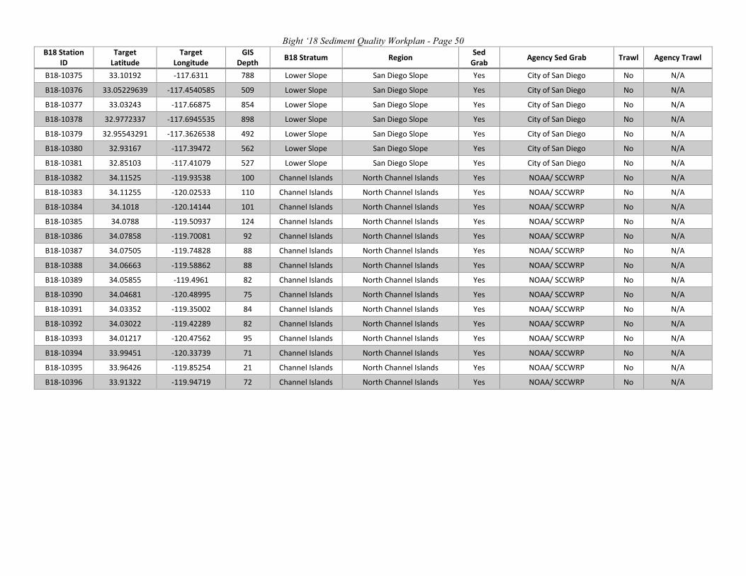
Bight ‘18 Sediment Quality Workplan - Page 50 B18 Station
ID Target
Latitude Target
Longitude GIS
Depth B18 Stratum Region Sed Grab Agency Sed Grab Trawl Agency Trawl
B18-10375 33.10192 -117.6311 788 Lower Slope San Diego Slope Yes City of San Diego No N/A
B18-10376 33.05229639 -117.4540585 509 Lower Slope San Diego Slope Yes City of San Diego No N/A
B18-10377 33.03243 -117.66875 854 Lower Slope San Diego Slope Yes City of San Diego No N/A
B18-10378 32.9772337 -117.6945535 898 Lower Slope San Diego Slope Yes City of San Diego No N/A
B18-10379 32.95543291 -117.3626538 492 Lower Slope San Diego Slope Yes City of San Diego No N/A
B18-10380 32.93167 -117.39472 562 Lower Slope San Diego Slope Yes City of San Diego No N/A
B18-10381 32.85103 -117.41079 527 Lower Slope San Diego Slope Yes City of San Diego No N/A
B18-10382 34.11525 -119.93538 100 Channel Islands North Channel Islands Yes NOAA/ SCCWRP No N/A
B18-10383 34.11255 -120.02533 110 Channel Islands North Channel Islands Yes NOAA/ SCCWRP No N/A
B18-10384 34.1018 -120.14144 101 Channel Islands North Channel Islands Yes NOAA/ SCCWRP No N/A
B18-10385 34.0788 -119.50937 124 Channel Islands North Channel Islands Yes NOAA/ SCCWRP No N/A
B18-10386 34.07858 -119.70081 92 Channel Islands North Channel Islands Yes NOAA/ SCCWRP No N/A
B18-10387 34.07505 -119.74828 88 Channel Islands North Channel Islands Yes NOAA/ SCCWRP No N/A
B18-10388 34.06663 -119.58862 88 Channel Islands North Channel Islands Yes NOAA/ SCCWRP No N/A
B18-10389 34.05855 -119.4961 82 Channel Islands North Channel Islands Yes NOAA/ SCCWRP No N/A
B18-10390 34.04681 -120.48995 75 Channel Islands North Channel Islands Yes NOAA/ SCCWRP No N/A
B18-10391 34.03352 -119.35002 84 Channel Islands North Channel Islands Yes NOAA/ SCCWRP No N/A
B18-10392 34.03022 -119.42289 82 Channel Islands North Channel Islands Yes NOAA/ SCCWRP No N/A
B18-10393 34.01217 -120.47562 95 Channel Islands North Channel Islands Yes NOAA/ SCCWRP No N/A
B18-10394 33.99451 -120.33739 71 Channel Islands North Channel Islands Yes NOAA/ SCCWRP No N/A
B18-10395 33.96426 -119.85254 21 Channel Islands North Channel Islands Yes NOAA/ SCCWRP No N/A
B18-10396 33.91322 -119.94719 72 Channel Islands North Channel Islands Yes NOAA/ SCCWRP No N/A

Bight ‘18 Sediment Quality Workplan - Page 51
APPENDIX C
Sample Laboratory Assignments

Bight ‘18 Sediment Quality Workplan - Page 52 Table C1. Sediment Laboratory Assignments
B18 Station
ID
Agency Sed Grab
Agency Tox Eohaust
Agency Tox Mytilus
Agency Grain Size
Agency TOC/ TN
Agency Metals Agency PAH Agency CHC Agency PCB Agency
Pyreth Agency PBDE Agency Fiproynl
Agency Domoic
Acid
Agency Infauna
B18-10000 CLA-EMD CLA-EMD ABC City of San
Diego CLA-EMD CLA-EMD CLA-EMD CLA-EMD CLA-EMD OCSD OCSD OCSD N/A CLA-EMD
B18-10001 CLA-EMD CLA-EMD AMEC/
WOOD City of San
Diego CLA-EMD CLA-EMD CLA-EMD CLA-EMD CLA-EMD OCSD OCSD OCSD N/A CLA-EMD
B18-10002 CLA-EMD CLA-EMD ABC City of San
Diego CLA-EMD CLA-EMD CLA-EMD CLA-EMD CLA-EMD OCSD OCSD OCSD N/A CLA-EMD
B18-10003 RMC RMC RMC RMC City of San
Diego RMC RMC RMC RMC LACSD Weck Weck N/A RMC
B18-10004 CLA-EMD CLA-EMD ABC City of San
Diego CLA-EMD CLA-EMD CLA-EMD CLA-EMD CLA-EMD OCSD OCSD OCSD N/A CLA-EMD
B18-10005 RMC RMC RMC RMC City of San
Diego RMC RMC RMC RMC LACSD Weck Weck N/A RMC
B18-10006 CLA-EMD CLA-EMD ABC City of San
Diego CLA-EMD CLA-EMD CLA-EMD CLA-EMD CLA-EMD OCSD OCSD OCSD N/A CLA-EMD
B18-10007 CLA-EMD CLA-EMD AMEC/
WOOD City of San
Diego CLA-EMD CLA-EMD CLA-EMD CLA-EMD CLA-EMD OCSD OCSD OCSD N/A CLA-EMD
B18-10008 N/A N/A N/A N/A N/A N/A N/A N/A N/A N/A N/A N/A N/A N/A
B18-10009 CLA-EMD CLA-EMD ABC City of San
Diego CLA-EMD CLA-EMD CLA-EMD CLA-EMD CLA-EMD OCSD OCSD OCSD N/A CLA-EMD
B18-10010 CLA-EMD CLA-EMD AMEC/
WOOD City of San
Diego CLA-EMD CLA-EMD CLA-EMD CLA-EMD CLA-EMD OCSD OCSD OCSD N/A CLA-EMD
B18-10011 POLA/LB CLA-EMD ABC City of San
Diego City of San
Diego City of San
Diego OCSD OCSD OCSD LACSD Weck Weck N/A POLA/LB
B18-10012 CLA-EMD CLA-EMD ABC City of San
Diego CLA-EMD CLA-EMD CLA-EMD CLA-EMD CLA-EMD OCSD OCSD OCSD N/A CLA-EMD
B18-10013 CLA-EMD CLA-EMD ABC City of San
Diego CLA-EMD CLA-EMD CLA-EMD CLA-EMD CLA-EMD OCSD OCSD OCSD N/A CLA-EMD
B18-10014 RMC RMC RMC RMC N/A RMC RMC RMC RMC N/A N/A N/A N/A RMC
B18-10015 RHMP RHMP RHMP RHMP RHMP RHMP RHMP RHMP RHMP RHMP RHMP RHMP N/A RHMP
B18-10016 RHMP RHMP RHMP RHMP RHMP RHMP RHMP RHMP RHMP RHMP RHMP RHMP N/A RHMP
B18-10017 RHMP RHMP RHMP RHMP RHMP RHMP RHMP RHMP RHMP RHMP RHMP RHMP N/A RHMP
B18-10018 RHMP RHMP RHMP RHMP RHMP RHMP RHMP RHMP RHMP RHMP RHMP RHMP N/A RHMP
B18-10019 RHMP RHMP RHMP RHMP RHMP RHMP RHMP RHMP RHMP RHMP RHMP RHMP N/A RHMP
B18-10020 RHMP RHMP RHMP RHMP RHMP RHMP RHMP RHMP RHMP RHMP RHMP RHMP N/A RHMP
B18-10021 Unassigned N/A N/A N/A N/A N/A N/A N/A N/A N/A N/A N/A N/A N/A
B18-10022 RHMP RHMP RHMP RHMP RHMP RHMP RHMP RHMP RHMP RHMP RHMP RHMP N/A RHMP
B18-10023 RHMP RHMP RHMP RHMP RHMP RHMP RHMP RHMP RHMP RHMP RHMP RHMP N/A RHMP
B18-10024 RHMP RHMP RHMP RHMP RHMP RHMP RHMP RHMP RHMP RHMP RHMP RHMP N/A RHMP
B18-10025 Navy Navy Navy Navy Navy Navy Navy Navy Navy Unassigned Unassigned Unassigned N/A Navy
B18-10026 Navy Navy Navy Navy Navy Navy Navy Navy Navy Unassigned Unassigned Unassigned N/A Navy

Bight ‘18 Sediment Quality Workplan - Page 53 B18
Station ID
Agency Sed Grab
Agency Tox Eohaust
Agency Tox Mytilus
Agency Grain Size
Agency TOC/ TN
Agency Metals Agency PAH Agency CHC Agency PCB Agency
Pyreth Agency PBDE Agency Fiproynl
Agency Domoic
Acid
Agency Infauna
B18-10027 Navy Navy Navy Navy Navy Navy Navy Navy Navy Unassigned Unassigned Unassigned N/A Navy
B18-10028 Navy Navy Navy Navy Navy Navy Navy Navy Navy Unassigned Unassigned Unassigned N/A Navy
B18-10029 RHMP RHMP RHMP RHMP RHMP RHMP RHMP RHMP RHMP RHMP RHMP RHMP N/A RHMP
B18-10030 RHMP RHMP RHMP RHMP RHMP RHMP RHMP RHMP RHMP RHMP RHMP RHMP N/A RHMP
B18-10031 RHMP RHMP RHMP RHMP RHMP RHMP RHMP RHMP RHMP RHMP RHMP RHMP N/A RHMP
B18-10032 RHMP RHMP RHMP RHMP RHMP RHMP RHMP RHMP RHMP RHMP RHMP RHMP N/A RHMP
B18-10033 Navy Navy Navy Navy Navy Navy Navy Navy Navy Unassigned Unassigned Unassigned N/A Navy
B18-10034 RHMP RHMP RHMP RHMP RHMP RHMP RHMP RHMP RHMP RHMP RHMP RHMP N/A RHMP
B18-10035 RHMP RHMP RHMP RHMP RHMP RHMP RHMP RHMP RHMP RHMP RHMP RHMP N/A RHMP
B18-10036 RHMP RHMP RHMP RHMP RHMP RHMP RHMP RHMP RHMP RHMP RHMP RHMP N/A RHMP
B18-10037 RHMP RHMP RHMP RHMP RHMP RHMP RHMP RHMP RHMP RHMP RHMP RHMP N/A RHMP
B18-10038 RHMP RHMP RHMP RHMP RHMP RHMP RHMP RHMP RHMP RHMP RHMP RHMP N/A RHMP
B18-10039 RHMP RHMP RHMP RHMP RHMP RHMP RHMP RHMP RHMP RHMP RHMP RHMP N/A RHMP
B18-10040 RHMP RHMP RHMP RHMP RHMP RHMP RHMP RHMP RHMP RHMP RHMP RHMP N/A RHMP
B18-10041 RHMP RHMP RHMP RHMP RHMP RHMP RHMP RHMP RHMP RHMP RHMP RHMP N/A RHMP
B18-10042 RHMP RHMP RHMP RHMP RHMP RHMP RHMP RHMP RHMP RHMP RHMP RHMP N/A RHMP
B18-10043 RHMP RHMP RHMP RHMP RHMP RHMP RHMP RHMP RHMP RHMP RHMP RHMP N/A RHMP
B18-10044 RHMP RHMP RHMP RHMP RHMP RHMP RHMP RHMP RHMP RHMP RHMP RHMP N/A RHMP
B18-10045 ABC LACSD AMEC/
WOOD City of San
Diego City of San
Diego City of San
Diego ABC ABC ABC OCSD OCSD OCSD N/A ABC
B18-10046 ABC LACSD EcoAnalyst City of San
Diego City of San
Diego City of San
Diego ABC ABC ABC OCSD OCSD OCSD N/A ABC
B18-10047
LA Public Works
LA Public Works
LA Public Works
LA Public Works
LA Public Works
LA Public Works
LA Public Works
LA Public Works
LA Public Works LACSD Weck Weck N/A LA Public
Works B18-
10048 LA Public
Works LA Public
Works LA Public
Works LA Public
Works LA Public
Works LA Public
Works LA Public
Works LA Public
Works LA Public
Works LACSD Weck Weck N/A LA Public Works
B18-10049
LA Public Works
LA Public Works
LA Public Works
LA Public Works
LA Public Works
LA Public Works
LA Public Works
LA Public Works
LA Public Works LACSD Weck Weck N/A LA Public
Works B18-
10050 LA Public
Works LA Public
Works LA Public
Works LA Public
Works LA Public
Works LA Public
Works LA Public
Works LA Public
Works LA Public
Works LACSD Weck Weck N/A LA Public Works
B18-10051
LA Public Works
LA Public Works
LA Public Works
LA Public Works
LA Public Works
LA Public Works
LA Public Works
LA Public Works
LA Public Works LACSD Weck Weck N/A LA Public
Works B18-
10052 RMC RMC RMC RMC N/A RMC RMC RMC RMC N/A N/A N/A N/A RMC
B18-10053 RMC RMC RMC RMC City of San
Diego RMC RMC RMC RMC LACSD Weck Weck N/A RMC
B18-10054 MBC AMEC/
WOOD Unassigned City of San Diego
City of San Diego
City of San Diego OCSD OCSD OCSD OCSD OCSD OCSD N/A EcoAnalyst
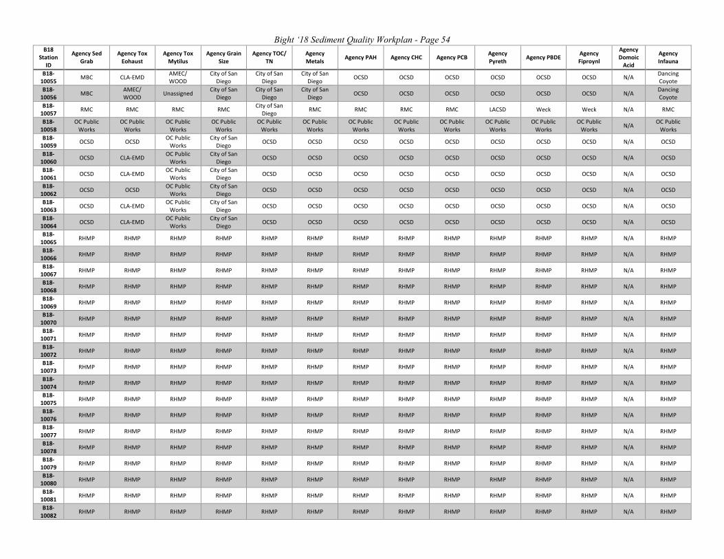
Bight ‘18 Sediment Quality Workplan - Page 54 B18
Station ID
Agency Sed Grab
Agency Tox Eohaust
Agency Tox Mytilus
Agency Grain Size
Agency TOC/ TN
Agency Metals Agency PAH Agency CHC Agency PCB Agency
Pyreth Agency PBDE Agency Fiproynl
Agency Domoic
Acid
Agency Infauna
B18-10055 MBC CLA-EMD AMEC/
WOOD City of San
Diego City of San
Diego City of San
Diego OCSD OCSD OCSD OCSD OCSD OCSD N/A Dancing Coyote
B18-10056 MBC AMEC/
WOOD Unassigned City of San Diego
City of San Diego
City of San Diego OCSD OCSD OCSD OCSD OCSD OCSD N/A Dancing
Coyote B18-
10057 RMC RMC RMC RMC City of San Diego RMC RMC RMC RMC LACSD Weck Weck N/A RMC
B18-10058
OC Public Works
OC Public Works
OC Public Works
OC Public Works
OC Public Works
OC Public Works
OC Public Works
OC Public Works
OC Public Works
OC Public Works
OC Public Works
OC Public Works N/A OC Public
Works B18-
10059 OCSD OCSD OC Public Works
City of San Diego OCSD OCSD OCSD OCSD OCSD OCSD OCSD OCSD N/A OCSD
B18-10060 OCSD CLA-EMD OC Public
Works City of San
Diego OCSD OCSD OCSD OCSD OCSD OCSD OCSD OCSD N/A OCSD
B18-10061 OCSD CLA-EMD OC Public
Works City of San
Diego OCSD OCSD OCSD OCSD OCSD OCSD OCSD OCSD N/A OCSD
B18-10062 OCSD OCSD OC Public
Works City of San
Diego OCSD OCSD OCSD OCSD OCSD OCSD OCSD OCSD N/A OCSD
B18-10063 OCSD CLA-EMD OC Public
Works City of San
Diego OCSD OCSD OCSD OCSD OCSD OCSD OCSD OCSD N/A OCSD
B18-10064 OCSD CLA-EMD OC Public
Works City of San
Diego OCSD OCSD OCSD OCSD OCSD OCSD OCSD OCSD N/A OCSD
B18-10065 RHMP RHMP RHMP RHMP RHMP RHMP RHMP RHMP RHMP RHMP RHMP RHMP N/A RHMP
B18-10066 RHMP RHMP RHMP RHMP RHMP RHMP RHMP RHMP RHMP RHMP RHMP RHMP N/A RHMP
B18-10067 RHMP RHMP RHMP RHMP RHMP RHMP RHMP RHMP RHMP RHMP RHMP RHMP N/A RHMP
B18-10068 RHMP RHMP RHMP RHMP RHMP RHMP RHMP RHMP RHMP RHMP RHMP RHMP N/A RHMP
B18-10069 RHMP RHMP RHMP RHMP RHMP RHMP RHMP RHMP RHMP RHMP RHMP RHMP N/A RHMP
B18-10070 RHMP RHMP RHMP RHMP RHMP RHMP RHMP RHMP RHMP RHMP RHMP RHMP N/A RHMP
B18-10071 RHMP RHMP RHMP RHMP RHMP RHMP RHMP RHMP RHMP RHMP RHMP RHMP N/A RHMP
B18-10072 RHMP RHMP RHMP RHMP RHMP RHMP RHMP RHMP RHMP RHMP RHMP RHMP N/A RHMP
B18-10073 RHMP RHMP RHMP RHMP RHMP RHMP RHMP RHMP RHMP RHMP RHMP RHMP N/A RHMP
B18-10074 RHMP RHMP RHMP RHMP RHMP RHMP RHMP RHMP RHMP RHMP RHMP RHMP N/A RHMP
B18-10075 RHMP RHMP RHMP RHMP RHMP RHMP RHMP RHMP RHMP RHMP RHMP RHMP N/A RHMP
B18-10076 RHMP RHMP RHMP RHMP RHMP RHMP RHMP RHMP RHMP RHMP RHMP RHMP N/A RHMP
B18-10077 RHMP RHMP RHMP RHMP RHMP RHMP RHMP RHMP RHMP RHMP RHMP RHMP N/A RHMP
B18-10078 RHMP RHMP RHMP RHMP RHMP RHMP RHMP RHMP RHMP RHMP RHMP RHMP N/A RHMP
B18-10079 RHMP RHMP RHMP RHMP RHMP RHMP RHMP RHMP RHMP RHMP RHMP RHMP N/A RHMP
B18-10080 RHMP RHMP RHMP RHMP RHMP RHMP RHMP RHMP RHMP RHMP RHMP RHMP N/A RHMP
B18-10081 RHMP RHMP RHMP RHMP RHMP RHMP RHMP RHMP RHMP RHMP RHMP RHMP N/A RHMP
B18-10082 RHMP RHMP RHMP RHMP RHMP RHMP RHMP RHMP RHMP RHMP RHMP RHMP N/A RHMP

Bight ‘18 Sediment Quality Workplan - Page 55 B18
Station ID
Agency Sed Grab
Agency Tox Eohaust
Agency Tox Mytilus
Agency Grain Size
Agency TOC/ TN
Agency Metals Agency PAH Agency CHC Agency PCB Agency
Pyreth Agency PBDE Agency Fiproynl
Agency Domoic
Acid
Agency Infauna
B18-10083 RHMP RHMP RHMP RHMP RHMP RHMP RHMP RHMP RHMP RHMP RHMP RHMP N/A RHMP
B18-10084 RHMP RHMP RHMP RHMP RHMP RHMP RHMP RHMP RHMP RHMP RHMP RHMP N/A RHMP
B18-10085 RHMP RHMP RHMP RHMP RHMP RHMP RHMP RHMP RHMP RHMP RHMP RHMP N/A RHMP
B18-10086 RHMP RHMP RHMP RHMP RHMP RHMP RHMP RHMP RHMP RHMP RHMP RHMP N/A RHMP
B18-10087 RHMP RHMP RHMP RHMP RHMP RHMP RHMP RHMP RHMP RHMP RHMP RHMP N/A RHMP
B18-10088 RHMP RHMP RHMP RHMP RHMP RHMP RHMP RHMP RHMP RHMP RHMP RHMP N/A RHMP
B18-10089 RMC RMC RMC RMC N/A RMC RMC RMC RMC N/A N/A N/A N/A RMC
B18-10090 RMC RMC RMC RMC City of San
Diego RMC RMC RMC RMC LACSD Weck Weck N/A RMC
B18-10091 RMC RMC RMC RMC City of San
Diego RMC RMC RMC RMC LACSD Weck Weck N/A RMC
B18-10092 POLA/LB AMEC/
WOOD AMEC/ WOOD
City of San Diego
City of San Diego
City of San Diego CLA-EMD CLA-EMD CLA-EMD LACSD Weck Weck N/A POLA/LB
B18-10093 RMC RMC RMC RMC N/A RMC RMC RMC RMC N/A N/A N/A N/A RMC
B18-10094 CLA-EMD CLA-EMD ABC City of San
Diego CLA-EMD CLA-EMD CLA-EMD CLA-EMD CLA-EMD LACSD OCSD OCSD N/A CLA-EMD
B18-10095 RMC RMC RMC RMC City of San
Diego RMC RMC RMC RMC LACSD Weck Weck N/A RMC
B18-10096 POLA/LB LACSD ABC City of San
Diego City of San
Diego City of San
Diego City of San
Diego City of San
Diego City of San
Diego LACSD Weck Weck N/A POLA/LB
B18-10097 RMC RMC RMC RMC City of San
Diego RMC RMC RMC RMC LACSD Weck Weck N/A RMC
B18-10098 RMC RMC RMC RMC City of San
Diego RMC RMC RMC RMC LACSD Weck Weck N/A RMC
B18-10099 RMC RMC RMC RMC City of San
Diego RMC RMC RMC RMC LACSD Weck Weck N/A RMC
B18-10100 CLA-EMD CLA-EMD Unassigned City of San
Diego CLA-EMD CLA-EMD CLA-EMD CLA-EMD CLA-EMD LACSD OCSD OCSD N/A CLA-EMD
B18-10101 CLA-EMD CLA-EMD ABC City of San
Diego CLA-EMD CLA-EMD CLA-EMD CLA-EMD CLA-EMD LACSD OCSD OCSD N/A CLA-EMD
B18-10102 RMC RMC RMC RMC City of San
Diego RMC RMC RMC RMC LACSD Weck Weck N/A RMC
B18-10103 RMC RMC RMC RMC N/A RMC RMC RMC RMC N/A N/A N/A N/A RMC
B18-10104
OC Public Works
OC Public Works
OC Public Works
OC Public Works
OC Public Works
OC Public Works
OC Public Works
OC Public Works
OC Public Works
OC Public Works
OC Public Works
OC Public Works N/A OC Public
Works B18-
10105 RMC RMC RMC RMC City of San Diego RMC RMC RMC RMC LACSD Weck Weck N/A RMC
B18-10106 RMC RMC RMC RMC City of San
Diego RMC RMC RMC RMC LACSD Weck Weck N/A RMC
B18-10107 CLA-EMD CLA-EMD ABC City of San
Diego CLA-EMD CLA-EMD CLA-EMD CLA-EMD CLA-EMD OCSD OCSD OCSD N/A CLA-EMD
B18-10108 RMC RMC RMC RMC City of San
Diego RMC RMC RMC RMC LACSD Weck Weck N/A RMC
B18-10109 CLA-EMD CLA-EMD Unassigned City of San
Diego CLA-EMD CLA-EMD CLA-EMD CLA-EMD CLA-EMD LACSD OCSD OCSD N/A CLA-EMD
B18-10110 RMC RMC RMC RMC City of San
Diego RMC RMC RMC RMC LACSD Weck Weck N/A RMC

Bight ‘18 Sediment Quality Workplan - Page 56 B18
Station ID
Agency Sed Grab
Agency Tox Eohaust
Agency Tox Mytilus
Agency Grain Size
Agency TOC/ TN
Agency Metals Agency PAH Agency CHC Agency PCB Agency
Pyreth Agency PBDE Agency Fiproynl
Agency Domoic
Acid
Agency Infauna
B18-10111 RMC RMC RMC RMC City of San
Diego RMC RMC RMC RMC LACSD Weck Weck N/A RMC
B18-10112 RHMP RHMP RHMP RHMP RHMP RHMP RHMP RHMP RHMP RHMP RHMP RHMP N/A RHMP
B18-10113 RHMP RHMP RHMP RHMP RHMP RHMP RHMP RHMP RHMP RHMP RHMP RHMP N/A RHMP
B18-10114 RHMP RHMP RHMP RHMP RHMP RHMP RHMP RHMP RHMP RHMP RHMP RHMP N/A RHMP
B18-10115 RHMP RHMP RHMP RHMP RHMP RHMP RHMP RHMP RHMP RHMP RHMP RHMP N/A RHMP
B18-10116 RHMP RHMP RHMP RHMP RHMP RHMP RHMP RHMP RHMP RHMP RHMP RHMP N/A RHMP
B18-10117 RHMP RHMP RHMP RHMP RHMP RHMP RHMP RHMP RHMP RHMP RHMP RHMP N/A RHMP
B18-10118 Navy Navy Navy Navy Navy Navy Navy Navy Navy Unassigned Unassigned Unassigned N/A Navy
B18-10119 RHMP RHMP RHMP RHMP RHMP RHMP RHMP RHMP RHMP RHMP RHMP RHMP N/A RHMP
B18-10120 Navy Navy Navy Navy Navy Navy Navy Navy Navy Unassigned Unassigned Unassigned N/A Navy
B18-10121 RHMP RHMP RHMP RHMP RHMP RHMP RHMP RHMP RHMP RHMP RHMP RHMP N/A RHMP
B18-10122 Navy Navy Navy Navy Navy Navy Navy Navy Navy Unassigned Unassigned Unassigned N/A Navy
B18-10123 RHMP RHMP RHMP RHMP RHMP RHMP RHMP RHMP RHMP RHMP RHMP RHMP N/A RHMP
B18-10124 RHMP RHMP RHMP RHMP RHMP RHMP RHMP RHMP RHMP RHMP RHMP RHMP N/A RHMP
B18-10125 Navy Navy Navy Navy Navy Navy Navy Navy Navy Unassigned Unassigned Unassigned N/A Navy
B18-10126 RHMP RHMP RHMP RHMP RHMP RHMP RHMP RHMP RHMP RHMP RHMP RHMP N/A RHMP
B18-10127 RHMP RHMP RHMP RHMP RHMP RHMP RHMP RHMP RHMP RHMP RHMP RHMP N/A RHMP
B18-10128 Navy Navy Navy Navy Navy Navy Navy Navy Navy Unassigned Unassigned Unassigned N/A Navy
B18-10129 Navy Navy Navy Navy Navy Navy Navy Navy Navy Unassigned Unassigned Unassigned N/A Navy
B18-10130 Navy Navy Navy Navy Navy Navy Navy Navy Navy Unassigned Unassigned Unassigned N/A Navy
B18-10131 Navy Navy Navy Navy Navy Navy Navy Navy Navy Unassigned Unassigned Unassigned N/A Navy
B18-10132 RHMP RHMP RHMP RHMP RHMP RHMP RHMP RHMP RHMP RHMP RHMP RHMP N/A RHMP
B18-10133 RHMP RHMP RHMP RHMP RHMP RHMP RHMP RHMP RHMP RHMP RHMP RHMP N/A RHMP
B18-10134 Navy Navy Navy Navy Navy Navy Navy Navy Navy Unassigned Unassigned Unassigned N/A Navy
B18-10135 Navy Navy Navy Navy Navy Navy Navy Navy Navy Unassigned Unassigned Unassigned N/A Navy
B18-10136 RHMP RHMP RHMP RHMP RHMP RHMP RHMP RHMP RHMP RHMP RHMP RHMP N/A RHMP
B18-10137 RHMP RHMP RHMP RHMP RHMP RHMP RHMP RHMP RHMP RHMP RHMP RHMP N/A RHMP
B18-10138 Navy Navy Navy Navy Navy Navy Navy Navy Navy Unassigned Unassigned Unassigned N/A Navy

Bight ‘18 Sediment Quality Workplan - Page 57 B18
Station ID
Agency Sed Grab
Agency Tox Eohaust
Agency Tox Mytilus
Agency Grain Size
Agency TOC/ TN
Agency Metals Agency PAH Agency CHC Agency PCB Agency
Pyreth Agency PBDE Agency Fiproynl
Agency Domoic
Acid
Agency Infauna
B18-10139 RHMP RHMP RHMP RHMP RHMP RHMP RHMP RHMP RHMP RHMP RHMP RHMP N/A RHMP
B18-10140 RHMP RHMP RHMP RHMP RHMP RHMP RHMP RHMP RHMP RHMP RHMP RHMP N/A RHMP
B18-10141 RHMP RHMP RHMP RHMP RHMP RHMP RHMP RHMP RHMP RHMP RHMP RHMP N/A RHMP
B18-10142 RHMP RHMP RHMP RHMP RHMP RHMP RHMP RHMP RHMP RHMP RHMP RHMP N/A RHMP
B18-10143 RHMP RHMP RHMP RHMP RHMP RHMP RHMP RHMP RHMP RHMP RHMP RHMP N/A RHMP
B18-10144 RHMP RHMP RHMP RHMP RHMP RHMP RHMP RHMP RHMP RHMP RHMP RHMP N/A RHMP
B18-10145 MBC LACSD EcoAnalyst City of San
Diego City of San
Diego City of San
Diego City of San
Diego City of San
Diego City of San
Diego OCSD OCSD OCSD N/A CLA-EMD
B18-10146 MBC LACSD EcoAnalyst City of San
Diego City of San
Diego City of San
Diego City of San
Diego City of San
Diego City of San
Diego OCSD OCSD OCSD N/A CLA-EMD
B18-10147 MBC LACSD EcoAnalyst City of San
Diego City of San
Diego City of San
Diego City of San
Diego City of San
Diego City of San
Diego OCSD OCSD OCSD N/A EcoAnalyst
B18-10148 MBC LACSD EcoAnalyst City of San
Diego City of San
Diego City of San
Diego City of San
Diego City of San
Diego City of San
Diego OCSD OCSD OCSD N/A EcoAnalyst
B18-10149 MBC LACSD EcoAnalyst City of San
Diego City of San
Diego City of San
Diego City of San
Diego City of San
Diego City of San
Diego OCSD OCSD OCSD N/A EcoAnalyst
B18-10150 RMC RMC RMC RMC N/A RMC RMC RMC RMC N/A N/A N/A N/A RMC
B18-10151 ABC LACSD EcoAnalyst City of San
Diego City of San
Diego City of San
Diego ABC ABC ABC OCSD OCSD OCSD N/A ABC
B18-10152
OC Public Works
OC Public Works
OC Public Works
OC Public Works
OC Public Works
OC Public Works
OC Public Works
OC Public Works
OC Public Works
OC Public Works
OC Public Works
OC Public Works N/A OC Public
Works B18-
10153 ABC LACSD EcoAnalyst City of San Diego
City of San Diego
City of San Diego ABC ABC ABC OCSD OCSD OCSD N/A ABC
B18-10155
OC Public Works
OC Public Works
OC Public Works
OC Public Works
OC Public Works
OC Public Works
OC Public Works
OC Public Works
OC Public Works
OC Public Works
OC Public Works
OC Public Works N/A OC Public
Works B18-
10156 OC Public
Works OC Public
Works OC Public
Works OC Public
Works OC Public
Works OC Public
Works OC Public
Works OC Public
Works OC Public
Works OC Public
Works OC Public
Works OC Public
Works N/A OC Public Works
B18-10158
OC Public Works
OC Public Works
OC Public Works
OC Public Works
OC Public Works
OC Public Works
OC Public Works
OC Public Works
OC Public Works
OC Public Works
OC Public Works
OC Public Works N/A OC Public
Works B18-
10159 OC Public
Works OC Public
Works OC Public
Works OC Public
Works OC Public
Works OC Public
Works OC Public
Works OC Public
Works OC Public
Works OC Public
Works OC Public
Works OC Public
Works N/A OC Public Works
B18-10160
OC Public Works
OC Public Works
OC Public Works
OC Public Works
OC Public Works
OC Public Works
OC Public Works
OC Public Works
OC Public Works
OC Public Works
OC Public Works
OC Public Works N/A OC Public
Works B18-
10161 OC Public
Works OC Public
Works OC Public
Works OC Public
Works OC Public
Works OC Public
Works OC Public
Works OC Public
Works OC Public
Works OC Public
Works OC Public
Works OC Public
Works N/A OC Public Works
B18-10162
OC Public Works
OC Public Works
OC Public Works
OC Public Works
OC Public Works
OC Public Works
OC Public Works
OC Public Works
OC Public Works
OC Public Works
OC Public Works
OC Public Works N/A OC Public
Works B18-
10163 OC Public
Works OC Public
Works OC Public
Works OC Public
Works OC Public
Works OC Public
Works OC Public
Works OC Public
Works OC Public
Works OC Public
Works OC Public
Works OC Public
Works N/A OC Public Works
B18-10164
OC Public Works
OC Public Works
OC Public Works
OC Public Works
OC Public Works
OC Public Works
OC Public Works
OC Public Works
OC Public Works
OC Public Works
OC Public Works
OC Public Works N/A OC Public
Works B18-
10165 OC Public
Works OC Public
Works OC Public
Works OC Public
Works OC Public
Works OC Public
Works OC Public
Works OC Public
Works OC Public
Works OC Public
Works OC Public
Works OC Public
Works N/A OC Public Works
B18-10166
Riverside County Flood
Control
Riverside County Flood
Control
Riverside County Flood
Control
Riverside County Flood
Control
Riverside County Flood
Control
Riverside County Flood
Control
Riverside County Flood
Control
Riverside County Flood
Control
Riverside County Flood
Control
Riverside County Flood
Control
Riverside County Flood
Control
Riverside County Flood
Control N/A
Riverside County Flood
Control
B18-10167
Riverside County Flood
Control
Riverside County Flood
Control
Riverside County Flood
Control
Riverside County Flood
Control
Riverside County Flood
Control
Riverside County Flood
Control
Riverside County Flood
Control
Riverside County Flood
Control
Riverside County Flood
Control
Riverside County Flood
Control
Riverside County Flood
Control
Riverside County Flood
Control N/A
Riverside County Flood
Control

Bight ‘18 Sediment Quality Workplan - Page 58 B18
Station ID
Agency Sed Grab
Agency Tox Eohaust
Agency Tox Mytilus
Agency Grain Size
Agency TOC/ TN
Agency Metals Agency PAH Agency CHC Agency PCB Agency
Pyreth Agency PBDE Agency Fiproynl
Agency Domoic
Acid
Agency Infauna
B18-10168
San Diego Stormwater
San Diego Stormwater
San Diego Stormwater
San Diego Stormwater
San Diego Stormwater
San Diego Stormwater
San Diego Stormwater
San Diego Stormwater
San Diego Stormwater
San Diego Stormwater
San Diego Stormwater
San Diego Stormwater N/A San Diego
Stormwater B18-
10169 San Diego
Stormwater San Diego
Stormwater San Diego
Stormwater San Diego
Stormwater San Diego
Stormwater San Diego
Stormwater San Diego
Stormwater San Diego
Stormwater San Diego
Stormwater San Diego
Stormwater San Diego
Stormwater San Diego
Stormwater N/A San Diego Stormwater
B18-10170
San Diego Stormwater
San Diego Stormwater
San Diego Stormwater
San Diego Stormwater
San Diego Stormwater
San Diego Stormwater
San Diego Stormwater
San Diego Stormwater
San Diego Stormwater
San Diego Stormwater
San Diego Stormwater
San Diego Stormwater N/A San Diego
Stormwater B18-
10171 San Diego
Stormwater San Diego
Stormwater San Diego
Stormwater San Diego
Stormwater San Diego
Stormwater San Diego
Stormwater San Diego
Stormwater San Diego
Stormwater San Diego
Stormwater San Diego
Stormwater San Diego
Stormwater San Diego
Stormwater N/A San Diego Stormwater
B18-10172
San Diego Stormwater
San Diego Stormwater
San Diego Stormwater
San Diego Stormwater
San Diego Stormwater
San Diego Stormwater
San Diego Stormwater
San Diego Stormwater
San Diego Stormwater
San Diego Stormwater
San Diego Stormwater
San Diego Stormwater N/A San Diego
Stormwater B18-
10173 San Diego
Stormwater San Diego
Stormwater San Diego
Stormwater San Diego
Stormwater San Diego
Stormwater San Diego
Stormwater San Diego
Stormwater San Diego
Stormwater San Diego
Stormwater San Diego
Stormwater San Diego
Stormwater San Diego
Stormwater N/A San Diego Stormwater
B18-10174
San Diego Stormwater
San Diego Stormwater
San Diego Stormwater
San Diego Stormwater
San Diego Stormwater
San Diego Stormwater
San Diego Stormwater
San Diego Stormwater
San Diego Stormwater
San Diego Stormwater
San Diego Stormwater
San Diego Stormwater N/A San Diego
Stormwater B18-
10175 San Diego
Stormwater San Diego
Stormwater San Diego
Stormwater San Diego
Stormwater San Diego
Stormwater San Diego
Stormwater San Diego
Stormwater San Diego
Stormwater San Diego
Stormwater San Diego
Stormwater San Diego
Stormwater San Diego
Stormwater N/A San Diego Stormwater
B18-10176
San Diego Stormwater
San Diego Stormwater
San Diego Stormwater
San Diego Stormwater
San Diego Stormwater
San Diego Stormwater
San Diego Stormwater
San Diego Stormwater
San Diego Stormwater
San Diego Stormwater
San Diego Stormwater
San Diego Stormwater N/A San Diego
Stormwater B18-
10177 San Diego
Stormwater San Diego
Stormwater San Diego
Stormwater San Diego
Stormwater San Diego
Stormwater San Diego
Stormwater San Diego
Stormwater San Diego
Stormwater San Diego
Stormwater San Diego
Stormwater San Diego
Stormwater San Diego
Stormwater N/A San Diego Stormwater
B18-10178 RHMP RHMP RHMP RHMP RHMP RHMP RHMP RHMP RHMP RHMP RHMP RHMP N/A RHMP
B18-10179 RHMP RHMP RHMP RHMP RHMP RHMP RHMP RHMP RHMP RHMP RHMP RHMP N/A RHMP
B18-10180 RHMP RHMP RHMP RHMP RHMP RHMP RHMP RHMP RHMP RHMP RHMP RHMP N/A RHMP
B18-10181 RHMP RHMP RHMP RHMP RHMP RHMP RHMP RHMP RHMP RHMP RHMP RHMP N/A RHMP
B18-10182
San Diego Stormwater
San Diego Stormwater
San Diego Stormwater
San Diego Stormwater
San Diego Stormwater
San Diego Stormwater
San Diego Stormwater
San Diego Stormwater
San Diego Stormwater
San Diego Stormwater
San Diego Stormwater
San Diego Stormwater N/A San Diego
Stormwater B18-
10183 MBC LACSD ABC City of San Diego
City of San Diego
City of San Diego
City of San Diego
City of San Diego
City of San Diego OCSD OCSD OCSD N/A EcoAnalyst
B18-10184 ABC ABC EcoAnalyst City of San
Diego City of San
Diego City of San
Diego ABC ABC ABC OCSD OCSD OCSD N/A ABC
B18-10185 MBC LACSD ABC City of San
Diego City of San
Diego City of San
Diego City of San
Diego City of San
Diego City of San
Diego OCSD OCSD OCSD N/A EcoAnalyst
B18-10186 MBC ABC ABC City of San
Diego City of San
Diego City of San
Diego City of San
Diego City of San
Diego City of San
Diego OCSD OCSD OCSD N/A EcoAnalyst
B18-10187 MBC LACSD ABC City of San
Diego City of San
Diego City of San
Diego City of San
Diego City of San
Diego City of San
Diego OCSD OCSD OCSD N/A EcoAnalyst
B18-10188 MBC LACSD SCCWRP-
archive City of San
Diego City of San
Diego City of San
Diego City of San
Diego City of San
Diego City of San
Diego OCSD OCSD OCSD N/A EcoAnalyst
B18-10189
Dominguez Channel
Watershed
Dominguez Channel
Watershed
Dominguez Channel
Watershed
Dominguez Channel
Watershed
Dominguez Channel
Watershed
Dominguez Channel
Watershed
Dominguez Channel
Watershed
Dominguez Channel
Watershed
Dominguez Channel
Watershed
Dominguez Channel
Watershed
Dominguez Channel
Watershed
Dominguez Channel
Watershed N/A
Dominguez Channel
Watershed
B18-10190
Dominguez Channel
Watershed
Dominguez Channel
Watershed
Dominguez Channel
Watershed
Dominguez Channel
Watershed
Dominguez Channel
Watershed
Dominguez Channel
Watershed
Dominguez Channel
Watershed
Dominguez Channel
Watershed
Dominguez Channel
Watershed
Dominguez Channel
Watershed
Dominguez Channel
Watershed
Dominguez Channel
Watershed N/A
Dominguez Channel
Watershed B18-
10191 MBC LACSD EcoAnalyst City of San Diego
City of San Diego
City of San Diego
City of San Diego
City of San Diego
City of San Diego OCSD OCSD OCSD N/A EcoAnalyst
B18-10192 MBC LACSD SCCWRP-
archive City of San
Diego City of San
Diego City of San
Diego City of San
Diego City of San
Diego City of San
Diego OCSD OCSD OCSD N/A Dancing Coyote
B18-10193
SD Co/ San Luis Rey
SD Co/ San Luis Rey
SD Co/ San Luis Rey
SD Co/ San Luis Rey
SD Co/ San Luis Rey
SD Co/ San Luis Rey
SD Co/ San Luis Rey
SD Co/ San Luis Rey
SD Co/ San Luis Rey
SD Co/ San Luis Rey
SD Co/ San Luis Rey
SD Co/ San Luis Rey N/A SD Co/ San
Luis Rey

Bight ‘18 Sediment Quality Workplan - Page 59 B18
Station ID
Agency Sed Grab
Agency Tox Eohaust
Agency Tox Mytilus
Agency Grain Size
Agency TOC/ TN
Agency Metals Agency PAH Agency CHC Agency PCB Agency
Pyreth Agency PBDE Agency Fiproynl
Agency Domoic
Acid
Agency Infauna
B18-10194
San Diego County
Stormwater
San Diego County
Stormwater
San Diego County
Stormwater
San Diego County
Stormwater
San Diego County
Stormwater
San Diego County
Stormwater
San Diego County
Stormwater
San Diego County
Stormwater
San Diego County
Stormwater
San Diego County
Stormwater
San Diego County
Stormwater
San Diego County
Stormwater N/A
San Diego County
Stormwater
B18-10195
San Diego County
Stormwater
San Diego County
Stormwater
San Diego County
Stormwater
San Diego County
Stormwater
San Diego County
Stormwater
San Diego County
Stormwater
San Diego County
Stormwater
San Diego County
Stormwater
San Diego County
Stormwater
San Diego County
Stormwater
San Diego County
Stormwater
San Diego County
Stormwater N/A
San Diego County
Stormwater B18-
10196 San Diego
Stormwater San Diego
Stormwater San Diego
Stormwater San Diego
Stormwater San Diego
Stormwater San Diego
Stormwater San Diego
Stormwater San Diego
Stormwater San Diego
Stormwater San Diego
Stormwater San Diego
Stormwater San Diego
Stormwater N/A San Diego Stormwater
B18-10197
San Diego Stormwater
San Diego Stormwater
San Diego Stormwater
San Diego Stormwater
San Diego Stormwater
San Diego Stormwater
San Diego Stormwater
San Diego Stormwater
San Diego Stormwater
San Diego Stormwater
San Diego Stormwater
San Diego Stormwater N/A San Diego
Stormwater B18-
10198 San Diego
Stormwater San Diego
Stormwater San Diego
Stormwater San Diego
Stormwater San Diego
Stormwater San Diego
Stormwater San Diego
Stormwater San Diego
Stormwater San Diego
Stormwater San Diego
Stormwater San Diego
Stormwater San Diego
Stormwater N/A San Diego Stormwater
B18-10199
San Diego County
Stormwater
San Diego County
Stormwater
San Diego County
Stormwater
San Diego County
Stormwater
San Diego County
Stormwater
San Diego County
Stormwater
San Diego County
Stormwater
San Diego County
Stormwater
San Diego County
Stormwater
San Diego County
Stormwater
San Diego County
Stormwater
San Diego County
Stormwater N/A
San Diego County
Stormwater B18-
10200 RHMP RHMP RHMP RHMP RHMP RHMP RHMP RHMP RHMP RHMP RHMP RHMP N/A RHMP
B18-10201
San Diego Stormwater
San Diego Stormwater
San Diego Stormwater
San Diego Stormwater
San Diego Stormwater
San Diego Stormwater
San Diego Stormwater
San Diego Stormwater
San Diego Stormwater
San Diego Stormwater
San Diego Stormwater
San Diego Stormwater N/A San Diego
Stormwater B18-
10202 San Diego
Stormwater San Diego
Stormwater San Diego
Stormwater San Diego
Stormwater San Diego
Stormwater San Diego
Stormwater San Diego
Stormwater San Diego
Stormwater San Diego
Stormwater San Diego
Stormwater San Diego
Stormwater San Diego
Stormwater N/A San Diego Stormwater
B18-10203 MBC LACSD N/A City of San
Diego City of San
Diego City of San
Diego City of San
Diego City of San
Diego City of San
Diego N/A SCCWRP-archive N/A Weck City of San
Diego B18-
10204 MBC N/A N/A City of San Diego
City of San Diego
City of San Diego
City of San Diego
City of San Diego
City of San Diego N/A N/A N/A Weck City of San
Diego B18-
10205 N/A N/A N/A N/A N/A N/A N/A N/A N/A N/A N/A N/A N/A N/A
B18-10206 ABC N/A N/A City of San
Diego City of San
Diego City of San
Diego ABC ABC ABC N/A N/A N/A Weck ABC
B18-10207 ABC N/A N/A City of San
Diego City of San
Diego City of San
Diego ABC ABC ABC N/A N/A N/A Weck ABC
B18-10208 ABC N/A N/A City of San
Diego City of San
Diego City of San
Diego ABC ABC ABC N/A N/A N/A Weck OCSD
B18-10209 ABC N/A N/A City of San
Diego City of San
Diego City of San
Diego ABC ABC ABC N/A N/A N/A Weck ABC
B18-10210 ABC LACSD N/A City of San
Diego City of San
Diego City of San
Diego ABC ABC ABC N/A SCCWRP-archive N/A Weck ABC
B18-10211 ABC N/A N/A City of San
Diego City of San
Diego City of San
Diego ABC ABC ABC N/A N/A N/A Weck OCSD
B18-10212 ABC N/A N/A City of San
Diego City of San
Diego City of San
Diego ABC ABC ABC N/A N/A N/A Weck OCSD
B18-10213 ABC N/A N/A City of San
Diego City of San
Diego OCSD ABC ABC ABC N/A N/A N/A Weck ABC
B18-10214 ABC N/A N/A City of San
Diego City of San
Diego OCSD ABC ABC ABC N/A N/A N/A Weck ABC
B18-10215 ABC N/A N/A City of San
Diego City of San
Diego OCSD ABC ABC ABC N/A N/A N/A Weck ABC
B18-10216 ABC N/A N/A City of San
Diego City of San
Diego OCSD ABC ABC ABC N/A N/A N/A Weck ABC
B18-10217 ABC LACSD N/A City of San
Diego City of San
Diego City of San
Diego ABC ABC ABC N/A SCCWRP-archive N/A Weck ABC
B18-10218 CLA-EMD CLA-EMD N/A City of San
Diego CLA-EMD CLA-EMD CLA-EMD CLA-EMD CLA-EMD N/A SCCWRP-archive N/A Weck CLA-EMD
B18-10219 CLA-EMD N/A N/A City of San
Diego CLA-EMD CLA-EMD CLA-EMD CLA-EMD CLA-EMD N/A N/A N/A Weck CLA-EMD

Bight ‘18 Sediment Quality Workplan - Page 60 B18
Station ID
Agency Sed Grab
Agency Tox Eohaust
Agency Tox Mytilus
Agency Grain Size
Agency TOC/ TN
Agency Metals Agency PAH Agency CHC Agency PCB Agency
Pyreth Agency PBDE Agency Fiproynl
Agency Domoic
Acid
Agency Infauna
B18-10220 OCSD N/A N/A City of San
Diego OCSD OCSD OCSD OCSD OCSD N/A N/A N/A Weck OCSD
B18-10221 N/A N/A N/A N/A N/A N/A N/A N/A N/A N/A N/A N/A N/A N/A
B18-10222 OCSD N/A N/A City of San
Diego OCSD OCSD OCSD OCSD OCSD N/A N/A N/A Weck OCSD
B18-10223 OCSD N/A N/A City of San
Diego OCSD OCSD OCSD OCSD OCSD N/A N/A N/A Weck OCSD
B18-10224 LACSD LACSD N/A City of San
Diego LACSD LACSD LACSD LACSD LACSD N/A SCCWRP-archive N/A Weck LACSD
B18-10225 OCSD N/A N/A City of San
Diego OCSD OCSD OCSD OCSD OCSD N/A N/A N/A Weck OCSD
B18-10226 OCSD OCSD N/A City of San
Diego OCSD OCSD OCSD OCSD OCSD N/A SCCWRP-archive N/A Weck OCSD
B18-10227 OCSD OCSD N/A City of San
Diego OCSD OCSD OCSD OCSD OCSD N/A SCCWRP-archive N/A Weck OCSD
B18-10228 OCSD OCSD N/A City of San
Diego OCSD OCSD OCSD OCSD OCSD N/A SCCWRP-archive N/A Weck OCSD
B18-10229 OCSD OCSD N/A City of San
Diego OCSD OCSD OCSD OCSD OCSD N/A SCCWRP-archive N/A Weck OCSD
B18-10230 OCSD N/A N/A City of San
Diego OCSD OCSD OCSD OCSD OCSD N/A N/A N/A Weck OCSD
B18-10231
City of San Diego N/A N/A City of San
Diego City of San
Diego City of San
Diego City of San
Diego City of San
Diego City of San
Diego N/A N/A N/A Weck City of San Diego
B18-10232
City of San Diego N/A N/A City of San
Diego City of San
Diego City of San
Diego City of San
Diego City of San
Diego City of San
Diego N/A N/A N/A N/A City of San Diego
B18-10233
City of San Diego
City of San Diego N/A City of San
Diego City of San
Diego City of San
Diego City of San
Diego City of San
Diego City of San
Diego N/A SCCWRP-archive N/A Weck City of San
Diego B18-
10234 City of San
Diego City of San
Diego N/A City of San Diego
City of San Diego
City of San Diego
City of San Diego
City of San Diego
City of San Diego N/A N/A N/A N/A City of San
Diego B18-
10235 City of San
Diego City of San
Diego N/A City of San Diego
City of San Diego
City of San Diego
City of San Diego
City of San Diego
City of San Diego N/A N/A N/A Weck City of San
Diego B18-
10236 City of San
Diego City of San
Diego N/A City of San Diego
City of San Diego
City of San Diego
City of San Diego
City of San Diego
City of San Diego N/A N/A N/A N/A City of San
Diego B18-
10237 City of San
Diego City of San
Diego N/A City of San Diego
City of San Diego
City of San Diego
City of San Diego
City of San Diego
City of San Diego N/A N/A N/A Weck City of San
Diego B18-
10238 City of San
Diego City of San
Diego N/A City of San Diego
City of San Diego
City of San Diego
City of San Diego
City of San Diego
City of San Diego N/A N/A N/A N/A City of San
Diego B18-
10239 City of San
Diego City of San
Diego N/A City of San Diego
City of San Diego
City of San Diego
City of San Diego
City of San Diego
City of San Diego N/A N/A N/A N/A City of San
Diego B18-
10240 City of San
Diego City of San
Diego N/A City of San Diego
City of San Diego
City of San Diego
City of San Diego
City of San Diego
City of San Diego N/A N/A N/A N/A City of San
Diego B18-
10241 MBC N/A N/A City of San Diego
City of San Diego
City of San Diego
City of San Diego
City of San Diego
City of San Diego N/A N/A N/A Weck City of San
Diego B18-
10242 MBC LACSD N/A City of San Diego
City of San Diego
City of San Diego
City of San Diego
City of San Diego
City of San Diego N/A SCCWRP-
archive N/A Weck City of San Diego
B18-10243 ABC N/A N/A City of San
Diego City of San
Diego City of San
Diego ABC ABC ABC N/A N/A N/A Weck ABC
B18-10244 ABC LACSD N/A City of San
Diego City of San
Diego City of San
Diego ABC ABC ABC N/A SCCWRP-archive N/A Weck ABC
B18-10245 ABC N/A N/A City of San
Diego City of San
Diego City of San
Diego ABC ABC ABC N/A N/A N/A Weck OCSD
B18-10246 ABC N/A N/A City of San
Diego City of San
Diego City of San
Diego ABC ABC ABC N/A N/A N/A Weck ABC
B18-10247 ABC N/A N/A City of San
Diego City of San
Diego City of San
Diego ABC ABC ABC N/A N/A N/A Weck OCSD

Bight ‘18 Sediment Quality Workplan - Page 61 B18
Station ID
Agency Sed Grab
Agency Tox Eohaust
Agency Tox Mytilus
Agency Grain Size
Agency TOC/ TN
Agency Metals Agency PAH Agency CHC Agency PCB Agency
Pyreth Agency PBDE Agency Fiproynl
Agency Domoic
Acid
Agency Infauna
B18-10248 ABC N/A N/A City of San
Diego City of San
Diego City of San
Diego ABC ABC ABC N/A N/A N/A Weck ABC
B18-10249 ABC N/A N/A City of San
Diego City of San
Diego City of San
Diego ABC ABC ABC N/A N/A N/A Weck OCSD
B18-10250 CLA-EMD N/A N/A City of San
Diego CLA-EMD CLA-EMD CLA-EMD CLA-EMD CLA-EMD N/A N/A N/A Weck CLA-EMD
B18-10251 ABC N/A N/A City of San
Diego City of San
Diego City of San
Diego ABC ABC ABC N/A N/A N/A Weck OCSD
B18-10252 CLA-EMD N/A N/A City of San
Diego CLA-EMD CLA-EMD CLA-EMD CLA-EMD CLA-EMD N/A N/A N/A Weck CLA-EMD
B18-10253 CLA-EMD N/A N/A City of San
Diego CLA-EMD CLA-EMD CLA-EMD CLA-EMD CLA-EMD N/A N/A N/A Weck CLA-EMD
B18-10254 N/A N/A N/A N/A N/A N/A N/A N/A N/A N/A N/A N/A N/A N/A
B18-10255 CLA-EMD N/A N/A City of San
Diego CLA-EMD CLA-EMD CLA-EMD CLA-EMD CLA-EMD N/A N/A N/A Weck CLA-EMD
B18-10256 CLA-EMD N/A N/A City of San
Diego CLA-EMD CLA-EMD CLA-EMD CLA-EMD CLA-EMD N/A N/A N/A Weck CLA-EMD
B18-10257 CLA-EMD N/A N/A City of San
Diego CLA-EMD CLA-EMD CLA-EMD CLA-EMD CLA-EMD N/A N/A N/A Weck CLA-EMD
B18-10258 OCSD N/A N/A City of San
Diego OCSD OCSD OCSD OCSD OCSD N/A N/A N/A Weck City of San Diego
B18-10259 OCSD N/A N/A City of San
Diego OCSD OCSD OCSD OCSD OCSD N/A N/A N/A Weck City of San Diego
B18-10260 OCSD OCSD N/A City of San
Diego OCSD OCSD OCSD OCSD OCSD N/A SCCWRP-archive N/A Weck City of San
Diego B18-
10261 N/A N/A N/A N/A N/A N/A N/A N/A N/A N/A N/A N/A N/A N/A
B18-10262 OCSD OCSD N/A City of San
Diego OCSD OCSD OCSD OCSD OCSD N/A SCCWRP-archive N/A Weck City of San
Diego B18-
10263 OCSD OCSD N/A City of San Diego OCSD OCSD OCSD OCSD OCSD N/A SCCWRP-
archive N/A Weck City of San Diego
B18-10264 OCSD N/A N/A City of San
Diego OCSD OCSD OCSD OCSD OCSD N/A N/A N/A Weck City of San Diego
B18-10265
City of San Diego N/A N/A City of San
Diego City of San
Diego City of San
Diego City of San
Diego City of San
Diego City of San
Diego N/A N/A N/A Weck City of San Diego
B18-10266
City of San Diego CLA-EMD N/A City of San
Diego City of San
Diego City of San
Diego City of San
Diego City of San
Diego City of San
Diego N/A SCCWRP-archive N/A Weck City of San
Diego B18-
10267 City of San
Diego CLA-EMD N/A City of San Diego
City of San Diego
City of San Diego
City of San Diego
City of San Diego
City of San Diego N/A SCCWRP-
archive N/A Weck City of San Diego
B18-10268
City of San Diego N/A N/A City of San
Diego City of San
Diego City of San
Diego City of San
Diego City of San
Diego City of San
Diego N/A N/A N/A Weck City of San Diego
B18-10269
City of San Diego CLA-EMD N/A City of San
Diego City of San
Diego City of San
Diego City of San
Diego City of San
Diego City of San
Diego N/A SCCWRP-archive N/A Weck City of San
Diego B18-
10270 City of San
Diego City of San
Diego N/A City of San Diego
City of San Diego
City of San Diego
City of San Diego
City of San Diego
City of San Diego N/A N/A N/A N/A City of San
Diego B18-
10271 City of San
Diego City of San
Diego N/A City of San Diego
City of San Diego
City of San Diego
City of San Diego
City of San Diego
City of San Diego N/A N/A N/A N/A City of San
Diego B18-
10272 City of San
Diego City of San
Diego N/A City of San Diego
City of San Diego
City of San Diego
City of San Diego
City of San Diego
City of San Diego N/A N/A N/A N/A City of San
Diego B18-
10273 City of San
Diego City of San
Diego N/A City of San Diego
City of San Diego
City of San Diego
City of San Diego
City of San Diego
City of San Diego N/A N/A N/A N/A City of San
Diego B18-
10274 City of San
Diego City of San
Diego N/A City of San Diego
City of San Diego
City of San Diego
City of San Diego
City of San Diego
City of San Diego N/A SCCWRP-
archive N/A Weck City of San Diego
B18-10275
City of San Diego
City of San Diego N/A City of San
Diego City of San
Diego City of San
Diego City of San
Diego City of San
Diego City of San
Diego N/A N/A N/A N/A City of San Diego

Bight ‘18 Sediment Quality Workplan - Page 62 B18
Station ID
Agency Sed Grab
Agency Tox Eohaust
Agency Tox Mytilus
Agency Grain Size
Agency TOC/ TN
Agency Metals Agency PAH Agency CHC Agency PCB Agency
Pyreth Agency PBDE Agency Fiproynl
Agency Domoic
Acid
Agency Infauna
B18-10276
City of San Diego
City of San Diego N/A City of San
Diego City of San
Diego City of San
Diego City of San
Diego City of San
Diego City of San
Diego N/A N/A N/A N/A City of San Diego
B18-10277
City of San Diego
City of San Diego N/A City of San
Diego City of San
Diego City of San
Diego City of San
Diego City of San
Diego City of San
Diego N/A SCCWRP-archive N/A Weck City of San
Diego B18-
10278 City of San
Diego City of San
Diego N/A City of San Diego
City of San Diego
City of San Diego
City of San Diego
City of San Diego
City of San Diego N/A SCCWRP-
archive N/A Weck City of San Diego
B18-10279 MBC City of San
Diego N/A City of San Diego
City of San Diego
City of San Diego
City of San Diego
City of San Diego
City of San Diego N/A SCCWRP-
archive N/A Weck City of San Diego
B18-10280 Unassigned N/A N/A N/A N/A N/A N/A N/A N/A N/A N/A N/A N/A N/A
B18-10281 MBC N/A N/A City of San
Diego City of San
Diego City of San
Diego City of San
Diego City of San
Diego City of San
Diego N/A N/A N/A Weck City of San Diego
B18-10282 LACSD N/A N/A City of San
Diego LACSD LACSD LACSD LACSD LACSD N/A N/A N/A Weck LACSD
B18-10283 LACSD N/A N/A City of San
Diego LACSD LACSD LACSD LACSD LACSD N/A N/A N/A Weck LACSD
B18-10284 LACSD N/A N/A City of San
Diego LACSD LACSD LACSD LACSD LACSD N/A N/A N/A Weck LACSD
B18-10285 LACSD N/A N/A City of San
Diego LACSD LACSD LACSD LACSD LACSD N/A N/A N/A Weck LACSD
B18-10286 LACSD LACSD N/A City of San
Diego LACSD LACSD LACSD LACSD LACSD N/A SCCWRP-archive N/A Weck LACSD
B18-10287 LACSD N/A N/A City of San
Diego LACSD LACSD LACSD LACSD LACSD N/A N/A N/A Weck LACSD
B18-10288 LACSD N/A N/A City of San
Diego LACSD LACSD LACSD LACSD LACSD N/A N/A N/A Weck LACSD
B18-10289 LACSD N/A N/A City of San
Diego LACSD LACSD LACSD LACSD LACSD N/A N/A N/A Weck LACSD
B18-10290 N/A N/A N/A N/A N/A N/A N/A N/A N/A N/A N/A N/A N/A N/A
B18-10291 LACSD N/A N/A City of San
Diego LACSD LACSD LACSD LACSD LACSD N/A N/A N/A Weck LACSD
B18-10292 LACSD N/A N/A City of San
Diego LACSD LACSD LACSD LACSD LACSD N/A N/A N/A Weck LACSD
B18-10293 LACSD N/A N/A City of San
Diego LACSD LACSD LACSD LACSD LACSD N/A N/A N/A Weck LACSD
B18-10294 N/A N/A N/A N/A N/A N/A N/A N/A N/A N/A N/A N/A N/A N/A
B18-10295 ABC N/A N/A City of San
Diego City of San
Diego City of San
Diego ABC ABC ABC N/A N/A N/A Weck OCSD
B18-10296 N/A N/A N/A N/A N/A N/A N/A N/A N/A N/A N/A N/A N/A N/A
B18-10297 N/A N/A N/A N/A N/A N/A N/A N/A N/A N/A N/A N/A N/A N/A
B18-10298 ABC N/A N/A City of San
Diego City of San
Diego City of San
Diego ABC ABC ABC N/A N/A N/A Weck ABC
B18-10299 N/A N/A N/A N/A N/A N/A N/A N/A N/A N/A N/A N/A N/A N/A
B18-10300 ABC N/A N/A City of San
Diego City of San
Diego City of San
Diego ABC ABC ABC N/A N/A N/A Weck OCSD
B18-10301 ABC LACSD N/A City of San
Diego City of San
Diego City of San
Diego ABC ABC ABC N/A SCCWRP-archive N/A Weck ABC
B18-10302 N/A N/A N/A N/A N/A N/A N/A N/A N/A N/A N/A N/A N/A N/A
B18-10303 CLA-EMD N/A N/A City of San
Diego CLA-EMD CLA-EMD CLA-EMD CLA-EMD CLA-EMD N/A N/A N/A Weck CLA-EMD

Bight ‘18 Sediment Quality Workplan - Page 63 B18
Station ID
Agency Sed Grab
Agency Tox Eohaust
Agency Tox Mytilus
Agency Grain Size
Agency TOC/ TN
Agency Metals Agency PAH Agency CHC Agency PCB Agency
Pyreth Agency PBDE Agency Fiproynl
Agency Domoic
Acid
Agency Infauna
B18-10304 CLA-EMD N/A N/A City of San
Diego CLA-EMD CLA-EMD CLA-EMD CLA-EMD CLA-EMD N/A N/A N/A Weck CLA-EMD
B18-10305 N/A N/A N/A N/A N/A N/A N/A N/A N/A N/A N/A N/A N/A N/A
B18-10306 CLA-EMD CLA-EMD N/A City of San
Diego CLA-EMD CLA-EMD CLA-EMD CLA-EMD CLA-EMD N/A SCCWRP-archive N/A Weck CLA-EMD
B18-10307 N/A N/A N/A N/A N/A N/A N/A N/A N/A N/A N/A N/A N/A N/A
B18-10308 CLA-EMD CLA-EMD N/A City of San
Diego CLA-EMD CLA-EMD CLA-EMD CLA-EMD CLA-EMD N/A SCCWRP-archive N/A Weck CLA-EMD
B18-10309 CLA-EMD N/A N/A City of San
Diego CLA-EMD CLA-EMD CLA-EMD CLA-EMD CLA-EMD N/A N/A N/A Weck CLA-EMD
B18-10310 N/A N/A N/A N/A N/A N/A N/A N/A N/A N/A N/A N/A N/A N/A
B18-10311 CLA-EMD CLA-EMD N/A City of San
Diego CLA-EMD CLA-EMD CLA-EMD CLA-EMD CLA-EMD N/A SCCWRP-archive N/A Weck CLA-EMD
B18-10312 OCSD N/A N/A City of San
Diego OCSD OCSD OCSD OCSD OCSD N/A N/A N/A Weck OCSD
B18-10313 OCSD N/A N/A City of San
Diego OCSD OCSD OCSD OCSD OCSD N/A N/A N/A Weck OCSD
B18-10314 N/A N/A N/A N/A N/A N/A N/A N/A N/A N/A N/A N/A N/A N/A
B18-10315 OCSD OCSD N/A City of San
Diego OCSD OCSD OCSD OCSD OCSD N/A SCCWRP-archive N/A Weck OCSD
B18-10316
City of San Diego
City of San Diego N/A City of San
Diego City of San
Diego City of San
Diego City of San
Diego City of San
Diego City of San
Diego N/A SCCWRP-archive N/A Weck City of San
Diego B18-
10317 City of San
Diego CLA-EMD N/A City of San Diego
City of San Diego
City of San Diego
City of San Diego
City of San Diego
City of San Diego N/A SCCWRP-
archive N/A Weck City of San Diego
B18-10318
City of San Diego
City of San Diego N/A City of San
Diego City of San
Diego City of San
Diego City of San
Diego City of San
Diego City of San
Diego N/A N/A N/A N/A City of San Diego
B18-10319
City of San Diego
City of San Diego N/A City of San
Diego City of San
Diego City of San
Diego City of San
Diego City of San
Diego City of San
Diego N/A N/A N/A Weck City of San Diego
B18-10320
City of San Diego CLA-EMD N/A City of San
Diego City of San
Diego City of San
Diego City of San
Diego City of San
Diego City of San
Diego N/A SCCWRP-archive N/A Weck City of San
Diego B18-
10321 MBC N/A N/A City of San Diego
City of San Diego
City of San Diego OCSD OCSD OCSD N/A N/A N/A N/A City of San
Diego B18-
10322 MBC N/A N/A City of San Diego
City of San Diego
City of San Diego
City of San Diego
City of San Diego
City of San Diego N/A N/A N/A N/A City of San
Diego B18-
10323 MBC N/A N/A City of San Diego
City of San Diego
City of San Diego
City of San Diego
City of San Diego
City of San Diego N/A N/A N/A N/A City of San
Diego B18-
10324 MBC N/A N/A City of San Diego
City of San Diego
City of San Diego
City of San Diego
City of San Diego
City of San Diego N/A N/A N/A N/A City of San
Diego B18-
10325 LACSD N/A N/A City of San Diego LACSD LACSD LACSD LACSD LACSD N/A N/A N/A N/A LACSD
B18-10326 N/A N/A N/A N/A N/A N/A N/A N/A N/A N/A N/A N/A N/A N/A
B18-10327 Unassigned N/A N/A N/A N/A N/A N/A N/A N/A N/A N/A N/A N/A N/A
B18-10328 LACSD N/A N/A City of San
Diego LACSD LACSD LACSD LACSD LACSD N/A N/A N/A N/A LACSD
B18-10329 Unassigned N/A N/A N/A N/A N/A N/A N/A N/A N/A N/A N/A N/A N/A
B18-10330 Unassigned N/A N/A N/A N/A N/A N/A N/A N/A N/A N/A N/A N/A N/A
B18-10331 MBC N/A N/A City of San
Diego City of San
Diego City of San
Diego City of San
Diego City of San
Diego City of San
Diego N/A N/A N/A N/A City of San Diego

Bight ‘18 Sediment Quality Workplan - Page 64 B18
Station ID
Agency Sed Grab
Agency Tox Eohaust
Agency Tox Mytilus
Agency Grain Size
Agency TOC/ TN
Agency Metals Agency PAH Agency CHC Agency PCB Agency
Pyreth Agency PBDE Agency Fiproynl
Agency Domoic
Acid
Agency Infauna
B18-10332 LACSD N/A N/A City of San
Diego LACSD LACSD LACSD LACSD LACSD N/A N/A N/A N/A LACSD
B18-10333 LACSD N/A N/A City of San
Diego LACSD LACSD LACSD LACSD LACSD N/A N/A N/A N/A LACSD
B18-10334 Unassigned N/A N/A N/A N/A N/A N/A N/A N/A N/A N/A N/A N/A N/A
B18-10335 LACSD N/A N/A City of San
Diego LACSD LACSD LACSD LACSD LACSD N/A N/A N/A N/A LACSD
B18-10336 MBC N/A N/A City of San
Diego City of San
Diego City of San
Diego OCSD OCSD City of San Diego N/A N/A N/A N/A City of San
Diego B18-
10337 LACSD N/A N/A City of San Diego
City of San Diego
City of San Diego LACSD LACSD LACSD N/A N/A N/A N/A CLA-EMD
B18-10338 LACSD N/A N/A City of San
Diego LACSD LACSD LACSD LACSD LACSD N/A N/A N/A N/A LACSD
B18-10339 LACSD N/A N/A City of San
Diego LACSD LACSD LACSD LACSD LACSD N/A N/A N/A N/A LACSD
B18-10340 LACSD N/A N/A City of San
Diego City of San
Diego City of San
Diego LACSD LACSD LACSD N/A N/A N/A N/A CLA-EMD
B18-10341 CLA-EMD N/A N/A City of San
Diego CLA-EMD CLA-EMD CLA-EMD CLA-EMD CLA-EMD N/A N/A N/A N/A CLA-EMD
B18-10342 LACSD N/A N/A City of San
Diego LACSD LACSD LACSD LACSD LACSD N/A N/A N/A N/A LACSD
B18-10343 LACSD N/A N/A City of San
Diego LACSD LACSD LACSD LACSD LACSD N/A N/A N/A N/A LACSD
B18-10344 OCSD N/A N/A City of San
Diego OCSD OCSD OCSD OCSD OCSD N/A N/A N/A N/A OCSD
B18-10345 OCSD N/A N/A City of San
Diego OCSD OCSD OCSD OCSD OCSD N/A N/A N/A N/A OCSD
B18-10346 OCSD N/A N/A City of San
Diego OCSD OCSD OCSD OCSD OCSD N/A N/A N/A N/A OCSD
B18-10347
City of San Diego N/A N/A City of San
Diego City of San
Diego City of San
Diego City of San
Diego City of San
Diego City of San
Diego N/A N/A N/A N/A City of San Diego
B18-10348
City of San Diego N/A N/A City of San
Diego City of San
Diego City of San
Diego City of San
Diego City of San
Diego City of San
Diego N/A N/A N/A N/A City of San Diego
B18-10349
City of San Diego N/A N/A City of San
Diego City of San
Diego City of San
Diego City of San
Diego City of San
Diego City of San
Diego N/A N/A N/A N/A City of San Diego
B18-10350
City of San Diego N/A N/A City of San
Diego City of San
Diego City of San
Diego City of San
Diego City of San
Diego City of San
Diego N/A N/A N/A N/A City of San Diego
B18-10351
City of San Diego N/A N/A City of San
Diego City of San
Diego City of San
Diego City of San
Diego City of San
Diego City of San
Diego N/A N/A N/A N/A City of San Diego
B18-10352 LACSD N/A N/A City of San
Diego LACSD LACSD LACSD LACSD LACSD N/A N/A N/A N/A LACSD
B18-10353 CLA-EMD N/A N/A City of San
Diego City of San
Diego OCSD OCSD OCSD OCSD N/A N/A N/A N/A CLA-EMD
B18-10354 LACSD N/A N/A City of San
Diego LACSD LACSD LACSD LACSD LACSD N/A N/A N/A N/A LACSD
B18-10355 LACSD N/A N/A City of San
Diego LACSD LACSD LACSD LACSD LACSD N/A N/A N/A N/A LACSD
B18-10356 LACSD N/A N/A City of San
Diego LACSD LACSD LACSD LACSD LACSD N/A N/A N/A N/A LACSD
B18-10357 LACSD N/A N/A City of San
Diego LACSD LACSD LACSD LACSD LACSD N/A N/A N/A N/A LACSD
B18-10358 LACSD N/A N/A City of San
Diego LACSD LACSD LACSD LACSD LACSD N/A N/A N/A N/A LACSD
B18-10359 CLA-EMD N/A N/A City of San
Diego City of San
Diego OCSD OCSD OCSD OCSD N/A N/A N/A N/A CLA-EMD
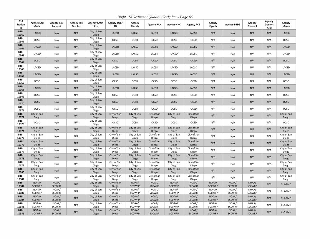
Bight ‘18 Sediment Quality Workplan - Page 65 B18
Station ID
Agency Sed Grab
Agency Tox Eohaust
Agency Tox Mytilus
Agency Grain Size
Agency TOC/ TN
Agency Metals Agency PAH Agency CHC Agency PCB Agency
Pyreth Agency PBDE Agency Fiproynl
Agency Domoic
Acid
Agency Infauna
B18-10360 LACSD N/A N/A City of San
Diego LACSD LACSD LACSD LACSD LACSD N/A N/A N/A N/A LACSD
B18-10361 OCSD N/A N/A City of San
Diego OCSD OCSD OCSD OCSD OCSD N/A N/A N/A N/A OCSD
B18-10362 LACSD N/A N/A City of San
Diego LACSD LACSD LACSD LACSD LACSD N/A N/A N/A N/A LACSD
B18-10363 LACSD N/A N/A City of San
Diego LACSD LACSD LACSD LACSD LACSD N/A N/A N/A N/A LACSD
B18-10364 OCSD N/A N/A City of San
Diego OCSD OCSD OCSD OCSD OCSD N/A N/A N/A N/A OCSD
B18-10365 LACSD N/A N/A City of San
Diego LACSD LACSD LACSD LACSD LACSD N/A N/A N/A N/A LACSD
B18-10366 LACSD N/A N/A City of San
Diego LACSD LACSD LACSD LACSD LACSD N/A N/A N/A N/A LACSD
B18-10367 OCSD N/A N/A City of San
Diego OCSD OCSD OCSD OCSD OCSD N/A N/A N/A N/A OCSD
B18-10368 LACSD N/A N/A City of San
Diego LACSD LACSD LACSD LACSD LACSD N/A N/A N/A N/A LACSD
B18-10369 OCSD N/A N/A City of San
Diego OCSD OCSD OCSD OCSD OCSD N/A N/A N/A N/A OCSD
B18-10370 OCSD N/A N/A City of San
Diego OCSD OCSD OCSD OCSD OCSD N/A N/A N/A N/A OCSD
B18-10371 OCSD N/A N/A City of San
Diego OCSD OCSD OCSD OCSD OCSD N/A N/A N/A N/A OCSD
B18-10372
City of San Diego N/A N/A City of San
Diego City of San
Diego City of San
Diego City of San
Diego City of San
Diego City of San
Diego N/A N/A N/A N/A City of San Diego
B18-10373 OCSD N/A N/A City of San
Diego OCSD OCSD OCSD OCSD OCSD N/A N/A N/A N/A OCSD
B18-10374
City of San Diego N/A N/A City of San
Diego City of San
Diego City of San
Diego City of San
Diego City of San
Diego City of San
Diego N/A N/A N/A N/A City of San Diego
B18-10375
City of San Diego N/A N/A City of San
Diego City of San
Diego City of San
Diego City of San
Diego City of San
Diego City of San
Diego N/A N/A N/A N/A City of San Diego
B18-10376
City of San Diego N/A N/A City of San
Diego City of San
Diego City of San
Diego City of San
Diego City of San
Diego City of San
Diego N/A N/A N/A N/A City of San Diego
B18-10377
City of San Diego N/A N/A City of San
Diego City of San
Diego City of San
Diego City of San
Diego City of San
Diego City of San
Diego N/A N/A N/A N/A City of San Diego
B18-10378
City of San Diego N/A N/A City of San
Diego City of San
Diego City of San
Diego City of San
Diego City of San
Diego City of San
Diego N/A N/A N/A N/A City of San Diego
B18-10379
City of San Diego N/A N/A City of San
Diego City of San
Diego City of San
Diego City of San
Diego City of San
Diego City of San
Diego N/A N/A N/A N/A City of San Diego
B18-10380
City of San Diego N/A N/A City of San
Diego City of San
Diego City of San
Diego City of San
Diego City of San
Diego City of San
Diego N/A N/A N/A N/A City of San Diego
B18-10381
City of San Diego N/A N/A City of San
Diego City of San
Diego City of San
Diego City of San
Diego City of San
Diego City of San
Diego N/A N/A N/A N/A City of San Diego
B18-10382
NOAA/ SCCWRP
NOAA/ SCCWRP N/A City of San
Diego City of San
Diego NOAA/
SCCWRP NOAA/
SCCWRP NOAA/
SCCWRP NOAA/
SCCWRP NOAA/
SCCWRP NOAA/
SCCWRP NOAA/
SCCWRP N/A CLA-EMD
B18-10383
NOAA/ SCCWRP
NOAA/ SCCWRP N/A City of San
Diego City of San
Diego NOAA/
SCCWRP NOAA/
SCCWRP NOAA/
SCCWRP NOAA/
SCCWRP NOAA/
SCCWRP NOAA/
SCCWRP NOAA/
SCCWRP N/A CLA-EMD
B18-10384
NOAA/ SCCWRP
NOAA/ SCCWRP N/A City of San
Diego City of San
Diego NOAA/
SCCWRP NOAA/
SCCWRP NOAA/
SCCWRP NOAA/
SCCWRP NOAA/
SCCWRP NOAA/
SCCWRP NOAA/
SCCWRP N/A CLA-EMD
B18-10385
NOAA/ SCCWRP
NOAA/ SCCWRP N/A City of San
Diego City of San
Diego NOAA/
SCCWRP NOAA/
SCCWRP NOAA/
SCCWRP NOAA/
SCCWRP NOAA/
SCCWRP NOAA/
SCCWRP NOAA/
SCCWRP N/A CLA-EMD
B18-10386
NOAA/ SCCWRP
NOAA/ SCCWRP N/A City of San
Diego City of San
Diego NOAA/
SCCWRP NOAA/
SCCWRP NOAA/
SCCWRP NOAA/
SCCWRP NOAA/
SCCWRP NOAA/
SCCWRP NOAA/
SCCWRP N/A CLA-EMD

Bight ‘18 Sediment Quality Workplan - Page 66 B18
Station ID
Agency Sed Grab
Agency Tox Eohaust
Agency Tox Mytilus
Agency Grain Size
Agency TOC/ TN
Agency Metals Agency PAH Agency CHC Agency PCB Agency
Pyreth Agency PBDE Agency Fiproynl
Agency Domoic
Acid
Agency Infauna
B18-10387
NOAA/ SCCWRP
NOAA/ SCCWRP N/A City of San
Diego City of San
Diego NOAA/
SCCWRP NOAA/
SCCWRP NOAA/
SCCWRP NOAA/
SCCWRP NOAA/
SCCWRP NOAA/
SCCWRP NOAA/
SCCWRP N/A CLA-EMD
B18-10388
NOAA/ SCCWRP
NOAA/ SCCWRP N/A City of San
Diego City of San
Diego NOAA/
SCCWRP NOAA/
SCCWRP NOAA/
SCCWRP NOAA/
SCCWRP NOAA/
SCCWRP NOAA/
SCCWRP NOAA/
SCCWRP N/A OCSD
B18-10389
NOAA/ SCCWRP
NOAA/ SCCWRP N/A City of San
Diego City of San
Diego NOAA/
SCCWRP NOAA/
SCCWRP NOAA/
SCCWRP NOAA/
SCCWRP NOAA/
SCCWRP NOAA/
SCCWRP NOAA/
SCCWRP N/A OCSD
B18-10390
NOAA/ SCCWRP
NOAA/ SCCWRP N/A City of San
Diego City of San
Diego NOAA/
SCCWRP NOAA/
SCCWRP NOAA/
SCCWRP NOAA/
SCCWRP NOAA/
SCCWRP NOAA/
SCCWRP NOAA/
SCCWRP N/A OCSD
B18-10391
NOAA/ SCCWRP
NOAA/ SCCWRP N/A City of San
Diego City of San
Diego NOAA/
SCCWRP NOAA/
SCCWRP NOAA/
SCCWRP NOAA/
SCCWRP NOAA/
SCCWRP NOAA/
SCCWRP NOAA/
SCCWRP N/A OCSD
B18-10392
NOAA/ SCCWRP
NOAA/ SCCWRP N/A City of San
Diego City of San
Diego NOAA/
SCCWRP NOAA/
SCCWRP NOAA/
SCCWRP NOAA/
SCCWRP NOAA/
SCCWRP NOAA/
SCCWRP NOAA/
SCCWRP N/A City of San Diego
B18-10393
NOAA/ SCCWRP
NOAA/ SCCWRP N/A City of San
Diego City of San
Diego NOAA/
SCCWRP NOAA/
SCCWRP NOAA/
SCCWRP NOAA/
SCCWRP NOAA/
SCCWRP NOAA/
SCCWRP NOAA/
SCCWRP N/A City of San Diego
B18-10394
NOAA/ SCCWRP
NOAA/ SCCWRP N/A City of San
Diego City of San
Diego NOAA/
SCCWRP NOAA/
SCCWRP NOAA/
SCCWRP NOAA/
SCCWRP NOAA/
SCCWRP NOAA/
SCCWRP NOAA/
SCCWRP N/A City of San Diego
B18-10395
NOAA/ SCCWRP
NOAA/ SCCWRP N/A City of San
Diego City of San
Diego NOAA/
SCCWRP NOAA/
SCCWRP NOAA/
SCCWRP NOAA/
SCCWRP NOAA/
SCCWRP NOAA/
SCCWRP NOAA/
SCCWRP N/A City of San Diego
B18-10396
NOAA/ SCCWRP
NOAA/ SCCWRP N/A City of San
Diego City of San
Diego NOAA/
SCCWRP NOAA/
SCCWRP NOAA/
SCCWRP NOAA/
SCCWRP NOAA/
SCCWRP NOAA/
SCCWRP NOAA/
SCCWRP N/A City of San Diego
Table C2. Fish Tissue Laboratory Assignments
Laboratory Fish Tissue DDT Fish Tissue Total Mercury Fish Tissue PCBs Fish Tissue Lipid Content Total # Samples Total # Samples Total # Samples Total # Samples
RHMP 75 75 75 75 City of San Diego 39 100 39 100 OCSD 60 60 60 60 OC Public Works 9 9 9 9 LACSD 30 30 30 30 CLA-EMD 70 70 70 70

Bight ‘18 Sediment Quality Workplan - Page 67
APPENDIX D
Bight ‘18 Leveraged Studies

Bight ‘18 Sediment Quality Workplan - Page 68
Screening for Contaminants of Emerging Concern in Southern California Bight Lead investigators: Alvine Mehinto, Keith Maruya and Bowen Du Background: Contaminants of emerging concern (CECs) represent a broad category of chemicals including natural and synthetic hormones, current use pesticides, personal care products, pharmaceuticals and their metabolites, and disinfection by-products, that are increasingly found in freshwater and marine aquatic ecosystems. In recent years, the California State Water Board has invested in the development of novel monitoring technologies for CECs. Using guidance from an expert panel, two technologies known as cell assay “bioscreening” and non-targeted analyses, were identified as promising monitoring tools. Cell assays provide an integrative measure of CECs acting via a common mode of action and offer a rapid and efficient way to screen for both known and unknown chemicals that can be linked to a toxic effect. Non-targeted chemical analysis has also emerged as a means for identifying previously unknown CECs in complex mixtures that show bioscreening responses, and for characterizing unique fingerprints that can be linked to a source of contamination. The Southern California Bight Regional Monitoring Program already measures numerous physical, chemical and biological parameters on any given sample. Application of bioscreening and non-targeted chemical analyses will help us determine how these techniques can enhance current monitoring practices. Statement of Problem: Assessing the impact of CECs in the aquatic environment is challenging due to the ever-changing universe of chemicals found in receiving waters, their occurrence and potential for deleterious effects at exceedingly low concentrations, and a lack of standardized analytical methods. Moreover, current chemical-specific analyses conducted during established monitoring programs such as Bight do not address unexpected and/or unknown substances (e.g. drug metabolites, disinfection by-products). Coupling bioscreening tools with non-targeted analysis has the potential to enhance current monitoring by broadening the chemical universe under investigation while improving our ability to identify and prioritize CECs that are most likely to impact aquatic ecosystem health. Objectives: The overall goal of this study is to screen for CECs occurring in coastal and marine environments. The specific questions addressed in this study are:
1. What is the extent and magnitude of cell assay responses in sediments from the Southern California Bight?
2. What is the extent and magnitude of cell assay responses in sportfish from the Southern California Bight?
3. Are there habitat-specific chemical fingerprints in sediments from the Bight? 4. Can cell assay responses be correlated with targeted and non-targeted chemistry data?
Bight ‘18 Sediment Quality Workplan - Page 69
Approach Task 1 – Sample collection and processing. Sediment (n=50-60) and fish tissue samples (n=30-45) that represent a broad range of anticipated CEC exposure will be selected from the more than 300 sediment and 100 tissue samples collected from various coastal and offshore habitats as part of Bight’18. Organic extracts of the selected sediment samples will be obtained from participating chemistry labs and further processed for bioanalytical and non-targeted analyses. Task 2 – Bioanalytical screening. Sample extracts will be analyzed using protocols standardized by SCCWRP and collaborators for 3 different cell assay endpoints: 1) estrogen receptor (ER), 2) anti-androgen receptor (anti-AR), and 3) aryl hydrocarbon receptor (AhR) activities. Validation of results will be performance-based, including generation of multi-point calibration curves using assay-specific reference chemicals, controls to correct for bioassay artifacts, and matrix spike recovery of a known bioactive compound. Results will be expressed as a bioassay equivalent concentration (BEQ), in units of ng/g, relative to the reference chemical. Task 3 – Non-targeted analyses. A subset of sediment sample extracts screened in Task 2 will be selected for non-targeted chemical analysis. To evaluate the utility of these tools, samples exhibiting a wide range of bioactivity will be preferred. Selected extracts will be analyzed using quadrupole-time of flight mass spectrometry (Q-TOF) coupled with liquid chromatography (LC) and/or gas chromatography (GC) to maximize the universe of CECs detectable. Comparative fingerprinting analysis of CECs detected across habitats will be performed. Products: As one of the first, large scale evaluations of novel screening tools for CECs, this project will inform the water quality and resource management communities on the extent and severity of CEC exposure and potential for impacts in coastal and marine habitats of the Southern California Bight. The data generated with also complement and assist in the interpretation of data collected on contaminant exposure, accumulation and effects as part of the core Bight’18 effort. A detailed write-up of methods, results, and conclusions; as well as graphical and tabular summaries of the data, will be provided as an Appendix in the Bight’ 18 Chemistry Report. The findings will also be published in a peer-reviewed journal.

Bight ‘18 Sediment Quality Workplan - Page 70
SEDIMENT TRANSPORT Lead Investigator: Jonathon Warrick, US Geological Survey Background The Bight Program has been answering questions about the extent and magnitude of sediment quality for nearly 25 years. Most frequently the results of the Bight Programs suggest good sediment quality; however, when sediment quality is impacted, managers typically ask what and where is the source of the sediment contamination. Unfortunately, sediment fate and transport is not well known at regional scales within the Bight. Localized studies of contaminated sediment transport have been conducted in places such as the Palos Verdes Shelf and San Pedro Bay. Yet large-scale sediment transport across the continental borderlands remains unquantified. Objective This leveraged study will develop a better understanding of the transport and fate of sediment across the Bight using an existing understanding of the physical and geological setting. The study area includes the continental shelf, slope and basin regions of the Bight deeper than 10 m. This evaluation will be conducted through a synthesis of existing information to assess the relative frequency and direction of sediment transport. Tasks This project will compile data from four sources that characterize sediment transport processes in the Bight. The data will be used to create a simple model of sediment transport direction and magnitude. Task 1: Sediment mobility from waves. Ocean waves are the primary means of suspending
sediment on the continental shelf, and thus are directly related to sediment transport in these settings. The wave patterns within the Bight are complex owing to the offshore islands, complex shelf and shoreline patterns, and the meteorological conditions that cause waves. To better understand the spatial and temporal variability of wave-suspension of sediment, an exercise will be conducted similar to Storlazzi and Reid (2010, Continental Shelf Research. 30:1582-1599) that will link existing wave models from SWAN, existing sediment grain size assessments from usSEABED, and sediment suspension assessments from standard sediment transport formulations.
Task 2: Sediment mobility from biological processes. Benthic organisms actively mix and suspend sediment and can be an important process in the movement of sediment in the Bight. A subgroup of study members will review and synthesize the types of benthic communities in the Bight and the processes and rates of sediment suspension produced by these communities. These factors will be integrated into the total sediment mobility assessment.
Task 3: Sediment transport pathways from currents. Pathways of sediment are dictated primarily by the direction of ocean currents near the seafloor. These near-bed currents can be different in magnitude and direction from overlying surface water currents. Existing

Bight ‘18 Sediment Quality Workplan - Page 71
numerical models of the Bight (UCLA ROMS) will be used to characterize the patterns of near-bed currents to better constrain sediment transport directions in space and time.
Task 4: Sediment transport down steep slopes. Where seafloor slope is adequately steep,
suspended sediment can flow downslope from gravity-driven processes. These are important sediment transport pathways in regions such as submarine canyons. These areas will be mapped using newly acquired bathymetric maps of the Bight.
Products The forcing elements characterized in Tasks 1 – 4 will be combined and synthesized using sediment transport ‘rules’. The rules will be defined by a project subcommittee, informed by the scientific literature, then calibrated and validated using Bight grain size measurements. Results will be synthesized in a geographical information system (GIS) and presented in a series of maps showing the relative frequency of transport and the dominant directions of transport. The project will be written as an appendix to the sediment chemistry report to help interpret sediment chemistry spatial magnitude findings. The project will also be submitted to a peer-reviewed journal for publication.

Bight ‘18 Sediment Quality Workplan - Page 72
Characterizing Meiofaunal Assemblages in the Southern California Bight
Project Lead: Holly Bik (UC Riverside)
Background: Benthic meiofaunal species (organisms 45µm–1mm, including nematodes, copepods, tardigrades, other “minor” metazoan phyla, protists, fungi, and eggs/larval stages of larger species) are abundant and ubiquitous in marine sediment habitats, performing key functions such as nutrient cycling and sediment stability (Snelgrove & Butman 1994). Yet, their unexplored diversity represents one of the major challenges in biology and currently limits our capacity to understand, mitigate and remediate the consequences of environmental change. Meiofaunal assemblages have been poorly characterized in Southern California sediments (Hooge 1999), and there is a critical need for baseline data on the abundance, richness, and structure of these communities.
Statement of Problem: Comprehensive data on the composition of meiofaunal assemblages in coastal California sediments would be particularly valuable for tracking both long-term environmental change and the effects of acute localized disturbance. The abundance, biomass, and community structure of sediment infaunal communities in general exhibit tight correlations to sediment properties such as grain size, organic content, and sediment stability (e.g., Snelgrove & Butman 1994), and thus reflect hydrodynamic processes and organic inputs from the overlying water column. Chronically polluted sites may also maintain distinct communities, with long-term exposure reducing both taxonomic richness and trophic diversity (with consequences for ecosystem function; Wang et al. 2009). The Bight 2018 survey offers an unprecedented opportunity for generating a comprehensive baseline dataset of benthic meiofaunal assemblages in Southern California; associated environmental and macrofauna data will facilitate robust assessment of the environmental drivers of meiofaunal community structure and function.
Objectives: The primary objective of this study is to generate a comprehensive baseline dataset of benthic meiofaunal species assemblages in the Southern California Bight, using a combination of environmental “-omics” approaches and traditional morphological taxonomy. Specific study objectives are as follows:
1. Determine how the diversity and structure of meiofaunal assemblages in Southern California estuaries relates to sediment properties (e.g. organic matter content, grain size, chemical profiles) and salinity levels (e.g. euhaline, polyhaline, mesohaline).
2. Identify meiofaunal community changes along gradients of stress (e.g., increasing levels of trace metals, legacy pesticides, emerging contaminants), with the goal of identifying meiofaunal “indicator taxa” in sites with high pollution loads.
3. Compare meiofaunal results with standard Bight survey approaches (e.g. macrofaunal data), to assess the complementary information that can be gained about ecosystem health and function.
4. Compare the utility of morphological taxonomy versus DNA metabarcoding for generating a comprehensive survey of benthic meiofaunal assemblages in the Southern California Bight.

Bight ‘18 Sediment Quality Workplan - Page 73
5. Developing Standard Operating Procedures (SOPs) for meiofauna sampling as well as paving the way for using meiofauna assemblages as an environmental assessment tool in the Southern California Region
Task 1: Sample Collection and Processing. Sediment samples will be collected at Bight survey stations using Van Veen grabs (offshore sites) or push cores by hand (shore-based sampling). Fresh sediment will be transferred into Whirl-Paks or Ziploc bags and kept cool on ice or frozen immediately on dry ice upon collection. Frozen/chilled cores will be transferred into long-term storage at -80°C and subsequently transferred to UC Riverside for further processing. Meiofaunal organisms will be extracted from sediments using standard taxonomic protocols that involve flotation and decantation over a 45µm sieve (Danovaro 2010).
Task 2: Environmental Metabarcoding: For the environmental metabarcoding approach (Figure 2), we will carry out DNA extractions on extracted meiofauna fractions followed by amplification of a ~400bp fragment of the 18S ribosomal RNA gene (F04/R22 primers amplifying the V1/V2 region; Creer et al. 2010). This primer set is effective over a broad taxonomic range (amplification of >20 metazoan phyla, as well as fungi, algae, and protists), and has been extensively tested and validated for metabarcoding studies of meiofauna. Metabarcoding PCR libraries will be cleaned, pooled, and sequenced on the Illumina MiSeq Platform (300bp Paired-End runs, enabling recovery of the entire 18S amplicon).
Task 3: Morphological Taxonomy and DNA barcoding of single meiofaunal specimens: For each sampling site, a subset of 30-100 individual meiofauna specimens will also be sorted, identified, and imaged under a high-power microscope, followed by DNA extraction and DNA barcoding of selected specimens to generate a full-length 18S rRNA barcode for the most abundant Bight meiofaunal species (~1600bps generated via Sanger sequencing, amplified using primer sets in Bik et al. 2010).
Task 4: Bioinformatics and Statistical Analysis: Morphological taxonomy data, DNA barcoding, and environmental metabarcoding datasets will be carried out in appropriate software pipelines such as QIIME, R Studio, and PRIMER-E. Alpha- and Beta-diversity analyses will be carried out to assess spatial and depth-related patterns of species richness and community structure, and identify potential environmental and biological drivers of meiofaunal assemblage structure. Phylogenetic analyses will be additionally carried out on DNA datasets to identify potential cryptic diversity amongst meiofaunal morphospecies, and assess biogeographic break points in the Southern California Bight.
Products: Products from this leveraged study will include peer-reviewed scientific publications, a reference database of key Bight meiofaunal species (morphological identifications and reference DNA barcodes generated from individual specimens), high-throughput environmental metabarcoding datasets (datasets of Operational Taxonomic Units and their geographic distribution), as well as formal SOPs detailing meiofaunal sampling protocols and data collection/analysis procedures. We anticipate a minimum of two manuscripts resulting from this leveraged study, one focused on phylogeographic patterns for Bight meiofaunal species, and a second manuscript focusing on environmental drivers of community structure (sediment grain size, salinity, pollutant levels, etc.).

Bight ‘18 Sediment Quality Workplan - Page 74
References
Bik HM, Lambshead PJD, Thomas WK, Lunt DH. (2010) Moving towards a complete molecular framework of the Nematoda: a focus on the Enoplida and early-branching clades. BMC Evol Biol 10:353
Creer S, Fonseca VG, Porazinska DL, Giblin-Davis RM, Sung W, et al. (2010) Ultrasequencing of the meiofaunal biosphere: practice, pitfalls and promises. Mol Ecol, 19:4-20
Danovaro, R (2010) Methods for the study of deep-sea sediments, their functioning and biodiversity. CRC Press, Boca Raton, FL, 428 pp.
Hooge M (1999) Abundance and horizontal distribution of meiofauna on a Northern California beach. Pacific Science, 53(3):305-315
Snelgrove PVR, Butman CA (1994) Animal-sediment relationships revisited: Cause versus effect. Oceanogr Mar Biol Annu Rev, 32:111-177
Wang Y, Chen H, Wu J (2009) Influences of chronic contamination of oil field exploitation on soil nematode communities at the Yellow River Delta of China. Front Biol China, 4:376-383.

Bight ‘18 Sediment Quality Workplan - Page 75
CA Halibut Juvenile Index of Abundance, and Age at Length Relationships
Project Leads: Miranda Haggerty
Background: The California Halibut (CH), Paralichthys californicus, has been a valuable commercial and recreational fishery for over a century. Currently the Southern California portion of the CH stock is considered depressed, estimated at 14 % of historic levels in Southern California (Maunder et al. 2011). Despite low catch levels and the depressed stock estimation, CH biomass may have the capacity to increase in a short time frame with favorable environmental conditions. Like many warm temperate fishes in the Southern California Bight (SCB), CH reproductive potential should increase during seasons with warmer than average water conditions. As the cooler Pacific Decadal Oscillation cycle ends and waters warm, there is evidence of increasing juvenile CH abundance with the ratio of released/kept CH increasing from 2015 to 2017 for private/rental boats and party/charter boats in southern CA. Developing a fishery-independent index of juvenile CH abundance will be used to inform management on the status of the resource, establishing expectations for recruitment to the fishery in Southern California and address biological data gaps for future stock assessments. The CDFW has conducted similar trawl surveys in the past which offers a unique dataset for comparison to the proposed study. Statement of Problem: Age at length relationships across a species distribution are an important component of fishery assessments. Due to resource limitations there is currently a data gap for sublegal sized CH in southern CA. As well as age and length, identification of sex is needed to assess gender ratios and gender specific growth rates. There are currently no fishery independent assessments of CH status in Southern California. To assess current populations and the potential for an increase in recruitment with long term oscillation in ocean temperatures, a plan is being implemented to tag and recapture CH. Collaboration with the California Bight 2018 Monitoring Program will maximize tagging/recapture events and minimize mortality of CH by providing samples that have died or already been sacrificed as part of Bight Program protocols. Objectives: The objectives of this study are to collect samples to supplement the age at length relationship for southern CA CH and to contribute to CDFW’s fishery independent assessments of CH by enumerating and tagging juvenile CH. This will aid in answering two primary questions:
1. What is the age, length and sex composition of sublegal CH from various locations in San Diego County and the SCB?
2. What is the relative juvenile abundance of CH across embayments and shallow coastal sites across the SCB, and how has this changed over time?
Task 1: CA Halibut Sample Collection. Fish will be collected from benthic trawls across the various preselected Bight’18 strata. It can be expected that CH will primarily be caught in embayment strata including marinas, ports, and bays/harbors, as well as the shallowest offshore strata, primarily inner shelf (5 to 30 m). From these strata, CH that are sacrificed for bioaccumulation sampling (primarily San Diego locations) will be provided to CDFW for otolith

Bight ‘18 Sediment Quality Workplan - Page 76
extraction and sexing. Additionally any CH caught in trawls that are in poor condition and unlikely to survive if released should be retained to contribute to the ongoing age/growth study.
Otoliths, along with corresponding length (mm) and sex data will be sent to the Northern and Central California Finfish Research and Management Project (NCCFRMP) based out of Monterey, CA for processing and aging. NCCFRMP has an ongoing age/length study for CA Halibut but due to logistical difficulties sampling across the SCB, opportunities have been limited.
Task 2: Tagging CA Halibut. For CDFW’s fishery independent assessments of CH, we are beginning a juvenile CH mark-recapture monitoring study in the spring of 2018 to evaluate juvenile distribution, abundance, and estimate the expected contribution from various habitats to the CH fishery. Trawling locations will vary from Oceanside to Los Angeles, covering the various embayment and shallow coastal habitats that juvenile CH (50-250 mm) rely upon. A scientific aid and/or environmental scientist will assist with trawling at the Bight’18 trawl locations that overlap with this monitoring study to ensure previously tagged CH are released as well as tag and release all untagged CH.
At other trawl locations, PIT tagging supplies and a tag reader can be provided. Biologists can scan all CH to identify tagged individuals, record their tag number, location and size, and return them back to the water. If there is time and interest, untagged CH can also be tagged before release. These data will be input into the mark-recapture model to aid in informing relative abundance and population growth.
Products: The primary products that will be provided for the Bight ’18 trawl report include an age/length curve and a table describing gender specific age composition across the geographical sampling area. The secondary product is dependent upon whether tagged CH are recaptured during the trawl surveys or new CH are tagged to contribute to the ongoing monitoring study. A table summarizing any tagged or recaptured CH and model of expected fishery contributions by each habitat type can be provided. As the mark- recapture is a long term monitoring study, conclusions of how tagged individuals contributed to the larger index of relative abundance may not be apparent for several monitoring seasons.