road map for making kathmandu valley development...
TRANSCRIPT

Road Map for Making Kathmandu Valley
Development Concept Plan Risk
Sensitive: Frameworks and Processes
May 29, 2012
Nepal
United Nations Development Programme (UNDP),
Nepal
Comprehensive Disaster Risk Management
Programme

Technical Services for Strengthening Risk Sensitive Land Use Planning and Implementation (RSLUP) in NepalRoad Map for Making Kathmandu Valley Development Concept Plan Risk Sensitive: Frameworks and Processes
Technical Services for Strengthening Risk Sensitive Land Use Planning and Implementation (RSLUP) in Nepal
Road Map for Making Kathmandu Valley Development Concept Plan Risk Sensitive: Frameworks and Processes
Submitted to:
UNDP Nepal
Prepared by:
Earthquakes and Megacities Initiative National Society for Earthquake Technology-Nepal (NSET)
May 2012
Technical Services for Strengthening Risk Sensitive Land Use Planning and
Road Map for Making Kathmandu Valley Development Concept
Earthquakes and Megacities Initiative
National Society for Earthquake Nepal (NSET)

COPYRIGHT INFORMATION
The document is a product of the Strengthening Risk Sensitive Land Use Planning and
Implementation (RSLUP) in Nepal project. The content of the document is jointly owned by
the Earthquakes and Megacities Initiative (EMI) and the National Society of Earthquake
Technology (NSET), Nepal and as such indicated: Copyright© 2012 EMI and NSET
Concepts, methods, data and tools (e.g. mainstreaming approach, risk sensitive land use
planning model and others) used in the document and originally owned by the Earthquakes
and Megacities Initiative (EMI) prior to the project, are and remain the sole intellectual
property of EMI as indicated in EMI’s prior documents, reports, and internal communication.

ABOUT THE DOCUMENT
This document is the main component of the Deliverable 2: Framework for RSLU Planning
of the project. The document acts as a guide for the Kathmandu Valley ministries and
municipalities in formulating their risk sensitive land use plans. A detailed summary of the
document is provided in the Executive Summary.
Contributors
EMI
Fouad Bendimerad, Ph.D., P.E., Seismology and Earthquake Risk Expert
Renan Tanhueco, Ph.D., Urban and Regional Land Use Planning Expert
Mr. Jerome Zayas, Task Manager
Mr. Moses Kent Borinaga, Project Coordinator
Mr. Jose Mari Daclan, Knowledge Management Specialist
Mr. Dominic Dizon, Training Specialist
Ms. Audrey Noeltner, Intern
Ms. Elsa Desmaison, Intern
NSET
Mr. Amod Mani Dixit, Senior Expert
Mr. Surya Bhakta Sangachhe, Task Manager
Mr. Surya Narayan Shrestha, Senior Expert
Mr. Ganesh Kumar Jimee, Junior Expert
Ms. Bhubaneswari Parajuli, Junior Expert
TABLE OF CONTENT
1 Background and Context ........................................................................................ 1
2 Summary of Analysis: Kathmandu Valley Development and Planning Context . 3
3 Recommendations .................................................................................................. 5
4 Way Forward ............................................................................................................ 6
1 Background and Rationale ..................................................................................... 8
2 Situational Analysis: Disasters in the Kathmandu Valley ................................. 14
2.1 Disaster Losses and Associated Risks ....................................................................... 15
2.2 Climate Change and Variability Impacts to Urban Settlements and Infrastructures ... 19
3 Vulnerability of Kathmandu Valley to Disasters .................................................. 20
3.1 Population and Social Aspects ................................................................................... 20
3.2 Building, Infrastructure &Transport related ................................................................. 23
4 The Kathmandu Valley Development Concept Plan: A Review and Gaps Analysis ................................................................................................................. 24
4.1 The KV Planning System ............................................................................................ 24
4.2 On Planning Structure ................................................................................................. 26
4.3 On KV Plan (KV Concept) and Planning Process ...................................................... 26
4.4 Gaps Analysis ............................................................................................................. 27
5 An Enabling Environment for KV 2020 ................................................................ 29
5.1 Key Policies ................................................................................................................. 29
5.2 Key National Policies .................................................................................................. 30
6 Enhancing the Capacity of the Valley Planning Structure .................................. 35
7 Framework for Making Kathmandu Valley Development Concept Plan Risk Sensitive ................................................................................................................ 36
7.1 Framework for Mainstreaming DRR ........................................................................... 36
7.2 Framework for Mainstreaming in Plans ...................................................................... 36
7.3 Mainstreaming Activities ............................................................................................. 38
7.4 Capacity building ......................................................................................................... 38
7.5 Enhanced Planning Steps ........................................................................................... 39
8 DRR related Implementation Tools ...................................................................... 43
8.1 Zoning ......................................................................................................................... 43
8.2 Safe Building By-Laws ................................................................................................ 43
8.3 Co-management ......................................................................................................... 44
8.4 Public Investment Programming ................................................................................. 44
8.5 Private Investments Incentives ................................................................................... 44
9 Way Forward: Completing the Risk Sensitive Kathmandu Valley Physical Framework Plan ..................................................................................................... 45
10 References ............................................................................................................. 47
Annexes ............................................................................................................................. 48
Annex 1. Earthquake .......................................................................................................................... 48
Annex 2. The Kathmandu Valley Development Concept of 2001:..................................................... 50
Annex 3. Kathmandu Valley Development Guiding Policies ............................................................. 52
Annex 4. General Settlements Policy ................................................................................................ 52
Annex 5. Urban expansion policy ...................................................................................................... 53
Annex 6. Urban Expansion Management Policies ............................................................................. 54
Annex 7. Housing Policy .................................................................................................................... 54
Annex 8. Infrastructures Policy .......................................................................................................... 54
Annex 9. Protection of Cultural Heritage and Landscapes ................................................................ 55
Annex 10. Environmental Policy .......................................................................................................... 55
Annex 11. Natural resources ................................................................................................................ 55
List of Figures
Figure 1. KMC Land Use Zoning Map in the KMC RSLUP ................................................................. 2
Figure 2. Sample of LUP Flier distributed as part of the awareness campaign ................................... 2
Figure 3. Model for Risk Sensitive Land Use Planning used for KMC .............................................. 12
Figure 4. Location Map ...................................................................................................................... 14
Figure 5. Identified Planning System at KV level ............................................................................... 25
Figure 6. Framework for Mainstreaming Disaster Risk Reduction (EMI, copyright) .......................... 36
Figure 7. Framework for Mainstreaming Disaster Risk Reduction in Land Use Planning (EMI, copyright) Note: Also presented in Figure 3 ..................................................................... 37
Figure 8. The Kathmandu Metropolitan City Sectoral Profile as a sample ........................................ 39
Figure 9. Proposed Activities and Timeline for the Completion of the Risk Sensitive Land Use Plan for the Kathmandu Valley ................................................................................................... 45
List of Tables
Table 1: Milestone in Integrating DRR and CCA into the Physical Development Process of Kathmandu Valley ................................................................................................................. 9
Table 2: Losses due to Earthquake in Kathmandu Valley, 1971-2011............................................. 15
Table 3: Loss estimation figures for mid-Nepal Earthquake (intensity IX MMI) ................................ 15
Table 4: Losses due to flood and landslide in Kathmandu Valley, 1971-2011 ................................. 17
Table 5: Losses due to fire in Kathmandu Valley, 1971-2011 .......................................................... 17
Table 6: Hazard Threats to the Population in Kathmandu Valley ..................................................... 18
Table 7: KATHMANDU VALLEY PLANNING SYSTEM ................................................................... 24

ACRONYMS
ADB Asian Development Bank
BM Bhaktapur Municipality
CBD Central Business District
CBOs Central Business Organizations
DRA Disaster Risk Assessment
DRRM Disaster Risk Reduction Management
DRMMP Disaster Risk Management Master Plan
DRR Disaster Risk Reduction
DUDBC Department of Urban Development and Building Construction
EMI Earthquakes and Megacities Initiative
FAR Floor Area Ratio
GIS Geographical Information System
GoN Government of Nepal
ICIMOD International Centre for Integrated Mountain Development
IEC Information and Education Campaign
IMP Integrated Master Plan
INGO International Non-government Organizations
IT Information Technology
IWO Implementation Work Output
JICA Japan International Cooperation Agency
KMC Kathmandu Metropolitan City
KVDA Kathmandu Valley Development Administration formerly the Kathmandu
Valley Town and Development Committee
LSGA Local Self Governance Act
LSMC Lalitpur Sub-Metropolitan City
mld million liters per day
MMI Modified Mercalli Intensity
MOC Memorandum of Cooperation
MoEST Ministry of Environment, Science and Technology
MoHA Ministry of Home Affairs
MoLD Ministry of Local Development
MoLRM Ministry of Land Reform and Management
MoPPW Ministry of Physical Planning and Works
M-TM Madhyapur Thimi Municipality
NAPA National Adaptation Programme of Action to Climate Change

NGA Non-Governmental Agency
NGO Non-governmental Organization
NSDRM National Strategy for Disaster Risk Management
NSET National Society for Earthquake Technology
NWSC Nepal Water Supply Corporation
RSLUP Risk Sensitive Land Use Planning
UNDP United Nations Development Programme
UNEP United Nations Environment Programme
VDC Village Development Committee
WB World Bank
ACKNOWLEDGEMENT
A number of institutions and individuals have supported and contributed to the completion of
the Roadmap for Making Kathmandu Valley Development Concept Plan Risk Sensitive:
Frameworks and Processes. The Contributors are grateful for the valuable time, ideas and
resources invested by the following entities in support of the project:
• The United Nations Development Programme Nepal (UNDP-Nepal) for lending support
to the RSLUP review exercises;
• The participants of the Risk Sensitive Land Use Planning Blended Training Course for
the information and discussions from the submitted assignments and end of course
projects; and,
• The officials from Ministry of Physical Planning and Works (MoPPW), Ministry of Local
Development (MoLD), Department of Urban Development and Building Construction
(DUDBC) and other Government Agencies and Local Governments in Nepal for sharing
their insights in the Closing Ceremonies of the RSLUP blended training course held at the
Kumari Hall, Annapurna Hotel, Kathmandu City on April 29, 2012.

Technical Services for Strengthening Risk Sensitive Land Use Planning and Implementation (RSLUP) in NepalRoad Map for Making Kathmandu Valley Development Concept Plan Risk Sensitive: Frameworks and Processes
Prepared jointly by: EMI & NSET
FRAMEWORK FOR MAKING KATHMANDU VALCONCEPT PLANRISK SEN
1 BACKGROUND AND CONTE
This document provides a roadmap on how the Kathmandu Valley (KV) Development
Concept published in 2001 can be made risk sensitive. In view of the need i
Government of Nepal to integrate disaster risk concerns in the development planning process
and land use plans of the Kathmandu Valley, this review looks into the planning process and
outputs at the Valley level, and assesses the various a
disaster risk reduction (and climate change and variability risk aspects) may be introduced to
make the KV Development Concept Plan (KV 2020 Plan) risk sensitive and supportive of the
sustainable development envisioned i
documentation of the planning exercise and outputs of the endorsed KV Development
Concept Plan because it informs on the process of planning at KV level, the stakeholders
involved in plan formulation and validatio
Kathmandu Valley. The information on the planning process was partly augmented from
input provided by the
interviews and questionnaire surveys developed by
(EMI) and National Society for Earthquake Technology
The formulation of this road map and the suggested frameworks and processes were built
upon the prior experiences of EMI in crafting the Kathmandu Metropoli
Management Master Plan (KMC DRMMP) 2005
Use Plan (KMC RSLUP) 2008
in the KMC RSLUP project, funded by the
the Deutches Komitee Katas
DRR in plans was introduced
vulnerability and (disaster) risk assessment (HVRA) and mitigation elements
use planning by: (a) using available
utilizing the findings and results of the
including emergency management parameters (e.g., evac
series of disaster risk reduction strategies and actions in the land use planning practice. Three
other related documents were
Ordinance, KMC Socio
presents an example of an output produced in the KMC RSLUP in terms of the Land Use
Zoning Map.
1 The name was recently changed to Kathmandu Valley
Technical Services for Strengthening Risk Sensitive Land Use Planning and Implementation (RSLUP) in NepalMap for Making Kathmandu Valley Development Concept Plan Risk Sensitive: Frameworks and Processes
MAKING KATHMANDU VALLEYDEVELOPMENT CONCEPT PLANRISK SENSITIVE
EXECUTIVE SUMMARY
BACKGROUND AND CONTEXT
This document provides a roadmap on how the Kathmandu Valley (KV) Development
Concept published in 2001 can be made risk sensitive. In view of the need i
Government of Nepal to integrate disaster risk concerns in the development planning process
and land use plans of the Kathmandu Valley, this review looks into the planning process and
outputs at the Valley level, and assesses the various aspects of its planning system where
disaster risk reduction (and climate change and variability risk aspects) may be introduced to
make the KV Development Concept Plan (KV 2020 Plan) risk sensitive and supportive of the
sustainable development envisioned in 2001. This document relied mainly on the
documentation of the planning exercise and outputs of the endorsed KV Development
Concept Plan because it informs on the process of planning at KV level, the stakeholders
involved in plan formulation and validation, and the policy framework for developing
Kathmandu Valley. The information on the planning process was partly augmented from
input provided by the Kathmandu Valley Town Development Committee
interviews and questionnaire surveys developed by Earthquakes and Megacities Initiative
National Society for Earthquake Technology (NSET).
The formulation of this road map and the suggested frameworks and processes were built
upon the prior experiences of EMI in crafting the Kathmandu Metropolitan City Disaster Risk
Management Master Plan (KMC DRMMP) 2005-2006, and the KMC Risk Sensitive Land
Use Plan (KMC RSLUP) 2008-2010, with KMC, NSET and other local stakeholders. It was
in the KMC RSLUP project, funded by the German Federal Foreign Affairs
the Deutches Komitee Katastrophenvorsorge (DKKV), that the concept of mainstreaming
DRR in plans was introduced. These activities included the integrat
vulnerability and (disaster) risk assessment (HVRA) and mitigation elements
by: (a) using available seismic, flood, fire hazard and risk information, especially
findings and results of the 2002 JICA Earthquake study (not updated); (b)
including emergency management parameters (e.g., evacuation roads), and (c) prescribing a
series of disaster risk reduction strategies and actions in the land use planning practice. Three
other related documents were completed as part of the KMC RSLUP:
Ordinance, KMC Socio-Economic Profile and KMC Emergency Operations
presents an example of an output produced in the KMC RSLUP in terms of the Land Use
The name was recently changed to Kathmandu Valley Development Administration
Technical Services for Strengthening Risk Sensitive Land Use Planning and Implementation (RSLUP) in Nepal Map for Making Kathmandu Valley Development Concept Plan Risk Sensitive: Frameworks and Processes 1
LEYDEVELOPMENT
This document provides a roadmap on how the Kathmandu Valley (KV) Development
Concept published in 2001 can be made risk sensitive. In view of the need identified by the
Government of Nepal to integrate disaster risk concerns in the development planning process
and land use plans of the Kathmandu Valley, this review looks into the planning process and
spects of its planning system where
disaster risk reduction (and climate change and variability risk aspects) may be introduced to
make the KV Development Concept Plan (KV 2020 Plan) risk sensitive and supportive of the
n 2001. This document relied mainly on the
documentation of the planning exercise and outputs of the endorsed KV Development
Concept Plan because it informs on the process of planning at KV level, the stakeholders
n, and the policy framework for developing
Kathmandu Valley. The information on the planning process was partly augmented from
Kathmandu Valley Town Development Committee (KVTDC)1 to
arthquakes and Megacities Initiative
The formulation of this road map and the suggested frameworks and processes were built
tan City Disaster Risk
2006, and the KMC Risk Sensitive Land
2010, with KMC, NSET and other local stakeholders. It was
German Federal Foreign Affairs Office through
(DKKV), that the concept of mainstreaming
integration of hazard,
vulnerability and (disaster) risk assessment (HVRA) and mitigation elements into local land
hazard and risk information, especially
Earthquake study (not updated); (b)
uation roads), and (c) prescribing a
series of disaster risk reduction strategies and actions in the land use planning practice. Three
: KMC Draft Zoning
Operations Plan. Figure 1
presents an example of an output produced in the KMC RSLUP in terms of the Land Use

2 Technical Services for Strengthening Risk Sensitive Land Use Planning and Implementation (RSLUP) in Nepal Road Map for Making Kathmandu Valley Development Concept Plan Risk Sensitive: Frameworks
Figure 1. KMC Land Use Zoning Map in the KMC RSLUP
Parallel to the development of the KMC RSLUP
were the conduct of awareness
by EMI and NSET through
and the dissemination of information, education
and communication (IEC) materials such as
posters and fliers (see Figures 2). These activities
helped improve understanding and support to the
KMC RSLUP by key stakeholders such as
government ministries and
It is important to note that, KMC
need to integrate its RSLUP
sensitive Kathmandu Valley physical framework
plan, which was not available at the time. KMC
RSLUP updating and completion is believed
hinge upon a KV physical framework.
year plan was proposed in the KMC RSLUP
document on how the KV plans and local land
use plans in the Valley can be made risk
sensitive.
Figure 2. Sample of LUP Flier distributed as part of the awareness campaign
Technical Services for Strengthening Risk Sensitive Land Use Planning and Implementation (RSLUP) in Nepal Road Map for Making Kathmandu Valley Development Concept Plan Risk Sensitive: Frameworks and Processes
Prepared
KMC Land Use Zoning Map in the KMC RSLUP
Parallel to the development of the KMC RSLUP
were the conduct of awareness raising activities
by EMI and NSET through public consultations
and the dissemination of information, education
and communication (IEC) materials such as
posters and fliers (see Figures 2). These activities
helped improve understanding and support to the
KMC RSLUP by key stakeholders such as
government ministries and donor organizations.
It is important to note that, KMC highlighted the
its RSLUP with a similarly risk
sensitive Kathmandu Valley physical framework
which was not available at the time. KMC
RSLUP updating and completion is believed to
KV physical framework. A three-
year plan was proposed in the KMC RSLUP
document on how the KV plans and local land
use plans in the Valley can be made risk
Sample of LUP Flier distributed as part of the awareness campaign
Technical Services for Strengthening Risk Sensitive Land Use Planning and Implementation (RSLUP) in Nepal
Prepared jointly by: EMI & NSET
KMC Land Use Zoning Map in the KMC RSLUP
Sample of LUP Flier distributed as part of the awareness campaign

Technical Services for Strengthening Risk Sensitive Land Use Planning and Implementation (RSLUP) in NepalRoad Map for Making Kathmandu Valley Development Concept Plan Risk Sensitive: Frameworks and Processes
Prepared jointly by: EMI & NSET
In the last quarter of 2011, under the UNDP
(CDRM) and the Flagship Programmes
endorse the 2010 KMC RSLUP
plan sensitive to risk came about. In December 2011, 2010 KMC RSLUP was endorsed by
selected stakeholders from the Valley. A few months later, this was approved for adoption
and implementation by the KMC Legislative Council, thus sanctioning an important
milestone in the adoption of risk
Building on all previous work, this document addresses the findings, gaps, strategies and
recommendations on how to make the KV2020 Plan and the future Physical Framework Plan
risk sensitive.
2 SUMMARY OF ANALYSISPLANNING CONTEXT
In brief, while the KV 2020 Plan did not address the
policies and strategies opted for the
policy areas: settlements, production, protection
supportive of risk reduction efforts
cored on five proactive policies in keeping
environment:
1. Environmental Protection and Management,
2. Better Urban Planning and Safer Urban Expansion and Management,
3. Better Enforcement of Building Codes and Bye Laws,
4. Improved Disaster Management
5. Improving Institutional Capacities for Planning and Enforcement.
These policies are strongly advocated
Disaster Risk Management
to Climate Change” (2009)
of KV 2020 with current available information on
the recent census information
gaps in information, processes, and tools in the KV 2020 Plan with respect to risk sensitive
parameters.
Hazards Information
One important parameter that the KV 2020
information that may guide urban expansion. New environmentally constrained areas may
need to be mapped as a result of the new information. Interviews and surveys with members
of Kathmandu Valley Development Ad
already pointed the following as necessary for updating the
• The disaster prone areas should be shown clearly in KV Plans;
• Physical infrastructure must be able to mitigate the effect of
• Areas for rescue and relief need to be identified and protected;
• Areas for future expansion of infrastructure need to be designated;
• Open spaces must be defined;
2 Formerly the Kathmandu Valley Town and Development Committee
Technical Services for Strengthening Risk Sensitive Land Use Planning and Implementation (RSLUP) in NepalMap for Making Kathmandu Valley Development Concept Plan Risk Sensitive: Frameworks and Processes
e last quarter of 2011, under the UNDP-run Comprehensive Disaster Risk Management
and the Flagship Programmes of Nepal, the opportunity to update,
endorse the 2010 KMC RSLUP, as well as developing a road map on how to make the KV
sensitive to risk came about. In December 2011, 2010 KMC RSLUP was endorsed by
selected stakeholders from the Valley. A few months later, this was approved for adoption
and implementation by the KMC Legislative Council, thus sanctioning an important
one in the adoption of risk-sensitive land use planning in the country.
Building on all previous work, this document addresses the findings, gaps, strategies and
recommendations on how to make the KV2020 Plan and the future Physical Framework Plan
SUMMARY OF ANALYSIS: KATHMANDU VALLEY DEVELOPMENT AND PLANNING CONTEXT
KV 2020 Plan did not address the particular hazards and risks in detail, the
policies and strategies opted for the sustainable development of KV in the
policy areas: settlements, production, protection, and infrastructural uses were found
supportive of risk reduction efforts. The development policies and strategies were strongly
cored on five proactive policies in keeping an orderly, safe, and balanced built and un
Environmental Protection and Management,
Better Urban Planning and Safer Urban Expansion and Management,
Better Enforcement of Building Codes and Bye Laws,
Improved Disaster Management, and
Improving Institutional Capacities for Planning and Enforcement.
strongly advocated in the Government of Nepal’s “National Strategy for
Disaster Risk Management” (2010) and “National Adaptation Programme of Action (NAPA)
(2009). However, there is a need to update the planning base information
of KV 2020 with current available information on hazards, vulnerabilities and risks and with
the recent census information. The following sub-sections explain the areas where ther
gaps in information, processes, and tools in the KV 2020 Plan with respect to risk sensitive
One important parameter that the KV 2020 Plan has yet to incorporate is the hazard risk
information that may guide urban expansion. New environmentally constrained areas may
need to be mapped as a result of the new information. Interviews and surveys with members
Kathmandu Valley Development Administration2 (KVDA), NSET, M
already pointed the following as necessary for updating the KV 2020Plan
The disaster prone areas should be shown clearly in KV Plans;
Physical infrastructure must be able to mitigate the effect of disasters;
Areas for rescue and relief need to be identified and protected;
Areas for future expansion of infrastructure need to be designated;
Open spaces must be defined;
Formerly the Kathmandu Valley Town and Development Committee
Technical Services for Strengthening Risk Sensitive Land Use Planning and Implementation (RSLUP) in Nepal Map for Making Kathmandu Valley Development Concept Plan Risk Sensitive: Frameworks and Processes 3
run Comprehensive Disaster Risk Management
update, validate, and
, as well as developing a road map on how to make the KV
sensitive to risk came about. In December 2011, 2010 KMC RSLUP was endorsed by
selected stakeholders from the Valley. A few months later, this was approved for adoption
and implementation by the KMC Legislative Council, thus sanctioning an important
sensitive land use planning in the country.
Building on all previous work, this document addresses the findings, gaps, strategies and
recommendations on how to make the KV2020 Plan and the future Physical Framework Plan
EVELOPMENT AND
particular hazards and risks in detail, the
sustainable development of KV in the different land use
and infrastructural uses were found to be
. The development policies and strategies were strongly
, and balanced built and un-built
Better Urban Planning and Safer Urban Expansion and Management,
National Strategy for
National Adaptation Programme of Action (NAPA)
update the planning base information
rabilities and risks and with
sections explain the areas where there are
gaps in information, processes, and tools in the KV 2020 Plan with respect to risk sensitive
lan has yet to incorporate is the hazard risk
information that may guide urban expansion. New environmentally constrained areas may
need to be mapped as a result of the new information. Interviews and surveys with members
, NSET, MoPPW, and MoLD
lan, among others:
disasters;

4 Technical Services for Strengthening Risk Sensitive Land Use Planning and Implementation (RSLUP) in Nepal Road Map for Making Kathmandu Valley Development Concept Plan Risk Sensitive: Frameworks
• Conflicts in sensitive areas (ex. encroachment in sensitive areas) must be identifi
addressed;
• Integration of KV Plan with Local Periodic Plans;
Updating hazards and exposure information appear critical for the Kathmandu Valley. The
succeeding process for detailing the spatial component of the
updating of the previous Earthquake Impact study made in 2002 and a review of the Flood
Study in 2009 and explained in terms of the following:
• Exposure and condition of settlements
• Exposure of condition production areas
• Exposure and condition of buildings and infrastr
• Exposure and condition of environmentally constrained areas
For the fire-related hazards, an updated inventory will help determine the places of highest
fire hazard risks.
Within the Kathmandu Valley, the risk reduction and emerg
municipalities, Village Development Committees (
area will need to undertake shall depend on th
KV Level Committee to Manage and Communicate Ha
The generation of risk information, integration of risk information in plans,
interpretations may require a group at the KV level to carry them out. These tasks are left un
answered in the KV plan:
• Hazard risks and climate change
• Interpretation and simplification of the assessments for the deliberative body and
stakeholders;
• Advocacy for awareness and better understanding of the following
change risks and environmental management, rural and urban land use management,
climate proofing of structures, community preparedness
and social development;
• Coordination and engagement of hazard (mandated) related agencies (ex. D
Mines and Geology (DMG)
scientific organizations,
validation and further research;
• Preparation of simplified guidelines for mainstr
and climate change a
valley level;
• Explanation to Local and Valley level officials about the hazards and risks and ensuring
that decision makers are aware
and risks and their implications to the development thrusts pursued;
• Consolidation and taking responsibility over these hazard risk data
interpreting these into popular language
various channels of communication;
• Engaging KVDA, MoLD, MoPPW,
ensure that valley-wide development and physical framework are risk sensitive and that
common solutions are found among municipalities, cities and VDCs; and
Technical Services for Strengthening Risk Sensitive Land Use Planning and Implementation (RSLUP) in Nepal Road Map for Making Kathmandu Valley Development Concept Plan Risk Sensitive: Frameworks and Processes
Prepared
Conflicts in sensitive areas (ex. encroachment in sensitive areas) must be identifi
Integration of KV Plan with Local Periodic Plans;
Updating hazards and exposure information appear critical for the Kathmandu Valley. The
succeeding process for detailing the spatial component of the KV 2020P
the previous Earthquake Impact study made in 2002 and a review of the Flood
Study in 2009 and explained in terms of the following:
Exposure and condition of settlements
Exposure of condition production areas
Exposure and condition of buildings and infrastructures, transport network
Exposure and condition of environmentally constrained areas
related hazards, an updated inventory will help determine the places of highest
Within the Kathmandu Valley, the risk reduction and emergency management actions that
Village Development Committees (VDC), sub-metropolitan and metropolitan
area will need to undertake shall depend on the severity of risks that will be
KV Level Committee to Manage and Communicate Hazard Risk Information
The generation of risk information, integration of risk information in plans,
interpretations may require a group at the KV level to carry them out. These tasks are left un
answered in the KV plan:
Hazard risks and climate change related risk assessments preparation (new or updated);
Interpretation and simplification of the assessments for the deliberative body and
Advocacy for awareness and better understanding of the following disaster risks, climate
d environmental management, rural and urban land use management,
climate proofing of structures, community preparedness, and implications
and social development;
Coordination and engagement of hazard (mandated) related agencies (ex. D
eology (DMG), Department of Water Induced Disaster Prevention(DWIDP)
scientific organizations, and academe towards hazard and risk information interpretations,
validation and further research;
Preparation of simplified guidelines for mainstreaming disaster risk management (
adaptation (CCA) in KV Plan formulation and implementation at
Explanation to Local and Valley level officials about the hazards and risks and ensuring
that decision makers are aware of and understand the essential characteristics of hazards
and risks and their implications to the development thrusts pursued;
Consolidation and taking responsibility over these hazard risk data; translating or
interpreting these into popular language; and, disseminating the knowledge through
of communication;
Engaging KVDA, MoLD, MoPPW, district government and disaster management
wide development and physical framework are risk sensitive and that
are found among municipalities, cities and VDCs; and
Technical Services for Strengthening Risk Sensitive Land Use Planning and Implementation (RSLUP) in Nepal
Prepared jointly by: EMI & NSET
Conflicts in sensitive areas (ex. encroachment in sensitive areas) must be identified and
Updating hazards and exposure information appear critical for the Kathmandu Valley. The
KV 2020Plan shall require
the previous Earthquake Impact study made in 2002 and a review of the Flood
uctures, transport network
related hazards, an updated inventory will help determine the places of highest
ency management actions that
metropolitan and metropolitan
that will be identified.
zard Risk Information
The generation of risk information, integration of risk information in plans, and
interpretations may require a group at the KV level to carry them out. These tasks are left un-
related risk assessments preparation (new or updated);
Interpretation and simplification of the assessments for the deliberative body and
isaster risks, climate
d environmental management, rural and urban land use management,
, and implications to economic
Coordination and engagement of hazard (mandated) related agencies (ex. Department of
isaster Prevention(DWIDP))
academe towards hazard and risk information interpretations,
disaster risk management (DRM)
mplementation at
Explanation to Local and Valley level officials about the hazards and risks and ensuring
and understand the essential characteristics of hazards
translating or
disseminating the knowledge through
isaster management units to
wide development and physical framework are risk sensitive and that
are found among municipalities, cities and VDCs; and,
Technical Services for Strengthening Risk Sensitive Land Use Planning and Implementation (RSLUP) in NepalRoad Map for Making Kathmandu Valley Development Concept Plan Risk Sensitive: Frameworks and Processes
Prepared jointly by: EMI & NSET
• Engaging municipalities, VDCs,
physical development plans and land use plans, which will implement the KV physical
framework and development objec
Risk Sensitive Physical Framework and Process
The detailing and refinement into a physical framework plan have yet to be continued. Both
framework and process for this refinement ha
Norms and Standards
A set of performance cr
different development sectors or land use policy areas
following sectors, namely:
• Agriculture and Food security
• Health
• Education
• Shelter, Infrastructure and Physical Planning
• Livelihood Protection
• Water and Sanitation
• Information, Communication, Coordination and Logistics
• Search and Rescue, and Damage and Needs Assessment
• Institutional Framework for Planning
• Transport planning
• Prevention and Securit
• Emergency management program and standards
- Hazard identification, vulnerability and risk assessment;
- Legal, fiscal and regulatory procedures;
- Prevention, preparedness, mitigation, response and recovery plans, among othe
- Incident management
- Communications and Warning
- Support for emergency management (facilities, training, among others)
3 RECOMMENDATIONS
The recommendations proposed in this document are additions to integrate key components of
risk sensitive planning in
policy frameworks and strategies identified for sustainable development in 2001.They are as
follows:
• Designing a program that
- Identifying, describing, validating the issues and problems of the Valley;
- Preparing the Development Vision;
- Supporting the data collection process;
- Validating the component plans (settlement, infrastructure, environment and
production (economy) plans);
3 Source: Emergency Management Accreditation Program (http://www.emaponline.org)
Technical Services for Strengthening Risk Sensitive Land Use Planning and Implementation (RSLUP) in NepalMap for Making Kathmandu Valley Development Concept Plan Risk Sensitive: Frameworks and Processes
Engaging municipalities, VDCs, districts to prepare risk sensitive periodic plans and
physical development plans and land use plans, which will implement the KV physical
framework and development objectives.
Risk Sensitive Physical Framework and Process
The detailing and refinement into a physical framework plan have yet to be continued. Both
framework and process for this refinement have not been formulated.
performance criteria need to be developed for the risk reduction efforts in the
different development sectors or land use policy areas for monitoring implementation in the
following sectors, namely:
Agriculture and Food security
re and Physical Planning
Livelihood Protection
Water and Sanitation
Information, Communication, Coordination and Logistics
Search and Rescue, and Damage and Needs Assessment
Institutional Framework for Planning
Prevention and Security (Public Safety, Hazard Materials)
Emergency management program and standards3
Hazard identification, vulnerability and risk assessment;
Legal, fiscal and regulatory procedures;
Prevention, preparedness, mitigation, response and recovery plans, among othe
Incident management
Communications and Warning
for emergency management (facilities, training, among others)
RECOMMENDATIONS
The recommendations proposed in this document are additions to integrate key components of
risk sensitive planning in crafting the KV physical framework plan. They build upon the
policy frameworks and strategies identified for sustainable development in 2001.They are as
rogram that would include a wider set of stakeholders to be involved in:
ing, describing, validating the issues and problems of the Valley;
the Development Vision;
Supporting the data collection process;
alidating the component plans (settlement, infrastructure, environment and
production (economy) plans);
Source: Emergency Management Accreditation Program (http://www.emaponline.org)
Technical Services for Strengthening Risk Sensitive Land Use Planning and Implementation (RSLUP) in Nepal Map for Making Kathmandu Valley Development Concept Plan Risk Sensitive: Frameworks and Processes 5
to prepare risk sensitive periodic plans and
physical development plans and land use plans, which will implement the KV physical
The detailing and refinement into a physical framework plan have yet to be continued. Both
iteria need to be developed for the risk reduction efforts in the
implementation in the
Prevention, preparedness, mitigation, response and recovery plans, among others;
for emergency management (facilities, training, among others)
The recommendations proposed in this document are additions to integrate key components of
crafting the KV physical framework plan. They build upon the
policy frameworks and strategies identified for sustainable development in 2001.They are as
include a wider set of stakeholders to be involved in:
ing, describing, validating the issues and problems of the Valley;
alidating the component plans (settlement, infrastructure, environment and

6 Technical Services for Strengthening Risk Sensitive Land Use Planning and Implementation (RSLUP) in Nepal Road Map for Making Kathmandu Valley Development Concept Plan Risk Sensitive: Frameworks
- Developing the favorable conditions and institutional environment for mainstreaming.
• Inclusion of natural hazard risks and their management to the different component plans
and their development policy
- Hazard, vulnerabilit
- Inclusion of past disaster information
- Inclusion of climate change impact assessments to the region
research and validation
- Implications of hazard, vulnerability and risk informatio
terms of land use management, particularly on enforcement issues;
- Inclusion and review of current programs, projects and activities
development plans for Valley wide development;
- Inclusion of disaster resiliency
relevant to the Valley;
- Identifying the programs, projects and activities which may be integrated in the
periodic plans of Municipalities, and cities;
In transforming the KV plan into a spatial framework, s
• Combining the component plans into a preferred physical framework:
- Utilizing hazard maps and disaster risk information as constraints to urban expansion
areas(ex. exclusion areas, or development areas with use restrictions
- Having appropriately scaled hazard maps and disaster risk information to provide a
more detailed zoning (ex. municipal level (1:10:000);
- Inclusion and review of current programs, projects and activities in the components
spatial plans for Va
- Inclusion of spatial components of risk management options and climate change
adaptation strategies relevant to the Valley;
• A simplified guide to aid in the process of mainstreaming hazard, vulnerability and risk
assessment in KV ph
risk sensitive physical framework planning (land use planning) at the KV level.
• A set of performance criteria developed for the risk reduction and climate change
adaptation efforts in the d
monitoring implementation.
In order to carry out the needed enhancements and crafting of the KV framework plan,
capacity building must be directed to the technical, operational and institutional asp
governance. Efforts already undertaken under the current projects should continue to ensure
professionals and public officials have the competency to implement, enforce and improve on
the risk sensitive land use strategies for the country.
The proposed road map
of information. While it does not aim for comprehensiveness nor exhaustiveness,
further refinement on the premise used and its analysis, to make it a more r
substantive working document for its stakeholders, within the
4 WAY FORWARD
To complete the KV Development Concept into a KV Physical framework plan, a
year plan programmed into four (4) stages is proposed, as
Stage 1 will focus on organization and preparation for KV risk sensitive planning. This shall
include the composition of KVDA committee for planning, data inventorying, work planning,
Technical Services for Strengthening Risk Sensitive Land Use Planning and Implementation (RSLUP) in Nepal Road Map for Making Kathmandu Valley Development Concept Plan Risk Sensitive: Frameworks and Processes
Prepared
g the favorable conditions and institutional environment for mainstreaming.
Inclusion of natural hazard risks and their management to the different component plans
and their development policy and strategy decisions:
Hazard, vulnerability and risk information and maps;
Inclusion of past disaster information (following research and validation)
Inclusion of climate change impact assessments to the region, or Valley
research and validation);
Implications of hazard, vulnerability and risk information to the component plans in
terms of land use management, particularly on enforcement issues;
Inclusion and review of current programs, projects and activities
development plans for Valley wide development;
disaster resiliency actions and climate change adaptation strategies
relevant to the Valley;
Identifying the programs, projects and activities which may be integrated in the
periodic plans of Municipalities, and cities;
In transforming the KV plan into a spatial framework, suggestions include the following:
Combining the component plans into a preferred physical framework:
Utilizing hazard maps and disaster risk information as constraints to urban expansion
areas(ex. exclusion areas, or development areas with use restrictions
Having appropriately scaled hazard maps and disaster risk information to provide a
more detailed zoning (ex. municipal level (1:10:000);
Inclusion and review of current programs, projects and activities in the components
spatial plans for Valley wide arrangements;
Inclusion of spatial components of risk management options and climate change
adaptation strategies relevant to the Valley;
A simplified guide to aid in the process of mainstreaming hazard, vulnerability and risk
assessment in KV physical framework. Basic steps are proposed to follow the model for
risk sensitive physical framework planning (land use planning) at the KV level.
A set of performance criteria developed for the risk reduction and climate change
adaptation efforts in the different development sectors or land use policy areas for
monitoring implementation.
In order to carry out the needed enhancements and crafting of the KV framework plan,
capacity building must be directed to the technical, operational and institutional asp
Efforts already undertaken under the current projects should continue to ensure
professionals and public officials have the competency to implement, enforce and improve on
the risk sensitive land use strategies for the country.
roposed road map is currently a working draft and requires further reviews and updating
While it does not aim for comprehensiveness nor exhaustiveness,
on the premise used and its analysis, to make it a more r
substantive working document for its stakeholders, within the remaining project period.
complete the KV Development Concept into a KV Physical framework plan, a
programmed into four (4) stages is proposed, as follows:
will focus on organization and preparation for KV risk sensitive planning. This shall
include the composition of KVDA committee for planning, data inventorying, work planning,
Technical Services for Strengthening Risk Sensitive Land Use Planning and Implementation (RSLUP) in Nepal
Prepared jointly by: EMI & NSET
g the favorable conditions and institutional environment for mainstreaming.
Inclusion of natural hazard risks and their management to the different component plans
(following research and validation);
or Valley (following
n to the component plans in
terms of land use management, particularly on enforcement issues;
Inclusion and review of current programs, projects and activities in the component
climate change adaptation strategies
Identifying the programs, projects and activities which may be integrated in the
uggestions include the following:
Combining the component plans into a preferred physical framework:
Utilizing hazard maps and disaster risk information as constraints to urban expansion
areas(ex. exclusion areas, or development areas with use restrictions and control);
Having appropriately scaled hazard maps and disaster risk information to provide a
Inclusion and review of current programs, projects and activities in the components
Inclusion of spatial components of risk management options and climate change
A simplified guide to aid in the process of mainstreaming hazard, vulnerability and risk
teps are proposed to follow the model for
risk sensitive physical framework planning (land use planning) at the KV level.
A set of performance criteria developed for the risk reduction and climate change
ifferent development sectors or land use policy areas for
In order to carry out the needed enhancements and crafting of the KV framework plan,
capacity building must be directed to the technical, operational and institutional aspects of KV
Efforts already undertaken under the current projects should continue to ensure
professionals and public officials have the competency to implement, enforce and improve on
draft and requires further reviews and updating
While it does not aim for comprehensiveness nor exhaustiveness, it aims for
on the premise used and its analysis, to make it a more relevant and
project period.
complete the KV Development Concept into a KV Physical framework plan, a three (3)-
will focus on organization and preparation for KV risk sensitive planning. This shall
include the composition of KVDA committee for planning, data inventorying, work planning,

Technical Services for Strengthening Risk Sensitive Land Use Planning and Implementation (RSLUP) in NepalRoad Map for Making Kathmandu Valley Development Concept Plan Risk Sensitive: Frameworks and Processes
Prepared jointly by: EMI & NSET
approval process and project budgeting. This stage shall help
Nepalese government agencies and development partners in Nepal on the development
strategies, methodology and institutional arrangements for the development of the Kathmandu
Valley RSLUP. This may be completed within the first sem
Stage 2 will include updating of the KV concept plan. This shall include updating the
information about the planning environment (social, economic, physical and environmental
aspects) and the development of a simplified guide towar
(land use) planning. This may be completed within the first year.
Stage 3 will include the Valley wide multi hazard analysis, transport planning, and physical
framework planning. Because of possible data requirements wh
primary data gathering(surveys and interviews), model development and processing, at least
two (2) years may be required to complete an integrated transport and land use planning for
the Kathmandu Valley. The government partners
KVDA, KMC and other Municipalities and VDC’s within Kathmandu Valley. Previous
studies will be reviewed for relevance to this particular effort.
Stage 4 will focus on municipal land use planning or periodic planning of
metropolitan cities, municipalities and urbanizing VDCs. This stage will also include the
finalization of the KMC RSLUP. Special studies on heritage areas or historical sites are
proposed while the land use plans are similarly prepared, in or
concurrent with the land use plan preparation. This is expected to start in the last three
semesters of the three year period.
The recommended process is consistent with previous initiatives and efforts including the
KMC RSLUP and the goals of the CDRM program. Capacity building activities are proposed
to be spread over the entire project period and be made parallel to the different tasks.
Technical Services for Strengthening Risk Sensitive Land Use Planning and Implementation (RSLUP) in NepalMap for Making Kathmandu Valley Development Concept Plan Risk Sensitive: Frameworks and Processes
approval process and project budgeting. This stage shall help reach consensus among the
Nepalese government agencies and development partners in Nepal on the development
strategies, methodology and institutional arrangements for the development of the Kathmandu
Valley RSLUP. This may be completed within the first semester of the first year.
will include updating of the KV concept plan. This shall include updating the
information about the planning environment (social, economic, physical and environmental
aspects) and the development of a simplified guide towards risk sensitive physical framework
(land use) planning. This may be completed within the first year.
will include the Valley wide multi hazard analysis, transport planning, and physical
framework planning. Because of possible data requirements which can only be acquired by
primary data gathering(surveys and interviews), model development and processing, at least
two (2) years may be required to complete an integrated transport and land use planning for
the Kathmandu Valley. The government partners for the project will be MoPPW, MoLD,
KVDA, KMC and other Municipalities and VDC’s within Kathmandu Valley. Previous
studies will be reviewed for relevance to this particular effort.
will focus on municipal land use planning or periodic planning of
metropolitan cities, municipalities and urbanizing VDCs. This stage will also include the
finalization of the KMC RSLUP. Special studies on heritage areas or historical sites are
proposed while the land use plans are similarly prepared, in order that these master plans are
concurrent with the land use plan preparation. This is expected to start in the last three
semesters of the three year period.
The recommended process is consistent with previous initiatives and efforts including the
UP and the goals of the CDRM program. Capacity building activities are proposed
to be spread over the entire project period and be made parallel to the different tasks.
Technical Services for Strengthening Risk Sensitive Land Use Planning and Implementation (RSLUP) in Nepal Map for Making Kathmandu Valley Development Concept Plan Risk Sensitive: Frameworks and Processes 7
reach consensus among the
Nepalese government agencies and development partners in Nepal on the development
strategies, methodology and institutional arrangements for the development of the Kathmandu
ester of the first year.
will include updating of the KV concept plan. This shall include updating the
information about the planning environment (social, economic, physical and environmental
ds risk sensitive physical framework
will include the Valley wide multi hazard analysis, transport planning, and physical
ich can only be acquired by
primary data gathering(surveys and interviews), model development and processing, at least
two (2) years may be required to complete an integrated transport and land use planning for
for the project will be MoPPW, MoLD,
KVDA, KMC and other Municipalities and VDC’s within Kathmandu Valley. Previous
will focus on municipal land use planning or periodic planning of selected sub-
metropolitan cities, municipalities and urbanizing VDCs. This stage will also include the
finalization of the KMC RSLUP. Special studies on heritage areas or historical sites are
der that these master plans are
concurrent with the land use plan preparation. This is expected to start in the last three
The recommended process is consistent with previous initiatives and efforts including the
UP and the goals of the CDRM program. Capacity building activities are proposed
to be spread over the entire project period and be made parallel to the different tasks.

8 Technical Services for Strengthening Risk Sensitive Land Use Planning and Implementation (RSLUP) in Nepal Road Map for Making Kathmandu Valley Development Concept Plan Risk Sensitive: Frameworks
1 BACKGROUND AND RATIONALE
Land Use Planning, generally, may be defined as the “prope
(Serote, 2004). This means that the land is used consistent with its natural qualities and made
productive to yield benefits for many generations of users. Proper management necessarily
involves interventions in decisions
certain activities such as those related to environmental protection and management, land use
management, building development, among others. As a matter of public interest, land use
planning is the responsibility of the government or State.
When land resources are poorly managed, it can lead to its abuse, disuse or misuse. Lack of
planning or poor planning may also result to urban agglomerations which are uncoordinated,
inefficient and can lead to man
occupation of hazard prone area), lesser economic productivity, less than optimum social
welfare leading to unsafe conditions which are major causes of risks and vulnerabilities.
These risks and vulnerabilities are manifested by the disasters which happen in an area.
One aspect of proper land use planning is its consideration
seriously put a place at risk. Often, the absence of information on natural hazard risks, or
neglect to include it in land use planning and management can contribute to disasters.
this integration of hazard, vulnerability, risks, emergency management and climate change
related impacts in the planning analysis
land use management),
activities make the planning process risk
living environment and sustainable deve
The Government of Nepal (GoN) is met with many challenges, among which is the
sustainable growth and development of
of the Valley in 2001(KV 2020 Development Concept
concerns in achieving the following
expansion; undertaking
controlling and managing environmental damage and providing adequate protection to it
people from natural and man
Within the last decade, it has become imperative to national and Kathmandu Valley local
leaders to rethink their
more so that natural and man
the component cities, municipalities, VDCs, and Kathmandu Valley as a whole. The concerns
on climate change and variability impacts to several sectors (agriculture, water, health, amon
others) have put forward the need to monitor, evaluate and address long term vulnerabilities
such as the inability of people to adapt or cope with day to day and extreme risks because of
poverty, lack of economic opportunity, poor access to services, wat
Other institutional and political factors may include the lack of enabling environment (ex.
capacity, knowledge, institutions,
environment. Several activities, project
the importance of reducing disaster risks
implementation processes
disaster risk reduction and clim
of Kathmandu Valley. A suggestion is given at the end of the table for its continuation.
Technical Services for Strengthening Risk Sensitive Land Use Planning and Implementation (RSLUP) in Nepal Road Map for Making Kathmandu Valley Development Concept Plan Risk Sensitive: Frameworks and Processes
Prepared
AND RATIONALE
Land Use Planning, generally, may be defined as the “proper management of land resources”
2004). This means that the land is used consistent with its natural qualities and made
productive to yield benefits for many generations of users. Proper management necessarily
involves interventions in decisions which involve State and Local regulation and control of
certain activities such as those related to environmental protection and management, land use
management, building development, among others. As a matter of public interest, land use
esponsibility of the government or State.
When land resources are poorly managed, it can lead to its abuse, disuse or misuse. Lack of
planning or poor planning may also result to urban agglomerations which are uncoordinated,
inefficient and can lead to many conflicts in land use (ex. incompatible uses, encroachment,
occupation of hazard prone area), lesser economic productivity, less than optimum social
to unsafe conditions which are major causes of risks and vulnerabilities.
vulnerabilities are manifested by the disasters which happen in an area.
One aspect of proper land use planning is its consideration of natural hazards which can
seriously put a place at risk. Often, the absence of information on natural hazard risks, or
neglect to include it in land use planning and management can contribute to disasters.
this integration of hazard, vulnerability, risks, emergency management and climate change
related impacts in the planning analysis, and translating them into development concerns (ex.
and addressed through policies, strategies, programs
activities make the planning process risk-sensitive, with the great benefits of achieving
living environment and sustainable development.
The Government of Nepal (GoN) is met with many challenges, among which is the
sustainable growth and development of Kathmandu Valley. A report on the development plan
of the Valley in 2001(KV 2020 Development Concept Plan) revealed the GoN prime
the following goals: meeting community needs; managing its urban
undertaking redevelopment; providing the appropriate sites and services,
controlling and managing environmental damage and providing adequate protection to it
people from natural and man-made hazards, among others.
Within the last decade, it has become imperative to national and Kathmandu Valley local
policies and approaches in addressing these development problems,
al and man-made disasters have continued to undermine the gains made
the component cities, municipalities, VDCs, and Kathmandu Valley as a whole. The concerns
on climate change and variability impacts to several sectors (agriculture, water, health, amon
others) have put forward the need to monitor, evaluate and address long term vulnerabilities
such as the inability of people to adapt or cope with day to day and extreme risks because of
poverty, lack of economic opportunity, poor access to services, water scarcity, among others.
Other institutional and political factors may include the lack of enabling environment (ex.
capacity, knowledge, institutions, technical and financial, cultural) to sustain a risk
environment. Several activities, projects, policies, both local and national have highlighted
the importance of reducing disaster risks through the development planning and
es. Table 1 below presents this progression of efforts
disaster risk reduction and climate change adaptation into the physical development processes
of Kathmandu Valley. A suggestion is given at the end of the table for its continuation.
Technical Services for Strengthening Risk Sensitive Land Use Planning and Implementation (RSLUP) in Nepal
Prepared jointly by: EMI & NSET
r management of land resources”
2004). This means that the land is used consistent with its natural qualities and made
productive to yield benefits for many generations of users. Proper management necessarily
ocal regulation and control of
certain activities such as those related to environmental protection and management, land use
management, building development, among others. As a matter of public interest, land use
When land resources are poorly managed, it can lead to its abuse, disuse or misuse. Lack of
planning or poor planning may also result to urban agglomerations which are uncoordinated,
y conflicts in land use (ex. incompatible uses, encroachment,
occupation of hazard prone area), lesser economic productivity, less than optimum social
to unsafe conditions which are major causes of risks and vulnerabilities.
vulnerabilities are manifested by the disasters which happen in an area.
natural hazards which can
seriously put a place at risk. Often, the absence of information on natural hazard risks, or its
neglect to include it in land use planning and management can contribute to disasters. Hence,
this integration of hazard, vulnerability, risks, emergency management and climate change
development concerns (ex.
and addressed through policies, strategies, programs, projects and
, with the great benefits of achieving better
The Government of Nepal (GoN) is met with many challenges, among which is the
Kathmandu Valley. A report on the development plan
) revealed the GoN prime
: meeting community needs; managing its urban
redevelopment; providing the appropriate sites and services,
controlling and managing environmental damage and providing adequate protection to its
Within the last decade, it has become imperative to national and Kathmandu Valley local
policies and approaches in addressing these development problems,
made disasters have continued to undermine the gains made by
the component cities, municipalities, VDCs, and Kathmandu Valley as a whole. The concerns
on climate change and variability impacts to several sectors (agriculture, water, health, among
others) have put forward the need to monitor, evaluate and address long term vulnerabilities
such as the inability of people to adapt or cope with day to day and extreme risks because of
er scarcity, among others.
Other institutional and political factors may include the lack of enabling environment (ex.
technical and financial, cultural) to sustain a risk-reduced
s, policies, both local and national have highlighted
development planning and
this progression of efforts to integrate
physical development processes
of Kathmandu Valley. A suggestion is given at the end of the table for its continuation.
Technical Services for Strengthening Risk Sensitive Land Use Planning and Implementation (RSLUP) in NepalRoad Map for Making Kathmandu Valley Development Concept Plan Risk Sensitive: Frameworks and Processes
Prepared jointly by: EMI & NSET
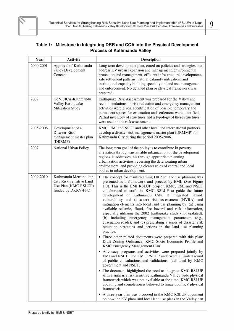
Table 1: Milestone in Integrating DRR and CCA into the Physical Development
Year Activity
2000-2001 Approval of Kathmandu
valley Development
Concept
2002 GoN, JICA-Kathmandu
Valley Earthquake
Mitigation Study
2005-2006 Development of a
Disaster Risk
management master plan
(DRRMP)
2007 National Urban Policy
2009-2010 Kathmandu Metropolitan
City Risk Sensitive Land
Use Plan (KMC-RSLUP)
funded by DKKV-FFO
Technical Services for Strengthening Risk Sensitive Land Use Planning and Implementation (RSLUP) in NepalMap for Making Kathmandu Valley Development Concept Plan Risk Sensitive: Frameworks and Processes
Milestone in Integrating DRR and CCA into the Physical Development
Process of Kathmandu Valley
Description
Approval of Kathmandu
valley Development
Long term development plan, cored on policies and strategies that
address KV urban expansion and management, environmental
protection and management, efficient infrastructure
safe settlement patterns; natural calamity mitigation; and
institutional capacity building specially on land use management
and enforcement. No detailed plan or physical framework was
prepared.
Kathmandu Earthquake Risk Assessment was prepared for the Valley and
recommendations on risk reduction and emergency management
activities were given. Identification of possible temporary and
permanent spaces for evacuation and settlement were identified
Partial inventory of structures and a typology of these structures
were used in the risk assessment.
management master plan
KMC, EMI and NSET and other local and international partners
develop a disaster risk management master plan (DRMMP) for
Kathmandu City during the period 2005-2006.
National Urban Policy The long term goal of the policy is to contribute in poverty
alleviation through sustainable urbanization of the development
regions. It addresses this through appropriate planning
urbanization activities, reversing the deteriorating urban
environment, and providing clearer roles of central and local
bodies in urban development.
Kathmandu Metropolitan
City Risk Sensitive Land
RSLUP)
FFO
• The concept for mainstreaming DRR in land use planning was
presented as a framework and process by EMI. (See Figure
1.0). This is the EMI RSLUP project, KMC, EMI and NSET
collaborated to craft the KMC RSLUP to guide the future
development of Kathmandu City. It integrated hazard,
vulnerability and (disaster) risk assessment (HVRA) and
mitigation elements into local land use planning by: (a) using
available seismic, flood, fire hazard and risk information,
especially utilizing the 2002 Earthquake study (not u
(b) including emergency management parameters (e.g.,
evacuation roads), and (c) prescribing a series of disaster risk
reduction strategies and actions in the land use planning
practice.
• Three other related documents were prepared with this plan:
Draft Zoning Ordinance, KMC Socio Economic Profile and
KMC Emergency Management Plan.
• Advocacy programs and activities were prepared jointly by
EMI and NSET. The KMC RSLUP underwent a limited round
of public consultations and validations, facilitated by KM
government and NSET.
• The document highlighted the need to integrate KMC RSLUP
with a similarly risk sensitive Kathmandu Valley wide physical
framework which was not available at the time. KMC RSLUP
updating and completion is believed to hinge upon KV ph
framework.
• A three year plan was proposed in the KMC RSLUP document
on how the KV plans and local land use plans in the Valley can
Technical Services for Strengthening Risk Sensitive Land Use Planning and Implementation (RSLUP) in Nepal Map for Making Kathmandu Valley Development Concept Plan Risk Sensitive: Frameworks and Processes 9
Milestone in Integrating DRR and CCA into the Physical Development
Long term development plan, cored on policies and strategies that
address KV urban expansion and management, environmental
protection and management, efficient infrastructure development,
safe settlement patterns; natural calamity mitigation; and
institutional capacity building specially on land use management
and enforcement. No detailed plan or physical framework was
Earthquake Risk Assessment was prepared for the Valley and
recommendations on risk reduction and emergency management
activities were given. Identification of possible temporary and
permanent spaces for evacuation and settlement were identified.
Partial inventory of structures and a typology of these structures
KMC, EMI and NSET and other local and international partners
risk management master plan (DRMMP) for
2006.
The long term goal of the policy is to contribute in poverty
alleviation through sustainable urbanization of the development
addresses this through appropriate planning
urbanization activities, reversing the deteriorating urban
environment, and providing clearer roles of central and local
The concept for mainstreaming DRR in land use planning was
presented as a framework and process by EMI. (See Figure
1.0). This is the EMI RSLUP project, KMC, EMI and NSET
collaborated to craft the KMC RSLUP to guide the future
. It integrated hazard,
vulnerability and (disaster) risk assessment (HVRA) and
mitigation elements into local land use planning by: (a) using
available seismic, flood, fire hazard and risk information,
especially utilizing the 2002 Earthquake study (not updated);
(b) including emergency management parameters (e.g.,
evacuation roads), and (c) prescribing a series of disaster risk
reduction strategies and actions in the land use planning
Three other related documents were prepared with this plan:
Draft Zoning Ordinance, KMC Socio Economic Profile and
Advocacy programs and activities were prepared jointly by
EMI and NSET. The KMC RSLUP underwent a limited round
of public consultations and validations, facilitated by KMC
The document highlighted the need to integrate KMC RSLUP
with a similarly risk sensitive Kathmandu Valley wide physical
framework which was not available at the time. KMC RSLUP
updating and completion is believed to hinge upon KV physical
A three year plan was proposed in the KMC RSLUP document
on how the KV plans and local land use plans in the Valley can
10 Technical Services for Strengthening Risk Sensitive Land Use Planning and Implementation (RSLUP) in Nepal Road Map for Making Kathmandu Valley Development Concept Plan Risk Sensitive: Frameworks
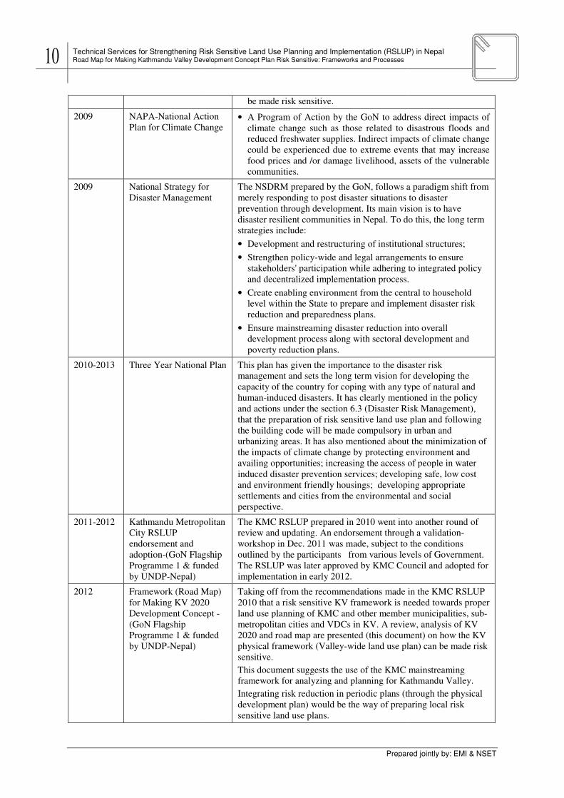
2009 NAPA-National Action
Plan for Climate Change
2009 National Strategy for
Disaster Management
2010-2013 Three Year National Plan
2011-2012 Kathmandu Metropolitan
City RSLUP
endorsement and
adoption-(GoN Flagship
Programme 1 & funded
by UNDP-Nepal)
2012 Framework (Road Map)
for Making KV 2020
Development Concept
(GoN Flagship
Programme 1 & funded
by UNDP-Nepal)
Technical Services for Strengthening Risk Sensitive Land Use Planning and Implementation (RSLUP) in Nepal Road Map for Making Kathmandu Valley Development Concept Plan Risk Sensitive: Frameworks and Processes
Prepared
be made risk sensitive.
National Action
Plan for Climate Change • A Program of Action by the GoN to address
climate change such as those related to disastrous floods and
reduced freshwater supplies. Indirect impacts of climate change
could be experienced due to extreme events that may increase
food prices and /or damage livelihood, assets of th
communities.
National Strategy for
Disaster Management
The NSDRM prepared by the GoN, follows a paradigm shift from
merely responding to post disaster situations to disaster
prevention through development. Its main vision is to have
disaster resilient communities in Nepal. To do this, the long term
strategies include:
• Development and restructuring of institutional structures;
• Strengthen policy-wide and legal arrangements to ensure
stakeholders' participation while adhering to integrat
and decentralized implementation process.
• Create enabling environment from the central to household
level within the State to prepare and implement disaster risk
reduction and preparedness plans.
• Ensure mainstreaming disaster reduction into ov
development process along with sectoral development and
poverty reduction plans.
Three Year National Plan This plan has given the importance to the disaster risk
management and sets the long term vision for developing the
capacity of the country for coping with any type of natural and
human-induced disasters. It has clearly mentioned in the policy
and actions under the section 6.3 (Disaster Risk Management),
that the preparation of risk sensitive land use plan and following
the building code will be made compulsory in urban and
urbanizing areas. It has also mentioned about the minimization of
the impacts of climate change by protecting environment and
availing opportunities; increasing the access of people in water
induced disaster prevention services; developing safe, low cost
and environment friendly housings; developing appropriate
settlements and cities from the environmental and social
perspective.
Kathmandu Metropolitan
(GoN Flagship
amme 1 & funded
The KMC RSLUP prepared in 2010 went into another round of
review and updating. An endorsement through a validation
workshop in Dec. 2011 was made, subject to the conditions
outlined by the participants from various levels of Government.
The RSLUP was later approved by KMC Council and adopted for
implementation in early 2012.
Framework (Road Map)
for Making KV 2020
Development Concept -
Programme 1 & funded
Taking off from the recommendations made in the KMC RSLUP
2010 that a risk sensitive KV framework is needed towards proper
land use planning of KMC and other member municipalities, sub
metropolitan cities and VDCs in KV. A review, analysis of KV
2020 and road map are presented (this document) on how the KV
physical framework (Valley-wide land use plan) can be made risk
sensitive.
This document suggests the use of the KMC mainstreaming
framework for analyzing and planning for Kathmandu Valley.
Integrating risk reduction in periodic plans (through the physical
development plan) would be the way of preparing local risk
sensitive land use plans.
Technical Services for Strengthening Risk Sensitive Land Use Planning and Implementation (RSLUP) in Nepal
Prepared jointly by: EMI & NSET
A Program of Action by the GoN to address direct impacts of
climate change such as those related to disastrous floods and
reduced freshwater supplies. Indirect impacts of climate change
could be experienced due to extreme events that may increase
food prices and /or damage livelihood, assets of the vulnerable
The NSDRM prepared by the GoN, follows a paradigm shift from
merely responding to post disaster situations to disaster
prevention through development. Its main vision is to have
disaster resilient communities in Nepal. To do this, the long term
Development and restructuring of institutional structures;
wide and legal arrangements to ensure
stakeholders' participation while adhering to integrated policy
and decentralized implementation process.
Create enabling environment from the central to household
level within the State to prepare and implement disaster risk
Ensure mainstreaming disaster reduction into overall
development process along with sectoral development and
This plan has given the importance to the disaster risk
management and sets the long term vision for developing the
ountry for coping with any type of natural and
induced disasters. It has clearly mentioned in the policy
and actions under the section 6.3 (Disaster Risk Management),
that the preparation of risk sensitive land use plan and following
e will be made compulsory in urban and
urbanizing areas. It has also mentioned about the minimization of
the impacts of climate change by protecting environment and
availing opportunities; increasing the access of people in water
n services; developing safe, low cost
and environment friendly housings; developing appropriate
settlements and cities from the environmental and social
The KMC RSLUP prepared in 2010 went into another round of
review and updating. An endorsement through a validation-
workshop in Dec. 2011 was made, subject to the conditions
outlined by the participants from various levels of Government.
er approved by KMC Council and adopted for
Taking off from the recommendations made in the KMC RSLUP
hat a risk sensitive KV framework is needed towards proper
land use planning of KMC and other member municipalities, sub-
metropolitan cities and VDCs in KV. A review, analysis of KV
2020 and road map are presented (this document) on how the KV
wide land use plan) can be made risk
This document suggests the use of the KMC mainstreaming
framework for analyzing and planning for Kathmandu Valley.
Integrating risk reduction in periodic plans (through the physical
plan) would be the way of preparing local risk

Technical Services for Strengthening Risk Sensitive Land Use Planning and Implementation (RSLUP) in NepalRoad Map for Making Kathmandu Valley Development Concept Plan Risk Sensitive: Frameworks and Processes
Prepared jointly by: EMI & NSET
Post 2012-
Proposed
Continuati
on
Risk Sensitive-
Kathmandu Valley
Development & Physical
Framework
Land use planning is identified as one of the most effective ways to achieve DRR and to take
the National Strategy for Disaster Risk Management
Programme of Action (NAPA) to Climate Change (2009)
fast growing urban areas such as the
physical framework plan
and spatial plans by engaging the government (at various levels), private sector, civil society,
international development organizations, and other key stakeholders (e.g. academe, media,
private sector, etc.). The land use planning process helps the
need to reduce disaster risks as part of its pursuit for sustainable development
The work done by Kathmandu Municipal City (KMC)
in completing a Risk Sensitive Land Use Plan (RSLUP) in 201
experience to local and national government officials
be enhanced or made risk sensitive
reduction, climate change adaptation towards sustainable development
necessary that existing planning structures (institutions) and legal frameworks are in place,
and that tools and process are appropriate They collectively provide the environmen
enable communities to develop sustainably and become disaster resilient.
RSLUP is illustrated in Figure
Technical Services for Strengthening Risk Sensitive Land Use Planning and Implementation (RSLUP) in NepalMap for Making Kathmandu Valley Development Concept Plan Risk Sensitive: Frameworks and Processes
Development & Physical
An updated KV concept plan and risk sensitive physical
framework is prepared that will be used to guide the urbanizing
and urbanized VDCs, municipalities and sub-
and KMC.
identified as one of the most effective ways to achieve DRR and to take
National Strategy for Disaster Risk Management (2009) and the
Programme of Action (NAPA) to Climate Change (2009) forward. For highly vulnerable
fast growing urban areas such as the Kathmandu Valley, a risk sensitive land use plan or
physical framework plan offers an opportunity to incorporate risk reduction into development
and spatial plans by engaging the government (at various levels), private sector, civil society,
international development organizations, and other key stakeholders (e.g. academe, media,
. The land use planning process helps the Kathmandu Valley
need to reduce disaster risks as part of its pursuit for sustainable development
The work done by Kathmandu Municipal City (KMC), NSET, EMI, and other local partners
Risk Sensitive Land Use Plan (RSLUP) in 2010 provided
experience to local and national government officials that traditional land use planning can
be enhanced or made risk sensitive and be used to meet national and local agendas on risk
ion, climate change adaptation towards sustainable development
necessary that existing planning structures (institutions) and legal frameworks are in place,
and that tools and process are appropriate They collectively provide the environmen
enable communities to develop sustainably and become disaster resilient.
Figure 3.
Technical Services for Strengthening Risk Sensitive Land Use Planning and Implementation (RSLUP) in Nepal Map for Making Kathmandu Valley Development Concept Plan Risk Sensitive: Frameworks and Processes 11
An updated KV concept plan and risk sensitive physical
ill be used to guide the urbanizing
-metropolitan cities
identified as one of the most effective ways to achieve DRR and to take
) and the National Adaptation
forward. For highly vulnerable and
risk sensitive land use plan or
to incorporate risk reduction into development
and spatial plans by engaging the government (at various levels), private sector, civil society,
international development organizations, and other key stakeholders (e.g. academe, media,
Kathmandu Valley address its
need to reduce disaster risks as part of its pursuit for sustainable development.
, NSET, EMI, and other local partners
provided the learning
that traditional land use planning can
to meet national and local agendas on risk
ion, climate change adaptation towards sustainable development. However, it is
necessary that existing planning structures (institutions) and legal frameworks are in place,
and that tools and process are appropriate They collectively provide the environment that will
enable communities to develop sustainably and become disaster resilient. The framework for

12 Technical Services for Strengthening Risk Sensitive Land Use Planning and Implementation (RSLUP) in Nepal Road Map for Making Kathmandu Valley Development Concept Plan Risk Sensitive: Frameworks
Figure 3. Model for Risk Sensitive Land Use Planning used for KMC
This enabling environment may be anchored on several themes
as: environmental protection & management, land use planning and management, safe
infrastructure & building construction and enforcement, disaster risk management and good
governance.
Hence, in practice, mainstreaming disaster
use planning) requires one to review existing systems and identify gaps in the following:
• Supportive legal, institutional arrangements;
- Clear mandates, functions, responsibilities and jurisdictions;
- Legal frameworks;
- Capacities;
• A clear framework for plan formulation and implementation;
- Planning process and linkage (ex. linkage between sectoral development and land
use) ;
- Participatory planning;
- Planning practice and implementation/ enforcement;
- Implementation tools used (ex. zoning, building by
• Plan outputs;
- Norms and standards used
- Use of scientific information(ex. hazard and risks)
Technical Services for Strengthening Risk Sensitive Land Use Planning and Implementation (RSLUP) in Nepal Road Map for Making Kathmandu Valley Development Concept Plan Risk Sensitive: Frameworks and Processes
Prepared
Model for Risk Sensitive Land Use Planning used for KMC
This enabling environment may be anchored on several themes of development policies such
as: environmental protection & management, land use planning and management, safe
infrastructure & building construction and enforcement, disaster risk management and good
Hence, in practice, mainstreaming disaster risk reduction in development planning (ex. land
use planning) requires one to review existing systems and identify gaps in the following:
Supportive legal, institutional arrangements;
Clear mandates, functions, responsibilities and jurisdictions;
frameworks;
A clear framework for plan formulation and implementation;
Planning process and linkage (ex. linkage between sectoral development and land
Participatory planning;
Planning practice and implementation/ enforcement;
Implementation tools used (ex. zoning, building by- laws, incentives)
Norms and standards used
Use of scientific information(ex. hazard and risks)
Technical Services for Strengthening Risk Sensitive Land Use Planning and Implementation (RSLUP) in Nepal
Prepared jointly by: EMI & NSET
Model for Risk Sensitive Land Use Planning used for KMC
of development policies such
as: environmental protection & management, land use planning and management, safe
infrastructure & building construction and enforcement, disaster risk management and good
risk reduction in development planning (ex. land
use planning) requires one to review existing systems and identify gaps in the following:
Planning process and linkage (ex. linkage between sectoral development and land
laws, incentives)

Technical Services for Strengthening Risk Sensitive Land Use Planning and Implementation (RSLUP) in NepalRoad Map for Making Kathmandu Valley Development Concept Plan Risk Sensitive: Frameworks and Processes
Prepared jointly by: EMI & NSET
- Analytical process (ex. suitability mapping)
Recommendations are then made to ensure that these
that which is desired are addressed in the different themes or policy areas.
Unfortunately, important elements of the RSLUP
(middle box in Figure 3
suggested by the relevant stakeholders that the RSLUP for Kathmandu City should be
integrated into a full exercise
Kathmandu Valley, the EMI RSLUP proje
cover the whole Valley. Thus, th
importance of the RSLUP for the Kathmandu Valley is recognized in the Flagship
Programme and was originally include
Kathmandu Valley is a logical starting point for DRR in the country since it will
inadequate development conditions and hazard exposures which translate to its
vulnerabilities. Consultation
KMC, ADB, JICA and others
RSLUP for the Valley. This project should also be recognized and fully integrated in the
CDRM Programme.
Technical Services for Strengthening Risk Sensitive Land Use Planning and Implementation (RSLUP) in NepalMap for Making Kathmandu Valley Development Concept Plan Risk Sensitive: Frameworks and Processes
Analytical process (ex. suitability mapping)
Recommendations are then made to ensure that these gaps between the existing situation and
that which is desired are addressed in the different themes or policy areas.
Unfortunately, important elements of the RSLUP such as implementation and enforcement
3) were not completed in 2010 due to lack of resources.
the relevant stakeholders that the RSLUP for Kathmandu City should be
integrated into a full exercise to develop a risk sensitive physical framework plan for the full
the EMI RSLUP project in 2010 did not have the resources
cover the whole Valley. Thus, the work was limited to Kathmandu City
importance of the RSLUP for the Kathmandu Valley is recognized in the Flagship
Programme and was originally included in Flagship 5. The development of the RSLUP for the
Kathmandu Valley is a logical starting point for DRR in the country since it will
inadequate development conditions and hazard exposures which translate to its
. Consultations with the stakeholders including MoPPW, MoLD, KVTDC,
KMC, ADB, JICA and others point to the importance and urgency of the development of a
RSLUP for the Valley. This project should also be recognized and fully integrated in the
Technical Services for Strengthening Risk Sensitive Land Use Planning and Implementation (RSLUP) in Nepal Map for Making Kathmandu Valley Development Concept Plan Risk Sensitive: Frameworks and Processes 13
gaps between the existing situation and
that which is desired are addressed in the different themes or policy areas.
such as implementation and enforcement
due to lack of resources. While it was
the relevant stakeholders that the RSLUP for Kathmandu City should be
to develop a risk sensitive physical framework plan for the full
ct in 2010 did not have the resources at that time to
was limited to Kathmandu City. Nonetheless, the
importance of the RSLUP for the Kathmandu Valley is recognized in the Flagship
. The development of the RSLUP for the
Kathmandu Valley is a logical starting point for DRR in the country since it will help address
inadequate development conditions and hazard exposures which translate to its
s with the stakeholders including MoPPW, MoLD, KVTDC,
the importance and urgency of the development of a
RSLUP for the Valley. This project should also be recognized and fully integrated in the

14 Technical Services for Strengthening Risk Sensitive Land Use Planning and Implementation (RSLUP) in Nepal Road Map for Making Kathmandu Valley Development Concept Plan Risk Sensitive: Frameworks
2 SITUATIONAL ANALYSIS
Kathmandu Valley (KV) i
Nepal. It covers an area of 66,650 hectares of land within Kathmandu Metropolitan City,
Madhyapur Thimi Municipali
Kirtipur Municipality and 98 Village Development Committees
rise behind the green hills in the north to provide an awe
city is located at 27°42' north Latitude and 85°20' east Longitude.
Technical Services for Strengthening Risk Sensitive Land Use Planning and Implementation (RSLUP) in Nepal Road Map for Making Kathmandu Valley Development Concept Plan Risk Sensitive: Frameworks and Processes
Prepared
SITUATIONAL ANALYSIS: DISASTERS IN THE KATHMANDU VALLEY
Kathmandu Valley (KV) is located in the Bagmati Zone, Central Develo
It covers an area of 66,650 hectares of land within Kathmandu Metropolitan City,
Thimi Municipality, Bhaktapur Municipality, Lalitpur Sub
Kirtipur Municipality and 98 Village Development Committees. Snow
rise behind the green hills in the north to provide an awe-inspiring backdrop
at 27°42' north Latitude and 85°20' east Longitude.
Figure 4. Location Map
Technical Services for Strengthening Risk Sensitive Land Use Planning and Implementation (RSLUP) in Nepal
Prepared jointly by: EMI & NSET
KATHMANDU VALLEY
one, Central Development Region of
It covers an area of 66,650 hectares of land within Kathmandu Metropolitan City,
Lalitpur Sub-metropolitan City,
. Snow-covered mountains
inspiring backdrop to the city. The

Technical Services for Strengthening Risk Sensitive Land Use Planning and Implementation (RSLUP) in NepalRoad Map for Making Kathmandu Valley Development Concept Plan Risk Sensitive: Frameworks and Processes
Prepared jointly by: EMI & NSET
2.1 Disaster Losses and Associated Risks
Earthquake Vulnerability
Concerns over seismic risk to Kathmandu are
driven not only by the high rate of seismicity
(See Annex 1) but also by the extreme
vulnerability of structures and infrastructure
and the high density of the built environment.
The percent of building construction that
could be considered to
of earthquake is negligible, whereas the
overwhelming majority of buildings and structures indicate a high to very high vulnerability.
The density of buildings and population, the extreme vulnerability, the difficulties of access
due to narrow roads and the potential for secondary effects such as fire f
earthquake, hazardous material release, landslides, liquefaction and others are indicators of a
Table 2: Losses due to Earthquake in Kathmandu Valley,
Hazards/Disaster
Events
No
of
Da
ta
Human Population
Dea
th
Earthquake 4 3
Table 3: Loss estimation figures for mid
Municipality / VDC
Projected Population, Buildings and Impacts due to Scenario Earthquake in
Population
Kathmandu District
Kathmandu
Metropolitan City (35
Wards)
956,364
Technical Services for Strengthening Risk Sensitive Land Use Planning and Implementation (RSLUP) in NepalMap for Making Kathmandu Valley Development Concept Plan Risk Sensitive: Frameworks and Processes
Disaster Losses and Associated Risks
Earthquake Vulnerability
oncerns over seismic risk to Kathmandu are
driven not only by the high rate of seismicity
but also by the extreme
vulnerability of structures and infrastructures
and the high density of the built environment.
The percent of building construction that
could be considered to withstand the impact
earthquake is negligible, whereas the
ming majority of buildings and structures indicate a high to very high vulnerability.
The density of buildings and population, the extreme vulnerability, the difficulties of access
due to narrow roads and the potential for secondary effects such as fire f
earthquake, hazardous material release, landslides, liquefaction and others are indicators of a
large scale urban catastrophe waiting to happen with
a level of destruction that is unprecedented.
Further, Kathmandu is also subject to other haza
such as flooding, landslides and has high exposure
to climate change because of its location and fragile
environment, which aggravate the vulnerability of
the city to natural hazards (KMC RSLUP, 2011)
The following tables reveal actual losses (past
events) and potential losses estimated from the Mid
Nepal earthquake scenario.
Losses due to Earthquake in Kathmandu Valley, 1971
Human Population Buildings
Ev
acu
ate
d
Fa
rmin
g/F
ore
sts(
ha
)
Mis
sin
g
Inju
ries
Vic
tim
s
Aff
ecte
d
Des
tro
yed
Da
ma
ge
--- 6 --- ----- 10 254 --- -----
(Source: Nepal DesInventar data base, NSET 2011)
Loss estimation figures for mid-Nepal Earthquake (intensity
Projected Population, Buildings and Impacts due to Scenario Earthquake in
2009
Population No. of
Buildings Death
Injury
(Severe
and
Moderate)
Building
Damage
(Heavy
and
Partial)
956,364 187,137 14,585 120,717 87,193
Technical Services for Strengthening Risk Sensitive Land Use Planning and Implementation (RSLUP) in Nepal Map for Making Kathmandu Valley Development Concept Plan Risk Sensitive: Frameworks and Processes 15
ming majority of buildings and structures indicate a high to very high vulnerability.
The density of buildings and population, the extreme vulnerability, the difficulties of access
due to narrow roads and the potential for secondary effects such as fire following an
earthquake, hazardous material release, landslides, liquefaction and others are indicators of a
large scale urban catastrophe waiting to happen with
a level of destruction that is unprecedented.
Further, Kathmandu is also subject to other hazards
such as flooding, landslides and has high exposure
to climate change because of its location and fragile
environment, which aggravate the vulnerability of
(KMC RSLUP, 2011).
The following tables reveal actual losses (past
ents) and potential losses estimated from the Mid-
1971-2011 F
arm
ing
/Fo
rest
s(h
a)
Liv
esto
ck
Ed
uca
tio
n C
entr
e
Lo
sses
va
lue(
NR
s)
----- --- 9 -----
(Source: Nepal DesInventar data base, NSET 2011)
Nepal Earthquake (intensity IX MMI)
Projected Population, Buildings and Impacts due to Scenario Earthquake in
Building
Damage
(Heavy
and
Partial)
Displaced
Population
87,193 291,232
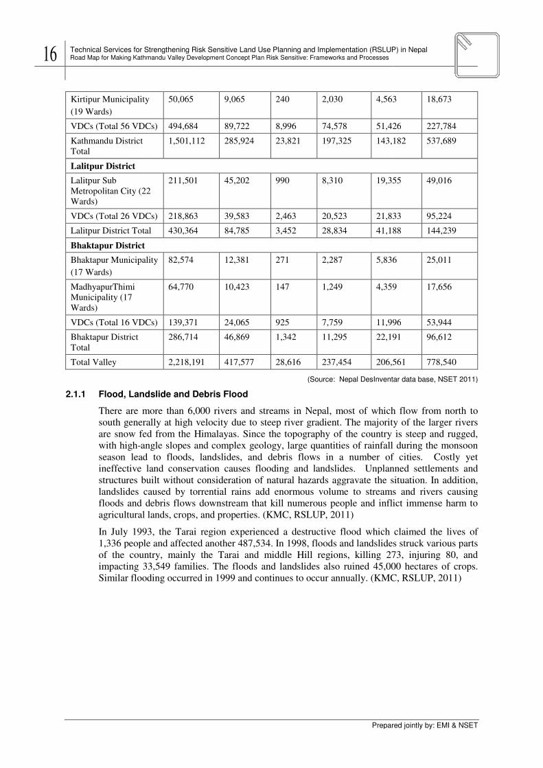
16 Technical Services for Strengthening Risk Sensitive Land Use Planning and Implementation (RSLUP) in Nepal Road Map for Making Kathmandu Valley Development Concept Plan Risk Sensitive: Frameworks
Kirtipur Municipality
(19 Wards)
50,065
VDCs (Total 56 VDCs) 494,684
Kathmandu District
Total
1,501,112
Lalitpur District
Lalitpur Sub
Metropolitan City (22
Wards)
211,501
VDCs (Total 26 VDCs) 218,863
Lalitpur District Total 430,364
Bhaktapur District
Bhaktapur Municipality
(17 Wards)
82,574
MadhyapurThimi
Municipality (17
Wards)
64,770
VDCs (Total 16 VDCs) 139,371
Bhaktapur District
Total
286,714
Total Valley 2,218,191
2.1.1 Flood, Landslide and Debris Flood
There are more than 6,000 rivers and streams in Nepal, most of which flow from north to
south generally at high velocity due to steep river gradient. The majority of the larger rivers
are snow fed from the Himalayas. Since the topography of the country is steep and rugged,
with high-angle slopes and complex geology, large quantities of rainfall during the monsoon
season lead to floods, landslides, and debris flows in a number of cities. Costly yet
ineffective land conservation causes flooding and landslides. Unplanned settlements and
structures built without consideration of natural hazards aggravate the situation. In addition,
landslides caused by torrential rains add enormous volume to streams a
floods and debris flows downstream that kill numerous people and inflict immense harm to
agricultural lands, crops, and properties.
In July 1993, the Tarai region experienced a destructive flood which claimed the lives
1,336 people and affected another 487,534. In 1998, floods and landslides struck various parts
of the country, mainly the Tarai and middle Hill regions, killing 273, injuring 80, and
impacting 33,549 families. The floods and landslides also ruined 45,00
Similar flooding occurred in 1999 and continues to occur annually.
Technical Services for Strengthening Risk Sensitive Land Use Planning and Implementation (RSLUP) in Nepal Road Map for Making Kathmandu Valley Development Concept Plan Risk Sensitive: Frameworks and Processes
Prepared
9,065 240 2,030 4,563
494,684 89,722 8,996 74,578 51,426
1,501,112 285,924 23,821 197,325 143,182
211,501 45,202 990 8,310 19,355
218,863 39,583 2,463 20,523 21,833
430,364 84,785 3,452 28,834 41,188
12,381 271 2,287 5,836
10,423 147 1,249 4,359
139,371 24,065 925 7,759 11,996
286,714 46,869 1,342 11,295 22,191
2,218,191 417,577 28,616 237,454 206,561
(Source: Nepal DesInventar data base, NSET 2011)
Flood, Landslide and Debris Flood
There are more than 6,000 rivers and streams in Nepal, most of which flow from north to
south generally at high velocity due to steep river gradient. The majority of the larger rivers
from the Himalayas. Since the topography of the country is steep and rugged,
angle slopes and complex geology, large quantities of rainfall during the monsoon
season lead to floods, landslides, and debris flows in a number of cities. Costly yet
ineffective land conservation causes flooding and landslides. Unplanned settlements and
structures built without consideration of natural hazards aggravate the situation. In addition,
landslides caused by torrential rains add enormous volume to streams a
floods and debris flows downstream that kill numerous people and inflict immense harm to
agricultural lands, crops, and properties. (KMC, RSLUP, 2011)
In July 1993, the Tarai region experienced a destructive flood which claimed the lives
1,336 people and affected another 487,534. In 1998, floods and landslides struck various parts
of the country, mainly the Tarai and middle Hill regions, killing 273, injuring 80, and
impacting 33,549 families. The floods and landslides also ruined 45,00
Similar flooding occurred in 1999 and continues to occur annually. (KMC, RSLUP, 2011)
Technical Services for Strengthening Risk Sensitive Land Use Planning and Implementation (RSLUP) in Nepal
Prepared jointly by: EMI & NSET
4,563 18,673
51,426 227,784
143,182 537,689
19,355 49,016
21,833 95,224
41,188 144,239
5,836 25,011
4,359 17,656
11,996 53,944
22,191 96,612
206,561 778,540
(Source: Nepal DesInventar data base, NSET 2011)
There are more than 6,000 rivers and streams in Nepal, most of which flow from north to
south generally at high velocity due to steep river gradient. The majority of the larger rivers
from the Himalayas. Since the topography of the country is steep and rugged,
angle slopes and complex geology, large quantities of rainfall during the monsoon
season lead to floods, landslides, and debris flows in a number of cities. Costly yet
ineffective land conservation causes flooding and landslides. Unplanned settlements and
structures built without consideration of natural hazards aggravate the situation. In addition,
landslides caused by torrential rains add enormous volume to streams and rivers causing
floods and debris flows downstream that kill numerous people and inflict immense harm to
In July 1993, the Tarai region experienced a destructive flood which claimed the lives of
1,336 people and affected another 487,534. In 1998, floods and landslides struck various parts
of the country, mainly the Tarai and middle Hill regions, killing 273, injuring 80, and
impacting 33,549 families. The floods and landslides also ruined 45,000 hectares of crops.
(KMC, RSLUP, 2011)

Technical Services for Strengthening Risk Sensitive Land Use Planning and Implementation (RSLUP) in NepalRoad Map for Making Kathmandu Valley Development Concept Plan Risk Sensitive: Frameworks and Processes
Prepared jointly by: EMI & NSET
Table 4: Losses due to flood and lan
Hazards/D
isaster
Events
No
of
Dat
a Human Population
Dea
th
Mis
sin
g
Inju
ries
Flood 60 53 18 8
Landslide 60 68 6 20
2.1.2 Fire
Fire occurs mainly between April and June during the dry season when it seldom rains and
temperatures in the Tarai region reach higher than 35°C. Fires are common to the rural Tarai
and Hill regions where 90.8 percent of the total population lives in very poor housing
conditions. Houses in rural regions, especially Tarai, are composed of straw or timber and
tend to be very close to each other, thereby increasing the risk of fire and fire spread. In 1999
a blaze killed 39 people, injured 10, and affected 1,065 families. The fire, with estimated total
losses of NRs 45.23 million, destroyed 1,035 houses, 52 cattle sheds and 148 livestock.
Table 5: Losses due to fire in Kathmandu Valley, 1971
Hazards/Dis
aster
Events
No
of
Dat
a
Human Population
Dea
th
Mis
sin
g
Inju
ries
Fire 603 126 50 168
Natural hazards which threaten Madhyapur Municipality through the years 2004 to 2011 can
be categorized as related to: fire, hailstorm, rains and monsoon, earthquake, landslides. Fire
appears frequent and occurred in this city four times, in the following year: 2007, 2008, 2010,
and 2011, with a single human loss in 2010. The hail storm in 2007 caused huge destroy of
ripen crops. In 2011, heavy rains and flood destroyed the several houses and cultivated area
Roads were water -logged for several hours. In 2011, an earthquake of magnitude 6.9 caused
minor losses and landslides seriously affected the historic and picnic spot of the city so called
Nil Barahi jungle area. About a decade ago, a large landslide oc
the mostly the east and west part of this Significant Temple area.
For Kathmandu City, using a 41 year record, (1971
among hazards, in number of deaths, injuries and missing persons
losses to built- up areas. With forest fires included, it gives a picture that fire hazards are the
most destructive to KMC environment. Floods appear to affect lesser numbers of people and
very few had been recorded to die from floo
There is a short record and lack of damage estimates to indicate destructive impacts of
Technical Services for Strengthening Risk Sensitive Land Use Planning and Implementation (RSLUP) in NepalMap for Making Kathmandu Valley Development Concept Plan Risk Sensitive: Frameworks and Processes
Losses due to flood and landslide in Kathmandu Valley,
Human Population Buildings
Ev
acu
ated
Far
min
g/F
ore
sts(
ha)
Vic
tim
s
Aff
ecte
d
Des
tro
yed
Dam
age
---- 10,579 186 225 322 33,252 62
--- 573 134 39 --- 21 5
(Source: Nepal DesInventar data base, NSET 2011)
Fire occurs mainly between April and June during the dry season when it seldom rains and
temperatures in the Tarai region reach higher than 35°C. Fires are common to the rural Tarai
ere 90.8 percent of the total population lives in very poor housing
conditions. Houses in rural regions, especially Tarai, are composed of straw or timber and
tend to be very close to each other, thereby increasing the risk of fire and fire spread. In 1999
a blaze killed 39 people, injured 10, and affected 1,065 families. The fire, with estimated total
losses of NRs 45.23 million, destroyed 1,035 houses, 52 cattle sheds and 148 livestock.
Losses due to fire in Kathmandu Valley, 1971-
Human Population Buildings
Ev
acu
ated
Far
min
g/F
ore
sts(
ha)
Liv
esto
ck
Inju
ries
Vic
tim
s
Aff
ecte
d
Des
tro
yed
Dam
age
168 --- 1,336 390 296 3 0.5 1293
(Source: Nepal DesInventar data base, NSET 2011)
Natural hazards which threaten Madhyapur Municipality through the years 2004 to 2011 can
be categorized as related to: fire, hailstorm, rains and monsoon, earthquake, landslides. Fire
ccurred in this city four times, in the following year: 2007, 2008, 2010,
and 2011, with a single human loss in 2010. The hail storm in 2007 caused huge destroy of
ripen crops. In 2011, heavy rains and flood destroyed the several houses and cultivated area
logged for several hours. In 2011, an earthquake of magnitude 6.9 caused
minor losses and landslides seriously affected the historic and picnic spot of the city so called
Nil Barahi jungle area. About a decade ago, a large landslide occurred causing the erosion of
the mostly the east and west part of this Significant Temple area.
For Kathmandu City, using a 41 year record, (1971-2011), fire events (295 events) rank first
among hazards, in number of deaths, injuries and missing persons and in terms of damage
up areas. With forest fires included, it gives a picture that fire hazards are the
most destructive to KMC environment. Floods appear to affect lesser numbers of people and
very few had been recorded to die from floods, but it leads fires in terms of building damages.
There is a short record and lack of damage estimates to indicate destructive impacts of
Technical Services for Strengthening Risk Sensitive Land Use Planning and Implementation (RSLUP) in Nepal Map for Making Kathmandu Valley Development Concept Plan Risk Sensitive: Frameworks and Processes 17
slide in Kathmandu Valley, 1971-2011
Liv
esto
ck
Ed
uca
tio
n C
entr
e
Lo
sses
val
ue(
NR
s)
62 ---- 58,674,000
5 ---- 35,012,050
(Source: Nepal DesInventar data base, NSET 2011)
Fire occurs mainly between April and June during the dry season when it seldom rains and
temperatures in the Tarai region reach higher than 35°C. Fires are common to the rural Tarai
ere 90.8 percent of the total population lives in very poor housing
conditions. Houses in rural regions, especially Tarai, are composed of straw or timber and
tend to be very close to each other, thereby increasing the risk of fire and fire spread. In 1999,
a blaze killed 39 people, injured 10, and affected 1,065 families. The fire, with estimated total
losses of NRs 45.23 million, destroyed 1,035 houses, 52 cattle sheds and 148 livestock.
-2011
Ed
uca
tio
n C
entr
e
Lo
sses
val
ue(
NR
s)
2 591,558,339
(Source: Nepal DesInventar data base, NSET 2011)
Natural hazards which threaten Madhyapur Municipality through the years 2004 to 2011 can
be categorized as related to: fire, hailstorm, rains and monsoon, earthquake, landslides. Fire
ccurred in this city four times, in the following year: 2007, 2008, 2010,
and 2011, with a single human loss in 2010. The hail storm in 2007 caused huge destroy of
ripen crops. In 2011, heavy rains and flood destroyed the several houses and cultivated areas.
logged for several hours. In 2011, an earthquake of magnitude 6.9 caused
minor losses and landslides seriously affected the historic and picnic spot of the city so called
curred causing the erosion of
2011), fire events (295 events) rank first
and in terms of damage
up areas. With forest fires included, it gives a picture that fire hazards are the
most destructive to KMC environment. Floods appear to affect lesser numbers of people and
ds, but it leads fires in terms of building damages.
There is a short record and lack of damage estimates to indicate destructive impacts of

18 Technical Services for Strengthening Risk Sensitive Land Use Planning and Implementation (RSLUP) in Nepal Road Map for Making Kathmandu Valley Development Concept Plan Risk Sensitive: Frameworks
earthquakes; but they are perceived to be more devastating when left unaddressed considering
the vulnerability of buildings and structures mentioned in this land use plan.
Fire and building collapse appears frequent in Lalitpur. The earthquake of 2011 had revealed
that damage to structure will be more under stronger earthquakes.
In Bhaktapur municipality, based on a 10
collapse has contributed to the many affected people and building damages.
Based on the Table shown below; fire flood, rain, structural collapse and epidemic account for
most of the hazard threats to the
forest fire and structural collapse comprise the monetary losses from damages.
Table 6: Hazard Threats to the Population in Kathmandu Valley
Table : Eventwise Human population death and other losses due to different natural disasters in Kathmandu Valley, 1971 - 2011
Deaths Missing Injuries
Accident 73 77 1
Boat Capsize 3 6 -
Cold Wave 2 3 -
Earthquake 4 - -
Epidemic 72 58 -
Explosion 15 10 -
Fire 603 126 50
Flood 60 53 18
Forest fire 7 - -
Frost 1 - -
Hail strom 17 - -
Landslide 60 68 6
Other 5 4 1
Panic 1 70 -
Plague 8 - -
Pollution 2 - -
Rains 24 4 -
Snow Storm 1 - -
Storm 5 - -
Strong wind 10 4 -
Struct. Collapse 128 91 6
Thunderstorm 25 19 -
Total 1,126 593 82 1,049
Source : Nepal DesInventar Database, NSET 2011
Note : Nepal DesInventar Database includes for the period of January 1, 1971 to June 15, 2011
Human PopulationNo. of
Data-
Hazard / Disaster
events
Technical Services for Strengthening Risk Sensitive Land Use Planning and Implementation (RSLUP) in Nepal Road Map for Making Kathmandu Valley Development Concept Plan Risk Sensitive: Frameworks and Processes
Prepared
earthquakes; but they are perceived to be more devastating when left unaddressed considering
uildings and structures mentioned in this land use plan.
Fire and building collapse appears frequent in Lalitpur. The earthquake of 2011 had revealed
that damage to structure will be more under stronger earthquakes.
In Bhaktapur municipality, based on a 10 year record: fire, flood, landslide and structural
collapse has contributed to the many affected people and building damages.
Based on the Table shown below; fire flood, rain, structural collapse and epidemic account for
most of the hazard threats to the population in Kathmandu Valley. Fire, flood, landslide,
forest fire and structural collapse comprise the monetary losses from damages.
Hazard Threats to the Population in Kathmandu Valley
Table : Eventwise Human population death and other losses due to different natural disasters in Kathmandu Valley, 1971 - 2011
Injuries Victims Affected Destroyed Damaged
19 - 5 - - - -
7 - 7 - - - -
- - - - - - -
6 - - 10 254 - -
486 222 4,495 - - - -
11 - 4 - 1 - -
168 - 1,336 390 296 3 0.5 1,293
8 - 10,579 186 225 322 332.52
- - - - - - 45
- - 5 2 - -
9 - - - 8 - 851.1
20 - 573 134 39 - 21
- - - - - 2 -
97 - - - - - -
- - - - - - -
- - - - - - -
10 - 1,096 14 6 - -
- - - - - - -
- - - - 10 - -
12 - - - 14 - -
170 - 548 149 50 - 0.25
26 - - 3 4 - -
1,049 222 18,648 888 907 327 1250.37 2,527
Note : Nepal DesInventar Database includes for the period of January 1, 1971 to June 15, 2011
Human Population LivestockFarming and
forest (Ha)
EvacuatedBuildings
Technical Services for Strengthening Risk Sensitive Land Use Planning and Implementation (RSLUP) in Nepal
Prepared jointly by: EMI & NSET
earthquakes; but they are perceived to be more devastating when left unaddressed considering
uildings and structures mentioned in this land use plan.
Fire and building collapse appears frequent in Lalitpur. The earthquake of 2011 had revealed
year record: fire, flood, landslide and structural
collapse has contributed to the many affected people and building damages.
Based on the Table shown below; fire flood, rain, structural collapse and epidemic account for
population in Kathmandu Valley. Fire, flood, landslide,
forest fire and structural collapse comprise the monetary losses from damages.
Hazard Threats to the Population in Kathmandu Valley
- - -
- - -
- - -
- 9 -
- - -
- - 65,200
1,293 2 591,558,339
62 - 58,674,000
- - 2,710,000
- - 520,000
- - 4,500,000
5 - 35,012,050
- - -
- - -
1159 - -
- - -
3 - 1,760,000
- - 1,000,000
- 1 120,000
- - -
2 - 2,829,000
3 - 403,000
2,527 12 699,151,589
Losses Value
(NRs)
Education
Centre
Livestock

Technical Services for Strengthening Risk Sensitive Land Use Planning and Implementation (RSLUP) in NepalRoad Map for Making Kathmandu Valley Development Concept Plan Risk Sensitive: Frameworks and Processes
Prepared jointly by: EMI & NSET
2.2 Climate Change and Variability Impacts Infrastructures
Nepal’s climate is influenced by the Himalayan mountain range and the South Asian
Monsoon. The climate is characterized into four distinct seasons: pre
monsoon (June-September), post monsoon (Octo
February). Annual average rainfall is about 1800 mm yearly. The monsoon rain is abundant in
the east and gradually declines as it moves westwards; while winter rains are higher in the
northwest declining as it moves sou
mid-hill areas around Pokhara and northeast and east of the Kathmandu Valley. Temperature
tends to increase from north to south.
In terms of projections, mean annual temperature may increase betw
by 2030 and about 1.7 deg C by 2050. Increases in temperature from 2
be expected until 2100. Precipitation may increase in the range of 15 to 20% for the whole
country during summer months. Generally there is
rainfall in terms of intensity of rainfall.
Nepal, largely an agrarian economy
resource availability (i.e. water resources).
The NAPA report indicates that
very high rating in terms of a vulnerability index. Essentially, it describe
vulnerable to loss of physical capital (damage to shelter and infrastructure), human capital
(malnutrition and disease), social capital (displacement of communities) and financial capital
(more disasters and lower income).
In that same report, it indicated that
disastrous floods and reduce
be experienced due to extreme events that may increase food prices and /or damage livelihood
assets of the vulnerable communities.
The report further adds that climate change is likely to result in incre
buildings, energy services, telecommunications, transport structures and water services,
hence, generally affecting the quality of lives and safety of local communities.
4 Excerpts of this section are culled from the of the
Ministry of Environment
Technical Services for Strengthening Risk Sensitive Land Use Planning and Implementation (RSLUP) in NepalMap for Making Kathmandu Valley Development Concept Plan Risk Sensitive: Frameworks and Processes
Climate Change and Variability Impacts to Urban Settlements and
Nepal’s climate is influenced by the Himalayan mountain range and the South Asian
Monsoon. The climate is characterized into four distinct seasons: pre-monsoon (March
September), post monsoon (October- November) and winter (December
February). Annual average rainfall is about 1800 mm yearly. The monsoon rain is abundant in
the east and gradually declines as it moves westwards; while winter rains are higher in the
northwest declining as it moves south-eastwards. The highest rainfall occurs in the central and
hill areas around Pokhara and northeast and east of the Kathmandu Valley. Temperature
tends to increase from north to south.
In terms of projections, mean annual temperature may increase between 1.2 deg C
by 2030 and about 1.7 deg C by 2050. Increases in temperature from 2 deg
be expected until 2100. Precipitation may increase in the range of 15 to 20% for the whole
country during summer months. Generally there is an increase in monsoon and post monsoon
rainfall in terms of intensity of rainfall.
Nepal, largely an agrarian economy, is highly sensitive to these changes in climate and nature
resource availability (i.e. water resources).4
The NAPA report indicates that Kathmandu is one among the more vulnerable districts with a
very high rating in terms of a vulnerability index. Essentially, it described
vulnerable to loss of physical capital (damage to shelter and infrastructure), human capital
lnutrition and disease), social capital (displacement of communities) and financial capital
(more disasters and lower income).
it indicated that the direct impacts of climate change may result to
disastrous floods and reduced freshwater supplies. Indirect impacts of climate change could
be experienced due to extreme events that may increase food prices and /or damage livelihood
assets of the vulnerable communities.
The report further adds that climate change is likely to result in incre
buildings, energy services, telecommunications, transport structures and water services,
hence, generally affecting the quality of lives and safety of local communities.
Excerpts of this section are culled from the of the National Adaptation Programme of Action (NAPA) to Climate Change 2009
Technical Services for Strengthening Risk Sensitive Land Use Planning and Implementation (RSLUP) in Nepal Map for Making Kathmandu Valley Development Concept Plan Risk Sensitive: Frameworks and Processes 19
Urban Settlements and
Nepal’s climate is influenced by the Himalayan mountain range and the South Asian
monsoon (March-May),
November) and winter (December-
February). Annual average rainfall is about 1800 mm yearly. The monsoon rain is abundant in
the east and gradually declines as it moves westwards; while winter rains are higher in the
eastwards. The highest rainfall occurs in the central and
hill areas around Pokhara and northeast and east of the Kathmandu Valley. Temperature
een 1.2 deg C- 1.4 deg C
deg C to 3 deg C may
be expected until 2100. Precipitation may increase in the range of 15 to 20% for the whole
an increase in monsoon and post monsoon
is highly sensitive to these changes in climate and nature
Kathmandu is one among the more vulnerable districts with a
d that poor people are
vulnerable to loss of physical capital (damage to shelter and infrastructure), human capital
lnutrition and disease), social capital (displacement of communities) and financial capital
the direct impacts of climate change may result to
r supplies. Indirect impacts of climate change could
be experienced due to extreme events that may increase food prices and /or damage livelihood
The report further adds that climate change is likely to result in increased damage to
buildings, energy services, telecommunications, transport structures and water services,
hence, generally affecting the quality of lives and safety of local communities.
National Adaptation Programme of Action (NAPA) to Climate Change 2009 of the
20 Technical Services for Strengthening Risk Sensitive Land Use Planning and Implementation (RSLUP) in Nepal Road Map for Making Kathmandu Valley Development Concept Plan Risk Sensitive: Frameworks
3 VULNERABILITY OF KAT
The Nepal, Kathmandu Va
world. It is ranked 11th among 150 countries, according to the Humanitarian Aid Office of the
European Commission.
In addition, there are certain social, economic and political factors in t
which tend to aggravate the impact of hazard events.
the development related aspects which contribute to the physical, social and environmental
vulnerability of the Valley. Information was mainly
2001 and various agency reports.
3.1 Population and Social
3.1.1 Population
The Valley district growth includes Kathmandu, Lalitpur and Bhaktapur,
five (5) municipalities and ninety
and rural growth rate was
3.6million people in 202
be living in the Kathmandu District, 1
A significant percentage, a
areas and 20% in the rural areas.
migration on the Kathmandu metropolitan area.
natural increase alone in the Valley population
3.1.2 Social Aspects
Kathmandu Valley continues to
components of vulnerability reveal the following:
• Widespread Poverty
the effects of which exacerbate environmental disasters, for example, deforestation or
destruction of forests
• Movement to High risk areas
areas such as unstable slopes, river banks, or along road and rail rights of way and along
easements of power lines. This exposes the poor directly to hazards and their deprivation
reduces their capacity to cope with disasters, much less recover quickly from the effects
of disasters.
• Political Instability
conflicts which have displaced
country and lack of security and safety of life and property in the rural areas compelled
many families to move to urban
dissolved on 27th May 2012 at the stroke of midnight
constitution.
• Threat to Cultural and Heritage Sites
world heritage sites, namely Kathmandu Durbar Square, Patan Durbar Square, Bhaktapur
Durbar Square, Swayambhunath, Boudhanath, Pas
risk to damage from environmental hazards. These heritage sites consist of numerous
temples, monasteries, stupas, palaces, chowks, ponds, and waterspouts etc., which
represent the culture,
heritage sites, there are also more than thirty religious and monument sites in various
places such as Dakshin
Bajra Yogini and Budha
Technical Services for Strengthening Risk Sensitive Land Use Planning and Implementation (RSLUP) in Nepal Road Map for Making Kathmandu Valley Development Concept Plan Risk Sensitive: Frameworks and Processes
Prepared
VULNERABILITY OF KATHMANDU VALLEY TO DISASTERS
Nepal, Kathmandu Valley is considered one of the most disaster-prone countries in the
among 150 countries, according to the Humanitarian Aid Office of the
In addition, there are certain social, economic and political factors in the
which tend to aggravate the impact of hazard events. The following section briefly describes
related aspects which contribute to the physical, social and environmental
vulnerability of the Valley. Information was mainly sourced from KV Development Concept
2001 and various agency reports.
Social Aspects
Valley district growth includes Kathmandu, Lalitpur and Bhaktapur,
five (5) municipalities and ninety-eight (98) VDCs. Urban growth rate was
and rural growth rate was 1.03% (2001 -2011). Population projections indicate a rise to
21 from 2.642 million in 2011. Among these, sixty eight (6
be living in the Kathmandu District, 18% in Lalitpur district and 12.5% in Bhaktapur district.
A significant percentage, about 80% of the Valley population will be residing in the urban
areas and 20% in the rural areas. The burden will be on KMC. There is a great pressure of
Kathmandu metropolitan area. It is highlighted in the KV report that a
atural increase alone in the Valley population can propel the urbanization on its own.
Kathmandu Valley continues to experience a number of pressing social issues.
omponents of vulnerability reveal the following:
Widespread Poverty: Poverty drives many people to engage in unsustainable livelihoods
the effects of which exacerbate environmental disasters, for example, deforestation or
forests.
o High risk areas: Poverty also drives some people to inhabit high
such as unstable slopes, river banks, or along road and rail rights of way and along
easements of power lines. This exposes the poor directly to hazards and their deprivation
uces their capacity to cope with disasters, much less recover quickly from the effects
Political Instability: The long-running conflicts (1996-2006) have triggered armed
conflicts which have displaced many communities living in the remote areas of the
country and lack of security and safety of life and property in the rural areas compelled
many families to move to urban centres. The four year-old Constituent Assembly
May 2012 at the stroke of midnight without delivering a new
Threat to Cultural and Heritage Sites: Seven cultural heritage sites enlisted in the
world heritage sites, namely Kathmandu Durbar Square, Patan Durbar Square, Bhaktapur
Durbar Square, Swayambhunath, Boudhanath, Pasupatinath, Changunarayan,
risk to damage from environmental hazards. These heritage sites consist of numerous
temples, monasteries, stupas, palaces, chowks, ponds, and waterspouts etc., which
represent the culture, history, religion and architecture of the Valley. Apart from the
there are also more than thirty religious and monument sites in various
places such as Dakshin Kali, Nil Barahi, Bajra Barahi, Surya Binayak, Karya Binayak,
and Budha Nilakanth.
Technical Services for Strengthening Risk Sensitive Land Use Planning and Implementation (RSLUP) in Nepal
Prepared jointly by: EMI & NSET
TO DISASTERS
prone countries in the
among 150 countries, according to the Humanitarian Aid Office of the
he Kathmandu Valley,
The following section briefly describes
related aspects which contribute to the physical, social and environmental
sourced from KV Development Concept
Valley district growth includes Kathmandu, Lalitpur and Bhaktapur, and encompasses
growth rate was 3.38% per year
rojections indicate a rise to
ixty eight (69.5%) will
% in Bhaktapur district.
bout 80% of the Valley population will be residing in the urban
There is a great pressure of
It is highlighted in the KV report that a
can propel the urbanization on its own.
a number of pressing social issues. Key
Poverty drives many people to engage in unsustainable livelihoods
the effects of which exacerbate environmental disasters, for example, deforestation or
to inhabit high-risk
such as unstable slopes, river banks, or along road and rail rights of way and along
easements of power lines. This exposes the poor directly to hazards and their deprivation
uces their capacity to cope with disasters, much less recover quickly from the effects
have triggered armed
living in the remote areas of the
country and lack of security and safety of life and property in the rural areas compelled
old Constituent Assembly
without delivering a new
Seven cultural heritage sites enlisted in the
world heritage sites, namely Kathmandu Durbar Square, Patan Durbar Square, Bhaktapur
upatinath, Changunarayan, etc. are at
risk to damage from environmental hazards. These heritage sites consist of numerous
temples, monasteries, stupas, palaces, chowks, ponds, and waterspouts etc., which
cture of the Valley. Apart from the
there are also more than thirty religious and monument sites in various
, Nil Barahi, Bajra Barahi, Surya Binayak, Karya Binayak,

Technical Services for Strengthening Risk Sensitive Land Use Planning and Implementation (RSLUP) in NepalRoad Map for Making Kathmandu Valley Development Concept Plan Risk Sensitive: Frameworks and Processes
Prepared jointly by: EMI & NSET
3.1.3 Economy
Tourism, agro-service, business, commerce and industry sector fuels the growth in
Kathmandu’s economy. The manufacturing industries engaged a total of 123,000 persons
(National Research Associates, Nepal 1999).Such principal industries are carpets, textil
ready-made garments, weaving/hosiery,
factories. A great number of hotels and resorts may be found in the Valley
• Economic infrastructure support is weak
and facilities can no longer cope and can
For this, employment and services and facilities, in addition to economic opportunities,
should be expanded in
• The Agriculture sector is also weakening.
3.1.4 Environment & Resource Related
Day-to-day risks are faced by the people living in the Valley and are strongly related to
environmental degradation.
• Degraded and denuding water resources
Ministry of Environment, Science and Technology
Integrated Mountain Development
Programme (UNEP)
surface water sources, such as rivers and “kunds”
from increasing population and economic activities. The pressure on these water sources
has also increased over the years as the agricultural sector intensified its de
water. Almost all major rivers have been tapped at source for drinking water supplies.
This supply is only about 120 million liters per day (mld) during the rainy season and 80
mld during dry season, against the estimated daily demand of 170 mld (
dry season, 60-70 percent of the water supply comes from groundwater. Only 79 percent
of the total demand for water of the urban population has been met. (MoEST, ICIMOD
and UNEP, 2007). In view of the climate change impacts identified in the
2009, there is a need to address these resource issues immediately.
• Hazard Prone & Disaster areas
sourced from various agencies, NGO database (Nepal DesInventar, NSET, 2011) and
from project reports specially related to earthquake and flood impacts.
- Natural hazard & risk information integrated in Development plans and
processes: Most of the reports on natural hazard impacts in the Valley had been
published after the KV 2001 plan. Hence, haz
information were not available during KV 2020 plan conception and finalization.
• Land, Water & Air Pollution
the Valley included motor vehicles, factories, bio
emission is the major factor. The reasons for aggravating vehicular emission can be
attributed to the use of old vehicles, poor maintenance and use of substandard fuel, among
others.
• Poor sanitation& waste management in
household sewage and wastes, and industrial effluents dumped into the river without
treatment. There is also a high level of air pollution due to poor road conditions
producing dust and particulates. Improper solid waste disposal du
of garbage along roadsides also contributes to urban pollution in the city.
3.1.5 Land Use Related
The agricultural, non-agricultural and forest zones occupy 41%, 28%, and 31% of the total
land of the Valley (as of 1998)
Technical Services for Strengthening Risk Sensitive Land Use Planning and Implementation (RSLUP) in NepalMap for Making Kathmandu Valley Development Concept Plan Risk Sensitive: Frameworks and Processes
service, business, commerce and industry sector fuels the growth in
Kathmandu’s economy. The manufacturing industries engaged a total of 123,000 persons
(National Research Associates, Nepal 1999).Such principal industries are carpets, textil
weaving/hosiery, handicrafts and wooden craft, furniture, brick and tile
A great number of hotels and resorts may be found in the Valley
Economic infrastructure support is weak: As a result of fast urban expansion, s
and facilities can no longer cope and can eventually destabilize the urban management.
r this, employment and services and facilities, in addition to economic opportunities,
should be expanded in urbanizing areas. The carrying capacity needs to b
The Agriculture sector is also weakening.
Environment & Resource Related
day risks are faced by the people living in the Valley and are strongly related to
environmental degradation.
Degraded and denuding water resources: According to a joint study
Ministry of Environment, Science and Technology (MoEST), International Centre for
Integrated Mountain Development (ICIMOD) and United Nations Environment
) titled, “Kathmandu Valley Environmental Outlook,” the Valle
surface water sources, such as rivers and “kunds”, have received tremendous pressure
from increasing population and economic activities. The pressure on these water sources
has also increased over the years as the agricultural sector intensified its de
water. Almost all major rivers have been tapped at source for drinking water supplies.
This supply is only about 120 million liters per day (mld) during the rainy season and 80
mld during dry season, against the estimated daily demand of 170 mld (
70 percent of the water supply comes from groundwater. Only 79 percent
of the total demand for water of the urban population has been met. (MoEST, ICIMOD
and UNEP, 2007). In view of the climate change impacts identified in the
2009, there is a need to address these resource issues immediately.
Hazard Prone & Disaster areas: Information on hazards and negative impacts may be
sourced from various agencies, NGO database (Nepal DesInventar, NSET, 2011) and
ct reports specially related to earthquake and flood impacts.
Natural hazard & risk information integrated in Development plans and
Most of the reports on natural hazard impacts in the Valley had been
published after the KV 2001 plan. Hence, hazard information and other vital
information were not available during KV 2020 plan conception and finalization.
Land, Water & Air Pollution: The KV report had identified the cause of air pollution in
motor vehicles, factories, bio-mass and fuel; out of which, vehicular
emission is the major factor. The reasons for aggravating vehicular emission can be
use of old vehicles, poor maintenance and use of substandard fuel, among
Poor sanitation& waste management in Kathmandu Valley: This is mainly due to
household sewage and wastes, and industrial effluents dumped into the river without
treatment. There is also a high level of air pollution due to poor road conditions
producing dust and particulates. Improper solid waste disposal due to temporary dumping
of garbage along roadsides also contributes to urban pollution in the city.
agricultural and forest zones occupy 41%, 28%, and 31% of the total
land of the Valley (as of 1998), respectively. There is much diversification of land use. Urban
Technical Services for Strengthening Risk Sensitive Land Use Planning and Implementation (RSLUP) in Nepal Map for Making Kathmandu Valley Development Concept Plan Risk Sensitive: Frameworks and Processes 21
service, business, commerce and industry sector fuels the growth in
Kathmandu’s economy. The manufacturing industries engaged a total of 123,000 persons
(National Research Associates, Nepal 1999).Such principal industries are carpets, textiles and
wooden craft, furniture, brick and tile
A great number of hotels and resorts may be found in the Valley.
As a result of fast urban expansion, services
eventually destabilize the urban management.
r this, employment and services and facilities, in addition to economic opportunities,
areas. The carrying capacity needs to be determined.
day risks are faced by the people living in the Valley and are strongly related to
a joint study in 2007 by
International Centre for
United Nations Environment
titled, “Kathmandu Valley Environmental Outlook,” the Valley’s
have received tremendous pressure
from increasing population and economic activities. The pressure on these water sources
has also increased over the years as the agricultural sector intensified its demand for
water. Almost all major rivers have been tapped at source for drinking water supplies.
This supply is only about 120 million liters per day (mld) during the rainy season and 80
mld during dry season, against the estimated daily demand of 170 mld (NWSC 2001). In
70 percent of the water supply comes from groundwater. Only 79 percent
of the total demand for water of the urban population has been met. (MoEST, ICIMOD
and UNEP, 2007). In view of the climate change impacts identified in the NAPA report of
Information on hazards and negative impacts may be
sourced from various agencies, NGO database (Nepal DesInventar, NSET, 2011) and
ct reports specially related to earthquake and flood impacts.
Natural hazard & risk information integrated in Development plans and
Most of the reports on natural hazard impacts in the Valley had been
ard information and other vital
information were not available during KV 2020 plan conception and finalization.
cause of air pollution in
s and fuel; out of which, vehicular
emission is the major factor. The reasons for aggravating vehicular emission can be
use of old vehicles, poor maintenance and use of substandard fuel, among
This is mainly due to
household sewage and wastes, and industrial effluents dumped into the river without
treatment. There is also a high level of air pollution due to poor road conditions
e to temporary dumping
of garbage along roadsides also contributes to urban pollution in the city.
agricultural and forest zones occupy 41%, 28%, and 31% of the total
re is much diversification of land use. Urban

22 Technical Services for Strengthening Risk Sensitive Land Use Planning and Implementation (RSLUP) in Nepal Road Map for Making Kathmandu Valley Development Concept Plan Risk Sensitive: Frameworks
residential use covers about 7% while rural settlement covers 12.6%.
covers about 66,665 hectares.
rapid decline of the agriculture land
of 2041-51 B. (1984-1994), a total of 7642 hectares of agriculture land was converted for
urban uses whereas during the period of 2051
of agriculture land was converted.
It is estimated that 3600 hectares of land will be required for the next 20 years at the rate of
300 persons per hectare.
structures were promoted
mentioned in the report is deemed to help in preserving the a
hand, new sites for urban expansion must be pre
3.1.6 Key contributors of vulnerability:
• A rapid urbanization of the Valley is uncontrolled
population growth and inadequate services and facilities will eventually destabilize the
urban management.
- Rapid conversion of unproductive agricultural lands
constraints is that habitation with low density of population was taking place in the
Valley and causing decline of fertile agriculture land. The report mentions that
between 2041B.S.
decreased from 64 percent to 42 percent. If this trend continues, the agriculture land
in the Valley will go to zero in 2082 B.S.
• Rapid and haphazard urban transformation of the Kathmandu Valley
inflicted a great pressure on the Valley's precious natura
land, environment, cultural heritage, services and facilities; and the way of life of the
people in the Valley has changed and their living is getting dearer and more painful
growth of settlements in the Valley is gene
planning intervention on the part of the government to guide its directions. The low
density urban sprawl and uncontrolled settlement development in rural areas similarly
pose a challenge for urban managers becau
maintaining municipal services
• Densification issues
KV 2020 at 300 persons per hectare (or net density of 600 persons per hectare)
considering a 50% occupation for residential purposes. Given the assumption that 500
persons per hectare (ne
densification. Standards for land allocation for educational or health institutions were
provided in the report
where this maybe cons
• Current causes and effects and trends of urbanization need to be updated
Use Plan of the Valley 2033 B.S. (1976) remained in effect until the reported period
(2001) when KV 2020 was crafted. The
current causes and effects, trends of urbanization should be analyzed for Kathmandu
Valley to aid decision making
• Basin or watershed approach is not yet developed for Kathmandu
how a basin wide approach may be tackled as the watershed planning covers a wider
5 Source: KV 2020
6 Source: KV 2020, RSLUP E-Learning, 2012 Discussion Forum
7 Ibid.
Technical Services for Strengthening Risk Sensitive Land Use Planning and Implementation (RSLUP) in Nepal Road Map for Making Kathmandu Valley Development Concept Plan Risk Sensitive: Frameworks and Processes
Prepared
residential use covers about 7% while rural settlement covers 12.6%.
covers about 66,665 hectares. The analysis of the land use trend of the Valley
culture land and that this trend is likely continuing
1994), a total of 7642 hectares of agriculture land was converted for
urban uses whereas during the period of 2051-57 B.S. (1994-2000), a total of
f agriculture land was converted.
t is estimated that 3600 hectares of land will be required for the next 20 years at the rate of
300 persons per hectare. Because land for built up areas are getting scarce, m
promoted in the development concept plan. This densification approach,
mentioned in the report is deemed to help in preserving the agricultural land
hand, new sites for urban expansion must be pre-identified.
Key contributors of vulnerability:
ation of the Valley is uncontrolled: It is likely that the uncontrolled
population growth and inadequate services and facilities will eventually destabilize the
Rapid conversion of unproductive agricultural lands: One of the derived
raints is that habitation with low density of population was taking place in the
Valley and causing decline of fertile agriculture land. The report mentions that
between 2041B.S. (1984) and 2057B.S. (2000), the agriculture land in the Valley
64 percent to 42 percent. If this trend continues, the agriculture land
in the Valley will go to zero in 2082 B.S. (2025)5.
Rapid and haphazard urban transformation of the Kathmandu Valley
inflicted a great pressure on the Valley's precious natural resources such as agriculture
land, environment, cultural heritage, services and facilities; and the way of life of the
people in the Valley has changed and their living is getting dearer and more painful
growth of settlements in the Valley is generally spontaneous, and there is very little
planning intervention on the part of the government to guide its directions. The low
density urban sprawl and uncontrolled settlement development in rural areas similarly
pose a challenge for urban managers because of the high cost of providing and
maintaining municipal services” (MoEST, ICIMOD and UNEP, 2007)
Densification issues: The average gross residential density in the Valley was proposed in
KV 2020 at 300 persons per hectare (or net density of 600 persons per hectare)
considering a 50% occupation for residential purposes. Given the assumption that 500
(net density-KV 2020 report), there is still enough room for
densification. Standards for land allocation for educational or health institutions were
in the report, cultural and entertainment areas; however, there is no study on
where this maybe considering the hazard risks and terrain of the Valley.
Current causes and effects and trends of urbanization need to be updated
Use Plan of the Valley 2033 B.S. (1976) remained in effect until the reported period
(2001) when KV 2020 was crafted. The current approved plan is still
current causes and effects, trends of urbanization should be analyzed for Kathmandu
Valley to aid decision making7.
Basin or watershed approach is not yet developed for Kathmandu
in wide approach may be tackled as the watershed planning covers a wider
Learning, 2012 Discussion Forum
Technical Services for Strengthening Risk Sensitive Land Use Planning and Implementation (RSLUP) in Nepal
Prepared jointly by: EMI & NSET
residential use covers about 7% while rural settlement covers 12.6%. The total land area
The analysis of the land use trend of the Valley in 2001 reveals
and that this trend is likely continuing. During the period
1994), a total of 7642 hectares of agriculture land was converted for
2000), a total of 5,738 hectares
t is estimated that 3600 hectares of land will be required for the next 20 years at the rate of
Because land for built up areas are getting scarce, multi-storeyed
This densification approach,
gricultural land. On the other
is likely that the uncontrolled
population growth and inadequate services and facilities will eventually destabilize the
One of the derived
raints is that habitation with low density of population was taking place in the
Valley and causing decline of fertile agriculture land. The report mentions that
(2000), the agriculture land in the Valley
64 percent to 42 percent. If this trend continues, the agriculture land
Rapid and haphazard urban transformation of the Kathmandu Valley: It has
l resources such as agriculture
land, environment, cultural heritage, services and facilities; and the way of life of the
people in the Valley has changed and their living is getting dearer and more painful6.“The
rally spontaneous, and there is very little
planning intervention on the part of the government to guide its directions. The low-
density urban sprawl and uncontrolled settlement development in rural areas similarly
se of the high cost of providing and
” (MoEST, ICIMOD and UNEP, 2007).
The average gross residential density in the Valley was proposed in
KV 2020 at 300 persons per hectare (or net density of 600 persons per hectare)
considering a 50% occupation for residential purposes. Given the assumption that 500
, there is still enough room for
densification. Standards for land allocation for educational or health institutions were
, cultural and entertainment areas; however, there is no study on
idering the hazard risks and terrain of the Valley.
Current causes and effects and trends of urbanization need to be updated: The Land
Use Plan of the Valley 2033 B.S. (1976) remained in effect until the reported period
in effect. The
current causes and effects, trends of urbanization should be analyzed for Kathmandu
Basin or watershed approach is not yet developed for Kathmandu: It is not yet clear
in wide approach may be tackled as the watershed planning covers a wider

Technical Services for Strengthening Risk Sensitive Land Use Planning and Implementation (RSLUP) in NepalRoad Map for Making Kathmandu Valley Development Concept Plan Risk Sensitive: Frameworks and Processes
Prepared jointly by: EMI & NSET
scope of uses, generally settlements or built up areas, agriculture and crop areas, forest
areas (protected forests and agro
Urban Development
natural resources (forest, agriculture
3.2 Building, Infrastructure
3.2.1 Building Related
In principle, future constructions should not increase vulnerabilities or risks to already high
risk areas. However, there is an increasing risk to building stock damage to a very strong
earthquake, not only because of old buildings (non
enforcement of local byelaws and national
• Increasing physical vulnerability of Kathmandu Valley
factors related to poor building planning, lack of municipal land use plan and a supporting
transport plan to guide development
construction standards.
• Poor site planning of spaces
major roads in the Valley. The current land use trend reveals that rural settlements are
scattered and building works are being done around such settlements in an unplanned
manner9.
3.2.2 Transport and Infrastruc
• Traffic congestion:
and poor condition of such vehicles have caused congestion of motor vehicles in the
urban area of the Valley and been increasing air and noise pollution
of pedestrian walking, bicycle and rickshaw has also caused conges
vehicles.10
• Small internal roads
important urban roads. This will similarly improve the sit
In doing so, undeveloped areas and open spaces and the places where there is no wider
road and there is difficulty with movement should be chosen. (KV 2020
be a need to reduce internal vehicular traffic i
• Lack of service roads
difficult.
• Lack of open space
adjustments or realignments difficult to
• Lack of adequate supply of clean safe drinking water
some communities to stagnant water which causes occasional outbreaks of water
diseases.
• Lack of fire fighting
Kathmandu Valley renders them unable to cope with frequent fires especially during the
hot dry months.
8 Source: KV 2020
9 Ibid
10 Ibid
Technical Services for Strengthening Risk Sensitive Land Use Planning and Implementation (RSLUP) in NepalMap for Making Kathmandu Valley Development Concept Plan Risk Sensitive: Frameworks and Processes
scope of uses, generally settlements or built up areas, agriculture and crop areas, forest
areas (protected forests and agro-forests), and inland waters. The Kathmandu Valley
evelopment Authority, when formed, will need to integrate broader plans on
natural resources (forest, agriculture) with Valley wide urban plans8.
Infrastructure &Transport related
n principle, future constructions should not increase vulnerabilities or risks to already high
However, there is an increasing risk to building stock damage to a very strong
earthquake, not only because of old buildings (non-seismic designed) b
enforcement of local byelaws and national building codes.
Increasing physical vulnerability of Kathmandu Valley: This is a result of several
factors related to poor building planning, lack of municipal land use plan and a supporting
nsport plan to guide development and poor enforcement of building codes and
construction standards.
Poor site planning of spaces: Buildings and other structures are built in either side of the
major roads in the Valley. The current land use trend reveals that rural settlements are
scattered and building works are being done around such settlements in an unplanned
Transport and Infrastructure Related
The rise of private vehicles as compared to public transport vehicles
and poor condition of such vehicles have caused congestion of motor vehicles in the
urban area of the Valley and been increasing air and noise pollution. Non
of pedestrian walking, bicycle and rickshaw has also caused congestion of motor
Small internal roads: It is necessary to improve internal roads and improve surface of
important urban roads. This will similarly improve the situation of transport in the future.
In doing so, undeveloped areas and open spaces and the places where there is no wider
road and there is difficulty with movement should be chosen. (KV 2020
be a need to reduce internal vehicular traffic in inner roads to reduce congestion.
Lack of service roads: This absence makes transition from main road to interior areas
Lack of open space: There is currently a lack of open space in urban areas, making
adjustments or realignments difficult to pursue.
Lack of adequate supply of clean safe drinking water or the prolonged exposure of
some communities to stagnant water which causes occasional outbreaks of water
fire fighting equipment: Lack of modern (fire fighting) equipm
renders them unable to cope with frequent fires especially during the
Technical Services for Strengthening Risk Sensitive Land Use Planning and Implementation (RSLUP) in Nepal Map for Making Kathmandu Valley Development Concept Plan Risk Sensitive: Frameworks and Processes 23
scope of uses, generally settlements or built up areas, agriculture and crop areas, forest
forests), and inland waters. The Kathmandu Valley
, when formed, will need to integrate broader plans on
n principle, future constructions should not increase vulnerabilities or risks to already high-
However, there is an increasing risk to building stock damage to a very strong
seismic designed) but because of poor
This is a result of several
factors related to poor building planning, lack of municipal land use plan and a supporting
and poor enforcement of building codes and
other structures are built in either side of the
major roads in the Valley. The current land use trend reveals that rural settlements are
scattered and building works are being done around such settlements in an unplanned
The rise of private vehicles as compared to public transport vehicles
and poor condition of such vehicles have caused congestion of motor vehicles in the
. Non-encouragement
tion of motor
It is necessary to improve internal roads and improve surface of
uation of transport in the future.
In doing so, undeveloped areas and open spaces and the places where there is no wider
road and there is difficulty with movement should be chosen. (KV 2020). There may also
n inner roads to reduce congestion.
This absence makes transition from main road to interior areas
There is currently a lack of open space in urban areas, making
or the prolonged exposure of
some communities to stagnant water which causes occasional outbreaks of water-borne
) equipment in the
renders them unable to cope with frequent fires especially during the

24 Technical Services for Strengthening Risk Sensitive Land Use Planning and Implementation (RSLUP) in Nepal Road Map for Making Kathmandu Valley Development Concept Plan Risk Sensitive: Frameworks
3.2.3 Institutional Aspects
There are laws covering both land use planning and disaster risk management
interlinked by the policy & strategi
Operationalization of disaster risk reduction and climate change adaptation through land use
planning, periodic planning and their implementation has yet to be realized in a Valley wide
scale. There seems to be very limited funding to support
reforms related to DRRM at the Valley and local level
• The lack of the institutional capacity to effectively manage state of urbanization
The policies of the Kathman
control land developments and construction works are not becoming effective to mitigate
the effects of the externalities in the Valley.
• Weak enforcement of public safety and environmental regulations
mentioned in the KV report (and in the current project) as a prime concern related to
disaster proneness of the Kathmandu Valley.
4 THE KATHMANDU VALLEYAND GAPS ANALYSIS
The actual target of this review and an
Plan. The content of the intervention is mainly the preparation of plans
assumed that the KV planning
practice of planning at the KV level. The analysis is geared towards how the KV 2020 can be
made risk sensitive and what can be recommended to implement it.
4.1 The KV Planning System
The Kathmandu Valley level
components, namely; 1) the planning structure
planning mandates (or what particular
process (how the plans will be
be implemented). The KV
Table 7: KATHMANDU VALLEY PLANNING SYSTEM
Local Planning Structure
Who are involved? (A)
General Land Use Planning Process in Kathmandu
Technical Services for Strengthening Risk Sensitive Land Use Planning and Implementation (RSLUP) in Nepal Road Map for Making Kathmandu Valley Development Concept Plan Risk Sensitive: Frameworks and Processes
Prepared
There are laws covering both land use planning and disaster risk management
by the policy & strategies of NAPA and the NDRM
of disaster risk reduction and climate change adaptation through land use
planning, periodic planning and their implementation has yet to be realized in a Valley wide
There seems to be very limited funding to support for institutional and organizational
related to DRRM at the Valley and local level.
The lack of the institutional capacity to effectively manage state of urbanization
The policies of the Kathmandu Valley Town Development Committee
control land developments and construction works are not becoming effective to mitigate
the effects of the externalities in the Valley.
Weak enforcement of public safety and environmental regulations
mentioned in the KV report (and in the current project) as a prime concern related to
proneness of the Kathmandu Valley.
THE KATHMANDU VALLEY DEVELOPMENT CONCEPT PLAN: A REVIAND GAPS ANALYSIS
this review and analysis is the Kathmandu Valley Development Concept
he content of the intervention is mainly the preparation of plans
planning process, described in the KV 2001 report, captures the existing
at the KV level. The analysis is geared towards how the KV 2020 can be
made risk sensitive and what can be recommended to implement it.
The KV Planning System
Kathmandu Valley level planning system may be said to be composed of several
1) the planning structure (those involved in formulation),
planning mandates (or what particular plans are required to be prepare
will be prepared), and 4) the KV implementation tools
KV planning system is summarized in Figure 5.
KATHMANDU VALLEY PLANNING SYSTEM
General Land Use Planning Process in Kathmandu
Valley
What is the process? (B)
Implementing Tools Used in
Technical Services for Strengthening Risk Sensitive Land Use Planning and Implementation (RSLUP) in Nepal
Prepared jointly by: EMI & NSET
There are laws covering both land use planning and disaster risk management and are
es of NAPA and the NDRM. However, the
of disaster risk reduction and climate change adaptation through land use
planning, periodic planning and their implementation has yet to be realized in a Valley wide
institutional and organizational
The lack of the institutional capacity to effectively manage state of urbanization: du Valley Town Development Committee (now KVDA) to
control land developments and construction works are not becoming effective to mitigate
Weak enforcement of public safety and environmental regulations: These have been
mentioned in the KV report (and in the current project) as a prime concern related to
CONCEPT PLAN: A REVIEW
Kathmandu Valley Development Concept
he content of the intervention is mainly the preparation of plans at KV level. It is
process, described in the KV 2001 report, captures the existing
at the KV level. The analysis is geared towards how the KV 2020 can be
may be said to be composed of several
formulation), 2) the KV
prepared), 3) the planning
KV implementation tools (how plans can
KATHMANDU VALLEY PLANNING SYSTEM
Implementing Tools Used in
KV
How are the plans
implemented? (C)

Technical Services for Strengthening Risk Sensitive Land Use Planning and Implementation (RSLUP) in NepalRoad Map for Making Kathmandu Valley Development Concept Plan Risk Sensitive: Frameworks and Processes
Prepared jointly by: EMI & NSET
• Political Decisions-Who
performs these?
• Deliberation – KVDA,
MPPW,
• Policies Formulation –
GoN, MPPW/KVDA
• Decision taking – GoN,
MPPW
• Technical Aspects-Who
are involved in the
following?
• Data generation for
sectoral and land use
planning- (Sectoral
departments)
• Formulation of Goals,
Objectives
• (Sectoral agencies with
participatory
process)(KVDA along
with MPs)
• Identifies programs and
Projects (Sectoral
ministries/ dept./
municipalities KVDA)
• Conducts Public
consultations
• (Sectoral agencies,
• Municipalities, KVDA)
• Monitors Programs,
Project Implementation
• (Sectoral agencies,
KVDA)
• Conducts detailed
researches and analysis-
(outsourced by
DUDBC/KVDA)
Figure 5
11 Adapted from : Serote, 2004, Comprehensive Land Use Plan and Management of Local Territories, C
Territory: Foundations of Land Use Planning
9
8
7
6
1
2
3
4
5
**Spatial plan not yet prepared
Technical Services for Strengthening Risk Sensitive Land Use Planning and Implementation (RSLUP) in NepalMap for Making Kathmandu Valley Development Concept Plan Risk Sensitive: Frameworks and Processes
•
•
•
•
•
•
•
•
•
5. Identified Planning System at KV level11
Adapted from : Serote, 2004, Comprehensive Land Use Plan and Management of Local Territories, C-
Planning in the Philippines; School of Urban and Regional Planning, UP
Detailing & Refinement
OF
Formulating Policies &
Implementation Tools
Plan Adoption &
Legitimization
Implementation, Monitoring
& Feedback
Inter-Agency
Consultation
Data Collection & Inventory
Inter- & Intra-Area Analysis
Goals/Objectives Setting
Generation Of
Alterative Strategies
Evaluation & Selection
Of Preferred strategy
Public
Consultatio
n
Various-
Stages
Inter-
Agency
**Spatial plan not yet prepared
**Development concept
prepared
Technical Services for Strengthening Risk Sensitive Land Use Planning and Implementation (RSLUP) in Nepal Map for Making Kathmandu Valley Development Concept Plan Risk Sensitive: Frameworks and Processes 25
Are the plans implemented
by the following?
Zoning (building by-laws
by KVDA)
Co-management
(with municipalities)
Development regulation
(Zoning Bye- Laws-
KVDA& Municipalities)
Local investment programs
(KVDA& Municipalities,
sectoral agencies, MPs)
New Taxation – (local Gov.
property tax)
Private Investments –
(FNCCI)
Innovative Approaches –
(Academia)
-9, Property, Patrimony and
Regional Planning, UP-PLANADES

26 Technical Services for Strengthening Risk Sensitive Land Use Planning and Implementation (RSLUP) in Nepal Road Map for Making Kathmandu Valley Development Concept Plan Risk Sensitive: Frameworks
Note: Intra area analysis refers to spatial and sectoral analysis (socio economic, demographic,
environment, and infrastructure) among municipalities within Kathmandu Valley. Inter area
analysis refer to spatial and sectoral relationships of adjacent distr
4.2 On Planning Structure
As shown in Figure 5, the local planning structure consists of the political
and the technical working group
deliberate, formulate the
of KVTDC (currently KVDA)
Government of Nepal. Th
strategies, plan and coordinate KV wide programs, design projects and source funds from
national government budgets, financial institutions, and foreign donors (among others)
towards plan implementation.
decision makers. They are in charge of data generation; analysis;
policy options in order
programs, projects, and activities.
members from sectoral Ministries, MPs
Municipalities, representatives from the
ministry government agencies with field offices in the locality.
4.3 On KV Plan (KV Concept) and
In 2056-57 B.S (1999/2000) a Kathmandu Valley long
prepared by the Kathmandu
instructions by the Board formed under the
development concept provides the policy framework and a road map that will guide Valley
wide activities and physical development, to include land use and physical and infrastructure
development in a sustainable manner. The empha
the Valley provides for a balanced built and un
underwent many consultations in the following years
governmental Organization (NGOs),
local authorities and experts. These interactions took place in four stages and culminated into
a final draft in the same year.
The draft plan was prepared by various
Following Figure 5 in column (B), the sectoral profiles for the Development concept plan was
initially prepared by the
collected by various bodies
order to reduce error. The intra
then KVTDC with consultations among government agencies. From this t
interactions to validate the analysis
B.S. (2000/01) on the draft plan prepared in fiscal year 2056/057 B.S. (1999/2000).
vision and goal setting, identification and validation of sectoral development thrusts, policy
frameworks and strategies were made through
concerned bodies, local authorities and experts
12 Source: KV Concept Plan, 2001
Technical Services for Strengthening Risk Sensitive Land Use Planning and Implementation (RSLUP) in Nepal Road Map for Making Kathmandu Valley Development Concept Plan Risk Sensitive: Frameworks and Processes
Prepared
Note: Intra area analysis refers to spatial and sectoral analysis (socio economic, demographic,
environment, and infrastructure) among municipalities within Kathmandu Valley. Inter area
analysis refer to spatial and sectoral relationships of adjacent districts of Kathmandu Valley.
On Planning Structure
the local planning structure consists of the political
the technical working group. The political component represents the persons who will
deliberate, formulate the policies and head the decision making and is composed of members
TDC (currently KVDA), minister of MoPPW and other representatives from the
Government of Nepal. These groups are the decision makers who deliberate on the policies,
coordinate KV wide programs, design projects and source funds from
national government budgets, financial institutions, and foreign donors (among others)
towards plan implementation. The technical working group provides technical support
They are in charge of data generation; analysis; generates and evaluates
policy options in order to aid decision makers towards resource allocation and approval of
programs, projects, and activities. Comprising the technical group may be
sectoral Ministries, MPs representing KVDA, VDC chairperson, Mayor of
Municipalities, representatives from the District Development Committees
ministry government agencies with field offices in the locality.
(KV Concept) and Planning Process
57 B.S (1999/2000) a Kathmandu Valley long-term draft development concept was
prepared by the Kathmandu Valley Town Development Committee (KVTDC), under
instructions by the Board formed under the Ministry of Physical Planning and Works
development concept provides the policy framework and a road map that will guide Valley
wide activities and physical development, to include land use and physical and infrastructure
development in a sustainable manner. The emphasis on incorporating environmental values of
the Valley provides for a balanced built and un-built environment. The draft concept plan
underwent many consultations in the following years 2057/58 (2000/2001) involving Non
governmental Organization (NGOs), People’s Organizations (POs), intellectuals, politicians,
local authorities and experts. These interactions took place in four stages and culminated into
a final draft in the same year.
The draft plan was prepared by various thematic teams appointed by KV
5 in column (B), the sectoral profiles for the Development concept plan was
initially prepared by the Committee's employees who (a) gathered information and data
various bodies (b) did on-site inspection and (c) verified information and data
The intra-analysis and inter analysis were likely prepared initially by
with consultations among government agencies. From this t
to validate the analysis took place at various four stages in fiscal year 2057/058
(2000/01) on the draft plan prepared in fiscal year 2056/057 B.S. (1999/2000).
vision and goal setting, identification and validation of sectoral development thrusts, policy
tegies were made through these interactions and participated in by the
concerned bodies, local authorities and experts concerned12
.
Technical Services for Strengthening Risk Sensitive Land Use Planning and Implementation (RSLUP) in Nepal
Prepared jointly by: EMI & NSET
Note: Intra area analysis refers to spatial and sectoral analysis (socio economic, demographic,
environment, and infrastructure) among municipalities within Kathmandu Valley. Inter area
icts of Kathmandu Valley.
the local planning structure consists of the political decision makers
. The political component represents the persons who will
policies and head the decision making and is composed of members
PPW and other representatives from the
ese groups are the decision makers who deliberate on the policies,
coordinate KV wide programs, design projects and source funds from
national government budgets, financial institutions, and foreign donors (among others)
technical support to the
generates and evaluates
to aid decision makers towards resource allocation and approval of
group may be the following:
, VDC chairperson, Mayor of
District Development Committees and other heads of
term draft development concept was
Town Development Committee (KVTDC), under
al Planning and Works. This
development concept provides the policy framework and a road map that will guide Valley
wide activities and physical development, to include land use and physical and infrastructure
sis on incorporating environmental values of
built environment. The draft concept plan
57/58 (2000/2001) involving Non-
People’s Organizations (POs), intellectuals, politicians,
local authorities and experts. These interactions took place in four stages and culminated into
thematic teams appointed by KV Committee.
5 in column (B), the sectoral profiles for the Development concept plan was
gathered information and data
information and data in
analysis and inter analysis were likely prepared initially by
with consultations among government agencies. From this technical viewpoint,
place at various four stages in fiscal year 2057/058
(2000/01) on the draft plan prepared in fiscal year 2056/057 B.S. (1999/2000). The
vision and goal setting, identification and validation of sectoral development thrusts, policy
participated in by the

Technical Services for Strengthening Risk Sensitive Land Use Planning and Implementation (RSLUP) in NepalRoad Map for Making Kathmandu Valley Development Concept Plan Risk Sensitive: Frameworks and Processes
Prepared jointly by: EMI & NSET
4.4 Gaps Analysis
4.4.1 Hazards Information
One important parameter that the KV 2020
information that may guide urban expansion. New environmentally constrained areas may
need to be mapped as a result of the new information. Interviews and surveys with members
of Kathmandu Valley Development Ad
already pointed the following as necessary for updating the
• The disaster prone areas should be shown clearly in KV Plans;
• Physical infrastructure must be able to mitigate the effect of
• Areas for rescue and relief need to be identified and protected;
• Areas for future expansion of infrastructure need to be designated;
• Open spaces must be defined;
• Conflicts in sensitive areas (ex. encroachment in sensitive areas) must be identifi
addressed;
• Integration of KV Plan with Local Periodic Plans;
Updating hazards and exposure information appear critical for the Kathmandu Valley. The
succeeding process for detailing the spatial component of the
updating of the previous Earthquake Impact study made in 2002 and a review of the Flood
Study in 2009 and explained in terms of the following:
• Exposure and condition of settlements
• Exposure of condition production areas
• Exposure and condition of buildings and infrastr
• Exposure and condition of environmentally constrained areas
For the fire-related hazards, an updated inventory will help determine the places of highest
fire hazard risks.
Within the Kathmandu Valley, the risk reduction and emerg
municipalities, Village Development Committees (
area will need to undertake shall depend on th
4.4.2 KV Level Committee to Manage and Communicate Ha
The generation of risk information, integration of risk information in plans,
interpretations may require a group at the KV level to carry them out. These tasks are left un
answered in the KV plan:
• Hazard risks and climate change
• Interpretation and simplification of the assessments for the deliberative body and
stakeholders;
• Advocacy for awareness and better understanding of the following
change risks and environmental management, rural and urban land use management,
climate proofing of structures, community preparedness
and social development;
• Coordination and engagement of hazard (mandated) related agencies (ex.
Mines and Geology (DMG)
13 Formerly the Kathmandu Valley Town and Development Committee
Technical Services for Strengthening Risk Sensitive Land Use Planning and Implementation (RSLUP) in NepalMap for Making Kathmandu Valley Development Concept Plan Risk Sensitive: Frameworks and Processes
One important parameter that the KV 2020 Plan has yet to incorporate is the hazard risk
information that may guide urban expansion. New environmentally constrained areas may
need to be mapped as a result of the new information. Interviews and surveys with members
Kathmandu Valley Development Administration13
(KVDA), NSET, M
already pointed the following as necessary for updating the KV 2020Plan
The disaster prone areas should be shown clearly in KV Plans;
Physical infrastructure must be able to mitigate the effect of disasters;
Areas for rescue and relief need to be identified and protected;
Areas for future expansion of infrastructure need to be designated;
Open spaces must be defined;
Conflicts in sensitive areas (ex. encroachment in sensitive areas) must be identifi
Integration of KV Plan with Local Periodic Plans;
Updating hazards and exposure information appear critical for the Kathmandu Valley. The
succeeding process for detailing the spatial component of the KV 2020P
the previous Earthquake Impact study made in 2002 and a review of the Flood
Study in 2009 and explained in terms of the following:
Exposure and condition of settlements
Exposure of condition production areas
Exposure and condition of buildings and infrastructures, transport network
Exposure and condition of environmentally constrained areas
related hazards, an updated inventory will help determine the places of highest
Within the Kathmandu Valley, the risk reduction and emergency management actions that
Village Development Committees (VDC), sub-metropolitan and metropolitan
area will need to undertake shall depend on the severity of risks that will be
KV Level Committee to Manage and Communicate Hazard Risk Information
The generation of risk information, integration of risk information in plans,
interpretations may require a group at the KV level to carry them out. These tasks are left un
answered in the KV plan:
Hazard risks and climate change related risk assessments preparation (new or updated);
Interpretation and simplification of the assessments for the deliberative body and
Advocacy for awareness and better understanding of the following disaster risks, climate
and environmental management, rural and urban land use management,
climate proofing of structures, community preparedness, and implications
and social development;
Coordination and engagement of hazard (mandated) related agencies (ex.
Mines and Geology (DMG), Department of Water Induced Disaster Prevention (DWIDP)
Formerly the Kathmandu Valley Town and Development Committee
Technical Services for Strengthening Risk Sensitive Land Use Planning and Implementation (RSLUP) in Nepal Map for Making Kathmandu Valley Development Concept Plan Risk Sensitive: Frameworks and Processes 27
lan has yet to incorporate is the hazard risk
information that may guide urban expansion. New environmentally constrained areas may
need to be mapped as a result of the new information. Interviews and surveys with members
, NSET, MoPPW, and MoLD
lan, among others:
disasters;
Conflicts in sensitive areas (ex. encroachment in sensitive areas) must be identified and
Updating hazards and exposure information appear critical for the Kathmandu Valley. The
KV 2020Plan shall require
the previous Earthquake Impact study made in 2002 and a review of the Flood
uctures, transport network
related hazards, an updated inventory will help determine the places of highest
ency management actions that
metropolitan and metropolitan
that will be identified.
zard Risk Information
The generation of risk information, integration of risk information in plans, and
interpretations may require a group at the KV level to carry them out. These tasks are left un-
related risk assessments preparation (new or updated);
Interpretation and simplification of the assessments for the deliberative body and
isaster risks, climate
and environmental management, rural and urban land use management,
, and implications to economic
Coordination and engagement of hazard (mandated) related agencies (ex. Department of
Department of Water Induced Disaster Prevention (DWIDP)

28 Technical Services for Strengthening Risk Sensitive Land Use Planning and Implementation (RSLUP) in Nepal Road Map for Making Kathmandu Valley Development Concept Plan Risk Sensitive: Frameworks
scientific organizations,
validation and further research;
• Preparation of simplified guidelines for mains
and climate change a
valley level;
• Explanation to Local and Valley level officials about the hazards and risks and ensuring
that decision makers are aware
and risks and their implications to the development thrusts pursued;
• Consolidation and taking responsibility over these hazard risk data
interpreting these into popular language
various channels of communication;
• Engaging KVDA, MoLD, MoPPW,
ensure that valley-wide development and physical framework are risk sensitive and that
common solutions are found among municipalities, cities and VDCs; and
• Engaging municipalities, VDCs,
physical development plans and land use plans, which will implement the KV physical
framework and development obje
4.4.3 Risk Sensitive Physical Framework and Process
The detailing and refinement into a physical framework plan have yet to be continued. Both
framework and process for this refinement ha
4.4.4 Norms and Standards
A set of performance criteria need to be developed for the risk reduction efforts in the
different development sectors or land use policy areas
following sectors, namely:
• Agriculture and Food security
• Health
• Education
• Shelter, Infrastructure and Physical Planning
• Livelihood Protection
• Water and Sanitation
• Information, Communication, Coordination and Logistics
• Search and Rescue, and Damage and Needs Assessment
• Institutional Framework for Planning
• Transport planning
• Prevention and Security (Public Safety, Hazard Materials)
• Emergency management program and standards
- Hazard identification, vulnerability and risk assessment;
- Legal, fiscal and regulatory procedures;
- Prevention, preparedness, mitigation, response and recovery plans, amo
- Incident management
- Communications and Warning
14 Source: Emergency Management Accreditation Program (http://www.emaponline.org)
Technical Services for Strengthening Risk Sensitive Land Use Planning and Implementation (RSLUP) in Nepal Road Map for Making Kathmandu Valley Development Concept Plan Risk Sensitive: Frameworks and Processes
Prepared
scientific organizations, and academe towards hazard and risk information interpretations,
validation and further research;
Preparation of simplified guidelines for mainstreaming disaster risk management (
adaptation (CCA) in KV Plan formulation and implementation at
Explanation to Local and Valley level officials about the hazards and risks and ensuring
that decision makers are aware of and understand the essential characteristics of hazards
and risks and their implications to the development thrusts pursued;
Consolidation and taking responsibility over these hazard risk data; translating or
interpreting these into popular language; and, disseminating the knowledge through
of communication;
Engaging KVDA, MoLD, MoPPW, district government and disaster management
wide development and physical framework are risk sensitive and that
s are found among municipalities, cities and VDCs; and
Engaging municipalities, VDCs, districts to prepare risk sensitive periodic plans and
physical development plans and land use plans, which will implement the KV physical
framework and development objectives.
Risk Sensitive Physical Framework and Process
The detailing and refinement into a physical framework plan have yet to be continued. Both
framework and process for this refinement have not been formulated.
criteria need to be developed for the risk reduction efforts in the
different development sectors or land use policy areas for monitoring implementation in the
following sectors, namely:
Agriculture and Food security
ture and Physical Planning
Livelihood Protection
Water and Sanitation
Information, Communication, Coordination and Logistics
Search and Rescue, and Damage and Needs Assessment
Institutional Framework for Planning
Security (Public Safety, Hazard Materials)
Emergency management program and standards14
Hazard identification, vulnerability and risk assessment;
Legal, fiscal and regulatory procedures;
Prevention, preparedness, mitigation, response and recovery plans, amo
Incident management
Communications and Warning
Source: Emergency Management Accreditation Program (http://www.emaponline.org)
Technical Services for Strengthening Risk Sensitive Land Use Planning and Implementation (RSLUP) in Nepal
Prepared jointly by: EMI & NSET
academe towards hazard and risk information interpretations,
disaster risk management (DRM)
mplementation at
Explanation to Local and Valley level officials about the hazards and risks and ensuring
and understand the essential characteristics of hazards
translating or
disseminating the knowledge through
isaster management units to
wide development and physical framework are risk sensitive and that
s are found among municipalities, cities and VDCs; and,
to prepare risk sensitive periodic plans and
physical development plans and land use plans, which will implement the KV physical
The detailing and refinement into a physical framework plan have yet to be continued. Both
criteria need to be developed for the risk reduction efforts in the
implementation in the
Prevention, preparedness, mitigation, response and recovery plans, among others;

Technical Services for Strengthening Risk Sensitive Land Use Planning and Implementation (RSLUP) in NepalRoad Map for Making Kathmandu Valley Development Concept Plan Risk Sensitive: Frameworks and Processes
Prepared jointly by: EMI & NSET
- Support for emergency management (facilities, training, among others)
5 AN ENABLING ENVIRONM
The KV Development Concept of 2001 or KV 2020
management by the KVDA of all lands, waters, and other natural resources within its
territorial jurisdiction. It provides for a comprehensive policy
territory, and can be subdivided into four basic policy areas namely
infrastructure, production, and protection area
5.1 Key Policies
The areas for settlements, infrastructure, and production comprise the built
built form while the protection area constitutes the un
area follows the population growth, but left unchecked, the un
decreased and may result in an unhealthy ecological situation
maintain a healthy balance between the built form and the un
mean, in the context of the KV development plan the following:
• Forests, agricultural lands, freshwater sources, and the like are kept open to create a
healthy and pleasant environment;
• Protection from encroachment by human settlements to preven
• Clear delineation of settlement areas, production areas, protected areas and infrastructural
areas is necessary to reduce conflicts in use;
• Buffers and exclusion zones are provided to protect people and their livelihoods; and
• Safe carrying capacities, zoning and combinations of mix use, building byelaws and
national building codes and standards are risk sensitive and shall be the guide towards
managing urban expansion and vertical development.
A risk sensitive KV Development Concept
incorporates DRR-sensitive policies for each of the four policy areas. In terms of social
dimensions of development
follows17
:
• There is community d
participatory planning or engagement of stakeholders in the planning and implementation;
• Local (community) emergency management programs feed into
land use planning;
• Community decisions and planning regarding built environment take potential natural
hazard risks into account (including potential for increasing risks thru interference with
ecological, hydrological, geological systems) and vulnerabilities of different grou
• Security of land ownership/tenancy rights. There is low level of homelessness and
landlessness;
• Communities in safe locations: community members & facilities (homes, workplaces,
public & social facilities) not exposed to hazards in high
relocated away from unsafe sites;
15 Serote, 2004
16 Ibid
17 Adapted from works by Twigg, 2007
Technical Services for Strengthening Risk Sensitive Land Use Planning and Implementation (RSLUP) in NepalMap for Making Kathmandu Valley Development Concept Plan Risk Sensitive: Frameworks and Processes
Support for emergency management (facilities, training, among others)
AN ENABLING ENVIRONMENT FOR KV 2020
Development Concept of 2001 or KV 2020 provides a long term policy guide for the
gement by the KVDA of all lands, waters, and other natural resources within its
It provides for a comprehensive policy covering every portion of its
can be subdivided into four basic policy areas namely
infrastructure, production, and protection areas15
.
The areas for settlements, infrastructure, and production comprise the built
built form while the protection area constitutes the un-built environment. The expansion of an
a follows the population growth, but left unchecked, the un-built environment is rapidly
decreased and may result in an unhealthy ecological situation16
. It is then important to
maintain a healthy balance between the built form and the un-built environment.
mean, in the context of the KV development plan the following:
Forests, agricultural lands, freshwater sources, and the like are kept open to create a
healthy and pleasant environment;
Protection from encroachment by human settlements to prevent their degradation;
Clear delineation of settlement areas, production areas, protected areas and infrastructural
areas is necessary to reduce conflicts in use;
Buffers and exclusion zones are provided to protect people and their livelihoods; and
carrying capacities, zoning and combinations of mix use, building byelaws and
codes and standards are risk sensitive and shall be the guide towards
managing urban expansion and vertical development.
A risk sensitive KV Development Concept and Physical Framework therefore is one which
sensitive policies for each of the four policy areas. In terms of social
dimensions of development, key characteristics of disaster resilient communities are as
There is community decision making regarding land use and management; this highlights
participatory planning or engagement of stakeholders in the planning and implementation;
Local (community) emergency management programs feed into local
mmunity decisions and planning regarding built environment take potential natural
hazard risks into account (including potential for increasing risks thru interference with
ecological, hydrological, geological systems) and vulnerabilities of different grou
Security of land ownership/tenancy rights. There is low level of homelessness and
Communities in safe locations: community members & facilities (homes, workplaces,
public & social facilities) not exposed to hazards in high-risk areas with
relocated away from unsafe sites;
Technical Services for Strengthening Risk Sensitive Land Use Planning and Implementation (RSLUP) in Nepal Map for Making Kathmandu Valley Development Concept Plan Risk Sensitive: Frameworks and Processes 29
Support for emergency management (facilities, training, among others)
provides a long term policy guide for the
gement by the KVDA of all lands, waters, and other natural resources within its
covering every portion of its
can be subdivided into four basic policy areas namely: settlements,
The areas for settlements, infrastructure, and production comprise the built-up area or the
built environment. The expansion of an
built environment is rapidly
. It is then important to
built environment. This shall
Forests, agricultural lands, freshwater sources, and the like are kept open to create a
t their degradation;
Clear delineation of settlement areas, production areas, protected areas and infrastructural
Buffers and exclusion zones are provided to protect people and their livelihoods; and
carrying capacities, zoning and combinations of mix use, building byelaws and
codes and standards are risk sensitive and shall be the guide towards
and Physical Framework therefore is one which
sensitive policies for each of the four policy areas. In terms of social
key characteristics of disaster resilient communities are as
ecision making regarding land use and management; this highlights
participatory planning or engagement of stakeholders in the planning and implementation;
local development and
mmunity decisions and planning regarding built environment take potential natural
hazard risks into account (including potential for increasing risks thru interference with
ecological, hydrological, geological systems) and vulnerabilities of different groups;
Security of land ownership/tenancy rights. There is low level of homelessness and
Communities in safe locations: community members & facilities (homes, workplaces,
risk areas within locality and/or
30 Technical Services for Strengthening Risk Sensitive Land Use Planning and Implementation (RSLUP) in Nepal Road Map for Making Kathmandu Valley Development Concept Plan Risk Sensitive: Frameworks
• Meeting more than the basic needs of communities (or resiliency).
The key policies and related strategies incorporated in the KV Plan, namely: Environmental
Protection & Management, Better Urban Plannin
Management, Better Enforcement of Building
Improved Disaster Management and Improved Institutional Capacities for Planning and
Enforcement shall support a
aspects of these policies are
Environmental Protection and Management
improved, water and air quality, sustainable utilization of land and other natural resources,
solid and liquid waste management, among others. Policy formulation is also cored in
regularizing and managing the water supply, protection of wetlands
strongly proposed to be done through national legislation
Better Urban Planning and Safer Urban Expansion & Management
focused on the proper use of land and other natural
capacity. It aims to improve the form of the urban areas of the Valley and increase the supply
of cost-effective residential houses; strong enforcement of
laws are also advocated
facilities, land-use and transport, and specification of certain forms and sizes of urbanized and
non-urbanizing areas were proposed to be pursued.
vision, there is a need to
framework plan to reduce the conflicts in land and resource use.
Better Enforcement of Building Bye
application of standard engineering procedures
are enforced on all types of construction ranging from repairs, rehabilitation, existing building
stock; retrofitting to improve the resistance of non
retrofitting heritage & historic structures.
this also entails amendment or adaptation of the national building code through local
ordinances that are responsive to local requirements.
Improved Disaster Management
by providing sufficient information, warning
stakeholders and authorities.
policies proposed to be continuously
Improvement of Institutional Capacities
state of urbanization, enforce public safety and environmental regulations which ha
the prime concerns related to disaster
5.2 Key National Policies
Several key National policies and development action plans that are relevant to disaster risk
reduction and management
Kathmandu Valley18
.
5.2.1 Three-Year National Plan (2009/10
This plan has given the importance to the disaster risk management and set
vision for developing the capacity of the country for coping with any type of natural and
human-induced disasters. It has clearly mentioned in the policy and actions under the section
6.3 (Disaster Risk Management)
18 Source: KMC RSLUP, 2011
Technical Services for Strengthening Risk Sensitive Land Use Planning and Implementation (RSLUP) in Nepal Road Map for Making Kathmandu Valley Development Concept Plan Risk Sensitive: Frameworks and Processes
Prepared
Meeting more than the basic needs of communities (or resiliency).
The key policies and related strategies incorporated in the KV Plan, namely: Environmental
Protection & Management, Better Urban Planning and Safer Urban Expansion &
Management, Better Enforcement of Building Bye-laws and National
Improved Disaster Management and Improved Institutional Capacities for Planning and
Enforcement shall support a risk sensitive environment in Kathmandu Valley
these policies are discussed below.
Environmental Protection and Management: in the KV plan, it is concerned
improved, water and air quality, sustainable utilization of land and other natural resources,
solid and liquid waste management, among others. Policy formulation is also cored in
regularizing and managing the water supply, protection of wetlands. Poli
strongly proposed to be done through national legislation and implemented in the Valley.
Better Urban Planning and Safer Urban Expansion & Management
focused on the proper use of land and other natural resources with concern on safe carrying
It aims to improve the form of the urban areas of the Valley and increase the supply
effective residential houses; strong enforcement of zoning ordinance and building bye
are also advocated. Policy measures related to improvement of linkages of parking
use and transport, and specification of certain forms and sizes of urbanized and
urbanizing areas were proposed to be pursued.Guided by its development concept and
there is a need to harmonize and detail these policy areas,
to reduce the conflicts in land and resource use.
Better Enforcement of Building Bye-Laws and National Building Codes
application of standard engineering procedures that result to disaster resilient structures. They
are enforced on all types of construction ranging from repairs, rehabilitation, existing building
stock; retrofitting to improve the resistance of non-engineered buildings and special
e & historic structures. Building by laws are enforced at the local level but
this also entails amendment or adaptation of the national building code through local
that are responsive to local requirements.
Improved Disaster Management: These are aimed at directly protecting lives and property
by providing sufficient information, warning to and appropriate response by threatened
stakeholders and authorities. These should similarly be supported by the
continuously pursued in the Valley.
Improvement of Institutional Capacities: There is a strong need to effectively manage the
state of urbanization, enforce public safety and environmental regulations which ha
related to disaster proneness of the Kathmandu Valley.
Key National Policies
policies and development action plans that are relevant to disaster risk
management reinforce these pro-active policies in Nepal and
Year National Plan (2009/10 - 2012/13)
This plan has given the importance to the disaster risk management and set
vision for developing the capacity of the country for coping with any type of natural and
induced disasters. It has clearly mentioned in the policy and actions under the section
6.3 (Disaster Risk Management), that the preparation of risk sensitive land use plan and
Technical Services for Strengthening Risk Sensitive Land Use Planning and Implementation (RSLUP) in Nepal
Prepared jointly by: EMI & NSET
The key policies and related strategies incorporated in the KV Plan, namely: Environmental
g and Safer Urban Expansion &
laws and National building Codes,
Improved Disaster Management and Improved Institutional Capacities for Planning and
hmandu Valley. To elaborate,
n the KV plan, it is concerned with
improved, water and air quality, sustainable utilization of land and other natural resources,
solid and liquid waste management, among others. Policy formulation is also cored in
. Policy enforcement is
implemented in the Valley.
Better Urban Planning and Safer Urban Expansion & Management: in the KV plan, it
oncern on safe carrying
It aims to improve the form of the urban areas of the Valley and increase the supply
zoning ordinance and building bye-
lated to improvement of linkages of parking
use and transport, and specification of certain forms and sizes of urbanized and
Guided by its development concept and
through a physical
Codes: It involves the
lient structures. They
are enforced on all types of construction ranging from repairs, rehabilitation, existing building
engineered buildings and special
enforced at the local level but
this also entails amendment or adaptation of the national building code through local
e aimed at directly protecting lives and property
to and appropriate response by threatened
other four pro-active
There is a strong need to effectively manage the
state of urbanization, enforce public safety and environmental regulations which have been
of the Kathmandu Valley.
policies and development action plans that are relevant to disaster risk
Nepal and especially at
This plan has given the importance to the disaster risk management and sets the long term
vision for developing the capacity of the country for coping with any type of natural and
induced disasters. It has clearly mentioned in the policy and actions under the section
isk sensitive land use plan and
Technical Services for Strengthening Risk Sensitive Land Use Planning and Implementation (RSLUP) in NepalRoad Map for Making Kathmandu Valley Development Concept Plan Risk Sensitive: Frameworks and Processes
Prepared jointly by: EMI & NSET
following the building code will be made compulsory in urban and urbanizing areas. It has
also mentioned about the minimization of the impacts of climate change by protecting
environment and availing opportunities; increasin
disaster prevention services; developing safe, low cost and environment friendly housings;
developing appropriate settlements and cities from the environmental and social perspective
5.2.2 Kathmandu Valley Development
Section 6 pertains to the development of Kathmandu Valley by improving existing town
development and identifying new areas for urban expansion. It also highlights the
development and implementation of land pooling program and building c
identified areas.
Section 7 explicitly highlights the need to stop land fragmentation in the identified land use
plan area. Land fragmentation is the result of dividing a parcel of land into smaller sizes by
the head of the family and dist
In many cases, the resulting lots become inadequate in size and shape for the construction of a
comfortable house or that the building is built higher in order to accommodate the expanding
family occupants. However, whenever the original lots are pooled or consolidated into bigger
lots or parcels, the resulting area would yield a building structure with adequate amenities and
open spaces for air to flow through.
5.2.3 National Urban Policy 2064 (
The National Urban Policy has been formulated for
development and to clarify the role of implementing institution for addressing those issues.
This includes giving clear information on how to mobilize necessa
private investment for implementation of working policy set in the policy document. The long
term goal of the policy is to contribute in poverty alleviation through sustainable urbanization
of the development regions. It address
activities, reversing the deteriorating urban environment, and providing clearer roles of
central and local bodies in urban development
Hence, the three main objectives set by the policy
clean and developed urban environment
disaster risk reduction19
.
1. Balanced national urban structure
- North-south corridor (ex. Terai region to
equal distribution of facilities to all regional development cent
- Develop trade linkage between mountain
- Develop at least one large
- Develop inter-linkage of other small urban cent
physical facilities;
- Give priority to large industrial activities in regional urban cent
medium industrial activities in medium urban cen
- Encourage government and private investment
special encouragement to private investment.
19 Source: National Urban Policy 2064,
Planning and Works, Department of Urban Development and Bui
Technical Services for Strengthening Risk Sensitive Land Use Planning and Implementation (RSLUP) in NepalMap for Making Kathmandu Valley Development Concept Plan Risk Sensitive: Frameworks and Processes
following the building code will be made compulsory in urban and urbanizing areas. It has
also mentioned about the minimization of the impacts of climate change by protecting
environment and availing opportunities; increasing the access of people in water induced
disaster prevention services; developing safe, low cost and environment friendly housings;
developing appropriate settlements and cities from the environmental and social perspective
Development Authority Act of 1988
Section 6 pertains to the development of Kathmandu Valley by improving existing town
development and identifying new areas for urban expansion. It also highlights the
development and implementation of land pooling program and building c
Section 7 explicitly highlights the need to stop land fragmentation in the identified land use
plan area. Land fragmentation is the result of dividing a parcel of land into smaller sizes by
the head of the family and distributing the pieces of land to his heir or members of his family.
In many cases, the resulting lots become inadequate in size and shape for the construction of a
comfortable house or that the building is built higher in order to accommodate the expanding
family occupants. However, whenever the original lots are pooled or consolidated into bigger
lots or parcels, the resulting area would yield a building structure with adequate amenities and
open spaces for air to flow through.
National Urban Policy 2064 (2007)
The National Urban Policy has been formulated for an integration of all the issues of urban
development and to clarify the role of implementing institution for addressing those issues.
This includes giving clear information on how to mobilize necessary resources and public and
private investment for implementation of working policy set in the policy document. The long
term goal of the policy is to contribute in poverty alleviation through sustainable urbanization
of the development regions. It addresses this through appropriate planning urbanization
activities, reversing the deteriorating urban environment, and providing clearer roles of
central and local bodies in urban development
Hence, the three main objectives set by the policy: 1) balanced national urban structure, 2)
clean and developed urban environment, and 3) effective urban environment are supportive of
Balanced national urban structure. Working policies proposed were the following:
south corridor (ex. Terai region to Hills and Mountain ) shall be developed for
equal distribution of facilities to all regional development center;
Develop trade linkage between mountain-terai region and boosting tourism;
Develop at least one large urban economic center;
linkage of other small urban center to it and each other through
physical facilities;
Give priority to large industrial activities in regional urban center
medium industrial activities in medium urban center;
government and private investment for fulfillment of these policies and
special encouragement to private investment.
Source: National Urban Policy 2064, Unofficial Translation, Nepal Government Ministry of Physical
Planning and Works, Department of Urban Development and Building Construction, Babar Mahal
Technical Services for Strengthening Risk Sensitive Land Use Planning and Implementation (RSLUP) in Nepal Map for Making Kathmandu Valley Development Concept Plan Risk Sensitive: Frameworks and Processes 31
following the building code will be made compulsory in urban and urbanizing areas. It has
also mentioned about the minimization of the impacts of climate change by protecting
g the access of people in water induced
disaster prevention services; developing safe, low cost and environment friendly housings;
developing appropriate settlements and cities from the environmental and social perspective.
Section 6 pertains to the development of Kathmandu Valley by improving existing town
development and identifying new areas for urban expansion. It also highlights the
development and implementation of land pooling program and building construction in
Section 7 explicitly highlights the need to stop land fragmentation in the identified land use
plan area. Land fragmentation is the result of dividing a parcel of land into smaller sizes by
ributing the pieces of land to his heir or members of his family.
In many cases, the resulting lots become inadequate in size and shape for the construction of a
comfortable house or that the building is built higher in order to accommodate the expanding
family occupants. However, whenever the original lots are pooled or consolidated into bigger
lots or parcels, the resulting area would yield a building structure with adequate amenities and
integration of all the issues of urban
development and to clarify the role of implementing institution for addressing those issues.
ry resources and public and
private investment for implementation of working policy set in the policy document. The long
term goal of the policy is to contribute in poverty alleviation through sustainable urbanization
es this through appropriate planning urbanization
activities, reversing the deteriorating urban environment, and providing clearer roles of
al urban structure, 2)
urban environment are supportive of
. Working policies proposed were the following:
) shall be developed for
terai region and boosting tourism;
to it and each other through
er and small and
for fulfillment of these policies and
, Nepal Government Ministry of Physical
Construction, Babar Mahal
32 Technical Services for Strengthening Risk Sensitive Land Use Planning and Implementation (RSLUP) in Nepal Road Map for Making Kathmandu Valley Development Concept Plan Risk Sensitive: Frameworks
2. Clean and developed urban environment
- Give priority to conservation of cultu
- Give due consideration to urban sanitation and public health;
- Minimize natural disaster
- Encourage and formulate environment friendly vehicles and transportation system
- Promote various economic activities based on local
- Increase access of low income group to urban infrastructure facilities; and
opportunities and management economic activities in unorganized and informal
sectors
3. Effective urban management
Proposed Physical Planning Act shall address the following:
- Identify concerned agencies
development plan preparation, approval and implementation in the legal framework
of law;
- Strengthen capacity of local body accordingly by making urban development
planning compulsory under it;
- Form a separate unit within the central and regional body for physical development
planning, approval and implementation;
- Declare only those municipalities as
required level of physical facilities
urban municipality to be a
5.2.4 Building Act of 1999
The Preamble of this Act provides for di
standards to make buildings safe from natural disasters like earthquak
others. Section 4 calls for the formulation and adoption of a building code and
implementation of the same with t
building. Section 8 mandates the categorization of buildings into different classes and the
issuance of a building permit prior to construction in the municipal areas.
5.2.5 National Adaptation Programme
NAPA is a strategic tool which assesses vulnerability to climate change and variability
provides for the process and framework for developing adaptation measures. When related to
environmental hazards.
themes of disaster mitigation, prevention and preparedness. NAPA is mainly cored on six
basic themes which fall within the national and local development sectors.
• Agriculture and Food Security
sustainable agricultural land use system, agro
conducive governance mechanism.
• Forests and Biodiversity
improved governance and capacity at the local level.
• Water resources and Energy
information and technology, stronger and more adaptable institutions, and natural and
human-made infrastructure to store water,
energy production base, and expand and integrate transmission and distribution networks.
• Climate Change Induced Disasters
strengthening resilience, diversifying l
developing and early warning system, and community based approaches for DRR.
Technical Services for Strengthening Risk Sensitive Land Use Planning and Implementation (RSLUP) in Nepal Road Map for Making Kathmandu Valley Development Concept Plan Risk Sensitive: Frameworks and Processes
Prepared
Clean and developed urban environment. Working policies proposed were the following:
Give priority to conservation of cultural and natural resources;
Give due consideration to urban sanitation and public health;
Minimize natural disasters;
Encourage and formulate environment friendly vehicles and transportation system
Promote various economic activities based on local resources and opportunities;
Increase access of low income group to urban infrastructure facilities; and
opportunities and management economic activities in unorganized and informal
Effective urban management. Working policies proposed were to ensu
Proposed Physical Planning Act shall address the following:
concerned agencies, their responsibilities, to include bringing physical
development plan preparation, approval and implementation in the legal framework
pacity of local body accordingly by making urban development
planning compulsory under it;
eparate unit within the central and regional body for physical development
planning, approval and implementation;
those municipalities as urban centers when they have
required level of physical facilities and urban character; and to help transform the
urban municipality to be a responsible for urban development activities.
The Preamble of this Act provides for disaster-resistant building design and construction
standards to make buildings safe from natural disasters like earthquake, fire, floods, among
Section 4 calls for the formulation and adoption of a building code and
implementation of the same with the end in view of improving the quality and safety of each
building. Section 8 mandates the categorization of buildings into different classes and the
issuance of a building permit prior to construction in the municipal areas.
National Adaptation Programme of Action (NAPA)
NAPA is a strategic tool which assesses vulnerability to climate change and variability
provides for the process and framework for developing adaptation measures. When related to
. In these adaptation measures may fall within the risk reduction
themes of disaster mitigation, prevention and preparedness. NAPA is mainly cored on six
basic themes which fall within the national and local development sectors.
Agriculture and Food Security–adaptation priorities in agriculture have been set
sustainable agricultural land use system, agro-biodiversity management and favorable and
conducive governance mechanism.
Forests and Biodiversity-adaptation measures set on sustainable forest management,
ce and capacity at the local level.
Water resources and Energy- adaptation priorities set on better and more accessible
information and technology, stronger and more adaptable institutions, and natural and
made infrastructure to store water, transport and treat water, and to maintain
energy production base, and expand and integrate transmission and distribution networks.
Climate Change Induced Disasters- relevant to adaptation, the DRR practices include
strengthening resilience, diversifying livelihood, planning, providing insurance and
developing and early warning system, and community based approaches for DRR.
Technical Services for Strengthening Risk Sensitive Land Use Planning and Implementation (RSLUP) in Nepal
Prepared jointly by: EMI & NSET
Working policies proposed were the following:
Encourage and formulate environment friendly vehicles and transportation system;
resources and opportunities;
Increase access of low income group to urban infrastructure facilities; and
opportunities and management economic activities in unorganized and informal
were to ensure that the
bringing physical
development plan preparation, approval and implementation in the legal framework
pacity of local body accordingly by making urban development
eparate unit within the central and regional body for physical development
when they have developed a
to help transform the
responsible for urban development activities.
resistant building design and construction
e, fire, floods, among
Section 4 calls for the formulation and adoption of a building code and
he end in view of improving the quality and safety of each
building. Section 8 mandates the categorization of buildings into different classes and the
issuance of a building permit prior to construction in the municipal areas.
NAPA is a strategic tool which assesses vulnerability to climate change and variability and
provides for the process and framework for developing adaptation measures. When related to
fall within the risk reduction
themes of disaster mitigation, prevention and preparedness. NAPA is mainly cored on six
basic themes which fall within the national and local development sectors. They are:
in agriculture have been set at
biodiversity management and favorable and
adaptation measures set on sustainable forest management,
adaptation priorities set on better and more accessible
information and technology, stronger and more adaptable institutions, and natural and
transport and treat water, and to maintain
energy production base, and expand and integrate transmission and distribution networks.
practices include
ivelihood, planning, providing insurance and
developing and early warning system, and community based approaches for DRR.

Technical Services for Strengthening Risk Sensitive Land Use Planning and Implementation (RSLUP) in NepalRoad Map for Making Kathmandu Valley Development Concept Plan Risk Sensitive: Frameworks and Processes
Prepared jointly by: EMI & NSET
• Public Health-adaptation strategies focus largely on awareness raising and public health
initiatives at local level. Carry out researc
IEC on health related issues caused by climate change.
• Urban Settlements and Infrastructure
Settlements:
• improving effective and pro
• reduce the threat through prevention
• improve coping capacity of vulnerable communities
Infrastructures:
• formulate and implement sound climate change adaptation
• providing enabling conditions to ensure resilient infrastructures
CCA measures, especially with regards to hydro
surges, windstorms) are
management field (i.e. prevention, mitigation and preparedness
practices are still being brought forward by
is then critical to view the
development of Kathmandu Valley.
current and long term vulnerabilities
At the local level, implementation of the
the purview of the municipal
financial and technical support from the Ministries and Districts
National Strategy for Disaster Risk Management, (NSDRM
National Strategy for Disaster Risk Management is a National Framework with
commitment of the Government of Nepal for protection, growth, and promotion of national
heritages and physical infrastructures. It provides for a course of action to address the loss of
physical properties and human lives, destructions of basic infrastr
proposing an organizational structure for DRM in Nepal and by mainstreaming disaster
reduction in the development process.
Similar to the NAPA, the NSDRM is an inseparable component of all other sector strategies
contributing to sustainable development of Nepal.
guide towards reducing disasters in the process of formulation and execution of development
programs for national development.
The NSDRM follows a paradigm shift from merely resp
disaster prevention through development. Its main vision is to have disaster resilient
communities in Nepal. To do this, the long term strategies include:
• Development and restructuring of institutional structures;
• Strengthen policy-wide and legal arrangements to ensure stakeholders' participation while
adhering to integrated policy and decentralized implementation process.
20 Source: National Adaptation Programme of Action (NAPA) to Climate Change
Environment, 2010
Technical Services for Strengthening Risk Sensitive Land Use Planning and Implementation (RSLUP) in NepalMap for Making Kathmandu Valley Development Concept Plan Risk Sensitive: Frameworks and Processes
adaptation strategies focus largely on awareness raising and public health
initiatives at local level. Carry out research, formulate appropriate strategies and conduct
IEC on health related issues caused by climate change.
Urban Settlements and Infrastructure- adaptation measures are cored at the following:
improving effective and pro-poor structures of governance
reduce the threat through prevention
improve coping capacity of vulnerable communities
formulate and implement sound climate change adaptation measures
providing enabling conditions to ensure resilient infrastructures20
especially with regards to hydro-meteorological hazards (ex, floods, storm
surges, windstorms) are usually drawn from the best practices and norms of the disaster risk
management field (i.e. prevention, mitigation and preparedness). New experiences and bes
being brought forward by CCA practitioners to address adaptation issues
to view the CCA and DRR agendas together to support the
Kathmandu Valley. The process of planning must identify a
current and long term vulnerabilities and the disasters they may bring about
At the local level, implementation of the disaster reduction and adaptation measures is within
unicipal and city functions and duties. Coordinatio
and technical support from the Ministries and Districts are needed to ensure success.
National Strategy for Disaster Risk Management, (NSDRM-2009)
National Strategy for Disaster Risk Management is a National Framework with
commitment of the Government of Nepal for protection, growth, and promotion of national
heritages and physical infrastructures. It provides for a course of action to address the loss of
physical properties and human lives, destructions of basic infrastructures. This is done by
proposing an organizational structure for DRM in Nepal and by mainstreaming disaster
reduction in the development process.
Similar to the NAPA, the NSDRM is an inseparable component of all other sector strategies
ustainable development of Nepal. An Inherent objective of this Strategy is to
guide towards reducing disasters in the process of formulation and execution of development
programs for national development.
The NSDRM follows a paradigm shift from merely responding to post disaster situations to
disaster prevention through development. Its main vision is to have disaster resilient
communities in Nepal. To do this, the long term strategies include:
Development and restructuring of institutional structures;
wide and legal arrangements to ensure stakeholders' participation while
adhering to integrated policy and decentralized implementation process.
Source: National Adaptation Programme of Action (NAPA) to Climate Change
Technical Services for Strengthening Risk Sensitive Land Use Planning and Implementation (RSLUP) in Nepal Map for Making Kathmandu Valley Development Concept Plan Risk Sensitive: Frameworks and Processes 33
adaptation strategies focus largely on awareness raising and public health
h, formulate appropriate strategies and conduct
adaptation measures are cored at the following:
meteorological hazards (ex, floods, storm
drawn from the best practices and norms of the disaster risk
w experiences and best
to address adaptation issues. It
to support the sustainable
identify and address
and the disasters they may bring about.
adaptation measures is within
oordination, capacity building,
needed to ensure success.
National Strategy for Disaster Risk Management is a National Framework with the
commitment of the Government of Nepal for protection, growth, and promotion of national
heritages and physical infrastructures. It provides for a course of action to address the loss of
uctures. This is done by
proposing an organizational structure for DRM in Nepal and by mainstreaming disaster
Similar to the NAPA, the NSDRM is an inseparable component of all other sector strategies
Inherent objective of this Strategy is to
guide towards reducing disasters in the process of formulation and execution of development
onding to post disaster situations to
disaster prevention through development. Its main vision is to have disaster resilient
wide and legal arrangements to ensure stakeholders' participation while
adhering to integrated policy and decentralized implementation process.
Source: National Adaptation Programme of Action (NAPA) to Climate Change, Ministry of

34 Technical Services for Strengthening Risk Sensitive Land Use Planning and Implementation (RSLUP) in Nepal Road Map for Making Kathmandu Valley Development Concept Plan Risk Sensitive: Frameworks
• Create enabling environment from the central to household level within the State to
prepare and implement disaster risk reduction and preparedness plans.
• Ensure mainstreaming disaster reduction into overall development process along with
sectoral development and poverty reduction plans.
The Government of Nepal (GoN)
development. Hence, the GoN
assessing the nature of potential disaster. This may be seen in Nepal's need
development agenda with
implementation process:
• Put up an institutional framework in place for its implementation by prioritizing DRR at
both the national and local levels.
• Strengthen assessment, identification, monitoring, and early warning sy
disaster;
• Make use of knowledge, new ideas, and education for the development of safety and
disaster resilient culture at all levels;
• Minimize existing risk factors; and
• Make Disaster Preparedness strong enough for effective response.
Mainstreaming of DRR in the various development sectors become imperative to ensure that
preparedness, mitigation or response arrangements are in place and that damages, losses are
reduced, thereby bringing sustainability of development. In the same sense,
identified the following sectors as targets for risk reduction efforts:
• Agriculture and Food security
• Health
• Education
• Shelter, Infrastructure and Physical Planning
• Livelihood Protection
• Water and Sanitation
• Information, Communication, Coordination and Logistics
• Search and Rescue, and Damage and Needs Assessmen
• Institutional Framework for Planning
21 Source: NSDRM, 2009
22 Source: NSDRM, Government of Nepal, 2009
Technical Services for Strengthening Risk Sensitive Land Use Planning and Implementation (RSLUP) in Nepal Road Map for Making Kathmandu Valley Development Concept Plan Risk Sensitive: Frameworks and Processes
Prepared
Create enabling environment from the central to household level within the State to
implement disaster risk reduction and preparedness plans.
Ensure mainstreaming disaster reduction into overall development process along with
sectoral development and poverty reduction plans.
he Government of Nepal (GoN) strongly realizes that disasters are tied up with inappropriate
development. Hence, the GoN had set up priorities based on sector
assessing the nature of potential disaster. This may be seen in Nepal's need
development agenda with HFA 2005-201521
. The NSDRM follows five priorities in the
implementation process:
Put up an institutional framework in place for its implementation by prioritizing DRR at
both the national and local levels.
Strengthen assessment, identification, monitoring, and early warning sy
Make use of knowledge, new ideas, and education for the development of safety and
disaster resilient culture at all levels;
Minimize existing risk factors; and
Make Disaster Preparedness strong enough for effective response.
Mainstreaming of DRR in the various development sectors become imperative to ensure that
preparedness, mitigation or response arrangements are in place and that damages, losses are
reduced, thereby bringing sustainability of development. In the same sense,
he following sectors as targets for risk reduction efforts:
Agriculture and Food security
Shelter, Infrastructure and Physical Planning
Livelihood Protection
Water and Sanitation
Information, Communication, Coordination and Logistics
Search and Rescue, and Damage and Needs Assessment
Institutional Framework for Planning22
SDRM, Government of Nepal, 2009
Technical Services for Strengthening Risk Sensitive Land Use Planning and Implementation (RSLUP) in Nepal
Prepared jointly by: EMI & NSET
Create enabling environment from the central to household level within the State to
implement disaster risk reduction and preparedness plans.
Ensure mainstreaming disaster reduction into overall development process along with
s are tied up with inappropriate
set up priorities based on sector-wide activities by
assessing the nature of potential disaster. This may be seen in Nepal's need-based
follows five priorities in the
Put up an institutional framework in place for its implementation by prioritizing DRR at
Strengthen assessment, identification, monitoring, and early warning system on potential
Make use of knowledge, new ideas, and education for the development of safety and
Mainstreaming of DRR in the various development sectors become imperative to ensure that
preparedness, mitigation or response arrangements are in place and that damages, losses are
reduced, thereby bringing sustainability of development. In the same sense, the GoN has

Technical Services for Strengthening Risk Sensitive Land Use Planning and Implementation (RSLUP) in NepalRoad Map for Making Kathmandu Valley Development Concept Plan Risk Sensitive: Frameworks and Processes
Prepared jointly by: EMI & NSET
6 ENHANCING THE CAPACITY
In order to support the formulation and implementatio
responsive organizational set up as well as acquire the proper capacity to perform
following:
• Mainstreaming work as described in Figure
• Prepare the Land Use plan
• Facilitate Generation & Management of hazard risk
• Communicate Risks
• Support Trainings
This KV committee (or subcommittee) forming a technical working group, may comprise of
thematic teams of KVDA, dedicated
especially towards formulating a risk
communication (ex. creating basic awareness). The thematic teams may be formed from the
environment sector, land use sector or from the infrastructure sector. For t
aspect, this may comprise of th
MoLD and joined by the Valley or District Level
Technical Services for Strengthening Risk Sensitive Land Use Planning and Implementation (RSLUP) in NepalMap for Making Kathmandu Valley Development Concept Plan Risk Sensitive: Frameworks and Processes
CAPACITY OF THE VALLEY PLANNING STRUCTURE
support the formulation and implementation of the KV framework,
responsive organizational set up as well as acquire the proper capacity to perform
Mainstreaming work as described in Figure 7
Prepare the Land Use plan
Facilitate Generation & Management of hazard risk information
This KV committee (or subcommittee) forming a technical working group, may comprise of
thematic teams of KVDA, dedicated to look after all technical DRM
especially towards formulating a risk sensitive physical framework plan and its
communication (ex. creating basic awareness). The thematic teams may be formed from the
environment sector, land use sector or from the infrastructure sector. For t
aspect, this may comprise of the existing deliberative group comprised of the MPPW, KVDA,
MoLD and joined by the Valley or District Level Disaster Coordinating Council
Technical Services for Strengthening Risk Sensitive Land Use Planning and Implementation (RSLUP) in Nepal Map for Making Kathmandu Valley Development Concept Plan Risk Sensitive: Frameworks and Processes 35
NG STRUCTURE
n of the KV framework, it must have a
responsive organizational set up as well as acquire the proper capacity to perform the
This KV committee (or subcommittee) forming a technical working group, may comprise of
DRM-related matters
sensitive physical framework plan and its
communication (ex. creating basic awareness). The thematic teams may be formed from the
environment sector, land use sector or from the infrastructure sector. For the decision-making
e existing deliberative group comprised of the MPPW, KVDA,
Disaster Coordinating Council (DCC).
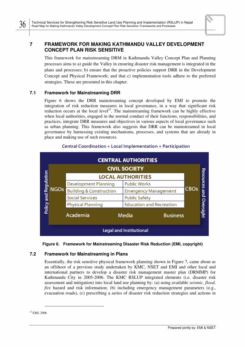
36 Technical Services for Strengthening Risk Sensitive Land Use Planning and Implementation (RSLUP) in Nepal Road Map for Making Kathmandu Valley Development Concept Plan Risk Sensitive: Frameworks
7 FRAMEWORK FOR CONCEPT PLAN RISK SE
This framework for mainstreamin
processes aims to a) guide the Valley in ensuring disaster risk management is integrated in the
plans and processes; b) ensure that the proactive policies support DRR in the Development
Concept and Physical Framework; and that c) implementation tools adhere to the preferred
strategies. These are presented in this chapter.
7.1 Framework for Mainstreaming
Figure 6 shows the DRR mainstreaming concept developed by EMI to promote the
integration of risk reducti
reduction occurs at the local level
when local authorities, engaged in the normal conduct of their functions, responsibilities, and
practices, integrate DRR measures and objectives in various aspects of local governance such
as urban planning. This framework also suggests that DRR can be mainstreamed in local
governance by harnessing existing mechanisms, processes, and systems that are alrea
place and making use of such resources.
Figure 6. Framework for Mainstreaming Disaster Risk Reduction (EMI, copyright)
7.2 Framework for Mainstreaming in Plans
Essentially, the risk sensitive
an offshoot of a previous study undertaken by KMC, NSET and EMI and other local and
international partners to develop a disaster risk management master plan (DRMMP) for
Kathmandu City in 2005
assessment and mitigation) into local land use planning by: (a) using available
fire hazard and risk information; (b) including emergency management parameters (e.g.,
evacuation roads), (c) prescribing a series of disaster risk re
23 EMI, 2006
Technical Services for Strengthening Risk Sensitive Land Use Planning and Implementation (RSLUP) in Nepal Road Map for Making Kathmandu Valley Development Concept Plan Risk Sensitive: Frameworks and Processes
Prepared
FRAMEWORK FOR MAKING KATHMANDU VALLEY DEVELOPMENT CONCEPT PLAN RISK SENSITIVE
This framework for mainstreaming DRM in Kathmandu Valley Concept Plan and Planning
processes aims to a) guide the Valley in ensuring disaster risk management is integrated in the
plans and processes; b) ensure that the proactive policies support DRR in the Development
al Framework; and that c) implementation tools adhere to the preferred
These are presented in this chapter.
Mainstreaming DRR
shows the DRR mainstreaming concept developed by EMI to promote the
integration of risk reduction measures in local governance, in a way that significant risk
reduction occurs at the local level23
. The mainstreaming framework can be highly effective
when local authorities, engaged in the normal conduct of their functions, responsibilities, and
ces, integrate DRR measures and objectives in various aspects of local governance such
as urban planning. This framework also suggests that DRR can be mainstreamed in local
governance by harnessing existing mechanisms, processes, and systems that are alrea
place and making use of such resources.
for Mainstreaming Disaster Risk Reduction (EMI, copyright)
Mainstreaming in Plans
Essentially, the risk sensitive physical framework planning shown in Figure
an offshoot of a previous study undertaken by KMC, NSET and EMI and other local and
international partners to develop a disaster risk management master plan (DRMMP) for
2005-2006. The KMC RSLUP integrated elements (i.e. disa
assessment and mitigation) into local land use planning by: (a) using available
hazard and risk information; (b) including emergency management parameters (e.g.,
evacuation roads), (c) prescribing a series of disaster risk reduction strategies and actions in
Technical Services for Strengthening Risk Sensitive Land Use Planning and Implementation (RSLUP) in Nepal
Prepared jointly by: EMI & NSET
ELOPMENT
g DRM in Kathmandu Valley Concept Plan and Planning
processes aims to a) guide the Valley in ensuring disaster risk management is integrated in the
plans and processes; b) ensure that the proactive policies support DRR in the Development
al Framework; and that c) implementation tools adhere to the preferred
shows the DRR mainstreaming concept developed by EMI to promote the
on measures in local governance, in a way that significant risk
. The mainstreaming framework can be highly effective
when local authorities, engaged in the normal conduct of their functions, responsibilities, and
ces, integrate DRR measures and objectives in various aspects of local governance such
as urban planning. This framework also suggests that DRR can be mainstreamed in local
governance by harnessing existing mechanisms, processes, and systems that are already in
for Mainstreaming Disaster Risk Reduction (EMI, copyright)
Figure 7, came about as
an offshoot of a previous study undertaken by KMC, NSET and EMI and other local and
international partners to develop a disaster risk management master plan (DRMMP) for
2006. The KMC RSLUP integrated elements (i.e. disaster risk
assessment and mitigation) into local land use planning by: (a) using available seismic, flood,
hazard and risk information; (b) including emergency management parameters (e.g.,
duction strategies and actions in
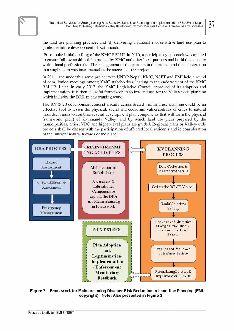
Technical Services for Strengthening Risk Sensitive Land Use Planning and Implementation (RSLUP) in NepalRoad Map for Making Kathmandu Valley Development Concept Plan Risk Sensitive: Frameworks and Processes
Prepared jointly by: EMI & NSET
the land use planning practice; and (d) delivering a rational risk
guide the future development of Kathmandu.
Prior to the initial crafting of the KMC RSLUP in 2010, a
to ensure full ownership of the project by KMC and other local partners and build the capacity
within local professionals. The engagement of the partners in the project and their integration
in a single team was instrumental to the success of th
In 2011, and under this same project with UNDP
of consultation meetings among KMC stakeholders, leading to the endorsement of the KMC
RSLUP. Later, in early 2012, the KMC Legislative Council approved of i
implementation. It is then, a useful framework to follow and use
which includes the DRR
The KV 2020 development concept already demonstrated that land use planning could be an
effective tool to lessen the physical, social and economic vulnerabilities of cities to natural
hazards. It aims to combine
framework (plan) of Kathmandu Valley
municipalities, cities, VDC and higher
projects shall be chosen with the participation of affected local residents and in consideration
of the inherent natural hazards of the place.
Figure 7. Framework for Maincopyright) Note: Also presented in Figure 3
Technical Services for Strengthening Risk Sensitive Land Use Planning and Implementation (RSLUP) in NepalMap for Making Kathmandu Valley Development Concept Plan Risk Sensitive: Frameworks and Processes
the land use planning practice; and (d) delivering a rational risk-sensitive land use plan to
guide the future development of Kathmandu.
Prior to the initial crafting of the KMC RSLUP in 2010, a participatory approach wa
to ensure full ownership of the project by KMC and other local partners and build the capacity
within local professionals. The engagement of the partners in the project and their integration
in a single team was instrumental to the success of the project.
, and under this same project with UNDP-Nepal, KMC, NSET and EMI held a round
of consultation meetings among KMC stakeholders, leading to the endorsement of the KMC
RSLUP. Later, in early 2012, the KMC Legislative Council approved of i
implementation. It is then, a useful framework to follow and use for the Valley wide
which includes the DRR mainstreaming work.
development concept already demonstrated that land use planning could be an
to lessen the physical, social and economic vulnerabilities of cities to natural
combine several development plan components that will
framework (plan) of Kathmandu Valley, and by which land use plans prepared by
unicipalities, cities, VDC and higher-level plans are guided. Regional plans or Valley
projects shall be chosen with the participation of affected local residents and in consideration
of the inherent natural hazards of the place.
Framework for Mainstreaming Disaster Risk Reduction in Land Use Planningcopyright) Note: Also presented in Figure 3
Technical Services for Strengthening Risk Sensitive Land Use Planning and Implementation (RSLUP) in Nepal Map for Making Kathmandu Valley Development Concept Plan Risk Sensitive: Frameworks and Processes 37
sensitive land use plan to
approach was applied
to ensure full ownership of the project by KMC and other local partners and build the capacity
within local professionals. The engagement of the partners in the project and their integration
KMC, NSET and EMI held a round
of consultation meetings among KMC stakeholders, leading to the endorsement of the KMC
RSLUP. Later, in early 2012, the KMC Legislative Council approved of its adoption and
Valley wide planning
development concept already demonstrated that land use planning could be an
to lessen the physical, social and economic vulnerabilities of cities to natural
that will form the physical
land use plans prepared by the
Regional plans or Valley-wide
projects shall be chosen with the participation of affected local residents and in consideration
streaming Disaster Risk Reduction in Land Use Planning (EMI,

38 Technical Services for Strengthening Risk Sensitive Land Use Planning and Implementation (RSLUP) in Nepal Road Map for Making Kathmandu Valley Development Concept Plan Risk Sensitive: Frameworks
7.3 Mainstreaming Activities
With continued efforts by KVDA and local stakeholders, and with strong support by the
Nepal Ministry (i.e. MoPPW,
by scientific organizations such as NSET and EMI, a blueprint towards sustainable urban
development within the Kathmandu Valley can be pursued.
The KV Development Concept Plan had already initiated a participatory a
the initial document undergo a series of reviews among its stakeholders in latter stages in
2001. The approved KV Plan consolidated the reviews and comments with the original
proposal and formed the basis for future land use planning acti
needs updating, the following enhancements are proposed:
• A program that includes a wider set of stakeholders to be involved in:
- identifying, describing, validating the issues and problems of the Valley;
- preparation of the Devel
- validating the component plans (settlement, infrastructure, environment and
production (economy) plans);
• Inclusion of natural hazard risks and their management to the different component plans
and their development policy, strategy decision
- Hazard, vulnerability and risk information and maps;
- Inclusion of past disaster information;
- Inclusion of climate change impact assessments to the region (or Valley);
- Implications of hazard, vulnerability and risk information to the component plans in
terms of land use management, particularly on enforcement issues;
- Inclusion and review of current progr
development plans for Valley wide development;
- Inclusion of risk management options and climate change adapt
relevant to the Valley;
- Identifying the programs, projects and activities which may be integrated in the
periodic plans of Municipalities, and cities;
In transforming the KV plan into a spatial framework, suggestions include the following:
• Combining the component plans into a preferred physical framework:
- Utilizing hazard maps and disaster risk information as constraints to urban expansion
areas (ex. exclusion areas, or development areas with use restrictions and control);
- Having appropriat
more detailed zoning (ex. municipal level (1:10:000);
- Inclusion and review of current programs, projects and activities in the components
spatial plans for Valley wide arrangements
- Inclusion of spatial components of risk management options and climate change
adaptation strategies relevant to the Valley;
- A simplified guide to aid in the process of mainstreaming hazard, vulnerability and
risk assessment in KV physical framework.
7.4 Capacity building
In order to carry out the needed enhancements and crafting of the KV framework plan,
capacity building must be directed to the technical, operational and institutional aspects of KV
governance. This capacity building
objectives by carrying out the policies and strategies set forth in the KV 2020 Development
Concept, and further refined towards a physical framework plan. These shall be in accordance
Technical Services for Strengthening Risk Sensitive Land Use Planning and Implementation (RSLUP) in Nepal Road Map for Making Kathmandu Valley Development Concept Plan Risk Sensitive: Frameworks and Processes
Prepared
Activities
With continued efforts by KVDA and local stakeholders, and with strong support by the
MoPPW, MoHA, MoLD and DUDBC) and departments
by scientific organizations such as NSET and EMI, a blueprint towards sustainable urban
the Kathmandu Valley can be pursued.
The KV Development Concept Plan had already initiated a participatory a
the initial document undergo a series of reviews among its stakeholders in latter stages in
2001. The approved KV Plan consolidated the reviews and comments with the original
proposal and formed the basis for future land use planning activities. However, as the plan
needs updating, the following enhancements are proposed:
A program that includes a wider set of stakeholders to be involved in:
identifying, describing, validating the issues and problems of the Valley;
preparation of the Development Vision;
validating the component plans (settlement, infrastructure, environment and
production (economy) plans);
Inclusion of natural hazard risks and their management to the different component plans
and their development policy, strategy decisions:
Hazard, vulnerability and risk information and maps;
Inclusion of past disaster information;
Inclusion of climate change impact assessments to the region (or Valley);
Implications of hazard, vulnerability and risk information to the component plans in
erms of land use management, particularly on enforcement issues;
Inclusion and review of current programs, projects and activities in
development plans for Valley wide development;
Inclusion of risk management options and climate change adaptation strategies
relevant to the Valley;
Identifying the programs, projects and activities which may be integrated in the
periodic plans of Municipalities, and cities;
In transforming the KV plan into a spatial framework, suggestions include the following:
Combining the component plans into a preferred physical framework:
Utilizing hazard maps and disaster risk information as constraints to urban expansion
(ex. exclusion areas, or development areas with use restrictions and control);
Having appropriately scaled hazard maps and disaster risk information to provide a
more detailed zoning (ex. municipal level (1:10:000);
Inclusion and review of current programs, projects and activities in the components
spatial plans for Valley wide arrangements
of spatial components of risk management options and climate change
adaptation strategies relevant to the Valley;
A simplified guide to aid in the process of mainstreaming hazard, vulnerability and
risk assessment in KV physical framework.
In order to carry out the needed enhancements and crafting of the KV framework plan,
capacity building must be directed to the technical, operational and institutional aspects of KV
governance. This capacity building should aim for the attainment of th
objectives by carrying out the policies and strategies set forth in the KV 2020 Development
and further refined towards a physical framework plan. These shall be in accordance
Technical Services for Strengthening Risk Sensitive Land Use Planning and Implementation (RSLUP) in Nepal
Prepared jointly by: EMI & NSET
With continued efforts by KVDA and local stakeholders, and with strong support by the
and departments, by UNDP and
by scientific organizations such as NSET and EMI, a blueprint towards sustainable urban
The KV Development Concept Plan had already initiated a participatory approach by having
the initial document undergo a series of reviews among its stakeholders in latter stages in
2001. The approved KV Plan consolidated the reviews and comments with the original
vities. However, as the plan
A program that includes a wider set of stakeholders to be involved in:
identifying, describing, validating the issues and problems of the Valley;
validating the component plans (settlement, infrastructure, environment and
Inclusion of natural hazard risks and their management to the different component plans
Inclusion of climate change impact assessments to the region (or Valley);
Implications of hazard, vulnerability and risk information to the component plans in
erms of land use management, particularly on enforcement issues;
ams, projects and activities in the component
ation strategies
Identifying the programs, projects and activities which may be integrated in the
In transforming the KV plan into a spatial framework, suggestions include the following:
Combining the component plans into a preferred physical framework:
Utilizing hazard maps and disaster risk information as constraints to urban expansion
(ex. exclusion areas, or development areas with use restrictions and control);
ely scaled hazard maps and disaster risk information to provide a
Inclusion and review of current programs, projects and activities in the components
of spatial components of risk management options and climate change
A simplified guide to aid in the process of mainstreaming hazard, vulnerability and
In order to carry out the needed enhancements and crafting of the KV framework plan,
capacity building must be directed to the technical, operational and institutional aspects of KV
the attainment of the KV development
objectives by carrying out the policies and strategies set forth in the KV 2020 Development
and further refined towards a physical framework plan. These shall be in accordance

Technical Services for Strengthening Risk Sensitive Land Use Planning and Implementation (RSLUP) in NepalRoad Map for Making Kathmandu Valley Development Concept Plan Risk Sensitive: Frameworks and Processes
Prepared jointly by: EMI & NSET
with existing national laws especially with the NSDRM
NAPA for Climate Change
continue on the efforts undertaken by this project, where several public officials from various
government institutions and KMC were t
separate report for this particular element of the project).
7.5 Enhanced Planning Steps
This section will focus attention on the
7.5.1 Data Collection & Inventory/Analysis
Data from five development sectors
and institutions contribute
same data shall form the bases for planning the different land use policy areas
production, infrastructure and protection land use. Significant data has already been collected
for Kathmandu City in relation to the earlier
project on KMC Risk Sensitive Land Use Plan
where a sectoral profile was developed. The
proposed data collection should be extended to
the Valley. Figure 8 provides an example of the
Sectoral Profile developed for KMC.
To be of more effective use for planning
following tasks should be accomplished:
• a common data set prepared for both sectoral
development and physical framework
planning analysis;
• indicators of development drawn from the
data are used to provide the existing
development scenario and to establish
trends;
• a lead agency shall be assigned towards
harmonization or streamlining the
information requirements for planning
Figure 8. The Kathmandu Metropolitan City Sectoral Profile as a sample
At later stages, these tasks must similarly be done by the municipalities in preparing their
periodic plans and component physical development plans. Eventu
prepare the individual municipal land use plans:
Thematic Mapping. The t
of the Valley. The list of thematic maps
regards to risk reduction, these shall include
from project reports and maps
hazard mapping exercises
related and geologic disasters.
Disaster Risk Mapping.
outputs. The Disaster Risk Assessment (DRA) process entails several steps
prepared ahead of the planning stage
(b) the vulnerabilities and risks of different elements (e.g. people, buildings, facilities,
activities, etc.) in the Valley or component areas, (c) risk parameters represented by estimates
Technical Services for Strengthening Risk Sensitive Land Use Planning and Implementation (RSLUP) in NepalMap for Making Kathmandu Valley Development Concept Plan Risk Sensitive: Frameworks and Processes
with existing national laws especially with the NSDRM for disaster risk management
for Climate Change policies and strategies. The capacity building effort should
continue on the efforts undertaken by this project, where several public officials from various
government institutions and KMC were trained on risk sensitive land use planning (refer to
separate report for this particular element of the project).
Enhanced Planning Steps
This section will focus attention on the following KV planning steps:
Data Collection & Inventory/Analysis
five development sectors, namely social, economy, infrastructures, environment,
contribute towards developing the socio-economic and physical profile. These
same data shall form the bases for planning the different land use policy areas
production, infrastructure and protection land use. Significant data has already been collected
for Kathmandu City in relation to the earlier
project on KMC Risk Sensitive Land Use Plan
where a sectoral profile was developed. The
collection should be extended to
the Valley. Figure 8 provides an example of the
Sectoral Profile developed for KMC.
To be of more effective use for planning, the
following tasks should be accomplished:
a common data set prepared for both sectoral
ment and physical framework
of development drawn from the
data are used to provide the existing
development scenario and to establish
a lead agency shall be assigned towards
harmonization or streamlining the
information requirements for planning
The Kathmandu Metropolitan City Sectoral Profile as a sample
At later stages, these tasks must similarly be done by the municipalities in preparing their
periodic plans and component physical development plans. Eventually, they shall be used to
prepare the individual municipal land use plans:
. The thematic maps are necessary to build the physical framework plan
The list of thematic maps shall cover the different land use policy areas
regards to risk reduction, these shall include geo-hazard maps. These maps may
and maps on earthquakes and floods, existing databases or from new
hazard mapping exercises. These shall be used to determine areas vulnerabl
related and geologic disasters.
apping. The risk maps may be drawn from the disaster risk assessment
The Disaster Risk Assessment (DRA) process entails several steps
prepared ahead of the planning stage. It involves an assessment of the following: (a) hazard,
(b) the vulnerabilities and risks of different elements (e.g. people, buildings, facilities,
Valley or component areas, (c) risk parameters represented by estimates
Technical Services for Strengthening Risk Sensitive Land Use Planning and Implementation (RSLUP) in Nepal Map for Making Kathmandu Valley Development Concept Plan Risk Sensitive: Frameworks and Processes 39
for disaster risk management and the
The capacity building effort should
continue on the efforts undertaken by this project, where several public officials from various
rained on risk sensitive land use planning (refer to
, namely social, economy, infrastructures, environment,
economic and physical profile. These
same data shall form the bases for planning the different land use policy areas-settlements,
production, infrastructure and protection land use. Significant data has already been collected
The Kathmandu Metropolitan City Sectoral Profile as a sample
At later stages, these tasks must similarly be done by the municipalities in preparing their
ally, they shall be used to
are necessary to build the physical framework plan
shall cover the different land use policy areas. With
hazard maps. These maps may be obtained
on earthquakes and floods, existing databases or from new
determine areas vulnerable to climate-
may be drawn from the disaster risk assessment
The Disaster Risk Assessment (DRA) process entails several steps and may be
involves an assessment of the following: (a) hazard,
(b) the vulnerabilities and risks of different elements (e.g. people, buildings, facilities,
Valley or component areas, (c) risk parameters represented by estimates

40 Technical Services for Strengthening Risk Sensitive Land Use Planning and Implementation (RSLUP) in Nepal Road Map for Making Kathmandu Valley Development Concept Plan Risk Sensitive: Frameworks
of damage or loss, and the (
open access, access routes, etc.)
Vulnerability analysis refers
socio-economic vulnerability
related to determining severity of
expressed as monetary loss, loss of function of specific sectors
Understanding the implications of the risk assessme
experiences and expertise of the planners, scientific experts and stakeholders in different
sectors to address these threats. To treat them as significant or not, or whether they are
impediments to development and
(KMC RSLUP, 2010)
• Emergency management
information on possible escape routes of an area, temporary sites for evacuation, and
locations of critical infrastructures (e.g. hospitals, water sources) may be mapped and
evaluated. The basic informat
make use of the aerial images. The information shall be validated on the ground as to
suitability in ground conditions.
• Decision zones. Overlays comprising
or compatible areas or finding those conflict
are called decision zones. For hazard and exposure mapping, a specific hazard map is
overlaid with the existing land use map, or with other component plan
infrastructures, productive assets, and social infrastructures
different levels of vulnerability
7.5.2 DRR-Sensitive Physical Planning Goals
If efforts had been made to ensure that the vision statement is
goals, particularly the goals of physical development, are expected to be equally risk
sensitive. Some examples drawn from the KV 2001
• Rational population distribution
concentration of development in the metropolitan cities. At the local scale, rational
population distribution may mean promoting the development of human settlements in
hazard-free and well
• Environmental integrity m
areas are not degraded further and areas under protection remain
7.5.3 DRR-Sensitive Spatial Strategies
In drawing up a KV physical framework, a preferred spatial strategy (or spatia
support the objectives of the KV development concept and
their community is needed.
The physical framework
the organizing concept to gui
its implementing tools such as the
• Demand-supply balancing of land for urban development
demand of land for urban development,
available areas for urban expansion
24 Serote, 2004
Technical Services for Strengthening Risk Sensitive Land Use Planning and Implementation (RSLUP) in Nepal Road Map for Making Kathmandu Valley Development Concept Plan Risk Sensitive: Frameworks and Processes
Prepared
and the (d) requirements for emergency management (e.g. open spaces,
open access, access routes, etc.).
refers to the following: physical vulnerability of the built environment,
economic vulnerability, climate change and variability vulnerability. R
determining severity of consequence (e.g. direct and indirect damages and losses
loss, loss of function of specific sectors.
Understanding the implications of the risk assessment to development requires the collective
experiences and expertise of the planners, scientific experts and stakeholders in different
sectors to address these threats. To treat them as significant or not, or whether they are
impediments to development and progress, will require further evaluation
Emergency management. In view of the spatial requirements for emergencies,
information on possible escape routes of an area, temporary sites for evacuation, and
locations of critical infrastructures (e.g. hospitals, water sources) may be mapped and
evaluated. The basic information on critical infrastructures, routes, temporary sites can
make use of the aerial images. The information shall be validated on the ground as to
suitability in ground conditions.
Overlays comprising various thematic maps provide for find
or compatible areas or finding those conflicts among land use areas. These common areas
are called decision zones. For hazard and exposure mapping, a specific hazard map is
overlaid with the existing land use map, or with other component plan
infrastructures, productive assets, and social infrastructures and facilities)to reveal
of vulnerability or risks to the hazard
Sensitive Physical Planning Goals
If efforts had been made to ensure that the vision statement is risk sensitive, other sectoral
goals, particularly the goals of physical development, are expected to be equally risk
sensitive. Some examples drawn from the KV 2001 include the following:
Rational population distribution. For the KV 2001 it means dispers
concentration of development in the metropolitan cities. At the local scale, rational
population distribution may mean promoting the development of human settlements in
free and well-serviced locations.
Environmental integrity maintained. This means that environmentally constrained
are not degraded further and areas under protection remain protected at all times.
Sensitive Spatial Strategies
In drawing up a KV physical framework, a preferred spatial strategy (or spatia
support the objectives of the KV development concept and in general the
is needed.
physical framework of the KV development concept would be this form and will serve as
the organizing concept to guide the detailed elaboration of the Valley wide
s such as the zoning ordinances.
supply balancing of land for urban development. In projecting the future
demand of land for urban development, the following exclusion areas help identify
available areas for urban expansion24
:
Technical Services for Strengthening Risk Sensitive Land Use Planning and Implementation (RSLUP) in Nepal
Prepared jointly by: EMI & NSET
) requirements for emergency management (e.g. open spaces,
to the following: physical vulnerability of the built environment,
variability vulnerability. Risk analysis is
indirect damages and losses),
nt to development requires the collective
experiences and expertise of the planners, scientific experts and stakeholders in different
sectors to address these threats. To treat them as significant or not, or whether they are
progress, will require further evaluation by the stakeholders.
In view of the spatial requirements for emergencies,
information on possible escape routes of an area, temporary sites for evacuation, and
locations of critical infrastructures (e.g. hospitals, water sources) may be mapped and
ion on critical infrastructures, routes, temporary sites can
make use of the aerial images. The information shall be validated on the ground as to
provide for finding suitable
These common areas
are called decision zones. For hazard and exposure mapping, a specific hazard map is
overlaid with the existing land use map, or with other component plan maps (ex.
and facilities)to reveal
risk sensitive, other sectoral
goals, particularly the goals of physical development, are expected to be equally risk
include the following:
. For the KV 2001 it means dispersion to prevent over-
concentration of development in the metropolitan cities. At the local scale, rational
population distribution may mean promoting the development of human settlements in
environmentally constrained
protected at all times.
In drawing up a KV physical framework, a preferred spatial strategy (or spatial form) that will
general the people’s vision for
of the KV development concept would be this form and will serve as
Valley wide land use plan and
. In projecting the future
sion areas help identify

Technical Services for Strengthening Risk Sensitive Land Use Planning and Implementation (RSLUP) in NepalRoad Map for Making Kathmandu Valley Development Concept Plan Risk Sensitive: Frameworks and Processes
Prepared jointly by: EMI & NSET
- the land areas of
demand.
- land areas for future
hazards are excluded from consideration
- Protected areas and environmentally constrained areas
for urban expansion purposes.
The result of the demand
need to augment supply to satisfy the demand.
agricultural land conversions are among other ways of meeting demand.
• Designing alternative spatial strategies or urban forms
spatial strategies is a major activity in the crafting of
framework. The spatial strategy is
Valley (and components)
- The evaluation of the alternative spatial strategies
advantages and disadvantages of each strategy
- Sectoral development issues and concerns
hazard risks and other data outp
and concerns.
and concerns that
reviewed, validated, prioritized
the updated KV Development Concept
development
- Sectoral development objectives and targets
vision statement. The development goals and targets are framed from these
development issues and concerns.
- Sectoral policies
of proposed sectoral programs and projects. As with the KV plan, they
the spatial trends of settlement expansion, ii) economic concentration and
specialization and iii) environmental concerns, iv)
risk reduction and adaptation.
- Spatial content.
then included in the KV physical framework plan and into the zoning policies,
ordinance and other proposed local legislation.
- Sectoral Programs and Projects
development
identified in the development
integrated later
- public consultation.
consultation. It is expected that the public consultation will result in a consensus
on the final vision statement and the preferred spatial strategy.
7.5.4 Evaluation and selection of the preferred strategy
The preferred spatial strategy
draft RSLUP. The main activities include identifying and mapping the land use policy areas
and their sub- components
The preferred urban form
Technical Services for Strengthening Risk Sensitive Land Use Planning and Implementation (RSLUP) in NepalMap for Making Kathmandu Valley Development Concept Plan Risk Sensitive: Frameworks and Processes
areas of existing settlements in hazard prone areas are added to the total
land areas for future urban development which are highly prone to different types of
excluded from consideration if mitigation is not cost effective.
rotected areas and environmentally constrained areas are considered
for urban expansion purposes.
The result of the demand-supply balancing process will indicate whether or n
need to augment supply to satisfy the demand. In-filling, densification, urban renewal
agricultural land conversions are among other ways of meeting demand.
Designing alternative spatial strategies or urban forms. Generation of alternat
spatial strategies is a major activity in the crafting of risk sensitive KV physical
. The spatial strategy is a form or pattern of physical development of the
Valley (and components) that will contribute to the realization of the long
valuation of the alternative spatial strategies aims to analyze and
advantages and disadvantages of each strategy:
Sectoral development issues and concerns. The sectoral profile, thematic maps,
hazard risks and other data outputs are used to describe the development issues
and concerns. In the context of the KV plan, the previously identified
and concerns that still resurface are documented in the updating. These are then
reviewed, validated, prioritized among the various sectoral issues and concerns in
updated KV Development Concept. Their implications
development and their possible solutions are discussed in workshops.
Sectoral development objectives and targets. These are derived from the
n statement. The development goals and targets are framed from these
development issues and concerns.
policies and strategies. These guide the formulation and implementation
of proposed sectoral programs and projects. As with the KV plan, they
the spatial trends of settlement expansion, ii) economic concentration and
specialization and iii) environmental concerns, iv) capacity development and v)
risk reduction and adaptation.
Spatial content. Spatial content or implications of the different sectoral plans are
then included in the KV physical framework plan and into the zoning policies,
ordinance and other proposed local legislation.
Sectoral Programs and Projects. Programs and projects necessary to realize the
development objectives and achieve the targets of the sectors and subsectors are
in the development and physical framework plan
later in the periodic plans.
public consultation. The outputs of this stage are then
n. It is expected that the public consultation will result in a consensus
on the final vision statement and the preferred spatial strategy.
Evaluation and selection of the preferred strategy
The preferred spatial strategy for Kathmandu Valley serves the basis for the preparation of the
draft RSLUP. The main activities include identifying and mapping the land use policy areas
components, namely: settlements, protection, production and infrastructure.
The preferred urban forms are also reflected in the land use plan.
Technical Services for Strengthening Risk Sensitive Land Use Planning and Implementation (RSLUP) in Nepal Map for Making Kathmandu Valley Development Concept Plan Risk Sensitive: Frameworks and Processes 41
added to the total
which are highly prone to different types of
if mitigation is not cost effective.
are considered not available
supply balancing process will indicate whether or not there will be a
filling, densification, urban renewal,
Generation of alternative
risk sensitive KV physical
form or pattern of physical development of the
that will contribute to the realization of the long-term vision.
aims to analyze and determine the
. The sectoral profile, thematic maps,
used to describe the development issues
In the context of the KV plan, the previously identified problems
the updating. These are then
ious sectoral issues and concerns in
. Their implications to sectoral
workshops.
. These are derived from the KV
n statement. The development goals and targets are framed from these
the formulation and implementation
of proposed sectoral programs and projects. As with the KV plan, they cover: i)
the spatial trends of settlement expansion, ii) economic concentration and
capacity development and v)
different sectoral plans are
then included in the KV physical framework plan and into the zoning policies,
. Programs and projects necessary to realize the
and achieve the targets of the sectors and subsectors are
plan. These may be
are then subject to public
n. It is expected that the public consultation will result in a consensus
on the final vision statement and the preferred spatial strategy.
the preparation of the
draft RSLUP. The main activities include identifying and mapping the land use policy areas
, namely: settlements, protection, production and infrastructure.
42 Technical Services for Strengthening Risk Sensitive Land Use Planning and Implementation (RSLUP) in Nepal Road Map for Making Kathmandu Valley Development Concept Plan Risk Sensitive: Frameworks
7.5.5 Detailing the land use plan
The chosen spatial strategy or urban form will now become the organizing concept for
detailing the Valley wide
tools.
Technical Services for Strengthening Risk Sensitive Land Use Planning and Implementation (RSLUP) in Nepal Road Map for Making Kathmandu Valley Development Concept Plan Risk Sensitive: Frameworks and Processes
Prepared
Detailing the land use plan
The chosen spatial strategy or urban form will now become the organizing concept for
Valley wide land use plan, the zoning ordinances and other
Technical Services for Strengthening Risk Sensitive Land Use Planning and Implementation (RSLUP) in Nepal
Prepared jointly by: EMI & NSET
The chosen spatial strategy or urban form will now become the organizing concept for
and other plan implementation

Technical Services for Strengthening Risk Sensitive Land Use Planning and Implementation (RSLUP) in NepalRoad Map for Making Kathmandu Valley Development Concept Plan Risk Sensitive: Frameworks and Processes
Prepared jointly by: EMI & NSET
8 DRR RELATED IMPLEMENTATION
8.1 Zoning
The Zoning Ordinance, which basically translates the
implementing tool, is
frameworks. It is necessary for the KV
impose penalties and fines on violators of its provision
Fines and Penalties
Fines and penalties can also have a regulatory effect.
penalized:
• Settlement encroachments into “no buil
among areas to be included in protected zones. As “no
and buffers are in place to protect communities or resources
• Violations in development plan and building plan permitting
• Non-conformance of allowed occupancy use
• Non-conformance of construction work with approved plans or building bye
codes
• Non-provision of Open space
requirements must be
• In a watershed approach
areas are considered in evaluating proposed land uses
• Non-conformance of owners, developers to approved
ordinances. Necessarily,
guided by the Valley wide physical framework (spatial) plan.
• Degradation of the environment by unlawful activities and poor practices in waste
management shall be penalized in the Valley.
• Adopt the “polluter pays” principle. Project proponents whose projects are determined to
cause risks to the local population should pay the intended or unintended effects.
• Penalties and fines should be used to compensate victims of man
proofing of buildings, building collapses).
8.2 Safe Building By-Laws
Safe building construction
should be integrated in the local building bye
equipment needed to enf
municipalities, VDCs and cities.
• The building by-laws
peculiarities, but guided by National Building Code.
25 The implementation tools discussed in this section
and from works by Serote, 2004, Comprehensive Land Use Plan and Management of Local Territories, Property, Patrimony and
Territory: Foundations of Land Use Planning in the Philippines; School of Urban and Regional Planning, UP
Technical Services for Strengthening Risk Sensitive Land Use Planning and Implementation (RSLUP) in NepalMap for Making Kathmandu Valley Development Concept Plan Risk Sensitive: Frameworks and Processes
IMPLEMENTATION TOOLS25
Zoning Ordinance, which basically translates the KV risk-sensitive land use plan into a
is based on the preferred land use plan and the
It is necessary for the KVDA to strongly enforce the derived
impose penalties and fines on violators of its provision.
Fines and penalties can also have a regulatory effect. Acts such as the following should be
Settlement encroachments into “no build” zones. High risk- areas shall be included
among areas to be included in protected zones. As “no-build” zones, necessary easements
and buffers are in place to protect communities or resources
Violations in development plan and building plan permitting
conformance of allowed occupancy use
conformance of construction work with approved plans or building bye
Open spaces. Remaining open spaces must be maintained and that
requirements must be determined and met.
tershed approach, interrelationships and impacts of upland activities on lowland
are considered in evaluating proposed land uses.
conformance of owners, developers to approved building bye-laws and zoning
Necessarily, municipal and city land use plans and periodic plans
guided by the Valley wide physical framework (spatial) plan.
Degradation of the environment by unlawful activities and poor practices in waste
management shall be penalized in the Valley.
pays” principle. Project proponents whose projects are determined to
cause risks to the local population should pay the intended or unintended effects.
Penalties and fines should be used to compensate victims of man-made risks (ex. poor fire
buildings, building collapses).
Laws
Safe building construction should be guided by the Nepal (National) Building Code
should be integrated in the local building bye-laws. The structure, functions, resources and
equipment needed to enforce this must be determined by the KVDA and the component
municipalities, VDCs and cities.
laws (Valley wide) should be more responsive to local needs and
peculiarities, but guided by National Building Code.
discussed in this section were obtained from the KV 2001 report, E-learning discussion forums and adaptations
Serote, 2004, Comprehensive Land Use Plan and Management of Local Territories, Property, Patrimony and
Land Use Planning in the Philippines; School of Urban and Regional Planning, UP
Technical Services for Strengthening Risk Sensitive Land Use Planning and Implementation (RSLUP) in Nepal Map for Making Kathmandu Valley Development Concept Plan Risk Sensitive: Frameworks and Processes 43
sensitive land use plan into an
the land use policy
y enforce the derived zoning and to
the following should be
areas shall be included
build” zones, necessary easements
conformance of construction work with approved plans or building bye-laws and
s. Remaining open spaces must be maintained and that
upland activities on lowland
laws and zoning
and periodic plans must be
Degradation of the environment by unlawful activities and poor practices in waste
pays” principle. Project proponents whose projects are determined to
cause risks to the local population should pay the intended or unintended effects.
made risks (ex. poor fire
the Nepal (National) Building Code and
laws. The structure, functions, resources and
orce this must be determined by the KVDA and the component
should be more responsive to local needs and
learning discussion forums and adaptations
Serote, 2004, Comprehensive Land Use Plan and Management of Local Territories, Property, Patrimony and
Land Use Planning in the Philippines; School of Urban and Regional Planning, UP-PLANADES) pp.371-386.

44 Technical Services for Strengthening Risk Sensitive Land Use Planning and Implementation (RSLUP) in Nepal Road Map for Making Kathmandu Valley Development Concept Plan Risk Sensitive: Frameworks
• Strict enforcement of
design and construction of building structures and their foundations.
• Monitoring, assessment and evaluation programs for existing structures must be in place
• Regular monitoring of
must be in place. Appropriate treatment measures ranging from conservation to
rehabilitation to redevelopment
shall be formulated to create a
example, preserving open spaces, non
to more compact and efficient forms; monitoring, assessment and evaluation programs
must be in place.
8.3 Co-management
Ministries (through KVDA)
undertake joint responsibility for managing the different land use
territorial jurisdiction. Th
enforcement of Valley wide building bye
environment and natural resource areas (forest land areas)
8.4 Public Investment Programming
The annual investment program should be
plan. For example, the municipalities and urbanizing VDCs use a portion of their individual
annual budgets for its risk sensitive programs, projects and activities
8.5 Private Investments Incentives
Incentives are given to private
of Government may consider:
• Giving fiscal and monetary rewards
significant risk reduction measures in their day to day operations or to those
that an Environmental
Program for Environmental Management
allowed to operate in an area
Technical Services for Strengthening Risk Sensitive Land Use Planning and Implementation (RSLUP) in Nepal Road Map for Making Kathmandu Valley Development Concept Plan Risk Sensitive: Frameworks and Processes
Prepared
ment of safe engineering standards should be encouraged
design and construction of building structures and their foundations.
Monitoring, assessment and evaluation programs for existing structures must be in place
ing of the structural and environmental quality of residential districts
ppropriate treatment measures ranging from conservation to
rehabilitation to redevelopment should be considered. Urban expansion
shall be formulated to create a balanced built and un-built environment, that is, for
preserving open spaces, non-conversion or remaining lands, adjusting systems
to more compact and efficient forms; monitoring, assessment and evaluation programs
DA) and local governments (e.g. the municipalities, cities and VDCs
nsibility for managing the different land use areas that lie within the
. The activities may include enforcement of national buil
Valley wide building bye-laws and zoning ordinances, co
environment and natural resource areas (forest land areas).
Public Investment Programming
The annual investment program should be the principal instrument for implementing the
For example, the municipalities and urbanizing VDCs use a portion of their individual
risk sensitive programs, projects and activities.
Private Investments Incentives
private investors for implementing DRM activities;
may consider:
Giving fiscal and monetary rewards (tax –subsidies) to private firms that
significant risk reduction measures in their day to day operations or to those
nvironmental Impact Assessments are prepared and a Monitoring, Evaluation
Program for Environmental Management are designed and funded before any project is
allowed to operate in an area
Technical Services for Strengthening Risk Sensitive Land Use Planning and Implementation (RSLUP) in Nepal
Prepared jointly by: EMI & NSET
should be encouraged especially in the
Monitoring, assessment and evaluation programs for existing structures must be in place.
d environmental quality of residential districts
ppropriate treatment measures ranging from conservation to
rban expansion and management
environment, that is, for
conversion or remaining lands, adjusting systems
to more compact and efficient forms; monitoring, assessment and evaluation programs
the municipalities, cities and VDCs)
areas that lie within their
may include enforcement of national building codes,
laws and zoning ordinances, co-managing the
mplementing the KV
For example, the municipalities and urbanizing VDCs use a portion of their individual
DRM activities; the different levels
to private firms that put into practice
significant risk reduction measures in their day to day operations or to those who ensure
Impact Assessments are prepared and a Monitoring, Evaluation
are designed and funded before any project is

Technical Services for Strengthening Risk Sensitive Land Use Planning and Implementation (RSLUP) in NepalRoad Map for Making Kathmandu Valley Development Concept Plan Risk Sensitive: Frameworks and Processes
Prepared jointly by: EMI & NSET
9 WAY FORWARD: COMPLETINGVALLEY PHYSICAL FRAM
It is proposed that to complete the KV Development Concept into a KV Physical framework
plan, a 3-year plan be programmed in four stages
Tasks
STAGE 1:
Task 1. Organizing and tasking activities for Risk
Sensitive physical framework planning for
Kathmandu Valley
Task 1.1 KVDA planning committee &structure defined
Task 1.2 KV Data inventory and Thematic Map
inventory
Task 1.3 Work Plan and Approval, Funding source
STAGE 2:
Task 2.Updating of KV Concept Plan,
Task 2.1 Updating of Ecological profile,
Task 2.2 RSLUP Guideline preparation
STAGE 3:
Task 3 Valley Wide Multi Hazards Analysis
Task 4. Valley wide Transport Planning
Task 5. Valley wide Physical Framework Planning
STAGE 4:
Task 6. Selected Sub-Met.Cities,Municipalities
RSLUP
Task 7. Special Studies (Selected Heritage/Historical
Sites)
Task 8. Capacity building, monitoring tools
development
Figure 9. Proposed Activities and Timeline for the Completion of the Risk Sensitive Land Use
Stage 1 will focus on
composition of KVDA committee for planning, data inventorying, work planning, approval
process and budgeting. This stage shall help r
agencies and development partners in Nepal on the development strategies, methodology and
institutional arrangements for the development of the Kathmandu Valley RSLUP
The activities of Stage 2
updating the information about the planning environment (social, economic, physical and
environmental aspects) and the development of a simplified guide towards risk sensitive
physical framework (land use) planning.
Stage 3 shall include the Valley wide multi hazard analysis, the transport planning and
physical framework planning. Because of po
acquired by primary data gathering (surveys and interviews), model development and
processing, the period is given two (2) years to complete an integrated transport and land use
planning for the Kathmandu Valley.
MoLD, KVDA, KMC and other Municipalities and VDC’s within Kathmandu Valley.
Technical Services for Strengthening Risk Sensitive Land Use Planning and Implementation (RSLUP) in NepalMap for Making Kathmandu Valley Development Concept Plan Risk Sensitive: Frameworks and Processes
COMPLETING THE RISK SENSITIVE KATHMANDU VALLEY PHYSICAL FRAMEWORK PLAN
It is proposed that to complete the KV Development Concept into a KV Physical framework
be programmed in four stages as indicated in Figure 9.
Year 1 Year 2
Task 1. Organizing and tasking activities for Risk
Sensitive physical framework planning for
Task 1.1 KVDA planning committee &structure defined
Task 1.2 KV Data inventory and Thematic Map
and Approval, Funding source
Task 2.Updating of KV Concept Plan,
Task 2.1 Updating of Ecological profile,
Task 2.2 RSLUP Guideline preparation
Task 3 Valley Wide Multi Hazards Analysis
Valley wide Transport Planning
Task 5. Valley wide Physical Framework Planning
Met.Cities,Municipalities
Task 7. Special Studies (Selected Heritage/Historical
building, monitoring tools
Proposed Activities and Timeline for the Completion of the Risk Sensitive Land Use Plan for the Kathmandu Valley
will focus on organization and preparation for KV risk sensitive planning:
KVDA committee for planning, data inventorying, work planning, approval
process and budgeting. This stage shall help reach consensus among the Nepalese government
agencies and development partners in Nepal on the development strategies, methodology and
stitutional arrangements for the development of the Kathmandu Valley RSLUP
Stage 2will include updating of the KV concept plan. This shall include
updating the information about the planning environment (social, economic, physical and
vironmental aspects) and the development of a simplified guide towards risk sensitive
physical framework (land use) planning.
shall include the Valley wide multi hazard analysis, the transport planning and
physical framework planning. Because of possible data requirements which can only be
acquired by primary data gathering (surveys and interviews), model development and
processing, the period is given two (2) years to complete an integrated transport and land use
for the Kathmandu Valley. The government partners for the project will be MoPPW,
, KMC and other Municipalities and VDC’s within Kathmandu Valley.
Technical Services for Strengthening Risk Sensitive Land Use Planning and Implementation (RSLUP) in Nepal Map for Making Kathmandu Valley Development Concept Plan Risk Sensitive: Frameworks and Processes 45
KATHMANDU
It is proposed that to complete the KV Development Concept into a KV Physical framework
Figure 9.
Year 2 Year 3
Proposed Activities and Timeline for the Completion of the Risk Sensitive Land Use
organization and preparation for KV risk sensitive planning:
KVDA committee for planning, data inventorying, work planning, approval
each consensus among the Nepalese government
agencies and development partners in Nepal on the development strategies, methodology and
stitutional arrangements for the development of the Kathmandu Valley RSLUP.
will include updating of the KV concept plan. This shall include
updating the information about the planning environment (social, economic, physical and
vironmental aspects) and the development of a simplified guide towards risk sensitive
shall include the Valley wide multi hazard analysis, the transport planning and
ssible data requirements which can only be
acquired by primary data gathering (surveys and interviews), model development and
processing, the period is given two (2) years to complete an integrated transport and land use
The government partners for the project will be MoPPW,
, KMC and other Municipalities and VDC’s within Kathmandu Valley.

46 Technical Services for Strengthening Risk Sensitive Land Use Planning and Implementation (RSLUP) in Nepal Road Map for Making Kathmandu Valley Development Concept Plan Risk Sensitive: Frameworks
Stage 4 will focus on municipal land use planning or periodic planning of selected sub
metropolitan cities, municipalities an
finalization of the KMC RSLUP. Special studies on heritage areas or historical sites are
proposed while the land use plans are similarly prepared, in order that these master plans are
concurrent with the land use plan preparation.
Capacity building activities are proposed to be spread over the entire project period and be
made parallel to the different tasks. Capacity building of Nepalese planners in
land use planning shall be coursed throu
workshop and lectures, field trips and site visits among others. These activities are hoped to
support the future implementation of the CDRM and the Flagship Programmes
Technical Services for Strengthening Risk Sensitive Land Use Planning and Implementation (RSLUP) in Nepal Road Map for Making Kathmandu Valley Development Concept Plan Risk Sensitive: Frameworks and Processes
Prepared
will focus on municipal land use planning or periodic planning of selected sub
metropolitan cities, municipalities and urbanizing VDCs. This stage shall also include the
finalization of the KMC RSLUP. Special studies on heritage areas or historical sites are
proposed while the land use plans are similarly prepared, in order that these master plans are
land use plan preparation.
Capacity building activities are proposed to be spread over the entire project period and be
made parallel to the different tasks. Capacity building of Nepalese planners in
shall be coursed through active participation in the various activities,
workshop and lectures, field trips and site visits among others. These activities are hoped to
support the future implementation of the CDRM and the Flagship Programmes
Technical Services for Strengthening Risk Sensitive Land Use Planning and Implementation (RSLUP) in Nepal
Prepared jointly by: EMI & NSET
will focus on municipal land use planning or periodic planning of selected sub-
d urbanizing VDCs. This stage shall also include the
finalization of the KMC RSLUP. Special studies on heritage areas or historical sites are
proposed while the land use plans are similarly prepared, in order that these master plans are
Capacity building activities are proposed to be spread over the entire project period and be
made parallel to the different tasks. Capacity building of Nepalese planners in risk sensitive
gh active participation in the various activities,
workshop and lectures, field trips and site visits among others. These activities are hoped to
support the future implementation of the CDRM and the Flagship Programmes.

Technical Services for Strengthening Risk Sensitive Land Use Planning and Implementation (RSLUP) in NepalRoad Map for Making Kathmandu Valley Development Concept Plan Risk Sensitive: Frameworks and Processes
Prepared jointly by: EMI & NSET
10 REFERENCES
1. Earthquakes and Megac
Metropolitan City, Nepal;
Application in Metro Manila and Kathmandu 2010; Submitted to The German Federal
Foreign Affairs Office t
2. Earthquakes and Megacities Initiative (EMI),
Kathmandu Metropolitan City, Nepal;
megacities: A Pilot-Application in Metro Manila and Ka
Deutches Komitee Katasrophenvorsorge
3. Earthquakes and Megacities Initiative (EMI),
City, Nepal; A Pilot-
German Federal Forei
Katasrophenvorsorge
4. Earthquakes and Megacities Initiative, 2007, Urban and Megacities Disaster Risk
Reduction – Manual of Sound Practices. Quezon City, Philippines.
5. Japan International Cooperation Agency and t
2002. The Study on Earthquake Disaster Mitigation in the Kathmandu Valley, Kingdom
of Nepal, Volume III.
6. Kathmandu Valley Environment Outlook, ICIMOD, International Centre for Integrated
Mountain Development, Kathmand
7. Municipality Profile of Nepal, a socio
Intensive Study and Research Center (Kathmandu). 2008.
8. National Adaptation Programme of Action (NAPA) to Climate Change, Ministry of
Environment, 2010
9. National Strategy for Disaster Risk Management, Government of Nepal, 2009
10. National Urban Policy 2064 (200
Government
11. Nepal DesInventar Database, NSET 2011
12. Ministry of Physical Planning and Works
Building Construction
13. Pradhan and Perera. 2005. Urban Growth and Its Impact on the Livelihoods of
Kathmandu Valley, Nepal.
14. Serote, E. 2004. Property, Patrimony & Territory: Foundations of Land Use Planning in
the Philippines. School of Urban and Regional Planning. University of the Philippines.
9, pp.347-387
15. Serote, E. (2005): Rationalized Local Planning System
Urban and Regional Planning, University of the Philippines, unpublished
16. Sharma P., 2003. Population Monograph of Nepal Volume 1: Urbanization and
development. Central Bureau of Statistics, Kathmandu.
17. The Preparation of Flood Risk and Vulnerability Map of the Kathmandu Valley,
Government of Nepal
Disaster Prevention, Pulchowk, Lalitpur, Nep
18. Urban Indicators for Managing Cities: Cities Data Book, 2001
Technical Services for Strengthening Risk Sensitive Land Use Planning and Implementation (RSLUP) in NepalMap for Making Kathmandu Valley Development Concept Plan Risk Sensitive: Frameworks and Processes
Earthquakes and Megacities Initiative (EMI) Risk-sensitive Land Use Plan of Kathmandu
Metropolitan City, Nepal; Mainstreaming Disaster Risk Reduction in megacities: A Pilot
Application in Metro Manila and Kathmandu 2010; Submitted to The German Federal
Foreign Affairs Office through the Deutches Komitee Katasrophenvorsorge
Earthquakes and Megacities Initiative (EMI), Risk-sensitive Land Use Plan of
Kathmandu Metropolitan City, Nepal; Mainstreaming Disaster Risk Reduction in
Application in Metro Manila and Kathmandu 2011 through the
Deutches Komitee Katasrophenvorsorge
Earthquakes and Megacities Initiative (EMI), Sectoral Profile of Kathmandu Metropolitan
-Application in Metro Manila and Kathmandu 2010; Submitted to the
German Federal Foreign Affairs Office through the Deutches Komitee
Katasrophenvorsorge
Earthquakes and Megacities Initiative, 2007, Urban and Megacities Disaster Risk
Manual of Sound Practices. Quezon City, Philippines.
Japan International Cooperation Agency and the Ministry of Home Affairs of Nepal.
The Study on Earthquake Disaster Mitigation in the Kathmandu Valley, Kingdom
, Volume III.
Kathmandu Valley Environment Outlook, ICIMOD, International Centre for Integrated
Mountain Development, Kathmandu. 2007
Municipality Profile of Nepal, a socio-economic development data base of Nepal.
Intensive Study and Research Center (Kathmandu). 2008.
National Adaptation Programme of Action (NAPA) to Climate Change, Ministry of
y for Disaster Risk Management, Government of Nepal, 2009
National Urban Policy 2064 (2007), Government of Nepal Unofficial Translation, Nepal
Nepal DesInventar Database, NSET 2011
Ministry of Physical Planning and Works, Department of Urban Development and
Building Construction, Babar Mahal
Pradhan and Perera. 2005. Urban Growth and Its Impact on the Livelihoods of
Kathmandu Valley, Nepal.
Serote, E. 2004. Property, Patrimony & Territory: Foundations of Land Use Planning in
chool of Urban and Regional Planning. University of the Philippines.
Serote, E. (2005): Rationalized Local Planning System in the Philippines, School of
Urban and Regional Planning, University of the Philippines, unpublished
2003. Population Monograph of Nepal Volume 1: Urbanization and
development. Central Bureau of Statistics, Kathmandu.
The Preparation of Flood Risk and Vulnerability Map of the Kathmandu Valley,
Government of Nepal 2009, Ministry of Water Resources, Department of Water Induced
Disaster Prevention, Pulchowk, Lalitpur, Nepal.
Urban Indicators for Managing Cities: Cities Data Book, 2001
Technical Services for Strengthening Risk Sensitive Land Use Planning and Implementation (RSLUP) in Nepal Map for Making Kathmandu Valley Development Concept Plan Risk Sensitive: Frameworks and Processes 47
sensitive Land Use Plan of Kathmandu
Mainstreaming Disaster Risk Reduction in megacities: A Pilot-
Application in Metro Manila and Kathmandu 2010; Submitted to The German Federal
hrough the Deutches Komitee Katasrophenvorsorge
sensitive Land Use Plan of
Mainstreaming Disaster Risk Reduction in
thmandu 2011 through the
Sectoral Profile of Kathmandu Metropolitan
Application in Metro Manila and Kathmandu 2010; Submitted to the
gn Affairs Office through the Deutches Komitee
Earthquakes and Megacities Initiative, 2007, Urban and Megacities Disaster Risk
he Ministry of Home Affairs of Nepal.
The Study on Earthquake Disaster Mitigation in the Kathmandu Valley, Kingdom
Kathmandu Valley Environment Outlook, ICIMOD, International Centre for Integrated
economic development data base of Nepal.
National Adaptation Programme of Action (NAPA) to Climate Change, Ministry of
y for Disaster Risk Management, Government of Nepal, 2009
), Government of Nepal Unofficial Translation, Nepal
Development and
Pradhan and Perera. 2005. Urban Growth and Its Impact on the Livelihoods of
Serote, E. 2004. Property, Patrimony & Territory: Foundations of Land Use Planning in
chool of Urban and Regional Planning. University of the Philippines. C-
in the Philippines, School of
Urban and Regional Planning, University of the Philippines, unpublished
2003. Population Monograph of Nepal Volume 1: Urbanization and
The Preparation of Flood Risk and Vulnerability Map of the Kathmandu Valley,
ent of Water Induced

48 Technical Services for Strengthening Risk Sensitive Land Use Planning and Implementation (RSLUP) in Nepal Road Map for Making Kathmandu Valley Development Concept Plan Risk Sensitive: Frameworks
According to the Kathmandu Valley DRM Profile (EMI, 2005), the most frequent natural
disasters in Nepal are flood, la
property. The middle hills are mainly prone to landslides while the flat Tarai region is
susceptible to flood and fire. While earthquakes are not frequent, historically, Nepal has
experienced several destructive earthquakes with more than 11,000 people killed in four
major earthquakes just in the past century.
The more devastating natural hazards for Kathmandu Valley are related to earthquakes, floods
and fires.
Annex 1. Earthquake
The historical earthquak
the Himalaya.
Historically, Nepal has experienced several destructive earthquakes with more than 11,000
people killed in four major earthquakes just in the past century. Based on the earthquak
catalog, Nepal faces one earthquake of Magnitude 7 or greater every 75 years, on average.
Such magnitude earthquake could be extremely damaging to urban metropolises as
demonstrated by the M7.0 January 2010 Haiti earthquake. Even more alarming is that
1800 five (5) events of M>= 7 have affected Kathmandu; the most recent severe earthquake
was the 1934 M8.3 earthquake. On average earthquake intensities equal to or greater than
VIII MMI (Modified Mercalli Intensity) take place every 36 years while
intensities of IX MMI or greater take place every 75 years. The last significant earthquake
M6.6 causing a loss of 721 lives occurred in east Nepal in 1988. It caused a total direct
economic loss of about 5 billion Nepalese Rupees. Further a re
and central Nepal as well as north east India causing damage to 30,684 buildings and
inflicting a total direct economic loss of 5.65billion Nepalese Rupees. The consolidated
earthquake catalogue of Nepal (1255 to 1992 A.D) and
Seismological centre (NSC) of Department of Mines and Geology (DMG) shows high
frequency of large earthquakes in Nepal. Based on these observations, it is reasonable to
conclude that there is a high likelihood of an eart
greater in Kathmandu. Such intensities will create catastrophic damages in the city.
Table A.1: Magnitude-Frequency Data on Earthquakes in Nepal and the Surrounding Region
No. of Events
Approximate Recurrence Interval, yr.
Table A.2: Frequency and Various levels of earthquake intensities in Kathmandu since 1800
KATHMANDU
5 Events
event of M=8.3 (1934)
Technical Services for Strengthening Risk Sensitive Land Use Planning and Implementation (RSLUP) in Nepal Road Map for Making Kathmandu Valley Development Concept Plan Risk Sensitive: Frameworks and Processes
Prepared
ANNEXES
According to the Kathmandu Valley DRM Profile (EMI, 2005), the most frequent natural
disasters in Nepal are flood, landslide, and fire causing loss of life and severe damage to
property. The middle hills are mainly prone to landslides while the flat Tarai region is
susceptible to flood and fire. While earthquakes are not frequent, historically, Nepal has
eral destructive earthquakes with more than 11,000 people killed in four
major earthquakes just in the past century.
The more devastating natural hazards for Kathmandu Valley are related to earthquakes, floods
The historical earthquake catalogue of UNDP/UNCHS (1994) showed high seismicity along
Historically, Nepal has experienced several destructive earthquakes with more than 11,000
people killed in four major earthquakes just in the past century. Based on the earthquak
catalog, Nepal faces one earthquake of Magnitude 7 or greater every 75 years, on average.
Such magnitude earthquake could be extremely damaging to urban metropolises as
demonstrated by the M7.0 January 2010 Haiti earthquake. Even more alarming is that
1800 five (5) events of M>= 7 have affected Kathmandu; the most recent severe earthquake
was the 1934 M8.3 earthquake. On average earthquake intensities equal to or greater than
VIII MMI (Modified Mercalli Intensity) take place every 36 years while
intensities of IX MMI or greater take place every 75 years. The last significant earthquake
M6.6 causing a loss of 721 lives occurred in east Nepal in 1988. It caused a total direct
economic loss of about 5 billion Nepalese Rupees. Further a recent M6.9 event shook eastern
and central Nepal as well as north east India causing damage to 30,684 buildings and
inflicting a total direct economic loss of 5.65billion Nepalese Rupees. The consolidated
earthquake catalogue of Nepal (1255 to 1992 A.D) and subsequent reporting by National
Seismological centre (NSC) of Department of Mines and Geology (DMG) shows high
frequency of large earthquakes in Nepal. Based on these observations, it is reasonable to
conclude that there is a high likelihood of an earthquake which will cause intensities of 8 or
greater in Kathmandu. Such intensities will create catastrophic damages in the city.
Frequency Data on Earthquakes in Nepal and the Surrounding Region (1911-1991)
Earthquakes of Magnitudes in Richter
5 to 6 6 to 7 7 to 7.5
41 17 10
Approximate Recurrence Interval, yr. 2 5 8
Source: Earthquake Catalogue in BCDP, 1994
Frequency and Various levels of earthquake intensities in Kathmandu since 1800 A.D
(Source: EMI from historical earthquake catalogue)
KATHMANDU
5 Events of M>=7 since 1800 with one
event of M=8.3 (1934)
Technical Services for Strengthening Risk Sensitive Land Use Planning and Implementation (RSLUP) in Nepal
Prepared jointly by: EMI & NSET
According to the Kathmandu Valley DRM Profile (EMI, 2005), the most frequent natural
ndslide, and fire causing loss of life and severe damage to
property. The middle hills are mainly prone to landslides while the flat Tarai region is
susceptible to flood and fire. While earthquakes are not frequent, historically, Nepal has
eral destructive earthquakes with more than 11,000 people killed in four
The more devastating natural hazards for Kathmandu Valley are related to earthquakes, floods
e catalogue of UNDP/UNCHS (1994) showed high seismicity along
Historically, Nepal has experienced several destructive earthquakes with more than 11,000
people killed in four major earthquakes just in the past century. Based on the earthquake
catalog, Nepal faces one earthquake of Magnitude 7 or greater every 75 years, on average.
Such magnitude earthquake could be extremely damaging to urban metropolises as
demonstrated by the M7.0 January 2010 Haiti earthquake. Even more alarming is that since
1800 five (5) events of M>= 7 have affected Kathmandu; the most recent severe earthquake
was the 1934 M8.3 earthquake. On average earthquake intensities equal to or greater than
VIII MMI (Modified Mercalli Intensity) take place every 36 years while earthquake
intensities of IX MMI or greater take place every 75 years. The last significant earthquake
M6.6 causing a loss of 721 lives occurred in east Nepal in 1988. It caused a total direct
cent M6.9 event shook eastern
and central Nepal as well as north east India causing damage to 30,684 buildings and
inflicting a total direct economic loss of 5.65billion Nepalese Rupees. The consolidated
subsequent reporting by National
Seismological centre (NSC) of Department of Mines and Geology (DMG) shows high
frequency of large earthquakes in Nepal. Based on these observations, it is reasonable to
hquake which will cause intensities of 8 or
greater in Kathmandu. Such intensities will create catastrophic damages in the city.
Frequency Data on Earthquakes in Nepal and the Surrounding Region
Earthquakes of Magnitudes in Richter Scale
7.5 to 8 >8
2 1
40 81
Source: Earthquake Catalogue in BCDP, 1994
Frequency and Various levels of earthquake intensities in Kathmandu since 1800
(Source: EMI from historical earthquake catalogue)

Technical Services for Strengthening Risk Sensitive Land Use Planning and Implementation (RSLUP) in NepalRoad Map for Making Kathmandu Valley Development Concept Plan Risk Sensitive: Frameworks and Processes
Prepared jointly by: EMI & NSET
For example, it was reported that in 1833, a strong earthquake resulted in the destruction of
643 houses, and death of 414 people. The 1934 Bihar
shaking in Kathmandu Valle
destroyed 20 percent and damaged 40 percent of the valley’s building stock. In Kathmandu
itself, one quarter of all homes was destroyed along with many historic buildings. In
Kathmandu valley 19,000 buildings were heavily damaged, 3800 people were killed and 1000
people were seriously wounded by 1934 earthquake (from a study by JICA and MOHA in
2002).
Figure 3 presents the historical epicentral distributions in and around Nepal. The epicentral
distribution map indicates the following characteristics:
• There are three main tectonic lines running across Nepal, namely, the Main Central
Thrust (MCT), Main Boundary Thrust (MBT) and Main Frontal Thrust (MFT), and many
of the past earthquakes occurred in
• Seismicity is active in the west of Nepal.
• The central part of Nepal has suffered relatively few earthquakes.
A study by JICA and MOHA in 2002 covered seismic risk assessment for the whole
Kathmandu Valley. It was, however, c
resources. At that time, there was no official building inventory of the area so the total
number of buildings was estimated from population and household distribution as reported in
the 1991 census. Information on building vulnerability was based on an inventory survey of
only 1,000 buildings and from onsite observation of the main sites.
Figure A.1: Epicentral Distribution around Nepal, 1255 to 2001
There are several faults in the Kathmandu Valley. If one of
in the Valley will be severely damaged, even if the damaged area is not so large. The nature
of damage from the earthquake in the valley will be different from that of a huge earthquake
that occurs outside the Valley.
According to the same earthquake study, the main source of seismic activity in Nepal is the
subduction of the Indian plate under the Tibetan plate or Himalayas. Another earthquake
26 Source: Earthquake Disaster Mitigation in the Kathmandu Valley, March 2002
Technical Services for Strengthening Risk Sensitive Land Use Planning and Implementation (RSLUP) in NepalMap for Making Kathmandu Valley Development Concept Plan Risk Sensitive: Frameworks and Processes
For example, it was reported that in 1833, a strong earthquake resulted in the destruction of
643 houses, and death of 414 people. The 1934 Bihar-Nepal Earthquake produced strong
shaking in Kathmandu Valley, the country’s political, economic and cultural capital, and
destroyed 20 percent and damaged 40 percent of the valley’s building stock. In Kathmandu
itself, one quarter of all homes was destroyed along with many historic buildings. In
9,000 buildings were heavily damaged, 3800 people were killed and 1000
people were seriously wounded by 1934 earthquake (from a study by JICA and MOHA in
Figure 3 presents the historical epicentral distributions in and around Nepal. The epicentral
istribution map indicates the following characteristics:
There are three main tectonic lines running across Nepal, namely, the Main Central
Thrust (MCT), Main Boundary Thrust (MBT) and Main Frontal Thrust (MFT), and many
of the past earthquakes occurred in the area between MCT and MBT.
Seismicity is active in the west of Nepal.
The central part of Nepal has suffered relatively few earthquakes.
A study by JICA and MOHA in 2002 covered seismic risk assessment for the whole
Kathmandu Valley. It was, however, conducted within a short duration of time under limited
resources. At that time, there was no official building inventory of the area so the total
number of buildings was estimated from population and household distribution as reported in
nformation on building vulnerability was based on an inventory survey of
only 1,000 buildings and from onsite observation of the main sites.
Epicentral Distribution around Nepal, 1255 to 2001
There are several faults in the Kathmandu Valley. If one of them moves, part of this lineament
in the Valley will be severely damaged, even if the damaged area is not so large. The nature
of damage from the earthquake in the valley will be different from that of a huge earthquake
that occurs outside the Valley.
ording to the same earthquake study, the main source of seismic activity in Nepal is the
subduction of the Indian plate under the Tibetan plate or Himalayas. Another earthquake
Source: Earthquake Disaster Mitigation in the Kathmandu Valley, March 2002.
Technical Services for Strengthening Risk Sensitive Land Use Planning and Implementation (RSLUP) in Nepal Map for Making Kathmandu Valley Development Concept Plan Risk Sensitive: Frameworks and Processes 49
For example, it was reported that in 1833, a strong earthquake resulted in the destruction of
Nepal Earthquake produced strong
y, the country’s political, economic and cultural capital, and
destroyed 20 percent and damaged 40 percent of the valley’s building stock. In Kathmandu
itself, one quarter of all homes was destroyed along with many historic buildings. In
9,000 buildings were heavily damaged, 3800 people were killed and 1000
people were seriously wounded by 1934 earthquake (from a study by JICA and MOHA in
Figure 3 presents the historical epicentral distributions in and around Nepal. The epicentral
There are three main tectonic lines running across Nepal, namely, the Main Central
Thrust (MCT), Main Boundary Thrust (MBT) and Main Frontal Thrust (MFT), and many
the area between MCT and MBT.
A study by JICA and MOHA in 2002 covered seismic risk assessment for the whole
onducted within a short duration of time under limited
resources. At that time, there was no official building inventory of the area so the total
number of buildings was estimated from population and household distribution as reported in
nformation on building vulnerability was based on an inventory survey of
Epicentral Distribution around Nepal, 1255 to 200126
them moves, part of this lineament
in the Valley will be severely damaged, even if the damaged area is not so large. The nature
of damage from the earthquake in the valley will be different from that of a huge earthquake
ording to the same earthquake study, the main source of seismic activity in Nepal is the
subduction of the Indian plate under the Tibetan plate or Himalayas. Another earthquake

50 Technical Services for Strengthening Risk Sensitive Land Use Planning and Implementation (RSLUP) in Nepal Road Map for Making Kathmandu Valley Development Concept Plan Risk Sensitive: Frameworks
generator in the Valley is the identified seismic gap zone in the middle of Nep
seismic records dating back to 1255, destructive earthquakes (estimated to have reached M7
or greater) have occurred in 1255, 1408, 1681, 1767, 1803, 1810, 1833, and 1866, 1913,
1916, 1934 and 1936 with the M8.3 1934 earthquake being the large
earthquake.
Annex 2. The Kathmandu Valley Development Concept of 2001:
The main objective of the KV plan was to maintain coordination between the land use and
transportation system for the well
objectives, outlined in the KV report were as follows
a. Pursue the carrying capacity as the basic ground in order to manage the population
growth in the Valley.
b. Maintain the balance between the urban growth and the scarce natural resources, by
conserving the social, economic and environmental values.
c. Improve the quality of life of the Valley people.
d. Select possible places for areas with transport facility and its development in order to
encourage urban development only in the designated areas.
e. Constantly monitor the land
development.
f. Identify the land available for urban development, and analyze its constraints and
opportunities.
g. Guide the land-use by arranging for efficient transportation.
h. Involve all the concerned stakeholders in the planning process.
In essence, the following principles had been advocated by the KV draft concept plan in order
that KV will succeed in conserving its finite natural resources and make the life of the future
generation enjoyable, by guiding the future urbanization through land use fixation, transport
management and infrastructure services
risk sensitive:
Principle 1: Participatory planning and a strong engagement of
Committees (DDCs), Municipalities and Village Development Committees (VDCs) in plan
formulation, plan implementation and enforcement of local and national laws.
1.1 Central and local bodies have a prime responsibility to initiate developmen
construction works in the Valley. This means that the five municipalities have to
prepare and enforce land
1.2 Properly plan urban development and to provide essential services and facilities to
their constituents;
1.3 Village Development committees have to give emphasis on protection of agricultural
land, natural resources and building physical infrastructures in their respective areas.
Principle 2: A Valley wide structure plan or physical framework shall be ba
watershed development concept.
• The District Development Committees have to consolidate interrelationship of rural and
urban areas in the Valley and establish a useful and dynamic synergy among them;
Technical Services for Strengthening Risk Sensitive Land Use Planning and Implementation (RSLUP) in Nepal Road Map for Making Kathmandu Valley Development Concept Plan Risk Sensitive: Frameworks and Processes
Prepared
generator in the Valley is the identified seismic gap zone in the middle of Nep
seismic records dating back to 1255, destructive earthquakes (estimated to have reached M7
or greater) have occurred in 1255, 1408, 1681, 1767, 1803, 1810, 1833, and 1866, 1913,
1916, 1934 and 1936 with the M8.3 1934 earthquake being the largest magnitude recorded
The Kathmandu Valley Development Concept of 2001:
The main objective of the KV plan was to maintain coordination between the land use and
transportation system for the well-planned urban development of the Valley.
objectives, outlined in the KV report were as follows:
ursue the carrying capacity as the basic ground in order to manage the population
growth in the Valley.
Maintain the balance between the urban growth and the scarce natural resources, by
ving the social, economic and environmental values.
ity of life of the Valley people.
Select possible places for areas with transport facility and its development in order to
encourage urban development only in the designated areas.
tly monitor the land-use situation in order to manage population and urban
Identify the land available for urban development, and analyze its constraints and
use by arranging for efficient transportation.
all the concerned stakeholders in the planning process.
In essence, the following principles had been advocated by the KV draft concept plan in order
that KV will succeed in conserving its finite natural resources and make the life of the future
on enjoyable, by guiding the future urbanization through land use fixation, transport
management and infrastructure services. These principles stated in the KV 2020 are deemed
Participatory planning and a strong engagement of D
Municipalities and Village Development Committees (VDCs) in plan
formulation, plan implementation and enforcement of local and national laws.
Central and local bodies have a prime responsibility to initiate developmen
construction works in the Valley. This means that the five municipalities have to
prepare and enforce land –use plans in their respective municipal areas;
Properly plan urban development and to provide essential services and facilities to
ituents;
Village Development committees have to give emphasis on protection of agricultural
land, natural resources and building physical infrastructures in their respective areas.
A Valley wide structure plan or physical framework shall be ba
watershed development concept.
The District Development Committees have to consolidate interrelationship of rural and
urban areas in the Valley and establish a useful and dynamic synergy among them;
Technical Services for Strengthening Risk Sensitive Land Use Planning and Implementation (RSLUP) in Nepal
Prepared jointly by: EMI & NSET
generator in the Valley is the identified seismic gap zone in the middle of Nepal. Based on
seismic records dating back to 1255, destructive earthquakes (estimated to have reached M7
or greater) have occurred in 1255, 1408, 1681, 1767, 1803, 1810, 1833, and 1866, 1913,
st magnitude recorded
The Kathmandu Valley Development Concept of 2001:
The main objective of the KV plan was to maintain coordination between the land use and
planned urban development of the Valley. Its other
ursue the carrying capacity as the basic ground in order to manage the population
Maintain the balance between the urban growth and the scarce natural resources, by
Select possible places for areas with transport facility and its development in order to
use situation in order to manage population and urban
Identify the land available for urban development, and analyze its constraints and
In essence, the following principles had been advocated by the KV draft concept plan in order
that KV will succeed in conserving its finite natural resources and make the life of the future
on enjoyable, by guiding the future urbanization through land use fixation, transport
These principles stated in the KV 2020 are deemed
District Development
Municipalities and Village Development Committees (VDCs) in plan
formulation, plan implementation and enforcement of local and national laws.
Central and local bodies have a prime responsibility to initiate development and
construction works in the Valley. This means that the five municipalities have to
use plans in their respective municipal areas;
Properly plan urban development and to provide essential services and facilities to
Village Development committees have to give emphasis on protection of agricultural
land, natural resources and building physical infrastructures in their respective areas.
A Valley wide structure plan or physical framework shall be based on a
The District Development Committees have to consolidate interrelationship of rural and
urban areas in the Valley and establish a useful and dynamic synergy among them;

Technical Services for Strengthening Risk Sensitive Land Use Planning and Implementation (RSLUP) in NepalRoad Map for Making Kathmandu Valley Development Concept Plan Risk Sensitive: Frameworks and Processes
Prepared jointly by: EMI & NSET
• Governmental and semi
wide programs in accordance with the structure plan (or guided by the development
concept);
Principle 3: The Valley must be planned taking into consideration its natural, historical,
cultural (built) resources and its primary
• The land must be utilized considering its opportunities for best and highest use and
takes into account its inherent constraints (ex. ecological fragility, hazards) and derived
constraints (ex. pollution, poverty)
In order to carry out these principles, two main strategies are pursued in the
development concept,
Strategy 1: Deconcentration of economic and capital investment in the Valley in other
regions.
The implementation of this strategy involves pursuing economic diver
a) Developing and expanding the tourism sector and hinges on the cultural and religious
heritage of the Valley; thereby, creating employment opportunities and business;
b) Shifting of incompatible and highly
cement and brick factories) away from settlement areas and environmentally sensitive
areas.
c) Promoting state of the art but environment friendly technologies;
d) Transferring police and military premises covering much land located in inner urb
into the periphery of the Valley;
e) Develop traditional agricultural system commercially and protect cottage and handicraft
industries.
Strategy 2: Pursue studies that will clarify as to where and how urban development of the
Valley shall be channelled
a. Ensure well-planned development and expansion of the Valley;
congestion and organize built and un
b. The boundaries of urban and rural areas of the Valley will be delineated using legal,
policy and financial measures
patterns for each area and reduce the fragmentation of agricultural land. Currently, the
legal provision of minimum
c. Urban development works shall be
expansion areas;
- A minimum of 300pph may bring a change in la
it encourages higher FAR, resulting to multi
individual low rise
d. Harmonization of the physical, transport development and land use policies;
e. An extensive improvement and adjustment in the existing institutional structures and
separate laws will be made to implement the plan
Technical Services for Strengthening Risk Sensitive Land Use Planning and Implementation (RSLUP) in NepalMap for Making Kathmandu Valley Development Concept Plan Risk Sensitive: Frameworks and Processes
Governmental and semi-governmental bodies shall formulate and implement valley
wide programs in accordance with the structure plan (or guided by the development
The Valley must be planned taking into consideration its natural, historical,
resources and its primary role in Nation building.
The land must be utilized considering its opportunities for best and highest use and
takes into account its inherent constraints (ex. ecological fragility, hazards) and derived
constraints (ex. pollution, poverty)
ry out these principles, two main strategies are pursued in the
Deconcentration of economic and capital investment in the Valley in other
The implementation of this strategy involves pursuing economic diversity:
Developing and expanding the tourism sector and hinges on the cultural and religious
heritage of the Valley; thereby, creating employment opportunities and business;
Shifting of incompatible and highly pollute industries (e.g. carpet, ready
cement and brick factories) away from settlement areas and environmentally sensitive
Promoting state of the art but environment friendly technologies;
Transferring police and military premises covering much land located in inner urb
into the periphery of the Valley;
Develop traditional agricultural system commercially and protect cottage and handicraft
Pursue studies that will clarify as to where and how urban development of the
nnelled.
planned development and expansion of the Valley;(i.e. Reduce sprawl,
congestion and organize built and un-built spaces)
The boundaries of urban and rural areas of the Valley will be delineated using legal,
policy and financial measures. This is to facilitate the differentiation of development
patterns for each area and reduce the fragmentation of agricultural land. Currently, the
legal provision of minimum plot size is enforceable for the entire Valley
Urban development works shall be guided in existing urban areas and in proposed urban
A minimum of 300pph may bring a change in land use patterns and densities
it encourages higher FAR, resulting to multi-storied apartment buildings in place of
individual low rise structures.
Harmonization of the physical, transport development and land use policies;
An extensive improvement and adjustment in the existing institutional structures and
separate laws will be made to implement the plan.
Technical Services for Strengthening Risk Sensitive Land Use Planning and Implementation (RSLUP) in Nepal Map for Making Kathmandu Valley Development Concept Plan Risk Sensitive: Frameworks and Processes 51
formulate and implement valley-
wide programs in accordance with the structure plan (or guided by the development
The Valley must be planned taking into consideration its natural, historical,
The land must be utilized considering its opportunities for best and highest use and
takes into account its inherent constraints (ex. ecological fragility, hazards) and derived
ry out these principles, two main strategies are pursued in the KV 2020
Deconcentration of economic and capital investment in the Valley in other
sity:
Developing and expanding the tourism sector and hinges on the cultural and religious
heritage of the Valley; thereby, creating employment opportunities and business;
industries (e.g. carpet, ready-made-garment,
cement and brick factories) away from settlement areas and environmentally sensitive
Transferring police and military premises covering much land located in inner urban areas
Develop traditional agricultural system commercially and protect cottage and handicraft
Pursue studies that will clarify as to where and how urban development of the
Reduce sprawl,
The boundaries of urban and rural areas of the Valley will be delineated using legal,
. This is to facilitate the differentiation of development
patterns for each area and reduce the fragmentation of agricultural land. Currently, the
size is enforceable for the entire Valley;
guided in existing urban areas and in proposed urban
nd use patterns and densities because
storied apartment buildings in place of
Harmonization of the physical, transport development and land use policies;
An extensive improvement and adjustment in the existing institutional structures and

52 Technical Services for Strengthening Risk Sensitive Land Use Planning and Implementation (RSLUP) in Nepal Road Map for Making Kathmandu Valley Development Concept Plan Risk Sensitive: Frameworks
i. The Valley-wise regional
the role of adviser and regulator;
ii. Local authorities and sectoral agencies will be implementers and operators
iii. An act will contain provisions that these bodi
projects subject to the regional plan of the Valley;
iv. KVDA to provide the regulatory guidelines, coordinate, and facilitate preparation and
approval of plans, programs and projects made by the various bodies
with the Plan;
v. Provisions of KVDA
and semi-governmental agencies which operates programs contrary
of the Plan; and
vi. Provisions of their executive powers woul
- To withhold fully or partly grants and loans provi
and;
- Regulatory powers such as cancellation of approval certificates for
designs.
Annex 3. Kathmandu Valley Development Guiding Policies
The following guiding policies (or goals) describe the conditions and characteristics of
sustainable development in the various land use policy areas: settlements (ex. related to urban
development and housing), economy (ex. diversification), physical infrastructu
environment (ex. open spaces, environmental management).
A risk sensitive KV Plan therefore is one which incorporates DRR
of the above mentioned land use policy areas. Necessarily, hazard, vulnerability and risk
information and emergency management concerns should inform these land use policy areas.
Annex 4. General Settlements Policy
a. Regional basis
The Valley is considered as a single unit based on its geographically limited size, natural
resources and its social setting. F
development of the Valley should make joint efforts in tune with the specified goals of the
proposed Plan.
b. Hierarchy of development nodes
It is imperative that the hierarchical set up of development no
Valley be geared towards balanced development.
c. Interrelationship between land use and transportation
For planned urban development, the proposed Plan maintains an interrelationship between the
land-use and transportation. Prop
air and noise pollution, and traffic volume on the roads.
d. Land use efficiency
A land-use system should be practical and sustainably developed and managed. The land in
the outer areas will be utiliz
27 Source: KV 2020
Technical Services for Strengthening Risk Sensitive Land Use Planning and Implementation (RSLUP) in Nepal Road Map for Making Kathmandu Valley Development Concept Plan Risk Sensitive: Frameworks and Processes
Prepared
wise regional planning body to be established under Nepali law will play
the role of adviser and regulator; (i.e. currently taken as KVDA)
Local authorities and sectoral agencies will be implementers and operators
An act will contain provisions that these bodies will prepare their plans, programs and
projects subject to the regional plan of the Valley;
to provide the regulatory guidelines, coordinate, and facilitate preparation and
approval of plans, programs and projects made by the various bodies
KVDA legislative powers to curtail annual budget of the governmental
governmental agencies which operates programs contrary
Provisions of their executive powers would include the following:
To withhold fully or partly grants and loans provided by His Majesty’s Government
Regulatory powers such as cancellation of approval certificates for
Kathmandu Valley Development Guiding Policies
lowing guiding policies (or goals) describe the conditions and characteristics of
sustainable development in the various land use policy areas: settlements (ex. related to urban
development and housing), economy (ex. diversification), physical infrastructu
environment (ex. open spaces, environmental management).
A risk sensitive KV Plan therefore is one which incorporates DRR-sensitive policies for each
of the above mentioned land use policy areas. Necessarily, hazard, vulnerability and risk
rmation and emergency management concerns should inform these land use policy areas.
General Settlements Policy27
The Valley is considered as a single unit based on its geographically limited size, natural
resources and its social setting. For this, all the stakeholders having concerns with the
development of the Valley should make joint efforts in tune with the specified goals of the
Hierarchy of development nodes
It is imperative that the hierarchical set up of development nodes in various places of the
Valley be geared towards balanced development.
Interrelationship between land use and transportation
For planned urban development, the proposed Plan maintains an interrelationship between the
use and transportation. Proper balance between the land-use and transportation reduces
air and noise pollution, and traffic volume on the roads.
Land use efficiency
use system should be practical and sustainably developed and managed. The land in
the outer areas will be utilized for (future) urban expansion, properly utilizing the unoccupied
Technical Services for Strengthening Risk Sensitive Land Use Planning and Implementation (RSLUP) in Nepal
Prepared jointly by: EMI & NSET
planning body to be established under Nepali law will play
Local authorities and sectoral agencies will be implementers and operators;
es will prepare their plans, programs and
to provide the regulatory guidelines, coordinate, and facilitate preparation and
approval of plans, programs and projects made by the various bodies in consonance
legislative powers to curtail annual budget of the governmental
governmental agencies which operates programs contrary to the objectives
d include the following:
ded by His Majesty’s Government
Regulatory powers such as cancellation of approval certificates for non-complying
lowing guiding policies (or goals) describe the conditions and characteristics of
sustainable development in the various land use policy areas: settlements (ex. related to urban
development and housing), economy (ex. diversification), physical infrastructure, natural
sensitive policies for each
of the above mentioned land use policy areas. Necessarily, hazard, vulnerability and risk
rmation and emergency management concerns should inform these land use policy areas.
The Valley is considered as a single unit based on its geographically limited size, natural
or this, all the stakeholders having concerns with the
development of the Valley should make joint efforts in tune with the specified goals of the
des in various places of the
For planned urban development, the proposed Plan maintains an interrelationship between the
use and transportation reduces
use system should be practical and sustainably developed and managed. The land in
urban expansion, properly utilizing the unoccupied
Technical Services for Strengthening Risk Sensitive Land Use Planning and Implementation (RSLUP) in NepalRoad Map for Making Kathmandu Valley Development Concept Plan Risk Sensitive: Frameworks and Processes
Prepared jointly by: EMI & NSET
land in the urban area. It also encompasses the matters of discouraging uncontrolled urban
expansion and conserving agriculture land.
e. Formulation of plan based on easy transport linkage
It was proposed to develop dense settlements in various places of the Valley through linkage,
easy and accessibility between urban settlements.
f. Accessibility to public open space
Provision of public open space in the neighbourhood and community is important
viewpoint of plan formulation. Public open spaces are necessary in rescue works in times of
emergency and in public functions, etc.
Places which are not suitable for the construction, such as riverbanks and unstable slopes,
shall be protected through
environmental balance. Hence, a policy should be pursued to identify and protect such lands.
g. Settlement area with physical facility
Creation of physical environment liveable for the communities is necessary from the
viewpoint of urban development.
Provision of basic infrastructures such as road, drinking water, drainage and sanitation,
proximity to community facilities such as school,
and public transport, with proper protection and promotion of the natural environment.
h. Carrying capacity
The proposed urban expansion strategy will, to some extent, increase the carrying capacity of
the Valley. The carrying capacity of the Valley
accommodate maximum population without destroying its natural resources or disrupting
environmental balance must be followed
Annex 5. Urban expansion policy
a. To have equitable urban ex
The projection of the Valley's future urban population reveals that most population will
concentrate in the Kathmandu metropolitan city. This will consequently exert excessive
pressure on the services and facilities. To avert this,
facilities and creation of employment opportunities in other towns adjoining the Valley and
increase population should be promoted
b. To have urban expansion conforming to infrastructure capacity
In carrying out development works in an
should be taken into account so that such works do not cause adverse impacts on the
environment.
c. To carry out development works in the designated areas
Planned growth can be ensured with the provisio
designated by the plan. The haphazard urban growth can, to a
concentrating economic investment in certain
d. To control urban exp
28 Source: KV 2020
Technical Services for Strengthening Risk Sensitive Land Use Planning and Implementation (RSLUP) in NepalMap for Making Kathmandu Valley Development Concept Plan Risk Sensitive: Frameworks and Processes
land in the urban area. It also encompasses the matters of discouraging uncontrolled urban
expansion and conserving agriculture land.
Formulation of plan based on easy transport linkage
proposed to develop dense settlements in various places of the Valley through linkage,
easy and accessibility between urban settlements.
Accessibility to public open space
Provision of public open space in the neighbourhood and community is important
viewpoint of plan formulation. Public open spaces are necessary in rescue works in times of
emergency and in public functions, etc.
Places which are not suitable for the construction, such as riverbanks and unstable slopes,
shall be protected through plantation or farming in such places; it will help maintain
environmental balance. Hence, a policy should be pursued to identify and protect such lands.
Settlement area with physical facility
Creation of physical environment liveable for the communities is necessary from the
viewpoint of urban development.
Provision of basic infrastructures such as road, drinking water, drainage and sanitation,
proximity to community facilities such as school, play-ground, hospital, police post, market
and public transport, with proper protection and promotion of the natural environment.
The proposed urban expansion strategy will, to some extent, increase the carrying capacity of
he carrying capacity of the Valley must be respected. It
accommodate maximum population without destroying its natural resources or disrupting
must be followed.
Urban expansion policy 28
urban expansion
The projection of the Valley's future urban population reveals that most population will
concentrate in the Kathmandu metropolitan city. This will consequently exert excessive
pressure on the services and facilities. To avert this, an equitable provision of services and
facilities and creation of employment opportunities in other towns adjoining the Valley and
should be promoted.
To have urban expansion conforming to infrastructure capacity
In carrying out development works in any location of the Valley, the infrastructures available
should be taken into account so that such works do not cause adverse impacts on the
To carry out development works in the designated areas
Planned growth can be ensured with the provision of facilities and services
designated by the plan. The haphazard urban growth can, to a larger extent, be streamlined by
concentrating economic investment in certain areas and in areas with transportation facility.
To control urban expansion in risky and environmentally sensitive areas
Technical Services for Strengthening Risk Sensitive Land Use Planning and Implementation (RSLUP) in Nepal Map for Making Kathmandu Valley Development Concept Plan Risk Sensitive: Frameworks and Processes 53
land in the urban area. It also encompasses the matters of discouraging uncontrolled urban
proposed to develop dense settlements in various places of the Valley through linkage,
Provision of public open space in the neighbourhood and community is important from
viewpoint of plan formulation. Public open spaces are necessary in rescue works in times of
Places which are not suitable for the construction, such as riverbanks and unstable slopes,
plantation or farming in such places; it will help maintain
environmental balance. Hence, a policy should be pursued to identify and protect such lands.
Creation of physical environment liveable for the communities is necessary from the
Provision of basic infrastructures such as road, drinking water, drainage and sanitation,
ground, hospital, police post, market
and public transport, with proper protection and promotion of the natural environment.
The proposed urban expansion strategy will, to some extent, increase the carrying capacity of
. It means its ability to
accommodate maximum population without destroying its natural resources or disrupting
The projection of the Valley's future urban population reveals that most population will
concentrate in the Kathmandu metropolitan city. This will consequently exert excessive
vision of services and
facilities and creation of employment opportunities in other towns adjoining the Valley and
y location of the Valley, the infrastructures available
should be taken into account so that such works do not cause adverse impacts on the
n of facilities and services only in the areas
larger extent, be streamlined by
areas and in areas with transportation facility.
ansion in risky and environmentally sensitive areas

54 Technical Services for Strengthening Risk Sensitive Land Use Planning and Implementation (RSLUP) in Nepal Road Map for Making Kathmandu Valley Development Concept Plan Risk Sensitive: Frameworks
Naturally risk prone areas such as seismically active areas, liquefaction zones, steep slopes,
areas with risk of flood will be identified and construction works will be prohibited in such
areas.
Construction works in the environmentally sensitive areas such as ponds, forests and wetlands
are not appropriate areas because such areas are very necessary to maintain ecological and
environmental balance.
Annex 6. Urban Expansion Management Policies
a. Orderly transition
It is highly essential to manage urbanization process in the rural area in order to manage urban
expansion. It is also necessary to proceed with urban development in a certain pattern by
controlling the urban expansion t
The planned urbanization can be ensured through measures such as provision of land for the
future, classification of urban and rural land and preservation of agricultural land. Moreover,
infrastructure development, housing
strongly.
b. Delineation of urban and rural areas
The Kathmandu Valley is suffering from problems such as gradual loss of agriculture land,
lack of employment, environmental degradation, lack of infrastructu
control urban expansion by having clear delineation of urban and rural areas.
c. Preservation of agriculture land
There is need to preserve the agriculture land in the Valley, which are as follows:
• To maintain the reservoir of un
• To recycle/ filter the polluted air and gas emanating from the urban area,
• To meet the requirement of open space around the town.
d. Land reserved for urban development
The future urban expansion will be encouraged only in the
development. A mixed land
of land-uses shall be pursued.
Annex 7. Housing Policy
An appropriate housing policy will be pursued in order to improve the form of the urban
of the Valley and increase the supply of residential houses. Such housing schemes will be
encouraged so as to maintain certain population density in the urban area and have efficient
utilization of the limited land through development of cost
Annex 8. Infrastructures Policy
Regional level infrastructures such as highway, arterial road, drinking water supply system,
sewerage, electricity and telecommunications, and unplanned urbanization will be controlled.
29 Ibid
Technical Services for Strengthening Risk Sensitive Land Use Planning and Implementation (RSLUP) in Nepal Road Map for Making Kathmandu Valley Development Concept Plan Risk Sensitive: Frameworks and Processes
Prepared
Naturally risk prone areas such as seismically active areas, liquefaction zones, steep slopes,
areas with risk of flood will be identified and construction works will be prohibited in such
ction works in the environmentally sensitive areas such as ponds, forests and wetlands
are not appropriate areas because such areas are very necessary to maintain ecological and
Urban Expansion Management Policies29
from rural setting to urbanization
It is highly essential to manage urbanization process in the rural area in order to manage urban
expansion. It is also necessary to proceed with urban development in a certain pattern by
controlling the urban expansion that is taking place haphazardly.
The planned urbanization can be ensured through measures such as provision of land for the
future, classification of urban and rural land and preservation of agricultural land. Moreover,
infrastructure development, housing policies etc. are necessary to move ahead this act
Delineation of urban and rural areas
The Kathmandu Valley is suffering from problems such as gradual loss of agriculture land,
lack of employment, environmental degradation, lack of infrastructures. So, it is imperative to
control urban expansion by having clear delineation of urban and rural areas.
Preservation of agriculture land
There is need to preserve the agriculture land in the Valley, which are as follows:
To maintain the reservoir of underground water resources,
To recycle/ filter the polluted air and gas emanating from the urban area,
To meet the requirement of open space around the town.
for urban development
The future urban expansion will be encouraged only in the designated areas for urban
development. A mixed land-use rather than specification of separate places for different types
uses shall be pursued.
Housing Policy
An appropriate housing policy will be pursued in order to improve the form of the urban
of the Valley and increase the supply of residential houses. Such housing schemes will be
encouraged so as to maintain certain population density in the urban area and have efficient
utilization of the limited land through development of cost-effective infrastructures.
Infrastructures Policy
Regional level infrastructures such as highway, arterial road, drinking water supply system,
sewerage, electricity and telecommunications, and unplanned urbanization will be controlled.
Technical Services for Strengthening Risk Sensitive Land Use Planning and Implementation (RSLUP) in Nepal
Prepared jointly by: EMI & NSET
Naturally risk prone areas such as seismically active areas, liquefaction zones, steep slopes,
areas with risk of flood will be identified and construction works will be prohibited in such
ction works in the environmentally sensitive areas such as ponds, forests and wetlands
are not appropriate areas because such areas are very necessary to maintain ecological and
It is highly essential to manage urbanization process in the rural area in order to manage urban
expansion. It is also necessary to proceed with urban development in a certain pattern by
The planned urbanization can be ensured through measures such as provision of land for the
future, classification of urban and rural land and preservation of agricultural land. Moreover,
policies etc. are necessary to move ahead this act
The Kathmandu Valley is suffering from problems such as gradual loss of agriculture land,
res. So, it is imperative to
control urban expansion by having clear delineation of urban and rural areas.
There is need to preserve the agriculture land in the Valley, which are as follows:
To recycle/ filter the polluted air and gas emanating from the urban area,
designated areas for urban
use rather than specification of separate places for different types
An appropriate housing policy will be pursued in order to improve the form of the urban area
of the Valley and increase the supply of residential houses. Such housing schemes will be
encouraged so as to maintain certain population density in the urban area and have efficient
e infrastructures.
Regional level infrastructures such as highway, arterial road, drinking water supply system,
sewerage, electricity and telecommunications, and unplanned urbanization will be controlled.

Technical Services for Strengthening Risk Sensitive Land Use Planning and Implementation (RSLUP) in NepalRoad Map for Making Kathmandu Valley Development Concept Plan Risk Sensitive: Frameworks and Processes
Prepared jointly by: EMI & NSET
The land pooling and guided
should be guided by appropriate principles.
In order to reduce the demand of motor vehicles, measures such as discouraging the use of
private vehicles and attracting the people towards public transp
walking in inner city will be adopted.
Provision of high capacity trolley buses on the ring road and Kathmandu
Kathmandu-Bhaktapur routes will reduce the number of motor vehicles; mitigate air pollution
and fuel consumption.
Policy measures such as improvement in the linkage of parking facility, land
transport and specification of certain form and area of the cities are pursued.
Annex 9. Protection of Cultural Heritage and Landscapes
A policy to protect and promote
age-old religion, culture and parts of the Valley. This will help develop tourism business and
consolidate the economy of the Valley.
Annex 10. Environmental Policy
Air quality
The air quality of the urban area in the Valley shall be improved to protect health of the
Valley inhabitants, foster tourism, attract external investment and enhance the vitality and
aesthetics of the city.
Annex 11. Natural resources
Forests
It is necessary to formulate a program that w
improve the living standard of the i
• To protect the forests around the Valley as the green belt, by not allowing the increase in
settlement there and if possible to shi
appropriate places;
• To enhance entertainment and tourism attraction in certain areas and make provision that
the inhabitants in those areas will be the beneficiaries of the plan;
• To prepare a work plan t
users' committee
Rivers and rivulets
The rivers and rivulets in the Valley are playing an important role in the preservation of
underground water resources, exit of rainwater, irrigation of agr
drinking water and preservation of religious and cultural activities shall be protected.
• Demarcation of river boundary has become because of changes in river flow each year;
• After such demarcation, not to allow encroachment on such
• Extraction of sand near these water bodies will be prohibited;
• To discourage the disposal of solid wastes and liquid wastes in the river;
• Public gardens and parks will be built in the riverbanks on either side of the bridges;
Wetland
Technical Services for Strengthening Risk Sensitive Land Use Planning and Implementation (RSLUP) in NepalMap for Making Kathmandu Valley Development Concept Plan Risk Sensitive: Frameworks and Processes
The land pooling and guided land development programs, which are being practiced now,
should be guided by appropriate principles.
In order to reduce the demand of motor vehicles, measures such as discouraging the use of
private vehicles and attracting the people towards public transport and encouraging pedestrian
walking in inner city will be adopted.
Provision of high capacity trolley buses on the ring road and Kathmandu
Bhaktapur routes will reduce the number of motor vehicles; mitigate air pollution
Policy measures such as improvement in the linkage of parking facility, land
transport and specification of certain form and area of the cities are pursued.
Protection of Cultural Heritage and Landscapes
A policy to protect and promote cultural and religious sites will go on in order to preserve the
old religion, culture and parts of the Valley. This will help develop tourism business and
consolidate the economy of the Valley.
Environmental Policy
urban area in the Valley shall be improved to protect health of the
Valley inhabitants, foster tourism, attract external investment and enhance the vitality and
Natural resources
It is necessary to formulate a program that will sustainably utilize natural resources to
improve the living standard of the inhabitants around the areas, particularly:
To protect the forests around the Valley as the green belt, by not allowing the increase in
settlement there and if possible to shift the currently existing settlements there to other
To enhance entertainment and tourism attraction in certain areas and make provision that
the inhabitants in those areas will be the beneficiaries of the plan;
To prepare a work plan to develop leasehold forests and community forests, through the
The rivers and rivulets in the Valley are playing an important role in the preservation of
underground water resources, exit of rainwater, irrigation of agriculture land, supply of
drinking water and preservation of religious and cultural activities shall be protected.
Demarcation of river boundary has become because of changes in river flow each year;
After such demarcation, not to allow encroachment on such areas;
Extraction of sand near these water bodies will be prohibited;
To discourage the disposal of solid wastes and liquid wastes in the river;
Public gardens and parks will be built in the riverbanks on either side of the bridges;
Technical Services for Strengthening Risk Sensitive Land Use Planning and Implementation (RSLUP) in Nepal Map for Making Kathmandu Valley Development Concept Plan Risk Sensitive: Frameworks and Processes 55
land development programs, which are being practiced now,
In order to reduce the demand of motor vehicles, measures such as discouraging the use of
ort and encouraging pedestrian
Provision of high capacity trolley buses on the ring road and Kathmandu-Lalitpur and
Bhaktapur routes will reduce the number of motor vehicles; mitigate air pollution
Policy measures such as improvement in the linkage of parking facility, land-use and
transport and specification of certain form and area of the cities are pursued.
cultural and religious sites will go on in order to preserve the
old religion, culture and parts of the Valley. This will help develop tourism business and
urban area in the Valley shall be improved to protect health of the
Valley inhabitants, foster tourism, attract external investment and enhance the vitality and
ill sustainably utilize natural resources to
nhabitants around the areas, particularly:
To protect the forests around the Valley as the green belt, by not allowing the increase in
ft the currently existing settlements there to other
To enhance entertainment and tourism attraction in certain areas and make provision that
o develop leasehold forests and community forests, through the
The rivers and rivulets in the Valley are playing an important role in the preservation of
iculture land, supply of
drinking water and preservation of religious and cultural activities shall be protected.
Demarcation of river boundary has become because of changes in river flow each year;
To discourage the disposal of solid wastes and liquid wastes in the river;
Public gardens and parks will be built in the riverbanks on either side of the bridges;

56 Technical Services for Strengthening Risk Sensitive Land Use Planning and Implementation (RSLUP) in Nepal Road Map for Making Kathmandu Valley Development Concept Plan Risk Sensitive: Frameworks
• It is necessary to demarcate the
construction works in those areas;
• Local Authorities should strictly apply the rule that prohibits construction works up to 20
meters from the riverbank and allows const
consonance with certain standards;
Natural Calamity mitigation
• It is essential that on the one hand urban expansion and construction works here should be
controlled and on the other hand public awareness should be en
• The concerned bodies and general public will be informed in time about the risky areas
that are vulnerable to land
Policy on Solid Waste Management
• Solid waste management shall not only focus on
focus on lesser waste generation, recycling and reuse; involvement of stakeholders in the
proper waste management;
Policy on Water Supply
• A need to regularize and manage the water supply in the Valley. It is necess
increase the quantity of drinking water and it is highly imperative to develop well
distribution system;
• A number of the water sources and quantity of water therefrom can be increased by
protecting the forests in the hilly areas around the V
• Rain water harvesting and storage shall be promoted;
Rural Development
Demarcation of the rural and urban area proposed in this Plan will make it easy to formulate
separate policy and regulation for the rural area. On the one hand provision of minim
physical infrastructures in the rural area;
Technical Services for Strengthening Risk Sensitive Land Use Planning and Implementation (RSLUP) in Nepal Road Map for Making Kathmandu Valley Development Concept Plan Risk Sensitive: Frameworks and Processes
Prepared
It is necessary to demarcate the river and wetland areas in the survey map and control
construction works in those areas;
Local Authorities should strictly apply the rule that prohibits construction works up to 20
meters from the riverbank and allows construction works in other wetlands only in
consonance with certain standards;
Natural Calamity mitigation
It is essential that on the one hand urban expansion and construction works here should be
controlled and on the other hand public awareness should be enhanced;
The concerned bodies and general public will be informed in time about the risky areas
that are vulnerable to land-erosion, collapse and the geographically risky areas;
Policy on Solid Waste Management
Solid waste management shall not only focus on collection and proper disposal, but also
focus on lesser waste generation, recycling and reuse; involvement of stakeholders in the
proper waste management;
Policy on Water Supply
A need to regularize and manage the water supply in the Valley. It is necess
increase the quantity of drinking water and it is highly imperative to develop well
A number of the water sources and quantity of water therefrom can be increased by
protecting the forests in the hilly areas around the Valley;
Rain water harvesting and storage shall be promoted;
Demarcation of the rural and urban area proposed in this Plan will make it easy to formulate
separate policy and regulation for the rural area. On the one hand provision of minim
physical infrastructures in the rural area;
Technical Services for Strengthening Risk Sensitive Land Use Planning and Implementation (RSLUP) in Nepal
Prepared jointly by: EMI & NSET
wetland areas in the survey map and control
Local Authorities should strictly apply the rule that prohibits construction works up to 20
ruction works in other wetlands only in
It is essential that on the one hand urban expansion and construction works here should be
hanced;
The concerned bodies and general public will be informed in time about the risky areas
erosion, collapse and the geographically risky areas;
collection and proper disposal, but also
focus on lesser waste generation, recycling and reuse; involvement of stakeholders in the
A need to regularize and manage the water supply in the Valley. It is necessary to
increase the quantity of drinking water and it is highly imperative to develop well-planned
A number of the water sources and quantity of water therefrom can be increased by
Demarcation of the rural and urban area proposed in this Plan will make it easy to formulate
separate policy and regulation for the rural area. On the one hand provision of minimum