risk analysis of the occurrence of the...
TRANSCRIPT

RISCURII CATASTROFE
Vol. VII,Nr. 5/ 2008
Fenomene i procese climatice de risc
65
RISK ANALYSIS OF THE OCCURRENCE OF THE FOREST WIND FALLS. THE CASE OF THE ŠUMAVA NATIONAL PARK AFTER HURRICANE KYRILL 2007
J. KOLEJKA, M. KLIMÁNEK, T. MIKITA
ABSTRACT. -Risk analysis of the occurrence of the forest wind falls. The case of the Šumava National Park after hurricane Kyrill 2007. Forest damages caused by storm winds are very common event in Šumava Mts. since written history. Growing number of hurricanes here is followed by large wind fall and endangered local economy, nature protection, human life and recreation. Geographical analysis using GIS was applied to identify main factors influencing the location and level of damages. Results of separate factor analysis and consequent integrated area risk analysis are presented in the paper.
Key words: risk, hurricane, variable, integrated analysis, Šumava
1. Introduction
Growing interest of the specialists as well as the public in the issues natural and social risks shows an increased care for the conservation and improvement of the quality of life. One of the examples of the, so far not deeply researched, problems are forest wind falls. Forest wind falls are more or less standard events in the existence of forest growth meaning uprooted and broken trees by stormy winds. Owing to the fact that forests are an important part of the economy - both directly as production areas and indirectly as environmental, aesthetic, recreational areas – no advanced society can ignore events such as forest wind falls. A good geographical focus on the issue of forest wind falls and the analysis of their location with the help of geographical information technologies might help to identify and understand a number of patterns of the impact of wind storms on the forests and this knowledge can be then used for elimination of the damages in the future. During the night of January 18, 2007 large areas of south-west Šumava region were hit by hurricane Kyrill. The hurricane reached the speed of 170 km/h, most of the time 130 km/h (the highest wind speed reaching 216 km/h was recorded on the top of Sn žka mountain in the Krkonoše mountains far from the area of interest). On both sides of the Czech-German state border it totally or partly damaged dozens of square kilometers of the forest in all zones of the Šumava

RISCURII CATASTROFE
Vol. VII,Nr. 5/ 2008
Riscuri i catastrofe Victor Sorocovschi
66
National Park and the Bayerischer Wald National Park. For the analysis of the growth in the area damaged by the hurricane, the area of Prášilsko of circa 70 km2
was chosen.
2. Wind falls in the Šumava Mountains
The mountainous region of the Šumava has been for centuries the scene of repeated wind falls. However, the evidence and dating is scant. In the original virgin forest, 300-500 years old giants used to grow up to 80-120 years of their age in closely spaced canopy and heavily shaded. Their root systems were well developed which gave the trees a considerable wind resistance, which was multiplied by other morphological and biological factors. Old archive materials do not bring any evidence of calamitous wind damage. The first records appear in the 14th century at the time of the first settlers - the charcoal burners, gold-washers and especially glass makers. During the wars of the 17th century glass making is in decline. Later on when the glass-works re-emerge, a considerable number of them are relocated into forest areas which were previously unspoiled. This exceptional flourishing of glass-making on quite a small area was caused by the existence of rich resources of siliceous sand as well as by the seemingly inexhaustible supply of wood. From the 18th century on, land owners gradually became aware of the real value of their forests and this marks the beginning of economical use of wood mass as well as recording the state of forests. This is how we know about wind falls from 1710 (Jelínek, 1985). The forest owners do no longer allow fragrant tree cutting and wood burning. The period of rational use of forest begins. For these purposes a number of colonies is built up to the beginning of the 19th century. These little villages were connected by simple footpaths, as a systematic construction of a transport network did not begin until the mid-19th
century. The factor which considerably sped up the construction of the network was the need to salvage wind thrown timber. Written records from 18th and 19th
centuries suggest that wind falls often occurred as a result of large scale clear felling on the hillsides sloping towards the paths in the valleys or to water courses. Forest regeneration in damaged areas at that time was traditionally left to natural reproduction although on old and derelict cleared areas it considerably raised operational costs. No later than 1788 the head foresters are reminded to reforest old clearings artificially. From 1868 to 1878 there was a series of damaging windstorms followed by wind falls including number types of trees with deep roots (elms and sycamore maples). These large scale damages were not cleared in time and in 1872 a mass bark beetle attack appeared and culminated in the years 1874-1875. In November 1875 there was another wind disaster, this time followed by massive snowing. Unfortunately, most of the land was covered with

RISCURII CATASTROFE
Vol. VII,Nr. 5/ 2008
Fenomene i procese climatice de risc
67
the pure spruce stands, but as it was a local species, the autochthonous character of the local forest land was preserved (only until about 1880). A number of injured areas had to be drained. At places broadleaved species (beach) were preferred (more damaged). Forest wind falls were also often followed by outbreaks of bark beetles (Šev tínský, 1895). The amount of wind falls depends on the state of the site, the terrain configuration as well as on the human influences. Maximum concentration of the damage can be seen where about a hundred years ago large areas of forest growth were clear cut and where the original mixed composition gave way to pure stands. Extent damages were also found on the terrain cuts along the tributaries of the river Vltava where the wind owing to nozzle effect reached exceptional speed and damaged closed forest complexes without reinforcing elements. Spruces were uprooted and beeches broken (Jelínek, 1985). Devastating winds causing damage to forest stands occur with a continuously shorter periodicity. Winds with impact velocity of about 110 km/h occur in the Šumava as many as five times a year. The recent hurricane Kyrill caused damages to about 840 000 m3 of fallen wood. The hurricane reached an impact velocity of 170 km/h, most of the time 130 km/h. This has been the fifth hurricane in the last 25 years. Winds of a greater devastating power have a periodicity of about 30 years. In 2008 the wind falls on the same area occurred again, fortunately on a much lesser scale. The wind is thus an important phenomenon affecting the landscape and the economy of the Šumava region, as well as other European mountain ranges. Although forest wind falls are a part of the existence of the forest and forest economy, there are not many published articles devoted to space (geographic) and objective (forestry) analysis of this phenomenon that would lead to important results. The main problem seems to be the lack of detailed territorial background of the damaged areas and the absence of quality documentation of the damages caused. There are available some interesting results form the Polish and Slovak Tatras. E. Bielecka (1986, E. Bielecka, W. Fedorowicz-Jackowski, E. Witkowska 1995) compared the aerial photos used for measurements from 1934 and 1977 in the scale of 1:20 000 for the documentation of wind falls from spring 1968 (föhn) and applied their areas to the chosen parameters of the relief (altitude, slope gradient and exposition, geological base) and forest growth (species composition and age). It turned out that wind falls are linked to higher altitudes influenced by winds regulated by the configuration of slopes. Areas with old growth, pure-stand spruce areas and areas with loose growth material were most affected. Experience with wind falls is also known form the Canadian province of British Columbia (Ruel, 2001). Although each example of the outbreak of wind fall seems to be a specific event and the results of the analyses may substantially differ, it is a well known fact that in the exposed areas the wind falls occur repeatedly,
RISCURII CATASTROFE
Vol. VII,Nr. 5/ 2008
Riscuri i catastrofe Victor Sorocovschi
68
although not regularly. It might be supposed that some areas with certain natural (forestry) parameters are more vulnerable to wind falls. The Šumava is one of these susceptible areas and that is why it was chosen in 2005 for carrying out geographic analyses of wind falls to gain knowledge for further use in forest economy.
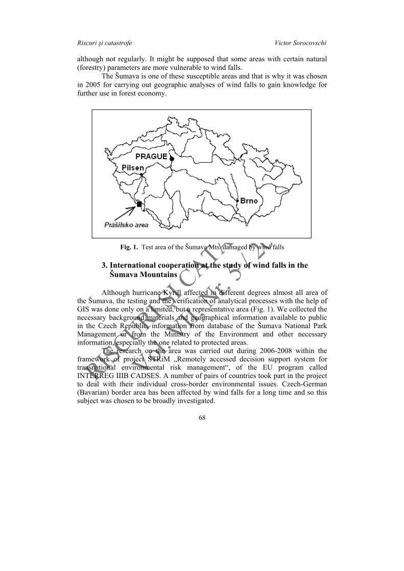
Fig. 1. Test area of the Šumava Mts. damaged by wind falls
3. International cooperation at the study of wind falls in the Šumava Mountains
Although hurricane Kyrill affected in different degrees almost all area of the Šumava, the testing and the verification of analytical processes with the help of GIS was done only on a limited, but a representative area (Fig. 1). We collected the necessary background materials and geographical information available to public in the Czech Republic, information from database of the Šumava National Park Management or from the Ministry of the Environment and other necessary information, especially the one related to protected areas. The research on the area was carried out during 2006-2008 within the framework of project STRiM „Remotely accessed decision support system for transnational environmental risk management“, of the EU program called INTERREG IIIB CADSES. A number of pairs of countries took part in the project to deal with their individual cross-border environmental issues. Czech-German (Bavarian) border area has been affected by wind falls for a long time and so this subject was chosen to be broadly investigated.
RISCURII CATASTROFE
Vol. VII,Nr. 5/ 2008
Fenomene i procese climatice de risc
69
The test area of the Prášilsko region comprising ca 70 square km in the western part of the Šumava National Park was chosen. In the case of the Šumava this originally meteorological hazard turns into biotic hazard as it is often followed by bark beetle calamities. The research hypothesis presumes that the incidence of wind falls, the amount of harm done and the cost of alleviating it are in close relationship with natural factors of the area and previous human interventions into the landscape. The research tried to find out the relationship between the natural and growth characteristics on the one hand and the location of the wind falls and the size of caused damages on the other. It also used GIS technologies for a more effective damage removal.
4. Test area
4.1 Geographical characteristics Geologically the area of “Prášilsko“ belongs to Czech Moldanubikum (i.e. a regional unit forming the southern part of Bohemian massif). Most of the area is formed by meta-igneous rocks (composite gneisses, paragneis, orthognesis, at some places mica schist - Vejnar 1991, Pelc 1994). In the inland there are metamorphosed massif lined with intruded granodiorites and granites of the Šumava plutone. Younger substrates are represented by quaternary sediments and weathered rocks. Near glacial lakes ”Prášilské“ and Laka are degraded till and stony, or even boulder slope sediments which date back to the Pleistocene. There is a frequent occurrence of glacial sediments of different grain-size composition, often with big blocks of rocks. Holocene materials are represented by various deluvial deposits, large bogs in valleys and gravel-sand sediments along water streams. This test area of the Šumava national park is characterized by hilly to mountainous relief. A number of vault-like peaks of the border range exceed the sea-level altitude of 1,300 meters (Debrník 1,337 m, Ždánidla 1,308 m, Poledník 1,315 m), which towards the North subside to elongated but open depression of the ground alongside K emelná River flowing from the West to the East. The sea level altitude is only 718 m. The relief of the depression is at some places flat with numerous bogs. Vault-like peaks are interchanged with relatively deep valleys with steep slopes. Three smaller glacial lakes were formed in the Pleistocene in the valleys of two creeks - Jelení and Prášilský. The climate of this part of the Šumava Mts. is harsh. The average yearly temperatures are around 6o C in the valleys and less than 3o C at the highest altitudes. There is a lot of rainfall (1000 to 1200 mm/year). Destructive winds which cause damage to the forest stands arrive with continually shorter frequency. Winds with impact speed of around 110 km/h occur as much as five times a year in
RISCURII CATASTROFE
Vol. VII,Nr. 5/ 2008
Riscuri i catastrofe Victor Sorocovschi
70
the Šumava. Kyrill has been the fifth hurricane for the last 25 years. On the January 18, 2007 before midnight its direction was from South-West and around midnight it turned from the West. Even stronger winds occur with frequency of around 30 years. The test area is found on the main European water divide. Most of the area is drained by the K emelná River to the Elbe, smaller areas descending towards Železná Ruda are drained by the Regen River ( ezná) belonging to the sea drainage of the Black Sea. Soil cover is formed with soils characterized by different slacks of silicate crystalline rocks from lithosols, haplic leptosols and cambisols and in the higher, colder and more humid altitudes entic podzols and podzols. There is a frequent occurrence of histosols and histic gleysols in the bottoms of valleys. Potential vegetation is characterized by three forest vegetation stages – from the 6th stage of spruce-beech, the 7th beech-spruce and to the 8th stage of spruces. The present forest stands are commonly moisturized by horizontal precipitations. They have undergone a considerable change caused by the human made dominance of spruce. Firs and broad leaves deciduous trees are very rare. The area is relatively well accessible thanks to dense network of paved and unpaved public and forest roads, which are often legacy of the long presence of the army in the frontier area in our recent past. Some areas are still not accessible for the public due to possible presence of not exploded bombs. Not far from the state frontier is a cleared lane which used to serve as frontier entrenchments of the so-called ”iron curtain“ which at some places reaches up to 20 meters.
4.2 Available digital geographical data about the area Shortly after the event, the management of the National Part and Protected Area of the Šumava mountains ordered to review the damage done using three classes: 1. totally damaged forest stands, 2. partially damaged forest stands, 3. only single trees damaged in the stands. For the analysis of the relief in respect of the windfalls a digital model of terrain was used with the definition corresponding to the map scale of 1:25 000 based on a data set DMÚ 25 created by the Army of the Czech Republic. Further, digital materials of forestry typological maps with definition corresponding to the map scale of 1:10 000 were used which contained relevant data about the natural habitat of the forest stands, age, species and crown density of the present stands and air orthophoto map from 2005 (i.e. before the analysis of the damage) and year 2007 (after Kyrill). In addition, were taken into consideration the meteorological data about the direction and the speed of wind at the time of impact of the hurricane from the station of the Czech Hydrometeorological Institute in the Šumava region, Churá ov (1118 m) and in Germany at DWD station on Velký Javor (Grosser Arber, 1456 m). These, however, are not sufficient to explain the phenomenon. The researchers from the Institute of Physics of Atmosphere from the Science Academy of the Czech

RISCURII CATASTROFE
Vol. VII,Nr. 5/ 2008
Fenomene i procese climatice de risc
71
Republic in Prague created a model of the directions and speed of wind at the moment of the greatest wind gust of Kyrill in the square raster of 100 x 100m for further use.
5. Geographical data processing
5.1 Individual research hypotheses and analysis of their verification It can be supposed that some areas with specific natural parameters (and those relating to forest industry) are more susceptible to windfalls. The occurrence of windfalls, the amount of the damage done and the expenses to alleviate them are related to certain logical concurrence of natural factors of the area and previous interventions of the forest industry into the landscape. Natural elements of the landscape – water, air, energy, rocks and soil, relief and forest stands affect mutually but with different intensity the area and the manner of damage. While a number of the parameters of these elements are found thanks to available data, other important information is missing (real wind speed and wind direction at a particular moment as well as humidity and others). Therefore the following evaluation of the factors affecting windfalls is only approximate. Moreover, some parameters (elements) of individual natural factors can only be derived from already known but general characteristics of the stands, as is the case of forest typological maps, or derived from digital model of the relief. Natural disasters or catastrophes are natural phenomena which are outside of human influence and manifest themselves with great destructive strength (Alekseyev 1988, Bryant 1991). Regardless of the cause of the phenomenon they have very different duration and their occurrence (in space and time) and their course is subject to the following natural patterns:
1. every risk type is typical for a particular area and location, i.e. it respects a particular selection and value of natural or even anthropogenic factors,
2. every risk type occurs with certain periodicity in respect of time and place, i.e. in susceptible areas natural disasters are to be expected but the time of their occurrence depends on meeting several conditions at once,
3. occurrence of a disaster can be predicted with greater or smaller probability according to its decisive factors relating to the range, duration, intensity of geological or hydro-meteorological processes; however, the problem remains that the defined processes cannot be reliably predicted.
According to the landscape element which determines the start of a natural disaster, we can define the following risks (Mazur, Ivanov 2004):
1. geological and terrain risks – risks lie mainly in the lithosphere and on the relief (e.g. landslides, collapses, avalanches, erosion, subsidence, earthquakes, volcanic activity etc.)

RISCURII CATASTROFE
Vol. VII,Nr. 5/ 2008
Riscuri i catastrofe Victor Sorocovschi
72
2. meteorological and hydrological risks and climate related risks – triggered by atmospheric and hydrological parameters of the area based on present-day or long-term criteria (e.g. floods, tornados, draughts, windfalls, etc.)
3. biotic – caused by „self-development“ of flora and fauna, associations, chains or ecosystem, which are in the background influenced by biotic catalysts (deformation of humidity-energetic balance – e.g. insect outbreaks, pest outbreaks, change of biodiversity, invasion of species, etc.)
Although the impulse comes from some of the listed elements and the catalyst of the damage is mostly a particular quality of the specific landscape element or a process, the risk is often very complex with consequences in all elements of landscape. Finally, there are other elements which, although with smaller intensity but in a certain way participate in the occurrence of the disaster, although some of its parameters can contribute to the disaster or prevent it. Geoinformation technology offers a number of different tools for area analysis. In case of the recent disaster caused by hurricane Kyrill, large data files were collected which provide certain hope that thanks to area analysis it will be possible to find relations or patterns for the occurrence of similar phenomena. Thus the basis of research hypothesis is a belief that the occurrence of windfalls, the quantity of the damage caused and the expenses to alleviate the damage are related to logical effect of natural factors and previous interventions of forest industry to the landscape of the area. Using another pragmatic analysis of this data it is possible to select and implement an effective method of mitigation of the after-effects of the disaster. Using the tools of map algebra and geostatistics in SW GIS ArcGIS from ESRI the analyses of relations between the values of individual variables (characteristics of the environment and forest stands) and windfall affected areas were made. Before each analysis an individual research hypothesis was defined (table 1). In all the stand groups of the area the current species composition was converted in the program MS Excel using a preset macro into the form of a stand type (based on the methodology Vyskot et al. 2003) and by the confrontation with the natural stand type, each stand group was given a definite value of naturalness at a 1-6 scale (1=non-natural forest, 6=natural forest). Considering the altitude of the area of interest (vegetation zone 6-8), the presence of the spruce is quite natural and so the naturalness of the stands ranged between the values 3 and 6. The degree of the correspondence between the hypothesis and the result of the geostatistical analysis was a statistic concentration of values around the so called “key value” of the expected hypothesis. It turned out that the local terrain conditions do not show high values of the correspondence with the wind falls occurrence (Fig. 2). A different situation can be seen at the density of the growth of the forest stand density (Fig. 3).
RISCURII CATASTROFE
Vol. VII,Nr. 5/ 2008
Fenomene i procese climatice de risc
73
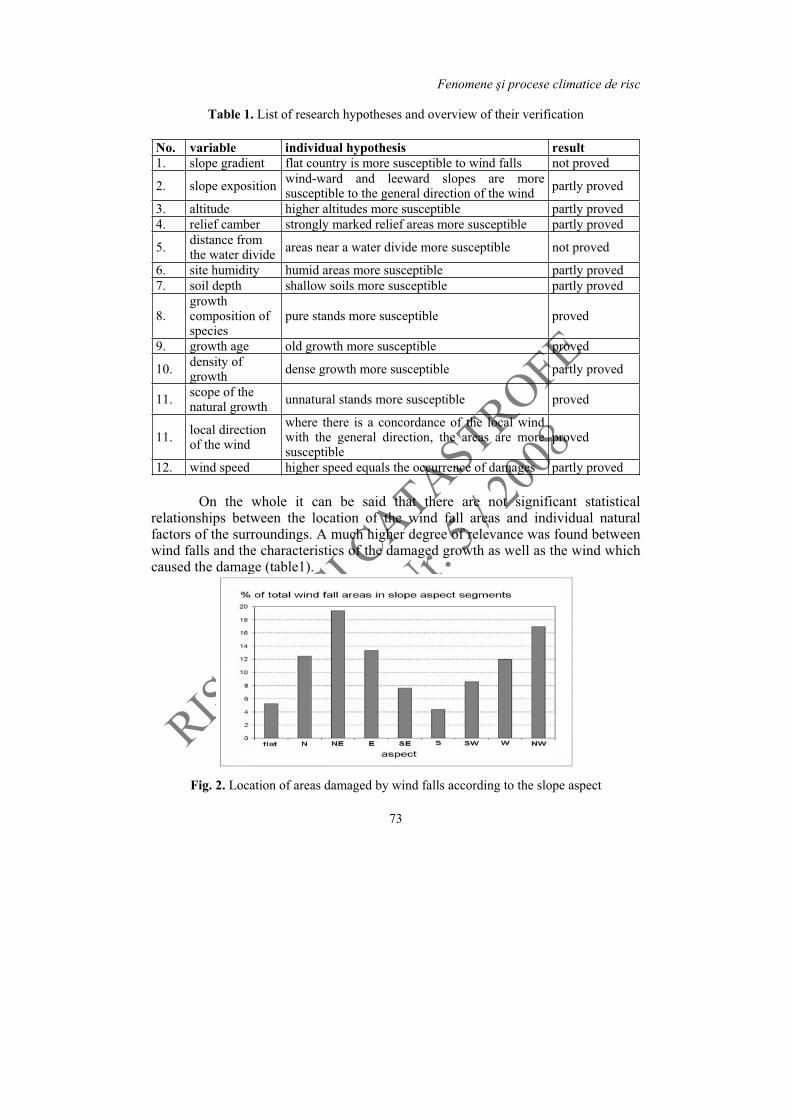
Table 1. List of research hypotheses and overview of their verification
No. variable individual hypothesis result1. slope gradient flat country is more susceptible to wind falls not proved
2. slope exposition wind-ward and leeward slopes are more susceptible to the general direction of the wind partly proved
3. altitude higher altitudes more susceptible partly proved 4. relief camber strongly marked relief areas more susceptible partly proved
5. distance from the water divide areas near a water divide more susceptible not proved
6. site humidity humid areas more susceptible partly proved 7. soil depth shallow soils more susceptible partly proved
8.growth composition of species
pure stands more susceptible proved
9. growth age old growth more susceptible proved
10. density of growth dense growth more susceptible partly proved
11. scope of the natural growth unnatural stands more susceptible proved
11. local direction of the wind
where there is a concordance of the local wind with the general direction, the areas are more susceptible
proved
12. wind speed higher speed equals the occurrence of damages partly proved
On the whole it can be said that there are not significant statistical relationships between the location of the wind fall areas and individual natural factors of the surroundings. A much higher degree of relevance was found between wind falls and the characteristics of the damaged growth as well as the wind which caused the damage (table1).
Fig. 2. Location of areas damaged by wind falls according to the slope aspect
RISCURII CATASTROFE
Vol. VII,Nr. 5/ 2008
Riscuri i catastrofe Victor Sorocovschi
74
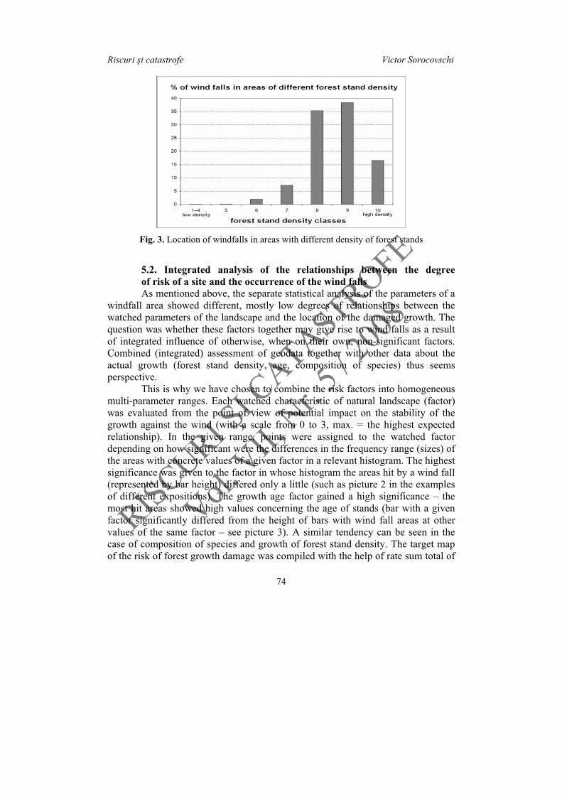
Fig. 3. Location of windfalls in areas with different density of forest stands
5.2. Integrated analysis of the relationships between the degree of risk of a site and the occurrence of the wind falls As mentioned above, the separate statistical analysis of the parameters of a windfall area showed different, mostly low degrees of relationships between the watched parameters of the landscape and the location of the damaged growth. The question was whether these factors together may give rise to wind falls as a result of integrated influence of otherwise, when on their own, non-significant factors. Combined (integrated) assessment of geodata together with other data about the actual growth (forest stand density, age, composition of species) thus seems perspective. This is why we have chosen to combine the risk factors into homogeneous multi-parameter ranges. Each watched characteristic of natural landscape (factor) was evaluated from the point of view of potential impact on the stability of the growth against the wind (with a scale from 0 to 3, max. = the highest expected relationship). In the given range, points were assigned to the watched factor depending on how significant were the differences in the frequency range (sizes) of the areas with concrete values of a given factor in a relevant histogram. The highest significance was given to the factor in whose histogram the areas hit by a wind fall (represented by bar height) differed only a little (such as picture 2 in the examples of different expositions). The growth age factor gained a high significance – the most hit areas showed high values concerning the age of stands (bar with a given factor significantly differed from the height of bars with wind fall areas at other values of the same factor – see picture 3). A similar tendency can be seen in the case of composition of species and growth of forest stand density. The target map of the risk of forest growth damage was compiled with the help of rate sum total of

RISCURII CATASTROFE
Vol. VII,Nr. 5/ 2008
Fenomene i procese climatice de risc
75
all watched parameters using the overlay map and map algebra (Orgando, Selicato, Torre, 2005). Thus the weighted maps of individual factors were the object of the summing.
Fig. 4. Representation of areas damaged by wind falls in individual categories of weighted integrated risk rate
Final values of the sum total were evenly divided into five categories which show graded susceptibility (risk rate) of the individual areas to wind falls. The subsequent geostatic analysis of the relationship between the risk rate of a spot area (class 1 – min. to 5 – max.) and the wind fall occurrence already shows a high rate of relationship. Areas identified in this way as the most risky ones are in fact areas where overwhelming majority of recorded wind falls occurred (picture 4). However, also this method does not give absolutely unequivocal results as there is a certain proportion between the sizes of spot representation of individual risk categories in the area of interest and the proportion of actually damaged spots in the area. (in other words, there are the most risky dominating and so in them there are the most wind damaged spots and vice versa). Fig. 5 shows the space location of the wind damaged areas compared to risk categories. From the results of the geographical analysis of wind fall distribution it follows that although the occurrence of wind falls is to some, but limited, extent influenced by site conditions of the growth as a whole (that is combination of conditions, not each individual one separately) and by biotic characteristics of the stands, the decisive role in causing damage is in the actual wind behaviour, the description and prognosis of which is a long-term task of applied science.

RISCURII CATASTROFE
Vol. VII,Nr. 5/ 2008
Riscuri i catastrofe Victor Sorocovschi
76
Fig. 5. Prášilsko area – forest areas damaged by hurricane Kyrill in individual categories of weighted integrated risk rate
6. Debate about the used methods and gained results
The present results of the space analyses reveal various relationships between the occurrence of wind damage and some natural factors. Nevertheless, it is not possible to consider the present methodology as a guiding principle. The accuracy of the analyses is to a certain extent influenced also by the accuracy of the input data. While for the landscape data (taken from DMÚ 25) the discrimination ability, i.e. the quantity aspect of the data, is of vital importance. As far as the forestry data are concerned, there may be doubts concerning accurate positioning of a place and the accuracy of the description of the site conditions. In respect of the size of the area, it was not possible to carry out a detailed and accurate mapping of the site conditions. Another aspect that would necessitate a specialized approach is the study of the behavior of the wind itself. There is no doubt that the

RISCURII CATASTROFE
Vol. VII,Nr. 5/ 2008
Fenomene i procese climatice de risc
77
landscape, its configuration and the character of the active surface play a decisive role in the modification of wind direction and speed, and thus its devastating power. In particular locations, the wind direction does not necessarily correspond with the data from meteorological stations, since the landscape pattern, the active surface of the place and its surroundings may influence it. At such speed of ground-level wind, it is necessary to expect also eddying wind with frequent fluctuations of direction, height and speed in short periods of time. This does not mean, however, that space analyses have no prospects. The results of the study of the after-effect traces of Hurricane Kyrill together with the local factors can support and improve the forest management measures which might increase the resistance of the forest to wind damage. This is demonstrated on the proved influence of the actual stands characteristics on the occurrence of the damage. These characteristics can to a certain extent be influenced by forest management and so it is possible to at least alleviate the damage by an appropriate forest care. Another side of this issue is the effective transmission of news about wind falls occurrence, especially to the academic and broad publics. Concerning this issue, the methods elaborated in a project of the Czech Ministry of Education and Sports No. MSM0021622418 called “Dynamic geovisualisation in crisis management” are of particularly good use (Fig. 6).
Fig. 6. Visualized image of an area in Prášilsko damaged by Kyrill hurricane in January 2007 (subhorizontal black sticks– fallen trees, vertical gray sticks – standing
dry dead trees without needles)

RISCURII CATASTROFE
Vol. VII,Nr. 5/ 2008
Riscuri i catastrofe Victor Sorocovschi
78
Through a number of simplification and inaccuracies of the input data sets, already the preliminary research results showed a concrete relationship between the wind fall occurrence and natural surroundings a p írodními prost edím and the characteristics of the stands. Still, it is necessary to mark that so far only some of the available methods have been used. A much greater attention will have to be devoted to the history of forest growth, both damaged stands and the stands in the surrounding areas. It seems perspective to take into account the aerodynamic factors, if this is possible via available data processing technologies. Due to more frequent occurrence of forest damage by wind and the possibility that this is caused by global warming of the Earth, it is an economic as well as ecological necessity to further deepen our knowledge of this phenomenon. In many cases of forest wind falls the subsequent damage removal is costly (as a result of road and rail transport interruptions, cut-offs of power lines, telecommunication systems, etc.) and the wind damage risk is taken into account also in other sectors besides forestry. (Eisl, et al., 2005). Thus, the evidence, evaluation and generalisation of the forest wind falls risk is a standard part of crisis management in the regions.
REFERENCES
1. Alekseyev, N. A. (1988), Stichiyniye yavleniya v prirode: proyavleniye, effektivnost zashchity. Mysl, Moskva, 254 p.
2. Bielecka, E. (1986), Photointerpretation survey of changes in the range of the Tatra subalpine forests. Miscelanea Geographica, Warszawa, pp. 125-131.
3. Bielecka, E., Fedorowicz-Jackowski, W., Witkowska, E. (1995), Sequential monitoring of Tatra subalpine forests on the basis of cartographic and remotely-sensed data. In: Breymeyer, A. (ed.)(1993), EURO-MAB IV – Mountain zonality facing global change,Zakopane, Conference papers 21, Institute of Geography and Spatial Organization, Polish Academy of Science, Warszawa, pp. 119-130.
4. Bryant, E. A. (1991), Natural Hazards, Cambridge University Press, Cambridge-New York-Melbourne, 294 p.
5. Eisl, M.M., et al. (2005): Disaster Prevention for Alpine Routes. In: van Oosterom, P., Zlatanova, S., Fendel, E. M. (eds.): Geo-Information for Disaster Management. Berlin-Heidelberg, Springer, 2005, pp. 569-584.
6. Jelínek, J. (1985), V trná a k rovcová kalamita na Šumav z let 1868 až 1878. Ústav pro hospodá skou úpravu les ,. Brandýs n.L.
7. Mazur, I. I., Ivanov, O. P. (2004), Opasniye prirodniye processy. Ekonomika, Moskva, 702 p.
8. Orgando, G., Selicato, F., Torre, C.M. (2005), The Use of GIS as Tool to Support Risk Assessment. In: van Oosterom, P., Zlatanova, S., Fendel, E. M. (eds.): Geo-Information for Disaster Management. Berlin-Heidelberg, Springer, pp. 1381-1399.
9. Pelc, Z. (red.) (1994), Geologická mapa R. Sheet 22-33 Kašperské Hory. Scale 1:50 000. eský geologický ústav, Praha.
RISCURII CATASTROFE
Vol. VII,Nr. 5/ 2008
Fenomene i procese climatice de risc
79
10. Ruel, J.C., Pin, D., Cooper K. (2001), Windthrow in riparian buffer strips: effect of wind exposure, thinning and strip width, In: Forest Ecology and Management, Vol. 143, No. 1-3, pp. 105-113.
11. Šev tínský, J. (1895), D jiny les v echách. Písek. 12. Vejnar, Z. (red.) (1991), Geologická mapa R. Sheet 21-44 Železná Ruda. Scale 1:50
000. Úst ední ústav geologický, Praha. 13. Vyskot, I., et al. (2003), Kvantifikace a hodnocení funkcí les eské republiky. MŽP
R, Praha, 210 p.