risk analysis methodology related to the seismic
TRANSCRIPT

RISK ANALYSIS METHODOLOGY RELATED TO THE SEISMIC HAZARD. THE BUCHAREST HISTORICAL CENTER/ROMANIA
IULIANA ARMAŞ, RĂSVAN DAMIAN, SILVIA DUMITRAŞCU
1. Introduction The natural risk research focused mostly on the assessment of the potential of
a certain territory for the natural hazard by identifying, mapping and modeling the individual processes and thus, leaving as a second priority the assessment of the potential for the probable damage that could happen in the case of a disaster occurrence. (Keiler et al., 2004).
At a global level, there are still few references and conceptual approaches focused on the natural risk assessment methodology concerning the belongings/ property or the individual’s life, these aspects representing the collective risk that characterizes a certain territory (de ex.: Wilhelm, 1997; Heinimann et al., 1998; Borter, 1999). Despite the progress made in this field in the last few years, there are still area implementation and a proper conceptual particularization missing and such is the case of the assessment of the natural hazard.
This aspect is even more important from the perspective of the growth of the socio-human vulnerability level in the context of the development of the urban concentrations that must be interpreted as socio-ecological systems of a maximum risk level. The urban areas bring up the aspect of the psycho-social vulnerability in relation with the impact of the global changes, distinguished according to the economical status expressed by territorial disparities and dysfunctions.
In Romania, the natural hazard vulnerability is still rarely taken into account as a standard practice in investments. This aspect is even more important as the expensive infrastructure of cities, along with the high density of their population offers a high degree of susceptibility in case of major impacts as a result of natural events. Reducing the vulnerability of urban spaces would lead, implicitly, to the reduction of the costs produced by natural disasters.

IULIANA ARMAŞ, RĂSVAN DAMIAN, SILVIA DUMITRAŞCU
54
Starting from the premises noted the present study contains a conceptual approach concerning the direct investigation of the urban risk, based on a seismic risk scenario in an extremely vulnerable area of Bucharest: the Lipscani historical center. We are aware of the fact that not all of the urban environment variables were taken into consideration and we find as a main justification that the actual objective of this study was to develop and test a methodological application (still going through improvement and testing processes) and not to present a regional approach.
The specific of the Bucharest Municipality is shown by the seismic hazard, in the context of a general predisposition to risk, implied by an explosive urban evolution and an aged urban edilitary fund. The street network and the sewerage system have disorganized the natural system resulted from the evolution of the lake-river system in Superior Pleistocene–Holocene, and the entire intense building activity represents a pressure that hasn’t been measured and that is in need for a methodological interdisciplinary approach.
The Lipscani nucleus is a maximum seismic vulnerability area, this being the result of its location in the Dâmboviţa River meadow, on the brow and 80 m terrace, but especially because of the degradation of the edilitary fund that cumulated the effects of the repeated earthquakes. The majority of the buildings from the historical center of Bucharest are included in the I and II categories of seismic risk, having more than P + 4 stories and being built between 1875 and 1940. There is a number of 21 constructions P + 4 included in the I category of seismic risk, with 1429 inhabitants and 16 buildings P + 4 included in the II category, summing up 753 persons. By relating the number of people who inhabit the buildings susceptible to the seismic risk to the total number of persons who live in the analyzed sector, results an exposure index of 0.49 which indicates that half of the people living in this sector could become victims in the case of a major earthquake (the calculations were based on the data offered by the Regional Statistics Direction of the Bucharest Municipality, 2005).
2. The Lipscani historical nucleus The social, economical and political changes of Bucharest are present in
the image of the construction fund, the center including on a smaller scale the essence of the city’s evolution.
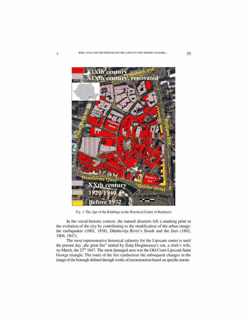
From the perspective of the urban risk, the urban fund built in the XIXth century is the most important for the Lipscani nucleus (the Elisabeth boulevard – the Brătianu boulevard – the Dâmboviţa Quay – Calea Victoriei), it leaving its mark on the transition from the medieval city to the modern city (fig. 1).
2
RISK ANALYSIS METHODOLOGY RELATED TO THE SEISMIC HAZARD…
55
Fig. 1. The Age of the Buildings in the Historical Center of Bucharest
In the social-historic context, the natural disasters left a marking print in the evolution of the city by contributing to the modification of the urban image: the earthquakes (1802, 1838), Dâmboviţa River’s floods and the fires (1802, 1804, 1847).
The most representative historical calamity for the Lipscani center is until the present day „the great fire” started by Zoiţa Drugăneasca’s son, a clerk’s wife, on March, the 23rd 1847. The most damaged area was the Old Court-Lipscani-Saint George triangle. The route of the fire synthesizes the subsequent changes in the image of the borough defined through works of reconstruction based on specific norms.
3
IULIANA ARMAŞ, RĂSVAN DAMIAN, SILVIA DUMITRAŞCU
56
The main norms were the ones regarding the prevention of fires (The 1847 Regulation complemented by “The Regulation for alignments and buildings” from 1848), “rules for manufacturing construction bricks and for the stove”1 – 1836, norms concerning the thickness of the walls, the plans of the cellars and of the buildings’ façade (the height of the buildings was set according to the breadth of the street), technical data regarding the assembly of the floors (a “foreign specialist” was called in the absence of proper workers), special conditions for the placement of the buildings on boulevards and quays (given by the Technical Works Direction of the City Hall-1897).
The variation of the functions of the city was given by the presence of a series of architectural programs representative for the XIXth Century, defined by: the living house, the shop, the inn and the institution.
The residential house has as a specific the placement in the center of a court or garden (it can be correlated with the term of “villa” = ”a rustic dwelling placed in big gardens that fulfills the desire for luxury and confort”2). The commercial areas have as a distinctive characteristic the presence of the alleyway: “a big building with two floors where the entrance is done through a hall or an alleyway arched towards the interior court and from there to the upper floor, in the interior court the building being prolonged by wings placed on one side or on both sides, thus an L or U plan taking shape. In these placements are usually located the additions and the circulation for the successive rooms is usually done only at the upper floors through a gallery hanging over the ground floor or placed on pillars”3.
In the historical center the type of dwelling (usually with 2 floors) with a shop at the ground floor is dominant, this being a consequence of the commercial function characterizing the area. The commercial space is represented by a regular sized room, having a direct entrance from the street, the façade or shop window being the center piece (the place where the goods are displayed). In the crowded area of the commercial center the need to save space implied to narrow down the façade and thus the “I” shaped buildings were developed.
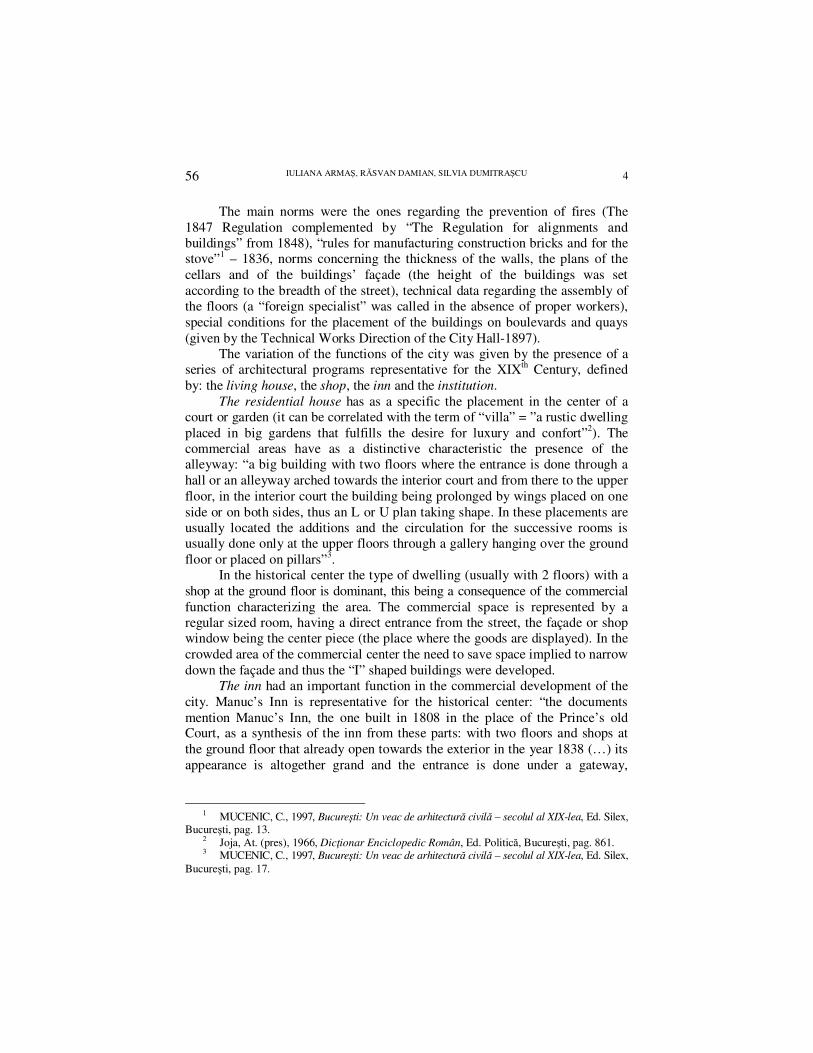
The inn had an important function in the commercial development of the city. Manuc’s Inn is representative for the historical center: “the documents mention Manuc’s Inn, the one built in 1808 in the place of the Prince’s old Court, as a synthesis of the inn from these parts: with two floors and shops at the ground floor that already open towards the exterior in the year 1838 (…) its appearance is altogether grand and the entrance is done under a gateway,
1 MUCENIC, C., 1997, Bucureşti: Un veac de arhitectură civilă – secolul al XIX-lea, Ed. Silex,
Bucureşti, pag. 13. 2 Joja, At. (pres), 1966, Dicţionar Enciclopedic Român, Ed. Politică, Bucureşti, pag. 861. 3 MUCENIC, C., 1997, Bucureşti: Un veac de arhitectură civilă – secolul al XIX-lea, Ed. Silex,
Bucureşti, pag. 17.
4

RISK ANALYSIS METHODOLOGY RELATED TO THE SEISMIC HAZARD…
57
through an arched alleyway, the gate being placed under the bay that probably stands out from the building because it has a separate roof”4.
The public services constructions are present in Bucharest since the XIXth century. The public functions were previously done in the premises of the Prince’s Palace. From an architectural perspective, these buildings reflect the mentality of the time and use the most modern construction techniques. A relevant example for this is the National Bank Palace.
Photo 1. Manuc’s Inn at the end of the XIXth century and today
3. Methodology From the perspective of the seismic hazard, there are 4 models of urban
projection globally: of preparation (Fiedrich, 2004, adapted the HAZUS system for Bucharest in the SFB461 german project, proposing the EQ-RESQUE model that implies the settlement of the intervention areas), of mitigation (inexistent for Bucharest), of resilience (Bruneau et al., 2003, and the RISK-UE project: Mouroux and Le Brun, 2006) and of post-disaster recuperation (inexistent for Bucharest). The RISK-UE project developed a modular methodology for the evaluation of the earthquake scenarios by analyzing the distinctive features of the European cities concerning the buildings and also their functional and social structures. The elements were categorized according to the role played in the system during regular, crisis and recuperation periods of time. This analysis was also applied to Bucharest, but on a sequential level.
The method proposed during this study is based on digital and statistical spatial information resulted from 1:500 topographical plans, satellite pictures, data offered by the Statistics Regional Department of the Bucharest Municipality, archives and historical maps used for the identification of the age of the buildings, field observations concerning their functionality and current condition, the
4 MUCENIC, C., 1997, Bucureşti: Un veac de arhitectură civilă – secolul al XIX-lea, Ed. Silex,
Bucureşti, pag. 23.
5
IULIANA ARMAŞ, RĂSVAN DAMIAN, SILVIA DUMITRAŞCU
58
height and number of floors, number of entrances, demographical and locative aspects, the degree of daily and weekly occupation.
All the field information was registered in tables of attributes. The next stage involved the calculation of the surface and volume of each
construction. The estimation of the value of the buildings was based on the average number of insurances offered by various companies in the case of the new buildings according to the functions and the space of each residence.
The insurance companies in Romania hold on the average 0.2 from the value of the building on the market, going up to the maximum limit of 03.-0.4. The government offers only 0.1 from the sum insured, this value being limited to 20000 euro. In the case of the buildings with a maximum seismic risk, the societies turn down the insurance in the case of an earthquake. In order to estimate the value, especially in the case of the damaged buildings or in a state of ruin, mp for each construction was used as a reference point in the Lipscani area (estimated in the spring of 2007 at 1000-1500 euro). The buildings with special attributes, such as churches, couldn’t be evaluated because of the lack of criteria or the insufficient characterization.
The association between variables resulted by taking a series of signification tests (oneway ANOVA, Pearson chi-test, Independent-Samples T-Test) and the factorial analysis was used for the organization of variables in groups of factors. The vulnerability and risk maps wee made through GIS analysis based on classifications and reclassifications of thematic layers and the intersection of layers of interest by using
Map Calculator. 4. Results Taking the statistical signification tests indicated that the historical print
is strongly attached to the functional structure of the historical center. Over 68% represents the residential or mixed (residential at the top floors and with shops at the ground floor) buildings, 19% is commercial spaces and the rest of the percentages is divided almost uniformly between buildings with administrative, cultural or financial functions, ruins or spaces in construction.
The oneway ANOVA test shows a significant difference between the function and height of the buildings F(5) = 12.87, p = 0.001. The Bonferoni test indicates that the height of the buildings differs according to their function, from the residential buildings that are the smallest to the ones with a mixed residential function that have shops at the ground floor and to the ones with a financial-administrative function that are the tallest.
The Pearson chi-square test (chi-square(15) = 29.96; p = 0.01) shows a significant association between the state of the buildings and their function,
6

RISK ANALYSIS METHODOLOGY RELATED TO THE SEISMIC HAZARD…
59
indicating that over 77% from the deteriorated buildings (in ruin) and over 68% from the ones deteriorated have a residential function, altogether representing almost 40% from the construction fund. This situation must be related to the historical context, most of the houses being disputed or retroceded.
The factorial analysis was applied in order to verify if there is a series of specific variables of the buildings grouped in factors that could be used in the assessment of the vulnerability. From the correlation matrix of Kaiser-Meyer-Olkin Measure of Sampling Adequacy (0.64) and of Bartlett's Test of Sphericity (sign. = 0.0001) results the possibility of one or more common factors, this fact justifying the application of a factorial reduction procedure.
From the factors to which the factorial analysis was applied (Principal Component Analysis, Varimax) only the ones that indicated strong enough saturations on certain groups were selected. Two factors saturated in 3 items were detected, based on the Eigen > 1 criteria (table 1).
Rotated Component Matrix (a) Table 1
Component
1 2 Number of persons .900 Number of apartments .893 Number of floors .770 The age of the building .856 The state of the building –.838 Area .435 Extraction Method: Principal Component Analysis. Rotation Method: Varimax with Kaiser Normalization. A Rotation converged in 3 iterations.
The first factor justifies, according to the rotation, 36.9% of the total variance
of the indicator variables and along with the 2 factors resulted from the analysis justifies a percentage of over 64.5% from the variance of the indicator variables.
Depending on the number of variables held by the factors, they were renamed: factor 1 – environmental factor and factor 2 – historical factor. Factor 1 indicates a strong positive correlation to the first 3 indicator variables: number of apartments, number of persons and number of floors. Factor 2 includes the occupied area, the state and the age of the constructions. Factor 2 shows a strong negative correlation between the age and the state of the buildings: the newer the buildings are, the better their state is and the lower the vulnerability value gets. The vulnerability given by the state of the building was given scores according to the 4 steps Likert scale: very deteriorated buildings or in ruins got 4, the buildings with a very good condition, new or completely renovated got 1.
The state of the buildings was appreciated on the field, according to visual observations noted on a standard file. The classification of the buildings in different
7

IULIANA ARMAŞ, RĂSVAN DAMIAN, SILVIA DUMITRAŞCU
60
categories referring to their condition was done according to the state of the materials that constitute the building and, thus, resulted 5 categories used in the assessment of the construction fund in the historical center of Bucharest (table 2).
Categories used to assess the state of the buildings Table 2
VG A Very Good State a building that is completely restored or new
G A Good State a building that is partially restored or not restored, but with the plaster damaged less than 15%
B A Bad State a building that is not restored, with deep fissures and the plaster damaged from 20% to 55 %
VB A Very Bad State a building that is not restored, often uninhabited, with broken windows or lacking windows and the plaster damaged over 60%
Rn Ruin a deteriorated building that should be demolished
The function of the buildings correlates significantly, but not strongly, to
the factors resulted (factor 1 : r = – 0.431, Sig = 0.0001; factor 2 : r = 0.319, Sig = 0.0001). The result of the negative correlation shows that the values of factor 1 grow in the case of the residential buildings. In the case of factor 2, the positive value of the correlation shows (from the interpretation of the classifications that the factorial analysis was based on) that the commercial, financial, administrative and cultural functions imply a slight growth of the area of the edifices, an improvement of their condition and the existence of a number of recent constructions.
Independent-Samples T-Test reaches statistically significant values in associating the dominant residential function or other kind of functions of the buildings with the resulted factors. IN the first case, the statistical significant result (t = 7.1; df = 343; Sig. = 0.0001) shows that the dominant residential function implies the existence of buildings with a higher number of apartments, occupants, floors. The Independent-Samples T-Test (t = 8.7; df = 271; Sig. = 0.0001) showed statistically that the number of people who can be caught inside the premises of a building during an earthquake is bigger in the case of the residential buildings (especially in a night scenario), this fact being linked significantly to the number of apartments form the residence (r = 0.75; Sig. = 0.0001).
In the case of factor 2, the result (t = – 6.0; df = 221; Sig. = 0.0001) shows a higher vulnerability by taking into account the historical condition at the mainly residential buildings. This fact is justified also by the context of the locative situation determined historically, the houses being retroceded by the prior owners. Previous studies (Armaş, 2006, 2008) showed that the current population of the historical center is a “secondary” one (artificially brought in the area during the communist period) with a difficult economical status.
8

RISK ANALYSIS METHODOLOGY RELATED TO THE SEISMIC HAZARD…
61
For example, the 2005-2006 comparative analysis indicates that the inhabitants of this sector live mostly under the poverty limit (Armaş, 2008).
The poverty index is 1 – which shows that for an average earning of a household of 2 members only the expenditures on food and non-food minimum products are covered, with no available resources left. The poverty index resulted from the ratio between the monthly revenue per household (net household incomes) composed of two members (representing the average in the studied area), and the total necessary expenditures per month.
The vulnerability should be perceived according to the intensity of the event. Bucharest is included, according to the seismic zoning done after the 1977 earthquake, in the macro-area of VIII degrees seismic intensity (MSK-64), see Mândrescu et al., 2004. Because of the lack of studies that could differentiate the areas accepted scientifically at the zonal level of the city and also because of the even lesser number of distinctions of this hazard at the micro-zonal level in the Lipscani nucleus, the seismic differentiation condition was eliminated from the vulnerability analysis – in this stage of the research. In a future analysis we will take into consideration a parameter that will synthesize the response given by each building at different levels of seismic intensity. It will be possible to correlate this factor with the degree of probable damage and of costs directly associated from the risk analysis.
In the current stage, the vulnerability assessment (fig. 2) was based on the matrix approach between the vulnerability factors of the buildings (resulted from the factorial analysis), their current condition and the function of the edifices in the Lipscani nucleus, on the principle of a differentiated degree of occupancy during the day (this being useful information in appreciating the number of probable human losses).
The spatial analysis indicates a reduced vulnerability concerning the buildings with financial-banking and cultural functions, built in the inter-war period, many of them being renovated. The residential buildings from the XIXth century are characterized by both medium and low vulnerability levels, being placed inside the area and the apartment houses built before 1977 that stand at the limit of the main boulevards, having over 6 floors and numerous apartments.
Maximum vulnerability levels define the old houses, litigated, many of them being in an advanced state of degradation or even ruins and also defines the inter-war apartment houses, unfunded, with many inhabitants and large commercial spaces at the ground floor.
9

IULIANA ARMAŞ, RĂSVAN DAMIAN, SILVIA DUMITRAŞCU
62
Fig. 2. The vulnerability of buildings in the historical center from the matrix analysis of the vulnerability factors cumulated, the state and the function of the buildings
(1. low vulnerability; 2. medium vulnerability; 3. high vulnerability; 4. very high vulnerability)
The seismic risk was assessed from the intersection of the thematic layers
concerning the vulnerability and the value of the buildings in euro (fig. 3).
10

RISK ANALYSIS METHODOLOGY RELATED TO THE SEISMIC HAZARD…
63
Fig. 3. The risk map based on the value of the constructions (1. low risk; 2. medium risk; 3. high risk; 4. very high risk)
The spatial distribution based on the criteria selected in this study show
an overlap of about 1:1 of the two analyses. The general disposal is justified by the fact that the new edifices, renovated, the grand époque constructions, holding the highest value on the market are the less vulnerable form the
11

IULIANA ARMAŞ, RĂSVAN DAMIAN, SILVIA DUMITRAŞCU
64
perspective of the seismic risk. The residential and mixed buildings from the XIX-th century, being litigated and many inhabited illegally, are in an advanced state of deterioration, representing a high risk. In the large risk category there are also the inter-war apartment buildings or the ones built before 1977, unfunded, but cumulating the effects of the previous earthquakes and would produce significant material losses by their partial or total destruction.
The next type of analysis that implies a technical approach and doesn’t in fact represent the purpose of this study consists of the proportional appreciation of the probable damage for each construction.
Another aspect in the risk studies that has caught our attention for further study refers to the monitoring of the indirect costs implied by the eventual dysfunctions that may appear in the services area, of traffic congestions, demolition costs in the case in which a building cannot be saved etc.
5. Conclusions The present study represents a methodological approach in the assessment
of the urban vulnerability and risk in the context of the seismic hazard. In order to reach this objective, a reference perimeter was selected, being heterogeneous from an architectural point of view and having specific characteristics, different from the rest of the city and determined by a specific historical evolution. The micro-zonal differentiation under the functional and architectural point of view: residential XIX-th century houses with mixed functions, buildings with cultural and administrative-banking functions from the beginning of the XXth century, inter-war apartment buildings constructed before 1977, facilitated the verification of the results with the reality from the field, certifying the results and the capacity of the statistical results to show the existent situation.
The results indicate a very good coverage of the field and justify the methodological approach at least as far as limited areas are concerned where the correction and correlation of data referring to the field observations is easily made. In the same time, the methodology applied consists of prompt assessment procedures of the relations between variables and also of procedures used in order to cumulate data from the partial analysis in synthetic indexes.
The flaws of the methodological approach developed consist of the high degree of subjectivity and in the possibility of errors to appear because of the numerous classifications needed that rely strongly on the competence of the specialist.
Further studies will pursue the improvement of the methodological approach regarding the urban vulnerability and risk by introducing other environmental parameters in the vulnerability analysis, especially those referring to the construction and resistance of the buildings, but also of a series of synthetic indicators regarding the seismic response of the edifices.
12

RISK ANALYSIS METHODOLOGY RELATED TO THE SEISMIC HAZARD…
65
LA MÉTHODOLOGIE DE L`ANALYSE DE RISQUE EN CE QUI CONCERNE LE HASARD SEISMIQUE. LE CENTRE HISTORIQUE DU MUNICIPE BUCAREST/ROUMANIE
L`objectif principal de cet étude est le developpement d`une méthodologie d`evaluation du risque naturel qui peut souligner les dommages materiels enregistrées dans une situation de séisme. Le centre historique du Bucarest a été choisi pour l`étude de cas, parce que cet arrondisement c`est l`espace urbain ideal, avec une grande vulnerabilité au risque seismique, où l`efficience de la méthodologie proposée peut être démontrée. La méthodologie implique des dates statistiques et digitales resultées des plans topographiques 1:500, des images satellitaires, des dates fourniées de la Dirección Régionalé de Statistique du Municipe Bucarest, des archives, des vieux cartes et fonctions SIG. Le but de cette méthodologie est de creer une relation trés forte entre les possibles dommages produites en cas de séisme et la realité de cela. Si on considére les categories d`immeubles existentes dans le centre historique de Bucarest, entre lesquelles la majorité este representée par de vieux immeubles qui font part de la premiére categorie de risque seismique (risque seismique et grande vulnerabilité seismique), les resultats de l`analyse peut aider à indentifiquer le reponse exact des edifices si un séisme se produit. Cette information peut être essentielle dans la situation particulière du Municipe Bucarest, ou les citoyens donnent une attention diminuée à le cadre crée d`un eventuel séisme. Les dates resultées de l`analyse de risque seismique doivent avoir une impact positif en elevant le grade de conscience des specialistes et des citoyens. Dans ce mode, on va developper le corect management de ce type de risque.
Key words: centre historique, séisme, l`analyse de vulnerabilité, le coût direct, SIG.
BIBLIOGRAPHY ALCÁNTARA-AYALA, I. (2002), „Geomorphology, Natural Hazards, Vulnerability and Prevention
of Natural Disasters in Developing Countries”, Geomorphologie, 47: 107-124. ALEXANDER, D. (1993), Natural Disasters, UCL Press and Chapman &Hall, New York. ARMAŞ, I. (2006), Risc şi vulnerabilitate. Metode de evaluare în geomorfologie, Editura Universităţii
din Bucureşti. ARMAŞ, I. (2006), „Earthquake Risk Perception in Bucharest, Romania”, Risk Analysis, 26, 5,
pp. 1223-1234. ARMAŞ, I. (2008), Social Vulnerability and Seismic Risk Perception. Case Study: the Historic
Center of the Bucharest Municipality/Romania, Natural Hazards (in press). ARMAŞ, I., ANGHEL, M., NICULUŞCĂ, A., „Cogniţia riscului. Studiu de caz: Centrul istoric al
oraşului Bucureşti”, Comunicări de Geografie, sub tipar. ARMAŞ, I., „Percepţia riscului seismic în oraşul Bucureşti, pe baza anchetelor desfăşurate între
1997 şi 2006”, Comunicări de Geografie, sub tipar. Birkmann, J. (ed.) (2006), Measuring Vulnerability to Natural Hazards. Towards Disaster Resilien
Societies, United Nation University Press, Tokyo. BORTER, P. (1999), „Risikoanalyse bei gravitativen Naturgefahren. Methode”, Umwelt-Materialien,
nr. 107/I, BUWAL, Bern. Glade, Th., Malcom, A., Crozier, M. J. (ed.) (2005), Landslide Hazard and Risk, Wiley and
Sons Ltd., London. HEINIMANN, H., HOLLENSTEIN, K., KIENHOLZ, H., KRUMMENACHER, B. & MANI, P., (1998),
„Methoden zur Analyse und Bewertung von Naturgefahren”, BUWAL, Umwelt-Materialien 85, Bern.
Joja, At. (pres), 1966, Dicţionar Enciclopedic Român, Editura Politică, Bucureşti, p. 861.
13

IULIANA ARMAŞ, RĂSVAN DAMIAN, SILVIA DUMITRAŞCU
66
KEILER, M., SEVEN, F., ZISCHG, A., STOTTER, J. (2004), „The Adaptation of Technical Risk Analysis on Natural Hazards on a Regional Scale”, Z. Geomorph. N. F., 135, 95-110.
LUNGU, D., ARION, C., BAUR, M., ALDEA, A. (2000), „Vulnerability of Existing Building Stock in Bucharest”, 6ICSZ Sixth International Conference on Seismic Zonation, Palm Springs, California, USA, November 12-15, pp. 837-846.
LUNGU, D., CORNEA, T., CRAIFALEANU, I., ALDEA, A. (1995), „Seismic Zonation of Romania Based on Uniform Hazard Response”, Proc. Fifth International Conference on Seismic Zonation, October 17-19, Nice, France.
MÂNDRESCU, N., RADULIAN, M., MĂRMUREANU, GH. (2004), „Site Conditions and Predominant Period of Seismic Motion in the Bucharest Urban Area”, Rev. Roum. Géophysique, 48, 37-48.
MUCENIC, C. (1997), Bucureşti: Un veac de arhitectură civilă – secolul al XIX-lea, Editura Silex, Bucureşti, 13, 17, 23.
TWIGG, J. (2002), Corporate Social Responsibility and Disaster Reduction: A Global Oveview, http: //www.bghrg.com/SSR7893%20conclusions%20&%20recommendations.pdf
WILHELM, C. (1997), Wirtschaftlichkeit im Lawinenschutz, Swiss Federal Institute for Snow and Avalanche Research: Davos.
14