development of a seismic damage assessment methodology for
TRANSCRIPT

Development of a seismic damage assessmentmethodology for building in Algeria
M. Boukri, M.N. Farsi, M. BelazouguiNational Centre of Earthquake Engineering, CGS, Algiers, Algeria
A. Mebarki, S. JerezUniversité Paris-Est, LaboratoireModélisation et Simulation Multi Echelle,MSME, UMR 8208 CNRS, 5 Bd Descartes, 77454 Marne-La-Vallée, France
SUMMARYAlgeria is one of the countries that have experienced several strong to moderate earthquakesduring the last threedecades. These earthquakes have caused considerable damages especially in the urban areas close to theepicentres. These damages can be reduced in urban areas prone to earthquakes if we proceed to estimate theseismic risk in sufficient time in order to take adequate preventive measures. In this paper is presented a seismicdamage loss estimation methodology of buildings in Algeria based on the "Capacity Spectrum Method" usingHAZUS(Hazard-United States) capacity and fragility curves adapted to the Algerian built context.Thismethodology gives an estimation of the seismic damage probabilities. A data-processing code was developed forthis purpose to analyse the whole data and damage assessment. This methodology was validated with theobserved damages induced by the May 21st,2003 Boumerdès earthquake.
Key words: Algerian buildings, HAZUS, Boumerdès earthquake, Algerian Seismic Code.
1. INTRODUCTION
The historical seismicity (Loauami et al., 2006) shows that Algeria is one of the countries where theseismic activity is high. It knew several strong earthquakes during the three last decades. Since ElAsnam earthquake (October 10, 1980, Ms 7.3) which caused more than 2600 deaths and destroyed ordamaged more than 60 000 buildings, several moderate but destroying earthquakes occurred inConstantine (October 27, 1985; Ms 5.7), Chenoua (October 29, 1989; Ms 6.0), Mascara (August 8,1994; Ms 5.6), Algiers (September 4, 1996; Ms 5.6), Ain Temouchent (December 22, 1999; Ms 5.6)and Beni Ourtilane (November 10, 2000; Ms 5.5). Recently, the region of Boumerdès (50 Km East ofAlgiers) was struck by a magnitude Mw 6.8 earthquake on May 21st, 2003, (Belazougui, 2008),which caused considerable damage and more than 2300 deaths. The experience of these lastearthquakes showed that the relief interventions have taken place only after the return of the firstinvestigators, which may take a long time to give the information and therefore decreasesthe chance tofind survivors. This delay is due to the non-fast localization of the affected zones and to the ignoranceof the level of alarm to be given.
Just after a destroying earthquake, the catastrophe managers must take urgent decisions to mobilize thenecessary means, according to the damages and their geographical distribution. This requires apreparation and installation of seismic risk reduction strategies in order to reduce the human andeconomic losses by the development of decision making tools.
The seismic damage estimation studies are a very useful tool to develop preparation and emergencymanagement plans (Agrawal, 2004). The risk assessment process began at the end of the 19th century,by the systematic recording of the weather, stream heights and then earthquakes Charles, 2005). Thefirst to draw up the benefit of the risk reduction studies was John R. Freeman, in his work “EarthquakeDamage and Earthquake Insurance”, realised in 1932 (Charles, 2005), where it reviewed thecatastrophes history. During the 1990's, the loss estimation models saw a significant and fastdevelopment (Clark, 2002), following several storms in Europe, the Andrew hurricane in 1992, theNorthridge earthquake (USA, 1994) and the Kobe earthquake (Japan, 1995) which caused catastrophic
losses to the world insurers and reinsurers who recognized the utility of such models. Indeed, thesemodels allow a better quantification of the covered risks and thus a better knowledge of theirexposure.
In this work, we elaborated a seismic damage estimation methodology for Algerian buildings based onHAZUS approach whose capacity and fragility curves of related typologies were adapted tocorresponding typologies of the Algerian building context.
2. ELABORATION OF A SEISMIC DAMAGE ESTIMATION METHODOLOGY FORALGERIAN BUILDINGS
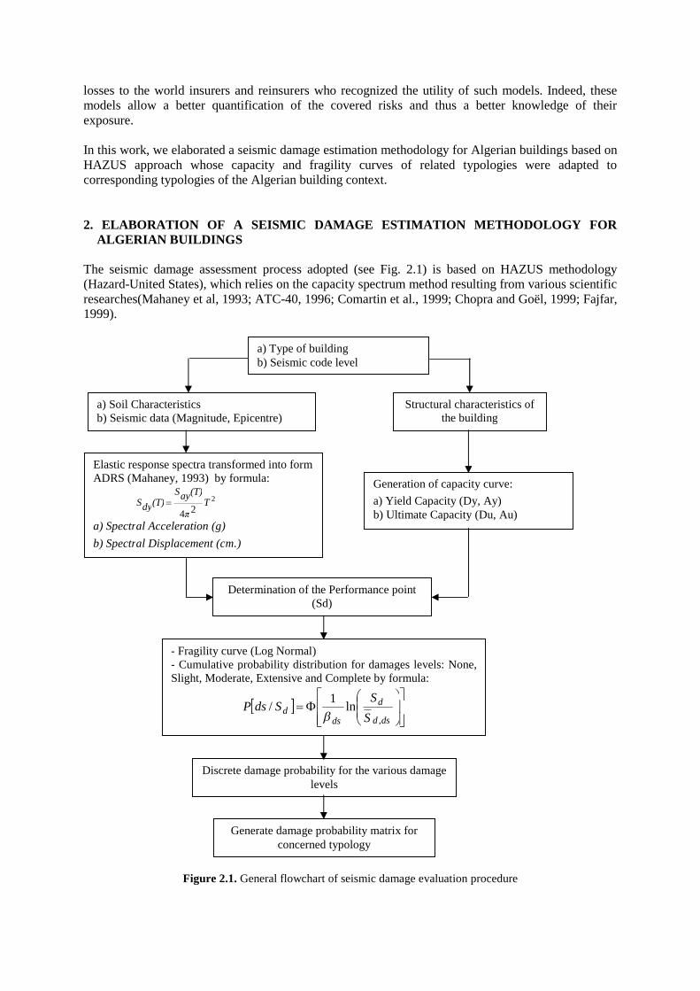
The seismic damage assessment process adopted (see Fig. 2.1) is based on HAZUS methodology(Hazard-United States), which relies on the capacity spectrum method resulting from various scientificresearches(Mahaney et al, 1993; ATC-40, 1996; Comartin et al., 1999; Chopra and Goël, 1999; Fajfar,1999).
Figure 2.1. General flowchart of seismic damage evaluation procedure
a) Soil Characteristicsb) Seismic data (Magnitude, Epicentre)
a) Type of buildingb) Seismic code level
Structural characteristics ofthe building
Elastic response spectra transformed into formADRS (Mahaney, 1993) by formula:
2
24T
π
(T)ayS(T)dyS
a) Spectral Acceleration (g)
b) Spectral Displacement (cm.)
Generation of capacity curve:
a) Yield Capacity (Dy, Ay)b) Ultimate Capacity (Du, Au)
Determination of the Performance point(Sd)
- Fragility curve (Log Normal)- Cumulative probability distribution for damages levels: None,Slight, Moderate, Extensive and Complete by formula:
dsd
d
dsd
S
SSdsP
,
ln1
/
Discrete damage probability for the various damagelevels
Generate damage probability matrix forconcerned typology

The innovative character of the used approach mainly lies in the use of parameters directly related tothe ground motion for damage estimation.The main parameters are the seismic solicitation representedin the form of response spectrum and the structure behaviour represented in the form of a capacitycurve. The performance point, which is the intersection between the capacity curve and the seismicinput, represents the behaviour of the building subjected to a given earthquake, see Fig. 2.1.Accordingto its location on the fragility curves, it permits to calculate the damage probabilities for each damagelevel and thus described the damage level of the considered structure under the given seismic input.
2.1. Building Classification
The building inventory and its classification constitute the main step for seismic damage assessment inan urban area. The selected building classification is based on the type of lateral-bracing, number ofstories as well as the period of construction. We chose the constructions types defined in the Algerianseismic code (RPA99/Version 2003), most widespread in Algeria, i.e. Reinforced Concrete structures(up to more than eight stories), Steel structures (up to more than eight stories) and Non ConfinedMasonry structures (up to more than three stories). This distinction is roughly homogeneous with themost existing classifications in the world earthquake loss estimation and particularly that used by theHAZUS methodology (FEMA, 2002). Thus, eleven (11) standard building classes were analysedrepresenting four (04) categories of lateral-bracing systems as illustrated in Table 2.1.
Table 2.1. Building Typologies used for the methodology
N° Typology Type of lateral-bracing
Height (m)
Stories
Name Number
1 RC1-BReinforced Concrete moment frame
Structures (Beam-Columns)
Low-rise 1 – 3
2 RC1-M Mediumriseoyenne
4 – 7
3 RC1-H High-rise 8 and more
4 RC2-B
Reinforced Concrete Shear Walls
Low-rise 1 – 3
5 RC2-M Mediumriseoyenne
4 – 7
6 RC2-H High-rise 8 and more
7 S-B
Steel Structures
Low-rise 1 – 3
8 S-M Mediumriseoyenne
4 – 7
9 S-H High-rise 8 and more
10 URM-B Unreinforced Masonry(Bearing walls)
Low-rise 1 -2
11 URM-M Mediumriseoyenne
3 and more
2.2. Capacity and Fragility Curves
In this study, we used capacity and fragility curves developed and used in the HAZUSmethodology(FEMA, 2002) which take account of the American seismic design level (high code,moderate code, low code and pre-code). This choice was made by taking into account the Algerianbuilding context. Indeed, we used the capacity and fragility curves of the existing building types inAlgeria, while trying to make closeness between the application levels of the American seismic code,UBC (FEMA, 2002) and the Algerian seismic code, RPA, in order to use these curves. Hence, wedefined four (04) seismic design levels according to evolution periods' of the various versions of theAlgerian seismic code bringing a change in the design level, see Table 2.2.
Table 2.2. Seismic design levels according to evolution periods' of the Algerian seismic code (RPA)
Code version After 2003 1999–2003 1981-1999 Before 1981
Code level High-code Moderate-code Low-code Pre-code

3. VALIDATION OF THE METHODOLOGYWITH THE BOUMERDESCITY CASE(ALGERIA)
In order to test and calibrate the seismic damage estimation methodology elaborated for the Algerianbuildings, we applied it to the case of the Boumerdès urban area (located at 50 km East of Algierscity), see Fig. 3.1, which was stricken on May 21, 2003 by a destructive moment magnitude 6.8 (Mw)earthquake (Boukri et al., 2008).
Figure 3.1. (a)-Quick-bird satellite image of Boumerdès city before the earthquake (April 22, 2002) provided byOYO corp.-(b)-Location of the May 21, 2003 Boumerdès earthquake
An interactive data-processing code was developedsteps to analyse the whole data and damage estimationseismic damages in Boumerdès city were estimated using the site elastic response spectrum derivedfrom the accelerometer records obtained during the main shock of the May 21results are compared to the real observed
The post-seismic evaluation forms drawn up by experts moved on the affected areas by the earthquakewere used on the one hand to consider the damage undergone by constructions and, on the other hand,to make a building classification of Boumerdès city.
Table 3.1.Structural and non-structural damages: Classification for Reinforced Concrete and Masonry structuresequivalent to EMS 98 (CGS, 2003; Grünthal and Levret, 2001)
Masonry structures Reinforced Concrete structures
VALIDATION OF THE METHODOLOGYWITH THE BOUMERDESCITY CASE
In order to test and calibrate the seismic damage estimation methodology elaborated for the Algerianbuildings, we applied it to the case of the Boumerdès urban area (located at 50 km East of Algiers
which was stricken on May 21, 2003 by a destructive moment magnitude 6.8 (Mw)
bird satellite image of Boumerdès city before the earthquake (April 22, 2002) provided byLocation of the May 21, 2003 Boumerdès earthquake epicentre (black star) (Bounif et al., 2004)
processing code was developed for this purpose gathering all the methodologysteps to analyse the whole data and damage estimation process as illustrated in Fseismic damages in Boumerdès city were estimated using the site elastic response spectrum derived
accelerometer records obtained during the main shock of the May 21st, 2003 earthquake. Theobserved damages.
seismic evaluation forms drawn up by experts moved on the affected areas by the earthquakethe one hand to consider the damage undergone by constructions and, on the other hand,
to make a building classification of Boumerdès city.
structural damages: Classification for Reinforced Concrete and Masonry structuresvalent to EMS 98 (CGS, 2003; Grünthal and Levret, 2001)
Reinforced Concrete structures Damage description
Level 1: No damage(none : structural damage
Level 2: Light damage(light structural damages, moderatenon-structural damages)Level 3: Moderatestructural damages, important nonstructural damages)
Level 4: Important damage(important structural damages, severenon-structural damages)Level 5: Severe damage Collapse orabout to(severe structural damages)Partial or total collapse
VALIDATION OF THE METHODOLOGYWITH THE BOUMERDESCITY CASE
In order to test and calibrate the seismic damage estimation methodology elaborated for the Algerianbuildings, we applied it to the case of the Boumerdès urban area (located at 50 km East of Algiers
which was stricken on May 21, 2003 by a destructive moment magnitude 6.8 (Mw)
bird satellite image of Boumerdès city before the earthquake (April 22, 2002) provided byblack star) (Bounif et al., 2004)
for this purpose gathering all the methodologyprocess as illustrated in Fig. 2.1. The building
seismic damages in Boumerdès city were estimated using the site elastic response spectrum derived, 2003 earthquake. The
seismic evaluation forms drawn up by experts moved on the affected areas by the earthquakethe one hand to consider the damage undergone by constructions and, on the other hand,
structural damages: Classification for Reinforced Concrete and Masonry structures
Damage description
damage: structural damage)
Light damage(light structural damages, moderate
damages)Moderate damage (moderate
structural damages, important non-structural damages)
Important damage(important structural damages, severe
structural damages)damage Collapse or
structural damages)Partial or total collapse

This evaluation form (see Fig. 3.2) gathers information of each inspected constructions (CTC, 1981)
allowing to consign its damage state according to a 5 damage categories classification (Meslem et al.,
2010; Meslem et al., 2012) close to the European Macroseismic Scale, EMS 98 (Grünthal, 2001 and
CGS, 2003) as shown on the Table 3.1
Figure 3.2. Post-quake damage evaluationform for Algeria (CTC, 1981; CGS, 2003)
3.1. Building Characteristics of Boumerdès City : Post-Quake Damage Estimation
The 3663 inspected damaged constructions in Boumerdès city were analysed by the National Centre ofEarthquake Engineering (CGS, 2003) and occupancy classified as residential, industrial, commercial,educational, administrative, etc. The Reinforced Concrete structures are prevalent and represent thethree quarters of the total buildings. This type of construction has been built after 1962 and isconcentrated especially in the Western part of the city between the two rivers crossing the city, namelyCorso and Boumerdès Rivers. The buildings having the "beam-column" frame system (RC1) representapproximately 71% (2596 constructions), while those built using the reinforced concrete shear wallssystem (RC2) represent 3.66%. The majority are collective buildings for residential, commercial oradministrative use. Nevertheless, Masonry structures which the majority date from the colonial period(before 1962) represent approximately a quarter (25%) of the inspected constructions, locatedessentially in the secondary and dispersed agglomerations in the Eastern and Southern part of the cityand are mainly individual constructions. There are also some steel (for industrial use) and woodconstructions (12 and 15 constructions respectively, not included in the 3663 constructions). Thesetwo (02) typologies (steel and wood) represent only less than 1% of the total buildings in Boumerdès,so they are excluded from the data base. The buildings are also classified according to the constructivesystem, number of stories, construction periods and damage levels caused by the May 21, 2003earthquake. This classification respects the seismic damage estimation procedure to be applied.
(a) (b)
This classification emphasizes that some typologies retained for the analysis, see table 2.1, do not existin Boumerdès city, like RC1-H, RC2-H and URM-M (Pre-code), RC2-B, URM-M (Low-code) andRC1-H (Moderate code). For the period before 1981, the number of constructions is about 1443 whosethe half is in masonry system. During this period, Boumerdès city was only a small locality belongingto the municipality of Thénia (Dunand, 2005), the urban expansion started with the materialization ofthe town-planning of 1970. The number of constructions is more significant (1866 units) during thelow-code period (1981-1999) of which nearly 90% are built in Reinforced Concrete. During thisperiod, Boumerdès became Wilaya (province) in 1984 and knew a strong urbanization andtransformed at the same time into an industrial pole represented by the Algerian oil companySONATRACH and an academic pole with the construction of the University containing severalfaculties and institutes. For the 3rd period (2000-2003), all constructions are built using the RC1 orRC2 systems with various heights, but their number is very small considering the short duration of thisperiod.
The analysis of the assessed damages in Boumerdès city (see table 3.3 and figure 3.4), shows that asignificant percentage of masonry buildings have suffered a several (extended and complete) damage,because these constructions are unreinforced masonry built without any design standard. ConcerningRC1 buildings which are prevalent in Boumerdès city, although their half was slightly damaged, theyrepresent the greatest number severely damaged (574 units classified between D4 and D5). This is duemainly to the poor quality of concrete and the bad reinforcement of column-beam joints (no stirrups).The more very slightly damaged construction system is RC2 (shear wall), which is used essentially forthe buildings belonging to the public inheritance such as the dwelling residences like "Cité 800logements". This system showed that it is more appropriate in high seismicity zones if it is welldesigned. The total building classification according to their damage categories is given in table 3.2
Table 3.2. Classification of the observed buildings according to their typology and the relative damages theyhave suffered
Damage level D1 D2 D3 D4 D5 Total number ofconstructions
Number of constructions 57 1766 975 658 2073663
Pourcentage (%) 1.56 48.21 26.62 17.96 5.65
3.2 Damage Estimation Using the Developed Methodology and Comparison with the ObservedDamages
Because of the defection of the accelerometer station, located at Boumerdès city (36.75N, 03.47E), 18Km from the epicentre, during the mains hock of the May 21, 2003 earthquake, which could representbetter the generated seismic excitation, the Keddara station (36.65N, 03.41E) located at the south-westof the disaster area (29 km of epicentral distance) has provided the accelerometer record which wasused for the construction of the elastic response spectrum for this study. The choice to use this recordis due to the fact that this station is closest to the defective station of Boumerdès and the study area.The H/V spectral ratios (Farsi et al., 2004) measurements performed by (Meslem et al., 2010), showthe existence of hard surface layers at Keddara station site. This argues for an absence ofamplification.
3.2.1. Development of the elastic response spectrum (ζ = 5%) The normalized mean elastic response spectrum used in this case (see figure 3.3) was built from thetwo (02) horizontal components (E-W and N-S) of the accelerogram recorded at Keddara station.
From this response spectrum, we extracted the limit characteristic periods of the constant spectralacceleration branch T1 and T2 which have as respective values 0.088s and 0.227s. These two periodsare used to plot the corresponding normalized elastic spectrum (see figure 3.3) given by the 1999Algerian seismic code (RPA, 2000), see Eqn 3.1.
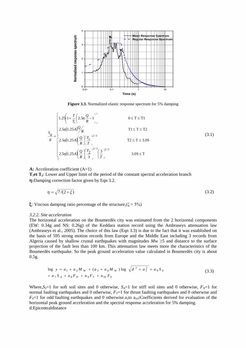
Figure 3.3. Normalized elastic response spectrum for 5% damping
T3.0S3
3225.15.2
3.0STT225.15.2
T2TT125.15.2
T1T015.2125.1
3/53/2
3/22
1
T
T
R
QA
T
T
R
QA
RQA
R
Q
T
T
gaS
(3.1)
A: Acceleration coefficient (A=1)T1et T2: Lower and Upper limit of the period of the constant spectral acceleration branch
:Damping correction factor given by Eqn 3.2.
)2/(7 (3.2)
: Viscous damping ratio percentage of the structure,(ζ = 5%)
3.2.2. Site accelerationThe horizontal acceleration on the Boumerdès city was estimated from the 2 horizontal components(EW: 0.34g and NS: 0.26g) of the Keddara station record using the Ambraseys attenuation law(Ambraseys et al., 2005). The choice of this law (Eqn 3.3) is due to the fact that it was established onthe basis of 595 strong motion records from Europe and the Middle East including 3 records fromAlgeria caused by shallow crustal earthquakes with magnitudes Mw ≥5 and distance to the surfaceprojection of the fault less than 100 km. This attenuation law meets more the characteristics of theBoumerdès earthquake. So the peak ground acceleration value calculated in Boumerdès city is about0.5g.
010987
625
24321 log)(log
FaFaFaSa
SaadMaaMaay
TNA
SWW
(3.3)
Where,SS=1 for soft soil sites and 0 otherwise, SA=1 for stiff soil sites and 0 otherwise, FN=1 fornormal faulting earthquakes and 0 otherwise, FT=1 for thrust faulting earthquakes and 0 otherwise andF0=1 for odd faulting earthquakes and 0 otherwise.a1to a10:Coefficients derived for evaluation of thehorizontal peak ground acceleration and the spectral response acceleration for 5% damping.d:Epicentraldistance
3.2.3. Geological and geotechnical context of Boumerdès cityThe geological and geotechnical context of Boumerdès site (CGS, 2009) shows that the soil type is asfirm (S2) according to the classification of the Algerian seismic codeMoreover, the H/V spectral ratios measurements performed on the urban site of Boumerdès city(Guiller et al., 2004) indicate that VsNational laboratory of habitat and construction in December, 2010 gives mean values of Vs
Concerning the site amplification effect, the H/V spectral ratios measurements performed on this ssite (Guillier et al., 2004; Hellal et al., 2010;city. This argues that the calculated acceleration value (A = 0.5g) on the Boumerdès station is fairlyrealistic and can be used to perform the elastic response spectrum
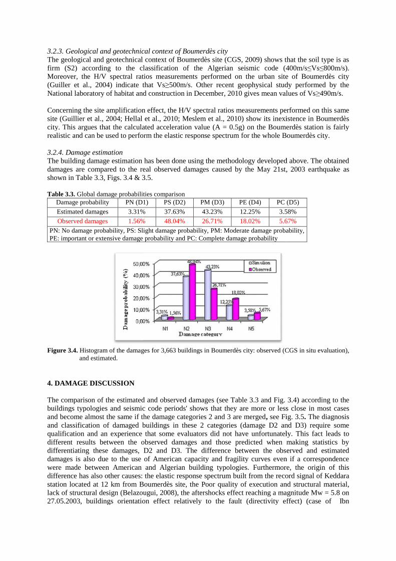
3.2.4. Damage estimationThe building damage estimation has been done using the methodology developed above. The obtaineddamages are compared to the realshown in Table 3.3, Figs. 3.4 & 3.5
Table 3.3. Global damage probabilities cDamage probability PN (D1)
Estimated damages 3.31%
Observed damages 1.56%
PN: No damage probability, PS: Slight damage probability, PM: Moderate damage probabilityPE: important or extensive damage probability and PC: Complete damage probability
Figure 3.4. Histogram of the damages for 3,663 buildings inand estimated.
4. DAMAGE DISCUSSION
The comparison of the estimatedbuildings typologies and seismic code periods' showsand become almost the same if the damage categories 2 and 3 are mergedand classification of damaged buildings in these 2 categories (damqualification and an experiencedifferent results between the observed damages and those predicted when making statistics bydifferentiating these damages, D2 andamages is also due to the use of American capacity and fragility curves even if a correspondencewere made between American and Algerian buildingdifference has also other causes: the elastic response spectrum built from the restation located at 12 km from Boumerdès site,lack of structural design (Belazougui, 200827.05.2003, buildings orientation effect relatively to the fault
ical context of Boumerdès cityThe geological and geotechnical context of Boumerdès site (CGS, 2009) shows that the soil type is asfirm (S2) according to the classification of the Algerian seismic code (400m/sMoreover, the H/V spectral ratios measurements performed on the urban site of Boumerdès city(Guiller et al., 2004) indicate that Vs≥500m/s. Other recent geophysical study performed by the
laboratory of habitat and construction in December, 2010 gives mean values of Vs
Concerning the site amplification effect, the H/V spectral ratios measurements performed on this ssite (Guillier et al., 2004; Hellal et al., 2010; Meslem et al., 2010) show its inexistence in Boumerdèscity. This argues that the calculated acceleration value (A = 0.5g) on the Boumerdès station is fairlyrealistic and can be used to perform the elastic response spectrum for the whole Boumerdès city.
building damage estimation has been done using the methodology developed above. The obtainedreal observed damages caused by the May 21st, 2003 earthquake
3.4 & 3.5.
Global damage probabilities comparisonPN (D1) PS (D2) PM (D3) PE (D4) PC (D5)
3.31% 37.63% 43.23% 12.25% 3.58%
1.56% 48.04% 26.71% 18.02% 5.67%
PN: No damage probability, PS: Slight damage probability, PM: Moderate damage probabilityPE: important or extensive damage probability and PC: Complete damage probability
Histogram of the damages for 3,663 buildings in Boumerdès city: observed (CGS in situ evaluation),
comparison of the estimated and observed damages (see Table 3.3 and Fig.buildings typologies and seismic code periods' shows that they are more or less close inand become almost the same if the damage categories 2 and 3 are merged, see Figand classification of damaged buildings in these 2 categories (damage D2 and D3) require some
that some evaluators did not have unfortunately.different results between the observed damages and those predicted when making statistics bydifferentiating these damages, D2 and D3. The difference between the observed and estimateddamages is also due to the use of American capacity and fragility curves even if a correspondence
American and Algerian building typologies. Furthermore, the origin of thise has also other causes: the elastic response spectrum built from the record signal of Keddara
at 12 km from Boumerdès site, the Poor quality of execution and(Belazougui, 2008), the aftershocks effect reaching a magnitude Mw = 5.8 on
27.05.2003, buildings orientation effect relatively to the fault (directivity effect)
The geological and geotechnical context of Boumerdès site (CGS, 2009) shows that the soil type is as(400m/s≤Vs≤800m/s).
Moreover, the H/V spectral ratios measurements performed on the urban site of Boumerdès city≥500m/s. Other recent geophysical study performed by the
laboratory of habitat and construction in December, 2010 gives mean values of Vs≥490m/s.
Concerning the site amplification effect, the H/V spectral ratios measurements performed on this same, 2010) show its inexistence in Boumerdès
city. This argues that the calculated acceleration value (A = 0.5g) on the Boumerdès station is fairlyfor the whole Boumerdès city.
building damage estimation has been done using the methodology developed above. The obtainedst, 2003 earthquake as
PC (D5)
3.58%
5.67%
PN: No damage probability, PS: Slight damage probability, PM: Moderate damage probability,
city: observed (CGS in situ evaluation),
3.4) according to thee or less close in most cases
see Fig. 3.5. The diagnosisge D2 and D3) require some
that some evaluators did not have unfortunately. This fact leads todifferent results between the observed damages and those predicted when making statistics by
d D3. The difference between the observed and estimateddamages is also due to the use of American capacity and fragility curves even if a correspondence
Furthermore, the origin of thiscord signal of Keddara
Poor quality of execution and structural material,aftershocks effect reaching a magnitude Mw = 5.8 on
(directivity effect) (case of Ibn
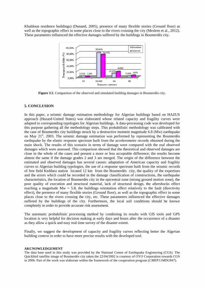
Khaldoun residence buildings) (Dunand, 2005)well as the topographic effect in some places close to the rivers crossing the city (MeslemThese parameters influenced the effective damages suffered by the buildings in Boumerdès city.
Figure 3.5. Comparison of the observed
5. CONCLUSION
In this paper, a seismic damage estimation methodology for Algerian buildingsapproach (Hazard-United States) was elaborated whose related capacity and fragility curves wereadapted to corresponding typologies for Algerian buildings. A datathis purpose gathering all the methodologythe case of Boumerdès city buildingson May 21st, 2003. The seismic damage estimation was performed by representing the Boumerdèsearthquake by the elastic response spectrum built from the accelerometer recordsmain shock. The results of this scenario in terms of damage were compared with the real observeddamages which were assessed. This comparison showed that the theorclose in the whole of the cases and present a more or less acceptable difference; the resultsalmost the same if the damage grades 2 and 3 are merged.estimated and observed damages has several causes: adaptation of American capacity and fragilitycurves to Algerian building typologies, the use of a responseof free field Keddara station located 12 km from the Boumerdès city, the qualitand the errors which could be recorded in the damage classification of constructions, the earthquakecharacteristics, the location of Boumerdès city in the epicentral zone (strong ground motion zone), thepoor quality of execution and sreaching a magnitude Mw = 5.8, the buildings orientation effect relatively to the faulteffect), the presence of many flexible storplaces close to the rivers crossing the citysuffered by the buildings of the city. Furthermore, the local soil conditions should be knowncompletely in order to provide accurate r
The automatic probabilistic processing method by combining its results with GIS tools and GPSlocation is very helpful for decision making at early days and hours afteras they allow a quick and easy real time su
Finally, we suggest the development of capacity and fragilitybuilding context in order to have more precise results with the developed tool.
AKCNOWLEDGEMENTThe data base used in this study was provided by the National Centre of Earthquake Engineering (CGS)Quickbird satellite image of Boumerdès city taken the 22/04/2002 is courtesy of OYO Corporation towards CGSin 2006. Part of the work was elaborate within the framework of the c
(Dunand, 2005), presence of many flexible storiesthe topographic effect in some places close to the rivers crossing the city (Meslem
These parameters influenced the effective damages suffered by the buildings in Boumerdès city.
Comparison of the observed and simulated building damages in Boumerdès
In this paper, a seismic damage estimation methodology for Algerian buildingsUnited States) was elaborated whose related capacity and fragility curves were
adapted to corresponding typologies for Algerian buildings. A data-processing code was developed forthis purpose gathering all the methodology steps. This probabilistic methodology was calibrated withthe case of Boumerdès city buildings struck by a destructive moment magnitude 6.8 (Mw) earthquake
2003. The seismic damage estimation was performed by representing the Boumerdèske by the elastic response spectrum built from the accelerometer records
. The results of this scenario in terms of damage were compared with the real observeddamages which were assessed. This comparison showed that the theoretical and observed damages areclose in the whole of the cases and present a more or less acceptable difference; the resultsalmost the same if the damage grades 2 and 3 are merged. The origin of the difference between the
mages has several causes: adaptation of American capacity and fragilityto Algerian building typologies, the use of a response spectrum built from the seismic records
of free field Keddara station located 12 km from the Boumerdès city, the qualitand the errors which could be recorded in the damage classification of constructions, the earthquakecharacteristics, the location of Boumerdès city in the epicentral zone (strong ground motion zone), the
and structural material, lack of structural design, the aftershocks effectreaching a magnitude Mw = 5.8, the buildings orientation effect relatively to the faulteffect), the presence of many flexible stories (Ground floor), as well as the topogra
to the rivers crossing the city, etc. These parameters influenced thesuffered by the buildings of the city. Furthermore, the local soil conditions should be knowncompletely in order to provide accurate risk assessment.
The automatic probabilistic processing method by combining its results with GIS tools and GPSlocation is very helpful for decision making at early days and hours after the occurrence of a disasteras they allow a quick and easy real time survey of the disaster extent.
Finally, we suggest the development of capacity and fragility curves reflecting better the Algerianbuilding context in order to have more precise results with the developed tool.
study was provided by the National Centre of Earthquake Engineering (CGS)Quickbird satellite image of Boumerdès city taken the 22/04/2002 is courtesy of OYO Corporation towards CGSin 2006. Part of the work was elaborate within the framework of the cooperation program (
ies (Ground floor) asthe topographic effect in some places close to the rivers crossing the city (Meslem et al., 2012).
These parameters influenced the effective damages suffered by the buildings in Boumerdès city.
Boumerdès city.
In this paper, a seismic damage estimation methodology for Algerian buildings based on HAZUSUnited States) was elaborated whose related capacity and fragility curves were
processing code was developed forprobabilistic methodology was calibrated with
struck by a destructive moment magnitude 6.8 (Mw) earthquake2003. The seismic damage estimation was performed by representing the Boumerdès
ke by the elastic response spectrum built from the accelerometer records obtained during the. The results of this scenario in terms of damage were compared with the real observed
etical and observed damages areclose in the whole of the cases and present a more or less acceptable difference; the results become
The origin of the difference between themages has several causes: adaptation of American capacity and fragility
built from the seismic recordsof free field Keddara station located 12 km from the Boumerdès city, the quality of the expertisesand the errors which could be recorded in the damage classification of constructions, the earthquakecharacteristics, the location of Boumerdès city in the epicentral zone (strong ground motion zone), the
lack of structural design, the aftershocks effectreaching a magnitude Mw = 5.8, the buildings orientation effect relatively to the fault (directivity
as well as the topographic effect in some, etc. These parameters influenced the effective damages
suffered by the buildings of the city. Furthermore, the local soil conditions should be known
The automatic probabilistic processing method by combining its results with GIS tools and GPSoccurrence of a disaster
reflecting better the Algerian
study was provided by the National Centre of Earthquake Engineering (CGS). TheQuickbird satellite image of Boumerdès city taken the 22/04/2002 is courtesy of OYO Corporation towards CGS
ooperation program (CMEP11MDU847).

REFERENCES
Agrawal, S.K. (2004). Microzonation studies as impacted by recent earthquakes in India. Building Material andTechnology Promotion Council, New Delhi, pp. 10.
Ambraseys, N. N., Douglas, J., Sarma, S. K., and Smit, P. M. (2005).Equations for the estimation of strongground motions from shallow crustal earthquakes using data from Europe and the Middle East: horizontalpeak ground acceleration and spectral acceleration. Bulletin of Earthquake Engineering, 3: pp 1–53
ATC-40.(1996). Seismic Evaluation and Retrofit of Concrete Buildings. Vol. 1. Applied Technology Council,Redwood City, California.
Belazougui, M. (2008).Boumerdès Algeria earthquake of May 21, 2003: damage analysis and behavior of beam-column reinforced concrete structures. Proceedings of the 14th World Conference on EarthquakeEngineering, Beijing, China.
Boukri, M.,and Bensaïbi, M. (2008).Vulnerability index of Algiers masonry buildings. Proceedings of the 14th
World Conference on Earthquake Engineering, Beijing, China.Bounif, A., Dorbath, C., Ayadi, A., Meghraoui, M., Beldjoudi, H., Laouami, N., Frogneux, M., Slimani, A.
(2004). The 21 May 2003 Zemmouri (Algeria) earthquake Mw 6.8: Relocation and aftershock sequenceanalysis, Geophysical Research Letters. Vol31.
CGS. (2009).Seismic Microzonation Study of Urban Areas in Boumerdès City. National Centre of EarthquakeEngineering, CGS.
CGS. (2003). Statistical study on the damaged buildings following the Boumerdès earthquake of May 21st, 2003,National Centre of Earthquake Engineering, CGS.
Charles, S. (2005).History of Risk Model Development, Kyoto University.Clark, K. (2002). The Use of Computer Modelling in Estimating and Managing Future Catastrophe Losses. The
Geneva Papers on Risk and Insurance.Vol.27, No.2 15p.CTC. (1981). Rapport sur le séisme d'El Asnam du 10 octobre 1980, Alger.1Chopra, A. K., and Goël, R.K..(1999). Capacity Demand Diagram Methods Based on Inelastic Design Spectrum.
Earthquake Spectra. N° 15.Comartin, C., Niewiarowski, R., Freeman, S. A., and Turner, F. (2000).Seismic Evaluation and Retrofit of
Concrete Buildings: A practical Overview of the ATC 40 Document. Earthquake Spectra. N° 16.Dunand, F. (2005). Pertinence du bruit de fond sismique pour la caractérisation dynamique et l’aide au
diagnostic sismique des structures de génie civil, Thèse de doctorat, Université Joseph Fourrier, France.Fajfar, P.(1999). Capacity Spectrum Methods Based on Inelastic Demand Spectra. Earthquake Engineering and
Structural Dynamics. N° 28.Farsi, M. N., Bard, P. Y. (2004). Estimation des périodes propres des bâtiments et vulnérabilité du bâti existant
dans l’agglomération de Grenoble. Revue Française de Génie Civil. Volume X – n° Y/200Z.FEMA.:HAZUS99. (2002). Earthquake Loss Estimation Methodology. Technical Manual., Federal Emergency
Management Agency , Washington, DC, United States.Grünthal,G., and Levret, A. (2001).EuropeanMacroseismicScale1998. Cahiers du Centre Européen de
Géodynamique et de Séismologie.Vol.19.103pp., Luxembourg.Guillier, B., Machane, D., Oubaiche, E., Chatelain, J. L., Ben Salem, R. and Dunand, F. (2004). Résultats
préliminaires sur les fréquences fondamentales et les amplifications de sols obtenus par l’étude du bruit defond, sur la ville de Boumerdès, Algérie. Mémoire du service géologique d’Algérie. N° 12, pp 103-114.
Hellel, M., Chatelain, J. L., Guillier, B., Machane, D., Ben Salem, R., Oubaiche, E., and Haddoum, H.(2010).Heavier Damages without Site Effects and Site Effects with Lighter Damages: Boumerdès City(Algeria) after the May 2003 Earthquake, 2010.Seismological Research Letter. Vol. 81, N°1.
Laouami, N., Slimani, A., Bouhadad, Y., Chatelain, J. L., and Nour, A. (2006). Evidence for fault-relateddirectionality and localized site effects from strong motion recordings of the 2003 Boumerdès (Algeria)earthquake: Consequences on damage distribution and the Algerian seismic code.Soil Dynamics andEarthquake Engineering. N° 26, pp 993-1003.
Mahaney, J. A., Terrence F. P., Bryan E. K., and Sigmund A. F. (1993).The Capacity Spectrum Method forEvaluating Structural Response during the Loma Prieta Earthquake. Proceedings of the 1993 United StatesNational Earthquake Conference, Memphis, Tennessee.Vol.2, Pages 501-510.
Meslem, A., Yamazaki, F., Maruyama, Y., Benouar, D., Kibboua, A., Mehani, Y. (2012).The Effects of BuildingCharacteristics and Site Conditions on the DamageDistribution in Boumerdès afterthe 2003 AlgeriaEarthquake.Earthquake Spectra, Vol. 28, N°.1, pp185–216..
Meslem, A., Yamazaki, F., Maruyama, Y., Benouar, D., Laouami, N. and Benkaci, N. (2010). Site-responsecharacteristics evaluated from strong motion records of the 2003 Boumerdès, Algeria earthquake.Earthquake Spectra.Vol. 26, N°. 3, pp 803–823.
Règles Parasismique Algériennes, RPA99. (2000). Ministère de l’habitat et de l’urbanisme, Algérie.