richmond hills stages 6 & 7 - mackay council · richmond hills stages 6 & 7 . mackay habana...
TRANSCRIPT

DEVELOPMENT ASSESSMENT REPORT
Richmond Hills Stages 6 & 7 Mackay Habana Road, Richmond
Reconfiguration of a Lot (Development Permit)
Date – 12 April 2013

Development Assessment Report
12 April 2013 2
Pointglen Developments retains ownership and copyright of the contents of this document including drawings, plans, figures and other work produced by Pointglen Developments. This document is not to be reproduced in full or in part, unless separately approved by Pointglen Developments. Council may use this document only for the purpose for which it was prepared. No third party is entitled to use or rely on this document.
This report is based on our opinion of the town planning issues that arise from the statutory provisions relating to this site. Comments and conclusions in or construed from this report relating to matters of law are not to be relied upon. You should only rely upon the advice of your professional legal advisors with respect to matters of law. The validity and comprehensiveness of supplied information has not been independently verified and, for the purposes of this report, it is assumed that the information provided to Pointglen Developments is both complete and accurate. Whilst, to the best of our knowledge, the information contained in this report is accurate at the date of issue, changes may occur to the site conditions, the site context or the applicable planning framework. This report should not be used after any such changes without consulting the provider of the report or a suitably qualified person.

Development Assessment Report
12 April 2013 3
CONTENTS 1. Application Summary ...................................................................................................................... 4
1.1 Summary ................................................................................................................................. 4
1.2 Approval/s Sought................................................................................................................... 4
2. Introduction .................................................................................................................................... 8
2.1 Mandatory Information .......................................................................................................... 8
3. Site Characteristics .......................................................................................................................... 9
3.1 Site Context ............................................................................................................................. 9
3.2 Cultural Heritage ................................................................................................................... 10
3.3 Site Contamination ............................................................................................................... 10
4. Proposal ........................................................................................................................................ 11
4.1 Proposal Details – Reconfiguring a Lot ................................................................................. 11
5. Planning Framework & Assessment.............................................................................................. 14
5.1 Sustainable Planning Act 2009 .............................................................................................. 14
5.2 Existing Approvals / Instruments .......................................................................................... 15
5.3 Mackay, Isaac and Whitsunday Regional Plan ...................................................................... 16
5.4 State Planning Policies .......................................................................................................... 16
5.5 Consolidated Mackay City Planning Scheme 2009 ............................................................... 17
6. Recommendations ........................................................................................................................ 22
APPENDICES .................................................................................................................................. 23
SUPPORTING DOCUMENTS (ATTACHED / ENCLOSED) .................................................................. 23
Engineering Report

Development Assessment Report
12 April 2013 4
1. Application Summary
1.1 Summary
PROPERTY DESCRIPTION
Lot 1 on RP714389 and Lot 903 on SP185586 and Lot 905 on SP255642
ADDRESS Richmond, QLD 4740
SITE AREA 48.918 Hectares (8.868 Ha + 24.62 Ha + 15.43 Ha respectively)
APPLICANT Pointglen Developments Pty Ltd
OWNERSHIP Illuka Investments P/L A.C.N. 106 737 151 Refer to Appendix for current title searches
CONTACT Paul Thompson c/- Pointglen Developments PO Box 8158, MT PLEASANT QLD 4740 Ph 07 4968 0000 Fax 07 4942 4648 Email [email protected]
LOCAL AUTHORITY Mackay Regional Council
PLANNING SCHEME Consolidated Mackay City Planning Scheme as adopted 13 May 09
PLANNING SCHEME LOCALITY / PRECINCT
LOCALITY: Frame PRECINCT: McReadys Creek
ZONE Lot 903 on SP185586 – Rural Lot 1 on RP714389 and Lot 905 on SP255642 – Urban Expansion
PLANNING SCHEME OVERLAYS
Bushfire Management Development in the Vicinity of Mackay Airport Development on Steep Land Good Quality Agricultural Land Landscape Character
CURRENT USE Agriculture – cane farming and grazing
REFERRAL AGENCIES Concurrence: Department of Transport and Main Roads
1.2 Approval/s Sought
DEVELOPMENT TYPE DETAILS / DEFINED USES DOCUMENTS SOUGHT FOR
APPROVAL
Reconfiguring a Lot (Development Permit)
Stages 6 and 7. 3 existing lots into a total of 84 residential lots and 3 balance lots. To be subdivided in stages.
Plan/s of Development in Appendix A
Other Currency period of 6 years sought

Development Assessment Report
12 April 2013 5
FIGURE 1 – Locality Map
LEGEND SUBJECT SITE
LOCA LITY MA P
DATE 11 April 2013 JOB NO.> 5005 0620 SCALE No particular scale SOURCE Google Maps

Development Assessment Report
11 April 2013 6
FIGURE 2 – Zoning Map
LEGEND
Open Space Public Purpose Rural Rural Residential Urban Expansion Urban Residential
Z O N ING MA P
DATE 9 April 2013 JOB NO.> 5005 0520 SCALE No particular scale SOURCE Council Mi-Maps website
OAKVIEW ST
PARKEDGE AVE
JANM
AC C
T
STAGE 4
STAGE 5
STAGE 6
STAGE 7
STAGE 3

Development Assessment Report
11 April 2013 7
FIGURE 3 – Aerial Map
AERIAL MAP
DATE 11 April 2013 JOB NO.> 5005 0520 SCALE No particular scale SOURCE Mi Maps
OAKVIEW ST
PARKEDGE AVE
JANM
AC C
T
STAGE 4
STAGE 5
STAGE 6
STAGE 7
STAGE 3

Development Assessment Report
12 April 2013 8
2. Introduction
This planning report accompanies a Development Application over land accessed off Grangewood Avenue, and located near the Mackay Habana Road and Boveys Road, Richmond (referred to hereafter as “Richmond Hills” estate).
Richmond Hills estate is a masterplanned residential development expected to yield about 650 lots and will be developed in stages. The Application is for the development of parts of the site known as Stages 6 and 7 of Richmond Hills estate as identified on Figure 1 – Location map of this report. Stages 6 and 7 directly adjoin, and are a logical extension to, Stages 3 and 5.
Stages 3 and 4 have an RoL and Operational Works approval. Construction of Stage 3 has been commissioned to commence in 2013. Stage 4 construction is anticipated to commence in 2014.
Stage 5 (in RoL application phase) will be developed prior to Stages 6 & 7.
A Relevant Period of 6 years is sought to ensure previous stages of development are constructed without the need for further extension requests. This period is considered realistic and in line with the development program.
Accordingly, this application is for a development permit (reconfiguration of a lot) to create (as separable stages) 84 residential lots.
2.1 Mandatory Information
The common material of this application includes all of the “mandatory supporting information”, which constitutes a ‘properly made application’ under section 261 of the Sustainable Planning Act 2009 (SPA).

Development Assessment Report
12 April 2013 9
3. Site Characteristics
3.1 Site Context
3.1.1 Location
The subject site is located off the Mackay-Habana Road, Richmond (refer to Figure 1 – Location Map) within the City of Mackay Local Government Area (“LGA”). The site is situated within close proximity to the Mackay-Bucasia Road, Mackay Golf Course, and the retail and community facilities of Rural View.
3.1.2 Road Frontage and Practical Access
The subject site is accessed via Grangewood Avenue– Stage 2 Richmond Hills and Stage 5. Lot 903 on SP185586 is bound by Boveys Road at its far western boundary.
3.1.3 Current Use of Site
The subject site is currently used for agriculture – cane farming and grazing.
3.1.4 Surrounding Land Uses and Built Form
The subject site is surrounded by various land uses and built form as outlined below:
DIRECTION BUILT FORM LAND USE
North Developing urban land (Premier Vista Estate), residential dwellings and caneland.
Vacant, and rural residential, and cane farm.
South Developing urban land (Richmond Hills Estate), residential dwellings and caneland.
Horse paddock and residential.
East Cane paddock Broad scale sugar cane farming West Cane paddock, including a farm
house and associated farm sheds and a rural res dwelling.
Broad scale sugar cane farming and a rural residential property
3.1.5 Existing Significant Vegetation
The residential development contains no remnant vegetation and does not involve the clearing of vegetation. The balance subject site is also clear of remnant vegetation. Broad scale clearing of the site was undertaken long ago for the purposes of farming, with the dominant vegetation on site now cane.
3.1.6 Topography
The Plans of Development in Appendix A include existing contours that show the land undulating from Stage 5 and the existing residential stage 2. The land form varies from gently undulating to

Development Assessment Report
12 April 2013 10
between 10-20% grade. A slope analysis is included in the accompanying Engineering Report.
3.1.7 Easements
The site is encumbered by easements relating to infrastructure provided in Stage 1 of the development. These easements include a trunk water main leading from Premier Vista into the site, and a trunk sewer main heading east. Refer Sketch 0219 in Appendix H showing existing infrastructure and easements.
3.1.8 Flooding and Stormwater Drainage
McReadys Creek adjoins proposed Stage 5 at the south east corner. Drainage has been provided through an open drain in Stage 5 (lot 903) to McReadys Creek as well as through the Stage 5 road network to the open space adjoining McReadys Creek
An extensive hydraulic analysis for the Richmond Hills site was undertaken as part of the existing development approvals to determine a flood strategy. The analysis concludes that there will be no detrimental impact generated on upstream or downstream properties in accordance with the recommended measures within the report (Refer accompanying Engineering Report, including the Hydraulic Flood Analysis).
3.1.9 Existing Infrastructure Services
A trunk water main leads from the north through Premier Vista and then into the site. A trunk sewer main heads east from the proposed park lot 902. Both services are covered by existing easements (Refer Sketch 0219 in Appendix H). The easement strategy is shown on the Plan of Development in Appendix A where existing easements are cancelled or partially cancelled where they have been catered for within the proposed development.
3.2 Cultural Heritage
The risk of an indigenous cultural heritage find is relatively low given the extent of prior site disturbance associated with historic land use and site disturbance. The Applicant is aware of the duty of care responsibilities under the Aboriginal Cultural Heritage Act 2003, in the event that aboriginal cultural heritage is encountered during site development activities.
3.3 Site Contamination
The site is not included within the Environmental Management Register, or the Contaminated Land Register (refer to Appendix D – CLR and EMR Searches) and is not known to have contained any notifiable activity. Accordingly, the site is not expected to contain any contamination.

Development Assessment Report
12 April 2013 11
4. Proposal
This section of the report provides a summary of the proposed development shown in the Appendix A – Plans of Development. The following sections of this report discuss the key planning issues.
The Applicant proposes to construct 84 urban residential allotments and road. The development will be completed in stages – called stages 6 and 7 – and form part of a master-planned estate of about 650 allotments.
The site is generally contained in the Urban Expansion Zone. However, part of proposed lots 215 and 216 slightly encroach into Lot 903 on SP185586, which is zoned Rural. Lot 903 has a Preliminary MCU Approval that overrides the Planning Scheme Zone “so that any future development application on the site will be assessed as if the land is located in the Mackay Frame Locality, McReadys Creek Precinct and Urban Residential Zone”. Refer DA 2007-536 for the Decision Notice.
4.1 Proposal Details – Reconfiguring a Lot
4.1.1 Relevant Period
Stages 3, 4 & 5 will be developed prior to the subject stages. Accordingly, a Relevant Period of 6 years is sought to ensure previous stages of development are constructed without the need for further extension requests. This period is considered realistic and in line with the development program.
4.1.2 Masterplan
The site is being developed as a masterplanned estate. Infrastructure is being developed in a coordinated manner that accounts for future upstream catchments.
Refer Masterplan layout in Appendix H, and the Masterplan Park Agreement in Appendix E. Also, Masterplanned water, sewer, road hierarchy and stormwater quality infrastructure plans / strategies are included in the accompanying Engineering report.
4.1.3 Allotment Characteristics
A Development Permit for Reconfiguring a Lot (Code Assessment) is sought for Stages 6-7 of the development. Approval is sought for development in accordance with the Plan of Development in Appendix A.
Some of the allotments will be elevated. The civil design of the estate will endeavour to minimize allotment slope through appropriate road placement and earthworks design.
Lot densities have been increased from earlier stages. Stages 6 and 7 includes lots sized from 607m² that are of standard configuration and standard freehold (not community title) format.

Development Assessment Report
12 April 2013 12
4.1.4 Staging
Stage 5 will be developed prior to the construction of Stages 6 & 7 to ensure the appropriate infrastructure connectivity.
4.1.5 Open Space Strategy
The estate will be provided with open space areas in a masterplanned and staged fashion for the use of the Richmond Hills and surrounding residents and in accordance with the Park Masterplan in Appendix E, notably:
• A high quality and comprehensive “Village Park” has been provided within Stage 1 for use by Richmond Hills estate and adjoining estates. This park includes landscaped play areas, kick about spaces, hiking and biking trails and sheltered picnic areas.
• An open space link to the Stage 1 Village Park is strongly encouraged along the McReadys Creek riparian zone in the adjoining development to the east of Richmond Hills estate.
• A link park adjoining the McReadys Creek riparian zone is proposed as part of Stage 5 (proposed Lot 902). A shared cycle and pedestrian path will be provided within this link park, which will link to the adjoining future development.
• Proposed Lot 902 will act as a buffer to the riparian vegetation and as a flood conveyance corridor in accordance with the hydraulic study.
4.1.6 Traffic and Access
The road design throughout the estate is in accordance with Council’s road hierarchy strategy (refer Mackay Level 4 Road Hierarchy report by Eppell Olsen) and in accordance the Road Hierarchy Concept plan 0166 in the accompanying Engineering Report.
Refer to the accompanying Engineering Report where issues are discussed in more detail.
4.1.7 Services Connectivity
Provision has been made with existing stages to ensure adequate capacity and connectivity for the proposed and future residential allotments. The site does not need additional permissions from downstream or adjoining owners.
Refer to the accompanying Engineering Report where issues are discussed in more detail.
4.1.8 Stormwater Quality
AECOM has prepared a Masterplan Conceptual Site Based Storm Water Management Plan (SBMP) for a large portion of the Richmond Hills development (Refer to the accompanying Engineering Report). The proposed development is included in the masterplanned SBMP catchment, which sizes and locates bio retention.
As with previous stages, it is proposed to make fair and reasonable staged cash contribution towards a regional stormwater quality system and not provide internal bio retention devices.
4.1.9 Flooding and Inundation

Development Assessment Report
12 April 2013 13
McReadys Creek adjoins proposed Stage 5 at the south east corner. Drainage has been provided through an open drain in Stage 5 (lot 903) to McReadys Creek as well as through the Stage 5 road network to the open space adjoining McReadys Creek
An extensive hydraulic analysis for the Richmond Hills site was undertaken as part of the existing development approvals to determine a flood strategy. The analysis concludes that there will be no detrimental impact generated on upstream or downstream properties in accordance with the recommended measures within the report (Refer accompanying Engineering Report, including the Hydraulic Flood Analysis).
Cardno Ullman and Nolan has completed a McReadys Creek Hydraulic Flood Analysis for the Richmond Hills development, which is included in the accompanying Engineering Report. Their assessment identifies no impacts on upstream or downstream properties during the Q100 Flood Event as a result of the proposed development.
The developments minimum residential levels will be above the Q100 flood event.
4.1.10 Telecommunications and Electricity
The estate will be provided with both electricity (underground) and telecommunication services. The provision of such services will be in accordance agreements from Ergon and the NBN. The design of such services will occur during civil design stage.
4.1.11 Water and Sewer
Provision has been made with previous stages that ensure adequate capacity and connectivity for the proposed residential allotments. Refer the accompanying Engineering Report for more detail.

Development Assessment Report
12 April 2013 14
5. Planning Framework & Assessment
This section of the development assessment report explains the components of the applicable planning framework and their impacts on the proposed development. The Sustainable Planning Act Section 313 (code assessable applications) state matters or things the Assessment Manager must have regard to for apply to this application. These matters or things are now discussed.
5.1 Sustainable Planning Act 2009
The Sustainable Planning Act 2009 (“SPA”) is the statutory instrument for the State of Queensland under which, amongst other matters, development applications are assessed by local governments. SPA is accompanied by the Sustainable Planning Regulation 2009 (SP Regs) and Planning and Environment Court Rules 2008.
5.1.1 Type of Approval Sought
The SPA provides for development approvals in the form of preliminary approvals, development permits, compliance permits and compliance certificates.
In this instance, the Applicant is seeking a Development Permit for a Reconfiguration of a Lot to undertake the proposed development. Chapter 6, Part1, Division 3, Subdivision 3 – Development Permits of the SPA states:
A development permit authorises assessable development to take place—
a) to the extent stated in the permit; and
b) subject to—
(i) the conditions of the permit; and
(ii) any preliminary approval relating to the development the permit authorises, including any conditions of the preliminary approval.
5.1.2 Level of Assessment
The local government planning framework relevant to assessing this development application at the time of lodgement comprises predominantly of the Consolidated Mackay City Planning Scheme (“the Planning Scheme”) adopted on the 13 May 2009.
Under the provisions of the Planning Scheme, the application will be subject to Code Assessment (the assessment level prescribed for a Reconfiguring a Lot in Table 5.2 of the Planning Scheme).
5.1.3 Public Notification
According to Section 295(1) of the SPA - Applicant or assessment manager to give public notice of application, applies to an application if either of the following applies –
a) any part of the application requires impact assessment; b) the application is an application to which section 242 applies.

Development Assessment Report
12 April 2013 15
As the development application requires Code Assessment, public notification is not required in this instance.
5.1.4 Referral Agencies
Section 254 of the SPA – Jurisdiction of referral agencies for applications – generally, states that:
(1) A referral agency has, for assessing and responding to the part of an application giving rise to the referral, the jurisdiction or jurisdictions prescribed under a regulation.
Additional, Section 13 of the SPR explains that:
“For sections 250(a), 251(a) and 254(1) of the Act —
a) schedule 7, column 2 states the referral agency, and whether it is an advice agency or a concurrence agency, for the development application mentioned in column 1; and
b) schedule 7, column 3 states the jurisdiction of the referral agency mentioned in column 2.”
According to the above, the following State Government Agencies have been identified as Referral Agencies:
AGENCY TYPE TRIGGER
Department of Transport and Main Roads (DTMR)
Concurrence Schedule 9 Item 27 - Threshold exceeded for LGA population 2.
5.1.5 Resource Entitlement
The Department of Environment band Resource Management has issued a General Authority – Evidence of resource entitlement for roads. The resource entitlement provides general authority to development applications (other than for vegetation clearing) involving local government roads. The development may impact local government roads for purposes which this entitlement is intended.
5.2 Existing Approvals / Instruments
At the time of writing, the following applications / approvals / instruments are relevant to the development application:
INSTRUMENT STAGE COMMENTS
DA 2007-536 Stages 1 - 3 Reconfiguring a Lot - Approved.
OW 2010-45 Stage 3 Operational Works - Approved.
DA 2010-191 Stage 4 Reconfiguring a Lot - Approved.
OW 2012-184 Stage 4 Operational Works - Approved.
DA 2007-543 Site B (Lot 903 on SP185586)
Material Change of Use – Preliminary Approval to override the Planning Scheme as if located in the Urban Residential Zone, McCreadys Creek Precinct. Approved.

Development Assessment Report
12 April 2013 16
The proposed development is consistent with the existing development approvals.
5.3 Mackay, Isaac and Whitsunday Regional Plan
The site is contained within the Mackay, Isaac and Whitsunday (MIW) Regional Plan Region. This plan is a statutory plan that provides strategic advice and direction and prevails over other planning instruments. In accordance with section 313 and 314 of the Sustainable Planning Act 2009 an Assessment Manager must assess an application against a range of matters, including a regional plan where the regional plan has not been appropriately reflected in the planning scheme. On this basis, the MIW Regional Plan (i.e. sub-regional narratives and desired regional outcomes) must be considered by the assessment manager for code and impact assessable applications. As of 12 July 2012 the MIW State planning regulatory provisions (SPRP) no longer have effect.
Urban Footprint Designation:
The proposal is for urban residential development within the Urban Footprint and is therefore consistent with the designation under the Mackay, Issac and Whitsunday Regional Plan.
In view of the above assessment, the proposed development will not compromise the intent of the Mackay, Isaac and Whitsunday Regional Plan. Therefore, the proposed development is viewed as being consistent with the main planning principles contained within this particular document.
5.4 State Planning Policies
Where not appropriately reflected in a planning scheme, State Planning Policies (SPPs) are relevant to assessing applications subject to assessment. In this regard, the Minister has identified that the following State Planning Policies (SPPs) have been appropriately reflected in the Mackay City Planning Scheme:-
• State Planning Policy 1/92 – Development and the Conservation of Agricultural Land 1.0 (SPP 1/92);
• State Planning Policy 1/02 – Development in the Vicinity of Certain Airport and Aviation Facilities 1.0 (SPP 1/02);
• State Planning Policy 2/02 – Planning and Managing Development Involving Acid Sulfate Soils 1.0 (SPP 2/02);
• State Planning Policy 1/03 – Mitigating the Adverse Impacts of Flood, Bushfire & Landslide 1.0 (SPP 1/03).
Given that the above SPP’s (or component parts) have been appropriately reflected in the Consolidated Mackay City Planning Scheme, no specific consideration of these particular SPPs is required (beyond the measures contained in the Planning Scheme for these matters).
5.4.1 SPP 4/10 – Healthy Waters
The site is greater than 2,500m² and therefore the SPP is applicable to the development. As with previous stages, we propose to make a fair and reasonable cash contribution towards a regional external stormwater quality system in lieu of providing on-site Stormwater treatment devices. A detailed stormwater quality masterplan has been provided with the Accompanying Engineering report.

Development Assessment Report
12 April 2013 17
5.5 Consolidated Mackay City Planning Scheme 2009
Land use and development within the City of Mackay is regulated by the Mackay City Planning Scheme, incorporating all amendments on and before the date of adoption. The proposal will be assessed against the following codes in accordance with the Planning Scheme:
The following sections assess the proposal against the abovementioned use codes and overlay codes of the Planning Scheme.
5.5.1 Mackay Frame Locality
According to section 5.8 of the Mackay Frame Locality Code, compliance with the Mackay Frame Locality Code is achieved when development is consistent with:
The specific outcomes for the locality (Division 7); and
• The specific outcomes for the relevant zone (Division 8-20).
The proposed development achieves compliance with each of the Codes Acceptable/Probable solutions for the locality (Division 7) and the Zones (Division 10 and 13). The development is therefore consistent with the Mackay Frame Locality Code.
Particular reference is made to the following specific outcomes:
CODE TYPE CODE TITLE
LOCALITY CODE Mackay Frame Locality Code (McReadys Creek Precinct)
Urban Expansion Zone within the Mackay Frame Locality
Rural Zone within the Mackay Frame Locality
OVERLAY CODES • Bushfire Management Overlay Code • Development in the Vicinity of Mackay Airport Overlay Code • Development on Steep Land Overlay Code • Good Quality Agricultural Land Overlay Code • Landscape Character Overlay Code
DEVELOPMENT CODES • Reconfiguration of a Lot Code. • Environment and Infrastructure Code • Mackay Frame Locality Code; • Urban Expansion Zone Code within the Mackay Frame Locality
(Site A only); • Urban Residential Zone Code within the Mackay Frame Locality
(Site B only);

Development Assessment Report
12 April 2013 18
MACKAY FRAME LOCALITY - DIVISION 7
SPECIFIC OUTCOME ACCEPTABLE / PROBABLE SOLUTIONS
STATEMENT OF COMPLIANCE
P5 Residential development on land zoned for residential uses, adopts or creates new traffic and transport systems which:
(i) are based on the hierarchy of roads;
(ii) are appropriate to the transport and traffic tasks required by the proposed development, having regard to its scale, intensity and character;
(iii) are linked efficiently and safely with the existing road network;
(iv) promote the safe movement of traffic,
cyclists and pedestrians throughout the development area; and
(v) minimises the potential for through traffic and local traffic conflicts and for industrial and non-industrial traffic conflicts
No Solution specified Complies The proposal accords with the Road Hierarchy Concept plan 0166 (in the accompanying Engineering Report) which takes into consideration Council’s Key Infrastructure Maps. The road hierarchy has been discussed at length with Council, with the road hierarchy plan 0166 being used in the assessment of existing approvals / applications on the land.
5.5.2 Zone Having regards to the relevant Planning Scheme Zoning Map, the subject site is included in the Urban Expansion and Rural Zones (refer Figure 2 – Zoning map).
However, for the purpose of this application, the planning scheme’s Rural Zone within Site B is overridden by the Preliminary Approval “so that any future development application on the site will be assessed as if the land is located in the Mackay Frame Locality, McReadys Creek Precinct and Urban Residential Zone”.
The proposed development is consistent with the Overall and Specific Outcomes in the Urban Expansion and Urban Residential Zones.
5.5.3 Bushfire Management Overlay Code
The proposed development achieves compliance with each of the applicable Acceptable/Probable Solutions of this code and therefore each corresponding Specific Outcome.
Parts of the development include areas noted as a Medium Risk Bushfire Hazard. Residential lots will be serviced by a reticulated water service that has sufficient flow and pressure characteristics for fire fighting purposes. Also, a perimeter road and link park on the lower parts of Stage 4 will separate and buffer the higher lots.
In summary, the proposed development is consistent with the Landscape Overlay Code.
5.5.4 Development in the Vicinity of Mackay Airport Overlay Code
The proposed development achieves compliance with each of the applicable Acceptable/Probable Solutions of this code and therefore each corresponding Specific Outcome.
The development is located a significant distance from the airport. It’s proposed uses, lighting, built form, airborne emissions etc will not detrimentally impact upon the operation of the

Development Assessment Report
12 April 2013 19
airport or the safety of aircraft. The development does not encroach into Obstacle Limitation Surface of the airport
In summary, the proposed development is consistent with the Development in the Vicinity of Mackay Airport Overlay Code.
5.5.5 Development on Steep Land Overlay Code
Part of proposed Stage 6 includes 15-20% grades. The layout has taken grade into account, especially with regards to access. A geotechnical assessment of the site has been undertaken demonstrating the site is suitable for development (refer accompanying Engineering Report). As part of the future operational works application, a site specific geotechnical analysis will be prepared by a registered professional engineer to demonstrate that the resultant form of the development site geologically stable and will not be affected by surrounding unstable land.
The topography will be regraded to achieve the required road gradients and comply with the appropriate allotment grading/geotechnical requirements. General earthworks and/or retaining walls may be utilized to effect this.
Furthermore, future dwellings on steep land will trigger the need for a Material Change of Use application demonstrating how the building and other works will ensure a very low classification of risk.
The proposed development achieves compliance with each of the applicable Acceptable/Probable Solutions of this code and therefore each corresponding Specific Outcome.
5.5.6 Landscape Overlay Code
The proposed development achieves compliance with each of the applicable Acceptable/Probable Solutions of this code and therefore each corresponding Specific Outcome.
The overlay affects a small strip of land well away from the residential development.
In summary, the proposed development is consistent with the Landscape Overlay Code.
5.5.7 Good Quality Agricultural Land Overlay Code
The overlay shows parts of the site contains Good Quality Agricultural Land. The residential activity areas are appropriately separated from the balance agricultural uses.
The proposed development achieves compliance with each of the applicable Acceptable/Probable Solutions of this code and therefore each corresponding Specific Outcome.
In summary, the proposed development is consistent with the Good Quality Agricultural Land Overlay Code.
5.5.8 Reconfiguration of a Lot Code
The proposed development achieves compliance with Overall Outcomes of the code.
Particular reference is made to the following specific outcomes:

Development Assessment Report
12 April 2013 20
RECONFIGURATION OF A LOT CODE
SPECIFIC OUTCOME ACCEPTABLE / PROBABLE SOLUTIONS
STATEMENT OF COMPLIANCE
LOT AREAS AND DIMENSIONS
P2. Each lot is consistent with the minimum area and dimensions as set out in Table 9-19.1 Minimum Area & Dimensions.
Table 9-19.1 Minimum Area & Dimensions Zones Area Frontage Depth
Rural 100 ha Rural Residential 1 ha 60m 60m Urban Residential Minimum 300m2
Average 500m2 10m 30m
Higher Density Residential
800m2 20m 35m
Village 1000m2 20m 40m City Centre Zones No minimum area or dimension specified Commercial No minimum area or dimension specified
Industry (Low Impact) 1,000m2 25m 35m Industry (High
Impact) 2,000m2 30m 60m
Public Purposes No minimum area or dimension specified Sport & Recreation No minimum area or dimension specified Open Space No minimum area or dimension specified Special Activities No minimum area or dimension specified
quality objectives for the waters
any relevant ground water protection plan;
No solution specified
Complies NOTE: (the following assessment is as if in the Urban Res zone). Lot 257 (stage 7) does not comply with minimum front requirements, however the intent of this code is to assess against provision P5 – Battleaxe Lots.
P4. Irregular shaped lots are designed to have: (i) a frontage to depth ratio of no more than 1:3; (ii) for land in the Urban Residential Zone: a minimum frontage of 10m to any cul-de-sac road or along any curved road alignment; and an area within the lot with the minimum dimensions of 15 by 15m; and (iii) for land in the Higher Density Residential Zone, a minimum width of 20m at a point 6 m in the lot parallel to the longest road frontage.
No solution specified
Complies NOTE: (the following assessment is as if in the Urban Res zone). NOTE: Lot 257 (stage 7) does not comply with minimum front requirements, however the intent of this code is to assess against provision P5 – Battleaxe Lots.

Development Assessment Report
12 April 2013 21
P5. Battleaxe lots do not occur in any proposal for reconfiguring a lot that creates more than 1 additional lot. Battleaxe lots are provided only where: (i) there is no increase in the density that is applicable to the zone that the subject land is included in; (ii) the lot handle is not less than 5m in width; (iii) both sides of the lot handle are landscaped for the full length of the handle; (iv) the maximum length of the lot handle is not greater than the minimum depth specified in Table 9-18.1 Minimum Area and Dimensions; (v) the area of the lot handle is not included in the calculation of the area of the lot for minimum area purposes; and (vi) for land in the Urban Residential Zone, two adjacent lots have a combined frontage of 50% of the minimum road frontage for a single lot, and a common access drive is provided between the kerb and the head of the access handle.
No solution specified
NOTE: (the following assessment is as if in the Urban Res zone). This provision applies to Lot 257 (stage 7) and is outdated since it has been overridden several times since it was introduced. Lot 257 (stage 7) access and services can be provided within the access handle. The configuration of the lot includes a significant area that easily provides for a dwelling house.
OPEN SPACE REQUIREMENTS
P1 In residential, commercial and industrial areas, public open space is provided as part of development involving reconfiguration of a lot: (i) as part of a linked open space system for safe pedestrian and cycling paths linking centres; (ii) in a location, size and shape to satisfy the local, district or regional recreational needs of the community; and (iii) to have a multi-functional role such as for stormwater management or fauna habitat. Note: Guidelines for complying with Council information requirements is detailed in the Open Space Planning Scheme Policy
S1 The provision and design of open space complies with the requirements of the Open Space Planning Scheme Policy and the Parks Contributions Planning Scheme Policy
Complies Open Space has been masterplanned. Refer s 4.1.3 of the report.
In summary, the proposed development is consistent with the Reconfiguration of a Lot Code.
5.5.9 Environment and Infrastructure Code
The proposed development achieves compliance with each of the applicable Acceptable/Probable Solutions of this code and therefore each corresponding Specific Outcome.
The proposal is appropriately sited within urban zoned land. Accordingly, the development will be required to incorporate WSUD principles. All infrastructure will be readily available to the site, as described in previous sections of this planning report. Residential development will be above the DFE and the development will not detrimentally impact upon upstream or downstream properties in accordance with the Cardno Ullman and Nolan Hydraulic Study.
In summary, the proposed development is consistent with the Environment and Infrastructure Code.

Development Assessment Report
12 April 2013 22
6. Recommendations
This Assessment Report (and supporting application material) has demonstrated that the proposed development complies with the intent of the Mackay City Planning Scheme (as amended 13 May 2009).
In particular, the proposed development:
• Complies with the intent of the sites Urban Expansion zone for that part of the development within the Urban Expansion Zone; and
• Complies with the intent of the Urban Residential zone for that part of the development within the Rural Zone, in accordance with the existing Preliminary Material Change of Use approval,
• Complies with all of the applicable Mackay City Planning Scheme provisions;
• Complies with relevant state regulatory codes / instruments
• Has efficient and effective access to the existing road network and other urban infrastructure including reticulated water, sewerage, electricity and telecommunications.
In conclusion, based upon the planning assessment of the proposed development against the provisions of the SPA, Regional Plan (non-statutory), relevant State Planning Policies and the Mackay City Planning Scheme, it is recommended that the Mackay Regional Council approves the development application, subject to reasonable and relevant conditions.
Yours faithfully
POINTGLEN DEVELOPMENTS
PAUL THOMPSON
DEVELOPMENT MANAGER

Development Assessment Report
12 April 2013 23
APPENDICES
Appendix
A FOR APPROVAL: Plan/s of Development
Appendix
B
Owners Consent & IDAS Forms
Appendix
C Current Title Search, Registered Survey Plan/s and Smart Map
Appendix
D EMR and CLR search
Appendix
E Park Agreement and Plan RIC0191 (5 sheets) and Council AICN email
Appendix
F Remnant Vegetation Mapping
Appendix
G Masterplan Layout
Appendix
H Existing Infrastructure within Easements
SUPPORTING DOCUMENTS (ATTACHED / ENCLOSED)
Engineering Report

Development Assessment Report
12 April 2013 24
AP
PE
ND
IX
A
FOR APPROVAL:
Plan/s of Development
Note: Approval is sought for only these documents unless otherwise expressly permitted by the applicant.

CRESTRIDGE AVE
OAKVIEW ST
GRANGEWOOD AVE
REGENT AVE
GLENOAK AVE
EAGLEFORD ST
PARKEDGE
AVE
JANMAC CT
McCREADYS
CREEK
STAGE 5
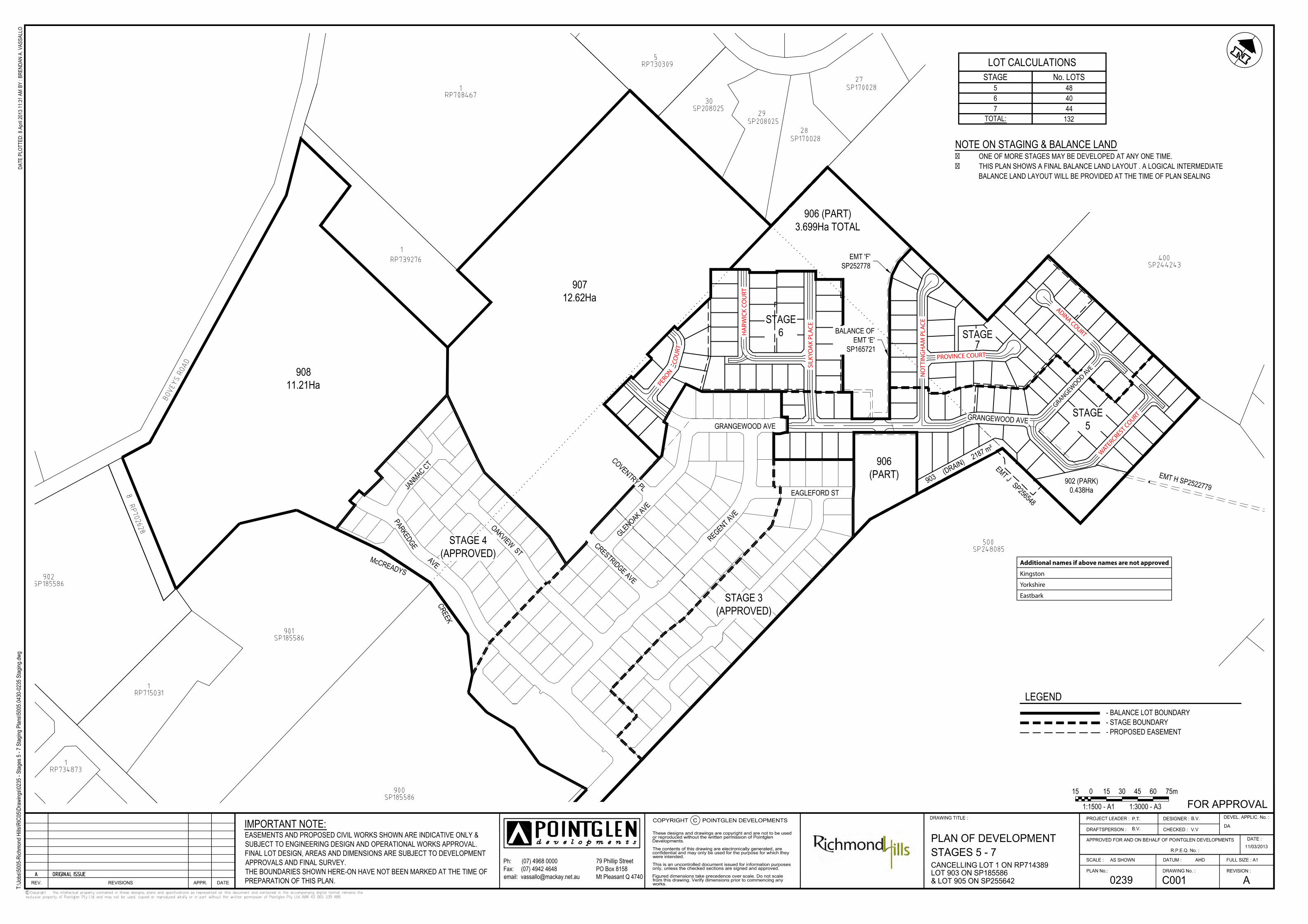
906 (PART)3.672Ha TOTAL
EMT J SP256548
GRANGEWOOD AVE
EMT 'F' SP252778(TRUNK WATER MAIN)
BALANCE OFEMT 'E' SP165721
(TRUNK WATER MAIN)
EMT H SP2522779 (TRUNK SEWER MAIN)
906 (PART)
EMT H SP2522779 (TRUNK SEWER MAIN)
STAGE 7STAGE 6
LOT CALCULATIONSSTAGE RES. LOTS
6 407 44
TOTAL: 84
15 150 30 45 60 75m
1:1500 - A1 1:3000 - A3
79 Phillip StreetPO Box 8158Mt Pleasant Q 4740
Ph: (07) 4968 0000 Fax: (07) 4942 4648 email: [email protected]
C
t:\Job
s\500
5-ric
hmon
d hills
\RIC
06\D
rawi
ngs\0
238 -
Stag
es 6
& 7 P
ropo
sal P
lans\5
005.0
530-
0238
Stag
es 6
& 7 P
ropo
sal P
lan.dw
gDA
TE P
LOTT
ED: 1
5 Apr
il 201
3 9:02
AM
BY
: BRE
NDAN
A. V
ASSA
LLO
IMPORTANT NOTE:EASEMENTS AND PROPOSED CIVIL WORKS SHOWN ARE INDICATIVE ONLY &SUBJECT TO ENGINEERING DESIGN AND OPERATIONAL WORKS APPROVAL.FINAL LOT DESIGN, AREAS AND DIMENSIONS ARE SUBJECT TO DEVELOPMENTAPPROVALS AND FINAL SURVEY.THE BOUNDARIES SHOWN HERE-ON HAVE NOT BEEN MARKED AT THE TIME OFPREPARATION OF THIS PLAN.

35.4
30.0
20.5
20.520.5
20.520.5
22.7
21.0
35.75
23.0
18.5
42.5
42.5
20.047.8
18.5
18.0
18.5
18.5
35.0
19.0
32.2
5.7
15.1
15.0
9.5
32.0
39.3
20.721.0
35.0
18.1
23.0
15.8
16.8
19.013.9
17.517.5
19.020.0
14.9
15.2
22.029.0
35.0
14.2
35.75
34.7
22.5
31.7
16.0
35.3
35.3
3.4
32.0
31.0
36.7
7.5
33.7
35.0
18.6
32.0
35.0
41.2
35.0
20.5
14.5
21.0
20.521.1
21.0
21.0
20.0
20.5
21.0
21.021.0
33.9
20.0
35.8
30.0
20.0
3.7
6.312.5
12.5
12.3
5.0
14.421.5
16.6
5.8
31.0
22.8
9.9
12.2
31.0
10.3
11.6
5.8
4.4
8.9
37.6
12.9
5.531.0
19.0
5.7
18.7
31.0
20.0
5.7
31.8
5.7
29.0
14.5
18.5
33.0
14.7
35.0
47.8
24.0
35.8
18.5
37.6
21.020.5
20.020.0
21.0
8.7
15.5
7.0
12.5
19.0
35.0
35.0
5.7
13.5
13.5
13.5
15.0
19.5
6.3
35.0
15.0
11.9
22.0
7.0
17.0
35.0
16.6
5.0
248 261
256
267
253
265 271
276
269
277
272
279
274
281
275
285
234
236
237
244
245
247
250
225
228
227
231
230
235
233
232
226
257
229
254
251
238
260
259
252
246
249
266
262
263
255
264268
273
278
280
270
284
286
282
258
718m²
718m²
718m²
718m²
718m²
786m²
718m²
718m²
735m²
807m²
669m²
797m²
661m²
675m²
721m²
1100m²
728m²
726m²
820m²
777m²
665m²
665m²
613m²
613m²
665m²
700m²712m²
735m²
718m²
718m²
739m²700m²
607m²
650m²
644m²
661m²
661m²
655m²
784m²
726m²
884m²
653m²
930m²849m²752m²760m²
884m²
653m²
803m²
735m²
736m²
748m²
715m²
715m²
751m²
712m²
706m²
786m²
786m²
McCREADYS CREEKEAGLEFORD ST
18.5
EMT J SP256548902 (PARK)
0.438Ha
GRANGEWOOD AVE
POSSIBLE REAR LOT DRAIN
SEE DETAIL 1 ONDWG C004
POSSIBLESEWER &
DRAINAGE EMT
EMT 'F' SP252778(TRUNK WATER MAIN)
BALANCE OFEMT 'E' SP165721
(TRUNK WATER MAIN)
EMT H SP2522779 (TRUNK SEWER MAIN)
A-
906 (PART)
99
989192
979594 96
48
93
SP 255642
STAGE 7
STAGE 6
33.0
35.0
7.57.5 0 15 22.5 30 37.5m
1:750 - A1 1:1500 - A3
79 Phillip StreetPO Box 8158Mt Pleasant Q 4740
Ph: (07) 4968 0000 Fax: (07) 4942 4648 email: [email protected]
C
t:\Job
s\500
5-ric
hmon
d hills
\RIC
06\D
rawi
ngs\0
238 -
Stag
es 6
& 7 P
ropo
sal P
lans\5
005.0
530-
0238
Stag
es 6
& 7 P
ropo
sal P
lan.dw
gDA
TE P
LOTT
ED: 1
5 Apr
il 201
3 9:02
AM
BY
: BRE
NDAN
A. V
ASSA
LLO
IMPORTANT NOTE:EASEMENTS AND PROPOSED CIVIL WORKS SHOWN ARE INDICATIVE ONLY &SUBJECT TO ENGINEERING DESIGN AND OPERATIONAL WORKS APPROVAL.FINAL LOT DESIGN, AREAS AND DIMENSIONS ARE SUBJECT TO DEVELOPMENTAPPROVALS AND FINAL SURVEY.THE BOUNDARIES SHOWN HERE-ON HAVE NOT BEEN MARKED AT THE TIME OFPREPARATION OF THIS PLAN.

19.6
13.1
30.6
18.5
8.2
23.0
9.1
18.518.5
18.518.5
19.5
17.9
20.0 20.5 20.5 20.520.0
19.7
38.7
35.0
35.0
20.520.5
20.520.5
22.7
59.1
35.0
35.0
29.3
28.5
19.0
45.0
36.529.0
10.418.8
15.0
20.5
13.8
5.7
15.1
42.4
37.4
15.010.0
19.013.9
17.517.5
19.020.0
14.9
15.2
29.014.2
3.4
36.7
35.0
18.6
35.0
35.0
20.5
14.5
21.0
20.521.1
21.020.5
21.021.0
4.4
37.6
31.031.0
5.4
5.7
31.2
18.7
35.0
17.13.9
3.9
31.0
15.5
4.7
20.5
41.3
6.2
20.0
20.0
20.1
40.8
27.6
21.020.5
20.020.0
35.0
5.7
16.0
3.0
46.4
13.5
15.0
15.015.
0
18.5
38.3
15.0
35.0
15.0
35.0
5.7
35.0
16.636.
0
7.2
5.7
13.4
3.8 36.1
35.9
159
160 164
212
206
213
224
248
234
236
237
239
240
241
242
243
244
245
247
250
203157
202
163161
211
165
205
162
219
207
216
209
214
208
210
221
220
204
225
228
227
217
215
223
218 231
222
230
235
233
232
226
229
251
238
246
249
156
1081m²
734m²
706m²
717m²
683m²
648m²
785m²
755m²
963m²
683m²
828m²
795m²
1063m²718m²700m² 718m²718m²
1061m²648m²
648m²
648m²
648m²700m² 718m²
718m²735m²
735m² 718m²
718m²735m²
692m² 786m²
718m²
718m²
735m²
669m²
797m²
777m²
665m²
665m²
613m²
613m²
665m²
700m²712m²
735m²
718m²
718m²
739m²700m²
GRANGEWOOD AVE
POSSIBLESEWER &
DRAINAGE EMT
EMT 'F' SP252778(TRUNK WATER MAIN)
BALANCE OFEMT 'E' SP165721
(TRUNK WATER MAIN)
A-
906 (PART)42
44 45
65
46
4964 66
4347 48
S P 2 5 5 6 4 2
S P 2 5 5 6 4 2SP 255642
SP 255642
STAGE 6
35.0
//
//
/PR
OPER
TYBO
UNDA
RY
PROP
ERTY
BOUN
DARY
EXIS
TING
Ø300 WATER MAIN
FUTURE ROAD RESERVE & CARRIAGEWAY (25.0m) STAGE 7
6.5 12.0 6.5
FUTURE LOT TO FRONT DAWSON BLVD
1.8
79 Phillip StreetPO Box 8158Mt Pleasant Q 4740
Ph: (07) 4968 0000 Fax: (07) 4942 4648 email: [email protected]
C
t:\Job
s\500
5-ric
hmon
d hills
\RIC
06\D
rawi
ngs\0
238 -
Stag
es 6
& 7 P
ropo
sal P
lans\5
005.0
530-
0238
Stag
es 6
& 7 P
ropo
sal P
lan.dw
gDA
TE P
LOTT
ED: 1
5 Apr
il 201
3 9:02
AM
BY
: BRE
NDAN
A. V
ASSA
LLO
IMPORTANT NOTE:EASEMENTS AND PROPOSED CIVIL WORKS SHOWN ARE INDICATIVE ONLY &SUBJECT TO ENGINEERING DESIGN AND OPERATIONAL WORKS APPROVAL.FINAL LOT DESIGN, AREAS AND DIMENSIONS ARE SUBJECT TO DEVELOPMENTAPPROVALS AND FINAL SURVEY.THE BOUNDARIES SHOWN HERE-ON HAVE NOT BEEN MARKED AT THE TIME OFPREPARATION OF THIS PLAN.
7.57.5 0 15 22.5 30 37.5m
1:1500 - A3
1.00.5 0 0.5 2.01.5 2.5m
1:100 - A3
GRANGEWOOD AVE
REGENT AVE
CRESTRIDGE AVE
GLENOAK AVE
EAGLEFORD ST
OAKVIEW ST
PARKEDGE
AVE
JANMAC CT
McCREADYS
CREEK
STAGE5
STAGE7
906 (PART)3.699Ha TOTAL
EMT J SP256548
EMT H SP2522779
GRANGEWOOD AVE
EMT 'F'SP252778
BALANCE OFEMT 'E'
SP165721
LOT CALCULATIONSSTAGE No. LOTS
5 486 407 44
TOTAL: 132
NOTE ON STAGING & BALANCE LAND� ONE OF MORE STAGES MAY BE DEVELOPED AT ANY ONE TIME.� THIS PLAN SHOWS A FINAL BALANCE LAND LAYOUT . A LOGICAL INTERMEDIATE
BALANCE LAND LAYOUT WILL BE PROVIDED AT THE TIME OF PLAN SEALING
15 150 30 45 60 75m
1:1500 - A1 1:3000 - A3
79 Phillip StreetPO Box 8158Mt Pleasant Q 4740
Ph: (07) 4968 0000 Fax: (07) 4942 4648 email: [email protected]
C
T:\Jo
bs\50
05-R
ichmo
nd H
ills\R
IC05
\Dra
wing
s\023
5 - S
tages
5 - 7
Stag
ing P
lans\5
005.0
430-
0235
Stag
ing.dw
gDA
TE P
LOTT
ED: 8
Apr
il 201
3 11:3
1 AM
BY
: BRE
NDAN
A. V
ASSA
LLO
IMPORTANT NOTE:EASEMENTS AND PROPOSED CIVIL WORKS SHOWN ARE INDICATIVE ONLY &SUBJECT TO ENGINEERING DESIGN AND OPERATIONAL WORKS APPROVAL.FINAL LOT DESIGN, AREAS AND DIMENSIONS ARE SUBJECT TO DEVELOPMENTAPPROVALS AND FINAL SURVEY.THE BOUNDARIES SHOWN HERE-ON HAVE NOT BEEN MARKED AT THE TIME OFPREPARATION OF THIS PLAN.
PROVINCE COURT
NO
TTIN
GH
AM
PLA
CE
HA
RWIC
K CO
URT
SILK
YOA
K PL
ACE
GRANGEWOOD AVE
ADINA COURT
WATERCREST COURT
Additional names if above names are not approved
Kingston
Yorkshire
Eastbark
PERON
COU
RT

Development Assessment Report
12 April 2013 25
AP
PE
ND
IX
B
Owners Consent and
IDAS Forms


IDAS form 1—Application details (Sustainable Planning Act 2009 version 2.0 effective 31 March 2013)
This form must be used for ALL development applications.
You MUST complete ALL questions that are stated to be a mandatory requirement unless otherwise identified on this form.
For all development applications, you must:
complete this form (IDAS form 1—Application details)
complete any other forms relevant to your application
provide any mandatory supporting information identified on the forms as being required to accompany your application.
Attach extra pages if there is insufficient space on this form.
All terms used on this form have the meaning given in the Sustainable Planning Act 2009 or the Sustainable Planning Regulation 2009.
This form and any other IDAS form relevant to your application must be used for development applications relating to strategic port land and Brisbane core port land under the Transport Infrastructure Act 1994 and airport land under the Airport Assets (Restructuring and Disposal) Act 2008. Whenever a planning scheme is mentioned, take it to mean land use plan for the strategic port land, Brisbane core port land or airport land.
PLEASE NOTE: This form is not required to accompany requests for compliance assessment.
This form can also be completed online using eDA at www.smarteda.qld.gov.au
Mandatory requirements
Applicant details (Note: the applicant is the person responsible for making the application and need not be the owner of the land. The applicant is responsible for ensuring the information provided on all IDAS application forms is correct. Any development permit or preliminary approval that may be issued as a consequence of this application will be issued to the applicant.)
Name/s (individual or company name in full) Pointglen Developments Pty Ltd
For companies, contact name Paul Thompson
Postal address PO Box 8158
Suburb Mt Pleasant
State Qld Postcode 4740
Country (if other than Australia)
Contact phone number 07 4968 0000
Mobile number (non-mandatory requirement) 0407 531 499

Fax number (non-mandatory requirement)
e-mail address (non-mandatory requirement) [email protected]
Applicant’s reference number (non-mandatory requirement)
1. What is the nature of the development proposed and what type of approval is being sought?
Table A—Aspect 1 of the application (If there are additional aspects to the application please list in Table B—Aspect 2.)
a) What is the nature of the development? (Please only tick one box.)
Material change of use
Reconfiguring a lot Building work Operational work
b) What is the approval type? (Please only tick one box.)
Preliminary approval
under s241 of SPA
Preliminary approval
under s241 and s242 of SPA
Development
permit
c) Provide a brief description of the proposal, including use definition and number of buildings or structures where applicable (e.g. six unit apartment building defined as a multi-unit dwelling, 30 lot residential subdivision etc.)
Reconfiguring a Lot to create Stages 6 and 7 of an estate. 3 existing lots into a total of 84 residential lots and 3 balance lots. To be subdivided in stages and in accordance with the attached Plan of Development.
d) What is the level of assessment? (Please only tick one box.)
Impact assessment
Code assessment
Table B—Aspect 2 of the application (If there are additional aspects to the application please list in Table C—Additional aspects of the application.)
a) What is the nature of development? (Please only tick one box.)
Material change of use
Reconfiguring a lot Building work Operational work
b) What is the approval type? (Please only tick one box.)
Preliminary approval
under s241 of SPA
Preliminary approval
under s241 and s242 of SPA
Development
permit
c) Provide a brief description of the proposal, including use definition and number of buildings or structures where applicable (e.g. six unit apartment building defined as a multi-unit dwelling, 30 lot residential subdivision etc.)
d) What is the level of assessment?
Impact assessment
Code assessment

3 Application details—IDAS form 1 Version 2.0 31 March 2013
Table C—Additional aspects of the application (If there are additional aspects to the application please list in a separate table on an extra page and attach to this form.)
Refer attached schedule
Not required
2. Location of the premises (Complete Table E and/or Table F as applicable. Identify each lot in a separate row.)
Table E—Street address and lot on plan for the premises or street address and lot on plan for the land adjoining or adjacent to the premises. (Note: this table is to be used for applications involving taking or interfering with water). (Attach a separate schedule if there is insufficient space in this table.)
Street address and lot on plan (All lots must be listed.)
Street address and lot on plan for the land adjoining or adjacent to the premises (Appropriate for development in water but adjoining or adjacent to land, e.g. jetty, pontoon. All lots must be listed)
Street address Lot on plan description
Local government area (e.g. Logan, Cairns)
Lot Unit no.
Street no.
Street name and official suburb/ locality name
Post-code
Lot no. Plan type and plan no.
i) Boveys Road, Richmond
4740 903 SP185586 Mackay Regional Council
ii) Grangewood Ave, Richmond
4740 905 SP255642 Mackay Regional Council
iii) Richmond 4740 1 RP714389 Mackay Regional Council
Planning scheme details (If the premises involves multiple zones, clearly identify the relevant zone/s for each lot in a separate row in the below table. Non-mandatory.)
Lot Applicable zone/precinct Applicable local plan/precinct Applicable overlay/s
i) Rural and Urban Expansion McReadys Creek Precinct Bushfire Management Development in the Vicinity of Mackay Airport Development on Steep Land Good Quality Agricultural Land
Landscape Character
ii) Urban Expansion McReadys Creek Precinct Bushfire Management Development in the Vicinity of Mackay Airport Development on Steep Land Good Quality Agricultural Land Landscape Character
iii) Urban Expansion McReadys Creek Precinct Bushfire Management Development in the Vicinity of Mackay Airport Good Quality Agricultural Land
Table F—Premises coordinates (Appropriate for development in remote areas, over part of a lot or in water not adjoining or adjacent to land e.g. channel dredging in Moreton Bay.) (Attach a separate schedule if there is insufficient space in this table.)

Integrated Development Application System form
Department of State Development, Infrastructure and Planning PO Box 15009 City East Qld 4002 tel 13 QGOV (13 74 68) [email protected]
www.dsdip.qld.gov.au
Coordinates (Note: place each set of coordinates in a separate row.)
Zone reference
Datum Local government area (if applicable)
Easting Northing Latitude Longitude
GDA94
WGS84
other
3. Total area of the premises on which the development is proposed (indicate square metres)
489180 m² or 48.918 Hectares
4. Current use/s of the premises (e.g. vacant land, house, apartment building, cane farm etc.)
Agriculture – cane farming and grazing
5. Are there any current approvals (e.g. a preliminary approval) associated with this application? (Non-mandatory requirement.)
No Yes—provide details below
List of approval reference/s Date approved (dd/mm/yy) Date approval lapses (dd/mm/yy)
DA-2007-543 20 July 2010 20 July 2014
6. Is owner’s consent required for this application? (Refer to notes at the end of this form for more information.)
No
Yes—complete either Table G, Table H or Table I as applicable
Table G
Name of owner/s of the land Illuka Investments P/L A.C.N. 106 737 151
I/We, the above-mentioned owner/s of the land, consent to the making of this application.
Signature of owner/s of the land
Date
Table H
Name of owner/s of the land
The owner’s written consent is attached or will be provided separately to the assessment manager
Table I
Name of owner/s of the land
By making this application, I, the applicant, declare that the owner has given written consent to the making of the
application.

Integrated Development Application System form
Department of State Development, Infrastructure and Planning PO Box 15009 City East Qld 4002 tel 13 QGOV (13 74 68) [email protected]
www.dsdip.qld.gov.au
7. Does the application involve a state resource? (E.g. the application involves taking water or quarry material, or interfering with the flow of water. Refer to the notes at the end of this form for more information) (Non-mandatory requirement.)
No Not identified whether or not the application involves a State resource
Yes—complete Table J
Table J
Nature of state-owned resource (if identified)
8. Identify if any of the following apply to the premises (Tick applicable box/es.)
Adjacent to a water body, watercourse or aquifer (e.g. creek, river, lake, canal)—complete Table K
On strategic port land under the Transport Infrastructure Act 1994—complete Table L
In a tidal water area—complete Table M
On Brisbane core port land under the Transport Infrastructure Act 1994 (no table requires completion)
On airport land under the Airport Assets (Restructuring and Disposal) Act 2008 (no table requires completion)
Table K
Name of water body, watercourse or aquifer:
Table L
Lot on plan description for strategic port land Port authority for the lot
Table M
Name of local government for the tidal area (if applicable) Port authority for the tidal area (if applicable)
9. Are there any existing easements on the premises? (e.g. for vehicular access, electricity, overland flow, water etc.)
No Yes—ensure the type, location and dimension of each easement is included in the plans submitted
10. Does the proposal include new building work or operational work on the premises? (Including any services.)
No Yes—ensure the nature, location and dimension of proposed works are included in plans submitted
11. Is the payment of a portable long service leave levy applicable to this application? (Refer to notes at the end of this form for more information.)

Integrated Development Application System form
Department of State Development, Infrastructure and Planning PO Box 15009 City East Qld 4002 tel 13 QGOV (13 74 68) [email protected]
www.dsdip.qld.gov.au
No—go to question 13 Yes
12. Has the portable long service leave levy been paid? (Refer to notes at the end of this form for more information.)
No
Yes—complete Table N and submit with this application the yellow local government/private certifier’s copy of the receipted QLeave form
Table N
Amount paid Date paid
(dd/mm/yy)
QLeave project number (6 digit number starting with A, B, E, L or P)
13. Has the local government agreed to apply a superseded planning scheme to this application under section 96 of the Sustainable Planning Act 2009?
No
Yes—please provide details below
Name of local government Date of written notice given by local government (dd/mm/yy)
Reference number of written notice given by local government (if applicable)
14. List below all of the forms and supporting information that accompany this application (Include all IDAS forms, checklists, mandatory supporting information etc. that will be submitted as part of this application. Note: this question does not apply for applications made online using eDA.)
Description of attachment or title of attachment Method of lodgement to assessment manager
Planning Report and accompanying documentation / reports Digital (Smart EdA)
Plan of Development 0238 (enclosed in Planning Report) Digital (Smart EdA)
IDAS Form 1 - General Digital (Smart EdA)
IDAS Form 7 - RoL Digital (Smart EdA)
15. Applicant’s declaration
By making this application, I declare that all information in this application is true and correct (Note: it is unlawful to
provide false or misleading information.)
Notes for completing this form
Section 261 of the Sustainable Planning Act 2009 prescribes when an application is a properly-made application. Note, the assessment manager has discretion to accept an application as properly made despite any non-

Integrated Development Application System form
Department of State Development, Infrastructure and Planning PO Box 15009 City East Qld 4002 tel 13 QGOV (13 74 68) [email protected]
www.dsdip.qld.gov.au
compliance with the requirement to provide mandatory supporting information under section 260(1)(c) of the Sustainable Planning Act 2009
. Applicant details
Where the applicant is not a natural person, ensure the applicant entity is a real legal entity. Question 1
Schedule 3 of the Sustainable Planning Regulation 2009 identifies assessable development and the type of assessment. Where schedule 3 identifies assessable development as “various aspects of development” the applicant must identify each aspect of the development on Tables A, B and C respectively and as required.
Question 6
Section 263 of the Sustainable Planning Act 2009 sets out when the consent of the owner of the land is required for an application. Section 260(1)(e) of the Sustainable Planning Act 2009 provides that if the owner’s consent is required under section 263, then an application must contain, or be accompanied by, the written consent of the owner, or include a declaration by the applicant that the owner has given written consent to the making of the application. If a development application relates to a state resource, the application is not required to be supported by evidence of resource entitlement. However, where owner's consent to the application is required under section 263, and the State is the owner of the subject land, the written consent of the state as landowner will be required. Some departments, such as the Department of Natural Resources and Mines, have specific requirements for applying for owners consent. Allocation or entitlement to the state resource is a separate process and will need to be obtained before development commences.
Question 7
If a development application involves a state resource, the application is not required to be supported by evidence of resource entitlement. The allocation or entitlement to the resource is a separate process and should be obtained prior to development commencing.
Question 11
The Building and Construction Industry (Portable Long Service Leave) Act 1991 prescribes when the portable long service leave levy is payable.
The portable long service leave levy amount and other prescribed percentages and rates for calculating the levy are prescribed in the Building and Construction Industry (Portable Long Service Leave) Regulation 2002.
Question 12
The portable long service leave levy need not be paid when the application is made, but the Building and Construction Industry (Portable Long Service Leave) Act 1991 requires the levy to be paid before a development permit is issued.
Building and construction industry notification and payment forms are available from any Queensland post office or agency, on request from QLeave, or can be completed on the QLeave website at www.qleave.qld.gov.au. For further information contact QLeave on 1800 803 481 or visit www.qleave.qld.gov.au.
Privacy—The information collected in this form will be used by the Department of State Development, Infrastructure and Planning (DSDIP), assessment manager, referral agency and/or building certifier in accordance with the processing and assessment of your application. Your personal details will not be disclosed for a purpose outside of the IDAS process, except where required by legislation (including the Right to Information Act 2009) or as required by Parliament. This information may be stored in relevant databases. The information collected will be retained as required by the Public Records Act 2002.
OFFICE USE ONLY
Date received Reference numbers
NOTIFICATION OF ENGAGEMENT OF A PRIVATE CERTIFIER
To Council. I have been engaged as the private certifier for the building work referred to in this application
Date of engagement Name BSA Certification license number
Building classification/s

Integrated Development Application System form
Department of State Development, Infrastructure and Planning PO Box 15009 City East Qld 4002 tel 13 QGOV (13 74 68) [email protected]
www.dsdip.qld.gov.au
QLEAVE NOTIFICATION AND PAYMENT (For completion by assessment manager or private certifier if applicable.)
Description of the work QLeave project number
Amount paid ($)
Date paid
Date receipted form sighted by assessment manager
Name of officer who sighted the form
The Sustainable Planning Act 2009 is administered by the Department of State Development, Infrastructure and Planning. This form and all other required application materials should be sent to your assessment manager and any referral agencies.

1 IDAS form 7—Reconfiguring a lot Version 2.1 1 April 2013
IDAS form 7—Reconfiguring a lot (Sustainable Planning Act 2009 version 2.1 effective 1 April 2013)
This form must be used for development applications or requests for compliance assessment for reconfiguring a lot.
You MUST complete ALL questions that are stated to be a mandatory requirement unless otherwise identified on this form.
For all development applications, you must: complete IDAS form 1—Application details complete any other forms relevant to your application provide any mandatory supporting information identified on the forms as being required to accompany your
application.
For requests for compliance assessment, you must also complete IDAS form 32 – Compliance Assessment. Attach extra pages if there is insufficient space on this form.
All terms used on this form have the meaning given in the Sustainable Planning Act 2009 or the Sustainable Planning Regulation 2009.
This form can also be completed online using eDA at www.smarteda.qld.gov.au
Mandatory requirements
1. What is the total number of existing lots making up the premises? 3
2. What is the nature of the lot reconfiguration? (Tick applicable box/es.)
subdivision—complete questions 3 – 6 and 11
boundary realignment—complete questions 8, 9 and 11 creating an easement giving access to a lot from a constructed road—complete questions 10 and 11 dividing land into parts by agreement—please provide details below and complete questions 7 and 11
3. Within the subdivision, what is the number of additional lots being created and their intended final use?
Intended final use of new lots Residential Commercial Industrial Other—specify
Number of additional lots created
84 3 Balance lots

2 IDAS form 7—Reconfiguring a lot Version 2.1 1 April 2013
4. What type of approval is being sought for the subdivision?
Development permit
Preliminary approval Compliance assessment
5. Are there any current approvals associated with this subdivision application? (E.g. material change of use.)
No Yes—provide details below
List of approval reference/s Date approved (dd/mm/yy) Date approval lapses (dd/mm/yy)
DA-2007-543 20 July 2010 20 July 2014
6. Does the proposal involve multiple stages?
No—complete Table A Yes—complete Table B
Table A
a) What is the total length of any new road to be constructed? (metres)
b) What is the total area of land to be contributed for community purposes? (square metres)
c) Does the proposal involve the construction of a canal or artificial waterway?
No Yes
d) Does the proposal involve operational work for the building of a retaining wall?
No Yes
Table B (Stage 6) —complete a new Table B for every stage if the application involves more than one stage
a) What is the proposed estate name? (if known and if applicable) Richmond Hills
b) What stage in the development does this table refer to? Stage 6
c) Will the development permit being sought for this stage result in additional residential lots? (only applicable if a development permit is being sought)
No Yes—specify the total number 40 lots
d) What is the total area of land for this stage? (square metres) 37910 m²
e) What is the total length of any new road to be constructed at this stage? (metres) 547 m
f) What is the total area of land to be contributed for community purposes at this stage? (square metres)
g) Does the proposal involve the construction of a canal or artificial waterway?
No Yes
h) Does the proposal involve operational work for the building of a retaining wall?
No Yes

3 IDAS form 7—Reconfiguring a lot Version 2.1 1 April 2013
Table B (Stage 7) —complete a new Table B for every stage if the application involves more than one stage
a) What is the proposed estate name? (if known and if applicable) Richmond Hills
b) What stage in the development does this table refer to? Stage 7
c) Will the development permit being sought for this stage result in additional residential lots? (only applicable if a development permit is being sought)
No Yes—specify the total number 44 lots
d) What is the total area of land for this stage? (square metres) 39570 m²
e) What is the total length of any new road to be constructed at this stage? (metres) 442 m
f) What is the total area of land to be contributed for community purposes at this stage? (square metres)
g) Does the proposal involve the construction of a canal or artificial waterway?
No Yes
h) Does the proposal involve operational work for the building of a retaining wall?
No Yes
7. Lease/agreement details—how many parts are being created and what is their intended final use?
Intended final use of new parts Residential Commercial Industrial Other—specify
Number of additional parts created
8. What are the current and proposed dimensions following the boundary realignment for each lot forming the premises?
Current lot Proposed lot
Lot plan description Area (square metres)
Length of road frontage Lot number Area (square metres)
Length of road frontage
9. What is the reason for the boundary realignment?
10. What are the dimensions and nature of the proposed easement? (If there are more than two easements proposed please list in a separate table on an extra page and attach to this form.)
Width (m) Length (m) Purpose of the easement (e.g. pedestrian access)?
Entity favoured by the easement
11. Confirm that the following mandatory supporting information accompanies this application
Mandatory supporting information Confirmation of lodgement
Method of lodgement

4 IDAS form 7—Reconfiguring a lot Version 2.1 1 April 2013
All applications for reconfiguring a lot
Site plans drawn to an appropriate scale (1:100, 1:200 or 1:500 are the recommended scales) which show the following: the location and site area of the land to which the application relates
(relevant land) the north point the boundaries of the relevant land any road frontages of the relevant land, including the name of the road the contours and natural ground levels of the relevant land the location of any existing buildings or structures on the relevant land the allotment layout showing existing lots, any proposed lots (including
the dimensions of those lots), existing or proposed road reserves, building envelopes and existing or proposed open space (note: numbering is required for all lots)
any drainage features over the relevant land, including any watercourse, creek, dam, waterhole or spring and any land subject to a Q100 flood event
any existing or proposed easements on the relevant land and their function
all existing and proposed roads and access points on the relevant land any existing or proposed car parking areas on the relevant land the location of any proposed retaining walls on the relevant land and
their height the location of any stormwater detention on the relevant land the location and dimension of any land dedicated for community
purposes the final intended use of any new lots.
Confirmed
A statement about how the proposed development addresses the local government’s planning schemes and any other planning documents relevant to the application.
Confirmed
For an application involving assessable development in a wild river declaration
Documentation that: describes how the activity to which the application relates is not
prohibited development under Schedule 3 of the Sustainable Planning Act 2009 and
demonstrates how the proposed activity will meet the requirements set out in the relevant wild river declaration and Wild Rivers Code.
Confirmed Not applicable
A map showing the proposed location of the activity in relation to wild river management areas and nominated waterways (a map may be produced digitally at http://www.ehp.qld.gov.au/wildrivers/wildrivers-map.php).
Confirmed Not applicable
Notes for completing this form For supporting information requirements for requests for compliance assessment, please refer to the relevant
matters for which compliance assessment will be carried out against. To avoid an action notice, it is recommended that you provide as much of the mandatory information listed in this form as possible.
Privacy—Please refer to your assessment manager, referral agency and/or building certifier for further details on the use of information recorded in this form.
OFFICE USE ONLY

5 IDAS form 7—Reconfiguring a lot Version 2.1 1 April 2013
Date received Reference numbers The Sustainable Planning Act 2009 is administered by the Department of State Development, Infrastructure and Planning. This form and all other required application materials should be sent to your assessment manager and any referral agencies.
Department of State Development, Infrastructure and Planning PO Box 15009 City East Qld 4002 tel 13 QGOV (13 74 68) [email protected] www.dsdip.qld.gov.au

Development Assessment Report
12 April 2013 26
AP
PE
ND
IX
C
Current Title Search, Registered Survey Plan/s and Smart Map


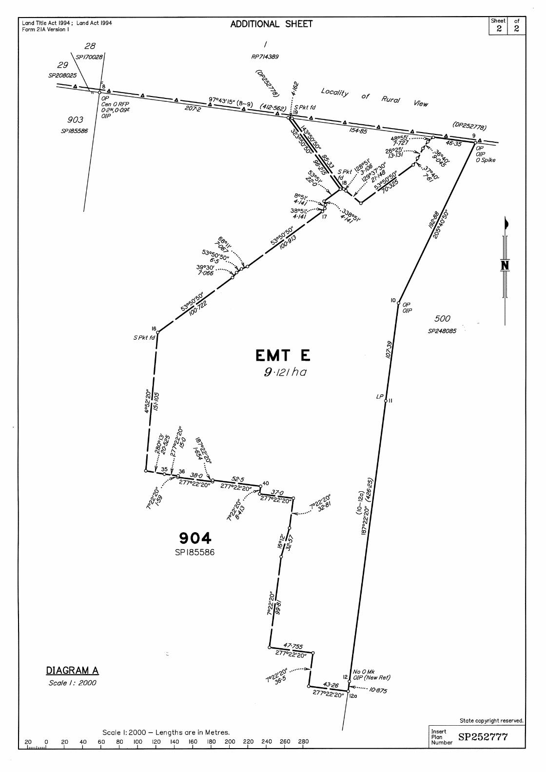


LAND TITLE ACT 1994
REGISTRATION CONFIRMATION STATEMENT
DEPT OF NATURAL RESOURCES AND MINES, QUEENSLAND
Title Reference : 50585755
This is the current status of the title as at 09:45 on 14/08/2012
REGISTERED OWNER
Dealing No: 709244534 22/12/2005
ILLUKA INVESTMENTS PTY LTD A.C.N. 106 737 151
TRUSTEE
UNDER INSTRUMENT 709244534
ESTATE AND LAND
Estate in Fee Simple
LOT 1 REGISTERED PLAN 714389
County of CARLISLE Parish of BASSETT
Local Government: MACKAY
EASEMENTS, ENCUMBRANCES AND INTERESTS
1. Rights and interests reserved to the Crown by
Deed of Grant No. 10356109 (POR 7)
2. EASEMENT IN GROSS No 714619605 13/08/2012 at 14:20
burdening the land
MACKAY REGIONAL COUNCIL
over
EASEMENT F ON SP252778
3. EASEMENT IN GROSS No 714619612 13/08/2012 at 14:21
burdening the land
MACKAY REGIONAL COUNCIL
over
EASEMENT G ON SP252778
ADMINISTRATIVE ADVICES - NIL
UNREGISTERED DEALINGS - NIL
CERTIFICATE OF TITLE ISSUED - No
DEALINGS REGISTERED
714619598 SURVEY PLAN
714619605 EAS IN GROSS
714619612 EAS IN GROSS
Page 1/2
LAND TITLE ACT 1994
REGISTRATION CONFIRMATION STATEMENT
DEPT OF NATURAL RESOURCES AND MINES, QUEENSLAND
Title Reference : 50585755
Corrections have occurred - Refer to Historical Search
Caution - Charges do not necessarily appear in order of priority
** End of Confirmation Statement **
M G Locke
Registrar of Titles and Registrar of Water Allocations
Lodgement No: 3178611
Office: MACKAY
Email: [email protected]
MCKAYS SOLICITORS PTY LTD
PO BOX 37
MACKAY QLD 4740
Page 2/2


2RP702625
FH
43.468ha
RURAL VIEW
MACKAY REGIONAL
8
RP730309
FH
1.982ha
RURAL VIEW
MACKAY REGIONAL
5RP730309
FH
1.982ha
RURAL VIEWMACKAY REGIONAL
31RP884907
FH
3.635ha
RICHMONDMACKAY REGIONAL
33SP119354
FH
69.26ha
RICHMOND
MACKAY REGIONAL
24
SP132379
FH
9710m²
RURAL VIEW25
SP119968FH
1.05ha
RURAL VIEW
26
SP119968
FH
9227m²
A
SP
119968
B
SP119968
C
SP
141027
A
RP
884907
7
SP159747
FH
1.017ha
RURAL VIEW
MACKAY REGIONAL
8
SP
159747FH
9667m²
RURAL VIEW
MACKAY REGIONAL
28
SP170028
FH
9687m²
RURAL VIEW
27
SP170028
FH
1.014ha
RURAL VIEW
MACKAY REGIONAL
903SP185586
FH
24.62ha
RICHMOND
MACKAY REGIONAL
902SP185586
FH5.814ha
RICHMOND
MACKAY REGIONAL
901SP185586
FH
6.6807ha
RICHMOND
MACKAY REGIONAL
1RP739276 FH2.023ha
RICHMONDMACKAY REGIONAL
1RP708467
FH
11.878ha
RICHMOND
MACKAY REGIONAL
8
RP
702628
6
C
124760
71
SP190923FH
9261m²
RURAL VIEW
MACKAY REGIONAL
72
SP
190923FH
1.057ha
RURAL VIEW
MACKAY REGIONAL
B
RP708734
30
SP208025
FH
9883m²
RURAL VIEW
MACKAY REGIONAL
29
SP208025
FH
9949m²
RURAL VIEW
D
RP739747
C
RP739747 1RP714389
FH
8.868ha
RURAL VIEW
MACKAY REGIONAL
511
CI3878
RE
2.364ha
1
RP734696
FH
5675m²
RICHMOND
2
GTP106700
FH
5215m²
1
GTP106700
FH
5636m²
0
GTP106700
2722m²
1
RP724649
FH
1.268ha
RURAL VIEW
2
SP128626
FH
4245m²
RICHMOND
1
SP128626
FH
4377m²
20
SP132653
FH
3803m²
25
SP132653
2169m²30
SP132653
2001m²
31
SP132653
2024m²
32
SP132653
A
SP159586
33
SP
159579
34
SP159579
37
SP159579
38
SP159579
1810m²
39
SP159579
2522m²
40
SP159579
41
SP159579
42
SP159579
43
SP159579
44
SP159579
45
SP159579
1677m²
46
SP159579
47
SP159579
48
SP159579
49
SP159579
50
SP159579
2027m²
51
SP159579
2214m²
52
SP159579
53
SP159579
54
SP159579
55
SP159579
56
SP159579
57
SP159579
58
SP159579
59
SP159579
60
SP159579
61
SP159579
62
SP159579
2389m²
63
SP159579
FH
2834m²
64
SP159579
FH
3637m²
65
SP159579
3007m²
66
SP159579
FH
1.887ha
RICHMOND
H
SP159579
J
SP159579
K
SP159579
XY
SP
159579
WY
SP159579
VY
SP159579
VX
SP
159579
UY
SP159579
2012m²
UX
SP
159579
TY
SP
159579TX
SP159579
1421m² SY
SP
159579
SX
SP159579
1442m²
RY
SP159579
RX
SP159579
QY
SP
159579
QX
SP159579
PY
SP159579
PX
SP159579
NY
SP159579
NX
SP159579
MY
SP159579
MX
SP159579
LY
SP159579
LX
SP159579
KY
SP159579
KX
SP159579
JY
SP159579
JX
SP159579
HY
SP159579
HX
SP159579
GY
SP159579
GX
SP159579
FY
SP
159579
FX
SP159579
1566m²
EY
SP
159579
EX
SP
159579
DY
SP
159579
DX
SP
159579
CX
SP159579
BY
SP159579
BX
SP159579
AY
SP159579
AX
SP159579
WX
SP159579
XX
SP159579
CY
SP
159579
900SP185586
FH13.06ha
RICHMOND
MACKAY REGIONAL
35
SP183075
FH
3063m²
C
SP172226EA
5663m²
D
SP172226EA
4504m²
RICHMOND
400SP244243
FH
7.713ha
RURAL VIEWMACKAY REGIONAL
10
SP248085
11
SP248085
34
SP248085
33
SP248085
32
SP248085
31
SP248085
H
SP248085G
SP248085
M
SP248085
L
SP248085
K
SP248085
J
SP248085
500SP248085
FH
42.2555ha
RICHMOND
MACKAY REGIONALQ
SP
248085
E
SP252754
F
SP
252778
G
SP252778EA
9026m²
RURAL VIEW
MACKAY REGIONAL
23
SP
16572125
SP165721
26
SP165721
28
SP165721
29
SP16572130
SP165721
31
SP16572132
SP16572133
SP165721
34
SP16572135
SP165721
39
SP
165721
38
SP
165721
37
SP
165721
36
SP
165721
22
SP
165721
21
SP
165721
20
SP
165721
19
SP165721
18
SP16572117
SP165721
16
SP
165721
15
SP
165721
14
SP
165721
13
SP
165721
12
SP
165721
11
SP
165721
10
SP
165721
9
SP
165721
8
SP
165721
7
SP
165721
6
SP
165721
5
SP
165721
4
SP
165721
3
SP
165721
2
SP
165721
1
SP
165721
A
SP165721B
SP165721L
SP165721D
SP165721
N
SP165721
O
SP165721P
SP165721Q
SP165721
I
SP165721
J
SP165721K
SP165721C
SP
165721S
SP165721
R
SP165721
901
SP165721FH
1.132ha
RICHMOND
909
SP
165721
24
SP16572127
SP165721
M
SP165721
H
SP
252779
J
SP256548
57
SP255642
56
SP255642
55
SP255642
54
SP255642
53
SP255642
52
SP255642
73
SP255642
72
SP255642
71
SP255642
70
SP255642
69
SP255642
58
SP255642
59
SP255642
60
SP255642
61
SP255642
62
SP255642
40
SP
255642
41
SP
255642
42
SP
255642
68
SP255642
67
SP
25564263
SP255642
66
SP
255642
65
SP
25564264
SP
255642
51
SP
255642
50
SP
255642
49
SP
25564243
SP
255642
44
SP
255642
45
SP
255642
46
SP
255642
47
SP
255642
48
SP
255642
X
SP255642
W
SP255642
V
SP255642
U
SP255642E
SP
252777
905
SP255642
FH
15.43ha
RICHMOND
MACKAY REGIONAL
Y
SP255642
E
SP252777
EA
0m²
RICHMOND
MACKAY REGIONAL
902SP249177
FH9.434ha
RURAL VIEWMACKAY REGIONALR
SP
252780
1
RP
741521
FH
1.194ha
BEACONSFIELD
MACKAY REGIONAL
3
SP213261
FH
8.026ha
BEACONSFIELD
MACKAY REGIONAL
1
SP213261
FH
46.8244ha
BEACONSFIELD
MACKAY REGIONAL
17
SP254845
FH
16.5189ha
RURAL VIEW
MACKAY REGIONAL
4
SP256177
FH
4.233ha
BEACONSFIELD
MACKAY REGIONAL
135
SP256177
134
SP256177
124
SP256177
123
SP256177
122
SP256177
121
SP256177
120
SP256177119
SP256177
118
SP256177
117
SP
256177
114
SP256177115
SP256177116
SP256177
O
SP
247913
P
SP
247913
E
SP
247922
Q
SP256177
N
SP256177
M
SP256177
L
SP256177
K
SP256177
J
SP256177
I
SP256177
H
SP256177
129
SP256177
128
SP256177
127
SP
256177
126
SP
256177
125
SP
256177133
SP
256177
132
SP
256177
130
SP256177
ROAD
AV
EA
KO
NEL
G
STOAKVIEW
RE
GE
NT
AV
EN
UE
EAV
NT
REGE
AVEEDGKEPAREVAEPARKEDG
BLV
DD
AW
SO
N
KER
RIS
DA
LEC
RE
SC
EN
T
CRES
BENSARA
RO
AD
EY
SO
VB
EVRIDVIEW
RURAL
RD
AS
IAC
BU
AY
-K
AC
M
MA
CK
AY
-BU
CA
SIA
RO
AD
DR
IAS
CK
AY
-BU
CA
AM
MA
CK
AY
-BU
CA
SIA
RO
AD
RO
AD
Y-B
UC
AS
IAA
KC
MA
SH
UT
TL E
WO
OD
DR
IVE
SH
UT
TLE
WO
OD
DR
IVE
EM
MA
DR
193654193653
191808
191807
164949
148295
73537
134814
119476
DCDB
Lot/Plan 42/SP255642
Area/Volume 873m²
Tenure FREEHOLD
Local Government MACKAY REGIONAL
Locality RICHMOND
Parish BASSETT
County CARLISLE
Segment/Parcel 61845/740
SCDB Permanent Marks
SUBJECT PARCEL DESCRIPTION
SCALE 1 : 6000HORIZONTAL DATUM:GDA94 ZONE:55
m
120 240 360 480 6000
8755-41341
STANDARD MAP NUMBER
149°08'55".319
21°04'34".685
RURAL VIEW
2.01 KM
MAP WINDOW POSITION &NEAREST LOCATION
PRINTED (dd/mm/yyyy) 27/03/2013
DCDB 26/03/2013SCDB 27/03/2013;
Users of the information recorded in this document (the Information) accept all responsibility andrisk associated with the use of the Information and should seek independent professional advice inrelation to dealings with property.
Despite Department of Natural Resources and Mines(DNRM)'s best efforts, DNRM makesno representations or warranties in relation to the Information, and, to the extent permitted by law,exclude or limit all warranties relating to correctness, accuracy, reliability, completeness orcurrency and all liability for any direct, indirect and consequential costs, losses, damages andexpenses incurred in any way (including but not limited to that arising from negligence) inconnection with any use of or reliance on the Information
For further information on SmartMap products visit http://nrw.qld.gov.au/property/mapping/blinmap
CLIENT SERVICE STANDARDS
SmartMapAn External Product of
SmartMap Information Services
Based upon an extraction from the
Digital Cadastral Data Base
(c) The State of Queensland,(Department of NaturalResources and Mines) 2013.
72 25 00m E
25
72 30
72 30
35
35
72 40
72 40
1
766 75 00 m N
75
2
766 80
766 80
GDA
Queensland Government
21°04'51".469
149°08'18".618 149°09'00" 149°09'32".021
21°04'51".469
21°04'17".902
149°09'32".021149°09'00"
21°04'17".902
149°08'18".618

Development Assessment Report
12 April 2013 27
AP
PE
ND
IX
D
EMR and CLR Search


Development Assessment Report
12 April 2013 28
AP
PE
ND
IX
E
Park Agreement
and
Plan RIC0191
and
Council AICN correspondence


1
Paul Thompson
From: John Caldwell [[email protected]]Sent: Sunday, 14 October 2012 4:44 PMTo: Paul ThompsonCc: Peter Bratt; Shane KleveSubject: FW: Richmond Hills - Council agreemnt to principle that Park contributions in this instance
are able to be offset against the PSP regime as well as the AICN regime.- Da 2007-543, DA 2007-536, DA 2007-545
Attachments: 009-Council Agreement- Park.pdf; Park contribution budget .pdf
Paul, The Richmond Hills Adopted Infrastructure charge resolution identifies this site as having a new district sport park and a local rectreation park identified as item 2.8 on the parks map with resolution.- Your development is provided a component of this trunk park infrastructure. Once this site is developed where the AICN regime is applicable, then the Council is able to offset the agreed value of the land area and the embellishments value against the charges. As this site is one where there is a transition between the PSP regime for earlier approvals and offsetting agreed to earlier, the amount outstanding (after the credits are rationalised against the PSP regime) can be offset against the AICN for subsequent stages.The attached park contribution budget attached to this email will serve as the basis both for the PSP offsetting (as agreed earlier) as well as the offset for the AICN regime. When the survey plan is lodged when the approval was issued under the AICN regime, then the total AICN charge will reduced by the value of the outstanding offset. If the offset is greater than the AICN charge for that survey plan, then the offset credit will be transferred to subsequent stages. This is of course assuming that you have provided the relevant parkland area and embellishments as agreed as per the relevant stage associated with the survey plan for that stage. As an example if the attached park contribution was entirely subject to only the AICN regime, the $2763475of land and embellishments would equate to about 99 lots using the capped figure of $28,000 per lot under the AICN regime in simplistic terms. Assuming that there were no other claimed offsets, then a simplistic way forward would be to say the next 99 lots would not attract a AICN contribution to be paid. Preferably the maximum offset to be claimed at each survey plan should be say 20% of the AICN charge so that other infrastructure networks are not denied their contribution, but this is something that will need more specific detailed working to determine how the reconciliation will work in practice. When the relevant survey plan is lodged the parkland reconciliation should use the values as fixed in November 2010 dollars on your budget tabulation as the AICN contribution is a capped figure so any reconciliation will need to factor this into account. In summary, the AICN regime recognises that an offset against the AICN charge can be given because you are providing trunk park infrastructure and that Council has already recognised that there is an agreement to certain lands and embellishments from the first few stages that took into account the total development of the estate from the PSP regime to AICN regime. The reconciliation of the relevant stages parkland contribution under the relevant regime is accepted in principle but a more detailed reconciliation will be needed as survey plans are presented for endorsement.
Regards,
John Caldwell | Manager Development Assessment | Mackay Regional Council � 07 4961 9172 | � 07 4944 2411 | � [email protected]| � www.mackay.qld.gov.au
Kevene- to register

Development Assessment Report
12 April 2013 29
AP
PE
ND
IX
F
Remnant Vegetation Mapping


Development Assessment Report
12 April 2013 30
AP
PE
ND
IX
G
Masterplan Layout

GRANGEWOOD AVE
REGE
NT A
VE
CRESTRIDGE AVE
GLEN
OAK
AVE
EAGLEFORD ST
OAKVIEW STPARKEDGE
AVEJA
NMAC
CT
McCREADYS
CREEK
GRANGEWOOD AVE
WAT
ER &
SW
EMT
DAWSONS BLVD
MACKAY HABANA ROAD
2020 0 806040 100m
1:2000 - A1 1:4000 - A3
79 Phillip StreetPO Box 8158Mt Pleasant Q 4740
Ph: (07) 4968 0000 Fax: (07) 4942 4648 email: [email protected]
C
T:\Jo
bs\50
05-R
ichmo
nd H
ills\R
IC05
\Dra
wing
s\023
6 - M
aster
plan D
rawi
ngs\5
005.0
530-
0236
Mas
terpla
n Dra
wing
s.dwg
DATE
PLO
TTED
: 15 A
pril 2
013 9
:01 A
M B
Y : B
REND
AN A
. VAS
SALL
O
IMPORTANT NOTE:EASEMENTS AND PROPOSED CIVIL WORKS SHOWN ARE INDICATIVE ONLY &SUBJECT TO ENGINEERING DESIGN AND OPERATIONAL WORKS APPROVAL.FINAL LOT DESIGN, AREAS AND DIMENSIONS ARE SUBJECT TO DEVELOPMENTAPPROVALS AND FINAL SURVEY.THE BOUNDARIES SHOWN HERE-ON HAVE NOT BEEN MARKED AT THE TIME OFPREPARATION OF THIS PLAN.

Development Assessment Report
12 April 2013 31
AP
PE
ND
IX
H
Existing Infrastructure within Easements

