requÊte - international court of justice cover of this letter costa rica attaches a signed original...
TRANSCRIPT

INTERNATIONAL COURT OF JUSTICE
APPLICATIONINSTITUTING PROCEEDINGS
filed in the Registry of the Court on 16 January 2017
LAND BOUNDARY IN THE NORTHERN PART OF ISLA PORTILLOS
(COSTA RICA v. NICARAGUA)
COUR INTERNATIONALE DE JUSTICE
REQUÊTEINTRODUCTIVE D’INSTANCE
enregistrée au Greffe de la Cour le 16 janvier 2017
FRONTIÈRE TERRESTRE DANS LA PARTIE SEPTENTRIONALE D’ISLA PORTILLOS
(COSTA RICA c. NICARAGUA)
5 R-COS_NIC.indd 1 4/07/17 10:32

I. LETTER FROM THE CO‑AGENT OF THE REPUBLIC OF COSTA RICA TO THE REGISTRAR
OF THE INTERNATIONAL COURT OF JUSTICE
16 January 2017.
I have the honour to inform the Court that the Republic of Costa Rica hereby initiates proceedings against the Republic of Nicaragua, in the dispute concerning the precise definition on the boundary in the area of Los Portillos/Harbor Head Lagoon and the establishment of a new military camp by Nicaragua.
Under cover of this letter Costa Rica attaches a signed original of the Applica‑tion, filed pursuant to Article 40, paragraph 1, of the Statute of the Court, and Rule 38 of the Rules of Court, together with a letter from the acting Minister of Foreign Affairs and Worship of the Republic of Costa Rica, Mr. Alejandro Solano Ortiz, appointing Mr. Edgar Ugalde Alvarez as Agent, and the undersigned as Co‑Agent.
Costa Rica remains at the disposal of the Court.
(Signed) Sergio Ugalde.
2
2017General List
No. 165
5 R-COS_NIC.indd 2 4/07/17 10:32
I. LETTRE DU COAGENT DE LA RÉPUBLIQUE DU COSTA RICA AU GREFFIER
DE LA COUR INTERNATIONALE DE JUSTICE
[Traduction]
Le 16 janvier 2017.
J’ai l’honneur d’informer la Cour que la République du Costa Rica introduit par la présente une instance contre la République du Nicaragua au sujet d’un diffé‑rend relatif à la définition précise de la frontière dans la zone de la lagune de Los Portillos/Harbor Head et à l’établissement par le Nicaragua d’un nouveau camp militaire.
Sous le couvert de la présente lettre, le Costa Rica fait tenir un exemplaire origi‑nal signé de la requête, déposée conformément au paragraphe 1 de l’article 40 du Statut de la Cour et à l’article 38 de son Règlement, ainsi qu’une lettre par laquelle M. Alejandro Solano Ortiz, ministre par intérim des affaires étrangères et des cultes de la République du Costa Rica, désigne M. Edgar Ugalde Alvarez en tant qu’agent et le soussigné en tant que coagent en la présente affaire.
Le Costa Rica demeure à la disposition de la Cour.
(Signé) Sergio Ugalde.
3
2017Rôle général
no 165
5 R-COS_NIC.indd 3 4/07/17 10:32

4
II. LETTER FROM THE ACTING MINISTER OF FOREIGN AFFAIRS AND WORSHIP
OF THE REPUBLIC OF COSTA RICA TO THE REGISTRAR OF THE INTERNATIONAL COURT OF JUSTICE
10 January 2017.
I have the honour to refer to the Application that is being presented by Costa Rica, in the dispute concerning the precise definition of the boundary in the area of Los Portillos/Harbor Head Lagoon and the establishment of a new military camp by Nicaragua.
In this connection, I wish to inform the Court that my Government has decided to name Mr. Edgar Ugalde Alvarez, as Agent, and the Ambassador of Costa Rica to the Netherlands, Mr. Sergio Ugalde Godínez, as Co‑Agent.
(Signed) Alejandro Solano Ortiz.
5 R-COS_NIC.indd 4 4/07/17 10:32

5
II. LETTRE DU MINISTRE PAR INTÉRIM DES AFFAIRES ÉTRANGÈRES ET DES CULTES
DE LA RÉPUBLIQUE DU COSTA RICA AU GREFFIER DE LA COUR INTERNATIONALE DE JUSTICE
[Traduction]
Le 10 janvier 2017.
J’ai l’honneur de me référer à la requête présentée par le Costa Rica au sujet d’un différend relatif à la définition précise de la frontière dans la zone de la lagune de Los Portillos/Harbor Head et à l’établissement par le Nicaragua d’un nouveau camp militaire.
Je souhaite à cet égard informer la Cour que mon gouvernement a décidé de désigner M. Edgar Ugalde Alvarez en tant qu’agent et l’ambassadeur du Costa Rica aux Pays‑Bas, M. Sergio Ugalde Godínez, en tant que coagent.
(Signé) Alejandro Solano Ortiz.
5 R-COS_NIC.indd 5 4/07/17 10:32

6
III. APPLICATION INSTITUTING PROCEEDINGS
1. The undersigned, being duly authorized by the Republic of Costa Rica, have the honour to submit to the International Court of Justice this Application insti‑tuting proceedings on behalf of the Republic of Costa Rica against the Republic of Nicaragua in the following dispute.
I. Introduction
2. On behalf of the Government of the Republic of Costa Rica and pursuant to Article 36, paragraphs 1 and 2, and Article 40 of the Statute of the Court and Arti‑cle 38 of the Rules of Court, I have the honour to submit for decision of the Court the present Application instituting proceedings against the Government of the Republic of Nicaragua.
3. The dispute between Costa Rica and Nicaragua concerns the precise location of the land boundary separating the Los Portillos/Harbor Head Lagoon sandbar from Isla Portillos. It also concerns the illegal establishment of a military camp by Nicaragua on the beach of Isla Portillos, a territory belonging to Costa Rica, as confirmed by the Court in its Judgment of 16 December 2015 in the case concern‑ing Certain Activities Carried Out by Nicaragua in the Border Area (Costa Rica v. Nicaragua) (hereinafter “Certain Activities case”) 1.
4. The present Application does not include the question of sovereignty over the beach of the northern part of Isla Portillos between Los Portillos/Harbor Head Lagoon and the mouth of the San Juan River. This question was settled by the Court in favour of Costa Rica and the decision of the Court has the force of res judicata. The only question that remains disputed and open for a decision is the precise location of the land boundary separating the Los Portillos/Harbor Head Lagoon sandbar from Isla Portillos.
5. At the same time, Costa Rica also requests that the Court join the proceed‑ings in the present case with the proceedings in the case concerning Maritime Delimitation in the Caribbean Sea and the Pacific Ocean (Costa Rica v. Nicaragua) (hereinafter “Maritime Delimitation case”), pursuant to Article 47 of the Rules of Court.
II. The Court’s Jurisdiction
6. The Court has jurisdiction over the present dispute in accordance with the provisions of Article 36, paragraph 2, of its Statute, by virtue of the operation of the declarations of acceptance made by Costa Rica, dated 20 February 1973, and by Nicaragua, dated 24 September 1929.
1 Certain Activities Carried Out by Nicaragua in the Border Area (Costa Rica v. Nica-ragua), joined with proceedings in the case concerning Construction of a Road in Costa Rica along the San Juan River (Nicaragua v. Costa Rica), Judgment, I.C.J. Reports 2015 (II), pp. 696‑697, paras. 69‑70 and p. 740, para. 229 (1).
5 R-COS_NIC.indd 6 4/07/17 10:32

7
III. REQUÊTE INTRODUCTIVE D’INSTANCE
[Traduction]
1. Le soussigné, dûment autorisé par la République du Costa Rica, a l’honneur de soumettre au nom de celle‑ci à la Cour internationale de Justice la présente requête introductive d’instance contre la République du Nicaragua au sujet du différend dont la teneur est exposée ci‑dessous.
I. Introduction
2. Au nom du Gouvernement de la République du Costa Rica, j’ai l’honneur de soumettre à la Cour, conformément aux paragraphes 1 et 2 de l’article 36 et à l’ article 40 de son Statut ainsi qu’à l’article 38 de son Règlement, la présente requête introductive d’instance contre le Gouvernement de la République du Nicaragua.
3. Le différend entre le Costa Rica et le Nicaragua concerne l’emplacement pré‑cis de la frontière terrestre séparant Isla Portillos du banc de sable de la lagune de Los Portillos/Harbor Head. Il concerne également l’établissement illicite, par le Nicaragua, d’un campement militaire sur la plage d’Isla Portillos, un territoire qui appartient au Costa Rica, ainsi que la Cour l’a confirmé dans son arrêt du 16 décembre 2015 en l’affaire relative à Certaines activités menées par le Nicaragua dans la région frontalière (Costa Rica c. Nicaragua) (ci‑après, « l’affaire relative à Certaines activités ») 1.
4. La présente requête n’a pas trait à la question de la souveraineté sur la plage située dans la partie septentrionale d’Isla Portillos, entre la lagune de Los Portillos/Harbor Head et l’embouchure du fleuve San Juan. Cette question a été réglée en faveur du Costa Rica par la Cour, et la décision de celle‑ci est revêtue de l’autorité de la chose jugée (res judicata). La seule question qui demeure en litige et reste à trancher est celle de l’emplacement précis de la frontière terrestre séparant Isla Por‑tillos du banc de sable de la lagune de Los Portillos/Harbor Head.
5. Le Costa Rica demande en outre à la Cour de procéder, conformément à l’article 47 de son Règlement, à la jonction des instances en la présente affaire et en l’affaire relative à la Délimitation maritime dans la mer des Caraïbes et l’océan Paci-fique (Costa Rica c. Nicaragua) (ci‑après, « l’affaire relative à la Délimitation mari-time »).
II. La compétence de la Cour
6. La Cour a compétence à l’égard du présent différend en application des dis‑positions du paragraphe 2 de l’article 36 de son Statut, par le jeu de la déclaration d’acceptation du Costa Rica datée du 20 février 1973 et de celle du Nicaragua datée du 24 septembre 1929.
1 Certaines activités menées par le Nicaragua dans la région frontalière (Costa Rica c. Nicaragua) et Construction d’une route au Costa Rica le long du fleuve San Juan ( Nicaragua c. Costa Rica), arrêt, C.I.J. Recueil 2015 (II), p. 696‑697, par. 69‑70, et p. 740, par. 229 1).
5 R-COS_NIC.indd 7 4/07/17 10:32

8
7. The Court also has jurisdiction over the present dispute in accordance with the provisions of Article 36, paragraph 1, of its Statute, by virtue of the operation of the American Treaty on Pacific Settlement of Disputes, Bogotá, 30 April 1948, Article XXXI (the Pact of Bogotá) 2. The parties have expressed their commitment to the Pact of Bogotá through the Pact of Amity, Washington, 21 February 1949, Article III 3.
III. The Facts of the Dispute
8. In November 2010, Nicaragua invaded and occupied Costa Rican territory adjacent to the Caribbean Sea, in the northern area of Isla Portillos. Nicaragua subsequently claimed sovereignty over that area, which had previously been undis‑puted Costa Rican territory. The Court rejected Nicaragua’s claim of sovereignty over that area in its Judgment of 16 December 2015 in the Certain Activities case. The Court confirmed that Costa Rica has sovereignty over the “disputed territory” 4. The “disputed territory” was defined by the Court in its Order of 8 March 2011 on provisional measures as “the northern part of Isla Portillos, that is to say, the area of wetland of some 3 square kilometres between the right bank of the disputed caño, the right bank of the San Juan River up to its mouth at the Caribbean Sea and the Harbor Head Lagoon” 5.
9. During that proceeding, Nicaragua established a military camp on the beach of Isla Portillos. Nicaragua’s conduct in doing so, as well as its construction of two new artificial caños on the disputed territory, led Costa Rica to seek and obtain a second Order on provisional measures, dated 22 November 2013. In that Order, the Court declared that the beach formed part of the “disputed territory” and ordered Nicaragua to remove the camp 6. In its Judgment on the merits of 16 December 2015, the Court recalled that the beach where the Nicaraguan encampment was established was situated in the “disputed territory” 7. The rele‑vant paragraphs of the Court’s Judgment of 16 December 2015 provide as follows:
“69. Since it is uncontested that Nicaragua conducted certain activities in the disputed territory, it is necessary, in order to establish whether there was a breach of Costa Rica’s territorial sovereignty, to determine which State has sovereignty over that territory. The ‘disputed territory’ was defined by the
2 30 United Nations, Treaty Series (UNTS) 84. Both Costa Rica and Nicaragua are parties to the Pact of Bogotá.
3 1465 UNTS 221. 4 Certain Activities Carried Out by Nicaragua in the Border Area (Costa Rica v. Nica-
ragua) and Construction of a Road in Costa Rica along the San Juan River (Nicaragua v. Costa Rica), Judgment, I.C.J. Reports 2015 (II), pp. 696‑697, paras. 69‑70 and p. 740, para. 229 (1).
5 Certain Activities Carried Out by Nicaragua in the Border Area (Costa Rica v. Nicaragua), Provisional Measures, Order of 8 March 2011, I.C.J. Reports 2011 (I), p. 19, para. 55.
6 Certain Activities Carried Out by Nicaragua in the Border Area (Costa Rica v. Nica-ragua) and Construction of a Road in Costa Rica along the San Juan River (Nicaragua v. Costa Rica), Provisional Measures, Order of 22 November 2013, I.C.J. Reports 2013, p. 365, para. 46.
7 Certain Activities Carried Out by Nicaragua in the Border Area (Costa Rica v. Nica-ragua) and Construction of a Road in Costa Rica along the San Juan River (Nicaragua v. Costa Rica), Judgment, I.C.J. Reports 2015 (II), pp. 696‑697, para. 69.
5 R-COS_NIC.indd 8 4/07/17 10:32

9
7. La Cour a également compétence à l’égard du présent différend en applica‑tion des dispositions du paragraphe 1 de l’article 36 de son Statut, par le jeu de l’article XXXI du traité américain de règlement pacifique des différends signé à Bogotá le 30 avril 1948 (ci‑après, le « pacte de Bogotá ») 2. Les Parties ont déclaré souscrire au pacte de Bogotá à l’article III du pacte d’amitié qu’elles ont signé à Washington le 21 février 1949 3.
III. Les faits en litige
8. Au mois de novembre 2010, le Nicaragua a envahi et occupé un territoire costa‑ricien adjacent à la mer des Caraïbes, dans la partie septentrionale d’Isla Por‑tillos. Il a ensuite revendiqué la souveraineté sur ce territoire, dont l’appartenance au Costa Rica n’avait pourtant pas été contestée auparavant. La Cour a rejeté cette revendication du Nicaragua dans son arrêt du 16 décembre 2015 en l’affaire relative à Certaines activités, confirmant que le Costa Rica avait souveraineté sur le « territoire litigieux » 4. Dans son ordonnance en indication de mesures conserva‑toires du 8 mars 2011, la Cour avait défini ce « territoire litigieux » comme « la partie septentrionale [d’]Isla Portillos, soit la zone humide d’environ trois kilo‑mètres carrés comprise entre la rive droite du caño litigieux, la rive droite du fleuve San Juan lui‑même jusqu’à son embouchure dans la mer des Caraïbes et la lagune de Harbor Head » 5.
9. Alors que cette procédure suivait son cours, le Nicaragua a établi un campe‑ment militaire sur la plage d’Isla Portillos. Ce comportement du Nicaragua ainsi que la construction par celui‑ci de deux nouveaux caños artificiels dans le territoire litigieux ont conduit le Costa Rica à demander à la Cour de rendre une deuxième ordonnance en indication de mesures conservatoires, ce qu’elle a fait le 22 novembre 2013. Dans cette ordonnance, la Cour a déclaré que la plage en ques‑tion faisait partie du « territoire litigieux » et a ordonné au Nicaragua d’en retirer son campement 6. Dans son arrêt sur le fond du 16 décembre 2015, la Cour a rap‑pelé que la plage sur laquelle le campement nicaraguayen était établi se trouvait dans le « territoire litigieux » 7. Les paragraphes pertinents de cet arrêt se lisent comme suit :
« 69. Puisqu’il n’est pas contesté que le Nicaragua a mené certaines activités dans le territoire litigieux, il y a lieu, pour rechercher si la souveraineté territo‑riale du Costa Rica a été violée, de déterminer lequel des deux Etats a souve‑raineté sur ce territoire. Dans son ordonnance du 8 mars 2011 portant indica‑
2 Nations Unies, Recueil des traités (RTNU), vol. 30, p. 85. Le Costa Rica et le Nica‑ragua sont tous deux parties au pacte de Bogotá.
3 RTNU, vol. 1465, p. 224. 4 Certaines activités menées par le Nicaragua dans la région frontalière (Costa Rica
c. Nicaragua) et Construction d’une route au Costa Rica le long du fleuve San Juan ( Nicaragua c. Costa Rica), arrêt, C.I.J. Recueil 2015 (II), p. 696‑697, par. 69‑70, et p. 740, par. 229 1).
5 Certaines activités menées par le Nicaragua dans la région frontalière (Costa Rica c. Nicaragua), mesures conservatoires, ordonnance du 8 mars 2011, C.I.J. Recueil 2011 (I), p. 19, par. 55.
6 Certaines activités menées par le Nicaragua dans la région frontalière (Costa Rica c. Nicaragua) et Construction d’une route au Costa Rica le long du fleuve San Juan ( Nicaragua c. Costa Rica), mesures conservatoires, ordonnance du 22 novembre 2013, C.I.J. Recueil 2013, p. 365, par. 46.
7 Certaines activités menées par le Nicaragua dans la région frontalière (Costa Rica c. Nicaragua) et Construction d’une route au Costa Rica le long du fleuve San Juan (Nica-ragua c. Costa Rica), arrêt, C.I.J. Recueil 2015 (II), p. 696‑697, par. 69.
5 R-COS_NIC.indd 9 4/07/17 10:32

10
Court in its Order of 8 March 2011 on provisional measures as ‘the northern part of Isla Portillos, that is to say, the area of wetland of some 3 square kilo‑metres between the right bank of the disputed caño, the right bank of the San Juan River up to its mouth at the Caribbean Sea and the Harbor Head Lagoon’ (I.C.J. Reports 2011 (I), p. 19, para. 55). The caño referred to is the one which was dredged by Nicaragua in 2010. Nicaragua did not contest this definition of the ‘disputed territory’, while Costa Rica expressly endorsed it in its final submissions (para. 2 (a)). The Court will maintain the definition of ‘disputed territory’ given in the 2011 Order. It recalls that its Order of 22 November 2013 indicating provisional measures specified that a Nicara‑guan military encampment ‘located on the beach and close to the line of veg‑etation’ near one of the caños dredged in 2013 was ‘situated in the disputed territory as defined by the Court in its Order of 8 March 2011.” (I.C.J. Reports 2013, p. 365, para. 46.)
70. The above definition of the ‘disputed territory’ does not specifically refer to the stretch of coast abutting the Caribbean Sea which lies between the Harbor Head Lagoon, which lagoon both Parties agree is Nicaraguan, and the mouth of the San Juan River. In their oral arguments the Parties expressed different views on this issue. However, they did not address the question of the precise location of the mouth of the river nor did they provide detailed infor‑mation concerning the coast. Neither Party requested the Court to define the boundary more precisely with regard to this coast. Accordingly, the Court will refrain from doing so.” 8
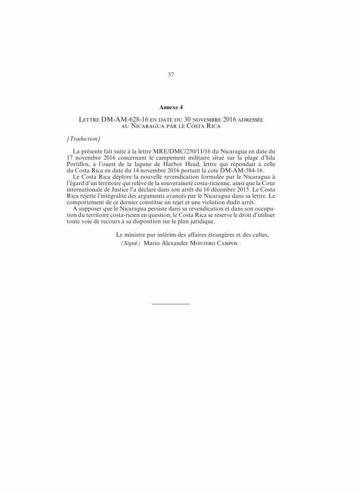
10. Sometime after the Order of the Court of 22 November 2013, Nicaragua placed a military encampment on the sandbar separating Los Portillos/Harbor Head Lagoon from the Caribbean Sea. Remarkably, Nicaragua has recently relo‑cated this military camp to the beach of Isla Portillos, which is Costa Rican terri‑tory. Image 1 on the following page shows:
(a) the location of the military camp established sometime in August/September 2013 on the beach of Isla Portillos, the removal of which was ordered by the Court in its Order of 22 November 2013 (shown as “A” in the image) 9;
(b) the location of the military camp established by Nicaragua sometime after the Order of the Court of 22 November 2013, on the sandbar separating Los Por‑tillos/Harbor Head Lagoon from the Caribbean Sea (shown as “B” in the image); and
(c) the new current location of the Nicaraguan military camp on Costa Rica’s beach of Isla Portillos (shown as “C” in the image).
11. Image 2 on the following page is a close‑up of Image 1 showing locations “B” and “C” in closer detail.
8 Certain Activities Carried Out by Nicaragua in the Border Area (Costa Rica v. Nica-ragua) and Construction of a Road in Costa Rica along the San Juan River (Nicaragua v. Costa Rica), Judgment, I.C.J. Reports 2015 (II), p. 697, para. 70.
9 Certain Activities Carried Out by Nicaragua in the Border Area (Costa Rica v. Nica-ragua) and Construction of a Road in Costa Rica along the San Juan River (Nicaragua v. Costa Rica), Provisional Measures, Order of 22 November 2013, I.C.J. Reports 2013, p. 369, para. 59 (1) (C).
5 R-COS_NIC.indd 10 4/07/17 10:32
11
tion de mesures conservatoires, la Cour a défini le « territoire litigieux » comme « la partie septentrionale [d’]Isla Portillos, soit la zone humide d’environ trois kilomètres carrés comprise entre la rive droite du caño litigieux, la rive droite du fleuve San Juan lui‑même jusqu’à son embouchure dans la mer des Caraïbes et la lagune de Harbor Head » (C.I.J. Recueil 2011 (I), p. 19, par. 55). Le caño dont il est ici question est celui que le Nicaragua a dragué en 2010. Ce dernier n’a pas contesté cette définition du « territoire litigieux » et le Costa Rica l’a expressément adoptée dans ses conclusions finales (point 2 a)). La Cour s’en tiendra à la définition du « territoire litigieux » qu’elle a énoncée dans son ordonnance de 2011. Elle rappelle que, dans son ordonnance en indication de mesures conservatoires du 22 novembre 2013, elle a précisé qu’un campement militaire nicaraguayen « se trouv[ant] sur la plage elle‑même à la lisière de la végétation », à proximité d’un des caños dragués en 2013, était « situé sur le territoire litigieux tel que défini par elle dans son ordonnance du 8 mars 2011 » (C.I.J. Recueil 2013, p. 365, par. 46).
70. La définition précitée du « territoire litigieux » ne traite pas spécifique‑ment du segment de la côte caraïbe qui s’étend entre la lagune de Harbor Head, dont les deux Parties admettent qu’elle est nicaraguayenne, et l’embouchure du San Juan. Les Parties ont bien, dans leurs plaidoiries, exprimé des vues divergentes sur ce point, mais elles n’ont pas abordé la question de l’emplace‑ment précis de l’embouchure du fleuve, et n’ont pas davantage présenté d’in‑formation détaillée concernant la côte. Elles n’ont ni l’une ni l’autre demandé à la Cour de préciser le tracé de la frontière par rapport à cette côte. La Cour s’abstiendra donc de le faire. » 8
10. Postérieurement au prononcé de l’ordonnance de la Cour du 22 no‑vembre 2013, le Nicaragua a installé un campement militaire sur le banc de sable séparant la lagune de Los Portillos/Harbor Head de la mer des Caraïbes. Fait remarquable, il a récemment déplacé ce campement militaire jusqu’à la plage d’Isla Portillos, qui fait partie du territoire costa‑ricien. La figure no 1 sur la page suivante montre :a) l’emplacement du campement militaire établi entre août et septembre 2013 sur
la plage d’Isla Portillos et dont la Cour a ordonné le retrait dans son ordon‑nance du 22 novembre 2013 (représenté par la lettre « A » sur l’image) 9 ;
b) l’emplacement du campement militaire établi par le Nicaragua postérieurement au prononcé de l’ordonnance de la Cour du 22 novembre 2013 sur le banc de sable séparant la lagune de Los Portillos/Harbor Head de la mer des Caraïbes (représenté par la lettre « B » sur l’image) ; et
c) l’emplacement actuel du campement militaire nicaraguayen sur la plage d’Isla Portillos, qui appartient au Costa Rica (ce nouvel emplacement est représenté par la lettre « C » sur l’image).
11. La figure no 2 sur la page suivante constitue un agrandissement de la figure no 1 montrant les emplacements « B » et « C » de plus près.
8 Certaines activités menées par le Nicaragua dans la région frontalière (Costa Rica c. Nicaragua) et Construction d’une route au Costa Rica le long du fleuve San Juan ( Nicaragua c. Costa Rica), arrêt, C.I.J. Recueil 2015 (II), p. 697, par. 70.
9 Certaines activités menées par le Nicaragua dans la région frontalière (Costa Rica c. Nicaragua) et Construction d’une route au Costa Rica le long du fleuve San Juan ( Nicaragua c. Costa Rica), mesures conservatoires, ordonnance du 22 novembre 2013, C.I.J. Recueil 2013, p. 369, par. 59 1) C).
5 R-COS_NIC.indd 11 4/07/17 10:32

12
Image 1
Satellite Image, 3 October 2016 (reproduced as Annex 5)
Image 2
Close‑up of Satellite Image, 3 October 2016 (reproduced as Annex 6)
A: Camp location in 2013
C: Current camp location
C: Current camp location
B: Camp location at
the beginning of 2016
B: Camp location at
the beginning of 2016
5 R-COS_NIC.indd 12 4/07/17 10:32

13
Image 1
Image satellite en date du 3 octobre 2016 (reproduite à l’annexe 5)
Image 2
Agrandissement de l’image satellite du 3 octobre 2016 (reproduit à l’annexe 6)
A : emplacement du campement
en 2013 C : emplacement
actuel
C : emplacement actuel du
campement
B : emplacement début 2016
B: emplacement début 2016
5 R-COS_NIC.indd 13 4/07/17 10:32

14
12. Nicaragua does not deny these facts. On 14 November 2016, Costa Rica wrote to Nicaragua to protest the establishment of this camp on Costa Rican ter‑ritory 10. In a response of 17 November 2016, Nicaragua not only refused to remove its camp, but it also made a new claim of sovereignty over “the entire stretch of coast abutting the Caribbean Sea between Harbor Head and the river’s mouth” 11. That claim is radically inconsistent with the Court’s Judgment of 16 December 2015, where it was declared — and is now a matter of res judicata — that the “dis‑puted territory” (which includes the beach between Harbor Head Lagoon and the mouth of the San Juan River) is Costa Rican territory.
13. In its response of 17 November 2016, Nicaragua also asserted that the ques‑tions raised by the Costa Rican note are not part of the Maritime Delimitation case 12.
14. On 24 November 2016, Hurricane Otto seriously affected the area of Isla Portillos and damaged Costa Rica’s police and environmental installations in that area 13. Costa Rica understands that Nicaragua removed the military camp before Hurricane Otto landed.
15. However, following Hurricane Otto, Nicaragua re‑established, and contin‑ues to maintain, a military camp on the beach of Isla Portillos, which is located some 100 metres into Costa Rican territory.
16. On 30 November 2016, Costa Rica wrote to Nicaragua, expressing its regret that Nicaragua had made a new claim to Costa Rican sovereign territory, and ask‑ing it to reconsider its position. Costa Rica reiterated its request for Nicaragua to remove its military camp from Costa Rican territory 14. Nicaragua has not responded.
17. The re‑established military camp was observable to those participating in the site visit by the experts appointed by the Court in the Maritime Delimitation case on 5 to 9 December 2016.
18. Nicaragua’s establishment and maintenance of the military camp on the beach of Isla Portillos constitutes a further violation of Costa Rica’s sovereignty and territorial integrity, and a further violation of the Court’s Judgment of 16 December 2015. Nicaragua has not withdrawn its claim of sover‑eignty made in its letter of 17 November 2016 over “the entire stretch of coast abutting the Caribbean Sea between Harbor Head [Lagoon] and the [San Juan] river’s mouth”.
19. Given the factual and legal positions adopted by Nicaragua, the futility of further negotiations is apparent.
10 Letter from Costa Rica to Nicaragua of 14 November 2016 (Reference DM‑AM‑584‑16), Annex 1.
11 Letter from Nicaragua to Costa Rica of 17 November 2016 (Reference MRE/DMC/250/11/16), Annex 2.
12 Ibid. 13 Letter from Costa Rica to the Court of 28 November 2016 (Reference ECRPB‑132‑
16), Annex 3. 14 Letter from Costa Rica to Nicaragua of 30 November 2016 (Reference DM‑AM‑628‑
16), Annex 4.
5 R-COS_NIC.indd 14 4/07/17 10:32
15
12. Le Nicaragua ne conteste pas ces faits. Le 14 novembre 2016, le Costa Rica lui a écrit pour protester contre l’établissement de ce campement en territoire costa‑ricien 10. Dans une réponse datée du 17 novembre 2016, le Nicaragua a non seulement refusé de lever son campement, mais a en outre formulé une nouvelle revendication de souveraineté sur « l’intégralité du segment de la côte caraïbe qui s’étend entre la lagune de Harbor Head et l’ embouchure du fleuve San Juan » 11. Cette revendication va radicalement à l’ encontre de ce que la Cour a déclaré dans son arrêt du 16 décembre 2015 — déclaration désormais revêtue de l’autorité de la chose jugée —, à savoir que le Costa Rica a souveraineté sur le « territoire litigieux » (qui inclut la plage située entre la lagune de Harbor Head et l’embouchure du fleuve San Juan).
13. Dans sa réponse du 17 novembre 2016, le Nicaragua prétendait également que les questions soulevées par le Costa Rica dans sa note débordaient le cadre de l’affaire relative à la Délimitation maritime 12.
14. Le 24 novembre 2016, l’ouragan Otto a durement frappé Isla Portillos et a endommagé les installations de police et de protection de l’environnement établies dans la région par le Costa Rica 13. Le Costa Rica croit comprendre que le Nicara‑gua a levé son campement militaire avant qu’Otto ne touche terre.
15. Toutefois, après le passage de l’ouragan Otto, le Nicaragua a rétabli, et maintient depuis lors, un campement militaire sur la plage d’Isla Portillos, à une centaine de mètres à l’intérieur du territoire costa‑ricien.
16. Le 30 novembre 2016, le Costa Rica a adressé au Nicaragua une lettre dans laquelle il déplorait la nouvelle revendication formulée par celui‑ci à l’égard d’un territoire relevant de la souveraineté costa‑ricienne, et l’exhortait à reconsidérer sa position. Le Costa Rica y demandait une nouvelle fois au Nicaragua de lever son campement militaire situé en territoire costa‑ricien 14. Le Nicaragua n’a pas répondu.
17. Le rétablissement de ce campement militaire a pu être constaté par la délégation qui s’est rendue sur les lieux du 5 au 9 décembre 2016 dans le cadre de la visite des experts désignés par la Cour en l’affaire relative à la Délimitation maritime.
18. L’établissement et le maintien, par le Nicaragua, de ce campement mili‑taire sur la plage d’Isla Portillos constituent une nouvelle violation de la souveraineté et de l’intégrité territoriale du Costa Rica, en même temps que de l’arrêt rendu par la Cour le 16 décembre 2015. Le Nicaragua n’a, à ce jour, pas retiré la revendication de souveraineté formulée dans sa lettre du 17 no‑vembre 2016 à l’égard de « l’intégralité du segment de la côte caraïbe qui s’étend entre la lagune de Harbor Head et l’embouchure du fleuve San Juan ».
19. Compte tenu de la position adoptée par le Nicaragua en fait et en droit, il est évident que de nouvelles négociations seraient vaines.
10 Lettre DM‑AM‑584‑16 en date du 14 novembre 2016 adressée au Nicaragua par le Costa Rica, annexe 1.
11 Lettre MRE/DMC/250/11/16 en date du 17 novembre 2016 adressée au Costa Rica par le Nicaragua, annexe 2.
12 Ibid. 13 Lettre ECRPB‑132‑16 en date du 28 novembre 2016 adressée à la Cour par le Costa
Rica, annexe 3. 14 Lettre DM‑AM‑628‑16 en date du 30 novembre 2016 adressée au Nicaragua par le
Costa Rica, annexe 4.
5 R-COS_NIC.indd 15 4/07/17 10:32

16
IV. The Grounds upon Which Costa Rica Bases Its Claim
20. The 1858 Treaty of Limits, the Cleveland Award, and the two Alexander Awards establish the course of the land boundary between Costa Rica and Nica‑ragua. In its Judgment of 16 December 2015 in the Certain Activities case, the Court described the land boundary between the two States as established by these instruments as follows:
“59. The 1858 Treaty fixed the course of the boundary between Costa Rica and Nicaragua from the Pacific Ocean to the Caribbean Sea . . . According to Article II of the Treaty . . . part of the boundary between the two States runs along the right (Costa Rican) bank of the San Juan River from a point three English miles below Castillo Viejo, a small town in Nicaragua, to ‘the end of Punta de Castilla, at the mouth of the San Juan’ on the Caribbean coast
. . . . . . . . . . . . . . . . . . . . . . . . . . . . . . . . . . . . . . .60. The Cleveland Award of 1888 confirmed, in its paragraph 1, the valid‑
ity of the 1858 Treaty and found, in its paragraph 3 (1), that the boundary line between the two States on the Atlantic side ‘begins at the extremity of Punta de Castilla at the mouth of the San Juan de Nicaragua River, as they both existed on the 15th day of April 1858’ . . . . . . . . . . . . . . . . . . . . . . . . . . . . . . . . . . . . . . .
73. In [General Alexander’s] first Award he stated that the boundary line:
‘must follow the . . . branch . . . called the Lower San Juan, through its har‑bor and into the sea.
The natural terminus of that line is the right‑hand headland of the harbor mouth.’ (RIAA, Vol. XXVIII, p. 217.)
. . . . . . . . . . . . . . . . . . . . . . . . . . . . . . . . . . . . . . .He then defined the initial part of the boundary starting from the Carib‑
bean Sea in the following terms:‘The exact spot which was the extremity of the headland of Punta de
Castillo [on] April 15, 1858, has long been swept over by the Caribbean Sea, and there is too little concurrence in the shore outline of the old maps to permit any certainty of statement of distance or exact direction to it from the present headland. It was somewhere to the north‑ eastward, and proba‑bly between 600 and 1,600 feet distant, but it cannot now be certainly located. Under these circumstances it best fulfils the demands of the treaty and of President Cleveland’s award to adopt what it practically the head‑land of today, or the north‑ western extremity of what seems to be the solid land, on the east side of Harbor Head Lagoon.
I have accordingly made personal inspection of this ground, and declare that initial line of the boundary to run as follows, to wit:
Its direction shall be due north‑east and south‑west, across the bank of sand, from the Caribbean Sea into the waters of Harbor Head Lagoon. It shall pass, at its nearest point, 300 feet on the north‑west side from the small hut standing in that vicinity. On reaching the waters of Harbor Head Lagoon the boundary line shall turn to the left, or south‑ eastward, and shall follow the water’s edge around the harbor until it reaches the river proper by the first channel met. Up this channel, and up the river proper,
5 R-COS_NIC.indd 16 4/07/17 10:32

17
IV. Les fondements de la demande du Costa Rica
20. Le traité de limites de 1858, la sentence Cleveland et les deux sentences Alexander fixent le tracé de la frontière terrestre entre le Costa Rica et le Nicara‑gua. Dans son arrêt du 16 décembre 2015 en l’affaire relative à Certaines activités, la Cour a présenté en ces termes la frontière terrestre établie entre les deux Etats par ces instruments :
« 59. Le traité de 1858 fixait le tracé de la frontière entre le Costa Rica et le Nicaragua depuis l’océan Pacifique jusqu’à la mer des Caraïbes. Selon l’ar‑ticle II du traité …, une partie de la frontière entre les deux Etats longe la rive droite (c’est‑à‑dire costa‑ricienne) du San Juan, à partir d’un point situé à trois milles anglais en aval de Castillo Viejo, petite localité nicaraguayenne, jusqu’à « l’extrémité de Punta de Castilla, à l’embouchure du fleuve San Juan » sur la côte caraïbe . . . . . . . . . . . . . . . . . . . . . . . . . . . . . . . . . . . . . . .
60. En 1888, la sentence Cleveland confirma, en son premier paragraphe, la validité du traité de 1858 et précisa, au point 1 de son troisième paragraphe, que, sur la façade atlantique, la ligne frontière entre les deux pays « commen[çait] à l’extrémité de Punta de Castilla à l’embouchure du fleuve San Juan de Nicaragua, en leur état respectif au 15 avril 1858 » . . . . . . . . . . . . . . . . . . . . . . . . . . . . . . . . . . . . . . .
73. Dans [s]a première [sentence], [le général Alexander] déclara que la ligne frontière
« d[evait] suivre le bras … appelé le San Juan inférieur, à travers son port et dans la mer.
L’extrémité naturelle de cette ligne est le promontoire droit de l’embou‑chure du port. » (RSA, vol. XXVIII, p. 217.)
. . . . . . . . . . . . . . . . . . . . . . . . . . . . . . . . . . . . . . .Il procéda ensuite à la délimitation du premier tronçon de la frontière, à
partir de la mer des Caraïbes, dans les termes suivants :« [L]’emplacement exact où était l’extrémité du promontoire de
Punta de Castillo le 15 avril 1858 est depuis longtemps recouvert par la mer des Caraïbes et il n’y a pas assez de convergence dans les cartes anciennes sur le tracé du rivage pour déterminer avec une certitude suffi‑sante sa distance ou son orientation par rapport au promontoire actuel. Il se trouvait quelque part au nord‑est et probablement à une distance de 600 à 1600 pieds, mais il est aujourd’hui impossible de le situer exactement. Dans ces conditions, la meilleure façon de satisfaire aux exigences du traité et de la sentence arbitrale du président Cleveland est d’adopter ce qui constitue en pratique le promontoire aujourd’hui, à savoir l’extrémité nord‑ouest de ce qui paraît être la terre ferme, sur la rive est de la lagune de Harbor Head.
J’ai en conséquence personnellement inspecté cette zone et je déclare que la ligne initiale de la frontière sera la suivante :
Son orientation sera nord‑est sud‑ouest, à travers le banc de sable, de la mer des Caraïbes aux eaux de la lagune de Harbor Head. Elle passera au plus près à 300 pieds au nord‑ouest de la petite cabane qui se trouve actuellement dans les parages. En atteignant les eaux de la lagune de Harbor Head, la ligne frontière obliquera vers la gauche, en direction du sud‑est, et suivra le rivage autour du port jusqu’à atteindre le fleuve propre‑ment dit par le premier chenal rencontré. Remontant ce chenal et le fleuve
5 R-COS_NIC.indd 17 4/07/17 10:32

18
the line shall continue to ascend as directed in the treaty.’ (RIAA, Vol. XXVIII, p. 220.)
. . . . . . . . . . . . . . . . . . . . . . . . . . . . . . . . . . . . . . .74. The second Alexander Award envisaged the possibility that the banks
of the San Juan River would ‘not gradually expand or contract but that there [would] be wholesale changes in its channels’. The Arbitrator observed that:
‘Today’s boundary line must necessarily be affected in future by all these gradual or sudden changes. But the impact in each case can only be deter‑mined by the circumstances of the case itself, on a case‑by‑case basis in accordance with such principles of international law as may be applica‑ble.
The proposed measurement and demarcation of the boundary line will not have any effect on the application of those principles.’ (Ibid., p. 224.)”
21. In its Judgment of 16 December 2015 in the Certain Activities case, the Court found that Costa Rica has sovereignty over the “disputed territory”, as defined by the Court in paragraphs 69‑70 of its Judgment. The “disputed territory” includes the beach of Isla Portillos. Costa Rican sovereignty over the beach of Isla Portillos is therefore a matter of res judicata. Any Nicaraguan territory existing seaward of Isla Portillos disappeared some time ago. Today, the only Nicaraguan territory in the area of Isla Portillos is an enclave comprising the Los Portillos/Harbor Head Lagoon and the sandbar separating Los Portillos/Harbor Head Lagoon from the Caribbean Sea, insofar as this sandbar remains above water at all times and thus this enclave is capable of constituting territory appertaining to a State. Paragraph 70 of the Court’s December 2015 Judgment in the Certain Activ-ities case indicated that the Court refrained from defining the land boundary more precisely with regard to this coast because the Parties did not request it to do so. The present Application requests the Court to define precisely the land boundary separating Costa Rica’s coastal territory from Nicaragua’s coastal territory as it exists today, as indicated above.
V. Decision Requested
22. Accordingly, the Court is asked:(a) To determine the precise location of the land boundary separating both ends
of the Los Portillos/Harbor Head Lagoon sandbar from Isla Portillos, and in doing so to determine that the only Nicaraguan territory existing today in the area of Isla Portillos is limited to the enclave consisting of Los Portillos/Har‑bor Head Lagoon and the sandbar separating the Lagoon from the Caribbean Sea, insofar as this sandbar remains above water at all times and thus this enclave is capable of constituting territory appertaining to a State. Conse‑quently, that the land boundary runs today from the north‑ eastern corner of the Lagoon by the shortest line to the Caribbean Sea and from the north‑ western corner of the Lagoon by the shortest line to the Caribbean Sea.
(b) To adjudge and declare that, by establishing and maintaining a new military camp on the beach of Isla Portillos, Nicaragua has violated the sovereignty and territorial integrity of Costa Rica, and is in breach of the Judgment of the Court of 16 December 2015 in the Certain Activities case. Consequently, Costa Rica further requests the Court to declare that Nicaragua must withdraw its military camp situated in Costa Rican territory and fully comply with the
5 R-COS_NIC.indd 18 4/07/17 10:32

19
proprement dit, la ligne se poursuivra comme prescrit dans le traité. » (RSA, vol. XXVIII, p. 220.)
. . . . . . . . . . . . . . . . . . . . . . . . . . . . . . . . . . . . . . .74. La deuxième sentence Alexander envisageait la possibilité « non seule‑
ment que [l]es rives [du fleuve San Juan] s’élargissent ou se resserr[assent] de manière progressive, mais aussi que ses chenaux [fussent] radicalement modi‑fiés ». On y lit l’observation suivante :
« De tels changements, qu’ils soient progressifs ou soudains, auront nécessairement des incidences sur la ligne frontière actuelle. Mais, concrète‑ment, les conséquences ne pourront être déterminées qu’en fonction des circonstances particulières à chaque cas, conformément aux principes du droit international applicables.
Le mesurage et la démarcation proposés de la ligne frontière seront sans incidence sur l’application desdits principes. » (Ibid., p. 224.) »
21. Dans son arrêt du 16 décembre 2015 en l’affaire relative à Certaines activités, la Cour a conclu que le Costa Rica avait souveraineté sur le « territoire litigieux », tel que défini aux paragraphes 69 et 70 de son arrêt. La plage d’Isla Portillos fait partie du « territoire litigieux ». La souveraineté du Costa Rica sur cette plage relève donc de la chose jugée. Tout territoire nicaraguayen ayant pu exister au large d’Isla Portillos a disparu il y a un certain temps déjà. A ce jour, le seul terri‑toire nicaraguayen existant dans la zone d’Isla Portillos est une enclave compre‑nant la lagune de Los Portillos/Harbor Head et le banc de sable qui sépare la lagune de la mer des Caraïbes, pour autant que ce banc de sable soit émergé en permanence et que cette enclave puisse de ce fait constituer un territoire apparte‑nant à un Etat. Au paragraphe 70 de son arrêt de décembre 2015 en l’affaire rela‑tive à Certaines activités, la Cour a déclaré qu’elle s’abstenait de préciser le tracé de la frontière terrestre par rapport à cette côte puisque les Parties ne le lui avaient pas demandé. Par la présente requête, la Cour est priée de préciser le tracé de la frontière terrestre séparant le territoire côtier du Costa Rica et celui du Nicara‑gua, tel qu’il existe à ce jour, ainsi qu’indiqué plus haut.
V. Décision demandée
22. En conséquence, la Cour est priée : a) de déterminer l’emplacement précis de la frontière terrestre séparant Isla Portil‑
los des deux extrémités du banc de sable de la lagune de Los Portillos/Harbor Head et, ce faisant, de déclarer que le seul territoire nicaraguayen existant à ce jour dans la zone d’Isla Portillos se limite à l’enclave comprenant la lagune de Los Portillos/Harbor Head et le banc de sable qui sépare la lagune de la mer des Caraïbes, pour autant que ce banc de sable soit émergé en permanence et que cette enclave puisse de ce fait constituer un territoire appartenant à un Etat, et donc de déclarer que la frontière terrestre court à l’heure actuelle de l’extrémité nord‑est de la lagune à la mer des Caraïbes par la ligne la plus courte, et de l’ex‑trémité nord‑ouest de la lagune à la mer des Caraïbes par la ligne la plus courte ;
b) de dire et juger que l’établissement et le maintien, par le Nicaragua, d’un nou‑veau campement militaire sur la plage d’Isla Portillos emportent violation de la souveraineté et de l’intégrité territoriale du Costa Rica, et contreviennent à l’arrêt rendu le 16 décembre 2015 par la Cour en l’affaire relative à Certaines activités. En conséquence, le Costa Rica prie également la Cour de déclarer que le Nicaragua doit retirer son campement militaire situé en territoire costa‑ricien
5 R-COS_NIC.indd 19 4/07/17 10:32

20
Court’s 2015 Judgment. Costa Rica reserves it rights to seek any further rem‑edies with respect to any damage that Nicaragua has or may cause to its terri‑tory.
VI. Application for Joinder
23. Under Article 47 of the Rules of Court, “[t]he Court may at any time direct that the proceedings in two or more cases be joined”. As the Court has noted, it has a broad margin of discretion 15.
24. The close relationship between this case and the case concerning Maritime Delimitation in the Caribbean Sea and the Pacific Ocean (Costa Rica v. Nicaragua) will be readily apparent. It is manifest that the two cases should be joined. The two cases concern the same Parties. They both concern the same geographic area where the two countries meet the Caribbean Sea. Moreover, the question of the present proceeding is closely related to the dispute in the Maritime Delimitation case, in that the two Parties express different views as to the starting‑point of the maritime boundary in the Caribbean Sea. As the Court has stated several times, “land dom‑inates the sea” 16. In order to proceed to the delimitation of maritime areas of the Parties in the Caribbean Sea, the prior settlement of this dispute is necessary.
25. Further, given that the issue that is the subject of the present proceeding is a confined one, the facts are not contested, and the written phase can be very short, Costa Rica considers that joinder of the two cases would not result in any undue delay in the Court rendering a Judgment.
26. Costa Rica further considers that, given the inter‑ relationship between the issues at play in the two cases, joinder is consistent with the principle of the sound administration of justice and with the need for judicial economy 17. Moreover, join‑der will save both time and costs of two separate hearings.
VII. Reservation of Rights
27. Costa Rica reserves its rights to supplement or amend the present Applica‑tion.
VIII. Designation of Ad Hoc Judge
28. Costa Rica designates as Judge ad hoc Professor Bruno Simma.29. The Minister of Foreign Affairs of Costa Rica has appointed as Agent for
these proceedings Mr. Edgar Ugalde Alvarez, and as Co‑Agent Mr. Ser‑gio Ugalde Godínez (Ambassador of Costa Rica to the Kingdom of the Nether‑
15 Construction of a Road in Costa Rica along the San Juan River (Nicaragua v. Costa Rica), Joinder of Proceedings, Order of 17 April 2013, I.C.J. Reports 2013, p. 193, para. 12.
16 See, e.g., Maritime Delimitation in the Black Sea (Romania v. Ukraine), Judgment, I.C.J. Reports 2009, p. 89, para. 77; and Territorial and Maritime Dispute (Nicaragua v. Colombia), Judgment, I.C.J. Reports 2012 (II), p. 674, para. 140.
17 See Construction of a Road in Costa Rica along the San Juan River (Nicaragua v. Costa Rica), Joinder of Proceedings, Order of 17 April 2013, I.C.J. Reports 2013, p. 188, para. 18.
5 R-COS_NIC.indd 20 4/07/17 10:32

21
et se conformer pleinement à l’arrêt de 2015. Le Costa Rica se réserve le droit de demander d’autres réparations pour tout dommage causé ou susceptible d’être causé à son territoire par le Nicaragua.
VI. Demande de jonction
23. Aux termes de l’article 47 de son Règlement, « [l]a Cour peut à tout moment ordonner que les instances dans deux ou plusieurs affaires soient jointes ». Ainsi que la Cour l’a relevé, elle dispose à cet égard d’une large marge d’appréciation 15.
24. Il est évident que la présente affaire est étroitement liée à celle relative à la Délimitation maritime dans la mer des Caraïbes et l’océan Pacifique (Costa Rica c. Nicaragua). L’opportunité d’une jonction d’instances est manifeste. Les deux affaires opposent les mêmes Parties ; elles portent l’une et l’autre sur la même zone géographique, où le territoire des deux pays rencontre la mer des Caraïbes ; de plus, la question qui fait l’objet de la présente procédure est étroitement liée au différend en cause dans l’affaire relative à la Délimitation maritime, en ce sens que les deux Parties expriment des vues divergentes quant au point de départ de la frontière maritime dans la mer des Caraïbes. Comme la Cour l’a déclaré à maintes reprises, « la terre domine la mer » 16. La délimitation des espaces maritimes des Parties dans la mer des Caraïbes nécessite au préalable le règlement du présent différend.
25. En outre, étant donné que la présente procédure porte sur une question cir‑conscrite, que les faits ne sont pas contestés et que la phase écrite peut être très brève, le Costa Rica considère qu’une jonction des deux instances n’aurait pas pour effet de retarder indûment le prononcé d’un arrêt par la Cour.
26. Le Costa Rica considère au surplus que, compte tenu de l’interaction exis‑tant entre les questions en jeu dans les deux affaires, une jonction serait conforme au principe de la bonne administration de la justice et aux impératifs d’économie judiciaire 17. Enfin, une jonction permettrait une économie à la fois de temps et d’argent, en tant qu’elle éviterait la tenue de deux procédures orales distinctes.
VII. Réserve de droits
27. Le Costa Rica se réserve le droit de compléter ou de modifier la présente requête.
VIII. Désignation d’un juge Ad Hoc
28. Le Costa Rica désigne M. Bruno Simma en qualité de juge ad hoc.29. Aux fins de la présente procédure, le ministre des affaires étrangères
du Costa Rica a désigné M. Edgar Ugalde Alvarez en qualité d’agent, et M. Sergio Ugalde Godínez (ambassadeur du Costa Rica auprès du Royaume
15 Construction d’une route au Costa Rica le long du fleuve San Juan (Nicaragua c. Costa Rica), jonction d’instances, ordonnance du 17 avril 2013, C.I.J. Recueil 2013, p. 193, par. 12.
16 Voir, par exemple, Délimitation maritime en mer Noire (Roumanie c. Ukraine), arrêt, C.I.J. Recueil 2009, p. 89, par. 77 ; Différend territorial et maritime (Nicaragua c. Colombie), arrêt, C.I.J. Recueil 2012 (II), p. 674, par. 140.
17 Voir Construction d’une route au Costa Rica le long du fleuve San Juan (Nicaragua c. Costa Rica), jonction d’instances, ordonnance du 17 avril 2013, C.I.J. Recueil 2013, p. 188, par. 18.
5 R-COS_NIC.indd 21 4/07/17 10:32
22
lands). Please send all communications concerning this case to the following address:
Embassy of the Republic of Costa RicaLaan Copes van Cattenburch 462585 GB, The Hague The NetherlandsE‑mail: [email protected]
(Signed) Ambassador Sergio Ugalde, Co‑Agent.
5 R-COS_NIC.indd 22 4/07/17 10:32

23
des Pays‑Bas) en qualité de coagent. Merci de bien vouloir envoyer toute commu‑nication afférente à la présente instance à l’adresse suivante :
Ambassade de la République du Costa RicaLaan Copes van Cattenburch 462585 GB, La HayePays‑BasAdresse électronique : [email protected]
Le coagent du Costa Rica, ambassadeur, (Signé) Sergio Ugalde.
5 R-COS_NIC.indd 23 4/07/17 10:32

24
CERTIFICATION
16 January 2017.
The undersigned, Co‑Agent of the Republic of Costa Rica, certifies that the documents hereunder listed as annexes to this Application, are true and accurate copies and conform to the original of documents and that the translations into English made by Costa Rica are accurate translations.
(Signed) Ambassador Sergio Ugalde, Co‑Agent.
List of Annexes
Annex 1. Letter from Costa Rica to Nicaragua of 14 November 2016 (Reference DM‑AM‑584‑16) (English translation).
Annex 2. Letter from Nicaragua to Costa Rica of 17 November 2016 (Reference MRE/DMC/250/11/16) (English translation).
Annex 3. Letter from Costa Rica to the Court of 28 November 2016 (Reference ECRPB‑132‑16) (English original).
Annex 4. Letter from Costa Rica to Nicaragua of 30 November 2016 (Reference DM‑AM‑628‑16) (English translation).
Annex 5. Satellite image, 3 October 2016 (indicating locations of Nicaraguan camp).
Annex 6. Satellite image (close‑up), 3 October 2016 (showing relocation of Nicara‑guan camp in 2016).
5 R-COS_NIC.indd 24 4/07/17 10:32
25
ATTESTATION
[Traduction]
Le 16 janvier 2017.
Le soussigné, coagent de la République du Costa Rica, certifie que les docu‑ments annexés à la présente requête, dont le bordereau figure ci‑dessous, sont des copies exactes et conformes des documents originaux et que les traductions anglaises fournies par le Costa Rica sont exactes.
Le coagent du Costa Rica, ambassadeur, (Signé) Sergio Ugalde.
Bordereau des annexes
Annexe 1. Lettre DM‑AM‑584‑16 en date du 14 novembre 2016 adressée au Nica‑ragua par le Costa Rica.
Annexe 2. Lettre MRE/DMC/250/11/16 en date du 17 novembre 2016 adressée au Costa Rica par le Nicaragua.
Annexe 3. Lettre ECRPB‑132‑16 en date du 28 novembre 2016 adressée à la Cour par le Costa Rica.
Annexe 4. Lettre DM‑AM‑628‑16 en date du 30 novembre 2016 adressée au Nica‑ragua par le Costa Rica.
Annexe 5. Image satellite en date du 3 octobre 2016 (montrant les emplacements successifs du campement nicaraguayen).
Annexe 6. Image satellite en date du 3 octobre 2016 (agrandissement montrant le déplacement du campement nicaraguayen en 2016).
5 R-COS_NIC.indd 25 4/07/17 10:32

26
Annex 1
Letter from Costa Rica to Nicaragua of 14 November 2016 (Reference DM‑AM‑584‑16) (English Translation)
I address you regarding the cases concerning Certain Activities Carried Out by Nicaragua in the Border Area (Costa Rica v. Nicaragua) and Maritime Delimita-tion in the Caribbean Sea and the Pacific Ocean (Costa Rica v. Nicaragua).
Costa Rica has recently become aware of the new positioning of a Nicaraguan military camp from its previous location on the beach separating Los Portillos Lagoon from the Caribbean Sea, to a new location on the beach of Isla Portillos to the north‑east of Los Portillos Lagoon, situated on Costa Rican territory as deter‑mined by the Court in its Judgment of 16 December 2015 in the Certain Activities case. Costa Rica annexes the following images to this note:1. Attachment 1, a satellite image of 5 July 2016 which shows the previous loca‑
tion of the Nicaraguan military camp, circled in red;2. Attachment 2, an aerial photograph of 8 March 2016 which shows the previous
location of the Nicaraguan military camp;3. Attachment 3, a satellite image of 14 September 2016 which shows the new
location of the Nicaraguan military camp, circled in red;4. Attachment 4, a photograph of 7 November 2016 which shows the new loca‑
tion of the Nicaraguan camp;5. Attachment 5, a superimposition of two satellite images of 8 March [sic][5 July]
and 14 September 2016, on which a red line shows the change of location of the Nicaraguan military camp.
Costa Rica recalls that in its Judgment of 16 December 2015, at paragraph 229(1), the Court found that Costa Rica has sovereignty over the “disputed territory” defined by the Court at paragraph 69 of the same Judgment as comprising “the northern part of Isla Portillos, that is to say, the area of wetland of some 3 square kilometres between the right bank of the disputed caño, the right bank of the San Juan River up to its mouth at the Caribbean Sea and the Harbor Head Lagoon”, including “the beach”.
In light of the above, Costa Rica vigorously protests this most recent Nicara‑guan violation of its sovereignty and territorial integrity. Nicaragua’s actions fur‑ther constitute a violation of the Court’s Judgment of 16 December 2015 in the Certain Activities case, which remains an active case whilst compensation from Nicaragua is pending.
Costa Rica requests Nicaragua to remove its military camp from the Costa Rican territory in question, and to abstain from taking any action that may aggravate the dispute that is the subject of the Maritime Delimitation proceedings pending before the Court, or which may make those proceedings more difficult to resolve.
(Signed) Manuel A. González Sanz, Minister of Foreign Affairs and Worship.
5 R-COS_NIC.indd 26 4/07/17 10:32
27
Annexe 1
Lettre DM‑AM‑584‑16 en date du 14 novembre 2016 adressée au Nicaragua par le Costa Rica
[Traduction]
La présente a trait à l’affaire relative à Certaines activités menées par le Nicara-gua dans la région frontalière (Costa Rica c. Nicaragua) ainsi qu’à l’affaire relative à la Délimitation maritime dans la mer des Caraïbes et l’océan Pacifique (Costa Rica c. Nicaragua).
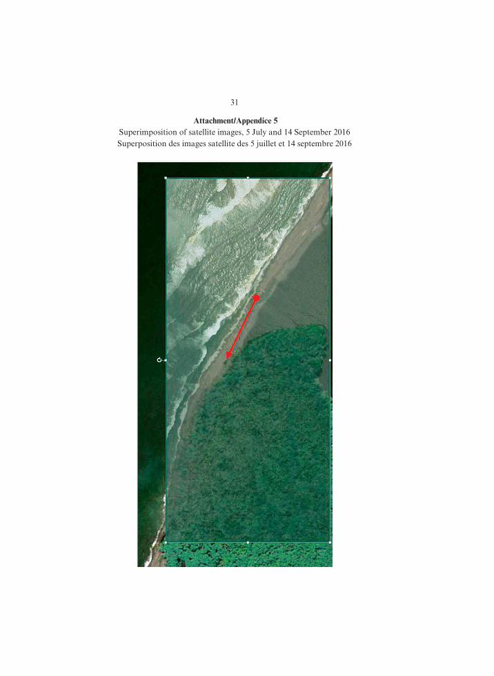
Le Costa Rica a récemment appris que le campement militaire du Nicaragua auparavant situé sur la plage séparant la lagune de Los Portillos de la mer des Caraïbes avait été déplacé pour être installé au nord‑[ouest] de ladite lagune sur la plage d’Isla Portillos, qui se trouve en territoire costa‑ricien, ainsi que la Cour l’a déclaré dans son arrêt du 16 décembre 2015 en l’affaire relative à Certaines activités.
Le Costa Rica joint à la présente les images et photographies suivantes : 1. une image satellite en date du 5 juillet 2016 montrant, par un cercle rouge, le
précédent emplacement du campement militaire du Nicaragua (appendice 1) ; 2. une photographie aérienne en date du 8 mars 2016 montrant le précédent
emplacement du campement militaire du Nicaragua (appendice 2) ; 3. une image satellite en date du 14 septembre 2016 montrant, par un cercle rouge,
le nouvel emplacement du campement militaire du Nicaragua (appendice 3) ; 4. une photographie aérienne en date du 7 novembre 2016 montrant le nouvel
emplacement du campement militaire du Nicaragua (appendice 4) ; et 5. une superposition des images satellite des 8 mars (sic) [5 juillet] et 14 sep‑
tembre 2016 montrant, par une ligne rouge, le déplacement du campement mili‑taire du Nicaragua (appendice 5).
Le Costa Rica rappelle que, au point 1) du paragraphe 229 de son arrêt du 16 décembre 2015, la Cour a jugé que le Costa Rica avait souveraineté sur le « ter‑ritoire litigieux » qu’elle avait défini au paragraphe 69 de ce même arrêt comme « la partie septentrionale [d’]Isla Portillos, soit la zone humide d’environ trois kilo‑mètres carrés comprise entre la rive droite du caño litigieux, la rive droite du fleuve San Juan lui‑même jusqu’à son embouchure dans la mer des Caraïbes et la lagune de Harbor Head », « la plage » étant incluse dans ce territoire.
Compte tenu de ce qui précède, le Costa Rica élève les plus vives protestations contre cette toute nouvelle violation de sa souveraineté et de son intégrité territo‑riale par le Nicaragua. Les actes du Nicaragua violent l’arrêt rendu par la Cour le 16 décembre 2015 en l’affaire relative à Certaines activités, qui est toujours inscrite au rôle, la question de l’indemnisation due par celui‑ci demeurant pendante.
Le Costa Rica demande au Nicaragua de retirer son campement militaire du territoire costa‑ricien susvisé et de s’abstenir de tout acte qui risquerait d’aggraver le différend dont la Cour est actuellement saisie en l’affaire relative à la Délimita-tion maritime, ou d’en rendre la solution plus difficile.
Le ministre des affaires étrangères et des cultes, (Signé) Manuel A. González Sanz.
5 R-COS_NIC.indd 27 4/07/17 10:32

28
Attachment/Appendice 1Satellite image, 5 July 2016
Image satellite en date du 5 juillet 2016
5 R-COS_NIC.indd 28 4/07/17 10:32

29
Attachment/Appendice 2Aerial photograph, 8 March 2016
Photographie aérienne en date du 8 mars 2016
Attachment/Appendice 3Satellite image, 14 September 2016
Image satellite en date du 14 septembre 2016
5 R-COS_NIC.indd 29 4/07/17 10:32

30
Attachment/Appendice 4Aerial photograph, 7 November 2016
Photographie aérienne en date du 7 novembre 2016
5 R-COS_NIC.indd 30 4/07/17 10:32
31
Attachment/Appendice 5Superimposition of satellite images, 5 July and 14 September 2016Superposition des images satellite des 5 juillet et 14 septembre 2016
5 R-COS_NIC.indd 31 4/07/17 10:32

32
Annex 2
Letter from Nicaragua to Costa Rica of 17 November 2016 (Reference MRE/DMC/250/11/16) (English Translation)
I address you in reference to your note DM‑AM‑584‑16, in which you express your protest regarding the presence of a Nicaraguan military camp which, accord‑ing to your note, is located on Costa Rican territory and request its removal from said territory which, as further indicated in your note, was allegedly awarded to your country as a result of the Judgment issued by the International Court of Jus‑tice on 16 December 2015.
Allow me to point out that Costa Rica knows first‑hand that Nicaragua has always exercised sovereignty over the sandbar that separates Harbor Head Lagoon from the Caribbean Sea, and both the International Court of Justice and Costa Rica have had knowledge of the presence of a Nicaraguan military camp on that sandbar for a number of years, regardless of its exact location.
In this regard I must remind you that, contrary to what is alleged in your note, Costa Rica has recognized Nicaragua’s sovereignty over that sandbar in front of the lagoon on numerous occasions, most recently during the oral hearings held in April 2015. At that time, Costa Rica noted that “the sandbar which separates the sea from Harbor Head Lagoon [. . .] can only be considered as land capable of appertaining to a State in so far as it remains permanently above water at high tide and, if it does, it appertains to Nicaragua.” This was confirmed by the Judgment of 16 December 2015.
Consequently, this new claim by Costa Rica is unfounded and contradicts all actions and official statements made by your country.
On the other hand, as you are aware of, and as recorded in the official maps of Nicaragua and Costa Rica for a number of years now, both countries have always considered as part of Nicaraguan territory not only the sandbar in front of Harbor Head Lagoon but also the entire stretch of coast abutting the Caribbean Sea which lies between Harbor Head Lagoon and the mouth of the river.
Nicaragua cannot help but notice the particular moment in which Costa Rica has decided to make this new claim, especially taking into account the next on‑site visit of the experts appointed by the International Court of Justice within the con‑text of the case Maritime Delimitation in the Caribbean Sea and the Pacific Ocean, a case which does not address this topic and for which the stage for submission of written pleadings has ended.
Thus, the Government of Reconciliation and National Unity of Nicaragua rejects Costa Rica’s gratuitous protest and new claims, as well as any legal sense intended for them.
(Signed) Denis Moncada Colindres, Minister Adviser to the President of the Republic on International Policies and Affairs.
5 R-COS_NIC.indd 32 4/07/17 10:32

33
Annexe 2
Lettre MRE/DMC/250/11/16 en date du 17 novembre 2016 adressée au Costa Rica par le Nicaragua
[Traduction]
La présente fait suite à votre lettre DM‑AM‑584‑16, dans laquelle vous protes‑tez contre la présence d’un campement militaire nicaraguayen dont vous alléguez qu’il est situé en territoire costa‑ricien, et dont vous demandez le retrait dudit ter‑ritoire, que l’arrêt rendu par la Cour internationale de Justice le 16 décembre 2015 aurait eu pour effet d’attribuer à votre pays.
Permettez‑moi de faire observer que le Costa Rica sait, pour l’avoir lui‑même constaté, que le Nicaragua a toujours exercé sa souveraineté sur le banc de sable qui sépare la lagune de Harbor Head de la mer des Caraïbes, et que la présence d’un campement militaire nicaraguayen sur ce banc de sable, quel qu’en soit l’em‑placement exact, est connue tant de la Cour que de lui‑même depuis de nombreuses années.
A cet égard, je dois vous rappeler que, contrairement à ce qui est affirmé dans votre lettre, le Costa Rica a reconnu la souveraineté du Nicaragua sur ce banc de sable situé en face de la lagune, et ce, à plusieurs occasions, la dernière en date remontant aux audiences d’avril 2015. Voici ce que le Costa Rica a déclaré à l’ audience : le « banc de sable séparant la lagune [de Harbor Head] de la mer … ne peut être considéré comme étant susceptible d’appartenir à un Etat que si, à marée haute, il demeure émergé en permanence, auquel cas il appartiendrait au Nicaragua ». La Cour a confirmé ce point dans son arrêt du 16 décembre 2015.
En conséquence, cette nouvelle revendication du Costa Rica est dépourvue de fondement et contredit tous les actes et déclarations officiels de votre pays.
Par ailleurs, comme vous n’êtes pas sans le savoir, et comme le montrent les cartes officielles du Nicaragua et du Costa Rica depuis déjà un certain nombre d’années, les deux pays ont toujours considéré comme nicaraguayens non seule‑ment le banc de sable situé en face de la lagune de Harbor Head, mais également l’intégralité du segment de la côte caraïbe qui s’étend entre la lagune de Harbor Head et l’embouchure du fleuve San Juan.
Le Nicaragua ne peut que s’étonner du moment choisi par le Costa Rica pour présenter cette nouvelle revendication, compte tenu notamment de la visite prochaine sur les lieux des experts désignés par la Cour dans le cadre de l’affaire relative à la Délimitation maritime dans la mer des Caraïbes et l’océan Pacifique, affaire sans rapport avec la question et dans laquelle la phase de la procédure écrite est close.
Partant, le Gouvernement de réconciliation et d’unité nationale du Nicaragua rejette la protestation injustifiée et les nouvelles prétentions du Costa Rica, ainsi que tout effet juridique susceptible de leur être prêté.
Le ministre conseiller auprès du Président de la République pour les questions internationales, (Signé) Denis Moncada Colindres.
5 R-COS_NIC.indd 33 4/07/17 10:32

34
Annex 3
Letter from Costa Rica to the Court of 28 November 2016 (Reference ECRPB‑135‑16) (English Original)
I have the honour to refer to the case concerning Maritime Delimitation in the Caribbean Sea and the Pacific Ocean (Costa Rica v. Nicaragua).
On Thursday, 24 November 2016, Costa Rica suffered damage in the north‑west region of the country as a result of Hurricane Otto. Emergency services and first response personnel are presently assisting the victims. Thousands have been affected, and a number of lives have been lost.
Hurricane Otto first entered Nicaraguan territory just north of Isla Portillos, before continuing onto Costa Rican territory. The Costa Rican support installa‑tions on Isla Portillos were seriously damaged or destroyed as a result.
Costa Rica respectfully requests the Court to consider re‑ scheduling the impend‑ing visit of the experts to the region in light of these events. Costa Rica proposes that the visit of the experts takes place in early January 2017.
In the event that the experts’ mission were to proceed as presently scheduled, Costa Rica may not be able to make all the logistical arrangements as planned, and Costa Rica respectfully asks for the Court’s understanding in this respect.
(Signed) Ambassador Sergio Ugalde, Co‑Agent.
5 R-COS_NIC.indd 34 4/07/17 10:32

35
Annexe 3
Lettre ECRPB‑135‑16 en date du 28 novembre 2016 adressée à la Cour par le Costa Rica
[Traduction]
J’ai honneur de me référer à l’affaire relative à la Délimitation maritime dans la mer des Caraïbes et l’océan Pacifique (Costa Rica c. Nicaragua).
Le jeudi 24 novembre 2016, l’ouragan Otto a causé des dommages dans la région nord‑ouest du Costa Rica. Les services d’urgence et le personnel de premiers secours viennent actuellement en aide aux victimes. Des milliers de personnes ont été touchées et plusieurs ont perdu la vie.
L’ouragan Otto a touché terre sur le territoire du Nicaragua juste au nord d’Isla Portillos avant de poursuivre sa route sur celui du Costa Rica. Les installa‑tions d’Isla Portillos en ont été gravement endommagées et certaines ont même été détruites.
Le Costa Rica prie respectueusement la Cour d’envisager de reporter la visite imminente des experts dans la région compte tenu de ces événements et propose qu’elle ait lieu au début du mois de janvier 2017.
Si la mission des experts devait se dérouler comme cela avait été convenu, il se pourrait que le Costa Rica ne soit pas en mesure de prendre tous les arrangements d’ordre logistique tels que ceux‑ci étaient prévus et prie respectueusement la Cour de faire preuve de compréhension à cet égard.
Le coagent du Costa Rica, ambassadeur, (Signé) Sergio Ugalde.
5 R-COS_NIC.indd 35 4/07/17 10:32

36
Annex 4
Letter from Costa Rica to Nicaragua of 30 November 2016 (Reference DM‑AM‑628‑16) (English Translation)
I refer to Nicaragua’s note MRE/DMC/250/11/16 of 17 November 2016 con‑cerning the military camp placed and maintained on the beach of Isla Portillos west of Harbor Head Lagoon, responding to Costa Rica’s note DM‑AM‑584‑16 dated 14 November 2016.
Costa Rica regrets that Nicaragua has now made a new claim to Costa Rican sovereign territory, as determined by the International Court of Justice in its Judg‑ment of 16 December 2015. Costa Rica rejects in their entirety the arguments invoked by Nicaragua in its note. Nicaragua’s attitude constitutes a rejection and a breach of said Judgment.
Should Nicaragua persist in its claim to and occupation of Costa Rican terri‑tory, Costa Rica reserves all its rights in terms of the legal avenues available to it.
(Signed) Mario Alexander Montero Campos, Acting Minister of Foreign Affairs and Worship.
5 R-COS_NIC.indd 36 4/07/17 10:32
37
Annexe 4
Lettre DM‑AM‑628‑16 en date du 30 novembre 2016 adressée au Nicaragua par le Costa Rica
[Traduction]
La présente fait suite à la lettre MRE/DMC/250/11/16 du Nicaragua en date du 17 novembre 2016 concernant le campement militaire situé sur la plage d’Isla Portillos, à l’ouest de la lagune de Harbor Head, lettre qui répondait à celle du Costa Rica en date du 14 novembre 2016 portant la cote DM‑AM‑584‑16.
Le Costa Rica déplore la nouvelle revendication formulée par le Nicaragua à l’égard d’un territoire qui relève de la souveraineté costa‑ricienne, ainsi que la Cour internationale de Justice l’a déclaré dans son arrêt du 16 décembre 2015. Le Costa Rica rejette l’intégralité des arguments avancés par le Nicaragua dans sa lettre. Le comportement de ce dernier constitue un rejet et une violation dudit arrêt.
A supposer que le Nicaragua persiste dans sa revendication et dans son occupa‑tion du territoire costa‑ricien en question, le Costa Rica se réserve le droit d’utiliser toute voie de recours à sa disposition sur le plan juridique.
Le ministre par intérim des affaires étrangères et des cultes, (Signé) Mario Alexander Montero Campos.
5 R-COS_NIC.indd 37 4/07/17 10:32

38
Annex/Annexe 5
Satellite Image, 3 October 2016 (Indicating Locations of Nicaraguan Camp)
Image satellite en date du 3 octobre 2016 (montrant les emplacements successifs du campement nicaraguayen)
A: Camp location in 2013A: emplacement du campement
en 2013C: Current camp
locationC: emplacement
actuel
B: Camp location at the beginning of 2016
B: emplacement début 2016
5 R-COS_NIC.indd 38 4/07/17 10:32

39
Annex/Annexe 6
Satellite Image (Close‑Up), 3 October 2016 (Showing Relocation of Nicaraguan Camp in 2016)
Image satellite en date du 3 octobre 2016 (vue rapprochée montrant le déplacement du campement nicaraguayen)
C: Current camp locationC : emplacement actuel
du campementB: Camp location at the beginning of 2016
B : emplacement début 2016
5 R-COS_NIC.indd 39 4/07/17 10:32

IMPRIMÉ EN FRANCE – PRINTED IN FRANCE
5 R-COS_NIC.indd 40 4/07/17 10:32