renato and eduard ') inrtitlrte
TRANSCRIPT

THE SIGNIFICANCE OF STRUCTURAL AND GEOLOGICAL RELATIONSHIP ASSESSMENT IN THE CONSTRUCTION OF THE OMBLA UNDERGROUND
HYDROELECTRIC POWER PLANT
Rudarsko-geoldko-naftni zbornik
Renato BULJAN') and Eduard PRELOGOVIC~)
') Inrtitlrte of Geology, S[tchsovclZ, HR-10000 Zu&,t.h, Croatiu 2, Mining-Geology mu1 I>etroleron Engineering Funrlty, Unive,:vity ofZugreh, Pierortqelu 6, HR-10000 Zugreh, Croutiu
Vol. 9
Keywords: Structural fabric, Tectonic movements, Underground KUufne rijefi: Strukturni sklop, Tektonska aktivnost, Podzemna hydroelectric power plant, Ombla, Dubrovnik hidroclektrana, Ombla, Dubrovnik
The construction design of the underground hydroclcctric plant Ombla required geological and structural investigations to bc carricd out. Due to past earthquakcs in thc arca permanent tectonic move- mentst were ~nferred. Therefore, in thc widcr and adjaccnt surround- ingsof the Ombla spring it was necessary to analyze the structural fabric and thc geodynamlc characteristics of the arca The most activc zone encountered is the front part of a thrust fault belonging to thc Di- naricum regional structural unit. Thc compressive regimc is main- tained as a res nse to the rcgional strcss of an approximately S-N orientation. D ig ren t displacements of various parts of the Dinaricum unit are prcsent. Along the rim of thestructural bloch, thc Hum-Om- bla fault zone extends, accompanied by Icft transcurrcnt faults. Through this zonc thc main groundwater drainage :excurs sup lying thc Ombla spring. In thc local Ombla spring urca this zonc is cfarac- terized by three sub-blocks and threc major faults. Thc most important fault for the vital facilities of the Ombla hydrtxlcctric powcr plant is thc Plotice fault which dividcs thc structural sub-blocks. Along this fault zone there are four mutually connected. Thc lowest two arc active groundwater draining systems supplying thc Ombla spring. The data on local stress implies the following deformation of sub-blocks: sub- blocks 2e and 2f are displaced along normal faults from 20' to 30' to the Icft, downwards, whilc the sub-block 2 d is displaccd along thc PloEicc thrust fault of 10'' to 130' to the left, upwards. Thc structural data confirmed that the building of an undcrgrounddam with a hcight from 100 to 130 m was feasible. Thc connection between thc caverns and the fault zone was dctcrmined. The unfavorable pusition of the active Pldice fault zone imposes the construction of vital Ombla power plant facilities underground.
str. 17-22
Introduction
The study area is situated in the hinterland of the karstic spring Ombla near Dubrovnik an which supply the headwaters of the Rijeka DubravaEka. The idea that an underground dam and water accumulation should be constructed arises form the cognition on the porosity and permeability of the water saturated carbonate rock com- plex. The key feature of this complex is that it is under- lain by non permeable flysh strata. Because of the damming, the groundwater level is elevated. The accu- mulating area covers subsurface caverns and conduits, consequent of fault systems, fissures and karstified car- bonate rocks. The concept of the barrier profile implies access into the rock mass about 200 m behind the mouth of the spring and the construction of and underground dam 100 to 150 m high and approximately 1000 m wide. The flanks of the dam are positioned on flysh strata which occur to the west and east of the spring at eleva- tions of up to 300 m. All vital hydroelectric power plant facilities will be built underground. Due to this the cliff above the Ombla spring and the surrounding landscape will be maximally preserved.
Such a complex civil engineering project requires ex- tensive reconnaissance. The study of geological and hy-
Zagrcb, 1997.
Za potrebe igradnje podzemnc hidroelektrane Ombla izvrsena su i strukturno-gcoloika istraiivanja. Zbog pojava potresa malo se za postojanjc stalne tektonskc aktivnosti. Stoga se u Sirem i lokalnom prostoru oko izvorilta Ombla pristupilo razradi strukturnog sklopa i geodinamitkih odlika prostora. Najaktivniju zonu prcdstavlja Eelo navlake regionalne struktumc jedinice Dinaricuma. Djelovanje re io nalnog stresa pribliinc orijentacije JS stvara kornpresijski reiim. #osl tojc razliEiti omaci dijelova jedinice Dinaricuma. Granicom struktumih blotova pn,teie r zona rajeda Hum-Ornbla s prisutnim lijevim transkurentnlm pomacima. Kroz tu zonu postoji glavni dovod podzemne vodc na izvorigte Ombla. U lokalnom prostoru unutar tc zonc izdvajajusc tri strukturna potbloka i tri vaina rasjeda. Za vitalne objektc HE Ornbla znaEajan je rasjcd Plotice koji odvaja strukturne pothlokovc. Dui njcgove zonc u prostoru su formirana Ectiri povczana nivoa Su ljina Dva donja predstavljaju aktivan dovod vodc na izvoriStc Ombla. Fodali o lokalnom stresu ukazuju na deformacije potblokova i to: potblokovi 2e i f pomib sc dui normalnih rasjeda od 20' do 30° lijcvo, dolje, a potblok 2 d du i rcversnog ras'cda PIoEice od 100° do 1300 Iijevo, gore. Strukturni su podaci ,tvrdi~i mogufnost izgradnje p>d?mnc branc visinc od 100 do 1 3 f m Utvrdena je povezanost suplj~na sa sustavima rasjeda. Nepovoljni poloiaj aktivnc zonc rasje&a PloEicc u rostoru uvjetuje projcktiranjc vitalnih objckata HE Ombla u podzemiju.
drogeoIogical relationships is therefore of major impor- tance, with emphasis on the characteristics of the struc- tural fabric and recent tectonic movements. The importance of these features is stressed because of the permanent seizmotectonic activities and earthquakes with magnitudes up to 7,O. Also, hydrogeological and engi- neering geological solutions require detailed analysis of the structural and geological relationships. The study began in the wider region enclosing the Ombla spring. Data was obtained with reference to the structures both on the surface and subsurface, their displacement, detachment of blocks, active fault zones, and the position of the studied site in this fabric. A detailed structural model was devel- oped for the area of the proposed facilities of the Ombla hydroelectric power plant. The study was focused on the analysis of the fault and fissure systems, their activities, movement types and position. Emphasis was on the geody- namic properties of structural blocks and sub-blocks, the evaluation of stress relationships and possible space defor- mations and particularly the origin and occurrence of sub- surface cavities. The obtained results gave and insight to groundwater flow, the estimate of accumulated ground- water quantities, the existence of possible watersheds or possible groundwater drainage to some other spring. Relevant results are concisely presented in this paper.
Rud.-pol.-naft. zb., Vol. 9, Zagreb, 1W7. 18 RuLjutr, R. & I3alcpi i i ; E.: Undcground Ombla HEPP
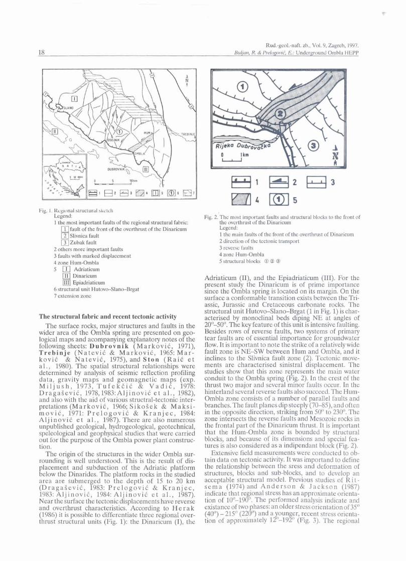
Fig. I . licg~onal slructurill skct~.ll Legend: 1 the most important faults of thc regional structural fabric:
1 fault of the front of the ovcrthrust of thc Dinaricum 2 Slivnica fault B
Zubak fault 2 others more important faults 3 faults with marked displacement 4 zone Hum-Ombla 5 )Il Adriaticum
Dinaricum Epiadriaticum
6 structural unit Hutovo-Slano-Brgat 7 extension zonc
The structural fabric and recent tectonic activity The surface rocks, major structures and faults in the
wider area of the Ombla spring are presented on geo- logical maps and acompanying explanatory notes of the following sheets: Dubrovnik (MarkoviC, 1971), Trebinje (Na tev iC & MarkoviC, 1965: M a r - koviC & NateviC, 1975), and Ston (RaiC e t a1 . , 1980). The spatial structural relationships were determined by analysis of seismic reflection profiling data, gravity maps and geomagnetic maps (exp. M i l j u s h , 1973, T u f e k E i C & V a d i C , 1978: DragaSeviC, 1978,1983:AljinoviC e t a l . , 1982), and also with the aid of various structral-tectonic inter- pretations ( M a r k o v i , 1966; S ikoSek & M a k s i - mov iC , 1971: P r e l o g o v i C & K r a n j e c , 1984: A1 j i n ov i C e t a 1 ., 1987). There are also numerous unpublished geological, hydrogeological, geotechnical, speleological and geo hysical studies that were carried out for the purpose o the Ombla power plant construc- tion.
P The origin of the structures in the wider Ombla sur-
rounding is well understood. This is the result of dis- placement and subduction of the Adriatic platform below the Dinarides. The platform rocks in the studied area are submerged to the depth of 15 to 20 km (DragaSeviC, 1983: P r e l o g o v i C B K r a n j e c , 1983: A l j inov id , 1984: A l j i n o v i k e t a l . , 1987). Near the surface the tectonic displacements have reverse and overthrust characteristics. According to H e r a k (1986) it is possible to differentiate three regional over- thrust structural units (Fig. 1): the Dinaricum (I), the
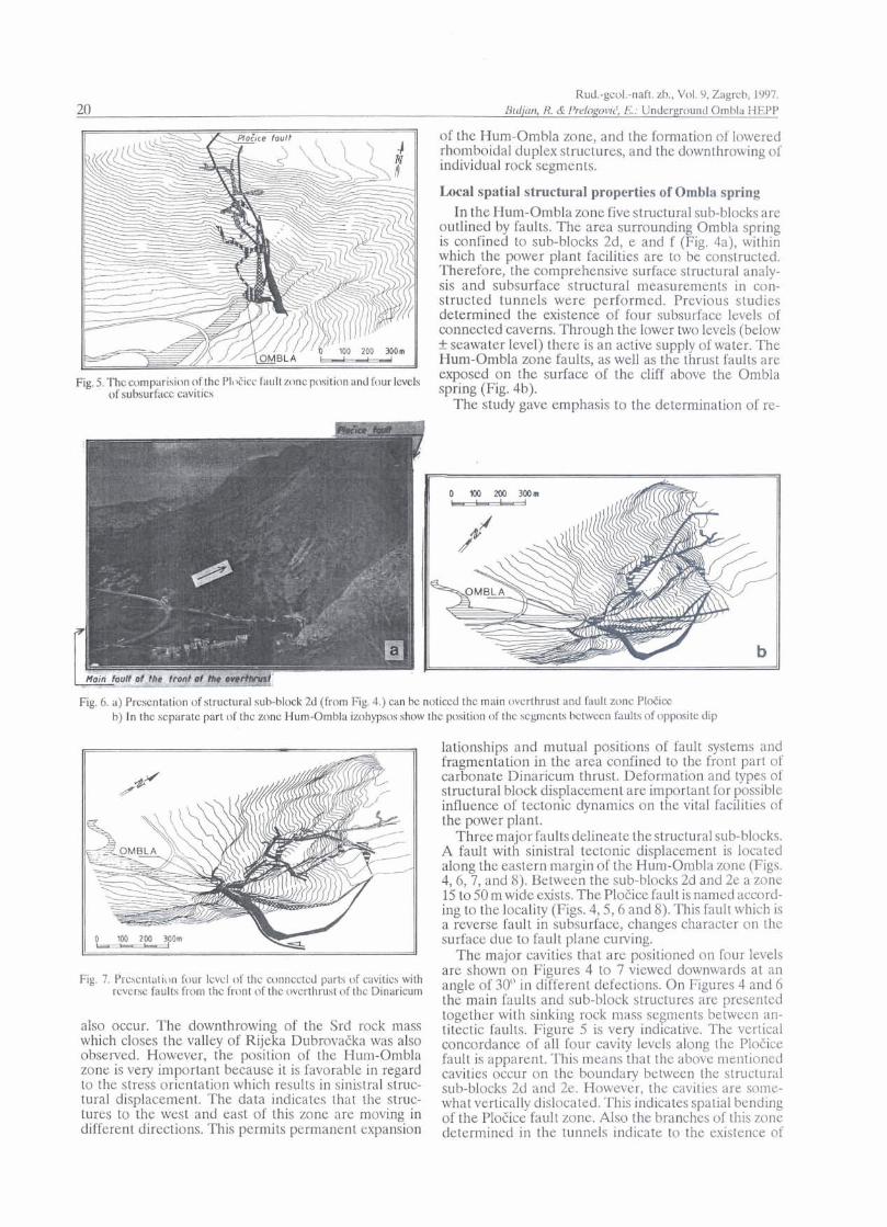
Fig. 2. Thc most important faulb and structural blocks to the front of thc ovcrthrust of the Dinaricum Lcgcnd: 1 thc main faults of thc front of thc overthrust of Dinaricum 2 direction of the tcctonic transport 3 rcvcrsc faulb 4 zonc Hum-Ombla 5 structural blocks O B @
Adriaticum (11), and the Epiadriaticum (111). For the present study the Dinaricum is of prime importance since the Ombla spring is located on its margin. On the surface a conformable transition exists between the Tri- assic, Jurassic and Cretaceous carbonate rocks. The structural unit HutovoSlano-Brgat (1 in Fig. 1) is char- acterised by monoclinal beds diping NE at angles of 20"-50". The key feature of this unit is intensive faulting. Besides rows of reverse faults, two systems of primary tear faults are of essential importance for groundwater flow. It is important to note the strike of a relatively wide fault zone is NE-SW between Hum and Ombla, and it inclines to the Slivnica fault zone (2). Tectonic move- ments are characterised sinistral displacement. The studies show that this zone represents the main water conduit to the Ombla spring (Fig. 2). In the crest of the thrust two major and several minor faults occur. In the hinterland several reverse faults also succeed. The Hum- Ombla zone consists of a number of parallel faults and branches. The fault planes dip steeply (70-85), and often in the opposite direction, striking from 50' to 230'. The zone intersects the reverse faults and Mesozoic rocks in the frontal part of the Dinaricum thrust. It is important that the Hum-Ombla zone is bounded by structural blocks, and because of its dimensions and special fea- tures is also considered as a indipendant block (Fig. 2).
Extensive field measurements were conducted to ob- tain data on tectonic activity. It was importand to define the relationship between the sress and deformation of structures, blocks and sub-blocks, and to develop an acceptable structural model. Previous studies of R i t - s e m a (1974) and A n d e r s o n & J a c k s o n (1987) indicate that regional stress has an approximate orienta- tion of 10"-190'. The performed analysis indicate and existance of two phases: an older stress orientationof 35" (40") - 215" (220") and a younger, recent stress orienta- tion of approximately 12"-192" (Fig. 3). The regional

Rud.-geol.-naft. zb., Vol. 9, Zagrcb, 1997. Rlt&tn, R. di I'relogovit, E.: Underground Omhla HEPP 19
Fig. 3. Area of thc Ornbla spring Legend: 1 fault bordering the front of thc overthrust of thc Dinaricum 2 revcrsc faults 3 fault. with changeable dip 4 w n e of Hum-Ornbla fault 5 direction of displacement of structures close to thc surfacc 6 stress
stress orientations indicate possible structural fabric de- formation.
The basic structural model is presented in Fig. 3. Inside the crest of the Dinaricum thrust a compression regime is established. The rotation of the crest around the horizontal axis is possible. This causes rock displace- ment in an upward direction and permanent activity of reverse faults. Because the strike of the beds is parallel to the principal faults, reverse interlayer displacements
Fig. -I. Faults and structural sub-blocks W , 2e and 2f abovc Ombla spring a sketch b photo
Rud.-gco1.-naft. zb., Vol. 9, Zagrcb, 1997. 20 &djun, R. & I'relqovic', E.: Underground Ombla HEPP
of the Hum-Ombla zone, and the formation of lowered rhomboidal duplex structures, and the downthrowing of individual rock segments.
Local spatial structural properties of Ombla spring In the Hum-Ombla zone five structural sub-blocks are
outlined by faults. The area surrounding Ombla spring is confined to sub-blocks 2d, e and f (Fig. 4a), within which the power plant facilities are to'beconstructed. Therefore, the comprehensive surface structural analy- sis and subsurface structural measurements in con- structed tunnels were performed. Previous studies determined the existence of four subsurface levels of connected caverns. Through the lower two levels (below +seawater level) there is an active supply of water. The Hum-Ombla zone faults, as well as the thrust faults are
Fig. 5. Thcu)mpdrision of thc PloEicc faultzoncpnsition and four levels exposed on the surface of the cliff above the Ombla
of subsurface cavitics spring (Fig. 4b). The study gave emphasis to the determination of re-
Fig. 6. a) Presentation of structural sub-block 2d (from Fig. 4.) can bc noticed thc main ovcrthrust and fault zonc PloEicc b) In the separate part of thc zonc Hum-Ombla izohypsc~~ show the position of thc scgmcnts bctwccn faults of oppositc dip
Fig. 7. Prcscnialion four lcvcl of thc conncctcd parts of cavitics with rcversc faults from thc front of thc c>vcrthrust of thc Dinaricum
also occur. The downthrowing of the Srd rock mass which closes the valley of Rijeka DubrovaEka was also observed. However, the position of the Hum-Ombla zone is very important because it is favorable in regard to the stress orientation which results in sinistral struc- tural displacement. The data indicates that the struc- tures to the west and east of this zone are moving in different directions. This permits permanent expansion
lationships and mutual positions of fault systems and fragmentation in the area confined to the front part of carbonate Dinaricum thrust. Deformation and types of structural block displacement are important for possible influence of tectonic dynamics on the vital facilities of the power plant.
Three major faults delineate the structural sub-blocks. A fault with sinistral tectonic displacement is located along the eastern margin of the Hum-Ombla zone (Figs. 4,6,7, and 8). Between the sub-blocks 2d and 2e a zone 15 to 50 m wide exists. The PloEice fault is named accord- ing to the locality (Figs. 4,5,6 and 8). This fault which is a reverse fault in subsurface, changes character on the surface due to fault plane curving.
The major cavities that are positioned on four levels are shown on Figures 4 to 7 viewed downwards at an angle of 30" in different defections. On Figures 4 and 6 the main faults and sub-block structures are presented together with sinking rock mass segments between an- titectic faults. Figure 5 is very indicative. The vcrtical concordance of all four cavity levels along the PloEice fault is apparent. This means that the above mentioncd cavities occur on the boundary between the structural sub-blocks 2d and 2e. However, the cavities are some- what vertically dislocated. This indicates spatial bending of the PloEice fault zone. Also the branches of this zone determined in the tunnels indicate to the existence of

Rud.-geo1.-naft. zb., Vol. 9, Zagreb, 1997. Wlljun, R. & PrelogoviC, E.: Underground Ombla HEPP 21
Fig. 8. Presentation of local displacement of fault along three main separated faults of the zone Hum-Ombla Legend: 1 the main faults of thc front of thc overthrust on thc surface 2 faults bordering structural sub-block: thc faults along thc castern hordcr of the zone Hum-Ombla and 3 PloEice faults 4 direction of di.placemcnt of thc fault's hanging wall
Pull-apart structures. These structures are frequently detected in tunnels where they accompany various fault systems, as well as the PloCice fault. Deformation proc- esses that accompany compression can produce cavities parallel to the directions of maximum stress. The smaller cavities that branch from the large cavities and planes with different declination are fault controlled. Figure 7 shows the relationship between cavity parts and reverse faults. The concordance of the two lower cavity levels with the main thrust faults is evident.
Detailed structural analysis provided data on local stress. The directional variations observed indicate that differences in tectonic dynamics exist within the struc- tural sub-blocks. The divergence of the compression directions from north direction are as follows:
structural sub-block 2d: 283"-293'; structural sub-block 2e: 310°-3430; structural sub-block 2f: 7".
The resulting structural deformations characterize the properties of the structural sub-blocks as follows:
within sub-blocks 2e and 2f the fragmentation is induced by normal faults and sinistral dislocation;
the faults parallel to the major thrust faults are substantial;
reverse faults with a NW fault plane dip occurwithin the sub-block 2f, and are perpendicular to the local stress direction.
The most important data obtained are those related to the PloCica fault, because of the future position of vital facilities of the Ombla hydroelectric power plant. Addi- tional compression was observed in the structural sub-
block 2d as a result of left transcurent movements along the Hum-Ombla zone boundary faults. As a conse- quence sub-block 2d is displaced along the PloCice fault in the SE direction. This is why the direction of local stress is different, thet reverse movements prevail, spa- tial divergence of the fault zone occured and the shape of the cavities is related to the high intensity of the stress. This emphasizes the importance of the PloCice fault zone in the local structural fabric.
Conclusion The data collected signify the marked recent tectonic
activity. The evidence for this can be summarized as follows: spatial compression, tangential thrust displace- ments and sinistral displacement along the Hum-Ombla zone. Three sub-blocks where identified within the Hum-Ombla zone in the neighboring area around Om- bla spring. These three sub-blocks exhibit different dy- namic properties: in the extent and direction of displacement, change of local stress orientation, and the magnitude of boundary zone sub-block activity. The extent of displacement is pronounced along major faults (Fig. 8): the sub-blocks 2e and 2f are displaced along normal faults 20" to 30" to the left and downwards, while the sub-block 2d is displaced along the Plotice reverse fault 100" to 130' to the left and upwards.
Structural and geological investigations confirmed that there is a basis for the construction of a subsurface dam 100 to 130 m high. It is extremely important that the structural properties of the Hum-Ombla zone were de- termined, as well as the relationship between the cavity levels and fault systems. The obtained study results

Kud.-gcol.-naft. zb., Vol. 9, Zagreb, 1997.
should be corroborated during the final design of vital facilities of the Ombla hydroelectric power plant. The location of these facilities is determined by the Plotice fault zone. The pronounced activity and fragmentation of this zone makes it neccessaxy to dislocate the facilities within the more stable structural sub-block 2d.
Received: 1997-03-12 Accepted: 1997-07-1 0
REFERENCES
Alj i novi C, B. 1984): Najdublji seizmiEki horizont NE Jadrana. Dissertation, b MF, p. 513, Zagrcb.
AljinoviC, B., CvijanoviC, D. , Labas, V . , PrclogoviC, E. & S koko , D. (1982): GcoloSka grada podruEja Dub- rovnika na temelju seizmotektonskih i gcofuiEkih istrdivanja. Zb. radova X kong. gcol. Jug., Knj. 1,527-540, Budva.
AljinoviC, B., PrelogoviC, E. & Skoko, D. (1987): Novi pxiaci o geoldkim strukturama u dubini i scizmotcktonski ak- tivnim zonama Jugoslavije. GeoL vjmnik, 40,255-263, Zagrcb.
Anderson , H. & Jackson , J . 1987): ActivcTectonics of thc Adriatic Rcgion. Gioghys. J.RA.& 91,937-983.
Drag a SeviC, T . (1978): Strukturne i naftno- colrxtkc karakteris- tike jugoistoCno dijela Jadranskog mora. jb . radova IX kong geol. Jug., 862-8%, Sarajevo.
Drag a3 ev i C, T. (1983): Oilpolqiccxpbration in the Montcncgro offshore in Yugoslavi. Nuftu 34l7-8, 397-404, Zagreb.
H c ra k, M . (1986): A new b n c e t of Geotcctonics of the Di- narides. A m ged, JAZU, 16,1$2, Zagrcb.
Btt.$itr, R. & IJrelqo~iC, E.: Underground Ombla HEPP
Mar kovi 6, B. (1971 : TumaE Osnovne geoloSke kartc K 34-49, list Dubrovnik, 5-43, avod za gcol. i geofiz. istrai., Sav. geol. zavod, Bcograd.
k M a r k o v i C , B . & N a t c v i C , L J . 1975): TumaE Osnovnc
8 eololkc kartc, K 33-49, Trcbinje, 5 0, Geol. zavod, Sarajcvo, av. gcol. zavod, Beograd.
d M i I j us h, P. (1973): Geologic-Tmtonic Structure and Evolution of
Outcr Dinaridcs and Adriatic Area. BtrllA.A.IJ.G., 5715,913-929, Tulsa.
NateviC, Lj. & MarkoviC, B. 1965):Osnovnageoldkakarta K 33-49, list Trcbinjc 1:100.000. eol. zavod, Sarajevo, Sav. gall. zavod, Beograd.
b PrclogoviC, E. & Kranjcc , V. (1983): Gcolo.$kirazvitakpo-
druEja Jadranskog mora. IJo~norskizborn~ 21,38745, Rijcka. R a i 6, V . & Pap cb, J . 1980): TumaE Osnovnc geologke karte, K
33-48, list Ston, 5-39, I coidcnjcring, Sarajevo. Institut za geol. istrai., Zagrcb, Sav. geol. zavod, Beograd.
Rai6, V., Papek, J . , Ahac , A., Koro l i j a , B., BoroviC, I . , G r i m a n i , I . h MarinEiC, S . (1980): Osnovna coldka karta K 35-48, list Ston 1:100.0(m. Geoinzcnjcring, 8 arajcvo, Inst. za gco~. istrd, Zapcb, Sav. g w ~ . zavod, Beograd.
R i tscm a , R. A., (1Y74): Fault Planc Mechanism on of Balkan Earth uakc. Proc. of Scm. on thc Scisrnotect. Ma of the Balkan Reg., bubrovnik. 17-26, April 1973. UNESCO, &opljc.
SikoSck, P. & MaksirnoviC, B. (1971):Geotektonskarajoni- zacija jadranskog pojasa Najia, 22/&5,298-304, Zagreb.
TufckEiC, D. & Vadi6, R. (1978): Nckc geoldko-tcktonske karaktcristikc JI dijcla Jadrana izvedenc iz podataka rcfleksivne scizmikc. Zb. radova IX kong. gcol. Jug., 972-976, Sarajevo.