remedial works program - city of whyalla · the whyalla wetlands remedial works program is an...
TRANSCRIPT

1
5 Year Remedial Works Program
Whyalla Wetlands
for
City of Whyalla
Assessed /Compiled by: January 2008 Larry Bebbington Habitat & Land Management Consultant Port Lincoln SA

© L. Bebbington Habitat & Land Management Consultant (08) 8684 5065 [email protected]
2
Document Information Job/Project Title:
Erosion Control / Revegetation Remedial Works
Title: 5 Year Remedial Works Program Whyalla Wetlands
Client Organisation: City of Whyalla
Document ID: 697/WLRW/108 Date: January 2008 Revision Status: Final Assessor: Larry Bebbington Current Document Approval: Greg Hill – Works Supervisor
This work is copyright. Apart from any use permitted under the Copyright Act, no part may be reproduced by any process,
or any other exclusive right exercised, without the permission of:
Larry A. Bebbington
P.O. Box 1235 North Shields South Australia 5607

© L. Bebbington Habitat & Land Management Consultant (08) 8684 5065 [email protected]
3
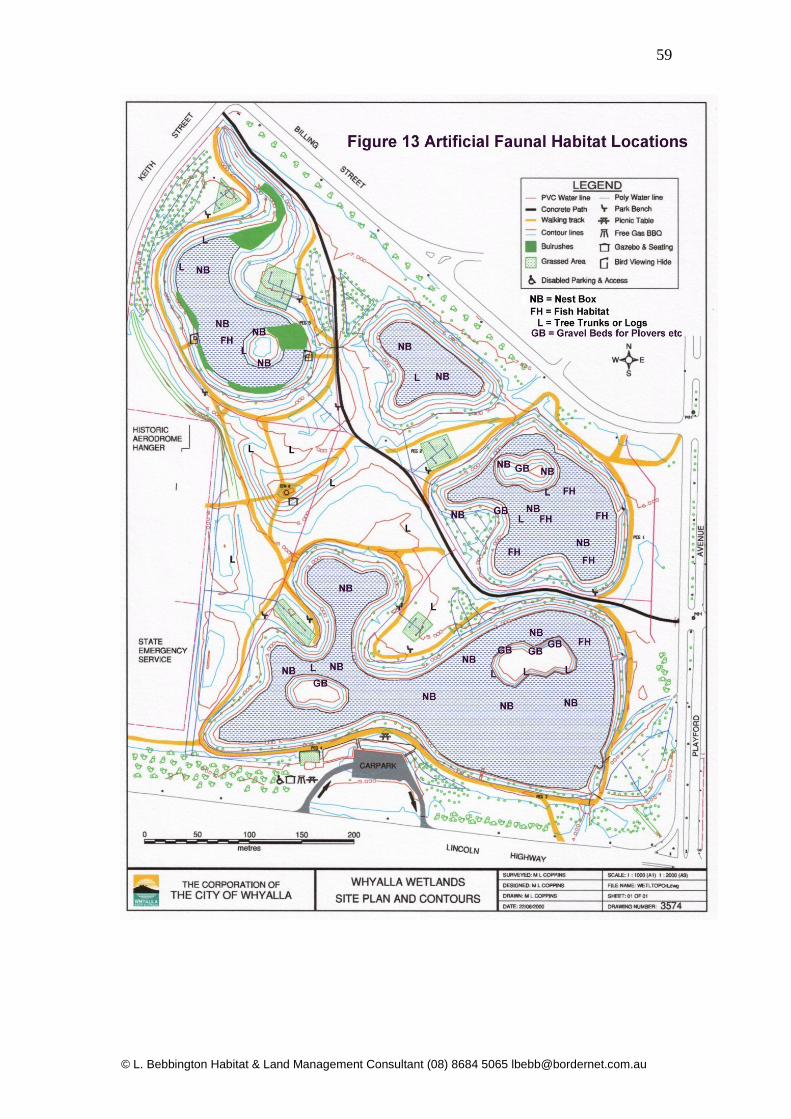
Index Summary………………………………. 4,5 1.0 – CIVIL WORKS…………………. 6 1.1 – Inflow Drains & Embankment Maintenance… 6 1.1.1- Pond 1……………………. 6 1.1.2 – Pond 1 Remedial Works EC… 13-22 2.0 – Pond 2 Erosion Control………. 23 2.1 – Pond 2 Site Photographs EC.. 25-29 3.0 – Pond 3 Erosion Control………. 30 3.1.0 – Pond 3 Site Photos EC.. 32-34 4.0 – Pond 4 Erosion Control…………. 35 4.1.0 – Pond 4 Site Photos EC.. 37-46 5.0 – VEGETATION MANAGEMENT… 47 5.1 – Vegetation Summary……………. 47 5.2 – Recommendations for Revegetation… 47 5.3 – Species Selection for Planting Programs.. 48 5.3.1 – Temporary Inundated Species………. 48 5.3.2 – Permanently Inundated Species…….. 48 5.3.3 – Terrestrial Species…………………… 49 5.3.4 - Mapping for Planting Programs……… 50-53 6.0- ARTIFICIAL HABITAT FOR NATIVE FAUNA … 55 7.0 – COMMUNITY INVOLVEMENT………………. 60 7.1 – Example Flora Interpretive Signage…. 61 8.0 – 5 YEAR REMEDIAL WORKS PROGRAM …. 62-66 APPENDIX 1 – Example of Water Level Manipulation Device 67-68 APPENDIX 2 – Photos Natural Seedling Recruitment Technique 69 Fig 1 – Finished Profile of Pond I Inlet Drain………………… 8 Fig 2 – Schematic of Typical Sediment Basin Design…. 9 Fig 3 _ Plan View Sediment Trap………………………….. 10 Fig 4 – Typical Diversion Berm & Armoured Chute… 11 Fig 5 – Pond 1 EC works………………… 12 Fig 6 – Pond 2 EC Works……………….. 24 Fig 7 - Pond 3 EC Works………………. 31 Fig 8 – Pond 4 EC Works………………. 36 Fig 9 – Schematic of Typical Planting Zones 54 Fig 10 – Typical Artificial Nest Boxes 56 Fig 11 – Typical Duck Nest Box…………………………… 57 Fig 12 - Artificial Fish Habitat…………………… 58 Fig 13 – Mapping of Artificial Habitat Locations……. 59

© L. Bebbington Habitat & Land Management Consultant (08) 8684 5065 [email protected]
4
Summary The Whyalla Wetlands Remedial Works Program is an ongoing working document to assist City of Whyalla management and staff in rectifying post construction erosion issues and implementing a revegetation and habitat enhancement program. The Whyalla Wetlands site is ideally situated for storm water harvesting and recreation and educational pursuits due to its proximity to the city centre and the Lincoln Highway. Unfortunately the construction of the wetlands on the old airport site located in a samphire flat has resulted in significant management problems. The soils within the wetlands complex consist primarily of red-brown calcareous silty clays with low permeability to an approximate depth of 2 metres. There is an overall trend to grey mottled sandy clays beyond the 2 metre depth in low lying areas (north) of the site. The soils excavated during construction which have been broadcast across the site consist of a mix of these silty clays which are sodic and have a low permeability. These types of soils are prone to erosion and generally only support hardy salt tolerant vegetation types. The low permeability of the silty clays ensures that the leaching of salts from the soil profile during rainfall events is severely restricted and salt leaching may only occur over many years in the upper profile. Shallow saline groundwater systems are typically found within the alluvium layer of coastal marsh systems and random water monitoring indicates that saline and possibly hyper saline groundwater ingress is occurring in ponds two, three and four. The ingress of saline water coupled with the high levels of evaporation is exacerbating soil salinity problems on the banks of all of the ponds. The original design and construction of the wetlands drainage and overflow system did not incorporate infrastructure for the manipulation of water levels and the potential need to bleed off saline water. Whilst this infrastructure can be retrofitted post construction and landscaping it will involve significant levels of disturbance to existing pond and drain embankments. The lack of water level manipulation devices coupled with other environmental factors has also ensured that the success rate of revegetation works has remained very low throughout the project. (see Section 5 for more detail). In addition inappropriate species selection for the soil types and salinity levels on site have contributed to a low level of plant recruitment and establishment particularly within the “riparian” zones of ponds.

© L. Bebbington Habitat & Land Management Consultant (08) 8684 5065 [email protected]
5
As with all constructed wetlands the Whyalla Wetlands project has some significant post construction maintenance requirements which may appear insurmountable and costly. If the afore mentioned issues are recognised and remedial planning is implemented the outcomes can be cost effective and rewarding. It is the opinion of the author that the most important issue is to recognise the fact that the wetlands have been constructed in a saline environment containing poor soils which have saline water (possibly marine) interactions on pond floors. Therefore it will be extremely difficult and costly to try to replicate a fresh water wetlands complex in these harsh conditions. Following the identification and rectification of engineering and post construction problems it will be possible over time to produce an aesthetically appealing landscape within the wetlands surrounds based on brackish and saline ecosystems. The basic foundation for these ecosystems and plant communities already exists within the project boundary and with careful planning the Whyalla community and the fauna utilising the site will benefit enormously. The following report makes recommendations based on the authors experience in establishing artificial wetlands and rehabilitating natural wetlands in similar environs across Australia. The emphasis of the remedial works program will be to rectify erosion and sedimentation issues and to make recommendations for the installation of water level control devices to ponds and outfall pipes. Revegetation works will specifically target species from Eyre Peninsula that naturally occur in saline environments and planting programs will target habitat requirements of native fauna (avifauna, amphibians, reptiles and fish) that utilise the site. It must be emphasised that wetland species for the project should be sourced from local Eyre Peninsula provenance as the introduction of species from other regions that do not naturally occur on Eyre Peninsula can cause serious environmental issues within regional wetland ecosystems. Waterfowl can transfer seeds of introduced wetland plant species hundreds of kilometres during overnight migrations.

© L. Bebbington Habitat & Land Management Consultant (08) 8684 5065 [email protected]
6
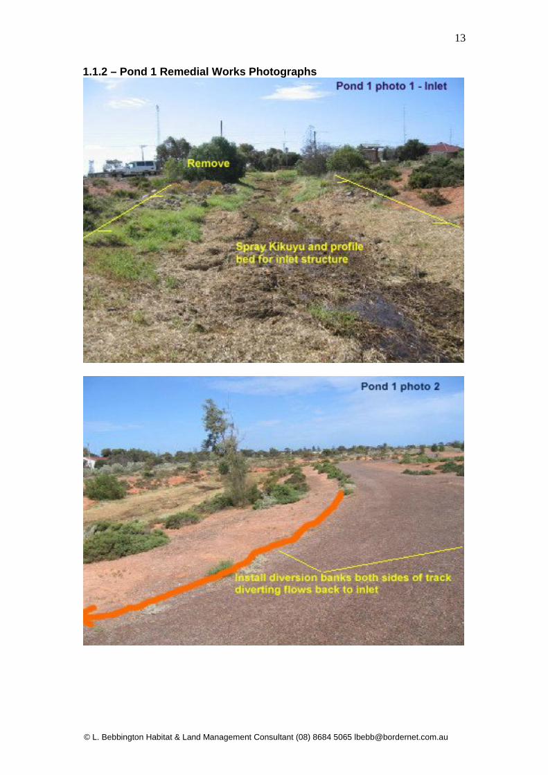
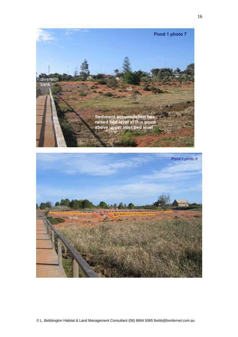
1.0 – Civil Works 1.1 – Inflow Drains and Embankment Maintenance 1.1.1 Pond 1 Pond 1 Storm water is harvested from areas west of Keith Street and Billing Street and is diverted into the inflow channel at the northern street intersection. The catchment contains significant areas of unpaved sodic soils which generate high sediment loadings into the inflow drain of Pond 1. In addition bank rill erosion and bed scouring would have occurred in initial inflows following construction which added to the sediment loads entering the inflow channel. The channel currently supports dense infestations of Kikuyu grass which has trapped tons of sediment predominately along the final 30 metres of the inlet channel. The dense stands of Kikuyu trap sediment on the channel bed and over time the bed level has raised to such an extent that the bed immediately upstream of the foot bridge is now at inlet level. Prior to the Kikuyu becoming established and acting as a filter trap, tons of sediment entered pond 1 in the form of a sediment fan between the footbridge and the pond proper. Typha domingensis (Bulrush) which was introduced into pond 1 has become established in the inlet sediment fan and the reed beds have exacerbated the problems associated with bed raising. Significant amounts of sediment have also entered Pond 1 from rill erosion occurring on slopes surrounding the pond. Whilst rill erosion of slopes may appear minor, if left unchecked over time they can trigger into small gully erosion problems which has already occurred on the eastern side of the pond. The overall depth of Pond 1 in sections adjacent to eroding points has become quite shallow and choked with Typha. Over time the combination of sediment loadings and the spread of Typha will ensure that Pond 1 will become a dense stand of reeds with very shallow standing water in some areas. The following recommendations for remedial works require retrofitting infrastructure into established samphire and chenopod vegetation. Every effort must be made to minimise damage to existing vegetation as the root matrix of these plants are currently stabilising soils on slopes. Recommendations:
1. Spray Kikuyu in Pond 1 inlet channel. Use low rates of Glyphosate with additional wetting agent. Spraying must not take place when ponded water is in channel as Glyphosate may enter the pond. Avoid off target damage to established vegetation. Only spray when Kikuyu is active and follow up spraying will be required.
2. Remove sediment build up and Kikuyu mats with a small excavator and remove off-site.
© L. Bebbington Habitat & Land Management Consultant (08) 8684 5065 [email protected]
7
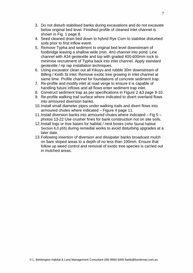
3. Do not disturb stabilised banks during excavations and do not excavate below original bed level. Finished profile of cleaned inlet channel is shown in Fig. 1 page 8.
4. Seed cleaned drain bed down to hybrid Rye Corn to stabilise disturbed soils prior to first inflow event.
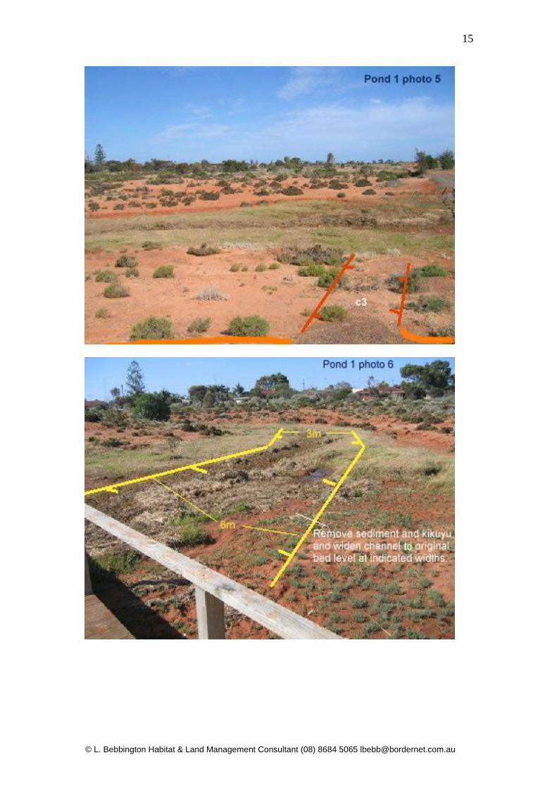
5. Remove Typha and sediment to original bed level downstream of footbridge leaving a shallow wide (min. 4m) channel into pond. Line channel with A34 geotextile and top with graded 400-600mm rock to minimise recruitment of Typha back into inlet channel. Apply standard geotextile / rip rap installation techniques.
6. Using excavator clean out all Kikuyu and rubble 30m downstream of Billing / Keith St inlet. Remove exotic tree growing in inlet channel at same time. Profile channel for foundations of concrete sediment trap.
7. Re-profile and modify inlet at road verge to ensure it is capable of handling future inflows and all flows enter sediment trap inlet.
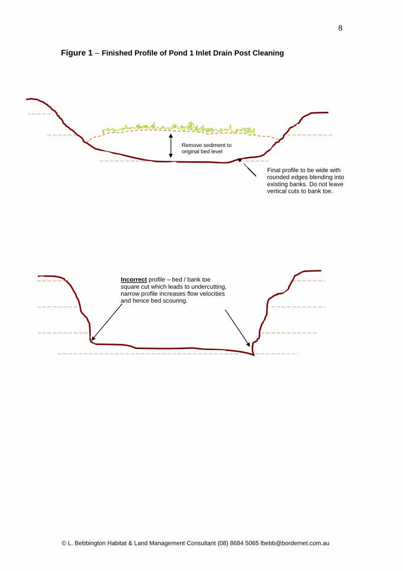
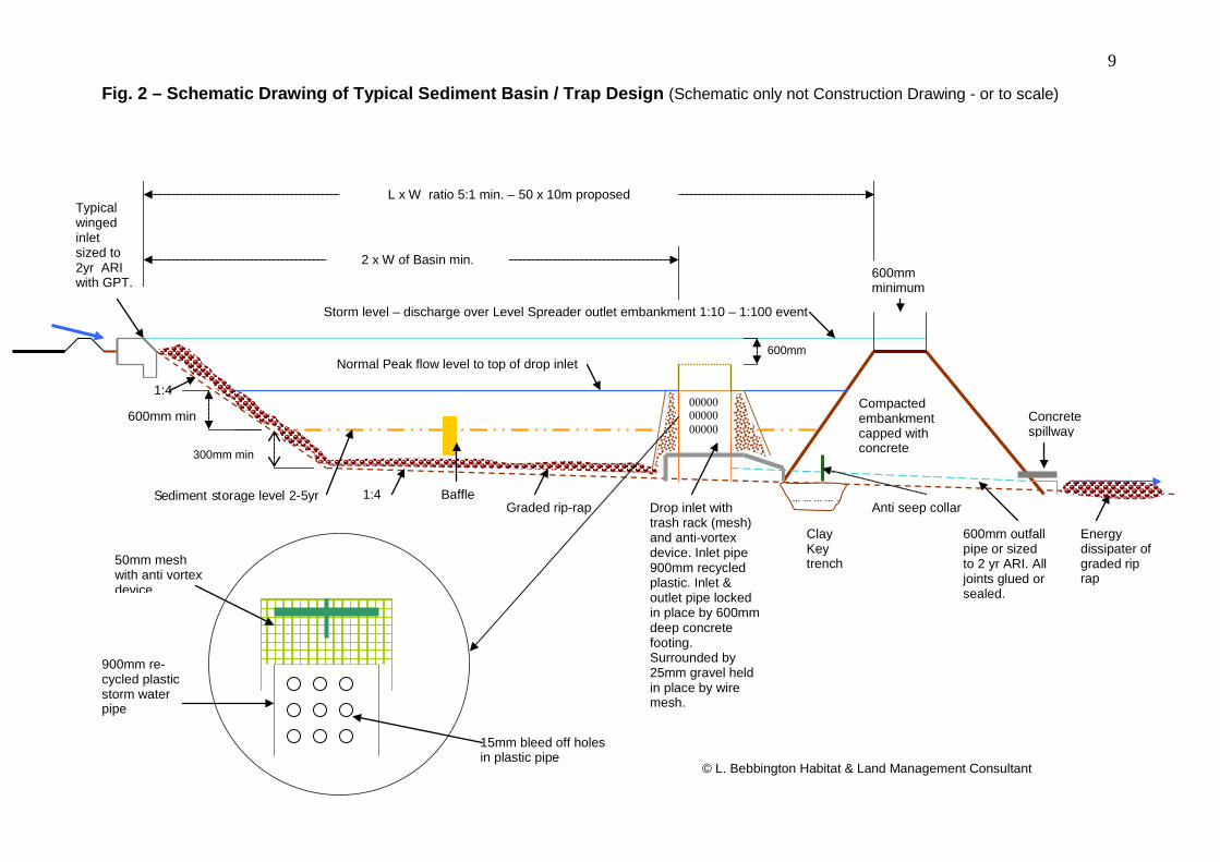
8. Construct sediment trap as per specifications in Figure 2 &3 page 9-10. 9. Re-profile walking trail surface where indicated to divert overland flows
into armoured diversion banks. 10. Install small diameter pipes under walking trails and divert flows into
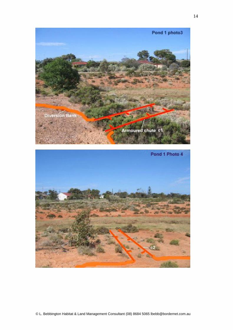
armoured chutes where indicated – Figure 4 page 11. 11. Install diversion banks into armoured chutes where indicated – Fig 5 –
photos 13-22 Use crusher fines for bank construction not on site soils. 12. Install logs or tree bases for habitat / nest boxes (refer faunal habitat
Section 6.0 p55) during remedial works to avoid disturbing upgrades at a later date.
13. Following insertion of diversion and dissipater banks broadcast mulch on bare sloped areas to a depth of no less than 100mm. Ensure that follow up weed control and removal of exotic tree species is carried out in mulched areas.
© L. Bebbington Habitat & Land Management Consultant (08) 8684 5065 [email protected]
8
Figure 1 – Finished Profile of Pond 1 Inlet Drain Post Cleaning
Remove sediment to original bed level
Final profile to be wide with rounded edges blending into existing banks. Do not leave vertical cuts to bank toe.
Incorrect profile – bed / bank toe square cut which leads to undercutting, narrow profile increases flow velocities and hence bed scouring.
9
00000 00000 00000
Fig. 2 – Schematic Drawing of Typical Sediment Basin / Trap Design (Schematic only not Construction Drawing - or to scale)
1:4
1:4 Baffle Graded rip-rap
Typical winged inlet sized to 2yr ARI with GPT.
Storm level – discharge over Level Spreader outlet embankment 1:10 – 1:100 event
Normal Peak flow level to top of drop inlet
Sediment storage level 2-5yr Drop inlet with trash rack (mesh) and anti-vortex device. Inlet pipe 900mm recycled plastic. Inlet & outlet pipe locked in place by 600mm deep concrete footing. Surrounded by 25mm gravel held in place by wire mesh.
50mm mesh with anti vortex device
900mm re-cycled plastic storm water pipe
15mm bleed off holes in plastic pipe
Clay Key trench
Anti seep collar
600mm outfall pipe or sized to 2 yr ARI. All joints glued or sealed.
Energy dissipater of graded rip rap
Concrete spillway
Compacted embankment capped with concrete
600mm minimum
300mm min
© L. Bebbington Habitat & Land Management Consultant
600mm min
L x W ratio 5:1 min. – 50 x 10m proposed
2 x W of Basin min.
600mm
© L. Bebbington Habitat & Land Management Consultant (08) 8684 5065 [email protected]
10
300-600mm rip rap over Geotextile on bank surrounds
Graded rip rap on pond bed
Concrete baffles to increase settling area. Lock into side banks.
Concrete spillway below level spreader locked into rip rap underlain with Geotextile to prevent scouring during overtopping.
Drop inlet pipe
Compacted embankment (compact at 600mm depth intervals) topped with concrete capping and 600mm wide level spreader crest. Lock structure into banks on both sides of channel.
1:4 batter
Figure 3 – Plan View of Sediment Basin
11
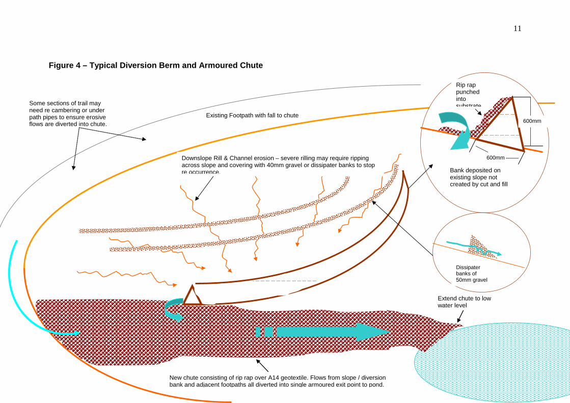
Figure 4 – Typical Diversion Berm and Armoured Chute
Existing Footpath with fall to chute
Downslope Rill & Channel erosion – severe rilling may require ripping across slope and covering with 40mm gravel or dissipater banks to stop re occurrence.
New chute consisting of rip rap over A14 geotextile. Flows from slope / diversion bank and adjacent footpaths all diverted into single armoured exit point to pond.
Extend chute to low water level
600mm
600mm
Rip rap punched into substrate
Bank deposited on existing slope not created by cut and fill
Some sections of trail may need re cambering or under path pipes to ensure erosive flows are diverted into chute.
Dissipater banks of 50mm gravel

12
Fig 5 – Pond 1 Erosion Control Works
© L. Bebbington Habitat & Land Management Consultant (08) 8684 5065 [email protected]
13
1.1.2 – Pond 1 Remedial Works Photographs


© L. Bebbington Habitat & Land Management Consultant (08) 8684 5065 [email protected]
23
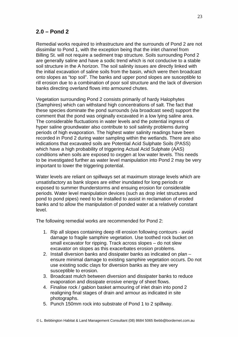
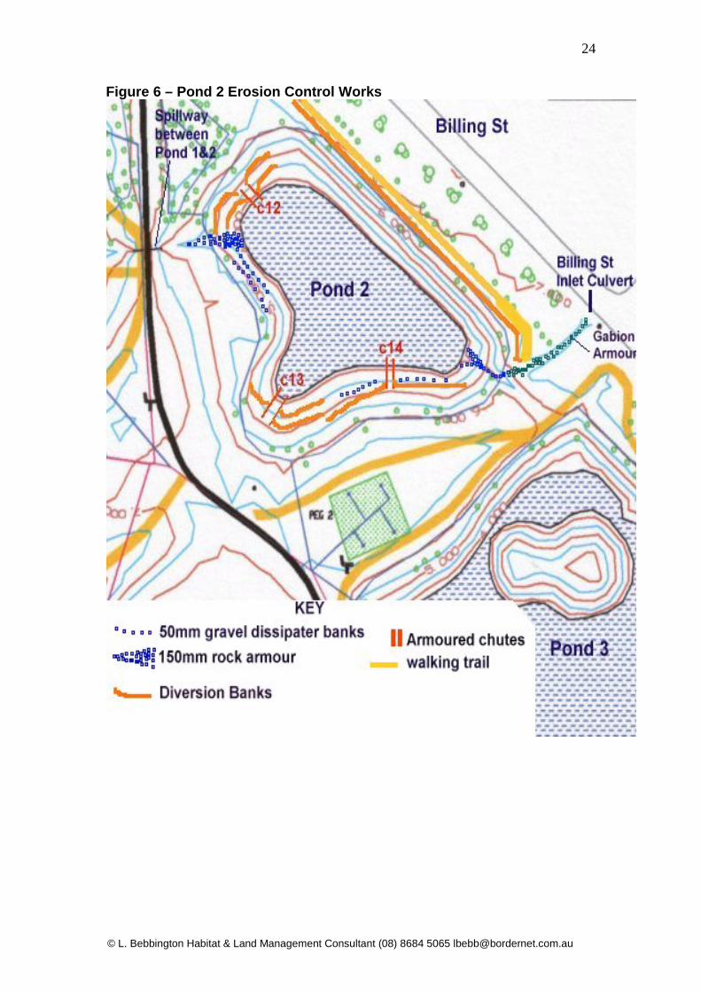
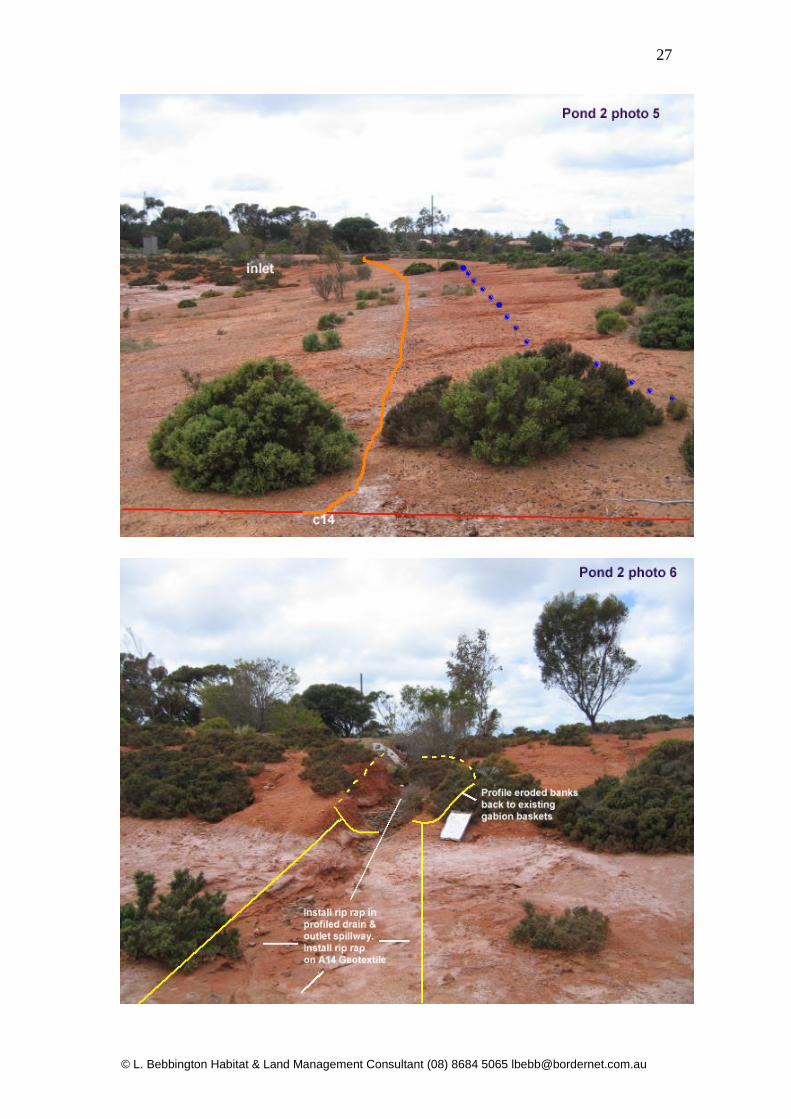
2.0 – Pond 2 Remedial works required to infrastructure and the surrounds of Pond 2 are not dissimilar to Pond 1, with the exception being that the inlet channel from Billing St. will not require a sediment trap structure. Soils surrounding Pond 2 are generally saline and have a sodic trend which is not conducive to a stable soil structure in the A horizon. The soil salinity issues are directly linked with the initial excavation of saline soils from the basin, which were then broadcast onto slopes as “top soil”. The banks and upper pond slopes are susceptible to rill erosion due to a combination of poor soil structure and the lack of diversion banks directing overland flows into armoured chutes. Vegetation surrounding Pond 2 consists primarily of hardy Halophytes (Samphires) which can withstand high concentrations of salt. The fact that these species dominate the pond surrounds (via broadcast seed) support the comment that the pond was originally excavated in a low lying saline area. The considerable fluctuations in water levels and the potential ingress of hyper saline groundwater also contribute to soil salinity problems during periods of high evaporation. The highest water salinity readings have been recorded in Pond 2 during water sampling within the wetlands. There are also indications that excavated soils are Potential Acid Sulphate Soils (PASS) which have a high probability of triggering Actual Acid Sulphate (AAS) conditions when soils are exposed to oxygen at low water levels. This needs to be investigated further as water level manipulation into Pond 2 may be very important to lower the triggering potential. Water levels are reliant on spillways set at maximum storage levels which are unsatisfactory as bank slopes are either inundated for long periods or exposed to summer thunderstorms and ensuing erosion for considerable periods. Water level manipulation devices (such as drop inlet structures and pond to pond pipes) need to be installed to assist in reclamation of eroded banks and to allow the manipulation of ponded water at a relatively constant level. The following remedial works are recommended for Pond 2:
1. Rip all slopes containing deep rill erosion following contours - avoid damage to fragile samphire vegetation. Use toothed rock bucket on small excavator for ripping. Track across slopes – do not slew excavator on slopes as this exacerbates erosion problems.
2. Install diversion banks and dissipater banks as indicated on plan – ensure minimal damage to existing samphire vegetation occurs. Do not use existing sodic clays for diversion banks as they are very susceptible to erosion.
3. Broadcast mulch between diversion and dissipater banks to reduce evaporation and dissipate erosive energy of sheet flows.
4. Finalise rock / gabion basket armouring of inlet drain into pond 2 realigning final stages of drain and armour as indicated in site photographs.
5. Punch 150mm rock into substrate of Pond 1 to 2 spillway.
© L. Bebbington Habitat & Land Management Consultant (08) 8684 5065 [email protected]
24
Figure 6 – Pond 2 Erosion Control Works

© L. Bebbington Habitat & Land Management Consultant (08) 8684 5065 [email protected]
25
2.1 – Pond 2 Site Photographs


© L. Bebbington Habitat & Land Management Consultant (08) 8684 5065 [email protected]
30
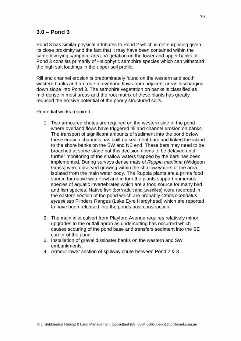
3.0 – Pond 3 Pond 3 has similar physical attributes to Pond 2 which is not surprising given its close proximity and the fact that it may have been contained within the same low lying samphire area. Vegetation on the lower and upper banks of Pond 3 consists primarily of Halophytic samphire species which can withstand the high salt loadings in the upper soil profile. Rill and channel erosion is predominately found on the western and south western banks and are due to overland flows from adjacent areas discharging down slope into Pond 3. The samphire vegetation on banks is classified as mid-dense in most areas and the root matrix of these plants has greatly reduced the erosive potential of the poorly structured soils. Remedial works required:
1. Two armoured chutes are required on the western side of the pond where overland flows have triggered rill and channel erosion on banks. The transport of significant amounts of sediment into the pond below these erosion channels has built up sediment bars and linked the island to the shore banks on the SW and NE end. These bars may need to be broached at some stage but this decision needs to be delayed until further monitoring of the shallow waters trapped by the bars has been implemented. During surveys dense mats of Ruppia maritima (Widgeon Grass) were observed growing within the shallow waters of the area isolated from the main water body. The Ruppia plants are a prime food source for native waterfowl and in turn the plants support numerous species of aquatic invertebrates which are a food source for many bird and fish species. Native fish (both adult and juveniles) were recorded in the eastern section of the pond which are probably Craterocephalus eyresii ssp Flinders Ranges (Lake Eyre Hardyhead) which are reported to have been released into the ponds post construction.
2. The main inlet culvert from Playford Avenue requires relatively minor
upgrades to the outfall apron as undercutting has occurred which causes scouring of the pond base and transfers sediment into the SE corner of the pond.
3. Installation of gravel dissipater banks on the western and SW embankments.
4. Armour lower section of spillway chute between Pond 2 & 3.

© L. Bebbington Habitat & Land Management Consultant (08) 8684 5065 [email protected]
31
Figure 7 – Pond 3 Erosion Control Works

© L. Bebbington Habitat & Land Management Consultant (08) 8684 5065 [email protected]
32
3.1 – Pond 3 Site Photographs


© L. Bebbington Habitat & Land Management Consultant (08) 8684 5065 [email protected]
35
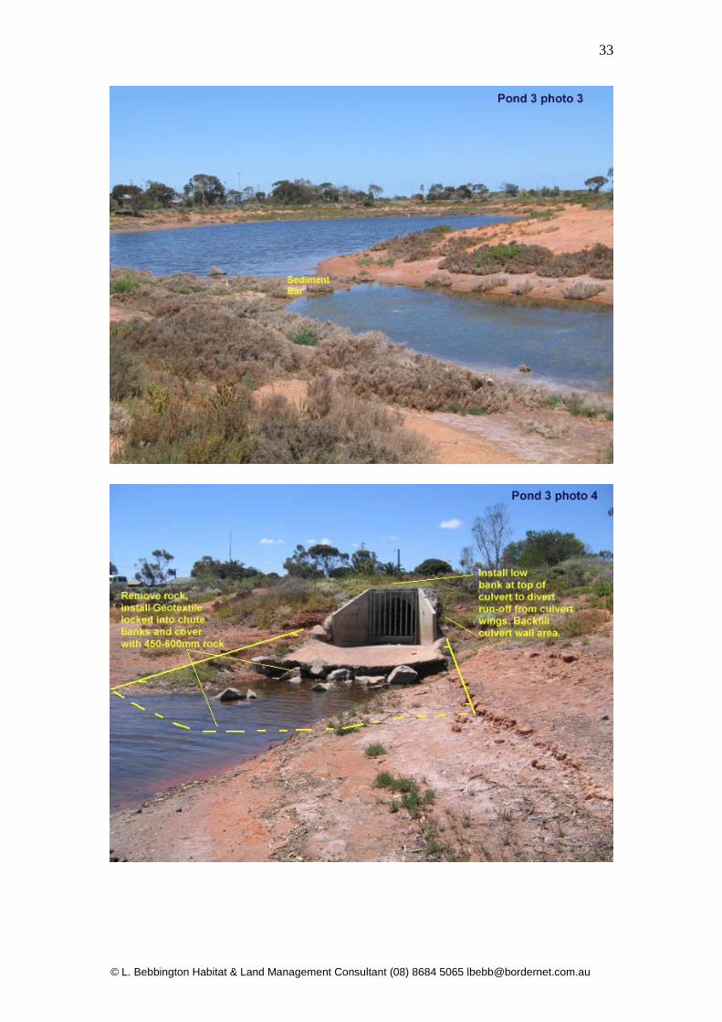
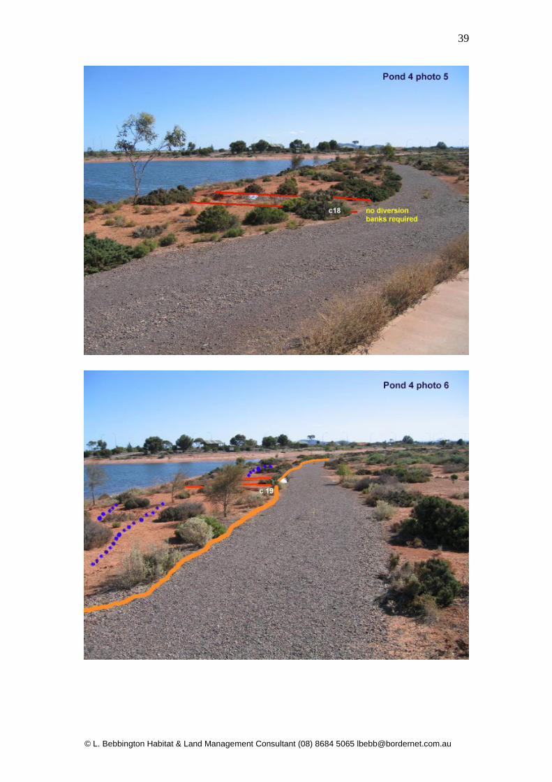
4.0 – Pond 4 Erosion Control Works Pond 4 is the largest of the basins in the wetlands system and consequently has the largest bank and water surface area. Whilst soils are of a marginally better quality surrounding Pond 4 there is still significant issues with soil salinity. The salinity of water within Pond 4 is high, particularly during periods of high evaporation. Evaporation rates in Pond 4 are possibly the highest in the wetlands system due to the large surface area and the openness of the southern surrounds which expose the water body to prevailing winds. The following management issues have been identified:
• High soil salinity in the eastern section grading to moderate in the west. • High rates of evaporation due to large surface area of pond. • Wave induced erosion on islands and northern banks due to length of
fetch across pond and exposure to prevailing winds. • Lack of water level manipulation devices on outlet to maintain high
water levels to combat evaporation. • Surrounding areas (including off-site industrial catchments) shed
surface run-off towards Pond 4 exacerbating bank erosion and depositing large amounts of sediment due to un-armoured chutes.
• Sections of the walking trail require raising and re profiling to divert surface run off into adjacent drains or new armoured chutes.
• Drains running parallel to western boundary need cleaning to capture and divert run off into Pond 4.
• New drains installed in eastern section require hard or soft armour to minimise sediment transport from drain beds into wetland.
The following remedial works address some of the issues listed above:
1. Install water level manipulation devices on outlet (see schematic drawings Appendix 1 p67-68).
2. Install diversion banks, dissipation banks and armoured chutes in identified areas to combat erosion.
3. Raise and re profile walking trails where identified and install under path pipe work as directed.
4. Clean drains on western perimeter. 5. Install hard or soft armour in new inlet drains in eastern section.

36

37
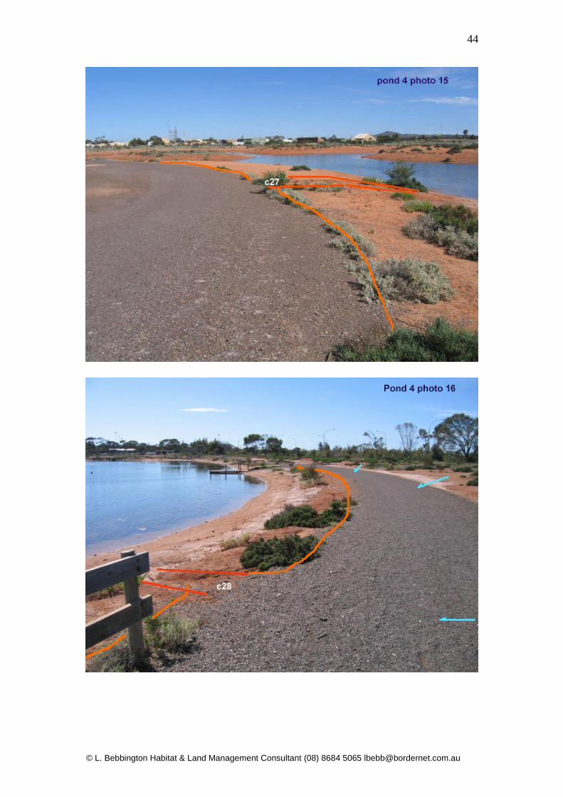
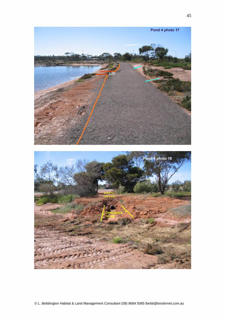
4.1 – Pond 4 Site photographs


© L. Bebbington Habitat & Land Management Consultant (08) 8684 5065 [email protected]
47
5.0 – Vegetation Management 5.1 – Vegetation Summary As previously stated in the document summary, a wide range of parameters will affect the final outcome of revegetation works within the wetlands complex, particularly in the created riparian zone. The following points relate to site issues identified during surveys:
• Wide range in water level fluctuations due to a lack of suitable infrastructure to manage water levels, ensure vegetation is either inundated or stressed for long periods.
• Soil and water salinity has contributed to die back of majority of planted vegetation (see also species selection).
• Waterfowl either trample or consume new growth on aquatic and semi-aquatic vegetation.
• Inappropriate species selection based on aesthetics instead of environmental parameters.
• Inappropriate species utilised that are not of local progeny can lead to major environmental issues within the region.
• Lack of knowledge regarding best practice techniques during revegetation programs has contributed to the loss rate post planting.
• Vandalism of surviving trees is high - in particular adjacent to Pond 4. 5.2 – Recommendations for Revegetation The following recommendations for revegetation can only be implemented post erosion control works. The staging and completion of erosion control works will be dictated by annual budgets, availability of plant and staff and seasonal constraints. The above constraints may mean that the revegetation program becomes part of a 3 year plan with planting programs commencing in elevated areas well outside the erosion control site works. If erosion control is staged so that works are finalised on a pond to pond basis planting programs can be implemented as each stage is completed. It is worth noting that erosion control works such as ripping rill erosion channels and the insertion off gravel dissipater banks will assist in the recruitment of seedlings of samphire plant species that are currently found on site. This is achieved by providing a roughened seed bed and the gravel bank to trap seed shed by plants upslope. . Natural recruitment is a cost effective method of revegetation that can be enhanced by tube stock planting of selected species at a later date. This technique has successfully been utilised by the author in similar landforms during mining rehabilitation (see Appendix ?? photos).

© L. Bebbington Habitat & Land Management Consultant (08) 8684 5065 [email protected]
48
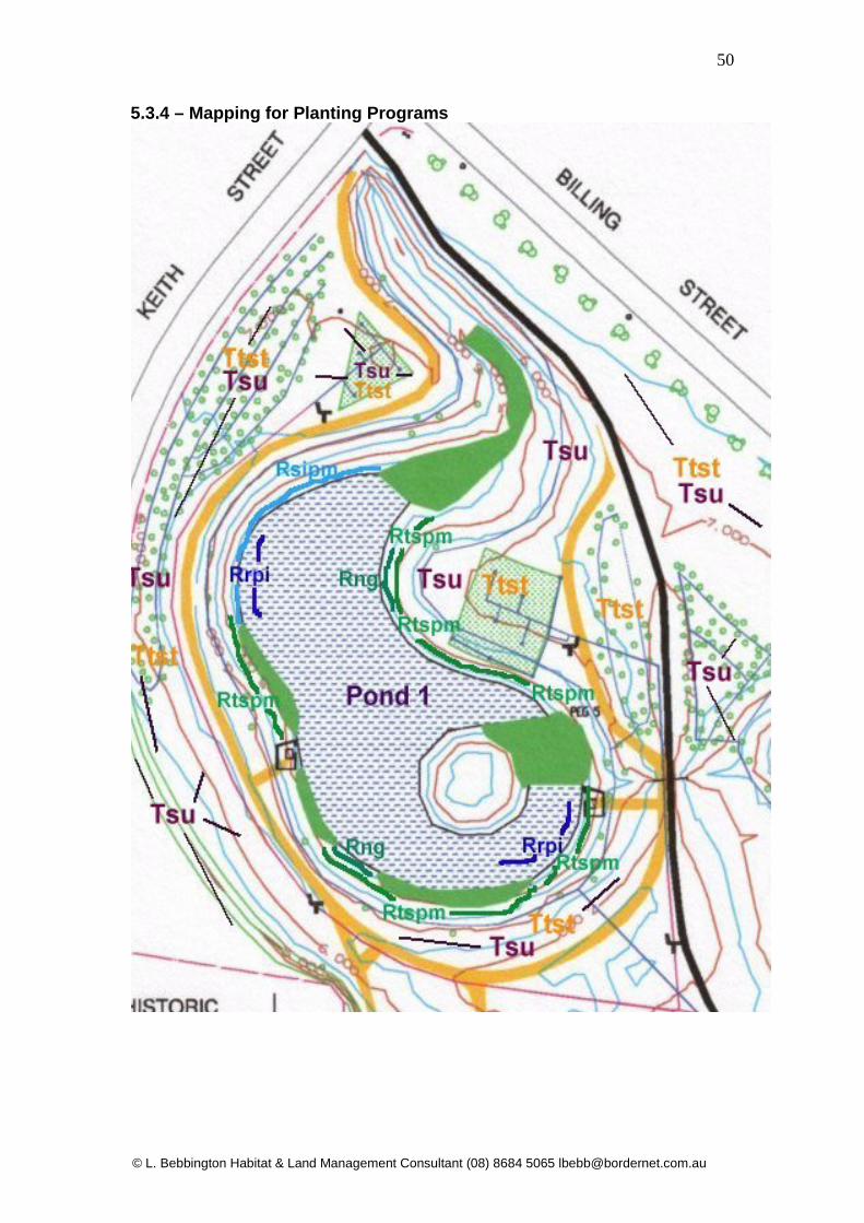
5.3 – Species Selection and Planning Planting Programs Due to environmental constraints it is particularly important to select species that will survive long term in the wetlands landscape. Long term survival of plant communities includes the recruitment of seedlings from mature plants on site. These outcomes can only be achieved by identifying species from the region that naturally occur or will survive in similar saline environments. Species selection also takes into account habitat requirements such as food, nesting or roosting sites of native fauna utilising the site. The following recommendations are generalised as City of Whyalla staff with the appropriate skill levels will oversee and carry out planting programs in conjunction with the consultant following erosion control. The following list includes some of the species recommended for planting programs: 5.3.1 - Areas Temporarily Inundated or Permanently Moist #denotes species that tolerate low levels of salinity, Map Code refers to Planting Program Maps Section 5.3.4 pages 50-53. Sedges (Rushes) – Map Code RsIpm
Baumea juncea Bare Twig Rush Bolboschoenus cadwellii Sea Club Rush Carex tereticaulis# Rush Sedge Gahnia filum# Cutting Grass Juncus pallidus# Pale Rush Juncus kraussii Sea Rush Native Grasses – Map Code Rngpm
Distichlis distichophylla Emu Grass (native couch) Poa labillardieri# Tussock Grass (not suitable saline areas) Tall Shrubs (Low Trees) – Map Code Rtspm
Melaleuca halmaturorum Salt Paperbark Melaleuca brevifolia Bracelet Honey Myrtle Myoporum insulare Boobialla 5.3.2 - Permanently Inundated or to 1m Depth – Map Code Rrpi
Baumea arthrophylla# Swamp twig-rush Schoenoplectus littoralis# Tall Rush Above 2 species tolerate Moderate salinity

© L. Bebbington Habitat & Land Management Consultant (08) 8684 5065 [email protected]
49
5.3.3 - Terrestrial beyond Riparian Zone Shrubs & Understorey# - Map Code Tsu
Acacia notabilis Notable Wattle Acacia oswaldii Oswald’s Wattle Atriplex sp. All Local species Bursaria spinosa Prickly Box Disphyma crassifolium Round Leaf Pigface (G.Cover) Enchylaena tomentosa Ruby Salt Bush (G.Cover) Eremophila longifolia Weeping Emu Bush Eremophila scoparia Broom Emu Bush Lycium australe Native Boxthorn Maireana sp. All local species Myoporum insulare Boobialla Senna artemisioides ft. Senna Native Grasses# -Map Code Tng
Austrodanthonia setacea Small Flower Wallaby Grass Austrodanthonia caespitosa Common Wallaby Grass Austrostipa nitida Balcarra Spear Grass Chloris truncata Windmill Grass Cymbopogon ambiguus Lemon Scented grass Trees# - Map Code Ttst
Acacia salicina Willow Wattle Myoporum platycarpum False Sandalwood Eucalyptus brachycalyx Gilja Eucalyptus gracilis Yorrel Pittosporum angustifolium Native Apricot
© L. Bebbington Habitat & Land Management Consultant (08) 8684 5065 [email protected]
50
5.3.4 – Mapping for Planting Programs


53

54
Figure 9 – Schematic of Typical Planting Zones
High Water Level
Low Water Level
Diversion Bank
Dissipater Bank
Rrpi Only In Pond 1
Rtspm Rngpm Rsipm Only in inundated zones
Rtspm Predominately Mel. Brevifolia, Myoporum insulate
Tsu with scattered Ttst species selected according to soil type and soil salinity.
Tsu, Tst and Tng selected according to soil type and salinity. Mel. Halmaturorum ONLY
LB’08
55
6.0 – Artificial Habitat for Native Fauna The installation of artificial habitat for native fauna will enhance specific habitat plantings and encourage native fauna species to breed within the wetlands complex. It must be emphasised that predation of eggs and chicks by Laurus novaehollandiae (Silver Gull) is a significant threat. It is recommended that signs alerting the public to gull predation is necessary, as observations made during surveys indicate that the public are not only feeding gulls take away food scraps in the car park but are taking food scraps from home to feed gulls on site. 7bird species were recorded breeding in the wetlands during the 2007 assessment but chicks and adult birds were continually harassed by gulls and few fledgling chicks were observed in later surveys. Gulls will always constitute a problem at the wetland site but actively encouraging large numbers of gulls by feeding should be discouraged. A large percentage of the public that visit the Whyalla Wetlands use the walking trails for exercising their dogs. Whilst the majority of users walk their dogs on a leash a significant percentage allow their dogs to roam off leash. This has a negative impact on ground nesting birds (such as the majority of waders) by continual disturbance of nests or can lead to bird mortality by dog attack. The majority of birds utilising the wetlands have nested in dense Typha beds in Pond 1 or on the islands in Ponds 3 and 4. Due to the openness of the area birds predominately use the protected northern side of islands which means that ideal nest sites are at a premium. Artificial nest structures sited in the water or placed on island will increase available nest sites and offer protection from the elements and human / dog disturbances. The location of nest boxes and habitat requires specific knowledge of targeted species and will necessitate the overseeing of structure installation. The basic mapping of suitable areas for nest boxes and habitat is a guide only and is included as a component of school and community involvement of the project. The following diagrams indicate basic nest box / structures that have been utilised successfully in other wetland projects by the author.

© L. Bebbington Habitat & Land Management Consultant (08) 8684 5065 [email protected]
56
Figure 10 – Typical Artificial Nest Boxes Suitable for Herons, Egrets, Ducks, Cormorants & Harriers
Fibreglass Galv Mesh Plywood Box
Escape holes Mesh size must be Box type with escape ramp for chicks must 5cm for chicks for chicks be >5cm If side walls of hard sided structures are more than 7cm above the nest material and angled at more than 450, escape holes, mesh ramps or galv mesh 5cm x 5cm should be used. All base nest materials should be tied into the base with heavy duty cable ties to stop nesting material blowing out during windy days. Twisted straw or sedge stems provide the best nesting material and lasts for up to 3 years – replacement is then necessary. Nest platforms must be installed at least 1m above the highest water level, however varying heights are necessary as some species prefer sites right at water level. Optional Heron & Cormorant platforms Recycled Plastic Post 4m
5cm x 5cm Hardwood Perch – rounded on top
5cm x 5cm hardwood rails

© L. Bebbington Habitat & Land Management Consultant (08) 8684 5065 [email protected]
57
Figure 11- Typical duck nesting box – (Adopted from “The Nestbox Book – Gould League of Victoria1997) Suitable for Grey & Chestnut Teal, Black Duck. Larger boxes are suitable for Wood Duck & Aust. Shelduck Back of box should be hinged to allow cleaning. Base of box can be extended outwards from opening to provide a platform
35cm
45cm
35cm
100-150cm diameter
Recycled Plastic Post 4m Length
Hardwood supports
Hinges on rear door – all fittings should be galvanised or stainless. Timber should be of marine
ply (12mm) or treated pine

© L. Bebbington Habitat & Land Management Consultant (08) 8684 5065 [email protected]
58
Figure 12 - Recommendations for Artificial Fish Habitat
75mm end caps with 12mm drilled holes in
t f
12mm holes in centre of lengths for fish access – utilise for wiring pipe to anchor block
1m lengths 75mm (or larger) PVC stormwater pipe with end caps either end. End caps drilled with 12mm holes stop birds (Cormorants and Grebes) from inserting bills into pipe.
As above but manufactured of cylinders of 12mm round or square galvanised aviary netting which allow fish access but not bird beaks. This type will sink without weights and settle on the bottom.
Old pavers or bricks for anchoring. Wrap wire through pvc and around anchor. Can also be large rock wired to pvc.
Large (1mH x 600mmW) 12mm mesh cylinders with mesh ends which stand vertical fill base with rocks.

© L. Bebbington Habitat & Land Management Consultant (08) 8684 5065 [email protected]
60
7.0 – Community Involvement Functioning artificial wetlands are an excellent educational resource for the community and in particular for local schools. Whilst project management and associated civil works remain as local government “in-house” programs the community can be involved in aspects of the wetlands project under direct supervision of local government staff. Community and school group monitoring programs such as Water Watch, Frog Watch and National Tree program are on-going site projects that can be introduced as part of school curriculum and introduced in consultation with the City of Whyalla Environment Unit. Data collected during monitoring projects can be recorded in the EU data base and information links established between working groups. The erosion control and large scale planting programs are specialist tasks (due to required knowledge of species, habitat requirements and soil types) that are directly linked to budgets and time frames within the annual LG works agenda. However community and school groups under direct supervision of the EU staff can be involved in plantings in “landscaped” terrestrial environments such as adjacent to the car park and the lookout pergola. School groups can also be involved in the construction of nest boxes (sponsored by community groups) and ultimately in the monitoring of bird species utilising nest boxes after installation. Nest box manufacturing can involve maths (calculating costs and material requirements), woodwork (in construction) and science (monitoring and research of bird species). Community groups can be involved in planting and nest box schemes and groups such as the Whyalla 4ED group can be involved in installation of logs on islands and in deep water for habitat. 4wd groups in similar projects have used vehicle mounted winches to haul large branches and logs into position after placement by LG machinery. Community groups such as Rotary, Landcare and the Lions Club can be involved in all of the above activities to some degree and can also implement projects such as interpretive flora and fauna signage organised by LG staff members.

© L. Bebbington Habitat & Land Management Consultant (08) 8684 5065 [email protected]
61
7.1 – Example of Possible Flora Interpretive Signage (Adopted from “Coastal Flora of Whyalla” - Bebbington L /. Whyalla City Council 2007) Enchylaena tomentosa – Ruby Salt Bush Low spreading perennial shrub found in a variety of habitats within arid lands. May be confused with some of the Maireana ssp. (Bluebush) which have a similar habit. Foliage: Leaves blue-green, fleshy, tending to be cylindrical and up to 15mm long. Flowers: Tiny singular flowers at the base of leaves in November to February. Seed: Small dark seed contained within fruit that resembles minature tomatoes. Fruit varies from red, mauve and yellow at maturity and is edible. Ecological Roles: An important understorey species in arid areas as it provides habitat for reptiles and the fruit is consumed by reptiles from small skinks to large dragons. A wide variety of birds from Silvereyes to Emus consume the ripened fruit. Native mammals also feed on the succulent leaves and fruit.
Insert Line Drawing of Leaves, flowers Fruit here
62
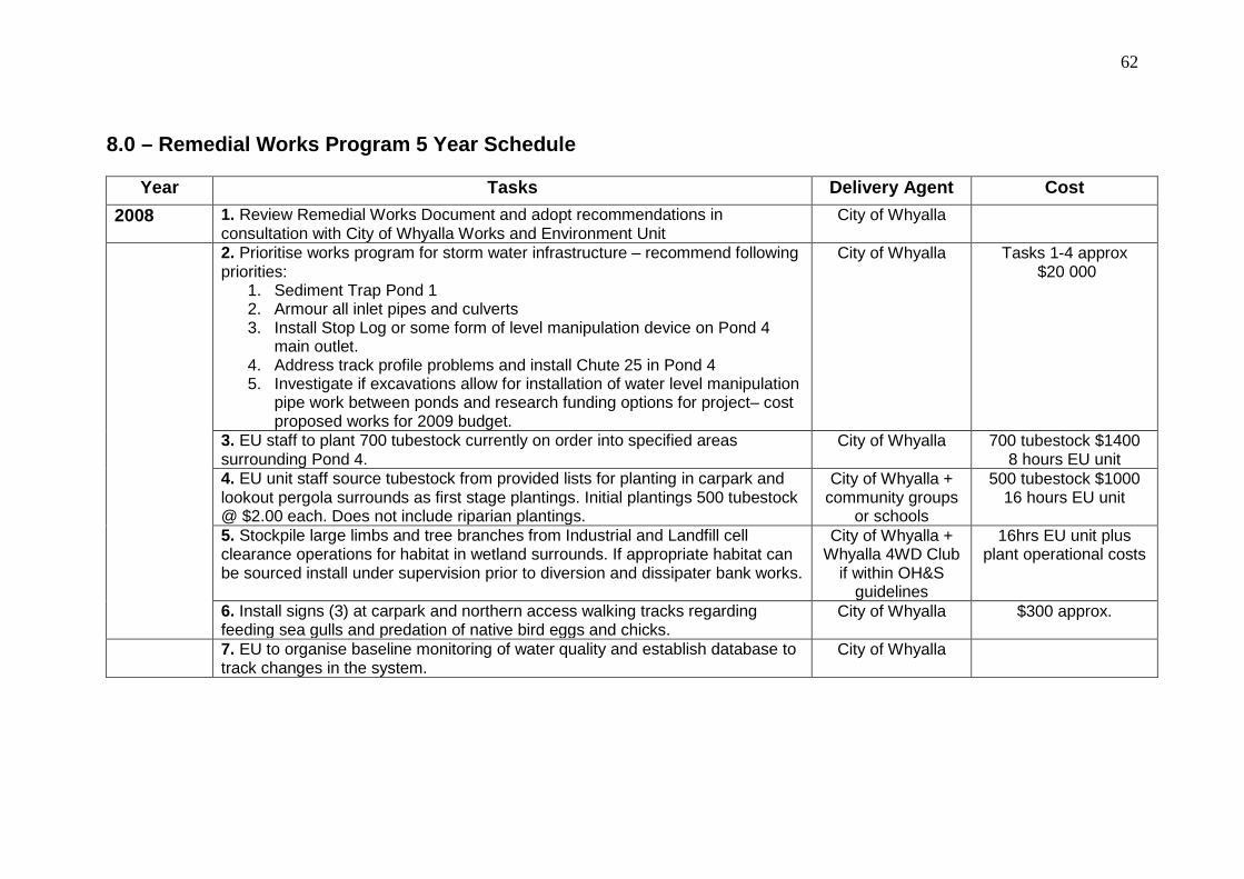
8.0 – Remedial Works Program 5 Year Schedule
Year Tasks Delivery Agent Cost 2008 1. Review Remedial Works Document and adopt recommendations in
consultation with City of Whyalla Works and Environment Unit City of Whyalla
2. Prioritise works program for storm water infrastructure – recommend following priorities:
1. Sediment Trap Pond 1 2. Armour all inlet pipes and culverts 3. Install Stop Log or some form of level manipulation device on Pond 4
main outlet. 4. Address track profile problems and install Chute 25 in Pond 4 5. Investigate if excavations allow for installation of water level manipulation
pipe work between ponds and research funding options for project– cost proposed works for 2009 budget.
City of Whyalla Tasks 1-4 approx $20 000
3. EU staff to plant 700 tubestock currently on order into specified areas surrounding Pond 4.
City of Whyalla 700 tubestock $1400 8 hours EU unit
4. EU unit staff source tubestock from provided lists for planting in carpark and lookout pergola surrounds as first stage plantings. Initial plantings 500 tubestock @ $2.00 each. Does not include riparian plantings.
City of Whyalla + community groups
or schools
500 tubestock $1000 16 hours EU unit
5. Stockpile large limbs and tree branches from Industrial and Landfill cell clearance operations for habitat in wetland surrounds. If appropriate habitat can be sourced install under supervision prior to diversion and dissipater bank works.
City of Whyalla + Whyalla 4WD Club
if within OH&S guidelines
16hrs EU unit plus plant operational costs
6. Install signs (3) at carpark and northern access walking tracks regarding feeding sea gulls and predation of native bird eggs and chicks.
City of Whyalla $300 approx.
7. EU to organise baseline monitoring of water quality and establish database to track changes in the system.
City of Whyalla

© L. Bebbington Habitat & Land Management Consultant (08) 8684 5065 [email protected]
63
Year Tasks Delivery Agent Cost
2009 1. Plan and survey sites for installation of water level manipulation pipe work concentrating on Pond 1 to 2 and Pond 1 to 4. Finalise installation of water level infrastructure prior to erosion control.
City of Whyalla As costed by C of W Works Supervisor.
2. Commence installation of diversion and dissipater banks as per document – prioritise Ponds 1,2 &4. Complete armouring of inlet drains not finalised in 2008 at same time. Works should proceed on a pond by pond basis followed by plantings to plan in specified areas with recommended species. Earthworks should be carried out using small excavator in preference to skid steers as skid steers will cause significant damage to existing vegetation.
City of Whyalla As costed by C of W Works Supervisor.
3. EU to liaise with Works Manager regarding timing of diversion bank works to enable the budgeting and purchase of suitable tube stock for planting programs following erosion control works. Tubestock will need to be ordered months in advance of planting programs as species required may not be readily available. Allow minimal costs of $2.50 per tubestock. Only order enough tube stock that can be planted out within targeted time frames and that can be maintained in one season.
City of Whyalla + community groups
in elevated terrestrial areas
Approximately 500-700 tube stock will be required per pond
surround as indicated in planting plan.
4. EU and C of W Programs Officer to liaise with schools and community groups such as Rotary to organise purchase of materials and manufacture of nest boxes. Install nest boxes with community groups in designated sites prior to onset of breeding season – ie. early winter.
City of Whyalla + community groups /
schools
<$1000 if majority of materials are provided by hardware chains at
cost price and manufacturing is part of school curriculum.
5. EU to establish monitoring programs and database for water monitoring in conjunction with schools that currently test water quality on an ad hoc basis. Good opportunity to establish a Whyalla Water Watch school group.
City of Whyalla Normal operational cost for EU
6. EU organise mulch from Landfill Recovery Centre for mulching bare areas prone to salinity. Mulching can be carried out in areas where erosion control has been completed prior to planting. Community groups and schools can assist in mulching areas prior to planting or spreading mulch in planted areas.
City of Whyalla + community / school
groups
Transport of mulch from Landfill site to
wetlands.
© L. Bebbington Habitat & Land Management Consultant (08) 8684 5065 [email protected]
64
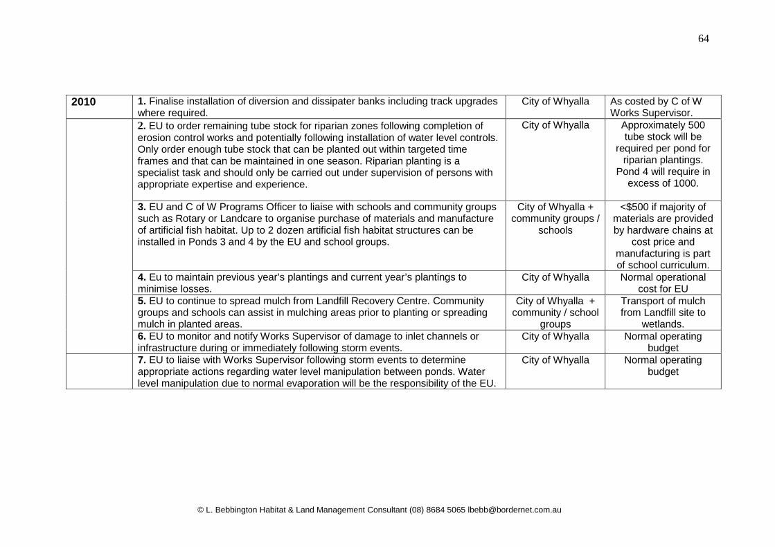
2010 1. Finalise installation of diversion and dissipater banks including track upgrades
where required. City of Whyalla As costed by C of W
Works Supervisor. 2. EU to order remaining tube stock for riparian zones following completion of
erosion control works and potentially following installation of water level controls. Only order enough tube stock that can be planted out within targeted time frames and that can be maintained in one season. Riparian planting is a specialist task and should only be carried out under supervision of persons with appropriate expertise and experience.
City of Whyalla Approximately 500 tube stock will be
required per pond for riparian plantings.
Pond 4 will require in excess of 1000.
3. EU and C of W Programs Officer to liaise with schools and community groups such as Rotary or Landcare to organise purchase of materials and manufacture of artificial fish habitat. Up to 2 dozen artificial fish habitat structures can be installed in Ponds 3 and 4 by the EU and school groups.
City of Whyalla + community groups /
schools
<$500 if majority of materials are provided by hardware chains at
cost price and manufacturing is part of school curriculum.
4. Eu to maintain previous year’s plantings and current year’s plantings to minimise losses.
City of Whyalla Normal operational cost for EU
5. EU to continue to spread mulch from Landfill Recovery Centre. Community groups and schools can assist in mulching areas prior to planting or spreading mulch in planted areas.
City of Whyalla + community / school
groups
Transport of mulch from Landfill site to
wetlands. 6. EU to monitor and notify Works Supervisor of damage to inlet channels or infrastructure during or immediately following storm events.
City of Whyalla Normal operating budget
7. EU to liaise with Works Supervisor following storm events to determine appropriate actions regarding water level manipulation between ponds. Water level manipulation due to normal evaporation will be the responsibility of the EU.
City of Whyalla Normal operating budget
© L. Bebbington Habitat & Land Management Consultant (08) 8684 5065 [email protected]
65
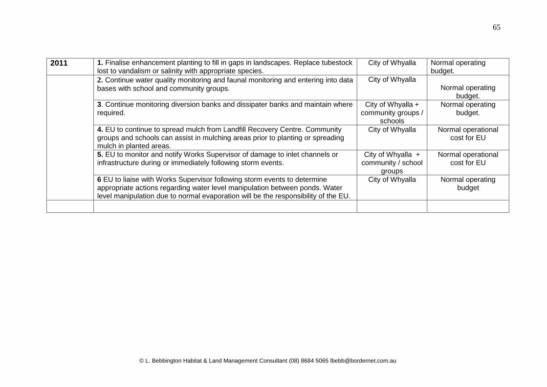
2011 1. Finalise enhancement planting to fill in gaps in landscapes. Replace tubestock lost to vandalism or salinity with appropriate species.
City of Whyalla Normal operating budget.
2. Continue water quality monitoring and faunal monitoring and entering into data bases with school and community groups.
City of Whyalla Normal operating
budget. 3. Continue monitoring diversion banks and dissipater banks and maintain where required.
City of Whyalla + community groups /
schools
Normal operating budget.
4. EU to continue to spread mulch from Landfill Recovery Centre. Community groups and schools can assist in mulching areas prior to planting or spreading mulch in planted areas.
City of Whyalla Normal operational cost for EU
5. EU to monitor and notify Works Supervisor of damage to inlet channels or infrastructure during or immediately following storm events.
City of Whyalla + community / school
groups
Normal operational cost for EU
6 EU to liaise with Works Supervisor following storm events to determine appropriate actions regarding water level manipulation between ponds. Water level manipulation due to normal evaporation will be the responsibility of the EU.
City of Whyalla Normal operating budget
© L. Bebbington Habitat & Land Management Consultant (08) 8684 5065 [email protected]
66
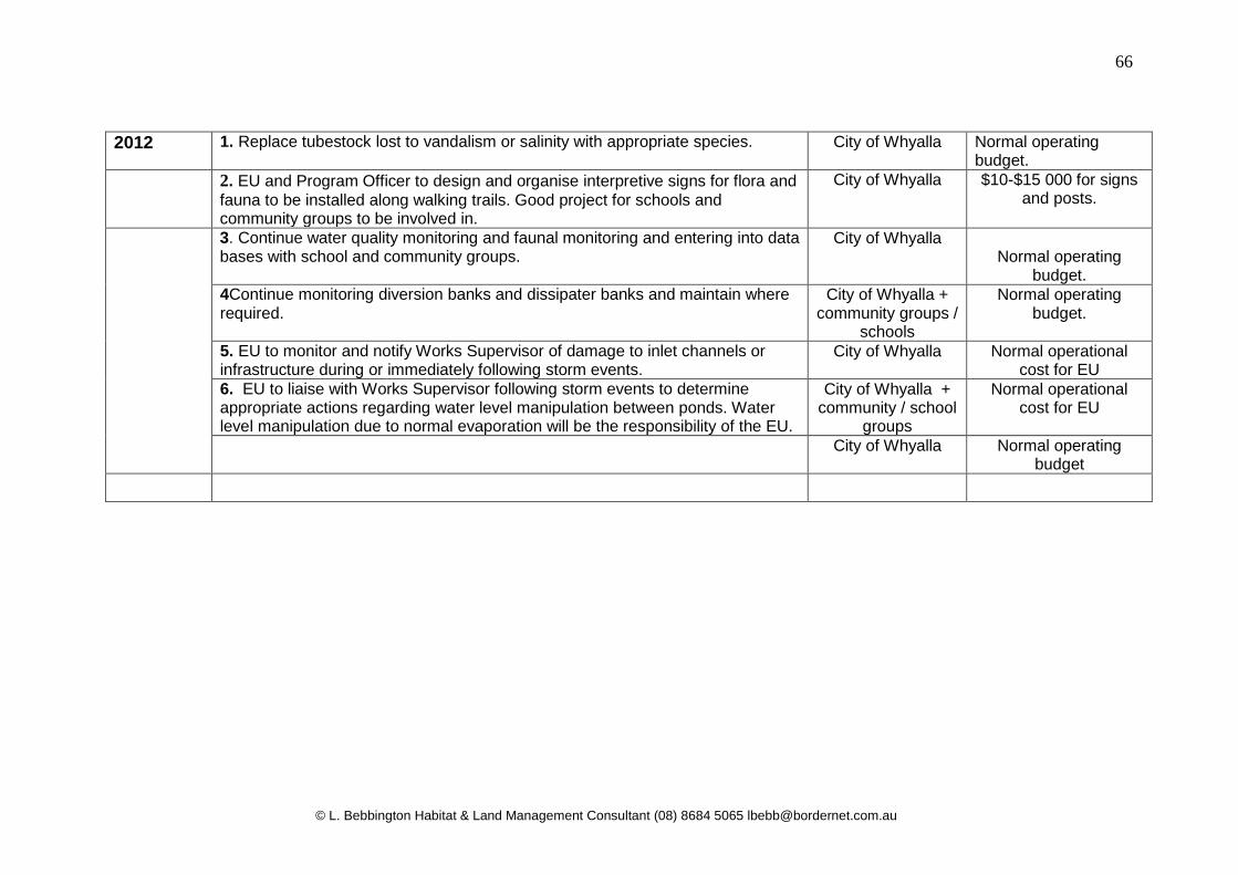
2012 1. Replace tubestock lost to vandalism or salinity with appropriate species. City of Whyalla Normal operating budget.
2. EU and Program Officer to design and organise interpretive signs for flora and fauna to be installed along walking trails. Good project for schools and community groups to be involved in.
City of Whyalla $10-$15 000 for signs and posts.
3. Continue water quality monitoring and faunal monitoring and entering into data bases with school and community groups.
City of Whyalla Normal operating
budget. 4Continue monitoring diversion banks and dissipater banks and maintain where required.
City of Whyalla + community groups /
schools
Normal operating budget.
5. EU to monitor and notify Works Supervisor of damage to inlet channels or infrastructure during or immediately following storm events.
City of Whyalla Normal operational cost for EU
6. EU to liaise with Works Supervisor following storm events to determine appropriate actions regarding water level manipulation between ponds. Water level manipulation due to normal evaporation will be the responsibility of the EU.
City of Whyalla + community / school
groups
Normal operational cost for EU
City of Whyalla Normal operating budget
67
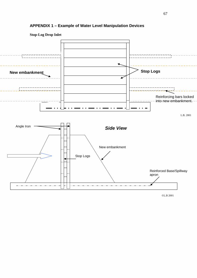
APPENDIX 1 – Example of Water Level Manipulation Devices Stop-Log Drop Inlet
Stop Logs
Reinforcing bars locked into new embankment.
New embankment
Side View
Reinforced Base/Spillway apron
Stop Logs
Angle Iron
New embankment
L.B. 2001
©L.B 2001
© L. Bebbington Habitat & Land Management Consultant (08) 8684 5065 [email protected]
68
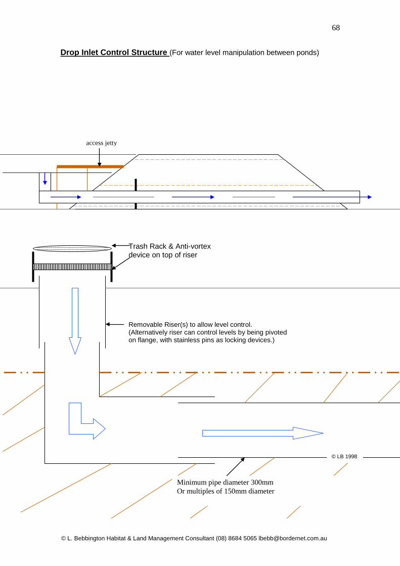
Drop Inlet Control Structure (For water level manipulation between ponds)
Trash Rack & Anti-vortex device on top of riser
Removable Riser(s) to allow level control. (Alternatively riser can control levels by being pivoted on flange, with stainless pins as locking devices.)
Minimum pipe diameter 300mm Or multiples of 150mm diameter
access jetty
© LB 1998

© L. Bebbington Habitat & Land Management Consultant (08) 8684 5065 [email protected]
69
APPENDIX 2 –Examples of Ripping and Wind Borne Seed Revegetation Techniques – Lake Malata Gypsum Mine Eyre Peninsula 2006
Recruitment of Samphire species post works © L. Bebbington 2008
Recruitment of Melaleuca halmaturorum / Samphire species © L. Bebbington 2008