real time parking study
DESCRIPTION
traffic engineeringTRANSCRIPT


FEASIBILITY STUDY OF REAL TIME PARKING INFORMATION AT METRORAIL PARKING
FACILITIES (VIRGINIA STATIONS)
FINAL REPORT
Prepared For: Washington Metropolitan Area Transit Authority
In Cooperation With Virginia Department of Transportation
Under the Commonwealth of Virginia
Office of Intermodal Planning and Investment Multimodal Planning Grant Program
Prepared By: Wilbur Smith Associates
Under Sub-Contract To: Michael Baker Jr., Inc.
June 2009

This study was made possible by the Federal Highway Administration (FHWA), the Commonwealth of Virginia
Multimodal Planning Grant Program and the Washington Metropolitan Area Transit Authority
(WMATA)

WMATA Real-Time Parking Information Feasibility Study
Page iii June 2009
Final Report
Table of Contents
CHAPTER 1 - INTRODUCTION Study Purpose................................................................................................................1-1 Study Tasks ...................................................................................................................1-1 Study Area .....................................................................................................................1-2 Report Presentation .......................................................................................................1-2
CHAPTER 2 – EXISTING PARKING CONDITIONS Regional Setting.............................................................................................................2-1 Parking Rates and Payment Options .............................................................................2-2 Data Collection...............................................................................................................2-4 Parking Inventory ...........................................................................................................2-4 Parking Facility Usage ...................................................................................................2-9
Parking Accumulation ................................................................................................2-9 All Stations .............................................................................................................2-9 Franconia/Springfield Parking Accumulation........................................................2-11 Vienna/Fairfax Parking Accumulation ..................................................................2-11 Van Dorn Parking Accumulation ..........................................................................2-14 West Falls Church Parking Accumulation ............................................................2-14
Entering Traffic.........................................................................................................2-17 Franconia/Springfield ...........................................................................................2-19 Vienna/Fairfax ......................................................................................................2-19 Van Dorn ..............................................................................................................2-19 West Falls Church................................................................................................2-19
Driveway Usage .......................................................................................................2-19 Summary and Conclusions ..........................................................................................2-24
CHAPTER 3 – BEST PRACTICES REVIEW Overview ........................................................................................................................3-1 Examples of APS Systems ............................................................................................3-2
Portland International Airport (PDX), Portland, Oregon .............................................3-2 Dallas/Fort Worth International Airport (DFW), Texas ...............................................3-3 Minneapolis/St. Paul International Airport (MSP), Minnesota ....................................3-3 Chicago Metra Park and Ride, near Chicago, Illinois.................................................3-3 City of St. Paul, Minnesota.........................................................................................3-3 Seattle Center, Seattle, Washington ..........................................................................3-4 City of Pittsburgh, Pennsylvania ................................................................................3-4 City of Santa Monica, California.................................................................................3-4 Baltimore Washington International Thurgood Marshall Airport (BWI),
Linthicum, Maryland..........................................................................................3-5 Bay Area Rapid Transit (BART), San Francisco/
Oakland Metropolitan Area, California ..............................................................3-7 Carpooling....................................................................................................................3-12
WMATA Experience.................................................................................................3-12

WMATA Real-Time Parking Information Feasibility Study
Page iv June 2009
General Observations ..............................................................................................3-13 Proposed Parking Program for Carpooling Users....................................................3-13
Summary......................................................................................................................3-14
CHAPTER 4 – REAL TIME PARKING TECHNOLOGY Goals, Objectives and Functional Requirements ...........................................................4-1 Detection Technology ....................................................................................................4-3
Level of Detection ......................................................................................................4-3 Vehicle Detection Technology....................................................................................4-4
Data Communication Technology..................................................................................4-8 Sensor to Processor...................................................................................................4-8 Processor to WMATA.................................................................................................4-9 WMATA to Traffic Management Agencies .................................................................4-9 Internal (within WMATA) ............................................................................................4-9
Communication Technologies for Traveler Information .................................................4-9 Dynamic Message Signs (DMS) ..............................................................................4-10 Internet Applications.................................................................................................4-10 Mobile Telephone / SMS Applications .....................................................................4-12 Interactive Voice Response .....................................................................................4-13 Highway Advisory Radio (HAR) ...............................................................................4-13 Wayfinding ...............................................................................................................4-13
Technology Summary ..................................................................................................4-14 System Software ......................................................................................................4-16 Detection Technology ..............................................................................................4-17 Communications Technology...................................................................................4-17 Traveler Information Technology .............................................................................4-17
CHAPTER 5 – OPTIONS AND PREFERRED SYSTEM FOR WMATA
Basic System Requirements ..........................................................................................5-1 Connectivity................................................................................................................5-1 Compatibility with Other Systems ..............................................................................5-2 Information Transmission Requirements ...................................................................5-2
Currently Existing Applications.......................................................................................5-3 WMATA Web and Mobile Device Interfaces ..............................................................5-3 WMATA Trip Planner .................................................................................................5-5 511 Virginia ................................................................................................................5-6 Trafficland ..................................................................................................................5-8 GPS and Navigation Information Vendors .................................................................5-8 WMATA Relationship with Value Added Resellers ....................................................5-8
Potential New Applications.............................................................................................5-8 Traveler Information Service Radio (TIS/HAR) ..........................................................5-9 EZ Pass Integration....................................................................................................5-9 Online Reservations System....................................................................................5-10 Handheld Devices and Mobile Telephones..............................................................5-12
Zone-level Detection vs. Space-level Detection...........................................................5-12 Zone-level Detection ................................................................................................5-12 Space-level Detection ..............................................................................................5-14
Detector Scenario Options ...........................................................................................5-15

WMATA Real-Time Parking Information Feasibility Study
Page v June 2009
Local Controller ............................................................................................................5-15 On-Site Traveler Information........................................................................................5-16
Highway Advisory Radio (HAR) ...............................................................................5-16 Dynamic Message Signs (DMS) ..............................................................................5-17
Station Communications Server...................................................................................5-17 Headquarters System ..................................................................................................5-17 Generic Station ............................................................................................................5-19 Preferred Concept........................................................................................................5-20
Vehicle Detection .....................................................................................................5-21 Data Communication................................................................................................5-21 Traveler Information .................................................................................................5-21
Operational Needs .......................................................................................................5-22 User Information...........................................................................................................5-23 Summary......................................................................................................................5-24
CHAPTER 6 – PILOT PROJECT CONCEPT Identify Pilot Study Station .............................................................................................6-2 General Design Considerations .....................................................................................6-3
System Overview .......................................................................................................6-3 System Operations.....................................................................................................6-7 Technologies Utilized .................................................................................................6-8 Communications ......................................................................................................6-15 High Level Computer Architecture ...........................................................................6-16
Requirements and Procurement Method .....................................................................6-17 Impacts on Existing System.........................................................................................6-18
Servers.....................................................................................................................6-18 Communications ......................................................................................................6-18 Staffing .....................................................................................................................6-18
Potential for Growth .....................................................................................................6-20 Costs ............................................................................................................................6-21 Funding ........................................................................................................................6-22
Payback/Benefits Perspective..................................................................................6-22 Potential New Funding Sources...............................................................................6-23
Marketing .....................................................................................................................6-24 Potential Market Segments ......................................................................................6-25 Outreach Methods....................................................................................................6-25
Deployment Issues and Procedures ............................................................................6-26 Design ......................................................................................................................6-26 Implementation Steps ..............................................................................................6-26 Evaluation Requirements .........................................................................................6-29 Applicability to Other Stations ..................................................................................6-30 Shifts in Facility Use over Time Based on Information Access ................................6-31


WMATA Real-Time Parking Information Feasibility Study
Chapter 1 INTRODUCTION
Page 1-1 June 2009
Study Purpose The Washington Metropolitan Area Transit Authority’s (WMATA’s) Metrorail system is an integral part of the regional transportation system. WMATA is committed to promoting regional mobility and accessibility and providing safe and convenient transit service through technology and management initiatives. The provision of real-time parking information at stations and on surrounding roads would offer innovative ways to enhance connectivity among Metrorail, Park and Ride lots, and the roadway system. It would also improve parking operations efficiency and help alleviate corridor congestion by making it more convenient for drivers to use Metrorail. As such, the purpose of the Metrorail Real Time Parking Information Feasibility Study is to identify the technological solution, best suited for WMATA, which will improve customer satisfaction by providing guidance to available parking spaces within a Metrorail station parking facility, with accuracy being the top priority.
Improved station access through real-time parking information applications reflects the transportation vision and goals of the National Capital Region Transportation Planning Board, in particular:
• Goal 2: The Washington metropolitan region will develop, implement, and maintain an interconnected transportation system that enhances quality of life and promotes a strong and growing economy throughout the entire region.
• Goal 4: The Washington metropolitan region will use the best available technology to maximize system effectiveness.
This study is being funded through the Commonwealth of Virginia’s Office of Intermodal Planning and Investment, Multimodal Planning Grant Program.
Study Tasks The primary objectives of this study are to:
• Assess existing parking conditions • Research best practices in real-time parking systems in other U.S. cities • Examine real-time parking technology options • Determine existing information applications at WMATA and the Virginia
Department of Transportation • Recommend changes, along with order of magnitude costs, to the WMATA
system to accommodate real-time parking information at the Northern Virginia stations
• Develop a conceptual pilot program that could be tested at a selected Virginia station
This study is to evaluate the feasibility of a real-time parking application for the Metrorail system, with the purpose of improving operations efficiency, reducing operating costs by providing guidance to available parking spaces, encouraging more transit usage and reducing congestion.

WMATA Real-Time Parking Information Feasibility Study
Chapter 1: INTRODUCTION
Page 1-2 June 2009
Study Area The focus of this study is on the potential feasibility of real-time parking information applications at four Virginia Metrorail stations, namely:
• Franconia/Springfield • Vienna/Fairfax • Van Dorn • West Falls Church
Report Presentation This report is a condensed compilation of a series of technical memoranda. The report covers the basic tasks, highlighting the proposed technology and the benefits of the real-time parking application. Subsequent chapters include:
• Chapter 2: Existing Parking Conditions • Chapter 3: Best Practices Review • Chapter 4: Real-Time Parking Technology • Chapter 5: Options and Preferred System for WMATA • Chapter 6: Pilot Project Concept
The technical memoranda that can be referred to for more information include:
• Existing Parking Conditions (July 9, 2008) • Evaluation of Practices in Real Time Parking Information (July 3, 2009) • Technical Memorandum Task 3B: Requirements and Technologies (March 2009) • Technical Memorandum Task 3C: Supporting Applications for Real-Time Parking
Information (March 2009) • Technical Memorandum Task 3D: System Concept for Generic WMATA Station
(May 2009) • Technical memorandum Task 4: Pilot Project Concept

WMATA Real-Time Parking Information Feasibility Study
Chapter 2 EXISTING PARKING CONDITIONS
Page 2-1 June 2009
WMATA operates more than 18,000 Park and Ride spaces in its system so that customers have access via personnel vehicles to the Metrorail stations in addition to other modes of access including bus, waling and bicycling. In Northern Virginia, WMATA has the Metrorail Orange, Blue, and Yellow lines that carry more than 170,000 daily boardings at the Virginia stations. The Orange Line reaches out along I-66 westwards towards Vienna and Fairfax, Virginia. The Blue Line extends essentially southward along US 1 and then west along I-495/I-95 (Capital Beltway) towards Springfield.
An inventory of existing conditions was performed in early 2008.
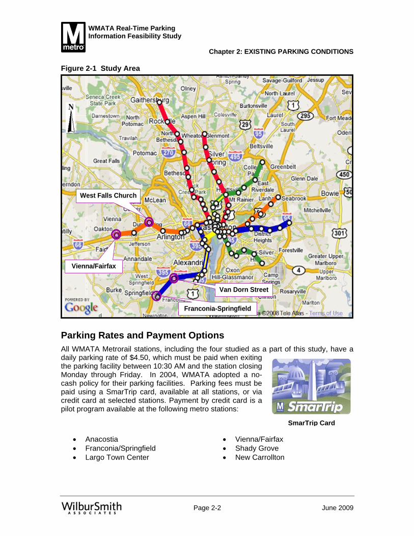
Regional Setting Four WMATA Metrorail stations were selected for detailed parking studies including:
• Franconia/Springfield on the Blue Line • Vienna/Fairfax on the Orange Line • Van Dorn on the Blue Line • West Falls Church on the Orange Line
Figure 2-1 depicts the location of these stations in their regional context. Both the Vienna/Fairfax and Franconia/Springfield stations are located outside the I-495 Capital Beltway, whereas the West Falls Church and Van Dorn stations are just inside the I-495 Capital Beltway. Interestingly, I-66 is HOV-2 eastbound from 6:30 AM to 9:00 AM and westbound from 4:00 PM to 6:30 PM inside the I-495 Capital Beltway; consequently, single occupancy vehicle commuters accessing the West Falls Church station from the peak direction of travel must do so via other routes or violate the HOV regulation.
This chapter addresses the relevance of real-time parking information applications through the assessment of existing parking conditions. The analysis showed that Park and Ride facilities at all four of the stations reach extremely high level of usage, resulting in potential delays for driving access to available parking spaces during the morning peak period. It is concluded that real-time parking information would help commuters at these stations.
WMATA Real-Time Parking Information Feasibility Study
Chapter 2: EXISTING PARKING CONDITIONS
Page 2-2 June 2009
Figure 2-1 Study Area
Parking Rates and Payment Options All WMATA Metrorail stations, including the four studied as a part of this study, have a daily parking rate of $4.50, which must be paid when exiting the parking facility between 10:30 AM and the station closing Monday through Friday. In 2004, WMATA adopted a no-cash policy for their parking facilities. Parking fees must be paid using a SmarTrip card, available at all stations, or via credit card at selected stations. Payment by credit card is a pilot program available at the following metro stations:
• Anacostia • Vienna/Fairfax • Franconia/Springfield • Shady Grove • Largo Town Center • New Carrollton
SmarTrip Card
Van Dorn Street
Franconia-Springfield
West Falls Church
Vienna/Fairfax

WMATA Real-Time Parking Information Feasibility Study
Chapter 2: EXISTING PARKING CONDITIONS
Page 2-3 June 2009
At these stations, one exit lane accepts major credit cards: Visa, MasterCard, American Express, Discover, and JCB International.
Reserved parking spaces are available at all of the WMATA Metrorail stations studied as part of this project. Reserved parking spaces cost $55 per month in addition to the $4.50 daily fee. The spaces are reserved from 2:00 AM until 10:00 AM, Monday through Friday, except on certain Federal holidays. After 10:00 AM, the reserved spaces are made available to regular customers. A customer with a reserved parking hangtag is not required to park in a reserved space. Vehicles displaying a current reserved parking hangtag may park for up to 10 days in a reserved space. Of the four WMATA metro stations studied, all but the Franconia/Springfield has a waiting list for reserved spaces.
No Cash Policy Reserved
Parking Sign WMATA Reserved Parking Hang Tag

WMATA Real-Time Parking Information Feasibility Study
Chapter 2: EXISTING PARKING CONDITIONS
Page 2-4 June 2009
Data Collection The data collection activities were comprised of:
• Confirming and breaking down the parking inventory by location and parking category
• Conducting a parking space vehicle occupancy study from 5:00 AM until 12:00 NOON (Hour Beginning) at 1 hour intervals and from 2:00 to 3:00 PM
• Counting traffic entering and exiting the parking facilities at 15 minute intervals from 12:00 MIDNIGHT until 2:30 PM
For the parking accumulation study, parked vehicles were recorded by their location within the parking facility and their classification: handicap, reserved, multi-day (available only at the Franconia/Springfield station), or unrestricted. The parking accumulation and entering/exiting data were collected on April 1, 2008, April 2, 2008, and April 3, 2008 – a Tuesday, Wednesday, and Thursday.
Parking Inventory Table 2-1 presents a summary inventory at the four WMATA Metrorail stations studied. Figures 2-2 to 2-5 are snapshots of each study site. Combined, the four stations contain 12,600 parking spaces with 82 percent, or 10,366, spaces located in parking garages. The Franconia/Springfield and Vienna/Fairfax stations have almost the same number of parking spaces at 5,120 and 5,160, respectively. Approximately 1.5 percent of all spaces surveyed are handicap, and they are generally located near the elevators in the parking garages or in convenient locations in the parking lots. All parking facilities, except the South Lot at Vienna/Fairfax, contain handicap parking. There are 1,477 reserved parking spaces at the four study sites that account for 11.7 percent of the total inventory. The vast majority of parking spaces (86.8 percent) at the study sites are unrestricted.
Franconia 5,120 Handicap 191 Garage 10,366 Vienna 5,160 Reserved 1,477 Lot 2,234 Van Dorn 341 WMATA 1 TOTAL 12,600 West Falls Church 1,979 Unrestricted 10,902 TOTAL 12,600 Multiday 29
TOTAL 12,600
Station Type LocationTable 2-1 Summary of Parking Inventory

WMATA Real-Time Parking Information Feasibility Study
Chapter 2: EXISTING PARKING CONDITIONS
Page 2-5 June 2009
Figure 2-2 Franconia/Springfield Station Parking Inventory Spaces: 5,120
West Garage
East Garage
Sub-total
Handicap 52 15 67 Reserved* 525 13 538 WMATA 1 - 1 Unrestricted 3,459 1,026 4,485 Multiday 29 - 29 TOTAL 4,066 1,054 5,120 The two garages are joined together with driveways between the two on most levels. The East Garage contains some Kiss and Ride and taxi parking spaces on the south section of the ground floor that were not surveyed. Multi-day parking spaces are located in the first level of the West Garage on the west outside row. A large percent of the reserved parking spaces are located on the second level.
WestGarage
4066 Spaces
EastGarage
1054 Spaces
* Note: In 2008, WMATA’s Parking office reduced the number of reserved spaces after the parking inventory was completed.

WMATA Real-Time Parking Information Feasibility Study
Chapter 2: EXISTING PARKING CONDITIONS
Page 2-6 June 2009
Figure 2-3 Vienna/Fairfax Station Parking Inventory Spaces: 5,160
North Garage
South Garage
North Lot
South Lot
Sub-total
Handicap 19 40 12 - 71 Reserved 271 241 77 136 725 WMATA - - - - - Unrestricted 1,574 1,904 390 496 4,364Multiday - - - - - TOTAL 1,864 2,185 479 632 5,160 Most of the reserved spaces are located on Level 3 of the North Garage and Level 4 of the South Garage. The South Lot has a reserved area that is separated from the unrestricted spaces by a gate. The North Lot contains 77 reserved spaces located in the northwest corner.
North Garage1864 Spaces
South Garage
2185 Spaces
South Lot632 Spaces
North Lot479 Spaces

WMATA Real-Time Parking Information Feasibility Study
Chapter 2: EXISTING PARKING CONDITIONS
Page 2-7 June 2009
Figure 2-4 Van Dorn Station Parking Inventory Spaces: 341
LotHandicap 8Reserved 60WMATA 0Unrestricted 273Multiday 0TOTAL 341 All of the reserved spaces are clustered in the first two rows of parking beyond the driveway.
Lot 341
Spaces

WMATA Real-Time Parking Information Feasibility Study
Chapter 2: EXISTING PARKING CONDITIONS
Page 2-8 June 2009
Figure 2-5 West Falls Church Station Parking Inventory Spaces: 1,979
East Lot West Lot GarageSub-total
Handicap 12 7 26 45 Reserved - - 154 154 WMATA - - - - Unrestricted 490 273 1,017 1,780 Multiday - - - - TOTAL 502 280 1,197 1,979 Of all four sites studied, West Falls Church provides the smallest percent of reserved parking spaces at 7.8 percent. All 154 reserved parking spaces are on the first level of the parking garage. Some commuters elect to park at the nearby Virginia Tech/ University of Virginia Northern Virginia Center where they are charged $4.50 per day or pay a monthly rate of $60. A daily fee charge is not assessed on top of the monthly rate of $60.
West Lot
280 Spaces
Garage
1197 Spaces
East Lot502 Spaces

WMATA Real-Time Parking Information Feasibility Study
Chapter 2: EXISTING PARKING CONDITIONS
Page 2-9 June 2009
Parking Facility Usage In the parking industry, an occupancy level of 90 percent is often considered the practical capacity of a parking facility. This level of usage takes into consideration the inefficiencies associated with a parking facility, like a vehicle consuming two spaces, and considers the difficulties of finding an empty space in a very crowded facility. The WMATA Park and Ride facilities demonstrated a measured practical capacity well in excess of 90 percent, probably because the users repeat their routine day after day and know generally where to find a space. This fact not withstanding, during the field visits frustrated parking facility users were observed searching for a space. Recognizing a practical capacity is worthwhile in terms of planning, but because of familiar users, it should probably be set at 95 percent. Note however, that one of the primary reasons for a parking information system is to maximize parking capacity and guide consumers to those difficult to find parking spaces.
Parking Accumulation The accumulation data were recorded by location (lot or garage) and floor within the garage and by type of user. More detailed information was developed by taking a beginning accumulation count and then using data from the mechanical driveway counts of entering and exiting vehicles to derive accumulation by 15-minute period.
All Stations Tables 2-2 and 2-3 present accumulation information for all four stations, first by type of space, and then by station, respectively. At the four survey sites parking accumulation is extremely high with mid-morning levels routinely exceeding the practical capacity of 95 percent. The surveys found that there are very few empty parking spaces during peak hours.
By the hour period beginning at 9:00 AM almost 90 percent of spaces were occupied. The number of available spaces continues to decrease throughout the morning. By mid-day, peak occupancy has been reached (97 percent) and only 324 spaces were available at all four stations combined. Of the 324 empty spaces, 230 are reserved spaces.
After 10:00 AM commuters find it difficult to find an empty parking space in most of the facilities. Vienna/Fairfax was operating above capacity from 10:00 AM until 1:00 PM and both Van Dorn and West Falls Church were generally above 97 percent occupancy. Considering all parking spaces, the overall peak accumulation of parked vehicles occurs from 12:00 NOON to 1:00 PM when 12,276 parked vehicles were recorded, which is an occupancy level of 97.4 percent.
While the WMATA Metrorail station Park and Ride system operates at an extremely high level of efficiency, there are several benefits to increasing parking usage to a level that is even greater than exists today. These benefits include increased revenue, greater Metrorail ridership, and less traffic congestion.

WMATA Real-Time Parking Information Feasibility Study
Chapter 2: EXISTING PARKING CONDITIONS
Page 2-10 June 2009
Hou
r Beg
inni
ng#
%#
%#
%#
%#
%#
%5
AM
16
8.4%
21
1.
4%0
0.0%
655
6.0%
24
82
.8%
716
5.
7%6
AM
33
17.3
%44
3.0%
00.
0%1,
721
15
.8%
25
86
.2%
1,82
3
14
.5%
7 A
M79
41
.4%
147
10
.0%
00.
0%4,
839
44
.4%
27
93
.1%
5,09
2
40
.4%
8 A
M11
0
57.6
%40
1
27.1
%0
0.0%
8,40
5
77.1
%23
79.3
%8,
939
70.9
%9
AM
145
75
.9%
746
50
.5%
110
0.0%
10,4
15
95.5
%25
86.2
%11
,332
89
.9%
10 A
M15
4
80.6
%1,
118
75.7
%1
100.
0%10
,785
98
.9%
24
82
.8%
12,0
82
95.9
%11
AM
154
80
.6%
1,19
6
81
.0%
00.
0%10
,828
99
.3%
25
86
.2%
12,2
03
96.8
%12
NO
ON
156
81
.7%
1,24
7
84
.4%
110
0.0%
10,8
4899
.5%
24
82
.8%
12,2
76
97.4
%2
PM
152
79
.6%
1,24
7
84
.4%
00.
0%10
,717
98
.3%
25
86
.2%
12,1
41
96.4
%In
vent
ory
10,9
02
Tabl
e 2-
2 P
arki
ng A
ccum
ulat
ion
at A
ll Fo
ur S
tatio
ns B
y Ty
pe S
pace
Han
dica
pped
Res
erve
dW
MAT
AU
nres
tric
ted
Mul
tiday
Tota
l
2912
,600
191
1,47
71
Hou
r Beg
inni
ng#
%#
%#
%#
%#
%5
AM29
3
5.7%
252
4.
9%12
135
.5%
50
2.5%
716
5.
7%6
AM72
8
14.2
%81
3
15.8
%14
442
.2%
138
7.0%
1,82
3
14
.5%
7 AM
2,05
3
40
.1%
2,34
3
45
.4%
271
79.5
%42
5
21
.5%
5,09
2
40
.4%
8 AM
3,65
1
71
.3%
3,91
1
75
.8%
296
86.8
%1,
081
54
.6%
8,93
9
70
.9%
9 AM
4,32
0
84
.4%
4,92
1
95
.4%
311
91.2
%1,
780
89
.9%
11,3
32
89
.9%
10 A
M4,
642
90.7
%5,
164
100.
1%33
197
.1%
1,94
5
98.3
%12
,082
95.9
%11
AM
4,75
2
92
.8%
5,16
4
10
0.1%
339
99.4
%1,
948
98
.4%
12,2
03
96
.8%
12 N
OO
N4,
836
94.5
%5,
168
100.
2%33
798
.8%
1,93
5
97.8
%12
,276
97
.4%
2 PM
4,78
0
93
.4%
5,08
3
98
.5%
339
99.4
%1,
939
98
.0%
12,1
41
96
.4%
Inve
ntor
y
Fran
coni
aVi
enna
Van
Dor
nW
est F
alls
Chu
rch
Tota
l
12,6
00
Tabl
e 2-
3 P
arki
ng A
ccum
ulat
ion
at A
ll Fo
ur S
tatio
ns B
y St
atio
n
5,12
05,
160
341
1,97
9

WMATA Real-Time Parking Information Feasibility Study
Chapter 2: EXISTING PARKING CONDITIONS
Page 2-11 June 2009
Franconia/Springfield Parking Accumulation Figure 2-6 indicates that some empty spaces are available at this station, but many are reserved spaces. As expected based on the lack of a waiting list, the reserved parking spaces did not fill up and had a maximum accumulation of only 36.2 percent prior to 10:00 AM. The reserved spaces reached a maximum accumulation of only 61.7 percent between 2:00 and 3:00 PM. By contrast, the unrestricted spaces exceeded a 90 percent occupancy level at 9:00 AM and climbed to 98.9 percent usage between 12:00 NOON and 1:00 PM.
The reserved parking spaces at the Franconia/Springfield facilities are almost all clustered on the second level of the West Garage. The modest jump in usage of the reserved spaces from 10:00 AM to 11:00 AM suggests one of two things. Either the reserved spaces are not perceived to be any more convenient than the unrestricted spaces, or many commuters are not aware of the fact that these spaces are available to everyone after 10:00 AM. Between 10:00 and 11:00 AM, 48 percent of the reserved spaces were full and it increases to only 57.4 percent from 12:00 NOON until 1:00 PM. One-hundred fourteen vehicles arrived and parked in the reserved spaces after 10:00 AM compared with 80 that arrived and parked at the unrestricted spaces.
Figure 2-6 demonstrates the accelerated pace at which the Franconia/Springfield facility fills up. At 7:15 AM there were 2,759 parked vehicles representing an occupancy rate of almost 54 percent. By 9:30 AM over 85 percent (4,363 vehicles) of the parking spaces were occupied. By 11:30 AM the facilities are at 94 percent of their overall capacity and at 12:45 PM they reach their practical capacity of 95 percent when 4,865 parked vehicles were calculated.
Vienna/Fairfax Parking Accumulation Parking usage at the Vienna/Fairfax Metrorail station is extremely high from 9:00 AM until the last survey period, 2:00 to 3:00 PM, as shown in Figure 2-7. Parked vehicles were observed in unmarked spaces on the roof of the South Garage after 10:00 AM and Fairfax County police officers were writing tickets to the violators. Lot full signs are manually moved to the entrances but seem to be sometimes too late to prevent cars entering the facilities when there is not a parking space. At the 7:00 to 8:00 AM interval, 45.8 percent of all spaces were occupied and the occupancy increases to 76.4 percent from 8:00 to 9:00 AM.
The graphic in Figure 2-7 depicts the high level of parking facility congestion experienced at the Vienna/Fairfax Metrorail station. As noted above, the 8:00 to 9:00 AM period had a measured accumulation of 76.4 percent, but from 9:15 to 9:30 AM the overall occupancy reached 96 percent with 4,960 parked vehicles.

WMATA Real-Time Parking Information Feasibility Study
Chapter 2: EXISTING PARKING CONDITIONS
Page 2-12 June 2009
Figure 2-6 Franconia/Springfield Station Parking Accumulation Spaces: 5,120 Peak Accumulation: 4,865 between 12 NOON and 1 PM, representing 95 percent occupancy
Hour Beginning # % # % # % # % # % # %5 AM 10 14.9% 6 1.1% 0 0.0% 253 5.6% 24 82.8% 293 5.7%6 AM 18 26.9% 9 1.7% 0 0.0% 676 15.1% 25 86.2% 728 14.2%7 AM 37 55.2% 28 5.2% 0 0.0% 1,961 43.7% 27 93.1% 2,053 40.1%8 AM 50 74.6% 89 16.5% 0 0.0% 3,489 77.8% 23 79.3% 3,651 71.3%9 AM 67 100.0% 130 24.2% 1 100.0% 4,097 91.3% 25 86.2% 4,320 84.4%10 AM 66 98.5% 195 36.2% 1 100.0% 4,356 97.1% 24 82.8% 4,642 90.7%11 AM 63 94.0% 258 48.0% 0 0.0% 4,406 98.2% 25 86.2% 4,752 92.8%12 NOON 66 98.5% 309 57.4% 1 100.0% 4,436 98.9% 24 82.8% 4,836 94.5%2 PM 64 95.5% 332 61.7% 0 0.0% 4,359 97.2% 25 86.2% 4,780 93.4%Inventory
Parking AccumulationMultiday
29
Total
5,120
WMATA
1
Unrestricted
4,48567
Handicapped Reserved
538 Parking Accumulation by 15 Minutes
0
1000
2000
3000
4000
5000
6000
5:15
AM
5:30
AM
5:45
AM
6:00
AM
6:15
AM
6:30
AM
6:45
AM
7:00
AM
7:15
AM
7:30
AM
7:45
AM
8:00
AM
8:15
AM
8:30
AM
8:45
AM
9:00
AM
9:15
AM
9:30
AM
9:45
AM
10:0
0 A
M10
:15
AM
10:3
0 A
M10
:45
AM
11:0
0 A
M11
:15
AM
11:3
0 A
M11
:45
AM
12:0
0 P
M12
:15
PM
12:3
0 P
M12
:45
PM
1:00
PM
1:15
PM
1:30
PM
1:45
PM
2:00
PM
Time - Period Beginning
Num
ber o
f Veh
icle
s
Capacity: 5120 Spaces
27592759
43634363
4865
2759
4363
2759
4363
2759
4865
4363
2759
4865
4363
2759

WMATA Real-Time Parking Information Feasibility Study
Chapter 2: EXISTING PARKING CONDITIONS
Page 2-13 June 2009
Figure 2-7 Vienna/Fairfax Station Parking Accumulation Spaces: 5,160 Peak Accumulation: 5,168 between 12 NOON and 1 PM, representing 100.9 percent occupancy
Hour Beginning # % # % # % # % # % # %5 AM 5 7.0% 9 1.2% 0 0.0% 238 5.5% 0 0.0% 252 4.9%6 AM 13 18.3% 24 3.3% 0 0.0% 776 17.8% 0 0.0% 813 15.9%7 AM 35 49.3% 95 13.1% 0 0.0% 2,213 50.7% 0 0.0% 2,343 45.8%8 AM 48 67.6% 232 32.0% 0 0.0% 3,631 83.2% 0 0.0% 3,911 76.4%9 AM 56 78.9% 500 69.0% 0 0.0% 4,365 100.0% 0 0.0% 4,921 96.1%10 AM 64 90.1% 725 100.0% 0 0.0% 4,375 100.3% 0 0.0% 5,164 100.9%11 AM 66 93.0% 725 100.0% 0 0.0% 4,373 100.2% 0 0.0% 5,164 100.9%12 NOON 65 91.5% 725 100.0% 0 0.0% 4,378 100.3% 0 0.0% 5,168 100.9%2 PM 62 87.3% 702 96.8% 0 0.0% 4,319 99.0% 0 0.0% 5,083 99.3%Inventory
Multiday Total
71 725 0 4,364 0 5,160
Handicapped Reserved WMATA UnrestrictedParking Accumulation
Parking Accumulation by 15 Minutes
0
1000
2000
3000
4000
5000
6000
5:15
AM
5:30
AM
5:45
AM
6:00
AM
6:15
AM
6:30
AM
6:45
AM
7:00
AM
7:15
AM
7:30
AM
7:45
AM
8:00
AM
8:15
AM
8:30
AM
8:45
AM
9:00
AM
9:15
AM
9:30
AM
9:45
AM
10:0
0 A
M10
:15
AM
10:3
0 A
M10
:45
AM
11:0
0 A
M11
:15
AM
11:3
0 A
M11
:45
AM
12:0
0 P
M12
:15
PM
12:3
0 P
M12
:45
PM
1:00
PM
1:15
PM
1:30
PM
1:45
PM
2:00
PM
Time - Period Beginning
Num
ber o
f Veh
icle
s
Capacity: 5160 Spaces
5143
2489
4960

WMATA Real-Time Parking Information Feasibility Study
Chapter 2: EXISTING PARKING CONDITIONS
Page 2-14 June 2009
Van Dorn Parking Accumulation The parking spaces at the Van Dorn Metrorail station are in high demand with unrestricted spaces reaching capacity between 8:00 and 9:00 AM and staying full or almost full until 3:00 PM when the data collection activities were completed, as shown in Figure 2-8. Some parkers did take advantage of the availability of reserved parking spaces after 10:00 AM because usage jumped from 86.7 percent in the hour beginning at 10:00 AM to 100 percent in the hour beginning at 11:00 AM. Approximately one month prior to the data collection activities, a field review was undertaken of all the study sites including Van Dorn. At approximately 2:00 PM, the reserved spaces were fully occupied but only 21 of the 60 vehicles had a reserved monthly parking permit and there were 11 vehicles with parking tickets. These observations suggest that some abuse of the reserved parking spaces occurs, but many of the parkers using the spaces arrived after 10:00 AM.
West Falls Church Parking Accumulation The accumulation of parked vehicles at the West Falls Church station starts slower than at the other three sites and gradually builds towards near capacity conditions. Between 7:00 and 8:00 AM, only 21.5 percent of the spaces were occupied as compared with 79.5 percent at Van Dorn, 45.8 percent at Vienna/Fairfax, and 40.1 percent at Franconia/Springfield. Overall occupancy levels reach 89.9 percent from 9:00 until 10:00 AM and then climb to percentages in the high 90’s thereafter. Unrestricted spaces reach their actual capacity from 10:00 to 11:00 AM and then decrease slightly with a few unoccupied spaces from 11:00 AM until the completion of the count at 3:00 PM. Figure 2-9 presents a summary of the hour-by-hour count of parked vehicles at the West Falls Church Metrorail station.

WMATA Real-Time Parking Information Feasibility Study
Chapter 2: EXISTING PARKING CONDITIONS
Page 2-15 June 2009
Figure 2-8 Van Dorn Station Parking Accumulation Spaces: 341 Peak Accumulation: 339 between 11 AM and 12 NOON, representing 99.4 percent occupancy
Hour Beginning # % # % # % # % # % # %5 AM - 0.0% 5 8.3% 0 0.0% 116 42.5% 0 0.0% 121 35.5%6 AM - 0.0% 9 15.0% 0 0.0% 135 49.5% 0 0.0% 144 42.2%7 AM 2 25.0% 14 23.3% 0 0.0% 255 93.4% 0 0.0% 271 79.5%8 AM 4 50.0% 19 31.7% 0 0.0% 273 100.0% 0 0.0% 296 86.8%9 AM 5 62.5% 33 55.0% 0 0.0% 273 100.0% 0 0.0% 311 91.2%10 AM 6 75.0% 52 86.7% 0 0.0% 273 100.0% 0 0.0% 331 97.1%11 AM 6 75.0% 60 100.0% 0 0.0% 273 100.0% 0 0.0% 339 99.4%12 NOON 6 75.0% 60 100.0% 0 0.0% 271 99.3% 0 0.0% 337 98.8%2 PM 7 87.5% 60 100.0% 0 0.0% 272 99.6% 0 0.0% 339 99.4%Inventory 0 3418 60 0 273
Parking AccumulationHandicapped Reserved WMATA Unrestricted Multiday Total
Parking Accumulation by 15 Minutes
0
50
100
150
200
250
300
350
400
5:00
AM
5:15
AM
5:30
AM
5:45
AM
6:00
AM
6:15
AM
6:30
AM
6:45
AM
7:00
AM
7:15
AM
7:30
AM
7:45
AM
8:00
AM
8:15
AM
8:30
AM
8:45
AM
9:00
AM
9:15
AM
9:30
AM
9:45
AM
10:0
0 AM
10:1
5 AM
10:3
0 AM
10:4
5 AM
11:0
0 AM
11:1
5 AM
11:3
0 AM
11:4
5 AM
12:0
0 PM
12:1
5 PM
12:3
0 PM
12:4
5 PM
1:00
PM
1:15
PM
1:30
PM
1:45
PM
2:00
PM
Time - Period Beginning
Num
ber o
f Veh
icle
s
Capacity: 341 Spaces
338
307
320

WMATA Real-Time Parking Information Feasibility Study
Chapter 2: EXISTING PARKING CONDITIONS
Page 2-16 June 2009
Figure 2-9 West Falls Church Station Parking Accumulation Spaces: 1,979 Peak Accumulation: 1,948 between 11 AM and 12 NOON, representing 98.4 percent occupancy
Hour Beginning # % # % # % # % # % # %5 AM 1 2.2% 1 0.6% 0 0.0% 48 2.7% 0 0.0% 50 2.5%6 AM 2 4.4% 2 1.3% 0 0.0% 134 7.5% 0 0.0% 138 7.0%7 AM 5 11.1% 10 6.5% 0 0.0% 410 23.0% 0 0.0% 425 21.5%8 AM 8 17.8% 61 39.6% 0 0.0% 1,012 56.9% 0 0.0% 1,081 54.6%9 AM 17 37.8% 83 53.9% 0 0.0% 1,680 94.4% 0 0.0% 1,780 89.9%10 AM 18 40.0% 146 94.8% 0 0.0% 1,781 100.1% 0 0.0% 1,945 98.3%11 AM 19 42.2% 153 99.4% 0 0.0% 1,776 99.8% 0 0.0% 1,948 98.4%12 NOON 19 42.2% 153 99.4% 0 0.0% 1,763 99.0% 0 0.0% 1,935 97.8%2 PM 19 42.2% 153 99.4% 0 0.0% 1,767 99.3% 0 0.0% 1,939 98.0%Inventory 0 1,97945 154 0 1,780
Parking AccumulationHandicapped Reserved WMATA Unrestricted Multiday Total
Parking Accumulation by 15 Minutes
0
500
1000
1500
2000
2500
5:00
AM
5:15
AM
5:30
AM
5:45
AM
6:00
AM
6:15
AM
6:30
AM
6:45
AM
7:00
AM
7:15
AM
7 :30
AM
7:45
AM
8:0 0
AM
8:15
AM
8:30
AM
8:45
AM
9:00
AM
9:15
AM
9:30
AM
9:45
AM
10:0
0 A
M10
:15
AM
10:3
0 A
M10
:45
AM
11:0
0 A
M11
:15
AM11
:30
AM11
:45
AM12
:00
PM12
:15
PM
12: 3
0 P
M12
:45
PM
1:00
PM
1:15
PM
1:30
PM
1:45
PM
2:00
PM
2:15
PM
Time - Period Beginning
Num
ber o
f Veh
icle
s
Capacity: 1979 Spaces
872
19211948

WMATA Real-Time Parking Information Feasibility Study
Chapter 2: EXISTING PARKING CONDITIONS
Page 2-17 June 2009
Entering Traffic Currently, the gates at each of the garages/lots are open until the parking contractor arrives somewhere around 10:00 AM. Once the parking contractor arrives they review the garage/lot for available spaces. If there are no spaces available, the contractor will place a “Lot Full” sign in the entrance roadway. Over the course of the day, the parking contractor will drive through the garages and lots to determine whether there are available parking spaces. If the determination is made there are enough spaces available, the contractor will remove the signs until the next time the lot fills up. Drivers in the parking lot at 10:30 AM or later must pay to exit the parking facility. Figure 2-10 shows the entering traffic patterns at all four stations combined. Figure 2-11 shows the same information for each individual station.
Figure 2-10 Entering Traffic at All Stations
0
200
400
600
800
1000
1200
5:00
AM
5:15
AM
5:30
AM
5:45
AM
6:00
AM
6:15
AM
6:30
AM
6:45
AM
7:00
AM
7:15
AM
7:30
AM
7:45
AM
8:00
AM
8:15
AM
8:30
AM
8:45
AM
9:00
AM
9:15
AM
9:30
AM
9:45
AM
10:0
0 A
M
10:1
5 A
M
10:3
0 A
M
10:4
5 A
M
11:0
0 A
M
11:1
5 A
M
11:3
0 A
M
11:4
5 A
M
12:0
0 P
M
12:1
5 P
M
12:3
0 P
M
12:4
5 P
M
1:00
PM
1:15
PM
1:30
PM
1:45
PM
2:00
PM
Time - Period Beginning
Num
ber o
f Ent
erin
g Ve
hicl
es
Peak Hour: 6:45-7:45 AM; 1141

WMATA Real-Time Parking Information Feasibility Study
Chapter 2: EXISTING PARKING CONDITIONS
Page 2-18 June 2009
050100
150
200
250
300
350
400
450
4:00 AM
4:30 AM
5:00 AM
5:30 AM
6:00 AM
6:30 AM
7:00 AM
7:30 AM
8:00 AM
8:30 AM
9:00 AM
9:30 AM
10:00 AM
10:30 AM
11:00 AM
11:30 AM
12:00 PM
12:30 PM
1:00 PM
1:30 PM
2:00 PM
Tim
e - P
erio
d B
egin
ning
Number of Entering Vehicles
Peak
Hou
r: 6
:45-
7:45
AM
; 42
242
2
Fran
coni
a/Sp
ringf
ield
01020304050607080
5:00 AM
5:15 AM
5:30 AM
5:45 AM
6:00 AM
6:15 AM
6:30 AM
6:45 AM
7:00 AM
7:15 AM
7:30 AM
7:45 AM
8:00 AM
8:15 AM
8:30 AM
8:45 AM
9:00 AM
9:15 AM
9:30 AM
9:45 AM
10:00 AM
10:15 AM
10:30 AM
10:45 AM
11:00 AM
11:15 AM
11:30 AM
11:45 AM
12:00 PM
12:15 PM
12:30 PM
12:45 PM
1:00 PM
1:15 PM
1:30 PM
1:45 PM
Tim
e - P
erio
d B
egin
ning
Number of Entering Vehicles
68Pe
ak H
our:
6:0
0-7:
00 A
M; 1
83
050100
150
200
250
5:00 A
M 5:15 A
M 5:30 A
M 5:45 A
M 6:00 A
M 6:15 A
M 6:30 A
M 6:45 A
M 7:00 A
M 7:15 A
M 7:30 A
M 7:45 A
M 8:00 A
M 8:15 A
M 8:30 A
M 8:45 A
M 9:00 A
M 9:15 A
M 9:30 A
M 9:45 A
M 10:00
AM 10:15
AM 10:30
AM 10:45
AM 11:00
AM 11:15
AM 11:30
AM 11:45
AM 12
:00 PM 12
:15 P
M 12:30
PM 12:45
PM 1:00 P
M 1:15 P
M 1:30 P
M 1:45 P
M 2:00 P
M 2:15 P
M
Tim
e -P
erio
d B
egin
ning
Number of Entering Vehicles
Peak
Hou
r: 7
:15-
8:15
AM
; 868
230
230
Peak
Hou
r: 7
:15-
8:15
AM
; 868
230
050100
150
200
250
300
350
400
450
500
5:00 AM
5:15 AM
5:30 AM
5:45 AM
6:00 AM
6:15 AM
6:30 AM
6:45 AM
7:00 AM
7:15 AM
7:30 AM
7:45 AM
8:00 AM
8:15 AM
8:30 AM
8:45 AM
9:00 AM
9:15 AM
9:30 AM
9:45 AM
10:00 AM
10:15 AM
10:30 AM
10:45 AM
11:00 AM
11:15 AM
11:30 AM
11:45 AM
12:00 PM
12:15 PM
12:30 PM
12:45 PM
1:00 PM
1:15 PM
1:30 PM
1:45 PM
2:00 PM
Tim
e - P
erio
d B
egin
ning
Number of Entering Vehicles
Tota
lN
orth
Gar
age
Nor
th L
otS
outh
Gar
age
Sou
th L
ot
473
Peak
Hou
r: 6
:45-
7:45
AM
;
Figu
re 2
-11
Ent
erin
g Tr
affic
Pat
tern
s at
All
Stat
ions
Wes
t Fal
ls C
hurc
h
Vien
na/F
airf
ax
Van
Dor
n

WMATA Real-Time Parking Information Feasibility Study
Chapter 2: EXISTING PARKING CONDITIONS
Page 2-19 June 2009
Franconia/Springfield Five driveways and seven lanes are available to enter the Franconia/Springfield parking garages. The peak hour of entering traffic is from 6:45 to 7:45 AM. This hour represents about 30 percent of the total entering traffic from midnight until 2:15 PM. There was a very distinct 15-minute surge in entering traffic when 422 vehicles were counted from 7:15 to 8:15 AM. Approximately 61 percent of all entering traffic arrived between 6:00 and 8:15 AM.
Vienna/Fairfax This station has four distinct parking facilities that are not connected; therefore, the entering data are presented for each of the four facilities. Like Franconia/Springfield, the peak hour of entering traffic occurs from 6:45 to 7:45 AM, representing about 30 percent of the total entering traffic. The count data indicates that almost 55 percent of the entering traffic arrives between 6:15 and 8:15 AM. At the North Lot and South Garage the peak entering hour was from 7:00 to 8:00 AM, and at the North Garage it was 15 minutes later, from 7:15 to 8:15 AM. At the South Lot the peak hour was from 6:15 to 7:15 AM.
Van Dorn The 183 entering vehicles between 6:00 and 7:00 AM were 44 percent of the total entering volume. Within this peak entering hour, 38 percent entered within the 6:30 to 6:45 AM peak 15-minute period.
West Falls Church This station had a unique entering pattern because the peak 15-minute period occurred from 7:15 to 7:30 AM when 230 vehicles entered, then it declined to 203 in the next 15 minutes, and finally increased again in the next two 15-minute periods with 219 and 216 vehicles recorded. A total of 868 vehicles were counted in the 7:15 to 8:15 AM peak hour, representing 38 percent of total entering traffic.
Driveway Usage Counting entering and exiting traffic at the driveways also provides an indication of which are the most popular driveways. Figures 2-12 through 2-15 represent snapshots of the daily entering traffic distributions for the individual stations between 5:00 AM and 2:00 PM.
Traffic Backing up on Saintsbury Drive for the South Garage and Lot

WMATA Real-Time Parking Information Feasibility Study
Chapter 2: EXISTING PARKING CONDITIONS
Page 2-20 June 2009
Figure 2-12 Franconia/Springfield Station Driveway Usage
WestGarage
4066 Spaces
EastGarage
1054 Spaces
36%1837
LEGEND
70%1594
Percent EnteringNumber Entering
29%1482 8%
425
4%194
23%1188
Only four percent of the traffic enters the East Garage, probably because its driveway is farther from the interchange than those at the West garage. Almost two-thirds of the entering traffic uses the west driveways of the West Garage.
Franconia/Springfield West Garage Driveway

WMATA Real-Time Parking Information Feasibility Study
Chapter 2: EXISTING PARKING CONDITIONS
Page 2-21 June 2009
Figure 2-13 Vienna/Fairfax Station Driveway Usage
Driveway distributions are presented for each parking facility at the Vienna/Fairfax metro station. Both lots have only one point of access and both garages have two driveways each that serve entering traffic. At the south Garage, 65 percent enter via the Saintsburg Drive driveway and 35 percent via the Vaden Drive driveway. At the North Garage, 62 percent enter at the Virginia Center Boulevard driveway and the balance at the Vaden Drive driveway.
WMATA Real-Time Parking Information Feasibility Study
Chapter 2: EXISTING PARKING CONDITIONS
Page 2-22 June 2009
Van Dorn Driveway
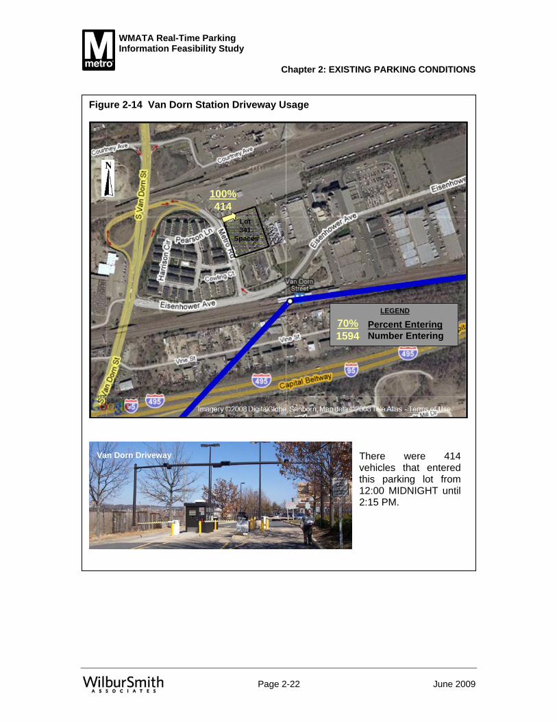
Figure 2-14 Van Dorn Station Driveway Usage
Lot 341
Spaces
100%414
LEGEND
70%1594
Percent EnteringNumber Entering
There were 414 vehicles that entered this parking lot from 12:00 MIDNIGHT until 2:15 PM.
Van Dorn Driveway
WMATA Real-Time Parking Information Feasibility Study
Chapter 2: EXISTING PARKING CONDITIONS
Page 2-23 June 2009
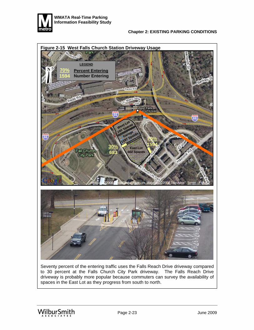
Figure 2-15 West Falls Church Station Driveway Usage
West Lot
280 Spaces
Garage
1197 Spaces
East Lot502 Spaces
30%683
70%1594
LEGEND
70%1594
Percent EnteringNumber Entering
Seventy percent of the entering traffic uses the Falls Reach Drive driveway compared to 30 percent at the Falls Church City Park driveway. The Falls Reach Drive driveway is probably more popular because commuters can survey the availability of spaces in the East Lot as they progress from south to north.

WMATA Real-Time Parking Information Feasibility Study
Chapter 2: EXISTING PARKING CONDITIONS
Page 2-24 June 2009
Summary and Conclusions All of the WMATA Metrorail station Park and Ride facilities reach an extremely high level of usage by 10:00 AM. The peak hour of parking usage occurred from 12:00 NOON to 1:00 PM when 12,276 of the 12,600 parking spaces were occupied, which is a percent accumulation of 97.4 percent. This usage level exceeds the practical capacity of 95 percent by 2.4 percent, or 305 spaces.
At all of the stations surveyed, the unrestricted parking spaces reach near-capacity levels by 10:00 AM and stay almost at 100 percent occupancy throughout the day. Most of the reserved parking spaces were observed to be full after 10:00 AM with the only exception being at Franconia/Springfield. (WMATA’s Parking office reduced the number of reserved spaces in 2008, after this parking inventory was completed)
Real-time parking information would greatly enhance the Park and Ride operation at WMATA’s Metrorail stations by providing information about the availability, or lack thereof, of parking spaces. There is probably nothing more frustrating to a commuter than to be on a tight schedule and enter a Metrorail station Park and Ride facility and have difficulty finding, or not being able to find, a parking space. This occurrence was observed at Vienna/Fairfax and it probably takes place regularly. While search time in the parking facilities was not surveyed, after 9:00 AM it is expected to be long because of their size and the pace at which the facilities fill up. This fact is supported by the practical capacity being exceeded at 10:00 AM. Real-time parking information would help commuters decide which station to use and would prevent them from entering a station that is already full. Parking space guidance within the parking facilities would also minimize search time and would help to maximize usage. In addition to providing parking information, WMATA should consider the following:
• Adding more supply at all of the stations • Increase passenger yield per space by providing spaces reserved for carpooling • Conducting similar existing condition assessments at other WMATA stations • Reducing the number of reserved parking spaces at Franconia/Springfield (this
recommendation was implemented since the completion of this parking analysis).

WMATA Real-Time Parking Information Feasibility Study
Chapter 3 BEST PRACTICES REVIEW
Page 3-1 June 2009
Overview Within the United States, many metropolitan regions have seen the demands on their transportation infrastructure meet and in some cases exceed the accompanying regional growth. Increased strain on the transportation system, be it roadway congestion, crowded transit facilities or the lack of adequate parking, requires innovative solutions to make better use of new and existing infrastructure.
As the demand for parking increases, there is a need to better utilize existing facilities and ensure that new facilities are used to their fullest potential. Intelligent Transportation Systems (ITS) have been employed at a number of locations to help achieve these goals. In addition to increasing utilization, ITS can improve the user experience and encourage continued use of a particular facility. Jurisdictions across the country have begun to respond by implementing advanced parking systems (APS) in an effort to alleviate parking issues at airport parking garages, transit parking lots, and urbanized downtown areas.
The most widely deployed APS elements are Parking Guidance Systems (PGS). These systems have the ability to utilize dynamic message signs (DMSs) to guide motorists to the nearest facility with available parking. Static signs may also be used to provide general information such as directions to a lot or garage, but the DMS has the ability to be changed depending on various criteria including the status of a lot and the availability of parking at a given location. The DMS is typically linked to a central computer which receives data from one of two general types of technology. Entry/exit counters can be used to calculate occupancy in a given facility, while systems that are more sophisticated utilize detectors at each parking space.
The more advanced DMS type of system allows for in-facility guidance including the ability to direct motorists to the available lanes, rows, and parking levels, as well as indicating the number of available spaces in each location. Some jurisdictions have gone a step further; including information on parking availability at a given location(s) on their web site, via a dedicated phone line, wireless devices, or the regional ITS infrastructure. Some systems even offer the ability to pre-reserve a parking space at various facilities. To various degrees, APS technologies have been deployed at a number of locations in the United States. These deployments provide excellent examples of how APS can assist with parking management. Table 3-1 provides a
The purpose of the best practices review is to summarize the state of the practice of real-time parking information systems, including carpool encouragement. The review focused on applications involving transit agencies, airport authorities and state and local Departments of Transportation. Ten locations were reviewed and two (the Baltimore-Washington International airport (BWI) and the Bay Area Rapid Transit system (BART) in the San Francisco/Oakland area) were selected for more detailed investigation. The detailed investigations include “Lessons Learned” sections that provide valuable insight into physical system components, agency interaction strategies, and implementation advice. A brief review of carpooling operations in general at other locations was also conducted.

WMATA Real-Time Parking Information Feasibility Study
Chapter 3: BEST PRACTICES REVIEW
Page 3-2 June 2009
sampling of systems across the country and the technologies each system currently employs.
Table 3-1 Summary of APS Systems Name Purpose
Guidance to Lot
Guidance within Lot
Guidance to Space
Reservation System
Availability on Web Site
Regional ITS Integration
Baltimore/Washington International Thurgood Marshall Airport (BWI) Airport × × ×Portland International Airport (PDX) Airport - × -Dallas/Fort Worth International Airport(DFW) Airport - × -Minneapolis/St. Paul International Airport(MSP) Airport × × -Bay Area Rapid Transit Transit × × -Chicago Metra Park and Ride Transit × × × ×City of St. Paul, MN Special Events × × × × -Seattle, Washington (Seattle Center) Urban Center × × ×City of Pittsburgh, PA Urban Center × × × -City of Santa Monica Urban Center/
Beach Area × × × -Key
Technology Included in System
Technology Not Included in System ×Unknown -
Examples of APS Systems Several brief summaries of APS Systems are provided in this chapter, along with detailed descriptions of the Baltimore-Washington International (BWI) facility, toured as part of this study, and the BART system in San Francisco. More detail can be found in the Technical Memorandum.
Portland International Airport (PDX), Portland, Oregon PDX has an Advanced Parking Guidance System (APGS) installed in its existing parking garage, which accommodates 3,300 spaces. Vehicle sensors are installed at each parking space to detect and indicate the real-time occupancy. A red LED on the sensor indicates the parking space is occupied, and a green LED (or blue LED for disabled spaces) indicates the space is available. The APGS system uses the occupancy status from each parking space sensor to continuously update information on the dynamic signs, directing motorists to available parking spaces. The APGS continuously calculates the number of available spaces within each zone or floor, and it continuously updates the display on each dynamic sign. Additional dynamic signs display the number of available spaces in a given row. Counting on the roof level uses embedded loops under the entry and exit ramps to detect vehicle movements and calculate occupancy.

WMATA Real-Time Parking Information Feasibility Study
Chapter 3: BEST PRACTICES REVIEW
Page 3-3 June 2009
The APGS also interfaces with Open/Full signs at the garage entry. APGS counting is based on the space sensor status, pre-count sensor status, and user-controlled overrides. A second parking garage is currently under construction and will add approximately 2,500 parking spaces equipped with APGS technology. The PDX web site also includes a real time update of parking availability for the garage and lots.
Dallas/Fort Worth International Airport (DFW), Texas Terminal D of the DFW Airport is equipped with “Smart Parking” technology which consists of LED displays informing motorists of how many spaces are available on each level of the 8-story garage. Once inside, the smart technology will direct motorists to a location with an available space. The dynamic-message system indicates the floors where spaces are available using sensors installed under the pavement on each garage level. The system includes vehicle detection sensors, automated barrier gates, central processing, access control subsystem, motorist information signs, communications subsystem, and systems integration. The parking structure at Terminal D provides 8,100 parking spaces. Parking availability information is accessible on the airport web site, dedicated phone line, and via pod cast.
Minneapolis/St. Paul International Airport (MSP), Minnesota MSP has offered way-finding signage and real-time parking availability information since 2002. The facility uses overhead LED signs to inform motorists of which levels are available in the facility. Exterior DMSs are also used at entrances and exits as well as on access roadways. Parking status is provided at two advanced locations and at the entrance to each parking option as well as available by phone, on the internet, and via text message.
Chicago Metra Park and Ride, near Chicago, Illinois The Metra Parking Management Guidance System includes eight DMSs located in a corridor with two commuter rail stations. Loop detectors in the pavement at the rail station parking lots detect vehicles entering and exiting the lots. Information from the loop detectors is sent to a central computer system that estimates the available parking and determines the message to be sent via wireless communications to the DMSs. The DMSs provide motorists with a real-time estimate of the number of available parking spaces at the rail station lots. If parking at a station is unavailable, the sign will indicate that the lot is full and suggest an alternative parking option. This technology is installed at two park and ride surface lots encompassing approximately 4,000 parking spaces with a total of eight deployed signs within ¼ to 3 miles of both stations to enable both road-to-parking lot guidance as well as lot-to-lot guidance. The system is integrated with the regional ITS structure.
City of St. Paul, Minnesota The APS system in St. Paul interconnects eight different parking facilities in the downtown area and began as a test initiative in 1995-96. Electronic signs display real-time parking availability information for planned special events in the Civic Center/Rice Park area of downtown St. Paul. The eight parking facilities that are included in the system provide approximately 4,700 parking spaces. The system updates real-time

WMATA Real-Time Parking Information Feasibility Study
Chapter 3: BEST PRACTICES REVIEW
Page 3-4 June 2009
parking availability every 30 seconds based on information collected from entry and exit ramps at each facility. Vehicle counting is accomplished with loop detectors, ticket spitters, or cash registers. DMSs are strategically located where commuters can make decisions about which parking facility to use. Each dynamic sign contains information about two or more facilities and is supplemented by directional static signage to guide motorists. As a result of minimal financial and innovation investments over time, the city is now looking to refurbish the system. Future considerations to be explored by the city include an expansion of the system to include other information outlets and whether to add more parking facilities to the system. Although the Saint Paul Advanced Parking Information System is capable of working in a fully automatic mode, it is an event-based system that does not operate continuously.
Seattle Center, Seattle, Washington Seattle Center is a 74-acre urban park that serves as a center of the cultural, festival, and sports interests of the Puget Sound region. Through the use of automatic monitoring technology and roadside DMSs, the Seattle Center Parking Information System provides information on, and directs traffic to, three major parking lots encompassing approximately 3,535 parking spaces. It also provides parking and trip planning information to travelers before they leave for the Center and while en route so that they can make informed route and mode choices. The information is also being made available to internet service providers who will transmit the information to the public on cellular phones, pagers, and the Internet. DMSs provide lot specific information for multi-level garages and surface lots which use entry/exit counters to calculate space availability. This system is integrated into the regional ITS structure.
City of Pittsburgh, Pennsylvania The City of Pittsburgh operates a "wayfinder" system that consists of a series of linked signs that guide drivers not only to parking facilities but also to special attractions in the area. This system divides Pittsburgh into five color-coded areas. Most of the signs are static, but some are dynamic, showing text such as "open" or "full" to describe the status of the facility. The City also offers the ability to reserve a parking space with a call-ahead reservation system.
City of Santa Monica, California Downtown Santa Monica has introduced a system that allows visitors to determine when and where parking is available. The system is based on data transmitted by sensors located on ramps at every entry/exit point throughout participating structures that collect travel information and track the movement and direction of vehicles in the facility. Parking information is updated every five seconds to ensure real-time data is transmitted. The city has created real time availability for their most heavily used parking facilities. The city has 46 parking facilities that are identified on static maps on their website. Fourteen of these facilities located in downtown and the area known as Beach City have real time availability information on the city website at http://parkingspacenow.smgov.net.

WMATA Real-Time Parking Information Feasibility Study
Chapter 3: BEST PRACTICES REVIEW
Page 3-5 June 2009
Baltimore Washington International Thurgood Marshall Airport (BWI), Linthicum, Maryland BWI’s advanced parking guidance system was first deployed in April of 2001 in a multi-level parking garage. The system provides information on the availability of parking spaces at the floor, aisle, and parking space level. Occupancy detectors mounted over each parking space monitor the vacancy status of each space. A dedicated computer system communicates to the LED indicators via a wireline backbone. Green arrows direct motorists to lanes with vacant spaces. Red Xs indicate lanes where no spaces are available. Blue lights direct disabled patrons to accessible parking areas. Over 13,000 spaces in BWI parking garages have been equipped with APS technologies which include 27 signs, 167 aisle signs, and 11,900 LED indicators above each space. The BWI APS system is not integrated with the regional ITS infrastructure.
Background - BWI is a leader in advanced parking management systems (APMS) at U.S. airports and the first in the country to use smart parking technology. The site has one of the largest airport advanced parking systems in the country. The system determines garage space availability in real time and guides travelers to the available parking spaces. BWI deployed the system to improve the traveler's experience as part of the airport's growth plan.
In April 2001, an advanced parking management system, known as BWI Smart Park, was installed on Level 2 of the BWI hourly garage as an operational test of the system. Approximately 1,100 spaces were included as part of the operational test to determine the effectiveness of the parking system prior to making a large capital investment. During the operational test, the Maryland Aviation Administration (MAA) received an overwhelmingly positive customer satisfaction response via surveys and e-mail comments. The parking operators also found a reduction in the number of illegally parked cars in fire lanes and other no-parking areas during the test. As a result of the positive operational test results, the system was expanded to the other four levels of the hourly garage. The BWI Smart Park technology was also included in the construction of the new Daily Garage A. Daily Garage A offers 7,100 spaces on eight levels, bringing the total number of spaces served to over 13,000. This expansion was completed in early 2004. At the time, BWI was the only East Coast airport to mount ultrasonic sensors over each parking space to monitor the availability of spaces.
A test program in the summer of 2006 allowed drivers to reserve parking in advance; however, this program was discontinued. Other improvements to BWI’s parking system include:
• Creation of a free cell phone lot where people picking up passengers can park until they are called by the passenger, minimizing circling the airport frontage and causing congestion
• Remote signage on the approach roads indicating the status of each parking lot (Open, Closed, Full)
• Counters were installed at the long-term parking lots to estimate and display the number of available parking spaces
• Creation of an express parking lot (originally marketed as ESP Parking), a higher grade long-term parking facility located closer to the airport terminals and offering frequent shuttle service directly to and from a patron’s parked vehicle (Patrons at

WMATA Real-Time Parking Information Feasibility Study
Chapter 3: BEST PRACTICES REVIEW
Page 3-6 June 2009
the regular long-term lots must walk to a bus stop within the lot to access the shuttle)
In 2004, the BWI Airport APMS was completed at an estimated cost of $6 million. The unit cost of the equipment was approximately $450 per parking space. The APMS was estimated to cost between two and five percent of the overall construction cost of the new parking facility (excluding land costs).
General Project Information - The BWI Smart Park system provides information on the availability of parking spaces at the facility, floor, aisle, and parking space level. Ultrasonic occupancy sensors mounted over each parking space monitor the vacancy status of each space. Occupancy status information is processed by a central computer which polls each sensor several times a second for real-time occupancy. The dedicated computer system communicates to a real-time light emitting diode (LED) display above each parking space. Green arrows direct motorists to lanes with vacant spaces. Red Xs indicate lanes where no spaces are available. Blue lights direct disabled patrons to accessible parking areas. Parking guidance information is also provided to drivers via Dynamic Message Signs (DMSs) on the airport access road, which indicate either “Open” or “Full” for each facility, as well as billboard signs at the entry of each level indicating the number of spaces on that floor. Signs on the up/down ramps of the garage also indicate the number of spaces on the floors above and below. The new garage, Daily Garage A, also has a sign at the main entrance listing the number of spaces available on each floor.
Over 13,000 spaces in BWI parking garages have been equipped with the smart parking technologies which include 27 signs on each garage level, 167 aisle signs, and 11,900 LED indicators above each space. The BWI Smart Park system is not integrated with the regional ITS infrastructure.
In the vicinity of the airport, drivers may tune to 1040AM for BWI Airport Parking Information.
Fees – The fees charged at BWI include:
• Hourly Garage: The first 30 minutes are free; each half hour thereafter is $2 with a daily maximum of $20.
• Daily Garage A: Rates at $2 per hour with a daily maximum of $10.00.
Lessons Learned – Based on interviews with BWI staff and review of literature, the lessons learned include:
• Consider the impact of various technical and design aspects when calculating cost estimates
• Ensure proper operations and maintenance • Identify key design issues in the deployment of advanced parking management
systems • Involve all appropriate stakeholders in a formal and collaborative manner during
each phase of the project • Confirm detector operation periodically. (System accuracy is a critical
component of a successful system. System errors can cause the inventory count to be in error, in either a positive or a negative direction. Under-counting available spaces means a lost opportunity for a patron and lost revenue for the operator, while over-counting available spaces results in frustrated patrons and a

WMATA Real-Time Parking Information Feasibility Study
Chapter 3: BEST PRACTICES REVIEW
Page 3-7 June 2009
potential loss of future credibility and revenue for the operator. At BWI, attendants conduct periodic drive-through inspections to ensure all the detectors accurately reflect the status of the parking space.)
Results – How the system has performed was assessed through a customer satisfaction survey conducted in 2003. The survey indicated that 81 percent of polled travelers felt that parking was easier and 68 percent felt that parking was faster at BWI as compared to other airports they frequented as a result of the Smart Park technology. Direct BWI customer feedback gathered by the MAA indicated that drivers felt the APMS "saved them aggravation" leading to very high levels of customer satisfaction with the BWI parking experience.
The use of APMS has also aided the airport in the management of the parking inventory by allowing the operators to monitor and control various zones of the facilities, close or reserve specific sections as needed, and obtain accurate real-time parking facility data. In addition, the technology has allowed the garages to operate at 100 percent capacity and decrease air pollution within the facilities due to reduced time that drivers spend searching for parking spaces.
Overall, the system has increased customer satisfaction and improved traffic flow in the hourly parking facilities as well as decreased the number of illegally parked vehicles in various areas. The increased ease of parking has also been seen to deter vehicles from circling drop-off/pick-up lanes and has relieved congestion in general throughout the airport facilities.
Bay Area Rapid Transit (BART), San Francisco/Oakland Metropolitan Area, California BART’s Smart Parking field test began in 2004 at one BART station and included two DMSs on Highway 24 and entrance/exit counters at the parking facility. The system provided real-time parking availability between the hours of 7:30 AM and 10:00 AM Monday-Friday. The other component of the field test was a centralized intelligent reservation and real time availability system which provided parking availability via telephone, internet, or PDA. Motorists could reserve a space up to two weeks in advance of the day of their transit use. Fifty parking spaces were utilized for the field test of which 15 spaces were held for advance reservations. Users who made en route reservations were charged $1.00 for the service, and those who made pre-trip reservations were charged $4.50. At the conclusion of the field test in 2006, the project accommodated more than 13,000 successful parking events. More than 4,000 smart parking reservations were made through the online reservation system. BART has incorporated smart parking into the agency’s strategy and plans to introduce the technology to other stations in the system.
Background - Rail station park and ride facilities form the cornerstone of operations for many transit systems across the county. In the San Francisco Area, Bay Area Rapid Transit (BART) operates the rail service across the region, with 43 stations and approximately 46,000 parking spaces. Parking shortages are common at most of the stations, specifically during peak morning commute times where commuters are finding parking lots full earlier and earlier. In an attempt to address parking issues, particularly those of occasional users of the system, a smart parking field test was implemented at one BART station which allowed motorists to reserve a parking space at the transit lot as

WMATA Real-Time Parking Information Feasibility Study
Chapter 3: BEST PRACTICES REVIEW
Page 3-8 June 2009
well as providing real-time parking information. For this demonstration project a public-private partnership was formed among California Partners for Advanced Transit and Highways (PATH), the California Department of Transportation (Caltrans), the BART District (BART), ParkingCarma, Inc., and Quixote Corporation.
Interagency agreements and contracts outlined specific roles and responsibilities of each partner, which facilitated the use of private resources to implement smart parking at a transit station. The project agreements documented that the partners were willing to work together to implement and launch the field test at the selected station. Primary partners and subcontractors were identified while the project proposal was developed. Periodic meetings and weekly updates assisted in maintaining these relationships throughout the project.
Funding for the project was provided primarily by the private partners who covered most of the capital costs and maintenance/operations associated with this field test. Initial capital costs were estimated to total $150-$250 per space while maintenance/operations costs were estimated to be $40-$60 per space per year.
The partnership began with a study to determine which BART station would be most appropriate to be used as the location of the project. Some of the major factors for consideration included:
• Parking at the selected station should be operating at or near capacity • The location should be near a major freeway or arterial • There should be structured access (entrances and exits) to the parking lot for
placement of vehicle sensor technology to ensure accurate parking counts • Jurisdictional cooperation and agreements between the BART District and other
partners/stakeholders should be in place or obtainable in a reasonable amount of time
The Rockridge BART station in Oakland, California has a high demand for parking and 862 total spaces. Analyses conducted by researchers in April 2003 found that parking demand was the highest at this station (as compared to other stations that were being considered) and even with a ten percent over-subscription rate on monthly permits not all spots are filled every day. As a result, the Rockridge station was selected as the smart parking test site.
Originally, the project was to be incorporated as an overflow parking strategy for the Dublin/Pleasanton BART station in Pleasanton, California. However, an economic downturn in the Bay Area lessened the parking demand at that particular station before the project began. As a result the Rockridge site was selected. The fact that changes in the economy can have a significant impact on congestion and affect parking demand was an early lesson learned.
Researchers employed expert interviews, internet surveys, and focus groups and reviewed parking reservation data to conduct a thorough analysis of the smart parking project. Over 400 participants completed the initial survey and 177 completed the final survey.
General Project Information - BART’s Smart Parking field test began in December 2004 and ended in April 2006 at the Rockridge BART Station. The BART smart parking field test was the first of its kind in the United States. The system provided real-time parking availability between the hours of 7:30 AM and 10:00 AM Monday-Friday.

WMATA Real-Time Parking Information Feasibility Study
Chapter 3: BEST PRACTICES REVIEW
Page 3-9 June 2009
Motorists could reserve a space up to two weeks in advance or the day of their transit use. Fifty parking spaces in Bart’s East lot were utilized for the field test of which 15 spaces were held for advance reservations and five spaces maintained as a buffer. Elements of the project included:
• Two solar powered changeable message signs (CMSs) on Highway 24 which were placed before and after a heavily traveled three bore tunnel in the East Bay
• Fixed station and wayfinding signs installed on local streets and at the smart parking site
• Centralized intelligent reservation and real time availability system which provided parking availability via telephone, internet, or PDA
• A wireless parking lot counting system consisting of six in-ground sensors, two Local Base Units (LBUs) to control the sensors and a Master Base Unit (MBU) for overall system control
The CMS displays alternated between two messages: the number of available smart parking spaces at the Rockridge BART station and static directions to the smart parking site from the highway. Expert interviews with the smart parking project manager indicated that the CMSs were beneficial because they provided general project awareness and, after seeing the parking availability every day at the same time, some travelers were encouraged to participate in the field test. CMS placement is important, and the location should be on users’ commute routes. As indicated in user survey results, the CMSs were not widely employed in users’ decision making processes for this project.
Sensors were located at each entrance to the reserved area and exit of the smart parking lot to track occupancy. They wirelessly communicated parking count information to the solar-powered LBUs, which transmitted data to the MBU. From there, data was transmitted to the ParkingCarma, Inc. central computer through the Internet. Once data reached the central computer, parking availability information was updated on the three user interfaces (CMSs, phone system, and the reservation website). Vehicle counting was done primarily to account for a person parking without a reservation, and minimizing the possibility of a last-minute reservation being granted when the lots were full. The communications aspects of the wireless counting system worked well; however, the in-ground sensors were prone to miscounts.
Fees - Initially the reservation service was provided free of charge with fees for the reservation beginning in October 2005, 10 months after the launch of the project. Users who made en route reservations were charged $1.00 for the service, and those who made pre-trip reservations were charged $4.50. As part of the registration process, users entered their credit card information with a flat fee of $30 being charged as an initial deposit into the user’s account. Reservation fees were subsequently deducted from the account with an additional $30 added automatically as needed. As the field test approached its end, users were charged on a per-transaction basis. In 2006, after the field test was completed, BART began charging vehicles $1 a day for unreserved, first-come, first-served spaces.
With the implementation of reservation fees, drive-in reservations increased at the expense of advanced reservations. Initially 57 percent of users reserved a parking space upon arrival to the lot, with this increasing to 80 percent after the introduction of fees. The majority of participants continued to use the service after fees were

WMATA Real-Time Parking Information Feasibility Study
Chapter 3: BEST PRACTICES REVIEW
Page 3-10 June 2009
implemented. Survey respondents indicated that their greatest issue with smart parking pricing was that the total cost of parking combined with BART fares. With roundtrip BART fares ranging from $6 to $8 depending on the customer’s destination, the monthly cost of commuting would range from $147 to $189 monthly using drive-in reservations and $220.50 to $262.50 monthly using advanced reservations (assuming 21 workdays per month.) There also were concerns about charging flat increments of $30 into an electronic account, with some participants preferring a per transaction charge. The majority indicated that the service should not cost more than either nearby commercial parking or monthly reserved parking at the BART station. Participants indicated that they would continue using the smart parking service if daily parking fees increased up to $5 per day, but not higher. Enforcement - BART security personnel and paid community service assistants received a daily log of vehicle license plate numbers registered to use the service each day, and they ticketed vehicles without reservations. Officers also used PDAs, beginning in January 2006, to access the license plate numbers of vehicles with reservations. If a vehicle was parked in a smart parking space and the driver was not a registered user in the database, they were issued a ticket. If they were in the database but did not have a reservation, their account was charged.
Lessons Learned – The key lessons learned from the BART system include:
• Two months were included in the project implementation phase to obtain the permits, but this actually took between six to seven months. A lesson learned is that more time should be designated for the permitting process (at least six months), and a budget should be prepared for this project stage, including permit funds, review, and safety fees.
• Since a majority of the hardware was off-the-shelf, there were numerous challenges in customizing the equipment.
• Approximately six months were allocated for the field test project scoping phase including identification of primary partners and subcontractors, setting up public-private partnership, interagency agreements and contracts, refining project scope, coordinating numerous agencies, and addressing additional project variables. An additional three months for these activities would have been useful.
• A lesson learned was to plan and budget for a CMS impact evaluation, if CMSs are to be used in future projects. The project team encountered difficulties with the CMSs as both signs had intermittent, unreliable operations due to electronic and communication problems. Another concern was that the expense to operate the CMS’s due to the need for frequent real-time updates of smart parking space availability. As a result, technical staff switched the to the Global System for Mobile (GSM) cell phone technology at the same time that the signs were replaced, resulting in airtime savings of approximately 10 to 30 percent.
• CMSs should be located on all nearby, popular commute routes with access to the transit station to widen the base of commuters who view the signs each day.
• More public outreach/branding could be developed to help motorists better understand the purpose of the information displayed on the CMSs.
• Focus group participants and final survey respondents indicated that better fixed signage would have been beneficial to designate the smart parking spaces within the station.

WMATA Real-Time Parking Information Feasibility Study
Chapter 3: BEST PRACTICES REVIEW
Page 3-11 June 2009
• The field test did not employ enough PDAs for every enforcement officer and as a result of staff rotations it was not possible to consistently implement this method of enforcement during the research project. Increased investment in enforcement technology would be preferable.
• Since free parking was offered at the Rockridge BART station at 10 AM, this made it difficult to determine if an unreserved vehicle had parked legally (after 10 AM) using the faxed list of confirmed reservations alone. One officer used chalk to mark tires at 9:30 AM and issued a ticket if the vehicle did not have a reservation by 10:05 AM. It was helpful to have a live operator available to assist users when parking tickets were issued in error.
• It was noted that there was neither an easily accessible phone nor kiosk near the smart parking lot, making it difficult for users without mobile phones to make drive-in reservations. It was suggested that a courtesy phone be placed closer to the smart parking area to make it more convenient for users without mobile phones.
• It is helpful to have a live operator on the phone system to answer questions, etc. It was also sometimes difficult for the automated phone system to identify users’ accents further requiring the need of a live operator.
• Adding options to the phone reservation system such as “repeat,” information confirmations, and the ability to skip through beginning instructions would be beneficial.
• Charging parking reservation fees on a per-transaction basis was preferable to users carrying a balance on their accounts.
• The most difficulty arose from the in-ground sensors. Prior to this project, the sensors had been used on highways and streets with traffic in one direction only. Project partners modified the firmware to detect two-way vehicle movements, and testing at an off-site location indicated that they worked well. At the BART station, the sensors were unable to accurately count vehicles moving at parking lot speeds. Project partners noted that this problem may have resulted from the magnetic field at the BART station, since the sensors perform by detecting the changing magnetic fields from vehicles passing over the sensors. Also, sensors had difficulty accounting for atypical vehicle movements, such as cars driving into or out of the lot the wrong way. The sensors were eventually replaced during the field test with ones that were situated aboveground, which were more effective and less expensive. The integration of the new sensors with the wireless counting system resulted in communication protocol problems that were resolved by technicians. Researchers ultimately maintained count accuracy by using a proprietary algorithm that corrected the sensor problems and accounted for instances when vehicles queued above the sensors.
Results - At the conclusion of the field test in 2006, the project accommodated more than 13,000 successful parking occurrences by 1,245 users. More than 4,000 smart parking reservations were made through the online reservation system. Space utilization increased from five to 75 percent (i.e., 38 of 50 spaces filled) during the first three months of operation and was sustained at that level for the remainder of the project. The smart parking field test helped to manage parking capacity without a new capital expenditure for construction.
Travel behaviors affecting the smart parking field test were evaluated by administering before and after Internet-based user surveys. More than 30 percent of respondents
WMATA Real-Time Parking Information Feasibility Study
Chapter 3: BEST PRACTICES REVIEW
Page 3-12 June 2009
indicated that smart parking encouraged them to use BART instead of driving alone on their typical commute to their usual workplace, with 55.9 percent stated the same for work trips to meetings and other locations. Overall, 75 percent of survey respondents indicated that their reserved space always had been available when they arrived at the smart parking lot.
Forty-nine percent of respondents did not use BART to commute to work before smart parking and were encouraged to use BART more because they could drive to the station. In addition, smart parking resulted in sizable increase in BART modal share. On average, BART uses per participant increased by 5.5 trips per month for typical work commutes and by four trips per month for work trip commutes to meetings and locations other than their typical place of work. Finally, the program reduced overall vehicle miles traveled by 9.7 fewer miles per participant per month on average and decreased the average commute time by 2.6 minutes.
While the field test at the Rockridge BART station concluded in 2006, BART has incorporated smart parking into the agency’s strategic plans and intends to introduce the technology at other stations in the system. In addition, there is an upcoming California PATH and Federal Highway Administration Value Pricing Pilot Program initiative at five stations in conjunction with the San Diego Coast Express Rail (COASTER) scheduled to launch in late 2008. This initiative is planned to include a value pricing component, more detailed messages on CMSs, and an expanded number of parking spaces included in the test.
Carpooling With parking demand exceeding capacity at a number of Metro stations in the DC metro area, various options are being explored to increase utilization of the existing facilities to better serve the traveling public. Encouraging passengers to carpool to stations may help to increase the number of transit riders served, decrease the number of vehicles traveling to access transit and help to minimize the costs to travelers as travel and parking expenses could be split between the driver and passengers. Research was done to identify other transit systems nationwide where carpooling is being encouraged at transit stations. Studies on the topic were reviewed and researchers and parking operators were interviewed to obtain additional insights on the topic.
WMATA Experience For a number of years, WMATA had a number of park and ride locations with a limited amount of carpool parking. This program was discontinued due to a number of factors, including poor utilization, difficulties in administering the program, use of the spaces by non-carpool patrons and the difficulty and costs associated with monitoring and enforcement. However, with parking shortages becoming increasingly acute at a number of WMATA stations there has been renewed interest in re-instating an improved version of the program.

WMATA Real-Time Parking Information Feasibility Study
Chapter 3: BEST PRACTICES REVIEW
Page 3-13 June 2009
General Observations • Carpool parking at transit stations cannot be thought of in isolation; they must be
part of an overall parking strategy. • Promotion is key. Carpool spaces are not self-sustaining and require continued
promotion, perhaps as part of a wider Transportation Management Agency program.
• Enforcement of carpool spaces must be rigorous and continuous, particularly at locations where lots fill up early. Signage must also be clear.
• Pilot programs should be wider in scope; one program at a single location is unlikely to be successful.
Proposed Parking Program for Carpooling Users This study attempted to research the existing carpool parking programs and interviewed the TDM program manager in Contra Costa County, California, who initiated and managed a carpool parking program at the County’s BART stations. A proposed framework for a WMATA pilot carpool parking program is outlined below:
• WMATA can add a number of spaces for carpool parking at a convenient location within the parking facility, ideally, next to the permit parking area and easily accessible to elevators if in the garage.
• Carpool driver and passengers in the same vehicle can sign up a WMATA carpool parking permit pass for each. Allowing 2 people at the same address, while not 100 percent desirable, should be allowed. This allows unrelated people sharing an address to participate and encourages related people to carpool more frequently.
• The permit can be renewed on a quarterly, semi-annual, or annual basis, and requires each person in the car (driver and passengers) to provide the identification number of individual’s Smartrip card. The Smartrip card can then be tied with the person’s use of Metrorail in the central fare card transaction database to allow for validation.
• A carpool vehicle needs to display two permit passes on the dash of the vehicle. Passes need not be tied to each other nor tied to a specific vehicle.
• On a monthly basis, staff will validate the carpooling against train rides based on the defined frequency of usage established by WMATA for the permit holders. WMATA could also consider a monetary refund in a small amount to each Smartrip card as an incentive.
• The importance of enforcement cannot be over stated. It will need to be continuous or there will be a need for frequent, high profile enforcement days. For fines to be a deterrence, they will need to be significant. Consideration should be given to having the fine for parking in a carpool spot being higher than the equivalent fine for a standard reserved space.
• Consideration should be given to revoking current permits as well as restricting the ability to obtain and renew permits when there is a violation.
• Future ITS applications to the carpool program should be investigated. Some things to consider are:
o Handheld devices to check the validity of permits/complete summons,

WMATA Real-Time Parking Information Feasibility Study
Chapter 3: BEST PRACTICES REVIEW
Page 3-14 June 2009
o Linking permits and fare collection so that permits could be entered or scanned and then fare collection data queried to ensure these patrons entered the system,
o Heat signature and image recognition systems to ensure compliance.
Summary While various combinations of APS technologies have been deployed at airports, transit agencies, and urban areas, each individual system has been tailored to local needs to provide motorists with the information they need to make informed parking and mode choice decisions. In most cases, research and feasibility studies were completed to ensure that the systems deployed accomplished stakeholder goals. As a result of initial needs assessments and follow up studies, many jurisdictions have been able to compile lessons learned related to the system of their choice. For systems with multiple stakeholders, it has been noted that agreements dictating the responsibilities between each involved entity should in all cases be finalized before construction of the system begins. This will alleviate potential issues arising from operational concerns and also allow for problems to be addressed more efficiently if or when they occur. Additional lessons learned include pre-testing of the vehicle sensors whether they are individual space sensors or entry/exit counters. Pre-testing allows for the de-bugging of any potential issues before the system is made available to the public decreasing the likelihood of a negative public reaction. Public outreach as to how to use the new technologies and/or facilities was also cited. The majority of jurisdictions plan continued or expanded use of their current systems based on positive user reactions, increased revenue at some locations, and increased use of transit services.

WMATA Real-Time Parking Information Feasibility Study
Chapter 4 REAL-TIME PARKING TECHNOLOGY
Page 4-1 June 2009
A real-time parking information system is comprised of a variety of elements that generate raw data, process the data into useable information, and transmit the information to users. Each of these elements can be addressed with a number of different technology options. The system vision includes seamless communication of available parking information from the detection of parking occupancy to public notification. To analyze technologies considered for system deployment effectively, they must be evaluated with respect to the needs of the system. To accomplish this, the goals and objectives of the system must first be determined. This document reviews the goals and objectives and identifies the functional requirements needed to achieve them. Different technologies are reviewed to understand their potential for meeting the functional requirements.
Goals, Objectives and Functional Requirements Goals are defined as high level statements of a result that, when accomplished, will achieve all or part of the vision. Objectives are defined as a set of statements that include specific measurable accomplishments directly related to the opportunity, need, or problem addressed by a goal. Once goals and objectives are established, functional requirements are determined in order to provide implementable and verifiable requirements that define how to meet the objectives. It should be noted that functional requirements define how the system should function and do not specify the technology used to meet the requirements.
Goals and objectives were established for this project based on the desires of WMATA and VDOT using information from interviews conducted in May 2008. The goals and objectives address matters such as operation of parking facilities, customer satisfaction, parking payment processing, and information sharing between agencies.
The long-term goals, objectives, and functional requirements for this project are shown in Table 4-1.
Chapter 3 provided information on smart parking technologies. This chapter provides a more detailed discussion of the types of technologies used in different locations and which technologies are used to produce and convey different types of information. The findings detailed in this chapter will then be used to identify which technologies will meet the specific WMATA needs.
The technologies are described in terms of the three basic system components: vehicle detection, data communication, and traveler information communication.
This chapter addresses the functional requirements needed for a real-time parking information system. It identifies the goals and objectives of the system as determined through interviews with WMATA and Virginia Department of Transportation staff. This is followed by a review of available technology.

WMATA Real-Time Parking Information Feasibility Study
Chapter 4: REAL-TIME PARKING TECHNOLOGY
Page 4-2 June 2009
Table 4-1 Summary of Goals, Objectives and Functional Requirements
Goals Objectives Functional Requirements Share real time information on parking availability from various stations with a central server
Operate facilities as a system (not just as individual garages and lots) Provide information on nearby facilities when the
closest facility is full
Provide real time availability to staff at each facility Increase efficiency of facility staff Provide staff with ability to adjust or correct real time
information if they observe differences
Provide signage approaching each facility with the number of available spaces
Direct vehicles approaching facilities to available parking Provide signage approaching each facility with
directions to nearest lot with spaces available
Measure number of spaces available at a given time
Maintain database information with parking availability and pricing structure information
Maximize efficiency of parking facilities
Generate real time information on parking availability
Using the measure of occupied spaces and the database of availability, calculate the number of spaces available at a given time
Direct customers to open spaces when they are not readily apparent
Provide signage to open spots in each aisle and level when not readily apparent
Provide information to drivers regarding availability of spaces
Keep entrance gate closed when lot is full
Improve customer experience and satisfaction Prevent cars from entering
the facility when spaces are not available
Provide greater ability to reserve parking spaces
Maximize efficiency of parking payment system
Have complete up-to-date pricing information available to operators and users
Maintain database information with pricing structure information
Make real time parking information available to VDOT and other regional agencies and to MATOC/RITIS1
Maintain database information with parking availability
Share real time parking information with other regional agencies
Support coordination with other traffic management and traveler information systems deployed in immediate region as necessary
Maintain data archive with historic parking information
1 Metropolitan Area Transportation Operations Coordination, Regional Integrated Transportation Information System

WMATA Real-Time Parking Information Feasibility Study
Chapter 4: REAL-TIME PARKING TECHNOLOGY
Page 4-3 June 2009
Detection Technology Smart parking systems generally require some way of determining the location of vehicles within a parking facility. Simpler systems may only detect entry to and exit from a facility, while systems that are more complex can identify position and movement within the facility, either to general zones and floor locations or to a single space. This information can then be used to calculate remaining capacity and/or guide vehicles within the facility.
Level of Detection The level of detection needed depends on the specific requirements of the system. General information needs, such as the number of currently available spaces in a given facility or section, can be addressed using counts available from entry and exit detection. Systems designed to guide users directly to empty spaces require additional information, provided by localized detection, to determine the occupancy of each space.
Occupancy/Presence Detection - Occupancy or presence detection determines whether a vehicle is present in a travel lane within a facility or in an individual space. Presence detection can be used to calculate facility occupancy and can also be used in conjunction with guidance systems to guide drivers to an individual vacant space. Because these systems require detectors for each space, the cost of presence detection can be high, making them most appropriate for high-revenue, high-turnover installations such as short-term airport parking. In these situations, guidance may provide added value that can result in additional revenue that will offset the installation cost. Additionally, by reducing the need for circulating traffic patterns, guidance systems can enable more spaces to be placed in a given area, further resulting in additional revenue. A benefit-cost analysis is recommended to determine if occupancy/presence detection is an economically viable alternative.
Portal (Entry/Exit) Detection - Portal or entry/exit detection counts vehicles as they enter and exit a facility or a section of a facility. Based on entry and exit counts, the number of available spaces in a facility can be determined. For smaller facilities, this type of portal detection may be sufficient to develop useable information, particularly if the facility is anticipated to empty out on a daily basis. This also requires a facility whose operations are simplified – i.e., only one or two entrances and exits with no reversible lanes, no special parking spaces, and very well-defined and maintained number of spaces. This type of system may require occasional calibration with manual counts. Portal detection generally uses induction loops, although other sensor types can also be used for this purpose.
Movement within Facility - Larger facilities may have a need for information regarding movement within the facility. One approach is to divide a facility into multiple zones, with entry and exit detected between the zones. However, this only detects movement at the zone boundaries. This makes the process of determining available spaces more complex. When vehicles are counted as they enter the facility, it is possible to inform drivers with a high degree of reliability if the facility is full. When measured at the boundaries, it is necessary to inform drivers before they enter a section that this particular section is full. This requires an accurate occupancy count for each section.

WMATA Real-Time Parking Information Feasibility Study
Chapter 4: REAL-TIME PARKING TECHNOLOGY
Page 4-4 June 2009
Approaches that are more elaborate may use detectors positioned above or below the roadways to determine in real time the location and direction of movement of a vehicle. This information can then be used in conjunction with guidance systems to direct vehicles to available spaces.
Vehicle Detection Technology There are two basic installation locations for vehicle detection technology – in-roadway detection or off-roadway/over-roadway detection.
In-roadway Detection Detection systems that work in or below the roadway do not require mounting structures above or adjacent to the roadway. For this reason, they are particularly well suited to surface lot applications. However, location of the equipment in the roadway may subject equipment to damage from snow removal, maintenance, or reconstruction.
• Loop Detectors Induction loops determine the presence of a vehicle by noting a disturbance in the magnetic field generated by the loop. They generally detect presence only, though loops in sequence can be used to determine direction of travel or speed.
Locations: Induction loops are widely used in parking applications, and existing loop detection is often adapted to smart parking installations. Smart parking applications using loop detection were found in numerous locations, including the Santa Monica city-operated facilities and the Metra commuter rail system lots in Tinley Park, Illinois.
Costs: Loop detection is considered a mature technology. According to the US DOT ITS costs database, a set of four loops is estimated to cost between $3,000 and $8,000, including controllers, etc. Operations and maintenance is estimated to range from $400 to $600 annually. Lifespan is estimated at five years. A set of four loops would provide direction-specific counts for two lanes.
• Magnetic Detectors / Magnetometers Magnetometers detect a local disturbance in the earth’s magnetic field caused by a vehicle. Magnetometer capability is similar to loop detection but can be used in locations where loop detection cannot, such as on steel bridge grates. Magnetometers can detect moving vehicles, but do not detect stationary vehicles. For this reason, magnetometers are typically used with other forms of detection such as infrared to reduce the possibility of errant detection.
Magnetometers have been deployed as part of the pilot project for the port of San Francisco’s on-street parking system. No cost information was available for that system; however, a New Mexico State University survey of detection technologies estimates magnetometer cost to start at $600 per sensor.2
2 Luz Elena Y. Mimbela and Lawrence A. Klein. “Summary of Vehicle Detection and Surveillance Technologies Used in Intelligent Transportation Systems.” Southwest Technology Development Institute, New Mexico State University, 2007. Retrieved from http://www.nmsu.edu/~traffic, August 2008.

WMATA Real-Time Parking Information Feasibility Study
Chapter 4: REAL-TIME PARKING TECHNOLOGY
Page 4-5 June 2009
Off-Roadway or Over-Roadway Detection Installing detection equipment away from the roadway surface removes the need for digging and greatly reduces the risk of detector damage from construction or snow removal. To operate effectively, a reliable line of sight from the detector to the zone of detection is needed. The specific capabilities of each system are described below.
• Ultrasonic Ultrasonic detectors use a sonar-like sound pulse to determine the presence of a vehicle. The detectors are calibrated with the known distance from detector to pavement and can then note a difference in echo time to determine the presence of a vehicle. Detector performance can be impacted by extreme wind and temperature, although newer detectors can adjust for temperature fluctuation.
After induction loops, ultrasonic detection is likely the next most commonly used technology for advanced parking applications. In the U.S., ultrasonic detection is used in the Baltimore International Airport parking system to detect vehicle presence in parking spaces, and is cited in the IdentiPark implementations in Singapore; Beijing, China; and Cape Town, South Africa. The Baltimore Airport’s system’s net cost of $13 million equates to a system average cost of $450 per space, inclusive of detectors; the actual marginal cost per space would likely be lower. The NMSU report estimated the cost of ultrasonic detectors used for highway applications to range from $600 to $1,900 per lane.
• Passive Infrared Passive infrared detection relies on the infrared energy emitted by vehicles. A single detector can be configured to process multiple zones, reducing the cost per lane or space.
Various sources identify the cost of infrared detection as ranging from $700 to $1,200. No parking applications have yet been identified that use passive infrared detection.
• Active Infrared (laser radar) Active infrared systems work on similar principals to passive infrared systems, but illuminate the detection areas with beams of infrared light. By comparing the reflected beam against the known reflectivity of the pavement surface, vehicles can be identified and classified.
Costs of active infrared installation were estimated at $6,500 per detector in 2000. No parking applications have yet been identified that use active infrared detection.
• Video Video detection uses video cameras in conjunction with video image processors to generate a stream of digital information from the camera. A system may be configured around a number of zones identified in a single camera’s field of view, enabling one camera to provide information for as many as four adjoining zones. For best performance, the video cameras should be placed up to 50 feet above the surveyed zones. Lighting variations over the course of the day can impact system performance.

WMATA Real-Time Parking Information Feasibility Study
Chapter 4: REAL-TIME PARKING TECHNOLOGY
Page 4-6 June 2009
Video detection equipment is relatively expensive and is generally considered cost effective only when multiple zones must be monitored. An additional degree of cost effectiveness could result if an existing video monitor system is already being used and maintained for security surveillance or other purposes. A single camera setup is listed in the USDOT ITS costs database as ranging from $9,000 to $16,000, including processing equipment, but not including construction of a structure on which to mount the camera. The NMSU survey reports a single-lane system as costing about $5,000 for equipment and installation.
Video detection systems are used widely for traffic and security monitoring. A video system has been installed at Seattle-Tacoma International Airport’s main parking garage in conjunction with existing security equipment. The Seattle system uses 88 cameras coupled with dedicated signage, and is capable of directing a vehicle to the general area of available spaces. The system relies on periodic manual counts for calibration. The system was retrofitted into preexisting facilities and was developed in-house at an approximate cost of $400 per space.
• Microwave Radar (FM/CW) Frequency-modulated (FM) continuous wave (CW) microwave radar systems are widely used in highway applications but are capable of detecting vehicle presence, as well as traffic speed and volume. FM/CW radar systems are somewhat costly but are generally unaffected by weather. A single unit can be configured to detect across up to eight adjacent zones.
The Mountain-Plains Consortium study “Detector Technology Evaluation”3 estimates a single unit installation as costing from $800 to $3,300 per unit. No parking-specific implementations of microwave radar detection were identified.
Table 4-2 is a summary of the various detection technologies discussed. A cost comparison is given, but a number of factors make it difficult to directly compare costs between various technologies and installations. These include.
• Technological Innovations: Rapid changes in the availability and pricing of detection equipment make it difficult to compare similar installations completed at different times.
• Configurations and Scalability: Some forms of detection technology, particularly those that use individual detectors for individual spaces, have costs that increase proportionately with the number of spaces. For other forms of detection, where a single detection unit may cover a larger number of spaces, comparative pricing can be more difficult. Portal detection costs are driven by the number of portals and zones, rather than the number of spaces.
• Complementary: Equipment previously installed in a facility for other purposes could potentially be incorporated into a vehicle detection or smart parking system. Payment stations may often incorporate loop detection, while many garages have video installed for security purposes. The availability of already installed equipment can significantly impact the cost of a smart parking installation.
3 Peter T. Martin, Yuqi Feng, Xiaodong Wang. “Detector Technology Evaluation.” Mountain-Plains Consortium, 2003. Retrieved from http://www.mountain-plains.org/pubs/html/mpc-03-154/index.php, September 2008.
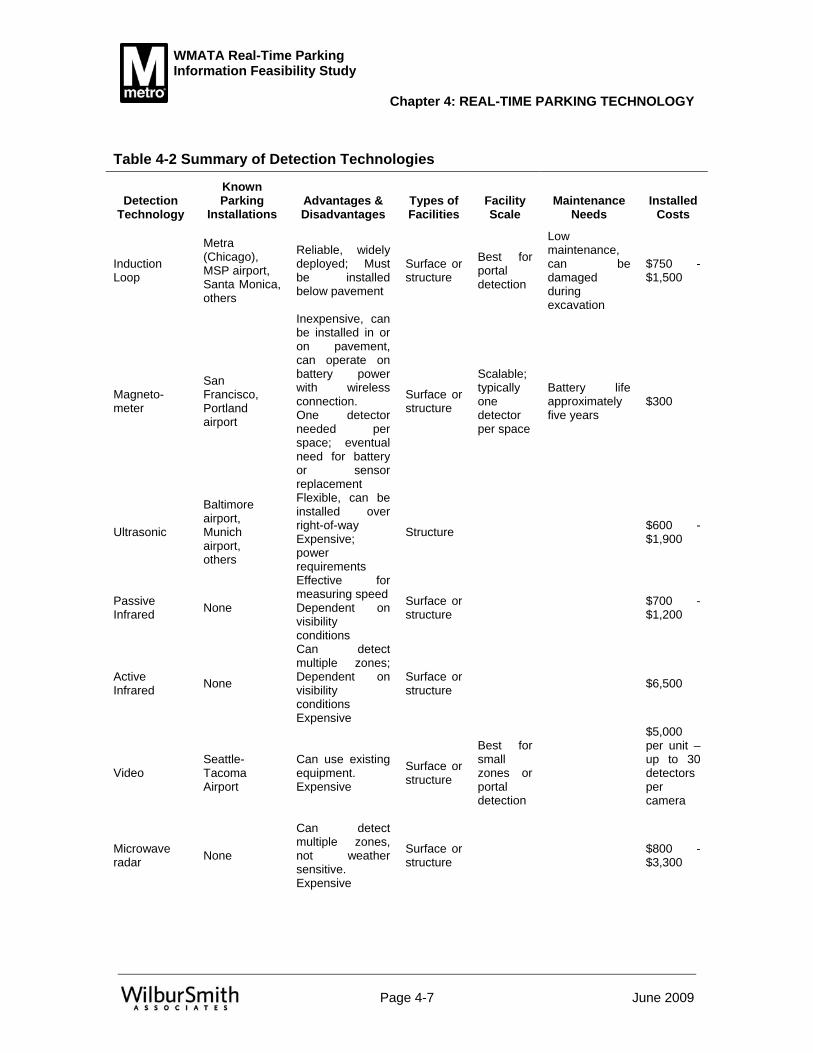
WMATA Real-Time Parking Information Feasibility Study
Chapter 4: REAL-TIME PARKING TECHNOLOGY
Page 4-7 June 2009
Table 4-2 Summary of Detection Technologies
Detection Technology
Known Parking
Installations Advantages & Disadvantages
Types of Facilities
Facility Scale
Maintenance Needs
Installed Costs
Induction Loop
Metra (Chicago), MSP airport, Santa Monica, others
Reliable, widely deployed; Must be installed below pavement
Surface or structure
Best for portal detection
Low maintenance, can be damaged during excavation
$750 - $1,500
Magneto-meter
San Francisco, Portland airport
Inexpensive, can be installed in or on pavement, can operate on battery power with wireless connection. One detector needed per space; eventual need for battery or sensor replacement
Surface or structure
Scalable; typically one detector per space
Battery life approximately five years
$300
Ultrasonic
Baltimore airport, Munich airport, others
Flexible, can be installed over right-of-way Expensive; power requirements
Structure $600 - $1,900
Passive Infrared None
Effective for measuring speed Dependent on visibility conditions
Surface or structure $700 -
$1,200
Active Infrared None
Can detect multiple zones; Dependent on visibility conditions Expensive
Surface or structure $6,500
Video Seattle-Tacoma Airport
Can use existing equipment. Expensive
Surface or structure
Best for small zones or portal detection
$5,000 per unit – up to 30 detectors per camera
Microwave radar None
Can detect multiple zones, not weather sensitive. Expensive
Surface or structure $800 -
$3,300

WMATA Real-Time Parking Information Feasibility Study
Chapter 4: REAL-TIME PARKING TECHNOLOGY
Page 4-8 June 2009
Data Communication Technology Much existing communications infrastructure is expected to be available for this project. The existing WMATA fiber network currently links each station to the existing central servers within WMATA, and will be used to transmit availability and system status information to the central servers. Real-time information will be shared with other agencies from the central servers. Communications with external traveler information equipment (i.e., DMS) may be directly from each station, or through the central servers.
This section describes the four basic communication systems: sensor (vehicle detection) to processor, processor to WMATA, WMATA to the traffic management agencies and internal within WMATA. The fifth element of communication, external to the system users, is described under traveler information technologies.
All communications systems will incorporate and comply with all applicable ITS standards (e.g., TMDD), and will be compatible and integrated with VDOT, RITIS and the 511 Virginia system. It will be the responsibility of the design engineer to work with WMATA, VDOT, and other stakeholders to ensure proper system integration.
Sensor to Processor Typically, the operational requirements and sensor technology used in the system dictate the technology used to communication from the field sensor to the information processing system. For example, a simple vehicle counter at the entrance portal could transmit information upstream using any number of methods. The method chosen would likely depend on the location and cost considerations. A more complex space-level detection system would more likely require wireless communication in order to be cost-effective, as it is often impractical to run wires to each parking space, particularly in an existing facility. Even if a detector were able to cover up to ten spaces, a hard-wired connection would still require the installation of a considerable amount of conduit and wire for each level of the garage. A full cost comparison of alternatives is required for final determination.
• Wired Wired communications from the detector to the Local Controller Unit (LCU) may not be cost effective in structured parking, unless a new facility was being planned and constructed.
• Wireless Wireless communications from the detector to the Local Controller Unit (LCU) is the most practical and cost effective means of communication connectivity. With the exception of Vehicle Image Detection System (VIDS), the majority of space occupancy sensors require low data telemetry (two to nine kbps) serial data.
• Data Flow The sensors will normally report two types of data. Emergent data transmits a state change of the parking space. Periodic data provides a periodic report of the sensor state.
Once the state of a parking space has changed, notifications are sent to either a master wireless unit or to a Local Controller Unit (LCU) where all assigned

WMATA Real-Time Parking Information Feasibility Study
Chapter 4: REAL-TIME PARKING TECHNOLOGY
Page 4-9 June 2009
sensor data is routed to the parking system management sever. The parking management system then recalculates the parking scheme and notifies the appropriate message board with the current information.
On the reverse side, if Highway Advisory Radio (HAR) is utilized for traveler information, the local processor will have to communicate to the HAR controller within the general parking facility. As this is a single connection, this could be accomplished by fiber or through the same wireless technology used by the sensors.
Processor to WMATA The stakeholder interviews made it clear that there would be no wireless transmissions into the station. Wherever the processor is located within a parking facility, it shall be directly connected to the station fiber optics through a wired connection. This could be fiber or other wired media.
Once connected to the WMATA fiber from the communications closet at the station, the information from the parking system can be collected and maintained at a central WMATA server.
Fiber Optic represents the best medium alternative to connect the Local Controller Unit (LCU) processors to the parking management system server. Fiber optics will allow for system expansion and upgrade. WMATA currently maintains fiber as part of the existing communication infrastructure.
WMATA to Traffic Management Agencies The parking information system is being planned to share information with other agencies and the general public and make maximum use of existing systems and communications infrastructure. With the exception of new field equipment installed as part of this project, there is no intent of adding new communication links just for this study. While the current web site for WMATA should be enhanced with new information from the parking facilities as part of this study, the existing communication interface with the internet should remain unchanged. Similarly, the same connection to share information with RITIS and VDOT will be utilized with minor changes to the actual data being transmitted. Much of this discussion is covered in the following section on traveler information.
Internal (within WMATA) The connections between the various servers related to both the smart parking system and other related WMATA systems will be accomplished by Ethernet – either WAN over fiber or locally over direct connections. WMATA IT staff should be familiar and experienced with this equipment and media.
Communication Technologies for Traveler Information Once information on parking availability has been collected and developed, it can only be useful if the potential user of the facility can access it. A number of technologies are currently available to transmit this information to users, and are described below.

WMATA Real-Time Parking Information Feasibility Study
Chapter 4: REAL-TIME PARKING TECHNOLOGY
Page 4-10 June 2009
Dynamic Message Signs (DMS) Dynamic message signs (DMS) have been used in a number of parking pilot applications and are currently in use in at least one permanent installation in the U.S. DMSs are placed on the roadside by the state or local highway authority. DMSs are widely used in limited access highways to provide drivers with event and incident information, travel information, and other types of information.
The parking information system in operation at two Metra commuter railroad stations in the Chicago area uses eight dedicated signs to convey the number of available spaces. The signs indicate the number of spaces available; if the lot is full, the signs display the word “FULL.” The signs were configured such that a loss of power or information input would still leave the signs providing directional information to the stations.
DMSs were also used in two identified pilot projects. For the Rockridge BART demonstration project in Oakland, California, temporary DMS were placed on the freeway near the station indicating the number of spaces available at the station and provided information on how to reserve a space. After the demonstration ended, the signs were removed, although other elements of the demonstration were retained, including the reservation system. The Seattle Center project included signs that could indicate the number of available spaces in multiple facilities. However, they were not placed into operation due to lack of operating funds.
The success of the Metra system likely owed much to the successful coordination of the agencies involved, including the Metra, the Illinois Department of Transportation (IDOT), and the two municipalities that operate the lots. IDOT originated the project, which would likely have eased the process of placing DMS on the highways. Day to day operation of the system is overseen by Metra.
Internet Applications Several installations use the worldwide web to transmit parking availability information via the Internet. Both the Portland and Minneapolis airports make parking availability information available via the web. Each airport provides general information regarding availability and percentage of available spaces that are filled.
The municipal parking facilities operated by the City of Santa Monica provide similar information via the web but also include the number of spaces available. Facility capacity is also available, and information for each facility can be reached via a unique web address. Percentage of capacity available is not provided.
Predictive parking availability is not used anywhere, although historic information should be available and predicative capability could possibly be added with minimal effort.
Figure 4-1 provides illustrations of web pages applications and Figure 4-2 illustrates feed for handheld devices.

WMATA Real-Time Parking Information Feasibility Study
Chapter 4: REAL-TIME PARKING TECHNOLOGY
Page 4-11 June 2009
Figure 4-1 Internet Web Page Application Examples
Portland Airport Web Site Parking Information
Minneapolis-St. Paul Airport Web Site Parking Information
City of Santa Monica Parking Information Web page

WMATA Real-Time Parking Information Feasibility Study
Chapter 4: REAL-TIME PARKING TECHNOLOGY
Page 4-12 June 2009
Figure 4-2 Feed for Handheld Device Application Examples
Although web sites can provide real time information, the usefulness of this information is limited unless it is also accessible via portable devices. While more traditional web interfaces may not be compatible with these devices, they demonstrate the functionality of the web as a way of making this information available to gateways and third-party information providers. The Minneapolis-Saint Paul airport website addresses this by providing a low-graphics version that can be accessed by wireless devices, as described below.
The same data that can be used for real time web feeds can also be distributed via mobile telephones and handheld digital devices, such as Blackberries. These devices can obtain information from a wireless wide-area network (WAN) service; through this service, they can access web-based information services. Many of these services provide a customized feed with fewer graphics that is more suitable for the smaller screens of these devices.
Mobile Telephone / SMS Applications The above examples show web-accessible information feeds that are customized for handheld devices. The Minneapolis-Saint Paul airport also makes information available via short message service (SMS) text messages. To access this information, the user transmits a message to the number 444555. The service responds with the status of the two garages, in a similar format to the handheld example in Figure 4-2.
The text message service is operated by a vendor that charges the airport authority for each message processed. Airport staff interviewed indicated that the costs were modest
Minneapolis-Saint Paul Airport Parking Information feed for Handheld Devices
Chicago-O’Hare Airport Parking Information Feed for Handheld Devices

WMATA Real-Time Parking Information Feasibility Study
Chapter 4: REAL-TIME PARKING TECHNOLOGY
Page 4-13 June 2009
relative to the value of the service provided to the customer and to the long-term revenue potential that could result from increased customer satisfaction.
Interactive Voice Response VDOT currently operates an interactive voice response (IVR) telephone information system that uses the standard 511 access number. The 511 Virginia service offers a jump to WMATA IVR service. Neither network currently offers direct station-specific parking information.
Once real-time parking information is available for transmission to users, it is anticipated that the information can also be made available to one or both IVR systems. The existing system would need to be expandable to include additional menu options for parking information.
Highway Advisory Radio (HAR) Highway advisory radio (HAR), also known as traveler information stations (TIS), include low-power AM stations often operated at the 530 kilohertz frequency. The stations are usually operated by state highway departments but can be operated by other government authorities. HAR typically broadcasts traveler information such as weather conditions or highway closures. HAR stations are licensed by the Federal Communications Commission (FCC). FCC regulations require that HAR operators be government entities (WMATA does qualify) and specify that HAR stations cannot transmit commercial information. It is anticipated that WMATA would qualify as a government entity and could operate HAR if its charter does not specifically prohibit it from doing so. The commercial restriction does not forbid the use of HAR to guide travelers traveling to commercial enterprises. HAR is currently used to guide travelers to and from the commercial parking operations at Dodger Stadium in Los Angeles.
At least two airports currently provide parking information via HAR. Chicago O’Hare International Airport uses the 1630 kHz frequency to broadcast information regarding availability, proximity to terminals and fees. Newark International Airport in New Jersey uses the 530 kHz frequency to transmit real-time information about available parking in each of the airport's lots.
Wayfinding For the purposes of this discussion, wayfinding indicators are defined as signage or other devices that provide directional information to drivers while they are driving. Wayfinding indicators can include dynamic message signage and can also include in-facility signage.
• External Roadside signage can be augmented with displays indicating the location and availability of parking at a garage or lot. In the U.S., wayfinding information systems have been installed in conjunction with parking facilities in downtown St. Paul and two Metra commuter rail stations in suburban Chicago. Additional pilot projects have used DMS on highways to convey information regarding parking availability. Providing real-time information is expected to result in improved

WMATA Real-Time Parking Information Feasibility Study
Chapter 4: REAL-TIME PARKING TECHNOLOGY
Page 4-14 June 2009
customer satisfaction and a reduction in vehicle miles of travel and associated emissions; however, results to date have been inconclusive.
• Internal A number of systems currently include internal wayfinding to direct users to available spaces in parking garages. Siemens has installed an ultrasonic-based system in the Munich airport that provides automated guidance within a facility. Vehicles are detected within the facility and directed to available spaces. A similar system is in operation at the Baltimore airport. The Seattle airport also includes in-facility wayfinding assistance that directs vehicles to available spaces.
Internal wayfinding helps maximize utilization of available spaces and reduces the time spent searching for a space. Internal wayfinding systems generally require a finer level of detail in vehicle detection. At a minimum, signage and detection capacity are needed to identify enroute vehicles and communicate to them the locations of available spaces. The Munich and Baltimore airport systems mentioned above include space level detection to guide a driver to a specific vacant space. The Seattle system does not include space-level detection but instead uses subzones within the facility and includes general directions to parts of the facility with available spaces.
Technology Summary Table 4-3 summarizes the technological options available for this project. It shows the various characteristics of each technological option: timeframe for implementation, benefits, issues, generalized costs, and other factors. A more detailed evaluation is presented in Chapter 5 relative to the application to WMATA stations.
A review of the technologies and their applications to the functional requirements identified earlier in this document indicated very few examples where a technology is not capable of accomplishing the objective. Many additional factors will be utilized to help ultimately determine which technologies are eventually used. At this preliminary stage, it should be assumed that any technology is capable of accomplishing the overall goals and objectives.
While the system is not being designed at this point, it is helpful for those reviewing the technologies to have an idea of what a generic system may look like. Figure 4-3 illustrates a generic system layout at the parking facility and shows how that system interacts with related systems.

WMATA Real-Time Parking Information Feasibility Study
Chapter 4: REAL-TIME PARKING TECHNOLOGY
Page 4-15 June 2009
Tabl
e 4-
3 S
umm
ary
of T
echn
olog
y O
ptio
n B
enei
fts a
nd Is
sues
Tech
nolo
gica
l Opt
ion
Tim
efra
me
for
impl
emen
tatio
nB
enef
itsIs
sues
WM
ATA
Appl
icab
ility
Exis
ting
Syst
ems:
Iden
tipar
k/N
orte
ch (B
eijin
g O
lym
pics
)9-
12 M
onth
sM
ediu
m
Inte
lligen
t Dev
ices
Inc
(JFK
Airp
ort)
9-12
Mon
ths
Med
ium
Schi
ck E
lect
roni
cs (B
MI A
irpor
t)9-
12 M
onth
sH
igh
Siem
ens
(Mun
ich
Airp
ort)
9-12
Mon
ths
Hig
h
Stre
etlin
e N
etw
orks
(San
Fra
ncis
co)
9-12
Mon
ths
Hig
h
Cus
tom
Sys
tem
:
Con
trolle
r Sof
twar
e (C
usto
m)
9-12
Mon
ths
Hig
h
Det
ectio
n
Indu
ctio
n Lo
op D
etec
tors
3-6
Mon
ths
Rel
iabl
e, w
idel
y de
ploy
ed5
year
life
span
Hig
h
Mag
neto
met
ers
3-6
Mon
ths
Can
be
inst
alle
d in
or o
n pa
vem
ent,
can
oper
ate
on b
atte
ry
pow
er w
ith w
irele
ss c
onne
ctio
nC
anno
t det
ect s
tatio
nary
veh
icle
s, m
ust b
e us
ed w
ith o
ther
form
s of
de
tect
ion.
Hig
h
Ultr
ason
ic3-
6 M
onth
sFl
exib
le, c
an b
e in
stal
led
over
righ
t-of-w
ay, n
ext m
ost c
omm
on
to lo
op d
etec
tors
Can
be
affe
cted
by
extre
me
win
d an
d te
mpe
ratu
re.
Med
ium
Pass
ive
Infra
red
3-6
Mon
ths
Can
be
conf
igur
ed to
pro
cess
mul
tiple
zon
esN
o pa
rkin
g ap
plic
atio
ns h
ave
yet t
o be
iden
tifie
d.Lo
w
Activ
e In
frare
d (L
aser
)3-
6 M
onth
sC
an d
etec
t mul
tiple
zon
es
No
park
ing
appl
icat
ions
hav
e ye
t to
be id
entif
ied.
Low
Vide
o3-
6 M
onth
sC
an b
e co
nfig
ured
to d
etec
t up
to 4
zon
es.
Can
use
exi
stin
g eq
uipm
ent.
Fo
r bes
t per
form
ance
mus
t be
plac
ed 5
0 fe
et a
bove
pav
emen
t. Li
ghtin
g va
riatio
ns a
lso
impa
ct s
yste
m p
erfo
rman
ceH
igh
Mic
row
ave
Rad
ar3-
6 M
onth
sC
an d
etec
t up
to e
ight
zon
es, n
ot w
eath
er s
ensi
tive
Mos
tly u
sed
in h
ighw
ay a
pplic
atio
ns. N
o pa
rkin
g ap
plic
atio
ns h
ave
yet t
o be
iden
tifie
d.Lo
w
Cab
inet
s, C
ontro
llers
, Etc
. (re
quire
d)3-
6 M
onth
sH
igh
Dat
a C
omm
unic
atio
ns
Sens
or to
Pro
cess
orw
irele
ss -
unlic
ense
d (m
agne
tom
eter
s on
ly)
1-3
Mon
ths
Che
aper
to in
stal
lN
ot a
s re
liabl
e, m
ay h
ave
secu
rity
issu
es
Cab
le (t
wis
ted
pair)
1-3
Mon
ths
Che
aper
to in
stal
llo
wer
ban
dwid
th
Fibe
r1-
3 M
onth
sM
ost s
ecur
e an
d hi
ghes
t ban
dwid
thEx
pens
ive
Proc
esso
r to
stat
ion
Fibe
r1-
3 M
onth
sM
ost s
ecur
e an
d hi
ghes
t ban
dwid
thEx
pens
ive,
but
this
is a
sho
rt di
stan
ce
Stat
ion
to c
entr
al s
erve
r
Exis
ting
fiber
1-3
Mon
ths
Exi
stin
gm
akes
exi
stin
g sy
stem
mor
e co
mpl
ex
Cen
tral
ser
ver t
o ot
her a
genc
ies
Inte
rnet
or f
iber
3-6
Mon
ths
Will
serv
e m
any
purp
oses
Not
yet
com
plet
ed
Cen
tral
ser
ver t
o pu
blic
DM
S1-
3 M
onth
sV
ery
visi
ble
to a
ll tra
ffic
pass
ing
the
sign
Req
uire
s V
DO
T op
erat
ions
and
mai
nten
ance
Inte
rnet
1-3
Mon
ths
Ava
ilabl
e to
mos
t and
wor
ks w
ell w
ith m
obile
app
licat
ions
HAR
1-3
Mon
ths
Ava
ilabl
e on
all
rout
es a
ppro
achi
ng a
faci
lity
Req
uire
s ex
tens
ive
new
mai
nten
ance
Trav
eler
Info
rmat
ion
Dyn
amic
Mes
sage
Sig
ns (D
MS
)1-
3 M
onth
sV
ery
visi
ble
to a
ll tra
ffic
pass
ing
the
sign
limite
d nu
mbe
r and
mus
t be
on ro
ute
to v
iew
Med
ium
Wor
ld W
ide
Web
1-3
Mon
ths
Ava
ilabl
e to
mos
t and
wor
ks w
ell w
ith m
obile
app
licat
ions
Use
fuln
ess
is li
mite
d un
less
als
o av
aila
ble
via
porta
ble
devi
ces
Hig
h
Han
dhel
d D
evic
es a
nd M
obile
Tel
epho
nes
1-3
Mon
ths
Ava
ilabl
e to
incr
easi
ng a
udie
nce
Req
uire
s th
ird p
arty
ven
dor t
o cr
eate
app
licat
ions
Hig
h
Hig
hway
Adv
isor
y R
adio
3-6
Mon
ths
Ava
ilabl
e on
all
rout
es a
ppro
achi
ng a
faci
lity
Req
uire
s ex
tens
ive
new
mai
nten
ance
M
ediu
m
Way
findi
ng
E
xter
nal s
igns
with
DM
S3-
6 M
onth
sD
irect
s ve
hicl
e to
gar
age
with
ava
ilabl
e sp
aces
.M
ediu
m
In
tern
al d
irect
iona
l arr
ows
3-6
Mon
ths
Dire
cts
vehi
cle
to a
vaila
ble
spac
e w
ithin
gar
age.
Req
uire
s sp
ace-
by-s
pace
or a
t lea
st z
onal
veh
icle
det
ectio
n H
igh

WMATA Real-Time Parking Information Feasibility Study
Chapter 4: REAL-TIME PARKING TECHNOLOGY
Page 4-16 June 2009
Figure 4-3 Parking Information System Concept
System Software There are two basic choices in the procurement of a smart parking system. If the system is viewed as a single item, it can be procured through a construction contract. For these systems, the contract is typically awarded to the low bidder. Well-defined requirements are critical to the success of this approach; the requirements must adequately define every aspect of the system. Typically, the successful bidder will either modify an existing system and software to meet the requirements or contract with a third party to come in and develop a new system from scratch. The requirements of a smart parking system are typically fairly simple, so development from scratch may not be much more difficult than modifying existing software.
If this project is viewed more as a pilot study and more systems related, then a qualifications-based procurement of a consultant and vendor with a separate field equipment construction contract can be used. The consultant and vendor would develop the software and manage the installation of the equipment. In both cases, it is important to fully define the requirements so that the system specified will meet agency needs.
Regardless of the technology used at each station, some customized software will be needed for systems at the WMATA central offices. A smart parking system has a minimal need for bandwidth between the local server and other computers, so bandwidth and speed are much less of a concern. However, development effort beyond the typical job responsibilities of WMATA IT staff may be necessary to integrate the data into existing web sites, transmit data to other agencies, and archive historical data. The vendor would be responsible for these tasks.

WMATA Real-Time Parking Information Feasibility Study
Chapter 4: REAL-TIME PARKING TECHNOLOGY
Page 4-17 June 2009
Detection Technology The various detection technology options are identified in the Technical Memos with costs and issues for each technology. Unless a particular technology is specified in the procurement, the vendor of an existing system will choose the technology. Wide area detection is possible with some technologies – i.e., one sensor can monitor several spaces. Newer low-cost magnetometers are likely the most cost effective approach to space-level detection. If a high level of detail in the detection system is not required, cost differences between technologies would likely be minimal, as most of the reviewed technologies have their advantages and disadvantages.
Communications Technology Communication technology decisions must take into account the amount and frequency of data transmittals, the existing communications network, and the local site conditions.
Communication technology between the detectors and the local server are typically driven by the choice of the detector technology and local site conditions. Both wired and wireless communication is possible. Wireless technologies are particularly well suited to the installation of systems in existing parking structures, as the need for less conduit may reduce the possibility of impacting the facility’s structural integrity. Space-level detection is generally most cost effective when using wireless communications technology, making it possible to avoid the difficulty and expense of installing new conduit and connections at each parking space. The advantages of wireless approaches are less pronounced in surface lots, where both wired and wireless communication is possible.
All communications from controllers to servers and between servers should be physically connected with serial cable or fiber optic cable. The communication protocol will likely be determined by the equipment used on each end of the connection. Where possible, incorporation of the parking system communications into the agency’s existing digital communications equipment and processes should minimize long-term maintenance. Because of the low bandwidth needs, the parking information system is not expected to require expanding WMATA’s existing data communication systems.
Traveler Information Technology There are two primary ways that a stand-alone parking information system can inform travelers of the status of the parking facilities as they approach a station. Highway Advisory Radio (HAR) has a relatively small range of five to 10 miles, which would typically be sufficient for a suburban parking facility. The disadvantage is that a motorist must be tuned to the correct station in order to receive the information. Dynamic Message Signage (DMS) is more passive in that the driver must pass a sign to have an opportunity to view the message. However, it may not be possible to place signs in sufficient numbers at all approaches to the facility to reach all interested drivers. Both technologies are similar in price.
Additionally, in most cases, arterial DMS are owned, operated, and maintained by VDOT. VDOT is solely responsible for posting information on VDOT owned DMS. The display of WMATA parking information on VDOT DMS will require the development of a Memorandum of Understanding between VDOT and WMATA, clearly specifying the

WMATA Real-Time Parking Information Feasibility Study
Chapter 4: REAL-TIME PARKING TECHNOLOGY
Page 4-18 June 2009
information to be displayed, when the information would be displayed, and the priority of the parking information message in relation to other messages VDOT would display on the DMS. In a similar manner, the City of Alexandria and other local governments could, if desired, incorporate parking information on any city-owned DMS.

WMATA Real-Time Parking Information Feasibility Study
Chapter 5 OPTIONS AND PREFERRED
SYSTEM FOR WMATA
Page 5-1 June 2009
WMATA maintains all day parking facilities in 37 stations across six different political jurisdictions: the District of Columbia, the City of Alexandria, Arlington County, Fairfax County, Montgomery County, and Prince George’s County. Each jurisdiction controls the roadways leading to the parking facilities with the exception of Fairfax County, whose roadways are controlled by the Virginia Department of Transportation (VDOT). Of the stations studied for this project, three are within Fairfax County: Franconia-Springfield, West Falls Church, and Vienna-Fairfax. Van Dorn Station is in the City of Alexandria.
Types of passengers using Metrorail include daily commuters, occasional commuters, infrequent but familiar riders, and those not familiar with the system. Persons not familiar with the system include visitors to the area as well as local residents who do not typically ride Metro. Each type of rider may use a different method to obtain parking information at rail stations. The daily commuter may choose to subscribe to a service where information is “pushed” to the user. An example of this type of service would be the existing service alerts e-mailed to individuals. This service is helpful to frequent riders, but is less useful to infrequent riders or visitors from outside of the metro area. To provide information to these types of individuals the information must be available to be “pulled” from a source. “Pull” information could be provided via the internet, a phone call (i.e. 511), highway advisory radio or dynamic message signs.
To satisfy the diverse ridership needs, information from an advanced parking system will need to be available for use in a variety of applications. A number of currently existing applications can use the resulting information with a minimum of additional expense and effort. The availability of real-time parking information also opens up the possibility of new applications. This section includes both a discussion of existing applications that can benefit from real-time parking information as well as some potential new applications.
Basic System Requirements
Connectivity The intent of this project is to deploy a pilot study at one station prior to making further decisions on deployment. In many pilot projects, the system is tested as a stand-alone system prior to communicating with other garages or systems. If this pilot project is to provide real-time information outside of the DMS or HAR that are specific to the pilot facility, then the system must be built to communicate with other WMATA systems, particularly WMATA web servers. The generic system configuration, shown in
Previous chapters addressed the need for and functional requirements of a real-time parking information system for WMATA. This chapter includes a review of WMATA’s current applications related to communication of real-time parking information as well as the identification of options and a preferred concept. A hybrid system that includes both space and portal (entry/exit) detection is identified as the most cost-efficient system to meet the WMATA goals and objectives.

WMATA Real-Time Parking Information Feasibility Study
Chapter 5: OPTIONS AND PREFERRED SYSTEM FOR WMATA
Page 5-2 June 2009
Figure 4-3, depicts a server residing within close physical proximity to other WMATA servers. It is assumed that the vendor will supply and configure this system to communicate with other WMATA systems such as the WMATA web servers. The information from the pilot site will be made available at the WMATA operations center in real or near real time.
Compatibility with Other Systems The parking information system will incorporate and comply with all applicable ITS standards. The system will be compatible and integrated with VDOT, the Regional Integrated Transportation Information System (RITIS), and the Virginia 511 system.
Information Transmission Requirements These applications will require at a minimum the following information fields to be transmitted from each facility:
• Facility identifier • Spaces available or occupied (by type of space) • Date/time stamp
Two types of additional information will also be needed. The first are standards related overhead. These are other pieces of information that may be required from one or more ITS standards. The second is additional calculated information that can be calculated either on-site by the facility, or by the same computer that prepares the text feed for the WMATA web site. The calculated fields will include:
• Current status (open, near full, full, closed) • Nearest alternative with available parking
Once the information is received and additional fields are calculated, the information received from each garage can be placed into one of the following formats, as shown in Figure 5-1, depending on the status of the facility. This format would reside at the central smart parking server.
Figure 5-1 Templates for Real-time Parking Information Messages
Spaces available message:
Limited availability message:
Full/Closed message:
Current time: 7:20 AM
Franconia Springfield
Parking AVAILABLE
305 spaces
Current time: 7:20 AM
Franconia Springfield
Parking LIMITED
30 spaces available
Nearest alternate parking: Van Dorn Street
Current time: 7:20 AM
Franconia Springfield
Parking FULL
Nearest alternate parking: Van Dorn Street

WMATA Real-Time Parking Information Feasibility Study
Chapter 5: OPTIONS AND PREFERRED SYSTEM FOR WMATA
Page 5-3 June 2009
Currently Existing Applications Northern Virginia currently has a number of existing applications that could potentially include or incorporate real-time parking information. These are described below. The information from the smart parking system is discussed relative to each application.
WMATA Web and Mobile Device Interfaces WMATA provides an extensive web site (http://wmata.com). The site currently offers a variety of real-time information, including alerts for service changes and interruptions and the status of accessible elevators. Arrival information for the next trains at each station is available. Bus arrival information had previously been provided by NextBus; however, that service is not currently available on the WMATA site.
WMATA also currently provides a version of their web page enhanced for portable devices (http://wmata.com/mobile). The agency also makes service alerts and other information available via RSS/XML feeds, including train arrival information, as shown in Figure 5-2. Because WMATA is already delivering real-time information to its customers, the addition of parking information to existing systems can be done with minimal need for additional resources. The same basic information feed that would be used on the WMATA web site can also be used for many of the other applications described herein.
Initial Installation The first deployment would be on a test web site, which could be either inside or outside of the WMATA domain. Following internal user testing, the links could be made available for public testing. It is recommended that the test link be emailed to a subset of SmarTrip users who are known to have used the facility in the past thirty days. The test link can be followed some days later with a brief web-based customer service survey that will seek to identify if the information is perceived favorably by users, and whether the use of the information is causing them to alter their use of the facility. It is possible that improved information could result in increased demand for parking and that, as a result, the facilities could fill sooner and need to be closed earlier.
Following satisfactory results of the pilot test and incorporating user feedback, the information link can then be included in the following WMATA information pages (a graphic representation is shown in Figure 5-3):
• Station information pages for stations with real-time parking information, • Parking information for those stations, and • Online maps with driving directions link for those stations.
Figure 5-2 WMATA Next Train Information

WMATA Real-Time Parking Information Feasibility Study
Chapter 5: OPTIONS AND PREFERRED SYSTEM FOR WMATA
Page 5-4 June 2009
Figure 5-3 Initial WMATA Web Page Changes to Incorporate Real-Time Parking Information
Service Nearby: See bus routesserving this station.
Carsharing: Available at this station. Read more.
Bike Parking: There are 40 bike racks and 22 lockers at this station.
ParkingDaily: $4.50 all day 53 short-term metered spots.Reserved: Reserved rate: $55Availability: YesSee full parking details for this stationClick here for current parking information. .
StationMasters
Parking Availabliity
RealtimeArrivals
What's nearby?
Plan Trip
West Falls Church-VT/UVA
For all of these, the link should open a pop-up box that shows the status of parking at the station. The station information pages can also be updated to include links to the same Virginia carpool information providers that are linked from the 511 Virginia page.
Subsequent Upgrades As the parking information is tested and users become more familiar with it, the information can be integrated into other WMATA web applications.
• Page-specific information: As web pages are updated, the links to the pop-up window can be replaced with live feed of parking availability information. This will save users’ time by eliminating the need to click through for information.
• User-specific information: For SmarTrip card users with registered cards, parking information can be included in a “My Station” feature incorporated into future updates of the WMATA web site. For non-registered users, or for users who prefer to remain anonymous, station preferences can be retained by using web cookies. When a customer’s home address is known, the system can automatically provide links to information about nearby bus routes, along with information on other non-motorized access to Metro station.

WMATA Real-Time Parking Information Feasibility Study
Chapter 5: OPTIONS AND PREFERRED SYSTEM FOR WMATA
Page 5-5 June 2009
WMATA Trip Planner The WMATA web site includes a trip planning application as shown in Figure 5-4. The trip planner enables users to input a starting location, a destination, and preferred travel times. The system then returns one or more recommended transit itineraries. As with many other WMATA web services, the trip planner is available in a simplified format for web-enabled devices.
Because trip planning information generally assumes that the user will walk to the nearest bus stop or rail station, some additional customization may be required to incorporate parking information into the trip planner. For this reason, integration with the trip planner will require greater modification of trip planner features.
Initial Installation Initial integration of parking information for the trip planner would be achieved by including a link to real-time parking information from the station’s information page. When clicked, this link would open a window showing the RSS feed for that station’s parking information. The station links typically already include a link for driving directions; parking information could be included in the same link, or incorporated into a separate link.
Subsequent Upgrades As the trip planner is upgraded, parking information can be incorporated into newer versions.
• Park and Ride Mode Choice: The trip planner currently allows users to choose between bus only, train only, and mixed mode itineraries. This enables users with a preference for one mode to specify that mode. Park and Ride could be offered as a mode for users who plan to drive to a Metro station.
• Inclusion of parking information: For itineraries that begin at a station that offers parking information, current parking availability can be provided along with the itinerary.
• Bus Alternates: Itineraries scheduled for times when parking facilities are expected to be full can recommend a bus alternate. Recommendations should emphasize one-seat bus rides, and should note differences in total price between the requested Park and Ride/Rail route and the bus/rail alternative.
• VDOT/Jurisdiction Park and Ride Lots: Itineraries scheduled for times when parking facilities are expected to be full can be directed to Park and Ride facilities operated by other jurisdictions including VDOT and some local agencies.

WMATA Real-Time Parking Information Feasibility Study
Chapter 5: OPTIONS AND PREFERRED SYSTEM FOR WMATA
Page 5-6 June 2009
Figure 5-4 WMATA Trip Planner
511 Virginia VDOT currently operates a 511 system that includes both web and telephone interfaces. The web interface includes extensive road travel information, along with links to transit information. Registered site users can configure the site to emphasize their most frequently accessed information, and can register for alerts to be sent to their email address or to a wireless device or mobile phone. Figure 5-5 depicts sample pages from the 511 Virginia system.
The system does not currently process WMATA alerts, and does not include specific Metro or WMATA information beyond links to the WMATA website. However, in the initial project interviews, VDOT and their consultant expressed an interest in adding this information to the 511 system. It is assumed that any development costs related to this effort would be the responsibility of VDOT unless a new agreement is brokered. WMATA would share the information electronically with VDOT’s 511 system and VDOT would determine how this information could best be implemented within 511. Any subsequent upgrades would require further discussions between WMATA and VDOT.
The existing 511 Virginia page includes links to carpooling information and ride sharing bulletin boards operated by the Metropolitan Washington Council of Governments (MWCOG) and the George Washington Regional Commission (GWRC).

WMATA Real-Time Parking Information Feasibility Study
Chapter 5: OPTIONS AND PREFERRED SYSTEM FOR WMATA
Page 5-7 June 2009
Figure 5-5 User-customized 511 Virginia Web Portal

WMATA Real-Time Parking Information Feasibility Study
Chapter 5: OPTIONS AND PREFERRED SYSTEM FOR WMATA
Page 5-8 June 2009
Trafficland Trafficland (http://www.trafficland.com) is a vendor that provides traffic camera services to a number of state departments of transportation (DOTs), including VDOT. Trafficland video streams are available on both the trafficland.com web site and the 511 Virginia website. The site offers mostly video camera links, but does not offer additional information such as travel times. Should the vendor decide to include real time parking information, it could integrate a subscription to the WMATA data feed into general information and user-customized pages.
GPS and Navigation Information Vendors A number of GPS and satellite radio operators offer additional service packages that include traffic information. The services can integrate traffic information into GPS directions, enabling users to identify faster routes by incorporating real-time traffic information. Two examples are as follows:
• MSN Direct offers service with info such as traffic incidents, speed, weather, gas prices, movie times, local events, news, stock quotes, etc. Prices for the service range from $50 per year to $130 for the device’s lifetime.
• Clear Channel offers traffic data via FM radio transmissions. The price for the service is $60 per year, but is included in the purchase price of some GPS models.
WMATA Relationship with Value Added Resellers In all of these applications, WMATA can make the data available in real time with a negotiated agreement. This would allow for the establishing of a formal communication means between WMATA and the private interest. It will be assumed that the private sector will be responsible for taking the data in the format provided by WMATA, and manipulating and adding value at no cost to WMATA.
Potential New Applications Many of the means of communicating with the public have been around for decades. DMS and HAR are over 30 years old, and Highway Advisory Telephone systems have been available prior to the new generation of 511 systems. While the trend is certainly towards mobile devices, it is difficult to predict exactly how this will evolve in the coming years. The US Department of Transportation also coordinates the national IntelliDrive initiative. As the former Vehicle Infrastructure Integration effort, this project is intended to develop standards and applications for intelligent vehicles that would receive information throughout the transportation network. While this will eventually result in new applications, these are likely several years after deployment of this parking system.
What can be determined is the level of effort that WMATA will put into informing its users. WMATA has dedicated significant amounts of money and effort to create an effective, informative web site that also allows information to be sent to mobile devices. There also is a commitment to use DMS for specific projects (such as this smart parking

WMATA Real-Time Parking Information Feasibility Study
Chapter 5: OPTIONS AND PREFERRED SYSTEM FOR WMATA
Page 5-9 June 2009
system). However, in most cases WMATA will make the information available to private users and resellers, but will allow them to decide the technology and method for final delivery to the user.
The following are a series of additional means that could be used to improve information and use of the smart park system.
Traveler Information Service Radio (TIS/HAR) Europe already uses a significant amount of FM sideband for various purposes. It would be possible for WMATA to procure low power radio stations and broadcast messages to its users over standard radio stations or through sideband. Broadcasts could be as simple as one of these messages:
• Facility is open with spaces available • Facility is nearly full and will close in X minutes • Facility is full/closed; nearest facility with available parking is <station>
Licenses are typically very expensive, especially in crowded markets such as D.C. It may still be better to work with third party vendors to allow them to take the risk and assume any potential liabilities (as well as rewards) related to this application.
EZ Pass Integration The majority of the current parking facilities require the use of a SmarTrip card for parking fees. The requirement that a SmarTrip card be used to exit the garage makes the use of the facilities expensive and somewhat confusing for the occasional Metrorail users and visitors from out of town, users who are most likely to use the facilities during off-peak hours. While credit cards are accepted for parking payment at certain locations, the widespread use of EZ-Pass transponders for toll payment may suggest an additional method of payment.
Although mostly used for toll roads, bridges, and tunnels, EZ-Pass is also now being used for parking payment at certain airports in New York and New Jersey. For most of those facilities, the Port Authority of New York and New Jersey was able to expand its existing toll collection operation to incorporate parking payment. Joining the EZ-Pass consortium would potentially be costly for WMATA, and would possibly require Board approval. For this reason, EZ-Pass payment is likely best pursued in conjunction with VDOT, a current member of the EZ-Pass consortium.
A full integration of EZ-Pass payment into the current WMATA payment system is beyond the scope of the current study. If implemented, EZ-Pass payment would require only minimal coordination with the parking information system, but may require significant integration of WMATA accounting and financial systems with the EZ-Pass consortium. Additionally, the cost of the equipment to read the EZ-Pass transponders remains fairly expensive. However, the ability to track a unique transponder’s entrance and exit movements would potentially increase the system’s accuracy. As currently configured, EZ-Pass transponders are not capable of displaying information, and would not be useable for alerting travelers of parking conditions prior to approaching a facility.

WMATA Real-Time Parking Information Feasibility Study
Chapter 5: OPTIONS AND PREFERRED SYSTEM FOR WMATA
Page 5-10 June 2009
Online Reservations System The San Francisco Bay Area Rapid Transit district (BART) has implemented a daily parking reservation system. The system is operated by a contractor, and allows users who do not pay for monthly reserved parking to purchase reserved spaces on an as-needed basis. The system does not currently operate with any advanced parking technology; instead, it relies on traditional enforcement techniques. The web-based BART reserved parking system is shown in Figure 5-6. The basic principles of the system are as follows:
• Reservation: The user reserves a space via a telephone call or uses a web reservation service.
• Payment: Upon reserving the space, the user pays with debit or credit card payment.
• Permitting: The user must print his/her daily permit using a computer. • Enforcement: Checking of daily reservation permits is incorporated into other
facility enforcement activities.

WMATA Real-Time Parking Information Feasibility Study
Chapter 5: OPTIONS AND PREFERRED SYSTEM FOR WMATA
Page 5-11 June 2009
Figure 5-6 BART Single-Day Reserved Parking
Although not dependent on detection systems, the reservation system would likely need to be pilot-tested for WMATA to ensure its adaptability to existing facilities. A daily permit system could be integrated with an advanced parking information system, providing greater knowledge of the current facility status. A system could also be used in conjunction with EZ-Pass; the transponder could be both the means of payment as well as the means of entering the facility. The benefits include additional revenues and greater customer flexibility. However, because new pricing would be required for the daily permit, board approval would likely be required. Any consideration of such a system should be identified early in the design to ensure the capability is built into the system.

WMATA Real-Time Parking Information Feasibility Study
Chapter 5: OPTIONS AND PREFERRED SYSTEM FOR WMATA
Page 5-12 June 2009
Handheld Devices and Mobile Telephones As discussed above, the demand for information via handheld devices is expected to expand considerably in the coming years. The opportunities for WMATA to build on its existing efforts to support information delivery via handheld devices will likewise expand.
Open questions remain regarding both the types of information and delivery methods that WMATA should support. One excellent opportunity includes carpool matching, which can currently be accessed via the existing 511 Virginia page. Typically, an agency provides the information on its web site via publicly available portals, allowing third party resellers to repackage the information. Under this framework, the actual application becomes irrelevant to WMATA. As long as accurate and timely information is available to all parties, WMATA does not need to match industry formats.
Zone-level Detection vs. Space-level Detection The review of existing WMATA applications indicates there are systems in place to communicate parking availability to Metrorail users. The decision that must be made is on how detailed that information is. It is basically a question of space or zone detection. Options are described in general terms for these detection levels and supporting components. This is followed by development and evaluation of four basic scenario options.
Zone-level Detection The surface lots at each station and other portions of parking facilities may be appropriate for zone-level detection. Zone-level detection counts entries to and exits from a lot or section and uses that information to determine the number of available spaces. Because zone-level detection does not identify whether an individual space is occupied, detection equipment need only be placed at the entrances and exits to a lot or section, though accuracy may be improved if additional detection elements are included.
For each zone, detection is needed at each entry and exit lane. If permitted by the payment system, exit detection can be coordinated with the payment system.
Figure 5-7 shows a schematic of a zonal detection concept for a generic station with both in-structure and surface spaces. Vehicles are counted as they enter the driveway into the facility’s circulation lanes. Information from these detectors provides a count of the number of vehicles within the facility. From there, vehicles are counted again as they move into each of the three parking zones. The two surface lots each represent a separate zone. The garage structure is represented here as a single zone, however, it can be internally divided into multiple zones covering each floor. The number of spaces within each zone is fixed – the number of vehicles entering and exiting that zone can be compared against the total to determine availability. The system must be able to match vehicles as they enter and exit each zone, and use the total entrance and exit numbers to verify that the zonal levels are in agreement.

WMATA Real-Time Parking Information Feasibility Study
Chapter 5: OPTIONS AND PREFERRED SYSTEM FOR WMATA
Page 5-13 June 2009
Figure 5-7 Zone-level Detection Concept
Potential Detection Location & Directions
Access Route
North Surface Lot
Structure
South Surface Lot
Internal Circulation
Access Route
Zone detection may use induction loops, video cameras, or any of the other types of detection technologies. Each detection system will be linked to the detection system controller, which will process the assembled information and determine the occupancy level of each zone and for the entire facility.
Whatever the detection technology, and wherever the detectors are placed, the counts they provide must be matched against known values and the results used in other portions of the system. The system should allow for manually verifying the results and adjusting as necessary. No detector has ever claimed 100% accuracy, and it is possible that during the course of a day or more, the detectors may miss one or more vehicles and end up with an imbalance. Because of this, the system will need periodic recalibration.
Zones can be defined to a finer level, down to individual aisles. The concept is presented at the simplest level, but could be modified later in the analysis if desired by WMATA. The question will remain what level of detection is desired between space level detection, and simple facility ingress/egress level detection. The greater the level of detection, the higher the cost, but the greater the potential benefit to the user.

WMATA Real-Time Parking Information Feasibility Study
Chapter 5: OPTIONS AND PREFERRED SYSTEM FOR WMATA
Page 5-14 June 2009
Space-level Detection Conceptually, space level detection is very similar to zone level detection – similar detection technologies monitor vehicles. However, there are some very important differences between space level and zone level detection. Primarily, zone level detection counts moving vehicles, while space level detection monitors when each space is occupied. Detection of moving vehicles is generally a more mature and proven technology, and is widely used in traffic monitoring. Occupancy detection requires the continuous monitoring of a fixed space for the presence or absence of a vehicle. Once a space is occupied, it is expected to be occupied for many hours.
This distinction implies a simpler task for the detectors. Rather than reading a loop detector 60 times a second, as is typical for applications that measure traffic flow, a space detector can be read every ten seconds or so. However, most detectors are designed to detect changes in a state, and it can be difficult for them to note a change and record that the “base” condition is now different. Sometime the detectors may be simplified units compared to typical on-street detectors, since they need only detect whether a vehicle is occupying a small, well-defined area.
With zone level detection, a handful of detectors are used to monitor hundreds or thousands of spaces. With space level detection, hundreds or thousands of detectors are often required. At an accuracy level of 99.9%, a detector may miss three cars a day driving past the sensor entering a large facility. The space level detectors have the advantage that they will have multiple opportunities to verify occupancy, so accuracy should be even higher. However, the detectors have to be maintained. If there are 4000 detectors within a facility, there are 4000 points of failure, 4000 sensors that have to be monitored and potentially provided with recurring maintenance (preventative as well as required). While most detectors are designed to last for many years, it is expected that a few of them will require maintenance (in the case of video, all of them) or replacement every year.
For space level detection, the system no longer needs to directly compare moving vehicles against a database – the system simply tallies how many detectors do or do not detect a vehicle. This could be matched to a map of the facility that shows graphically each of the detectors and whether they are occupied. This option provides an easy way to determine when detectors are failing; an operator simply has to drive or walk through a facility and see which space is showing the wrong occupancy.
Space level detection also creates a communications issue as potentially hundreds or thousands of detectors must communicate with the controller. This may require a significant amount of additional cable and conduit, or increased wireless spectrum.

WMATA Real-Time Parking Information Feasibility Study
Chapter 5: OPTIONS AND PREFERRED SYSTEM FOR WMATA
Page 5-15 June 2009
Detector Scenario Options Four scenario options varying the level of detection were developed for a generic station in order to compare costs. The options are depicted in Figure 5-8 and include:
Figure 5-8 Scenario Options
• Full Detection – It is assumed that every single space can be detected and that wayfinding is to at least the aisle level, or potentially to the space level.
• Hybrid Space/Zonal Detection – The space level detection is restricted to the garage only and surface lots are addressed as zones using portal detection (i.e., counting exiting and entering traffic only).
• Zoned Detection – Each separate parking facility is treated as its own zone with detections limited to the entrances and exits to the overall station and each zone.
• Access/Egress Only – Detection is limited to the entrance and exits to the overall station and there is no distinction between the different parking areas within a station.
Local Controller Each station is intended to primarily function on its own. That is, if communication is lost with central WMATA servers, the individual facility can continue to monitor parking availability and communicate the current conditions to on-site staff.
The local controller must receive information from all detectors and balance this data with the known database of available spaces. This calculation of availability should be done at least once every minute. It is possible to set up the system to make the calculations at a longer rate in off peak, but it may be simpler to always calculate availability. The system must then inform related systems of this information. For web applications and communications with other agencies, this information must go through the central WMATA computers. If communications is lost with a facility, the associated web pages and off-site dynamic message signs need to display a message stating information for the station is not available.
Any traffic management systems that may be local to the facility would also be controlled by this controller. If a HAR is on the site, or there are local DMS that display availability,
Full Detection
Option Type Detection in Garages
Type Detection in Surface Lots
Occupancy/Presence Occupancy/Presence
Hybrid Space/Zonal Detection
Occupancy/Presence and Portal (Entry/Exit) Portal (Entry/Exit)
Zoned Detection Portal Only Portal Only
Access/Egress Only Portal only for entire WMATA station –no distinction between parking facilities
WMATA Real-Time Parking Information Feasibility Study
Chapter 5: OPTIONS AND PREFERRED SYSTEM FOR WMATA
Page 5-16 June 2009
they would be managed from the local controller cabinet as well. The local staff must have the ability to monitor the system. This should either be from a terminal located somewhere on the premises, or through wireless devices. Again, all distribution of this information to the local field equipment should be handled locally.
The local controller will also be responsible for all communications within that facility. This includes communications to individual devices, as well as communications with the central servers. Communications from the devices to the local controller can be either wireless or wired. Communications between servers will almost always be by fiber.
The local controller must have some limited ability to archive data for use in future planning. While the primary analysis would be conducted at the WMATA central offices, in order to assure no loss of data, at least one or two weeks worth of information should be stored locally.
On-Site Traveler Information In addition to the means of providing information discussed above, the system must be able to provide information to motorists as they approach the parking facilities. Two methods currently in use elsewhere are highway advisory radio and dynamic message signs.
Highway Advisory Radio (HAR) One of the options for informing motorists is to use HAR. The biggest advantage of HAR is that it covers all local approaches, as opposed to DMS that can only inform motorists on selected approaches. HAR does have the disadvantage that the motorist must tune to the correct radio station to hear the messages. This is sometimes matched with several static signs to help promote the service.
A HAR transmitter would be located somewhere on the WMATA property. While low power, there may be licensing issues with the FCC that must be addressed. This should provide coverage of at least a five-mile radius, which should be sufficient to reach all potential patrons at least ten minutes before they would arrive at the facility.
Messages are created in one of two ways – manually, or through an automated process. Manually, a person records a message, uploads it to the controller, which then transmits the message. This requires a person to be recording new messages every few minutes, which would not be practical for this application. Through an automated process, after an initial set up a computer generates the message. Standard message fragments would be used along with the number of available spots or percent available. In this mode, a HAR system could be very effective for a station. This automated process is the only one that would meet the requirements – the manual process would be extremely cumbersome to operate and very labor intensive. However, it should be noted that the automated systems is a more expensive system to design, procure, and operate.
There does exist the potential for different messages from different stations to interfere with each other. The two typical solutions are to change frequencies and to synchronize the transmissions. A different frequency does not make sense for WMATA. It would be difficult for a driver to know which station to tune to depending on which station they

WMATA Real-Time Parking Information Feasibility Study
Chapter 5: OPTIONS AND PREFERRED SYSTEM FOR WMATA
Page 5-17 June 2009
were approaching. Synchronization is possible where all transmitters transmit the same information at the same time. This does require a single message be transmitted from all HAR stations. This in turn means that the motorists would have to listen to availability at all stations and know which station they are attempting to park at. A regular cyclic message pattern would be established. This would be more problematic for tourists who are not necessarily familiar with the name of the station.
Dynamic Message Signs (DMS) Another option is the use of local DMS; local in the sense of the DMS would be on the WMATA parking property, not on arterials approaching the station. This could be as simple as a standard trailer mounted DMS placed in view of vehicles approaching the entrances, or as elegant as a mixed use static and DMS that displays the number of spaces of each type similar to those in Figure 6-9.
Station Communications Server The components defined above could function very well in a stand-alone application. However, the requirements developed for this system include communications with other entities, most notably other arms within WMATA and VDOT.
WMATA staff will need the ability to monitor the parking system. While this is not anticipated to be a full time task, there will be times when this remote access is critical. Needed functions may include the following:
• Verification Testing • Problem Identification • Problem Resolution • System Reports
While the proposed system would be able to continue to function on its own if isolated, the communications with the central WMATA facilities is critical for a variety of reasons. For instance, in addition to the monitoring activities identified above, if DMS are to be used on the arterials, VDOT will be responsible for interfacing with those systems. VDOT will need real time information to determine what messages to use. This requires an interface to VDOT. Additionally, if WMATA places the information on the web site, this must be shared with the WMATA web services. To accomplish these and other functions, a station communications server will be located at the local controller cabinet, or in the station communications room. This equipment will be connected to the WMATA fiber link at the station, and connect to another system (the Headquarters System) at the central offices. The following section discusses what services are required at the central site.
Headquarters System The headquarters system includes all subsystems that reside at the WMATA control center. A single headquarters system will be scalable to incorporate information from multiple stations, although the pilot system will need to initially serve only the single pilot station.

WMATA Real-Time Parking Information Feasibility Study
Chapter 5: OPTIONS AND PREFERRED SYSTEM FOR WMATA
Page 5-18 June 2009
The headquarters system will include the following subsystems:
• A parking system controller that receives and displays operational and status information from all individual stations.
• A communications/internet server that transmits information to web services, VDOT, and other users.
• A management system that includes archiving and analysis.
The complexity of the parking system controller will increase as WMATA requirements and the number of smart parking sites expands. For the first installation, a simple interface that only allows staff at the central offices to monitor the system may be appropriate. Even as the system expands with deployments at additional stations, it may be appropriate to call up the information from stations individually, or WMATA staff may want to see all stations at once. In either case, it is unlikely that the central staff will actively manage the smart parking systems beyond the initial testing period. There may be occasional use for modifying messages to direct patrons to different lots (evacuations, major incidents, service disruptions near a station, etc.), but this is not expected on a daily basis.
For simply monitoring a station, a small server or PC may suffice. However, the central server will have one other function – archiving or collecting the data and placing it in a format suitable for other uses and sharing. The central server must keep track of the availability or occupancy every minute. This will allow all related traveler information services to be very accurate. It is typically unreasonable to expect traveler information to change more quickly than once a minute.
The role of the communications server is to distribute the information to other computers and services. Many of these already exist, such as the current web server for WMATA. Depending on the demand, the communications server could be combined with the central server or computer.
Some of the services that require parking information already exist. This includes the existing web server and email alert services. The web server may require upgrades as the information from the parking system will be updated more frequently than the current information that it handles. As the system will only be deployed at one station initially, it is not expected to increase email alerts by a significant amount. The processing load should be monitored as additional stations come online to determine when additional equipment will be required.
While a connection to VDOT has not yet been formally established, many of the pieces for this connection are already in place. The WMATA communications server will send the information to VDOT in an already established format defined by VDOT, suitable for both 511 and control of any local DMS. The WMATA communications server will send the information to RITIS, as well. RITIS will distribute the information to other interested parties.
Finally, information from one station may be required at another station. This is not expected immediately, but future designs need to consider this possibility.

WMATA Real-Time Parking Information Feasibility Study
Chapter 5: OPTIONS AND PREFERRED SYSTEM FOR WMATA
Page 5-19 June 2009
Generic Station In order to determine an order-of-magnitude cost for system, key characteristics and assumptions relative to the generic station were developed. These characteristics and assumptions are summarized in Table 5-1. The generic station has one garage and two surface lots. The garage has one entrance only and one exit only location as well as one combined entrance/exit location. One surface lot will have 750 spaces with one combined entrance/exit. The second lot with 1,250 spaces will have two combined entrances/exits. Table 5-1 Parking Characteristics and Key Assumptions for Generic Station Parameter Description Number
Reserved Spaces 500 Structure Regular (unrestricted) Spaces 1,500 Reserved Spaces 100 Surface Lots Regular (unrestricted) Spaces 1,900
Zones 7 Number 1 Station Entrances Number of Lanes 2 Number 1 Station Exits Number of Lanes 2
Parameter General Notes Controller Cabinet Located within the parking area Cabinets for Space Level Detection
Assumed 5 for the garage and 2 for the surface lot
Local Server Located within the communication closet at the station Central Server Required in order to communicate with others and build for
the future Device to Controller Average assumed distance of 1,000 feet Controller to Server Average assumed distance of 500 feet Dynamic Message Signs (DMS)
Assumed 2 arterial DMS at the station
Internal Wayfinding Assumed 1 device per 100 spaces
A detailed cost matrix is included in Technical Memorandum 3D detailing all the cost assumptions by element - software, detection, communications, and traveler information. The capital costs are those to procure and integrate the generic system and do not include any design, oversight, or support that WMATA may choose to use. Annual maintenance costs are also detailed and are assumed to be the annual costs for a five-year lifetime, including replacement of some devices. Power is not included, nor is the backbone communications since it already exists. Staffing to manage the system is also not included. Table 5-2 is a summary of the costs for the various scenario options for the generic station.

WMATA Real-Time Parking Information Feasibility Study
Chapter 5: OPTIONS AND PREFERRED SYSTEM FOR WMATA
Page 5-20 June 2009
Table 5-2 Scenario Option Cost Comparison
Detection Scenario Option System Component
Cost Component
Full
Hybrid Space/ Zonal
Zoned
Access/ Egress
Only Capital Costs
$300,000 $250,000 $200,000 $200,000Software
Annual Maintenance
$25,000 $25,000 $25,000 $25,000
Capital Costs
$4,482,000 $1,466,000 $30,000 $22,000Detection
Annual Maintenance
$682,000 $182,000 $2,000 $1,000
Capital Costs
$508,000 $84,000 $48,000 $48,000Communi- cations
Annual Maintenance
$44,000 $7,000 $5,000 $5,000
Capital Costs
$291,000 $104,000 $71,000 $71,000Traveler Information
Annual Maintenance
$13,000 $4,000 $2,000 $2,000
Capital Costs
$5,581,000 $1,904,000 $349,000 $341,000Total
Annual Maintenance
$764,000 $218,000 $34,000 $33,000
The range of costs for full space detection to only station access/egress is from $5.6 million to $341,000, respectively. Cost-effectiveness is a major consideration for WMATA as is accuracy. This suggests that the preferred detection level is neither full space detection, due to cost, nor access/egress only, due to the limited information available to potential users. The Hybrid Space/Zonal option appears to be the best balance of costs and benefits (information provided to the customer to improve parking efficiency and potentially reduce congestion).
Preferred Concept With the decision on the level of detection made, the preference for the rest of the system components can be established. Figure 5-9 is a decision matrix that highlights the various components, the options, the preferred strategy, and the basic reasoning supporting the selection.

WMATA Real-Time Parking Information Feasibility Study
Chapter 5: OPTIONS AND PREFERRED SYSTEM FOR WMATA
Page 5-21 June 2009
Figure 5-9 Summary Decision Matrix
Vehicle Detection The selection of loops for zonal detection is based on the need for accuracy. Loops are better than magnetometers for moving traffic. Space detection requires either off or over-roadway. Ultrasonic is preferred based on accuracy, but requires installation directly overhead. When over-roadway mounting is possible, but not directly overhead, video is the preferred option. When over-roadway mounting is not feasible, magnetometers are preferred for space detection.
Data Communication Loop installation requires wired communication, but the preference for all others is wireless. This is based on reduced cost and ease of installation. Fiber will be used to communicate data between the controller and station and station to central. Existing communications will be used to communicate internally within WMATA and from WMATA to transportation management agency.
Traveler Information Existing WMATA applications will be used for internet and mobile device communication. There is the choice of DMS or HAR to communicate by other means. WMATA believes that HAR has agency coordination challenges and has elected to use DMS.
Level of Detection
PreferredDecision Options Reasoning
• Full• Hybrid Space/Zonal• Zoned• Access/Egress Only
Hybrid Space/Zone(if spaces within a facility are all the same type (e.g. unrestricted) then zonal; if different types of spaces are in a facility, then space and zonal detection
Most cost-effective
Full space is too costly; access/egress does notprovide sufficient detail
Vehicle Detection
• In-roadway– Loops– Magnetometers
• Off or Over-roadway– Ultrasonic– Passive Infrared– Active Infrared– Video– Microwave Radar
• Loops for Zonal Detection in surface lots and garage entrance/exits
• Ultrasonic for Space Detectionwhere can have direct overhead mounting
• Video for Space Detection when can mountoverhead, but not directly
• Magnetometers for Space Detection when cannot mount overhead
Accuracy
Loops are best for measuring moving traffic
Ultrasonic is best for accuracy of space detection
Data Communication
• Sensor to Processor– Wired– Wireless
• Wireless except for loops that are wired• Controller to station and station to central will use
fiber• WMATA to TMA and internal WMATA will use
existing communications
Reduced costs for connection to detectors
Ease of installation
Compatibility
TravelerInformation
• Existing WMATA Internet and Mobile Device Applications
• Dynamic Message Signs(DMS)
• Highway Advisory Radio(HAR)
• Existing WMATA Applications
• DMS
Cost-effectiveness
DMS is used because HARhas agency coordinationchallenges
WMATA Real-Time Parking Information Feasibility Study
Chapter 5: OPTIONS AND PREFERRED SYSTEM FOR WMATA
Page 5-22 June 2009
Operational Needs The operational needs are expressed in Chapter 4 as the system goals and objectives. Each goal will be discussed separately with a high level indication of how the needs will be met by the ultimate system design.
Goal - Maximize efficiency of parking facilities • To operate facilities as a system (not just as individual garages and lots) • Increase efficiency of facility staff • Direct vehicles approaching facilities to available parking • Generate real-time information on parking availability
The needs for this goal are from the highest level to the lowest. It is desirable to operate the facilities as a system. If one lot is full, WMATA wants the customers to proceed to any open facility. To do this, WMATA needs knowledge of each individual facility. The staff can then better determine when they need to move signs or accomplish other tasks assigned to them. When information is available for a particular facility, customers approaching that facility can be informed of the current availability of the parking. To accomplish this, the system must have the capability to provide real-time monitoring of a facility.
Goal - Improve customer experience and satisfaction • Direct customers to open spaces when they are not readily apparent • Prevent cars from entering the facility when spaces are not available
Both of these needs relate directly to informing motorists. The first need is informing motorists that have already entered the facility where empty parking spaces remain. The second is to ensure that vehicles do not enter a facility that is already at its limit. Both require real-time information from the system. The first objective implies the ability for at least a zonal level of detection and the use of internal wayfinding signs. The second can be accomplished with entry/exit detection only.
Goal - Maximize efficiency of parking payment system • Have complete up to date pricing information available to operators and users
This need is really more directed to the payment system than the smart parking system. The information can be available to the public through a variety of sources.
Goal - Share real-time parking information with other regional agencies • Support coordination with other traffic management and traveler information
systems deployed in immediate region as necessary
The main system for parking management at WMATA will establish links to VDOT and the Regional Integrated Transportation Information System (RITIS) to share real-time data. Additional information will be posted on the web site for WMATA and made available to other agencies and third parties as desired and allowed.

WMATA Real-Time Parking Information Feasibility Study
Chapter 5: OPTIONS AND PREFERRED SYSTEM FOR WMATA
Page 5-23 June 2009
User Information The system will be planned around the goal of increasing user utility by making timely information about parking capacity available when it is of greatest use. In the ultimate system deployment, information could be made available from the following sources, intended to be used as noted:
• WMATA and 511 Virginia web sites (in advance of departure from home) • Portable wireless devices (enroute, or from origins where a workstation is not
available) • Dynamic message signs (enroute at decision points along the journey)
The types of messages that the user will receive are depicted in Table 5-3. Because lots typically fill up by mid morning, the system must be able to inform users when parking availability is getting scarce, and when parking is not available at a station. The threshold from the first to the second message should be tailored to begin approximately 60 minutes before the lot is expected to be full (and the fourth message would be used.) The threshold should be based on experience and set to the number of spaces available, i.e., determine when a lot typically is full, go back one hour, and whatever the approximate availability threshold is at that point should become the threshold for switching from the first message to the second. The threshold for the third message should be determined for 10 minutes remaining using the same approach. All of these thresholds should be adjusted in actual operations to meet the needs and the desires of WMATA.
The overall concept for transmitting information to users can be described as follows:
• When there is no problem, let the potential user know they have time. • When the facility is starting to fill up, and people may be beginning their trip to the
station, give them an indication of how many spaces are available at their target station. This will allow them to determine if they have enough time to drive to that station before it is full.
• When the facility is expected to be full at any minute, warn those approaching the station to seek an alternate location. If someone gets the message that the lot is near full when they are 1 block away, they will continue to the station. If they get this message when they are 1 mile away, they can more quickly divert to another station.
• When the facility is full, let everyone know not to come to the station and to seek alternate locations.

WMATA Real-Time Parking Information Feasibility Study
Chapter 5: OPTIONS AND PREFERRED SYSTEM FOR WMATA
Page 5-24 June 2009
Summary The preferred concept will use a mixture of space detection and zonal detector to provide the best balance of benefit and cost. Parking information - facility identifier, spaces available or occupied (by type of space), and a date / time stamp - will be transmitted back to WMATA operations center in real or near real time. In addition, the current status (open, near full, full, closed) and the nearest alternative with available parking will be calculated. Once the information is received and additional fields are calculated, the information received from each garage can be provided by WMATA to the public through dynamic message signs, the internet, and mobile devices. Furthermore, the system will be compatible and integrated with VDOT, the Regional Integrated Transportation Information System (RITIS), and the 511 Virginia system.
Table 5-3 Sample Messages Type of Message (website, eAlert) Message - Time Type of Message (DMS) Nonspecific availability information:
• Parking is available • Costs are $X.XX and can be paid via SmarTrip,
credit card or toll tag (optional) • Pointer to reservation information
OPEN – High availability (weekends, evenings, early mornings, off-peak hours)
Parking Open at STATION Detailed availability information:
• Description of limited availability (“As of TT:TT, 40 spaces are available at West Falls Church”)
• Costs are $X.XX and can be paid via SmarTrip, credit card or toll tag (optional)
• Pointer to reservation information
FILLING – Limited availability (early AM rush, afternoons, events) expected time till full of less than 60 minutes
STATION Parking / YY Spaces Open Nonspecific availability information:
• Description of near capacity (“As of TT:TT, less than 10 spaces are available at West Falls Church”)
• Availability at other stations (“(No) Parking is available at Vienna-Fairfax.”)
NEAR FULL – Near capacity (peak AM rush, events) expected time till full of less than 10 minutes
STATION Parking / Less Than 10 Spaces Open (or Near Full)
• Unavailability message (“Sorry, parking at the West Falls Church station is currently full.”
• Availability at other stations (“(No) Parking is available at Vienna-Fairfax.”)
FULL – No availability (peak AM rush, events)
STATION Parking Closed / YY ADA Spaces Open (or carpool or other category)

WMATA Real-Time Parking Information Feasibility Study
Chapter 6 PILOT PROJECT CONCEPT
Page 6-1 June 2009
This chapter documents the development of the system concept for the pilot implementation. The chapter defines the location of the pilot implementation, presents a design concept, and provides more specific cost estimates. Later sections describe anticipated issues, problems, and areas of concern regarding the pilot implementation process of the parking information system.
While not intended to represent a detailed design, this chapter serves as a starting point for the full design of a pilot system. Because the intent of the pilot study is to develop the concept and determine if it is a viable tool for further implementation, not all of the requirements developed in Task 3 are included in the pilot study. While this document addresses the anticipated major issues, it should not be considered a complete and exhaustive list of all potential issues.
In relation to the systems engineering “Vee” diagram, the cumulative work of this project has addressed the items highlighted in green in Figure 6-1. This began slightly before the Concept of Operations, and will end at the start of High-Level Design.4 This is about one-half the way down the left leg “Decomposition and Definition” portion of the “Vee” diagram, as shown below in Figure 6-1.
Figure 6-1 Systems Engineering Process
4 A full description of the systems engineering process is found in Systems Engineering for Intelligent Transportation Systems, U.S. Department of Transportation, Chapter 3, page 11; also available online at http://ops.fhwa.dot.gov/publications/seitsguide/index.htm.
This chapter presents the concept for the Pilot Project. While not intended to represent a detailed design, this chapter serves as a starting point for the full design of the pilot system. The chapter includes recommendations on the system architecture, hardware and software requirements, operational considerations, and potential funding mechanisms.

WMATA Real-Time Parking Information Feasibility Study
Chapter 6: PILOT PROJECT CONCEPT
Page 6-2 June 2009
Identify Pilot Study Station The initial scope of work identified four Metrorail stations for study. Each of the stations, Vienna-Fairfax, West Falls Church, Franconia-Springfield, and Van Dorn, offers a different parking configuration. Wilbur Smith Associates presented the positives and negatives of each station as they related to the implementation of the pilot program. The relevant information for each is presented below in Table 6-1.
Table 6-1 Comparison of Attributes for Selecting a Pilot Station
Station Advantages and Disadvantages Vienna-Fairfax • Largest capacity of the four facilities
under consideration • Two large parking structures • Two surface lots • Station divided by I-66 • Terminal station
West Falls Church • One garage and two surface lots • Medium size
Franconia-Springfield
• Garage only • Large parking structure • Terminal station
Van Dorn Street • Surface lot only • Smallest capacity of the four facilities
under consideration
The intent of the pilot deployment is to successfully test the technology and operations of the system and determine whether deployment of similar systems in additional stations is practical. WSA recommended implementation of the pilot project at a station that was neither the most complex nor the simplest installation.
In addition to the configuration of the parking facility, the committee considered the location of the station along the rail line. Advantages of implementing the pilot program at a terminal station were considered. A terminal station provides a larger market area for potential users, and because terminals tend to have larger parking facilities, the parking information will be useful to a greater number of users.
The final list of desirable characteristics for implementation of the pilot project, in order of importance, was identified as:
• Parking facility consists of both garage and surface lot • Size of the facility is appropriate for testing • Terminal station
The need for both a garage and a surface lot eliminated the Franconia-Springfield and the Van Dorn stations from further consideration. The study team considered the Vienna–Fairfax station, but the complexity of linking multiple garages and lots, and the division of the Vienna–Fairfax station by I-66 caused concern. The team agreed that the

WMATA Real-Time Parking Information Feasibility Study
Chapter 6: PILOT PROJECT CONCEPT
Page 6-3 June 2009
Vienna-Fairfax station was more complex than should be tested in a pilot study. The elimination of these three stations left the West Falls Church station for consideration.
The West Falls Church station offers both garage and surface lot parking (see Figure 6-2). The garage and surface lots are served by two entrance/exits to the parking area. Each entrance has three drive aisles (lanes): one dedicated entrance aisle, one dedicated for exit, and one reversible. The payment stations for the facility are located at these exits. A SmarTrip card is required to exit the facility. The West Falls Church station does not accept credit cards.
The facility includes two surface lots and one six-level parking garage. The garage includes unreserved general use spaces, as well as reserved spaces and spaces reserved for persons with disabilities. The reserved spaces are open to permit holders only from 2:00 AM to 10:00 AM. After 10:00 AM, any open reserved spaces may be used by other users.
The two surface lots are located to the north and south of the garage. Both surface lots contain unreserved spaces and spaces reserved for persons with disabilities. Based upon these characteristics, the study team agreed that West Falls Church offered the best potential for successful implementation of the pilot program.
General Design Considerations Earlier chapters identified and discussed a general concept of the system. In many of the areas, either the system requirements were not explicitly defined to allow for greater flexibility, or multiple possible solutions were identified. Based on team knowledge and committee discussions, this section presents a revised and more specific concept for the deployed system. This concept should be considered as one of several viable alternatives. Depending on financing, procurement, and technical issues, the final concept may be revised. However, this approach illustrates a common use of technologies and procurement of a vendor, and should be considered one of the most viable alternatives.
System Overview The generic station concept presented earlier was generally based on the West Falls Church station. The following attributes of the West Falls Church parking facilities were considered in the development of the pilot concept:
• A single structure with 1,197 spaces including 154 reserved and 26 Americans with Disability Act (ADA) compliant spaces
• A north lot of 280 spaces including 7 handicap and no reserved spaces • A south lot with 502 spaces including 12 handicap spaces • Two access points to the facility – one from Falls Church City Park Road and one
from Falls Reach Drive.
Figure 6-2 shows an aerial view of the West Falls Church parking facility, including the local arterials and access routes.

WMATA Real-Time Parking Information Feasibility Study
Chapter 6: PILOT PROJECT CONCEPT
Page 6-4 June 2009
Figure 6-2 Aerial View of West Falls Church Parking Facility
Access Route
MetroRailStation
Garage
Lot
Lot
Southeast Gate
West Gate
Access Route
MetroRailStation
Garage
Lot
Lot
Southeast Gate
West Gate

WMATA Real-Time Parking Information Feasibility Study
Chapter 6: PILOT PROJECT CONCEPT
Page 6-5 June 2009
The preferred concept described in Task 3D includes a mix of zonal and space-level detection system. The concept requires that special parking spaces (i.e., reserved, ADA, and potential carpool) be individually counted. The rest of the facility can be divided into three zones: the north lot, the structure, and the south lot. Within these zones, cars will be counted as they enter and exit the zone, but not at the individual spaces. Figure 6-3 shows the defined zones and the access and egress points between those zones.
Figure 6-3 West Falls Church Zones and Access Points
South Lot Zone
Garage Zone
North Lot Zone
Zone Access / Egress
Facility Access / Egress

WMATA Real-Time Parking Information Feasibility Study
Chapter 6: PILOT PROJECT CONCEPT
Page 6-6 June 2009
Figure 6-4 shows the general location of these specialty spaces. Special use parking spaces within the parking structure are easily monitored by overhead detectors, while those located in the surface lots present a greater challenge. Those spaces must be monitored by in-pavement sensors, or potentially via a more indirect technology such as video or microwave/radar.
Figure 6-4 Locations of Communications Equipment and Dedicated Spaces
South Lot Zone
Garage Zone
North Lot Zone
Zone Access / Egress
Facility Access / Egress
ADA Spaces
ADA Spaces
Potential Carpool Spaces
(reserved spaces
inside)
Comm
Room
(inside)

WMATA Real-Time Parking Information Feasibility Study
Chapter 6: PILOT PROJECT CONCEPT
Page 6-7 June 2009
System Operations This section describes the general operation of the systems and their components. The system components include all of the equipment needed to gather process and transmit information to system users. The detectors monitor movements and changes at the space or zone level. The space controllers process information from the space-level detectors. The system server assembles and processes information from the various system components at each station. Information signs provide information to users at the facility, while communications equipment transmits the information to the WMATA offices. At the WMATA offices, a central parking server monitors information from multiple stations, and the parking web server supplies the information in real time to WMATA’s web servers.
Detectors/Sensors The detectors for individual spaces continuously monitor whether the space is occupied or empty. The detectors for ingress and egress to zones (zonal detectors) will monitor all traffic that crosses them. The zonal detectors need to be capable of detecting the direction of travel, and will provide current counts (“ins” minus “outs”). The counters will be checked periodically to verify accuracy. All detectors will communicate with their respective controller continuously to report their status or count.
Sensor Controllers The sensor controllers will monitor information from the detectors. For the space detectors, the space sensor controller will know at all times whether the space is occupied or empty. For zonal detectors, the zonal sensor controller will keep a running count of the number of vehicles that have entered and exited that zone. The sensor controllers will communicate with the local server.
Local Server The local controller will process information from all of the detectors and subsystems within the facility. All space detectors are located within one of the zones, so the information from the space controller will be matched with the information from the zonal controller, to determine whether a vehicle that entered a zone has parked in a space monitored by a space detector, or whether the vehicle parked in a general parking space not monitored by a space detector. This requires that occupied space counts be compared to total zone counts and known available spaces. The local controller must also be able to determine when the entire facility is approaching and has reached capacity and supply that information to the communications equipment. The local controller will also include an interface for staff to review and adjust the information within the parking system.
Parking Information Signs Two types of signs will be provided in two general locations within the parking facility. The first type will be located off the parking facility, and oriented towards approaching traffic from the local arterials. These “external” wayfinding signs will display the number of available spaces by type. This information will assist patrons in their decision to enter

WMATA Real-Time Parking Information Feasibility Study
Chapter 6: PILOT PROJECT CONCEPT
Page 6-8 June 2009
the parking facility. The second type will be located at key decision points inside the parking facility gates and are designated “internal” wayfinding signs. These will direct drivers to the proper zone within the facility that has available parking. For example, if the garage has available spaces but the north lot is full, the sign will direct drivers to go directly to the garage and not waste time looking for a space in the north lot.
The local server will determine what information to display on these wayfinding signs, based on the information from the various detectors. The information may be either the number of spaces available, or simple messages such as “full” or “open.”
Communications Equipment The communications equipment continuously sends parking information from the local server to the central WMATA server. Information is sent via fiber media from the cabinet at the parking facility to the communications room at the station. This information is routed through a switch to fiber that sends the information to the central WMATA facility. From there, the information is delivered through another switch to a central parking server.
Central Parking Server The central parking server for WMATA staff at the central office will allow staff to view information, run reports, modify parameters, and administer the system. The central parking server will also provide an interface with the parking web portal and will connect to all future local parking servers at individual stations.
Parking Web Portal The parking web portal will assemble and transmit real-time parking availability information to the WMATA web servers. The parking web portal will also serve as the interface between WMATA, VDOT, and the Regional Integrated Transportation Information System (RITIS). Communication to the non-WMATA systems will initially use the internet. As systems are improved, upgraded, and interconnected, the parking web portal will also be interfaced with other agencies using these new connections.
Technologies Utilized The specific controllers, switches, communications, etc., are best determined during the final design, or potentially in the implementation process. Because technologies remain progressive and evolve quickly, some of the technologies discussed in this report may be outdated by the time the project is implemented. As discussed in the Task 3 Technical Memorandums, depending on the procurement method for this project, it may be best for the selected vendor to select the technologies subject to a rigorous list of requirements from WMATA. However, for preliminary costing and requirements, two specific types of technological approaches are discussed for sensors and traveler information.

WMATA Real-Time Parking Information Feasibility Study
Chapter 6: PILOT PROJECT CONCEPT
Page 6-9 June 2009
Detectors and Sensors Different types of detectors will likely be used for space level and zone level detection. It is also possible that the detector types selected for use inside the parking structure may be different from those used in surface lots. For space level detection in a structure, many of the currently deployed smart parking systems use ultrasonic detectors. This type of detector is typically mounted on the ceiling of a facility, often directly above the space as shown in Figure 6-5. The detector can also be attached to conduit extending down from an overhead structure.
Figure 6-5 Ceiling Mounted Ultrasonic Detector
A number of approaches could potentially be used for space level detection in the surface lots. The ultrasonic sensors shown could be mounted to a simple overhead structure. This is a feasible solution, though it may not be an aesthetically pleasing one. Structure-mounted ultrasonic detectors may also be subject to operational concerns regarding snow removal and other maintenance. Video detection is also an option, although concerns have been raised about the software’s capacity to determine occupancy as environmental conditions change due to factors such as shadows, darkness, or snow. Another alternative is the use of detectors embedded in the pavement, most likely magnetometers.
For zonal detectors in the parking structure, the current recommendation is to consider the entire parking structure as a single zone, as the layout of the parking spaces makes it very difficult to account for every vehicle moving between different levels.
Figure 6-6 shows the parking configuration inside the multi-level parking structure at the West Falls Church Parking Facility.

WMATA Real-Time Parking Information Feasibility Study
Chapter 6: PILOT PROJECT CONCEPT
Page 6-10 June 2009
Figure 6-6 West Falls Church Parking Structure Configuration
Stairs / Elevator
Ramp to ground level
2nd Deck Parking
2nd Deck Parking
To3rd Deck
Entrance/Exit Entrance/Exit
Parking along ramp
Parking along ramp
At the entry points to the structure, most of the available technologies should work well. Video would likely be a good choice if the software is able to distinguish between a vehicle and a pedestrian. Loop detectors, ultrasonic, and magnetometers are also good candidates. The same technologies will also work in the surface lots. As noted above, concerns must be addressed regarding placement and mounting of ultrasonic detectors and potential environment related issues with video detection. Magnetometers may be affected by the electrically powered third rail, and should be tested at the facility before proceeding with an installation.
For the purposes of finalizing requirements and detailed cost estimates, the following technologies were assumed, as shown in Table 6-2.
Table 6-2 Initial Sensor Technology Recommendations
Location Technology
Space level detection in the garage Ultrasonic
Space level detection in the surface lots Magnetometer
Zonal level detection in the garage Ultrasonic
Zonal level detection in the surface lots Magnetometer

WMATA Real-Time Parking Information Feasibility Study
Chapter 6: PILOT PROJECT CONCEPT
Page 6-11 June 2009
Figure 6-7 shows the location of special purpose spaces within the surface lots. The diagram also shows where zone detectors would be located as well as possible locations for equipment cabinets. Detectors are paired to enable the capture of the direction of travel.
Figure 6-7 Zone Detector Locations

WMATA Real-Time Parking Information Feasibility Study
Chapter 6: PILOT PROJECT CONCEPT
Page 6-12 June 2009
These technologies represent proven and cost effective solutions that should help minimize integration problems. Several other technologies could be utilized. This list provides a feasible solution based on current needs and knowledge. Regardless of which technology is used, all of the technologies should be tested in the actual environment prior to their implementation. If a design-build procurement process is used, the responsibility for testing can be left to the selected vendor.
Traveler Information Based on committee discussions to date, the preferences for sharing information with the public include the internet and web feeds, the VDOT 511 Virginia system, and local wayfinding signs. The internet offers several possibilities, the simplest of which is to add the information to the current WMATA web site. An example of how this information could be added is shown in Figure 6-8. The link would display either simple text information on the number of current available spaces, or could show a map of the locations of available spaces.
Parking information could also be added to the eAlerts page. Users who opt in to receive updates would be sent text messages when the availability of parking at the station changes significantly. There is great potential for additional ways to present the information given the versatility of the internet.
VDOT’s existing traveler information network provides another way to distribute information. Parking information could be included in the statewide 511 Virginia traveler information system, which would allow drivers availability information via cell phone as they approach the station. The region’s RITIS data gateway provides a common collection point and standardized format for sharing of data between agencies and with the general public.
The external wayfinding signs provide a third way to share information. As described earlier in this report, these external signs would be located near arterials approaching the facility so drivers will know the availability of each type of space before committing to search through the parking facility. Examples of signs are shown in Figure 6-9 below.
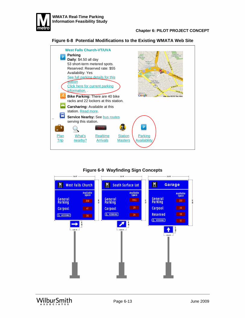
WMATA Real-Time Parking Information Feasibility Study
Chapter 6: PILOT PROJECT CONCEPT
Page 6-13 June 2009
Figure 6-8 Potential Modifications to the Existing WMATA Web Site
Service Nearby: See bus routesserving this station.
Carsharing: Available at this station. Read more.
Bike Parking: There are 40 bike racks and 22 lockers at this station.
ParkingDaily: $4.50 all day 53 short-term metered spots.Reserved: Reserved rate: $55Availability: YesSee full parking details for this stationClick here for current parking information. .
StationMasters
Parking Availabliity
RealtimeArrivals
What's nearby?
Plan Trip
West Falls Church-VT/UVA
Figure 6-9 Wayfinding Sign Concepts

WMATA Real-Time Parking Information Feasibility Study
Chapter 6: PILOT PROJECT CONCEPT
Page 6-14 June 2009
Figure 6-10 Locations of Wayfinding Signs
Garage
Lot
Lot
Sign Locations
E
D
C
A
B
Figure 6-10 shows the proposed locations of the five traveler information wayfinding signs. The specific locations and functions of the signs are described below:
• Signs A and B will provide information to travelers at the decision points where they decide whether to park at the station. These signs will provide general information regarding availability of parking. Sign A will be oriented to be visible to travelers arriving from the northeast along Haycock Road. Sign B will be positioned to be legible to those arriving from the southwest along Haycock Road.
• Sign C will provide information to travelers after they have entered the facility from the southeast entrance. The primary purpose of this sign is to provide information on whether there are available spaces in the north lot or garage, or whether the motorist should immediately use the south lot to their left. Sign C will be oriented to drivers who have turned into the facility’s southeast entrance route and are facing northwest.
• Sign D will provide similar information for travelers who are entering the facility from the southwest entrance. This sign will assist travelers in their decision to either turn left to park in the north lot or garage, or turn right for the south lot. The sign will be oriented to travelers facing northeast.
• Sign E will provide information about availability in the north lot and garage, for travelers who have already determined not to park in the south lot. The sign will be oriented to drivers who are facing northwest.

WMATA Real-Time Parking Information Feasibility Study
Chapter 6: PILOT PROJECT CONCEPT
Page 6-15 June 2009
Communications Communication between field devices and with other agencies is expected to use fiber optic technology, 10/100 Ethernet, or a hybrid of the two. Media converters will be needed to interface between Ethernet-based devices and fiber optic cabling. These are available at relatively low cost, and are not expected to significantly impact overall system costs.
Space level detectors most often utilize an ASI Bus system in which the power and data typically transmit along the same Siamese cable (two wires in parallel) to low voltage devices (32 volts typical). ASI Bus technologies have been proven to save enormous amounts of capital costs during deployment. A single bus type cable is deployed between the device controller and its associated sensors. Each run length of bus cabling can accommodate up to 62 devices with a distance limitation of approximately 330 feet, extendable to approximately 985 feet with the use of a repeater.
Figure 6-11 shows a potential WMATA architecture for connectivity between devices in any of the parking facilities.
Once the data is connected to the WMATA fiber in the station communications room, it will be transmitted to the central server room for WMATA. There it will be connected to the new Parking Central Server. This server will connect to other systems internal to WMATA as required (e.g., office LAN, web server). The communications to the internet will be through the existing WMATA web server. This includes publish/subscribe services to VDOT. Until such time as a direct fiber connection is available, the internet can be used to share information between the two agencies.
Additional load on the current web server will only require the addition of a dedicated Active Server Page (ASP), or the integration of the additional information into an existing ASP webpage, to facilitate incremental or real-time updates. The scripts within the ASP architecture will request, receive, and publish information from the equipment controllers as assigned by the webmaster.
While the additional responsibilities placed on the web server and IT staff are assumed to be marginal, this project does afford an opportunity for the agency to upgrade the web server. This price is not included in the estimate for this project.

WMATA Real-Time Parking Information Feasibility Study
Chapter 6: PILOT PROJECT CONCEPT
Page 6-16 June 2009
Figure 6-11 Potential WMATA Parking Facility Architecture
General Reserved
Carpool
FULL
PP
6
15
20
South Surface LotAvailable Spaces
General Reserved
Carpool
256
PP
23
20
30
Available Spaces
External Sign Internal Sign
High Level Computer Architecture It is expected that much of the computer architecture will be determined by the vendor. The design is typically requirements based, so while the design team may specify operating systems, or specific software packages (e.g., Oracle for the database), the vendor will likely have some flexibility to deliver a system that they are familiar with, yet meets all needs of WMATA. While WMATA IT staff will ultimately be responsible for the maintenance of the system, it is expected that they may need to contract with the vendor for software specific issues, regardless of the system selected.
In the simplest terms, from Figure 6-11 there are only two servers, a local server, and a central server. The rest of the equipment is generally off the shelf components that may require some integration.
Local Server The local server assembles and processes information for the user at the facility. The local server continuously collects and processes information from the detectors. It must know the parking facilities and continuously compare the number of vehicles to the number of available spaces. The information that the local server collects and calculates will be used by the other internal and external systems.
Because of its critical role, the local server will need to be both reliable and robust. It will need to withstand the elements and constantly check itself for errors or problems. The local server will also provide user information directly to the internal and external signs. It is expected that it will be able to provide this function even in the event that communication with the central server is lost.

WMATA Real-Time Parking Information Feasibility Study
Chapter 6: PILOT PROJECT CONCEPT
Page 6-17 June 2009
Central Server The central server is the main communications hub for the parking system. It will be responsible for maintaining the archive and interfacing with the central WMATA staff. For this reason, its application user interface is critical – it must be easy to use and complete. The central server will take the information from the local server, reformat it, and publish it to the outside world. This includes creating web pages or information, sending information to VDOT, and interfacing with other third party vendors. Over the long term, the central system will need to be able to interface with several different systems simultaneously.
The type of computer and operating system for the central server can be more rigidly defined. It will need to work within the greater WMATA WAN and will be maintained by WMATA staff. This should not be a problem for any vendor to supply a more custom system at the local controller, while the central system is a more traditional office environment system.
Requirements and Procurement Method The goals, objectives, and functional requirements were addressed in Chapter 4. In that chapter, requirements were matched to goals and objectives. For the system requirements, the requirements now need to be logically matched to actual field components, including systems and subsystems. Two tables demonstrating that all requirements are matched to objectives and that each objective corresponds to a requirement are included in the Technical Memorandum.
Not all of the final objectives will be addressed in the pilot study. The intent of a pilot study is to test the technologies and the operations of the system to see if this application is warranted at other locations throughout the WMATA system. The pilot system should be installed with the intention of expanding the system to other stations, but must stand alone first.
A full system design is still required before the system can be built. This can be procured using either a design-bid-build or a design-build approach. Under a design-bid-build procurement, a designer would be hired by WMATA to design the system and assemble contract-ready procurement documents. The system would then be put out to bid. A contractor would be hired, and either the designer or another consultant would likely serve as a systems manager, ensuring the contractor is meeting all requirements.
In a design-build procurement, a consultant will still need to assemble and complete these requirements into a design-build procurement package. The procurement package in this case will be conceptual and include specific functional requirements, with certain minimums that must be met to ensure the contractor meets all of the needs of WMATA. Again, the designer (or another consultant) would likely serve as a systems manager ensuring all requirements are met. In either procurement method, it is important that WMATA obtain design engineering and systems manager support to ensure all needs and desires are met. Though not an absolute requirement, the design engineer and the systems manager ideally should be the same firm. The first step in implementation should be to obtain this critical support.

WMATA Real-Time Parking Information Feasibility Study
Chapter 6: PILOT PROJECT CONCEPT
Page 6-18 June 2009
The system requirements are built off of the following assumptions:
• There will be a central system at WMATA headquarters that communicates with WMATA staff, outside agencies, and the public through the internet
• A mixed system will be used with space level detection for all specialty parking spots (i.e., reserved, handicapped, carpool, service), and zone level detection will be used for all other spaces
• Wayfinding signs will be used at the parking property.
Additional assumptions as they relate to costs are identified in a later section.
Impacts on Existing System The vast majority of the new equipment and services for this project are new and expected initially to have marginal impact on the overall operations of WMATA. The key areas of impact are discussed in this section, including servers, communications, and staffing.
Servers The majority of the servers related to this project are new. From discussions with WMATA staff, it is understood that WMATA IT staff will eventually take on the responsibility of maintaining the equipment. Therefore, while typically the requirements would allow for vendor flexibility in choosing the server platforms and operating systems, it is recommended that the final requirements define the latest versions of existing equipment and provide a recommendation to use compatible systems to help ease this transition.
The only existing server that should be impacted is the web server. The earlier review indicates that the impact would be marginal at best. Therefore, it is assumed that no substantial changes will be required.
Communications WMATA staff is already skilled and experienced with using and maintaining fiber optic communications systems. As the vast majority of this system is expected to use existing fiber, no additional training or staff is anticipated. The communications from the field devices to the field controllers will possibly use copper-based Ethernet, fiber optic cabling or a hybrid of both, depending on equipment location and physical distance. Any types of ASI Bus systems deployed will utilize copper cabling.
Staffing
WMATA Staffing needs for the project are expected to require additional WMATA staff. Most of the additional responsibilities were addressed earlier in this planning process.
Only minimal initial impacts are anticipated to staff responsible for communications and staff responsible for the new computer systems. For a project such as this, vendor staff typically remain involved (under contract) for up to two years after system initiation. This ensures that a knowledgeable staff will be able to quickly address problems as they
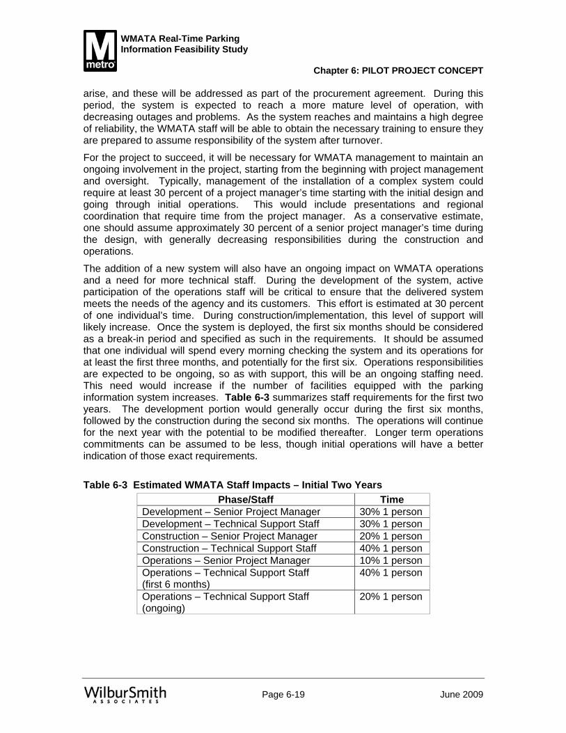
WMATA Real-Time Parking Information Feasibility Study
Chapter 6: PILOT PROJECT CONCEPT
Page 6-19 June 2009
arise, and these will be addressed as part of the procurement agreement. During this period, the system is expected to reach a more mature level of operation, with decreasing outages and problems. As the system reaches and maintains a high degree of reliability, the WMATA staff will be able to obtain the necessary training to ensure they are prepared to assume responsibility of the system after turnover.
For the project to succeed, it will be necessary for WMATA management to maintain an ongoing involvement in the project, starting from the beginning with project management and oversight. Typically, management of the installation of a complex system could require at least 30 percent of a project manager’s time starting with the initial design and going through initial operations. This would include presentations and regional coordination that require time from the project manager. As a conservative estimate, one should assume approximately 30 percent of a senior project manager’s time during the design, with generally decreasing responsibilities during the construction and operations.
The addition of a new system will also have an ongoing impact on WMATA operations and a need for more technical staff. During the development of the system, active participation of the operations staff will be critical to ensure that the delivered system meets the needs of the agency and its customers. This effort is estimated at 30 percent of one individual’s time. During construction/implementation, this level of support will likely increase. Once the system is deployed, the first six months should be considered as a break-in period and specified as such in the requirements. It should be assumed that one individual will spend every morning checking the system and its operations for at least the first three months, and potentially for the first six. Operations responsibilities are expected to be ongoing, so as with support, this will be an ongoing staffing need. This need would increase if the number of facilities equipped with the parking information system increases. Table 6-3 summarizes staff requirements for the first two years. The development portion would generally occur during the first six months, followed by the construction during the second six months. The operations will continue for the next year with the potential to be modified thereafter. Longer term operations commitments can be assumed to be less, though initial operations will have a better indication of those exact requirements.
Table 6-3 Estimated WMATA Staff Impacts – Initial Two Years
Phase/Staff Time Development – Senior Project Manager 30% 1 person Development – Technical Support Staff 30% 1 person Construction – Senior Project Manager 20% 1 person Construction – Technical Support Staff 40% 1 person Operations – Senior Project Manager 10% 1 person Operations – Technical Support Staff (first 6 months)
40% 1 person
Operations – Technical Support Staff (ongoing)
20% 1 person

WMATA Real-Time Parking Information Feasibility Study
Chapter 6: PILOT PROJECT CONCEPT
Page 6-20 June 2009
Vendor Staff Parking operations services at the West Falls Church station are currently provided by a vendor under contract. The contract length is for two years, and it is not expected that the contract can be easily modified. Any additional responsibilities for the contract staff would necessitate a contract amendment process. Because a pilot project is not expected to become operational for at least 18 months, the initial implications are minimal, as this would roughly coincide with the term of the current contract.
It is expected that contract staff at the parking facility would assume new responsibilities under a subsequent contract. The following responsibilities are anticipated in the long term and should be specified in the next contract, with an expected cost implication.
• Contracted staff should arrive earlier than 10 AM. • The first staffer should be responsible for providing initial checks of the system
on a daily basis to ensure it is working properly. Any issues would need to be addressed by WMATA staff or other contractors.
• Contracted staff would be responsible for updating information for known issues. For example, if snow plowing has left 10 spaces unusable, on-site staff should be able to input the needed information to ensure that the parking information system knows how many spaces are available.
• Operators should be available to confirm the number of occupied spaces after the last train has arrived. This will ensure that the system is recalibrated to start with the right number of spaces the next morning.
These additional responsibilities are all related to long term operations, and do not need to be addressed in a contract revision for the short term. However, any implementation schedule should add sufficient time to ensure that contract staff take care of these additional responsibilities.
Potential for Growth The requirements developed in earlier chapters assume that the full system would be implemented over the long term. The requirements identified in this chapter are solely for the pilot implementation. This leaves a large gap between the first installation and the long-term potential.
The simplest expansion of the system is to deploy additional smart parking systems at additional facilities. Therefore, the pilot implementation should create a central system that is capable of receiving information from many additional stations. Two caveats apply to this statement. The first is that the system cannot be tested for multiple locations until the second deployment. The second is that it is assumed in all technology applications that systems have a relatively short life cycle (e.g., 3-5 years). The initial system deployed with the pilot study would need, at a minimum, the hardware and software upgraded or changed prior to the third or fourth installation (depending on the programming of additional facilities). The pilot implementation should be adequate for the initial few installations, but will likely need some upgrades or improvements well before a full system implementation.
Most of the future applications identified in Chapter 5 are third party applications. It is assumed that WMATA will continue to keep its web pages current in terms of
WMATA Real-Time Parking Information Feasibility Study
Chapter 6: PILOT PROJECT CONCEPT
Page 6-21 June 2009
appearance and applications, while incorporating the information from the parking systems accordingly. The signs at the facility should be sufficient for the foreseeable future.
As long as WMATA continues to maintain communications with VDOT and RITIS, then new applications on their end will be the responsibility of these other agencies. It is assumed that WMATA will continue to work with these agencies and make improvements and modifications to the source data as necessary. The other applications identified included mobile applications with PDAs and mobile phones beyond the existing WMATA services. Similarly, it is assumed that the private sector will take the lead with these applications. WMATA may need to adjust the manner in which their information is provided to the third parties, but should not be responsible for developing new applications. This allows for maximum flexibility in meeting new needs and adopting new technologies, with a minimal investment on the part of WMATA.
Costs A detailed cost breakout for the pilot study is included in the Technical Memorandum. It should be noted that the costs presented herein are preliminary, and that decisions made during design could greatly affect these estimates.
The general concept for the pilot study was explained above. The following assumptions were used in generating the cost estimates:
• 154 reserved spaces • 45 ADA/handicap spaces • 50 carpool spaces (to be designated within the garage) • 273 general spaces in the north lot • 967 general spaces in the garage • 490 general spaces in the south lot • Existing fiber will be used to connect the field devices to the servers at WMATA’s
central offices • Advanced mixed static/DMS signs as well as general wayfinding signs will be
used only on WMATA property. • The detection technologies identified above will be used where appropriate to
accomplish the objectives, though could be changed during design and deployment.
The detailed costs also identify additional consultant costs that will be incurred by WMATA, and additional staff time to manage and operate this system.
Prior to the implementation of the pilot study, two things remain to be accomplished. First, a final design is required. The level of detail to be included in that design depends on the procurement method, but with either approach - design-bid-build or a design-build - a consultant will be required to develop actual plan sheets and more formal bid documents. This level of effort is estimated at between 10 to 15 percent of the construction cost, depending on the detail required. This translates to a high-level estimated cost of approximately $99,000. In addition to the design engineer, it is recommended that a consultant provide technical assistance such as construction oversight and assistance with the initial break-in period and evaluation. This systems

WMATA Real-Time Parking Information Feasibility Study
Chapter 6: PILOT PROJECT CONCEPT
Page 6-22 June 2009
manager contract is estimated in the detailed costs in the appendix as approximately $182,000 over 18 months. This gives a combined consultant support value of approximately $281,000. Again, it is WMATA’s decision on whether to procure these services or do them with internal forces, but they should be considered as part of the total overall cost of the system.
Earlier, the implications to WMATA staff were identified. While it is unlikely a new individual will be hired solely to assume project management responsibilities for this effort, some staff within WMATA should be identified prior to moving this project forward. It is typically very helpful if the same individual is involved in both the design and implementation of the pilot facility. This individual should also work well with the operations staff to help ease the eventual transition to WMATA operations.
Additionally, experience on other transit agencies facilities has raised concerns regarding operation of magnetometers in the vicinity of third rails. A test of several detection technologies should be implemented prior to implementation. This could be accomplished under the management of the design engineer, or could be accomplished directly by WMATA staff, or it could be the responsibility of the design-builder. Regardless of the approach, these technologies need to be tested prior to the decision to use them throughout the facility. If WMATA staff work with vendors, this cost could be insignificant. If the design engineer or design-builder is used, the cost and scope should be included in the appropriate contract.
The assumptions identified above were used with the technologies selected to develop a planning level cost estimate for the pilot project. The total estimated capital cost is approximately $955,000 with and estimated maintenance and operations cost of $237,000 for the first 18 months of operation.
The information presented in this document is for the West Falls Church station. Implementation of the system at other stations will require a separate evaluation to determine number and placement of equipment and communications, and as such, will have a different implementation and likely operational cost. However, approximately $290,000 of the cost incurred during the West Falls Church implementation, or approximately 44% of the total capital equipment cost, is part of the permanent central system, and would likely not be required in subsequent applications.
Funding Parking information systems have been implemented at a variety of locations in the U.S. and around the world. Although technology costs have generally trended downward, the anticipated costs remain considerable, particularly for space-level detection components and other aspects of the system.
Payback/Benefits Perspective Most parking information systems implemented to date are typically implemented with a direct or indirect consideration of their ability to pay for themselves by generating additional revenue.
That approach is not consistent with the intent of this pilot project. The information system is intended to provide an additional service to transit patrons that will help them save time and make more efficient decisions relative to their trip. It is generally not
WMATA Real-Time Parking Information Feasibility Study
Chapter 6: PILOT PROJECT CONCEPT
Page 6-23 June 2009
expected that the system will generate sufficient additional revenue to allow WMATA to recover the capital investment. It is anticipated that the system will provide information that can help WMATA adjust the number of reserved spaces to meet demand, as discussed below.
Potential New Funding Sources A number of potential funding sources have been identified for their potential to fund all or part of the parking information system. Most of these are federal funding sources, however, other funding sources are also considered. The following sections describe the funding possibilities that were deemed most applicable to the pilot implementation.
Emissions-related Funding Options By providing information on available parking capacity in a timely manner, system users are able to make decisions that can not only improve parking convenience, but also improve the efficiency of the overall transportation system beyond the station site. Shifting person trips from auto to bus when parking is not available, or diverting auto trips to facilities where capacity is available, has the potential to increase ridership on WMATA and effectively reduce vehicle miles traveled (VMT). This results in lower fuel consumption, and correspondingly lower emissions of carbon dioxide gas, and other pollutants. In addition to the environmental benefits and lower fuel cost for users, these reductions and efficiencies can be the basis for project funding. Related funding options are summarized below
CMAQ The Congestion Mitigation and Air Quality (CMAQ) program’s two key goals are to reduce emissions and mitigate congestion. The latter can result in air quality improvements by decreasing travel delays, unproductive fuel consumption, and idle engine time. When the U.S. Congress adopted the Intermodal Surface Transportation Efficiency Act (ISTEA) in 1991, this law also authorized the CMAQ program dedicating $6 billion of funding for projects that conform to the two main goals of the program. The CMAQ program was then reauthorized as part of the Safe, Accountable, Flexible, and Efficient Transportation Equity Act: A Legacy for Users (SAFETEA-LU) legislation in 2005. The SAFETEA-LU provides about $1.7 billion per year on average (totaling $8.6 billion over the 2005-2009 period) in funding state, MPO, and transit agencies’ investments in transportation projects resulting in air pollutants reductions. The Federal Transit Administration and the Federal Highway Administration jointly administer this program. The funding distribution formula considers an area’s population and severity of pollutants. A number of transportation project categories, including traffic flow and public transportation improvements, are eligible for CMAQ program funding.
Other Emissions-related Funding As part of the American Recovery and Reinvestment Act (ARRA), the U.S. Department of Energy (DOE) has announced two competitive grant opportunities in addition to the Energy Efficiency and Conservation Block Grants. These two grants, totaling $700 million for which this intelligent parking initiative may qualify, represent a significant potential funding opportunity.

WMATA Real-Time Parking Information Feasibility Study
Chapter 6: PILOT PROJECT CONCEPT
Page 6-24 June 2009
While specific guidance has not been issued as the DOE concentrates on the formula-based block grants, it appears that the first opportunity identified, will not require cost sharing and will continue the DOE's objectives under the formula grants. These objectives include:
• Reduce fossil fuel emissions in a manner that is environmentally sustainable and, to the maximum extent practical, maximizes benefits for local and regional communities;
• reduce the total energy use of eligible entities; and • improve energy efficiency in the building sector, the transportation sector, and
other appropriate sectors.
Additionally, cap-and-trade legislation is currently being considered by Congress. Dedicating 10 percent of cap-and-trade revenues specifically to transit funding is one of many alternatives that have been presented.
Finally, discussion of reauthorization of the Surface Transportation Act has begun. In the first version of the Clean Efficient Affordable New Transportation Equity Act (CLEAN TEA) read into both the Senate and House records in March of 2009, transportation projects that had the ability to reduce carbon emissions were highlighted. While there will, of course, be numerous changes as this important bill makes its way through Congress, it appears highly likely that transportation system efficiency and carbon emission reduction will be a major focus of this legislation. While it is too early to identify specific opportunities under either cap-and-trade or CLEAN TEA legislation, this legislation will need to be monitored as it proceeds through Congress to identify potential funding options that can be pursued.
Other Options Partnership opportunities may be available with the private sector. These include various parking-related creative advertising joint ventures that could result in additional revenues to WMATA supporting the parking information system. Programs such as location-based short messaging coupons delivered to cell phones, dynamic messaging signs, or advertising on the radio or the web for retail promotions can be deployed to generate additional revenues.
Marketing As discussed in an earlier chapter, one stated goal of the project is to maximize efficiency of parking facilities. Because the pilot station currently reaches capacity during the AM peak period, other periods present the greatest opportunity for improved utilization of the facility. In the AM peak period, the system should serve to alert potential users when the facility is filled or nearly filled, diverting them to other facilities as efficiently as possible.
This marketing effort should not be implemented until WMATA staff is comfortable with the operations of the system. This will likely be several months beyond the initial system activation.

WMATA Real-Time Parking Information Feasibility Study
Chapter 6: PILOT PROJECT CONCEPT
Page 6-25 June 2009
Potential Market Segments This section discusses the groups of users who may be interested in using the pilot system, and how they can be reached.
Current Regular Facility Users As discussed below, current parking facility users deal with the uncertainties of parking availability by either departing early enough to ensure getting a space, or accepting the possibility that no parking will be available on the WMATA property. A variety of relatively low-cost approaches can be used to inform these users about the availability of real-time parking information, including the following:
• posters at the pilot station, particularly near the walkways from the fare gates to the parking facilities, to be seen as users leave the station;
• audio announcements at the pilot station; and • announcements and links on the WMATA website.
Potential Off-peak Users Potential off-peak users may be somewhat familiar with the WMATA system, including parking capacity concerns, but may not know that spaces can become available in the mid afternoons. Because these users may not have daily contact with WMATA, it is more important to reach them before they begin their trip. As with regular users, banner ads and links on the WMATA web site may be the most cost-effective way to reach these users. Additionally, a program of reaching out to local hotels would help inform tourists of the potential for off-peak transit usage.
Outreach Methods Achieving the goals of the project will require that potential users be informed of the parking information system’s existence, how they can access the information, and what the information means. The following are some potential means of accomplishing this communication with the potential users of the system:
Web Links Users who request times for trains at the pilot station through the web site can be alerted to the new information system with a web link included in the list of train times. This can be automated and expanded to inform anyone requesting information on this line. That may allow more potential users to be aware of the system without creating a blanket information campaign to inform all residents of this potential.
Email to Registered Users Messages informing users of the information system can be sent though Metro’s existing “eAlert” system. This will enable the message to be limited to users of that particular subway line.

WMATA Real-Time Parking Information Feasibility Study
Chapter 6: PILOT PROJECT CONCEPT
Page 6-26 June 2009
Text / PDA messages Users who request times for trains at the pilot station through their mobile devices can be alerted to the new information system with a simple message attached to their request.
511 Virginia and Other Agencies VDOT and other regional agencies often have newsletters, web sites, and other means of informing their patrons of events and accomplishments. WMATA can work with these entities to help use their available methods to further distribute information relative to the pilot study.
Deployment Issues and Procedures Any technology deployment can encounter problems as multiple systems are designed, deployed, and interconnected. While it is not possible to detail here all potential problems, this section provides a summary of anticipated deployment issues and recommended procedures to minimize deployment complications.
Design The detailed system plan includes a combination of field equipment, software, and communications systems. For the system to work properly, each subsystem will need to work well independently and in coordination with the other components. Much of the success of the final system rests on a good design.
There are many competing needs that were identified in the earlier tasks. The requirements provided address the bulk of the details. However, as design proceeds, inconsistencies or changes in goals and objectives will translate into new or modified requirements. It is important that the design engineer track these changes back to the goals and objectives to ensure any changes are for a better system.
Additionally, the design engineer will need to verify that the latest versions of equipment are specified. The electronics and communications industries evolve quickly. Required models may no longer be available or supported. This is why a majority of the requirements are performance based – to allow the designer and implementer the opportunity to provide WMATA with the most current equipment.
Implementation Steps As stated above, the system includes a combination of field equipment, software, and communications systems that need to work well, both independently and, in coordination with the other components. Additionally, the system as deployed will need to be self-checking to ensure that a failure along one link in the system can be identified and corrected as quickly as possible. While the primary intent is to properly inform motorists where to park, the system must operate well with WMATA staff, or it will quickly be discarded or not maintained.
To address these issues, the consulting team recommends following the systems engineering process, and using a staged implementation approach that follows the path of information flow from facility to user. This will likely require hiring a consultant to
WMATA Real-Time Parking Information Feasibility Study
Chapter 6: PILOT PROJECT CONCEPT
Page 6-27 June 2009
serve as a systems manager, as discussed in section C. above. Additionally, an independent verification and validation consultant could be retained. This consultant could serve as a subcontractor to the systems manager, or be hired separately. If WMATA staff feel they have the proper available staff, these services could be addressed through internal staff.
The general stages of development and implementation are outlined in the following pages. It should be noted that these stages should be considered preliminary as they may be modified as the design engineer completes their work.
Local System The first step is in the implementation of the detection and information systems at the parking facility. These subsystems must be constructed and tested to verify they are working. As in most software development efforts, the field infrastructure is tested first to verify that the equipment is functioning properly.
• The field devices will be installed and tested independently to verify they are working. This means that the detectors are properly sensing vehicles in a variety of conditions, and that the wayfinding signs are able to display information.
• Concurrent to this, the software at the local controller should be developed, and the user interface and controls worked out on paper with the WMATA staff and the design engineer. This will ensure the implementer is developing the proper functionality. The software being developed for the pilot station must be capable of calculating total facility occupancy as well as occupancy of any defined zones or detected spaces. Once the software is demonstrated in a lab setting, it will be implemented at the field controller. An independent verification team should ensure that the system is properly receiving information from the sensors, processing that information, and communicating with the wayfinding signs.
• Next, the ancillary services of the local controller should be tested. This includes the interface with local staff, self checking, and data archiving. All error testing should be simulated and independently verified. This includes performing self-checks and properly notifying others of issues. While some of this is continuous, other more rigorous tests can take place at night, when the facility is closed and occupancy is at or near zero.
Transmission to WMATA The central parking information system controller at the WMATA IT offices will need to be installed and connected to the field controller.
• Similar to the field controller software, the software functionality for the central server should be developed in a document in coordination with WMATA to ensure that all required functions are included. Once the software is developed and demonstrated in a lab setting, the system should be installed at the central WMATA offices.
• The systems will then need to be connected. This step will include installing the fiber from the field to the communications room at the station and verifying that information can be received at the central WMATA offices. A separate test for verification of communications will need to be independently performed before the central server is connected to the field device. This will also involve a new

WMATA Real-Time Parking Information Feasibility Study
Chapter 6: PILOT PROJECT CONCEPT
Page 6-28 June 2009
test at the field device to ensure that it is properly transmitting information to the central server, and can receive information from the central server.
• Once the central server is properly communicating with the field controller, then all the internal functionality of the central server must be tested. This begins with the demonstration of access from other computers at WMATA, and the ability to review information, upload/download data, and make changes to system parameters. An independent verification and validation test is critical to this success.
• A 60 day operational test should be used to verify that the system operates reliably and can handle archiving of data beyond the current month. This test would require the use of the local wayfinding signs, but should be performed before information is made available via the internet. The test should verify data transmission and check that alarms are addressed as specified. The system should be able to determine if it is not receiving regular updates from the detection system and alert WMATA IT staff if its information feed from the detection system fails.
Transmission to Other Entities
It is recommended that user information systems such as web page, mobile device, and text message updates first be tested internally by WMATA staff. Subsequent to WMATA staff verification of correct functionality, the system should then be tested by a limited number of regular users of the pilot station parking facilities. After a suitable demonstration period, the system can then be made available to the general public.
• First test transmission to the WMATA web servers Communications must be established and the new web site developed. This will likely require coordination between the parking system developer, and the web site developer. Independent management of this coordination is critical to the success. Once the new web pages are developed and populated, they should be tested internally as stated above for at least one month prior to allowing the public access.
• Communications with RITIS and 511 Virginia Again, this will require coordination between the parking system developer and the RITIS and 511 Virginia developers. As both the RITIS and 511 Virginia systems already exist, it should primarily be the responsibility of the parking system developer to use and implement the existing data standards. Any proprietary systems should be discarded or not used for this link. Coordination with the other agencies and their developers is key to the seamless integration of these systems.
• Coordination with outside vendors (e.g., third party mobile device information resellers) In this instance, WMATA should adopt its own interface controls and require the resellers to meet these controls. These systems can be verified by the third party as to their operations and stability.
By following this process and completing independent verification and validation testing at each stage, the technical issues related to the development of this system should be more easily identified and addressed at the appropriate and easiest time to fix. This will help ensure WMATA takes ownership of a system that best meets their identified needs.

WMATA Real-Time Parking Information Feasibility Study
Chapter 6: PILOT PROJECT CONCEPT
Page 6-29 June 2009
Evaluation Requirements All federally funded projects through VDOT require a separate evaluation. This evaluation should verify that the goals and objectives identified in the Task 3 reports are met, and to gather lessons learned from this project to benefit others. To review, the goals identified for the pilot project are as follows:
• Maximize efficiency of parking facilities • Improve customer experience and satisfaction • Maximize efficiency of parking payment system • Share real time parking information with other regional agencies.
The last of these can be determined through a survey of regional stakeholders. The first three will require a more detailed evaluation approach, discussed as follows.
Utilization Review After a suitable period of operation, WMATA should review detailed utilization data from the parking system. It is particularly recommended that automated data collection, including logging of entries and exits, begin at least one or two months before the information system components are made available to users. This will enable WMATA to compare data from before and after the information system becomes available to the public. The utilization review should identify changes in utilization of the facility by time of day and day of the week, and by particular types of spaces, and should include any increase or decrease in off-peak usage. The intent is to determine if additional vehicles are able to use the facility later in the weekday (i.e., in the afternoon) and how well the system is utilized on weekends. This may include a quick review of nearby facilities to see if they experience any change in usage.
User Acceptance/Satisfaction Survey For many parking information systems currently installed around the world, it is assumed that the system will improve customer satisfaction by reducing time spent searching for a space. If WMATA already conducts regular customer satisfaction surveys, it may be possible to incorporate specific questions regarding parking at the pilot station as part of the regular survey. Otherwise, WMATA may wish to conduct surveys of users of the system both before and after implementation to determine the degree to which the system has increased customer satisfaction.
Payment System While the overall project goals include improvements to the parking payment system, the pilot study does not address this goal. No evaluation is required with the initial deployment.
Environmental Benefits Some funding programs may require an evaluation of environmental benefits, such as reduced idling or searching time. These may require WMATA staff or vendor efforts to measure or estimate the decrease in circling mileage or duration. Site-specific studies may be needed to accomplish this, and may include before and after video recording of
WMATA Real-Time Parking Information Feasibility Study
Chapter 6: PILOT PROJECT CONCEPT
Page 6-30 June 2009
circulation activity or monitoring of entry/exit flows before and after activation of the system components.
Applicability to Other Stations The pilot station was selected because it provided a general representation of the varying configurations and technical challenges of the WMATA parking facilities. With its mix of reserved, unreserved, and accessible spaces in a structure and surface lots, the West Falls Church station is expected to provide useful experience for other stations if WMATA should decide to deploy similar systems at other rail stations.
Although West Falls Church is reasonably typical among WMATA parking facilities, it is expected that other stations may present challenges in adapting the parking information system. Anticipated challenges are described below.
Geometric & Configuration Differences Most of the WMATA stations, like West Falls Church, have connecting routes available throughout the facility, among different lots and structures, so that a driver who does not find a space in one lot or structure can proceed to another. However, at some stations the facilities are not connected. This will pose design challenges that are site-specific. For example, the Vienna-Fairfax-GMU station has a particularly complex layout, with multiple parking lots and garages on either side of the Metro tracks that are not accessible through a single gate. Vienna-Fairfax-GMU will essentially need two separate detection systems, and it will also be necessary to determine how to inform users of available spaces in another lot or garage at the station when their original destination lot or garage is full. Similar though less severe challenges will likely be faced at other stations.
Regulatory Considerations (types of spaces) WMATA currently offers a mix of reserved, general unreserved, and disabled spaces at its facilities. As the system is deployed and historical data becomes available, it is possible that this information will enable WMATA to adjust the mix of spaces to better meet user needs. For example, the WSA team’s survey of West Falls Church showed that utilization of disabled spaces peaked at 42 percent. While this is based on a single day’s survey, historical data from the completed system may suggest a need to modify the mix of spaces. To ensure that disabled spaces are always available while ensuring maximum facility utilization, WMATA may wish to consider the possibility of testing automated real-time adjustment of disability restrictions for future installations. This will need to comply with ADA requirements and guidance.
Multi-day Spaces: The West Falls Church facility does not currently allow multi-day parking in non-reserved spaces. While it is not known if WMATA currently enforces this, it may simplify software development, as the system can generally assume that nearly all spaces will empty out before the facility’s closure. Deployments at stations that feature multi-day parking may benefit from including designated multi-day spaces in the pool of spaces covered by space-level detection.
Car Pool Spaces: While not currently implemented within WMATA, there is a desire to create additional car pool reserved spaces. These will require similar treatment as the

WMATA Real-Time Parking Information Feasibility Study
Chapter 6: PILOT PROJECT CONCEPT
Page 6-31 June 2009
reserved spaces. Policy changes within WMATA are required before these types, or other future specialty spaces, can be implemented.
Third Rail Interference During the initial requirements work, magnetometers were often identified as offering the best applicability to vehicle detection in a parking facility. However, it has been noted that some newer magnetometer-type detection systems may be susceptible to electromagnetic interference from the electrified third rail that powers WMATA trains. To ensure this is not a problem, WMATA should take the following steps:
• Vendor contact: Vendors of detection systems should be contacted and asked to identify any known interference problems with their detectors, and if any existing installations are known to operate in the vicinity of third-rail powered rail systems. It is also recommended that WMATA request a demonstration from several manufacturers to show that a particularly technological approach can function in the WMATA operating environment. Alternately, the demonstration could be a formal contract requirement of the selected contractor, particularly if design-build procurement is used.
• Specifications: Procurement materials should specify that detection equipment must operate effectively and accurately in an electrically powered heavy rail environment.
Shifts in Facility Use over Time Based on Information Access Many of the WMATA parking facilities routinely reach capacity during AM peak hours. For the study facilities, the study team has identified the time that each facility reaches capacity during weekdays. These times were identified through a manual survey of each station. It is anticipated that before the information system is made available to the traveling public, the detection subsystem will make it possible to have a more detailed set of measurements of facility utilization and its variability.
It can be assumed that current users of the system are generally aware of when a facility will fill, and through their arrival times have separated themselves into submarkets as follows:
• Early arrivers: These users arrive at a facility to take advantage of available capacity at early hours. These users include both those who arrive early because it meets their schedule, and those who have adjusted their schedule to arrive early enough to get a space.
• Late Arrivers: These users arrive near an anticipated fill time, and will have a backup plan available if the facility is filled to capacity. Likely, they will either continue to an alternate parking facility that may be less preferable for any number of reasons (price, distance of walk to station, etc.), or will drive directly to their destination.
• Ad-hoc arrivers come to the stations after the AM peak, and after spaces have once again become available. These users typically arrive in the late morning or in the afternoon.
It is possible that when supplied with real information regarding the availability of spaces at particular hours, users will shift their use of the facility to times that are more

WMATA Real-Time Parking Information Feasibility Study
Chapter 6: PILOT PROJECT CONCEPT
Page 6-32 June 2009
convenient for them. This could result in some fluctuation in the facility fill rates and “full” times, until a new equilibrium is achieved. Data should be collected and retained, both before and after system implementation, so that user behavior shifts can be anticipated and planned for in subsequent installations