real-time smart parking systems integration in distributed
TRANSCRIPT

Research ArticleReal-Time Smart Parking Systems Integration in DistributedITS for Smart Cities
Muhammad Alam,1 Davide Moroni ,2 Gabriele Pieri ,2 Marco Tampucci,2
Miguel Gomes,3 José Fonseca,1 Joaquim Ferreira ,1 and Giuseppe Riccardo Leone2
1 Instituto de Telecomunicacoes, Universidade de Aveiro, Portugal2Institute of Information Science and Technologies, National Research Council of Italy, Pisa, Italy3Micro I/O, Sistemas Electronicos, Lda, Aveiro, Portugal
Correspondence should be addressed to Gabriele Pieri; [email protected]
Received 18 June 2018; Revised 7 September 2018; Accepted 24 September 2018; Published 21 October 2018
Academic Editor: Eneko Osaba
Copyright © 2018 Muhammad Alam et al. This is an open access article distributed under the Creative Commons AttributionLicense, which permits unrestricted use, distribution, and reproduction in any medium, provided the original work is properlycited.
Intelligent Transportation Systems (ITS) have evolved as a key research topic in recent years, revolutionizing the overall trafficand travel experience by providing a set of advanced services and applications. These data-driven services contribute to mitigatemajor problems arising from the ever growing need of transport in our daily lives. Despite the progress, there is still need for anenhanced and distributed solution that can exploit the data from the available systems and provide an appropriate and real-timereaction on transportation systems.Therefore, in this paper, we present a new architecturewhere the intelligence is distributed andthe decisions are decentralized. The proposed architecture is scalable since the incremental addition of new peripheral subsystemsis supported by the introduction of gateways which requires no reengineering of the communication infrastructure.The proposedarchitecture is deployed to tackle the problem of traffic management inefficiency in urban areas, where traffic load is substantiallyincreased, by vehicles moving around unnecessarily, to find a free parking space. This can be significantly reduced through theavailability and diffusion of local information regarding vacant parking slots to drivers in a given area. Two types of parkingsystems, magnetic and vision sensor based, have been introduced, deployed, and tested in different scenarios. The effectivenessof the proposed architecture, together with the proposed algorithms, is assessed in field trials.
1. Introduction
The advancements in urbanization and the dependence ontransportation lead to the evident increase in the number ofvehicles on the roads around the world, which have a negativeimpact on the quality of life. Congestion on the roads, CO2emission, energy waste, road accidents, and increase stresslevel are some of the problems that are seriously affectingpublic health and wasting useful resources. It is clear thatinnovative solutions are needed, and that is where IntelligentTransportation Systems (ITS) should play the role in con-tributing to tangible results quickly and efficiently. Therefore,new disruptive technologies and techniques that ensure ITSto be more efficient, safer, and energetically sustainable needto be introduced.
The development of urban centers and the increasingnumber of vehicles on the roads around the world lead tothe evident increase in demand for parking places in urbancenters, which seriously affects the quality of the traffic. Thesearch for the available parking place increases the trafficvolume; it is estimated that more than 70% of the Europeanpopulation lives in urban centers under almost constantimpacts of air pollution and noise caused by road traffic[1]. But, next to the pollution, the problem called cruisingfor parking causes more than 30% of the usual total trafficcongestion resulting from the daily travels and traffic jamsdue to road constructions, traffic accidents, and related trafficproblems. The average search for the available parking placeis up to 20 minutes. According to other conducted studiesthis percentage could be much higher and so in a borough of
HindawiJournal of Advanced TransportationVolume 2018, Article ID 1485652, 13 pageshttps://doi.org/10.1155/2018/1485652

2 Journal of Advanced Transportation
MKCHNOLIISUKSESK FISIROPTPLATNLMTHULULTLVCYITHRFRESELEE IEDEDKCZBGBE
19902015
0
100
200
300
400
500
600
700
800
Figure 1: The increase in the number of passenger vehicles per 1000 inhabitants in EU [1].
Munich (Schwabing) even exceeds 44% and in a borough ofBrooklyn,NY (Park Slope) exceeds 45%.Moreover, accordingto an earlier study [1], 24% of all traffic accidents are caused bycareless parking (entry and exit from the parking lot), recklessdeparting from vehicles, sudden stops, etc.
In addition, from an economic point of view, in 2010, thespecified congestion caused in America 4.8 billion hours ofdelay, 7.2 billion litres of additional fuel consumption, and thecost of 101 billion dollars. Only in Los Angeles the search foravailable parking places took 178,000 litres of fuel (which isenough to circle the world 38 times) and produced 730 tonsof carbon dioxide [2].
The importance of applying the adequate strategy forthe management of parking places can also be found in theestimate that during the day a typical vehicle stays in idle 95%of the time.
The driver’s behavior, when choosing the type and thelocation of the parking place as well as making the final deci-sion, depends on many factors and represents a considerablymore complex process, which should be paid much moreattention than before. The usage of advanced technologies isunavoidable in achieving selected combination of strategies.
Increased vehicle production in the last 30 years andhigher purchasing power of citizens consequently inducedextremely high number of vehicles which are daily or peri-odically using highways as shown in Figure 1. In addition,according to the report presented in [4], every car is parkedfor 23 hours (average) daily and thus makes it extremelydifficult to find an empty parking. Today ITS are very complexsystems, made of several subsystems working in isolation,which are often closed, i.e., they do not provide interfacesfor direct access to third parties, and vertical, i.e., theyonly provide an end-to-end system from sensors/actuators to
the human-machine interface (HMI) of the system. Hence,the fusion of data originated from subsystems operating inthe same area is very difficult in practice and is bound tobecome worse in the future as the ICT infrastructure intransportation systems becomes bigger and more complex.Therefore, in this paper, we present an architecture whichmakes such interaction between heterogeneous data sourcesas seamless as possible, andwhich leverages such opportunityto shift the intelligence for decision making from humansin control centers to distributed machines. The proposedarchitecture tackles the problem of traffic management forthe specific case of open parking space management, throughlocal information diffusion on vacant parking slots to drivers.To this end, two types of parking systems’ technologies areconsidered: using magnetic and vision sensor based. Theywere considered, deployed, and tested in different urbanscenarios, and the effectiveness of the proposed architecture,along with the proposed algorithms, was assessed in fieldtrials.
This paper is further organized as follows: the relatedwork is presented in Section 2, Section 3 presents the pro-posed distributed architecture, and Section 4 presents visionbased algorithm. The implementation of both magnetic andvision sensors are presented in Section 5 while Section 6describes the equipments installation. The conclusions arepresented in Section 7.
2. Related Work
As urban centers are becoming increasingly more populatedand congested, the management of public parking places,according to local mobility policies, is a key strategic issuewith high economical impact. Academia and industry are

Journal of Advanced Transportation 3
well aware of the potential gains that can be obtained takingadvantage of information and communication technologiesapplied to this field. An efficient smart parking system willfavor drivers, by reducing the time to find a parking place andby optimizing parking spaces’ utilization rate, thus increasingthe revenues for the urban parking operators.
The demand for the available parking place is a dynamicvalue, i.e., a value that changes over time, so logically thereis a need to provide the information on the location andcondition of parking offer in real time to the drivers ofpassenger cars. The systems for providing the informationon parking offer to users already began to be used in someworld cities more than 20 years ago and can be foundunder names like “A Guided Parking System” or “DynamicParking Guidance System” [5]. By the usage of ParkingGuidance and Information (PGI) systems it is possible toimprove to some extent the process of parking and increaseits success and efficiency. The ecological effects of potentialPGI systems application are evident in the reduction of noise(the decreasing number of vehicles in certain segments of thetransport network) and in the reduction of fuel consumptionand exhaust emissions (shorter travel times and the increasein the traffic flow).
Typically, a PGI consists of 4 components, namely, theparking lot monitoring, information dissemination, commu-nication technology, and the control system [6]. The PGIsystems use either smart sensors or cameras for monitoringlots occupancy. The sensors based monitoring is furtherclassified as “On-Roadway” or “Off-Roadway”. The on-roadsensors are glued to the road surface; examples of such typeof sensors are magnetic sensors and acoustic sensors.The off-road sensors are placed above the surface of the road; theexamples are smart cameras for monitoring.
The body of knowledge in this area is vast, with large-scale field deployments since 1996. Lin et al. [7] provide anexhaustive, although not systematic, survey on smart parkingsolutions, from 2000 to 2016, and identify some challengesand open issues. The smart parking system can be designedin several ways and there are different technology optionsavailable. Regarding the technologies available for parkinglots monitoring various sensor solutions such as magneticsensor, acoustic sensors, RFIDs, ultrasounds, inductive loops,smart cameras, etc. can be used. Recently more advancedsolutions for street parking detection andmonitoring systemsare proposed, for example, crowdsourcing [8], which is basedon an ultrasonic range finder placed in each vehicle to detectfree places near the parked vehicle.The collected informationis then disseminated to the other vehicles’ drivers to helpthem find these free slots.
In [9] the authors have used photoelectric sensors todetect the vehicles in a controlled zone. The sensors wereinstalled at the entry/exit of the parking and connected withthe server for information processing and dissemination.Such arrangement can provide real-time information aboutthe number of free parking lots but does not provide exactlocation of the free space. In addition, the problem of findingexact free parking lot grows exponentially with the number ofparking lots. An increased production of sensors and smartcameras has enhanced the scope of analysis andmanagement
of urban traffic activities. New disruptive techniques leverag-ing computer vision that provides an added value to camerasby automatically extracting relevant information have beenproposed in several works. Therefore, these new techniquesbased on computer vision and video analytics becomeincreasingly important for ITS. For instance, a smart camerabased real-time car parking monitoring systems exploitingthe convolutional neural network algorithms was presentedin [10]. The system was tested and validated for robustnessand effectiveness in various challenging scenarios such as lowlight, shadows, and occlusions. The presented system exhibitshigh performance; however it is not integrated with a fullydistributed ITS architecture. In [11] the authors have usedapplied computational mechanisms and image processingtechniques to monitor and authorize vehicles entering theparking area. However, the presented systems only detect andrecognize the vehicles and verify if they are the registeredusers or not. Recently, a more interesting work on imageprocessing for smart transport infrastructure is presented in[12] using drones. The presented work uses drone camerasto capture the videos and then analyze it for the availableparking lots and congestion on the roads. However, thepresented work shows less precision and also not fullyintegrated into a distributed ITS system. Other related worksthat use smart camera for parking lots monitoring can befound in [13–16].
The work presented in this paper addresses some of thechallenges and openes issues identified in [7], notably at thesensing layer, guaranteeing personal privacy, and by usingsmart, low power, magnetic, and vision sensors. Moreover,with the aim of designing an architecture which can havehigh scalability and reliability, in the following section ourfully distributed ITS is presented and described, along withthe two different sensing technologies for covering differentaspects of parking systems (e.g., outdoor and undergroundparking lots). Another issue, faced by our proposal, regardsthe conditions for proposing a low-cost solution, at least incomparison with other proposals mentioned above, and withregard to several aspects: from the sensors customizationto the infrastructures and from the maintenance to thescalability.
3. Distributed ITS Architecture
In current information systems, supporting ITS applications,data flows from the edges of the system, i.e., sensors, road-sideunits, vehicles, and personal devices, towards a centralizeddata aggregation and control center. Automated or manualcontrol and supervision decisions are then either taken andfed back to the edge actuation components or forwardedexternally, e.g., to databases or web services.This architecturehas a number of drawbacks, such as the single point of failureof the central subsystem (control center) and the increasedend-to-end delay. Moreover, this legacy architecture haslimited scalability and availability, as the addition of newroad sections implies new configurations, parameterizations,and system restart. Therefore, based on these limitations,a different architecture was proposed, in the scope of the

4 Journal of Advanced Transportation
Sensor based Smart Parking
Computer Vision based Smart Parking
Local server anddata storage
Local server anddata storage
CentralSub-System 1
Local Sub-System 1
Local Sub-System 1
Gateway
RSU
Mobile App
Users
RSU
OBU
Traffic Management Emergency Service Vehicular Networks
Web Platform
Weather Centre
Figure 2: Distributed ITS architecture.
ICSI project [17], where the intelligence and storage aredistributed across limited geographical areas, as depicted inFigure 2. In this architecture, data is processed in gatewayslocated at each local subsystem without the interventionof the control center; hence the information is locally dis-tributed. These gateways aggregate and store data, processevents, issues warnings, etc., within a bounded geographicalarea. In turn, smart parking systems, vehicular networksvia road-side units (RSUs), and other personal subsystemsare connected with gateways. Additionally, each gatewayis logically connected to the control center, for long-termdata aggregation, optimizations, and big data processing.The proposed architecture provides higher dependability andreliability, as faults are confinedwithin the respective gateway,while other gateways and the control center may continue tooperate without failures. Furthermore, the new architectureis highly scalable, since the addition of new componentsof the system is automatically accommodated by a propor-tional increase of the number of gateways. Thus, thinkingto the typical development in an urban environment, newclusters (e.g., an existing parking lot becoming monitoredby smart cameras) could be added with only the cost ofthe infrastructure and the nodes, but at almost no cost forthe whole architecture. In addition, reactions in boundedtime are favored, because the complexity of interactions islimited to a local scope and the communication path is muchshorter. A data distribution layer acts as a bridge between thecooperative sensing infrastructure (sensors, road-side units,vehicles, and personal devices), the local gateways, and thecentral subsystem. The data distribution layer is connectedto the border routers of the vehicular network and the smartparking subsystems using the CoAP protocol. The borderrouter communicates with On-Board Units (OBUs) using theETSI ITS G5 and with the parking sensors and cameras using6LoWPAN.
4. Design of Cooperative ComputerVision Algorithms for Real-TimeParking Lot Monitoring
For the analysis of parking lot occupancy status, the approachfollowed is based on an ad hoc computer vision pipelinecapable of highlighting the changes in the Regions of Interest(RoI), with respect to an adaptive background referenceimage.The pipeline, described in the following, is particularlysuitable to real-time deployment on resource-constrainedembedded devices.
Change detection: in order to improve the computationalefficiency, the frame differencing for detecting changes isperformed only on predetermined RoI in the acquired frame.Each of the RoI corresponds to a specific parking slot,and for each of the regions the absolute accumulated pixel-wise difference is reported; such a difference is dynamicallyweighted in order to correct and improve the robustness ofthe algorithm with respect to environmental light changes.In order to perform this improvement, normalized versionsof the images are computed and used, with respect to globalillumination parameters (average and variance of both thecurrent and reference image). The sum of the differences isscaled with respect to the size of the RoI, and finally it isstored in a buffer. At this point verification occurs in orderto detect the possible change. In particular, a comparisonof the stored actual value with the historical values allowsfiltering out possible spurious values (i.e., exceeding thethreshold) due to, e.g., the presence of shadows. In the sameway the stored value is compared with another thresholdin order to detect possible changes with respect to thereference image. At this point the algorithm yields a firstoutcome which is a value regarding the occupancy status ofthe specific parking slot. Intranode occupancy detection:once the algorithm has computed values regarding the occu-pancy for each parking slot (corresponding to the RoIs), an
Journal of Advanced Transportation 5
intranode occupancy detection process occurs. In order toavoid transitory events (e.g., people crossing by and shadowscasted by external objects), the occupancy status becomeseffective and is transmitted to the smart camera network, onlyafter being observed consecutively for a specific number ofacquired frames. For each parking slot, the algorithm yieldsa confidence value in the range [0..255], meaning that valuesnext to 0 represent an almost no-change detectedwith respectto the reference value, and thus the slot is likely to be free;higher values, on the other hand, indicate that main changeshave occurred in the observed scene, and thus the slot is likelyto be occupied.
Internode cooperative decision making: the confidencevalues produced by the single nodes as a 256 levels numbershould be transformed to binary values corresponding eitherto free or busy parking slots, thus taking a final decisionregarding the parking availability. To this end, local confi-dence values will be propagated through the smart cameranetwork thanks to its middleware. In particular when aparking space is monitored by more than one sensor node,the final decision regarding its occupancy is obtained in acooperative way, at an internode level. This final decision isobtained aggregating all the confidence values produced bythe different nodes (which are statically dislocated and havestatic tables of the monitored parking slots). If a slot 𝑘 ismonitored by 𝑛 = 𝑛(𝑘) sensor nodes and V𝑘
1(𝑡), . . . , V𝑘𝑛(𝑡) arethe confidence values measurements from each single sensornode at time 𝑡, then the aggregated measure is computed as
V𝑘 (𝑡) =𝑛
∑𝑖=1
𝜔𝑖,𝑘V𝑘𝑖 (𝑡) (1)
where 𝜔𝑖,𝑘 are the nonnegative weights and𝑛
∑𝑖=1
𝜔𝑖,𝑘 = 1 (2)
Thus the final decision 𝑠𝑡𝑘(𝑡) regarding the slot 𝑘 isobtained performing a comparison with a threshold 𝜀:
𝑠𝑡𝑘 (𝑡) ={{{
1 if V𝑘 (𝑡) > 𝜀0 if V𝑘 (𝑡) ⩽ 𝜀
(3)
For the implementation of a more robust algorithm thatavoids meaningless oscillations, the above decision is furtherimproved using two levels of thresholds 𝜀1 < 𝜀2 andconsidering the status of the slot at the previous measureobtained at time 𝑡 − 1:𝑠𝑡𝑘 (𝑡)
= {{{
1 if V𝑘 (𝑡) ≥ 𝜀2 or (V𝑘 (𝑡) > 𝜀1 and 𝑠𝑡𝑘 (𝑡 − 1) = 1)0 if V𝑘 (𝑡) ≤ 𝜀1 or (V𝑘 (𝑡) < 𝜀2 and 𝑠𝑡𝑘 (𝑡 − 1) = 0)
(4)
Weights 𝜔𝑖,𝑘 are determined heuristically for each phys-ical configuration of the smart camera network, while thethresholds 𝜀1, 𝜀2 are set to a common value for all the nodes,the sensors, and the parking slots.
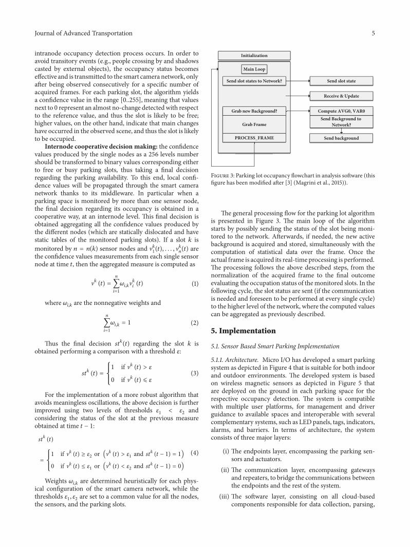
Initialization
Main Loop
Send slot states to Network?
Grab new Background?
Grab Frame
PROCESS_FRAME
Send slot state
Receive & Update
Compute AVG0, VAR0Send Background to
Network?
Send background
Figure 3: Parking lot occupancy flowchart in analysis software (thisfigure has been modified after [3] (Magrini et al., 2015)).
The general processing flow for the parking lot algorithmis presented in Figure 3. The main loop of the algorithmstarts by possibly sending the status of the slot being moni-tored to the network. Afterwards, if needed, the new activebackground is acquired and stored, simultaneously with thecomputation of statistical data over the frame. Once theactual frame is acquired its real-time processing is performed.The processing follows the above described steps, from thenormalization of the acquired frame to the final outcomeevaluating the occupation status of themonitored slots. In thefollowing cycle, the slot status are sent (if the communicationis needed and foreseen to be performed at every single cycle)to the higher level of the network, where the computed valuescan be aggregated as previously described.
5. Implementation
5.1. Sensor Based Smart Parking Implementation
5.1.1. Architecture. Micro I/O has developed a smart parkingsystem as depicted in Figure 4 that is suitable for both indoorand outdoor environments. The developed system is basedon wireless magnetic sensors as depicted in Figure 5 thatare deployed on the ground in each parking space for therespective occupancy detection. The system is compatiblewith multiple user platforms, for management and driverguidance to available spaces and interoperable with severalcomplementary systems, such as LEDpanels, tags, indicators,alarms, and barriers. In terms of architecture, the systemconsists of three major layers:
(i) The endpoints layer, encompassing the parking sen-sors and actuators.
(ii) The communication layer, encompassing gatewaysand repeaters, to bridge the communications betweenthe endpoints and the rest of the system.
(iii) The software layer, consisting on all cloud-basedcomponents responsible for data collection, parsing,

6 Journal of Advanced Transportation
WPAN
SENSOR
WPAN
GWGP RS/3G
TAG
SENSOR
GP RS/3G
DISPLAY
HTTP
USER INTERFACES
Figure 4: Sensor based smart parking overview.
Figure 5: Deployed sensors.
storage, and provision, from the web services anddatabases, to the multiple user platforms.
The system has the following features and specifications:
(i) Encapsulation: the sensor does not require cabling, asit features wireless communications and internal bat-teries for power.The device is installed inside a plasticcapsule, which is then filled with epoxy, and after theepoxy has hardened, the device is completely isolated.The encapsulation enables complete impermeabilityand the ability to withstand extreme pressure (as theweight of the vehicle).
(ii) Deployment: after encapsulated, the sensor is of easyand fast deployment. It only required the applicationof asphaltic glue beneath the sensor and little pressureafter its deployment on the ground, followed by fewwaiting minutes for the glue to dry and attain a robustfixation to the ground.
(iii) Programming and firmware updates: the sensorfirmware can be remotely transferred to the device.The system features FOTA (Firmware Over The Air).
(iv) Initialization: in order to initialize the sensor, a pro-vided magnet has to be approximated to the sensor.The device includes a reed sensor that will detect thepresence of the magnet and activate the device.
(v) Detection: the sensor features a 3-axis digital magne-tometer (Freescale MAG3110) for the vehicular detec-tion, through the perception of the variations on theEarth’s magnetic field, caused by the passage/presenceof the vehicle above it. The sensor has a determinedsampling rate and if the magnitude of the readingsovercomes the algorithm’s defined thresholds, thestatus change is communicated to the system.
(vi) Temperature compensation: the magnetometer sen-sibility varies with the temperature, being influencedboth by the temperature of its surroundings and theexposure to sunlight. For proper operation, the sensorrequires calibration and temperature compensation,in case of variations. For this purpose, the MAG3110features a temperature sensor and samples are alsotaken along the magnetic readings, for compensa-tion/recalibration, if necessary.
(vii) Communication: according to the applicationrequirements, in terms of communications rangeand device autonomy, the chosen communicationstechnology was LoRa, over 868MHz.This technologyenables a communications range up to 200m andlow power consumptions. There can be two types ofcommunications:
(a) Status change notification: following a samplingevent, the data is analyzed and, in case a statuschange is detected, the sensor sends the respec-tive communication/notification to the system.
(b) I’m alive notification: if no status change isverified for a defined period of time, the sensorsends an “I’m alive” notification to the system,indicating it is operating properly.
(viii) Power management and autonomy: the device auton-omy represents its lifetime.The sensors can feature upto 4 AA low self-discharge Li-SOCl2 batteries (SAFTLS14500, 3.6V, 2.6Ah); however, due to the permanent

Journal of Advanced Transportation 7
epoxy encapsulation, the batteries are not replaceablenor rechargeable; therefore power management isof great relevance. In order to expand the device’slifespan, the processes involving sampling, data pro-cessing, and communications were optimized:
(a) Sampling: in order to reduce the time themicroprocessor is awake, but not compromisethe quality of service levels, by ensuring promptstatus updates, the defined sampling periodicityis of 4 seconds. After the device is activated, atevery 4 seconds the microprocessor will wakeup from sleep, take a sample and, if no changeis detected, go back to sleep;
(b) Processing: in order to reduce power con-sumption, the selected microprocessor was the(LowPower)Microchip PIC18LF26K22-I/SS. Itspower consumption in sleep mode (at which itis most of the time) is, approximately, 1𝜇A.
(c) Communications: communications are themost power consuming processes. The chosencommunications technology, LoRa on the868MHz band, enables low power consumingcommunications, but the periodicity andduration (size) of the communications was alsooptimized, for greater power savings.According to the defined periodicity of the “I’malive” messages, for example, with intervals notsmaller than 30minutes, the sensors can achievean autonomy beyond 8 years.
5.2. Vision Based Smart Parking. In this section, a smartcamera prototype for vision based smart parking is presented.The prototype is based on previous work [3, 18]; choices thatlead to the selection of specific hardware are motivated anddiscussed and technical facts are reported. Main emphasisis given to the vision board, which is a custom PrintedCircuit Board (PCB)manufactured specifically for the sensor.Cameras, wireless module, batteries, photovoltaic panels, andhousing are also briefly addressed.
5.2.1. Vision Board. For the implementation and develop-ment of the vision board, an embedded Linux architecturehas been selected that provide enough computational powerand can be easily programmed. A selection of ready-madeLinux based prototyping boards had been evaluated withrespect to computing power, flexibility, price, and support.The following candidates were considered: Raspberry PiModel B (ARM11, 700 MHz), Phidget SBC (ARM9, 400MHz), and BeagleBone–TI Sitara AM3359 (Cortex A8, 720MHz). All the candidates have as common disadvantageshigh power consumption. It has been therefore decided torealize a custom vision component by designing, printing,and producing a new PCB. The new PCB has been designedto have the maximum flexibility of use while maximizingthe performance/consumption ratio. A good compromisehas been achieved by using a Freescale CPU based on theARM architecture, with support for MMU-like operating
Figure 6: Top view design of the vision board.
Figure 7: Actual vision board.
systems GNU/Linux. This architecture has the advantage tointegrate within it a PMU (Power Management Unit), inaddition to numerous peripheral interfaces, thus minimizingthe complexity of the board. Moreover, the CPU packageof type TQFP128 has helped us to minimize the layoutcomplexity, since it was not necessary to use multilayer PCBtechnologies for routing. Thus, the board can be printed alsoin a small number of instances. The choice has contributedto the further benefit of reducing development costs; infact, the CPU only needs an external SDRAM, a 24MHzquartz oscillator, and an inductance for the PMU.The chosenarchitecture has been proved to have an average consumptionmeasured at the highest speed (454MHz) less than 500mW.The system includes an on-board step-down voltage regulatortype LM2576 featuring high efficiency to ensure a range ofvoltages between 6 and 25V, making it ideal for battery-powered systems, in particular for power supply by lithiumbatteries (7.2 V packs) and lead acid batteries (6V, 12V, and24V packs). A microSD slot is present, which is essentialfor booting the system, booting the kernel and filesystemassociated (EXT4); the board can be upgraded simply bychanging the contents of the microSD. On board, there aretwo expansion connectors (strip 1x30), a specific connectorfor the serial console of the operating system and a serialconnector for debugging. On the expansion connectors, SPI,I2C, and UART peripherals are provided as well as two lowresolution ADC. Figure 6 shows the top a view of the board,renderedwith SketchUp directly from source Eagle CAD.Themain components including the CPU iMX233, the USB hostport, and the microSD card slot have been noted. Also shownare the connectors for the GPIO and debugging via serialconnection. Finally, in Figure 7 the realized operational visionboard is shown.

8 Journal of Advanced Transportation
5.2.2.The Camera. For the integration of a camera sensor onthe vision board, some specific requirements were definedin the design stage for providing easiness of connection tothe board itself and management through it, and capabilityto have at least a minimal performance in difficult visibilitycondition, e.g., in low light conditions. Thus the minimalconstraints were as follows:
(i) An USB Video Class (UVC) device.(ii) Possibility of removing IR filter or capability of Near-
IR acquisition. Moreover, the selection of a low-costdevice was the main requirement considered for thewhole smart camera prototype.
The USB Device Class Definition for Video Devices, orUSB Video Class (USB Implementers Forum, 2012), definesvideo streaming functionality on the Universal Serial Bus.Similarly, to most mass storage devices (USB flash disks,external SATA disk enclosures) that can be managed by asingle driver because they conform to the USB Mass Storagespecification; UVC compliant peripherals only need a genericdriver. Among a very large list of UVC compliant devices(see e.g. http://www.ideasonboard.org/uvc/), an easy-to-buyand cheap camera (HP HD 2300 Webcam) was selected.Such camera is equipped with an IR filter, designed to reducethe noise from IR light sources, which is easily removablefor our purposes of acquiring images even in low lightconditions. The camera supports several colour spaces (suchas YUYV and RGB) and image resolutions up to 1280x1024.The maximum achievable frame rate is 30 fps at 640x480resolution. Through the Video For Linux 2 (V4L2) API thiscamera allows for several controls and commands, includingbrightness, contrast, saturation, hue, sharpness, and gammacorrection.
5.2.3. The Wireless Communication Module. The smart cam-era was equipped with suitable interfaces for networking toconnect to the distributed ITS architecture reported in Sec-tion 3. An approach in linewithmodern trends in the Internetof Things (IoT) has been followed [19] in order to be able tobuild a smart camera network in which each sensor providesits own interpretation of the scene. To this end, a transceivercompliant with IEEE 802.15.4 has been integrated directly onthe PCB. More in detail the Microchip MRF24J40MB hasbeen selected working in the 2.4GHz range and featuringdata rate up to 250kbps. Typical power consumptions of thetransceiver are 25mA in RX mode and 130mA in TX mode.The aforementioned transceiver has an antenna integratedin the PCB; in case an external antenna is needed, thesimilar transceiver MRF24J40MC can be considered instead.A suitable glue has been used to integrate the transceiverwith the IPv6 stack, also containing the 6LoWPAN headercompression and adaptation layer for IEEE 802.15.4 links[20]. The use of IEEE 802.15.4 is an excellent solution forbuilding a network of smart cameras in a parking lot scenario,where the nodes are not excessively far and themeshnetwork,also by exploiting multihop mechanisms, can guarantee agood coverage. The whole prototype with energy harvestingsystem is depicted in Figure 8.
Figure 8: VSN sensor node prototype with energy harvestingsystem.
Figure 9: Web application.
5.2.4. Energy Harvesting and Housing. The other importantcomponent of the smart camera is the power supply andenergy harvesting system that controls charging and permitsto choose optimal energy savings policies. The power supplysystem includes the lead (Pb) acid battery pack and amodule for harvesting energy through photovoltaic panel.A wide range of photovoltaic panels can be integrated, thusmaking possible to respond to the energy requirements inany application scenario. For the experimentation a 12V panelwith a nominal power of 15W was used and managed by acontroller outputting up to 4ADC current.The controller hasprotection against deep battery discharging and can deal withbattery having capacity between 10 and 40Ah. A 12Ah batteryhas been normally used for tests.
5.3. Human-Machine Interface (HMI). A web platform andmobile applications has been developed, depicted in Figure 9,to validate the implementation and operational evaluationof the presented architecture taking into consideration inte-gration with existing traffic management system. The mainpurpose of these applications is to integrate collected datafrom the developed wireless sensors and transmitting theaggregated results to a higher hierarchical level. A mid-dleware has been designed and implemented over Lowpower Wireless Personal Area Networks (6LoWPAN) and

Journal of Advanced Transportation 9
Via Fazio degli Uberti
1
2
3
4
5
6
7
8
(a)
Normal
10
13 12
17 19
20 21
16 18
14 11
10
15
E-charge
Disable
NA
Sensor ID
63
64
65
66
67
68
69
70
71
72
73
74
75
10 9 8 7 6 5 4 3 2 111
12
Via Fazio degli Uberti
26
27
28
29
30
31
32
33
34
35
36
37
38
39
40
41
42
43
44
45
46
47
48
49
13
14
15
16
17
18
19
20
21
22
23
24
25
50
51
52
5354
55
56
57
58
5960
61
62
(b)
(c) (d)
Figure 10: Results: (a) pole displacements for sensor installation, (b) schema of parking lot monitoring with sensor and spaces IDs, (c)example of installation of two sensors on a single pole, and (d) parking view from sensor ID = 16.
Constrained Application Protocol (CoAP), both specializedfor tiny devices, to enable web services to manipulate simpleresources (e.g., vision sensors) [21]. The basic tasks that wereperformed are as follows: sensors monitor the status of theparking area, the GWs manage the sensed data and processit and publish the event and information messages, and theinformation messages are displayed via both mobile and webapplication.
6. Equipment Installation
Tests were conducted in the north-west border of the cityof Pisa, Italy. The parking area is very near to Pisa maintouristic attractions, including the leaning tower, to thehospital premises and to several buildings and departmentsof the local university. The experimental area included twosubregions consisting in the main access road (on whichflow analysis is performed) and a parking area subregion,on which cooperative parking monitoring is deployed. A
total of 12 sensors were deployed on 8 poles as shown inFigure 10(a). These sensors monitored a total of 75 parkinglots consisting of 1 Electric Cars slots, 4 Disabled slots and 70Regular slots. The schema of these parking slots with theirids is depicted in Figure 10(b) and the deployed sensors areshown in Figure 10(c). It must be noticed that there is anumber of slots which are covered by more than one sensor.On these ones, the middleware performs aggregation of theresults produced by each embedded vision node according tothe model described in (4).
7. Results
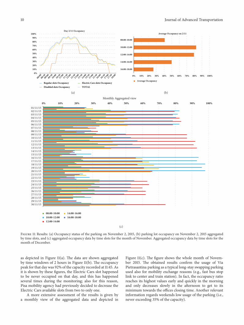
7.1. Vision Based Results. The results of the monitoring of atypical working day (November 2, 2015) scenario is shown inFigure 11(a). The monitoring, due to wintertime (i.e., shortdaylight time) and to the need to save the battery at night-time, took place starting from 8:00 hours until 18:00 hours foreach day.Theoccupancy statuswas recorded every 15minutes
10 Journal of Advanced Transportation
Day 2/11 Occupancy
08:0008:30
09:0009:30
10:0010:30
11:0011:30
12:0012:30
13:0013:30
14:0014:30
15:0015:30
16:0016:30
17:0017:30
18:00
100%90%80%70%60%50%40%30%20%10%
0%
Regular slots OccupancyDisabled slots Occupancy
Electric Cars slots OccupancyTOTAL
(a)
0% 10% 20% 30% 40% 50% 60% 70% 80% 90% 100%
08:00-10:00
10:00-12:00
12:00-14:00
14:00-16:00
16:00-18:00
Average Occupancy on 2/11
Average Occupancy
(b)
0% 10% 20% 30% 40% 50% 60% 70% 80% 90% 100%
Monthly Aggregated view
30/11/1529/11/1528/11/1527/11/1526/11/1525/11/1524/11/1523/11/1522/11/1521/11/1520/11/1519/11/1518/11/1517/11/1516/11/1515/11/1514/11/1513/11/1512/11/1511/11/1510/11/1509/11/1508/11/1507/11/1506/11/1505/11/1504/11/1503/11/1502/11/1501/11/15
08:00-10:0010:00-12:0012:00-14:00
14:00-16:0016:00-18:00
(c)
Figure 11: Results: (a) Occupancy status of the parking on November 2, 2015, (b) parking lot occupancy on November 2, 2015 aggregatedby time slots, and (c) aggregated occupancy data by time slots for the month of November. Aggregated occupancy data by time slots for themonth of December.
as depicted in Figure 11(a). The data are shown aggregatedby time windows of 2 hours in Figure 11(b). The occupancypeak for that day was 92% of the capacity recorded at 11:45. Asit is shown by these figures, the Electric Cars slot happenedto be never occupied on that day, and this has happenedseveral times during the monitoring; also for this reason,Pisa mobility agency had previously decided to decrease theElectric Cars available slots from two to only one.
A more extensive assessment of the results is given bya monthly view of the aggregated data and depicted in
Figure 11(c). The figure shows the whole month of Novem-ber 2015. The obtained results confirm the usage of ViaPietrasantina parking as a typical long-stay swapping parkingused also for mobility exchange reasons (e.g., fast bus stoplink to center and train station). In fact, the occupancy ratioreaches its highest values early and quickly in the morningand only decreases slowly in the afternoon to get to itsminimum towards the offices closing time. Another relevantinformation regards weekends low usage of the parking (i.e.,never exceeding 35% of the capacity).

Journal of Advanced Transportation 11
00:00 - 08:00
08:00 - 10:00
10:00 - 12:00
12:00 - 14:00
14:00 - 18:00
18:00 - 20:00
20:00 - 24:00
Average Occupancy per day
Occupancy percentage100908070605030 4020100
Figure 12: Average parking lots occupancy per day in outdoor parking.
Monthly Average occupancy
01/04/2016
02/04/2016
03/04/2016
04/04/2016
05/04/2016
06/04/2016
07/04/2016
08/04/2016
09/04/2016
10/04/2016
11/04/2016
12/04/2016
13/04/2016
14/04/2016
15/04/2016
16/04/2016
17/04/2016
18/04/2016
19/04/2016
20/04/2016
21/04/2016
22/04/2016
23/04/2016
24/04/2016
25/04/2016
26/04/2016
27/04/2016
28/04/2016
29/04/2016
30/04/20160
10
20
30
40
50
60
70
80
90
Figure 13: Parking occupancy for the whole month in outdoor parking.
7.2. Sensors Based Results. Sensors were deployed on an out-door parking lot in order to avail the car parking experienceon a typical working day. Figure 12 presents the averageoccupancy of the park on a daily basis. An overview on thegraph shows a 12-hour window pattern, an higher occupancyrate between 8 and 20 followed by an abrupt decrease andalmost vacancy in the remaining hours. Moreover, it can beseen that the parking lot is not used in full capacity having itsmaximum attendance between 10:00 and 12:00 (95%). Afterthis peak, the number of occupied parking slots graduallydescends until reaching the end of the 12 hour window.Theseresults and subsequent pattern can be explained by the park
vicinity, mostly composed by working spaces namely: officesand the university campus. This assertion was also verifiedby the low car park attendance during weekends showedin the average occupancy in the month of April depictedin Figure 13. The graph also shows a slight decrease on thenumber of cars parked on Fridays.
A different deployment was also conducted on a privateunderground parking lot and integrated with the system. Sixsensors were used and placed on different parking spaces, oneof which was reserved for persons with disabilities (Park ID:5048). Figure 14 shows the occupancy rate of each space perhour.The parking lot usage was very reduced throughout the

12 Journal of Advanced Transportation
00h01h02h03h04h05h06h07h08h09h10h11h12h13h14h15h16h17h18h19h20h21h22h23h
Hou
r
Percentage of Occupancy per parking space April 2016
Park ID: 3Park ID:91Park ID:101Park ID:102Park ID:5058Park ID:5048
5 10 15 20 25 30 35 40 45 500% of Occupancy
Figure 14: Average parking occupancy in a day of indoor parking.
entire month, only one parking space was often used and,even so, it had a maximum occupancy of 50%. Additionally,both the park spot with ID 5058 and the disabled parkingspace were not commonly used, specially the last one thatwas only occupied 11 times. These results can be justifiedby the lack of visibility of the car park and the lack ofinformation regarding the number of vacant parking spaces.Thus, an application capable of providing real-time car parkavailability and free parking spaces for nearby drivers couldimprove both the parking lot usage as the entire parkingexperience.
8. Conclusions
In this paper, we have presented a fully scalable and dis-tributed architecture that is easily integrated with multiplesensing sources.
The main novelty of the proposed approach lies in thecontext of scalability, and in particular the reduced costsfor obtaining it and the ease of introducing a new elementto the existing infrastructure. The joint design of these twoaspects in our approach, in particular due to the distributedarchitecture designed, allows having a global complex system
which, up to our knowledge, is different from the manyexisting and implemented in literature.
The scalability is achieved by the introduction of localgateways which have the capability of local storage. Inaddition, the GWs considers a hardware and software archi-tecture fully open, modular, flexible, scalable, and capable ofevolution that allows the authorities and operators to easilyimplement traffic management strategies and monitoringtraffic based on ITS cooperative technologies.
The proposed architecture was then validated via realworld deployment tests by integrating the two types of park-ing management systems. The magnetic sensors presentedare fully encapsulated, dust/water resistant, enabling bothindoor, and outdoor deployments and do not requiringany maintenance. The chosen communications technologyis LoRa on the 868MHz band and enables low power con-suming communications, but the periodicity and duration(size) of the communications was also optimized, for greaterpower savings. These sensors are suitable for mostly any typeof car park and enable fast and simple deployments. Sincethey do not require infrastructure or cabling, the systembecomes cheaper, involving less costs in terms of deployment

Journal of Advanced Transportation 13
and maintenance. The developed sensors were installed andtested in two different location: indoor parking and outdoorparking. The developed system was integrated in a noveldistributed architecture in order to be able to provide scal-ability and an ease to the drivers in finding available parkinglots, thus saving fuel and time. Scalability and reliability aregranted by means of the designed distributed architecture.
Following the sensor based parking system, a smartcamera prototype for vision based smart parking is alsopresented. Main emphasis is given to the vision board, whichis a custom PCB manufactured specifically for the sensor.Cameras, wireless module, batteries, photovoltaic panels, andhousing have also been described. In addition, a parking lotmonitoring algorithm specifically designed for smart camerasand featuring an internode processing strategy for the finaldecision making is presented. 12 smart camera based sensorswere deployed in on 8 poles in the city of Pisa, Italy. Theparking lots were monitored for a whole month and variousoccupancy data were recorded: they proved to be usefulboth to disseminate real-time information to tourists andcommuters as well to design and deploy adaptive policies foraccess and payment of parking lot facilities.
In the end, as already mentioned above our proposedapproach seems to be quite effective in being applied totypical urban environments, in which the deployment ofsuch infrastructures occurs gradually over time and with verydifferent geographical dislocations.
Data Availability
Major part of the data collected and used for testing in thispaper have been acquired in the course of the cited EU-FP7Project. They can be obtained on request to the consortiumcomposing the EU Project.
Conflicts of Interest
The authors declare that they have no conflicts of interest.
Acknowledgments
The research leading to these results has received fundingfrom the European Union’s Seventh Framework Programme(FP7) under Grant Agreement no. 3176711.
References
[1] EU, Passenger cars in the EU - Statistics Explained - EuropeanCommission, http://ec.europa.eu/eurostat/, Accessed on: 15May 2017.
[2] US. Data and Statistics — Bureau of Transportation Statistics,URL: https://www.rita.dot.gov/bts/data and statistics/index.html, Accessed on: 15 May 2017.
[3] M.Magrini, D.Moroni, G. Pieri, andO. Salvetti, “Smart camerasfor ITS in urban environment,” Intelligent Transport Systems:Technologies and Applications, pp. 167–188, 2015.
[4] SIEMENS, Future of Infrastructure:The SmartWay to Park, lastvisited: June 2016.
[5] M. Kodransky andG. Hermann, Europe’s Parking U-Turn: FromAccommodation to Regulation, Institute for Transportation and
Development Policy, 2011, https://www.itdp.org/wp-content/uploads/2014/07/Europes Parking U-Turn ITDP.pdf, Accessedon: 15 September, 2017.
[6] V. W. S. Tang, Y. Zheng, and J. Cao, “An intelligent car parkmanagement system based on wireless sensor networks,” inProceedings of the SPCA 2006: 1st International Symposium onPervasive Computing and Applications, pp. 65–70, August 2006.
[7] T. Lin, H. Rivano, and F. Le Mouel, “A survey of smart parkingsolutions,” IEEE Transactions on Intelligent Transportation Sys-tems, vol. 18, no. 12, pp. 3229–3253, 2017.
[8] L. Ruizhi, R. Cristian, B. Peter, O. Shumao, and C. Liping,“Crowdsourcing on-street parking space detection,” https://arxiv.org/abs/1603.00441, 2016.
[9] J. Vera-Gomez, A. Quesada-Arencibia, C. Garcıa, R. SuarezMoreno, and F. Guerra Hernandez, “An Intelligent ParkingManagement System for Urban Areas,” Sensors, vol. 16, no. 6,p. 931, 2016.
[10] G. Amato, F. Carrara, F. Falchi, C. Gennaro, and C. Vairo, “Carparking occupancy detection using smart camera networks andDeep Learning,” in Proceedings of the 2016 IEEE Symposium onComputers and Communication, ISCC 2016, pp. 1212–1217, July2016.
[11] E. C. Neto, E. S. Reboucas, J. L. De Moraes, S. L. Gomes,and P. P. R. Filho, “Development control parking access usingtechniques digital image processing and applied computationalintelligence,” IEEE Latin America Transactions, vol. 13, no. 1, pp.272–276, 2015.
[12] G. Maria, E. Baccaglini, D. Brevi, M. Gavelli, and R. Scopigno,“A drone-based image processing system for car detection ina smart transport infrastructure,” in Proceedings of the 18thMediterranean Electrotechnical Conference, MELECON 2016,pp. 1–5, April 2016.
[13] Q.Wu,C. Huang, S.-Y.Wang,W.-C. Chiu, and T. Chen, “Robustparking space detection considering inter-space correlation,” inProceedings of the IEEE International Conference onMultimediaand Expo, ICME 2007, pp. 659–662, July 2007.
[14] S. Funck, N. Mohler, and W. Oertel, “Determining car-parkoccupancy from single images,” in Proceedings of the 2004 IEEEIntelligent Vehicles Symposium, pp. 325–328, June 2004.
[15] C.-C. Huang, Y.-S. Dai, and S.-J.Wang, “A surface-based vacantspace detection for an intelligent parking lot,” in Proceedings ofthe 2012 12th International Conference on ITS Telecommunica-tions, ITST 2012, pp. 284–288, IEEE, November 2012.
[16] C. Galvez del Postigo, J. Torres, and J. M. Menendez, “Vacantparking area estimation through background subtraction andtransience map analysis,” IET Intelligent Transport Systems, vol.9, no. 9, pp. 835–841, 2015.
[17] Intelligent Cooperative Sensing for Improved traffic efficiency,http://www.ict-icsi.eu/.
[18] M. Magrini, D. Moroni, G. Palazzese, G. Pieri, G. Leone, andO. Salvetti, “Computer Vision on Embedded Sensors for TrafficFlowMonitoring,” in Proceedings of the 18th IEEE InternationalConference on Intelligent Transportation Systems, ITSC 2015, pp.161–166, September 2015.
[19] Z. Shelby, “Embedded web services,” IEEE Wireless Communi-cations Magazine, vol. 17, no. 6, pp. 52–57, 2010.
[20] Z. Shelby and C. Bormann, 6LoWPAN: The wireless embeddedInternet, vol. 43, John Wiley & Sons, 2011.
[21] A. Azzara, M. Petracca, and P. Pagano, “The icsi m2m mid-dleware for iot-based intelligent transportation systems,” inProceedings of the 2015 IEEE 18th International Conference onIntelligent Transportation Systems, pp. 155–160, 2015.

International Journal of
AerospaceEngineeringHindawiwww.hindawi.com Volume 2018
RoboticsJournal of
Hindawiwww.hindawi.com Volume 2018
Hindawiwww.hindawi.com Volume 2018
Active and Passive Electronic Components
VLSI Design
Hindawiwww.hindawi.com Volume 2018
Hindawiwww.hindawi.com Volume 2018
Shock and Vibration
Hindawiwww.hindawi.com Volume 2018
Civil EngineeringAdvances in
Acoustics and VibrationAdvances in
Hindawiwww.hindawi.com Volume 2018
Hindawiwww.hindawi.com Volume 2018
Electrical and Computer Engineering
Journal of
Advances inOptoElectronics
Hindawiwww.hindawi.com
Volume 2018
Hindawi Publishing Corporation http://www.hindawi.com Volume 2013Hindawiwww.hindawi.com
The Scientific World Journal
Volume 2018
Control Scienceand Engineering
Journal of
Hindawiwww.hindawi.com Volume 2018
Hindawiwww.hindawi.com
Journal ofEngineeringVolume 2018
SensorsJournal of
Hindawiwww.hindawi.com Volume 2018
International Journal of
RotatingMachinery
Hindawiwww.hindawi.com Volume 2018
Modelling &Simulationin EngineeringHindawiwww.hindawi.com Volume 2018
Hindawiwww.hindawi.com Volume 2018
Chemical EngineeringInternational Journal of Antennas and
Propagation
International Journal of
Hindawiwww.hindawi.com Volume 2018
Hindawiwww.hindawi.com Volume 2018
Navigation and Observation
International Journal of
Hindawi
www.hindawi.com Volume 2018
Advances in
Multimedia
Submit your manuscripts atwww.hindawi.com