quarterly biological monitoring report #6
TRANSCRIPT


QUARTERLY BIOLOGICAL MONITORING REPORT #6
RADIOLOGICAL STUDY OF THE
SANTA SUSANA FIELD LABORATORY AREA IV AND NORTHERN BUFFER ZONE
Prepared for: U.S. Environmental Protection Agency Region 9
75 Hawthorne Street San Francisco, CA 94105
Prepared by: HydroGeoLogic, Inc.
5800 Woolsey Canyon Road Building 204
Canoga Park, CA 93104
and
Envicom Corporation 28328 Agoura Road
Agoura Hills, CA 91301
February 7, 2012

TABLE OF CONTENTS
RADIOLOGICAL STUDY OF THE SANTA SUSANA FIELD LABORATORY AREA IV AND NORTHERN BUFFER ZONE
i
SECTION PAGE INTRODUCTION 1 PROJECT ACTIVITIES AND OPERATIONS 1 BIOLOGICAL CLEARANCE SURVEYS, MONITORING, AND IMPACTS 2
Clearance Survey Methodology 2 Biological Monitoring Methodology 3 Clearance Survey and Monitoring Results for Federally Listed Species 3 Sixth Quarterly Clearance Surveys and Monitoring Results for Non-Federally listed 4 Protected Biological Resources (excludes non-special status nesting birds) Sixth Quarterly Monitoring Results for Protected Nesting Birds 7 Sixth Quarterly Clearance Surveys and Monitoring Results for Riparian Habitat 7
ISSUES ENCOUNTERED AND ADAPTIVE MANAGEMENT 7 TABLES Table 1 List of Federally Listed Resources and Critical/Suitable Habitat Observed in 10
Survey Sections during the Sixth Quarterly Monitoring Period Table 2 List of Federally Listed Resources Impacted during Sixth Quarterly 11
Monitoring Period Table 3 List of Non-federally Listed Resources Observed during the Sixth Quarterly 12
Monitoring Period (grouped by area/subarea) Table 4 List of Non-federally Listed Resources Impacted during the Sixth 13
Quarterly Monitoring Period (excludes non-special status nesting birds) Table 5 List of Activities Conducted within Riparian Habitat during the Sixth Quarterly 14
Monitoring Period
APPENDICES Appendix 1 Figures and Photo Plates Appendix 2 Sixth Quarterly Biological Clearance Survey Forms Appendix 3 Sixth Quarterly Biological Monitoring Forms

QUARTERLY BIOLOGICAL MONITORING REPORT October 2011 – December 2011
RADIOLOGICAL STUDY OF THE SANTA SUSANA FIELD LABORATORY AREA IV AND NORTHERN BUFFER ZONE
1
INTRODUCTION
The U.S. Environmental Protection Agency (EPA) is conducting a radiological characterization of a portion of the Santa Susana Field Laboratory (SSFL), located in the Simi Hills of eastern Ventura County, California (Figure 1). The two areas at SSFL being characterized are Area IV, a 290-acre administrative section where the U.S. Department of Energy and its contractors once operated several nuclear reactors and associated fuel facilities and laboratories, and the Northern Buffer Zone (NBZ), a 182-acre area with no history of development that lies adjacent to Area IV. These two areas comprise the Area IV study area. Several activities associated with the radiological study of the Area IV Study Area have the potential to impact federally listed species and their critical habitat, as well as biological resources protected under other Federal and State laws. These activities include vegetation cutting, gamma scanning, geophysical survey, surface and subsurface soil sampling, groundwater monitoring well sampling, surface water sampling, and sediment sampling. The scope of these project activities is described in further detail in the Biological Assessment (BA) prepared for EPA by HydroGeoLogic, Inc. (HGL), and Envicom Corporation on February 12, 2010. To minimize the impact to natural resources and riparian habitat within the study area, protection measures were developed and are being implemented as activities progress. These measures are detailed in Appendices E, G, and N of the Site Management Plan (dated September 24, 2010). EPA is conducting this project pursuant to federal legislative mandate HR2764, the Consolidated Appropriations Act of 2008, and the authority granted under the Comprehensive Environmental Response, Compensation, and Liability Act (CERCLA). Formal consultation under Section 7 of the Endangered Species Act has been conducted with the U.S. Fish and Wildlife Service (USFWS), and a Biological Opinion was issued on May 25, 2010. The USFWS Biological Opinion identified Avoidance and Minimization Measures (AMMs) keyed to each of the proposed activities and Federally listed species with potential to occur within the Action Area. EPA has agreed to implement the various components of the Radiological Survey in compliance with the Biological Opinion and its requirements. Although not under discretionary approval, it is also EPA’s goal to comply with the substantive technical requirements of State of California natural resource protection laws, such as the California Endangered Species Act and California Fish and Game Code Section 1602 for impacts to riparian resources. Additional applicable biological resource laws or regulations to which the project is adhering include the Federal Migratory Bird Treaty Act and California Fish and Game Code 3503 and 3503.5 (for protection of nesting birds). The purpose of this report is to provide the sixth quarterly monitoring update, which summarizes 1) Project Activities and Operations, 2) Biological Surveys, Monitoring, and Impacts to Federally Listed Species and their Critical Habitat, if applicable, 3) Biological Surveys, Monitoring, and Impacts to State-listed species and Species of Special Concern, 4) Riparian Area impacts, and 5) Issues Encountered and Adaptive Management. The report covers the period from October 1, 2011, to December 31, 2011. PROJECT ACTIVITIES AND OPERATIONS The Area IV Study Area is subdivided into Subareas 3, 5A, 5B, 5C, 5D North, 5D South, 6, 7, 8 North, 8 South, NBZ-W, and NBZ-E (Figure 2). The subareas have been divided into 76 Survey Sections (SS) and 23 NBZ Priority Areas. The SSs include roads. To date, EPA has begun conducting all six of the primary project tasks: vegetation cutting, gamma scanning, geophysical surveying, surface and subsurface soil sampling, groundwater monitoring well sampling, and surface water and sediment sampling. The

QUARTERLY BIOLOGICAL MONITORING REPORT October 2011 – December 2011
RADIOLOGICAL STUDY OF THE SANTA SUSANA FIELD LABORATORY AREA IV AND NORTHERN BUFFER ZONE
2
following is a discussion of the project tasks and the locations in which they have been conducted as observed and monitored for this sixth quarterly report. Vegetation within the study area is being cut or trimmed to allow access to vehicles and equipment, and to provide clearance for gamma scanning equipment at optimum levels of sensitivity. Vegetation cutting protocols are found in Appendix E of the Site Management Plan. Vegetation cutting was monitored during this quarterly monitoring period in Subareas 5A, 5B, 5C, 5D South, 6, 8 North, NBZ-W, and NBZ-E (Figure 2). Standard equipment used during vegetation cutting includes weed whackers, lopping shears, chainsaws, skid steer with mower and fork-lift attachments, chipper, and front-loading tractor for the safe removal of poison oak (Toxicodendron diversilobum) branches. Gamma scanning is being accomplished using various scanning devices, depending on site conditions. Scanning equipment includes a JCB off-road forklift vehicle (an ERGS machine was formerly used, and the JCB is still referred to as the ‘ERGS’ in this report), a modified Canycom compact walk-behind rubber track-mounted gamma scanner (TMGS), mule-mounted gamma scanning devices (MMGS), a handcart scanner, and handheld scanners. Gamma scanning was monitored during this monitoring period in Subareas 5D South, 5D North, 7, 8 North, NBZ-W, and NBZ-E (Figure 2). Geophysical surveys have been completed in all Subareas of the project area and were not observed to occur during this monitoring quarter. Surface and subsurface soil sampling was conducted during this sixth quarterly period in Subareas 3, 5B, 5D-South, 6, 7, and 8-South. Previous biological clearance surveys had been performed on each of the affected survey sections and sensitive resources were clearly identified and flagged. As such, soil sampling activities were not monitored during this sixth quarterly monitoring period. Sampling equipment used for this task includes a mobile drilling/coring rig and hand tools. Support equipment for the soil sampling effort includes tables, chairs, and equipment boxes. The number of sampling points within each SS varies depending on the findings of the Historical Site Assessment (HSA) and the results of the gamma scanning surveys already conducted. The sampling procedure at each sample point involves retrieving a surface sample of approximately one gallon of soil from 0 to 6 inches below ground surface (bgs). A subsurface soil sample consisting of a core sample obtained from a depth of 10 feet bgs is collected at a subset of the surface sampling sites. Monitoring well sampling was completed during the fourth quarterly monitoring period and therefore was not conducted during the sixth quarterly monitoring period. BIOLOGICAL CLEARANCE SURVEYS, MONITORING, AND IMPACTS Clearance Survey Methodology Before project activities commenced, one of the USFWS-approved biologists from Envicom conducted clearance surveys to document the presence/absence and location of Federal and State special-status biological resources and riparian habitat within each of the subareas. The locations of the resources were marked in the field with conspicuous flagging and mapped using Global Positioning System (GPS) technology, and Geographic Information System (GIS) software. Mapped resources are shown on Figures 3, 4, and 5. Clearance survey monitoring forms (Appendix 2) were prepared for each clearance survey completed during this monitoring period to document the resources observed and to identify which AMMs included in the Biological Opinion are applicable to future activities occurring within the survey area.

QUARTERLY BIOLOGICAL MONITORING REPORT October 2011 – December 2011
RADIOLOGICAL STUDY OF THE SANTA SUSANA FIELD LABORATORY AREA IV AND NORTHERN BUFFER ZONE
3
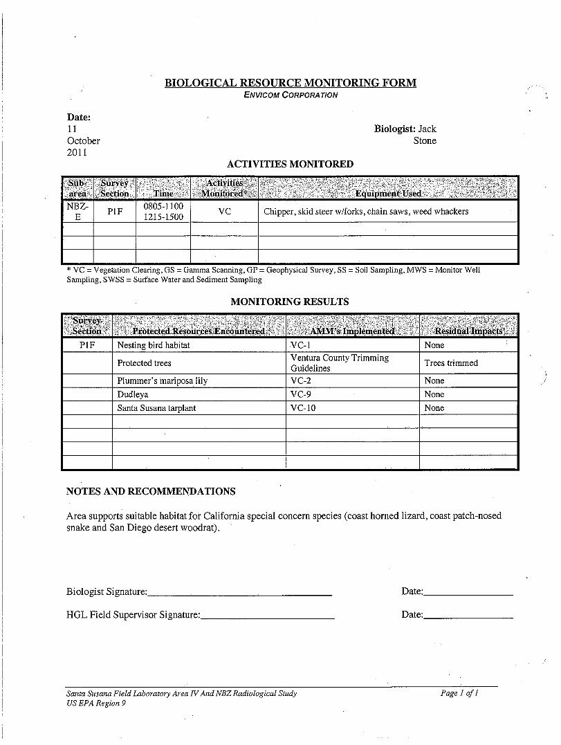
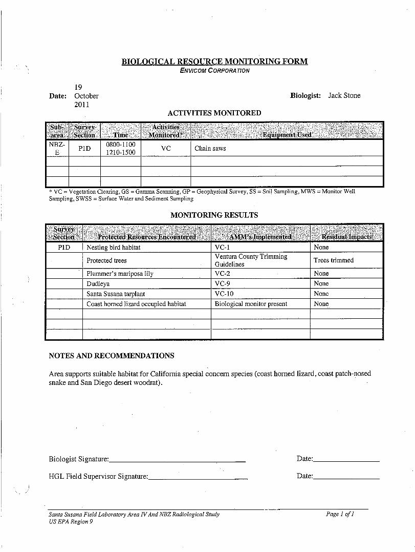
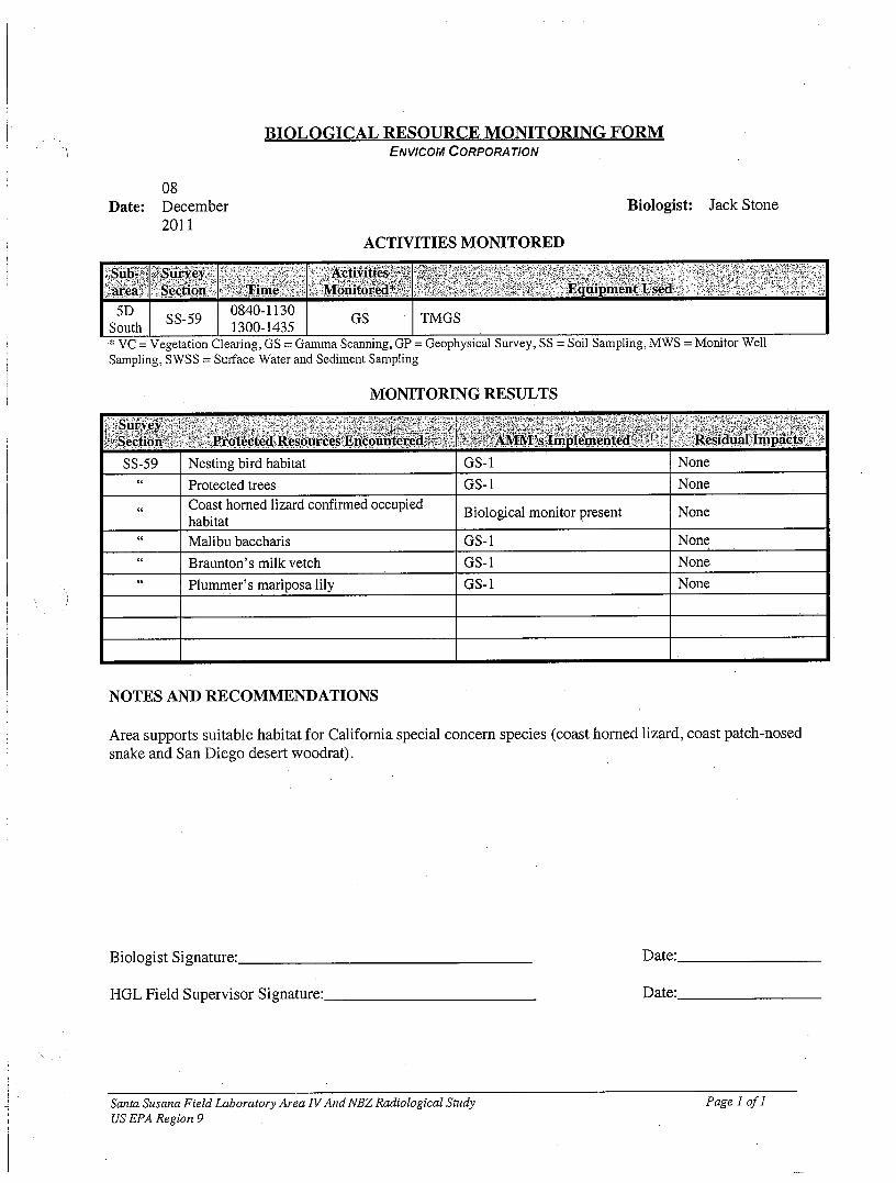
Biological Monitoring Methodology One or more of the approved biological monitors from Envicom were present on a daily basis when work activities occurred. The monitors attend the safety meeting with crews and monitor project activities. During the reporting period (October 1 to December 31, 2011) the primary project tasks that were monitored included vegetation cutting and gamma scanning. Some soil sampling activities also occurred but were not monitored as they were located in survey sections where previous clearance surveys had identified and flagged sensitive resources. The biological monitor(s) worked alongside the field crews to point out the locations of special-status biological resources and assist the crews in avoiding impacts. Daily biological monitoring forms (Appendix 3) were prepared to document the activities monitored, any special-status biological resources encountered, and impacts resulting from project activities. Any further recommendations on reducing impacts to biological resources also were reported on this form. In compliance with the Biological Opinion, all project-related crews participated in an environmental education program administered by the USFWS-approved biologist to inform participants as to the sensitive biological resources within the project area and the AMMs to be employed. Clearance Survey and Monitoring Results for Federally Listed Species Of the federally listed species in the Biological Opinion, only one (Braunton’s milkvetch) has been positively identified in the study area, although suitable habitat for unidentified individuals that could, in fact, be listed were observed as well. Table 1 summarizes the locations where these species have been detected during either clearance surveys or monitoring. Braunton’s milkvetch (Astragalus brauntonii); Federally Endangered During the monitoring period, project activities were conducted throughout a portion of the Designated Critical Habitat for Braunton’s milkvetch in Subarea 5D South (SS-59). Activities within the milkvetch habitat consisted of vegetation clearance and gamma scanning involving the use of the TMGS. Vegetation clearance involved the use of a rotary mower attached to a skid steer tractor and weed whackers. These activities were monitored closely to avoid and reduce impacts to milkvetch plants, as documented in the Biological Monitoring Forms included in this report as Appendix 3. Monitoring activities included surveying the subareas where activities were to occur, and flagging individual plants or establishing a perimeter buffer area around groups of plants as shown in Appendix 1 (Plate 1A). A total of three Braunton’s milkvetch were impacted during the monitoring period. Impacts to individual Braunton’s milkvetch are described in Table 2. These impacts were relatively minor, and did not result in the “take” of the plant. Stems of the three affected individuals were broken, but the plants were not uprooted or destroyed. The survey section where these impacts occurred was SS-59, which is located within the Critical Habitat Unit 1d for Braunton’s milkvetch. The primary constituent elements (PCEs) for Braunton’s milkvetch (calcium carbonate soils derived from marine sediment, low proportion (<10%) of shrub cover directly around the plant, and chaparral and coastal sage scrub communities characterized by periodic disturbances that stimulate seed germination [e.g., fire, flooding, erosion] and reduce vegetative cover) have not been negatively impacted.

QUARTERLY BIOLOGICAL MONITORING REPORT October 2011 – December 2011
RADIOLOGICAL STUDY OF THE SANTA SUSANA FIELD LABORATORY AREA IV AND NORTHERN BUFFER ZONE
4
Dudleya species: Conejo dudleya (Dudleya abramsii subsp. parva [=D. parva]), Santa Monica Mountains live-forever (D. cymosa subsp. ovatifolia [inclusive of D. cymosa subsp. agourensis]), and marcescent dudleya (D. cymosa subsp. marcescens); all Federally Threatened None of the Federally or State listed dudleya species have been encountered. Many flowering dudleya individuals were identified as D. lanceolata (no protection status), while some dudleya were unidentifiable because they were not flowering at the time of observation. All unidentifiable dudleya were flagged and protected during project activities. During this monitoring period, unidentifiable species were noted during vegetation cutting or gamma scanning activities in Subareas NBZ-E (P1D, P1E, P1F, P1I) and NBZ-W (P1A, P1B, P1C, P2K), as well as during gamma scanning activities in Subareas 5D South (SS-59) and 8 North (SS-43). No identified dudleya have been harmed during project activities. Vernal Pool Branchiopods: Riverside fairy shrimp (Streptocephalus woottoni), Federally Endangered, and vernal pool fairy shrimp (Branchinecta lynchi), Federally Threatened Known occupied vernal pool habitat in SS-7 and atop sandstone outcrops in P1C and P3V were not encountered during project activities conducted during the sixth quarterly monitoring period. California red-legged frog (Rana draytonii); Federally Threatened Project activities occurred in proximity to four areas identified in the Biological Assessment as potentially suitable habitat for the California red-legged frog. These habitat areas consist of outfall collection pools in Subareas 6 (SS-38) and 8 North (SS-46 and SS-43), as well as a riparian area in Subarea NBZ-E (within portions of P1G, P1H, P1J, P1Z, and P2R). A 300-foot buffer was mapped around each of these features using a GIS, and the biological monitor supervised all project activities within the upland buffer area. The buffer areas for the habitats in Subareas 6 and 8 North extend into NBZ-W and NBZ-E within survey sections P1A and P1D respectively. During the monitoring period, gamma scanning was conducted within SS-43 of Subarea 8 North; P1A of Subarea NBZ-W; and P1D, P1J and P2R of Subarea NBZ-E. Vegetation cutting was conducted in P1A of Subarea NBZ-W and equipment use was limited to hand tools within the buffer zone. Activities were not observed to occur within the critical habitat area during this monitoring period. No red-legged frogs were observed. Least Bell’s vireo (Vireo bellii pusillus); Federally Endangered No monitored work activities were conducted within the Least Bell’s Vireo (LBV) habitat areas in Subarea 5B (SS-12) and Subarea 6 (SS-26) during the monitoring period. No LBV have been observed in the project area during clearance surveys or monitoring. A focused survey to determine presence or absence of LBV was not conducted in SS-12 and SS-26 as no work was scheduled in these areas. California gnatcatcher (Polioptila californica californica); Federally Threatened Monitored activities during the sixth quarter of the study included gamma scanning and/or vegetation cutting in Subarea 8 North (SS-43), 5D South (SS-59), and NBZ-W (P1A, P1B, P1C, P1I, and P2K), which are identified as providing potential California gnatcatcher habitat. No California gnatcatchers have been detected on site during the implementation of the EPA study. Sixth Quarterly Clearance Surveys and Monitoring Results for Non Federally-listed Protected Biological Resources (excludes non-special status nesting birds) The Santa Susana tarplant is the only State-listed species observed during the clearance surveys and biological monitoring. However, other State-protected biological resources have been observed. The

QUARTERLY BIOLOGICAL MONITORING REPORT October 2011 – December 2011
RADIOLOGICAL STUDY OF THE SANTA SUSANA FIELD LABORATORY AREA IV AND NORTHERN BUFFER ZONE
5
locations of Santa Susana tarplant and other State-protected biological resources within the Action Area are illustrated on Figures 3, 4, and 5. The following is a more detailed description of the observations and impacts associated with State-protected biological resources. A summary of the State-Sensitive resource observations listed by Survey Section is shown in Table 3. Santa Susana tarplant (Deinandra minthornii); State Rare, CNPS List 1B.2 This species is locally common in sections of Area IV with sandstone outcrops. These plants were flagged for identification during activities occurring within their vicinity (Plate 1B). No plants were impacted by project activities during the sixth quarterly monitoring period (Table 4). Malibu baccharis (Baccharis malibuensis); CNPS List 1B.1 Malibu baccharis was recorded in Subareas 5D South (SS-59) on the hilly terrain at the extreme southern end of the study area. Malibu baccharis exhibits a flexible growth form whereby it is not easily damaged by project equipment when properly marked. None of these plants were damaged or destroyed during vegetation cutting or gamma scanning activities conducted this quarter. Plummer’s mariposa lily (Calochortus plummerae); CNPS List 1B.2 This species is found in suitable habitat throughout the project area. It was observed during project activities in 5D South, 7, NBZ-W, and NBZ-E (Plate 1C). One individual was severed at its base during vegetation cutting in Subarea 5D South (SS-59). All other specimens observed were protected from project activities. Slender mariposa lily (Calochortus clavatus var. gracilis); CNPS List 1B.2 Slender mariposa lily has not been identified to date within the project area. All Calochortus clavatus identified have been keyed to be the unprotected Calochortus clavatus var. pallidus. Nonetheless, all observed plants of this species were protected during vegetation cutting and gamma scanning during the sixth quarterly monitoring period. Non-flowering mariposa lilies (Calochortus sp.) Non-flowering lilies in the genus Calochortus that could not be positively identified to the species were protected from project activities to ensure that special-status lilies were not impacted by the project. No potential special-status lilies were damaged or destroyed during the sixth quarterly monitoring period. Protected Native Trees (various species); Protected by Ventura County Ordinance Native tree species that are protected by Ventura County Ordinance were observed in most areas where monitoring activities occurred. As part of the vegetation cutting in NBZ-E and NBZ-W Subareas, several trees including coast live oak (Quercus agrifolia), southern California black walnut (Juglans californica), blue elderberry (Sambucus nigra ssp. caerulea), and California bay (Umbellularia californica) were pruned in accordance with the Ventura County Trimming Ordinance. Coast horned lizard (Phrynosoma blainvillii); State Species of Special Concern Suitable habitat for this species was identified in most of the undeveloped survey sections of the study area. Although there were no observations of coast horned lizard during the sixth quarterly monitoring period, a biological monitor was present during vegetation cutting activities in all suitable coast horned lizard habitat.

QUARTERLY BIOLOGICAL MONITORING REPORT October 2011 – December 2011
RADIOLOGICAL STUDY OF THE SANTA SUSANA FIELD LABORATORY AREA IV AND NORTHERN BUFFER ZONE
6
Silvery legless lizard (Anniella pulchra pulchra); State Species of Special Concern Suitable habitat was identified in many of the undeveloped survey sections of the study area. Although there were no observations of silvery legless lizards during the sixth quarterly monitoring period, a biological monitor was present during vegetation cutting activities in all suitable silvery legless lizard habitat. Coast patch-nosed snake (Salvadora hexalepis virgultea); State Species of Special Concern Suitable habitat was identified in many of the undeveloped survey sections of the study area. Although there were no observations of coast patch-nosed snakes during the sixth quarterly monitoring period, a biological monitor was present during vegetation cutting activities in all suitable coast patch-nosed snake habitats. No coast patch-nosed snakes were observed during this quarterly monitoring period. Cooper’s Hawk (Accipiter cooperii); State Watch List There were no recorded observations of Cooper’s hawks or their nests during this monitoring period. Golden eagle (Aquila chrysaetos); Fully Protected (Federal and State), State Watch List A resident pair of golden eagles successfully raised two young from a nest site located on the SSFL property boundary in the NBZ-E in the spring of 2011. The eaglets fledged in June 2011 and were not observed roosting at the nest site during this monitoring period. Rufous hummingbird (Selasphorus rufus); Federal Bird Species of Conservation Concern Rufous hummingbirds are primarily found in Ventura County during spring migration en route to nesting grounds in the northwestern U.S. and western Canada. None have been impacted by project activities. Allen's hummingbird (Selasphorus sasin); Federal Bird Species of Conservation Concern Allen’s hummingbirds nest in Ventura County and are common in the project area. No nests were found during the monitoring period and no Allen’s hummingbirds were impacted by project activities. Loggerhead Shrike (Lanius ludovicianus); State Species of Special Concern Loggerhead shrikes inhabit open country with short vegetation and breed in isolated trees or large shrubs. No observations of loggerhead shrikes or their nests were made during this sixth quarterly monitoring period. Nuttall's woodpecker (Picoides nuttallii); Federal Bird Species of Conservation Concern Nuttall’s woodpeckers nest in cavities and are commonly seen in woodland areas of the project area. No nests were observed or impacted by project activities during the sixth quarterly monitoring period. Oak titmouse (Baeolophus inornatus); Federal Bird Species of Conservation Concern Oak titmice are common in oak woodland habitats in the study area. They nest in tree cavities and inhabit nearly every SS that contains mature coast live oaks. No nests were found or impacted by project activities during the monitoring period.

QUARTERLY BIOLOGICAL MONITORING REPORT October 2011 – December 2011
RADIOLOGICAL STUDY OF THE SANTA SUSANA FIELD LABORATORY AREA IV AND NORTHERN BUFFER ZONE
7
White-tailed kite (Elanus leucurus); Fully Protected Species (State) White-tailed kites are uncommon residents in open grasslands, valley oak savannas, marshes, and agricultural areas. These raptors hunt by hovering while searching for their prey, which generally consists of voles. No known nests of this species were documented during these observations or impacted by project activities during the sixth quarterly monitoring period. Yellow warbler (Dendroica petechia brewsteri); Federal Bird Species of Conservation Concern In southern California, yellow warblers mainly nest in riparian woodlands after spending the winter in Mexico and other southern latitudes. No nests of this species were observed or impacted by project activities during the sixth quarterly monitoring period. Southern California rufous-crowned sparrow (Aimophila ruficeps canescens); State Watch List Southern California rufous-crowned sparrows are year-round residents in the Simi Hills and Santa Susana Mountains, typically nesting at or near ground-level near rocky outcrops and associated low-growing shrubby and herbaceous cover. No observations of this species were made during the monitoring period and no nests of this species were found. San Diego desert woodrat (Neotoma lepida intermedia); State Species of Special Concern Suitable habitat was identified in much of the study area, especially areas that contain shrubby vegetation and rocky outcrops. Individuals and nest structures of this species were not harmed by project activities.
Sixth Quarterly Monitoring Results for Protected Nesting Birds Native bird species nesting in the study area are protected under several different laws at the State and Federal level, depending on the species. These laws include the Federal Endangered Species Act, Federal Migratory Bird Treaty Act, Federal Bald and Golden Eagle Protection Act, California Endangered Species Act, and California Department of Fish and Game Code Sections 3503, 3503.5, 3511, and 3513. At least 104 native bird species have been recorded in the study area since biological studies in support of the EPA Radiological Study began in 2010. Although biological monitors did survey the areas of work activity for bird nests and nesting behaviors, this sixth quarterly monitoring period is outside of the regulatory period for nesting birds and, furthermore, did not coincide with the nesting season for any of the protected bird species that may be present at the site. No nesting birds or occupied nests were observed during this monitoring period. Sixth Quarterly Clearance Surveys and Monitoring Results for Riparian Habitat Riparian habitat areas were noted in monitoring areas of subarea NBZ-W (SS-P1A, SS-P1B, SS-P1C) as well as subarea NBZ-E (P1J, and SS-P2R), 5B (SS-1), and 7 (SS-39). These areas are ephemeral drainages. Recommendations were given to limit vegetation clearance and the use of the skid steer in these areas. Gamma scanning activities in these areas was performed by TMGS or MMGS (Plate 1D). Table 6 summarizes activities within the riparian habitat areas that occurred during the sixth quarterly reporting period. ISSUES ENCOUNTERED AND ADAPTIVE MANAGEMENT To date there have been no issues with implementing the terms, conditions, avoidance and minimization measures and/or other protective measures required by USFWS in the Biological Opinion. However, beginning with the fourth quarterly monitoring period, as an adaptive management strategy, EPA
QUARTERLY BIOLOGICAL MONITORING REPORT October 2011 – December 2011
RADIOLOGICAL STUDY OF THE SANTA SUSANA FIELD LABORATORY AREA IV AND NORTHERN BUFFER ZONE
8
implemented more robust measures to protect nesting birds than those referenced in AMM VC-1. Due to the significant potential impacts to nesting birds created by the vegetation clearing component of the project, EPA has determined that nesting bird surveys should be conducted no more than 3 to 5 days before vegetation cutting activities begin because birds can build nests and lay eggs in a few days if undisturbed by human activity (such as during a weekend break in project activity). Additionally, throughout the nesting season, biological monitors are now provided at least 24 to 48 hours notice to allow sufficient time to complete a thorough survey for nests before vegetation cutting or other activities are conducted. These additional conditions are considered to provide adequate protections for nesting birds. In addition to these enhanced monitoring protocols, this monitoring period did not coincide with the nesting season of any protected bird species that may use this habitat and no nesting birds were observed during this quarterly reporting period EPA considers all other terms and conditions in the Biological Opinion to enhance the protection of Federally listed and State-Listed/Sensitive species to be adequate based on the project implementation to date.
QUARTERLY BIOLOGICAL MONITORING REPORT October 2011 – December 2011
RADIOLOGICAL STUDY OF THE SANTA SUSANA FIELD LABORATORY AREA IV AND NORTHERN BUFFER ZONE
9
TABLES
QUARTERLY BIOLOGICAL MONITORING REPORT October 2011 – December 2011
RADIOLOGICAL STUDY OF THE SANTA SUSANA FIELD LABORATORY AREA IV AND NORTHERN BUFFER ZONE
10
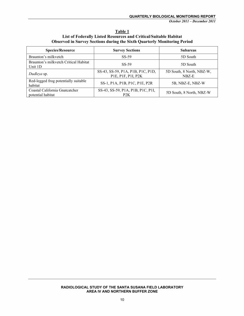
Table 1 List of Federally Listed Resources and Critical/Suitable Habitat
Observed in Survey Sections during the Sixth Quarterly Monitoring Period
Species/Resource Survey Sections Subareas
Braunton’s milkvetch SS-59 5D South Braunton’s milkvetch Critical Habitat Unit 1D SS-59 5D South
Dudleya sp. SS-43, SS-59, P1A, P1B, P1C, P1D, P1E, P1F, P1I, P2K
5D South, 8 North, NBZ-W, NBZ-E
Red-legged frog potentially suitable habitat SS-1, P1A, P1B, P1C, P1E, P2R 5B, NBZ-E, NBZ-W
Coastal California Gnatcatcher potential habitat
SS-43, SS-59, P1A, P1B, P1C, P1I, P2K 5D South, 8 North, NBZ-W

QUARTERLY BIOLOGICAL MONITORING REPORT October 2011 – December 2011
RADIOLOGICAL STUDY OF THE SANTA SUSANA FIELD LABORATORY AREA IV AND NORTHERN BUFFER ZONE
11
Table 2 List of Federally Listed Resources Impacted During Sixth Quarterly Monitoring Period
Species/
Resource Survey Section
Date Recorded
Associated project activity1
Impact Description
Braunton’s milkvetch SS-59 12/01/11 VC 3 plants damaged
Stems were broken on 3 plants , but the plants were not uprooted or destroyed.
1 VC = Vegetation Clearing

QUARTERLY BIOLOGICAL MONITORING REPORT October 2011 – December 2011
RADIOLOGICAL STUDY OF THE SANTA SUSANA FIELD LABORATORY AREA IV AND NORTHERN BUFFER ZONE
12
Table 3 List of Non-federally Listed Resources Observed during the Sixth Quarterly Monitoring Period
(grouped by area/subarea)
Species/Resource Survey Section Subarea
Santa Susana tarplant SS-15, SS-39, SS-43, SS-59, P1A, P1B, P1C, P1D, P1E, P1F, P1I, P1J, P2K, P2R
5A, 5D South, 7, 8 North, NBZ-W, NBZ-E
Malibu baccharis SS-59 5D South SS-59, P1C, P1D Plummer’s mariposa lily SS-39, SS-59, P1A, P1D, P1F, P1J, P2R 5D South, 7, NBZ-W, NBZ-E
Protected trees SS-1, SS-15, SS-39, SS-43, SS-59, P1A, P1B, P1C, P1D, P1E, P1F, P1G, P1H,
P1J, P2K, P2R, P3X
5A, 5B, 5D South, 7, 8 North, NBZ-W, NBZ-E
Riparian habitat SS-1, P1A, P1B, P1C, P1F, P1J, P2R 5B, NBZ-W, NBZ-E
QUARTERLY BIOLOGICAL MONITORING REPORT October 2011 – December 2011
RADIOLOGICAL STUDY OF THE SANTA SUSANA FIELD LABORATORY AREA IV AND NORTHERN BUFFER ZONE
13
Table 4 List of Non-federally Listed Resources Impacted during the Sixth Quarterly Monitoring Period
(excludes non-special status nesting birds)
Species/Resource Survey Section
Date Recorded
Associated project activity1
Impact Description
Plummer’s mariposa lily SS-59 12/01/11 VC 1 plant severed
One plant that had gone to seed was severed at its base.
Protected trees
P1A, P1B, P1D, P1E, P1F, P1G, P1H, P1I, P1J, P2K, P2R, P3X
–October - December VC Trimmed
Unknown number of mature trees trimmed per Ventura County trimming guidelines
1 VC = Vegetation Clearing

QUARTERLY BIOLOGICAL MONITORING REPORT October 2011 – December 2011
RADIOLOGICAL STUDY OF THE SANTA SUSANA FIELD LABORATORY AREA IV AND NORTHERN BUFFER ZONE
14
Table 5 List of Activities Conducted within Riparian Habitat
during the Sixth Quarterly Monitoring Period
Location Description Description of Activities Performed* Significant Impacts
P1A Ephemeral drainages VC, GS
Vegetation selectively trimmed; vegetation clearance and gamma scanning resulted in some siltation of dry creek bottoms after several crossings – soil will be removed following completion of activities in this area. Also, heavy build-up of loose soil near but outside of creek bottom. Impacts resulted in restrictions on use of skid steer in and near ephemeral drainages.
P1B Ephemeral drainages VC, GS
Vegetation selectively thinned; vegetation clearance and gamma scanning activities resulted in some siltation of dry creek bottoms after several crossings – soil will be removed following completion of activities in this area.
P1C Ephemeral drainages VC Vegetation selectively thinned
P1I Ephemeral drainages VC Vegetation selectively trimmed *VC = Vegetation Clearing, GS = Gamma Scanning

APPENDIX 1
FIGURES AND PHOTO PLATES


APPENDIX 2
SIXTH QUARTERLY BIOLOGICAL CLEARANCE SURVEY FORMS


APPENDIX 3
SIXTH QUARTERLY BIOLOGICAL MONITORING FORMS