qdb 15 = flight planning & monitoring
DESCRIPTION
EASATRANSCRIPT
Flight Planning & Monitoring - P a g e | 1
1. A public transport aeroplane with reciprocating engines is flying from PARlS to LYON. The final reserve
corresponds to:
45 minutes at holding speed
2. In a flight plan when the destination aerodrome is A and the alternate aerodrome is B, the final reserve fuel for
a turbojet engine aeroplane corresponds to:
30 minutes holding 1,500 feet above aerodrome B
3. An aeroplane flies at an airspeed of 380 kt. lt flies from A to B and back to A. Distance AB = 480 NM. When
going from A to B, it experiences a headwind component = 60 kt. The wind remains constant.
The duration of the flight will be:
2h 35min
4. During a flight at night a position has to be reported to ATC. The aeroplane is at a distance of 750 NM from
the groundstation and at flight level 350. The frequency to be used is:
5649 kHz
5. According to the chart the minimum obstruction clearance altitude (MOCA) is 8500 ft. The meteorological data
gives an outside air temperature of -20°C at FL 85. The QNH, given by a met. station at an elevation of 4000ft, is 1003
hPa.
What is the minimum pressure altitude which should be flown according to the given MOCA?
8800 ft
6. During an IFR flight in a Beech Bonanza the fuel indicators show that the remaining amount of fuel is 100 lbs
after 38 minutes. The total amount of fuel at departure was 160 lbs. For the alternate fuel, 30 lbs is necessary. The
planned fuel for taxi is 13 lbs. Final reserve fuel is estimated at 50 lbs. If the fuel flow remains the same, how many
minutes can be flown to the destination with the remaining fuel?
12 minutes
7. VFR flights shall not be flown over the congested areas of cities at a height less than
1000 ft above the highest obstacle within a radius of 600 m from the aircraft
8. How many feet you have to climb to reach FL 75?
Given: FL 75; departure aerodrome elevation 1500 ft; QNH = 1023 hPa; temperature = ISA; 1 hPa = 30 ft
6300 ft
9. Given:
Dry operating mass (DOM)= 33510 kg
Load= 7600 kg
Final reserve fuel= 983 kg
Alternate fuel= 1100 kg
Contingency fuel 102 kg
The estimated landing mass at alternate should be :
42195 kg
10. Given:
Dry operating mass (DOM)= 33000 kg
Load= 8110 kg
Final reserve fuel= 983 kg
Alternate fuel= 1100 kg
Contingency fuel 102 kg
The estimated landing mass at alternate should be :
42195 kg
Flight Planning & Monitoring - P a g e | 2
11. Given:
Dry operating mass (DOM)= 33510 kg
Load= 7600 kg
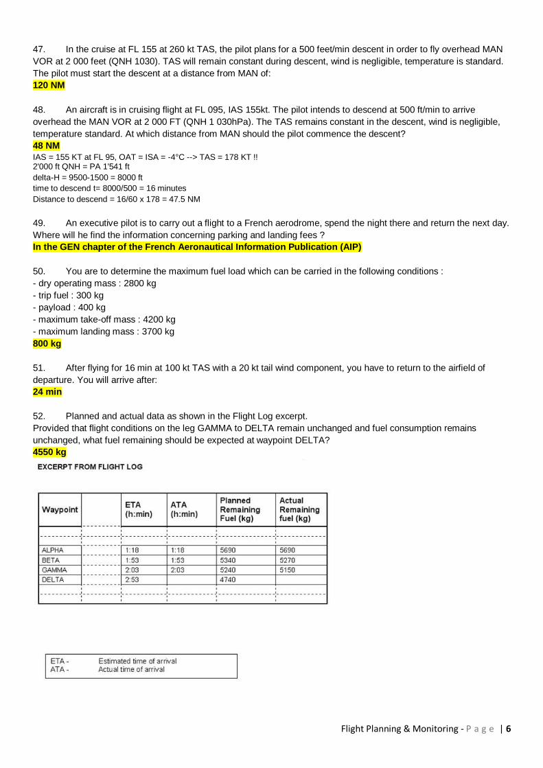
Trip fuel (TF)= 2040 kg
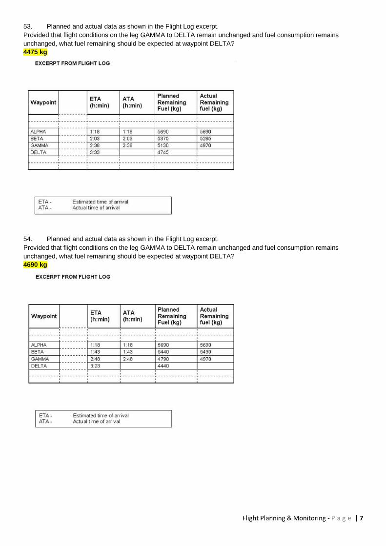
Final reserve fuel= 983 kg
Alternate fuel= 1100 kg
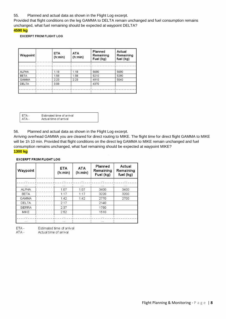
Contingency fuel= 5% of trip fuel
Which of the listed estimated masses is correct?
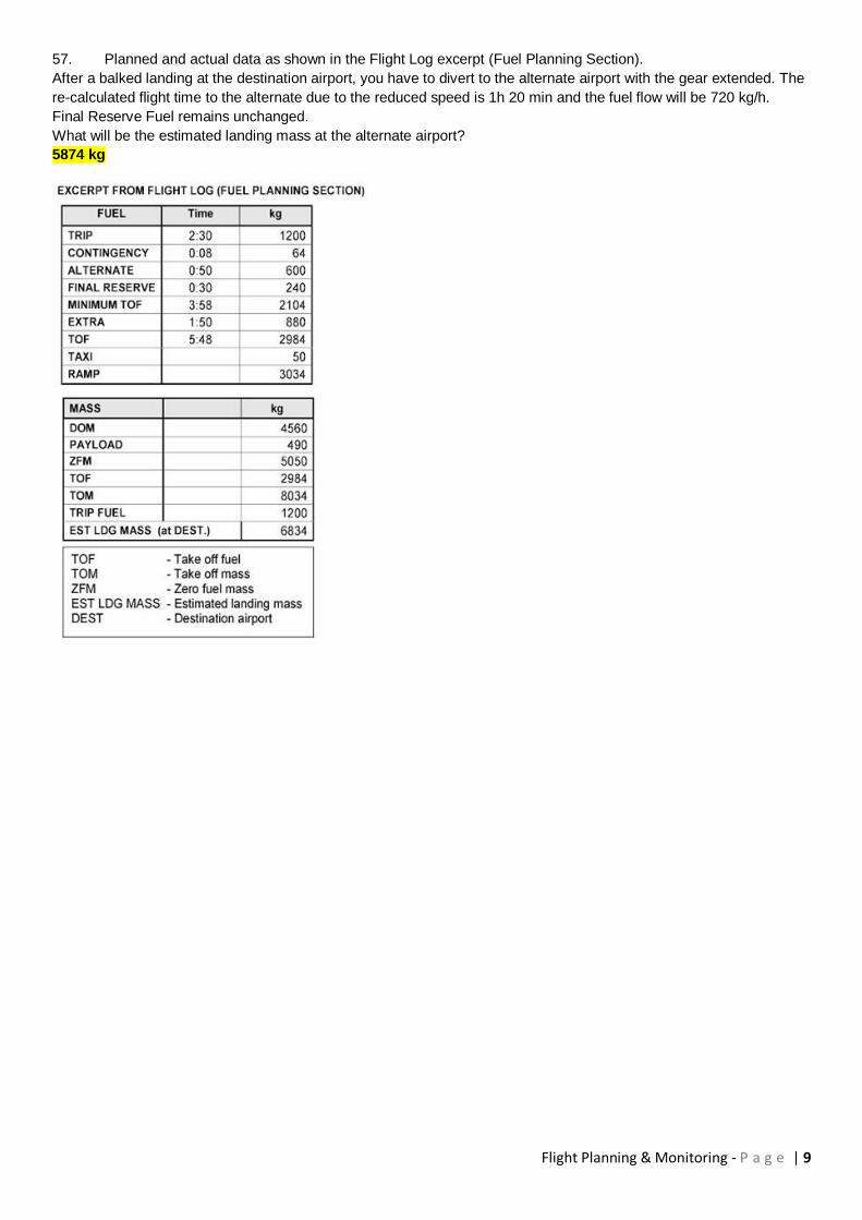
Estimated landing mass at destination= 43295 kg
12. (For this question use Flight Planning Manual MEP1 Figure 3.1)
A flight is to be made from one airport (elevation 3000 ft) to another in a multi engine piston aeroplane (MEP1). The
cruising level will be FL 110. The temperature at FL 110 is ISA - 10° C. The temperature at the departure aerodrome
is -1° C. Calculate the fuel to climb with mixture rich.
6 US gallon
13. (For this question use Flight Planning Manual MEP1 Figure 3.6)
A flight is to be made to an airport, pressure altitude 3000 ft, in a multi engine piston aeroplane (MEP1). The forecast
OAT for the airport is -1° C. The cruising level will be FL 110, where OAT is -10° C.
Calculate the still air descent distance for:
145 KIAS
Rate of descent 1000 ft/min
Gears and flaps up
20 NM
14. A VFR flight planned for a Piper Seneca III. At a navigational checkpoint the remaining usable fuel in tanks is
60 US gallons. The alternate fuel is 12 US gallons. According to the flight plan the remaining flight time is 1h35min.
Calculate the highest rate of consumption possible for the rest of the trip.
21.3 US gallons/hour
15. Given: maximum take-off mass 64 400 kg
maximum landing mass 56 200 kg
maximum zero fuel mass 53 000 kg
dry operating mass 35 500 kg
estimated load 14 500 kg
estimated trip fuel 4 900kg
minimum take-off fuel 7 400 kg
Find the maximum allowable take-off fuel:
11 100 kg
16. Given: True course (TC) 017; W/V 340/30; TAS 420 kt
Find: wind correction angle (WCA) and ground speed (GS)
WCA -2° ; GS 396 kt
17. A multi engine piston aeroplane is on an IFR flight. The fuel plan gives a trip fuel of 65 US gallons. The
alternate fuel, final reserve included, is 17 US gallons. Contingency fuel is 5% of the trip fuel. The usable fuel at
departure is 93 US gallons. At a certain moment the fuel consumed according to the fuel gauges is 40 US gallons and
the distance flown is half of the total distance. Assume that fuel consumption doesn't change. Which statement is right?
The remaining fuel is not sufficient to reach the destination with reserves intact
18. Flight planning chart for an aeroplane states, that the time to reach the cruising level at a given gross mass is
36 minutes and the distance travelled is 157 NM (zero-wind). What will be the distance travelled with an average
tailwind component of 60kt?
193 NM
Flight Planning & Monitoring - P a g e | 3
19. You are flying a constant compass heading of 252°. Variation is 22°E, deviation is 3°W and your INS is
showing a drift of 9° right. True track is?
280°
20. For a planned flight the calculated fuel is as follows:
Flight time: 3h06min
The reserve fuel, at any time, should not be less than 30% of the remaining trip fuel.
Taxi fuel: 8 kg
Block fuel: 118 kg
How much fuel should remain after 2 hours flight time?
30 kg trip fuel and 9 kg reserve fuel
Calculate trip + reserve fuel = 118 - 8 = 110 kg Calculate the remaining fuel (trip + reserve) after 2 hours of flight: Total planned flight time is 186 minutes, remaining time after 2 hours is 66 minutes. Remaining fuel: 110 / 186 x 66 = 39 kg Remaining fuel is 1.3 times remaining trip fuel (trip fuel plus 30% reserve) Remaining trip fuel is: 39/1.3 = 30 kg Remaining reserve fuel is: 0.3 x 30 = 9 kg
21. For a planned flight the calculated fuel is as follows:
Flight time: 2h42min
The reserve fuel, at any time, should not be less than 30% of the remaining trip fuel.
Taxi fuel: 9 kg
Block fuel: 136 kg
How much fuel should remain after 2 hours flight time?
25 kg trip fuel and 8 kg reserve fuel
22. Minimum planned take-off fuel is 160 kg (30% total reserve fuel is included). Assume the groundspeed on this
trip is constant. When the aeroplane has done half the distance the remaining fuel is 70 kg. Is diversion to a nearby
alternate necessary?
Diversion to a nearby alternate is necessary, because the remaining fuel is not sufficient
23. (For this Question use Flight Planning & Monitoring MEP1)
A flight has to be made with a multi engine piston aeroplane. For the fuel calculations take 5 US gallons for the taxi,
and an additional 13 minutes at cruise condition to account for climb and descent. Calculated time from overhead to
overhead is 1h47min. Power setting is 45%, 2600 RPM. Calculated reserve fuel is 30% of the trip fuel. FL 100.
Temperature -5°C. Find the minimum block fuel.
47 US gallons
24. (For this Question use Flight Planning & Monitoring MEP1)
A flight has to be made with a multi engine piston aeroplane. For the fuel calculations take 5 US gallons for the taxi,
and an additional 13 minutes at cruise condition to account for climb and descent. Calculated time overhead to
overhead is 2h37min. Power setting is 65%, 2500 RPM. Calculated reserve fuel is 30% of the trip fuel. FL 120.
Temperature 1°C. Find the minimum block fuel.
91 US gallons
25. (For this Question use Flight Planning & Monitoring SEP1 Fig. 2.2)
Given:
FL 75
OAT +10°C
Lean mixture
2300 RPM
Find:
Fuel flow in gallons per hour (GPH) and TAS.
11.6 GPH : TAS: 160 kt

Flight Planning & Monitoring - P a g e | 4
26. (For this Question use Flight Planning & Monitoring SEP1 Fig. 2.1)
Given:
FL 75
OAT: +5°C
During climb: average head wind component 20 kt
Take-off from MSL with the initial mass of 3 650 lbs.
Find:
Time and fuel to climb.
9 min : 3,3 USG
27. (For this Question use Flight Planning & Monitoring SEP1 Fig. 2.1) Given:
FL 75
OAT: +5°C
During climb: average head wind component 20 kt
Take-off from MSL with the initial mass of 3 650 lbs.
Find:
Still air distance (NAM) and ground distance (NM) using the graph "time, fuel, distance to climb".
18 NAM : 15 NM
28. Given: True course (TC) 017°, W/V 340°/30 kt, True air speed (TAS) 420 kt
Find: Wind correction angle (WCA) and ground speed (GS)
WCA -2°, GS 396 kt
29. (For this Question use Flight Planning & Monitoring SEP 1, Fig. 2.1)
Given: Take-off mass 3500 lbs, departure aerodrome pressure altitude 2500 ft,
OAT +10°C,
First cruising level: FL 140, OAT -5°C
Find the time, fuel and still air distance to climb.
22 min, 6.7 GAL, 45 NAM
30. (For this Question use Flight Planning & Monitoring SEP1, Fig. 2.4)
Given: Aeroplane mass at start-up 3663 lbs, Aviation gasoline (density 6 lbs/gal)-fuel load 74 gal, Take-off altitude sea
level, Headwind 40 kt, Cruising altitude 8000 ft, Power setting full throttle 2300 RPM 20°C lean of peak EGT
Calculate the range.
633 NGM
31. (For this question use Route Manual VFR + GPS chart ED-6)
Name the frequency of TANGO VORTAC (48°37'N, 009°16'E):
112.50 MHz
32. (For this question use Route Manual VFR + GPS chart ED-6)
Give the name and frequency of the Flight Information Service for an aeroplane in position (47°59'N, 010°14'E):
MÜNCHEN INFORMATION 126.95 MHz
33. (For this question use Route Manual VFR + GPS chart ED-6)
Give the frequency of STUTTGART ATIS:
126.125 MHz
34. (For this question use Route Manual VFR + GPS chart ED-6)
Give the frequency of ZÜRICH VOLMET:
127.20 MHz
35. Refer to the appropriate chart in the Student Pilot Route Manual: Which navigation aid is located in position
48°55'N, 009°20'E ?
VOR/DME
Flight Planning & Monitoring - P a g e | 5
36. Refer to the appropriate chart in the Student Pilot Route Manual: Which navigation aid is located in position
48°23'N, 008°39'E?
VOR
37. Refer to the appropriate chart in the Student Pilot Route Manual: Which navigation aid is located in position
48°30'N, 007°34'E?
VOR/DME
38. Flying VFR from VILLINGEN (48°03.5'N, 008°27.0'E) to FREUDENSTADT (48°28.0'N, 008°24.0'E) determine
the magnetic course.
356°
39. Flying VFR from VILLINGEN (48°03.5'N, 008°27.0'E) to FREUDENSTADT (48°28.0'N, 008°24.0'E) determine
the distance.
24 NM
40. Flying VFR from VILLINGEN (48°03.5'N, 008°27.0'E) to FREUDENSTADT (48°28.0'N, 008°24.0'E).Determine
the minimum altitude within a corridor 5NM left and 5 NM right of the courseline in order to stay 1000 ft clear of
obstacles.
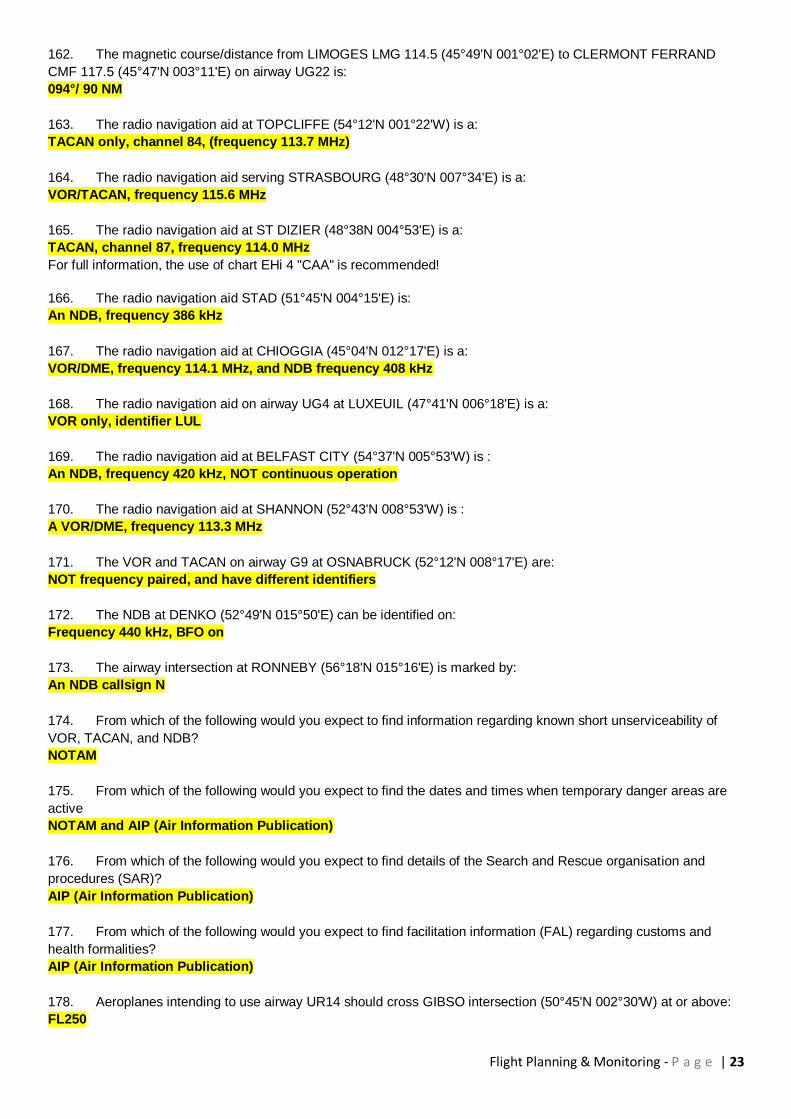
3900 ft
41. Flying VFR from PEITING (47°48.0'N, 010°55.5'E) to IMMENSTADT (47°33.5'N, 010°13.0'E) determine the
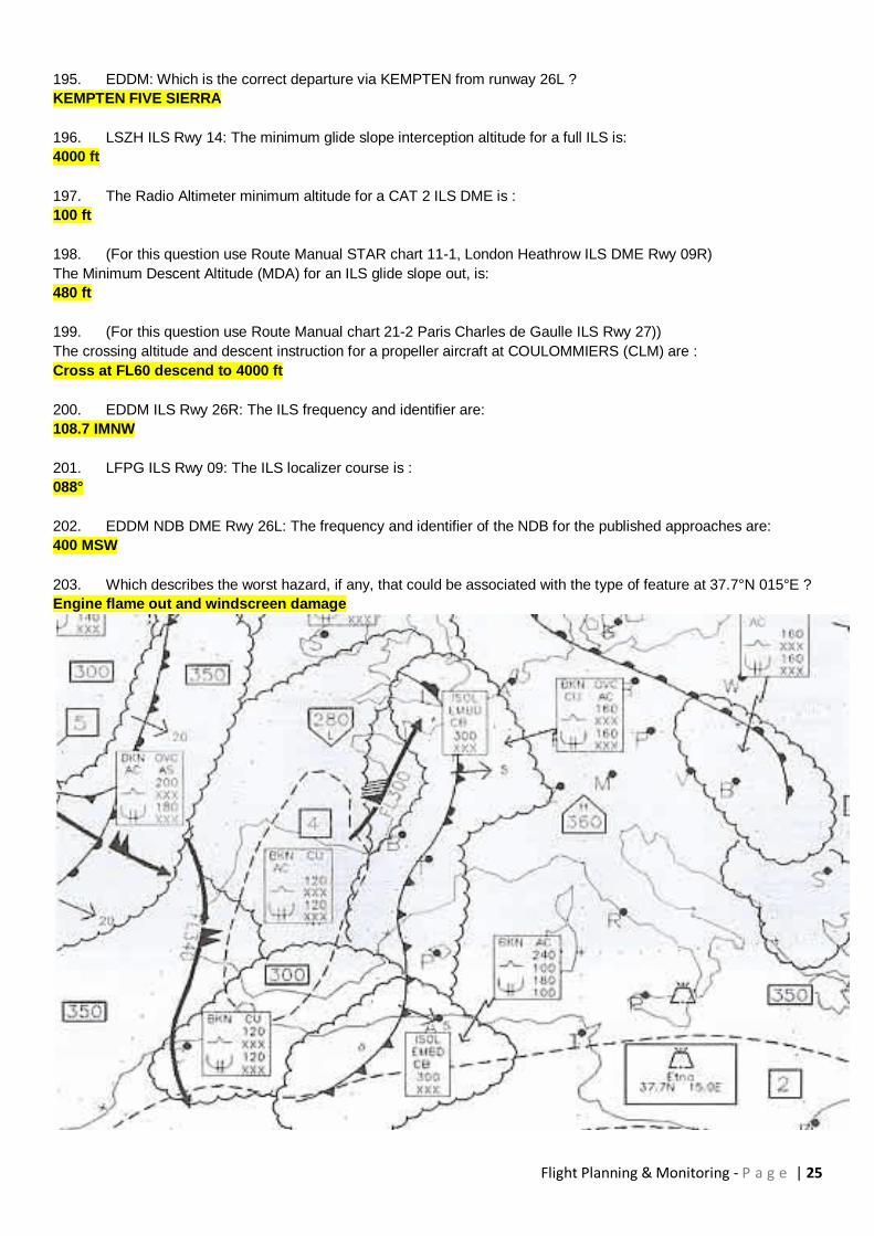
magnetic course.
243°
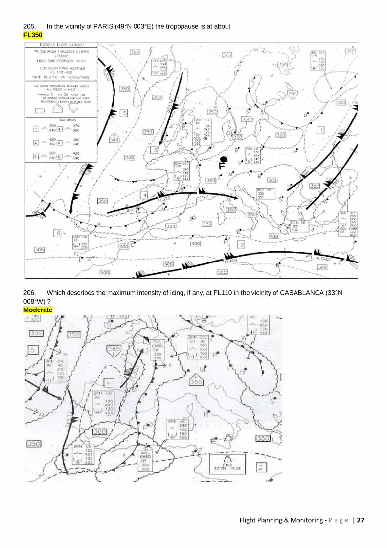
42. Flying VFR from PEITING (47°48.0'N, 010°55.5'E) to IMMENSTADT (47°33.5'N, 010°13.0'E) determine the
distance.
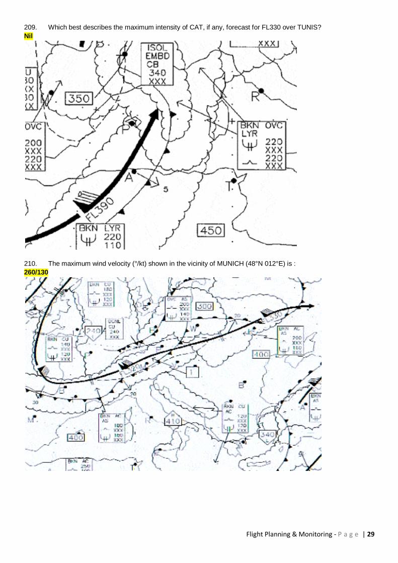
32 NM
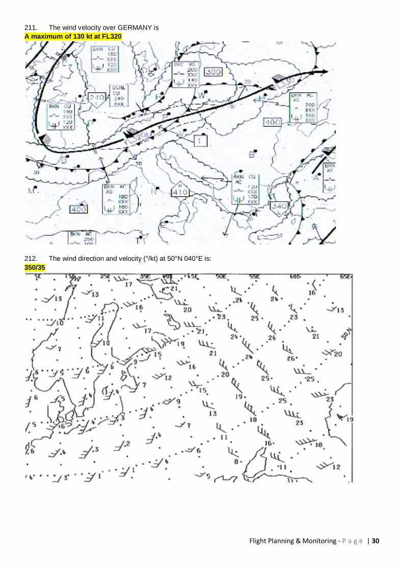
43. Flying VFR from PEITING (47°48.0'N, 010°55.5'E) to IMMENSTADT (47°33.5'N, 010°13.0'E).Determine the
minimum altitude within a corridor 5NM left and 5 NM right of the courseline in order to stay 1000 ft clear of obstacles.
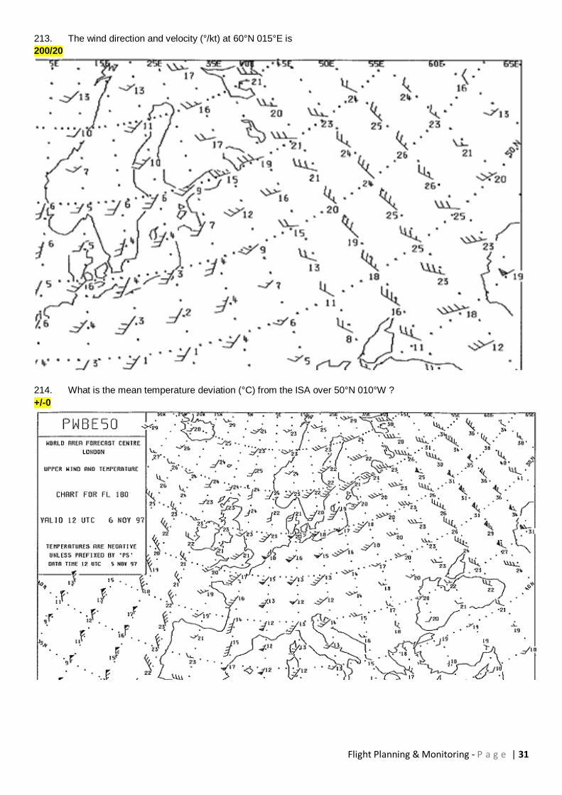
6900 ft
44. The fuel burn off is 200 kg/h with a relative fuel density of 0,8. If the relative density is 0,75, the fuel burn will
be:
200 kg/h
45. The fuel burn of an aircraft turbine engine is 220 l/h with a fuel density of 0,80. If the density is 0,75, the fuel
burn will be:
235 l/h
Turbine engines require a constant fuel flow in kg/h (and not l/h!) for a given power output. This is because the energy content per kg fuel (so called: calorific value) of a given fuel is constant for different densities. Density varies for example due to temperature. In addition, it is such that the calorific value (per kg) of pretty much all liquid hydrocarbon fuels (like all the different grades of kerosene, but also diesel fuel, heating oil, or gasoline for piston engines) is almost the same for all fuels, the variations between different types of fuel are neglect able. Therefore it is clear: For a given power, the fuel flow in kg/h must stay constant. Calculate fuel flow in kg/h for density 0.80: FF = 220*0.8 = 176 kg/h Calculate volumetric fuel flow (l/h) for density 0.75: FF=
176/0.75 = 234.67 l/h
46. The measured course 042° T.
The variation in the area is 6° W and the wind is calm.
The deviation card is reproduced in the annex.
In order to follow this course, the pilot must fly a compass heading of:
052°
Flight Planning & Monitoring - P a g e | 6
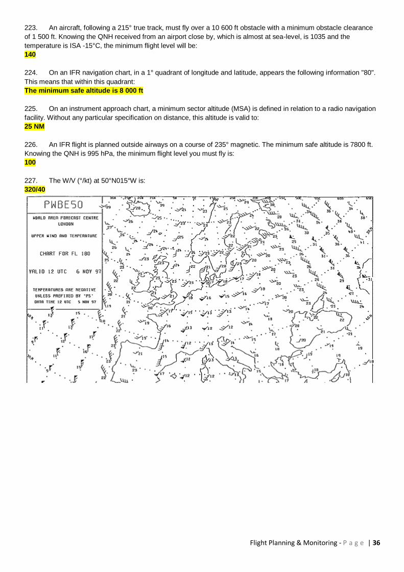
47. In the cruise at FL 155 at 260 kt TAS, the pilot plans for a 500 feet/min descent in order to fly overhead MAN
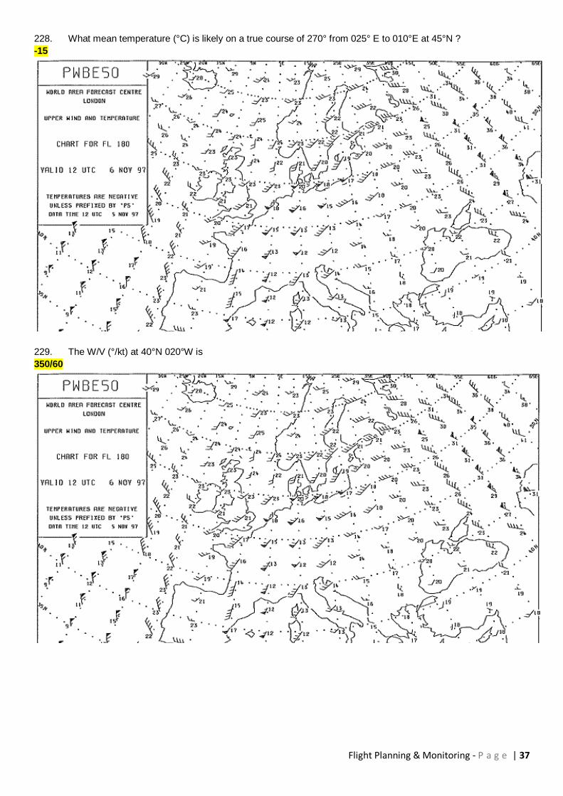
VOR at 2 000 feet (QNH 1030). TAS will remain constant during descent, wind is negligible, temperature is standard.
The pilot must start the descent at a distance from MAN of:
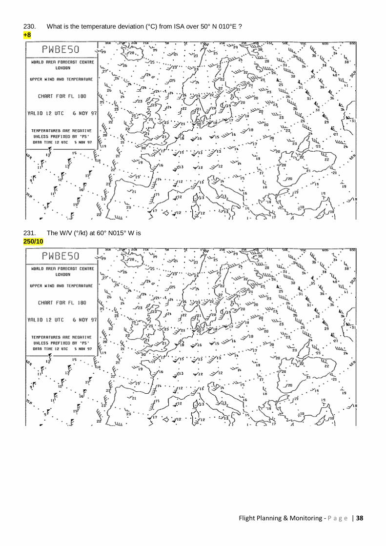
120 NM
48. An aircraft is in cruising flight at FL 095, IAS 155kt. The pilot intends to descend at 500 ft/min to arrive
overhead the MAN VOR at 2 000 FT (QNH 1 030hPa). The TAS remains constant in the descent, wind is negligible,
temperature standard. At which distance from MAN should the pilot commence the descent?
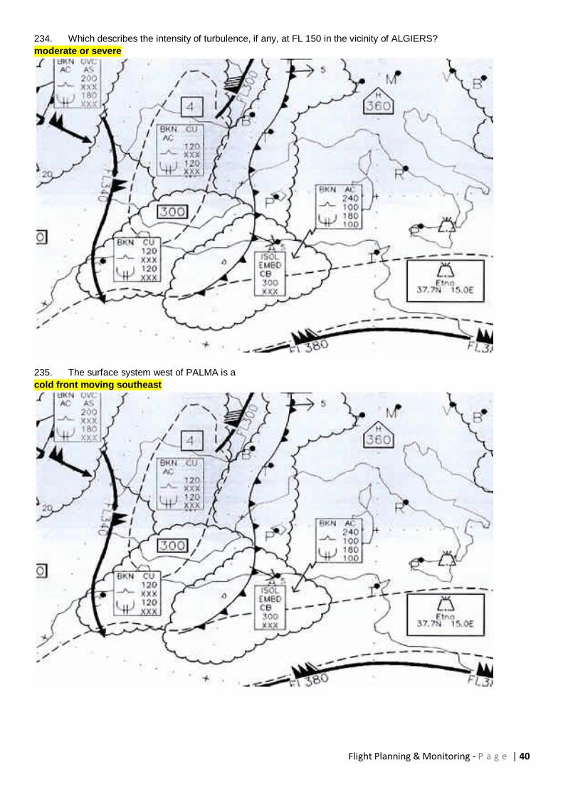
48 NM
IAS = 155 KT at FL 95, OAT = ISA = -4°C --> TAS = 178 KT !! 2'000 ft QNH = PA 1'541 ft
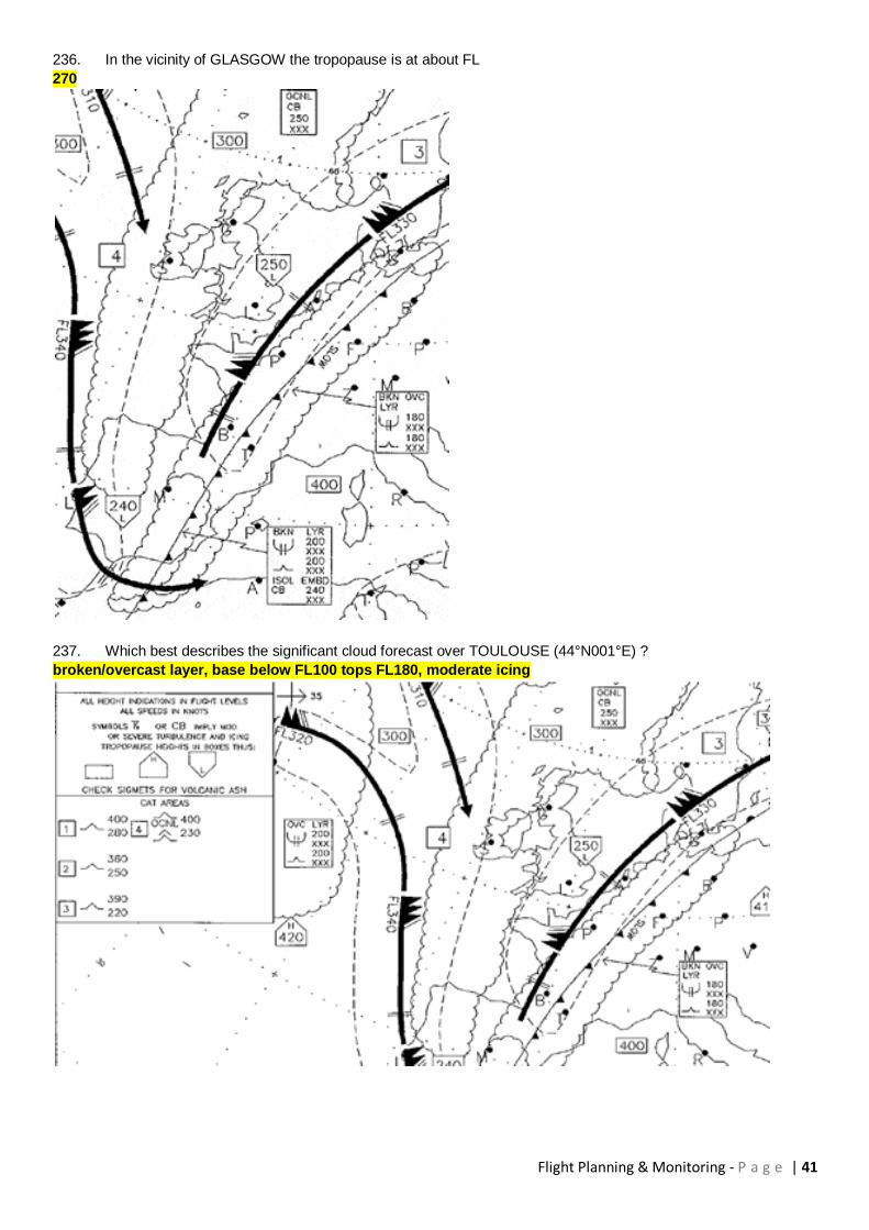
delta-H = 9500-1500 = 8000 ft
time to descend t= 8000/500 = 16 minutes
Distance to descend = 16/60 x 178 = 47.5 NM
49. An executive pilot is to carry out a flight to a French aerodrome, spend the night there and return the next day.
Where will he find the information concerning parking and landing fees ?
In the GEN chapter of the French Aeronautical Information Publication (AIP)
50. You are to determine the maximum fuel load which can be carried in the following conditions :
- dry operating mass : 2800 kg
- trip fuel : 300 kg
- payload : 400 kg
- maximum take-off mass : 4200 kg
- maximum landing mass : 3700 kg
800 kg
51. After flying for 16 min at 100 kt TAS with a 20 kt tail wind component, you have to return to the airfield of
departure. You will arrive after:
24 min
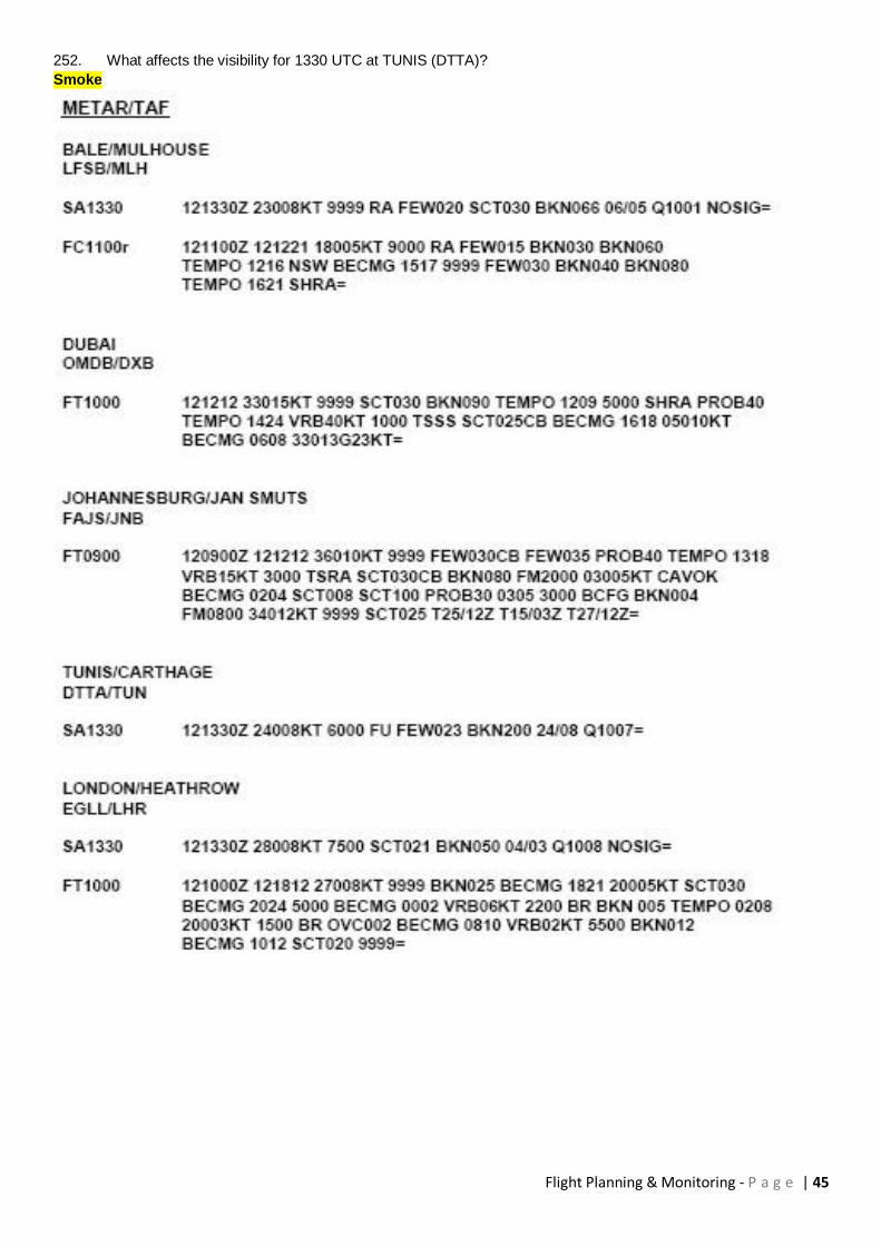
52. Planned and actual data as shown in the Flight Log excerpt.
Provided that flight conditions on the leg GAMMA to DELTA remain unchanged and fuel consumption remains
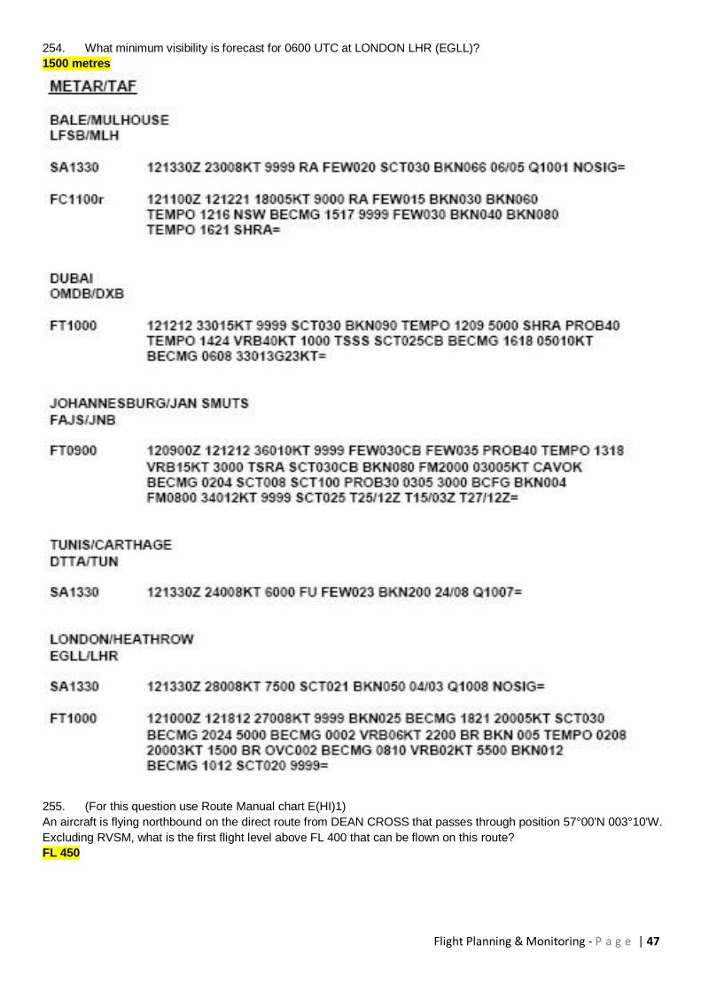
unchanged, what fuel remaining should be expected at waypoint DELTA?
4550 kg
Flight Planning & Monitoring - P a g e | 7
53. Planned and actual data as shown in the Flight Log excerpt.
Provided that flight conditions on the leg GAMMA to DELTA remain unchanged and fuel consumption remains
unchanged, what fuel remaining should be expected at waypoint DELTA?
4475 kg
54. Planned and actual data as shown in the Flight Log excerpt.
Provided that flight conditions on the leg GAMMA to DELTA remain unchanged and fuel consumption remains
unchanged, what fuel remaining should be expected at waypoint DELTA?
4690 kg
Flight Planning & Monitoring - P a g e | 8
55. Planned and actual data as shown in the Flight Log excerpt.
Provided that flight conditions on the leg GAMMA to DELTA remain unchanged and fuel consumption remains
unchanged, what fuel remaining should be expected at waypoint DELTA?
4590 kg
56. Planned and actual data as shown in the Flight Log excerpt.
Arriving overhead GAMMA you are cleared for direct routing to MIKE. The flight time for direct flight GAMMA to MIKE
will be 1h 10 min. Provided that flight conditions on the direct leg GAMMA to MIKE remain unchanged and fuel
consumption remains unchanged, what fuel remaining should be expected at waypoint MIKE?
1300 kg
Flight Planning & Monitoring - P a g e | 9
57. Planned and actual data as shown in the Flight Log excerpt (Fuel Planning Section).
After a balked landing at the destination airport, you have to divert to the alternate airport with the gear extended. The
re-calculated flight time to the alternate due to the reduced speed is 1h 20 min and the fuel flow will be 720 kg/h.
Final Reserve Fuel remains unchanged.
What will be the estimated landing mass at the alternate airport?
5874 kg
Flight Planning & Monitoring - P a g e | 10
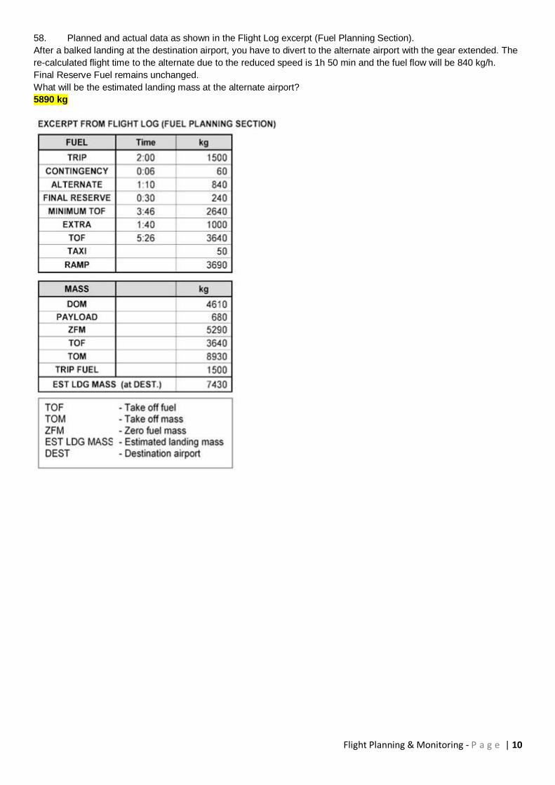
58. Planned and actual data as shown in the Flight Log excerpt (Fuel Planning Section).
After a balked landing at the destination airport, you have to divert to the alternate airport with the gear extended. The
re-calculated flight time to the alternate due to the reduced speed is 1h 50 min and the fuel flow will be 840 kg/h.
Final Reserve Fuel remains unchanged.
What will be the estimated landing mass at the alternate airport?
5890 kg

Flight Planning & Monitoring - P a g e | 11
59. Planned and actual data as shown in the Flight Log excerpt (Fuel Planning Section).
After a balked landing at the destination airport, you have to divert to the alternate airport with the gear extended. The
re-calculated flight time to the alternate due to the reduced speed is 2h 20 min and the fuel flow will be 780 kg/h.
Final Reserve Fuel remains unchanged.
What will be the estimated landing mass at the alternate airport?
5440 kg
Flight Planning & Monitoring - P a g e | 12
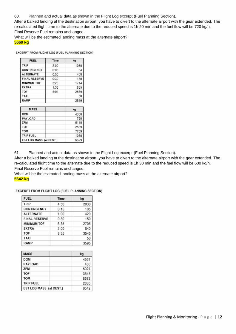
60. Planned and actual data as shown in the Flight Log excerpt (Fuel Planning Section).
After a balked landing at the destination airport, you have to divert to the alternate airport with the gear extended. The
re-calculated flight time to the alternate due to the reduced speed is 1h 20 min and the fuel flow will be 720 kg/h.
Final Reserve Fuel remains unchanged.
What will be the estimated landing mass at the alternate airport?
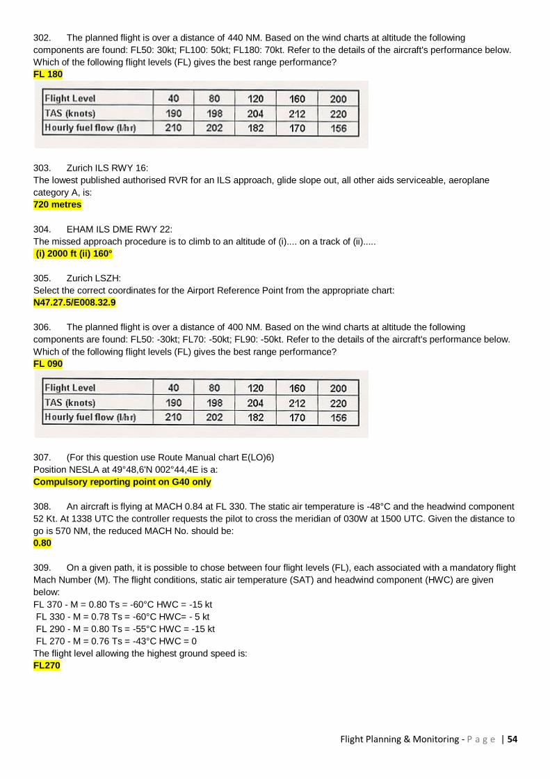
5669 kg
61. Planned and actual data as shown in the Flight Log excerpt (Fuel Planning Section).
After a balked landing at the destination airport, you have to divert to the alternate airport with the gear extended. The
re-calculated flight time to the alternate due to the reduced speed is 1h 30 min and the fuel flow will be 600 kg/h.
Final Reserve Fuel remains unchanged.
What will be the estimated landing mass at the alternate airport?
5642 kg
Flight Planning & Monitoring - P a g e | 13
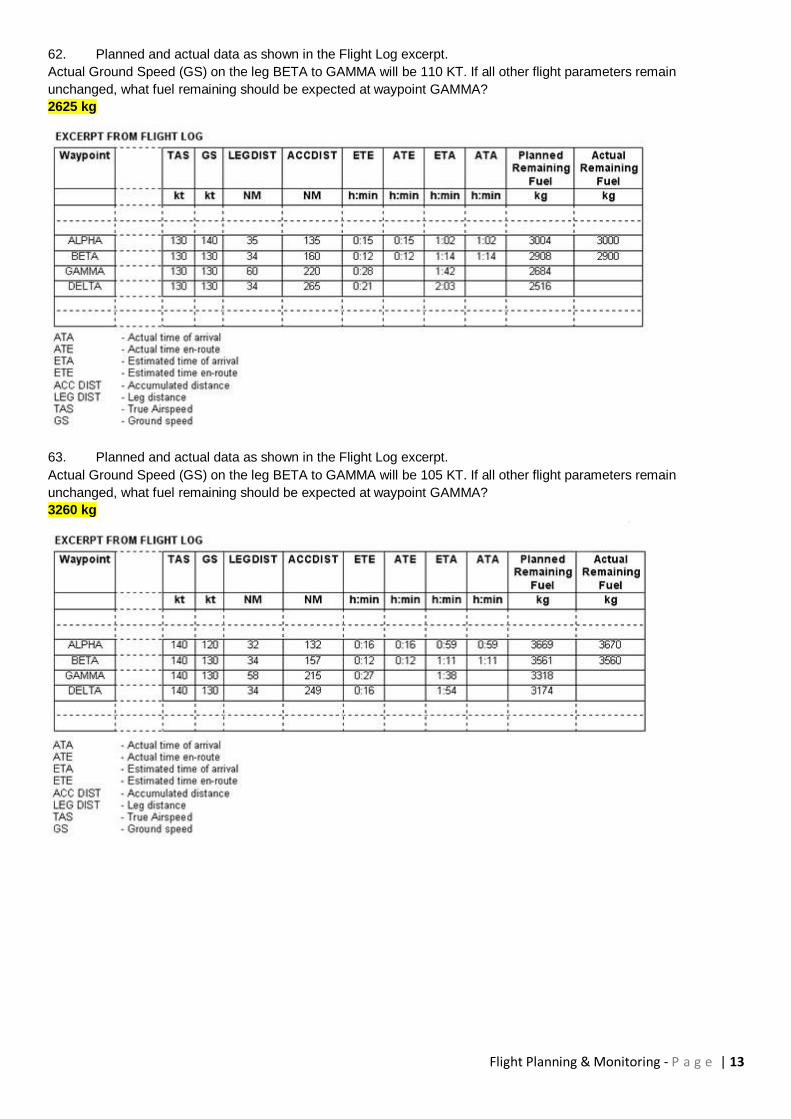
62. Planned and actual data as shown in the Flight Log excerpt.
Actual Ground Speed (GS) on the leg BETA to GAMMA will be 110 KT. If all other flight parameters remain
unchanged, what fuel remaining should be expected at waypoint GAMMA?
2625 kg
63. Planned and actual data as shown in the Flight Log excerpt.
Actual Ground Speed (GS) on the leg BETA to GAMMA will be 105 KT. If all other flight parameters remain
unchanged, what fuel remaining should be expected at waypoint GAMMA?
3260 kg
Flight Planning & Monitoring - P a g e | 14
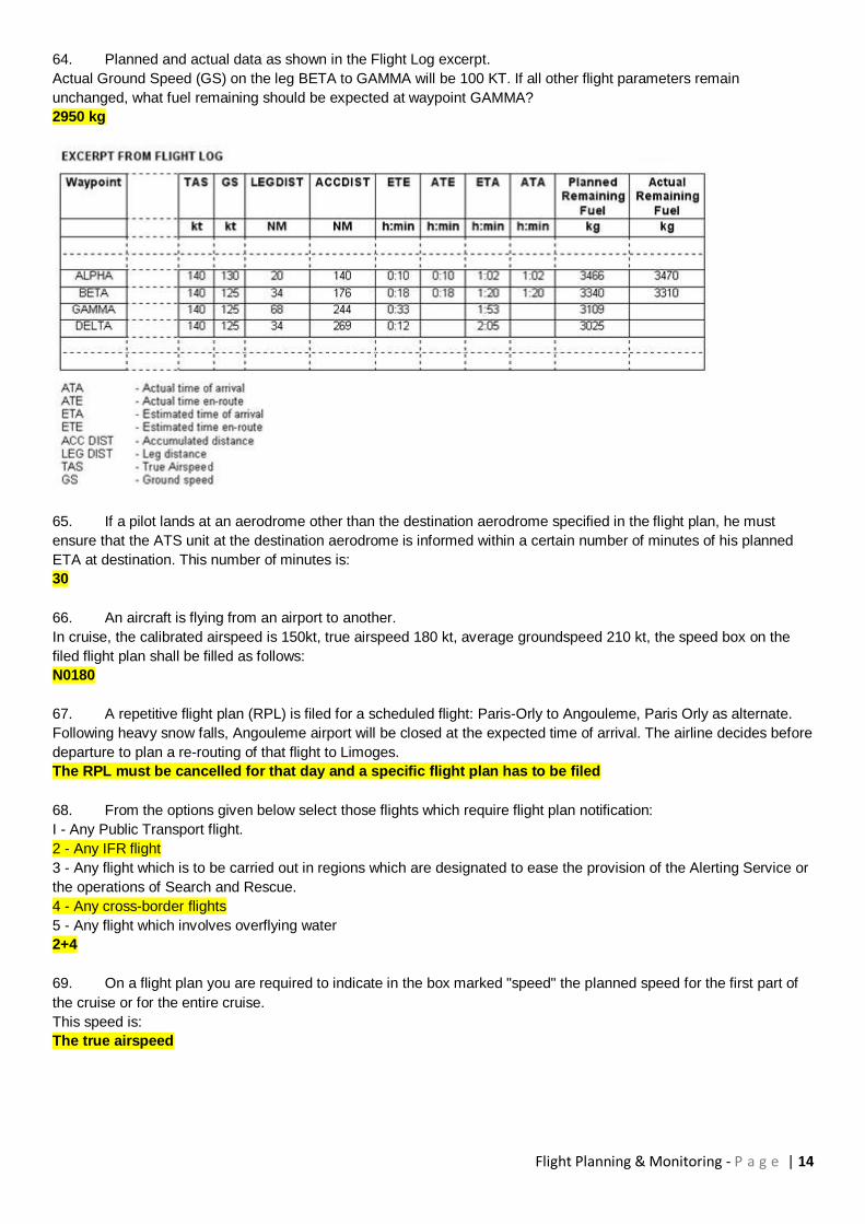
64. Planned and actual data as shown in the Flight Log excerpt.
Actual Ground Speed (GS) on the leg BETA to GAMMA will be 100 KT. If all other flight parameters remain
unchanged, what fuel remaining should be expected at waypoint GAMMA?
2950 kg
65. If a pilot lands at an aerodrome other than the destination aerodrome specified in the flight plan, he must
ensure that the ATS unit at the destination aerodrome is informed within a certain number of minutes of his planned
ETA at destination. This number of minutes is:
30
66. An aircraft is flying from an airport to another.
In cruise, the calibrated airspeed is 150kt, true airspeed 180 kt, average groundspeed 210 kt, the speed box on the
filed flight plan shall be filled as follows:
N0180
67. A repetitive flight plan (RPL) is filed for a scheduled flight: Paris-Orly to Angouleme, Paris Orly as alternate.
Following heavy snow falls, Angouleme airport will be closed at the expected time of arrival. The airline decides before
departure to plan a re-routing of that flight to Limoges.
The RPL must be cancelled for that day and a specific flight plan has to be filed
68. From the options given below select those flights which require flight plan notification:
I - Any Public Transport flight.
2 - Any IFR flight
3 - Any flight which is to be carried out in regions which are designated to ease the provision of the Alerting Service or
the operations of Search and Rescue.
4 - Any cross-border flights
5 - Any flight which involves overflying water
2+4
69. On a flight plan you are required to indicate in the box marked "speed" the planned speed for the first part of
the cruise or for the entire cruise.
This speed is:
The true airspeed
Flight Planning & Monitoring - P a g e | 15
70. Which of the following statements regarding filing a flight plan is correct?
In case of flow control the flight plan should be filed at least three hours in advance of the time of departure
71. An aeroplane is on an IFR flight. The flight is to be changed from IFR to VFR. Is it possible?
Yes, the pilot in command must inform ATC using the phrase "cancelling my IFR flight"
72. You have a flight plan IFR from Amsterdam to London. In the flight plan it is noted that you will deviate from
the ATS route passing the FIR boundary Amsterdam/London. The airway clearance reads: Cleared to London via
flight planned route.
Which of the following statements is correct?
The route according to the flight plan is accepted
73. During an IFR flight TAS and time appear to deviate from the data in the flight plan. The minimum deviations
that should be reported to ATC in order to conform to PANS-RAC are:
TAS 5% and time 3 minutes
74. How many hours in advance of departure time should a flight plan be filed in the case of flights into areas
subject to air traffic flow management (ATFM)?
3:00 hours
75. A "current flight plan" is a:
Filed flight plan with amendments and clearance included
76. The navigation plan reads:
Trip fuel: 100 kg
Flight time: 1h35min
Taxi fuel: 3 kg
Block fuel: 181 kg
The endurance on the ICAO flight plan should read:
2h 49min
77. The navigation plan reads:
Trip fuel: 136 kg
Flight time: 2h45min
Calculated reserve fuel: 30% of trip fuel
Fuel in tank is minimum (no extra fuel on board)
Taxi fuel: 3 kg
The endurance on the ICAO flight plan should read:
3h34min
78. If your destination airport has no ICAO indicator, in the appropriate box of your flight plan, you write:
ZZZZ
79. For a flight plan filed before the flight, the indicated time of departure is:
The estimated off-block time
80. The cruising speed to write in the appropriate box of a flight plan is:
True air speed
81. In the appropriate box of a flight plan, for endurance, one must indicate the time corresponding to:
The total usable fuel on board
82. The maximum permissible take-off mass of an aircraft for the L wake turbulence category on a flight plan is:
7 000 kg
Flight Planning & Monitoring - P a g e | 16
83. In the appropriate box of a flight plan form, concerning equipment, the letter to be used to indicate that the
aircraft is equipped with a mode A 4096 codes transponder with altitude reporting capability is:
C
84. It is possible, in flight, to:
1 - file an IFR flight plan
2 - modify an active IFR or VFR flight plan
3 - cancel an active VFR flight plan
4 - close an active VFR flight plan
Which of the following combinations contains all of the correct statements?
1 - 2 - 3 - 4
85. When a pilot fills in a flight plan, he must indicate the wake turbulence category. This category is a function of
which mass?
Maximum certified take-off mass
86. The planned departure time from the parking area is 1815 UTC
The estimated take-off time is 1825 UTC
The IFR flight plan must be filed with ATC at the latest at:
1715 UTC
87. In the appropriate box of a flight plan form, corresponding to the estimated time of departure, the time
indicated is that at which the aircraft intends to :
Go off blocks
88. When completing an ATS flight plan, an elapsed time (Item 16) of 1 hour 55 minutes should be entered as:
0155
89. When completing an ATS flight plan for a European destination, clock times are to be expressed in:
UTC
90. In the ATS flight plan, for a non-scheduled flight which of the following letters should be entered in Item 8
(Type of Flight):
N
91. In the ATS flight plan item 15, it is necessary to enter any point at which a change of cruising speed takes
place. For this purpose a "change of speed" is defined as:
5% TAS or 0.01 Mach or more
92. In the ATS flight plan item 15, when entering a route for which standard departure (SID) and standard arrival
(STAR) procedures exist:
Both should be entered in the ATS plan where appropriate
93. When an ATS flight plan has been submitted for a controlled flight, the flight plan should be amended or
cancelled in the event of the off-block time being delayed by:
30 minutes or more
94. When completing an ATS flight plan for a flight commencing under IFR but possibly changing to VFR, the
letters entered in Item 8 (FLIGHT RULES) would be:
Y
95. In the ATS flight plan Item 19, if the number of passengers to be carried is not known when the plan is ready
for filing:
"TBN" (to be notified) may be entered in the relevant box

Flight Planning & Monitoring - P a g e | 17
96. In an ATS flight plan Item 15, in order to define a position as a bearing and distance from a VOR, the group of
figures should consist of :
VOR ident, magnetic bearing and distance in nautical miles
97. An aircraft plans to depart London at 1000 UTC and arrive at Munich (EDDM) at 1215 UTC. In the ATS flight
plan Item 16 (destination/EET) should be entered with:
EDDM 0215
98. In an ATS flight plan Item 15 (route), in terms of latitude and longitude, a significant point at 41°35' north 4°15'
east should be entered as:
4135N00415E
99. In an ATS flight plan, Item 15 (route), a cruising pressure altitude of 32000 feet would be entered as:
F320
100. When an ATS flight plan is submitted for a flight outside designated ATS routes, points included in Item 15
(route) should not normally be at intervals of more than :
30 minutes flying time or 370 km
101. In the ATS flight plan Item 15, a cruising speed of 470 knots will be entered as:
N0470
102. In the ATS flight plan Item 13, in a flight plan submitted before departure, the departure time entered is the :
Estimated off-block time
103. In the ATS flight plan Item 15 (Cruising speed), when not expressed as a Mach number, cruising speed is
expressed as:
TAS
104. In the ATS flight plan Item 10 (equipment), the letter to indicate the carriage of a serviceable transponder -
mode A (4 digits-4096 codes) and mode C, is:
C
105. (For this question use Flight Planning Manual MEP 1 Figure 3.2)
A flight is to be made in a multi engine piston aeroplane (MEP1). The cruising level will be 11000ft. The outside air
temperature at FL is -15 ° C. The usable fuel is 123 US gallons. The power is set to economic cruise. Find the range
in NM with 45 min reserve fuel at 45 % power.
752 NM
The question states that "economy" power is set. The 45 minutes reserve fuel however, shall be calculated using 45%
power.
Now read figure 3.2 on page 18 carefully: Find in the upper right corner that "Economy" cruise means 65% power.
Find at the bottom that the curves on the left side include already a reserve of 45 minutes at 45% power while the
curves on the right include no reserve. So use the 65% power curve on the left side of the graph.
The cruise power setting is "economic cruise" and not 45% power!
Now, read the graph: In the right upper corner, it says: ECONOMY (65%)
Now, enter the graph at 11'000 ft and move right to the 65% power curve in the left half of the graph, where it says
"RANGE - NAUTICAL MILES, WITH 45 MIN. RESERVE at 45% POWER"
Read there 762 NM range.
Calculate ISA temperature at FL110: 15 - 22 = -7°C Hence -15°C is 8° below ISA
Read the note above the curve: Per 1° below ISA, decrease range by 1 NM Calculate Range = 762-8 = 754 NM
106. A descent is planned from 7500 ft MSL so as to arrive at 1000 ft MSL 6 NM from a VORTAC.
With a GS of 156 kts and a rate of descent of 800 ft/min. The distance from the VORTAC when descent is started is:
27,1 NM
Flight Planning & Monitoring - P a g e | 18
107. (For this Question use Flight Planning & Monitoring MEP1 Fig. 3.5)
Given:
FL 75
Lean mixture
Economy Power setting
Find:
Endurance in hours with no reserve
05:01
108. A sector distance is 450 NM long. The TAS is 460 kt. The wind component is 50 kt tailwind. What is the still air
distance?
406 Nautical Air Miles (NAM)
109. The still air distance in the climb is 189 Nautical Air Miles (NAM) and time 30 minutes. What ground distance
would be covered in a 30 kt head wind?
174 NM
110. Flying from SAULGAU airport (48°02'N, 009°31'E) to ALTENSTADT airport (47°50'N, 010°53'E). Find
magnetic course and the distance.
Magnetic course 102°, distance 56 NM
111. Flying from ERBACH airport (48°21'N, 009°55'E) to POLTRINGEN airport (48°33'N, 008°57'E). Find magnetic
course and the distance.
Magnetic course 287°, distance 41 NM
112. Flying from Position SIGMARINGEN (48°05'N, 009°13'E) to BIBERACH airport (48°07'N, 009°46'E). Find
magnetic course and the distance.
Magnetic course 086°, distance 22 NM
113. (For this Question use Flight Planning & Monitoring SEP1)
A flight has to be made with the single engine sample aeroplane. For the fuel calculation allow 10 lbs fuel for start up
and taxi, 3 minutes and 1 gallon of additional fuel to allow for the climb, 10 minutes and no fuel correction for the
descent.
Planned flight time (overhead to overhead) is 03 hours and 12 minutes.
Reserve fuel 30% of the trip fuel.
Power setting is 25 in.HG (or full throttle), 2100 RPM, 20°C lean.
Flight level is 70 and the OAT 11°C.
The minimum block fuel is:
283 lbs
Calculate ISA temperature at FL70: T ISA = 15-7x2 = +1°C Hence the OAT is ISA + 10 Read Fuel flow from Table 2.2.2 (page 9), interpolate fuel flow between the different numbers: at ISA, fuel flow = (61.9 + 66.1 ) / 2 = 64 PPH at ISA + 20, FF = (63.9 + 60.2 )/2 = 62.05 PPH Calculate FF at ISA +10: FF=(64+62.05)/2 = 63.025 PPH Flight time overhead to overhead is 03:12 which is 192 minutes The climb will take 3 minutes more time because of the slower speed than cruise and also the fuel flow will be considerably higher. This is compensated by adding 3 minutes to the cruise time AND 1 gallon of fuel. The descent is not going to increase the flight time, usually the speed is not lower than during cruise. The 10 minutes for descent are included in the 03:12 cruise time. Calculate cruise fuel: (192+3) x 63 / 60 = 204.75 lbs Addition for climb: 1 gallon = +6 lbs TRIP fuel: 210.75 lbs
Reserve: 30% of trip = 0.3 x 210.75 = 63.225 lbs Taxi: 10 lbs Minimum BLOCK: Taxi + TRIP + Reserve = 10 + 210.75
+ 63.225 = 283.9 lbs

Flight Planning & Monitoring - P a g e | 19
114. (For this Question use Flight Planning & Monitoring SEP1)
A flight has to be made with the single engine sample aeroplane. For the fuel calculation allow 10 lbs fuel for start up
and taxi, 3 minutes and 1 gallon of additional fuel to allow for the climb, 10 minutes and no fuel correction for the
descent.
Planned flight time (overhead to overhead) is 02 hours and 37 minutes.
Reserve fuel 30% of the trip fuel.
Power setting is 23 in.HG (or full throttle), 2300 RPM, 20°C lean.
Flight level is 50 and the OAT -5°C.
The minimum block fuel is:
265 lbs
115. (For this question use SPRM VFR & GPS chart ED-6)
Flying from EDSZ Rottweil Zepfenhan (48°12'N, 008°44'E) to EDPJ Laichingen airport (48°30'N, 009°38'E). Find
magnetic course and the distance.
Magnetic course 063°, distance 41 NM
116. (For this question use SPRM VFR & GPS chart ED-6)
Flying from EDSZ Rottweil Zepfenhan (48°12'N, 008°44'E) to EDPJ Laichingen airport (48°30'N, 009°38'E). Determine
the highest obstacle within a corridor 5 NM left and 5 NM right of the course line:
3760 ft
117. (For this question use SPRM VFR & GPS chart ED-6)
Flying from EDTM Mengen airport (48°03'N, 009°22'E) to EDPJ Laichingen airport (48°30'N, 009°38'E). Determine the
highest obstacle within a corridor 5 NM left and 5 NM right of the course line:
2870 ft
118. (For this question use SPRM VFR & GPS chart ED-6)
What minimum grid area altitude is applicable for EDPJ Laichingen airport (48°30'N, 009°38'E)?
43
119. (For this question use SPRM VFR & GPS chart ED-6)
What is the elevation of ZURICH Kloten airport (47°28'N, 008°33'E)?
1416 ft
120. An aeroplane has the following masses:
ESTLWT= 50 000 kg
Trip fuel= 4 300 kg
Contingency fuel= 215 kg
Alternate fuel (final reserve included)= 2 100kg
Taxi= 500 kg
Block fuel= 7 115 kg
Before departure the captain orders to make the block fuel 9 000 kg.
The trip fuel in the operational flight plan should read:
4 300 kg
121. (For this question use Route Manual chart E(HI)4)
An aeroplane has to fly from Abbeville (50°08.1'N 001°51.3'E) to Biggin (51°19.8'N 00°00.2'E). What is the first FL
above FL295 that can be flown on an IFR flight plan?
FL 310
122. (For this question use Route Manual chart E(HI)4)
An aeroplane has to fly from Abbeville (50°08.1'N 001°51.3'E) to Biggin (51°19.8'N 000°00.2'E). What is the distance
of this leg?
100 NM
Flight Planning & Monitoring - P a g e | 20
123. (For this question use Route Manual chart E(HI)4)
An aeroplane has to fly from Abbeville (50°08.1'N 001°51.3'E) to Biggin (51°19.8'N 00°00.2'E). At Biggin you can find :
141°. This is :
The magnetic great circle course from Biggin to Abbeville
124. (For this question use Route Manual chart E(HI)4&5)
An aeroplane has to fly from Salzburg (48°00.2'N 012°53.6'E) to Klagenfurt (46°37.5'N 014°33.8'E). Which statement
is correct?
The airway UB5 can be used for flights to/from Klagenfurt and Salzburg
125. (For this question use Route Manual chart E(HI)4)
An aeroplane has to fly from Salzburg (48°00.2'N 012°53.6'E) to Klagenfurt (46°35.9'N 014°33.8'E). Which statement
is correct?
The minimum grid safe altitude for the main part of this route is 13400 ft above MSL
126. (For this question use Route Manual chart E(HI)4)
An aeroplane has to fly from Salzburg (48°00.2'N 012°53.6'E) to Klagenfurt (46°37.5'N 014°33.8'E). At Salzburg there
is stated on the chart D 113.8 SBG. That means :
VOR/DME with identification SBG frequency 113.8 MHz can be used
127. Unless otherwise shown on charts for standard instrument departure the routes are given with:
Magnetic course
128. (For this question use Route Manual chart SID PARIS Charles-De-Gaulle (20-3))
Planning a IFR flight from Paris (Charles de Gaulle) to London (Heathrow).
Find the elevation of the departure aerodrome.
387 ft
129. (For this question use Route Manual chart STAR LONDON Heathrow (10-2))
Planning a IFR flight from Paris (Charles de Gaulle) to London (Heathrow).
Find the elevation of the destination aerodrome.
80 ft
130. (For this question use Route Manual chart E(HI)4)
Planning a IFR flight from Paris Charles de Gaulle (N49 00.9 E002 36.9) to London Heathrow
(N51 29.2 W000 27.9).
Find the average true course from Paris to London.
322°
This is a plotting question. Take chart E(HI)4/5 and use your plotter. Draw a line between VOR CHARLES DE GAULE 112.15 CDG and VOR LONDON 113.6 LON. Note the two VORs
are exactly at the position given in the question. Read the true course between the two points on the meridian at half
way between the two points and find the average True Course = 322°
131. (For this question use Route Manual chart E(HI)4)
Planning a IFR flight from Paris Charles de Gaulle (N49 00.9 E002 36.9) to London Heathrow
(N51 29.2 W000 27.9).
Determine the preplanning distance by calculating the direct distance plus 10%.
The preplanning distance is:
207 NM
132. EGLL ILS DME Rwy 09L: The Decision Altitude (DA) for a ILS straight-in landing is :
280 ft
133. EHAM VORDME Rwy 22: The Missed Approach procedure is to climb to an altitude of (i)---- on a track of (ii) --
--
(i) 2000 ft (ii) 160°

Flight Planning & Monitoring - P a g e | 21
134. Planning an IFR-flight from Paris to London (Heathrow).
Assume: STAR is BIG 2A, Variation 5° W, en-route TAS 430 kts, W/V 280/40, descent distance 76NM.
Determine the magnetic course, ground speed and wind correction angle from ABB 116.6(N50 08.1 E001 51.3) to top
of descent.
MC 321°, GS 396 kt, WCA -3°
135. Planning an IFR-flight from Paris to London (Heathrow).
Name the identifier and frequency of the initial approach fix (IAF) of the BIG 2A arrival route.
BIG 115.1 MHz
136. The minimum holding altitude (MHA) and maximum holding speed (IAS) at MHA at OCKHAM OCK 115.3 are:
7000 ft and 220kt
137. The route distance from CHIEVRES (CIV) to BOURSONNE (BSN) is :
96 NM
138. (For this question use Route Manual SID chart 10-3 for London Heathrow)
Which of the following is a correct Minimum Safe Altitude (MSA) for the Airport?
West sector 2100 ft within 25 NM
139. (For this question use Route Manual STAR chart 10-2A,B for Madrid Barajas)
For runway 33 arrivals from the east and south, the Initial Approach Fix (IAF) inbound from airway UR10 is :
VTB
140. (For this question use Route Manual SID chart 10-3 for Zurich)
Which is the correct ALBIX departure via AARAU for runway 16?
ALBIX 7S
141. EHAM: The route distance from runway 27 to ARNEM is:
67 NM
142. EHAM: Which of the following statements is correct for ANDIK departures from runway 19L?
Contact SCHIPOL DEPARTURE 119.05 passing 2000 ft and report altitude
143. EDDM: The correct arrival route and Initial Approach Fix (IAF) for an arrival from the west via TANGO for
runway 08 L/R is:
AALEN 1T, IAF ROKIL
144. Planning an IFR-flight from Paris to London.
Determine the distance of the departure route ABB 8A.
74.5 NM
145. Planning an IFR-flight from Paris (Charles de Gaulle) RWY 27 to London.
Given: Distance from PARIS Charles-de-Gaulle to top of climb 50 NM
Determine the distance from the top of climb (TOC) to ABB 116.6.
24.5 NM
146. Planning an IFR-flight from Paris to London (Heathrow) via initial approach fix (IAF) Biggin VOR .
Given: distance from top of descent (TOD) to Rwy 27R is 76 NM
Determine the distance from ABB 116.6 to TOD.
46.4 NM
147. Planning an IFR-flight from Paris Charles de Gaulle to London. SID is ABB 8A.
Assume Variation 3° W, TAS 430kts, W/V 280/40 and distance to top of climb 50NM
Determine the magnetic course, ground speed and wind correction angle from top of climb to ABB 116.6.
MC 349°, GS 414 kt, WCA -5°

Flight Planning & Monitoring - P a g e | 22
148. Of the following, the preferred airways routing from MARTIGUES MTG 117.3 (43°23'N 005°05'E) to ST PREX
SPR 113.9 (46°28'N 006°27'E) above FL245 is :
UB282 DGN UB46
149. Of the following, the preferred airways routing from AMBOISE AMB 113.7 (47°26'N 001°04'E) to AGEN AGN
(43°53°'N 000°52'E) above FL200 is:
UA34
150. Of the following, the preferred airways routing from CLACTON CLN 114.55 (51°51'N 001°09'E) to DINARD
DIN 114.3 (48°35'N 002°05'W) above FL245 is:
UB29 LAM UR1 ORTAC UR14
The use of chart EHi 4 "CAA" is required!
151. The magnetic course/distance from DINKELSBUHL DKB 117.8 (49°09'N010°14'E) to ERLANGEN ERL 114.9
(49°39'N011°09'E) on airway UR11 is;
050°/47 NM
152. The magnetic course/distance from GROSTENQUIN GTQ 111.25 (49°00'N 006°43'E) to LINNA (49°41'N
006°15'E) on airway R7 is:
337°/46 NM
153. The magnetic course/distance from ELBE LBE 115.1 (53°39'N 009°36'E) to LUNUD (54°50'N 009°19'E) on
airway H12 is:
352°/72 NM
154. The initial magnetic course/distance from EELDE EEL 112.4 (53°10'N 006°40'E) to WELGO (54°18'N
007°25'E) on airway A7 is:
024°/ 73 NM
155. The magnetic course/distance from CAMBRAI CMB 112.6 (50°14'N 003°09'E) to TALUN (49°33'N 003°25'E)
on airway B3 is:
169°/42 NM
156. The magnetic course/distance from WALLASEY WAL 114.1 (53°23N 003°28'W° to LIFFY (53°29'N 005°30'W)
on airway B1 is:
279°/85 NM
157. The magnetic course/distance from TRENT TNT 115.7 (53°03'N 001°40'W) to WALLASEY WAL 114.1
(53°23'N 003°08W) on airway UR3 is:
297°/57 NM
158. The magnetic course/distance from TANGO TGO 112.5 (48°37'N 009°16'E) to DINKELSBUHL DKB 117.8
(49°09'N 010°14E) on airway UR11 is:
052°/50 NM
159. The magnetic course/distance from ST PREX SPR 113.9 (46°28'N 006°27'E) to FRIBOURG FRI 115.1
(46°47'N 007°14'E) on airway UG60 is:
061°/37 NM
160. The magnetic course/distance from SALZBURG SBG 113.8 (48°00'N 012°54'E) to STAUB (48°44'N 012°38'E)
on airway UB5 is:
346°/45 NM
161. The magnetic course/distance from ELBA ELB 114.7 (42°44'N 010°24'E) to SPEZI (43°49'N 009°34'E) on
airway UA35 is:
332°/76 NM
Flight Planning & Monitoring - P a g e | 23
162. The magnetic course/distance from LIMOGES LMG 114.5 (45°49'N 001°02'E) to CLERMONT FERRAND
CMF 117.5 (45°47'N 003°11'E) on airway UG22 is:
094°/ 90 NM
163. The radio navigation aid at TOPCLIFFE (54°12'N 001°22'W) is a:
TACAN only, channel 84, (frequency 113.7 MHz)
164. The radio navigation aid serving STRASBOURG (48°30'N 007°34'E) is a:
VOR/TACAN, frequency 115.6 MHz
165. The radio navigation aid at ST DIZIER (48°38N 004°53'E) is a:
TACAN, channel 87, frequency 114.0 MHz
For full information, the use of chart EHi 4 "CAA" is recommended!
166. The radio navigation aid STAD (51°45'N 004°15'E) is:
An NDB, frequency 386 kHz
167. The radio navigation aid at CHIOGGIA (45°04'N 012°17'E) is a:
VOR/DME, frequency 114.1 MHz, and NDB frequency 408 kHz
168. The radio navigation aid on airway UG4 at LUXEUIL (47°41'N 006°18'E) is a:
VOR only, identifier LUL
169. The radio navigation aid at BELFAST CITY (54°37'N 005°53'W) is :
An NDB, frequency 420 kHz, NOT continuous operation
170. The radio navigation aid at SHANNON (52°43'N 008°53'W) is :
A VOR/DME, frequency 113.3 MHz
171. The VOR and TACAN on airway G9 at OSNABRUCK (52°12'N 008°17'E) are:
NOT frequency paired, and have different identifiers
172. The NDB at DENKO (52°49'N 015°50'E) can be identified on:
Frequency 440 kHz, BFO on
173. The airway intersection at RONNEBY (56°18'N 015°16'E) is marked by:
An NDB callsign N
174. From which of the following would you expect to find information regarding known short unserviceability of
VOR, TACAN, and NDB?
NOTAM
175. From which of the following would you expect to find the dates and times when temporary danger areas are
active
NOTAM and AIP (Air Information Publication)
176. From which of the following would you expect to find details of the Search and Rescue organisation and
procedures (SAR)?
AIP (Air Information Publication)
177. From which of the following would you expect to find facilitation information (FAL) regarding customs and
health formalities?
AIP (Air Information Publication)
178. Aeroplanes intending to use airway UR14 should cross GIBSO intersection (50°45'N 002°30'W) at or above:
FL250

Flight Planning & Monitoring - P a g e | 24
179. An airway is marked 3500T 2100 a. This indicates that:
The minimum obstruction clearance altitude (MOCA) is 3500 ft
180. The minimum enroute altitude available on airway UR160 from NICE NIZ 112.4 (43°46'N 007°15'E) to
BASTIA BTA 116.2 (42°32'N 009°29'E) is:
FL250
181. The minimum enroute altitude that can be maintained continuously on airway UA34 from WALLASEY WAL
114.1 (53°23'N 003°08'W) to MIDHURST MID 114.0 (51°03'N 000°37'W) is :
FL290
182. An airway is marked FL 80 1500 a. This indicates that:
The minimum enroute altitude (MEA) is FL 80
183. The minimum enroute altitude (MEA) that can be maintained continuously on airway G4 from JERSEY JSY
112.2 (49°13'N 002°03'W) to LIZAD (49°35'N 004°20'W) is :
FL140
184. An airway is marked 5000 2900a. The notation 5000 is the :
Minimum enroute altitude (MEA)
185. The minimum enroute altitude that can be maintained continuously on airway B65/H65 from DOXON (55°27'N
018°10'E) to RONNE ROE 112.0 (55°04'N 014°46'E) is :
FL100
186. An appropriate flight level for flight on airway UR1 from ORTAC (50°00'N 002°00'W) to MIDHURST MID 114.0
(51°03'N 000°37'W) is:
FL250
187. An appropriate flight level for flight on airway UG1 from ERLANGEN ERL 114.9 (49°39°'N 011°09'E) to
FRANKFURT FFM 114.2 (50°03'N 008°38'E) is:
FL310
188. An appropriate flight level for flight on airway UG5 from MENDE-NASBINALS MEN 115.3 (44°36'N 003°10'E)
to GAILLAC GAI 115.8 (43°57'N 001°50'E) is:
FL290
189. An appropriate flight level for flight on airway UR24 from NANTES NTS 117.2 (47°09'N 001°37'W) to CAEN
CAN 115.4 (49°10'N 000°27'W) is:
FL310
190. For this question use chart 2E(LO): An appropriate flight level for flight on airway B3 from CHATILLON CTL
117.6 (49°08'N 003°35'E) to CAMBRAI CMB 112.6 (50°14'N 003°09'E) is :
FL170
191. An appropriate flight level for flight on airway R10 from MONTMEDY MMD 109.4 (49°24'N 005°08'E) to
CHATILLON CTL 117.6 (49°08'N 003°35'E) is:
FL60
192. An appropriate flight level for IFR flight in accordance with semi-circular height rules on a course of 180° (M) is:
FL100
193. An appropriate flight level for IFR flight in accordance with semi-circular height rules on a magnetic course of
200° is:
FL310
194. LSZH: Aeroplane arriving via route BLM 2Z only, should follow the following route to EKRON int:
BLM R111 to GOLKE int then TRA R-247 inbound to EKRON int
Flight Planning & Monitoring - P a g e | 25
195. EDDM: Which is the correct departure via KEMPTEN from runway 26L ?
KEMPTEN FIVE SIERRA
196. LSZH ILS Rwy 14: The minimum glide slope interception altitude for a full ILS is:
4000 ft
197. The Radio Altimeter minimum altitude for a CAT 2 ILS DME is :
100 ft
198. (For this question use Route Manual STAR chart 11-1, London Heathrow ILS DME Rwy 09R)
The Minimum Descent Altitude (MDA) for an ILS glide slope out, is:
480 ft
199. (For this question use Route Manual chart 21-2 Paris Charles de Gaulle ILS Rwy 27))
The crossing altitude and descent instruction for a propeller aircraft at COULOMMIERS (CLM) are :
Cross at FL60 descend to 4000 ft
200. EDDM ILS Rwy 26R: The ILS frequency and identifier are:
108.7 IMNW
201. LFPG ILS Rwy 09: The ILS localizer course is :
088°
202. EDDM NDB DME Rwy 26L: The frequency and identifier of the NDB for the published approaches are:
400 MSW
203. Which describes the worst hazard, if any, that could be associated with the type of feature at 37.7°N 015°E ?
Engine flame out and windscreen damage

Flight Planning & Monitoring - P a g e | 26
204. The surface weather system over England (53°N 002°W) is
An occluded front moving east
Flight Planning & Monitoring - P a g e | 27
205. In the vicinity of PARIS (49°N 003°E) the tropopause is at about
FL350
206. Which describes the maximum intensity of icing, if any, at FL110 in the vicinity of CASABLANCA (33°N
008°W) ?
Moderate
Flight Planning & Monitoring - P a g e | 28
207. Which best describes the significant cloud, if any, forecast for the area southwest of BODO (67°N 014°E)
5 to 7 oktas AC, base below FL100, tops FL180
208. Which best describes the maximum intensity of icing, if any, at FL150 in the vicinity (west)of BUCHAREST
(45°N 026°E) ?
Moderate
Flight Planning & Monitoring - P a g e | 29
209. Which best describes the maximum intensity of CAT, if any, forecast for FL330 over TUNIS?
Nil
210. The maximum wind velocity (°/kt) shown in the vicinity of MUNICH (48°N 012°E) is :
260/130
Flight Planning & Monitoring - P a g e | 30
211. The wind velocity over GERMANY is
A maximum of 130 kt at FL320
212. The wind direction and velocity (°/kt) at 50°N 040°E is:
350/35
Flight Planning & Monitoring - P a g e | 31
213. The wind direction and velocity (°/kt) at 60°N 015°E is
200/20
214. What is the mean temperature deviation (°C) from the ISA over 50°N 010°W ?
+/-0

Flight Planning & Monitoring - P a g e | 32
215. The wind direction and velocity (°/kt) at 40°N 040°E is
330/20
216. What lowest cloud conditions (oktas/ft) are forecast for 1900 UTC at HAMBURG (EDDH) ?
5 to 7 at 500

Flight Planning & Monitoring - P a g e | 33
217. What minimum visibility (m) is forecast for 0600 UTC at LONDON LHR (EGLL) ?
1500

Flight Planning & Monitoring - P a g e | 34
218. What is the earliest time (UTC), if any, that thunderstorms are forecast for DUBAI (MDB) ?
1200
METAR/TAF LIST
PARIS / CHARLES-DE-GAULLE
LFPG/CDG
SA1330 121330Z 27004KT 9999 SCT011 BKN050 09/08 Q1001 NOSIG=
FC1100r 120800Z 120918 30005KT 3500 BR BKN003 BECMG 0911 6000 SCT011 SCT050 BECMG 1113
9999 SCT020 BECMG TEMPO 1317 8000 -SHRA SCT025TCU BKN030 T08/12Z T09/15Z=
FT1000 121000Z 121812 27008KT 9999 BKN025 BECMG 1821 20005KT SCT030 BECMG 2124 6000 BECMG 0002
20008KT 2000 BR BKN005 TEMPO 0208 20004KT 0500 BCFG OVC001 BECMG 0810 18012KT 9999 SCT012
BECMG 1012 SCT020=
BORDEAUX / MERIGNAC
LFBD/BOD
SA1330 121330Z 21005KT 9000 FEW030TCU FEW033CB SCT040 BKN100 09/08 Q1005 TEMPO 25015G25KT
3000 TSRA SCT005 BKN015CB=
FC1100r 121100Z 121221 28010KT 9999 -RA SCT020 FEW025CB SCT040 TEMPO 1218 25015G25KT 6000
SHRA SCT008 SCT020CB BKN033 PROB30 TEMPO 1218 28020G30KT 3000 TSRA SCT005 BKN015CB BKN030
BECMG 1821 22004KT 8000 NSW FEW006 BKN030=
FT1000 121000Z 121812 30010KT 9999 SCT020 FEW025CB BKN040 BECMG 1822 22004KT 8000 FEW006
BKN030 BECMG 0306 24005KT 6000 SCT007 SCT015 BKN090 BECMG 1012 -RA=
LYON / SATOLAS
LPLL/LYS
SA1330 121330Z 14007KT 9000 -TSRA FEW020CB SCT033TCU BKN046 09/07 Q1003 NOSIG=
FC1100r 121100Z 121221 VRB03KT 9999 FEW010 SCT020 BKN040 BECMG 1821 33006KT TEMPO 1221
VRB15G20KT 4000 SHRA SCT008 BKN015=
FT1000 121000Z 121812 33004KT 9999 SCT025 BKN060 BECMG 2224 VRB02KT 8000 SCT010 SCT020 BECMG
0204 1500 BR BKN003 TEMPO 0407 0800 FG OVC002 BECMG 0810 33006KT 9999 SCT015 BKN030=
BASEL / MULHOUSE
LFSB/BSL
SA1330 121330Z 23008KT 9999 -RA FEW020 SCT030 BKN066 06/05 Q1001 NOSIG=
FC1100r 121100Z 121221 18005KT 9000 -RA FEW015 BKN030 BKN060 TEMPO 1216 NSW BECMG 1517
9999 FEW030 BKN040 BKN080 TEMPO 1621 -SHRA=
DUBAI
OMDB/DXB
FT1000 121212 33015KT 9999 SCT030 BKN090 TEMPO 1209 5000 SHRA PROB40 TEMPO 1224 VRB40KT 1000
TSSH SCT025CB BECMG 1618 05010KT BECMG 0608 33013G23KT=
JOHANNESBURG / JAN SMUTS
FAJS/JNB
FT0900 120900Z 121212 36010KT 9999 FEW030CB FEW035 PROB40 TEMPO 1318 VRB15KT 3000 TSRA
SCT030CB BKN080 FM2000 03005KT CAVOK BECMG 0204 SCT008 SCT100 PROB30 0305 3000 BCFG BKN004
FM0800 34012KT 9999 SCT025 T25/12Z T15/03Z T27/12Z
219. A METAR reads : SA1430 35002KT 7000 SKC 21/03 Q1024 =
Which of the following information is contained in this METAR ?
temperature/dewpoint

Flight Planning & Monitoring - P a g e | 35
220. What mean temperature (°C) is likely on a course of 360° (T) from 40°N to 50°N at 040°E ?
-23
221. Which of the following flight levels, if any, is forecast to be clear of significant cloud, icing, turbulence, and
CAT along the marked route from SHANNON (53°N 10°W) to BERLIN (53°N 13°E) ?
FL250
222. You must fly IFR on an airway orientated 135° magnetic with a MSA at 7 800 ft. Knowing the QNH is 1 025
hPa and the temperature is ISA + 10°, the minimum flight level you must fly at is:
90
Flight Planning & Monitoring - P a g e | 36
223. An aircraft, following a 215° true track, must fly over a 10 600 ft obstacle with a minimum obstacle clearance
of 1 500 ft. Knowing the QNH received from an airport close by, which is almost at sea-level, is 1035 and the
temperature is ISA -15°C, the minimum flight level will be:
140
224. On an IFR navigation chart, in a 1° quadrant of longitude and latitude, appears the following information "80".
This means that within this quadrant:
The minimum safe altitude is 8 000 ft
225. On an instrument approach chart, a minimum sector altitude (MSA) is defined in relation to a radio navigation
facility. Without any particular specification on distance, this altitude is valid to:
25 NM
226. An IFR flight is planned outside airways on a course of 235° magnetic. The minimum safe altitude is 7800 ft.
Knowing the QNH is 995 hPa, the minimum flight level you must fly is:
100
227. The W/V (°/kt) at 50°N015°W is:
320/40
Flight Planning & Monitoring - P a g e | 37
228. What mean temperature (°C) is likely on a true course of 270° from 025° E to 010°E at 45°N ?
-15
229. The W/V (°/kt) at 40°N 020°W is
350/60
Flight Planning & Monitoring - P a g e | 38
230. What is the temperature deviation (°C) from ISA over 50° N 010°E ?
+8
231. The W/V (°/kt) at 60° N015° W is
250/10

Flight Planning & Monitoring - P a g e | 39
232. The approximate mean wind component (kt) along true course 180° from 50°N to 40°N at 005° W is
headwind 15 kt
233. Which best describes the maximum intensity of icing, if any, at FL160 in the vicinity of BUDAPEST?
Moderate
Flight Planning & Monitoring - P a g e | 40
234. Which describes the intensity of turbulence, if any, at FL 150 in the vicinity of ALGIERS?
moderate or severe
235. The surface system west of PALMA is a
cold front moving southeast
Flight Planning & Monitoring - P a g e | 41
236. In the vicinity of GLASGOW the tropopause is at about FL
270
237. Which best describes the significant cloud forecast over TOULOUSE (44°N001°E) ?
broken/overcast layer, base below FL100 tops FL180, moderate icing

Flight Planning & Monitoring - P a g e | 42
238. Which describes the maximum intensity of turbulence, if any, forecast for FL260 over TOULOUSE
(44°N001°E) ?
Moderate
239. Over LONDON (51°N000°E/W), the lowest FL listed which is unaffected by CAT is:
220

Flight Planning & Monitoring - P a g e | 43
240. What lowest cloud conditions (oktas/ft) are forecast for JOHANNESBURG/JAN SMUTS at 0300 UTC?
5 to 7 at 400
METAR/TAF LIST
PARIS / CHARLES-DE-GAULLE
LFPG/CDG
SA1330 121330Z 27004KT 9999 SCT011 BKN050 09/08 Q1001 NOSIG=
FC1100r 120800Z 120918 30005KT 3500 BR BKN003 BECMG 0911 6000 SCT011 SCT050 BECMG 1113
9999 SCT020 BECMG TEMPO 1317 8000 -SHRA SCT025TCU BKN030 T08/12Z T09/15Z=
FT1000 121000Z 121812 27008KT 9999 BKN025 BECMG 1821 20005KT SCT030 BECMG 2124 6000 BECMG 0002
20008KT 2000 BR BKN005 TEMPO 0208 20004KT 0500 BCFG OVC001 BECMG 0810 18012KT 9999 SCT012
BECMG 1012 SCT020=
BORDEAUX / MERIGNAC
LFBD/BOD
SA1330 121330Z 21005KT 9000 FEW030TCU FEW033CB SCT040 BKN100 09/08 Q1005 TEMPO 25015G25KT
3000 TSRA SCT005 BKN015CB=
FC1100r 121100Z 121221 28010KT 9999 -RA SCT020 FEW025CB SCT040 TEMPO 1218 25015G25KT 6000
SHRA SCT008 SCT020CB BKN033 PROB30 TEMPO 1218 28020G30KT 3000 TSRA SCT005 BKN015CB BKN030
BECMG 1821 22004KT 8000 NSW FEW006 BKN030=
FT1000 121000Z 121812 30010KT 9999 SCT020 FEW025CB BKN040 BECMG 1822 22004KT 8000 FEW006
BKN030 BECMG 0306 24005KT 6000 SCT007 SCT015 BKN090 BECMG 1012 -RA=
LYON / SATOLAS
LPLL/LYS
SA1330 121330Z 14007KT 9000 -TSRA FEW020CB SCT033TCU BKN046 09/07 Q1003 NOSIG=
FC1100r 121100Z 121221 VRB03KT 9999 FEW010 SCT020 BKN040 BECMG 1821 33006KT TEMPO 1221
VRB15G20KT 4000 SHRA SCT008 BKN015=
FT1000 121000Z 121812 33004KT 9999 SCT025 BKN060 BECMG 2224 VRB02KT 8000 SCT010 SCT020 BECMG
0204 1500 BR BKN003 TEMPO 0407 0800 FG OVC002 BECMG 0810 33006KT 9999 SCT015 BKN030=
BASEL / MULHOUSE
LFSB/BSL
SA1330 121330Z 23008KT 9999 -RA FEW020 SCT030 BKN066 06/05 Q1001 NOSIG=
FC1100r 121100Z 121221 18005KT 9000 -RA FEW015 BKN030 BKN060 TEMPO 1216 NSW BECMG 1517
9999 FEW030 BKN040 BKN080 TEMPO 1621 -SHRA=
DUBAI
OMDB/DXB
FT1000 121212 33015KT 9999 SCT030 BKN090 TEMPO 1209 5000 SHRA PROB40 TEMPO 1224 VRB40KT 1000
TSSH SCT025CB BECMG 1618 05010KT BECMG 0608 33013G23KT=
JOHANNESBURG / JAN SMUTS
FAJS/JNB
FT0900 120900Z 121212 36010KT 9999 FEW030CB FEW035 PROB40 TEMPO 1318 VRB15KT 3000 TSRA
SCT030CB BKN080 FM2000 03005KT CAVOK BECMG 0204 SCT008 SCT100 PROB30 0305 3000 BCFG BKN004
FM0800 34012KT 9999 SCT025 T25/12Z T15/03Z T27/12Z
241. The lowest cloud conditions (oktas/ft) at BORDEAUX/MERIGNAC at 1330 UTC were
1 to 2 at 3000
242. The surface wind velocity (°/kt) at PARIS/CHARLES-DE-GAULLE at 1330 UTC was
270/04
243. What is the earliest time (UTC), if any, that thunderstorms are forecast for BORDEAUX/MERIGNAC (LFBD)?
1200
244. Which is the heaviest type of precipitation, if any, forecast for BORDEAUX/MERIGNAC at 1000 UTC ?
light rain
245. What minimum visibility is forecast for PARIS/CHARLES-DE-GAULLE at 2100 UTC ?
6000m
Flight Planning & Monitoring - P a g e | 44
246. Which approach segment starts at the point where you report "established" ?
Intermediate approach
247. Which approach segment starts at the FAF and ends at the MAP?
Final approach
248. Act Hdg 250°
TAS 140 Kts
Wind 180/60Kt
GS?
132 Kts
249. Act Hdg 290° TAS 250 Kts Wind 135/75Kt GS?
320 Kts
250. (For this question use Route Manual chart E(HI)4&5)
An aeroplane has to fly from Salzburg (48°00.2'N 012°53.6'E) to Klagenfurt (46°37.5'N 014°33.8'E). Which statement
is correct ?
The minimum grid safe altitude on this route is 13400 ft above MSL
251. On an IFR navigation chart, in a 1° quadrant of longitude and latitude, appears the following information "80".
This means that within this quadrant:
the minimum safe altitude is 8000 ft
Flight Planning & Monitoring - P a g e | 45
252. What affects the visibility for 1330 UTC at TUNIS (DTTA)?
Smoke

Flight Planning & Monitoring - P a g e | 46
253. On a flight from Cairo to Madrid at FL 350 when Mt. Etna is not active, what sort of in-flight weather hazard
might you encounter?
Moderate CAT
Flight Planning & Monitoring - P a g e | 47
254. What minimum visibility is forecast for 0600 UTC at LONDON LHR (EGLL)?
1500 metres
255. (For this question use Route Manual chart E(HI)1)
An aircraft is flying northbound on the direct route from DEAN CROSS that passes through position 57°00'N 003°10'W.
Excluding RVSM, what is the first flight level above FL 400 that can be flown on this route?
FL 450

Flight Planning & Monitoring - P a g e | 48
256. (For this question use Route Manual chart E(LO)1)
The magnetic course from DEAN CROSS 115,2 DCS (54°43'N 003°20'W) to NEWCASTLE 114,25 NEW (55°02'N
001°41'W) on airway W911D is:
077°
257. (For this question use Route Manual chart E(LO)1)
The magnetic course/distance from TALLA 113,8 TLA (55°30'N 003°21'W) to DEAN CROSS 115,2 DCS (54°43'N
003°20'W)on airway A2 is:
185°/47 NM
258. (For this question use Route Manual chart E(LO)1)
The minimum enroute altitude (MEA) than can be maintained continuously on airway W911D from NEWCASTLE
114,25 NEW (55°02'N 001°24'W) to DEAN CROSS 115,2 DCS (54°43'N 003°20'W) is:
FL 50
259. (For this question use Route Manual chart E(LO)1)
The Maximum Authorised Altitude (MAA) on airway W911D from DEAN CROSS 115,2 DCS (54°43'N 003°20'W) to
NEWCASTLE 114,25 NEW (55°02'N 001°24'W) is:
FL 150
260. (For this question use Route Manual chart E(HI)1)
The initial magnetic course from TIREE 117.7 TIR (56°30'N 006°53'W) direct to INVERNESS 109.2 INS (57°32'N
004°03'W) is:
064°
261. (For this question use Route Manual chart E(HI)1)
The initial true course from INVERNESS 109.2 INS (57°32'N 004°03'W) direct to TIREE 117.7 TIR (56°30'N 006°53'W)
is:
237°
262. (For this question use Route Manual chart E(HI)2)
An aircraft has to fly on airways from ODIN (55°35'N 010°39'E) to BOTTNA (57°45'N 013°48'E). Which of the following
is an acceptable route for this flight?
ODN UR156 SKA UH42 BTD
263. (For this question use Route Manual chart E(HI)2)
An aircraft has to fly on airways from SKARA (58°23'N 013°15'E) to SVEDA (56°10'N 012°34'E). Once airborne, if
approved, which of the following is an acceptable route for this flight?
SKA UH42 BTD UV30 HIL UR1 SVD
264. (For this question use Route Manual chart E(HI)2)
An aircraft is flying from BACKA (57°33'N 011°59'E) to BOTTNA (57°45'N 013°48'E) on airway UR46.
Which of the following would be a useful cross-reference to check the aircraft's position at CINDY?
HAR161/LAV092
265. (For this question use Route Manual chart E(HI)2)
An aircraft has to fly from AALBORG (57°06'N 010°00'E) to BOTTNA (57°45'N 013°48'E) on airway UR46.
What is the track distance for this flight?
130 NM
266. (For this question use Route Manual chart E(HI)2)
What is the meaning of the chart information for the beacon(s) at position 55°59'N 014°06'E?
NDB only, ident OE
267. (For this question use Route Manual chart E(LO)1)
The magnetic course/distance from POLE HILL 112.1 POL (53°44'N 002°06'W) to TALLA 113,8 TLA (55°30'N
003°21'W) on airway B4 is:
343°/114 NM

Flight Planning & Monitoring - P a g e | 49
268. (For this question use Route Manual chart E(LO)1)
What are the applicable GRID MORAs for a flight from DEAN CROSS 115,2 DCS (54°43'N 003°20'W) to TALLA
113,8 TLA (55°30'N 003°21'W) on airway A2?
45 and 40
269. (For this question use Route Manual chart E(LO)1)
What are the magnetic course and distance when flying on airway B4 from the reporting point SHAPP (54°30'N
002°38'W) to the reporting point ESKDO (55°18'N 003°12'W)?
343°/52 NM
270. (For this question use Route Manual chart E(HI)1)
The radio navigation aid(s) at 57°32'N 004°03'W is/are:
VORDME, frequency 109.2 MHz
271. (For this question use Route Manual chart E(HI)2)
The radio navigation aid(s) at 56°17'N 010°47'E is a:
NDB, frequency 374 kHZ
272. (For this question use Route Manual chart E(HI)2)
The identifier of the radio navigation aid at 56°06'N 012°15'E is:
NOA
273. (For this question use Route Manual chart E(HI)2)
The radio navigation aid(s) at 55°26'N 011°38'E is/are:
VORDME, frequency 112.8 MHz
274. (For this question use Route Manual chart E(LO)1)
The radio navigation aid at LEEDS BRADFORD (53°52'N 001°39'W) is:
an NDB, frequency 402.5 kHz, NOT continuous operation
275. (For this question use Route Manual chart E(HI)2)
The navigation aid(s) at 55°59'N 014°06'E is/are?
NDB, frequency 363 kHz
276. (For this question use Route Manual chart E(HI)2)
The radio navigation aid(s) at 56°09'N 013°13'E is/are:
VOR, frequency 116.9 MHz
277. (For this question use Route Manual chart E(HI)1)
An aircraft has to fly from TALLA (55°30'N 003°21'W) to FINDO (56°22'N 003°28'W).
Excluding RVSM, what is the first flight level above FL400 that can be flown on this leg on an IFR flight plan?
FL430
278. (For this question use Route Manual chart E(LO)1)
The minimum enroute altitude (MEA) that can be maintained continuously on airway B226 from TALLA 113.8 TLA
(55°30'N003°21'W) to reporting point ANGUS (56°22'N 003°03'W)is:
FL70
279. (For this question use Route Manual chart E(LO)1)
What is the Minimum Enroute Altitude (MEA) on airway W911D from DEAN CROSS 115,2 DCS (54°43'N 003°20'W)
to NEWCASTLE 114,25 NEW (55°02'N 001°24'W)?
FL 50
Flight Planning & Monitoring - P a g e | 50
280. (For this question use Route Manual chart E(HI)2)
An aircraft is flying from ALMA (55°25'N 013°34'E) to BACKA (57°33'N 011°59'E) on airways UB45 UH40 and UA9.
What is the total track distance for this flight?
143 NM
281. (For this question use Route Manual chart E(HI)1)
An aircraft has to fly from TIREE (56°30'N 006°53'W) direct to ABERDEEN (57°19'N 002°16'W).
What is the minimum grid safe altitude for this route?
5700 ft
282. (For this question use Route Manual chart E(HI)1)
What navigation aid(s) is/are available to civil aircraft at the military airfield of Kinloss (57°40'N 003°32?W)?
The range element only of TACAN on DME frequency 109.8 MHz
283. (For this question use Route Manual chart E(LO)1)
The appropriate flight level for flight on airway A2 from TALLA 113,8 TLA (55°30'N 003°21'W) to DEAN CROSS 115,2
DCS (54°43'N 003°20'W)is:
FL90
284. Excluding RVSM an appropriate flight level for IFR flight in accordance with semi-circular height rules on a
course of 180°(M) is:
FL100
285. (For this question use Route Manual STAR chart 10-2D for London Heathrow)
The minimum holding altitude (MHA) and maximum holding speed (IAS) at MHA at OCKHAM OCK 115.3 are:
7000 ft and 220 kt
286. (For this question use Route Manual chart 10-9X, Amsterdam JAA minimums)
The Radio Altimeter minimum altitude for a CAT 2 ILS DME approach to RWY 01L is:
100 ft

Flight Planning & Monitoring - P a g e | 51
287. What is (i) the frequency and (ii) the QDM of the ILS at the De Kooy aerodrome?
(i) 109.70, (ii) 216°M
288. (For this question use Route Manual chart E(LO)1)
The magnetic course/distance from DEAN CROSS 115,2 DCS (54°43'N 003°20'W) to POLE HILL 112.1 POL
(53°44'N 002°06'W) to on airway A2 is:
149°/73 NM

Flight Planning & Monitoring - P a g e | 52
289. What is the minimum altitude it is permissible to fly over the "Quiet Zone" in the vicinity of De Kooy?
1500 ft
290. (For this question use Route Manual chart E(LO)5)
What is the track and distance shown on the chart from VOR/DME SKR (55°13,8'N 009°12,9'E) to overhead Esbjerg
(55°31,6'N 008°33,2'E?
308°(M)/29 NM
Flight Planning & Monitoring - P a g e | 53
291. Given:
Dry operating mass (DOM)= 33500 kg
Load= 7600 kg
Maximum allowable take-off mass= 66200 kg
Standard taxi fuel= 200 kg
Tank capacity= 16 100 kg
The maximum possible take-off fuel is:
15 900 kg
292. For flight planning purposes the landing mass at alternate is taken as:
Zero Fuel Mass plus Final Reserve Fuel and Contingency Fuel
293. Given: Leg Moulins (N46 42.4 E003 38.0)/Dijon(N47 16.3 E005 05.9).
Find: Route designator and total distance
Direct route, 69 NM
294. Given: Maximum allowable take-off mass 64400 kg, Maximum landing mass 56200 kg, Maximum zero fuel
mass 53000 kg, Dry operating mass 35500 kg, Traffic load 14500 kg, Trip fuel 4900 kg, Minimum Take-off Fuel 7400
kg
Find: Maximum allowable take-off fuel
11100 kg
295. Given: Maximum allowable take-off mass 64400 kg, Maximum landing mass 56200 kg, Maximum zero fuel
mass 53000 kg, Dry operating mass 35500 kg, Traffic load 14500 kg, Trip fuel 4900 kg, Take-off fuel 7400 kg
Find: Maximum additional load
3000 kg
296. On an ATC flight plan, an aircraft indicated as "H" for "Heavy"
is of the highest wake turbulence category
297. On a VFR flight plan, the total estimated time is:
the estimated time from take-off to overhead the destination airport
298. On an ATC flight plan, the letter "Y" is used to indicate that the flight is carried out under the following flight
rules.
IFR followed by VFR
299. On an ATC flight plan, to indicate that you will overfly the way-point TANGO at 350 kts at flight level 280, you
write:
TANGO / N0350 F280
300. When calculating the fuel required to carry out a given flight, one must take into account :
1 - the wind
2 - foreseeable airborne delays
3 - other weather forecasts
4 - any foreseeable conditions which may delay landing
The combination which provides the correct statement is :
1 - 2 - 3 - 4
301. On a ATC flight plan, to indicate that you will overfly the way-point ROMEO at 120 kt at flight level 085, you
will write :
ROMEO / N0120 F085
Flight Planning & Monitoring - P a g e | 54
302. The planned flight is over a distance of 440 NM. Based on the wind charts at altitude the following
components are found: FL50: 30kt; FL100: 50kt; FL180: 70kt. Refer to the details of the aircraft's performance below.
Which of the following flight levels (FL) gives the best range performance?
FL 180
303. Zurich ILS RWY 16:
The lowest published authorised RVR for an ILS approach, glide slope out, all other aids serviceable, aeroplane
category A, is:
720 metres
304. EHAM ILS DME RWY 22:
The missed approach procedure is to climb to an altitude of (i).... on a track of (ii).....
(i) 2000 ft (ii) 160°
305. Zurich LSZH:
Select the correct coordinates for the Airport Reference Point from the appropriate chart:
N47.27.5/E008.32.9
306. The planned flight is over a distance of 400 NM. Based on the wind charts at altitude the following
components are found: FL50: -30kt; FL70: -50kt; FL90: -50kt. Refer to the details of the aircraft's performance below.
Which of the following flight levels (FL) gives the best range performance?
FL 090
307. (For this question use Route Manual chart E(LO)6)
Position NESLA at 49°48,6'N 002°44,4E is a:
Compulsory reporting point on G40 only
308. An aircraft is flying at MACH 0.84 at FL 330. The static air temperature is -48°C and the headwind component
52 Kt. At 1338 UTC the controller requests the pilot to cross the meridian of 030W at 1500 UTC. Given the distance to
go is 570 NM, the reduced MACH No. should be:
0.80
309. On a given path, it is possible to chose between four flight levels (FL), each associated with a mandatory flight
Mach Number (M). The flight conditions, static air temperature (SAT) and headwind component (HWC) are given
below:
FL 370 - M = 0.80 Ts = -60°C HWC = -15 kt
FL 330 - M = 0.78 Ts = -60°C HWC= - 5 kt
FL 290 - M = 0.80 Ts = -55°C HWC = -15 kt
FL 270 - M = 0.76 Ts = -43°C HWC = 0
The flight level allowing the highest ground speed is:
FL270
Flight Planning & Monitoring - P a g e | 55
310. A twin-jet aeroplane carries out the WASHINGTON-PARIS flight. When it reaches point K (35°N - 048°W) a
non-mechanical event makes the Captain consider rerouting to one of the three following fields. The flight conditions
are:
- from K to BERMUDAS (distance 847NM, headwind component=18 kt)
- from K to SANTA MARIA (distance 1112 NM, tailwind component=120 kt)
- from K to GANDER (distance 883 NM, wind component=0).
With an aeroplane true airspeed of 460 kt, the field selected will be that more rapidly reached:
BERMUDAS or GANDER, or SANTA MARIA
311. The Trip Fuel for a jet aeroplane to fly from the departure aerodrome to the destination aerodrome is 5 350 kg.
Fuel consumption in holding mode is 6 000 kg/h. The quantity of fuel which is needed to carry out one go-around and
land on the alternate airfield is 4 380 kg. The destination aerodrome has a single runway.
What is the minimum quantity of fuel which should be on board at take-off?
13 230 kg
TRIP = 5'350 kg
Cont = 500 kg (5 minutes @ 6'000 kg/h )
Altn = 4'380 kg
FR = 3'000 kg
MIN TO = 13'230 kg
312. For turbojet engine driven aeroplane, given:
Taxi fuel 600 kg
Fuel flow for cruise 10 000 kg/h
Fuel flow for holding 8 000 kg/h
Alternate fuel 10 200 kg
Planned flight time to destination 6 h
Forecast visibility at destination 2000 m
The minimum ramp fuel required is:
77 800 kg
Contingency fuel is always required. There are different cases possible with different methods to determine
contingency fuel. If nothing is mentioned, use 5% of the planned trip fuel but (for a short flight) at least fuel to hold for
5 minutes at 1'500 ft above the destination
313. Following in-flight depressurisation, a turbine powered aeroplane is forced to divert to an en-route alternate
airfield. If actual flight conditions are as forecast, the minimum quantity of fuel remaining on arrival at the airfield will be:
At least equivalent to 30 minutes flying time
314. (For this Question use Fuel Planning MRJT1)
Given : Distance C - D : 3200 NM
Long Range Cruise at FL 340
Temperature Deviation from ISA : +12°C
Tailwind component : 50 kt
Gross mass at C : 55 000 kg
The fuel required from C - D is :
14 500 kg
Flight Planning & Monitoring - P a g e | 56
315. (For this Question use Fuel Planning MRJT1)
Given : Distance C - D : 680NM
Long Range Cruise at FL340
Temperature Deviation from ISA : 0° C
Headwind component : 60 kt
Gross mass at C : 44 700 kg
The fuel required from C - D is :
3700 kg
CAP 697, MRJT1 Fuel Planning, Figure 4.5.3.1 Long Range cruise at FL 340, page 54:
Column headings are kg gross weight of the aeroplane. The question states that the gross mass at "C" is 44'700 kg.
Read NAM for 44'700 kg in the line 44'000 kg and the column 700 and find 2150 NAM
Read TAS = 430 KT for 44'000 kg
Calculate Equivalent Still Air Distance: ESAD = Ground Distance/GS*TAS = 680/(430-60)*430 = 790 NAM
Read NAM in the table for 44'700 kg: 2150NAM
Calculate NAM at Point D: 2150-790 = 1360
Read the weight from the table for 1360 NAM: 41'000 kg
The difference between the two weights is the fuel burned between C and D Fuel required = 44'700 - 41'000 = 3'700
kg
316. (For this Question use Fuel Planning MRJT1)
Given : Brake release mass : 58 000 kg
Temperature : ISA + 15
The fuel required to climb from an aerodrome at elevation 4000 ft to FL300 is :
1250 kg
CAP 697, MRJT 1, Figure 4.5.1 En-Route Climb 280/.74, ISA +6°C TO +15°C, Page 43
1.) Read from table at the line 30'000 ft and the column 58'000 kg: Fuel = 1'350 kg
2.) Read at the bottom of the page: Fuel Adjustment for high elevation airports: Airport Elevation 4'000 ft : Fuel
Adjustment -100 kg
3.) Calculate: 1'350 - 100 = 1'250 kg
Interpolating in the table for airport elevation like for a piston engine acft, gives the wrong answer, because the surplus
fuel burn for acceleration from standstill to normal climb speed is not taken into account. When you do it that way, you
calculate the fuel that the acft uses from passing 4'000 ft already with climb speed (and thrust setting and
configuration) to reach the cruise level.
317. (For this Question use Fuel Planning MRJT1)
Given : Brake release mass : 62 000 kg
Temperature : ISA + 15°C
The fuel required for a climb from Sea Level to FL330 is :
1700 kg

Flight Planning & Monitoring - P a g e | 57
318. (For this Question use Fuel Planning MRJT1)
Given : Distance B - C : 1200 NM
Cruise Mach 0.78 at FL300
Temperature Deviation from ISA : -14°C
Tailwind component : 40 kt
Gross mass at B : 50 200 kg
The fuel required from B - C is :
6150 kg
Use Integrated Range Tables, CAP 697, MRJT 1 Figure 4.5.3.3 Mach 0.78 cruise, pressure altitude 30'000 ft Page 76
Read TAS = 460 Kts
Read at the bottom of the page: Decrease TAS by 1 knot per degree C below ISA. So correct TAS = 460 - 14 = 446
KT.
Calculate Air Distance: NAM = GD/GS x TAS = 1200/(446+40) x 446 = 1101 NAM
Enter the table at 50'200 kg and read NAM: 2800
Calculate new NAM: 2800 - 1101 = 1699 Read weight at new NAM : 44'000 kg
Difference = fuel used = 50'200 - 44'000 = 6'200 kg Read at the bottom of the page: Decrease fuel required by .6
percent per 10 degrees C below ISA
Calculate 0.6 * 14/10 = 0.84% 0.84 % of 6'200 kg = 52 kg fuel required = 6'200 - 52 = 6'148 kg
319. (For this Question use Fuel Planning MRJT1)
Given : Distance C - D : 540 NM
Cruise 300 KIAS at FL 210
Temperature Deviation from ISA : +20°C
Headwind component : 50 kt
Gross mass at C : 60 000 kg
The fuel required from C to D is :
4242 kg
320. (For this Question use Fuel Planning MRJT1)
Given : Distance B - C : 350 NM
Cruise 300 KIAS at FL 210
Temperature : - 40°C
Tailwind component : 70 kt
Gross mass at B : 53 200 kg
The fuel required from B - C is :
1940 kg
321. (For this Question use Fuel Planning MRJT1)
HOLDING PLANNING
The fuel required for 30 minutes holding, in a racetrack pattern, at PA 1500 ft, mean gross mass 45 000 kg, is :
1090 kg
322. (For this Question use Fuel Planning MRJT1)
HOLDING PLANNING
The fuel required for 45 minutes holding, in a racetrack pattern,
at PA 5000 ft, mean gross mass 47 000 kg, is :
1635 kg
323. (For this Question use Fuel Planning MRJT1)
Given: Distance to Alternate 450 NM
Landing mass at Alternate : 45 000 kg
Tailwind component : 50 kt
The Alternate fuel required is :
2500 kg
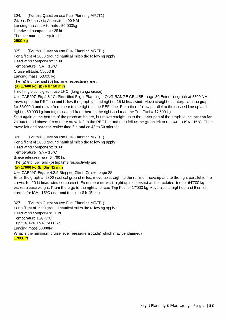
Flight Planning & Monitoring - P a g e | 58
324. (For this Question use Fuel Planning MRJT1)
Given : Distance to Alternate : 400 NM
Landing mass at Alternate : 50 000kg
Headwind component : 25 kt
The alternate fuel required is :
2800 kg
325. (For this Question use Fuel Planning MRJT1)
For a flight of 2800 ground nautical miles the following apply :
Head wind component: 15 kt
Temperature: ISA + 15°C
Cruise altitude: 35000 ft
Landing mass: 50000 kg
The (a) trip fuel and (b) trip time respectively are :
(a) 17600 kg (b) 6 hr 50 min
If nothing else is given, use LRC! (long range cruise)
Use CAP697, Fig 4.3.1C, Simplified Flight Planning, LONG RANGE CRUISE, page 30 Enter the graph at 2800 NM,
move up to the REF line and follow the graph up and right to 15 kt headwind. Move straight up, interpolate the graph
for 35'000 ft and move from there to the right, to the REF Line. From there follow parallel to the dashed line up and
right to 50'000 kg landing mass and from there to the right and read the Trip Fuel = 17'600 kg
Start again at the bottom of the graph as before, but move straight up to the upper part of the graph to the location for
29'000 ft and above. From there move left to the REF line and then follow the graph left and down to ISA +15°C. Then
move left and read the cruise time 6 h and ca 45 to 50 minutes.
326. (For this Question use Fuel Planning MRJT1)
For a flight of 2800 ground nautical miles the following apply :
Head wind component: 20 kt
Temperature: ISA + 15°C
Brake release mass: 64700 kg
The (a) trip fuel, and (b) trip time respectively are :
(a) 17000 kg (b) 6hr 45 min
Use CAP697, Figure 4.3.5 Stepped Climb Cruise, page 38
Enter the graph at 2800 nautical ground miles, move up straight to the ref line, move up and to the right parallel to the
curves for 20 kt head wind component. From there move straight up to intersect an interpolated line for 64'700 kg
brake release weight. From there go to the right and read Trip Fuel of 17'000 kg Move also straight up and then left,
correct for ISA +15°C and read trip time 6 h 45 min
327. (For this Question use Fuel Planning MRJT1)
For a flight of 1900 ground nautical miles the following apply :
Head wind component 10 kt
Temperature ISA -5°C
Trip fuel available 15000 kg
Landing mass 50000kg
What is the minimum cruise level (pressure altitude) which may be planned?
17000 ft
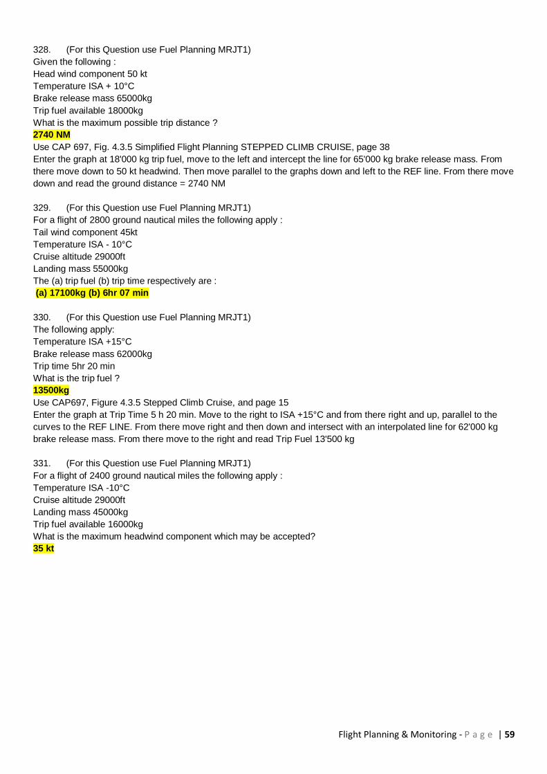
Flight Planning & Monitoring - P a g e | 59
328. (For this Question use Fuel Planning MRJT1)
Given the following :
Head wind component 50 kt
Temperature ISA + 10°C
Brake release mass 65000kg
Trip fuel available 18000kg
What is the maximum possible trip distance ?
2740 NM
Use CAP 697, Fig. 4.3.5 Simplified Flight Planning STEPPED CLIMB CRUISE, page 38
Enter the graph at 18'000 kg trip fuel, move to the left and intercept the line for 65'000 kg brake release mass. From
there move down to 50 kt headwind. Then move parallel to the graphs down and left to the REF line. From there move
down and read the ground distance = 2740 NM
329. (For this Question use Fuel Planning MRJT1)
For a flight of 2800 ground nautical miles the following apply :
Tail wind component 45kt
Temperature ISA - 10°C
Cruise altitude 29000ft
Landing mass 55000kg
The (a) trip fuel (b) trip time respectively are :
(a) 17100kg (b) 6hr 07 min
330. (For this Question use Fuel Planning MRJT1)
The following apply:
Temperature ISA +15°C
Brake release mass 62000kg
Trip time 5hr 20 min
What is the trip fuel ?
13500kg
Use CAP697, Figure 4.3.5 Stepped Climb Cruise, and page 15
Enter the graph at Trip Time 5 h 20 min. Move to the right to ISA +15°C and from there right and up, parallel to the
curves to the REF LINE. From there move right and then down and intersect with an interpolated line for 62'000 kg
brake release mass. From there move to the right and read Trip Fuel 13'500 kg
331. (For this Question use Fuel Planning MRJT1)
For a flight of 2400 ground nautical miles the following apply :
Temperature ISA -10°C
Cruise altitude 29000ft
Landing mass 45000kg
Trip fuel available 16000kg
What is the maximum headwind component which may be accepted?
35 kt

Flight Planning & Monitoring - P a g e | 60
332. (For this Question use Fuel Planning MRJT1)
The following apply :
Tail wind component 10kt
Temperature ISA +10°C
Brake release mass 63000kg
Trip fuel available 20000kg
What is the maximum possible trip distance ?
3740 NM
Use CAP 697, Figure 4.3.5 Simplified Flight Planning STEPPED CLIMB CRUISE, page 38
Enter the graph at trip fuel 20'000 kg, move to the left, intersect the (interpolated) line for 63'000 kg brake release
mass.
Move down to 10 kt tailwind. From there move up and to the right, parallel to the curves, until intersecting the REF line.
From there, move down and read the ground distance, ca 3'720 to 3'740 NM
333. (For this Question use Fuel Planning MRJT1)
For a flight of 2400 ground nautical miles the following apply :
Tail wind component 25 kt
Temperature ISA -10°C
Cruise altitude 31000ft
Landing mass 52000kg
The (a) trip fuel and (b) trip time respectively are :
(a) 14200kg (b) 5 hr 30 min
if nothing else is given or mentioned, use LRC (long range cruise). This might be deliberately omitted
334. The average magnetic course from C (62°N020°W) to B (58°N004°E) is
119°
335. The average true course from C (62°N020°W) to B (58°N004°E) is
109°
336. The initial magnetic course from C (62°N020°W) to B (58°N004°E) is
116°
337. The initial true course from C (62°N020°W) to B (58°N004°E) is
098°
338. The distance (NM) from A (64°N006°E) to C (62°N020°W) is
720
339. The average magnetic course from A (64°N006°E) to C (62°N020°W) is
271°
This is a plotting question
Use the appropriate chart from your Jeppesen Student Pilot Route Manual, plot the course between the two points,
use the plotter to measure the average true course, determine the average variation from the chart and calculate the
average magnetic course.
340. The average true course from A (64°N006°E) to C (62°N020°W) is
259°
341. The initial magnetic course from A (64°N006°E) to C (62°N020°W) is
275°
342. The initial true course from A (64°N006°E) to C (62°N020°W) is
271°
343. The distance (NM) from C (62°N020°W) to B (58°N004°E) is
760
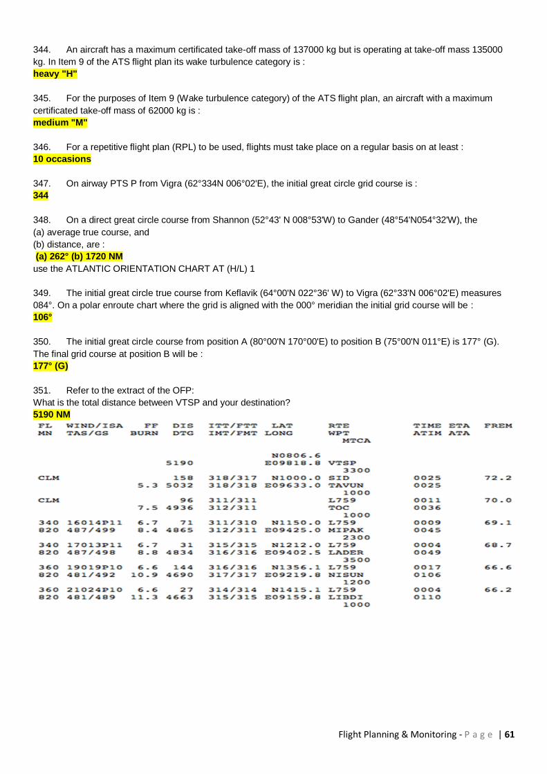
Flight Planning & Monitoring - P a g e | 61
344. An aircraft has a maximum certificated take-off mass of 137000 kg but is operating at take-off mass 135000
kg. In Item 9 of the ATS flight plan its wake turbulence category is :
heavy "H"
345. For the purposes of Item 9 (Wake turbulence category) of the ATS flight plan, an aircraft with a maximum
certificated take-off mass of 62000 kg is :
medium "M"
346. For a repetitive flight plan (RPL) to be used, flights must take place on a regular basis on at least :
10 occasions
347. On airway PTS P from Vigra (62°334N 006°02'E), the initial great circle grid course is :
344
348. On a direct great circle course from Shannon (52°43' N 008°53'W) to Gander (48°54'N054°32'W), the
(a) average true course, and
(b) distance, are :
(a) 262° (b) 1720 NM
use the ATLANTIC ORIENTATION CHART AT (H/L) 1
349. The initial great circle true course from Keflavik (64°00'N 022°36' W) to Vigra (62°33'N 006°02'E) measures
084°. On a polar enroute chart where the grid is aligned with the 000° meridian the initial grid course will be :
106°
350. The initial great circle course from position A (80°00'N 170°00'E) to position B (75°00'N 011°E) is 177° (G).
The final grid course at position B will be :
177° (G)
351. Refer to the extract of the OFP:
What is the total distance between VTSP and your destination?
5190 NM
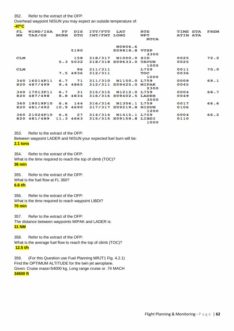
Flight Planning & Monitoring - P a g e | 62
352. Refer to the extract of the OFP:
Overhead waypoint NISUN you may expect an outside temperature of:
-47°C
353. Refer to the extract of the OFP:
Between waypoint LADER and NISUN your expected fuel burn will be:
2.1 tons
354. Refer to the extract of the OFP:
What is the time required to reach the top of climb (TOC)?
36 min
355. Refer to the extract of the OFP:
What is the fuel flow at FL 360?
6.6 t/h
356. Refer to the extract of the OFP:
What is the time required to reach waypoint LIBDI?
70 min
357. Refer to the extract of the OFP:
The distance between waypoints MIPAK and LADER is:
31 NM
358. Refer to the extract of the OFP:
What is the average fuel flow to reach the top of climb (TOC)?
12.5 t/h
359. (For this Question use Fuel Planning MRJT1 Fig. 4.2.1)
Find the OPTIMUM ALTITUDE for the twin jet aeroplane.
Given: Cruise mass=54000 kg, Long range cruise or .74 MACH
34500 ft

Flight Planning & Monitoring - P a g e | 63
360. (For this Question use Fuel Planning MRJT1 Fig. 4.2.1)
Find the OPTIMUM ALTITUDE for the twin jet aeroplane.
Given: Cruise mass=50000 kg, .78 MACH
35500 ft
361. (For this Question use Fuel Planning MRJT1)
Find the FUEL MILEAGE PENALTY for the twin jet aeroplane with regard to the given FLIGHT LEVEL .
Given: Long range cruise, Cruise mass=53000 kg, FL 310
4 %
362. (For this Question use Fuel Planning MRJT1)
Planning an IFR-flight from Paris (Charles de Gaulle) to London (Heathrow) for the twin jet aeroplane.
Given: Estimated Take-off Mass (TOM) 52000 kg, Airport elevation 387 ft, FL 280, W/V 280°/40 kt, ISA Deviation -
10°C, Average True Course 340°
Find: Time to the top of climb (TOC)
11 min
363. Planning an IFR-flight from Paris to London for the twin jet aeroplane.
Given: Estimated Landing Mass 49700 kg, FL 280, W/V 280°/40 kt, Average True Course 320°, Procedure for
descent .74 M/250 KIAS
Determine the distance from the top of descent to London (elevation 80 ft).
76 NM
364. Planning an IFR-flight from Paris to London for the twin jet aeroplane.
Given: Estimated Landing Mass 49700 kg, FL 280, W/V 280°/40 kt, Average True Course 320°, Procedure for
descent .74 M/250 KIAS
Determine the time from the top of descent to London (elevation 80 ft).
19 min
365. Planning an IFR-flight from Paris to London for the twin jet aeroplane.
Given: Estimated Landing Mass 49700 kg, FL 280, W/V 280°/40 kt, Average True Course 320°, Procedure for
descent .74 M/250 KIAS
Determine the fuel consumption from the top of descent to London (elevation 80 ft).
273 kg
366. Of the following, the preferred airways routing from FRANKFURT FFM 114.2 (50°03' N008°38'E) to KOKSY
(51°06'N 002°39'E) above FL245, on a Wednesday is :
UR10 NTM UB6 BUB ATS
367. Your aircraft is approved for MNPS and RVSM. What do you have to insert in item 10 of the ATC flight plan?
W, X
368. Which was the correct date of the implementation of the RVSM in the European Airspace?
24 January 2002
369. RVSM In-Flight procedure: Cross checks of the primary altimeters shall be made at intervals of approximately
one hour. These primary altimeters shall agree within
200 ft
370. RVSM Pre-Flight procedure: The flight crew shall verfiy the altimetry accuracy by setting the QNH or QFE.
The reading should then agree with the altitude of the apron or the zero height indication within
75 ft
371. Which flight level is not a RVSM level?
FL 280

Flight Planning & Monitoring - P a g e | 64
372. Which equipment failure must not be reported to ATC on a RVSM level?
Main hydraulic-pump failure
373. Do you need TCAS/ACAS Version 7.0 to operate in EUR-RVSM airspace?
Yes, if the aircraft has more than 30 seats or the aircraft weight is over 15000kg
374. Your aircraft is not RVSM approved. Are you able to enter RVSM airspace?
Yes, but not as a civil operator
375. What does HMU mean?
Height monitoring unit
376. RVSM In-Flight procedure: When changing levels, the aircraft shall not overshoot or undershoot the cleared
flight level by more than
150 ft
377. What is the proper phraseology if ATC wants to know if you are RVSM approved?
Affirm RVSM
378. Which equipment is not necessary to get a RVSM approval?
GPS with altitude reporting system
379. When approaching a cleared Flight level, the vertical speed should not exceed
1500 ft/min
380. Which document provides guidance for the approval of RVSM aircraft?
JAA TGL No. 6
381. RVSM was first implemented in which airspace?
NAT
382. Which transponder code is correct if you are 40 minutes before entering NAT airspace?
as requested by ATC
383. In case of an engine failure, unable to maintain altitude, how many miles do you have to fly offset of NAT track
(new procedure) ?
15 NM left or right
384. What is the Polar Track System?
Fixed tracks between Europe over the North Pole to Alaska
385. You are entering the NAT. What is the tolerance of the boundary window?
3 minutes
386. What is the NAT Track Message?
The publication of the Organized Track Message (OTS)
387. You are flying from ZRH to JFK (EET 8h04’). The EOBT is 1800Z. Are you able to fly the following track?
A 54/15 55/20 55/30 53/40 51/50 CYMON
EAST LVLS NIL
WEST LVLS 310 330 340 350 360 370 390
EUR RTS VIA BABAN
NAR N144B N148B-
No
388. Your position is N50° W20°. Your altimeter shows FL263 descending. Which airspace is that?
A
Flight Planning & Monitoring - P a g e | 65
389. Your HF radio is u/s. Are you able to cross the NAT?
Yes, but only on special routes
390. Before take off on an MNPS flight, one of your Long Range Navigation System fails. What is your action in
case you have one system left?
File Special routes or fly above or below the MNPS
391. Day time OTS are valid between...
1130 Z until 1800 Z
392. On which VHF frequency can you obtain the NAT clearance from Shanwick?
127. 65 (if your aircraft is registered E of 30 W)
393. An aerodrome with weather reports indicating that the weather conditions are at or above operation minima
from one hour prior to one hour after the anticipated arrival is defined as:
Suitable
394. On the ground in ZRH the APU on your B737-300 cannot be started. Can you accept the aircraft for an
ETOPS flight?
No
395. What is the Extended Range Entry point (or ETOPS entry point)?
The point of the route which is 60 minutes flying time (with approved single engine cruise speed) from an
alternate airport
396. What is general the “most critical fuel scenario” on the B737-300?
The two engine fuel scenario
397. (North Atlantic Plotting Chart, ETOPS) You are flying from Shannon (EINN) to Keflavik (BIKF). The wind
component to BIKF is 10kts headwind and to Shannon you will have 20kts tailwind. The ETP from EINN to BIKF is?
416 NM from EINN
398. North Atlantic Plotting Chart, ETOPS) You are flying from Lajes (LPLA) to St. John’s (CYYT). The wind
component to CYYT is 30kts headwind and to LPLA you will have 20kts tailwind. The ETP from TER to YYT is?
580 NM from YYT
399. (Critical fuel reserves long range cruise, CAP697) You have an engine failure and a decompression at the
same time. Your data are:
Tailwind: 25 kts
Distance to diversion airport: 820 NM
ISA: +10°C
Weight: 55’000 kg
Icing conditions: YES
What is your diversion fuel?
8200 kg
400. (Critical fuel reserves long range cruise, CAP697) You have a decompression at your cruising altitude and
following information:
Tailwind: 25 kts
Distance to diversion airport: 820 NM
ISA: +20°C
Weight: 55’000 kg
Icing conditions: No
What is your diversion fuel?
7270 kg

Flight Planning & Monitoring - P a g e | 66
401. (Area of Operation, CAP 697) You have following information:
Weight: 57.5 t
Speed schedule: LRC
ETOPS approval: 180 min
What is your area of operation?
1100 NM
402. Who is able to perform an ETOPS pre-departure service check on an A330?
Only an ETOPS qualified maintenance person can do that
403. The frequency designated for VHF air to air communications when out of range of VHF ground stations in
NAT region is:
123.45 MHz
404. In the Airspace where the MNPS is applicable, the vertical separation that can be applied between FL 290
and FL410 inclusive is:
1000 ft
405. Minimum Navigation Performance Specification (MNPS) airspace of the North Atlantic is defined within:
Flight levels 285 and 420 from the 27° North to the pole
406. ETOPS flight is a twin engine jet aeroplane flight conducted over a route, where no suitable airport is within an
area of
60 minutes flying time in still air at the approved one engine out speed
407. Weather deviation procedure in NAT: Due to CB ahead of your routing on NAT track BRAVO or ZULU you
have to deviate 5 NM left of track. Which is the correct procedure?
Deviate 5 NM and inform ATC
408. An aeroplane is flying at TAS 180 kt on a track of 090°.
The W/V is 045° / 50kt.
How far can the aeroplane fly out from its base and return in one hour?
85 NM
Refer to the Oxford textbook and study chapter "CP and PNR". Then try again to solve this question.
1. Apply the formula which you have to know by heart:
Time to PNR = Endurance x ground speed home / (ground speed out + ground speed home)
2. The given endurance is 1 hr, the ground speeds you must determine yourself using the wind side of your
mechanical computer: GSO = 142 KT / GSH 212 KT.
3 Using above formula you calculate a time of 36 MIN to the PNR.
4. The distance to the PNR equals: time to PNR x GSO resulting in 85 NM
409. Mark the correct statement:
If a decision point procedure is applied for flight planning,
The trip fuel to the destination aerodrome is to be calculated via the decision point
410. For a distance of 1860 NM between Q and R, a ground speed "out" of 385 kt, a ground speed "back" of 465 kt
and an endurance of 8 HR (excluding reserves) the distance from Q to the point of safe return (PSR) is:
1685 NM
411. Two points A and B are 1000 NM apart. TAS = 490 kt.
On the flight from A to B the wind component from the assumed Point of Equal Time (PET) to B is -20 kt (headwind),
on the return flight from the assumed PET to A the wind component is +40 kt (tailwind).
What is the distance from A to the PET?
530 NM

Flight Planning & Monitoring - P a g e | 67
412. Given:
AD = Air distance
GD = Ground distance
TAS = True Airspeed
GS = Groundspeed
Which of the following is the correct formula to calculate ground distance (GD) gone?
GD = (AD X GS)/TAS
413. An operator (turbojet engine) shall ensure that calculation up of usable fuel for a flight for which no destination
alternate is required includes, taxi fuel, trip fuel, contingency fuel and fuel to fly for:
30 minutes at holding speed at 450 m above aerodrome elevation in standard conditions
414. Planning a flight from Paris (Charles de Gaulle) to London (Heathrow) for a twin - jet aeroplane.
Preplanning:
Maximum Take-off Mass: 62 800 kg
Maximum Zero Fuel Mass: 51 250 kg
Maximum Landing Mass: 54 900 kg
Maximum Taxi Mass: 63 050 kg
Assume the following preplanning results:
Trip fuel: 1 800 kg
Alternate fuel: 1 400 kg
Holding fuel (final reserve): 1 225 kg
Dry Operating Mass: 34 000 kg
Traffic Load: 13 000 kg
Catering: 750 kg
Baggage: 3 500 kg
Find the Take-off Mass (TOM):
51 515 kg
You might argue that CF has to be at least holding fuel for 5 minutes or 5% of the trip fuel whichever is higher. This is
correct.
The most correct way to calculate is therefore: If FR is for 30 minutes, CF would then be 1225/6 = 204 kg. You have to
calculate with a CF of 204 kg and not with 90 kg (the higher of the two). With 204 kg the solution is: TOM 51 629 kg.
Since this answer is not available, the most correct (and closest) solution given is still 51 515 kg
415. The required time for final reserve fuel for turbojet aeroplane is:
30 min
416. The quantity of fuel which is calculated to be necessary for a jet aeroplane to fly IFR from departure
aerodrome to the destination aerodrome is 5352 kg. Fuel consumption in holding mode is 6 000 kg/h. Alternate fuel is
4380 kg. Contingency should be 5% of trip fuel.
What is the minimum required quantity of fuel which should be on board at take-off?
13000 kg
417. The following fuel consumption figures are given for a jet aeroplane:
-standard taxi fuel: 600 kg.
-average cruise consumption: 10 000 kg/h.
-holding fuel consumption at 1500 ft above alternate airfield elevation: 8000 kg/h.
-flight time from departure to destination: 6 hours
-fuel for diversion to alternate: 10 200 kg.
The minimum ramp fuel load is:
77 800 kg
418. A jet aeroplane has a cruising fuel consumption of 4060 kg/h, and 3690 kg/h during holding. If the destination
is an isolated airfield, the aeroplane must carry, in addition to contingency reserves, additional fuel of :
8120 kg
Flight Planning & Monitoring - P a g e | 68
419. A jet aeroplane is to fly from A to B. The minimum final reserve fuel must allow for :
30 minutes hold at 1500 ft above destination aerodrome elevation, when no alternate is required
420. (For this question use Flight Planning Manual MRJT 1 Figure 4.3.1.B)
Given : estimated zero fuel mass 50 t; estimated landing mass at alternate 52 t; final reserve fuel 2 t; alternate fuel 1 t;
flight to destination, distance 720 NM, true course (TC) 030, W/V 340/30; cruise: long range FL 330, outside air
temperature -30 ° C.
Find : estimated trip fuel and time
4 800 kg; 01 : 45
Calculate Landing Mass at Destination: LM = 52 + 1 = 53 t Determine Headwind Component (Jeppesen Computer):
HW = 20 KT Calculate ISA Deviation: ISA at FL330 = 15 - 33x2 = 15 - 66 = -51°C, OAT = -30°C = ISA +21 Enter the
graph at 720 Nautical Ground Miles, move up to the REF Line, follow parallel to the curves right and up to 20 KT
Headwind. From there, move straight up to intercept the line for 33'000 ft. Then move to the right to the REF Line and
from there parallel to the dashed lines (interpolate the direction) up to 53 t landing mass. Then move to the right and
read the fuel required about 4'900 kg.
To determine the trip time, start the same way, but when moving straight up, move up to the upper lines to the one for
29 & more thousand feet. From there to the left to the REF line. Then follow parallel to the curves down and to the left
to ISA +21 and read the trip time = ca 1.85 h which is 1:51 h.
Choose the most correct answer
421. (For this question use Flight Planning Manual MRJT 1 Figure 4.3.6)
Given: estimated dry operation mass 35 500 kg; estimated load 14 500 kg; final reserve fuel 1200 kg; distance to
alternate 95 NM; average true track 219°; head wind component 10 kt
Find : fuel and time to alternate.
1 100 kg; 25 min
422. (For this question use Flight Planning Manual MRJT 1 Figure 4.3.3C)
Given: ground distance to destination aerodrome 1 600 NM; headwind component 50 kt; FL 330; cruise 0.78 Mach;
ISA + 20 ° C; estimated landing weight 55000 kg .
Find: simplified flight planning to determine estimated trip fuel and trip time.
12 400 kg. 03h 55 min
423. (For this question use Flight Planning Manual MRJT 1 Figure 4.4)
Given: dry operating mass 35 500 kg; estimated load 12 000 kg, contingency approach and landing fuel 2 500 kg;
elevation at departure aerodrome 500 ft; elevation at alternate aerodrome 30 ft.
Find: final reserve fuel for a jet aeroplane (holding) and give the elevation which is relevant.
1 180 kg; alternate elevation
424. The purpose of the decision point procedure is ?
To reduce the minimum required fuel and therefore be able to increase the traffic load
425. When using decision point procedure, you reduce the
Contingency fuel by adding contingency only from the burnoff between decision point and destination
426. If CAS is 190 kts, Altitude 9000 ft. Temp. ISA - 10°C, True Course (TC) 350°, W/V 320/40, distance from
departure to destination is 350 NM, endurance 3 hours, and actual time of departure is 1105 UTC. The Point of Equal
Time (PET) is reached at :
1213 UTC
427. If CAS is 190 kts, Altitude 9000 ft. Temp. ISA - 10°C, True Course (TC) 350°, W/V 320/40, distance from
departure to destination is 350 NM, endurance 3 hours and actual time of departure is 1105 UTC. The distance from
departure to Point of Equal Time (PET) is :
203 NM

Flight Planning & Monitoring - P a g e | 69
428. (For this Question use Fuel Planning MRJT1)
Find the SPECIFIC RANGE for the twin jet aeroplane flying below the optimum altitude (range loss = 6%) and using
the following data.
Given: MACH .74 CRUISE, Flight level = 310, Gross mass = 50000 kg, ISA conditions
187 NAM/1000 kg
429. (For this Question use Fuel Planning MRJT1)
Find the FUEL FLOW for the twin jet aeroplane with regard to the following data.
Given: MACH .74 cruise, Flight level 310, Gross mass 50000 kg, ISA conditions
2300 kg/h
Use CAP 697 Flight Planning Manual, Figure 4.5.3.2, Mach 0.74 Cruise, 31'000 ft
Find TAS = 434 above the table
Read NAM at 50'100 kg = 3013
Read NAM at 49'900 kg = 2975
Difference = 3013 - 2975 = 38 NAM
Calculate time for 38 NAM: t = 38/434 = 0.0875576 h
Note that fuel consumption is 200 kg during this time (from 50'100 to 49'900 kg)
Calculate fuel flow: FF = 200 kg / 0.0875576 h = 2284 kg/h
430. Find the distance from waypoint 3 (WP 3) to the critical point.
Given: distance from WP 3 to WP 4 = 750 NM, TAS out 430 kt, TAS return 425 kt, Tailwind component out 30 kt, head
wind component return 40 kt
342 NM
431. Find the time to the Point of Safe Return (PSR).
Given: Maximum useable fuel 15000 kg, Minimum reserve fuel 3500 kg, TAS out 425 kt, Head wind component out 30
kt, TAS return 430 kt, Tailwind component return 20 kt, Average fuel flow 2150 kg/h
2 h 51 min
432. Given :
Distance A to B 2050 NM
Mean groundspeed 'on' 440 kt
Mean groundspeed 'back' 540 kt
The distance to the point of equal time (PET) between A and B is :
1130 NM
433. Given :
Distance A to B 3060 NM
Mean groundspeed 'out' 440 kt
Mean groundspeed 'back' 540 kt
Safe Endurance 10 hours
The time to the Point of Safe Return (PSR) is:
5 hours 30 minutes
434. Which of the following statements is (are) correct with regard to the advantages of computer flight plans ?
1. The computer can file the ATC flight plan.
2. Wind data used by the computer is always more up-to-date than that available to the pilot.
Statement 1 only
435. Which of the following statements is (are) correct with regard to the operation of flight planning computers ?
1. The computer can file the ATC flight plan.
2. In the event of inflight re-routing the computer produces a new plan.
Statement 1 only
With advanced systems such as LIDO, in-flight amendments are delivered to the deck printer via ACARS. Therefore,
with modern systems both statements are correct. However, it is unknown whether the question in the Central
Question Bank has been amended or not. For the time being, it remains therefore unchanged.

Flight Planning & Monitoring - P a g e | 70
436. Given:
Distance 'A' to 'B' 2484 NM
Groundspeed 'out' 420 kt
Groundspeed 'back' 500 kt
The time from 'A' to the Point of Equal Time (PET) between 'A' and 'B' is:
193 MIN
437. Given:
Distance 'A' to 'B' 2484 NM
Mean groundspeed 'out' 420 kt
Mean groundspeed 'back' 500 kt
Safe endurance 08 HR 30 MIN
The distance from 'A' to the Point of Safe Return (PSR) 'A' is:
1940 NM
438. Given:
Distance 'A' to 'B' 1973 NM
Groundspeed 'out' 430 kt
Groundspeed 'back' 385 kt
The time from 'A' to the Point of Equal Time (PET) between 'A' and 'B' is:
130 MIN
439. Given:
Distance 'A' to 'B' 1973 NM
Groundspeed 'out' 430 kt
Groundspeed 'back' 385 kt
Safe endurance 7 HR 20 MIN
The distance from 'A' to the Point of Safe Return (PSR) 'A' is:
1490 NM
440. Given:
Distance 'Q' to 'R' 1760 NM
Groundspeed 'out' 435 kt
Groundspeed 'back' 385 kt
The time from 'Q' to the Point of Equal Time (PET) between 'Q' and 'R' is:
114 MIN
441. Given:
Distance 'Q' to 'R' 1760 NM
Groundspeed 'out' 435 kt
Groundspeed 'back' 385 kt
Safe endurance 9 HR
The distance from 'Q' to the Point of Safe Return (PSR) between 'Q' and 'R' is:
1838 NM
442. Given:
Distance 'A' to 'B' 3623 NM
Groundspeed 'out' 370 kt
Groundspeed 'back' 300 kt
The time from 'A' to the Point of Equal Time (PET) between 'A' and 'B' is:
263 MIN
443. (For this Question use Fuel Planning MRJT1 Fig. 4.3.6)
In order to find ALTERNATE FUEL and TIME TO ALTERNATE, the AEROPLANE OPERATING MANUAL shall be
entered with:
Distance in nautical miles (NM), wind component, landing mass at alternate
Flight Planning & Monitoring - P a g e | 71
444. The final reserve fuel for aeroplanes with turbine engines is
Fuel to fly for 30 minutes at holding speed at 1500 ft (450 m) above aerodrome elevation in standard
conditions
445. Which of the following statements is relevant for forming route portions in integrated range flight planning?
The distance from take-off up to the top of climb has to be known
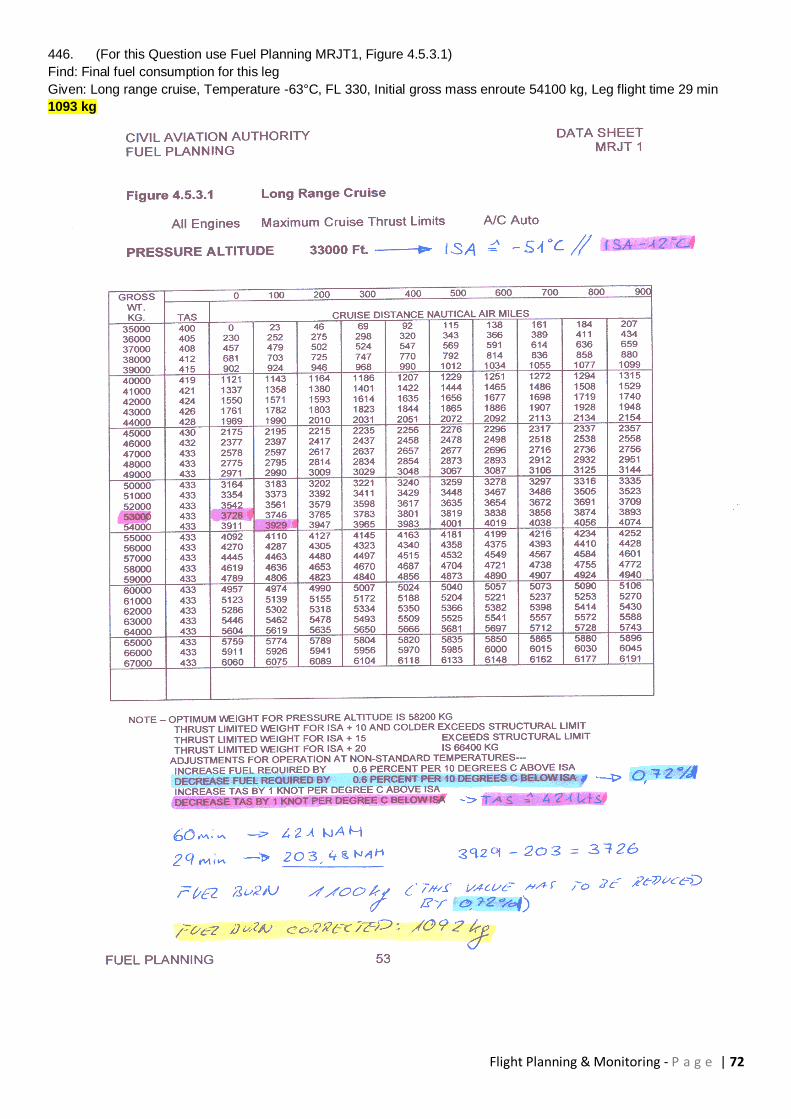
Flight Planning & Monitoring - P a g e | 72
446. (For this Question use Fuel Planning MRJT1, Figure 4.5.3.1)
Find: Final fuel consumption for this leg
Given: Long range cruise, Temperature -63°C, FL 330, Initial gross mass enroute 54100 kg, Leg flight time 29 min
1093 kg

Flight Planning & Monitoring - P a g e | 73
447. (For this Question use Fuel Planning MRJT1)
Find: Air distance in Nautical Air Miles (NAM) for this leg and fuel consumption
Given: Flight time from top of climb at FL 280 to the enroute point is 48 minutes. Cruise procedure is long range cruise.
Temperature is ISA -5°C. The take-off mass is 56000 kg and climb fuel 1100 kg.
345 NAM; 1994 kg
448. (For this Question use Fuel Planning MRJT1)
Given: Brake release mass 57500 kg, Initial FL 280, average temperature during climb ISA -10°C, average head wind
component 18 kt
Find: Climb time for enroute climb 280/.74
13 min
449. (For this Question use Fuel Planning MRJT1)
Given: Brake release mass 57500 kg, Temperature ISA -10°C, Headwind component 16 kt, Initial FL 280
Find: Still air distance (NAM) and ground distance (NM) for the enroute climb 280/.74
62 NAM, 59 NM
450. (For this Question use Fuel Planning MRJT1)
Given: Brake release mass 57500 kg, Temperature ISA -10°C, Average headwind component 16 kt, Initial FL 280
Find: Climb fuel for enroute climb 280/.74
1138 kg
451. (For this Question use Fuel Planning MRJT1)
Given: Long range cruise, OAT -45°C at FL 350, Gross mass at the beginning of the leg 40000 kg, Gross mass at the
end of the leg 39000 kg
Find: True air speed (TAS) and cruise distance (NAM) for a twin jet aeroplane
TAS 433 kt, 227 NAM
452. (For this Question use Fuel Planning MRJT1)
Given: Estimated take-off mass 57000 kg, Ground distance 150 NM, Temperature ISA -10°C, Cruise at .74 Mach
Find: Cruise altitude and expected true air speed
25000 ft, 435 kt
453. Given :
X = Distance A to point of equal time (PET) between A and B
E = Endurance
D = Distance A to B
O = Groundspeed 'on'
H = Groundspeed 'back'
The formula for calculating the distance X to point of equal time (PET) is:
D x H
X = _____
O + H
454. Given :
Course A to B 088° (T)
distance 1250 NM
Mean TAS 330 kt
Mean W/V 340°/60 kt
The time from A to the PET between A and B is :
1 hour 42 minutes
455. (For this Question use Fuel Planning MRJT1)
Given: twin jet aeroplane, FL 330, Long range cruise, Outside air temperature -63°C, Gross mass 50500 kg
Find: True air speed (TAS)
420 kt
Flight Planning & Monitoring - P a g e | 74
456. Given :
Distance X to Y 2700 NM
Mach Number 0.75
Temperature -45°C
Mean wind component 'on' 10 kt tailwind
Mean wind compontent 'back' 35 kt tailwind
The distance from X to the point of equal time (PET) between X and Y is :
1386 NM
457. Which of the following statements is (are) correct with regard to computer flight plans
1. The computer takes account of bad weather on the route and adds extra fuel.
2. The computer calculates alternate fuel sufficient for a missed approach, climb, cruise, descent and approach and
landing at the destination alternate.
Statement 2 only
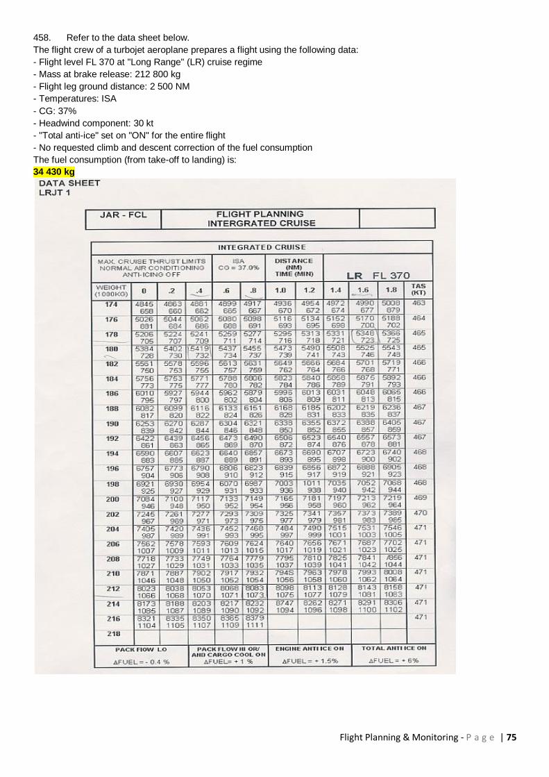
Flight Planning & Monitoring - P a g e | 75
458. Refer to the data sheet below.
The flight crew of a turbojet aeroplane prepares a flight using the following data:
- Flight level FL 370 at "Long Range" (LR) cruise regime
- Mass at brake release: 212 800 kg
- Flight leg ground distance: 2 500 NM
- Temperatures: ISA
- CG: 37%
- Headwind component: 30 kt
- "Total anti-ice" set on "ON" for the entire flight
- No requested climb and descent correction of the fuel consumption
The fuel consumption (from take-off to landing) is:
34 430 kg
Flight Planning & Monitoring - P a g e | 76
459. Given the following:
D = flight distance
X = distance to Point of Equal Time
GSo = groundspeed out
GSr = groundspeed return
The correct formula to find distance to Point of Equal Time is :
X = D x GSr / (GSo + GSr)
460. An aircraft takes-off from an airport 2 hours before sunset. The pilot flies a track of 090°(T), W/V 130°/ 20 kt,
TAS 100 kt. In order to return to the point of departure before sunset, the furthest distance which may be travelled is:
97 NM
461. The flight time from the PET to either of the landing places is:
Inversely proportional to the sum of ground speed out and ground speed back
462. Given:
Distance A to B is 360 NM.
Wind component A - B is -15 kt,
Wind component B - A is +15 kt,
TAS is 180 kt.
What is the distance from the equal-time-point to B?
165 NM
463. (For this Question use Fuel Planning MRJT1)
Given:
Diversion distance 720NM
Tail wind component 25kt
Mass at point of diversion 55000kg
Temperature ISA
Diversion fuel available 4250kg
What is the OEI minimum pressure altitude at which the above conditions may be met ?
20000ft
464. (For this Question use Fuel Planning MRJT1)
Given:
Diversion distance 650 NM
Diversion pressure altitude 16 000 ft
Mass at point of diversion 57 000 kg
Head wind component 20 kt
Temperature ISA + 15°C
The diversion (a) fuel required and (b) time, are approximately :
(a) 4800kg
(b) 2h 03min
465. (For this Question use Fuel Planning MRJT1)
Given:
Distance to alternate 950 NM
Head wind component 20 kt
Mass at point of diversion 50000kg
Diversion fuel available 5800kg
The minimum pressure altitude at which the above conditions may be met is :
22000ft
466. (For this Question use Fuel Planning MRJT1)
A descent is planned at .74/250KIAS from 35000ft to 5000ft. How much fuel will be consumed during this descent?
150kg
Flight Planning & Monitoring - P a g e | 77
467. You have calculated Point of No Return (PNR) on a flight, having all negative WCs in
the flight plan. During the flight you experience that the W/V is stronger but coming from the same direction as in the
flight plan. Consider the following statements:
A recalculated PNR will move toward the place of departure
468. Why do we normally overlook the descend phase when calculating Point of Equal Time (PET)?
Because the descend will have an equal effect, whatever destination we decide to proceed to
469. You fly from C to D, a distance of 450 NM. The WC C - D is +30, and the WC D - C is -40. TAS is 160 Kt and
1-engine out TAS is 130 Kt. The Fuel Flow is 165 kg/hr, and the Safe endurance when overhead C is 4 hours.
Calculate PNR for return to C.
What is the distance from PNR to D?
155,5 NM
Refer to chapter “Critical Point and Point of No Return” of your OAT textbook. Study in the subchapter “Point of No
Return” the 3 given examples.
The question 7112 represents example 3 with some amendments:
As in reality the tailwind component on the flight out is weaker than the headwind component on the flight back. The
safe endurance is given. Therefore you will not need the indicated fuel flow. The PNR is calculated with normal all
engine TAS, the flight out as well as the flight back. Therefore apply normal TAS.
Note: After an engine failure you would not continue to a PNR and burn all your fuel, but proceed to land. Therefore
the 1-engine out TAS is not needed.
After calculating the time to the PNR continue to determine the corresponding distance from C to the PNR. Caution:
The final question asks the distance from the PNR to D.
470. You fly from C to D, a distance of 450 NM. The WC C - D is +30, and the WC D - C is -40. TAS is 160 Kt and
reduced TAS is 130 Kt. The Fuel Flow is 165 kg/hr, and the Safe endurance when overhead C is 4 hours. Calculate
PET between C and D, based on reduced TAS for the flight from PET to C/D. What is the flying time from C to PET?
0:51
471. Given:
Distance from departure to destination: 210 NM
Safe endurance: 2,5 hrs
True Track: 035
W/V: 250/20
TAS: 105 KT
What is the distance of the PSR from the departure point?
127 NM
472. Given:
Distance from departure to destination 500 NM
True Track 090
W/V 090/20
TAS 150 kt
What is the distance and time of the PET from the departure point?
Distance 283 NM, time 131 min
473. Given:
Distance from departure to destination 270 NM
True Track 030
W/V 120/35
TAS 125 kt
What is the distance and time of the PET from the departure point?
Distance 135 NM, time 68 min
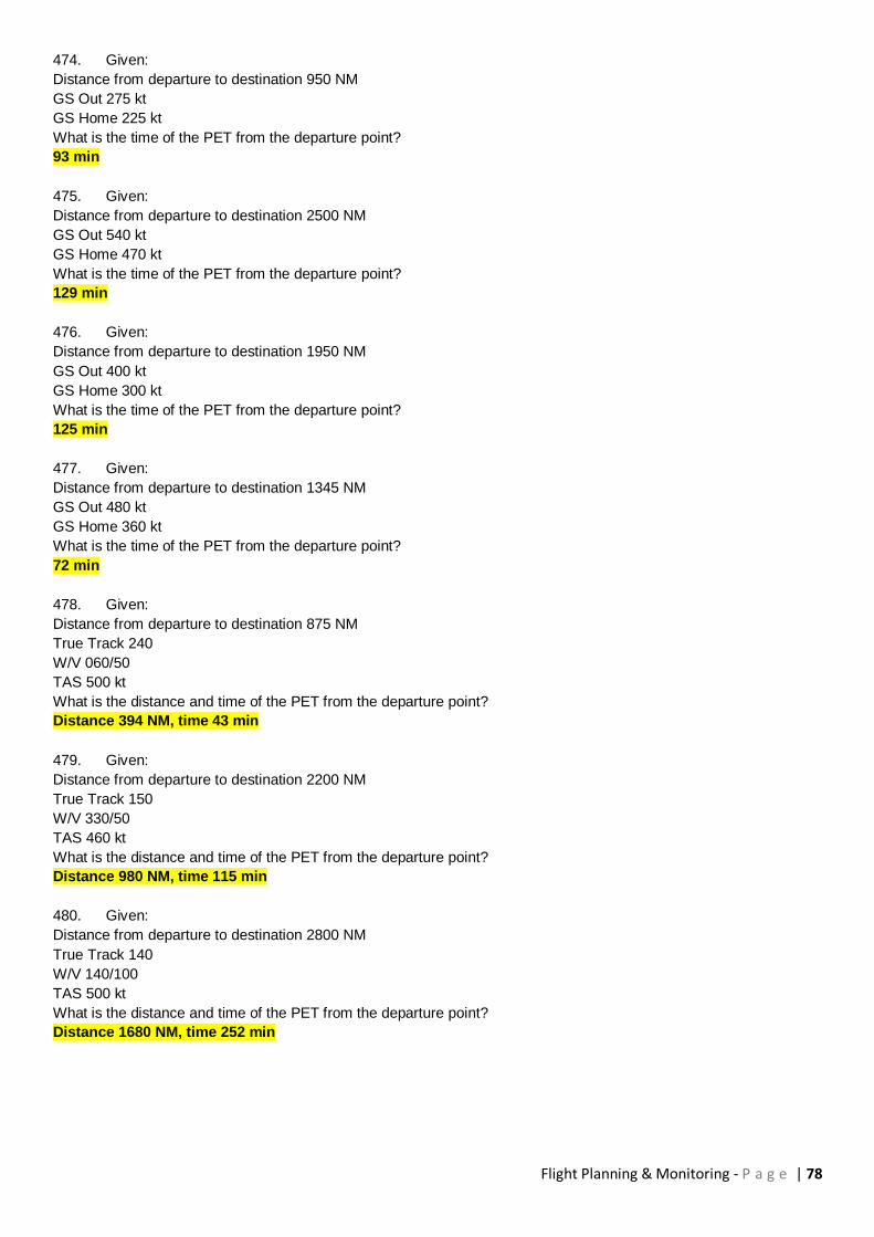
Flight Planning & Monitoring - P a g e | 78
474. Given:
Distance from departure to destination 950 NM
GS Out 275 kt
GS Home 225 kt
What is the time of the PET from the departure point?
93 min
475. Given:
Distance from departure to destination 2500 NM
GS Out 540 kt
GS Home 470 kt
What is the time of the PET from the departure point?
129 min
476. Given:
Distance from departure to destination 1950 NM
GS Out 400 kt
GS Home 300 kt
What is the time of the PET from the departure point?
125 min
477. Given:
Distance from departure to destination 1345 NM
GS Out 480 kt
GS Home 360 kt
What is the time of the PET from the departure point?
72 min
478. Given:
Distance from departure to destination 875 NM
True Track 240
W/V 060/50
TAS 500 kt
What is the distance and time of the PET from the departure point?
Distance 394 NM, time 43 min
479. Given:
Distance from departure to destination 2200 NM
True Track 150
W/V 330/50
TAS 460 kt
What is the distance and time of the PET from the departure point?
Distance 980 NM, time 115 min
480. Given:
Distance from departure to destination 2800 NM
True Track 140
W/V 140/100
TAS 500 kt
What is the distance and time of the PET from the departure point?
Distance 1680 NM, time 252 min

Flight Planning & Monitoring - P a g e | 79
481. Given:
Distance from departure to destination 180 NM
True Track 310
W/V 010/20
TAS 115 kt
What is the distance of the PET from the departure point?
98 NM
482. Given:
Distance from departure to destination 300 NM
Safe Endurance 4 h
TAS 110 kt
Ground Speed Out 120 kt
Ground Speed Home 100 kt
What is the distance of the PSR from the departure point?
218 NM
483. Given:
Distance from departure to destination 400 NM
Safe Endurance 2.5 h
TAS 115 kt
Ground Speed Out 130 kt
Ground Speed Home 105 kt
What is the distance of the PSR from the departure point?
145 NM
484. Given:
Distance from departure to destination 500 NM
Safe Endurance 4 h
TAS 140 kt
Ground Speed Out 150 kt
Ground Speed Home 130 kt
What is the distance and time of the PSR from the departure point?
Distance 279 NM, time 111 min
485. Given:
Distance from departure to destination 240 NM
Safe Endurance 3.5 h
TAS 125 kt
Ground Speed Out 110 kt
Ground Speed Home 140 kt
What is the distance and time of the PSR from the departure point?
Distance 216 NM, time 118 min
486. Given:
Distance from departure to destination 180 NM
Safe Endurance 2.8 h
True Track 065
W/V 245/25
TAS 100 kt
What is the distance of the PSR from the departure point?
131 NM
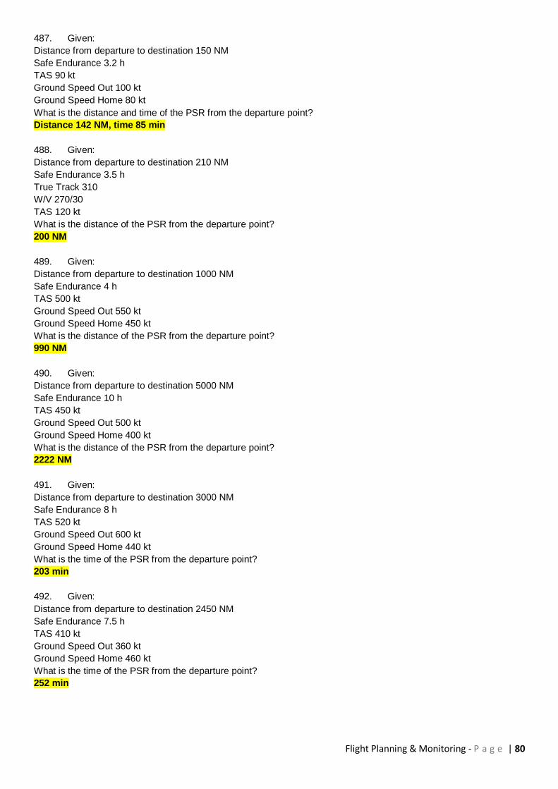
Flight Planning & Monitoring - P a g e | 80
487. Given:
Distance from departure to destination 150 NM
Safe Endurance 3.2 h
TAS 90 kt
Ground Speed Out 100 kt
Ground Speed Home 80 kt
What is the distance and time of the PSR from the departure point?
Distance 142 NM, time 85 min
488. Given:
Distance from departure to destination 210 NM
Safe Endurance 3.5 h
True Track 310
W/V 270/30
TAS 120 kt
What is the distance of the PSR from the departure point?
200 NM
489. Given:
Distance from departure to destination 1000 NM
Safe Endurance 4 h
TAS 500 kt
Ground Speed Out 550 kt
Ground Speed Home 450 kt
What is the distance of the PSR from the departure point?
990 NM
490. Given:
Distance from departure to destination 5000 NM
Safe Endurance 10 h
TAS 450 kt
Ground Speed Out 500 kt
Ground Speed Home 400 kt
What is the distance of the PSR from the departure point?
2222 NM
491. Given:
Distance from departure to destination 3000 NM
Safe Endurance 8 h
TAS 520 kt
Ground Speed Out 600 kt
Ground Speed Home 440 kt
What is the time of the PSR from the departure point?
203 min
492. Given:
Distance from departure to destination 2450 NM
Safe Endurance 7.5 h
TAS 410 kt
Ground Speed Out 360 kt
Ground Speed Home 460 kt
What is the time of the PSR from the departure point?
252 min

Flight Planning & Monitoring - P a g e | 81
493. Given:
Distance from departure to destination 3750 NM
Safe Endurance 9.5 h
True Track 360
W/V 360/50
TAS 480 kt
What is the distance of the PSR from the departure point?
2255 NM
494. Given:
Distance from departure to destination 6340 NM
Safe Endurance 15 h
True Track 090
W/V 270/100
TAS 520 kt
What is the distance of the PSR from the departure point?
3756 NM
495. Given:
Distance from departure to destination 950 NM
Safe Endurance 3.5 h
TAS 360 kt
Ground Speed Out 320 kt
Ground Speed Home 400 kt
What is the distance and time of the PSR from the departure point?
Distance 622 NM, time 117 min
496. Given:
Distance from departure to destination 4630 NM
Safe Endurance 12.4 h
True Track 240
W/V 060/80
TAS 530 kt
What is the distance of the PSR from the departure point?
3211 NM
497. Given:
Distance from departure to destination 550 NM
Safe Endurance 3.6 h
True Track 200
W/V 220/15
TAS 130 kt
What is the distance of the PSR from the departure point?
231 NM
498. Given:
Distance from departure to destination 150 NM
Safe Endurance 2.4 h
True Track 250
W/V 280/15
TAS 120 kt
What is the distance of the PSR from the departure point?
142 NM
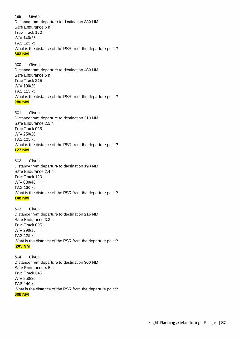
Flight Planning & Monitoring - P a g e | 82
499. Given:
Distance from departure to destination 330 NM
Safe Endurance 5 h
True Track 170
W/V 140/25
TAS 125 kt
What is the distance of the PSR from the departure point?
303 NM
500. Given:
Distance from departure to destination 480 NM
Safe Endurance 5 h
True Track 315
W/V 100/20
TAS 115 kt
What is the distance of the PSR from the departure point?
280 NM
501. Given:
Distance from departure to destination 210 NM
Safe Endurance 2.5 h
True Track 035
W/V 250/20
TAS 105 kt
What is the distance of the PSR from the departure point?
127 NM
502. Given:
Distance from departure to destination 190 NM
Safe Endurance 2.4 h
True Track 120
W/V 030/40
TAS 130 kt
What is the distance of the PSR from the departure point?
148 NM
503. Given:
Distance from departure to destination 215 NM
Safe Endurance 3.3 h
True Track 005
W/V 290/15
TAS 125 kt
What is the distance of the PSR from the departure point?
205 NM
504. Given:
Distance from departure to destination 360 NM
Safe Endurance 4.5 h
True Track 345
W/V 260/30
TAS 140 kt
What is the distance of the PSR from the departure point?
308 NM

Flight Planning & Monitoring - P a g e | 83
505. Given:
Dry operating mass (DOM)= 33500 kg
Load= 7600 kg
Maximum allowable take-off mass= 66200 kg
Standard taxi fuel= 200 kg
Tank capacity= 16 100 kg
The maximum possible take-off fuel is:
15 900 kg
506. (For this question Flight Planning Manual MRJT 1 Figure 4.5.3.1)
Given: flight time from top of climb to the enroute point in FL280 is 48 min. Cruise procedure is long range cruise
(LRC).
Temp. ISA -5° C
Take-off mass 56 000 kg
Climb fuel 1 100 kg
Find: distance in nautical air miles (NAM) for this leg and fuel consumption:
345 NAM; 2000 kg
507. (For this question use Flight Planning Manual MRJT 1 Figure 4.5.1)
Given: estimated take-off mass 57 500 kg;
initial cruise FL 280;
average temperature during climb ISA -10°C;
average head wind component 18 kt
Find: climb time
13 min
508. (For this question use Flight Planning Manual MRJT 1 Figure 4.5.1)
Given : brake release mass 57 500 kg
temperature ISA -10°C; head wind component 16 kt
initial FL 280
Find: still air distance (NAM) and ground distance (NM) for the climb
62 NAM; 59 NM
509. (For this question use Flight Planning Manual MRJT 1 Figure 4.5.1)
Given : mass at brake release 57 500 kg;
temperature ISA -10°C; average head wind component 16 kt
initial cruise FL 280
Find: climb fuel
1138 kg
510. (For this question Flight Planning Manual MRJT 1 Figure 4.5.3.1)
Given :FL 330; long range cruise; OAT -63°C; gross mass 50 500 kg.
Find: true airspeed (TAS)
420 kt
511. (For this question Flight Planning Manual MRJT 1 Figure 4.5.3.1)
Given: long range cruise; outside air temperature (OAT) -45 ° C in FL 350; mass at the beginning of the leg 40 000 kg;
mass at the end of the leg 39 000 kg.
Find: true airspeed (TAS) at the end of the leg and the distance (NAM).
TAS 431 kt; 227 NAM
Flight Planning & Monitoring - P a g e | 84
512. (For this question use Flight Planning Manual MRJT 1)
Given: estimated take-off mass 57 000 kg; still air distance 150 NAM; outside air temperature (OAT) ISA -10K; cruise
at 0.74 Mach.
Find : cruise altitude and expected true airspeed
25 000 ft; 435 kt
Use CAP 697MRJT 1 Figure 4.2.2 Short Distance Cruise Altitude (page 25)
Enter the graph with 150 NAM, read cruise altitude for 57'000 kg brake release weight = 25'000 ft
Use figure 4.5.3.2 Mach 0.74 cruise, pressure altitude 25'000 ft (page 62) Read TAS = 445 KT At the bottom, read
temperature correction for non ISA: -1 KT per degree below ISA. Correct TAS for ISA-10: 445 - 10 = 435 KT
513. (For this question use Flight Planning Manual MRJT 1 Figure 4.4)
Planning a flight from Paris Charles de Gaulle to London Heathrow for a twin - jet aeroplane.
Preplanning:
Dry Operating Mass (DOM): 34 000 kg
Traffic Load: 13 000 kg
The holding is planned at 1 500 ft above alternate elevation. The alternate elevation is 256 ft. The holding is planned
for 30 minutes with no reductions.
Determine the Estimated Landing Mass at alternate Manchester.
48 125 kg
514. (For this question use Route Manual chart E(HI)4)
Planning a flight from Paris Charles de Gaulle (N49 00.9 E002 36.9) to London Heathrow (N51 29.2 W000 27.9) for a
twin - jet aeroplane. The alternate airport is Manchester (N53 21.4 W002 15.7)
Preplanning:
The wind from London to Manchester is 250°/30 kt
The distance from London to Manchester is 160 NM.
Assume the Estimated Landing Mass at alternate is about 50 000 kg.
Find the alternate fuel and the according time.
1 450 kg and 32 minutes
515. (For this question use Route Manual chart E(HI)4)
Planning a flight from Paris Charles de Gaulle (N49 00.9 E002 36.9) to London Heathrow
(N51 29.2 W000 27.9) for a twin - jet aeroplane.
Preplanning:
Powersetting: Mach= 0.74
Planned flight level FL 280
The Landing Mass in the fuel graph is 50 000 kg
The trip distance used for calculation is 200 NM
The wind from Paris to London is 280°/40 kt
Find the estimated trip fuel.
1 740 kg
Wind Component: ca -30 kt ( average TT ca 320°) The question refers to a flight from Paris to Heathrow, means take
off, climb, descent and landing, and not just cruise from one point to the other. It clearly says "Planning a flight from
Paris Charles de Gaulle to London Heathrow".
CAP 697, Figure 4.3.2A SIMPLIFIED FLIGHT PLANNING, 0.74 MACH CRUISE Page 31
Enter the Graph at the bottom at 200 NM. Move straight up to the reference line. Follow the line right and up to 30 KT
headwind.
Then move straight up to intersect the line for the cruising altitude
Interpolate the middle between 27'000 and 29'000 ft. From there move to the right to the ref line.
Interpolate the direction between 21 and 35 (for 28'000 ft) and move to the right and up to intersect the 50'000 kg
landing weight.
From there move right to the Fuel Required and read ca 1'750 kg.
516. (For this question use Flight Planning Manual MRJT 1 Figure 4.3.6)
In order to get alternate fuel and time, the twin -jet aeroplane operations manual graph shall be entered with:
Distance (NM), wind component, landing mass at alternate
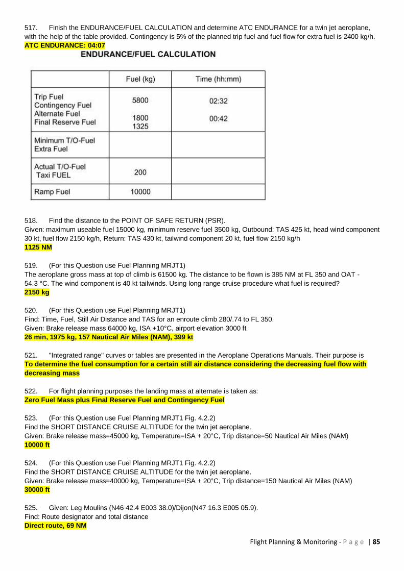
Flight Planning & Monitoring - P a g e | 85
517. Finish the ENDURANCE/FUEL CALCULATION and determine ATC ENDURANCE for a twin jet aeroplane,
with the help of the table provided. Contingency is 5% of the planned trip fuel and fuel flow for extra fuel is 2400 kg/h.
ATC ENDURANCE: 04:07
518. Find the distance to the POINT OF SAFE RETURN (PSR).
Given: maximum useable fuel 15000 kg, minimum reserve fuel 3500 kg, Outbound: TAS 425 kt, head wind component
30 kt, fuel flow 2150 kg/h, Return: TAS 430 kt, tailwind component 20 kt, fuel flow 2150 kg/h
1125 NM
519. (For this Question use Fuel Planning MRJT1)
The aeroplane gross mass at top of climb is 61500 kg. The distance to be flown is 385 NM at FL 350 and OAT -
54.3 °C. The wind component is 40 kt tailwinds. Using long range cruise procedure what fuel is required?
2150 kg
520. (For this Question use Fuel Planning MRJT1)
Find: Time, Fuel, Still Air Distance and TAS for an enroute climb 280/.74 to FL 350.
Given: Brake release mass 64000 kg, ISA +10°C, airport elevation 3000 ft
26 min, 1975 kg, 157 Nautical Air Miles (NAM), 399 kt
521. "Integrated range" curves or tables are presented in the Aeroplane Operations Manuals. Their purpose is
To determine the fuel consumption for a certain still air distance considering the decreasing fuel flow with
decreasing mass
522. For flight planning purposes the landing mass at alternate is taken as:
Zero Fuel Mass plus Final Reserve Fuel and Contingency Fuel
523. (For this Question use Fuel Planning MRJT1 Fig. 4.2.2)
Find the SHORT DISTANCE CRUISE ALTITUDE for the twin jet aeroplane.
Given: Brake release mass=45000 kg, Temperature=ISA + 20°C, Trip distance=50 Nautical Air Miles (NAM)
10000 ft
524. (For this Question use Fuel Planning MRJT1 Fig. 4.2.2)
Find the SHORT DISTANCE CRUISE ALTITUDE for the twin jet aeroplane.
Given: Brake release mass=40000 kg, Temperature=ISA + 20°C, Trip distance=150 Nautical Air Miles (NAM)
30000 ft
525. Given: Leg Moulins (N46 42.4 E003 38.0)/Dijon(N47 16.3 E005 05.9).
Find: Route designator and total distance
Direct route, 69 NM
Flight Planning & Monitoring - P a g e | 86
526. Given: Maximum allowable take-off mass 64400 kg, Maximum landing mass 56200 kg, Maximum zero fuel
mass 53000 kg, Dry operating mass 35500 kg, Traffic load 14500 kg, Trip fuel 4900 kg, Minimum Take-off Fuel 7400
kg
Find: Maximum allowable take-off fuel
11100 kg
527. Given: Maximum allowable take-off mass 64400 kg, Maximum landing mass 56200 kg, Maximum zero fuel
mass 53000 kg, Dry operating mass 35500 kg, Traffic load 14500 kg, Trip fuel 4900 kg, Take-off fuel 7400 kg
Find: Maximum additional load
3000 kg
528. (For this Question use Fuel Planning MRJT1)
Given: Twin jet aeroplane, Ground distance to destination aerodrome is 1600 NM, Headwind component 50 kt, FL 330,
Cruise .78 Mach, ISA Deviation +20°C and Landing mass 55000 kg
Find: Fuel required and trip time with simplified flight planning
12400 kg, 04 h 00 min
529. (For this Question use Fuel Planning MRJT1)
Given: twin jet aeroplane, Dry operating mass 35500 kg, Traffic load 14500 kg, Final reserve fuel 1200 kg, Distance to
alternate 95 NM, Tailwind component 10 kt
Find: Fuel required and trip time to alternate with simplified flight planning (ALTERNATE PLANNING)
1000 kg, 24 min
530. (For this Question use Fuel Planning MRJT1)
Given: twin jet aeroplane, Estimated mass on arrival at the alternate 50000 kg, Estimated mass on arrival at the
destination 52525 kg, Alternate elevation MSL, Destination elevation 1500 ft
Find: Final reserve fuel and corresponding time
1180 kg, 30 min
531. (For this Question use Fuel Planning MRJT1)
Given: twin jet aeroplane, Estimated mass on arrival at the alternate 50000 kg, Elevation at destination aerodrome
3500 ft, Elevation at alternate aerodrome 30 ft
Find: Final reserve fuel
1180 kg
532. (For this Question use Fuel Planning MRJT1)
Planning an IFR-flight from Paris to London for a twin jet aeroplane.
Given: Estimated Take-off Mass (TOM) 52000 kg, Airport elevation 387 ft, FL 280, W/V 280°/40 kt, ISA-Deviation -
10°C, Average True Course 340°
Find: Ground distance to the top of climb (TOC)
50 NM
533. (For this Question use Fuel Planning MRJT1)
Planning an IFR-flight from Paris to London for the twin jet aeroplane.
Given: Estimated Take-off Mass (TOM) 52000 kg, Airport elevation 387 ft, FL 280, W/V 280°/40 kt, ISA Deviation -
10°C, Average True Course 340°
Find: Fuel to the top of climb (TOC)
1000 kg
534. (For this Question use Fuel Planning MRJT1)
Planning an IFR-flight from Paris to London for the twin jet aeroplane.
Given: Gross mass 50000 kg, FL 280, ISA Deviation -10°C, Cruise procedure Mach 0.74
Determine the TAS
430 kt
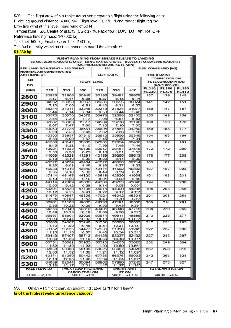
Flight Planning & Monitoring - P a g e | 87
535. The flight crew of a turbojet aeroplane prepares a flight using the following data:
Flight leg ground distance: 4 000 NM, Flight level FL 370; "Long range" flight regime
Effective wind at this level: head wind of 50 kt
Temperature: ISA, Centre of gravity (CG): 37 %, Pack flow : LOW (LO), Anti ice: OFF
Reference landing mass: 140 000 kg
Taxi fuel: 500 kg, Final reserve fuel: 2 400 kg
The fuel quantity which must be loaded on board the aircraft is:
51 860 kg
536. On an ATC flight plan, an aircraft indicated as "H" for "Heavy"
Is of the highest wake turbulence category
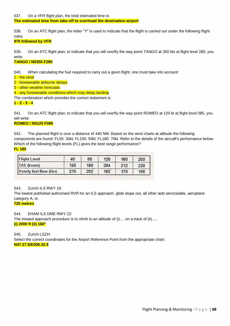
Flight Planning & Monitoring - P a g e | 88
537. On a VFR flight plan, the total estimated time is:
The estimated time from take-off to overhead the destination airport
538. On an ATC flight plan, the letter "Y" is used to indicate that the flight is carried out under the following flight
rules.
IFR followed by VFR
539. On an ATC flight plan, to indicate that you will overfly the way-point TANGO at 350 kts at flight level 280, you
write:
TANGO / N0350 F280
540. When calculating the fuel required to carry out a given flight, one must take into account:
1 - the wind
2 - foreseeable airborne delays
3 - other weather forecasts
4 - any foreseeable conditions which may delay landing
The combination which provides the correct statement is:
1 - 2 - 3 - 4
541. On an ATC flight plan, to indicate that you will overfly the way-point ROMEO at 120 kt at flight level 085, you
will write:
ROMEO / N0120 F085
542. The planned flight is over a distance of 440 NM. Based on the wind charts at altitude the following
components are found: FL50: 30kt; FL100: 50kt; FL180: 70kt. Refer to the details of the aircraft's performance below.
Which of the following flight levels (FL) gives the best range performance?
FL 180
543. Zurich ILS RWY 16:
The lowest published authorised RVR for an ILS approach, glide slope out, all other aids serviceable, aeroplane
category A, is:
720 metres
544. EHAM ILS DME RWY 22:
The missed approach procedure is to climb to an altitude of (i).... on a track of (ii).....
(i) 2000 ft (ii) 160°
545. Zurich LSZH:
Select the correct coordinates for the Airport Reference Point from the appropriate chart:
N47.27.5/E008.32.9

Flight Planning & Monitoring - P a g e | 89
546. The planned flight is over a distance of 400 NM. Based on the wind charts at altitude the following
components are found: FL50: -30kt; FL70: -50kt; FL90: -50kt. Refer to the details of the aircraft's performance below.
Which of the following flight levels (FL) gives the best range performance?
FL 090
547. (For this question use Route Manual chart E(LO)6)
Position NESLA at 49°48,6'N 002°44,4E is a:
Compulsory reporting point on G40 only
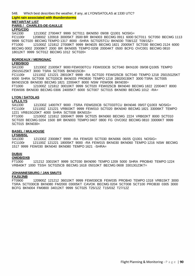
Flight Planning & Monitoring - P a g e | 90
548. Which best describes the weather, if any, at LYON/SATOLAS at 1330 UTC?
Light rain associated with thunderstorms
METAR/TAF LIST PARIS / CHARLES-DE-GAULLE LFPG/CDG SA1330 121330Z 27004KT 9999 SCT011 BKN050 09/08 Q1001 NOSIG= FC1100r 120800Z 120918 30005KT 3500 BR BKN003 BECMG 0911 6000 SCT011 SCT050 BECMG 1113 9999 SCT020 BECMG TEMPO 1317 8000 -SHRA SCT025TCU BKN030 T08/12Z T09/15Z= FT1000 121000Z 121812 27008KT 9999 BKN025 BECMG 1821 20005KT SCT030 BECMG 2124 6000 BECMG 0002 20008KT 2000 BR BKN005 TEMPO 0208 20004KT 0500 BCFG OVC001 BECMG 0810 18012KT 9999 SCT012 BECMG 1012 SCT020= BORDEAUX / MERIGNAC LFBD/BOD SA1330 121330Z 21005KT 9000 FEW030TCU FEW033CB SCT040 BKN100 09/08 Q1005 TEMPO 25015G25KT 3000 TSRA SCT005 BKN015CB= FC1100r 121100Z 121221 28010KT 9999 -RA SCT020 FEW025CB SCT040 TEMPO 1218 25015G25KT 6000 SHRA SCT008 SCT020CB BKN033 PROB30 TEMPO 1218 28020G30KT 3000 TSRA SCT005 BKN015CB BKN030 BECMG 1821 22004KT 8000 NSW FEW006 BKN030= FT1000 121000Z 121812 30010KT 9999 SCT020 FEW025CB BKN040 BECMG 1822 22004KT 8000 FEW006 BKN030 BECMG 0306 24005KT 6000 SCT007 SCT015 BKN090 BECMG 1012 -RA= LYON / SATOLAS LPLL/LYS SA1330 121330Z 14007KT 9000 -TSRA FEW020CB SCT033TCU BKN046 09/07 Q1003 NOSIG= FC1100r 121100Z 121221 VRB03KT 9999 FEW010 SCT020 BKN040 BECMG 1821 33006KT TEMPO 1221 VRB15G20KT 4000 SHRA SCT008 BKN015= FT1000 121000Z 121812 33004KT 9999 SCT025 BKN060 BECMG 2224 VRB02KT 8000 SCT010 SCT020 BECMG 0204 1500 BR BKN003 TEMPO 0407 0800 FG OVC002 BECMG 0810 33006KT 9999 SCT015 BKN030= BASEL / MULHOUSE LFSB/BSL SA1330 121330Z 23008KT 9999 -RA FEW020 SCT030 BKN066 06/05 Q1001 NOSIG= FC1100r 121100Z 121221 18005KT 9000 -RA FEW015 BKN030 BKN060 TEMPO 1216 NSW BECMG 1517 9999 FEW030 BKN040 BKN080 TEMPO 1621 -SHRA= DUBAI OMDB/DXB FT1000 121212 33015KT 9999 SCT030 BKN090 TEMPO 1209 5000 SHRA PROB40 TEMPO 1224 VRB40KT 1000 TSSH SCT025CB BECMG 1618 05010KT BECMG 0608 33013G23KT= JOHANNESBURG / JAN SMUTS FAJS/JNB FT0900 120900Z 121212 36010KT 9999 FEW030CB FEW035 PROB40 TEMPO 1318 VRB15KT 3000 TSRA SCT030CB BKN080 FM2000 03005KT CAVOK BECMG 0204 SCT008 SCT100 PROB30 0305 3000 BCFG BKN004 FM0800 34012KT 9999 SCT025 T25/12Z T15/03Z T27/12Z
Flight Planning & Monitoring - P a g e | 91
549. (For this question use Route Manual chart E(LO)1) An appropriate flight level for flights on airway A2 from TALLA 113,8 TLA (55°30'N 003°21'W) to DEAN CROSS 155,2 DCS (54°43'N 003°20'W)is: FL 90
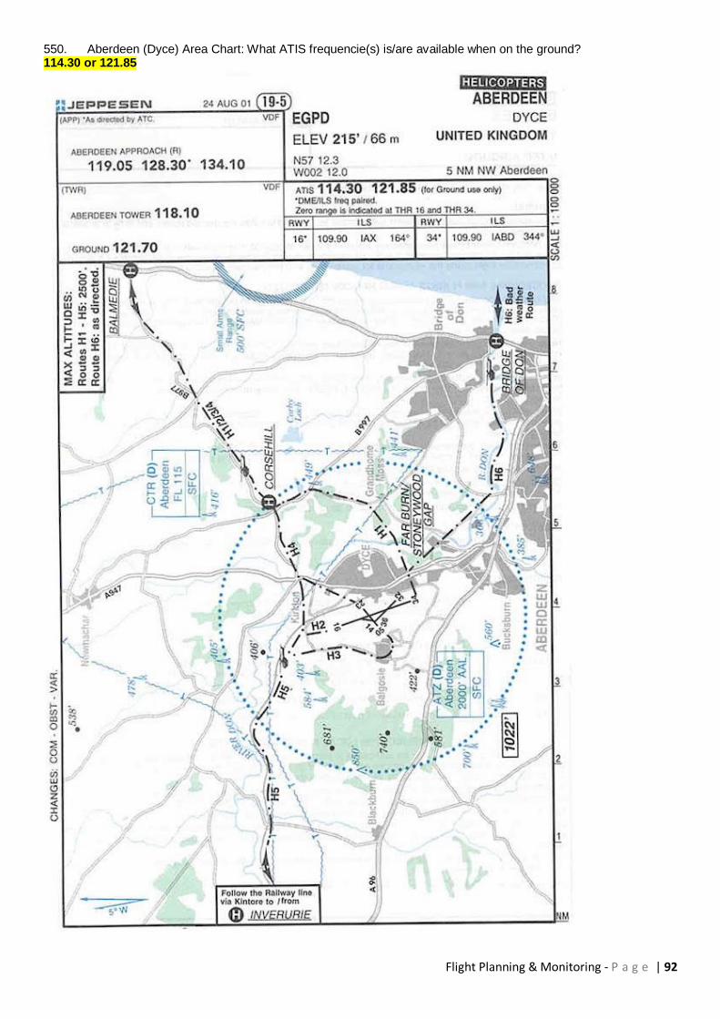
Flight Planning & Monitoring - P a g e | 92
550. Aberdeen (Dyce) Area Chart: What ATIS frequencie(s) is/are available when on the ground? 114.30 or 121.85

Flight Planning & Monitoring - P a g e | 93
551. What is the temperature deviation (°C) from ISA over 50° N 010°E ? +2
552. (For this Question use Flight Planning Manual SEP 1, Fig. 2.2 Table 2.2.3) Using the Power Setting Table, for the single engine aeroplane, determine the cruise TAS and fuel flow (lbs/hr) with full throttle and cruise lean mixture in the following conditions given: OAT 13° C Pressure altitude 8000 ft RPM 2300 160 kt and 69.3 lbs/hr
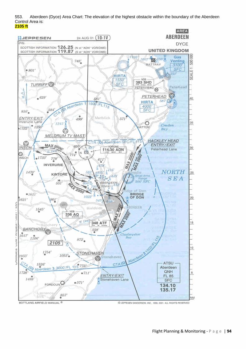
Flight Planning & Monitoring - P a g e | 94
553. Aberdeen (Dyce) Area Chart: The elevation of the highest obstacle within the boundary of the Aberdeen Control Area is: 2105 ft
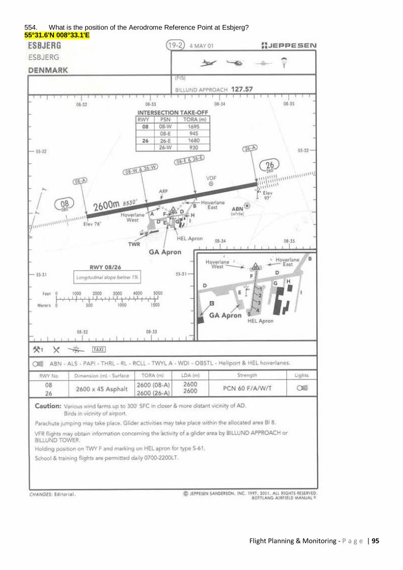
Flight Planning & Monitoring - P a g e | 95
554. What is the position of the Aerodrome Reference Point at Esbjerg? 55°31.6'N 008°33.1'E
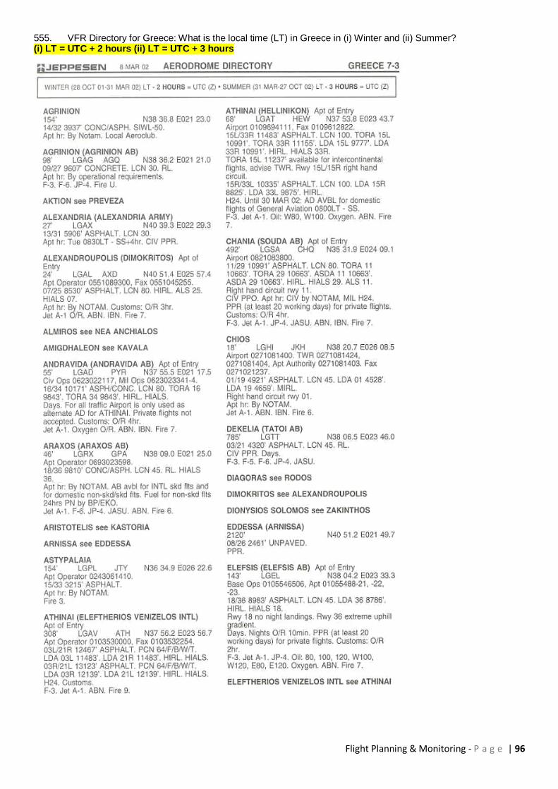
Flight Planning & Monitoring - P a g e | 96
555. VFR Directory for Greece: What is the local time (LT) in Greece in (i) Winter and (ii) Summer? (i) LT = UTC + 2 hours (ii) LT = UTC + 3 hours
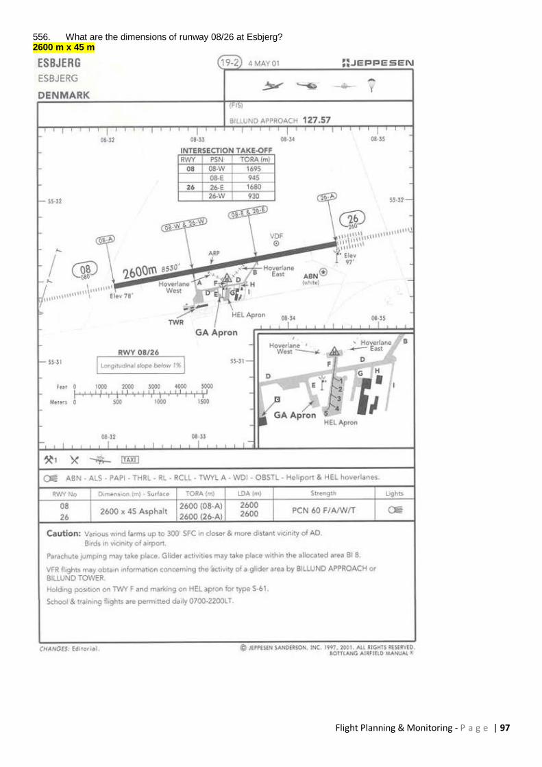
Flight Planning & Monitoring - P a g e | 97
556. What are the dimensions of runway 08/26 at Esbjerg? 2600 m x 45 m

Flight Planning & Monitoring - P a g e | 98
557. In the vicinity of PARIS (49°N 003°E) the tropopause is at about FL400
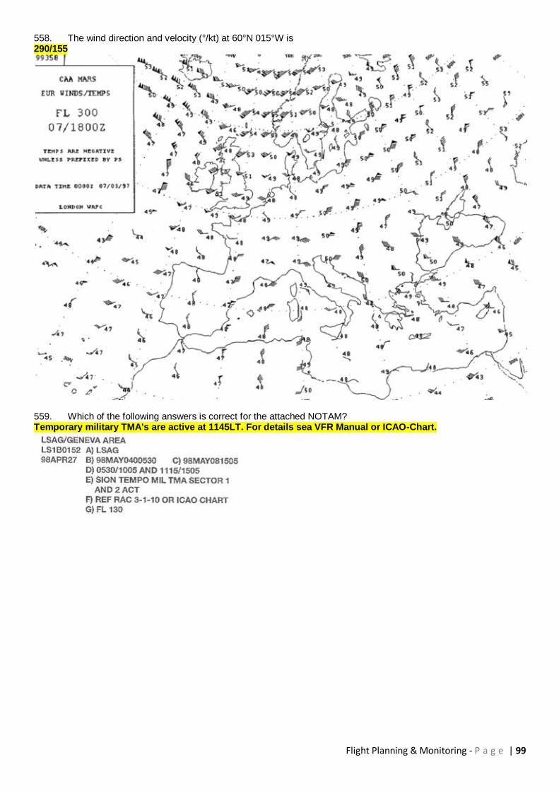
Flight Planning & Monitoring - P a g e | 99
558. The wind direction and velocity (°/kt) at 60°N 015°W is 290/155
559. Which of the following answers is correct for the attached NOTAM? Temporary military TMA's are active at 1145LT. For details sea VFR Manual or ICAO-Chart.
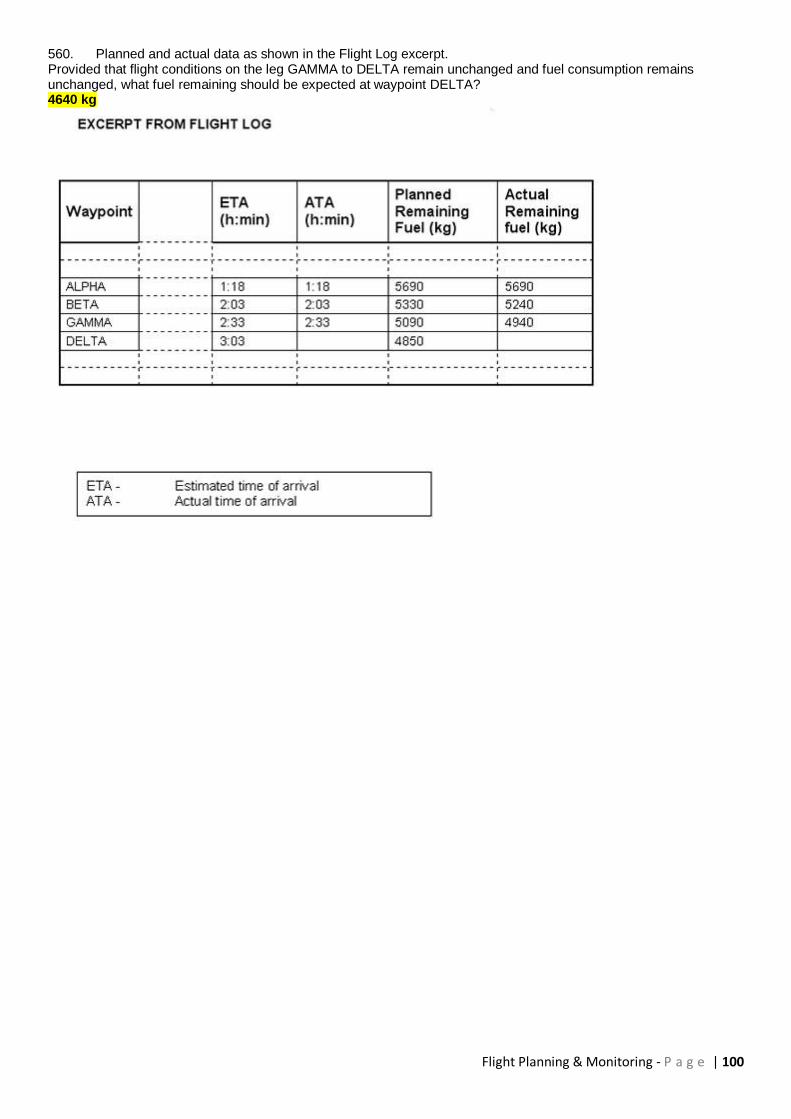
Flight Planning & Monitoring - P a g e | 100
560. Planned and actual data as shown in the Flight Log excerpt. Provided that flight conditions on the leg GAMMA to DELTA remain unchanged and fuel consumption remains unchanged, what fuel remaining should be expected at waypoint DELTA? 4640 kg
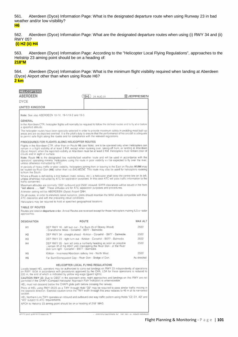
Flight Planning & Monitoring - P a g e | 101
561. Aberdeen (Dyce) Information Page: What is the designated departure route when using Runway 23 in bad weather and/or low visibility? H6 562. Aberdeen (Dyce) Information Page: What are the designated departure routes when using (i) RWY 34 and (ii) RWY 05? (i) H2 (ii) H4 563. Aberdeen (Dyce) Information Page: According to the "Helicopter Local Flying Regulations", approaches to the Helistrip 23 aiming point should be on a heading of: 218°M 564. Aberdeen (Dyce) Information Page: What is the minimum flight visibility required when landing at Aberdeen (Dyce) Airport other than when using Route H6? 2 km

Flight Planning & Monitoring - P a g e | 102
565. Athinai (Hellinikon) Chart: What is the maximum permitted altitude if routing inbound from "Abeam Patroklos" to Hellinikon? 300 ft 566. Athinai (Hellinikon) Chart: What is the total distance when following the VFR routing from "Abeam Patroklos" to Hellinikon? 19 NM
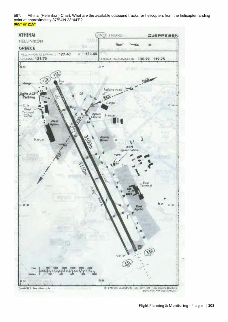
Flight Planning & Monitoring - P a g e | 103
567. Athinai (Hellinikon) Chart: What are the available outbound tracks for helicopters from the helicopter landing point at approximately 37°54'N 23°44'E? 065° or 215°

Flight Planning & Monitoring - P a g e | 104
568. Aberdeen (Dyce) Area Chart: The elevation of the highest obstacle within the boundary of the Aberdeen Control Area is: 2105 ft 569. Aberdeen (Dyce) Aera chart: What is the elevation of the highest ground within the boundary of Aberdeen Control Zone? 1733 ft 570. Aberdeen (Dyce) Aera Chart: Which of the following frequencies is listed as available for contact with Aberdeen ATSU? 135.17 571. Aberdeen (Dyce) Area Chart: What is the correct frequency to contact Scottish Information when overhead reporting point BANCHORY to the southwest of Aberdeen airport? 119.87

Flight Planning & Monitoring - P a g e | 105
572. Aberdeen Information Page: The East Apron and Eastern TWY have restricted access. The maximum permitted wingspan: Is 20 m
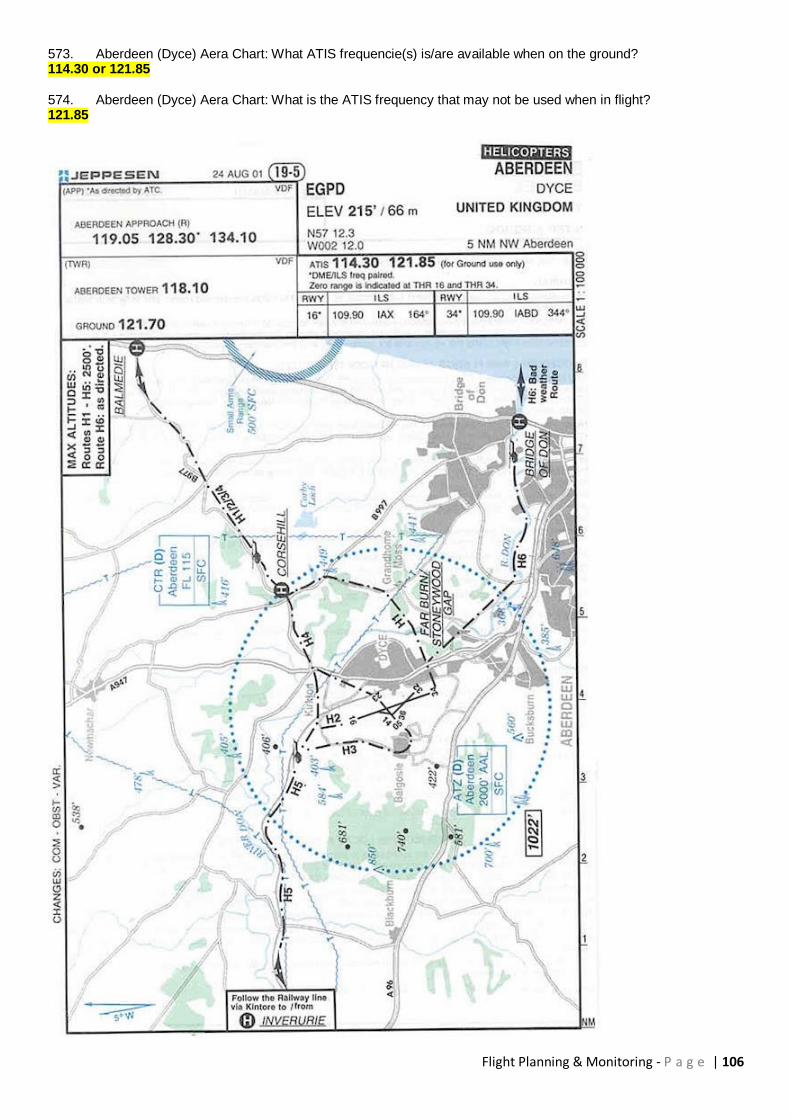
Flight Planning & Monitoring - P a g e | 106
573. Aberdeen (Dyce) Aera Chart: What ATIS frequencie(s) is/are available when on the ground? 114.30 or 121.85 574. Aberdeen (Dyce) Aera Chart: What is the ATIS frequency that may not be used when in flight? 121.85

Flight Planning & Monitoring - P a g e | 107
575. VFR directory for the Netherlands: What is the local time (LT) in the Netherlands in (i) Winter and (ii) Summer? (i) LT - 1 hour = UTC (ii) LT - 2 hours = UTC

Flight Planning & Monitoring - P a g e | 108
576. VFR Directory for Greece: What is the local time (LT) in Greece in (i) Winter and (ii) Summer? (i) LT = UTC + 2 hours (ii) LT = UTC + 3 hours
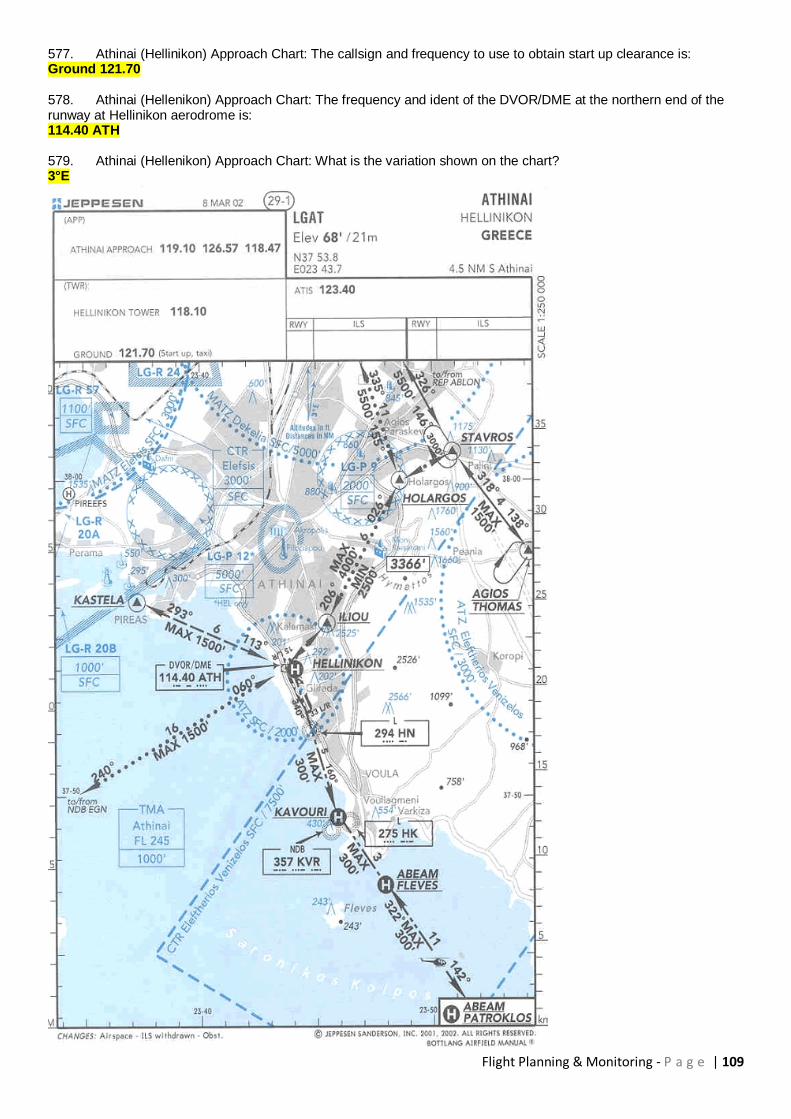
Flight Planning & Monitoring - P a g e | 109
577. Athinai (Hellinikon) Approach Chart: The callsign and frequency to use to obtain start up clearance is: Ground 121.70 578. Athinai (Hellenikon) Approach Chart: The frequency and ident of the DVOR/DME at the northern end of the runway at Hellinikon aerodrome is: 114.40 ATH 579. Athinai (Hellenikon) Approach Chart: What is the variation shown on the chart? 3°E
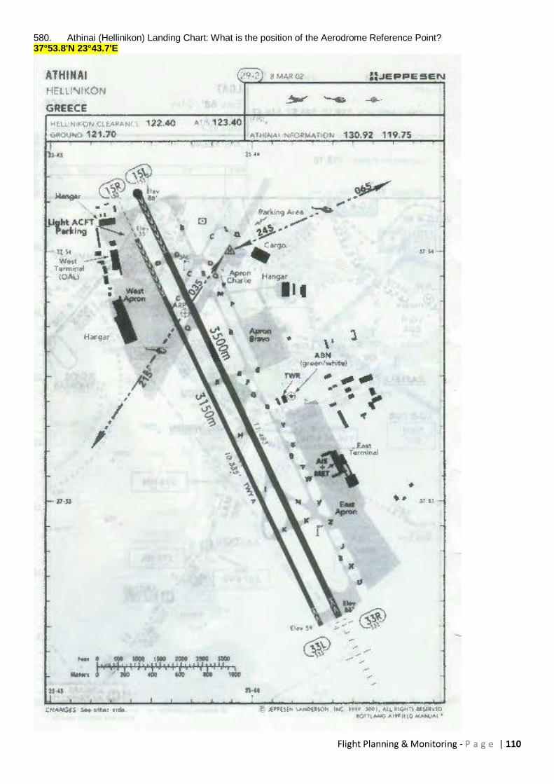
Flight Planning & Monitoring - P a g e | 110
580. Athinai (Hellinikon) Landing Chart: What is the position of the Aerodrome Reference Point? 37°53.8'N 23°43.7'E
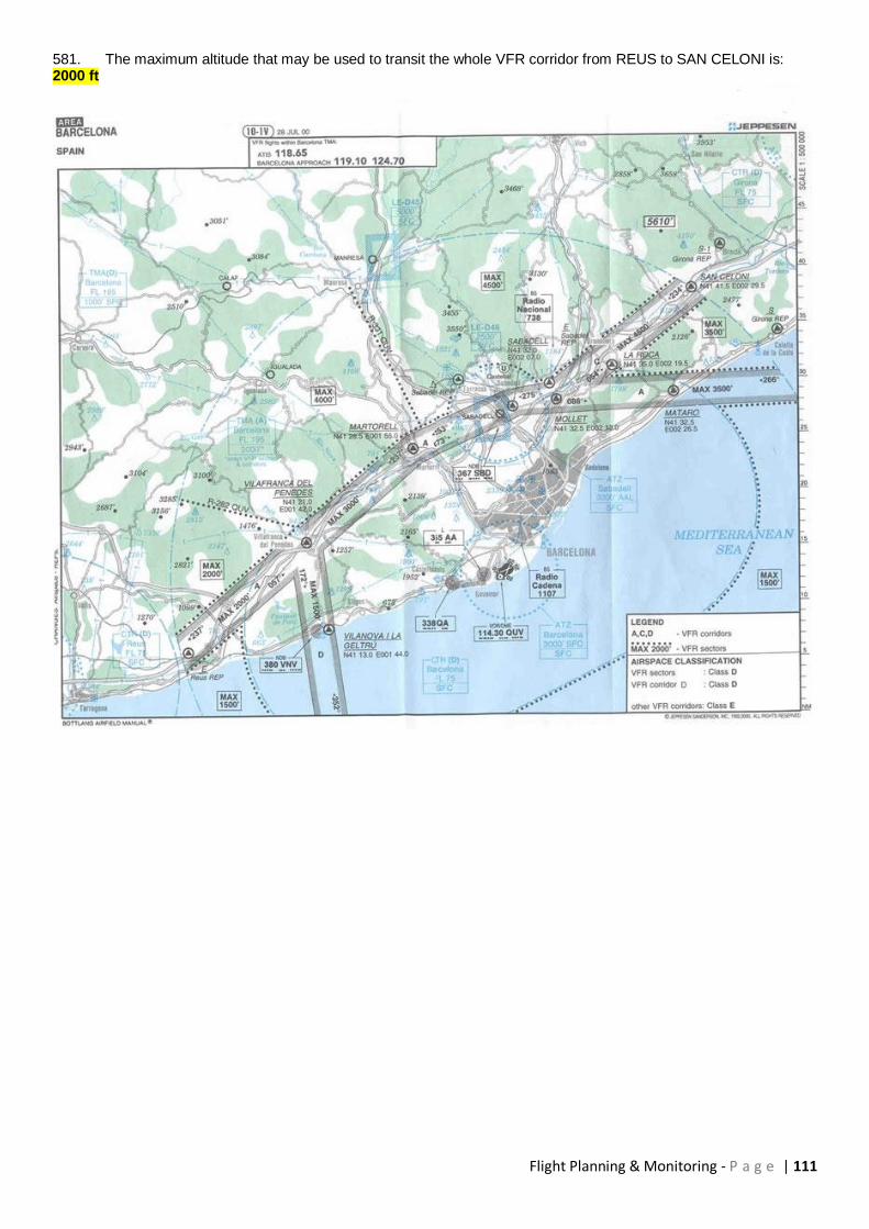
Flight Planning & Monitoring - P a g e | 111
581. The maximum altitude that may be used to transit the whole VFR corridor from REUS to SAN CELONI is: 2000 ft
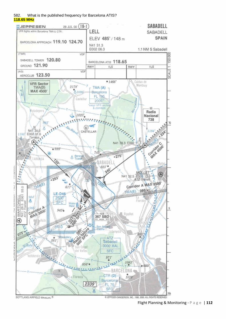
Flight Planning & Monitoring - P a g e | 112
582. What is the published frequency for Barcelona ATIS? 118.65 MHz
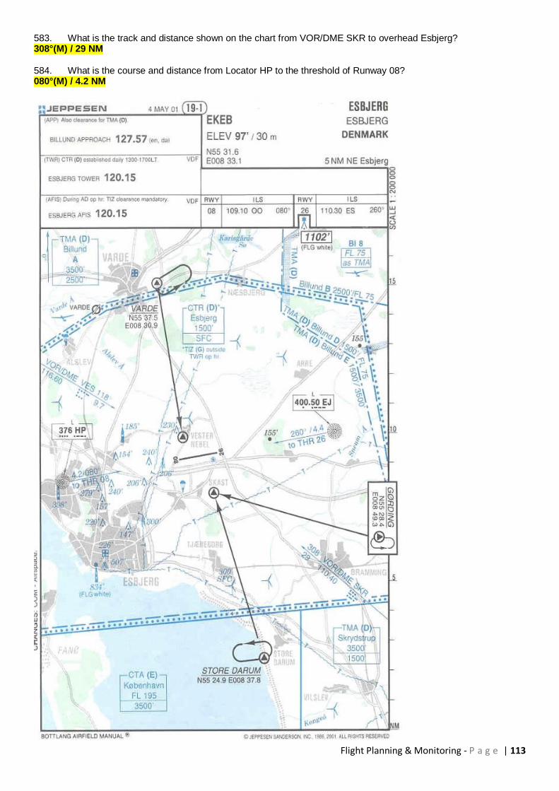
Flight Planning & Monitoring - P a g e | 113
583. What is the track and distance shown on the chart from VOR/DME SKR to overhead Esbjerg? 308°(M) / 29 NM 584. What is the course and distance from Locator HP to the threshold of Runway 08? 080°(M) / 4.2 NM
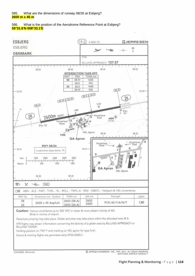
Flight Planning & Monitoring - P a g e | 114
585. What are the dimensions of runway 08/26 at Esbjerg? 2600 m x 45 m 586. What is the position of the Aerodrome Reference Point at Esbjerg? 55°31.6'N 008°33.1'E

Flight Planning & Monitoring - P a g e | 115
587. (For this Question use Fuel Planning MRJT1 Figure 4.3.1C)) Given: Diversion distance 2400 NM Wind component 25 kt tailwind Temperature ISA - 10°C Cruise altitude 31000 ft Landing mass 52000 kg The approximate (a) trip fuel and (b) trip time are respectively: (a) 14100kg (b) 5h 28min 588. (For this Question use Flight Planning Manual SEP 1, Fig. 2.3 Table 2.3.1) Using the Power Setting Table, for the single engine aeroplane, determine the cruise TAS and fuel flow (lbs/hr) with full throttle and cruise lean mixture in the following conditions given: OAT 3° C Pressure altitude 6000 ft Power Full throttle/21,0 in/Hg/2100 RPM 134 kt and 55.7 lbs/hr 589. (For this Question use Flight Planning Manual SEP 1, Fig. 2.2 Table 2.2.3) Using the Power Setting Table, for the single engine aeroplane, determine the cruise TAS and fuel flow (lbs/hr) with full throttle and cruise lean mixture in the following conditions given: OAT 13° C Pressure altitude 8000 ft RPM 2300 160 kt and 69.3 lbs/hr 590. (For this Question use Flight Planning Manual SEP 1, Fig. 2.2 Table 2.2.3) Using the Power Setting Table, for the single engine aeroplane, determine the manifold pressure and fuel flow (lbs/hr) with full throttle and cruise lean mixture in the following conditions given: OAT 13° C Pressure altitude 8000 ft RPM 2300 22.4 in.Hg and 69.3 lbs/hr