project legado: namuli - nitidae.org
TRANSCRIPT

Project Legado: Namuli
Gurue, Mozambique
Progress report
Jan
uary
– M
arc
h 2
020

Legado Namuli Initiative – 1st Trimester 2020 Progress Report
1
Table of Contents PROJECT SUMMARY ............................................................................................................................................................. 4
Activities .................................................................................................................................................................................... 4
1_ Legacy Leadership Methodology: Integrative Behavior Change Across All Programming ............. 34
1.1. Conceptual Framework ....................................................................................... Erreur ! Signet non défini.
1.2. Integrated Programming ............................................................................................................................... 34
1.3. Legacy Modules: Environmental Education and Discussion ................................................................ 34
1.4. Team Leadership .............................................................................................................................................. 35
2_ Objective 1: Namuli Communities are Using Sustainable Economic Options that are Less
Dependent of Namuli Upland Resources ........................................................................................................................ 4
2.1. Socio-Economic Baseline Studies of Communities’ Households .......................................................... 4
2.2. Identification of Options for Alternative Livelihoods, including Honey and Partnerships with
Agro-Businesses in Gurué ............................................................................................................................................... 6
3_ Communities Trained for Improved Alternative Livelihoods ....................................................................... 6
3.1. Conservation Agriculture .................................................................................................................................. 6
3.1.1. Pilot Test in Conservation Agriculture .................................................................................................... 14
3.1.2. Honey Value Chain Development ........................................................................................................... 16
3.2. Objective 2: A Conservation Agreement, including a Moratorium on Deforestation in the Upper
Elevations is Implemented .............................................................................................................................................. 19
3.2.1. Negotiation of a Conservation Agreement ........................................................................................... 19
3.2.2. Implementation of the Conservation Agreement .............................................................................. 20
3.2.3. Social Benefits Programming Launched within a Developing Framework of a Conservation
Agreement .................................................................................................................................................................... 20
3.3. Objective 3: A Meaningful Landscape Strategy is Developed to Prioritize Site Interventions,
Preserve Ecosystem Services and Prevent Fire Dissemination in the Namuli’s Upper Elevations .............. 21
3.3.1. Mapping of Forest Clusters and Rapid Ecosystem Services Evaluation
(Water/Biodiversity/Erosion) ...................................................................................................................................... 21
3.3.2. Identification and Prioritization of Adequate Site Interventions (Agriculture, Potential for
Restoration) and Design of a Firewall Network .................................................................................................. 24
3.3.3. Design, Building and Maintenance of Firewall Network with Communities ............................... 25
3.3.4. Systematic Deforestation Monitoring through Drone Observation .............................................. 26
3.4. Objective 4: Reinforce Community Land Rights and Promoting Local Decision-Making on Land
and Natural Resource Management .......................................................................................................................... 26
3.4.1. Delimitation and Local Mapping & Certification of 10 Communities and 4000 Household Land
Rights 26
3.4.2. Finalization of Natural Resources Management Committees Formalization ............................. 28
3.4.3. Landscape Plan Use with Communities ................................................................................................ 30

Legado Namuli Initiative – 1st Trimester 2020 Progress Report
2
3.5. Objective 5: Creation of a Community Conservation Area .................................................................. 30
3.5.1. Land Delimitation - Identify Core Community Conservation Area and Buffer Zone ............... 30
3.5.2. Negotiation of a Management Plan for the Conservation Area .................................................... 30
3.5.3. Secure ANAC Support for the Community Conservation Area ..................................................... 30
3.5.4. Early Stage Engagement with ANAC to Clarify the Intention to Create a Community
Conservation Area ...................................................................................................................................................... 30
3.5.5. Engagement with Local District Government Officials to Secure Support for PA Creation .... 31
3.5.6. Engagement with Provincial Government to Secure Support for Protected Area (PA) Creation
31
3.5.7. Completion of Paperwork Required by Legislation for Proposal Submission to ANAC .......... 31
3.5.8. Submit Community Conservation Area Proposal to ANAC ............................................................. 31
3.5.9. ANAC Engagement with MITADER for PA Approval and Formal Recognition .......................... 31
3.5.10. Create and Operate a Community Patrolling Unit ........................................................................ 31
3.6. Project Objective 6: Stakeholder’s and Partners Coordination ........................................................... 32
Figures, Maps and Picture table Figure 1 (Left to Right) : Community event in Murrece on Legacy Module “Trees are Life” ; Community
members raise their hands to share the ways that trees are important to their lives and local uses........... 35
Figure 2 : Agricultural income of the four production systems presented. A) The small-scale subsistence
farmer; B) The large potato producer ; C) The innovative farmer living from tomato ; D) The innovative
farmer living from forest ....................................................................................................................................................... 5
Figure 3 : Production linked to deforestation dynamics .............................................................................................. 5
Figure 4 : Accompanying agrarian measures and activities implemented during the period ......................... 9
Figure 5 : Tomato market strategy Focus group sharing local tea, Murrabué Sede, January 2020 .............. 10
Figure 6 : Training producers to traders’ quality demands, Murrabué Sede, January 2020 ............................ 10
Figure 7 : Bean seeding ....................................................................................................................................................... 11
Figure 8 : Bean harvest and result .................................................................................................................................... 11
Figure 9 : Yellowing of leaves and wilting of plants ..................................................................................................... 12
Figure 10 : Root observation............................................................................................................................................... 12
Figure 11 : Use of ashes in the seed bag to reduce humidity .................................................................................... 13
Figure 12 : Use of "Namahuco" powder against insects ............................................................................................. 13
Figure 13 : Collective dryer construction sessions ........................................................................................................ 14
Figure 14 : Outside and inside drying table to take advantage of the heat and smoke from the fire .......... 14
Figure 15 : The interior drying table also helps for storage of seed bags (heat and smoke) ........................... 14
Figure 16 : Selection of healthy cassava cuttings with Jossina Samuel, Murrece, February 2020 ................... 15
Figure 17 : Planting selected cuttings in the « woodpark » of Joaquim Saide, Curuca, February 2020 ........ 15
Figure 18 : Domingos Maita carrying his second hive to install in his apiary located at the foot of Mount
Namuli ...................................................................................................................................................................................... 16
Figure 19 : number of new beehives installed and swarm transfers competed (01/01 – 03/31/2020) ........... 16
Figure 20 : Beehive inspection at the apiary school .................................................................................................... 17
Figure 21 : Beefeeder and follower board ...................................................................................................................... 17
Figure 22 (Left to Right) : Use of local resources: Roof of natural fiber, Recyclable plastic bottle, Natural
Beewax sheets ........................................................................................................................................................................ 18

Legado Namuli Initiative – 1st Trimester 2020 Progress Report
3
Figure 23 : actual beekeepers situation (*swarm transfers realized but depopulated hive) ............................ 18
Figure 24 : Sr. Alvaro, Mucunha NMRC’s president during « trees are life » presentation ............................. 25
Figure 25 : Namuli NMRCs initial representativeness before revitalization (ongoing activity) ....................... 29
Figure 26 : Our New Office ................................................................................................................................................ 32
Figure 27 : Office Hand washing Station ....................................................................................................................... 33
Maps Map 1 : Land Use and Land Cover map 2018 ................................................................................................................ 21
Map 2 : Annual Land productivity trends (2001-2016) in Namuli ........................................................................... 23
Map 3 : Namuli Core Area Deforestation Risk ............................................................................................................. 23
Map 4 : multi level information map............................................................................................................................... 24
Map 5 : Main communities for Delimitation ................................................................................................................. 27
This report was prepared by Nitidae to demonstrate the work and progress of the Legado Namuli
Initiative during the first trimester 2020.

Legado Namuli Initiative – 1st Trimester 2020 Progress Report
4
PROJECT SUMMARY
Project Title: Mount Namuli Community Conservation Area
Project Duration: 1 November 2019 to 30 April 2023 (the “Project Term”)
Name of Organization(s): Nitidae, Legado, Lupa Reporting Period: 01/01/2020 – 03/30/2020
If this is a land purchase project, has the land been
purchased (YES / NO )? If not, why not?
N/A
Actual or expected date of Land Purchase
Completed: N/A
Please indicate what proportion of activities have
been completed toward the purchase?
If this is a land designation, lease, or government-run
protected area, has the land been officially designated
YES / NO? If not, please explain why
N/A
Actual or expected date of Official Designation:
Please indicate what proportion of activities have
been completed toward the designation?
Activities
1_ Objective 1: Namuli Communities are Using Sustainable
Economic Options that are Less Dependent of Namuli Upland
Resources
1.1. Socio-Economic Baseline Studies of Communities’ Households
In order to complete the preliminary studies conducted at the onset of the Legado: Namuli Project, an
Agrarian Diagnostic was conducted in 2019 to improve understanding of agricultural and land use
dynamics, and their impacts on forest resources. The Agrarian Diagnostic was concluded in 2019 and the
conclusions of the report have informed the identification and implementation of concrete measures and
technical interventions adapted to local producers’ strategies regarding the deforestation problematic.
This study defined four farmer profiles depending on their incomes and main activities in the living area of
the highlands (Figure 2), the main crops they cultivate and their association to deforestation risk in the
Namuli Uplands. It provides a robust understanding of which alternative crops should be promoted to
increase incomes while decreasing deforestation risk. It also provides key information regarding farmers’
who could see their revenues put at risk as a result of conservation efforts. Specifically, as presented below,
the Irish potato producers are highly linked to deforestation risk, and therefore would be greatly impacted
by conservation efforts (Figure 2).
It is to be noted that the Agrarian Diagnostic is an innovative methodology that has been successfully
elaborated and implemented by Nitidae in Namuli and is now replicated in other Nitidae projects
integrating conservation efforts, agriculture and rural development.

Legado Namuli Initiative – 1st Trimester 2020 Progress Report
5
FIGURE 1 : AGRICULTURAL INCOME OF THE FOUR PRODUCTION SYSTEMS PRESENTED. A) THE SMALL-SCALE
SUBSISTENCE FARMER; B) THE LARGE POTATO PRODUCER ; C) THE INNOVATIVE FARMER LIVING FROM TOMATO ;
D) THE INNOVATIVE FARMER LIVING FROM FOREST
FIGURE 2 : PRODUCTION LINKED TO DEFORESTATION DYNAMICS

Legado Namuli Initiative – 1st Trimester 2020 Progress Report
6
1.2. Identification of Options for Alternative Livelihoods, including Honey and
Partnerships with Agro-Businesses in Gurué
Since early 2019, Legado Namuli has developed a partnership with the Mozambican company Agri-Mel,
located in Gurue, to assist with honey value chain development, in addition to providing technical
assistance for sustainable, high-quality honey production and harvesting. Agri-Mel will ensure the market
access with Legado Namuli payment for raw honey from the individual community members, while the
Legado Namuli Project is responsible for the selection of the beneficiaries, logistics of installation of
apiaries, technical support and training, as well as monitoring of beneficiaries. The activities realized are
presented in Section 3.1.2 below.
The agroecosystem of Mount Namuli also presents potential for other high-quality cash crop and value
chain development, such as coffee in the highlands, and/or macadamia in the lowlands. Such crops, which
could be cultivated in agroforestry systems, could create alternative income opportunities for communities
while incentivizing the control of wildfires, as well as the preservation of forests, complementary to
apiculture activities. Securing a market is a key step in the development of any value chain and requires
experimental pilot tests in the field to assess the suitability of these cultures (in particular for macadamia,
as coffee has historically been produced in Gurue). The development of alternative high-quality cash crops
is, therefore, a very long-term effort that will require further studies to better analyze their suitability in the
Namuli context.
2_ Communities Trained for Improved Alternative Livelihoods
2.1. Conservation Agriculture
Based on the conclusions of the Agrarian Diagnostic, the technical measures presented in the table below
have been launched to improve the production and profitability of the key crops that can improve
communities’ livelihoods and do not present a deforestation risk or have adverse impacts on biodiversity:
Accompanying
Measures
Crops
Concerned
Problems/Opportunities
Identified
Lever(s) of
Action
Concrete Activities
Implemented in the
Field
Managing
phytosanitary
risk
Tomato
(+ cassava :
see above)
Risky use of pesticides
Informal market and local
traffic of dangerous
chemical products
Performance problems
linked to phytosanitary
pressures (Agrotis Ipsilon
and African Cassava
Mosaic Virus)
Improvement
of existing
practices to
maximize the
effectiveness
of products
already used
Raise awareness about
risks and transmit good
security practices of
chemicals using theater
skits (7 shows in front of
60 farmers in total)
Test of a local
biopesticide formula
against Agrotis Ipsilon

Legado Namuli Initiative – 1st Trimester 2020 Progress Report
7
Consequences on
farmers’ incomes and
food security
by local
farmers
Reduction of
producers'
dependence
on chemicals
Awareness of
health
security
in tomato plots (6
tests)
Realization and
management of
domestic “woodparks”
(see Accompanying
Measures: “Strengthen
household food
autonomy”)
Improve farmers
organization and
market linkage
Tomato
Lack of producer
confidence in the
tomato sector due to the
volatility of inter and
intra-annual prices
Tomato is a strategic
alternative to potato
cropping in the
highlands
Securing
market linkage
(financial and
logistical
traders’ costs)
Economic study to
calculate minimum sell
prices for farmers (2
collective working
sessions and 10
individual follow-ups)
Support tomato
producers to improve
negotiation capacity
and join sale (two
associations, 40
farmers)
Strengthen
household food
autonomy
Cassava
Poor cassava yields due
to high ACMV pressure
and loss of fertility in
cassava plots
No food autonomy and
lean period at least
between November and
March.
Farmers rely on potato
incomes (cultivated into
forest) to buy dried cassava
during the lean period.
Management
of biological
material to
fight against
the ACMV
Fertility of
cassava plots
Management of
domestic “woodparks”
for healthy cassava
cuttings multiplications
Test of five resistant
varieties produced by
IIAM in Nampula
(between three and
four testing
plots/variety planned)
Integration of cassava
into a crop rotation
(with beans in
particular)
Restoring soil fertility
after cassava harvest
by sowing Cajanus
cajan on cassava
fallows
Increase access
to bean seed
Common
bean Access to seed is one of
the first factors limiting
Farmers' ability
to produce
Distribution of
common bean seeds
(490kg of seeds, 136

Legado Namuli Initiative – 1st Trimester 2020 Progress Report
8
bean production in the
area.
Common bean is, for
some profiles of farmers,
a strategic alternative to
potato cropping in the
highlands
and conserve
their own bean
seeds
individual beneficiaries
and 4 associations).
Technical support
during the bean
campaign (for 51
“direct” beneficiaries).
Trainings on bean
seeds conservation (6
training with 26
farmers).
Participatory
workshops to design
solar seeds dryers with
and for the farmers (6
training with 26
farmers).
Collective construction
of solar seed dryer
prototypes (6
prototypes were
constructed with 21
farmers).
Test of intermediary
cycle during the off-
season (with 10
volunteers)
Diversify market
gardening
systems
Edible
leaves and
vegetables
Singular climate and rain
regime allowing
seasoning,
Dynamic local urban
markets
Farmers'
practices for
the
management
of water
resources (in
excess or
lack) at the
scale of the
cultivated
plot
Seed
autonomy of
producers
Amendment of
horticultural nurseries
by making home
composting (collective
trainings planed with
22 producers of
Murrabué Sede).
Pilot tests to facilitate
the self-production of
cabbage seeds (with 6
producers in Murresse,
Murrabué Sede and
Mucunha).
Support
producers to
spread tomato
sales
Tomato
Agricultural calendars are
constrained by the
agroecological conditions
specific to the plots of
producers.
Hydric
constraints
management
on the plot
Thermal
constraints
Creation of maps
representing water
constraints at plot
scale (in progress)
Design of "improved
nurseries"
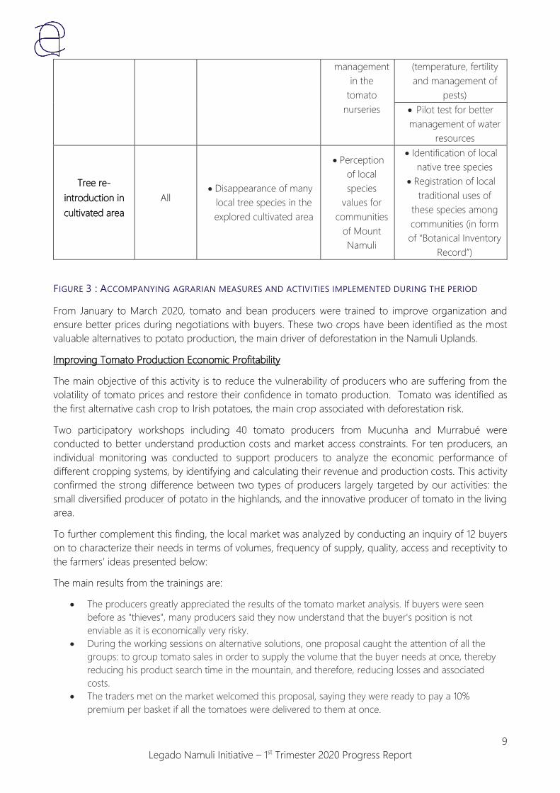
Legado Namuli Initiative – 1st Trimester 2020 Progress Report
9
management
in the
tomato
nurseries
(temperature, fertility
and management of
pests)
Pilot test for better
management of water
resources
Tree re-
introduction in
cultivated area
All Disappearance of many
local tree species in the
explored cultivated area
Perception
of local
species
values for
communities
of Mount
Namuli
Identification of local
native tree species
Registration of local
traditional uses of
these species among
communities (in form
of “Botanical Inventory
Record”)
FIGURE 3 : ACCOMPANYING AGRARIAN MEASURES AND ACTIVITIES IMPLEMENTED DURING THE PERIOD
From January to March 2020, tomato and bean producers were trained to improve organization and
ensure better prices during negotiations with buyers. These two crops have been identified as the most
valuable alternatives to potato production, the main driver of deforestation in the Namuli Uplands.
Improving Tomato Production Economic Profitability
The main objective of this activity is to reduce the vulnerability of producers who are suffering from the
volatility of tomato prices and restore their confidence in tomato production. Tomato was identified as
the first alternative cash crop to Irish potatoes, the main crop associated with deforestation risk.
Two participatory workshops including 40 tomato producers from Mucunha and Murrabué were
conducted to better understand production costs and market access constraints. For ten producers, an
individual monitoring was conducted to support producers to analyze the economic performance of
different cropping systems, by identifying and calculating their revenue and production costs. This activity
confirmed the strong difference between two types of producers largely targeted by our activities: the
small diversified producer of potato in the highlands, and the innovative producer of tomato in the living
area.
To further complement this finding, the local market was analyzed by conducting an inquiry of 12 buyers
on to characterize their needs in terms of volumes, frequency of supply, quality, access and receptivity to
the farmers’ ideas presented below:
The main results from the trainings are:
The producers greatly appreciated the results of the tomato market analysis. If buyers were seen
before as "thieves", many producers said they now understand that the buyer's position is not
enviable as it is economically very risky.
During the working sessions on alternative solutions, one proposal caught the attention of all the
groups: to group tomato sales in order to supply the volume that the buyer needs at once, thereby
reducing his product search time in the mountain, and therefore, reducing losses and associated
costs.
The traders met on the market welcomed this proposal, saying they were ready to pay a 10%
premium per basket if all the tomatoes were delivered to them at once.

Legado Namuli Initiative – 1st Trimester 2020 Progress Report
10
Some "innovative" producers took the lead individually and began to buy tomatoes from their
neighbors (at the same price as urban buyers) to sell them on their own directly to regional cities.
These results will support next year’s tomato campaign to continue to support the farmers’ improved
access to market and selling of their product.
Improve Farmers Organization and Market Linkage
FIGURE 4 : TOMATO MARKET STRATEGY FOCUS GROUP
SHARING LOCAL TEA, MURRABUÉ SEDE, JANUARY 2020
FIGURE 5 : TRAINING PRODUCERS TO
TRADERS’ QUALITY DEMANDS,
MURRABUÉ SEDE, JANUARY 2020
Improving Bean Production and Promoting Access to Seeds
Common beans, mostly grown in the Mucunha region, are a high value-added cash crop that bring in
cash at the end of the lean season (March). For specific types of agricultural households, especially the
small diversified farmers, supporting the bean sector makes it possible to diversify agricultural production
systems and reduce dependence on the income of late potatoes at the end of the lean season.

Legado Namuli Initiative – 1st Trimester 2020 Progress Report
11
FIGURE 6 : BEAN SEEDING
We continued to provide technical support to our producers during the campaign to follow the results of
the previous bean seed distribution and to enhance our understanding of bean production constraints in
the field:
Monitoring 51 producers from Murresse, Murrabué Sede, Chipe and Curuca during the campaign.
Yield weighing protocol and market access surveys with the 51 producers monitored to complete the
2019-2020 bean campaign.
FIGURE 7 : BEAN HARVEST AND RESULT
This year the rains were very late. This favored the emergence and growth of the bean sown in mid-
November in moist soil. Furthermore, the heavy rains at the end of December were particularly violent
this year. Many farmers reported yellowing of leaves and wilting of plants on a large scale (Figure 9,
Figure 10). Field visits have identified root rot as the cause of these symptoms (Figure 10). However, the
hypotheses of attacks by the bean fly (Ophiomyia spencerella) or the fungus Fuzarium solanii could not
be verified. It is highly likely that the waterlogged soils were enough to cause the root rot without
pressure from pests elsewhere. Farmers have been advised to pile soil at the base of plants to help
develop new roots above the infected areas and allow the plants to continue to absorb nutrients. The
protocol for weighing the bean harvested by our producers is ongoing.

Legado Namuli Initiative – 1st Trimester 2020 Progress Report
12
Enhance Our Understanding of Bean Production Constraints
FIGURE 8 : YELLOWING OF LEAVES
AND WILTING OF PLANTS
FIGURE 9 : ROOT OBSERVATION
One of the main factors limiting bean production in the area is access to seeds. Therefore, following the
bean harvest, our work focused on improving seed conservation practices. Six participatory trainings with
26 producers were organized in Murrece, Murrabué Sede, Chipe and Curuca to better understand
traditional seed drying and conservation practices and provide the producers with the tools they need to
independently design solutions to their problems.
During the workshops, the producers all expressed constraints related to seed conservation during the
rainy season (weevils, rotting, germination in the bag, etc.). Some, however, shared innovative techniques
such as using ash to absorb moisture in the seed bag or using local plant Tephrosia vogelii powder as a
natural insecticide against weevils (Figure 10 and Figure 11). The merits of these “traditional” techniques
were explained to the producers.

Legado Namuli Initiative – 1st Trimester 2020 Progress Report
13
How to Conserve Our Seeds with Local Material ?
FIGURE 10 : USE OF ASHES IN THE SEED BAG TO
REDUCE HUMIDITY
FIGURE 11 : USE OF "NAMAHUCO" POWDER
AGAINST INSECTS
Participatory Workshops to Design Solar Seed Dryers with and for the Farmers
Beyond conservation, the specific drying process (which takes place during the rainy season) was identified
as problematic.
Six workshops were conducted with 26 producers in Murrece, Murrabué Sede, Chipe and Curuca to explain
to producers some determining factors in the drying process and to design a dryer prototype. A model
was used to support the farmers’ understanding of the process of water migration between seeds and air
during the drying process. Producers noted the importance of air circulation, as well as the necessity to
protect seeds in cases of high humidity.
As a conclusion of the solar bean drying workshops, solutions were identified together during focus groups
with farmers to design two drying tables (fixed and mobile models):
One outside to take advantage of solar energy on sunny days,
One indoors (in the kitchen) for the night and rainy days. This second table can also be useful to stock
the seed bag during storage.
We called for volunteers to build prototypes in their homes. A total of six prototypes were built with 21
farmers (1 in Murece, 2 in Murrabué Sede, 1 in Chipe, 2 in Curuca) in six volunteer producers’ houses. These
collective construction sessions were very welcomed by the community.

Legado Namuli Initiative – 1st Trimester 2020 Progress Report
14
FIGURE 12 : COLLECTIVE DRYER CONSTRUCTION SESSIONS
Drying Device Designed by the Different Groups (Common Principle)
FIGURE 13 : OUTSIDE AND INSIDE DRYING TABLE
TO TAKE ADVANTAGE OF THE HEAT AND SMOKE
FROM THE FIRE
FIGURE 14 : THE INTERIOR DRYING TABLE ALSO
HELPS FOR STORAGE OF SEED BAGS (HEAT AND
SMOKE)
2.1.1. Pilot Test in Conservation Agriculture
Some tests on specific aspects of agricultural challenges have been implemented within the communities.
They concern tomato BioPestice (2019) as well as pilot work for management of domestic cassava
“woodparks” and collective construction of solar dryer prototypes for beans.
Test of a Local Biopesticide Formula Against Agrotis Ipsilon in Tomato Plots (Six tests)
A test protocol was implemented with six farmers (including control plots and test plots) in Murrece,
Murrabué Sede and Chipe. Among the six producers selected, only three allowed us to collect reliable
data throughout the campaign.

Legado Namuli Initiative – 1st Trimester 2020 Progress Report
15
Management of Domestic “Woodparks” for Healthy Cassava Cuttings Multiplication
Most of the population around Namuli area depends on cassava, along with corn, as a base of their diet.
We noticed poor cassava yields due to high ACMV (African Cassava Mosaic Virus) pressure and loss of
fertility in cassava plots. Furthermore, food autonomy stands problematic during the lean period (between
November and March) and farmers rely on potato incomes (cultivated into forest) to buy dried cassava.
The objective is thus to test the management of domestic “woodparks” for healthy cassava cuttings
multiplications in order to:
Build awareness for producers about how the ACMV (African Cassava Mosaic Virus) is propagated,
Promote good practices for the multiplication of cassava by cuttings to stop the spread of the
disease,
Guarantee to the most affected producers a pool of healthy cuttings for the 2020 planting campaign.
The multiplication test plots were set up with three pilot producers for a pilot experimental work on the
creation of “woodparks” (in Murrece, Chipe and Curuca). Producers were unaware that they were
contributing to the spread of the disease by reusing contaminated cuttings in their plots. Curiously, the
large highland potato producers exerting the greatest pressure on the forest and dependent on the
highlands’ potato income to meet their needs, were very interested in the training. At present, the cassava
plants have already sprouted.
Pilot Test of Prevention against African Cassava Mosaic Virus
FIGURE 15 : SELECTION OF HEALTHY CASSAVA
CUTTINGS WITH JOSSINA SAMUEL, MURRECE,
FEBRUARY 2020
FIGURE 16 : PLANTING SELECTED CUTTINGS IN
THE « WOODPARK » OF JOAQUIM SAIDE,
CURUCA, FEBRUARY 2020

Legado Namuli Initiative – 1st Trimester 2020 Progress Report
16
2.1.2. Honey Value Chain Development
FIGURE 17 : DOMINGOS MAITA CARRYING HIS SECOND HIVE TO INSTALL IN HIS APIARY LOCATED AT THE
FOOT OF MOUNT NAMULI
Apiculture activities continued to be implemented during the rainy season. The main activities consisted of
regular technical support to beneficiaries. The objective was to visit each beneficiary once every 3 weeks
to continue training and provide the best advice possible, strengthening their apiary based on the following
aspects:
Beehive monitoring and colony inspection
Continued installation of beehives in the apiaries (Objective: Three hives per apiary)
Transfer of capture box swarms into beehives
Strengthening apiary school
Beekeeper Name Locality New Beehives Installed Swarm Transfers
Ernesto Abílio Murrece 2 2
Domingos Maita Mucunha 1 1
Ramussa
Chicopera
Mucunha 1 1
Mário Januário Mucunha 1 0
Evaristo Joaquim Curuca 1 0
TOTAL 6 4
FIGURE 18 : NUMBER OF NEW BEEHIVES INSTALLED AND SWARM TRANSFERS COMPETED (01/01 –
03/31/2020)

Legado Namuli Initiative – 1st Trimester 2020 Progress Report
17
FIGURE 19 : BEEHIVE INSPECTION AT THE APIARY SCHOOL
Despite the restrictions caused by the heavy rains, the monitoring work in the field continued. Despite the
weather constraints, the number of honeybee colonies increased as a result of successful captures, which
positively surprised the team and motivated beneficiaries to keep working and taking care of the apiaries.
The technical assistance was successful, supporting the beneficiaries to find local solutions, such as:
Protecting the beehives with natural fibers and bamboo (Figure 22)
Recycling water bottles to protect the beehives against attacks by ants (Figure 22)
Making better beeswax sheets to improve the production of honey (Figure 21)
Create bee feeders with recyclable products and follower boards to strengthen weak colonies (Figure
20)
During this stage, the successful monitoring allowed the team to carry out the proper inspections of the
hives, avoiding depopulation and furthermore, to prepare some beehives for the first harvest at the end
of April.
FIGURE 20 : BEEFEEDER AND FOLLOWER BOARD

Legado Namuli Initiative – 1st Trimester 2020 Progress Report
18
FIGURE 21 (LEFT TO RIGHT) : USE OF LOCAL RESOURCES: ROOF OF NATURAL FIBER, RECYCLABLE PLASTIC
BOTTLE, NATURAL BEEWAX SHEETS
Apiculture Beneficiary Updates:
Beekeeper Name Locality Total Beevived
installed
Total swarms
transfers
Occupied
beehives
(31/03/20)
Captures boxes
occupieds
31/03/20
Ernesto Abílio Murrece 4 4 4
Arina Namahua Murrabue-Sede 1 1
Rosita Faustino Murrabue-Sede 1 1 1
Benito Costa Murrabue-Sede 1 1 1 1
Juliana Damião Murrece
Basilio Rafael Mukite Murrece 1
Zecas Vinte Murrece 1 1* 0
Waissone Murrece 1 1* 0
Eliseo Eugênio Murrece 1 1 1
Álvaro Mucunha 1 1 1
Domingos Maita Mucunha 2 2 2
Ramussa Chicopera Mucunha 2 2 2 1
Mário Januário Mucunha 2 1 1 1
Inácio Joseph Curuca 1 1*
Evaristo Joaquim Curuca 1 1
Celestino Hilário Curuca 1 1 1
Juana Macaula Chipe 1 1 1 1
Antonio Massanto Chipe 1 0 1
Yoyane Januário Chipe 1 1 1 0
TOTAL 24 19 16 7
FIGURE 22 : ACTUAL BEEKEEPERS SITUATION (*SWARM TRANSFERS REALIZED BUT DEPOPULATED HIVE)

Legado Namuli Initiative – 1st Trimester 2020 Progress Report
19
Next steps:
Sign the Terms of Reference with beekeepers to specify responsibilities and counterparts, notably for
forest and tree preservation around apiaries and the minimum price for honey commercialization
First honey harvest during the 2nd trimester
Continued installation of beehives with the objective of three hives/beekeeper and five beehives for
the apiary school
Beekeepers share experience in community workshops
Reinforce Natural Resource Management Committee and honey beekeeper’s mobilization to prevent
wildfire
2.2. Objective 2: A Conservation Agreement, including a Moratorium on Deforestation
in the Upper Elevations is Implemented
2.2.1. Negotiation of a Conservation Agreement
To structure the future conservation agreement, we are introducing the principles of Conservation
Agreement activity based on the counterpart of social benefit programs. The Conservation Agreement
will be implemented with the four core communities in the Namuli area: Mucunha, Murrabue, Carico, and
Murrece.
We have focused our awareness building activities in Mucunha and Murrabue, two key communities where
deforestation and natural resource issues are vital.
Meeting with the Chief of Locality of the area (Mucunha Sede), and the main leaders of four core
communities.
Meetings in the sub-divisions of the communities, with local leaders and producers (Mucunha: 8
meetings with 96 people, of whom 46 were women; Murrabue: 4 meetings with 128 people, of whom
52 were women)
During these meetings, we worked together with community members to establish a collective vision of
the Legado Namuli Program, as well as the importance of the Natural Resource Management Committee’s
leadership as the central role in the land delimitation process, development of land use plan, and the
potential establishment of a Community Conservation Area.
Most of the communities welcome the program as a way to improve the future management of their
natural resources. However, in the sub-division of Chipe and Curuca, where producers’ incomes rely heavily
on potato production in Namuli’s highland forests, more questions were raised about the project and still
require additional awareness building to clarify that the ongoing process will allow them to secure their
land rights as a first step in the process.
Secondly, we have supported the revitalized NRMCs through capacity building trainings covering topics
such as Leadership, Legal Framework (Mozambican Land and Conservation Law), and Natural Resource
Management. We organized 10 meetings with the different NRMCs involving 219 people of whom 69 were
women.
Finally, we intend to amplify community understanding of their natural interdependence with the Namuli
Uplands to recognize and leverage the collective responsibility to ensure that future generations have
access to the Namuli natural resources they are currently relying on. This will be achieved through the

Legado Namuli Initiative – 1st Trimester 2020 Progress Report
20
implementation of participatory community events around socio-environmental thematic, planned and
implemented by leaders from the Natural Resource Management Committees, together with the Legado
Namuli team.
2.2.2. Implementation of the Conservation Agreement
See above Methodology for the Negotiation and Implementation of the Conservation Agreement.
2.2.3. Social Benefits Programming Launched within a Developing Framework of a
Conservation Agreement
Social benefits programming is the foundation of the Conservation Agreement development process.
Legado Namuli is developing this framework as a counterpart to build support for local Namuli
communities in the establishment of the Community Conservation Area, while providing viable incentives
and economic alternatives to support livelihoods. We are exploring these alternatives within apiculture
and agriculture programming, as well as through the land tenure process with community vision and goal
development.
Within apiculture programming, we are developing specific values to:
Emphasize awareness and communication with the communities about honey activities
Install apiaries close to threatened forests
Establish a community apiary (Land Use Plan) close to Namuli Forest, threatened by uncontrolled fires
and advancement of opening fields
Encourage strategic planting of plant and tree species that support honey production near the apiary;
Encourage the protection of apiaries against uncontrolled fires
These values have been included in the Terms of Reference that will be submitted to each beekeeper in
counterpart for our assistance for promoting apiculture, furnishing all the training and material for
beekeepers (including hives and capture boxes), as well as guaranteeing them a market for honey and wax
with a minimum price point. This Term of Reference for beekeepers could be seen as an “individual”
conservation agreement model. Beneficiaries receive materials to carry out apiculture activities; however,
if they do not comply with their obligations, the project will stop support to those beneficiaries and focus
technical support and training on other interested community members.
The same type of agreement is required for agriculture, as beneficiaries should practice controlled fire use.
Tree Nursery and Tree Introduction
As part of the Conservation Agreement, we are challenging the communities to restore sensitive and
degraded areas through a restoration process that we are building out with community-run nurseries and
seedling distribution. This will include native trees in restoration areas, as well as agroforestry-oriented
species near living areas and agricultural lands, such as edible fruits, shade trees, species for
energy/construction, melliferous species, as well as species that protect and improve soils for agricultural
production.
Community nurseries

Legado Namuli Initiative – 1st Trimester 2020 Progress Report
21
Two groups of individuals (2-4) with experience and interest in the production of seedlings,
demonstrated leadership through Vision and Goal Development in the Legacy Leadership
Program (Legacy Leaders), and involvement in the NRMC were chosen from the two Namuli
priority communities (Mucunha and Murrabue) to lead the establishment of community
nurseries. Some members of the NRMC have been identified, such as Sr. Alvaro Caturia,
President of Mucunha’s NRMC
Individuals are supported with technical guidance for construction of nursery structures
Development of nursery methodology and terms of reference to build capacity and incentivize
local seedling production and plan for integration with NRMC structure
Beneficiaries of seedling distribution
Development and planning for future seedling distribution to incentivize leadership and
involvement in NRMC, as well as beekeepers, innovative farmers and community members
interested in reforestation or seedling planting
2.3. Objective 3: A Meaningful Landscape Strategy is Developed to Prioritize Site
Interventions, Preserve Ecosystem Services and Prevent Fire Dissemination in the
Namuli’s Upper Elevations
2.3.1. Mapping of Forest Clusters and Rapid Ecosystem Services Evaluation
(Water/Biodiversity/Erosion)
In order to analyze landscape priorities and identify main intervention areas, the Nitidae Lab has created
four different maps:
The Land Use and Land Cover of the Namuli Core Area in 2018 (
Multi-Level Information Map combines all land use and land cover information with administrative
infrastructure to support applied use of maps in community land use planning (hydrographic network
derived from slope analysis)
Map 1) can be broadly categorized into six main classes: forest, grassland, cropland area, secondary
vegetation or woodland, flooded area and other areas. Remaining forest areas cover 949 ha and
account for 28% of the Namuli Core Area. The area of secondary vegetation of woodland, which can
be natural area or area partially cleared, cultivated or frequently affected by fire, cover 1 735 ha or
50% of the Namuli Core Area.
o See annex 1 for the full details technical methodology used for the map elaboration.
o See annex 2 for the details analyze between Nitidae Land Use and Land Cover 2018 Map and
previous forest monitoring realized in Namuli with Global forest Watch.
Land Productivity Trend Map helps identify areas that are on a trajectory of degradation (decrease of
land productivity, red pixel) or restoration (increase of productivity, green pixel).
Threatened Area and Deforestation Risk Map combines land use cover info and other potential driver
criteria, such as slope, elevation, wetness index, distances to villages and roads, etc.
Multi-Level Information Map combines all land use and land cover information with administrative
infrastructure to support applied use of maps in community land use planning (hydrographic network
derived from slope analysis)

Legado Namuli Initiative – 1st Trimester 2020 Progress Report
22
MAP 1 : LAND USE AND LAND COVER MAP 2018

Legado Namuli Initiative – 1st Trimester 2020 Progress Report
23
MAP 2 : ANNUAL LAND PRODUCTIVITY TRENDS (2001-2016) IN NAMULI
MAP 3 : NAMULI CORE AREA DEFORESTATION RISK

Legado Namuli Initiative – 1st Trimester 2020 Progress Report
24
Combining the different information with the Administration Data Set, such as schools, villages, markets
and other infrastructure will permit to edit a readable map to best prepare the team to animate land use
discussion at community level.
MAP 4 : MULTI-LEVEL INFORMATION MAP BASED ON LULC 2018 MAP
2.3.2. Identification and Prioritization of Adequate Site Interventions (Agriculture,
Potential for Restoration) and Design of a Firewall Network
Through the landscape analysis described above, in addition to field work on the ground, the project has
identified:
Suitable areas for installation of apiaries
Priority communities and sub-divisions to develop conservation agriculture support
Degraded lands that have potential for ecological restoration (including riparian forests) or
agroforestry system (see Tree Landscape Strategy below)
Beekeeping and conservation agriculture are already being implemented in identified areas.
The delimitation process, including the land use plan will aim, through this participatory process, to achieve
a community commitment to define land-use, including buffer areas and potential for restoration, as well
as a firewall network. Map 4 (above) underlines the importance of water sources in the highland forest and
the high risk deforestation in those areas. Buffer areas should be applied in high risk of deforestation and
restoration in degraded areas, as well as riverbanks.

Legado Namuli Initiative – 1st Trimester 2020 Progress Report
25
Development of a Tree Introduction Landscape Strategy
Interactive “Trees are Life” game was developed as part of the Legacy Leadership Methodology to spark
community reflection and discussion around the local importance of trees and the identification of locally
relevant species, with a particular emphasis on native forest trees important for community livelihoods.
This game was carried out with the Natural Resource Management Committees of Mucunha and Murrabue
(17th and 18th March in Murrabue – 28 people and Mucunha – 28 people). Community responses were
collected regarding local species names, location, and local uses and registered in the “Namuli Useful
Species” database.
FIGURE 23 : SR. ALVARO, MUCUNHA NMRC’S PRESIDENT DURING « TREES ARE LIFE » PRESENTATION
This information will be utilized to create a strategic Tree Introduction Landscape Strategy that integrates
local knowledge and locally relevant species, including native species. Useful species information will also
be consulted for the species produced in the Community-run nurseries. In that way, working closely with
agricultural leaders and Natural Resources Management Committees has helped us to identify potential
reforestation areas and nursery locations in Mucunha and Murrabue. Following the “Trees are Life game”,
40 acacias were planted in public areas in Mucunha and Murrabue with the NMRCs as leaders in the
initiative, community-wide. Their leadership will continue to play a key role in the successful
implementation of the Tree Introduction Landscape Strategy and Land-Use Plan.
2.3.3. Design, Building and Maintenance of Firewall Network with Communities
Fire mainly occurs during the dry season, from June to December. The strategy is to build community
awareness through work with individual beneficiaries and capacity building of NRMCs to prevent fire
dissemination for a broad community mobilization against uncontrolled fire. NRMCs will be trained in fire
control methodologies by the Legado: Namuli Field Team. The NRMC will then work at community level

Legado Namuli Initiative – 1st Trimester 2020 Progress Report
26
to disseminate knowledge, supported by the Legado: Namuli Field Team. This will integrate leaders from
across Namuli's communities, emphasizing the involvement of the beekeepers.
Our intervention through agriculture and apiculture activities always focus on the importance of fire control
and prevention. For example, cleaning around the apiaries is obligatory to prevent fire destruction; it’s
also foreseen as part of the individual agreement terms with beekeepers. The vision of apiculture activities
is that the area around the apiaries will be protected from uncontrolled fires, and the implementation of
apiaries is thought to serve as a firebreak around sensitive areas and remains of forests. In agriculture,
improved practices are promoted to not use fires, or to use control fires.
2.3.4. Systematic Deforestation Monitoring through Drone Observation
Monitoring of forest cover will be conducted with an update of the Land Use and Land Cover 2018 Map.
The occurrence of wildfire will be monitored through MODIS, and the Nitidae Lab is evaluating the use of
other high-precision technology for monitoring of wildfire incidence.
A mission will be planned, when possible, to train the team about the protocol to monitor forest cover in
uplands through regular drone surveys.
2.4. Objective 4: Reinforce Community Land Rights and Promoting Local Decision-
Making on Land and Natural Resource Management
2.4.1. Delimitation and Local Mapping & Certification of 10 Communities and 4000
Household Land Rights
The land delimitation initiative funded by Land Tenure Facility, is being implemented in collaboration with
two partner organizations. ORAM is the Mozambican NGO responsible for the work on the ground in two
other districts (Ilé neighborhood district to Gurué, and in Angoche coastal area of Nampula Province. Terra
Firma is a company developing all technical and GIS support for the implementation of the CaVaTeCo
(Cadeia de Valores das Terras Comunitarias or Community Land Value Chain) methodology. The
CaVaTeCO approach seeks to put the community as the lead for clarifying land community rights and
limits, reinforce ongoing work with Natural Resource Management Committees to build capacity, and a
community vision for the development of natural resource management principles based on the
elaboration of participatory land-use plans.
IMPORTANT:
Objective 4 results and activities of CaVaTeCo project (delimit 10 communities surrounding Mt. Namuli,
4000 individuals’ household plots) are funded by Land Tenure Facility only and are not part of the
contract agreement between Nitidae and Rainforest Trust. Nevertheless, as Legado Namuli is an
integrated program, these activities are presented below to allow an overall vision and understanding of
Legado Namuli program vision, strategy and progresses.

Legado Namuli Initiative – 1st Trimester 2020 Progress Report
27
The final objective of CaVaTeCo project is to delimit the boundaries of 10 communities surrounding Mt.
Namuli, including the four key communities for the community conservation area, as well as the
delimitation of 4000 individuals’ household plots. The Legado Namuli Project has previously worked in 8
of the 10 defined communities. Map 5 shows the eight main communities where the Land Tenure Program
will be implemented (Murrece – close to Gurue Sede, Murrabué, Murrui, Nawitela, Nicau, Mujaua,
Mucunha, Carico) ; the two additional communities that will benefit the program ( Nintulo and Veiua) are
situated northwest of current Legado Namuli communities, bordering Mujaua and Nicau.
MAP 5 : MAIN COMMUNITIES FOR DELIMITATION
The first step is the divulgation of information about the land delimitation process based on existing
Mozambican law at the community level, to ensure that all communities know and understand the
objectives of the land delimitation process, how this will help them secure their land rights and to raise
concerns regarding the process. To date, the approach has been introduced to all sub-divisions (“cells”) of
those communities:
Murrui: 7 cells
Nawitela: 9 cells
Mucunha: 8 cells
Murruabue: 12 cells
Observations about the LTF Project Presentation Among the Communities:

Legado Namuli Initiative – 1st Trimester 2020 Progress Report
28
Murrabué
The general presentation in the community of Murrabué was carried out successfully. There were,
however, some concerns raised regarding conflicting community limits with the lands of privately-owned
tea plantations. Main concerns come from two sub-divisions, Chipe and Curuca, which have presented
resistance to the project, due to the sensibility of the producers in these two areas who depend on potato
production for their main income, directly dependent on Namuli’s upland forests. We also identified
conflicting limits with other surrounding communities. Conflict resolution around community limits is an
objective of the land delimitation process, and thus, identification of these conflicts is a key step in the
process.
Mucunha
The Land Tenure Facility initiative was well received in the community of Mucunha. The biggest concern
of the population is the land conflict with a private tea company having a land title in the community’s
perceived limits. During the war, the community occupied a part of the tea company area and they now
fear the company could get it back after 30 years of occupation. Producers have reported that they feel
threatened by the company which has forbidden them to open new fields and a local milling plant. The
community of Mucunha has asked for the project for help to solve the land occupation problem they have
with the company. The community also has limit conflicts with other bordering communities. It is important
to note that the Legado Namuli Project will act as a neutral mediator in the conflict resolution process,
seeking necessary government support for resolution.
Murrui e Nawitela
These communities have access problems and are less populated (distant sub-divisions). Murrui is divided
into two parts because of the Malema River and access to Murrui 2 (the farther part) is complicated.
However, the communities are open to the project and promise to give all possible support for the
materialization of the land delimitation process. As seen in other communities, there are no defined
boundaries with some of the surrounding communities.
Next Steps
Begin land delimitation process in communities
Hire local auxiliaries to facilitate land delimitation process, as well as the household fields’ delimitation,
included in the LTF program (the dialogue between the different communities under a clear process
should help clarify and resolve the conflicts of communities regarding boundaries)
Regarding conflicts with the private tea company, Legado Namuli will not act as a negotiator, but
rather serve as an intermediary between producers, companies and the district government, with the
District government being the only legitimate authority that can resolve land conflict.
CaVaTeCo process will offer a forum for the different stakeholders discuss and find solutions. It is
planned to organize a meeting with the District Administrator during the 2nd trimester
2.4.2. Finalization of Natural Resources Management Committees Formalization
Following the introduction of the project to all communities, the Field Team is working to revitalize the
Natural Resource Management Committees. These six committees were established by the Legado Namuli
project and Lupa in 2017; however, they were not fully functional and lacked equal representation across
sub-divisions (number of “cells”) and gender.

Legado Namuli Initiative – 1st Trimester 2020 Progress Report
29
Community Nawitela Murrui Mucunha Murruabue Nicau Mujaua
Cell numbers 9 7 8 12 7 14
Members numbers 24 17 22 15 17 29
Women representativity
33% 53% 45% 13% 53% 38%
Cell representativity 56% 71% 38% 58% 57% 29%
FIGURE 24 : NAMULI NMRCS INITIAL REPRESENTATIVENESS BEFORE REVITALIZATION (ONGOING ACTIVITY)
One of the main objectives of the project is to revitalize and restructure the committees. The process
involves encouraging and supporting equal representation from all neighborhoods within each
community, as well as increasing female representation. The restructuring of these committees is built
upon the understanding that the committees are independent, community-led associations that should
and will continue to function independent of the Legado: Namuli project. This encourages the sustainability
and ownership of the NRMC at the community level. Furthermore, the NRMC serve as representatives for
the unified voice of the community as a whole and leaders from the NRMC will work as community
facilitators during the land delimitation process. These leaders will be key in completing community
mapping, guaranteeing community acceptance and understanding of delimitation goals, household land
tenure mapping, land use planning and conservation agreement development.
We trained the four Natural Resource Management Committees (Mucunha, Nawitela, Murrui and
Murrabué) through capacity building training covering topics such as Leadership, Legal Framework
(Mozambican Land and Conservation Law), and Natural Resource Management. We organized 10
meetings with the different NRMCs involving 219 people of whom 69 women. The actions implemented
with the four NMRCs include:
Meeting about Land Tenure process, involving the role of the committees in the process
Surveying the members constituting the NRMCs
Training and revitalization on leadership and association governance, emphasis on new members and
increased female representation
Workshop for association nomenclature, statutes and institution
Training on Mozambican Land Law, and legislation regarding the new Conservation Law
Registration of new status and members
Next steps
Continued training on Mozambican Land Law, and legislation about the new Conservation Law
Once committees are fully operational, we will move forward on the delimitation process, private
producers land delimitation and Land Use Planning and Natural Resource Management workshops
with communities.
Introduce Land Tenure process to the communities of Carico and Murrece
Awareness building regarding the delimitation process and importance of the NMRC
NRMCs will continue to be trained in Legacy Modules and participate in the organization of
community events and communication of material at community level on environmentally relevant
topics

Legado Namuli Initiative – 1st Trimester 2020 Progress Report
30
2.4.3. Landscape Plan Use with Communities
Landscape plan use is part of the global strategy for defining a natural resource management strategy with
the communities, as well as agricultural areas, reforestation areas, firebreaks and conservation areas.
For the second trimester, with the support of Nitidae Lab in France a series of analytical maps (as presented
above) will be developed that associate a main “raw” map (presenting the physical information but no land
use) that will serve as a tool to prepare the team to carry out the Land Use Plan exercise, before being
responsible for the animation of discussions with the communities during the participatory elaboration of the
Land Use map. Through environmental education, vision and goal development and awareness building
through the Legacy Leadership programming, we will continue to discuss with communities the importance
of ecosystems and natural resource for their present and future livelihoods.
The elaboration of participatory land use plan by local communities will be realized primarily in the four
priority communities for upper land forests conservation after the delimitation process is finished.
2.5. Objective 5: Creation of a Community Conservation Area
2.5.1. Land Delimitation - Identify Core Community Conservation Area and Buffer
Zone
The Core Conservation Area is physically mapped (see section 2.3.1). However, negotiation with
communities for the conservation agreement and workshop during Land Use Planning could change the
delimitation of the core area. The delimitation process of the core area with the communities must be in
accordance with the Conservation Law.
2.5.2. Negotiation of a Management Plan for the Conservation Area
Our intervention strategy for the Management Plan is a multi-tier approach utilizing Community Vision
and Goal Development with the underlying goal of cultivating individual leadership throughout
communities that move from the level of the individual to the communal level, accelerating community
understanding and the conservation of Mount Namuli’s forests, ecosystem and natural resources.
We will work with communities to develop a community vision that will be used in defining land-use
planning, leadership, and management of the potential Community Conservation Area.
2.5.3. Secure ANAC Support for the Community Conservation Area
N/A
2.5.4. Early Stage Engagement with ANAC to Clarify the Intention to Create a
Community Conservation Area
N/A

Legado Namuli Initiative – 1st Trimester 2020 Progress Report
31
2.5.5. Engagement with Local District Government Officials to Secure Support for PA
Creation
A meeting was organized on 11/13/2019 with local District Government totaling 19 people – including the
District Administrator, District Service for Agriculture (SDAE), Sub-District leaders and the main leaders of
the Namuli communities to present the whole CaVaTeCo process. Local leaders are highly involved in all
meetings, awareness building activities, and revitalization of NRMC in the communities.
2.5.6. Engagement with Provincial Government to Secure Support for Protected Area
(PA) Creation
A meeting with provincial authorities with our partner ORAM about the launching of Community
Delimitation projects was held, with the goal to implement Land Use Strategy. Present at this meeting were
the Provincial Cabinet Director, as well as the representative of the DPTADER (in charge of Protected Areas
at the Provincial level) and of Flora, Fauna and Forest Officers. We underlined the importance to preserve
Mount Namuli’s ecosystem while contributing to the local economy and that our multi-level activities in
the area aim toward this goal, and thus working in coordination with authorities is a priority.
2.5.7. Completion of Paperwork Required by Legislation for Proposal Submission to
ANAC
N/A
2.5.8. Submit Community Conservation Area Proposal to ANAC
N/A
2.5.9. ANAC Engagement with MITADER for PA Approval and Formal Recognition
N/A
2.5.10. Create and Operate a Community Patrolling Unit
Through our landscape strategy and nursery implementation methodology, as well as the integrated
Legacy Leadership programming we are identifying individuals with experience and interest in the
production of seedlings and sustainable natural resource management, as well as demonstrated leadership
through Vision and Goal Development and involvement in the NRMC. Those individuals could be
supported with technical guidance for monitoring seedling distribution and over a medium-term period,
included in a patrolling unit.
Within the Community Delimitation for the Land Tenure Facility Program, we will hire some local auxiliaries
living in the communities. These auxiliaries, if they demonstrate further interest and leadership in natural
resource management components of the Legado Namuli Project, they could also be included in a
patrolling unit.

Legado Namuli Initiative – 1st Trimester 2020 Progress Report
32
2.6. Project Objective 6: Stakeholder’s and Partners Coordination
Regarding the Land Tenure Facility project with partners ORAM and Terra Firma, Skype meetings are
organized twice a month for updating activity progress. ORAM made a two-day visit to Gurue on March
23-24 to share experiences regarding community land delimitation work and conflict resolution.
Legado Namuli program new office
Despite the difficulty of locating adequate office spaces in Gurue, the Legado Namuli team relocated to a
new and improved office in Gurue, offering all security for materials and space for meetings and receiving
partners.
FIGURE 25 : LEGADO NAMULI PROGRAM NEW OFFICE
Partnership and Project team composition changes
Following discussions late 2019 and early 2020, LUPA and Nitidae agreed to establish new principles to
ease the coordination and implementation of Legado Namuli program activities under the leadership of
Nitidae (as agreed under 2019 MoU between Legado, Lupa and Nitidae).
Therefore, previous LUPA Gurue field team members are now all directly contracted by Nitidae under Land
Tenue Facility or Rainforest Trust funds, most of LUPA Maputo team costs are also supported by Land
Tenue Facility.
Nitidae would like to discuss with Rainforest Trust possible readjustment regarding human resources
budget lines to better adjust team composition and project implementation efficiency.
Additionally, due to coronavirus pandemic, the recruitment of 2 additional field technicians has been put
on hold after the 1st round of interviews in March 2020.

Legado Namuli Initiative – 1st Trimester 2020 Progress Report
33
Coronavirus Pandemic
On March 30, President Nyusi of Mozambique announced the State of Emergency (Level 3 on 4 existing)
to prevent the spreading of Coronavirus in the country. Under the State of Emergency, it is no longer
possible to organize meetings or gatherings.
Given the circumstances, it was decided to pause all field activities within the communities to limit
community transmission of the virus and contact with the communities. Since March 31, the team is
assigned to conduct work from the Gurue office. We directly informed the District and local authorities,
community leaders, NRMC and beneficiaries about the impossibility of continuing field work.
FIGURE 26 : OFFICE HAND WASHING STATION
To maintain the contacts with the communities, contact beekeepers, farmers and NRMC members,
community representatives have been identified to ensure a channel of communication between
communities and the field team to be able to provide technical support by phone or during visits in Gurue
city to support, as possible, the continuity of ongoing activities.
The Legado Namuli team is totally committed to pursuing its work and its support to Namuli communities
and conservation efforts during this time.

Legado Namuli Initiative – 1st Trimester 2020 Progress Report
34
3_ Legacy Leadership Methodology: Integrative Behavior Change
Across All Programming
3.1. Integrated Programming In top of the technical support to develop sustainable livelihoods alternative, the Legacy Leadership
Methodology is the underlying behavior change framework for the Legado Namuli Project. Each of the
objectives of the program is supported by Behavior Change Methodology which accelerates leadership at
the individual level, creating the foundation for communities to be the force for creating meaningful
change at the communal level in line with achieving their individual and collective legacies.
The Legacy Leadership Methodology is being refined, cultivated and accelerated across all programming,
building agricultural leaders, leading beekeepers and strong Natural Resource Management Committees.
We are building pride through knowledge sharing and community collaborations and engaging in
outreach and communication through community events and communication materials.
In our land tenure work, communities are converging on their visions for their futures and their forests
through capacity building training and land use planning. In Natural Resource Management Committees
and community-wide, they are sharing their values and pride in their ecosystem through collaborative
trainings, participatory community events, discussions, games and simulations. In agriculture, innovative
farmers are participating in conservation agriculture trainings and experiments to find alternatives that
decrease their impact on the forest while increasing their income. Beekeepers are becoming guardians of
their hives and the forests where they stand.
In these ways, we are integrating local knowledge into strategic landscape planning, cultivating key farmers
and beekeepers as community leaders in the adoption of conservation practices, and building capacity in
environmentally conscious leaders to lead community initiatives for sustainable land and natural resource
management.
The Leadership Methodology is integrated and evident throughout the Legado Namuli programming and
throughout this report in:
Capacity Building of Natural Resource Management Committees
Amplifying Community Understanding through Community Events
Strategy for Elaboration of Participatory Land Use Plan
o Integrating Local Knowledge into Strategic Landscape Strategy
Social Benefits Programming
o Community Vision and Goal Building through Land Tenure and Conservation Agreement
o Tree Nursery and Tree Introduction (Legacy Leaders)
3.2. Legacy Modules: Environmental Education and Discussion The Legacy Modules are interactive and dynamic activities that share valuable information, engage
community reflection, spark community discussion, and showcase valuable local community knowledge
around leadership, the environment, agriculture and natural resource management. These modules are
currently being used to build capacity in the core group of Legacy Leaders (NRMC). The NRMC is trained
in the Legacy Module material and works with the Field Team to organize and implement a community-
wide event in which they are the organizers and the implementers. The Legacy Leadership programming
provides the opportunity for the Legacy Leaders to activate their leadership with dynamic community
engagement and spark community pride and collaboration through peer-to-peer communication.

Legado Namuli Initiative – 1st Trimester 2020 Progress Report
35
The Field Team, NRMC, and community members will work together to identify slogans, images, and
games related to the respective module material to inspire community engagement and create relevant
and resonant communication materials. The current modules include Trees are Life, The Ecosystem of
Mount Namuli’s Communities, History of Degradation, Sustainable Natural Resource Management, and
Fire Control.
FIGURE 27 (LEFT TO RIGHT) : COMMUNITY EVENT IN MURRECE ON LEGACY MODULE “TREES ARE LIFE” ;
COMMUNITY MEMBERS RAISE THEIR HANDS TO SHARE THE WAYS THAT TREES ARE IMPORTANT TO THEIR
LIVES AND LOCAL USES
3.3. Team Leadership The effectiveness of our work at the level of the communities is predicated by the strength of the leadership
within our team. The Legacy Leadership programming starts with the team’s shared values for
communication and achieving project objectives and is carried to the communities of Namuli.
At the team level, the Legado Namuli team participated in a Team Culture and Communication Training
run by Legado and Susanne Conrad from Lightyear in February. The training was Zoom-based and
involved the leadership of Legado, Nitidae and Lupa, and the Field Team. The training used the principles
of Legacy Leadership to build upon and improve team communications and continue to create a culture
of integrity, collaboration, communication and leadership.