planning application – major permits
TRANSCRIPT

Planning Application_Major Permit_5-2014 (web).docx Page 1 of 15
COMMUNITY AND ECONOMIC DEVELOPMENT DEPARTMENT
PLANNING DIVISION
P.O. Box 1609, Mammoth Lakes, CA 93546
Phone: (760) 965-3630 Fax: (760) 934-7493
www.townofmammothlakes.ca.gov
PLANNING APPLICATION – MAJOR PERMITS
__________________________________________________________________________________Name of applicant or agent Mailing Address
__________________________________________________________________________________E-Mail Address Phone Number
__________________________________________________________________________________Property Owner (if other than applicant) Mailing Address (property owner)
__________________________________________________________________________________E-Mail Address (property owner) Phone Number (property owner)
__________________________________________________________________________________Street Address Assessor Parcel Number(s)
__________________________________________________________________________________Zoning Lot Tract
Project Description
I CERTIFY UNDER PENALTY OF PERJURY that I am: _____ legal owner(s) of the subject property (allindividual owners must sign as their names appear on the deed to the land), _____ corporate officer(s)empowered to sign for the corporation, or _____ owner’s legal agent having Power of Attorney for this action (anotarized “Power of Attorney” document must accompany the application form), AND THAT THE FOREGOING ISTRUE AND CORRECT.
__________________ _____________________________________________________Date Name (Print) and Signature of Property Owner or Agent
__________________ _____________________________________________________Date Name (Print) and Signature of Property Owner or Agent
ARCHITECT/ENGINEER STATEMENT (If plans drawn by an architect/engineer):I certify that I have reviewed the applicable development plans for compliance with the requirements of the Townof Mammoth Lakes and such plans are designed in accordance with those regulations.
__________________ _____________________________________________________Date Name (Print) and Signature of Licensed Architect or Engineer
DUE TO INTAKE PROCESSING REQUIREMENTS, APPLICATIONS ARE ACCEPTED BY APPOINTMENTONLY AND MUST BE COMPLETE. INCOMPLETE APPLICATIONS WILL NOT BE ACCEPTED.
Planning Application_Major Permit_5-2014 Page 2 of 15
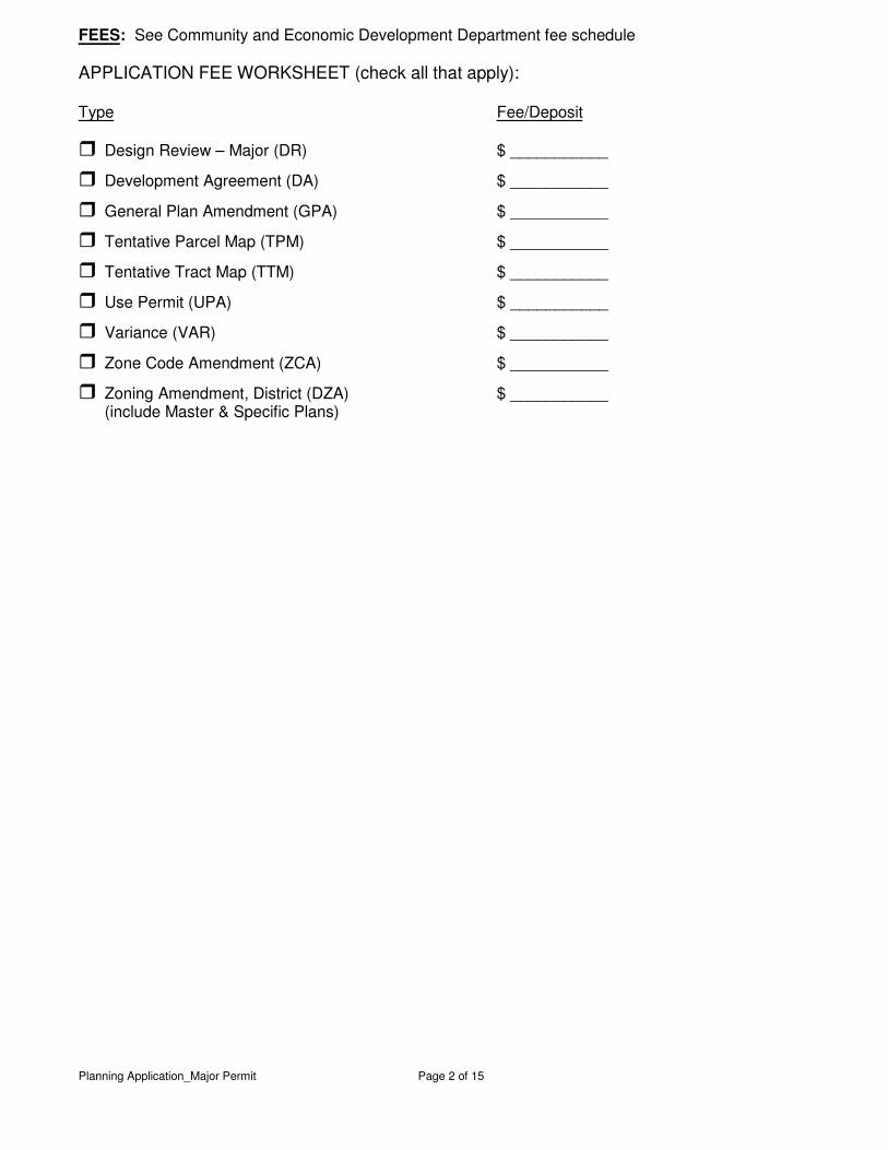
FEES: See Community and Economic Development Department fee schedule APPLICATION FEE WORKSHEET (check all that apply): Type Fee/Deposit
� Design Review – Major (DR) $ ___________
� Development Agreement (DA) $ ___________
� General Plan Amendment (GPA) $ ___________
� Tentative Parcel Map (TPM) $ ___________
� Tentative Tract Map (TTM) $ ___________
� Use Permit (UPA) $ ___________
� Variance (VAR) $ ___________
� Zone Code Amendment (ZCA) $ ___________
� Zoning Amendment, District (DZA) $ ___________ (include Master & Specific Plans)
Planning Application_Major Permit_5-2014 Page 3 of 15
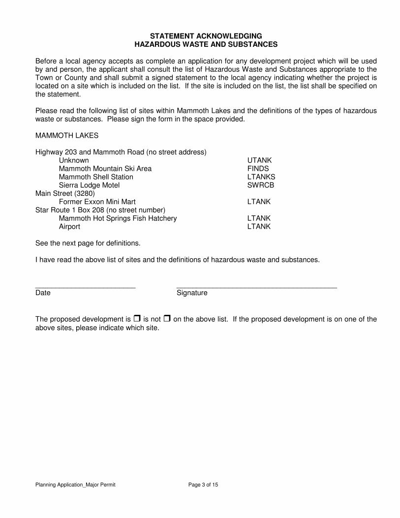
STATEMENT ACKNOWLEDGING HAZARDOUS WASTE AND SUBSTANCES
Before a local agency accepts as complete an application for any development project which will be used by and person, the applicant shall consult the list of Hazardous Waste and Substances appropriate to the Town or County and shall submit a signed statement to the local agency indicating whether the project is located on a site which is included on the list. If the site is included on the list, the list shall be specified on the statement. Please read the following list of sites within Mammoth Lakes and the definitions of the types of hazardous waste or substances. Please sign the form in the space provided. MAMMOTH LAKES Highway 203 and Mammoth Road (no street address) Unknown UTANK Mammoth Mountain Ski Area FINDS Mammoth Shell Station LTANKS Sierra Lodge Motel SWRCB Main Street (3280) Former Exxon Mini Mart LTANK Star Route 1 Box 208 (no street number) Mammoth Hot Springs Fish Hatchery LTANK Airport LTANK See the next page for definitions. I have read the above list of sites and the definitions of hazardous waste and substances. _________________________ ________________________________________ Date Signature The proposed development is � is not � on the above list. If the proposed development is on one of the above sites, please indicate which site.
Planning Application_Major Permit_5-2014 Page 4 of 15
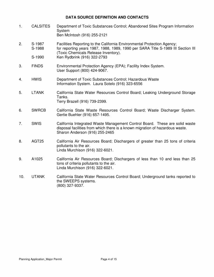
DATA SOURCE DEFINITION AND CONTACTS 1. CALSITES Department of Toxic Substances Control; Abandoned Sites Program Information
System Ben McIntosh (916) 255-2121 2. S-1987 Facilities Reporting to the California Environmental Protection Agency;
S-1988 for reporting years 1987, 1988, 1989, 1990 per SARA Title S-1989 III Section III (Toxic Chemicals Release Inventory).
S-1990 Ken Rydbrink (916) 322-2793
3. FINDS Environmental Protection Agency (EPA); Facility Index System. User Support (800) 424-9067. 4. HWIS Department of Toxic Substances Control; Hazardous Waste
Information System. Laura Sotelo (916) 323-6556 5. LTANK California State Water Resources Control Board; Leaking Underground Storage
Tanks. Terry Brazell (916) 739-2399. 6. SWRCB California State Waste Resources Control Board; Waste Discharger System.
Gertie Buehler (916) 657-1495. 7. SWIS California Integrated Waste Management Control Board. These are solid waste
disposal facilities from which there is a known migration of hazardous waste. Sharon Anderson (916) 255-2465 8. AGT25 California Air Resources Board; Dischargers of greater than 25 tons of criteria
pollutants to the air. Linda Murchison (916) 322-6021. 9. A1025 California Air Resources Board; Dischargers of less than 10 and less than 25
tons of criteria pollutants to the air. Linda Murchison (916) 322-6021. 10. UTANK California State Water Resources Control Board; Underground tanks reported to
the SWEEPS systems. (800) 327-9337.
Planning Application_Major Permit_5-2014 Page 5 of 15
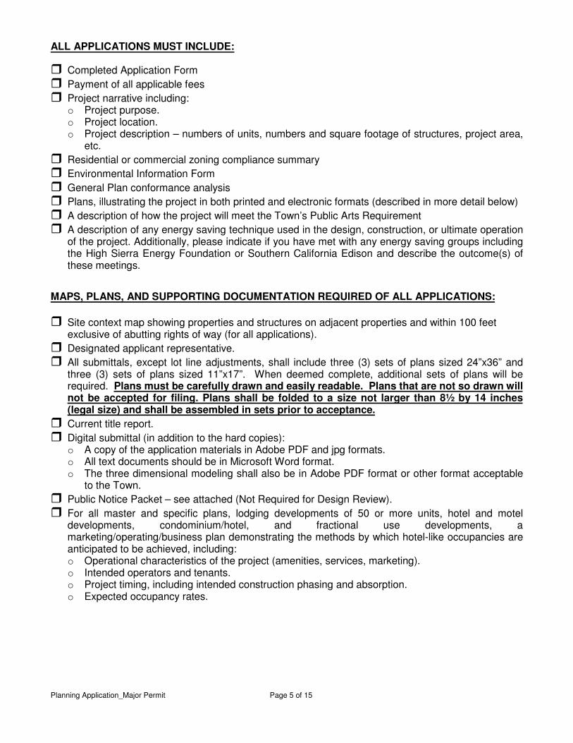
ALL APPLICATIONS MUST INCLUDE:
� Completed Application Form � Payment of all applicable fees � Project narrative including:
o Project purpose. o Project location. o Project description – numbers of units, numbers and square footage of structures, project area,
etc. � Residential or commercial zoning compliance summary � Environmental Information Form � General Plan conformance analysis � Plans, illustrating the project in both printed and electronic formats (described in more detail below)� A description of how the project will meet the Town’s Public Arts Requirement� A description of any energy saving technique used in the design, construction, or ultimate operation
of the project. Additionally, please indicate if you have met with any energy saving groups including the High Sierra Energy Foundation or Southern California Edison and describe the outcome(s) of these meetings.
MAPS, PLANS, AND SUPPORTING DOCUMENTATION REQUIRED OF ALL APPLICATIONS: � Site context map showing properties and structures on adjacent properties and within 100 feet
exclusive of abutting rights of way (for all applications). � Designated applicant representative. � All submittals, except lot line adjustments, shall include three (3) sets of plans sized 24”x36” and
three (3) sets of plans sized 11”x17”. When deemed complete, additional sets of plans will be required. Plans must be carefully drawn and easily readable. Plans that are not so drawn will not be accepted for filing. Plans shall be folded to a size not larger than 8½ by 14 inches (legal size) and shall be assembled in sets prior to acceptance.
� Current title report. � Digital submittal (in addition to the hard copies):
o A copy of the application materials in Adobe PDF and jpg formats. o All text documents should be in Microsoft Word format. o The three dimensional modeling shall also be in Adobe PDF format or other format acceptable
to the Town. � Public Notice Packet – see attached (Not Required for Design Review). � For all master and specific plans, lodging developments of 50 or more units, hotel and motel
developments, condominium/hotel, and fractional use developments, a marketing/operating/business plan demonstrating the methods by which hotel-like occupancies are anticipated to be achieved, including: o Operational characteristics of the project (amenities, services, marketing). o Intended operators and tenants. o Project timing, including intended construction phasing and absorption. o Expected occupancy rates.

Planning Application_Major Permit_5-2014 Page 6 of 15
REQUIREMENTS BY APPLICATION TYPE (See application requirements that follow for details)
Use Permit/Variance (M.C. 17.68/17.72) � Site plans � Building elevations/floor plans � Cross sections � Preliminary landscape plans � Affordable Housing Mitigation Plan
(HDMP) if required (see M.C. §17.136) Design Review (M.C. 17.88) � Site plans � Colored elevation drawings � Preliminary landscape plan � Materials board* � Special requirements for SDD Zone,
North Village, Sierra Star, Juniper Ridge, or Snowcreek
� Preliminary Landscape Plan (if changing landscaping)
Tentative Parcel/Tract Map (see Ord. 84-10) � Maps � Affordable Housing Mitigation Plan
(HDMP) if required (See M.C. §17.136) Zone Change (DZA, ZCA, GPA) � Map of property and adjoining properties � Statement with present zoning,
requested zoning, and reason for request
� Clear description of the public benefit that will result from the project
Master Plan � Master Plan text and exhibits Specific Plan � Specific Plan text and exhibits * Not larger than 24” by 36”
For all projects that include construction � Construction Staging/Management Plan:
A plan and text showing the location(s) of materials storage, construction parking, haul/access routes, and construction office.
Additional information that may be required (see definitions below) � Fiscal Impact Analysis � Market Study � Development pro forma � Story Pole Plan � Three-dimensional model (to scale) A Fiscal Impact Analysis is a projection of the direct, current, and public costs and revenues associated with a proposed project. A Market Study should demonstrate the demand for the proposed units and their demand-based absorption by the community over time. A Development Pro Forma should evaluate financial value of Town participation. A Story Pole Plan should indicate the locations where the poles will be erected on a Roof Plan of the proposed structure. A Three-Dimension Model of the proposed development; preferred scale one-eight inch equals one foot (1/8” = 1’) (1 model).
Planning Application_Major Permit_5-2014 Page 7 of 15
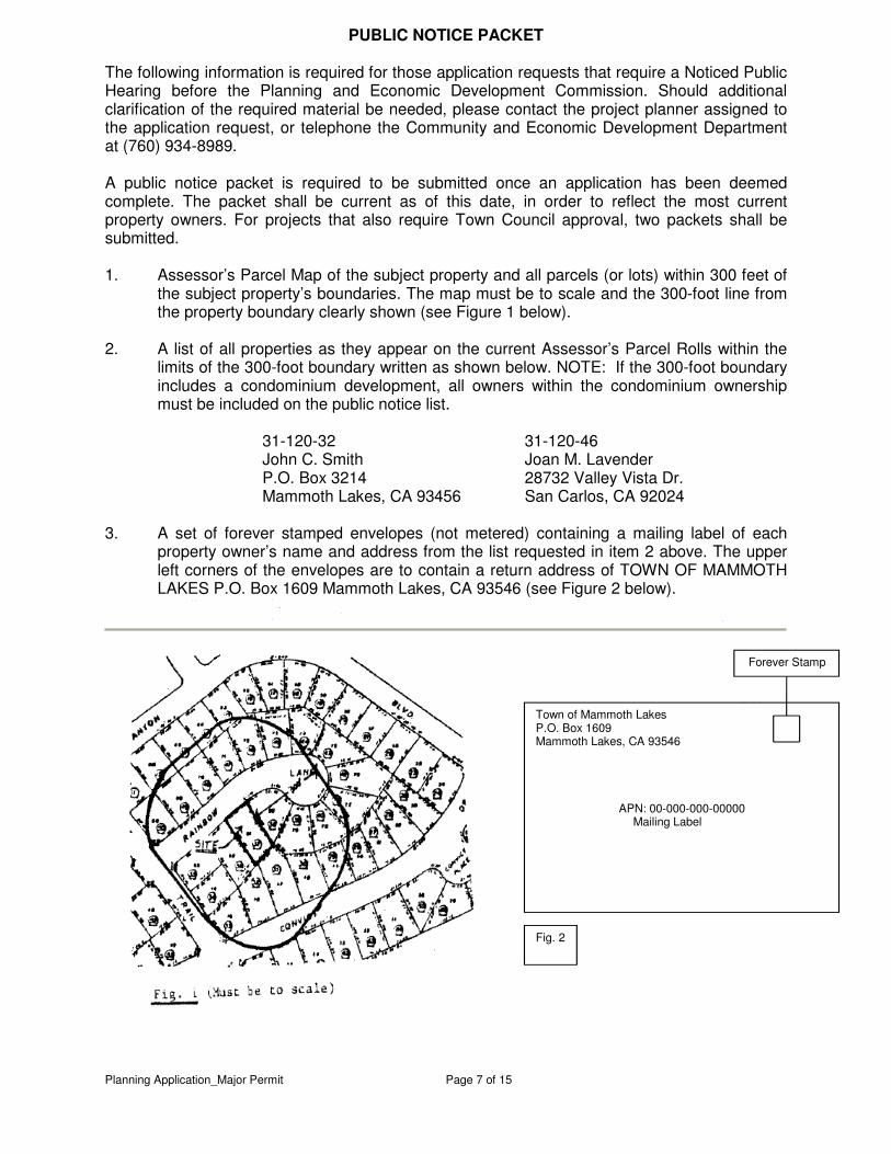
PUBLIC NOTICE PACKET The following information is required for those application requests that require a Noticed Public Hearing before the Planning and Economic Development Commission. Should additional clarification of the required material be needed, please contact the project planner assigned to the application request, or telephone the Community and Economic Development Department at (760) 934-8989. A public notice packet is required to be submitted once an application has been deemed complete. The packet shall be current as of this date, in order to reflect the most current property owners. For projects that also require Town Council approval, two packets shall be submitted. 1. Assessor’s Parcel Map of the subject property and all parcels (or lots) within 300 feet of
the subject property’s boundaries. The map must be to scale and the 300-foot line from the property boundary clearly shown (see Figure 1 below).
2. A list of all properties as they appear on the current Assessor’s Parcel Rolls within the
limits of the 300-foot boundary written as shown below. NOTE: If the 300-foot boundary includes a condominium development, all owners within the condominium ownership must be included on the public notice list.
31-120-32 31-120-46 John C. Smith Joan M. Lavender P.O. Box 3214 28732 Valley Vista Dr. Mammoth Lakes, CA 93456 San Carlos, CA 92024
3. A set of forever stamped envelopes (not metered) containing a mailing label of each
property owner’s name and address from the list requested in item 2 above. The upper left corners of the envelopes are to contain a return address of TOWN OF MAMMOTH LAKES P.O. Box 1609 Mammoth Lakes, CA 93546 (see Figure 2 below).
Town of Mammoth Lakes P.O. Box 1609 Mammoth Lakes, CA 93546
APN: 00-000-000-00000 Mailing Label
Forever Stamp
Fig. 2
Planning Application_Major Permit_5-2014 Page 8 of 15
REQUIRED DETAILS OF MAPS AND PLANS: Please check the box next to each item verifying that the plans include the required information. Community and Economic Development staff may determine an item not applicable. The staff member making the determination shall so note on the application checklist along with the justification.
SITE PLAN: � The property lines, including the distances from the edges of adjacent road surfaces.
All property corners must be identified in the field. � All easements and other property limitations (i.e. golf flyway). � All significant existing features, such as buildings, parking areas, roads, driveways,
paving, open space, trees measuring 6 inches or more in diameter 4 feet above the ground, landscaped areas, right-of-way.
� All proposed improvements with all dimensions, such as setbacks, lot coverage, distance between structures, driveway widths, parking areas, outside turn radius into garages or 24 feet of clear back-up, location of unenclosed parking spaces, etc., identified.
� The adjacent significant features, including buildings within 20 feet of the property line and streets.
� Scale and north arrow. � A preliminary grading plan which includes the existing and proposed contours, cut and
fill areas, retaining walls and proposed wall heights, and corner elevations (for sites of more than 5% slope, contour intervals shall be 2 feet; for sites of less than 5%, corner elevations only need to be indicated). A licensed engineer or surveyor shall stamp the site plan containing topographical information.
� The location of propane tanks, trash enclosures, fences, walls, site lighting, utility structures, and other structures located on the site. Landscape or structural screening provisions may be applicable.
� Projected roof plan showing all valleys, hips, roof pitch, and direction of slope. � Disabled parking spaces. � All exit pathways from the building, including ramps, walkways, stairways, accessible
routes of travel, and other provisions for persons with disabilities. � Fire Department access. � A separate sheet of the plans showing lot coverage calculations by shading areas that
are impervious and showing all calculations on the sheet. � A separate sheet of the plans showing snow storage areas, snow melt areas, and area
calculations by shading proposed snow storage locations that meet the Town’s snow storage requirements.
� Existing and proposed utilities, both overhead, and underground. � Driveway profile showing slope(s) and elevations at the street and garage. � Existing and proposed drainage courses and facilities. � Location(s) of stockpiling and construction materials storage and construction worker’s
vehicles. � Mechanical equipment including roof mounted equipment. � Topography of the site. � Shade/shadow analysis. � Parking Design Detail: Provide the design of enclosed and unenclosed parking stalls
consistent with the Public Works Parking Design Standards: (1) Number, location, and dimensions of all parking spaces; including location(s)
and dimension(s) of all obstructions. (2) Height clearance of enclosed parking areas from floor to any obstruction above
(i.e.: entry and ceiling height, signs, piping, mechanical equipment, etc.); (3) The slope of all ramp areas; and (4) The width of all travel lanes and their turn radii.
Planning Application_Major Permit_5-2014 Page 9 of 15
PRELIMINARY LANDSCAPE PLANS:
� The property lines. � An outline of the existing and proposed buildings, parking areas, driveways, walkways,
and other physical improvements. � All existing trees over 12 inches in diameter, and other areas of significant vegetation,
indicating the size and type, and significant features (boulders, knolls, etc.). � All trees over 12 inches in diameter and major features to be removed. � The location, type, size, pattern, and spacing of all proposed plant materials. All trees
should be described in height, not in gallons. � The proposed method of irrigation, establishment, and maintenance of plant materials. � Landscape Design Statement as to purpose, objectives and performance goals. � Scale and north arrow. � The existing and proposed contours and corner elevations (for sites of more than 5%
slope, contour intervals shall be 2 feet; for sites of less than 5% slope, corner elevations only need to be indicated).
� All accessory structures (i.e. fences, walls, patios, etc.) including applicable heights. � Landscape plans must be prepared by a licensed professional or stamped by a
licensed Landscape Architect for all plans other than a Single Family Dwelling.
BUILDING ELEVATIONS/PRELIMINARY FLOOR PLANS: � Architect or engineer of record (see business & professions code) � Elevations of all sides of all building(s) and structures, including smaller buildings, such
as garages and trash enclosures. � The type and pitch of roof, all exterior materials, and all color choices. � The sign locations, sizes, and styles, if any, indicating the relationship to the building
architecture. � The location of roof equipment, and materials to be used for trash enclosures,
recycling areas, fences, walls, exterior lighting, utility structures, and other structures located on the site.
� Natural grade on all building elevations � Building height calculations using measurements from finished grade. � Proposed layout of all residential and commercial units with spaces identified by use. � Accessible routes for ingress and egress. � For new construction, photographically correct color perspective representations of the
project showing accurately the project and its context in three dimensions, including the proposed development, existing and proposed structures on adjoining properties, backdrop, and proposed landscaping including trees to remain after development. The three dimensional submittals shall be in an electronic format compatible Adobe PDF, or other format acceptable to the Town.
� Floor plans of each residential unit type. � Required Mammoth Lakes Housing review and approval of on-site affordable housing
units.
CROSS SECTIONS: � The profiles of the proposed and existing buildings. � The relationship of the buildings to the site, including the finished floor, grade, adjacent
roads, buildings, and paved area elevations at key points. � All dimensions including building and slope heights. � Natural grade and finish grade
Planning Application_Major Permit_5-2014 Page 10 of 15
SAMPLE MATERIALS:
� Applicant name and contact information. � Name of application. (Project name) � Address of applicable properties. � Actual materials painted and/or stained with actual colors:
o Size of samples need to be large enough for staff evaluation. o Materials and colors must be identified. o Adhesive must be strong enough to hold all materials to board. o Do not use modeling materials such as foam and balsa wood. o Paint chips and/or printed color samples are not adequate. o For rock/stone use, a photo may be sufficient, but must be approved by
Planning. � The type of roofing and exterior materials. � All materials mounted on a rigid backing, not to exceed 24”x36”. � Color elevations (should be provided for all sides of the building):
o Identify elevation (i.e. north, looking south from Main St., etc.). o For design review on existing buildings, provide before and after elevations
(before elevations may be photos). o Elevation(s) may be shown on materials board (preferred). If elevations are not
shown on the materials board (but are included as a separate part of the application), the board must adequately show how materials will be used and how they relate to each other and the building.
o Materials should be clearly defined and should include a key also used on the elevation drawings.
� Please provide a handle for heavy boards. TENTATIVE MAP:
� The title may contain such project name as may be selected by the subdivider and shall contain the tract number which may be obtained from the Planning Division.
� Names and addresses of the legal owner(s) of the property, subdivider, and civil engineer or licensed land surveyor who prepared the map.
� For subdivisions of average lot size of less than one acre, the map shall be drawn to an engineer’s scale of not less than one inch equals fifty feet.
� For subdivisions of average lot size of one acre or more, the map shall be drawn to an engineer’s scale of not less than one inch equals one hundred feet.
� Contours showing accurately the existing terrain within the subdivision and adjacent area as required. The contour interval shall conform to the mapping standards for the scale used (Generally at intervals not exceeding five feet). Every fifth contour shall be of heavier weight and labeled. Care shall be exercised in labeling contours so that the elevation of any contour is readily discernible. Contours may be omitted when the lines fall closer than ten contours per inch, provided that all contours at the bottom and top of slope changes are shown. In no event shall the heavy contours be omitted.
(a) Spot elevations shall be expressed to the nearest one-tenth of a foot. On comparatively level terrain where contours are more than 100 feet apart at map scale, the contours may be omitted and spot elevations substituted therefore. Additional spot elevations shall be shown at intervals along the center of dikes, roads and ditches at summits, depressions, saddles, or at other existing permanent installations.
(b) At least 90 percent of all contours shall be within one-half contour of true elevation, except that in areas where the ground is completely obscured by dense brush or timber, ninety percent of all contours shall be within one contour interval. Contours in obscured areas shall be indicated by dashed lines. Mapping not having this accuracy shall be rejected.
Planning Application_Major Permit_5-2014 Page 11 of 15
� When the map contains more than one sheet, the sheets shall be indexed to show the relative position of each sheet (e.g., 1 of 2, 2 of 2, etc.).
� The outline of existing slides, slips, sump areas subject to inundation or avalanche. � The approximate edges of pavements of existing paved roads, driveways within or
adjacent to public rights-of-way and easements or within private common rights-of-way.
� Approximate existing property lines and approximate boundaries of existing easements within the subdivision with the names of owners of record. Submit current (within 90 days) Title Report.
� The proposed lot and street layout scaled dimensions of the lots, and the minimum, maximum, and average lot area.
� The approximate width, location, and purpose of all existing and proposed easements. Easements shall be shown for utilities such as electric, telephone, cable, television, sewer and water lines, and for drainage and access when applicable.
� Street names, widths of streets and easements, paving, approximate grade, approximate point of grade change, and radius of curves along centerlines of each street.
� Typical road sections shown may refer to the standard plans. � Areas designated for public and/or common purpose. � Location, approximate grade, direction of flow, and type of facility of existing drainage
channels and storm drains. � A vicinity map showing roads, adjoining subdivisions, creeks, and other data sufficient
to locate the proposed subdivision and show its relation to community development. � The line of high and low water and 100-year flood plain on all lots abutting any lake,
river, stream, reservoir, or other body of water. � North arrow and scales for maps, contour interval. � Existing and proposed use of all existing structures. � Names of adjacent property owners or subdivisions. � Approximate toe of fills and top of cuts. � Approximate finish contour lines along roadways. � Parking areas and access solutions for individual lots may be required. � Parking plan in accordance with zoning requirements and road department standards
when applicable. � For projects with final maps to be recorded in phases, proposed phase lines and
sequence of development.
TENTATIVE MAP, ACCOMPANYING DATA: The tentative map shall include the following: � Existing and proposed use of the property. � Description of the proposed subdivision, including the number of lots, parcels, and
units, their average and minimum size, management type, and form of ownership. � Source, adequacy, potability, and right thereto of water supply (i.e. “will-serve letter
from MCWD). � Method of sewage disposal proposed. � Plans for draining areas subject to inundation. � Other improvements proposed. � Approximate construction phasing so that each phase of construction is completed
within one construction season. � Calculations needed for development as to density, open space, lot coverage, snow
storage, parking, etc. � The proposed or intended methods of fire protection and, if applicable, approval of the
fire district.
Planning Application_Major Permit_5-2014 Page 12 of 15
� The proposed means that will be used to assure the proper administration and maintenance of common areas and open space, including a statement of intent regarding proposed deed restrictions. (This can be a simple statement included in the project narrative).
� A preliminary soils report shall be prepared by a civil engineer/engineering geologist, licensed to practice in the State of California, for the proposed subdivision addressing the unified soil classification of the soils, the depth of the water table, the degree of soil moisture from surface to a minimum depth of eight feet, the compaction of the soil at a minimum depth of two feet, and the expansive characteristics of the soil for the proposed project site. If this preliminary report indicates the presence of critically expansive soil or other soils or geological problems, which could lead to structural defects, or any other hazards, a soils report for each parcel, together with the proposed mitigation measures to alleviate identified problems shall be required. The requirements of a preliminary soils report may be waived by the Town Engineer if the project civil engineer/engineering geologist certifies that no soils problems exist on the site, and that such certification is based on sufficient soils reports prepared for the subdivision under consideration to demonstrate soil stability and the lack of soils problems on the proposed project site. The project proponent shall have the burden of demonstrating the required information. The decision to waive such requirements, based upon the certification of the project proponent’s civil engineer/engineering geologist of the absence of any soils related problems, shall be solely within the discretion of the Town Engineer.
� When part of a large single ownership area, a sketch showing proposed future development outside of the proposed subdivision.
� Plot plans and elevations of proposed buildings in planned unit developments or condominiums.
� A survey prepared by a qualified person identifying tree weakness, maturity, potential hazard, infestations, vigor, density, and spacing.
� A vegetation preservation and protection plan showing which trees are to be removed and which are to be retained and the location and type of vegetation that is to be planted.
� Information concerning the ability of the existing and proposed drainage facilities to handle the natural flows and the additional run-off that will be generated by the subdivision at ultimate development. The methods to be used to convey surface waters to this natural drainage courses or drainage systems.
VESTING TENTATIVE MAP, SUPPLEMENTAL DATA:
� A letter from MCWD authorizing use and acknowledging required capacity within the existing water and sewer system to meet the needs of this development.
� A letter from Mammoth Disposal acknowledging the capacity for the disposal of solid wastes.
� An area map showing the relationship to any significant environmental factors such as streams, ridge lines, tree stands, and public open spaces.
� Details of all water, sewer, and storm drain facilities and improvements. � Geologic/Seismic impact studies for the proposed development. � Provide signage and landscape plans. � When applicable, the proposed means for assuring continued existence, maintenance,
and operation of the various common elements and facilities. If a community association or similar governing structure is to be established, a copy of the covenants, conditions, and restrictions shall be supplied.
� Snow storage/management plan. � A precise site plan indicating the proposed division of the property and the height, size,
location and proposed use of all buildings, structures, streets, curb cuts, access drives,

Planning Application_Major Permit_5-2014 Page 13 of 15
walkways, parking areas, with spaces dimensioned and backup and turn radii called out, and open/landscape plans. (May be included in Use Permit if project includes a conditional use)
� Architectural, signage, and landscape plans. (May be included in Use Permit if project includes a conditional use)
� Such other information as may be required by the Community and Economic Development Development Director to permit a complete analysis and appraisal of the project.
HOUSING MITIGATION DEVELOPMENT PLAN:
� HMDP pursuant to the Town of Mammoth Lakes Housing Mitigation Regulations, Chapter 17.136 of the Municipal Code.
� For zoning concessions, pro forma showing necessity of concession to make units affordable.
� Identify concessions requested and purpose for requesting the concessions.
SPECIFIC PLAN: A specific plan shall include a text and diagram or diagrams, including maps, which specify all of the following in detail.
� The distribution, location, and extent of the uses of land, including open space, within the area covered by the plan.
� The proposed distribution, location, and extent and intensity of major components of public and private transportation, sewage, water, drainage, solid waste disposal, energy, and other essential facilities proposed to be located within the area covered by the plan and needed to support the land uses described in the plan.
� Standards and criteria by which development will proceed and standards for the conservation, development, and utilization of natural resources, where applicable.
� A program of measures, including regulations, programs, public works projects, and financing measures necessary to implement the intent and policies of the specific plan.
� A statement of the relationship of the specific plan to the General Plan. � A statement explaining how the Specific Plan will better meet the goals and policies of
the General Plan than the existing zoning.
MASTER PLAN: A master plan shall include text and diagrams, including maps that specify all of the following in detail:
� The type(s) and location(s) of proposed uses. � The intensity/density of proposed uses. � Standards for development including lot coverage, setbacks, building height, common
snow storage areas, and any other proposed restrictions or standards. � Standards for public improvements if different from adopted Town standards. � A list of permitted and conditional uses. � Location(s) of amenities and services. � Location of all streets and non-motorized circulation facilities. � Provisions for transit. � Topographic map and conceptual grading.
STORY POLE PLAN: A story pole plan shall include:
� Elevations of the height of each story pole and the natural and finished grade shall be indicated on the Story Pole Plan as an Elevation Drawing.
� The roof ridgelines shall be shown by extending nylon, plastic, or other acceptable material from one pole to the other along the direction of the ridgeline. The method to show the roof ridgeline will be called out on the Story Pole Plan.
� The Story Pole Plan shall be at the same scale as the Roof Plan.
Planning Application_Major Permit_5-2014 Page 14 of 15
� All story poles shall be placed, braced and supported to ensure the health, safety and general welfare of the public. Include the methods used to secure the poles and a statement absolving the Town of any liability associated with the construction of, or damage caused by the story poles. If at any time the Town determines the story poles to be unsafe, they shall be repaired and reset immediately by the project applicant or, at the Town’s discretion, removed.
� Shall be prepared and stamped by licensed surveyor, civil engineer, or architect to certify that the height and position of the poles accurately represent the height and location of the proposed structure.
� Include a statement signed by the applicant that reads: “I (Applicant Name) hereby agree to remove the story poles within seven (7) calendar days after the final appeal period ends related to a determination made on the proposed project.”
APPLICATION REVIEW PROCEDURE*
The following steps outline the Community and Economic Development Department procedures for the processing of discretionary permit application requests for Tentative Subdivision Maps, Use Permit Applications, Major Design Review Permits, Zoning Code Amendments, and Variances.
(If Applicable) Prior to Submittal of Planning Application
� Pre-Application: Applicants for large commercial and residential projects are required
to schedule a pre-application meeting with the Community and Economic Development Department (CEDD). The purpose of this meeting is to permit the CEDD staff to informally review a proposed development and determine the most efficient method of development review before substantial commitments of time and money are made to the submission of an application. A formal application will not be accepted until the applicant has a Pre-Application meeting with Town Staff.
� Concept Review Application: This submittal applies to applicants with large commercial and residential projects. Prior to submittal of a Concept Review Application the applicant is required to have had an informal Pre-Application submission meeting with a Planner to review basic zoning and procedural requirements in advance of project design. Upon determination that a more detailed review of your development plan is required including a written response from staff and a hearing before the Advisory Design Panel and/or the Planning and Economic Development Commission then it is advisable that a Concept Review Application be submitted.
Submittal of Planning Application
� In-Take Checklist: When submitting an application request to the Community and
Economic Development Department, Town staff will follow the Intake Checklist to assure the application is acceptable for submittal and setting up a file folder.
� Routing: The project is then assigned to a Project Planner, and is routed to the Engineering Services Manager for assignment to an Engineer Review Team Member, and to the Building Official.
� Development Review Committee: The Project Planner sets the application request on the Development Review Committee (DRC) Agenda to inform the group that the application has been filed and that a Completeness Review Meeting will be scheduled for the Review Team members.
� Completeness Review: A meeting of the Review Team members is scheduled to review the material submitted with the application request to assure that all the information required within the Planning Application has been provided and that the information is current.
Planning Application_Major Permit_5-2014 Page 15 of 15
� Applicant Informed: The Project Planner prepares a letter informing the applicant that the information submitted is complete and that additional sets of plans are required to route the application request to outside agencies for review and comment. If deemed “incomplete,” the Project Planner prepares a letter to the applicant requesting the additional information required to complete the application submittal. Staff will not analyze the application until it is deemed complete.
� Additional Sets of Plans: Upon staff deeming the project complete, staff may request additional plan sets for agency routing. Staff will request desired number of copies, or if not stated, 15 11” x 17” copies shall be provided. The application is not considered complete until these additional copies are provided.
� CEQA Review: The Project Planner determines if the application qualifies for a Statutory or Categorical Exemption from environmental review pursuant to the California Environmental Quality Act (CEQA). If not exempt, the Project Planner arranges for an Initial Study. Either a Negative Declaration, Mitigated Negative Declaration, or Environmental Impact Report (EIR) will be prepared. If a consultant is required, the applicant will be contacted to determine the consultant for preparation.
� Draft Staff Report: The Project Planner prepares a draft staff report for the Planning and Economic Development Commission and routes the report to the Review Team members for comments and conditions. Once the information received from the Review Team members is incorporated into the draft staff report, the draft is given to the applicant for review and comment. If the applicant has concerns with the staff report draft, a meeting is scheduled to discuss the specific concerns.
� Public Hearing Notice: Once the draft staff report is completed, the Project Planner prepares a public hearing notice to notify the public of the date scheduled for a Planning and Economic Development Commission hearing (only a public meeting is required for Major Design Review). The notice is published in the local newspaper and sent to all property owners within 300’ of the subject property. This is distributed up to 3 weeks prior to the meeting and published and mailed two weeks prior to the Planning and Economic Development Commission hearing.
� Planning and Economic Development Commission Hearing: The Planning and Economic Development Commission conducts the public hearing and determines if the application request is to be approved, denied, or continued to allow time for additional information to be submitted.
� Final Resolution: If a decision is made by the Planning and Economic Development Commission, the Project Planner prepares the Final Resolution of Approval or Denial. The Resolution is then signed by the Town and applicant and recorded by the County Recorder’s Office.
� Follow-up / Monitoring: The Grading Permit, Final Map, and Building Permit plan check is routed to the Planning Division to assure compliance with approved project design and conditions of approval. On-site inspections monitor construction and ensure that erosion control measures are in place during grading, that non-build areas are protected, and that the construction, landscape and irrigation conforms to the approved plans. A final inspection is made prior to the issuance of a Certificate of Occupancy.
*General Plan Amendments, Zoning Code Amendments, District Zoning Amendments, and Specific Plans are legislative acts and are not subject to the above processing timelines.