planning and environment act 1987 - melton.vic.gov.au · planning and environment act 1987 ... 5.3...
TRANSCRIPT

Planning and Environment Act 1987
Panel Report
Melton Planning Scheme Amendments C146 and C147
Plumpton and Kororoit Precinct Structure Plans
Front page
27 February 2017

Planning and Environment Act 1987
Panel Report pursuant to section 25 of the Act
Melton Planning Scheme Amendments C146 and C147
Plumpton and Kororoit Precinct Structure Plans
27 February 2017
Trevor McCullough, Chair
John Hartigan, Member
Annabel Paul, Member

Melton Planning Scheme Amendments C146 and C147 Panel Report 27 February 2017
Contents Page
Executive Summary………………………………………………………………………………………………….....1
1 Introduction ................................................................................................................ 9
1.1 The Amendments .................................................................................................... 9 1.2 Location and site context ...................................................................................... 11 1.3 Panel process ......................................................................................................... 11 1.4 Summary of issues raised in submissions ............................................................. 12 1.5 Issues dealt with in this Report ............................................................................. 12 1.6 Revisions to the Amendment ................................................................................ 13 1.7 Recommendations ................................................................................................ 14
2 The Precinct Structure Plan ....................................................................................... 15
2.1 Role and function of the PSPs ............................................................................... 15 2.2 PSP background reports ........................................................................................ 15 2.3 The PSP structure .................................................................................................. 15 2.4 Vision and objectives ............................................................................................. 15 2.5 Urban structure ..................................................................................................... 17
3 Planning policy context ............................................................................................. 20
3.1 Growth area planning ............................................................................................ 20 3.2 Melbourne Strategic Assessment and Biodiversity Conservation Strategy .......... 21 3.3 Conclusion ............................................................................................................. 22
4 Broader issues .......................................................................................................... 23
4.1 The issues .............................................................................................................. 23 4.2 Residential Growth Zone as the applied residential zone for all ‘other
land’ in the Urban Growth Zone ........................................................................... 23 4.3 APA high pressure gas pipeline ............................................................................. 27 4.4 Small local enterprises .......................................................................................... 37 4.5 Timing of the Infrastructure Contributions Plan ................................................... 41 4.6 Items for inclusion in the Infrastructure Contributions Plan ................................ 46 4.7 Beattys Road reserve ............................................................................................. 48 4.8 Dry stone walls ...................................................................................................... 55 4.9 Local park locations ............................................................................................... 58 4.10 Sequencing of development and potentially landlocked sites ............................. 63 4.11 Urban Floodway Zone ........................................................................................... 64
5 Plumpton PSP site specific submissions .................................................................... 68
5.1 Tan Buu Nguyen (Submission 3) ............................................................................ 68 5.2 Angelo Levecchia (Submission 4) .......................................................................... 69 5.3 Urban Design and Management for L and G Failli (Submission 6) ........................ 70 5.4 Urban Terrain (Submission 7) ................................................................................ 70 5.5 Marantali Pty Ltd (Submission 8) .......................................................................... 70 5.6 SJB Planning for Domenic Santacaterina (Submission 10) .................................... 72

Melton Planning Scheme Amendments C146 and C147 Panel Report 27 February 2017
5.7 Mesh for Villawood (Submission 11) ..................................................................... 73 5.8 Echelon for Mondous Group (Submission 12) ...................................................... 73 5.9 Gadens Lawyers for Dahua Dacland (Submission 19) ........................................... 80 5.10 Michael Ahmet (Submission 20) ........................................................................... 90 5.11 Select Group for Aldi (Submission 24) ................................................................... 93 5.12 Melbourne Water (Submission 25) ....................................................................... 93 5.13 Zoran Trimcevski and Mirjana Mihaljevic (Submission 27) ................................... 94 5.14 Melton City Council (Submission 29) .................................................................... 95 5.15 George and Vincenza Sultana (Submission 30) ................................................... 110 5.16 Urban Design and Management for Mrs Candan Ahmet (Submission 32) ......... 111
6 Kororoit PSP site specific submissions ..................................................................... 115
6.1 Robert Magro (Submission 2) .............................................................................. 115 6.2 Greybox Homes for George and Josie Gatt (Submission 5) ................................ 115 6.3 Kellehers for Maria Natale (Submission 6) .......................................................... 116 6.4 Town Planning Group for a number of landowners (Submission 7) ................... 124 6.5 Spiire for Villa World Development (Submission 8) ............................................ 127 6.6 Tract for Moremac (Submission 9) ...................................................................... 136 6.7 Lawport Holdings (Submission 12) ...................................................................... 148 6.8 Tract for Sekhon (Submission 14)........................................................................ 151 6.9 Dampier Quest Pty Ltd and Saviour and Lucy Debrincat (Submission 15).......... 151 6.10 Breese Pitt Dixon (Submission 16) ...................................................................... 155 6.11 Insight for Coles (Submission 18) ........................................................................ 155 6.12 Andrew Booth (Submission 19) ........................................................................... 157 6.13 ID Land (Submission 20) ...................................................................................... 160 6.14 Select Group for Aldi (Submission 24) ................................................................. 165 6.15 Nola Dunn (Submission 27) ................................................................................. 165 6.16 Whiteman Property for Luzon Holdings (Submission 29) ................................... 167 6.17 Best Hooper for N and S Zurzolo (Submission 30) .............................................. 169 6.18 Melton City Council (Submission 32) .................................................................. 173 6.19 Mesh for OYOB (Submission 33) ......................................................................... 176
Appendix A Submitters to the Amendments
Appendix B Parties to the Panel Hearing
Appendix C Document list
Melton Planning Scheme Amendments C146 and C147 Panel Report 27 February 2017
List of Tables Page
Table 1 Summary of VPA response to ICP items ................................................................ 48
List of Figures Page
Figure 1 Plumpton future urban structure .......................................................................... 18
Figure 2 Kororoit future urban structure ............................................................................ 19
Figure 3 Utilities plan Plumpton PSP ................................................................................... 27
Figure 4 Utilities Plan Kororoit PSP ..................................................................................... 28
Figure 5 Alternative road layout agreed for the Marantali land ......................................... 71
Figure 6 Proposed Future Principal Public Transport Network (PPTN) .............................. 79
Figure 7 Revised layout for the Plumpton MTC and community facilities ......................... 83
Figure 8 Alternative layout proposed by UDM ................................................................. 112
Figure 9 Extract of Figure 7 in the Kororoit PSP showing the Natale property ................ 117
Figure 10 Property 9 Debrincat submission ........................................................................ 152

Melton Planning Scheme Amendments C146 and C147 Panel Report 27 February 2017
List of Abbreviations APA APA VTS Australia (Operations) Pty Ltd
BCS Biodiversity Conservation Strategy for Melbourne’s Growth Corridors
C2Z Commercial 2 Zone
CA Conservation Area
CFA Country Fire Authority
DCP Development Contributions Plan
DCPO Development Contributions Plan Overlay
DELWP Department of Environment, Land, Water and Planning
DSS Drainage Services Scheme
DSW Dry Stone Wall
EPA Environment Protection Authority
EPBC Act Environment Protection and Biodiversity Conservation Act 1999 (Cth)
FUS Future Urban Structure
FZ Farming Zone
GAIC Growth Areas Infrastructure Plan
GCP Growth Corridor Plan
GGF Growling Grass Frog
GRZ General Residential Zone
ICP Infrastructure Contributions Plan
ICPO Infrastructure Contributions Plan Overlay
LTC Local Town Centre
MSA Melbourne Strategic Assessment
MTC Major Town Centre
MUZ Mixed Use Zone
OMR Outer Metropolitan Ring Road
PAO
PPTN
Public Acquisition Overlay
Principal Public Transport Network
PSP Precinct Structure Plan
PTV Public Transport Victoria
RGZ Residential Growth Zone
SRSS Sub‐regional Species Strategy
the Act the Planning and Environment Act 1987
UDM Urban Design and Management
UFZ Urban Floodway Zone
UGB Urban Growth Boundary
UGZ Urban Growth Zone

Melton Planning Scheme Amendments C146 and C147 Panel Report 27 February 2017
VPA Victorian Planning Authority (formerly Metropolitan Planning Authority)
WGCP West Growth Corridor Plan

Melton Planning Scheme Amendments C146 and C147 Panel Report 27 February 2017
Overview
Amendment Summary
The Amendments Melton Planning Scheme Amendments C146 and C147
Common name Plumpton and Kororoit Precinct Structure Plans
Subject site The land generally bounded by the Western Freeway, Melton Highway, developed suburbs in the east and the future Outer Metropolitan Ring Road to the west, as shown in Figures 1 and 2
Planning Authority Metropolitan Planning Authority (now the Victorian Planning Authority)
Exhibition 16 June to 18 July 2016
Submissions Number of Submissions: Plumpton C146: 31 and Kororoit C147: 34 as listed in Appendix A
Panel Process
The Panel Trevor McCullough (Chair), John Hartigan and Annabel Paul
Directions Hearings 27 October 2016, Planning Panels Victoria
Panel Hearing 29, 30 November; 1, 5, 6, 7, 8, 9, 12, 14,15, 16 December 2016, at Planning Panels Victoria
Site Inspections Unaccompanied, 18 October 2016
Appearances Refer to Appendix B
Date of this Report 27 February 2017
Melton Planning Scheme Amendments C146 and C147 Panel Report 27 February 2017
Page 1
Executive Summary
(i) Summary
Background
Melton Planning Scheme Amendments C146 and C147 (the Amendments) implement the Plumpton and Kororoit Precinct Structure Plans (the PSPs).
The Amendments provide a framework for the development of the land within the Precincts in accordance with the PSPs by introducing Schedules 11 (Plumpton) and 12 (Kororoit) to the Urban Growth Zone (UGZ) and rezoning the majority of land within the Precinct area to the UGZ. The Schedules to the UGZ will enable residential, industrial, and commercial use and development, along with open space and conservation areas, in areas identified in the future urban structure and in accordance with the vision of urban growth outlined in the PSPs.
The Plumpton Precinct covers an area of approximately 1,016 hectares and Kororoit Precinct covers an area of approximately 925 hectares. The Precincts are bounded by the Melton Highway to the north, the developed suburbs of Hillside, Taylors Hill West and Caroline Springs to the east, the Western Freeway to the south and the future Outer Metropolitan Ring road and rail (OMR) to the west. Taylors Road is the divide between the two precincts.
Key features of the Plumpton PSP include an industrial precinct in the north west quadrant; the Plumpton Major Town Centre and a Local Town Centre; Beattys Road ‘civic spine’; and substantial residential land accommodating over 10,600 dwellings.
Key features of the Kororoit PSP include the Kororoit Creek conservation area with its important Growling Grass Frog habitat and protection for significant Aboriginal heritage sites; substantial other conservation areas and networks of parks; two Local Town Centres; and residential land for 9,200 dwellings.
Planning for the Precincts has been complicated by significant electricity and high pressure gas pipeline infrastructure within the precinct and the reservation for the Outer Metropolitan Ring Road along the western boundary.
Submissions raised a wide range of issues, the impacts of electricity and high pressure gas pipeline infrastructure within the Precincts, boundaries of the conservation areas, appropriate residential densities, infrastructure contributions issues, the location of local parks and other infrastructure and various drafting and site specific issues.
Findings
The Panel supports Amendments C146 and C147, and is satisfied that the PSPs and UGZ Schedules 11 and 12 (as amended) provide a sound framework and mechanism to manage land use and development within the precincts.
The Panel believes that the Amendment should not be finalised until a fully costed Infrastructure Contributions Plan has been prepared and adopted for the Precincts.
In relation to the other key issues raised in submissions, the Panel has reached the following conclusions:

Melton Planning Scheme Amendments C146 and C147 Panel Report 27 February 2017
Page 2
The use of the applied RGZ in both the Plumpton and Kororoit PSP areas should be consistent with the approach sought by Council, with the remaining residential areas adopting the applied GRZ.
That the residential density targets for the RGZ and GRZ areas should be modified accordingly, to maintain overall population targets.
Retail use should not trigger a permit requirement within the high pressure gas pipeline measurement length, however a buildings and works application for retail premises, including shop, should be referred to the pipeline operator.
APA should be made a recommending referral authority rather than a body to which notice is given.
It is appropriate to apply ICPOs over the whole area of the PSPs.
The Amendment should not be approved and the PSP should not be finalised before an ICP is prepared.
The Panel supports the approach proposed by the VPA of developing a standard levy ICP and gazetting this with the PSP, and progressing any supplementary levies as a separate amendment process.
The Panel has made a number of recommendations for inclusion, deletion or modification of infrastructure items in the ICP.
Some infrastructure standards should be changed, including some road and bike lane treatments.
The Panel has recommended a number of changes to infrastructure location and alignment relating to issues raised in site specific submissions. In some cases this requires changes to the exhibited PSPs.
Any proposed changes to Conservation Areas (including the Growling Grass Frog (GGF) Conservation Area (CA) along the Kororoit Creek) should be pursued through application to DELWP and approval by the Commonwealth Government. If changes are approved, a number of consequential changes will be required to be made to the PSPs.
In addition, the Panel has responded to a range of drafting and site specific issues raised in submissions, and has recommended further changes where appropriate.
(ii) Recommendations
Based on the reasons set out in this Report, the Panel recommends that Melton Planning Scheme Amendments C146 and C147 be adopted as exhibited, subject to the following recommended changes:
Over‐arching version
Include the changes described in the Precinct Structure Plan Document Changes 1.tables (Version 1.0 – 18 November 2016) prepared by the Victorian Planning Authority (Documents 2 and 3), unless otherwise recommended.
Adopt the Victorian Planning Authority versions of the Urban Growth Zone 2.Schedules 11 and 12 as per the Part A submission (Documents 4 and 5), unless otherwise recommended.

Melton Planning Scheme Amendments C146 and C147 Panel Report 27 February 2017
Page 3
Applied Residential Growth Zone
Amend Schedules 11 and 12 to the Urban Growth Zone to include a plan (or 3.change to the Future Urban Structure) showing the applied Residential Growth Zone to residential areas that are generally within:
400 metres of the Plumpton Major Town Centre
200 metres from the Principal Pubic Transport Network
200 metres from the Local Town Centres, and
100 metres from co‐located community hubs, sports reserves and local convenience centres.
Amend Clause 2.1 Applied zone provisions to Schedules 11 and 12 of the Urban 4.Growth Zone to nominate the areas with an applied Residential Growth Zone and the remaining residential areas with an applied General Residential Zone.
Update the applicable Objectives, Requirements and Guidelines within the 5.Precinct Structure Plans relating to Housing to reflect the locations for medium or higher density housing, generally in accordance with Appendix 10 of the VPA’s Part B submission, however amended to reflect the revised catchment distances and associated densities.
Update the Housing Density Tables (Table 3) within the Precinct Structure Plans to 6.reflect the average densities and residential yield for the nominated catchments.
High pressure gas pipeline
Amend Clause 2.4 of the Urban Growth Zone, Schedules 11 and 12, to include the 7.following as uses which require a permit in the high pressure gas pipeline measurement length:
Accommodation (other than dwelling or dependent persons unit)
Childcare centre
Cinema
Education centre
Hospital; and
Place of assembly.
Amend Clause 6.0 of Schedules 11 and 12 of the Urban Growth Zone to read as 8.follows:
Referral to gas transmission pipeline operator
An application to use land for any of the following uses within the ‘gas pipeline measurement length’ shown on Plan 11 Utilities in the incorporated Plumpton Precinct Structure Plan must be referred to the gas transmission pipeline operator:
Accommodation (other than a dwelling or dependent persons unit)
Child care centre
Cinema
Education centre
Hospital
Place of assembly

Melton Planning Scheme Amendments C146 and C147 Panel Report 27 February 2017
Page 4
Amend the Schedule to Clause 66.04 to include the owner of the high pressure gas 9.pipeline as a recommending referral authority for applications specified under Clause 6.0 in Schedules 11 and 12 to the Urban Growth Zone.
Remove the proposed Schedule to Clause 66.06. 10.
Amend Map 1 to Schedules 11 and 12 of the Urban Growth Zone to include the 11.pipeline measurement lengths.
Small local enterprises
Amend the UGZ Schedule 11 (Plumpton) to include: 12.
Retail where the applied zone is Commercial 2 Zone directly north of the Plumpton Local Town Centre
The following land uses are prohibited where the
leaseable floor area is greater than 900m2:
Restricted retail premises
Postal agency
Market
Manufacturing sales
Trade supplies
Landscape gardening supplies
Food and drink premises are prohibited where the
leasable floor area is greater than 100m2
The following land uses are prohibited:
Shop (except restricted retail premises)
Motor vehicle, boat, or caravan sales
Gambling premises
Amend the UGZ Schedule 12 (Kororoit) to include: 13.
Retail where the applied zone is Commercial 2 Zone directly north of the Deanside Local Town Centre and directly east of the Kororoit Local Town Centre
The following land uses are prohibited where the
leaseable floor area is greater than 900m2:
Restricted retail premises
Postal agency
Market
Manufacturing sales
Trade supplies
Landscape gardening supplies
Food and drink premises is prohibited where the
leasable floor area is greater than 100m2
The following land uses are prohibited:
Shop (except restricted retail premises)
Motor vehicle, boat, or caravan sales
Gambling premises

Melton Planning Scheme Amendments C146 and C147 Panel Report 27 February 2017
Page 5
Beattys Road
Add an appendix to the Plumpton Precinct Structure Plan as proposed by the 14.Victorian Planning Authority to include separate plans to show who is responsible for delivering the required infrastructure on Beattys Road reserve, and amend Plumpton Precinct Structure Plan Table 9 – Precinct Infrastructure to make reference to these plans.
Replace Plumpton Precinct Structure Plan figures 1 to 5 with updated Beattys 15.Road concept plans (tabled Document 16).
Amend Plumpton Precinct Structure Plan Plan 6 – Open Space and Table 9 – 16.Precinct Infrastructure to delete local parks LP‐20, LP‐21 and LP‐22.
Amend the vision to the exhibited Plumpton Precinct Structure Plan (at page 9) to 17.acknowledge the strategic importance of Beatty Road reserve by adding the following underlined words:
Beattys Road Reserve will have strategic significance and function as a beautified ‘civic spine’ to draw visitors to play areas and community facilities punctuating its length, and will provide strong links to areas east and west of the PSP.
Dry stone walls
18. Amend the revised Kororoit Precinct Structure Plan Plan 2 – Precinct Features (Document 18) by deleting the notation referring to ‘Monaghans Lane dry stone wall D7822‐0735’.
Local park locations
Amend Plumpton R42 and Kororoit R28 by adding in the first sentence ‘generally’ 19.before the words ‘in accordance with’ and by altering the third dot point to read:
‘The land area total provision of open space for a local park is equal to or more than the local park provision outlined shown in Plan 6 and in Table 7.’
Amend Plumpton R42 and R28 by adding respectively a fifth and a sixth dot point 20.which reads:
‘Where it is proposed to provide two or more local parks instead of a local park described in Table 7, the combined area of those parks must not be less than the area of the local park described in Table 7.’
Urban Floodway Zone
Amend the legend on Plan 2 – Precinct Features in the Precinct Structure Plans to 21.read “Pre‐development 1 in 100 year flood event”.
Add a further note to Plan 3 – Future Urban Structure in the Precinct Structure 22.Plans as follows:
Areas of the PSP are subject to flooding in a 1 in 100 storm event. The flood extent of the 1 in 100 year event is shown on Plan 2 – Precinct Features.

Melton Planning Scheme Amendments C146 and C147 Panel Report 27 February 2017
Page 6
Marantali
Add the following notes to the Plumpton Precinct Structure Plan appendices: 23.a) Appendix G: “residential lots may have direct vehicular access from roads
abutting the gas pipeline easement” b) Appendix H: “residential lots may directly face or side onto the pipeline
easement with vehicular access to the lots provided from rear lanes or roads”
Remove the north‐east local access street on the western boundary of the 24.proposed non‐government school on the Marantali property from Plan 3 Future Urban Structure of the Plumpton Precinct Structure Plan, and include a new east‐west road as shown in Attachment 4 to the Marantali submission to Panel (Figure 5 of this report).
Dahua Dacland
Add a second dot point to Plumpton Precinct Structure Plan G48 and Kororoit 25.Precinct Structure Plan G40 as follows:
‘Hard landscaping (e.g. street furniture) and small trees may be included provided sight lines between signs indicating the location of the pipe are not obscured and compliance with mandated pipeline clearances is achieved.’
Amend the note to Appendix H – Easement cross sections in the Precinct Structure 26.Plan and Appendix K – Easement cross sections in the Kororoit Precinct Structure Plan to reflect the wording in the additional dot point to Plumpton G48 and Kororoit G40.
Amend Plan 3 – Future Urban Structure and other relevant plans in the Plumpton 27.Precinct Structure Plan to reflect the revised community hub layout as depicted in Appendix 7 of the Victorian Planning Authority’s closing submission.
Adopt the revised alignment for Hume Drive/Tarleton Drive as shown on 28.Appendix 8 to the Victorian Planning Authority closing submissions (Document 119) and amend Kororoit Precinct Structure Plan Plan 8 – Road Network Plan and other relevant plans accordingly.
Melton City Council (Plumpton)
Amend Plan 8 – Road Network Plan in the Plumpton Precinct Structure Plan to 29.include pedestrian/cyclist signals at the intersection of Tarleton Road and the Olive Grove shared path.
Add pedestrian/cyclist signals at the intersection of Tarleton Road and the Olive 30.Grove shared path to Plan 12 – Precinct Infrastructure – Transport in the Plumpton Precinct Structure Plan and amend Table 9 accordingly.
Replace the exhibited Section 1 – Primary Arterial Road 6 lane as shown in the 31.exhibited Precinct Structure Plans with the revised cross section tabled by the Victorian Planning Authority (Document 26).

Melton Planning Scheme Amendments C146 and C147 Panel Report 27 February 2017
Page 7
Add a note to the revised Section 1 – Primary Arterial Road 6 lane as shown in the 32.exhibited Precinct Structure Plans, that there must be low level planting on the 0.5 metre strip to delineate between the pedestrian path and the two‐way bike path.
Amend the Plumpton Precinct Structure Plan Sections 10 and 11 to show a 3.5 33.metre carriageway in each direction.
Amend the Kororoit Precinct Structure Plan Section 18 to show a 3.5 metre 34.carriageway in each direction.
Villa World
Replace the cross section Local Access Level 1 – Gas Pipeline Easement (typical) in 35.the Kororoit Precinct Structure Plan Appendix K: Easement Cross Sections and in the Plumpton Precinct Structure Plan Appendix H: Easement Cross Sections with the updated gas easement cross sections tabled by the Victorian Planning Authority (Documents 23 and 24).
Moremac
Consolidate bridges PBR‐06 and PBR‐07 into one bridge at a location in the vicinity 36.of the powerline easement and amend Plan 12 ‐ Precinct Infrastructure – Transport and Table 9 of the Precinct Structure Plans accordingly.
Add the new cross section 22 – Deanside Southern Access Track to the Kororoit 37.Precinct Structure Plan.
Amend Plan 8 – Road Network Plan in the Kororoit Precinct Structure Plan by 38.replacing cross section 21 with cross section 22 for Deanside Southern Access Track.
Amend the wording to clause 4.2 in the Kororoit Urban Growth Zone Schedule 12 39.and the Plumpton Urban Growth Zone Schedule 11 as per the change to clause 4.2 set out in the revised Kororoit Urban Growth Zone Schedule 12 tabled by the Victorian Planning Authority (Document 128).
Lawport Holdings
Review the medium density housing and walkable catchment designations on 40.Plan 5 of the Precinct Structure Plans to be consistent with the applied Residential Growth Zone and apply the walkable catchments from co‐located community hubs, sports reserves and local convenience centres rather than schools.
Update Figure 11 of the Kororoit Precinct Structure Plan to reflect the sewer 41.alignment in the revised concept agreed to by Western Water, City West Water, and proponents of properties 68 and 69 in the Kororoit precinct.
Insert the following notation in Plan 8: “Where streets abut waterways, 42.easements or open space, the relevant cross section should apply.”
Coles
Replace Figure 3 – Kororoit Local Town Centre Concept Plan with the revised Local 43.Town Centre Concept Plan prepared by the Victorian Planning Authority (Appendix 5 to the Closing submission).

Melton Planning Scheme Amendments C146 and C147 Panel Report 27 February 2017
Page 8
Update Plans 8 and 9 of the Kororoit Precinct Structure Plan to show the proposed 44.additional signalised intersections with Hopkins Road and Neale Road at the Kororoit Local Town Centre.
Update Plan 12 of the Kororoit Precinct Structure Plan to include the additional 45.Infrastructure Contributions Plan project identification numbers in respect of the proposed additional signalised intersections with Hopkins Road and Neale Road at the Kororoit Local Town Centre.
Update Table 9 of the Kororoit Precinct Structure Plan to include the proposed 46.additional signalised intersections with Hopkins Road and Neale Road at the Kororoit Local Town Centre.
Revise Clause 2.4 of Urban Growth Zone Schedule 12 to change 7,100 square 47.metres to 8,000 square metres as the permit trigger for shop within the Kororoit Local Town Centre.
ID Land
Delete the southern leg from the Taylors Road/Saric Court signalised intersection 48.(intersection IN‐16 on Plan 12 of the Kororoit Precinct Structure Plan) and amend the Kororoit Precinct Structure Plan Road Network Plan (Plan 8) and other relevant plans in the Kororoit Precinct Structure Plan to shift the local access street approximately 300 metres to the east of the Taylors Road/Saric Court intersection.
Luzon Holdings
Amend Plan 5 of the Kororoit Precinct Structure Plan to include a notation that 49.the north‐west corner of Hopkins and Neale Road is a gateway site.
Amend the Future Urban Structure (Plan 3) in the Kororoit Precinct Structure Plan 50.to reflect the revised proposal for the Deanside 10 hectare Sports Reserve, as provided for in Appendix 6 of the Victorian Planning Authority closing submission.
Melton City Council (Kororoit)
Adopt the cross section proposed by Council and amend the functional layout for 51.Bridge BR‐02 to add a separate 1.5 metre wide footpath on each side.
(iii) Further recommendation
The Panel makes the following further recommendation in relation to the preparation of the Infrastructure Contributions Plan:
Consider the Panel’s recommendations in relation to Infrastructure Contributions Plan items as summarised in Table 1 of this report.

Melton Planning Scheme Amendments C146 and C147 Panel Report 27 February 2017
Page 9
1 Introduction
1.1 The Amendments
(i) Purpose of the Amendments
Amendments C146 and C147 to the Melton Planning Scheme (the Amendments) facilitate use and development of land in accordance with the Plumpton and Kororoit Precinct Structure Plans, June 2016 (the PSPs).
(ii) Amendment description
The VPA submitted that the Amendments implement the development of the land within the Precincts in accordance with the PSPs by introducing Schedules 11 (Plumpton) and 12 (Kororoit) to the Urban Growth Zone and rezoning the majority of land within the Precinct area to the UGZ. The Schedules to the UGZ will enable residential, industrial, and commercial use and development, along with open space and conservation areas, in areas identified in the future urban structure and in accordance with the vision of urban growth outlined in the PSPs and the West Growth Corridor Plan.
Specifically, Amendment C146 – Plumpton PSP – proposes to:
Insert and apply Schedule 11 to the Urban Growth Zone (UGZ11) to the majority of land in the Precinct. The zone requires land use and development to be generally in accordance with the incorporated Plumpton Precinct Structure Plan, June 2016
Insert Schedule 10 to the Special Use Zone (SUZ10) and rezones existing Farming Zone (FZ) within the Precinct to SUZ10 over land encumbered by a power easement
Amend the map of the Public Acquisition Overlay Schedule 3 (PAO3) to delete approximately 1 kilometres length of east‐west oriented reservation between Beattys Road and Tarleton Road
Insert Schedule 10 to the Development Contributions Plan Overlay (DCPO10) and apply the overlay to all land within the Amendment area
Amend the Schedule to Clause 52.01 to include a public open space contribution for subdivision of land within the Amendment area
Amend the Schedule to Clause 52.02 to exempt permit requirements for the removal of restrictive covenants from the following properties in Plumpton: 451‐471 Beattys Road (Lot 8 on PS219656R), 1241‐1249 Plumpton Road (Lot 7 on PS219656R); 1251 Plumpton Road (Lot 1 on PS648499M); 1257 Plumpton Road (Lot 2 on PS648499M); 1259‐1265 Plumpton Road (Lot 5 on PS219656R); 1267‐1275 Plumpton Road (Lot 4 on PS219656R); 1200‐1306 Taylors Road (Lot 3 on PS219656R); 1176‐1198 Taylors Road (Lot 2 on PS219656R); and, 1152‐1174 Taylors Road (Lot 1 on PS219656R)
Amend the Schedule to Clause 52.17 to exempt permit requirements for native vegetation removal within the Precinct
Amend the Schedule to Clause 66.04 to include the Growth Area Authority as a determining referral authority for permit applications to develop land where value for works is in excess of $500,000 on land identified as the Plumpton Major and Local Town Centres pursuant to Clause 2.10 of the UGZ11

Melton Planning Scheme Amendments C146 and C147 Panel Report 27 February 2017
Page 10
Amend the Schedule to Clause 66.06 to include notice to the owner and operator of the gas transmission pipeline for an application to use land for sensitive purposes within the gas pipeline measurement length pursuant to Clause 6.0 of the UGZ11
Incorporate a new document into the Scheme by amending the Schedule to Clause 81.01:
- Plumpton Precinct Structure Plan
Amendment C147 – Kororoit PSP – proposes to:
Insert and apply Schedule 12 to the Urban Growth Zone (UGZ12) to the majority of land in the Amendment area. The zone requires land use and development to be generally in accordance with the incorporated Kororoit Precinct Structure Plan, June 2016
Inserts Schedule 9 to the Special Use Zone (SUZ9) and rezones existing Farming Zone (FZ) within the Precinct to SUZ9 over land encumbered by a power easement
Insert Schedule 4 to the Rural Conservation Zone (RCZ4) and rezone the remaining Farming Zone to RCZ4 that identifies land for nature conservation purposes in accordance with the Biodiversity Conservation Strategy
Apply RCZ4 to a portion of land south‐west of the intersection of Taylors Road and Sinclairs Road and to a large portion of land north of Kororoit Creek and east of Sinclairs Road that identifies land for nature conservation in accordance with the Biodiversity Conservation Strategy
Insert the Schedule 3 to the RCZ (RCZ3) and apply the RCZ3 to land that is currently zoned RCZ, UFZ and PPRZ along Kororoit Creek. RCZ3 identifies land values for GGF Conservation and Floodplain and Open Space conservation in accordance with the Biodiversity Conservation Strategy
Delete Schedules 1, 2, and 5 of the Environmental Significant Overlay (ESO1, ESO2, and ESO5) from the Amendment area and inserts Schedule 6 (ESO6) and apply it to all land to be zoned RCZ3 and RCZ4 within the Precinct to identify objectives to be achieved for conservation areas
Insert Schedule 4 to the Incorporated Plan Overlay (IPO4) over all land within the Precinct zoned RCZ3 and RCZ4 to protect and manage land in a manner consistent with the Biodiversity Conservation Strategy and the Kororoit PSP
Amend the Public Acquisition Overlay (PAO3) map to delete a curved portion of land from the overlay area east of Deanside Street north of the Western Freeway; alter the outline of the PAO3 area north of the Western Freeway at the intersection of Neale Road
Insert Schedule 10 to the Public Acquisition Overlay (PAO10) and apply it to land outside the Precinct to the north‐east of the Neale Road and Sinclairs Road intersection for the purposes of a retarding basin for the drainage of land within the Precinct
Delete the Development Plan Overlay Schedule 1 (DPO1) from land east of Monaghans Lane and north of Kororoit Creek within the Amendment area
Amend the map for the overlay area of Heritage Overlay Schedule 4 (HO4) to reflect the revised extent of heritage registration area for the Deanside Woolshed Complex
Insert Schedule 128 to the Heritage Overlay (HO128) and apply to the Stoneleigh Homestead on Sinclairs Road south of Kororoit Creek
Insert Schedule 11 to the Development Contributions Plan Overlay (DCPO11) and apply to all land within the Precinct
Amend the Schedule to Clause 52.01 to include a public open space contribution for subdivision of land within the Amendment area

Melton Planning Scheme Amendments C146 and C147 Panel Report 27 February 2017
Page 11
Amend the Schedule to Clause 52.17 to exempt permit requirements for native vegetation removal within the Precinct
Amend Schedule to Clause 61.03 to reflect new planning scheme maps inserted
Amend the Schedule to Clause 66.04 to include the Secretary to the Department of Environment, Land, Water, and Planning as a determining referral authority for permit applications pursuant to Clause 5.0 of the ESO6
Amend the Schedule to Clause 66.04 to include the Growth Area Authority as a determining referral authority for permit applications to develop land where value for works is in excess of $500,000 on land identified as a Local Town Centre pursuant to Clause 2.9 of the UGZ12
Amend the Schedule to Clause 66.06 to include notice to the owner and operator of the gas transmission pipeline for an application to use land for certain uses within the gas pipeline measurement length pursuant to Clause 6.0 of the UGZ12
Incorporate a new document into the Scheme by amending the Schedule to Clause 81.01:
- Kororoit Precinct Structure Plan.
1.2 Location and site context
The precincts are geographically sited north and south of each other located approximately 30 kilometres west of Melbourne’s Central Business District. The Plumpton Precinct covers an area of approximately 1,016 hectares and Kororoit Precinct covers an area of approximately 925 hectares both shown in Figures 1 and 2. The precincts are bounded by the Melton Highway to the north, the developed suburbs of Hillside, Taylors Hill West and Caroline Springs to the east, the Western Freeway to the south and the future Outer Metropolitan Ring road and rail (OMR) to the west. Taylors Road is the divide between the two precincts.
1.3 Panel process
The Amendment was prepared by the Victorian Planning Authority (VPA) as Planning Authority in conjunction with Melton City Council and other government agencies.
The Amendment was placed on public exhibition between 16 June and 18 July 2016, with 31 submissions received on the Plumpton C146 Amendment and 34 submissions received on the Kororoit C147 Amendment.
The VPA referred selected submissions to the Panel on 7 September 2016. A Panel to consider the Amendment was appointed under delegation from the Minister for Planning on 15 September 2016 and comprised Trevor McCullough (Chair), John Hartigan and Annabel Paul.
A Directions Hearings was held in relation to the Amendment on 27 October 2016.
The Panel then met in the offices of Planning Panels Victoria on 29, 30 November and 1, 5, 6, 7, 8, 9, 12, 14, 15, 16 December 2016 to hear submissions about the Amendment. Those in attendance at the Panel Hearing are listed in Appendix B.

Melton Planning Scheme Amendments C146 and C147 Panel Report 27 February 2017
Page 12
1.4 Summary of issues raised in submissions
The key issues raised in the submissions of the various parties are briefly summarised as follows:
(i) Broader issues relating to a number of properties
The key issues raised included:
The Residential Growth Zone as the applied residential zone in the UGZ area
Planning controls in the vicinity of the APA high pressure gas pipeline
Small local enterprises
Timing of the Infrastructure Contributions Plan
Beatty Road Reserve
Dry stone walls
Local park locations
Sequencing of development and landlocked sites
The Urban Floodway Zone.
(ii) Issues relating to specific sites
Submitters raised a number of detailed site specific issues, in most cases requesting changes to the form and content of the PSPs. These issues are dealt with on a submitter by submitter basis in this report.
1.5 Issues dealt with in this Report
The Panel considered all written submissions made in response to the exhibition of the Amendment, as well as further submissions, evidence and other material presented to it during the Hearing, and observations from site visits.
In determining its response to submissions, the Panel has been mindful of the VPA’s1 advice that:
The Amendment has been prepared by the VPA in collaboration with the Melton City Council, with the support of the relevant stakeholders, landowners and government agencies.
The VPA has worked extensively with Council, developers, landowners and other stakeholders including State agencies to resolve as many of the submissions as possible.
The position presented by the VPA in this submission where relevant represents a whole of government position.
In light of this advice, the Panel has not examined all aspects of the PSPs in detail, but rather has concentrated on unresolved matters.
The documents tabled at the Hearing are listed in Appendix C. The Panel was also provided with the following background reports:
Plumpton and Kororoit PSP Background Report, MPA June 2016
Plumpton and Kororoit Retail and Employment Land Assessment, HillPDA, March 2015
1 VPA Part A submission
Melton Planning Scheme Amendments C146 and C147 Panel Report 27 February 2017
Page 13
Plumpton and Kororoit Open Space and Community Infrastructure Needs Assessment, Capire, April 2015
Transport Modelling Report, Jacobs, March 2015 and updates to Modelling Report Draft B February 2016, and Draft C June 2016
Plumpton and Kororoit Whole of Water Cycle Analysis, Storm Consulting, June 2015
Plumpton and Kororoit Precincts Land Capability Assessment, GHD, October 2013
Plumpton and Kororoit Servicing and Utilities Reports Aurecon, September 2014
Plumpton and Kororoit Arboricultural Assessments, Treelogic, October 2013
Plumpton Aboriginal Cultural Heritage Assessment, AHMS, June 2016
Plumpton Post‐Contact Heritage Assessment, Ecology and Heritage Partners, November 2013
Kororoit Post‐Contact Heritage Assessment, Ecology and Heritage Partners, June 2014.
The Panel has reviewed a large volume of material and has had to be selective in referring to the more relevant or determinative material in this report. All submissions and material have been considered by the Panel in reaching its conclusions, regardless of whether they are specifically mentioned in the report.
This report deals with the issues under the following headings:
The Precinct Structure Plan
Planning policy context
Broader issues - Residential Growth Zone as the applied zone in the UGZ area - APA high pressure gas pipeline - Small local enterprises - Timing of the ICP - Items for inclusion in the ICP - Beattys Road reserve - Dry stone walls - Local park locations - Sequencing of development and potentially landlocked sites - Urban Floodway Zone
Plumpton PSP site specific submissions
Kororoit PSP site specific submissions.
1.6 Revisions to the Amendment
The VPA proposed various changes to the Amendment in response to submissions. The VPA documented these changes to the exhibited PSP in change matrix tables (Documents 2 and 3) and in its track changes versions of the exhibited UGZ11 and UGZ12 (Documents 4 and 5), tabled as part of the Part A submission. Further changes to the PSPs (Documents 8 and 9) and the UGZs (Documents 13 and 14) were tabled during the course of the Hearing.
The Panel, in considering the revised Amendment, has accepted these changes as a starting point and has addressed them where expressly raised in submissions throughout the report.
The Panel’s recommendations relate to the Part A submission versions of the PSPs and UGZ schedules.
Melton Planning Scheme Amendments C146 and C147 Panel Report 27 February 2017
Page 14
1.7 Recommendations
The Panel makes the following over‐arching recommendations in relation to changes to the final form of the Amendment since exhibition:
Include the changes described in the Precinct Structure Plan Document Changes 1.tables (Version 1.0 – 18 November 2016) prepared by the Victorian Planning Authority (Documents 2 and 3), unless otherwise recommended.
Adopt the Victorian Planning Authority versions of the Urban Growth Zone 2.Schedules 11 and 12 as per the Part A submission (Documents 4 and 5), unless otherwise recommended.

Melton Planning Scheme Amendments C146 and C147 Panel Report 27 February 2017
Page 15
2 The Precinct Structure Plan
2.1 Role and function of the PSPs
The VPA Part A submission provided a useful summary of the role and function of PSPs:
The precinct structure plans for the Plumpton and Kororoit precincts are long‐term plans for future urban development of the land. It describes how the land is expected to be developed, including how and where community and development services are planned to support the growing communities.
The PSPs provide a guide for the delivery of an urban environment that will form an extension of the existing Taylors Hill and Caroline Springs suburbs to the east of the subject precincts. The PSPs and associated amendments to the Melton Planning Scheme will facilitate the PSPs and enable the orderly transition of non‐urban land to urban land.
The PSPs include plans of the necessary transport and community infrastructure projects required to ensure that future residents, visitors and workers within the precincts are provided with timely access to services and transport essential to support the future communities.
The amendments will incorporate each PSP into the Melton Planning Scheme ensuring Government agencies, Melton City Council, developers, the local communities, and investors have certainty about the future development of the precincts.
2.2 PSP background reports
The Plumpton and Kororoit PSP Background Report June 2016 summarises how the PSPs respond to the background reports listed in Section 1.5 above.
The general approach taken by the VPA has not been challenged, and the Panel commends the VPA on the rigour of the process it has undertaken to develop the PSPs. The Panel has not examined the background reports in detail, except as required to address issues raised in submissions.
2.3 The PSP structure
The structure of the PSPs has built on the experience of previous PSPs which has evolved over many years, and is now well accepted and understood by most developers and landowners. Submitters have generally challenged only relatively minor details of the PSPs. The VPA should be congratulated for the overall quality and clarity of the PSP documents.
2.4 Vision and objectives
The PSPs present a vision for the Plumpton and Kororoit precincts2 and how they relate to surrounding land use and site constraints:
2 From VPA Part A submission

Melton Planning Scheme Amendments C146 and C147 Panel Report 27 February 2017
Page 16
Plumpton
The Plumpton Precinct is expected to provide approximately 12,000 jobs with synergies between the Major Town Centre and adjacent commercial and industrial areas encouraging a diversity of employment. The library, council facilities and nearby aquatic centre will complement the retail and commercial core of the Plumpton Major Town Centre including a food and drink / entertainment area optimising the outlook onto the adjacent waterway.
The future community will also be serviced by a local town centre and a local convenience centre to ensure accessibility to services and amenities. The PSP includes a soft cap for ‘shop’ floor space for the local town centre and the local convenience centre and provides guidance on the types of uses that are encouraged in order to outline a hierarchy of town centres.
….
The erstwhile gold route along Beattys Road shapes the structure of the Precinct and will be reinterpreted as a street and linear park. Beattys Road Reserve will draw visitors to play areas and community facilities punctuating its length, and will provide strong links to areas east and west of the PSP.
….
Sporting reserves will be developed in a range of sizes to adapt to different sporting needs over time, and are located near to waterways so that stormwater harvesting may be realised in future.
The Aboriginal history of the area will be enhanced through protection of significant places and through signage and information relating to this history. The area’s post‐contact history will be protected through retention of significant dry stone walls and other heritage sites, which will help develop a sense of place for the growing community.
Diversity of dwelling sizes and types will provide affordable and flexible housing and live‐work opportunities. Both the major town centre and the local town centre will offer shopping, community facilities and services immediately adjacent to residential areas, providing convenient access over the full life‐cycle to enable ageing‐in‐place. The adjacency of higher density residential areas to the town centres will ensure that these are vibrant places by day and by night.
Kororoit
Kororoit Creek shapes the structure of the Kororoit precinct, emphasising its importance as habitat for the Growling Grass Frog, an area of open space, and assisting in the management of stormwater for the catchment area. The Creek will connect to grassland conservation areas supporting preservation of nationally significant species, and will contribute to retaining a sense of the rural landscape within the developing precinct.
The Creek will form the backbone of a conservation and open space network which weaves together the proposed future Kororoit Regional Park, sporting

Melton Planning Scheme Amendments C146 and C147 Panel Report 27 February 2017
Page 17
reserves, local parks, Kororoit tributaries, and north‐south easements that will include shared paths connecting through to the Kororoit Creek trails. These north‐south easements and geography of waterways inform the locations of community infrastructure and town centres and will become popular recreation areas in their own right
The open space network will provide wildlife corridors as well as opportunities for residents to walk, cycle and connect with nature as part of their everyday experience. Sporting reserves will be developed in a range of sizes to adapt to different sporting needs over time, and are located near waterways so that stormwater harvesting may be realised in future.
Employment in the town centres and live‐work opportunities throughout Kororoit precinct is complemented by employment in the Plumpton Industrial and Business Precinct to the north and Mt Atkinson and Tarneit Plains precinct to the south, accessible along the future Hopkins Road. Convenient access to further job opportunities will be via bus services, along the Western Freeway and future Outer Metro Ring road, and potentially via the rail network with a possible railway station at Mt Atkinson.
….
Diversity of dwelling sizes and types will provide affordable and flexible housing and live‐work opportunities. The two Local Town Centres will offer shopping, community facilities, areas for small local enterprises and local services immediately adjacent to residential areas, which will give convenient access over the full life‐cycle to enable ageing‐in‐place.
Significant Aboriginal heritage places along Kororoit Creek will be protected through respectful siting of new bridges which link communities to the south and north of the Creek. The Deanside Homestead Complex will become a treasured and more visible part of the local landscape through its proximity to a local park and the Kororoit Creek shared paths. Landscape links to related parts of its history, such as the dam wall to its north and the old walking track to the south, will cement its role in the post‐contact development of the Kororoit PSP area.
2.5 Urban structure
Figures 1 and 2 (Plan 3 from each PSP) show the overall urban structures proposed for Plumpton and Kororoit respectively.

Melton Planning Scheme Amendments C146 and C147 Panel Report 27 February 2017
Page 18
Figure 1 Plumpton future urban structure

Melton Planning Scheme Amendments C146 and C147 Panel Report 27 February 2017
Page 19
Figure 2 Kororoit future urban structure

Melton Planning Scheme Amendments C146 and C147 Panel Report 27 February 2017
Page 20
3 Planning policy context
The VPA provided a response to the Strategic Assessment Guidelines as part of the Explanatory Report. That content is not repeated in this report, however this Chapter provides a summary of the background material and policy context that has informed the Panel’s consideration of the key issues raised in submissions.
3.1 Growth area planning
Growth area planning is guided by a hierarchy of plans prepared by State and local governments at a metropolitan, municipal or precinct level. The hierarchy of plans provide the framework for growth area planning and development and to achieve the objectives of the State Planning Policy Framework.
Designation of the land for urban growth
The Urban Growth Boundary (UGB) designates the long‐term limits of urban development.
The UGB first came into effect in 2002 in conjunction with the release of Melbourne 2030. This plan established the long‐term plan for land within the UGB, including the intention to review the boundary at an appropriate time in the future.
The initiative of Melbourne at 5 Million in 2008 and the subsequent Delivering Melbourne’s Newest Sustainable Communities Program Report 2009 facilitated the expansion of the UGB in 2010. It was at this time the West Growth Corridor, including the Plumpton and Kororoit Precincts, was brought into the UGB.
Plan Melbourne
Plan Melbourne: Metropolitan Planning Strategy, an adopted government policy document released by the Victorian Government in May 2014, outlines the provision of necessary infrastructure and support for development proposed by the West Growth Corridor Plan as part of its discussion regarding Melbourne’s Western Subregion.
Growth Corridor Plans: Managing Melbourne’s Growth
Work on Melbourne’s Growth Corridor Plans began in 2011, with consultation at the end of the same year. These plans were formally approved by the Minister for Planning in mid‐2012.
The Growth Corridor Plans: Managing Melbourne’s Growth (GCP) are high level integrated land use and transport plans that provide a strategy for the development of Melbourne’s growth corridors over the next thirty to forty years.
These plans will guide the delivery of key housing, employment and transport infrastructure and open space in Melbourne’s newest metropolitan suburbs.
The GCPs identify:
the long‐term pattern of land use and development
committed transport networks as well as network options for investigation
committed regional open space networks as well as investigation sites
opportunities for creating green corridors.
Melton Planning Scheme Amendments C146 and C147 Panel Report 27 February 2017
Page 21
The GCP informs the development and review of local planning schemes and the preparation of future strategies, structure plans and other planning tools. They also provide a strategic basis for infrastructure and service planning as well as sequencing of land release.
The preparation of PSPs is the primary vehicle for the implementation of the GCP.
West Growth Corridor Plan
The West Growth Corridor Plan covers Melbourne’s western corridor and includes large areas of the Melton City Council and Wyndham City Council. The Plumpton and Kororoit precincts are within the West GCP.
The West GCP outlines key existing and future infrastructure items in direct proximity to the precinct that will provide direct or flow‐on benefits to future residents in the area, including:
Arterial roads for private and public transport (buses)
Future rail stations
Future Principal Public Transport Network
E6 transport corridor / Outer Metropolitan Ring road and rail
Future industrial, business, and residential areas
Community, health and education facilities
New major and specialised town centres including at Mt Atkinson, Plumpton and Rockbank North
Future Western Industrial Precinct
Open space (including the proposed future Kororoit Regional Park) and Nature Conservation Areas
GGF CA along the Kororoit Creek
Metropolitan Trail Network.
The West GCP identifies the Plumpton precinct as industrial and residential with a major town centre; and the Kororoit precinct as residential with areas of biodiversity values.
The Panel is satisfied that the PSP is generally consistent with the strategic intent of the West GCP.
3.2 Melbourne Strategic Assessment and Biodiversity Conservation Strategy
Melbourne Strategic Assessment
In June 2009, the Victorian and Commonwealth governments agreed to undertake a strategic assessment of the Victorian Government's urban development program Delivering Melbourne’s Newest Sustainable Communities. The Melbourne Strategic Assessment (MSA) evaluated the impacts of the program on matters of national environmental significance (MNES) protected under the Commonwealth Environment Protection and Biodiversity Conservation Act 1999 (EPBC Act). It also established conservation measures to mitigate these impacts which are outlined in Delivering Melbourne’s Newest Sustainable Communities Program Report 1 (the Program Report).
Biodiversity Conservation Strategy
The MSA led to the Biodiversity Conservation Strategy for Melbourne’s Growth Corridors (BCS). The BCS was approved by the Commonwealth Minister for the Environment in 2013

Melton Planning Scheme Amendments C146 and C147 Panel Report 27 February 2017
Page 22
and finalises the planning for biodiversity under the MSA. The BCS sets out the conservation measures required to satisfy the commitments under the MSA and to meet State requirements for biodiversity under Victorian planning schemes.
The BCS identifies those matters of national environmental significance that must be protected and conserved and those areas that can be removed to enable the urban expansion of Melbourne.
The BCS identifies three conservation areas with the Kororoit precinct: Conservation Area 1; Conservation Area 2; and Conservation Area 15 (part).
The VPA advised that on 5 September 2013 the Commonwealth Minister for the Environment approved all actions associated with urban development in the west growth corridor as described in the BCS. This approval was issued subject to conditions:
Condition 3 of this approval is relevant to Conservation Area 15 as it states that, “Persons must not take any actions that would cause, or otherwise facilitate, a net loss of area of the conservation areas numbered … 15 … unless agreed by the Minister.”
Condition 4 of the approval is pertinent to Conservation Areas 1 and 2, and states that, “Persons must not take any actions that would cause, or otherwise facilitate, a change in the boundaries of the conservation areas numbered 1 to 9, … unless agreed by the Minister” (in each case the Minister referred to is the Commonwealth Minister for the Environment).
A number of submitters raised issues in relation to the Conservation Area 15 (Growling Grass Frog corridor) in the Kororoit PSP.
Time stamping native vegetation
The time‐stamping project captured and “time‐stamped” native vegetation information to establish a native vegetation dataset and maps showing the type, extent and condition of all native vegetation in the growth corridors. This information has been used, along with information on threatened species habitat from the conservation strategies, to calculate habitat compensation obligations and native vegetation offsets for urban development.
Habitat compensation
The habitat compensation scheme provides enables collection of offsets for the removal of native vegetation and loss of habitat for threatened species protected under the EPBC Act on land developed for urban uses within Melbourne’s growth corridors.
3.3 Conclusion
The Panel concludes that the Amendments are consistent with the broader policy context, subject to addressing the more specific issues raised in submissions and discussed in the following chapters.
The Panel is satisfied that the Amendments are well founded and strategically justified, and that they should be adopted subject to the Panel’s detailed recommendations.

Melton Planning Scheme Amendments C146 and C147 Panel Report 27 February 2017
Page 23
4 Broader issues
This Chapter deals with issues raised by more than one submitter or issues that span across both PSPs.
4.1 The issues
The following broader issues were referred to the Panel:
Residential Growth Zone as the applied residential zone
APA high pressure gas
Small local enterprises
Timing of the Infrastructure Contributions Plan
Beattys Road reserve
Dry stone walls
Local park locations
Sequencing of development / landlocked sites
Urban Floodway Zone.
4.2 Residential Growth Zone as the applied residential zone for all ‘other land’ in the Urban Growth Zone
(i) The issue
The issue is the extent and location of the applied Residential Growth Zone (RGZ) across the Plumpton and Kororoit PSPs and the associated housing density targets.
(ii) Background
As exhibited, the VPA proposed that the RGZ be the ‘default’ applied zone for residential areas in the exhibited Plumpton and Kororoit PSPs.
Following exhibition and in response to Council’s submissions, the VPA advised that they had changed their position, and now sought that the default applied zone be the General Residential Zone (GRZ) and sought to apply the RGZ only over residential land within the ‘walkable catchments’ of the proposed Principal Public Transport Network (PPTN), town centres and community hubs.
This change included a change to the Future Urban Structure (FUS) to depict where each zone is to be applied; inclusion of additional requirements and guidelines in the PSP to guide where higher residential development is appropriate; an update to the housing density table in the PSPs; and updates to Schedules 11 and 12 of the Urban Growth Zone.
(iii) Evidence and submissions
The VPA submitted that while it proposed to reduce the extent of the applied RGZ, it remained committed to applying the RGZ over significant areas of the Plumpton and Kororoit PSPs to:
Enable increased choice and diversity
Facilitate the permanent urban growth boundary
Deliver the 20‐minute city
Deliver the structure for compact and liveable communities, and

Melton Planning Scheme Amendments C146 and C147 Panel Report 27 February 2017
Page 24
Support the delivery of high quality public transport services.
The VPA proposed that the RGZ be applied to land within:
800 metres of the Major Town Centre (from central retail core)
600 metres of the PPTN (from the centre line)
400 metres from Local Town Centre (LTC) (from boundary of LTC)
100 metres from co‐located community hubs, sports reserves and Local Community Centre’s (LCC).
Associated with the proposed changes to the applied zones, the density targets for residential areas have been changed to enable the overall delivery of approximately the same number of dwellings across the PSP areas, as exhibited.
The overall revised density targets proposed by the VPA are: a minimum average density of 16.5 dwellings per net developable hectare on residential land outside the walkable catchment; a minimum average density of 20 dwellings per hectare within the identified walkable catchments (applied RGZ); and a minimum average density of 25 dwellings per hectare within town centres or mixed use areas.
Melton City Council was encouraged by the change in the VPA approach, and agreed that there exists a policy basis for applying the suite of residential zones. However, Council considered that in many cases, the extent of the RGZ was still excessive.
Council supported the application of the RGZ to land within:
400 metres of the Plumpton Major Town Centre
200 metres from the PPTN
200 metres from LTC, and
100 metres from co‐located community hubs, sports reserves and Local Community Centres.
Council submitted that its housing policy, House Smart: City of Melton Housing Diversity Strategy (March 2014), should be a guide in applying the RGZ and GRZ, and supported the application of the RGZ to be applied generally within 400 metres of the Major Town Centre, rather than 800 metres. Council also highlighted that this was the position adopted by the Panel in the Mt Atkinson and Tarneit Plains PSP (Amendment C162) and in several other growth areas.
Council submitted that where the RGZ is applied, it should be applied meaningfully. That is, there should be a more discreet area dedicated for the RGZ, to provide for genuine higher density housing. Associated with the reduced area of RGZ, Council submitted that there should be higher residential density targets of in the order of a minimum of 24 dwellings per net developable hectare in these areas.
While the VPA acknowledged that Council’s ‘House Smart’ policy applied a 400 metre rather than its proposed 800 metre catchment for the application of the RGZ, it submitted that this policy was developed in relation to established or existing residential areas, rather than growth areas. The VPA also acknowledged the Panel’s findings in relation to Mt Atkinson and Tarneit Plains, however it considered that local circumstances may warrant different approaches, and that in the circumstances of Plumpton and Kororoit, the proposed application of the RGZ was appropriate.

Melton Planning Scheme Amendments C146 and C147 Panel Report 27 February 2017
Page 25
Several other submitters made submissions in relation to the applied RGZ zoning and dwelling densities.
Mr Woodland provided expert planning evidence on behalf of ID Taylors Road Pty Ltd (905 & 961 Taylors Road, Plumpton) that the RGZ should not be applied around local convenience hubs and instead there should be more flexibility in providing medium density housing in a range of locations while achieving overall residential yields. Mr Woodland supported the density target reduction from 25 dwellings per hectare to 20 dwellings per hectare as proposed by the VPA within the nominated walkable catchments.
SJB Planning, on behalf of Domenic Santacaterina of 1015‐1041 Melton Highway, Plumpton in their written submission queried the VPA’s rationale for the requirement for properties to be developed at no less than 16.5 dwellings per hectare, and sought clarification on whether there was scope to provide larger lots in some areas.
(iv) Discussion
The VPA’s modified approach reflects the consistent lack of support by various Panels (e.g. Mt Atkinson and Tarneit Plains; Rockbank, Brompton Lodge and Donnybrook/Woodstock PSPs) for the RGZ as the ‘default’ residential zone in PSP areas.
There was general agreement that the RGZ should be applied around transport and activity nodes, however disagreement to the extent of the application.
While the Panel acknowledges the VPA’s desire to provide for greater housing density in growth areas to achieve housing diversity and walkable communities, the Panel agrees with Council that it should be applied to more targeted areas to achieve genuine higher densities and differentiation to other residential areas.
The RGZ is the residential zone that encourages the greatest residential density and scale of development amongst the residential zones, and the Panel questions whether density targets of 20 lots per hectare (while accepting that these are minimum targets) are truly reflective of the RGZ purpose and intent.
The Panel considers that Council’s proposed extent of ‘walkable catchments’ is appropriate and is consistent with House Smart: City of Melton Housing Diversity Strategy (March 2014). While it is acknowledged that this policy more particularly relates to established residential areas, it has a sound strategic basis.
It is noted that the extent of RGZ sought by Council and supported by the Panel will still achieve substantially greater areas of the PSP dedicated for ‘residential growth’ than compared with established residential areas throughout metropolitan Melbourne, in which the RGZ accounts for as little as 0.9 per cent3. On this basis, the Panel considers that the VPA’s broad objectives described above will be achieved.
The Panel does not consider that the walkable catchments should be removed from around local convenience hubs as suggested by Mr Woodland, as these are areas that provide a greater provision of service and infrastructure to residents and provide opportunities for diversity.
3 Managing Residential Development Taskforce, ‘Residential Zones State of Play: Overarching Report’ (29
January 2016), p. 23‐24.
Melton Planning Scheme Amendments C146 and C147 Panel Report 27 February 2017
Page 26
The Panel does consider that the PSP and zone provisions provide appropriate flexibility in providing medium density housing in a range of locations and notes that the purposes of both the RGZ and the GRZ include “to provide a diversity of housing types”.
The Panel also supports the VPA’s comments in relation to the SJB submission, that subject to overall density targets being achieved, it is likely that there will be the potential for larger lots where appropriate.
Finally, the Panel does not consider that there is any particular local circumstance to warrant a different approach than that taken for Mt Atkinson and Tarneit Plains, and note that the Mt Atkinson Specialised Town Centre includes a train station that would potentially provide greater support for a broader application of the RGZ, than the bus services proposed throughout Plumpton and Kororoit.
With support for the reduced walkable catchments as submitted by Council, the Panel notes that the residential density targets will need to be revised, to maintain overall population yields. This will increase the minimum density targets within the applied RGZ areas.
(v) Conclusions
The Panel concludes that:
The default residential zone should be the GRZ rather than the RGZ.
The Panel supports the application of the RGZ to the ‘walkable catchments’ as proposed by Council, in preference to those proposed by the VPA.
That the residential density targets for the RGZ and GRZ areas be modified to maintain overall population targets.
(vi) Recommendations
The Panel makes the following recommendations:
Amend Schedules 11 and 12 to the Urban Growth Zone to include a plan (or 3.change to the Future Urban Structure) showing the applied Residential Growth Zone to residential areas that are generally within:
400 metres of the Plumpton Major Town Centre
200 metres from the Principal Pubic Transport Network
200 metres from the Local Town Centres, and
100 metres from co‐located community hubs, sports reserves and local convenience centres.
Amend Clause 2.1 Applied zone provisions to Schedules 11 and 12 of the Urban 4.Growth Zone to nominate the areas with an applied Residential Growth Zone and the remaining residential areas with an applied General Residential Zone.
Update the applicable Objectives, Requirements and Guidelines within the 5.Precinct Structure Plans relating to Housing to reflect the locations for medium or higher density housing, generally in accordance with Appendix 10 of the VPA’s Part B submission, however amended to reflect the revised catchment distances and associated densities.
Update the Housing Density Tables (Table 3) within the Precinct Structure Plans to 6.reflect the average densities and residential yield for the nominated catchments.
Melton Planning Scheme Amendments C146 and C147 Panel Report 27 February 2017
Page 27
4.3 APA high pressure gas pipeline
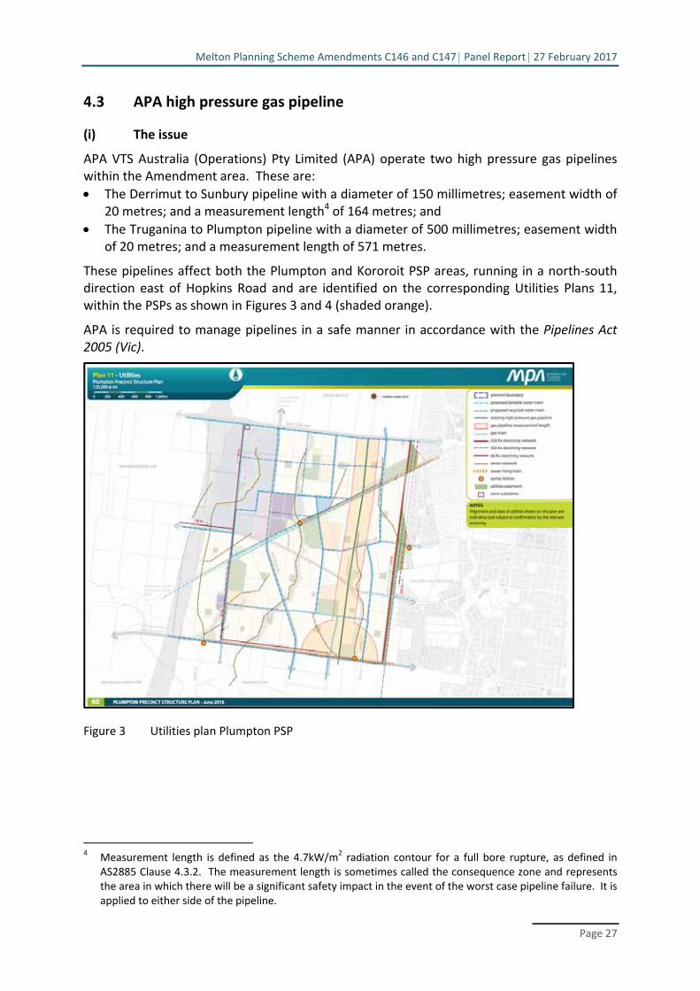
(i) The issue
APA VTS Australia (Operations) Pty Limited (APA) operate two high pressure gas pipelines within the Amendment area. These are:
The Derrimut to Sunbury pipeline with a diameter of 150 millimetres; easement width of 20 metres; and a measurement length4 of 164 metres; and
The Truganina to Plumpton pipeline with a diameter of 500 millimetres; easement width of 20 metres; and a measurement length of 571 metres.
These pipelines affect both the Plumpton and Kororoit PSP areas, running in a north‐south direction east of Hopkins Road and are identified on the corresponding Utilities Plans 11, within the PSPs as shown in Figures 3 and 4 (shaded orange).
APA is required to manage pipelines in a safe manner in accordance with the Pipelines Act 2005 (Vic).
Figure 3 Utilities plan Plumpton PSP
4 Measurement length is defined as the 4.7kW/m2 radiation contour for a full bore rupture, as defined in
AS2885 Clause 4.3.2. The measurement length is sometimes called the consequence zone and represents the area in which there will be a significant safety impact in the event of the worst case pipeline failure. It is applied to either side of the pipeline.

Melton Planning Scheme Amendments C146 and C147 Panel Report 27 February 2017
Page 28
Figure 4 Utilities Plan Kororoit PSP
The issues are:
Which uses should require a planning permit within the pipeline measurement length?
What notice or referral requirements should apply?
Should there be a density or other ‘buildings and works’ trigger for a planning permit within the gas pipeline measurement length and associated notice or referral requirements?
(ii) Background
The issues of:
The appropriate planning response to manage sensitive land uses within the pipeline measurement length
What uses should be deemed ‘sensitive’ in the context of high pressure pipelines; and
Whether APA should be a referral authority (determining or recommending) or whether notice only should be given for certain applications
have been the subject of many recent Panel hearings and reports, namely Lara West PSP5; Donnybrook/Woodstock PSP6; and Mount Atkinson and Tarneit Plains PSP7.
The Major Hazards Facilities Advisory Committee has also heard submissions in relation to this matter. The Committee report has not been released at the time of writing.
5 Amendment C246 to the Greater Geelong Planning Scheme, Panel Report, 19 July 2013. 6 Amendment GC28 to the Whittlesea and Mitchell Planning Schemes, Panel Report, 8 September 2016. 7 Amendment C162 to the Melton planning Scheme, Panel Report, 9 December 2016.

Melton Planning Scheme Amendments C146 and C147 Panel Report 27 February 2017
Page 29
The Panel agrees with commentary within the Lara West and Donnybrook/Woodstock PSP Panel reports, “that a more definitive, metropolitan‐wide planning policy approach is necessary in order to bring clarity and certainty to the issue”8. The VPA, Council and APA also advocated for a more holistic review of this issue, however, it was agreed that it was beyond the scope of this Panel to make broad recommendations.
In the absence of a State‐wide approach, the Panel has considered this manner in the context of the Plumpton and Kororoit PSP areas only, and the associated Future Urban Structure (FUS) presented in the PSPs, and note that its recommendations may not be suitable in other contexts.
The draft FUS Plans for both Plumpton and Kororoit propose predominately residential areas within the pipeline measurement lengths. The VPA advised that no land with an underlying ‘Residential Growth Zone’ is to be included within the measurement length. No schools or community centres are within the measurement length and generally all town centres are located outside the affected area.
The exception to this is the eastern part (approximately 70 metres) of the Kororoit Local Town Centre (LTC) located on the eastern side of Hopkins Road, being located at the outer edge of the Truganina to Plumpton pipeline measurement length.
(iii) Evidence and submissions
Which uses should require a planning permit within the pipeline measurement length?
The VPA, APA and Council agree on the following:
A planning permit is required for the following uses within the pipeline measurement length:
- Childcare centre - Cinema - Education centre - Hospital; and - Place of assembly.
That a Construction Management Plan with certain provisions should be triggered for any works within 50 metres of the easement land.
APA and Council also consider that the uses ‘Accommodation (other than a single dwelling on a lot or a Dependants persons unit)’ and ‘Retail premises’ should be permit required uses.
Initially the VPA did not consider that Accommodation (other than a single dwelling on a lot or a Dependant persons unit)’ should warrant the trigger of a permit, however in the VPA’s closing submission, Ms Peppler stated that VPA accepted that a permit trigger and notice to APA ought to exist for the use of ‘Accommodation (other than a single dwelling or dependant persons unit)’.
The VPA agree with Council that there is a need to add a permit trigger to the Kororoit Schedule to the UGZ to ensure that all accommodation uses within the Commercial 1 Zone would be captured, as many are ‘as of right’ subject to having a frontage at ground level of 2 metres or less.
8 p.93 Donnybrook/Woodstock PSP Panel Report.

Melton Planning Scheme Amendments C146 and C147 Panel Report 27 February 2017
Page 30
The VPA however maintained that the use of land for ‘dwelling’ should be excluded from the permit trigger, whereas Council and APA consider only ‘a single dwelling on a lot’ should be excluded from requiring a permit.
The other key issue where the parties differed is in relation to retail uses.
The VPA does not consider that retail uses are ‘sensitive uses’, and does not consider that retail uses should require the addition of a permit trigger within the measurement length.
The relevant Australian Standard 2885.1‐2012 Pipelines – Gas and liquid petroleum – Design and construction defines ‘sensitive uses’ as follows:
The sensitive use location class identifies land where the consequences of a failure may be increased because it is developed for use by sectors of the community who may be unable to protect themselves from the consequences of a pipeline failure. Sensitive uses are defined in some jurisdictions, but include schools, hospitals, aged care facilities and prisons. Sensitive use location class shall be assigned to any portion of pipeline where there is a sensitive development with a measurement length. It shall also include locations of high environmental sensitivity to pipeline failure.
Mr Chessell on behalf of Coles made submissions to the Panel that an additional permit trigger for retail premises is not warranted in this instance. Coles noted that a ‘buildings and works’ permit was already required in respect of retail development and that this would adequately address considerations raised by APA as being relevant to the proximity of the LTC to the gas pipeline. Coles adopted and relied on the submissions made by the VPA in relation to this issue.
Coles also submitted that APA had confirmed that it generally supported the land use and development outcomes under the revised Concept Development Plan for the Local Town Centre that included a series of retail uses, including a supermarket.
Moremac submitted that they did not support a retail permit trigger within the measurement length and supported the VPA position on this matter.
What notice or referral requirements should apply to those uses?
As exhibited, Schedules 11 and 12 to the UGZ include a notice provision to the gas transmission pipeline owner and operator. This is also reflected in the exhibited schedules to Clause 66.06 of the Melton Planning Scheme.
The submission by APA requested that applications be referred to the operator of the gas transmission pipeline rather than simply notice given. That is, that APA be made a recommending referral authority.
Council accepted this position and noted that it does not have the technical expertise to determine whether a particular use might be appropriate in the pipeline measurement length or to determine what, if any, conditions should be imposed. Accordingly, Council supported APA being a recommending referral authority and considered that they meet the criteria as outlined in the Planning Practice Note 54 – Referral and Notice Provisions.
The VPA considered that the ‘notice’ regime is adequate and didn’t consider that the APA should be made a referral authority. This would be consistent with the position

Melton Planning Scheme Amendments C146 and C147 Panel Report 27 February 2017
Page 31
recommended by the Panel in the Donnybrook/Woodstock PSP and Mt Atkinson PSP, with the ability of APA to receive information, make submissions and appeal to VCAT if desired.
Submissions made on behalf of Coles Property Group Developments were that neither referral nor notice was warranted, however it noted that “informal notice” may be acceptable. Council, however, was of the view that informal notice would not be a transparent, consistent or appropriate mechanism.
Should there be density or other ‘buildings and works’ trigger for a planning permit within the gas pipeline and associated notice or referral requirements?
APA’s original submission to the PSP sought that there be a permit trigger for anything other than a ‘single dwelling on a lot’, and therefore two or more dwellings on a lot.
In its presentation to the Panel by Ms Pickering, Hall & Wilcox Lawyers, it revised this position and suggested it should receive referral of applications for ‘higher density development’, with wording of ‘30 dwellings per hectare’. On Day 11 of the Hearing, APA made a supplementary submission in which it abandoned this position, and stated that APA was not seeking the inclusion of a specific density control. APA noted that in order for a density control to operate effectively, that an overlay would need to be implemented into the Victoria Planning Provisions.
The Panel notes, however, in APA’s suggested provisions to be included in the Urban Growth Zone schedules 11 and 12, that it retains ‘Accommodation, other than a single dwelling on a lot or a Dependent persons unit’ as both a permit trigger for the use of land and as a trigger for referral to the pipeline owner and operator. This in effect, is a density control as per their original submission.
The VPA’s position was that notice be given to APA of applications for a ‘residential development of four or more storeys’. It stated that there is already a buildings and works trigger for such development in all relevant zones, and therefore it is the notice requirement that they seek to be included, rather than an additional permit trigger. The VPA noted that this is the ‘threshold’ which will be readily workable in practice, as opposed to the density control, for example, suggested by APA.
Council also considered that the proposed density control suggested by APA would be unworkable, and suggested a trigger for referral be ‘two or three (at the nomination of the pipeline operator) dwellings on a lot’. In Council’s supplementary closing submission, they noted that they supported APA’s abandonment of the density control. However, as with APA, Council’s proposed provisions for schedules 11 and 12 of the Urban Growth Zone retain a permit trigger and a referral requirement for ‘Accommodation (other than a single dwelling on a lot or dependent person unit)’.
Other Matters
Council requested that the Panel make recommendations to amend Objective 24 in the Plumpton PSP and Objective 21 in the Kororoit PSP to read:
Ensure sensitive land uses are avoided within the measurement length of the high pressure gas transmission pipelines and that construction is managed to minimise risk of any adverse impacts.

Melton Planning Scheme Amendments C146 and C147 Panel Report 27 February 2017
Page 32
It also requested that Guideline 20 in the Plumpton PSP and Guideline 21 in the Kororoit PSP be amended to add the following dot point:
Not be located in the high pressure gas transmission pipeline measurement length identified on Plan 11 – Utilities.
In APA’s supplementary submissions made to the Panel a number of additional changes to the UGZ schedule 11 and 12 were proposed. These were:
The inclusion of a subdivision and building and works control in addition to the use control already included in the VPA’s draft schedules to the Urban Growth Zone.
Inclusion of the pipeline measurement length on Map 1 to Schedule 11 and 12 of the Urban Growth Zone, to ensure that the location of the pipeline measurement length is set out in the Urban Growth Zone and the area to which the pipeline planning control applies; and
Inclusion of a number of Decision Guidelines in Schedule 11 and Schedule 12 of the Urban Growth Zone for the Responsible Authority to consider in the assessment of applications within the pipeline measurement length, being:
Whether the proposal demonstrates compliance with Australian Standard AS2885.3 2012 (Pipeline Gas and Liquid Petroleum);
Any Worksafe and Environment Protection Authority guidelines;
The potential effect that a high pressure gas transmission pipeline full bore rupture could have on the proposed use or development;
Whether the use or development creates a risk to life or property and has the potential to compromise the safe operation of a pipeline;
Whether the proposal will result in an increase in the number of dwellings and/or people impacted by the pipeline full bore rupture;
Whether people will be able to safety respond to and/or evacuate the Pipeline Measurement Length in the event of a pipeline full bore rupture; and
The recommendations of any relevant safety Management Study or similar risk based assessment.
(iv) Discussion
Accommodation
The Panel agrees with the VPA that the permit trigger within the pipeline measurement length as it relates to Accommodation, should exclude ‘dwelling’ rather than ‘a single dwelling on a lot’. This more properly relates to a land use control, rather than a density control that is discussed separately below.
Retail use
The Panel was somewhat disappointed that, despite the lengthy process in preparing the PSP; consultation with APA including the preparation of the Safety Management Study Report (SMS) in 2014, and opportunity through the public exhibition process to make further comment, that there was no agreement about whether or not a local town centre was appropriately located within the pipeline measurement length and whether or not retail premises should require a permit for the use within the pipeline measurement length.

Melton Planning Scheme Amendments C146 and C147 Panel Report 27 February 2017
Page 33
In the context of urban growth area planning, it is precisely these broad land use planning issues that should be dealt with in preparing the FUS. As noted above, this is also not a new issue, with several PSPs dealing with this matter since the Lara West PSP in 2013.
In the Panel’s view, it is not orderly and proper planning to identify a local town centre within the pipeline measurement length, then require a permit for retail use. It would be entirely contrary to State and local planning policy to prohibit retail use within a dedicated town centre and contrary to the underlying Commercial 1 Zone in which both ‘Retail premises’ and ’Shop’ are Section 1, ‘as of right’ uses.
If retail is deemed a ‘sensitive use’ in the context of high pressure gas pipelines, APA have had ample opportunity to make this position clear, and for the local town centre to be relocated. Neither the Planning Scheme nor the Australian Standard for pipelines explicitly defines retail use as a sensitive use, and the Safety Management Study did not recommend the relocation of the town centre.
The Panel considers that to require a permit for retail use within the pipeline measurement length effectively defers the high level planning issue to the planning permit stage.
If the Panel accepts APA’s view that a planning permit should be required for retail uses, this could potentially result in a local town centre with no retail uses, if APA determined it not appropriate at the planning permit application stage. This fundamentally impacts on the future urban structure, and could deny the local residents of a conveniently located supermarket based retail centre. As noted above, this is also inconsistent with planning policy and the operation of the zoning system in Victoria.
Prior to the Hearing, the VPA and Coles had liaised with APA in relation to a concept design for the Kororoit LTC including a 4,000 square metre supermarket and speciality retail shops built along the eastern boundary of the town centre, and therefore partially within the pipeline measurement length. A service station was also shown located at the south/east corner of the LTC and also within the measurement length.
The Panel was provided with a letter from APA to Coles, dated 27 July 2016 stating:
APA has completed the review for the location of the proposed development around the high pressure pipelines and has ‘No Objection’ to the proposal. From the information supplied the proposed service station, retail and supermarket will be partially within the measurement length and in this instance your attention is particularly drawn to the following comments:
A Safety Management Study was conducted on the Precinct structure plan on the 16 June 2014. It is essential that all actions arising from this study are adhered to.
The proposal is outside the measurement length of APA 150mm pipeline but inside the measurement length of APA 500mm pipeline. The proposal encroaches a maximum 70 metres into this figure leaving approximately 500 metres separation. APA is comfortable with this proposal.
APA supports increased number of access/egress point throughout the north, south and west of the proposed development for emergency
Melton Planning Scheme Amendments C146 and C147 Panel Report 27 February 2017
Page 34
evacuation. In total six (6) different options moving people away from the threat are present in the unlikely event of an emergency incident.
Additionally all emergency exits to individual buildings should incorporate aspects to direct people away from the threat during an emergency incident; and
Where buildings are located along the eastern boundary of the parcel of land within the measurement length of the 500mm high pressure gas pipeline easement, it is advised not to have too many windows facing the potential hazard; windows and pervious materials are limited in their protection characteristics from radiant heat and should be minimised facing high pressure gas pipelines. Where this is not practical, heat resistant double glazed windows should be used to protect occupants in the event of an incident with the high pressure gas pipeline.
While this letter provides ‘No Objection’ to one concept plan only, and clearly the LTC may ultimately be designed with a different layout of uses and development, the Panel notes that the likely range of retail uses, namely supermarket, specialty shops and service station are all supported. The comments made by APA relate to the detailed design of windows and access/egress points. APA has not required the buildings to be re‐located outside the measurement length (which is theoretically possible as the western part of the LTC is outside the measurement length), nor has it requested a restriction on size of the building, number of patrons or type of retail.
The Panel does consider that it is appropriate that APA have a formal role in future development of the LTC which should be achieved through a buildings and works notice or referral, rather than a permit trigger for retail use.
The Panel is aware that other Panels have made different recommendations in relation to this matter, and in particular, the recent Mt Atkinson Panel report recommended that retail premises should require a permit within the measurement length. This was a cautionary approach in the context of a bulky goods retailing area.
The Panel considers that the Kororoit PSP has a different local circumstance, with the consideration relating to a LTC, that will provide the core retail facilities for the surrounding local community, at the outer edge of the measurement length. On this basis, and for the reasons outlined above, the Panel considers these Amendments warrant a different approach.
Notice or Referral
In relation to the matter of whether notice should be given, or whether APA should be a recommending referral authority, the Panel agrees with APA and Council that the more formal role of recommending referral authority should be provided.
Planning Practice Note 54 states:
A new section 55 referral should only be introduced where:
The referral authority’s specialist or technical advice is necessary for the responsible authority to properly assess and decide the application, but does not need to direct the outcome (a recommending referral authority).

Melton Planning Scheme Amendments C146 and C147 Panel Report 27 February 2017
Page 35
The Panel agrees with Council that this threshold is met. As outlined in submissions, Council does not have the technical expertise required to properly assess and decide an application, and this lies with the pipeline owner or operator.
With notice under section 52(1), APA would be made aware of the application but is not required to be provided with a copy of the application (required under Section 55). Referral, however, would ensure that the full details of the application are provided, that would include building design, locations of exits, windows, materials etc.
Given the technical nature of the issue, the Panel considers that the more formal referral process should be provided to enable APA to give technical advice to assist the responsible authority in determining a permit application.
The Panel also agrees with Council that the referral of a planning application is a simple matter undertaken by the administrative team within Council and is not burdensome. Furthermore, the impact on Council resources to make a referral rather than give notice is not considered to be materially different.
The Panel again recognises that this differs from recommendations from other Panels, however notes that this recommendation relates to the circumstances of the Plumpton and Kororoit PSP only, and until such time a State wide approach is made, there may be differences in approach.
Density triggers for notice or referral
The Panel was somewhat frustrated that the position on a density trigger by APA appeared to change through the course of the Hearing and its final position was unclear.
By the conclusion of the Hearing, APA stated that it no longer supported a density control within the pipeline measurement length and Council supported this position. However, both retained triggers for the use and referral of ‘Accommodation other than a single dwelling on a lot’, within the pipeline measurement length. This is a confused position as this use and referral provision are in effect a density control, requiring a permit and referral for ‘two or more dwellings on a lot’.
The Panel is also not convinced by the VPA’s proposal for a trigger for referral or notice, for a ‘development of four or more storeys accommodating dwellings’, as it is the density of people that is important to a pipeline operator, and not the height of a building. While in many circumstances there would be a direct correlation, this is not always the case. Planning scheme provisions relating to ‘four or more storeys’ typically relate to built form considerations, such as urban design and amenity impacts as a result of the height of a building, rather than the density of people on a site.
The Panel notes that no land with an applied RGZ is included within the pipeline measurement length, and it is unlikely that buildings greater than four storeys or 30 dwellings per hectare (being the originally suggested density control by APA) will be sought within the GRZ land.
On this basis, the Panel does not seek to include a density control, however does suggest that all parties give more thought to this for future PSP processes in areas that contain pipeline assets.
Melton Planning Scheme Amendments C146 and C147 Panel Report 27 February 2017
Page 36
Other matters
The Panel does not consider that the Objectives and Guidelines need to be amended as recommended by Council. The Panel considers that as objectives and guidelines rather than mandatory provisions, the exhibited wording is appropriate.
In response to the supplementary matters raised by APA, the Panel agrees with the VPA that there has not been any rationale put forward as to why there should be an additional trigger for subdivision or buildings and works, and in fact, there is already broad ranging permit triggers in place. The Panel also agrees with the VPA that it appears that what APA are really seeking is notice or referral of subdivision and buildings and works applications, rather than an additional permit trigger.
The Panel supports the inclusion of the pipeline measurement length on Map 1 to Schedules 11 and 12 of the Urban Growth Zone. This will enable the associated controls within the schedules relating to the pipeline measurement lengths to be readily understood and applied.
In relation to the Decision Guidelines suggested by APA, the Panel agrees with the VPA and Council that these are highly technical matters that are beyond the expertise of Council, or the Tribunal on review, to assess. While Council suggested an introductory paragraph which would read, “the comments of the gas pipeline operator in respect of” the Decision Guidelines, the Panel considers that the proposed guidelines are too broad and hard to implement by Council, and would not be workable in practice.
The Panel accepts that these may be matters that APA will consider in a referral of a permit application, however do not consider that they should be included within the schedules to the Urban Growth Zone.
(v) Conclusions
The Panel concludes that:
A planning permit should be required for the following uses within the pipeline measurement length:
- Accommodation (other than a dwelling or dependent persons unit) - Childcare centre - Cinema based entertainment facility - Education centre - Hospital; and - Place of assembly.
Retail use should not trigger a permit requirement within the pipeline measurement length, however a buildings and works application for retail premises, including shop, should be referred to the pipeline operator.
APA should be made a recommending referral authority rather than a body to which notice is given.
No density controls need to be included within the schedules to the Urban Growth Zone associated with the high pressure gas pipeline.
No change is required to objectives or guidelines within the PSP.
No additional permit triggers should be sought for subdivision or building and works.

Melton Planning Scheme Amendments C146 and C147 Panel Report 27 February 2017
Page 37
Map 1 to Schedules 11 and 12 to the UGZ should be amended to include the pipeline measurement length.
The Decision Guidelines suggested by APA are not required.
(vi) Recommendations
The Panel makes the following recommendations in relation to high pressure gas pipelines:
Amend Clause 2.4 of the Urban Growth Zone, Schedules 11 and 12, to include the 7.following as uses which require a permit in the high pressure gas pipeline measurement length:
Accommodation (other than dwelling or dependent persons unit)
Childcare centre
Cinema
Education centre
Hospital; and
Place of assembly.
Amend Clause 6.0 of Schedules 11 and 12 of the Urban Growth Zone to read as 8.follows:
Referral to gas transmission pipeline operator An application to use land for any of the following uses within the ‘gas pipeline measurement length’ shown on Plan 11 Utilities in the incorporated Plumpton Precinct Structure Plan must be referred to the gas transmission pipeline operator:
Accommodation (other than a dwelling or dependent persons unit)
Child care centre
Cinema
Education centre
Hospital
Place of assembly.
An application for buildings and works associated with Retail premises, including Shop, within the ‘gas pipeline measurement length’ must be referred to the gas transmission pipeline operator.
Amend the Schedule to Clause 66.04 to include the owner of the high pressure gas 9.pipeline as a recommending referral authority for applications specified under Clause 6.0 in Schedules 11 and 12 to the Urban Growth Zone.
Remove the proposed Schedule to Clause 66.06. 10.
Amend Map 1 to Schedules 11 and 12 of the Urban Growth Zone to include the 11.pipeline measurement lengths.
4.4 Small local enterprises
(i) Issue
Will the areas identified as ‘small local enterprises’ jeopardise the intended retail hierarchy of the Plumpton and Kororoit Local Town Centres (LTCs)?

Melton Planning Scheme Amendments C146 and C147 Panel Report 27 February 2017
Page 38
(ii) Background
A key objective relating to ‘Town Centres and Employment’ in the Plumpton and Kororoit PSP (objectives 11 and 8 respectively) is to deliver lower‐cost, flexible space in and adjacent to the Major Town Centre and LTCs for a range of small local enterprises, and to ensure these centres have an ability to adapt and evolve over time.
Within the Kororoit PSP, small local enterprises areas are nominated to the north of the Deanside LTC (p.23) and Kororoit LTC (p.24) and in the Plumpton PSP a small local enterprise area is included to the north of the LTC on Plumpton Road (p.33).
Small local enterprises are described as:
… supporting services and ancillary uses which are typically on the periphery of, or near, Local Town Centres in traditional inner and middle ring areas in Melbourne. Uses may include, but are not limited to the following (subject to planning permit requirements):
Printers, craft centres, storage, equipment repairs and servicing, studio/workrooms, veterinary clinics, dance studios.
The PSP notes that these areas can require many different layout options, varied floor space sizes, servicing, storage and lower‐order rentals than in the core retail areas and help provide a full range of local services; integrate local employment and service opportunities; and promote sustainability, adaptability and localisation.
The schedules to the UGZ nominate the Commercial 2 Zone (C2Z) as the applied zone for these areas.
(iii) Submissions
The VPA submitted that it has identified land for ‘small local enterprises’ in the PSPs in response to a review of LTCs in growth areas, and finding that they tend to not support space for a diversity of other local services and small businesses that are not typically core functions of the LTC.
Melton City Council raised concerns that the small local enterprise areas could jeopardise the intended hierarchy of the LTCs in the Plumpton and Kororoit areas.
Council noted that the applied C2Z allows, ‘as of right’, a supermarket up to a leasable floor area of 1,800 square metres provided the site adjoins or has access to a road in a Road Zone. This would apply in both LTCs within Kororoit but not in Plumpton. Further, the C2Z allows ‘as of right’ a combined leasable floor area of shops of up to 500 square metres adjoining, or on the same land as a supermarket.
Council submitted that the Plumpton and Kororoit – Retail and Employment Land Assessment, HillPDA 2015, that provided the background assessment in relation to the business and industrial areas within the Amendment, did not include the small local enterprise areas and therefore the impact on the hierarchy is not known.
Select Planners made a submission on behalf of ALDI Stores Pty Ltd. ALDI did not present to the Panel but requested that the matters raised in their original submission and letter dated 6 December 2016 to the Panel be considered.

Melton Planning Scheme Amendments C146 and C147 Panel Report 27 February 2017
Page 39
ALDI’s submission was that there was a lack of flexibility contained within the PSP and translated into the proposed zone controls, for smaller retail supermarket chains such as ALDI to establish in LTC and within the identified small enterprise areas. ALDI considered that this is contrary to the intent of Amendment VC100, which was established to open up competition, drive efficiency and maintain competitive advantages for smaller retail supermarkets chains such as ALDI.
ALDI submitted that the PSP fails to acknowledge the ‘as‐of‐right’ uses within the applied C2Z that could establish in the small local enterprise areas.
ALDI requested that the Panel consider adopting the following amendments:
References to ‘anchor retail’ and ‘secondary anchors’ be made less prescriptive.
That the applied zone schedule proposed for shops within the C2Z be deleted.
That the details of the uses encouraged within the small local enterprises areas in the PSP be made less prescriptive.
That the extent of Mixed Use Zone and C2Z west of Hopkins Road be reviewed to allow for small supermarkets.
That more detail be provided in relation to the conceptual layout of the C2Z adjacent to the western freeway, particularly in relation to access.
(iv) Discussion
VPA and Council agreed with the concept of ‘small enterprise areas’ and throughout the course of the Hearing had several discussions on how to achieve the intent of these areas, and prevent uses that would be more appropriately located within the LTC (with an applied Commercial 1 Zone) and that may impact on the retail hierarchy.
Following the Hearing the VPA provided the Panel with draft wording for the Urban Growth Zone that had been agreed to by Council, as follows:
Kororoit PSP:
Retail where the applied zone is Commercial 2 Zone directly north of the Deanside Local Town Centre and directly east of the Kororoit Local Town Centre
The following land uses are prohibited where the leaseable floor area is greater than 900m2:
Restricted retail premises
Postal agency
Market
Manufacturing sales
Trade supplies
Landscape gardening supplies
Food and drink premises is prohibited where the leasable floor area is greater than 100m2
The following land uses are prohibited:
Shop (except restricted retail premises)
Motor vehicle, boat, or caravan sales
Gambling premises
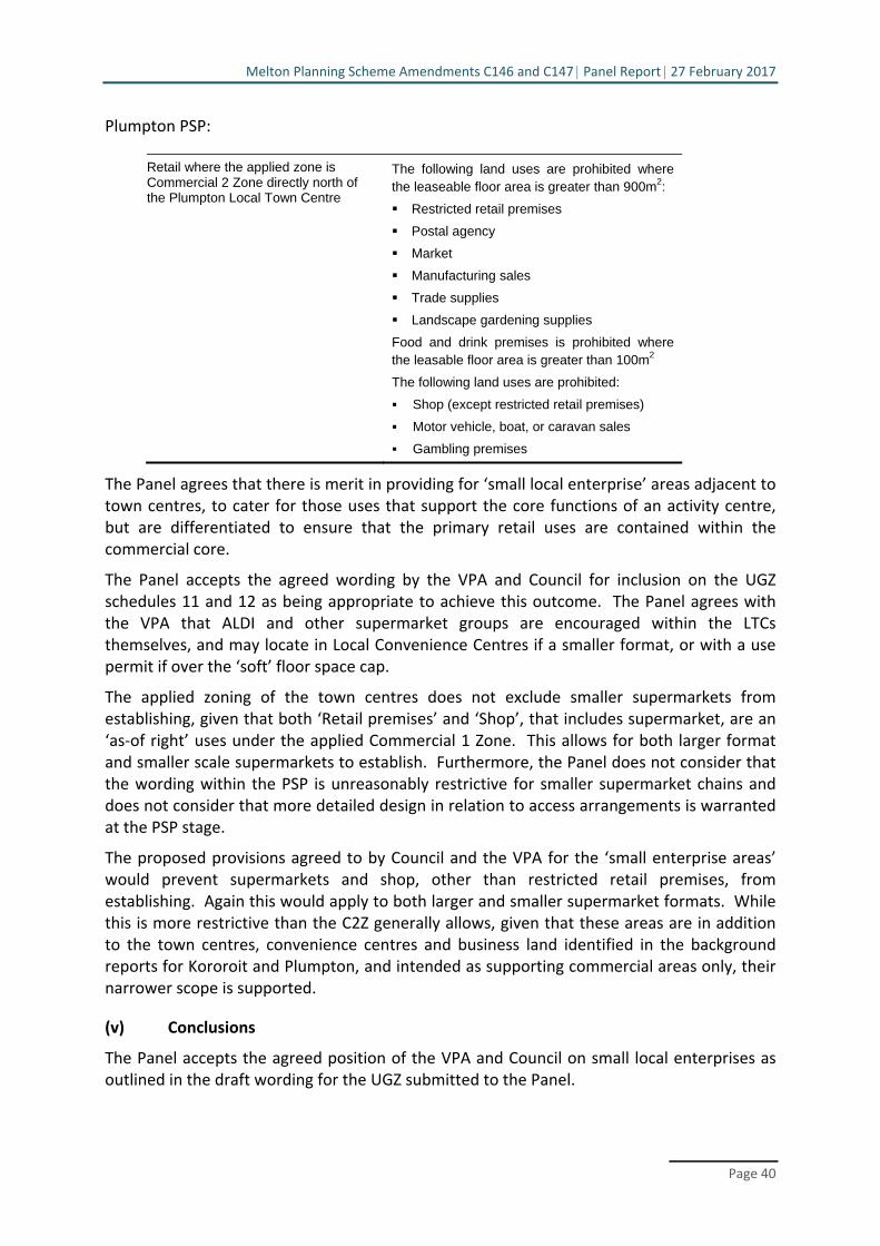
Melton Planning Scheme Amendments C146 and C147 Panel Report 27 February 2017
Page 40
Plumpton PSP:
Retail where the applied zone is Commercial 2 Zone directly north of the Plumpton Local Town Centre
The following land uses are prohibited where the leaseable floor area is greater than 900m2:
Restricted retail premises
Postal agency
Market
Manufacturing sales
Trade supplies
Landscape gardening supplies
Food and drink premises is prohibited where the leasable floor area is greater than 100m2
The following land uses are prohibited:
Shop (except restricted retail premises)
Motor vehicle, boat, or caravan sales
Gambling premises
The Panel agrees that there is merit in providing for ‘small local enterprise’ areas adjacent to town centres, to cater for those uses that support the core functions of an activity centre, but are differentiated to ensure that the primary retail uses are contained within the commercial core.
The Panel accepts the agreed wording by the VPA and Council for inclusion on the UGZ schedules 11 and 12 as being appropriate to achieve this outcome. The Panel agrees with the VPA that ALDI and other supermarket groups are encouraged within the LTCs themselves, and may locate in Local Convenience Centres if a smaller format, or with a use permit if over the ‘soft’ floor space cap.
The applied zoning of the town centres does not exclude smaller supermarkets from establishing, given that both ‘Retail premises’ and ‘Shop’, that includes supermarket, are an ‘as‐of right’ uses under the applied Commercial 1 Zone. This allows for both larger format and smaller scale supermarkets to establish. Furthermore, the Panel does not consider that the wording within the PSP is unreasonably restrictive for smaller supermarket chains and does not consider that more detailed design in relation to access arrangements is warranted at the PSP stage.
The proposed provisions agreed to by Council and the VPA for the ‘small enterprise areas’ would prevent supermarkets and shop, other than restricted retail premises, from establishing. Again this would apply to both larger and smaller supermarket formats. While this is more restrictive than the C2Z generally allows, given that these areas are in addition to the town centres, convenience centres and business land identified in the background reports for Kororoit and Plumpton, and intended as supporting commercial areas only, their narrower scope is supported.
(v) Conclusions
The Panel accepts the agreed position of the VPA and Council on small local enterprises as outlined in the draft wording for the UGZ submitted to the Panel.

Melton Planning Scheme Amendments C146 and C147 Panel Report 27 February 2017
Page 41
(vi) Recommendations
The Panel makes the following recommendations in relation to small enterprise areas:
Amend the UGZ Schedule 11 (Plumpton) to include: 12.
Retail where the applied zone is Commercial 2 Zone directly north of the Plumpton Local Town Centre
The following land uses are prohibited where the leaseable floor area is greater than 900m2:
Restricted retail premises
Postal agency
Market
Manufacturing sales
Trade supplies
Landscape gardening supplies
Food and drink premises are prohibited where the leasable floor area is greater than 100m2
The following land uses are prohibited:
Shop (except restricted retail premises)
Motor vehicle, boat, or caravan sales
Gambling premises
Amend the UGZ Schedule 12 (Kororoit) to include: 13.
Retail where the applied zone is Commercial 2 Zone directly north of the Deanside Local Town Centre and directly east of the Kororoit Local Town Centre
The following land uses are prohibited where the leaseable floor area is greater than 900m2:
Restricted retail premises
Postal agency
Market
Manufacturing sales
Trade supplies
Landscape gardening supplies
Food and drink premises is prohibited where the leasable floor area is greater than 100m2
The following land uses are prohibited:
Shop (except restricted retail premises)
Motor vehicle, boat, or caravan sales
Gambling premises
4.5 Timing of the Infrastructure Contributions Plan
(i) Background
The PSPs were exhibited with Development Contributions Plan Overlay Schedules 10 and 11 (DCPO10 and DCPO11) to apply to the respective PSP areas. The PSPs identify, at Table 9, a list of infrastructure projects proposed to be included in an Infrastructure Contributions Plan (ICP) (formerly called a Development Contributions Plan (DCP)). The items were not costed at the time of the Panel Hearing.
DCPO10 and DCPO11 note that no ‘Summary of costs’ nor ‘Summary of contributions’ are specified and that the preparation and incorporation of a plan is required.

Melton Planning Scheme Amendments C146 and C147 Panel Report 27 February 2017
Page 42
The overlay schedules provide for a permit to be granted to subdivide land, construct a building or construct or carry out works before a precinct wide contributions plan has been prepared under certain circumstances, including if an agreement is entered into under section 173 of the Planning and Environment Act 1987.
The ICP is being prepared but was not exhibited as part of this Amendment.
On 27 October 2016 the Minister for Planning released the new ICP Guidelines, along with a Ministerial Direction on the preparation and content of infrastructure contribution plans and Planning Advisory Note 64 ‘Transitional arrangements for metropolitan growth area infrastructure contributions’.
Planning Advisory Note 64 sets out circumstances that must be met for a DCP to be used instead of an ICP. Those circumstances do not apply to these Amendments, so in the Panel’s understanding, an ICP will be required for these precincts.
The Ministerial Direction sets out the requirements for imposing a supplementary levy, including allowable items, criteria for applying and requirements for estimating costs. Importantly, the ICP Guidelines, at page 34, state that “a normal amendment process will apply for an ICP where a supplementary levy is proposed”. This could potentially affect the time that may be needed to finalise the ICP in the event that a supplementary levy is required. Clearly if the ICP goes through a separate amendment process, it will take longer.
The Panel understands that, as part of the process to determine whether a supplementary levy is required, it must first be determined whether the cost of the supplementary item/s could be accommodated within the money collected from the standard levy. All items in the ICP (and any proposed supplementary items) will, therefore, need to be costed before a decision can be made about whether a supplementary levy is required.
The Amendment proposes the application of a DCPO over the entire area of the PSP. Given that the ICP Guidelines are now in place, this should be substituted with an ICPO. Planning Advisory Note 64 makes it clear that a DCP can only be used if it has been placed on exhibition prior to the commencement of the ICP system. No DCP was placed on exhibition in this case, so an ICP and ICPO are the appropriate mechanisms.
The VPA advised that it is likely that supplementary levies will be required for the ICPs for Plumpton and Kororoit. The VPA advised that this is largely due to the high land values in the area, and the three bridge crossings of the Kororoit Creek, which are supplementary allowable items.
(ii) The issue
Should the PSP be delayed until a fully costed ICP is prepared?
(iii) Submissions
There was considerable discussion at the Hearing and in submissions in relation to whether an ICP should be prepared before the PSPs are finalised. The position put, primarily by Council, was that a fully costed ICP should be prepared and agreed prior to finalising the PSP so that any changes that might be required to the precinct infrastructure table, future urban structure or any other aspect of the PSP can be made before both the PSP and ICP are gazetted. Council submitted that to do otherwise exposes Council to the risk of under‐

Melton Planning Scheme Amendments C146 and C147 Panel Report 27 February 2017
Page 43
funded infrastructure. Council expressed some frustration at the lack of cost estimates for infrastructure items in the PSPs, meaning that it was unclear to what extent a standard levy would cover the items listed. The Panel asked the VPA during the course of the Hearing if preliminary costings were available. The VPA responded that the costings were not able to be shared at that time.
Previous panels9 have consistently held that PSPs should not be finalised and gazetted until a DCP/ICP is produced. It is fair to note, however, that previous panels were held prior to the implementation of the new ICP system. The current Amendments are being implemented in the ‘transition phase’ of the new ICP system, and this creates some implementation difficulties. The VPA and Council proposed an alternative approach to dealing with the ICP in this case. The Council’s supplementary closing submission provided a useful summary of what the Panel understands is the compromise position offered by the VPA:
The proposal that the Council understands is as follows:
A Standard ICP would be gazetted at the same time as gazettal of the PSP.
The Standard ICP would be discussed with the Council during its formation to examine the extent of broadly estimated costs (based on VPA benchmarks) for the infrastructure in Table 9. This is to ensure that the Council’s concern about the need for potential revision of the PSP on account of infrastructure provision is addressed.
In the event that this review indicated that Council and/or the VPA considered a need for revision of Table 9 or revision of the Future Urban Structure or PSP then this would necessarily be the subject of targeted consultation prior to submission of each amendment to the Minister for approval.
Parties developing prior to the commencement of any supplementary ICP would need to enter into an agreement which provided for payment in the future of any future supplementary levy, a matter which Council hopes would be resolved shortly after gazettal of the PSP and Standard ICP.
Again, the Kororoit part two amendment may have implications for the processes above and it may be necessary as part of that PSP to amend the PSPs under consideration in this proceeding to address any issues.
Council considers the process above would constitute a workable means of meeting the competing interests of Council and the development community.
Council went on to provide an example of why it believes that it is essential to finalise the standard levy ICP items before the PSP is finalised.
The VPA responded as follows:
As per VPA’s closing submission (at 26), the Panel could recommend an alternative interim arrangement for the ICP to that exhibited, (given the ICP Directions have now been released). This alternative proposal would be as follows:
Introduction of an ICP concurrent with the gazettal of the PSP, but which ICP relates only to the items which are the subject of standard levies as per
9 Refer to panel reports for Melton C162 and GC28 (Donnybrook – Woodstock).
Melton Planning Scheme Amendments C146 and C147 Panel Report 27 February 2017
Page 44
the ICP Ministerial Guidelines for a standard ICP. This would comprise all ‘standard’ items, i.e. roads and intersections, community and recreation infrastructure, and land (up to the value to the standard levy rate). It would exclude all ‘supplementary’ items i.e. bridges, culverts and land over the value of the standard levy rate.
VPA has held preliminary discussions with DELWP regarding this option but we note this is still a matter for ongoing discussion.
VPA is appreciative that Council is open to considering this option.
VPA agrees that the Standard ICP would be discussed with Council during its preparation with relation to the infrastructure in Table 9.
In the event that this discussion indicated a need for revision of Table 9 (e.g. potentially the scope of items, or whether this were developer works instead of ICP works) then this would necessarily be the subject of targeted consultation with any affected party/ parties prior to submission of the PSP/ ICP amendment to the Minister for approval.
As per VPA’s closing submission, a second planning scheme amendment would then be pursued to introduce the required supplementary levy to deal with supplementary items, once further costings have been undertaken as per the Ministerial to clarify the extent of these items which do not fit within the standard ICP.
VPA would continue to discuss the detail of this with Council and costings will be available for review in the preparation of that amendment.
(iv) Discussion
The Panel agrees that it is appropriate to apply ICPOs over the whole area of the PSPs. The Panel recommends the substitution of the DCPO with the new ICPO. The PSP itself provides the strategic justification for the application of an ICP. The PSP defines the infrastructure proposed to be included in any ICP, although it is un‐costed. The Panel believes it would be better practice for the VPA to develop standard costs and share those with the Council. This would make it easier to estimate to what extent a standard levy ICP would cover infrastructure identified in the PSP.
The Panel agrees with Council that the Amendment should not be approved and the PSPs should not be finalised before the ICPs are prepared. The Panel agrees with Council that there is uncertainty with the approach as exhibited. The ‘blank’ DCPO, in the Panel’s view, leaves too many uncertainties.
The Panel is sympathetic to the alternative approach proposed by the VPA and Council of preparing and gazetting a standard levy ICP with the PSP.
The Panel notes that paragraph 7 of Overview of the Infrastructure Contributions Plans System states that whilst the Planning and Environment Regulations prescribe a Standard levy ICP as a class of amendment under section 20A of the Act (prepared by the Minister and exempt from notice requirements), “a normal amendment process will apply for an ICP where a supplementary levy is proposed”. The Panel understands that it is policy that if a supplementary levy is triggered then the whole of the ICP is subject to the normal amendment process including exhibition and panel hearings if required.

Melton Planning Scheme Amendments C146 and C147 Panel Report 27 February 2017
Page 45
The Panel is fully supportive of this policy where a PSP and ICP are being developed from scratch. It makes sense that ICPs are developed alongside the PSP, and the need for any supplementary levy identified as part of this process. It also makes sense that the entire ICP be reviewed (standard and supplementary levies) in the event that a supplementary levy is required to examine whether a supplementary levy is in fact required, or whether it can be accommodated within the standard levy.
The issue in this case is that the PSP was developed ahead of the implementation of the new ICP system. Whilst infrastructure items have been identified for each of the PSPs, costings have not been provided and the nature of any potential supplementary levy has not been identified. The Panel believes that it would be relatively easy to prepare costings for a standard levy based on standard costs or schedules of rates for the respective items. Standard ICPs should therefore be able to be produced in a short time frame and not delay the gazettal of the PSP. Finalising any supplementary levies are likely to be a different matter, with the normal amendment process required likely to take some additional months.
The VPA compromise proposal effectively ‘dis‐connects’ the standard levy from the supplementary levy process and enables the PSP to be gazetted once the standard levy has been finalised. While the Panel agrees that under normal circumstances it is better to follow the policy to connect the standard and supplementary levy processes together, these are not normal circumstances, and the Panel sees merit in the VPA proposed approach. The Panel is keen, however, that this approach should only be adopted in these ‘transitional’ circumstances and should not be seen as a precedent for other amendments.
The advantage of the approach proposed is that the PSP can be finalised earlier and development can commence, bringing housing and other land to the market earlier. The risk of having supplementary levies left unfunded can be addressed, as suggested by Council, by requiring developers commencing development prior to the preparation of any supplementary ICP to enter into an agreement which provided for payment in the future of any future supplementary levy. This could be achieved via a Section 17310 agreement or similar.
On balance, the Panel believes that the benefits of reduced delays in making land available outweighs any disadvantages of varying from the policy in this case.
(v) Conclusions
The Panel concludes:
It is appropriate to apply ICPOs over the whole area of the PSPs.
The Amendment should not be approved and the PSP should not be finalised before an ICP is prepared.
The Panel supports the approach proposed by the VPA of developing a standard levy ICP and gazetting this with the PSP, and progressing any supplementary levies as a separate amendment process.
10 Of the Planning and Environment Act 1987

Melton Planning Scheme Amendments C146 and C147 Panel Report 27 February 2017
Page 46
4.6 Items for inclusion in the Infrastructure Contributions Plan
(i) The issue
Various submissions were made to the Panel in relation to items that should or should not be included in the ICP. Most of these items are discussed under submissions by individual landowners. This section summarises the Panel’s conclusions on ICP items.
(ii) Submissions
The Panel asked the VPA to make clear whether it is seeking that the Panel recommend that certain items be included in the ICP; or whether the VPA is seeking that the Panel simply make a finding that certain items are strategically justified.
The VPA responded that it “requests that the Panel does make recommendations that the items are both: strategically justified; and should be included in the ICP.“
The VPA, in its closing submission, identified the following items raised by submitters which require closer attention from the Panel:
the proposed aquatic centre
Sinclairs Road widening
Bridges 1 and 3
Pedestrian bridges PBR‐02, PBR‐03 and PBR‐08
Two proposed new intersections to access the Kororoit LTC
New pedestrian signals on Hopkins Road close to CU‐05
Arterial roads over pipeline easement
Beattys Road road and landscaping works
The shared path in powerlines easement.
The VPA requested that the Panel make recommendations both that these items are strategically justified, and also that they should or should not be included in the ICP (where this was VPA's submission in respect of a particular item). The VPA provided a table summarizing the position on each item. The Panel has adapted and added to that table as shown in Table 1.
The Panel has added a summary of its response and a report section reference column to the table. The Panel’s discussion of the infrastructure item is covered in that section.

Melton Planning Scheme Amendments C146 and C147 Panel Report 27 February 2017
Page 47
Item Raised by Submitter VPA’s position Panel conclusion
Ref
Aquatic Centre
Council, which wants the Aquatic Centre included in the ICP “In part”
50 percent of the land for the Aquatic Centre land can be included in the ICP
Construction cannot be included in the ICP as it is not in the list of “Allowable items” in the ICP Guidelines (Table 1, p45)
Agree with VPA.
50 percent of the land can be included.
Construction is not an allowable item
5.14
Sinclairs Road widening
Villa World, which wants this item included in the ICP
This should be developer works, and not an ICP item.
Agree with VPA. Developer works
6.5
Bridges BR‐01 and BR‐03
Moremac, which wants these bridges excluded from an ICP
These items should be recommended for inclusion in the ICP.
These are bridges which are “on or adjoin land in fragmented ownership”. Include in ICP
6.6
Pedestrian bridge PBR‐02
Dahua Dacland seeks to delete as developer works
This item should be recommended for inclusion in the ICP.
Agree with VPA. Retain in ICP
5.9
Pedestrian bridge PBR‐03
Council This item no longer required as connector road and local park have moved north.
Removal noted and agreed
‐
Pedestrian bridge PBR‐08
Moremac, which wants this bridge excluded from an ICP
This item should be recommended for inclusion in the ICP (apportioned 40/60 (Mt Atkinson/ Plumpton and Kororoit) as per Mt Atkinson Panel recommendation).
Include as an ICP item, with part apportionment to Mt Atkinson ‐ Tarneit Plains PSP. Supplementary item if required
6.6
Two new intersections to access the Kororoit LTC
Coles, which wants these intersections included in an ICP
These items should be recommended for inclusion in the ICP.
Agree that the intersections should be included as ICP items
6.11
New pedestrian signals on Tarleton Road close to CU‐03
Council, which wants this item included in the PSP and in an ICP
This item is unnecessary and should not be included.
Agree with Council that signals are warranted and should be an ICP item
5.14
Arterial roads over
Council, which wants this item included in
This item can be included in the ICP as part of the project
Agree can be included as
5.14
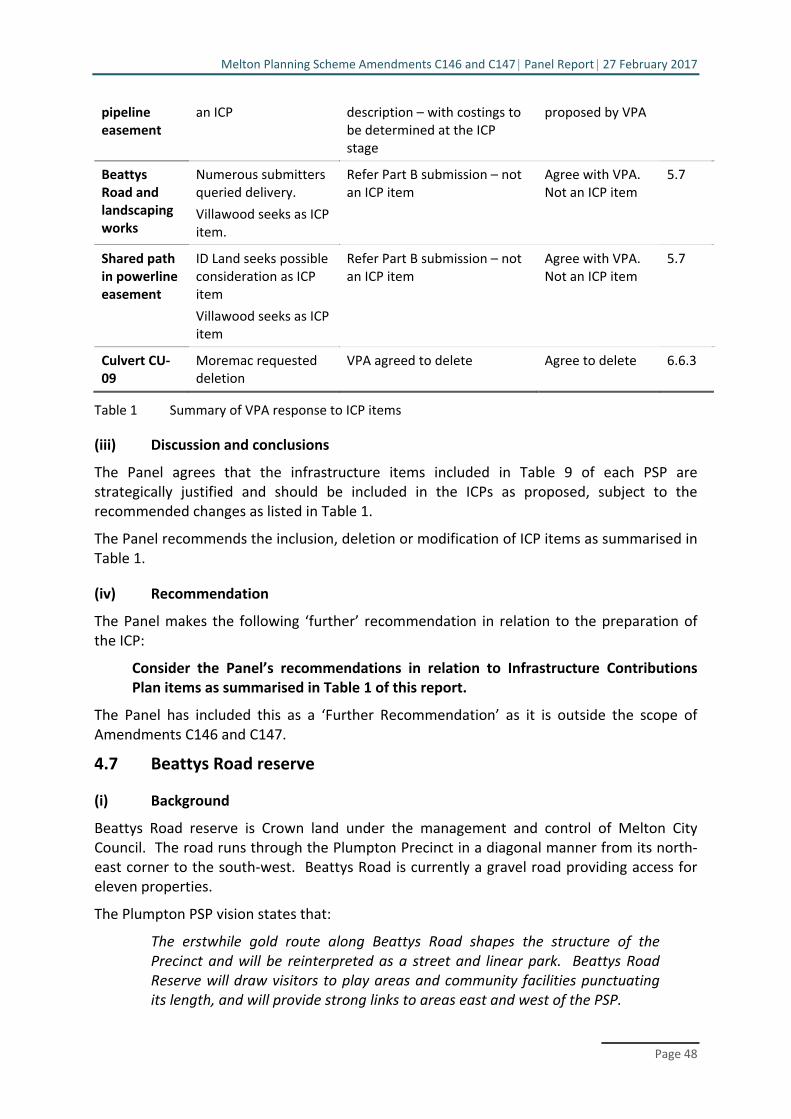
Melton Planning Scheme Amendments C146 and C147 Panel Report 27 February 2017
Page 48
pipeline easement
an ICP description – with costings to be determined at the ICP stage
proposed by VPA
Beattys Road and landscaping works
Numerous submitters queried delivery.
Villawood seeks as ICP item.
Refer Part B submission – not an ICP item
Agree with VPA. Not an ICP item
5.7
Shared path in powerline easement
ID Land seeks possible consideration as ICP item
Villawood seeks as ICP item
Refer Part B submission – not an ICP item
Agree with VPA. Not an ICP item
5.7
Culvert CU‐09
Moremac requested deletion
VPA agreed to delete Agree to delete 6.6.3
Table 1 Summary of VPA response to ICP items
(iii) Discussion and conclusions
The Panel agrees that the infrastructure items included in Table 9 of each PSP are strategically justified and should be included in the ICPs as proposed, subject to the recommended changes as listed in Table 1.
The Panel recommends the inclusion, deletion or modification of ICP items as summarised in Table 1.
(iv) Recommendation
The Panel makes the following ‘further’ recommendation in relation to the preparation of the ICP:
Consider the Panel’s recommendations in relation to Infrastructure Contributions Plan items as summarised in Table 1 of this report.
The Panel has included this as a ‘Further Recommendation’ as it is outside the scope of Amendments C146 and C147.
4.7 Beattys Road reserve
(i) Background
Beattys Road reserve is Crown land under the management and control of Melton City Council. The road runs through the Plumpton Precinct in a diagonal manner from its north‐east corner to the south‐west. Beattys Road is currently a gravel road providing access for eleven properties.
The Plumpton PSP vision states that:
The erstwhile gold route along Beattys Road shapes the structure of the Precinct and will be reinterpreted as a street and linear park. Beattys Road Reserve will draw visitors to play areas and community facilities punctuating its length, and will provide strong links to areas east and west of the PSP.
Melton Planning Scheme Amendments C146 and C147 Panel Report 27 February 2017
Page 49
Under the PSP, Beattys Road reserve will be retained to provide a road function in various forms to cater for connector roads, local access streets and loop road treatments as well as a continuous shared path for cyclists and pedestrians. It is envisaged that Beattys Road reserve will act as the civic spine of the Precinct flanked by community facilities, schools and sports reserves as well as facilitating priority pedestrian and cycling access.
The Beattys Road reserve is shown on PSP Plan 6 – Open Space as LOS‐03 which is listed in PSP Table 9 – Precinct Infrastructure as ‘developer works’. Three local parks (LP‐20, 21 and 22) are also shown within the Beattys Road reserve in the exhibited Plumpton PSP.
(ii) Submissions
Responsibility for delivery
Melton City Council and other submitters have queried who is responsible for delivering necessary road infrastructure and landscaping embellishments within the Beattys Road reserve. They submitted that it was not sufficiently clear in the PSP. Furthermore, it was submitted that the Beattys Road reserve should be included in the ICP.
In its Part B submission, the VPA sought to provide clarity on this issue by proposing to include in the PSP an additional appendix that would include separate plans to show who is responsible for delivering the required infrastructure be it landscaping and/or embellishments and road infrastructure. These plans would be referenced in the PSP Table 9 – Precinct Infrastructure and updated Beattys Road concept plans (Document 16) to replace figures 1‐5 in the exhibited Plumpton PSP.
Ms Peppler for the VPA confirmed that land owners/developers of parcels abutting Beattys Road are responsible for delivering the length of Beattys Road which they adjoin, up to the mid point of Beattys Road’s width being 30 metres. She elaborated by stating that the VPA proposed responsibility for each section of Beattys Road reserve as follows:
Connector Roads
Where there is a connector road proposed (which generally has a 25m wide cross section in the PSP) within the road reserve, the adjoining land owner will be required to construct the connector road which is 15.3m wide in this case (similar to the left hand side of Section 19, p 117 in the exhibited PSP). The land owner will also be required to deliver the shared path and undertake ground levelling works and landscaping embellishments from 15.3m to 25m within the road reserve (ultimate embellishment standard). This will include grassing the full area, tree and shrub plantings and the installation of seating/ benches (or other standard street furniture generally required by Council along a connector road). The shared path is intended to be meandering in nature. The land owner will be responsible for delivering it to an average equivalent to 25m width within the road reserve. This is considered equivalent in extent of works to what would normally be expected for a connector road. The final 5m within the road reserve is to include ground levelling and is to be fully grassed (interim embellishment standard). The ultimate embellishments for this 5m width will be the responsibility of Melton City Council, and will respond to the needs of the community at a future time.
Melton Planning Scheme Amendments C146 and C147 Panel Report 27 February 2017
Page 50
Level 2 Local Access Street
Where there is a level 2 local access street proposed, (which generally has a 20m wide cross section in the PSP), within the road reserve, the adjoining land owner will be required to construct the street at 14.3m (similar to the left hand side of Section 20, p 118 in the exhibited PSP). The land owner will be also required to deliver the shared path and undertake works to an ultimate embellishment standard to 20m. The final 10m within the road reserve is to include ground levelling and is to be fully grassed (interim embellishment standard).
Level 1 Local Access Streets (for loop roads)
Where there is a level 1 local access street proposed (which generally has a 16m wide cross section in the PSP) within the road reserve, the adjoining land owner will be required to construct the street at 13.3m. The land owner will be also required to deliver the shared path and undertake works to an ultimate embellishment standard to 16m. The final 14m within the road reserve is to include ground levelling and is to be fully grassed (interim embellishment standard).
Ms Peppler stated that the VPA expected that sections of Beattys Road would be delivered at different times:
When delivering a section of Beattys Road linear park, road access must be continuous whereby the new section delivered connects with the existing alignment of gravel road in the immediately abutting Beattys Road sections. This will ensure that access is maintained for parcels that require their access from Beattys Road until the wider road network has been established to provide alternative access to parcels.
Ms Peppler submitted that no change was necessary to the exhibited wording of the PSP vision with respect to the Beattys Road reserve. She stated that:
VPA does not support adding that it is a key access route between the northeast and the southwest of the Precinct as it will no longer have a continuous road function (although it will have a continuous path function).
On the matter of the three local parks, Ms Peppler submitted that:
Following consideration of submissions on this matter, the VPA proposes to remove the three proposed local parks (LP‐20, 21 and 22) from within the Beattys Road reserve.
These parks were intended to emphasise the role of Beattys Road as the ‘civic spine’ of the Plumpton PSP, but as there is sufficient provision of local parks and open space; as the 400m walking catchment to local parks is met; and as it is difficult to fairly apportion delivery of these local parks, they will be deleted from the requirement for ‘developer works’ in the Precinct Infrastructure Table 9, and from the PSP.
In his opening submission for the Council, Mr Tobin stated that Council had queried how items listed in the PSP Table 9 – Precinct Infrastructure for Beattys Road reserve were to be

Melton Planning Scheme Amendments C146 and C147 Panel Report 27 February 2017
Page 51
delivered on Crown land and Council had submitted that to ensure delivery, they should be included in the ICP.
In closing submissions, Mr Tobin submitted that:
Council recognises that Beattys Road constitutes an opportunity for the development of a civic spine, but Council observes that there is now no mechanism under the PSP or the ICP outside of the construction of standard connector roads for improvements works to occur.
He noted that Beattys Road is on Crown land and where the current road function no longer continues, Council will be obliged to close the road and purchase the land from the State. Mr Tobin stressed that:
It is therefore important that the PSP not create any expectation that Council will be closing the road in part to fund the various parks currently identified within the PSP plans and wording.
Mr Tobin noted the removal of the parks from Beattys Road reserve averted some matters of contention, but represented a lost opportunity and without funding and delivery, the success of the civic spine is uncertain. He also submitted that there is a lack of clarity regarding funding of the far eastern portions of the Beattys Road reserve where there is little development opportunity and for the connector streets in the middle of the reserve. He noted that the VPA will relocate the connector streets to the edge of the reserve and include guidance in the PSP.
In conclusion, Mr Tobin stated that:
Subject to the changes outlined above, Council accepts the (VPA) position in respect of Beattys Road.
Ms Brezzi for Villawood sought a recommendation from the Panel that the strategic importance of Beattys Road should be acknowledged in the PSP. She submitted that:
It is considered rare that within a growth area context, an existing 60 m road reservation is available to form an integral part of the strategic movement network, and to be used to positively contribute to the character of the Precinct.
Given the proposed role and function of Beattys Road as established by the PSP, Villawood considers that the exhibited PSP does not sufficiently describe the strategic significance of the future Beattys Road within the Plumpton PSP area.
Having regard to that importance, Villawood submits that the status of Beattys Road as strategically import to the PSP area.
This can be achieved by amending the Plumpton PSP top include the following underlined Text:
‘2.1 – Vision
.....
The erstwhile gold route along Beattys Road shapes the structure of the Precinct and will be reinterpreted as a street and linear park. Beattys Road

Melton Planning Scheme Amendments C146 and C147 Panel Report 27 February 2017
Page 52
Reserve will have strategic significance, providing a key access route between the northeast and southwest of the Precinct, and functioning as a beautified ‘civic spine’ to draw visitors to play areas and community facilities punctuating its length, and will provide strong links to areas east and west of the PSP.
Ms Brezzi noted that Villawood was supportive of the VPA’s Part B submissions (section 3.1, page 13) with respect to landowner responsibilities for delivering the connector roads and shared path and ground levelling works up to the midpoint of in the Beattys Road reserve and responsibility for ultimate embellishments being with the Council.
Ms Sharp for Dahua Dacland noted that the VPA had confirmed that local parks in the Beattys Road reserve are to be removed from the PSP and that abutting developers are responsible for delivery of works up to the 30 metres midpoint of the reserve. She said that:
Dacland appreciates the clarification on the extent and standard of developer works in Beatty’s reserve as this was a concern with the exhibited version of the PSP.
Inclusion in ICP
Ms Peppler argued that the Beattys Road reserve should not be included in the ICP. She submitted that:
Under the new ICP system landscaping works and embellishments are not allowable items in an ICP as outlined by the Ministerial Direction for ICPs. Therefore Beattys Road Reserve embellishments have not been proposed as ICP works. Also, the land is not considered sufficiently fragmented, as the roads can be delivered for the frontage to which they apply. Thirdly, it is not an upgrade to an existing local road to Council arterial standard (Ministerial Directions: Table 4, p 11).
Ms Peppler also submitted that other connector/local roads in the PSP are not proposed as ICP funded roads.
Ms Brezzi requested that the Panel recommend that road and landscaping works in the Beattys Road reserve are acknowledged as ‘strategically justified’ and be included in the ICP. She submitted that:
Villawood supports the VPA’s request in document number 79, submitted to the Panel during the Panel Hearing, that the panel consider whether Beattys Road road and landscaping works are strategically justified, and whether they should be included in the ICP.
In making this assessment, Villawood requests that the Panel has particular regard to its above submissions as to the strategic significance of Beattys Road within the Plumpton PSP area.
(iii) Discussion
Like some submitters, the Panel was initially confused as to the function of the Beattys Road reserve in the PSP as exhibited and who had responsibility for the infrastructure that would be constructed as part of the development of the Plumpton precinct. Beattys Road reserve was shown as LOS‐03 on PSP Plan 6 – Open Space and listed in PSP Table 9 – Precinct
Melton Planning Scheme Amendments C146 and C147 Panel Report 27 February 2017
Page 53
Infrastructure where it is described as “construction of a shared path, landscape and embellishment of linear open space” and “developer works”. No mention is made of the responsibility for funding and delivery of the connector streets located in the Beattys Road reserve. It is not surprising therefore that there has been some confusion on this issue.
The VPA has, however, clarified the intended function and responsibilities for delivery of the connector streets, shared path and landscaping works on Beattys Road reserve.
As outlined in submissions, the VPA has explained in some detail that landowners have responsibility for the construction of connector streets and ground levelling of the balance of the reserve to its midpoint for that section which abuts their property. Council will be responsible for any subsequent embellishments such as further landscaping and playground equipment. The VPA is intending to make these responsibilities explicit in the Plumpton PSP by updating the Beattys Road concept plans (Figures 1‐5 in the PSP) and adding an appendix that would include separate plans to show responsible and to reference these plans in the Plumpton PSP Table 9 – Precinct Infrastructure.
The connector streets on Beattys Road reserve will inevitably be delivered at different times as noted by Ms Peppler. This raised some concerns by landowners who currently access their land from the existing Beattys Road. Ms Peppler allayed these concerns by stating that road access will be maintained with new sections as they are delivered connected with the existing alignment of gravel road. There does not appear to be a specific requirement in the PSP to that effect but the Panel assumes that the requirement to maintain road connectivity and access along the Beattys Road corridor will be dealt with at the subdivision stage.
All parties have acknowledged the clarification made by the VPA and accepted the amendment to the PSP proposed by the VPA.
Ms Brezzi for Villawood sought an amendment to the PSP vision to emphasis the strategic importance of Beattys Road reserve and suggested a form of words. The VPA did not support adding the suggested words to the PSP vision. The VPA noted that Beattys Road would no longer be a continuous road through the Precinct although it would provide a continuous shared path. The Panel agrees with Ms Brezzi that Beattys Road has strategic significance. While it has no difficulties with most of the words suggested by her, the Panel agrees with the VPA that a reference to Beatty Road reserve being “a key access route between the northeast and southwest of the Precinct” is unnecessary, and indeed not strictly correct. The Panel suggests that the PSP vision be changed to incorporate some of the additional words proposed by Ms Brezzi by adding following underlined words:
Beattys Road Reserve will have strategic significance and function as a beautified ‘civic spine’ to draw visitors to play areas and community facilities punctuating its length, and will provide strong links to areas east and west of the PSP
There also appears to be general agreement with the VPA’s proposal to remove the three local parks from Beattys Road reserve, as shown in the exhibited PSP as LP‐20, 21 and 22. The reasons given by the VPA are sound, but the Panel does note the view expressed by Mr Tobin that the deletion of these local parks represents a lost opportunity and that without funding and delivery, the success of Beattys Rood reserve as a civic spine is uncertain.
This brings the Panel to the matter of the ICP, specifically whether the infrastructure on Beattys Road reserve should be included in the ICP. Delivery of the connector streets is the

Melton Planning Scheme Amendments C146 and C147 Panel Report 27 February 2017
Page 54
responsibility of developers and no parties have raised questions on that aspect. The issue is whether the other infrastructure (shared path, landscaping and embellishments) should be added to the ICP. This infrastructure is currently specified in PSP Table 9 – Precinct Infrastructure under linear open space LOS‐03 as “not included” in the ICP.
Ms Peppler argued that under the Ministerial Direction for the new ICP system, landscaping works and embellishments are not allowable items in an ICP. Connector streets are also usually excluded as ICP items.
Mr Tobin in his opening submission stated that Council had submitted that to ensure delivery, the shared pathway, landscaping and embellishment works on Beattys Road reserve should be included in the ICP. He made no further submissions to the Panel on this matter other than to observe in closing that other than for the construction of standard connector streets, there is now no mechanism under the PSP or the ICP for improvements works to occur.
The Panel found Ms Brezzi’s submissions on this aspect somewhat confusing. She firstly submitted that Villawood supported the VPA’s position that landowners would be responsible for delivering the connector roads and shared path and ground levelling works up to the midpoint of in the Beattys Road reserve and that responsibility for ultimate embellishments rested with Council. In closing, however, Ms Brezzi submitted that because of its strategic importance, Beattys Road reserve works should be included in the ICP.
The Panel accepts as discussed above that the Beattys Road reserve has strategic importance for the Plumpton PSP but that in itself is not sufficient justification for the infrastructure to be constructed on it to be included in the ICP. In fact, as submitted by Ms Peppler, the Ministerial Direction specifically excludes landscaping and embellishments as allowable ICP items.
The Panel acknowledges the concerns of the Council that without a funding mechanism in the PSP, there is some uncertainty over the delivery of infrastructure on Beattys Road reserve and thus the success of the civic spine. However, it will be a matter for the Council in the future as development occurs in the Plumpton Precinct to determine where landscaping and embellishment works on Beattys Road reserve sits in relation to its infrastructure funding priorities.
(iv) Conclusions
The Panel concludes that:
Changes to the PSP proposed by the VPA are sufficient to clarify responsibility for delivery of the infrastructure (connector streets, initial ground levelling, the shared path, landscaping and embellishment works) on Beattys Road reserve
Deletion of the three local parks from the Beattys Road reserve is justified for the reasons advanced by the VPA but their deletion does potentially weaken the strategic importance of Beattys Road reserve and its success as a civic spine
Words could be added to the vision to acknowledge the strategic importance of Beatty Road reserve
The ‘strategic importance’ of Beattys Road reserve is not sufficient justification to include Beattys Road reserve infrastructure in the ICP noting that as outlined in the Ministerial Direction, landscaping works and embellishments are not allowable items in an ICP.

Melton Planning Scheme Amendments C146 and C147 Panel Report 27 February 2017
Page 55
(v) Recommendations
The Panel makes the following recommendations in relation to the Beattys Road reserve:
Add an appendix to the Plumpton Precinct Structure Plan as proposed by the 14.Victorian Planning Authority to include separate plans to show who is responsible for delivering the required infrastructure on Beattys Road reserve, and amend Plumpton Precinct Structure Plan Table 9 – Precinct Infrastructure to make reference to these plans.
Replace Plumpton Precinct Structure Plan figures 1 to 5 with updated Beatty Road 15.concept plans (tabled Document 16).
Amend Plumpton Precinct Structure Plan, Plan 6 – Open Space and Table 9 – 16.Precinct Infrastructure to delete local parks LP‐20, LP‐21 and LP‐22.
Amend the vision to the exhibited Plumpton Precinct Structure Plan (at page 9) to 17.acknowledge the strategic importance of Beatty Road reserve by adding the following underlined words:
Beattys Road Reserve will have strategic significance and function as a beautified ‘civic spine’ to draw visitors to play areas and community facilities punctuating its length, and will provide strong links to areas east and west of the PSP.
4.8 Dry stone walls
(i) Background
The exhibited Plumpton and Kororoit Creek PSPs contain plans (Plan 2 – Precinct Features) which show the existing features for each precinct including the location of dry stone walls. The exhibited PSPs also have requirements with respect to the retention of dry stone walls, notably R7 in the Kororoit Creek PSP and R8 in the Plumpton PSP which both stipulate that “Dry stone walls illustrated on Plan 2 must be retained unless otherwise agreed by the responsible authority.”
A number of submissions raised concerns with regard to the rigidity of the ‘requirement’ to retain dry stone wall as illustrated on Plan 2 of the PSPs and questioned how this requirement would work in practice. Some submitters also questioned the actual level of significance of various dry stone walls shown on Plan 2 of the PSPs and the necessity for the retention of those dry stone walls that may physically exist but are not considered significant.
(ii) Evidence and submissions
In its Part B Submission, the VPA submitted that:
DSW are an important and prominent landscape feature and strong lineal element within the Melton municipality. DSWs provide a direct link to historical rural use and add to the visual interest and cultural identity of the area.
Relevantly Amendment C100 to the Melton Planning Scheme was gazetted in May 2016. It amends the Schedule to the Heritage Overlay (HO) to include

Melton Planning Scheme Amendments C146 and C147 Panel Report 27 February 2017
Page 56
DSW and introduces an incorporated document titled Shire of Melton Dry Stone Wall Study Volume 3 Statements of Significance.
DSW selected for HO protection were identified via the Shire of Melton Dry Stone Wall Study Volume 3 Statements of Significance, which included identifying the highest order DSW in the precincts.
Ms Peppler stated that the VPA considered that dry stone walls should be retained where feasible and appropriate, particularly in public areas such as open space and road reserves, and that their retention should not preclude development or road access. She acknowledged that walls varied in significance.
In response to concerns raised by submitters, the VPA outlined in its Part A Submission a revised approach to dealing with dry stone walls which it had prepared in consultation with Council and submitters. The VPA proposed as follows:
The VPA has consulted with Council in this matter, and now proposes to
refine the designation of existing dry stone walls (DSW) on Plan 2 in each PSP as either ‘significant dry stone wall’ or as ‘other dry stone wall’. A further desktop aerial photography assessment was made by Council’s heritage officer and senior strategic planner to identify DSWs likely to no longer exist, which were then checked by a site visit to publicly accessible locations near relevant stretches of DSW. Where too little of a DSW remained, these have been removed from the updated Plan 2 of each PSP.
The Requirement relating to DSW retention in each PSP has remained the same as the publicly exhibited PSP, but is proposed to only apply to ‘significant dry stone walls’ designated on Plan 2.
A new Guideline with similar wording to the exhibited Requirement is proposed to apply to ‘other dry stone walls’ designated on Plan 2.
Further detail and proposed updated documentation is included in Appendix 11 (of the VPA Part A Submission).
Ms Peppler handed up at the Hearing a revised Plan 2 for each of the PSPs (Documents 17 and 18) and explained that the designation of the dry stone walls as depicted on these revised plans were based on the advice contained in the VPA’s Plumpton Post‐Contact Heritage Assessment – December 2013 – Ecology & Heritage Partners and Kororoit Post‐Contact Heritage Assessment – June 2014 – Ecology & Heritage Partners. She stated that:
Walls classified of ‘low’ significance or above in the abovementioned studies, or which were part of a heritage overlay, are considered ‘significant’.
Ms Peppler noted that it was the VPA’s understanding that Council agreed with the revised approach proposed by the VPA.
Council made no substantive written submsissions on this issue. Mr Tobin did state at the Hearing that Council agreed in principle with the VPA’s revised approach but was seeking clarification from the VPA on what was meant by dry stone walls of ‘low’ significance and why walls of this designation where considered by the VPA to be ‘significant’ and therefore to be retained.

Melton Planning Scheme Amendments C146 and C147 Panel Report 27 February 2017
Page 57
Ms Lancashire for L & G Failli submitted that:
We previously had a concern with the inclusion and reference to the rock wall along the western boundary within the PSP as a drystone wall, particularly as it hadn’t been included in a Heritage Overlay under the Melton Planning Scheme.
However we were advised by the VPA on the 28th November that:
“The drystone walls on the Failli property are not considered to be of high significance and have therefore been removed from the plan. The only ones we are showing are on a section of Plumpton Road, Beattys Road and the Melton Highway”.
We are pleased with that response and appreciate the consideration given to this matter by the VPA.
Mr Cicero for Lawport Developments stated that:
Lawport has been advised by the VPA that, in addition to Appendix 11 of the Part A Submissions, all “other dry stone walls” will be deleted from Plan 2. This is on the basis that the dry stone walls on 855 Taylors Road have no significance. Lawport supports this amendment.
Mr Cicero submitted that to reflect this change, the notation shown on the revised Plan 2 referring to ‘Monaghans Lane dry stone wall D7822‐0735’ should be deleted.
Mr Cicero for the Mondous Group stated that they supported the proposed changes in Appendix 11 of the VPA’s Part A Submissions which would result in all identified dry stone walls on 206 Beattys Road being classified as ‘other dry stone walls’.
Mr Townshend for ID Land submitted that:
This issue has been resolved for ID Land on the basis that Plan 2 will be amended to show no dry stone walls on the Land. This will require an amendment to the Plan 2 as exhibited and also to the updated Plan produced by VPA on Day 1 of the Hearing.
The agreed outcome is that a permit is not required for removal of dry stone walls on properties 67 or 68.
The Panel notes that Plan 2 does not in fact delete all dry stone walls from the ID Land property. It was confirmed post‐Hearing that ID Land accept Plan 2 as tabled.
(iii) Discussion
The significance and treatment of dry stone walls in PSPs can be a contentious issue. Several land owners affected by the Plumpton and Kororoit Creek exhibited PSPs raised this matter, but on the submissions made during the Hearing, there is general acceptance of the revised approach proposed by the VPA. It would appear to the Panel that this issue has been resolved to the satisfaction of all parties subject to some clarification and further subsequent changes to relevant PSP plans.
The Panel agrees with the VPA that dry stone walls are an important and prominent landscape feature within the Melton municipality with a direct link to historical rural use and

Melton Planning Scheme Amendments C146 and C147 Panel Report 27 February 2017
Page 58
can add to the visual interest and cultural identity of the area. The Panel notes that the importance of dry stone walls has been reflected in the Melton Planning Scheme through the May 2016 Amendement C100 which amended the Schedule to the Heritage Overlay (HO) to include dry stone walls and introduced an incorporated document titled Shire of Melton Dry Stone Wall Study Volume 3 Statements of Significance.
Based on the Shire of Melton Dry Stone Wall Study Volume 3 Statements of Significance and the VPA’s Plumpton Post‐Contact Heritage Assessment – December 2013 – Ecology & Heritage Partners and Kororoit Post‐Contact Heritage Assessment – June 2014 – Ecology & Heritage Partners, the VPA put forward amendments to exhibited PSP Plan 2 – Precinct Features and to relevant Requirements and Guidelines which the Panel considers are an appropriate response to the concerns raised by submitters.
Council has sought clarification on the defintion of dry stone walls of ‘low’ significance and why walls of this designation were considered by the VPA to be ‘significant’ and therefore to be retained. The VPA and Council should resolve this matter before the revisions to Plan 2 – Precinct Features are finalised.
Mr Cicero and Mr Townshend requested changes to the revised Kororoit PSP Plan 2 – Precinct Features as tabled by the VPA (Document 18) to delete the notation referring to Monaghans Lane dry stone wall D7822‐0735’. The VPA raised no objections at the Hearing to these changes and the Panel therefore assumes that they are consistent with the VPA’s revised approach and should be made to the revised Plan 2 – Precinct Features. The Panel is unclear about whether the VPA’s revised approach has implications for walls on other properties. If so, further changes to Plan 2 in the PSPs may be required.
(iv) Conclusions
The Panel concludes that issues with respect to dry stone walls have been resolved subject to:
The VPA providing clarification for Council on the definition of ‘low’ significance and why walls of this designation are considered by the VPA to be ‘significant’
Subsequent changes to Plan 2 – Precinct Features requested by Mr Cicero (with respect to the LawPort land) and Mr Townshend (ID Land).
(v) Recommendation
The Panel makes the following recommendation with respect to dry stone walls:
Amend the revised Kororoit Precinct Structure Plan, Plan 2 – Precinct Features 18.(Document 18) by deleting the notation referring to ‘Monaghans Lane dry stone wall D7822‐0735’.
4.9 Local park locations
(i) Background
Plan 6 – Open Space depicts a network of local parks and reserves in the Plumpton and Kororoit PSPs. Each PSP has a set of Requirements and Guidelines with respect to the delivery of open space.

Melton Planning Scheme Amendments C146 and C147 Panel Report 27 February 2017
Page 59
ID Land, Dahua Dacland and other submitters have requested adjustments to the location of local parks in order to increase the area of developable land for their property, and/or to improve how land is developed in terms of residential/community subdivision layouts. In addition, requests have been made in several submissions for the inclusion of an additional requirement/guideline in the PSPs to provide for flexibility in the location and size of local parks in response to detailed residential layouts and community design.
(ii) Evidence and submissions
In its Part B Submission, the VPA stated that it had responded to submitters by advising them that:
The distribution of local parks ensures all residential lots have 400 metre access to local parks and sports reserves. In developing the open space network the VPA endeavoured to avoid where possible locating local parks across two parcels as this presents implementation issues in their delivery particularly if separate properties are to be developed at different times.
Any further refinement of the specific location and size of local parks will be addressed by detailed subdivision design that must be to the satisfaction of Council. This will enable the park location, size and any more particular use relative to other surrounding local parks or spaces in the open space network to be considered by Council and the developer proponent once more information is known at the subdivision stage.
In closing, Ms Peppler submitted that the relevant open space requirements and guidelines (R42/G41 in Plumpton PSP and R28/G33 in Kororoit PSP) provide adequate flexibility for developers in terms of interpreting how and where open space can be delivered. She stated that the VPA does not therefore consider it necessary to include an additional requirement or guideline to address this issue. She stated, however, that:
The VPA agrees to the local park wording which adds to R42 the words ‘generally’ before in “accordance with”. The VPA does not support wording to add ‘approximately’ to the local park area, as the intent of this part of the requirement is that the local park area should not be reduced.
In an addendum to the VPA’s closing submission in response to submissions made on behalf of Villawood (Plumpton Property Developments and Sandhurst Capital), Ms Peppler reiterated that:
The VPA notes that it agrees with the changes proposed in Council Closing Submission at paragraphs 27.1 and 27.2 but does not support Council’s proposal in 27.3 as a single owner may have multiple properties and may be able to propose a good outcome for council consideration across these properties while meeting distribution requirements.
Mr Tobin for Council submitted that while some submitters have expressed a desire that local parks be relocated, parks have been located “… having careful regard to maintaining walkable catchments and an adequate level of coverage across the PSP area”.
Melton Planning Scheme Amendments C146 and C147 Panel Report 27 February 2017
Page 60
He went on to say:
That is not to say that the park locations must be delivered in their current form. The PSP as exhibited contains sufficient capacity for relocation of parks where an acceptable outcome can be delivered. See, for example, Requirement R42 in the Plumpton PSP.
Council would agree to the following changes to Requirement R42:
27.1 In the first paragraph, add ‘generally’ before the words ‘in accordance’.
27.2 Alter the third bullet point to read that the total provision of open space for local park is equal to or more than the local park provision shown in Plan 6 and Table 7.
27.3 Alter the final paragraph to read ‘where a proposed park area is smaller than shown in Table 7, the removed area must be added to another open space area on the same property to the satisfaction of the responsible authority.
Mr Tobin submitted that these changes proposed by Council would facilitate appropriate changes at the subdivision stage.
Mr Townshend for ID Land submitted that:
If the submissions by the VPA are understood correctly, the PSP intends that the final location and design of local parks is a matter to be approached with flexibility and with the approval of Council at the subdivision stage.
ID land supports this approach.
The question for the Panel is to ensure that the statutory provisions are consistent with this approach. The overarching obligation at the permit stage is that the proposal must be “generally in accordance” with the PSP.
To achieve the requisite flexibility, the Requirements at R28 ought not unduly limit the Council’s discretion in this regard.
Mr Townshend recommended two text changes as follows:
In the third bullet point alter to read “the total provision of open space for local park is equal to or more than the local park provision shown in Plan 6”.
In the final paragraph alter to read “where a proposed park area is smaller than shown in Table 7 the removed area must be added to another open space area or otherwise provided to the satisfaction of the responsible authority. This may include demonstration that the open space provision elsewhere is adequate and will be delivered to the satisfaction of the resposnsibly authority”.
He opined that with the above changes, a developer has the opportunity to explore different and potentially better outcomes at the permit stage.
Ms Sharp for Dahua Dacland also acknowledged that the VPA considered that there was flexibility to determine the final location of parks at the subdivision stage. She submitted,

Melton Planning Scheme Amendments C146 and C147 Panel Report 27 February 2017
Page 61
however, that the amended version of R42 is still too restrictive. She submitted that R42 should be worded as follows:
R42: All parks must be located, designed and developed to the satisfaction of the responsible authority generally in accordance with Plan 6 and Table 5 (sic) of the PSP. An alternative provision of land for a local park is considered to be ‘generally in accordance’ provided:
the location does not reduce the walkable access to local parks demonstrated on Plan 6
the design does not diminish the quality or usability of the space for passive recreation
the land area is approximately equal to or more than the local park provision outlined in Table 5 (sic).
Ms Brezzi for Villawood stated that her client understood the VPA’s position to be that the PSP provides sufficient guidance to support a flexible approach to the delivery of local parks with final locations and design to be approved by the Council at the subdivision stage. She added that Villawood agrees with the principle that the Plumpton PSP should provide flexibility but noted that:
However, it is the experience of Villawood that unless support for distributed open space is stated in the PSP, there is often a mismatch encountered between the desired place‐making objectives of the PSP and the detail of subdivision layout plan sought by the responsible authority. In this regard, Villawood has been in discussions with the VPA and the Council with respect to subdivision layout for the Land.
Ms Brezzi went on to submit that:
To facilitate the innovative and improved outcomes proposed by Villawood for LP‐12, Villawood submits that the Panel should recommend that a fifth dot point be included in R42 on page 41 of the Plumpton PSP in the following terms:
‘Where it is proposed to provide two or more local parks instead of a local park described in Table 7, the combined area of those parks must not be less than the area of the local park described in Table 7.’
She continued that to further facilitate the distribution of open space on the Villawood land, the attributes of LP‐12 in Plumpton PSP Table 7 should include the following underlined text:
Stand alone park. Potential for alternative layout to include multiple local parks within Property No. 27 with a combined area of not less than 1.00 hectare.
In response to this specific issue raised by Ms Brezzi, the VPA stated that it takes the position that Plumpton PSP R42 provides flexibility for the land owner at the detailed design level of subdivision and does not therefore support amending the description of LP‐12 as sought by Ms Brezzi.

Melton Planning Scheme Amendments C146 and C147 Panel Report 27 February 2017
Page 62
(iii) Discussion
It seems to the Panel that there is general agreement amongst all parties that there should be flexibility in determining the location of local parks at the subdivision stage. The VPA argued that with a few minor changes, the requirements in the PSPs (R42 in Plumpton and R28 in Kororoit) do provide sufficient flexibility.
ID Land, Dahua Dacland and Villawood acknowledged the VPA position that this was the intent of the text in the PSP requirements. They submitted, however, that more explicit flexibility was needed. Ms Brezzi stated that her client’s experience (Villawood) has shown that there can be a “mismatch” between the objectives of the PSP and the detail of subdivision layout sought by the responsible authority. Ms Sharp held that the amended version of R42 was still too restrictive and should be re‐worded. Mr Townshend opined that in order to achieve the intended flexibility, the Requirements in R28 “ought not unduly limit the Council’s discretion”.
The Council also sought some changes. Except for a rewording of the last sentence in Plumpton R42 and Kororoit R28, which were not accepted by the VPA, the changes proposed by Mr Tobin for Council are relatively minor but nonetheless important points of clarification. The Panel considers that these changes – add ‘generally’ before ‘in accordance with’ in the first sentence of Plumpton R42 and Kororoit R28 and alter the third bullet point to read that The land area total provision of open space for local park is equal to or more than the local park provision shown in Plan 6 and outlined Table 7 – are uncontroversial and go part way to providing an explicit statement of flexibility as requested by submitters. Indeed, the wording change to the third dot point is essentially the change sought by Mr Townshend.
Ms Sharp proposed a further change to the third dot point by adding ‘approximately’ before ‘equal’ and deleting ‘or more than’ before ‘the local park provision’. The VPA did not support this change because in its view, the intent of this part of the requirement is that the local park area should not be reduced. The Panel agrees with the VPA on this point and does not consider that ‘approximately’ should be added. In the Panel’s view, the amendments proposed by Council for parks to be designed ‘generally’ in accordance with PSP Plan 6 and Table 7 will provide sufficient flexibility for the responsible authority with respect to the size of local parks.
The remaining change proposed by Council is more problematic. If accepted, the amended wording which would require any removed open space to be added to another open space area on the same property (Panel’s emphasis) could in fact reduce the flexibility available to the responsible authority. As noted by Ms Peppler, a land owner with multiple properties may be able to propose a good outcome for Council’s consideration across these properties while meeting the open space distribution requirements.
Mr Townshend offered an alternative wording for the last sentence in Kororoit PSP R28, and by inference R42, in the Plumpton PSP. The Panel prefers Mr Townshend’s wording as it overcomes the restriction pointed out by Ms Peppler in the Council’s wording that any removed open space must be added to open space on the same property. The Panel considers, however, that the last sentence proposed by Mr Townshend – “This may include demonstration that the open space provision elsewhere is adequate and will be delivered to the satisfaction of the responsible authority” – is unnecessary.

Melton Planning Scheme Amendments C146 and C147 Panel Report 27 February 2017
Page 63
Ms Brezzi sought an additional dot point to Plumpton PSP R42 and an additional sentence to the description of LP‐12 in Table 7 “to facilitate the innovative and improved outcomes proposed by Villawood for LP‐12”. The VPA argued that there was already sufficient flexibility in R42 to achieve the outcome sought by Villawood. The Panel is not so sure that this is the case – splitting a local park into two parcels is quite a significant change and may not be accepted as being “generally in accordance with” the PSP requirements.
The Panel therefore sees no harm in adding the dot point to R42 (and also Kororoit R28) as proposed by Ms Brezzi. This would make it clear that splitting local parks to get a good design outcome could be acceptable in certain circumstances.
The specific change to the description of LP‐12 in Table 7 is in the Panel’s view going too far. Such a specific change to the description of one local park would invite other land owners to seek similar changes to descriptions of local parks on their land and it is unnecessary with the additional dot point in R42 (and R28).
(iv) Conclusions
The Panel concludes that with the amendments to Plumpton PSP R42 and Kororoit PSP R28 as discussed above, the requirements will have sufficient and explicit flexibility for the responsible authority to consider alternatives with respect to the location of local parks at the subdivision stage which are ‘generally in accordance with’ the PSPs.
(v) Recommendations
The Panel makes the following recommendations with respect to the location of local parks:
Amend Plumpton R42 and Kororoit R28 by adding in the first sentence ‘generally’ 19.before the words ‘in accordance with’ and by altering the third dot point to read:
‘The land area total provision of open space for a local park is equal to or more than the local park provision outlined shown in Plan 6 and in Table 7.’
Amend Plumpton R42 and R28 by adding respectively a fifth and a sixth dot point 20.which reads:
‘Where it is proposed to provide two or more local parks instead of a local park described in Table 7, the combined area of those parks must not be less than the area of the local park described in Table 7.’
4.10 Sequencing of development and potentially landlocked sites
(i) Evidence and submissions
A number of submitters raised concerns about access to properties that may be temporarily landlocked at some stages of the development of the precincts, depending on the sequencing of development and the roll out of infrastructure.
The VPA has had some discussions on this issue with submitters including Council, Dahua Dacland, Breese Pitt Dixon on behalf of the owners of 1053 Taylors Road and Urban Design and Management on behalf of Mr and Mrs Failli. The VPA canvassed the potential for an additional Requirement in the PSP to add guidance on how temporary access may be achieved.

Melton Planning Scheme Amendments C146 and C147 Panel Report 27 February 2017
Page 64
Dahua Dacland submitted that there was value in modifying G75 (Plumpton) to clarify responsibilities for road access and service connections for out of sequence development. This position was supported by Urban Design and Management on behalf of Mr and Mrs Failli, albeit with suggested modified wording.
After considering the content of the PSPs and the submissions from potentially affected landowners, the VPA made the following comments in its closing submission:
The VPA has reviewed the two PSPs in relation to this potential issue, has discussed the matter with Council, Dahua Dacland, BPD and UDM, and makes the following observations noting that a formal response from UDM has not been received.
Firstly, both PSPs already contains the following requirement:
R98 (Plumpton): Convenient and direct access to the connector street network must be provided through neighbouring properties where a property does not otherwise have access to the connector network or signalised access to the arterial road network as appropriate.
On further review, the VPA contends that there is no need for additional wording/ requirement in the PSP as:
Council already has a basis on which to negotiate with developers as they seek planning permits (i.e. R98 ‐ Plumpton; noting Kororoit is not affected).
Land is not actually ‘landlocked’ – rather, a temporary (sacrificial) road would need to be built to access the developable part of the parcel. For example, in Wollert PSP area BPD is currently progressing interim works to allow access to a parcel otherwise landlocked. This is a negotiated outcome between Council and landowners.
Following discussion with Melton City Council officers, VPA considers that further detail on temporary access to properties is a matter best handled by Council rather than through the PSP. There are a not a great number of affected properties, and VPA is confident that Council will be able to resolve these issues at the stage of implementation.
(ii) Discussion
The Panel agrees with the position adopted by the VPA that there is no need to further specify the requirements for access in the PSP. The Panel agrees that this is properly a matter for the Council to handle at the permit stage.
(iii) Conclusions
The Panel concludes that R98 and G75 in the Plumpton PSP should remain as exhibited.
4.11 Urban Floodway Zone
(i) The issue
The issue is whether the floodway should be rezoned from Urban Floodway Zone to Urban Growth Zone which may raise Growth Areas Infrastructure Contribution (GAIC) implications.

Melton Planning Scheme Amendments C146 and C147 Panel Report 27 February 2017
Page 65
(ii) Evidence and submissions
In its submission on the exhibited PSP, Dahua Dacland raised concerns with the zoning treatment of the creek corridor that traverses both its properties and, in particular, the burdening of property 31. Dahua Dacland noted that the creek corridor is currently zoned Urban Floodway Zone (UFZ), rather than Urban Growth Zone (UGZ), and the Amendment to the Planning Scheme sought to rezone the UFZ land to UGZ Schedule 11 (UGZ11). Dahua Dacland submitted that the land would continue to be encumbered land as part of the urban floodway and should therefore remain UFZ to indicate this status.
At the Hearing, Ms Sharp noted that:
The PSP does not contain any drainage proposals that would make this land unencumbered. The rezoning of the creek corridor within the Precinct to UGZ11 will result in the area of land currently zoned UFZ being subject to the Growth Areas Infrastructure Contribution (GAIC) under the Planning & Environment Act 1987 (Vic) (P&E Act). This is because the proposed rezoning would bring the land into a ‘contribution area’ pursuant to s 201RC of the P&E Act. This will unjustly burden Dahua Dacland given that the land will remain undevelopable.
Mr Townshend for ID Land also raised this issue. He submitted that the proposed rezoning would attract the GAIC which was unfair and amounted to double dipping by government agencies. He added that the UGZ schedule should identify an appropriate floodway zone for the land such as a Floodway Overlay or a Land Subject to Inundation Overlay.
In its Part B Submission, the VPA responded it considered it unnecessary to retain the UFZ within both precincts as the PSPs adequately outlined how the drainage network should be established to mitigate flooding issues.
The VPA submitted that the PSP and the UGZ zoning is the appropriate planning tool to manage flooding measures.
The VPA noted that this issue was raised Melton Amendment C145 (Rockbank PSP) and that the Melton C145 Panel agreed that the re‐zoning of the UFZ to UGZ, with the addition of a notation on the relevant plan in the PSP, provided land owners with some certainty and the opportunity to reach an agreement with Melbourne Water through the detailed design stage.
In closing submissions, Ms Peppler submitted that the amendments are appropriate, especially insofar as it is not appropriate to retain the UFZ in its current location with the expected urban development, and expected changes to the drainage regime. She noted that Plan 2 of each PSP marked the location of the 1 in 100 year flood as it currently exists and this acted as a notification of the locations where flooding may currently occur.
She reiterated that Melbourne Water was supportive of the proposed Amendments as they are consistent with the approach adopted for Melton C145 (Rockbank PSP).
Ms Peppler submitted that:
... GAIC implications are an issue that follows from the application of provisions that sit alongside this Amendment process. The strategic planning questions of whether the land needs to remain UFZ, and what the best

Melton Planning Scheme Amendments C146 and C147 Panel Report 27 February 2017
Page 66
planning strategy is for land currently the subject of flooding risk, but where that may change, should guide the Panel – rather than whether or not there are GAIC implications.
It is noted that the UFZ land in question is identified in the PSP to be used as ‘service open space (drainage)’ that will not attract the infrastructure contribution levy as it is considered undevelopable land, similar to land where traffic and community infrastructure is identified yet will be also be zoned UGZ. Therefore, the VPA considers it fair and equitable to attract GAIC for land that will service the future urban development to the land.
Ms Peppler noted that the Panel had raised a question about whether it was desirable that flood mapping was re‐assessed once development had occurred and any consequential flood risks mapped into the Scheme. She noted that an assessment and rezoning process would occur as a matter of course after the precinct was developed in accordance with the PSP and translation from the UGZ to standard Victoria Planning Provisions (VPP) would occur in accordance with the UGZ practice note.
She submitted that:
The VPA accepts that the Panel’s approach of revisiting flood risk once development is underway has merit, but says that this does not need to be imposed on the land by way of the PSP. To clarify matters, VPA supports the option in Melbourne Water’s response as follows:
Plan 2 – ‘Precinct Features’ currently shows the location of the pre‐development 1 in 100 year flood extent. The legend on this map could be changed to read ‘Pre‐development 1 in 100 year flood extent’.
In closing submissions, Mr Tobin noted that the Panel had enquired about how persons may be given notice of the existence of flood constraints on land where the UFZ was not applied. He submitted that:
The Future Structure Urban forms part of the ordinary planning ordinance and identifies the general location of proposed waterways ......Greater detail is contained within the PSP, which itself forms part of the Scheme as an incorporated document. Again, Council is satisfied that this is a satisfactory response.
...
It is not necessary for this Panel to make recommendations on this issue. Rather, this is an issue which can be left to the management of the Council as it manages the implementation of the PSPs.
(iii) Discussion
This issue was covered at length in the Melton C145 (Rockbank) Panel Report. That Panel concluded that the re‐zoning of the UFZ to UGZ was appropriate with the addition of a notation on the relevant plan in the PSP. Landowners would be provided with some certainty and the opportunity to reach an agreement with Melbourne Water through the detailed design stage.

Melton Planning Scheme Amendments C146 and C147 Panel Report 27 February 2017
Page 67
This Panel sees no reason to adopt a different approach to that recommended by the Melton C145 Panel. The floodway land should be rezoned from UFZ to UGZ in accordance with the exhibited Amendments. As proposed by Melbourne Water and endorsed by the VPA, a change to the legend on Plan 2 – Precinct Features should be made, although the Panel considers the suggested change to be rather subtle.
The Panel notes that in its letter dated 14 December 2016 (see appendix 2 in Document 119), Melbourne Water suggested that, in addition to the change to the legend on Plan 2, a further note could be made on Plan 3 – Future Urban Structure of the PSPs that states that “areas of the PSP are subject to flooding in a 1 in 100 year storm event” and a reference made back to Plan 2. The Panel considers that this note should also be added to Plan 3 to provide greater guidance and certainty for landowners.
With the re‐zoning, there will be implications in terms of GAIC. However, as submitted by Ms Peppler, the Panel should consider the strategic planning questions of whether the land needs to remain UFZ and what the best planning strategy is for land currently the subject of flooding risk rather than whether there are GAIC implications. The Panel also notes that the land in question is identified in the PSP to be used as ‘service open space (drainage)’ and will not attract a levy under the ICP as it is considered undevelopable land.
(iv) Conclusion
The Panel concludes that:
The appropriate strategic planning outcome is for the floodway land to be rezoned from UFZ to UGZ
The legend on Plan 2 – Precinct Features of the PSPs should be amended and a note added to Plan 3 – Future Urban Structure as suggested by Melbourne Water.
(v) Recommendations
The Panel makes the following recommendations with respect to the exhibited Plumpton and Kororoit PSPs:
Amend the legend on Plan 2 – Precinct Features in the Precinct Structure Plans to 21.read “Pre‐development 1 in 100 year flood event”.
Add a further note to Plan 3 – Future Urban Structure in the Precinct Structure 22.Plans as follows:
Areas of the PSP are subject to flooding in a 1 in 100 storm event. The flood extent of the 1 in 100 year event is shown on Plan 2 – Precinct Features.
Melton Planning Scheme Amendments C146 and C147 Panel Report 27 February 2017
Page 68
5 Plumpton PSP site specific submissions
This Chapter addresses unresolved submissions in the Plumpton PSP. The property numbers relate to the numbers shown on Plan 4 of the PSP – Land use budget.
5.1 Tan Buu Nguyen (Submission 3)
Address: 1384‐1424 Taylors Road, Plumpton / Property number 41
(i) The issue
The issue is the size of the proposed interchange between the Outer Metropolitan Ring Road (OMR) and Taylors Road as shown on Kororoit PSP Plan 8 – Road Network Plan.
(ii) Submissions
Mr Nguyen submitted that relative to the size of the intersection at Ballarat Road and Melton Highway, the OMR/Taylors Road intersection appears small in land take for a proposed future busy interchange. He queried whether safety conditions for commuters as well as residents near this interchange had been considered as part of its design and land take.
In its Part B Submission, the VPA responded that:
The land take for this intersection is derived from research and design undertaken by the acquiring authority, being VicRoads. The size of this intersection is dependent on the anticipated traffic volumes and traffic conditions. The adequacy of its design is the responsibility of VicRoads. The PSP has proposed an additional area to be included to the existing Public Acquisition Overlay to cater for the future interchange.
(iii) Discussion
No other submissions where made to the Panel on this issue. The Panel notes the response of the VPA and accepts that the interchange and consequent land take as shown on Plan 8 – Road Network Plan of the exhibited Kororoit PSP were based on the requirements of the road authority, VicRoads, to meet anticipated future traffic volumes.
The Panel notes that the PSP provides for the future OMR/Taylors Road interchange through an increase in the existing Public Acquisition Overlay but the interchange is part of the PSP transport infrastructure for inclusion in the ICP.
(iv) Conclusion
The Panel concludes that the interchange layout and land take and consequent addition to the existing Public Acquisition Overlay as shown in the exhibited Kororoit PSP are appropriate.

Melton Planning Scheme Amendments C146 and C147 Panel Report 27 February 2017
Page 69
5.2 Angelo Levecchia (Submission 4)
Address: 1012 Taylors Road, Plumpton / Property number 49
5.2.1 The issues
Mr Levecchia raised concerns about the proposed width of waterways and the location of local park LP‐14.
5.2.2 Constructed waterway
(i) Submissions
Mr Levecchia objected to the proposed increase in the width of waterways from 30‐35 metres to 45 metres. He requested that it be decreased to the originally proposed width.
The VPA responded that “the proposed hydraulic width of the constructed waterway at exhibition is based on Melbourne Water’s Waterway Corridors ‐ Guidelines for Greenfield development areas within the Port Phillip and Westernport Region. Previous widths that have been provided have been indicative only and subject to further investigation and change by Melbourne Water”.
The VPA provided Melbourne Water’s response to the issue as follows:
… Melbourne Water requires a waterway corridor of 45 metres, as shown on the Integrated Water Management Plan (Plan 10) of the exhibited Plumpton PSP. The waterway corridor width has been determined based on the waterway channel width required to cater for the volume of flows and Melbourne Water’s ‘Waterway Corridor’ Guidelines. A lesser width of 30‐35 metres would be too narrow to convey the required flows, provide an adequate vegetated buffer to surrounding development, and allow for future maintenance access to the waterway. The subject waterway corridor is consistent with waterway corridor requirements across the Plumpton PSP (refer Melbourne Water letter dated 23 November 2016).
(ii) Discussion and conclusion
The Panel accepts Melbourne Water’s response and agrees the waterway width should remain at 45 metres as shown.
5.2.3 Location of local park LP‐14
(i) Submissions
Mr Lavecchia objected to the proposed location of the local park (LP‐14). The park has been shifted from its previous location shown on the draft Future Urban Structure Plan (FUS) (November, 2014). The previous location was immediately adjacent to the gas easement on the western boundary of the property. The exhibited version of the FUS now locates LP‐14 between the gas easement and the constructed waterway. Mr Lavecchia requested that LP‐14 be relocated off the parcel entirely or returned to its former position adjacent to the gas easement.
The VPA submitted that development of the precinct is such that infrastructure must be delivered generally in accordance with the PSP. The final location of LP‐14 is at the

Melton Planning Scheme Amendments C146 and C147 Panel Report 27 February 2017
Page 70
discretion of Melton City Council once an application to develop the site is proposed, and may be relocated at the subdivision stage as long as the distribution of open space is as per the requirements in the PSP (refer R42).
(ii) Discussion and conclusion
The Panel notes the VPA’s response. Refer also to the Panels comments in section 4.9. No changes are required to the PSP.
5.3 Urban Design and Management for L and G Failli (Submission 6)
Address: 1056 Taylors Road / Property number 48
Mr and Mrs Failli raised issues in relation to the ICP, residential zones and dry stone walls on their property. These issues are dealt with under the broader issues in Chapter 4.
5.4 Urban Terrain (Submission 7)
Address: 519 Beattys Road / Property number 39
Urban Terrain raised issues on behalf of the owners of 519 Beattys Road in relation to the Beattys Road reserve. This issue is addressed in section 4.7.
5.5 Marantali Pty Ltd (Submission 8)
Address: 989, 1043, 1069, 1097, and 1125 Melton Highway, Plumpton / Property numbers 21, 19, 18, 17, and 16
5.5.1 The issues
Mr Cicero appeared for Marantali Pty Ltd at the Hearing and raised three outstanding issues:
Vehicular access to roads abutting the gas pipeline easement
Road alignments
Requirement 40 (Non‐government school sites).
5.5.2 Vehicular access to roads abutting the gas pipeline easement
(i) Submissions
Marantali raised concerns that the cross‐section drawings incorporated into the PSP in Appendix G and H might be read prescriptively, limiting any potential alternative responses to the easement. The VPA agreed to include a note on the cross sections to address the possibility for lots being side or rear loaded to say the following:
Appendix G: “residential lots may have direct vehicular access from roads abutting the gas pipeline easement”
Appendix H: “residential lots may directly face or side onto the pipeline easement with vehicular access to the lots provided from rear lanes or roads”
The VPA also agreed to show built form on the cross sections to assist in illustrating these treatment options.
Melton Planning Scheme Amendments C146 and C147 Panel Report 27 February 2017
Page 71
(ii) Discussion and conclusion
The Panel accepts the proposed additional notes and has made a recommendation to that effect.
5.5.3 Road alignments
(i) Submissions
The VPA agreed to Marantali’s request to add a note regarding Beattys Road access and local road flexibility (refer Part B changes matrix Item 126).
Marantali sought the removal of the north‐east local access street on the western boundary of the proposed non‐government school and the inclusion of a new east‐west road
The VPA supported this change and the concept plan provided by Marantali as Attachment 4 to their submission to Panel as shown in Figure 5 below.
Figure 5 Alternative road layout agreed for the Marantali land
(ii) Discussion and conclusion
The Panel accepts the agreed position and has made a recommendation to that effect.
5.5.4 Requirement 40 (Non‐government school sites)
(i) Submissions
Marantali had concerns regarding R40. Marantali feared that it would be required to deal with the lead agency and no other educational providers. Mr Cicero advised that Marantali now understands that this would not be required, and supports a requirement to deal with the lead agency, in addition to any other educational provider.

Melton Planning Scheme Amendments C146 and C147 Panel Report 27 February 2017
Page 72
Marantali supported the submissions of Moremac in relation to the proposed re‐wording of R26 in the Kororoit PSP which is identical to R40 in the Plumpton PSP. This issue is discussed under the Moremac submission at section 6.6.
(ii) Discussion and conclusion
The Panel does not support the re‐wording proposed by Moremac. The reasons for this are discussed in section 6.6.
5.5.5 Recommendation
The Panel makes the following recommendations:
Add the following notes to the Plumpton Precinct Structure Plan appendices: 23.a) Appendix G: “residential lots may have direct vehicular access from roads
abutting the gas pipeline easement” b) Appendix H: “residential lots may directly face or side onto the pipeline
easement with vehicular access to the lots provided from rear lanes or roads”.
Remove the north‐east local access street on the western boundary of the 24.proposed non‐government school on the Marantali property from Plan 3 Future Urban Structure of the Plumpton Precinct Structure Plan, and include a new east‐west road as shown in Attachment 4 to the Marantali submission to Panel (Figure 5 of this report).
5.6 SJB Planning for Domenic Santacaterina (Submission 10)
Address: 1015 – 1041 Melton Highway, Plumpton / Property number 20
(i) The issues
SJB initially raised issues including dwelling density, the shared paths, the commitment to remove R100 within the PSP and the need to ensure that the PSP makes allowance for temporary access to the Melton Highway.
In a letter dated 25 November 2016, SJB advised that Mr Santacaterina accepted the responses from the VPA on the issues raised but wished to clarify the submission in relation to the distribution of open space.
(ii) Submission
SJB Planning sought to clarify its client’s position on the submission as follows:
… the PSP (as exhibited) provided a distribution of public open space within a 200 metre (or less) neighbourhood catchment (rather than the generally accepted 400 metre neighbourhood catchment) and that there were alternatives in terms of distribution and fair/proportional provision that would meet the accepted 400 metre catchment whilst more equitably distributing the same total area or quantum of public open space …
A plan was provided to the VPA that sought to show that the same amount of public open space could be more equitably distributed in half hectare (rather than 1 hectare) parks.

Melton Planning Scheme Amendments C146 and C147 Panel Report 27 February 2017
Page 73
The VPA responded that it11:
… understands the spatial distribution suggested by the applicant, it however retains its position that the distribution of open space assets as per the exhibited version is appropriate and caters to anticipated populations. The VPA and Melton City Council have resolved to locating local parks on one parcel only to reduce implementation issues which may arise from siting across two parcels such as different timelines for development and refinement of its location through subdivision layout. LP‐07 may be relocated at the subdivision stage as long as the distribution of open space is as per the requirements in the PSP (refer R42), to the satisfaction of the responsible authority.
(iii) Discussion and conclusion
The Panel notes the VPA’s response. Refer also to the Panels comments in section 4.9. No changes are required to the PSP.
5.7 Mesh for Villawood (Submission 11)
Address: 61 Beattys Road and 167‐233 Beattys Road / Properties #26 and #27
The issues raised on behalf of Villawood are generally covered in sections 4.5 (Timing of Infrastructure Contributions Plan), 4.7 (Beattys Road reserve) and 4.9 (Local Park Locations).
Submissions on behalf of Villawood requested that the Beattys Road reserve road and landscaping works and the shared path in the powerlines easement be included in the ICP. The VPA submitted in its Part B Submission that:
With respect to the Beattys Road reserve, landscaping works and embellishments are not allowable items in an ICP as outlined in the Ministerial Direction. This matter is canvassed more fully in section 4.7.
The level of embellishment of the easement is expected to be less than a local park and there is no compensation for embellishment of local parks through the proposed ICP.
The Panel agrees with the VPA that these items should not be included in the ICP.
5.8 Echelon for Mondous Group (Submission 12)
Address: 20‐388 Beatty's Road / Property numbers 12, 13 and 15
5.8.1 Background
The Mondous Group owns the following properties:
206‐288 Beattys Road, Plumpton (Property 12)
1037‐1067 Plumpton Road, Plumpton (Property 13)
971‐1003 Plumpton Road, Plumpton (property 15).
These land holdings comprise 124 hectares and include the Major Town Centre; land proposed for the Plumpton Aquatic Centre; industrial and business land; and areas of residential, open space and community facilities.
11 VPA closing submission.

Melton Planning Scheme Amendments C146 and C147 Panel Report 27 February 2017
Page 74
5.8.2 The issues
The Mondous Group raised a number of issues relating to their land holding, including:
Lack of conventional residential to support early development and infrastructure
Approach to delivering medium and higher residential densities
Amount of industrial land in the Plumpton PSP
Appropriateness of applied zones for the employment precinct
Location of the Plumpton aquatic centre
Community library.
Two other issues raised in relation to the location of dry stone walls and local park LP‐02 were resolved prior to the Hearing.
5.8.3 Extent of conventional residential development and residential densities
(i) Evidence and submissions
The Mondous Group submitted that only 8.2 hectares of their 124 hectare land holding is earmarked for ‘conventional housing’ under the Plumpton PSP. They submitted that the consequence of this would be that the land holding is largely undevelopable in the short‐medium term and that this would have an impact on the timely delivery of other infrastructure within the PSP area.
The Mondous Group supported the VPA’s revised densities from 30 lots/hectare to 25 lots/hectare within the Major Town Centre and from 25 lots/hectare to 20 lots/hectare within the walkable catchments, however considered that the walkable catchment should be revised to 400 metres rather than 800 metres.
(ii) Discussion
The Panel refers to Section 4.2 of this report in relation to residential land and densities. The Panel supports the Council’s and Mondous Group’s submissions that the walkable catchments should be revised to 400 metres rather than 800 metres, however considers that there should be a corresponding increase in minimum residential densities within these applied RGZ area to maintain overall population targets.
(iii) Conclusion
The Panel supports a reduction in the extent of the Mondous land with an applied RGZ, consistent with the Panel’s recommendations in relation to the applied RGZ more generally (refer section 4.2) and supports the reduction in the applied RGZ from 800 metres to 400 metres around the Major Town Centre.
5.8.4 Amount of industrial land in the Plumpton PSP
(i) Evidence and submissions
The Mondous Group considered that there is an excessive area designated for industrial purposes within the Plumpton Business and Industrial Precinct (PBIP), and relied on the evidence of Mr Henshall from Essential Economics in relation to this matter.
The Mondous Group submitted that the land is fragmented, bisected by a drainage line, and undulating and does not have good access to the Principal Freight Network. As such, it

Melton Planning Scheme Amendments C146 and C147 Panel Report 27 February 2017
Page 75
would serve only a local function, and that there is only limited demand for small scale industrial uses even in the longer term. They submitted that 100 hectares is much more than is required to create a local–scale industrial precinct.
Mr Henshall gave economic evidence that the underlying employment projections for the Plumpton PSP are optimistic and are unlikely to be realised. He considered the assumption in the background report prepared by HillPDA titled, ‘Plumpton and Kororoit – Retail and Employment Land Assessment’ that 5.2 hectares per year (or 50 per cent) of Melton’s demand for industrial and business land will be absorbed in Plumpton, is both very high for the municipality and an optimistic share for Plumpton. He also highlighted the significant vacant employment land in surrounding areas (984 hectares), including the Western Employment Node, Western Highway and Mt Atkinson that have better locational attributes.
The VPA submitted that the extent and mix of land within the PBIP is appropriate, and will set aside a sufficient area of land for business and industrial uses within the local area for coming decades. The VPA noted that DEDJTR does not support a reduction in the PBIP and their letter dated 25 November 2016 to the VPA reiterated the long term planning that has gone into the designation of this industrial land, including the Western Growth Corridor Plan and background studies that ascertained appropriate quanta and location of industrial land to be included within each growth area. DEDJTR noted that it is important that the PBIP area is maintained to meet the medium to long term requirements and should not be compromised by short term interests.
Mr Hrelja, provided expert economic evidence called by the VPA. Mr Hrelja was the principal author of the report: ‘Plumpton and Kororoit – Retail and Employment Land Assessment’ that was prepared for the (then) MPA in March 2015. Mr Hrelja gave oral evidence that, based on the estimated long term population of approximately 55,000 people, there would be a projected demand for the PBIP of 186 to 225 hectares of land. He considered therefore that the proposed supply of 105 hectares is a modest supply based on population projections.
(ii) Discussion
The evidence in relation to the extent of industrial land varied considerably. Mr Henshall’s evidence was that there was a ‘significant oversupply’ of industrial land and Mr Hrelja considered it be to a ‘modest’ supply.
It was agreed by all parties that the PBIP was to serve a local function, with small lot / high density uses that will serve the immediate surrounding catchment, and that this was different than the industrial supply within the Western Employment Node, Western Highway and Mt Atkinson, that will cater for large lot industry with a broader State and regional catchment. The Panel therefore does not consider that the availability of vacant industrial land in these surrounding State/regional industrial areas will have a significant bearing on the supply and demand for the local industrial areas in Plumpton.
While take up rates of industrial land within the Shire of Melton has been traditionally slow, both witnesses agreed that historic take up rates are not a good indicator for growth areas, and that with population growth and changing demographics, take up rates will accelerate over time.

Melton Planning Scheme Amendments C146 and C147 Panel Report 27 February 2017
Page 76
The risks of oversupply were described by Mr Henshall as resulting in vacant land with poor amenity, particularly in the short‐medium term, while the VPA urged against providing an undersupply with a need to ‘retro‐fit’ at a later date.
While the Panel found it difficult to reconcile the widely varied evidence, on balance, it supports the PBIP as exhibited. Mr Hrelja was not cross examined by any parties, and while his methodology differed from Mr Henshall, it was not challenged. The Panel accepts the VPA’s position that the supply of industrial land is based on a range of industrial studies over time, including background reports for the Western Growth Corridor, and is supported by DEDJTR.
The Panel also considers that while it is likely that the PBIP will take several decades to fully develop and mature, the implications of undersupply in the longer term are greater than the consequences of over‐supply in the short term.
(iii) Conclusion
The Panel concludes that no change is required in relation to the Plumpton Business and Industrial Precinct and the Panel does not support a reduction in industrial land.
5.8.5 Appropriateness of applied zones for the employment precinct
(i) Evidence and submissions
Mr Henshall considered that the employment figures for the PBIP are over‐estimated. The PSP assumes that 1 job per 60 square metres is appropriate for this area, and Mr Henshall considered this results in a “relatively high density for employment in industrial/employment areas”. Mr Henshall considered that it would be more realistic to adopt an average of around 1 job per 85 square metres located in an industrial / business context.
Mr Henshall considered that a re‐design of the land west of Hopkins Road to include a 50:50 mix of industry/employment land and mixed use would see a higher number of jobs in this locality compared with the employment/industry designation in the PSP.
Mr Henshall also considered that the introduction of the Mixed Use zoning along the western alignment of Hopkins Road and the southern alignment of Tarleton Road would provide a buffer between industrial uses to the west and the residential uses and town centre uses on the eastern side of Hopkins Road. It would, in his view, also provide for flexibility in development, which may assist in encouraging development in the short‐medium term.
The VPA did not support the proposed 50:50 mixed use: industrial mix and submitted that the thesis that this would create more jobs is over‐stated.
The VPA advised that, in response to submissions prior to the Panel Hearing, they had modified the FUS to include a strip of land (approximately 30 metres deep) along the western edge of Hopkins Road for Mixed Use, with employment uses at ground floor level and residential above. To the west of this strip, the VPA has nominated a 150 metre wide strip of land for Commercial 2 purposes, again to allow for a range of employment uses in the area. The remainder of the PBIP is proposed to have an underlying Industrial 1 zoning (I1Z).

Melton Planning Scheme Amendments C146 and C147 Panel Report 27 February 2017
Page 77
The VPA considered that extending the Mixed Use Zone (MUZ) as suggested by Mr Henshall would create a risk that there will be more pressure for housing rather than employment uses. Further, the VPA stated that the MUZ is undesirable as it brings more residents closer to industrial areas, than the exhibited FUS.
(ii) Discussion
The Panel considers that the Mondous proposal for a 50:50 mix of applied I1Z and MUZ within the PBIP on the western side of Hopkins Road could result in undesirable land use conflicts and not achieve the employment and business/industry vision sought by the PSP.
While the Panel agrees with Mr Cicero that there is an evolving trend or desire for people to combine living and working within the same building or immediate area, it is considered that this is better achieved in a contained mixed use precinct, or within town centres with living above retail and office, rather than directly adjacent to industrial areas.
The MUZ is part of the suite of residential zones with ‘dwelling’ an ‘as‐of right’ use. To encourage ground floor office or other uses with dwellings above, Schedules 11 and 12 to the UGZ propose a permit trigger for ‘dwelling’ if any frontage at ground level exceeds 2 metres where the applied zone is the MUZ. However, with a translation to the MUZ in the future, there would be no mechanism to prevent entirely residential use. This could result in an unintended de‐facto residential precinct, rather than an area of job creation and services.
The Panel is also concerned about potential land use conflicts between housing in the MUZ and immediately abutting industrial areas, even if residential was limited to upper levels of buildings.
Mr Henshall suggested creating a schedule within the MUZ to buffer residential uses from industrial uses, however no evidence was provided on how this could be achieved. In any event, as the dedicated business and industrial precinct within the Plumpton area, the Panel considers that it is the business and industrial uses that need to be ‘protected’ from fettering by residential uses, rather than the other way around.
Overall, the Panel supports the exhibited future urban structure with MUZ and C2Z ‘strips’ along the western side of Hopkins Road, to provide mixed use opportunities and an appropriate transition to the I1Z further to the west.
(iii) Conclusion
The Panel supports the applied zones for the employment precinct as exhibited, and does not support a re‐design of land west of Hopkins Road to include 50 per cent within the MUZ.
5.8.6 Location of the Plumpton aquatic centre
(i) Evidence and submissions
The Mondous Group objected to the location of the regional aquatic centre along Beattys Road, and suggested that it be located on the north side of the major town centre. The Mondous Group relied on the evidence of Mr Henshall in relation to this issue.
Mr Henshall’s evidence was that the Plumpton Aquatic Centre was to be a regional facility and therefore needs to be suitably located to service this broader catchment. Mr Henshall provided a list of optimal criteria for the location of an aquatic centre that included:

Melton Planning Scheme Amendments C146 and C147 Panel Report 27 February 2017
Page 78
a catchment population to support the facility (10 kilometre for Plumpton)
convenient access including by public transport, bike, pedestrians and private car
location on an arterial or main road for public exposure
adequate car parking
a location in proximity to other community facilities and services, including retail, commercial and civic facilities where possible, to encourage multi‐purpose trips
co‐location with other sports/recreation facilities as a positive feature, and
accessible to a range of users in a socio‐demographic context, including children and aged persons, families and other community and social groups.
Mr Henshall did not consider that the exhibited location was optimal given that it fronts Beattys Road as an open space reserve; there was no direct access to an arterial road; it is not easily accessible by public transport; and is not located near a town centre and therefore does not benefit from multi‐purpose trips. He noted that it was close to a government and potential non‐government school, however that this was not considered a positive feature as school children were not a dominant user of aquatic centres.
Mr Henshall preferred the proposed location within the Major Town Centre (MTC) as put forward by the Mondous Group given the frontage to Hopkins Road being an arterial road; facilitates multi‐purpose trips; and location of the PPTN nearby at Tarleton Road. He considered adequate car parking could be provided at both locations.
The VPA and Council in contrast, both considered the exhibited location of the aquatic centre as the most optimal location given its frontage to the Beattys Road reserve as the planned future civic spine of the precinct; the capacity of the facility to expand; adjacency to a future community centre; within walking distance to other sporting and recreation facilities, one secondary school and a P‐12 school; and high visibility and links to main roads and access to public transport. They also submitted that the ‘big box’ nature of the aquatic centre would not provide an attractive entry to the MTC and further removes the residential walking catchment.
Mr Day in his evidence called by Dahua Dacland, agreed with the VPA and Council that the Aquatic Centre was appropriately located along the Beattys Road civic spine, highlighting the significant opportunity for connections between cyclists, pedestrians and the PPTN in accessing a range of facilities and services.
(ii) Discussion
The Panel agrees with the VPA and Council that the exhibited location of the aquatic centre is the optimal location. The proposed PPTN will travel along Tarleton Road, a small section of Hopkins Road; through the MTC, then along Beattys Road at the south/west corner of the Aquatic Centre. This provides more convenient and direct public transport access to the proposed Aquatic Centre than the alternative location to the north of the MTC. It is noted that this PPTN route was provided during the course of the Hearing and after Mr Henshall’s evidence was prepared (revised Plan 9 – Public Transport and Path Network – see Figure 6 below).
This location is also highly accessible by other sustainable forms of transport such as walking and cycling.

Melton Planning Scheme Amendments C146 and C147 Panel Report 27 February 2017
Page 79
Figure 6 Proposed Future Principal Public Transport Network (PPTN)
In relation to the other criteria put forward by Mr Henshall, the exhibited location performs equally well. It has good public exposure; accessibility to the broader catchment; availability for car parking and co‐location with other facilities. The Panel does consider that the proximity to local schools and other sporting facilities to be an advantage of this exhibited location, and supports Mr Day’s evidence in relation to the positive contribution the aquatic centre will make to the Beattys Road civic spine that will be a key bicycle and pedestrian path through the area.
While the Panel agrees that there could be benefits of co‐location within the town centre and the ability for multi‐purpose trips, this is not outweighed by the location on the PPTN and other criteria.
(iii) Conclusion
The Panel supports the location of the Aquatic Centre as exhibited, and does not support a relocation to the north of the Major Town Centre.
5.8.7 Community library
(i) Evidence and submissions
The Mondous Group submitted that the land requirement of 1.01 hectares for the construction of the Plumpton library is too restrictive in that it may require less land, or could be co‐located with other facilities.
The VPA responded that they agreed in principle that the library may require less land, however did not consider that the PSP could assume that this was the case. Furthermore the Open Space and Community Infrastructure Needs assessment identified that other

Melton Planning Scheme Amendments C146 and C147 Panel Report 27 February 2017
Page 80
community facilities in addition to the library would be required at this location and the VPA stated that they would update Table 9 accordingly.
(ii) Discussion
The Panel accepts the VPA’s position in relation to this matter. The Panel does note, however, that some flexibility in the area requirements for various infrastructure may be required at the development stage.
(iii) Conclusion
The Panel does not support any change to the exhibited PSP in relation to the Community Library.
5.9 Gadens Lawyers for Dahua Dacland (Submission 19)
Address: 235‐311 Beattys Road (Property 28); 365‐389 Beattys Road (31); 391‐413 Beattys Road (32)
5.9.1 The issues
Dahua Dacland raised a number of issues as follows:
Gas pipeline interface and use
Re‐configuration of the community hub
Alignment of Hume Drive
Location and size of LP‐11
Beattys Road reserve
Urban Floodway Zone
Width of drainage reserves
Bridge PBR‐02
Timing of the ICP
Image, character and housing.
5.9.2 Gas pipeline interface and use
(i) The issue
The issue is whether there is sufficient flexibility to allow innovative interface treatments and activities and uses within the gas pipeline easement.
(ii) Evidence and submissions
Gadens Lawyers submitted that the Typical Cross Section in the Plumpton PSP Appendix H: Easement cross sections could limit potential residential interface treatments and easement outcomes in terms of vegetation, road pavements, shared paths and low impact recreational infrastructure.
Ms Sharp explained that the VPA’s initial response misunderstood the concerns of Dahua Dacland. She stated that:
The submission was not concerned about front and rear loading to the easement, but rather was seeking some flexibility in terms of the landscaping

Melton Planning Scheme Amendments C146 and C147 Panel Report 27 February 2017
Page 81
treatment to the easement and its interface so as to ensure the APA Gas Pipeline easement can provide an innovative ‘linear green spine’.
She submitted that the Appendix H: Easement cross section was too limiting and should be provided as a guide only and be amended to show indicative small trees and some indicative hard landscaping such as street furniture.
Ms Sharp requested that the Plumpton PSP be amended as follows:
Amend the wording of the Note on the cross section:
Indigenous shrubs, and plants and trees should be used in gas easement
Any trees used in the gas easement should not obscure the pipeline identification signs
(b) Amend plan in Appendix H to show indicative trees and hard landscaping such as street furniture
In its Part B Submission, the VPA responded that:
as per the PSP guidelines and requirements, residential lots should not back directly onto the easement and it is preferable to ensure there is a street either side of the easement, and
Appendix H: Easement cross section has been updated to show the rear‐loaded and side condition, with a path instead of a road in some cases, to make clear that in some cases this will be acceptable.
In closing, Ms Peppler submitted that the Panel should adopt the recommendation of Dahua Dacland to make reference to trees and hard landscaping by adding a second dot point to G48 (Plumpton) and G40 (Kororoit) as follows:
hard landscaping (e.g. street furniture) and small trees may be included provided sight lines between signs indicating the location of the pipe are not obscured and compliance with mandated pipeline clearances is achieved
Ms Peppler stated that APA had agreed to this wording.
(iii) Discussion
The Panel notes that the VPA has amended the cross section in Appendix H: Easement Cross Section to show that rear and side loading to the gas easement may be acceptable in some circumstances. The Panel considers that to be a sensible update to provide guidance for development abutting the gas easement.
This was not, however, the substantive issue raised by Dahua Dacland. They were seeking some flexibility with the landscaping on the gas easement including the use of hard landscaping such as street furniture. The VPA has proposed an addition to the relevant guidelines, agreed with APA, that will provide the flexibility sought by Dahua Dacland. Ms Sharp also requested that Appendix H: Easement cross section be amended to show indicative trees and hard landscaping such as street furniture. The Panel agrees that for consistency, Appendix H should be updated to reflect the second dot point to be added to G48 (Plumpton) and G40 (Kororoit).

Melton Planning Scheme Amendments C146 and C147 Panel Report 27 February 2017
Page 82
(iv) Conclusion
The Panel concludes that this issue has been resolved by the updating of Appendix H: Easement cross section and the addition of a new dot point to Plumpton G48 and Kororoit G40.
(v) Recommendations
The Panel makes the following recommendations with respect to uses within the gas pipeline easement:
Add a second dot point to Plumpton Precinct Structure Plan G48 and Kororoit 25.Precinct Structure Plan G40 as follows:
‘Hard landscaping (e.g. street furniture) and small trees may be included provided sight lines between signs indicating the location of the pipe are not obscured and compliance with mandated pipeline clearances is achieved.’
Amend the note to Appendix H – Easement cross sections in the Precinct Structure 26.Plan and Appendix K – Easement cross sections in the Kororoit Precinct Structure Plan to reflect the wording in the additional dot point to Plumpton G48 and Kororoit G40.
5.9.3 Re‐configuration of community hub
(i) The issue
The issue is whether the layout of the community hub should be re‐configured as per the proposal put forward by Dahua Dacland (tabled Document 25).
(ii) Evidence and submissions
Dahua Dacland proposed an alternative configuration to that shown on the exhibited PSP Plan 3 – Future Urban Structure. The proposed configuration would rotate the P‐12 School to an east‐west direction with a full interface to Beattys Road linear park; orientate the Sports Reserve (SR‐04) east‐west and locate it directly south of the P‐12 School; and shift the Community Centre (C1‐02) to directly abut Beattys Road to the north and the P‐12 school to the east. A re‐drawn version of the alternative configuration was tabled by the VPA as Appendix D to its closing submission as shown in Figure 7.

Melton Planning Scheme Amendments C146 and C147 Panel Report 27 February 2017
Page 83
Figure 7 Revised layout for the Plumpton MTC and community facilities
Dahua Dacland submitted that the revised configuration would result in an increased access to SR‐04 and the relocation of the P‐12 school would result in a better relationship with the Main Town Centre and the Aquatic Centre.
Ms Sharp for Dahua Dacland noted in her submission that the VPA and Council had both agreed to the revised configuration of the community hub proposed by Dahua Dacland. She submitted that the evidence of Mr Day set out the urban design advantages of the revised configuration and the evidence of Mr Gnanakone set out the traffic related advantages of the layout.
She further submitted that under cross‐examination, Council’s traffic expert Mr Pelosi agreed that the revised layout had advantages over the exhibited PSP layout in that it:
avoids a road between the school and the ovals
has the school directly abutting Beatty’s Road reserve and the future bike path therefore providing excellent access to the school for local students
provides superior access for the school and the ovals to be connected to the Kororoit Creek bike paths
provides a similar outcome to the PSP plan in terms of connector road access to the school on two sides
with the revised location of the north south connector road, it brings the PPTN to within a walkable catchment of a greater proportion of the residential area to the east.
Ms Sharp noted that Urban Design and Management (UDM) for the owners of properties 29 and 30 had proposed a re‐design of the layout of the community hub that moved the P‐12

Melton Planning Scheme Amendments C146 and C147 Panel Report 27 February 2017
Page 84
school onto property 28. She submitted that no expert evidence other than the submission by UDM was put to the Panel in support of this re‐design, it did not have the support of the VPA or Council and should not be considered by the Panel because it shifted community infrastructure onto the Dahua Dacland land (property 28) without consultation.
Ms Sharp submitted that in any event, the UDM layout was inferior to the Dahua Dacland proposal and both Mr Day and Mr Gnanakone considered that the Dahua Dacland layout would result in a better planning outcome than the UDM layout.
Mr Hines for the owners of properties 29 and 30 submitted that whilst the Dahua Dacland proposal had merit in co‐locating the school and open space, it had not suitably addressed several matters including:
a local street is shown separating the school and the local sports reserve from proposed the open space corridor to the west
the realigned connector street renders the north‐east corner of property 29 as effectively undevelopable land
the need to use some of the Beatty’s Road reserve for part of the school site (to meet the PSP land budget of 10 hectares rather than the 9.5 hectare site shown on the Dahua Dacland plan)
the landlocking of properties 29 and 30.
He submitted that the alternative UDM proposal responded successfully to many of the concerns raised by Mr Day in his evidence.
In its Part B Submission, the VPA stated it had consulted with Dahua Dacland as part of reconfiguring the community hub and it supported the Dahua Dacland proposal which also had the support of the Department of Education and Training and Public Transport Victoria (PTV).
In closing, Ms Peppler submitted that:
The VPA supports revised Dahua Dacland community hub proposal (re‐drawn by the VPA in Appendix 7). The VPA notes the Panel’s question whether the community centre could be moved further west to collocate with the town centre. VPA submits this would not be appropriate as it would not service communities to the east as conveniently.
VPA notes that the Panel queries whether the connector road ought to continue straight up to east of aquatic centre, to provide a further north‐south connection. VPA does not object to this.
Mr Tobin stated that Council recognises the potential issues raised by UDM with respect to properties 29 and 30 becoming landlocked under the Dahua Dacland community hub layout. He submitted that on review Council is satisfied that Requirement R12 will address this issue by mandating street connections be constructed ‘by any date or stage of development required or approved by the responsible authority’. He added that:
It is plain that if using the Daclands example that entity develops first, then Council can require and (sic) early connection between parcels.
If acquisition precedes Daclands development then that acquisition would presumably be negotiated with temporary access over the site to preserve the current use.

Melton Planning Scheme Amendments C146 and C147 Panel Report 27 February 2017
Page 85
In response to a question from the Panel, Mr Gnanakone agreed that any potential landlocking of properties 29 and 30 could be overcome by providing access from the south via the proposed north south connector street which links to Hume Drive.
(iii) Discussion
The Panel heard expert planning and traffic evidence from Mr Day and Mr Gnanakone respectively. Both experts agreed that the Dahua Dacland reconfiguration of the community hub layout provided a better outcome than the layout in the exhibited PSP. As submitted by Ms Sharp, they also agreed that the Dahua Dacland layout would provide a superior planning outcome to the alternative layout proposed by UDM. The Panel also notes that the Dahua Dacland layout was developed in consultation with the VPA and is supported by the VPA and Council along with the Department of Education and Training and PTV.
UDM expressed concern that part of their clients’ land (properties 29 and 30) could become landlocked if the Dahua Dacland layout were to be adopted. The Panel is satisfied that this should not eventuate. Mr Tobin made reference to Requirement R102 which mandated that street connections be constructed as required by the responsible authority and Mr Gnanakone agreed that suitable access could be provided to these properties from the south.
Mr Hines suggested that the site for the P‐12 school as shown on the Dahua Dacland layout would be insufficient in area and would have to be supplemented by land taken from Beattys Road reserve to meet the PSP land budget of 10 hectares. The Panel notes that this issue was not raised by the VPA and that the Department of Education and Training supported the revised layout proposed by Dahua Dacland.
The Panel accepts that on the advice of the VPA, the community centre should not be moved further west as this would result in a lesser service for communities to the east.
The Panel notes the re‐drawn layout plan (included as Appendix 7 to the VPA’s closing submission and reproduced as Figure 7 in this report). This re‐drawn layout was adapted to match the style of the PSP and is materially unchanged from the layout submitted by Dahua Dacland with the exception that the alignment of the north south connector street has been revised to run along the east side of the aquatic centre to provide an improved north south connection. This change was suggested by the Panel and supported at the Hearing by Mr Gnanakone.
(iv) Conclusion
The Panel concludes that the community hub layout as depicted in Appendix 7 to the VPA’s closing submission provides a superior planning outcome to the layout in the exhibited PSP and should be adopted.
(v) Recommendation
The Panel makes the following recommendation with respect to the exhibited Plumpton PSP:
Amend Plan 3 – Future Urban Structure and other relevant plans in the Plumpton 27.Precinct Structure Plan to reflect the revised community hub layout as depicted in Appendix 7 of the Victorian Planning Authority’s closing submission.

Melton Planning Scheme Amendments C146 and C147 Panel Report 27 February 2017
Page 86
5.9.4 Alignment of Hume Drive
(i) The issue
The issue is whether the alignment of the Hume Drive/Tarleton Road connection should be adjusted further to avoid the Dahua Dacland land (property 28) and create a larger triangle on the Failli land (property 48).
(ii) Evidence and submissions
Urban Design and Management put forward on behalf of L and G Failli a proposal that re‐aligned the Hume Drive/Tarleton Road connection in the north‐east corner of the Failli land to remove a small triangle of land on the their property and to create a straightened alignment of the road.
Ms Sharp stated that Dahua Dacland did not agree with the re‐alignment and had proposed an alternative which re‐aligned Hume Drive/Tarleton Road further south avoiding the Dahua Dacland property and creating a larger and more usable triangle of land on the Failli Property.
Ms Sharp submitted that:
In Dahua Dacland’s submission, retaining a small portion of property 28 land as shown in the exhibited PSP and Failli’s submission creates an inefficient design, poor network planning and fails to recognise how the road will be appropriately delivered.
...
This is not consistent with orderly planning and it is submitted, the whole of the road reserve for Hume Drive/Tarleton Road in this location should be located within property 48 which will benefit from the road (unlike property 28) and should allow for timely delivery of the whole road reservation.
In closing submissions, Ms Peppler stated that the VPA did not support the Dahua Dacland proposal to realign the road but supported the slight re‐alignment proposed by the Faillis (see Appendix 8 in the VPA Closing Submission) as this removed an undevelopable triangle of land left remnant on the Failli land. She submitted the Failli proposal had very little impact on the Dahua Dacland land, it did not leave an undevelopable triangle and it was fair that landowners contributed land subject to infrastructure contributions. She also noted that neither option had traffic implications.
(iii) Discussion
The Hume Drive/Tarleton Road connection as shown in the exhibited PSP was not a good alignment as it left one property owner with a small, fragmented parcel of land. The Failli’s proposal rectifies this problem without having much impact on the Dahua Dacland property.
The Hume Drive/Tarleton Road connection is an ICP item. The Panel is not persuaded by the case put by Ms Sharp that the Dahua Dacland alternative which pushes the alignment further onto the Failli land is a better solution. It would still leave a fragmented triangle of land, albeit a larger parcel, and would not result in a superior road network alignment.

Melton Planning Scheme Amendments C146 and C147 Panel Report 27 February 2017
Page 87
(iv) Conclusion
The Panel concludes that the most appropriate alignment of the Hume Drive/Tarleton Road connection is the proposal put forward by Mr and Mrs Failli and supported by the VPA and Council.
(v) Recommendation
The Panel makes the following recommendation with respect to the alignment of Hume Drive/Tarleton Road:
Adopt the revised alignment for Hume Drive/Tarleton Drive as shown on 28.Appendix 8 to the Victorian Planning Authority closing submissions (Document 119) and amend Kororoit Precinct Structure Plan, Plan 8 – Road Network Plan and other relevant plans accordingly.
5.9.5 Location and size of Local Park (LP‐11)
This issue is covered in section 4.9.
5.9.6 Beattys Road reserve
This issue is covered in section 4.7.
5.9.7 Urban Floodway Zone
This issue is covered in section 4.11.
5.9.8 Width of drainage reserves
(i) The issue
The issue is whether it is necessary to amend the Note on the Plumpton PSP Plan 10 – Integrated Water Management to reflect the flexibility to narrow the drainage corridor from 60 to 45 metres.
(ii) Evidence and submissions
Ms Sharp noted that on the basis of submissions made to the Panel, Dahua Dacland now understood that there was the potential to narrow the drainage corridor from 60 to 45 metres. She submitted that to reflect this flexibility, the Note to Plan 10 – Integrated Water Management (page 56 of the Plumpton PSP) should be amended as follows:
Stormwater quality treatment assets and waterway widths on this plan are subject to confirmation through may be altered or subject to variation following detailed design to the satisfaction of Melbourne Water.
Ms Sharp concluded that:
This would allow for potentially more developable land on either side of the drainage corridor which is an appropriate and desirable outcome in this important growth corridor.
In closing, Ms Peppler stated that:
The VPA does not agree to reduction of drainage reserve width from 60m to 45m as proposed by Dahua Dacland, but does note that further detailed

Melton Planning Scheme Amendments C146 and C147 Panel Report 27 February 2017
Page 88
design to satisfaction of Melbourne Water may reduce widths (as per note on Plan 10).
The VPA does not agree to update the note wording on Plan 10 as requested by Dahua Dacland. Melbourne Water does not support this change and is satisfied that the existing wording provides the required design flexibility for developers whilst maintaining a robust Development Services Scheme (DSS) which can be applied to stormwater assets across the entire catchment (PSP).
(iii) Discussion
There seems to be general agreement that there is flexibility to reduce the width of the drainage corridor during the detailed design stage to the satisfaction of Melbourne Water. Dahua Dacland requested a reduction from 60 to 45 metres but did not submit evidence to support its request. The Panel agrees with the VPA that without substantiating evidence, the drainage scheme should not be reduced to 45 metres. The appropriate time to consider any reduction is during the detailed design stage.
The Note to Plan 10 as per the exhibited PSP does on the face of it provide flexibility for the width of the drainage corridor to be reduced at the design stage. Whether there is sufficient clarity and certainty around this flexibility in the Note has been a point of discussion at the Hearing. Dahua Dacland submitted that the Note should be amended presumably to provide greater clarity and certainty whereas the VPA and Melbourne Water were satisfied that the existing wording of the Note provides the required design flexibility.
On its reading of the Note, the Panel considers that the exhibited wording does provide the flexibility sought by Dahua Dacland. Landowners should also take comfort from the assurances provided by the VPA and Melbourne Water in submissions that there is design flexibility for developers.
(iv) Conclusion
The Panel concludes that:
There is flexibility at the detailed design stage to reduce the width of the drainage corridor.
The change as requested by Dahua Dacland to the exhibited Note to PSP Plan 10 – Integrated Water Management is not necessary.
5.9.9 Bridge PBR‐02
(i) The issue
The issue is whether Bridge PBR‐02 should be deleted from the PSP or, if retained, included as an ICP item.
(ii) Evidence and submissions
The pedestrian bridge PBR‐02 is located on property 31 (235‐311 Beattys Road) in the Plumpton PSP area. Ms Sharp advised the Panel that Dahua Dacland had recently purchased 365‐389 Beattys Road (Property 31) and 391‐413 Beattys Road (Property 32). Ms Sharp noted that in its Part B Submission, the VPA had changed the exhibited PSP with respect to
Melton Planning Scheme Amendments C146 and C147 Panel Report 27 February 2017
Page 89
pedestrian bridges in that PBR‐02 is now excluded from the ICP (and becomes developer works) and PBR‐01 and PBR‐03 are deleted.
Ms Sharp argued that it was unfair to require PBR‐02 to be funded by the developer and unless it remained an ICP item, it should be deleted from the PSP.
She submitted that the pedestrian bridge PBR‐02 was unnecessary given that local park LP‐10 was located to essentially service properties on the west side of the waterway, its proximity within 400 metres to the proposed Tarleton and Hopkins Road crossings, as well as the potential flexibility in the location of LP‐10.
Ms Sharp further submitted that PBR‐01 is more important than PBR‐02 because it plays a regional role in providing connectivity between residential areas, the school, Town Centre and active open space.
In its Part B Submission in response to the submission made by Council (Submission 29), the VPA stated that the strategic justification and need for PBR‐02 (along with PBR‐01 and PBR‐03) is not sufficiently strong to retain it as an ICP item because the major beneficiaries of the bridge will be residents on properties 31 and 32.
In her closing submission, Ms Peppler stated that the VPA did not agree to delete this bridge because it will provide access to local park LP‐10 and connect residents west of the creek to the school and community centre to the east.
She submitted that:
VPA notes that Table 7 also states criteria about location of LP‐10 (which states under attributes that: “Located adjacent to waterway. Includes a pedestrian bridge across the waterway to increase its accessibility”). VPA thus recognises that the park may have a flexible location but emphasises in the PSP as exhibited that the bridge connection/ location is intrinsically linked to the local park location.
Contrary to earlier submissions, in its closing submission in the table of ICP items on which the VPA was seeking a recommendation by Panel, the VPA stated that its position was that PBR‐02 should be recommended for inclusion in the ICP.
In closing for the Council, Mr Tobin submitted that while sometimes Mr Day’s answers were difficult to reconcile, he understood that Mr Day’s evidence was that either a park was required on either side of the creek, or the bridge PBR‐02 was necessary.
He argued that:
In Council’s submission, the pedestrian bridge would serve not only as link between open space but also as a broader link between the western area of residential land and the school and local convenience centre to the east. Absent this connection, the access of the western residential portion in this area would have relatively difficult access to these facilities.
In this respect, Council maintains its position that the bridge is an appropriate bridge for inclusion within the PSP and, given its functional role, Council accepts that the bridge can be provide via infrastructure contribution funding.

Melton Planning Scheme Amendments C146 and C147 Panel Report 27 February 2017
Page 90
(iii) Discussion
Ms Sharp submitted that PBR‐01 which the VPA proposes to delete from the PSP is more important that PBR‐02. In essence, she was suggesting that PBR‐01 should be retained in place of PBR‐02. However, that is not the issue at hand.
The suggestion was made by Ms Sharp and supported by Mr Day that PBR‐02 was only there to provide access to the local park and therefore could be deleted from the PSP if another local park was located on the east side of the waterway. There may be some flexibility in the location of LP‐10 including the option of splitting it into two parts to provide a local park on the east side of the creek. However, as noted by Mr Tobin, not only will the bridge provide access to Local Park LP‐10 for residents on the east side of the creek, it will provide an important link between residential areas on the west side of the creek and the school and convenience centre to the east.
The Panel is satisfied that PBR‐02 should be retained. The issue then becomes whether the bridge should remain an ICP item. Indeed, that seems to the Panel to be the real concern of Dahua Dacland. Ms Sharp argued that it was unfair for PBR‐02 to be become part of developer works while PBR‐01 and PBR‐03 where deleted completely from the PSP. The Panel considers that Ms Sharp has a valid point. The bridge will provide an important link not only to the local park but also to other services in the area. Contrary to the initial position of the VPA, the Panel is of the view that there is sufficient strategic justification for PBR‐2 to remain an ICP item. The Panel notes that between its Part B Submission and its closing submission, the VPA changed its position and now supported PBR‐02 being an ICP item.
(iv) Conclusion
The Panel concludes that:
Pedestrian bridge PBR‐02 will provide an important access link to the local park and other facilities in the area and should be retained in the Plumpton PSP
There is sufficient strategic justification for PBR‐02 to remain in Table 9 and be included as an ICP item.
5.9.10 Timing of the Infrastructure Contributions Plan
This issue is discussed in section 4.5.
5.9.11 Image, character and housing
This issue is discussed in section 4.2.
5.10 Michael Ahmet (Submission 20)
Address: 313 & 339 Beattys Road / Property number 30 & 29
5.10.1 The issues
Mr Hines of Urban Design and Management made a submission to the Hearing on behalf of Mr Ahmet, raising the following issues and provided an alternative configuration for the Plumpton Community Hub:
Location of community facilities and open space
Delivery of roads
Melton Planning Scheme Amendments C146 and C147 Panel Report 27 February 2017
Page 91
Inefficient parcels of land for development.
5.10.2 Location of community facilities and open space and landlocked parcels
(i) Evidence and submissions
Mr Ahmet submitted that both properties are significantly affected with land required for active open space, a community facility and P‐12 government school and that the land is additionally encumbered with the east‐ west connection between Hume Drive and Tarleton Road. This leaves 54.69 per cent of developable land in Property 29 and 53.12 per cent in Property 30.
Mr Hines tabled a revised FUS showing an alternative layout for the open space and schools which increased the amount of available land for development.
The alternative configuration included:
Reorientate SR‐06/SR‐07 to fully front Beattys Road and drainage corridor
Continuous north‐south connector road to the Melton Highway. Currently concludes at the Aquatics Centre
Shift P‐12 school further east onto parcel number 31 and CI‐02 onto parcel number 12 to directly front Beattys Road reserve.
Mr Hines submitted that these changes will result in a more equitable distribution of land uses across various parcels and will increase the Net Developable Area to 70 per cent for both parcels.
The VPA did not support the alternative layout, and instead preferred the revised plan tabled by Dahua Dacland for the following reasons:
The proposal shifts community infrastructure items to other parcels without consultation.
The VPA seeks a more residential frontage to Beattys Road to increase passive surveillance and safety. While Beattys Road is encourage to be developed as the precinct’s civic spine, passive surveillance achieved through housing directly facing Beattys Road for most of its length is a key consideration. The proposal decreases the amount of residential area facing Beattys Road.
Dacland’s proposal offers better access to the Major Town Centre, sports reserve and P‐12 school for larger residential areas to the east and north‐east.
CI‐02 is further located from P‐12 and the proposed configuration would most likely require a local road on Beattys Road to ensure P‐12 school has three roads fronting.
P‐12 school and SR‐06/SR‐07 is separated by a connector road. Dacland’s configuration does not include a road separation allowing for shared used of facilities.
The proposed changes to the north‐south connector road results in creating an effective competitor to Hopkins Road. The VPA has staggered the connector road to ensure slower moving traffic, reduce through traffic past the P‐12 school and community hub and encouraging through traffic to use Hopkins Road.

Melton Planning Scheme Amendments C146 and C147 Panel Report 27 February 2017
Page 92
Mr Hines also raised concerns that Mr Ahmet’s land would be landlocked, relying on the construction of roads by other developers to be able to access his land for development.
The Panel has discussed the alternative FUS layout and the landlocking issue in section 5.9.3 of this report, and it is not repeated here.
(ii) Discussion and conclusion
As noted in section 5.9.3, the Panel concludes that the community hub layout as depicted in Appendix 7 to the VPA’s closing submission provides a superior planning outcome to the layout in the exhibited PSP and should be adopted.
5.10.3 Delivery of roads
(i) Submissions
Mr Ahmet submitted that the community facilities require a significant extent of ‘one sided roads’ with lots only able to be achieved on one side. He submitted that this is an expensive way to construct with one sided roads normally minimised to take advantage of expensive road infrastructure.
The VPA responded that “community infrastructure, such as schools and community centres, require road frontages for access as do residential lots. It is not uncommon to have residential lots on only one side of the road, and is inevitably going to be the case where other facilities are proposed opposite.”
(ii) Discussion and conclusion
The Panel supports the road layout as proposed, or as modified.
5.10.4 Inefficient parcels of land for development
(i) Submissions
Mr Ahmet submitted that the east west connection between Hume Drive and Tarleton Road also results in awkward triangle shaped parcels of land which result in an inefficient and expensive development.
The VPA responded as follows:
Given the proposed secondary arterial connects two existing roads (Hume Drive and Tarleton Road) it is inevitable that the road will be on a slight diagonal, resulting in some awkward alignments with the existing fragmented subdivision pattern.
It is expected that development of the precinct will not be parcel by parcel but instead will have a more collaborative approach to ensure delivery of a better subdivision outcome. The triangular portion of land resulting from the proposed road alignment is still developable, and the VPA has sought to avoid very small triangular parcels to the extent possible.

Melton Planning Scheme Amendments C146 and C147 Panel Report 27 February 2017
Page 93
(ii) Discussion and conclusion
The Panel agrees with the VPA’s response that such awkward to develop parcels are inevitable and notes that the lot yield should be maximized when the subdivision design is being developed.
5.11 Select Group for Aldi (Submission 24)
The submissions raised by Aldi are discussed in section 4.4 of this report.
5.12 Melbourne Water (Submission 25)
(i) The issue
Melbourne Water provided a number of comments and requested changes to the Plumpton and Kororoit PSPs. The changes have generally been resolved with the VPA. The remaining contested issue is the most appropriate interface between the waterway and Plumpton Business and Industrial Precinct.
(ii) Evidence and submissions
Melbourne Water submitted that the legend on the PBIP Concept Plan identifies “Attractive frontage to waterway/arterial road”. It submitted that this does not provide adequate planning controls for industrial lots adjacent to waterways and that these combined land uses are not always complementary.
Melbourne Water submitted that industrial land directly fronting onto waterways often creates visual intrusion from the waterway corridor, results in frequent rubbish dumping, and has poor visual surveillance causing public realm spaces that are perceived to be unsafe.
Melbourne Water requested the following:
Reintroduce more frontage roads between industrial lots and waterways.
Shorten to length of directly fronting lots.
Delete cross section showing bulky building 3m from lot boundary next to waterway.
Introduce built form height controls for buildings directly fronting waterways using a sliding scale between height and setback distance.
The VPA responded as follows:
The VPA seeks to provide attractive areas adjacent waterways through the PSP. The PSP requires continuous shared paths along waterways thus providing access to the public, and which are generally retained or improved into a ‘naturalised’ state. This is a significant improvement to waterways across most of existing Melbourne.
It is important that this is undertaken in a way which still allows development to be feasible. The PSP seeks to encourage local employment opportunities, and seeks to ensure that land development in employment areas in particular is feasible. Therefore, the PSP requires a street only along one side of a waterway in industrial areas. This will still provide passive surveillance across the entire waterway.

Melton Planning Scheme Amendments C146 and C147 Panel Report 27 February 2017
Page 94
Melton City Council's Industrial Design Guidelines also address these concerns. The exhibited version of Requirement 28 directly references the Industrial Design Guidelines. The VPA proposes to amend the requirement to say “relevant design guidelines”. This gives the responsible authority and the proponent the opportunity to develop the most appropriate response to the waterway as part of the planning application process when assessing design appropriateness of built form adjacent to these waterways.
(iii) Discussion and conclusion
The Panel agrees that the PSP achieves the basis for an appropriate interface between the waterway and the business and industrial precinct. Much of the design work for this will be done at the permit stage and will be required to meet the Council guidelines. The Panel trusts that Melbourne Water will be consulted on the design as it progresses.
5.13 Zoran Trimcevski and Mirjana Mihaljevic (Submission 27)
Address: 39‐51 Saric Court / Property number 54
(i) The issue
The issue is whether the location of local park LP‐15 can be changed with the consent of the responsible authority.
(ii) Evidence and submissions
The submitters requested that the configuration and local open space contributions could be reviewed and changed with the consent of the responsible authority. They submitted that the proposed location of local park LP‐15 against the southern boundary of their property created additional restrictions on their future development plans for their land.
In its Part B Statement, the VPA stated that it was proposing to shift LP‐15 slightly north to allow development of one lot on the south side of the park within this property. This would enable the development to benefit from the local park and avoid the need for it to include a one‐sided road.
The VPA added that:
LP‐15 may be relocated at the subdivision stage as long as the distribution of open space is as per the requirements in the PSP (refer to R42), to the satisfaction of the responsible authority. Requirement 42 in the PSP ensures this flexibility in terms of the location and distribution of open space within a parcel, provided it can be demonstrated that its residential catchment of 400m can still be achieved.
(iii) Discussion
As noted by the VPA, R42 of the Plumpton PSP provides flexibility with respect to the location of local parks. Amendments to R42 now proposed (see section 4.9 above) will confirm this flexibility and clarify the extent to changes to the location and distribution of local parks at the subdivision stage to the satisfaction of the responsible authority.

Melton Planning Scheme Amendments C146 and C147 Panel Report 27 February 2017
Page 95
In addition to the amendments to R42, the submissions made by the VPA specifically with respect to Local Park LP‐15 should provide comfort to the submitter that they will have the opportunity at the subdivision stage to propose an alternative location for LP‐15 provided that the requirements of R42 are met.
(iv) Conclusion
The Panel concludes that this issue has been resolved. No change is required to the PSP.
5.14 Melton City Council (Submission 29)
This section covers issues raised by the Melton City Council with respect to the Plumpton PSP, or in some cases as noted to both PSPs, which are not covered elsewhere in this Report and remain unresolved based on submissions made by Council at the Panel Hearing.
5.14.1 Infrastructure items to be included in the ICP
(i) The issue
The issue is whether the following items should be added to the ICP:
Plumpton Aquatic Centre
Pedestrian signals across Tarleton Road at the Olive Grove shared paths
Additional costs of road construction across APA gas pipelines.
(ii) Evidence and submissions
Plumpton Aquatic Centre
Council noted that ‘indoor sports facilities’ are listed as an allowable ICP item under the Ministerial Direction and that the VPA had stated in it Part B Submission that land for aquatic centres may be included in the definition of ‘indoor sports facilities’.
The VPA’s Part B Submission stated that:
The PSP Guidelines state that provision of 5ha per 60,000 people of indoor recreation land is reasonable. Plumpton and Kororoit PSPs include 2.5ha indoor recreation land already. Therefore approx. 2.5ha land could potentially be apportioned to the aquatics centre. Table 9 will be updated to reflect this.
Council noted that the PSP Guidelines provide guidance for the amount of land that should be included in a PSP for indoor recreational facilities, not the amount of land that should be funded in an ICP. Council considered it unnecessarily constrained for the VPA to rely on the PSP guidelines to justify not funding the Plumpton Aquatic Centre through the ICP.
Council also noted that the Ministerial Direction on ICP specifies community and recreation construction levy allowable items. Although not specifically listed as an example, Council submitted that there should be no contention that aquatic centre would fall within that item.
Council submitted that both the apportioned land purchase and construction of the Plumpton Aquatic Centre should be included in the ICP.
In closing submissions, the VPA stated that its position was that the aquatic centre land can in part be included in the ICP, but its construction cannot be included as it is not in the list of allowable items in the ICP Guidelines.
Melton Planning Scheme Amendments C146 and C147 Panel Report 27 February 2017
Page 96
Pedestrian signals on Tarleton Road
Council submitted that pedestrian signals should be installed at the intersection of Tarleton Road and the Olive Grove shared paths adjacent to the proposed culvert CU‐03. It argued that the Olive Grove shared paths will provide strong north‐south pedestrian and cycle routes and signals should be provided to enable safe crossing of Tarleton Road.
Council noted that ‘signalised pedestrian crossings’ are an allowable item for Council arterial roads under the Ministerial Direction on ICPs.
In his evidence, Mr Pelosi noted that the distance between the intersections IN‐09 and IN‐10 to the east and west of the Olive Grove shared path exceeds the recommended distance as specified in the VicRoads guidelines for pedestrian crossing facilities for secondary roads in growth areas. He considered that the absence of signals in this location would force shared path users to either detour to the signalised intersections adding around 500‐600 metres to their trip, or run the risk of crossing unaided a four lane arterial road.
Mr Pelosi concluded that it was highly desirable to provide a safe crossing facility at this location.
The VPA submitted in its Part B statement that:
Pedestrian signals are not warranted in this location, as the traffic signals at the connector to the west are sufficiently close (approx. 140m from the west side of the waterway) and the signals to the east are approximately 300m from the east side of the waterway). The waterway routes are provided more as a recreation route than being the most direct route to any given location. There is a continuous path of travel from the waterway shared path along the secondary arterial shared path back onto the waterway shared path.
In closing its closing submission, the VPA stated that the signals were unnecessary and should not be included as an ICP item.
Additional costs of road construction across the APA gas pipelines
Council submitted that any additional costs associated with the construction of the three arterial roads (Tarleton Road, Taylors Road and Neale Road) across the APA gas pipelines should be included in the ICP. It considered that the additional costs would constitute a supplementary ICP levy allowable item if they could not be funded by the standard levy. Costings would be required to determine this point.
The VPA stated in its Part A statement that its preliminary view was that ICP Guidelines suggest that the additional cost would not specifically be considered an ‘allowable item’. However, it would be part of the overall project cost as it is required for the construction of that segment of the arterial road. It would be a ‘costing’ matter, rather than a matter of arguing whether there is ‘strategic justification’ for the item which the VPA does not dispute. Therefore this is an ICP amendment issue rather than a PSP amendment issue.
In its closing submission, the VPA stated that the item can be included in the ICP as part of the project description with the costings determined at the ICP stage.

Melton Planning Scheme Amendments C146 and C147 Panel Report 27 February 2017
Page 97
(iii) Discussion
Plumpton Aquatic Centre
The inclusion in the ICP of the purchase of 50 per cent of the land required for the aquatic centre is not in dispute. The VPA has agreed to that inclusion.
Whether the construction of the aquatic centre can be an ICP item is in dispute. The VPA submitted that it cannot because aquatic centre is not listed in Table 1 of the ICP Guidelines as an allowable construction standard levy item. The Panel agrees with this interpretation of the ICP Guidelines.
Pedestrian signals on Tarleton Road
The pedestrian signals would be an allowable ICP item if they are warranted. There was much discussion at the Hearing about whether the pedestrian signals are warranted. Ms Peppler reiterated that there were signalised intersections in close proximity to where the Olive Grove shared paths met Tarleton Road. She expressed the view that pedestrians and cyclists would have the option of crossing safely at either of these intersections if they were hesitant to cross Tarleton Road at the Olive Grove path point.
The Panel does not agree with the suggestion that path users would deviate to the signalised intersections. A detour east to the signalised intersection would be an approximately 600 metre trip – no small deviation for a walker or even a cyclist. The Panel believes that cyclists and pedestrians would simply take the risk and cross Tarleton Road at the Olive Grove shared paths even in the absence of signals.
The Panel notes the advice of Mr Pelosi that the distance between the signalised intersections to the east and west of the Olive Grove shared path exceeds the recommended distance in the VicRoads guidelines for pedestrian crossing facilities.
The Panel is strongly of the view that for safety reasons, pedestrian/cyclist activated signals should be installed at the intersection of Tarleton Road and the Olive Grove shared paths.
Additional costs of road construction across the APA gas pipelines
The Panel considers that this matter is not in dispute. The VPA and Council have agreed that the additional required works can be included in the ICP and costings determined at the ICP stage.
(iv) Conclusion
The Panel concludes that:
The construction costs of the aquatic centre do not fit within the ICP Guidelines as an allowable item and cannot be included in the ICP.
For safety reasons, pedestrian/cyclist activated signals should be installed at the intersection of Tarleton Road and the Olive Grove shared paths and included in Table 9 of the PSP and the ICP.
The inclusion of the additional cost associated with PSP roads crossing the APA gas pipelines has been agreed.
(v) Recommendations
The Panel recommends with respect to the additional pedestrian signals on Tarleton Road:

Melton Planning Scheme Amendments C146 and C147 Panel Report 27 February 2017
Page 98
Amend Plan 8 – Road Network Plan in the Plumpton Precinct Structure Plan to 29.include pedestrian/cyclist signals at the intersection of Tarleton Road and the Olive Grove shared path.
Add pedestrian/cyclist signals at the intersection of Tarleton Road and the Olive 30.Grove shared path to Plan 12 – Precinct Infrastructure – Transport in the Plumpton Precinct Structure Plan and amend Table 9 accordingly.
5.14.2 Powerline easement table of opportunities
(i) The issue
Should Table 6 – Powerlines Easement Possible Use and Development be less specific about possible active and recreational uses within the powerline easement?
(ii) Submissions
Council acknowledged that Table 6 in the PSPs was not prescriptive but submitted that it would be preferable to be less specific at this stage about the possible range of uses. Council suggested that the structure of Table 6 in the Mt Atkinson and Tarneit Plains PSP should be adopted. That table had one column headed ‘Recreation opportunities’ rather than two columns separating passive and active recreation opportunities.
Council also submitted that Table 6 as exhibited was too specific and could raise community expectations which could not be met. It suggested that it would be appropriate to state in the single column ‘Opportunities for active and passive recreation’. Council also specifically requested that mountain bike circuit should be removed from Table 6 as it had not done any work on whether such a circuit should be provided in Melton.
In its Part B Submission, the VPA submitted that diluting all the listed recreational uses into ‘opportunities for active and passive recreation uses’ would render the table almost useless. It did not agree to the proposed changes to the Table but in its closing submission, the VPA indicated that it would update the descriptions of active recreation as requested by Council.
(iii) Discussion and conclusion
The Panel agrees with the VPA that the changes requested by Council would make the table virtually useless. The Panel concludes that there should be no change to the structure or descriptions in Table 6 other than the deletion of ‘mountain bike circuit’ as an example of possible active recreational use.
5.14.3 Access to Plumpton Road
Council raised the issue of restricting direct access to Plumpton Road and Sinclairs Road for an interim period until such time as Hopkins Road is constructed. Access to Sinclairs Road is discussed in section 6.5.1 of this Report. No submissions specific to Plumpton Road were made by Council. The Panel concludes that direct access to Sinclairs Road should be allowed during the transition period prior to the construction of Hopkins Road. The Panel considers that its conclusions with respect to Sinclairs Road also apply to Plumpton Road.

Melton Planning Scheme Amendments C146 and C147 Panel Report 27 February 2017
Page 99
5.14.4 PSP consistency with Melbourne Water DSS Plans
(i) The issue
Do the proposed water management plans shown in the PSP reflect Melbourne Water’s Development Services Schemes (DSS)?
(ii) Submissions
Council submitted that PSP Plan 10 – Integrated Water Management should be updated to ensure that it reflects the current DSS plans of Melbourne Water.
The VPA in it Part B Submission stated that Plan 10 reflects the DSS in most instances. The exceptions are where minor assets were not included, which the VPA will rectify, or where Melbourne Water has subsequently worked with developers on agreed changes to the Schemes. The VPA indicated that Melbourne Water would continue to work with developers and Council to resolve further details as stormwater management designs are developed.
(iii) Discussion and conclusion
Any discrepancies between Plan 10 and Melbourne Water’s DSSs seem to be minor and immaterial. Some details of the DSSs are clearly being refined. The note to Plan 10 states that the assets shown on the plan are subject to confirmation through detailed design.
The Panel concludes that no update to Plan 10 is necessary at this time unless any changes to the DSSs are significant in nature.
5.14.5 Primary arterial roads
(i) The issue
Should there be a 3 metre wide separation between the two‐way bike path and the pedestrian path on the side of the primary arterial road where the PSP has a cross section showing these paths joined?
(ii) Evidence and submissions
Council stated that it did not support the joining of the two‐way bike path to the pedestrian path on one side of the primary arterial road and had provided a revised cross section which had a 3 metre separation between the two paths.
A revised cross section was tabled (Document 26) by the VPA at the Hearing which shows a 0.5 metre strip between the two paths. Council submitted that while it considered its proposed cross section remained the preferable approach, it would accept the alternative put by the VPA based on the opinion of Mr Pelosi who the Council understood considered this outcome to be at the lowest end of the scale of what may be considered appropriate.
At the Hearing, Mr Pelosi said that he was comfortable with the VPA’s alternative cross section but that there would be a need for some form of delineation or barrier such as low level landscape planting.
Melton Planning Scheme Amendments C146 and C147 Panel Report 27 February 2017
Page 100
The VPA noted that it had agreed to the Council’s cross section with the 3 metre wide separation in the Mt Atkinson and Tarneit Plains PSP because in that case the land was not developable due to other issues.
In closing submissions, Ms Peppler stated that:
The VPA notes Mr Pelosi’s evidence that the revised the VPA primary arterial cross section is ‘acceptable’, with the 0.5m separation between pedestrian path and bicycle path – noting it would be preferable to have a narrow strip of planting in between. The VPA agrees to this change.
(iii) Discussion
The VPA and Council have agreed on a revised cross section albeit with some reservations on Council’s part.
The Panel notes the view of Mr Pelosi that the agreed cross section is suboptimal. It is inclined to agree that wider separation to reduce the potential for conflicts between walkers and cyclists would be preferable. A 0.5 metre planted strip would define the separation but any casual observation of existing similar facilities will show that dogs (and their owners) do not always stay off the bike path.
This is a situation however where a balance needs to struck between the ideal outcome for pedestrians and cyclists and minimising the land take for a road. As noted by the VPA, the cross section for the primary arterial road is already 41 metres in width. The Panel considers that the VPA alternative cross section is a reasonable compromise.
(iv) Conclusions
The Panel concludes that:
The cross section for primary arterial roads tabled by the VPA (Document 26) is an acceptable outcome.
With the addition of a note to indicate that there should be low level planting to delineate between the pedestrian path and the two‐way bike path, it should be adopted for the Plumpton and Kororoit PSPs.
(v) Recommendations
The Panel makes the following recommendation with respect to the primary arterial road cross section in the Plumpton and Kororoit PSPs:
Replace the exhibited Section 1 – Primary Arterial Road 6 lane as shown in the 31.exhibited Precinct Structure Plans with the revised cross section tabled by the Victorian Planning Authority (Document 26).
Add a note to the revised Section 1 – Primary Arterial Road 6 lane as shown in the 32.exhibited Precinct Structure Plans that there must be low level planting on the 0.5 metre strip to delineate between the pedestrian path and the two‐way bike path.

Melton Planning Scheme Amendments C146 and C147 Panel Report 27 February 2017
Page 101
5.14.6 Secondary arterial roads
(i) The issue
Should on‐road bike lanes on secondary arterial roads be removed and replaced with two‐way bike paths on each side of the road?
(ii) Evidence and submissions
Council stated in its submission that it did not support the provision of on‐road bike lanes on secondary arterial roads. Its preference was to provide two‐way off‐road bike paths on both sides of the road in addition to a pedestrian path on each side. It submitted an alternative road cross section as shown at Figure in the Expert Evidence Statement of Mr Pelosi.
Council referred to the written evidence of Mr Pelosi who applied the VicRoads Guidance for Planning Road Networks in Growth Areas to the secondary roads in the PSPs – Tarleton and Neale Roads. Mr Pelosi noted that pedestrian and cyclist use is expected to be high on these roads which will most likely carry relatively high volumes of traffic including buses and trucks.
Council submitted that it was not sensible to have off‐road bike paths on connector streets, on‐road bike lanes on secondary arterials and off‐road bike paths on primary arterial roads. Mr Pelosi noted in his evidence the inconsistency of protection afforded to cyclists in the two PSPs’ hierarchy of roads. He concluded that the exhibited arterial road cross sections are inconsistent with VicRoads’ guidelines.
In his statement, Mr Pelosi reported that he contacted a senior policy advisor at Bicycle Network who expressed the view that off‐road bike facilities helped to reduce potential conflicts and encouraged the community to benefit from safer active travel. Mr Pelosi quoted the Bicycle Network advisor as saying that “planners cannot create a bicycle network that will appeal to all types of bike riders without off‐road two‐way bike paths on both sides of the road.”
Mr Pelosi cited Todd Road in Port Melbourne and Dynon Road in West Melbourne which he suggested were good examples of existing, successful off‐road bike paths on secondary arterial roads. He concluded that the Council‐preferred option of two‐way bike paths on both sides of secondary arterial roads is consistent with the desired outcome of providing cyclists full separation from motorised vehicles.
Under cross examination at the Hearing, Mr Pelosi agreed that some riders would still use the road but it was better to provide good, safe off‐road facilities that people would use. He stated that he did not place much weight on the benefits of connectivity between on‐road bike lanes. He did not think it necessary to retain the same type of facility across the entire bike network.
Mr Tobin stated that Council also relied on the expert quantity surveying evidence of Mr Gill (WT Partnerships) which showed that off‐road bike paths were less costly by some $214 per linear metre than on‐road bike lanes.
Melton Planning Scheme Amendments C146 and C147 Panel Report 27 February 2017
Page 102
Mr Tobin submitted that:
Council accordingly submits that in addition to providing a safer outcome for all road users, including cyclists of varying abilities, off‐road bike paths are also substantially less costly to provide than on‐road bike lanes.
Council draws a distinction between commuting works and the serious recreational riders who were the subject of discussion at the Mt Atkinson and Tarneit Plains PSP Panel hearing. Serious recreational riders will likely use road pavement irrespective of the cross‐section. The provision of the off‐road commuter paths will permit a change in the behaviour of riders.
In its Part B Submission, the VPA noted that:
The Rockbank PSP and Mt Atkinson and Tarneit Plains PSP Panels recommended use of the cross section agreed for secondary arterial roads in the Rockbank PSP and this is also in accordance with Panel recommendations at Mt Atkinson PSP. VPA considers that on road bicycle lanes are appropriate for secondary arterial roads with a 60 km/hr speed limit such as Tarleton Road.
The VPA opined that recreational riders and commuters on road bikes will typically ride longer distances and will generally ride (legally) on the road whether or not there are on road lanes to avoid negotiating slow‐speed off‐road intersection treatments and the much shorter green traffic signal phases allowed for off‐road cyclists. It suggested that there are many real‐world demonstrations of this behaviour and the VPA therefore considered it safer to provide a network of on road bike lanes for on road cyclists (and shared off‐road facilities for other cyclists) in appropriate locations than to assume that on road cyclists can take care of themselves.
The VPA noted that its proposed secondary arterial road cross section includes 2.0 metre on road bicycle lanes for use by road bike riders and more confident cyclists and a 3.0 metre shared path on both sides of the road for slower, less experienced riders and pedestrians.
In response to evidence presented by Mr Pelosi the VPA noted, in part, that the Austroads recommendations regarding shared roads state that shared paths may be appropriate when “there is an existing road nearby which caters well for faster cyclists (eg has on–road bicycle lanes), to limit the extent of user conflict on the shared path”. The VPA suggested that this was ‘....surely the example of Taylors Road.”
In closing submissions, Ms Peppler stated that:
The VPA submits the Panel ought to recommend no change to the treatment of secondary arterials.
The VPA submits that there is both a connectivity benefit and a safety benefit to having cycle lanes on road. The VPA submits that the Panel ought to follow the approach of the Amendment C162 Panel. Mr Pelosi’s evidence relied upon conversations, in relation to which there is no direct evidence before the Panel.
Todd Road is an unhelpful example as it is a very different context. Mr Pelosi also gave evidence that cyclists will continue to ride on the road. The VPA agrees with this, noting that many cyclists will choose a continuous, smooth

Melton Planning Scheme Amendments C146 and C147 Panel Report 27 February 2017
Page 103
path of travel along the road in preference to riding along an off‐road path which needs to cross onto and off the path at cross roads, whereas an on‐road bike lane does not. If this is the case, it is highly undesirable to have them unprotected by a cycle lane. It is safer overall to have a cycle lane on the road.
(iii) Discussion
The Panel agrees with the VPA that on‐road bike lanes should be provided on secondary arterial roads. Many cyclists choose to ride on the road even when off‐road shared paths are provided. It makes sense therefore to respond where practical to actual rider behaviour by providing on‐road bike lanes in combination with off‐road shared paths.
Under this combination of bike facilities all riders would be able to ride off‐road while more confident riders would have the option of staying on‐road on secondary arterials. The Panel believes this would more accurately reflect rider behaviour and would provide a safer solution for all cyclists. The proposed bike lane width of 1.5 metres with an additional 0.5 metres for chevron markings to delineate the bike lane will provide clear separation of cyclists from vehicles including trucks and buses.
Mr Pelosi made reference to discussions he had with officers from VicRoads and Bicycle Network. He suggested that both expressed a preference for off‐road bike facilities. The Panel does not place much weight on this evidence as it could not be tested directly with representatives of the two organisations. Neither organisation was present at the Hearing nor did they raise this particular issue in their submissions in response to the exhibited PSPs.
The Panel disagrees with Mr Pelosi and Council that the inconsistency between bicycle facilities to be provided on different roads would somehow be an issue. The Panel questions the relevance of Mr Pelosi’s Todd Road and Dynon Road examples. Both are heavily trafficked arterial roads with a high proportion of heavy vehicles and are in a setting much different to an outer growth area.
Council submitted evidence that the construction of off‐road bike paths was less costly than providing on‐road bike lanes. The Panel considers that while cost is a consideration, it should not be a determining factor. In these particular circumstances, other factors outweigh cost savings.
(iv) Conclusion
The Panel concludes that there should be provision for on‐road bicycle lanes on secondary arterials as shown in road Sections 3 and 4 in the Plumpton PSP and Section 3 in the Kororoit PSP.
5.14.7 Town centre streets
(i) The issue
Should the carriageway width of main streets through the Plumpton Major Town Centre and Local Town Centres be widened from 3.0 metres to 3.5 metres?

Melton Planning Scheme Amendments C146 and C147 Panel Report 27 February 2017
Page 104
(ii) Submissions
Council stated that it made a similar submission to the Panel Hearing on the Mt Atkinson and Tarneit Plains PSP and noted that that Panel concluded that a traffic lane of 3.5 metres should be provided and that the VPA should review this cross‐section with PTV.
Mr Tobin submitted that:
Council does not consider 3.5 metre wide carriageway widths would facilitate significantly different speeds within the town centre. Further, Council considers that the additional space would reduce the potential for conflict with on‐road bicycles. Council’s previous experience relating to a 3 metre wide carriageway in Toolern has resulted in advice from PTV seeking a wider carriageway width.
The VPA noted in its Part B submission that as per the note on the relevant cross sections in the PSP, these streets will be designed for 30 kilometres per hour to allow for safe sharing of road space with cyclists and cars and should have traffic calming devices installed such as raised pedestrian crossings to achieve this outcome. The VPA submitted that for urban design reasons it was preferable to reduce the expanse of road pavement in town centres.
In closing submissions, Ms Peppler advised that the cross section width of carriageways in Plumpton and Kororoit PSPs do not in fact require further consultation with PTV because:
Plumpton MTC: Plan 9 identifies a ‘town centre connector’ which runs east‐west through the MTC (refer Section 9, p107). As this is a proposed future PPTN route the PSP exhibited carriageway widths are 3.5 metres.
Plumpton MTC: Plan 8 identifies a ‘feature main street’ which runs north‐south through the MTC (refer Section 10, p108). This is not a connector and therefore is not required to be ‘bus capable’. A carriageway width of 3 metres is applicable.
Plumpton LTC: Plan 8 identifies a ‘feature main street’ which runs east‐west through the LTC (refer Section 11, p109). This is not a connector and therefore is not required to be ‘bus capable’. A carriageway width of 3 metres is applicable.
Kororoit and Deanside LTCs: Plan 8 identifies a ‘town centre main street’ in each of these LTCs (refer Section 18, p109). This is not a connector and therefore is not required to be ‘bus capable’. A carriageway width of 3 metres is applicable.
(iii) Discussion
The width of the ‘town centre connector street’ through the Plumpton MTC can be set aside: it is shown in the PSP as being 3.5 metres wide and therefore bus capable.
The issue is what should be the width of the other town centre main streets, the so called ‘feature main streets’. These streets are not on the Principal Public Transport Network and the VPA therefore argued that they do not need to be bus capable. While regular bus services may not travel down these town streets, it is still likely that other buses and, in particular, service vehicles will use these streets. The Public Transport Guidelines for Land Use and Development 2008 do not show this same situation but the Guidelines seem to imply in a number of cross sections that a 3.5 metre lane is more appropriate to allow for the movement of buses. The same could be said for service vehicles.
Council argued that a 3.5 metre wide carriageway would not encourage significantly higher speeds in the town centres but would provide additional space to reduce the potential for

Melton Planning Scheme Amendments C146 and C147 Panel Report 27 February 2017
Page 105
conflict between cyclists and other road users. The Panel would add the intention as noted by the VPA to install traffic calming measures on the 3.0 metre wide carriageway could also be applied to 3.5 metre wide carriageways.
As noted by the Melton C162 Panel, the proposed 3.0 metre wide cross section seems to assume that cyclists would occupy the entire lane. In places where there is kerb side parking, a safe clearance for cyclists of around one metre to avoid ‘dooring’ would push a cyclist into the middle of the lane. The provision of an additional 0.5 metres would not significantly alter the situation for cyclists and as noted by the VPA, may encourage motorist to attempt to squeeze past cyclists. However, the assumption that cyclists would, for safety reasons, occupy a 3.0 metre lane could equally apply to a 3.5 metre lane. A wider lane would also provide space for cyclists to move left to allow cars to safely pass and for cyclists to manoeuvre around stationary cars.
There are arguments for and against a wider lane being safer for cyclists. The VPA and Council put differing views and the Panel is not able to make a determination based solely on the safest outcome for cyclists.
The Panel is concerned, however, that a 3.0 metre wide lane is too narrow to provide clearance for buses and services vehicles. While these town streets will not be on the PPTN and therefore not used by regular route buses, they will still be used by delivery and other service vehicles. As noted by the Melton C162 Panel, similar cross sections in earlier PSPs (e.g. Truganina and Riverdale) had 3.5 metre traffic lanes and the reasons for the change in subsequent PSPs has not been explained sufficiently.
Urban design outcomes are also a consideration. The Panel agrees with the VPA that it is highly desirable to keep pavement widths in town centres to a minimum. However, the Panel is of the view that in this particular circumstance, urban design considerations do not outweigh the need to provide a safe and practical environment for road users.
The Panel considers, on balance, that a 3.5 metre carriageway is preferable and should be adopted for the feature main streets through the Plumpton and Kororoit Town Centres.
(iv) Conclusion
The Panel concludes that the feature main streets through the Plumpton PSP and Kororoit PSP Town Centres should be 3.5 metres wide.
(v) Recommendations
The Panel makes the following recommendations with respect to feature town centre cross sections:
Amend the Plumpton Precinct Structure Plan Sections 10 and 11 to show a 3.5 33.metre carriageway in each direction.
Amend the Kororoit Precinct Structure Plan Section 18 to show a 3.5 metre 34.carriageway in each direction.
5.14.8 Plumpton West Community Centre
(i) The issue
Should the Plumpton West Community Centre CI‐04 be re‐located to the north west corner of the Government primary school adjacent to Sports Reserve SR‐05?

Melton Planning Scheme Amendments C146 and C147 Panel Report 27 February 2017
Page 106
(ii) Submissions
On PSP Plan 13 – Precinct Infrastructure – Community & Open Space (ICP) the Plumpton West Community Centre CI‐04 is shown as located on Plumpton Road between Beattys Road reserve and Taylors Road.
Council noted in its submission that Plumpton Road is currently functioning as an arterial road. It expressed concern that “... this busy intersection would be an inappropriate and unsafe location for a community centre catering for childcare and maternal health.”
Council suggested that the community centre be re‐located to the north west corner of the Government primary school. It submitted that this would have the additional benefit of bringing the community centre adjacent to the sports reserve which would facilitate more efficient delivery of Council facilities such as providing shared parking facilities.
Council submitted that:
Council does not consider this minor relocation would affect access to any facility. Further, there is no reason why a newly constructed school cannot provide an appropriate urban design interface to the corner opposite the commercial land within the town centre. The VPA argument does not hold.
In its Part B Submission, the VPA submitted that:
The VPA believes the proposed location for CI‐04 creates a civic corner presence that takes advantage of the local town centre immediately opposite on Plumpton Road. Its location provides easier access to the local town centre and Council facilities in a single trip. The VPA advocates council facilities closer to LTC to encourage activity in this area and civic focus to LTC.
(iii) Discussion
The Panel considers that the arguments put forward by Council in support of the relocation of the community centre lack substance. Plumpton Road may be carrying relatively high traffic volumes but that will not always be the case. Plumpton Road is categorised in the PSP road network as a Connector Street and can be expected in the future to carry less traffic commensurate with its road category.
Relocating the community centre may assist Council by enabling shared parking with the Sports Reserve but, as pointed out by the VPA, its current location provides easier access to the local town centre and other facilities in a single trip. Multi‐purpose trips should be encouraged by the co‐location of community facilities and retail and commercial uses.
In the Panel’s view, the urban design aspects are not a major consideration. Either location could provide a suitable urban design interface although the Panel is inclined think that keeping the community centre at its current location would present a better opportunity to create “a civic corner presence” than would a primary school.
(v) Conclusion
The Panel concludes that there is insufficient justification to relocate the Community Centre CI‐04 from its location as shown in the exhibited PSP.

Melton Planning Scheme Amendments C146 and C147 Panel Report 27 February 2017
Page 107
5.14.9 Retail floor space
(i) The issue
Should the reference to 45,000 square metres of floor space be replaced by 35,000 square metres in the Plumpton PSP and clause 2.5 of Schedule 11 to the UGZ?
(ii) Evidence and submissions
Council expressed concern about the quantum of shop floor space specified in the PSP and the impact on the retail catchments in the broader Melton municipality.
Mr Tobin observed that:
1. Melton is in the position of planning and constructing a network of activity centres. These centres should be introduced into the retail market in a way that does not have negative impacts on retail in established areas and does not result in an under‐provision in new growth areas.
2. Estimates of retail needs are just that. These centres in the PSP will be established over at least 20 years and it is difficult and impractical to accurately reflect what the retail market will be in 2036. This uncertainty means that a cautious methodology is required in planning the Plumpton Town Centre.
3. Mr Hrejla (HillPDA) conceded that his analysis of the PSP areas and he had not sought to assess the influence of this PSP on other centres. The narrow scope of his approach has influenced his assessment of the retail dollars available in his primary trade area and therefore the retail demand. Mr Hrelja has augmented the retail expenditure in the primary trade area by some $170 million including travelling trade. His analysis demonstrated that approximately $1 in every $3 attributed to the Plumpton Major Town Centre is derived from the secondary trade area. As conceded by Mr Hrejla, the primary trade area for the Centre is also part of a secondary trade area for other centres. There has been no allowance for the expenditure escape that will occur and therefore Council would describe the $170 million augmentation as being overly optimistic.
4. Food and drink premises as well as hotels and clubs have been included in Mr Hrelja’s analysis. The 55,000 square metre full retail build out identified by Mr Hrelja included both shop and retail uses. This was important because the only activity that the Planning Scheme seeks to control is shop.
5. The Planning Scheme only seeks to exert any control on the Plumpton Major Town Centre when full build out has already been achieved. This was seeking to control the horse that has already bolted.
Mr Tobin submitted that:
The appropriate place for the Planning Scheme to intervene is at a time when local market conditions are better known and when the optimistic assumptions pressed by Mr Hrelja can be ground‐truthed. That is, it is not appropriate to take a high level report in 2015 that includes no competitive analysis of other centres, and to act on that report without any ability for review. The approach Council advocates is that a soft cap should be a figure

Melton Planning Scheme Amendments C146 and C147 Panel Report 27 February 2017
Page 108
marginally below the full build out figure as calculated by Mr Hrelja. The Council figure is put at 35,000 square metres, in part because that is the broad estimate contained in the City of Melton Retail and Activities Centre Strategy (March 2014) (Retail Strategy), but moreover because it provides a sensible 80% trigger point for evaluation of how Mr Hrelja’s report is bearing out.
He added that the only additional change brought about by a soft cap for retail is that at the time the buildings and works permit was sought, a use trigger would also apply.
He submitted that the Council’s approach to a soft cap is a sensible one, and the Panel should adopt it by recommending that reference to 45,000 square metres be replaced by 35,000 square metres in the Plumpton PSP Requirement R19 and Table 4 and in clause 2.5 of Schedule 11 to the UGZ.
In its Part B Submission, the VPA stated that it commissioned HillPDA to undertake a Retail and Employment Land Assessment for Plumpton and Kororoit PSPs which provided the VPA with a basis to estimate likely demand for, and take‐up of, retail floor space (among other things) within the Major Town Centre. HillPDA’s methodology estimated an overall retail floorspace in the order of 77,800 square metres which translated to a ‘shop’ floor space of 45,000 square metres when as is appropriate in a Commercial 1 Zone, ‘fast food stores’, ‘restaurants, hotels and clubs’ and ‘restricted retail’ (i.e. ‘bulky goods stores’ in HillPDA) are excluded.
In closing, Ms Peppler stated that:
The VPA submits that the “soft cap” of 45,000 is appropriate. Council has no evidence or basis to support its submission that there ought be a cap at 35,000. The Council’s Retail Strategy is a more generalised apportionment of municipal demand and in any case states that no caps should apply to the Major Town Centre level in the hierarchy. We note that Council did not submit evidence on this matter.
Further there is no justification for Council’s recent proposal of a control at 80% build‐out. Council’s concern relates to the potential impact of the Plumpton MTC on other centres. However Mr Hrelja gave evidence that he had no concern about these kinds of impacts – he said he did not see a risk of closing or stymying other centres and Council did not provide any specific evidence that this would occur.
She argued that if a cap worked to limit or slow development of demanded retail space in a location such as Plumpton, the ‘escape spending’ from Plumpton would not necessarily flow to other centres in the City of Melton but to locations such as Watergardens, Highpoint and the Central Business District and be lost to the City of Melton.
Ms Peppler added that Council’s interpretation that 1 in every 3 dollars from the secondary trade area is assumed to be captured by Plumpton was incorrect. The analysis actually says 20 per cent may be captured from the secondary trade area and an additional amount of capture would be made from other unspecified areas beyond the secondary trade area (equivalent to 20 per cent of the secondary dollar value). ‘Beyond trade area spending’ is allocated by all retail economic analyses to reflect real world conditions to account for passing trade, including spending captured from beyond the City of Melton.

Melton Planning Scheme Amendments C146 and C147 Panel Report 27 February 2017
Page 109
She disagreed that Mr Hrelja’s analysis was overly optimistic noting that there are many examples of sub‐regional retail centres that operate with around 60,000 to 80,000 square metres of retail floor space (e.g. Camberwell Junction in the east and Broadmeadows in the north).
In response to the question from the Panel, Ms Peppler advised that Caroline Springs is in a Comprehensive Development Zone (CDZ) and does not have a floor space cap for shop. There is no permit required for shop if “the site is identified for the use in a precinct plan approved by the responsible authority.”
Ms Peppler submitted that there ought be no change to the exhibited floor space cap.
(iii) Discussion
The Panel agrees with Council that it is difficult to determine now what the quantum and type of retail demand will be in 20 years time. Forecasts over such a time frame are inevitably wrong. Nonetheless, it is necessary to rely on an analysis to provide a basis for a floorspace cap if one is to be applied. The question then is whether the HillPDA report is sufficiently robust to provide a sound basis for the exhibited 45,000 square metre retail cap for the Plumpton Major Retail Centre.
The VPA argued that the HillPDA report does provide a reasonable estimate of retail demand to 2026. It submitted that Council’s interpretation of the HillPDA report with respect to capture from the secondary trade area was incorrect and Council had provided no basis for a 35,000 square metre cap.
The Council argued that in essence it would be prudent to adopt a cautionary approach. It said that its proposed 35,000 square metre cap was based in part on the broad estimate contained in the City of Melton Retail and Activities Centre Strategy (March 2014) (Retail Strategy) and also provided a sensible 80 per cent trigger point for evaluation of how the HillPDA report is bearing out overtime. Ms Peppler disputed the claim by Council that its Retail Strategy provided a basis for a 35,000 square metre cap. She argued that the Strategy is a more generalised apportionment of municipal demand and in any case it stated that no caps should apply to the Major Town Centre level in the hierarchy.
Council was concerned with the impact that the Plumpton MTC may have on other centres. The evidence of Mr Hrelga did not support Council’s concerns and the Council did not present evidence on this particular aspect.
The 80 per cent cut off suggested by Council seems to the Panel to be somewhat arbitrary. Council presented no evidence for 80 per cent although it does equate more or less to the 35,000 square metre soft cap proposed by Council.
On the evidence before it, the Panel does not consider that the floor space cap should be reduced to 35,000 square metres. It accepts that the only effect of the soft cap proposed by Council would be to trigger the requirement for an application for ‘use’ at the time the buildings and works permit was sought. While that would not be particularly onerous, the Panel considers that any additional requirements should be avoided unless a strong case can made for them. In the Panel’s view, a sufficiently strong case has not been made to include a 35,000 square metre soft cap requirement in the PSP and a matching control in the UGZ Schedule.

Melton Planning Scheme Amendments C146 and C147 Panel Report 27 February 2017
Page 110
(iv) Conclusion
The Panel concludes that:
While a forecast of demand over 20 years is always fraught, the analysis by HillPDA is reasonable and provides a sound basis for determining an appropriate floor space cap at this stage.
The case presented to lower the cap did not provide sufficient grounds for a 35,000 square metre cap to be applied.
There should be no change to the exhibited retail floor space cap for the Plumpton Major Town Centre.
5.15 George and Vincenza Sultana (Submission 30)
Address: 391‐413 Beattys Road / Property number 32
(i) The issue
The issue is whether the alignment of Hume Drive through the submitter’s land (Properties 31 and 32) can be altered to avoid an existing water tank and shed.
(ii) Evidence and submissions
The submitters stated that it was their intention to keep the existing dwelling, shed and main supply water tank on their property regardless of the development that may occur in the surrounding area. They therefore requested that Hume Drive be shifted approximately 62 metres south to avoid removing the water tank and shed.
In its Part B Submission, the VPA noted that the West Growth Corridor Plan required Hume Drive to be extended to Tarleton Road as a four lane arterial road, land ownership in the Plumpton precinct is significantly fragmented and there was a number of key considerations in informing the alignment of Hume Drive/Tarleton Road. These considerations included:
the intersection with Hopkins Road being as close as possible to 90 degrees
with fragmented land ownership, the PSP has avoided as much as possible severing properties which could create inefficient development parcels
avoiding the existing dwelling on the submitter’s land.
The VPA submitted that:
It is not possible to accommodate the request to miss the sheds. We note also a late submission related to this property which suggests that development of the site will occur sooner than previously proposed by the submitter.
(iii) Discussion
In determining the alignment of new roads in PSPs, it is clearly preferable that existing structures such as sheds and, in particular, houses are avoided. This objective cannot always be met fully. Unfortunately, this is case with respect to the Hume Drive alignment through the Sultana’s property where the loss of a shed and water tank cannot be avoided. The Panels notes, however, that most importantly the proposed alignment will allow the existing house to be retained.
The Panel notes the factors considered by the VPA in determining the alignment of Hume Drive. The need to avoid severing properties and creating inefficient development parcels is

Melton Planning Scheme Amendments C146 and C147 Panel Report 27 February 2017
Page 111
an important consideration which has been raised by other submitters with respect to the alignment of Hume Drive through their properties – see section 5.9.4.
(iv) Conclusion
The Panel concludes that the proposed alignment of Hume Drive through the Sultana’s property is the best possible outcome taking into account all relevant design considerations.
5.16 Urban Design and Management for Mrs Candan Ahmet (Submission 32)
1259‐1265 Plumpton Road, Plumpton / Property number 38
(i) The issue
The issue is the extent of land required for schools on the site and the impact on the remaining developable land.
(ii) Submissions
Mr Hines of Urban Design and Management submitted on Ms Ahmet’s behalf that the property has a Net Developable Area (NDA) of approximately 40 per cent whereas surrounding parcels range between 57‐93 per cent. He submitted that the location of a community centre, government primary school and the non‐government school prevents access and development for the parcel, effectively landlocking it until the adjacent parcels to the south commence development. This is also the case for neighbouring parcels 36 and 37. He submitted that the location of two schools and a community facility on the land appears inequitable.
Mr Hines tabled an alternative arrangement (see Figure 8) for the community hub and noted the following points:
The Catholic primary school is relocated to parcel 44 to frame the Local Town Centre.
Parcel 44 retains a reasonable NDA of 64 per cent.
Shift the connector road slightly north onto parcel 38 to provide access to the parcel and enable development.
Will result in minor widening of the Government primary school and sports reserves to cater for the connector road on the parcel.
This configuration presents a more equitable distribution of community land uses whilst increasing the NDA to 62 per cent.

Melton Planning Scheme Amendments C146 and C147 Panel Report 27 February 2017
Page 112
Figure 8 Alternative layout proposed by UDM
Breese Pitt Dixon for Resi Ventures (Properties 42, 43 and 44) opposed the alternative arrangement for the following reasons12:
The non‐government school site is proposed to be located at a distance of approximately 300 metres from the active open space compared to being adjacent within the exhibited PSP. Imposing a requirement for students to walk this distance to utilise the active open space as part of their regular school curriculum is a poor operational outcome and represents a compromised planning response.
The proposed location of the non‐government school is inconsistent with preferred locational criteria for non‐governments schools as detailed in the Non Government Schools PSP Note which prioritises the co‐location of schools and community facilities with proximity to neighbourhood activity centres of secondary importance. The proposal prioritises the school's location in respect to the local town centre rather than prioritising the benefits of co‐location which are of higher importance within the location criteria.
The Non Government Schools PSP Note states:
Preference should be given to non government school sites immediately adjacent to areas of public open space.
12 Letter to the Panel Chair dated 29 November 2016 (Document 19)
Melton Planning Scheme Amendments C146 and C147 Panel Report 27 February 2017
Page 113
The proposal is contrary to this criteria as it relocates the non government school site from its current position adjacent to active public open space to approximately 300 metres away therefore representing an obvious departure from the preferred location criteria.
The proposal will result in an inability to achieve land use efficiencies and benefits available from the co‐location of schools, community facilities and open space such as supporting multi‐purpose trips, shared car parking, potential sharing of facilities, use of active open space as well as enhanced community interaction.
It is unclear what the planning benefits actually are as stated in the submission. The submission suggests that the proposed redistribution of land uses is of benefit although fails to elaborate on what and how new planning benefits are to be achieved.
We are of the understanding that neither the VPA, Council or the Catholic Education Commission is supportive of the proposed relocation of the non government school site to our client's land.
Urban Design and Management rebutted these points in a further letter dated 16 December 201613, and reiterated the advantages they saw for the alternative layout.
The VPA did not support the proposed reconfiguration of the community hub and responded as follows:
The VPA has undertaken extensive consultation with Melton City Council, the Department of Education and Training and the Catholic Education Office Melbourne in collocating the Government Primary School, Catholic Primary school and community centre in a most effective manner (note Council prefers to see CI‐04 moved north to abut SR‐05). The Catholic Education Office has a strong preference to be collocated with Government Primary Schools and Community Centres for shared use and early delivery of facilities wherever possible. Furthermore, locating the Catholic Primary School on the other side of the east‐west connector road and further separated by the waterway along the east‐west connector acts as a barrier to accessing the community centre. The shifting of the connector road will also result in a staggered treatment with the road that goes through the local town centre which will require the LTC to be redesigned.
(iii) Discussion
The Panel understands that Ms Ahmet would be concerned about the restrictions on development potential on the site resulting from the location of three substantial public facilities on this land. The Panel accepts, however, that it is important that the best overall urban structure be set out in the PSP. This will necessarily mean that some sites will have to have land allocated for community facilities. The Panel accepts the VPA’s reasons for clustering the community facilities in the form shown on the exhibited PSP and is not
13 Document 120.

Melton Planning Scheme Amendments C146 and C147 Panel Report 27 February 2017
Page 114
convinced that the alternative layout proposed by Urban Design and Management offers a superior outcome.
(iv) Conclusion
The Panel concludes that the FUS should be retained as exhibited in the vicinity of the Plumpton Road local town centre and community hub. No changes are required to the PSP.

Melton Planning Scheme Amendments C146 and C147 Panel Report 27 February 2017
Page 115
6 Kororoit PSP site specific submissions
This Chapter addresses unresolved submissions in the Kororoit PSP. The property numbers relate to the numbers shown on Plan 4 of the PSP – Land use budget.
6.1 Robert Magro (Submission 2)
Address: 676 – 700 Neale Road / Property number 46
(i) The issue
The issues are size and location of the local road and sports reserve on the land.
(ii) Submissions
Mr Magro opposed the local road and sports reserve that he submits occupy more than half of his property. He has asked that the road and open space be moved further north in order to retain his house.
The VPA responded as follows:
A sports reserve is shown on part of this property as it is strategically located adjacent to a government school site and Council community facilities. This will enable efficient co‐location and/or shared use of some of the required facilities likely to be provided on the site by Council, such as pavilions, car parking and meeting rooms.
The size of this sporting reserve is required to accommodate a range of sports and associated pavilion and car parking. It is in a highly accessible location which will make future access convenient for future community, along an arterial road and a connector road. Moving it further north would bring it closer to the other sports reserve south of Kororoit Creek, and would take it further from residents in the south east of the PSP (south of Neale Rd and west of Sinclairs Rd), which is not a desirable outcome.
(iii) Discussion and conclusion
The Panel understands and accepts the VPA’s reasons for locating the sports reserve as it has, and agrees that the reserve is proposed in the most central and accessible location. No solution to Mr Magro’s issues was offered and the Panel has nothing to suggest in terms of how his house could be retained in the longer term.
6.2 Greybox Homes for George and Josie Gatt (Submission 5)
Address: 304 Sinclairs Road / Property number 57
(i) The issue
The issue is the location of local park LP‐33.

Melton Planning Scheme Amendments C146 and C147 Panel Report 27 February 2017
Page 116
(ii) Submissions
Mr and Mrs Gatt objected to the location of local park LP‐33 in the middle of their property, which they submit reduces the amount of developable land. They requested that the FUS be amended to show the entire property to be fully developable with no allocation of open space.
The VPA responded as follows:
The Property Specific Land Budget at Appendix A of the PSP indicates that a 0.5 hectare local park is to be located on this property. Local parks in the PSP (other than those along the Creek) are generally around 1.0 hectares in size, but due to the size of the submitter’s property, and the smaller catchment area for the local park, this local park (LP‐33) is only proposed to be 0.5 hectares.
The remaining 1.78 hectares of the property is shown as residential land, resulting in 78% of the site being developable as residential land. The average NDA as a percentage of properties in this PSP is 58.62%.
A local park has been identified on this property in order to service the future community and meet the 400 metre walkable catchment requirement. This park is shown approximately centrally located to the residential catchment south of Neale Rd, and between Hopkins Rd and Sinclairs Rd, so it is well located and necessary to provide a local park within 400 metres of residents in this area (refer Plan 6 – Open Space, in the exhibited PSP).
Development of the precinct is such that infrastructure must be delivered generally in accordance with the PSP, including the FUS. The location of the park can be moved within the property at the subdivision stage to suit the subdivision layout better, if Council agrees to this.
(iii) Discussion and conclusion
The Panel accepts the VPA’s response and agrees that the allocation of space for the local park is appropriate. No change is required to the PSP.
6.3 Kellehers for Maria Natale (Submission 6)
Address: 173‐177 Deanside Drive / Property number 31
6.3.1 The issue
The majority of the Natale land is affected by the GGF CA as shown on Figure 9.
The key issues raised by Kellehers on behalf of the Mrs Natale are:
Whether the Panel ought to recommend changes to the GGF CA
The appropriateness of the boundaries of the GGF CA
The location of Melbourne Water assets WI‐08 and WI‐09
The location of the shared paths on Mrs Natale’s land.

Melton Planning Scheme Amendments C146 and C147 Panel Report 27 February 2017
Page 117
Figure 9 Extract of Figure 7 in the Kororoit PSP showing the Natale property
6.3.2 Should the Panel recommend changes to the boundary of the GGF CA?
(i) Submissions
Mr Molesworth QC, representing Mrs Natale at the Hearing, advised the Panel that:
The Biodiversity Conservation Strategy for Melbourne’s Growth Corridors (DEPI, June 2013) (“BCS”) … and the Sub‐regional Species Strategy for the Growling Grass Frog (DEPI, May 2013) (“SRSS”), were based on a broad‐scale assessment of where “metapopulation nodes” – clusters of wetlands suitable for breeding – might be constructed. Almost 15 hectares of Mrs Natale’s land was earmarked for one of these nodes and, so, was included in GGF Conservation Area (“CA”) 15.
He challenged the accuracy of the findings of the BCS, particularly with respect to the higher parts of the Natale land. He submitted that, based on the work of Mr Lane and Mr Fairbairn, the construction of a wetland area on the higher part of the land, whilst technically feasible, “would face critical issues in relation to water supply and quality, would require high levels of management, would be extremely expensive to construct and maintain, and would face ecological issues by virtue of the topography of the land”.
Mr Molesworth submitted that Mrs Natale requests that the Panel recommend that DELWP vary the boundaries of the CA to exclude the higher land so as to restrict the CA to 100 metres from the Creek, with the boundaries at the alternative sites identified as suitable for use for constructed wetlands varied appropriately.
Alternatively Mrs Natale sought a recommendation that:
Natale property boundary
Melton Planning Scheme Amendments C146 and C147 Panel Report 27 February 2017
Page 118
the Amendment not be approved until a final determination of the extent of CA 15 is made, following full consideration of site‐specific evidence including by a meeting between appropriate officers of the VPA, appropriate officers of DELWP, the experts involved in preparing the ‘Growling Grass Frog Masterplan’ (“GGF Masterplan”), the experts retained by Mrs Natale and Mrs Natale’s representatives, at which site‐specific data can be reviewed and/or the need for further site‐specific data can be identified to ensure the feasibility of constructed wetlands at Mrs Natale’s property and at alternative sites is properly assessed
the planning controls proposed to be applied to Mrs Natale’s land be amended to retain the existing zone within any variation made to the boundaries of CA 15
Melbourne Water assets wl‐08 and wl‐09 be reassessed and/or relocated accordingly, and
the shared paths on Mrs Natale’s land be relocated accordingly.
Mr Molesworth submitted that it is within the scope of the Panel’s remit to make recommendations in relation to changes to the GGF CA. He identified that the BCS and the SRSS both identify that the boundaries of a CA may be varied at the precinct structure planning stage. He also identified that:
Land Protection under the Biodiversity Conservation Strategy: Melbourne Strategic Assessment (DEPI, May 2014) provides that:
Where the BCS indicates that some changes may be allowed, the final boundaries of Conservation Areas will be settled during the PSP process including approval of the changes by the Commonwealth Government.
Mr Molesworth noted the process for making changes to the CA boundaries that his client has been pursuing through DELWP.
There was much discussion in submissions from Kellehers and from the VPA in relation to exactly where that process was up to and who should have responded to whom. The Panel does not intend to give an account of that. Suffice to say there is some dispute about the criteria to be applied, whether further information is still awaited, and exactly what was the cause of delays in resolving the disputed issues.
The VPA submitted that the Panel Hearing is not the appropriate forum in which to seek resolution of the concern in relation to the boundary. The appropriate process to amend the boundary is to apply to DELWP, which in turn would liaise with the Commonwealth in respect of boundary changes. The VPA submitted that the planning scheme follows the boundaries determined by DELWP in conjunction with the Commonwealth, and this is appropriate. The submitter has lodged a previous application for boundary amendment with DELWP. VPA submitted that any boundary amendment ought follow the outcome of that process.
The VPA noted that other Panel reports have dealt with the issue of the designation of CA boundaries in a consistent manner, and in the same manner that VPA requests of this Panel in these Amendments. The VPA referred to the June 2016 Whittlesea Amendment C188 Report, in which the Panel stated, in respect to a submission to amend a GGF CA boundary,

Melton Planning Scheme Amendments C146 and C147 Panel Report 27 February 2017
Page 119
that it was beyond the scope of the Panel, and the submitter ought take the issue up with DELWP.
Mr Molesworth referred the Panel to Whittlesea Amendment C187, where the Panel recommended:
In respect of conservation areas CA31 and CA32:
(a) Do not approve the Amendment until a final determination is made on the size of conservation areas CA31 and CA32 by the Commonwealth.
(b) Update the Amendment once a final determination is made on the size of conservation areas CA31 and CA32 by the Commonwealth.
Mr Molesworth noted that, in this case, survey work had been undertaken and a request that DELWP consider the variation was outstanding.
The VPA submitted that “the location of the boundary is well supported by scientific and strategic work undertaken over a long period of time. The work underpinning the boundary has been extensive, thorough, and informed by relevant experts. The work includes the BCS, the SRSS and the 2012 Biosis study – the first two of which have been approved by DELWP and the Commonwealth”. The VPA submitted that the onus was on the landowner in this case to go through the proper process, and if a change to the CA boundary is approved by the Commonwealth, the PSP can be amended accordingly.
The VPA also argued that DELWP remain of the view that the designation of the CA boundary is entirely appropriate. The VPA referred to various letters sent by DELWP to Kellehers which state this14.
In closing submissions the VPA acknowledged that although the Panel could make recommendations about the boundaries of the CA and the process for resolution, it ought not, and instead should leave the issues to be resolved through the normal process.
(ii) Discussion
The Panel agrees with the submission of the VPA and the findings of previous Panels that the appropriate forum for resolving the boundaries of the CA is via application to DELWP, including obtaining approval from the Commonwealth. The Panel is not prepared to consider recommending that DELWP vary the boundaries of the CA as requested by Mrs Natale. The Panel does not believe that it is appropriate for it to intervene in that process.
The question then before the Panel is whether it should recommend that the Amendment be deferred pending the resolution of Mrs Natale’s application to vary the boundaries of the CA.
The Panel agrees with Mr Molesworth that the appropriate time to consider the boundaries is during the preparation of the PSP. The Panel considers, however, that ample time has been available for Mrs Natale to pursue the application. From the Panel’s reading of the correspondence between DELWP and Mrs Natale (and Kellehers), DELWP have made it clear that it is not yet convinced that a change is warranted and has advised that the application
14 Provided as part of Document 36

Melton Planning Scheme Amendments C146 and C147 Panel Report 27 February 2017
Page 120
does not address the relevant criteria. The Panel is unclear whether there still is, in fact, an unresolved application before DELWP.
Given these circumstances, the Panel is not prepared to recommend that the Amendment be deferred pending any further discussion on an application by Mrs Natale to vary the CA boundary.
That is not so say that Mrs Natale should not continue to pursue an application. It is likely to be some time before the PSP is gazetted, and this should allow time to pursue the case to a conclusion with DELWP. The Panel encourages the VPA and DELWP to work collaboratively with Mrs Natale to try to reach a speedy conclusion to the consideration of any application. In the event that DELWP are convinced of the merits of any change to the CA boundaries, then the PSP should be amended accordingly.
The Panel is not convinced that there is any justification for the Amendment to be delayed while an application is actioned.
The Panel has made no assessment in relation to whether the Natale land is developable for any other purpose.
(iii) Conclusion
The Panel concludes:
The Panel is not prepared to consider recommending that DELWP vary the boundaries of the CA on the basis of submissions and evidence provided to it.
The Amendment should not be deferred pending any further discussion on an application by Mrs Natale to vary the CA boundary.
6.3.3 The appropriateness of the boundaries of the GGF CA
(i) Submissions and evidence
The proposed GGF CA on the Natale land includes the creation of wetlands to support the creation of a GGF metapopulation node.
Mr Molesworth submitted that the proposed GGF metapopulation node on Mrs Natale’s land was identified based on uncertain and “possibly fallible” material.
He submitted that there was no evidence that there had been any study, survey or technical work that related to the specific site. He submitted that the work that had been done had limitations and was broad in its assessment.
Mr Molesworth called engineering evidence from Mr Fairbairn, who concluded that the proposed metapopulation node is unsuitable for the following reasons:
Its catchment is not large enough to sustain a permanent system of wetlands within the area allocated.
The topography of the site is unsuitable for adaptation to a suitable growling grass frog habitat if permanent water is not always available.
The presence of rock at the surface makes the site unsuitable for economic construction of wetlands.
Mr Fairbairn gave evidence that there would not be an adequate water supply to support the type of wetland envisaged.

Melton Planning Scheme Amendments C146 and C147 Panel Report 27 February 2017
Page 121
He also gave evidence that there are other more suitable locations within the PSP area for adaptation of habitat for GGF metapopulation nodes.
Mr Lane gave ecological evidence called by Mr Molesworth. Mr Lane concluded:
The designation of most of the property at 173 – 177 Deanside Drive, Rockbank as a metapopulation node for the construction of a cluster of Growling Grass Frog habitat wetlands that support breeding by the species is not considered feasible for reasons of topography, geology, elevation, surface and ground water supply issues and cost.
The identification of the area as such is a mistake that needs to be corrected through the identification of alternative, feasible wetland construction projects that represent a more cost‐effective investment in the conservation of this species along the Kororoit Creek.
The VPA submitted:
The development of the BCS and the SRSS was informed by detailed technical reports.
These include the Review of habitat corridors for Growling Grass Frog Litoria raniformis within Melbourne’s Urban Growth corridors by Biosis Research Pty Ltd, 2012. The 2012 Biosis study is worthy of particular mention. The main objective of the Biosis study was to reduce the GGF corridor width shown in the Draft SRSS, where it was possible to do so without compromising the objectives (page 1). In respect of the subject land it retained the proposed meta‐population node of GGF in the vicinity of the land (see Figure 2c: Biosis 2012). This report also identified the Kororoit Creek area adjacent to the subject land as having existing in stream habitat including pools, and several GGF records and therefore likely to be a place where the species breeds. A metapopulation node was therefore proposed at this location. The strategy defines how locations for metapopulation nodes in streams of high conservation value were decided and includes consideration of contour data to identify areas most suitable for wetland creation (page 7). The subject land provides flat land on the high ground within the creek bend that would be suitable for construction of several GGF breeding wetlands.
The VPA relied on the advice from DELWP:
DELWP is confident that a viable and economic wetland could in fact be constructed on the land in order to support a successful meta‐population node. This is based on their experience, and internal assessment of both the Kellehers reports and their own estimation of whether a sufficient wetland would be viable.”
DELWP’s advice is that:
The location of the proposed wetlands is suitable;
It is economically feasible to construct wetlands on the property; and
Water sources are available.

Melton Planning Scheme Amendments C146 and C147 Panel Report 27 February 2017
Page 122
The VPA concluded:
It is also important to recognise that the GGF is a species vulnerable to extinction. It would be inconsistent with the precautionary principle to say that scientific uncertainty is a reason to exclude the option of the wetland from this land.
The VPA submits that it is relevant that this section of Kororoit Creek is in fact a high priority reach. It is one of the most significant nodes in the Kororoit Creek system. Property 31 will provide the opportunity for enhancement of an important GGF node. The current boundary delineation is appropriate.
The VPA submitted that Mr Fairbairn’s evidence that there will be insufficient water supply for the wetlands is based on incorrect assumptions about the size of the proposed wetlands, meaning he had substantially over‐estimated the volume of water required.
The VPA advised the Panel that DELWP intends to access a mix of both surface water and ground water and that the area of the wetland would be less than 1 hectare rather than the 4.5 hectares assumed by Mr Fairbairn. The VPA tabled a letter15 from DELWP confirming that wetlands totalling 1 hectare are proposed by DELWP.
The VPA challenged Mr Lane’s conclusions about whether frogs could access the higher ground on which the wetlands are proposed. It submitted that the slope of the escarpment is not such that it will present a movement barrier for frogs.
The VPA concluded that, far from being a barren wasteland that will not support the creation of habitat, the subject land is a very good location for the creation of wetlands.
The VPA submitted that none of the concerns raised by Mrs Natale, that the wetlands will not work, have been substantiated – despite the site specific assessments of the two experts.
Mr Molesworth raised the question whether the area of land set aside for conservation can be reduced if only 1 hectare is required for wetlands?
The VPA responded that this would not be appropriate. In short, the whole of the identified land will be of utility for the species:
It is important to observe that the land is located with the Creek bordering it on two sides, within a bend. A distance of 100m from the Creek is a standard distance applied to adequately protect just the Creek habitat, and even with this application, a good portion of the land is within the CA. To then provide for wetlands of the greatest utility, a buffer distance is applied (to create an “off‐line” water body). Further, the wetlands are in fact sought to be located upon the higher and flatter land, rather than downslope close to the Creek. Lastly, the areas surrounding the wetlands also provide valuable terrestrial habitat, and areas, especially in terms of foraging and dispersal. Extensive foraging habitat is needed around breeding wetlands.
15 Letter dated 16 December 2016 from DELWP – Document 127.

Melton Planning Scheme Amendments C146 and C147 Panel Report 27 February 2017
Page 123
Mr Fairbairn gave evidence that the wetlands will be economically unfeasible. He estimated a cost of $10M to $15M. The VPA pointed out that this was based on a 4.5 hectare wetland and noted that DELWP had estimated the cost at less than $2M.
Mr Fairbairn suggested that there might be better alternative sites for a wetland. The VPA responded that “identification of these alternative sites has not been the subject of such thorough analysis that the Panel can conclude that they would be better sites”.
(ii) Discussion
The Panel was not convinced by Mr Fairbairn’s or Mr Lane’s evidence that the establishment of a wetland on the Natale land is not feasible. Mr Fairbairn’s evidence is based on a much larger wetland than that proposed, and hence his conclusions are not particularly relevant to the proposal. The Panel concludes therefore that this work cannot be used as a reason to support a change to the CA boundary.
The Panel is satisfied that the background work to support the creation of a metapopulation node is generally sufficient to support the proposed CA. The construction of the wetlands supports the creation of the node, and therefore, in the opinion of the Panel, should be supported. The Panel also refers to the conclusions in the last section; that is that the case for a change to the CA boundary should be pursued by application to DELWP. In short, the case for a variation has not yet been made, nor has it been properly considered by DELWP nor approved by the Commonwealth.
(iii) Conclusion
The Panel concludes that it has not been presented with compelling evidence supporting the lack of viability of the proposed wetlands that might prompt a change to the GGF CA boundary.
6.3.4 Water infrastructure WI‐09
(i) Submission
Mr Molesworth noted that Melbourne Water stormwater catchment WI‐09 is identified as being “to treat future stormwater runoff to Best Practice Environmental Management Guidelines (BPEMG) and shaped to minimise the impact on the conservation area”.
He submitted that WI‐09 and WI‐08 (pipe connecting WI‐09 to the Kororoit Creek) should be reassessed, resized and/or relocated appropriately in response to the appropriate variation to the CA.
The VPA noted that very early design had previously proposed WI‐09 on the property outside the Conservation Area but this has been able to be moved from developable land to undevelopable land within the CA thus avoiding any further decrease to the net developable area on the property.
(ii) Discussion and conclusion
The Panel notes the VPA’s comment that the asset is now located within the CA. The Panel agrees that the location of WI‐09 should be reconsidered if the boundaries of the CA are changed.

Melton Planning Scheme Amendments C146 and C147 Panel Report 27 February 2017
Page 124
6.3.5 Shared paths
(i) Submissions
Mr Molesworth noted the VPA’s submissions as to the shared paths proposed for inclusion in the CA. He submitted that these paths should be relocated appropriately in response to the appropriate variation to the CA.
The VPA responded that:
Shared paths are provided at the edge of GGF conservation areas, along the edge of local roads, to provide a continuous shared path network along the Kororoit Creek connecting to the path to the east to Caroline Springs and to encourage walking and cycling and healthy living in the area. The shared paths would not need to be delivered while the land was in private ownership.
(ii) Discussion and conclusion
The response is noted and the Panel agrees that the location of the paths should be reviewed if the boundaries of the CA are varied.
6.4 Town Planning Group for a number of landowners (Submission 7)
Address: 149 ‐ 258 Clarke Road; 274 Clarke Road; 276 Clarke Road; 402 Clarke Road (all properties within the Kororoit Part 2 PSP)
(i) The issue
Mr Parker of the Town Planning Group presented on behalf of four landowners in Clarke Road Rockbank, on the eastern edge of the area designated to become a regional park. The area is shown as PSP 1080.2 Kororoit Part 2 on the Kororoit PSP.
The submitters object to the Part 2 area being split off from the Kororoit PSP and seek a delay to the consideration of the PSP so that the part 2 land can be considered concurrently.
(ii) Evidence and submissions
Mr Parker submitted (with assistance from Mr Cachia, Mr Galea and Mr Lagana) that Amendment C147 locks in an outcome, without considering the location of the regional park alongside the consideration of the broader structure plan.
The VPA submitted that the West Growth Corridor Plan (2012), which set the high level strategic plan for the area, showed the proposed Regional Park in this location. Further, the Biodiversity Conservation Strategy for Melbourne's West (2013) also shows the proposed Regional Park in this location, and preceded preparation of the PSP.
Mr Parker submitted that the State government can propose changes to the BCS, and that this would be possible if properly considered as part of a more holistic consideration of the area.
Mr Parker noted that the Rural Conservation Zone applied to his clients’ land constrains their ability to develop the land. He submitted:
The end outcome in any acquisition using the usual practices would see a substantial reduction in price for the State Government to acquire our clients’
Melton Planning Scheme Amendments C146 and C147 Panel Report 27 February 2017
Page 125
properties at lower market prices. It is extremely disappointing and frustrating for our land owners to be put into this situation, where the land is perfectly developable land …
Mr Parker submitted that land to the north of Kororoit Creek is a more appropriate location for a regional park for a number of reasons. He noted that the Defining the Boundaries Report for Kororoit Creek Regional Park 2009, that provides reasoning for the park location, has never been formally adopted.
He submitted that his clients’ land generally contains the least significant and less covered parcels of land, and submitted that other areas of land designated for residential development north of Kororoit Creek and west of Conservation Reserve 2 are heavily compromised. He suggested that there could be some re‐configuration of the areas that may allow his clients’ land to be developed rather than be attached to the regional park.
Mr Parker submitted that his clients’ rights to contest the location of the regional park have been constrained by splitting it from the Kororoit PSP.
Mr Cachia outlined some of the development ideas he has for his property, and Mr Galea and Mr Lagana spoke of their frustration at not being able to develop their land.
The VPA provided the following detailed response:
Preliminary planning for the two parts of the Kororoit PSP (i.e. including the proposed Regional Park area including their land) was undertaken at the same time and considered holistically. The more detailed planning of Part 2 will be undertaken with reference to Part 1 and the adjacent area of Caroline Springs.
The Melbourne Strategic Assessment (MSA) required the State Government to make commitments to the Commonwealth Government in relation to conservation outcomes and measures to protect matters of national environmental significance. These commitments included the preparation of the BCS.
The Final Approval for Urban Development in three growth corridors under the Melbourne urban growth program strategic assessment was signed by the Commonwealth Minister for the Environment in 2013. One of the conditions of the approval was that actions associated with urban development in the West Growth Corridor (among other places) be in accordance with approved strategies (i.e. including the BCS).
This is why the PSP work to date has proposed the location for the proposed Kororoit Regional Park in the location within Part 2 (identified as Conservation Area 3 in the BCS).
The BCS does state as a 'further action' to 'Finalise boundaries of Kororoit Regional Park'.
The Kororoit PSP was separated into two parts to allow the required time for this process, which requires the agreement of the Commonwealth in accordance with the terms of the Commonwealth approval. This is currently underway in consultation with DELWP and landowners have been updated when there are any changes to report regarding progress of this work.

Melton Planning Scheme Amendments C146 and C147 Panel Report 27 February 2017
Page 126
People with an interest in the PSP but outside the PSP (or current part of the exhibited PSP) are welcome to make a submission. The VPA has not removed this right.
The VPA provided detail on the merits of the regional park and reasons for its location on this site.
In closing, the VPA submitted that the Panel ought not to make any recommendations for change arising from the Town Planning Group submission and made the following relevant points (amongst others):
The proposed location of the Regional Park to the south of the Creek was established through the Growth Corridor Plan and the BCS – though noting its boundaries will be revisited through the “Part 2” amendment process.
The submitters have not established a sufficient basis for the Panel to recommend re‐location of the park to the northern side of the Kororoit Creek.
The compensation process is under discussion – the frustrations of the submitters are noted but it is not the role of this Panel to determine this issue.
In response to the question from the Panel: the VPA has confirmed with DELWP that there is no finalised version of the ‘Defining the Boundaries’ report.
The VPA will continue to work with DELWP to finalise the boundary of the proposed Regional Park and DELWP will seek Commonwealth approval for a change if required. VPA will seek comment from affected landowners as part of this process.
(iii) Discussion
The Panel agrees that the linkages between any future regional park and the PSP area north of Kororoit Creek should be ideally considered at the time of preparing the PSP. There is a strong interface between the future regional park the Kororoit Creek corridor and Conservation Area 2.
The Panel agrees that the form of the future regional park, including its interface with surrounding areas and whether the boundaries are appropriate, should be reviewed in considering the Part 2 area. The Panel does not have sufficient information before it to assess the merits of the arguments put by Mr Parker, and in any case it would not be appropriate for the Panel to comment on the issues that are clearly outside the scope of this Amendment.
The question for the Panel is whether Amendment C147 should be deferred pending the resolution of the regional park. On this question the Panel was not convinced by the arguments put by Mr Parker that the progression of C147 Part 1 would compromise the review of the Part 2 area, or that the current Amendment ‘locks in’ outcomes for the Part 2 area. The Panel believes that there is scope for all of the issues raised to be properly canvassed in the Part 2 amendment process, and accepts the VPA’s reasons why the Part 2 PSP has been separated.

Melton Planning Scheme Amendments C146 and C147 Panel Report 27 February 2017
Page 127
(iv) Conclusion
The Panel concludes that Amendment C147 should not be delayed until Kororoit PSP Part 2 is considered, and supports the VPA’s reasons for splitting the Amendment into two parts.
6.5 Spiire for Villa World Development (Submission 8)
Address: 1053 Taylors Road / Property number 63
6.5.1 Direct vehicular access onto Sinclairs Road
(i) The issue
The issue is whether direct vehicular access onto Sinclairs Road should be permitted in the interim until Hopkins Road is fully constructed.
(ii) Evidence and submissions
In its intial submission, Spiire noted that Section 7 in Appendix G: Cross Sections of the Kororoit PSP showed details of the expected Sinclairs Road profile. Spiire submitted that it was not clear from the cross section that lots fronting Sinclairs Road would have direct vehicular access. Spiire sought confirmation that the cross section provided appropriate sight line distance from vehicles exiting lots to the bike path and requested the inclusion of a note confirming direct access onto Sinclairs Road.
At the Hearing, Mr Cicero stated that Villa World relied on the evidence of Mr Walsh of the Traffix Group. He summarised the evidence of Mr Walsh as follows:
Sinclairs Road is designated as a connector road, and accordingly direct property access should be allowed.
In the interim, even without a Hopkins Road connection, direct property access is acceptable.
Mr Cicero concluded that Villa World was seeking a recommendation from the Panel that direct access to Sinclairs Road was appropriate.
In his statement of evidence, Mr Walsh stated that:
Sinclairs Road currently experiences a daily traffic volume of approximately 10,000 vehicles.
...
That said, clearly as the PSP develops and if Hopkins Road is not constructed, then traffic volumes on Sinclairs Road will increase.
So, in my mind, the question arises as to what is a safe and acceptable level of traffic where direct access to properties is reasonable, in the context of the ultimate operation of Sinclairs Road as a connector where direct access would be expected. That is, is it acceptable to have direct access for a higher than desirable traffic volume for an interim period.
Mr Walsh gave examples of inner Melbourne roads with traffic volumes in excess of 10,000 vehicles per day that have a traffic and parking lane in each direction and provide direct access to individual properties. He noted that a review of crash statistics for these roads

Melton Planning Scheme Amendments C146 and C147 Panel Report 27 February 2017
Page 128
over the past five years “... does not highlight a prevalence of accidents involving motorists accessing or departing properties”.
Mr Walsh submitted that the examples he gave showed that roads with one traffic and one parking lane in each direction can provide direct property access while maintaining function and safe operation up to around 15,000 vehicles per day.
He concluded that:
In view of the above assessment, and in the context of the ultimate operation of Sinclairs Road, I am of the opinion that direct property access is acceptable for an interim period whilst there is no Hopkins Road connection across Kororoit Creek.
In oral evidence at the Hearing, Mr Walsh questioned how the approach proposed by the VPA to ‘minimise’ the number of new cross‐overs from properties abutting Sinclairs Road would work as an interim solution. He noted that it was difficult “... to come back to change access arrangements”. Mr Walsh considered that leaving a ‘super lot’ along Sinclairs Road, as suggested by Council, was just ‘land banking’ although there was no traffic reason against having ‘super lots’.
In the VPA’s Part B Submission, Ms Peppler stated that following discussions with affected landowners and Council, the VPA proposed a new Guideline as follows:
Minimise the number of new crossovers to Sinclairs Road north of Neale Road until the first carriageway for the Hopkins Road alignment is constructed between Neale and Taylors Roads, to the satisfaction of the responsible authority.
She noted that two submitters with properties along Sinclairs Road (Submitter 14/ #20/ Sekhon Associates/ Tract; and Submitter 33/#26/ OYOB/ Mesh) supported this new Guideline proposed wording, and have withdrawn their submissions to Panel as a result, while a third submitter (Submitter 8/ #63/Villa World/ Spiire) had submitted traffic evidence which argued that direct access from properties to/ from Sinclairs Road was reasonable in the interim until the relevant part of Hopkins Road was constructed.
Ms Peppler further noted that as accepted by Council and VicRoads, ultimately Sinclairs Road would function as a connector road with connector road volumes and the issues raised are all transition or implementation problems as it is not feasible to provide the full suite of infrastructure up front. She added that the delivery of Hopkins Road and the Hopkins Road bridge are clearly priorities (as outlined in Section 2.3 of the VPA Part B submission) and transition arrangements to manage direct access to Sinclairs Road should not compromise the ultimate design and layout of land abutting it.
She submitted that if Council’s position of ‘no new direct access’ to Sinclairs Road in the interim was enforced, several dis‐benefits in urban design terms may occur including developments with rear and/or side fences along Sinclairs Road and developments requiring a ‘loop road’ adding to undevelopable land and hence costs. She added that a more desirable urban design outcome would be for all lots facing Sinclairs Road to be rear loaded but there was generally a more limited market for this type of housing. Ms Peppler opined that under each of these scenarios, it may be difficult for Council to enforce developer upgrades of Sinclairs Road.
Melton Planning Scheme Amendments C146 and C147 Panel Report 27 February 2017
Page 129
Ms Peppler submitted that:
The VPA’s proposal is preferable, as it acknowledges that some flexibility in the approach of both developer proponents and the responsible authority is required. That is, for a site which is quite deep, with few other constraints, it will be easier to have few direct crossovers; whereas for a narrower site with additional constraints (eg a gas easement and arterial road as per Submitter 8), it will be more difficult. The PSP should therefore contain a guideline which gives clear direction while allowing for flexibility in response to a future proposed subdivision pattern and site‐specific conditions.
In addressing safety, there are other measures the responsible authority may implement in its role as local roads authority. These may include:
Requiring construction of roundabouts on Sinclairs Rd when subdivision access to new or existing side streets is needed. This will have the effect of slowing speeds on Sinclairs Rd and increasing safety. In addition, as traffic volumes increase, speeds will necessarily decrease in response,
Sign‐posting and seeking enforcement of reduce speed limits on Sinclairs Rd (to 50 or 60kph).
In closing, Ms Peppler submitted that the Panel ought recommend the adoption of the VPA’s proposed wording in respect of access to Sinclairs Road.
Mr Tobin for Council noted that direct access from abutting properties onto connector streets is not typically restricted as is the case with arterial roads but in this case, Sinclairs Road is currently operating as an arterial road. He stated that the existing levels of traffic and truck volumes raised interim safety concerns for Council if direct access to Sinclairs Road was allowed. He submitted that it would be appropriate for the Panel to recommend the inclusion of a new requirement in section 3.5.1 of the Kororoit PSP as follows:
No new direct access to be provided to Sinclairs Road until the first carriageway for the Hopkins road alignment is constructed between Neale Road and Taylors Road unless otherwise agreed by the responsible authority.
Mr Tobin agreed with the VPA that Council’s issues were ‘transitional or implementation problems’ and that the management of transitional arrangements should not compromise the ultimate design and layout of land abutting Sinclairs Road. He suggested in oral submissions at the Hearing that transitional subdivision approvals could be given which could include, for example, super lots abutting Sinclairs Road for further subdivision in the future.
He submitted, however, that safety concerns should be paramount and that:
Council is not satisfied that a guideline seeking to ‘minimise the number of new crossovers‘ is adequate to address this concern.
Council submits that a requirement is necessary and that no new crossovers should be allowed in the relevant interim period unless it is demonstrated these could operate to Council’s satisfaction. Council considers that if residential subdivision is proposed while Plumpton Road and Sinclairs Road are
Melton Planning Scheme Amendments C146 and C147 Panel Report 27 February 2017
Page 130
functioning as arterial roads, the subdivisional design will need to ensure not only that the ultimate design and layout in the PSPs are not compromised, but that safety is not compromised at any time.
Mr Tobin noted that Mr Walsh’s evidence did not consider impacts on road functionality. Mr Tobin submitted that:
The examples provided (by Mr Walsh) are fundamentally different in that they are from areas where traffic lights break traffic and where alternative routes are available. This will not occur in Plumpton and Kororoit. For example, in Sinclairs Road no signalised intersections are present between Taylors Road and Neale Road.
Mr Tobin noted that there was no analysis as to how quickly development will progress and when Hopkins Road will be constructed. He submitted that the delivery of Hopkins Road will see a significant reduction in traffic on Sinclairs Road and that the limitation of direct access onto Sinclairs Road will encourage efforts to achieve early deliver of Hopkins Road.
Mr Tobin concluded that:
Finally, Council notes its position does not unreasonably change or constrain delivery of direct access. As was noted by Mr Walsh, there is no traffic reason why the lots fronting the road cannot be ‘super lots’ in the short term.
In closing, Mr Tobin submitted that no direct access to Sinclairs Road until provision of the first carriageway of Hopkins Road is important for safety and delivery reasons. He noted that the evidence of Mr Pelosi was unchallenged and unlike Mr Walsh, Mr Pelosi considered both road function and safety.
Mr Tobin submitted that:
Council has demonstrated and no party has challenged its contention that land could be developed in a double ended fashion with super lots awaiting further development fronting Sinclairs Road once Hopkins Road is delivered. The delay in creating direct frontage lots to Sinclairs Road (as opposed to access to subdivisions which are permitted) would provide practical traffic benefits to the precincts and the safety benefits.
Mr Pelosi stated in his expert witness statement that irrespective of current and future designations, and given current traffic volumes, Sinclairs Road is effectively operating as an arterial road. In his opinion:
Development on either side of Plumpton Road and Sinclairs Road should not take place unless existing traffic volumes are significantly reduced – as this could be a safety issue for dwellings directly fronting the roads ... I am of the view that no new direct access should be provided to Sinclairs Road until the first carriageway for the Hopkins Road alignment is constructed (between Neale Road and Taylors Road).
In oral evidence at the Hearing, Mr Pelosi stated that Sinclairs Road was currently playing an important regional role and would continue to do so until Hopkins Road was constructed. With this regional role, Sinclairs Road was carrying arterial road traffic volumes now and this raised safety concerns for drivers to find suitable gaps when accessing properties along

Melton Planning Scheme Amendments C146 and C147 Panel Report 27 February 2017
Page 131
Sinclairs Road. In his opinion, until Hopkins Road was delivered thereby reducing traffic volumes on Sinclairs Road, direct access onto Sinclairs Road should be avoided.
(iii) Discussion
The Panel heard three differing views with respect to interim arrangements for access to Sinclairs Road. Mr Cicero for Villa World submitted that direct access to Sinclairs Road should be allowed during the transition period; the VPA suggested a comprise with a new guideline to “minimise the number of new cross overs ... to the satisfaction of the responsible authority”; while Council proposed a requirement that “no new direct access to be provided ... unless otherwise agreed by the responsible authority”.
The Panel heard differing views from two traffic experts on the potential safety and functional impacts of allowing direct access onto Sinclairs Road. Mr Walsh gave expert evidence that while safety was an important consideration, there were numerous examples of streets carrying in excess of up to 15,000 vehicles per day where functional and safe operations were maintained with abutting properties having direct access. In his view, direct property access to Sinclairs Road would be acceptable for an interim period whilst there is no Hopkins Road connection.
Mr Pelosi had the opposite view. He considered that Sinclairs Road was already functioning as an arterial road and safety and functional considerations dictated that direct access should be kept to a minimum until such time as volumes on Sinclair Road fell to levels more commensurate with a connector street which would not occur until Hopkins Road was developed.
Mr Tobin pointed out that the examples cited by Mr Walsh are fundamentally different to the Sinclair Road circumstances. The Panel tends to agree with Mr Tobin on that point. The examples by Mr Walsh are inner Melbourne Roads and not readily comparable to Sinclairs Road. Mr Tobin also sought to downplay the evidence of Mr Walsh by arguing that he had not considered road functionality in his analysis. The Panel considers, however, that the fundamental point made by Mr Walsh is still valid. There are safety considerations as expressed by Mr Pelosi, but as noted by Mr Walsh, direct access onto roads carrying up 15,000 vehicles per day occurs on many roads without compromising functional and safe operations.
As pointed out by Ms Peppler, there are measures that could be implemented by Council as the responsible authority to slow speeds (e.g. roundabouts and a reduced speed limit to 50 or 60 kilometres per hour) thereby improving safety on Sinclairs Road.
Ms Peppler also argued that the requirement proposed by Council may result in a poor urban design outcome with developments having rear and/or side fences along Sinclairs Road or requiring a ‘loop road’ adding to undevelopable land and hence costs. It could also be counterproductive in terms of Council being able to enforce developer upgrades of Sinclairs Road. Mr Tobin sought to counter these urban design concerns by suggesting that as a transitional approach, subdivisions could be approved with ‘super lots’ being retained along Sinclairs Road. He suggested that these ‘super lots’ could be incorporated into an initial subdivisional design which did not compromise the ultimate design and layout in the PSP. These ‘super lots’ would be further subdivided at a later date when Hopkins Road was constructing resulting in lower traffic volumes on Sinclairs Road which would then allow direct access.

Melton Planning Scheme Amendments C146 and C147 Panel Report 27 February 2017
Page 132
The Panel agrees with Ms Peppler that limiting direct access onto Sinclairs Road as an interim measure could well result in a poor urban design outcome. Limiting direct access in the interim would constrain, unreasonably in the Panel’s, opportunities for developers to achieve good and efficient urban design outcomes. The Panel also sees some practical difficulties with the implementation of the ‘super lot’ approach suggested by Mr Tobin. Notwithstanding Mr Tobin’s proposition that ‘super lots’ will not comprise the ultimate subdivision layout, developers may have to provide interim access arrangements and then construct a revised subdivision internal road network at a late date. This could add to development costs and may in reality simply delay any significant development along Sinclairs Road. As noted by Mr Walsh, requiring ‘super lots’ along Sinclairs Road would be a form of land banking.
The VPA has proposed a compromise with a new guideline to “minimise the number of new cross overs to the satisfaction of the responsible authority”. Again, the Panel sees some practical difficulties with implementing such a guideline. What does ‘minimise’ actually mean in practice? None, one or two or up to some yet to be determined number of new cross overs approved on a “first come” basis? Furthermore, the responsible authority has already signalled its intention that there be no new cross overs approved during the transition phase before Hopkins Road is constructed. That may be some years away given the fragmented nature of land holding along its alignment notwithstanding provisions within the PSP to give priority to its construction.
The Panel accepts that there are some safety considerations with respect to the specific location of new cross overs to provide direct access to subdivision lots abutting Sinclairs Road. These safety aspects will need to be addressed at the subdivision stage and there may well be specific circumstances where a new cross over is not appropriate and should not be approved. The Panel is not convinced, however, that there is a compelling case based on safe and functional operations to limit direct access to Sinclairs Road as a transitional measure.
As a general approach in order to facilitate good urban design outcomes in terms of subdivision layout, the Panel considers that direct access to Sinclairs Road is appropriate during the transition period. The Panel does not see a need for a new guideline or requirement to limit in some way direct access as proposed by the VPA and Council. As with all subdivisions, approval will be subject to acceptance by the responsible authority.
(iv) Conclusion
The Panel concludes that:
Direct access onto Sinclairs Road should be allowed during the transition period prior to the construction of Hopkins Road.
There is no justification for a new guideline or requirement to limit direct access to Sinclairs Road as an interim measure.
6.5.2 Two‐way bike path along Sinclairs Road
(i) The issue
The issue is whether the two‐way bike path along Sinclairs Road is unnecessary and could be removed with a consequent reduction in the width of the road cross section.
Melton Planning Scheme Amendments C146 and C147 Panel Report 27 February 2017
Page 133
(ii) Evidence and submissions
Mr Cicero stated that Villa World relied on the evidence of Mr Walsh which he summarised with respect to the two‐way bike path as follows:
There is a bicycle path nominated along the gas easement and along Sinclairs Road. In this context it is not necessary to duplicate for a two‐way bicycle path along Sinclairs Road. Accordingly, the nominated Sinclairs Road reservation can be reduced.
In addition, the removal of the surplus bike path will result in the road reservation being further reduced by removing the power poles and by rationalisation of the nature strips.
Mr Walsh noted that the parallel bike paths along Sinclairs Road and the gas pipeline easement are about 100 metres apart. He was of the opinion that both routes were unnecessary and the two‐way bike path on Sinclairs Road could be removed which would allow the road reservation to be reduced by at least three metres.
During cross examination at the Hearing by Ms Peppler, Mr Walsh agreed that the Sinclairs Road bike path provided some benefit in terms of connectivity with other cycle paths but he was still of the opinion that it was unnecessary to retain both the Sinclairs Road bike path and the path in the gas easement.
Ms Peppler noted that the connector road network provides a continuous off‐road dedicated bicycle path network when combined with the primary arterial road network which also provides off‐road dedicated bicycle paths. She added that the path along the gas easement is a shared path and does not provide the same level of bicycle access.
She submitted that the Panel should recommend that the two‐way cycle path along Sinclairs Road be retained along with a 25 metre typical connector cross section width on Sinclairs Road.
(iii) Discussion
Mr Walsh suggested that the two‐way off road bike path along Sinclairs Road was unnecessary as it duplicated the path within the gas pipeline easement some 100 metres to the east.
The path along the gas easement is a shared path. Mr Walsh thought that shared paths function well without significant conflicts between users. The Panel accepts that there are many examples of shared paths functioning well but as noted by Ms Peppler, shared paths do not provide the same level of bike access as do dedicated off‐road bike paths. Mr Walsh suggested that this concern could be overcome by providing a separated bike path next to the path along the gas easement.
The off‐road bike path along Sinclairs Road is part of a bike path network along connector streets which will provide a continuous off‐road dedicated bicycle path network when combined with the primary arterial road network which also provides off‐road dedicated bicycle paths. Mr Walsh conceded that the proposed off‐road bike path along Sinclairs Road would provide a greater level of connectivity for cyclists than would the gas easement shared path although he downplayed that as a benefit.

Melton Planning Scheme Amendments C146 and C147 Panel Report 27 February 2017
Page 134
The Panel is not convinced that having an off‐road bike path and a shared path along the gas easement is a duplication to the extent suggested by Mr Walsh. The two paths albeit running in parallel and in relatively close proximity cater to different users and the deletion of the off‐road path along Sinclairs Road would create an unfortunate discontinuity in the off‐road bike path network. The Panel also finds some irony in the suggestion made by Mr Walsh that to overcome an issue that could arise by the deletion of the off‐road bike path, a separate dedicated bike path could be constructed in the gas easement next to the proposed shared path. Would that not be duplicating infrastructure which Mr Walsh is seeking to avoid?
The Panels does not support the deletion of the off‐road bike path along Sinclairs Road. The reduction in the width of the road cross‐section and the alternative cross‐section proposed by Mr Walsh are therefore no longer a relevant consideration.
(iv) Conclusion
The Panel concludes that:
The two‐way off‐road bike path along Sinclairs Road should be retained.
A typical 25 metre cross section width is appropriate for Sinclairs Road.
6.5.3 Kororoit PSP Appendix K: Easement Cross Sections
(i) The issue
The issue is whether the Kororoit PSP Appendix K: Easement Cross Sections should be amended to include an option to allow for rear loaded lots with direct frontage to the gas pipeline easement and as well an option allowing lots siding onto the easement.
(ii) Evidence and submissions
In its initial submission, Spiire for Villa World Development noted that Appendix K illustrated a proposed interface treatment for development adjoining the gas easement that included a 7.3 metre wide carriageway on either side of the easement. While it supported the principles for passive surveillance of the easement, Spiire expressed concern that the cross section could be read prescriptively in future planning permit applications. Spiire requested that the cross section be accompanied by options similar to the cross sections for local streets that have options and, specifically, that an option should include rear loaded lots with direct frontage to the easement area as well as an option showing lots siding onto the reservation.
The VPA responded in its Part B Submission that residential lots should not back directly onto the easement and it is preferable to ensure there is a street either side of the easement although in some cases, there will be possibilities for sides and fronts with loop roads.
The VPA stated that it has updated the easement cross section in Appendix K (Documents 23 and 24) to show the rear‐loaded and side condition, with a path instead of a road in some cases, to make clear that in some situations this will be required.
Mr Cicero submitted at the Hearing that:
Villa World is no longer seeking to address this matter before the Panel on the understanding that the VPA has agreed that the exhibited version of Appendix
Melton Planning Scheme Amendments C146 and C147 Panel Report 27 February 2017
Page 135
K is to be replaced with a version that also shows a rear loaded / side interface arrangement.
(iii) Discussion
The Panel notes that the VPA has submitted updated Kororoit PSP Appendix K: Easement Cross Sections. Mr Cicero advised the Panel that based on these updated cross sections, Villa World was no longer seeking to address the Panel on the matter.
The Panel considers that a similar update should be made to the Plumpton PSP Appendix H: Easement cross sections.
(iv) Conclusion
The Panel concludes that this matter has been resolved on the basis that Villa World accepts the updated Kororoit PSP Appendix K: Easement Cross Sections (Documents 23 and 24).
(v) Recommendations
The Panel makes the following recommendations with respect to gas pipeline easement cross sections:
Replace the cross section Local Access Level 1 – Gas Pipeline Easement (typical) in 35.the Kororoit Precinct Structure Plan Appendix K: Easement Cross Sections and in the Plumpton Precinct Structure Plan Appendix H: Easement Cross Sections with the updated gas easement cross sections tabled by the Victorian Planning Authority (Documents 23 and 24).
6.5.4 Inclusion of Sinclairs Road as ICP Item
(i) The issue
The issue is whether Sinclairs Road should be listed as an ICP item.
(ii) Evidence and submissions
Spiire for Villa World submitted that there may be no concerted effort to construct the proposed widening and upgrading of Sinclairs Road as shown in Section 7 in Appendix G: Cross Sections of the exhibited Kororoit PSP and, additionally, that some landowners may be unfairly burdened by the upgrade for the benefit of other land owners. Spiire requested that the widening and upgrade of Sinclairs Road be included in the ICP.
The VPA responded in its Part B Submission that:
Sinclairs Rd will be upgraded by developers as development proceeds (other than the bridge, which is an ICP item, as the bridge is located on four properties which is too fragmented to deliver and therefore justifiable as an ICP item).
Sinclairs Rd is widening to the east, ie not on conservation area land, so it will be in the interests of these landowners/ developers to develop their proportion of the road, and Council will coordinate this in an orderly manner as subdivision proceeds. Sinclairs Rd provides the main access to sites along

Melton Planning Scheme Amendments C146 and C147 Panel Report 27 February 2017
Page 136
Sinclairs Rd, so it is reasonable that the properties that benefit will pay for its upgrade.
The VPA stated that other connector streets in the PSP area are not ICP items. It noted that the Sinclairs Road/Taylors Road intersection is included in the ICP.
In submissions at the Hearing, Mr Cicero stated that:
Villa World is no longer seeking to address this matter before the Panel as it accepts that Sinclairs Road should be categorised as a connector road.
(iii) Discussion
Mr Cicero advised that Villa World accepted that Sinclairs Road should be categorised as a connector road. He made no submissions on that matter. The Panel assumes therefore that Villa World also accepts that Sinclairs Road should not be included as an ICP.
(iv) Conclusion
The Panel concludes that, as Sinclairs Road is categorised as connector road, it should not be included as an ICP item.
6.6 Tract for Moremac (Submission 9)
Address: 624‐648 Neale Road ( Property 48); 139 Gray Court (43); 140‐182 Gray Court (39); 130‐138 Gray Court (35); 104‐192 Deanside Drive (33); 46‐102 Deanside Drive (37); 2‐44 Deanside Drive (40); and, 61‐99 Deanside Drive (32)
6.6.1 Consolidation of pedestrian bridges PBR‐06 and PBR‐07
(i) The issue
The issue is whether two pedestrian bridges PBR‐06 and PBR‐07 should be combined and, if so, at what location.
(ii) Submissions
Moremac requested that Pedestrian Bridges PBR‐06 and PBR‐07 on Kororoit PSP Plan 12 – Precinct Infrastructure be consolidated into a single bridge.
In its Part B Submission, the VPA stated that a single/cyclist bridge near the powerline easement crossing of Kororoit Creek would deliver a good connection for local communities with a continuous connection to the shared path along the powerline easement. The VPA confirmed that the precise location would be determined during the preparation of the Kororoit PSP Part 2.
Mr Tobin stated that Council preferred that both of the two bridges be retained, noting that their locations may need to be refined once the Future Urban Structure of Kororoit PSP Part 2 is prepared. He added, however, that if only one bridge were to be retained, Council would support retention of PBR‐07.
(iii) Discussion
The VPA has agreed to this request to combine the two bridges. Ms Lardner confirmed at the Hearing that Moremac considers this issue resolved.

Melton Planning Scheme Amendments C146 and C147 Panel Report 27 February 2017
Page 137
The Panel notes Council’s preference for both bridges to be retained in the PSP, but that it supports PBR‐07 if only one bridge is kept.
All parties agreed that further work would need to be done to determine the precise location during the Kororoit PSP Part 2 process.
The Panel heard from the VPA that a single bridge appropriately located near the powerline easement would provide a good connection for local communities. No arguments were made by Council to retain both bridges.
(iv) Conclusion
The Panel concludes that:
The two bridges PBR‐06 and PBR‐07 should be consolidated into a single bridge near the power line easement with the location to be confirmed during the preparation of Kororoit PSP Part 2.
(v) Recommendation
The Panel makes the following recommendation with respect to the exhibited Kororoit PSP:
Consolidate bridges PBR‐06 and PBR‐07 into one bridge at a location in the vicinity 36.of the powerline easement and amend Plan 12 ‐ Precinct Infrastructure – Transport and Table 9 of the Precinct Structure Plans accordingly.
6.6.2 Additional signalised intersection to service the Kororoit Local Town Centre
Moremac requested the addition of two new signalised traffic intersections on Neale Road (adjacent to the Local Town Centre) and on Hopkins Road (adjacent to Local Town Centre at the location of pedestrian signals PS‐06) and their inclusion in the ICP.
The VPA has agreed to this request. It has worked with Coles (submitter 18) on its proposed revision to the LTC Concept plan (Figure 3 in the exhibited Kororoit PSP) and has agreed to changing Figure 3 including the two new signalised intersections. The VPA advised VicRoads also supported the additional two intersections.
The Panel considers that this issue is resolved. See also section 6.11.
6.6.3 Removal of ICP items
(i) The issue
The issue is whether bridges BR‐01 and BR‐03, pedestrian bridge PBR‐05 and culvert CU‐09 should be deleted as ICP items. Note: PBR‐05 across Kororoit Creek to the west of Hopkins Road is mistakenly labelled PBR‐07 on Plan 12 – Precinct Infrastructure ‐Transport (ICP) in exhibited Kororoit PSP.
(ii) Evidence and submissions
Moremac requested that BR‐01, BR‐03, PBR‐05 and CU‐09 be removed from the list of ICP items.
Ms Lardner submitted that items BR‐01, BR‐03 and CU‐09 were inappropriately included as ICP items because the relevant part of the road network was not included as an ICP item. She stated that in its Part B Submission, the VPA had advised the Panel that it had agreed to

Melton Planning Scheme Amendments C146 and C147 Panel Report 27 February 2017
Page 138
the deletion of these three items from the ICP. Ms Lardner made no submissions at the Hearing with respect to PBR‐05.
In its Part B submission, the VPA submitted that BR‐01 and BR‐03 were connector road bridges and the ICP Guidelines stated that a bridge could be an allowable item if it is on or adjoins land in fragmented land ownership. The VPA stated that the Vere Court bridge BR‐01 was on three properties and the Sinclairs Road bridge BR‐03 was on four properties.
The VPA stated that culvert CU‐09 had been included as an ICP item but on review of the ICP Guidelines, it should be removed from the ICP list because it is on a single parcel and there is 4.85 hectares of land on the property available for development.
At the Hearing, Ms Peppler clarified that the VPA did not agree to the removal from the ICP list items BR‐02 and BR‐03. It was also indicated during discussions on the ICP items on which the the VPA was seeking a recommendation from the Panel (tabled Document 79) that Moremac was no longer pursuing the removal of PBR‐05 from the ICP list.
(iii) Discussion
The VPA has agreed to the removal of culvert CU‐09 and it would appear that Moremac is no longer seeking the removal of pedestrian bridge PBR‐05.
This narrows the discussion to the two remaining items, road bridges BR‐01 and BR‐03. These bridges are on connector roads which are not usually funded by the ICP. As is the case with other bridges on connector roads in the PSP, the two bridges in question would not normally be included as ICP items. However, as pointed out by the VPA, the recently released ICP Guidelines do allow connector road bridges to be ICP items where they are on or adjoin land in fragmented ownership. This is the case with these two bridges. It would therefore seem appropriate for them to be included as ICP items in order to have them delivered in a timely manner as subdivisions proceed.
(iv) Conclusion
The Panel concludes that bridges BR‐01 and BR‐03 should remain in Table 9 and should be considered as ICP items.
6.6.4 Deanside Southern Access Track
(i) The issue
The issue is what road cross section should apply to the road shown on PSP Plan 8 – Road Network Plan as the Deanside Southern Access Track.
(ii) Submissions
Ms Lardner for Moremac noted that the VPA had agreed that there was an error on Plan 8 which showed cross section 21 as applying to Deanside Southern Access Track and had substituted a cross section 22 titled ‘Deanside Southern Access Tract – Local Access Street’ (tabled Document 41). She submitted that:
As a result, there has been agreement reached with the VPA that a different cross section reflecting a 7.3 metre carriageway with on street parking and if necessary, a wider verge to accommodate the access track is appropriate.

Melton Planning Scheme Amendments C146 and C147 Panel Report 27 February 2017
Page 139
To the extent that Council has raised concerns in relation to the Deanside Southern Access Track, Moremac first notes that the concerns expressed related to cross section 22. Secondly, discussions between Council and Moremac have resulted in agreement that Council’s concerns can be addressed in detailed design.
She concluded that the VPA accepts the negotiated outcome.
Mr Tobin stated that Council does not support the revised cross section provided by the VPA. He submitted that:
Council considers that, practically, the long driveways, underground location of services and provision of trees will result in the cobble stone track being lost and the retained sections being difficult to maintain.
Council would prefer the cobble stone track to be retained in a central median, but would not object to its removal, with a small section retained to provide some interpretation.
(iii) Discussion
While Moremac and the VPA may have negotiated an outcome to their satisfaction, it would appear that Council is not entirely satisfied. Council remains concerned over how the heritage values associated with the cobble stone track will be interpreted in the cross section used for the construction of the Deanside Southern Access Track.
Discussion occurred at the Hearing as to whether further work was needed to determine how to recognise the heritage of the track before a final cross section for the access road is settled.
The Panel agrees that further work should be done to provide some acknowledgement of the heritage of the cobble stone track at the detailed design stage. The new cross section 22 as proposed by the VPA provides a good basis to guide the detailed design work and should be added to the Kororoit PSP.
(iv) Conclusion
The Panel concludes that:
The new cross section 22 (titled Deanside Southern Access Track – Local Access Street) should be added to the Kororoit PSP.
This new cross section should provide the basis for further work at the detailed design stage to incorporate elements to recognise the heritage of the cobblestone track.
(v) Recommendations
The Panel makes the following recommendation with respect to the exhibited Kororoit PSP:
Add the new cross section 22 – Deanside Southern Access Track to the Kororoit 37.Precinct Structure Plan.
Amend Plan 8 – Road Network Plan in the Kororoit Precinct Structure Plan by 38.replacing cross section 21 with cross section 22 for Deanside Southern Access Track.

Melton Planning Scheme Amendments C146 and C147 Panel Report 27 February 2017
Page 140
6.6.5 Sports Reserve SR‐09
(i) The issue
The issue revolves around the potential impact that a drainage easement might have on the size of Sports Reserve SR‐09 which is shown in the exhibited Kororoit PSP as straddling properties 33 and 37.
(ii) Submissions
In her submissions to the Panel at the Hearing, Ms Lardner stated that the exhibited PSP showed a strip of residential development to the west of the sports reserve and a wetland and retarding basin to the south. She added that water from the retarding basin would flow north to Kororoit Creek and there was agreement with Melbourne Water that the 100 year Average Recurrence Interval Internal flow north would be piped to Kororoit Creek.
She went on to state that contrary to assertions by Melbourne Water, Moremac had not agreed to and did not accept that a 30 metre wide easement in addition to the pipe was required as now proposed by Melbourne Water.
She submitted that Moremac’s consultants, SMEC did not consider that a 30 metre drainage easement was necessary and they had suggested to Melbourne Water an engineering solution to address the concerns of Melbourne Water. This solution (outlined in a letter sent by SMEC to Melbourne Water on 12 December 2016 – Tabled Document 86) was to reduce the overland flow path from 30 to 10 metres and to grade Deanside Drive toward Kororoit Creek along with other measures.
Ms Lardner concluded that in any event there was agreement between the VPA and Moremac on a revised concept plan for this sport reserve and submitted that the Panel should recommend that Kororoit PSP Plan 3 – Future Urban Structure Plan be amended to reflect the reconfigured sports reserve (Tabled Documents 87 and 88) which removed the strip of residential land to the west of the reserve.
In its Part B Submission, the VPA stated that the revised configuration for the sports reserve is generally acceptable to the VPA and noted that Moremac was to provide an updated concept plan to demonstrate that the required overland flow path 30 metres in width can be accommodated on the western edge of the sports reserve without impacting on facilities within the reserve.
In closing, Ms Peppler noted that Melbourne Water did not agree to the flow path being reduced to 10 metres (as proposed by SMEC) and submitted that a 30 metres wide flow path could be incorporated on the western side of the sports reserve as shown on the reconfigured layout tabled by Moremac (Tabled Document 87). She noted that the VPA would update Plan 10 – Integrated Water Management to show the overland flow path across the western edge of Sports Reserve SR‐09 but did not propose to include the precise revised configuration in the PSP as there could be other designs that better suited future local recreational needs.
In response to a query from the Panel as to how WI‐13 would connect to the overland flow path, Ms Peppler advised that the flow path would connect to the northern end of WI‐13 with no residential area in between. She added that Melbourne Water had indicated that through detailed design, the flow path could be relocated to abut Deanside Drive.

Melton Planning Scheme Amendments C146 and C147 Panel Report 27 February 2017
Page 141
In closing submissions, Mr Tobin stated that Council was concerned with the proposal for a 30 metre easement over the active open space land and required 10 hectares of unencumbered land to meet current and future needs of the community.
(iii) Discussion
The Panel was surprised to see a narrow parcel of residential land between the drainage flow path abutting Sports Reserve SR‐09 and Deanside Drive as shown on the exhibited PSP Plan 3 – Future Urban Structure. Hence its query as to how this flow path would connect to WI‐13 without impacting on this residential development. Moremac and the VPA have agreed on a sensible solution by reconfiguring the sports reserve and pushing the overland flow path to the west to abut Deanside Drive.
This reconfiguration (as shown on tabled Document 87) retains 10 hectares of unencumbered open space active and should therefore alleviate the concerns of Council.
The Panel notes that Melbourne Water will not agree to reduce the overland flow path to 10 metres in width for reasons it set out in its letter to the VPA dated 14 December 2016 (Appendix 9 in tabled Document 119). Melbourne Water is the responsible authority and on the evidence presented to it, the Panel is not in a position to question Melbourne Water’s assessment. In any event, the Panel notes that Moremac has submitted a reconfigured layout of the sports reserve which retains a 30 metre wide over flow path.
The Panel considers the Moremac reconfiguration to be a good resolution of this matter although it notes that the VPA does not intend to include the precise revised sports reserve in the PSP as this stage. The Panel accepts that approach in that the final layout of the sports reserve can be resolved at the detailed design stage.
(iv) Conclusions
The Panel concludes that:
The reconfigured sports reserve layout option 1 as proposed by Moremac (tabled Document 87) provides a good basis for a final layout to be determined at the subdivision design stage.
A 30 metre wide overland flow path abutting Deanside Drive and the Sports Reserve SR‐09 should be retained.
6.6.6 Inclusion of pedestrian bridge PBR‐08 in ICP
(i) The issue
The issue is whether pedestrian bridge PBR‐08 should remain an ICP item.
(ii) Evidence and submissions
Tract for Moremac submitted that pedestrian bridge PBR‐08 was proposed to provide pedestrian access across the Western Highway which is a state significant road with an extensive road reserve. They argued therefore that the State should provide the bridge through GAIC or other State government funding.
Ms Lardner noted that the interim Panel Report in relation to the Mount Atkinson and Tarneit Plans PSP accepted that the bridge ought be included in the PSP and ICP. She noted

Melton Planning Scheme Amendments C146 and C147 Panel Report 27 February 2017
Page 142
further that the Kororoit PSP described the bridge as being ‘apportioned’ which she understood was a reference to the cost of construction being apportioned 50 per cent each to the Mount Atkinson and Tarneit PSP and the Kororoit PSP.
Ms Lardner challenged the rationale advanced by the VPA to substantiate the inclusion of PBR‐08 in the ICP. She submitted that from a pedestrian perspective:
The generally accepted walkable catchment is 400 metres. This is extended to 800 metres when measuring distances from proposed railway stations.
An analysis of the distance from the proposed future Mt Atkinson railway station tom proposed residences in the Kororoit PSP discloses that there will be no homes located within the 800 metre walkable distance.
...
Even assuming that the residents of Deanside are particularly fit and prepared to walk half as far again as the recognised applicable walkable distance (that is, 1200 metres), there would only be 45 residences out of the proposed 9,200 within the Kororoit PSP catchment which would be benefitted by the PDR‐08 bridge. This represents just 0.45 per cent houses expected to be established within the Kororoit PSP.
From a pedestrian and cyclists’ point of view, Ms Lardner submitted that both the Kororoit and Plumpton PSPs include town centres which would cater for the local needs of residents travelling on foot or by bicycle and it was therefore unclear why residents of these two precincts would be visiting the Mt Atkinson Specialised Town Centre on foot or by bicycle.
She submitted that:
The VPA asserts that the bridge would circumvent an additional 1.4km round trip if, instead of the PRB‐08 bridge, the future Hopkins Road bridge was to be utilised. Moremac contests this distance and instead suggests the distance between the intersection of Neale Road and Gray Court and the proposed railway station to be no more than in the order of an additional 600 metres.
...
The Hopkins Road bridge will form an important part of and service the continuous cycle and pedestrian networks. There is no overwhelming benefit provided by the PRB‐08 bridge in this respect which would justify the associated expenditure.
Ms Lardner challenged the VPA’s view that the Hopkins Road bridge route would comparatively be uninviting and hostile. She noted that the relevant road cross section includes bike path on both sides of the arterial road and separate footpaths. She argued that assertions that this treatment would be hostile and uninviting are at odds with the rationale to incorporate bike and pedestrian paths within primary arterial road sections.
Ms Lardner concluded that for these reasons, Moremac requested that the Panel recommend in accordance with the approach adopted by the Rockbank PSP Panel, the bridge be noted as a potential project in the PSP but it be removed as an ICP item.

Melton Planning Scheme Amendments C146 and C147 Panel Report 27 February 2017
Page 143
In its Part B Submission, the VPA noted that the combined pedestrian/cyclist bridge was proposed to serve the local communities of Plumpton and Kororoit PSPs and Mt Atkinson/Tarneit Plains PSP in gaining access to the future potential station at Mt Atkinson and the specialised town centre from the north and to the Kororoit Creek regional trails and proposed Kororoit Regional Park from the south.
The VPA added that the proposed Hopkins Road Bridge over the Freeway would be located approximately 700 metres from the proposed PBR‐08, resulting in an additional approximately 1.4 kilometre round trip for pedestrians and cyclists from the north‐east or south‐west. Cyclists crossing from the Mt Atkinson residential area south of Greigs Road would also need to navigate a further four intersections if using the Hopkins Road bridge.
The VPA submitted that as PBR‐08 would serve these local communities it was logical to be considered an ICP item rather than a state infrastructure item. In its matrix of proposed changes (Document 3), the VPA proposed that the cost of the bridge be apportioned 60 per cent to the Plumpton and Kororoit ICP and 40 per cent to the Mt Atkinson and Tarneit Plans ICP.
In closing, Ms Peppler submitted a map showing pedestrian and cyclist catchments to the proposed Mt Atkinson station (Appendix 10 in tabled document 119). She noted that PBR‐08 would also provide a connection for prospective secondary school students from Mt Atkinson and to the Kororoit Creek open space network. She noted also that the Kororoit PSP area south of Kororoit Creek is not in the Plumpton Main Town Centre main trade area in HillPDA’s analysis and therefore many of these residents would travel south to the Mt Atkinson Specialised Town Centre. Mr Tobin for Council submitted that in addition to providing access to the proposed Mt Atkinson station, the bridge PBR‐08 provided other benefits including connection to employment opportunities to the south and assisting cyclists to move readily around the PSP areas. It should therefore remain in the PSP and be identified as an ICP item.
(iii) Discussion
The bridge PBR‐08 is shown on Plan 12 – Precinct Infrastructure – Transport (ICP) and listed in Table 9 as an apportioned ICP item (with the Mt Atkinson and Tarneit Plans PSP) with Council as the lead agency.
The Panel heard differing views as to whether the pedestrian/cyclist bridge was necessary in addition to the proposed future Hopkins Road bridge. Moremac also argued that if the bridge were to be retained it should not be an ICP item but rather infrastructure funded by the State government.
The analysis provided by Moremac showed that there would no homes in the Kororoit PSP within the accepted 800 metres walking distance of the station and at best only 45 homes would be within 1200 metres. The VPA presented a different perspective with a catchment based on a 15 minute walk and a 12 minute cycle extending well into the PSP area.
The alternative route via the proposed Hopkins Road bridge will increase the travel distance for pedestrians and cyclists – some 1.4 kilometre per round trip according to the VPA although Moremac suggested it would be more in the order of 1.2 kilometres. In the Panel’s view, the additional distance, be it 1.2 or 1.4 kilometres, is a significant factor in determining whether PBR‐08 is justified.

Melton Planning Scheme Amendments C146 and C147 Panel Report 27 February 2017
Page 144
The VPA also put the view that the Hopkins Road bridge would be “uninviting and hostile”. The Panel does not place too much weight on that assessment although it does note the point made by the VPA that cyclists from the Mt Atkinson residential area south of Greigs Road would need to navigate a further four intersections if using the Hopkins Road bridge.
The Panel considers that PBR‐08 will be a localised item of infrastructure which will serve the local communities on both sides of the Western Freeway by providing access to the station and the Mt Atkinson Specialised town Centre from the north and to the Kororoit regional trails and regional park from the south. It does not agree that it should be funded by the State.
The Panel agrees with the Melton C162 (Mt Atkinson and Tarneit Plains PSP) that the project should be included in the PSP and ICP as proposed, i.e. 50 per cent apportioned to the Kororoit PSP. The Panel notes that pedestrian bridges are listed in the Ministerial Direction on the preparation and content of ICPs as an allowable item for a supplementary levy. The Panel notes that the VPA has suggested a 60 per cent apportionment to Mt Atkinson and Tarneit Plains. The Panel has no issue with 50/50 or 60/40 and leaves the final apportionment to the ICP process.
(iv) Conclusion
The Panel concludes that Bridge PBR‐08 should be retained as an ICP item with part of the cost apportioned to the Mt Atkinson and Tarneit Plains PSP as proposed, and if necessary funded as a supplementary levy item.
6.6.7 UGZ Schedule – clause 4.2
(i) The issue
Clause 4.2 of the UGZ Schedule to the Kororoit PSP concerns conditions for subdivision or buildings and works permits where land is required for community facilities, public open space and road widening. The issue is whether reference to the Kororoit PSP in this clause is unnecessary and can be deleted.
(ii) Evidence and submissions
Ms Lardner submitted that reference in clause 4.2 to the Kororoit PSP is unnecessary because the ICP will specify the land which is required to be transferred or vested in Council at no cost to Council. She argued that reference to the Kororoit PSP is this clause would cause uncertainty and issues of interpretation and therefore should be deleted.
Ms Lardner noted that it was agreed between Moremac, the VPA and Council that as currently worded, clause 4.2 is inappropriate.
The VPA responded initially in its Part B Submission that clause 4.2 would be revisited at the time that the ICP is prepared. However, in closing submissions, Ms Peppler stated that:
The VPA supports Council’s proposal to simplify and clarify this clause to its intent to capture the transaction costs of land transfer, as follows:
Conditions for subdivision or buildings and works permits where land is required for community facilities, public open space and road widening

Melton Planning Scheme Amendments C146 and C147 Panel Report 27 February 2017
Page 145
The costs associated with effecting the transfer or vesting of land required for community facilities, public open space or road widening must be borne by permit holder.
Land required for community facilities, public open space or road widening must be transferred to or vested in the relevant public agency with any designation (e.g. road, reserve or lot) nominated by the relevant agency.
This proposed change to clause 4.2 is included in the revised Schedule 12 to the Urban Growth Zone tabled by the VPA (Document 128).
(iii) Discussion
The Panels agrees with submissions made on behalf of Moremac that the original wording in clause 4.2 to the UGZ Schedule could cause uncertainty. The intention of this clause, as noted by Ms Peppler, is to capture the transaction costs of the transfer of land to Council. The revised wording of clause 4.2 makes this intent very clear.
The Panel notes that the same clause with the original wording is included in the exhibited Schedule 11 to the UGZ that relates to the Plumpton PSP. For consistency, it would make sense for the same revised wording to clause 4.2 to UGZ Schedule 12 to be applied to clause 4.2 in UGZ Schedule 11.
(v) Conclusion
The Panel concludes that:
The revised wording to clause 4.2 of the Schedule 12 to the UGZ clarifies the intent of the clause and should be adopted.
This revised wording should also be made to clause 4.2 in UGZ Schedule 11.
(v) Recommendation
The Panel makes the following recommendation with respect to the exhibited Amendments C146 and C147:
Amend the wording to clause 4.2 in the Kororoit Urban Growth Zone Schedule 12 39.and the Plumpton Urban Growth Zone Schedule 11 as per the change to clause 4.2 set out in the revised Kororoit Urban Growth Zone Schedule 12 tabled by the Victorian Planning Authority (Document 128).
6.6.8 Alternative land use of non‐government school sites ‐ Requirement 26
(i) The issue
The issue is whether the proposed alternative wording to PSP R26 with respect to alternative uses for non‐government school sites should be adopted in preference to the revised wording proposed by Council and the Catholic Education Office.
(ii) Evidence and submissions
In the change matrix detailing proposed changes (Document 3), the VPA adopted the revised wording for R26 proposed by Council and the Catholic Education Office. That wording which largely reflects the recommendation made by the Melton C145 (Rockbank PSP) Panel is as follows:

Melton Planning Scheme Amendments C146 and C147 Panel Report 27 February 2017
Page 146
Where the responsible authority is satisfied that land shown as a non‐government school site is unlikely to be used for a non‐government school, that land may be used for an alternative purpose which is generally consistent with the surrounding land uses and the provisions of the applied zone. In order to satisfy the responsible authority that a site is unlikely to be used for a non‐government school, is necessary to demonstrate that:
The application for an alternative use is not premature having regard to the extent of development in the surrounding residential area.
the school site is no longer strategically justified having regard to the provisions of schools in the locality, including land not within the PSP, as appropriate.
The landowner provides the responsible authority with evidence that:
‐ Genuine negotiations have been had with a range of educational providers including the lead agency nominated in the PSP, regarding the use of the site as a school and the sale of the site to the education provider/s; and
‐ The educational provider/s including the lead agency nominated in the PSP, do not intend to purchase and use the site as a school.
Ms Lardner for Moremac submitted that although the revised wording provides some guidance, there remained uncertainty around the time frame within which a decision was to be made on whether a site could be used for alternative purposes. She stated that her client considered that the proposed change to R26 did not deal with the potential for land use to be “sterilised for a protracted period of time in the absence of an interested education provider”. She noted the evidence adduced at the Rockbank PSP Panel Hearing on behalf of the Catholic Education Office that planning for a new school within a growth area did not commence until 1,500 occupied dwellings were established in the catchment area.
Ms Lardner proposed alternative wording as follows:
Where the responsible authority is satisfied that land shown as a non‐government school site is unlikely to be used for a non‐government school, that land may be used for an alternative purpose which is generally consistent with the surrounding land uses and the provisions of the applied zone. In order to satisfy the responsible authority that a site is unlikely to be used for a non‐government school, is necessary to demonstrate that:
The application for an alternative use is not premature having regard to the extent of development in the surrounding residential area; and
the school site is no longer strategically justified having regard to by reason of:
the provisions of schools in the locality, including land not within the PSP, as appropriate; and.
evidence provided to the responsible authority by Tthe landowner provides the responsible authority with evidence that:

Melton Planning Scheme Amendments C146 and C147 Panel Report 27 February 2017
Page 147
‐ at a time not before a planning permit allowing subdivision of the parcel or parcels of land designated for a non‐government school under this PSP is issued, Genuine negotiations have been had with a range of educational providers including the lead agency nominated in the PSP, have been invited through public notification to participate in an Expression of Interest process regarding the use of the site as a school and the sale of the site to the education provider/s; and
‐ No The educational provider/s including the lead agency nominated in the PSP, do not intend to purchase and use the site as a school has entered into a contract to purchase the land within 12 months from the Expression of Interest closing date.
In closing remarks at the Hearing, Ms Lardner mused that “perhaps it should be a Guideline rather a Requirement”.
Ms Peppler stated that the VPA supported Council’s position on revisions to R26. She submitted that:
The VPA agreed with Council and the Catholic Education Office (CEO) to change R26 to be consistent with the agreed wording in the Rockbank Panel (refer Part B submission: changes matrix item 52).
The VPA is unclear what community benefit would accrue from adopting Moremac’s proposed changes to R26. If the preferred school site as shown in the exhibited PSP reverts to residential use early in the development of the area, then a sub‐optimal outcome in terms of the school’s location will result.
The VPA has shown a non‐government school on this site in response to CEO strategic planning identifying a school as necessary. Therefore the issue of whether the site is strategically justified is already covered and the VPA does not believe this requires re‐justification in the near‐term.
In essence, the VPA considers Moremac’s proposed wording too conservative. It considers it will lead to a scenario where the land may be “turned” to a non‐school use in the short term, which is undesirable given demand.
In his closing submissions, Mr Tobin noted that arguments concerning school land were agitated at the Rockbank PSP Panel hearing where the Catholic Education Office presented evidence that it could take some years before the need for the purchase of a school site is confirmed. He added that Council sought to have some wording in the Rockbank PSP that would assist it in managing the many requests from developers seeking early release of school sites and in being able to provide certainty that a school site would be available at an appropriate time.
Mr Tobin submitted that:
The Moremac position promotes a winding back of this position. It would be possible on the Moremac wording for a developer to agitate at the very first subdivisions that their land should be released and put to non‐educational purposes. The reality is that this not how the growth areas work, or the purchase of land occurs. Council is concerned that the Moremac wording

Melton Planning Scheme Amendments C146 and C147 Panel Report 27 February 2017
Page 148
would simply result in a higher prevalence of early requests for release of education land needed for the building of these communities. Council opposes this submission.
(iii) Discussion
This matter was prosecuted at length at the Hearing for Melton C145 (Rockbank PSP). The Panel has not heard any evidence or augments that would persuade it to deviate from the conclusions and recommendations made by the Melton C145 (Rockbank PSP) Panel.
The Panel agrees with the position of the VPA and Council on this issue and prefers the revised wording put forward by Council. The Panel considers that the alternative wording proposed by Moremac would potentially open the gate for more requests by developers to release school sites for other uses very early in the development of a PSP. As noted by the VPA, the location in a PSP of non‐government schools sites are based on strategic planning by the Catholic Education Office. Further detailed work may, and has in some instances, shown that a school is not needed on site identified in a PSP. However, the premature release of school sites before a full assessment by education providers has been made could result in land needed for a school no longer being available. That could lead to a poor planning and community outcome with respect to the location of schools within a PSP.
(iv) Conclusion
The Panel concludes that:
Council’s revised wording at item 52 in the matrix of proposed changes to the Kororoit PSP tabled by the VPA (Document 3) to Kororoit PSP R26 is appropriate and should be adopted in preference to the alternative wording proposed by Moremac.
The same revised wording should be adopted for Plumpton PSP R40.
No recommendation is required as this is covered by Panel recommendation 1.
6.6.9 Pipeline easement – proposed retail trigger
Ms Lardner advised the Hearing that Moremac did not support the proposed permit trigger for retail premises within the gas pipeline measurement length as suggested by APA. She stated that Moremac adopts the submissions made by the VPA on this matter.
This issue is discussed above in section 4.3 APA High Pressure Gas Pipeline.
6.7 Lawport Holdings (Submission 12)
Address: 855‐903 Taylors Road / Property number 69
(i) The issues
Mr Cicero, made submissions on behalf of Lawport Developments Pty Ltd. Lawport is the owner of 855 Taylors Road, Plumpton, and raised issues in relation to a number of matters including:
Requirements for pavement – Cross section 4, Appendix G
Target residential densities around the Kororoit East Convenience Hub
Dry stone walls
Guideline G20
Waterway interface

Melton Planning Scheme Amendments C146 and C147 Panel Report 27 February 2017
Page 149
Sewer alignments
Conservation interface
Local park LP‐41
ICP timing and
Pedestrian bridges.
(ii) Submissions
Issues in relation to dry stone walls and G20 have been agreed to with the VPA, with consequential changes recommended in the Part A Submission, and are therefore not discussed further.
The issue raised in relation to ICP timing is addressed at section 4.5 of this report and the Panel notes that Lawport supported the VPA position on the consolidation of the pedestrian bridges BR‐01 and BR‐02 provided near the power line easement crossing to Kororoit Creek.
The outstanding submissions are addressed below.
Requirements for pavement – Cross section 4: Connector Street (25.0 metres), Appendix G
The PSP provides for a school site on 855 Taylors Road with an abutting connector street.
Cross section 4, Appendix G requires:
Where roads abut school drop off zones and thoroughfares, grassed nature strip should be replaced with pavement. Canopy tree planting must be incorporated into any additional pavement.
Lawport submitted that until the Department of Education and Training acquire or purchase the land, the land set aside for a school is undevelopable. Further the requirement for paving is directly linked with the use of land for a school and therefore Lawport sought that the notation be deleted or that the notation be amended to make it clear that it only arises if and when the land is acquired and developed for a school.
The VPA considered that the developer requires the connector street network to access lots as part of the development and that the developer and not the facility provider should fund the road and related treatments.
Target residential densities around Kororoit LTC
Lawport supported the proposed density of 20 dwellings per hectare within the walkable residential catchment, however submitted that the area is too broad and inconsistent with other convenience hubs in the PSP area, and in particular around primary schools. Lawport sought removal of the reference to medium density housing in Plan 5 and a reduced walkable catchment to the eastern boundary of the school.
The VPA considered that the designation of the land around the Kororoit East Convenience Hub is justified and consistent with its approach to the Residential Growth Zone.
Section 16, Conservation Reserve
The VPA advised Lawport that it would amend the second notation in Section 16 of the PSP as follows:

Melton Planning Scheme Amendments C146 and C147 Panel Report 27 February 2017
Page 150
The conservation area must have appropriate demarcation of edge to clarify maintenance responsibility, for example bollards at 10m intervals, to the satisfaction of DELWP and the responsible authority.
Lawport supported this change.
Local park‐LP‐41
In the VPA Part A submission, Item 55 notes that Plan 6 will be amended to straighten northern edge of LP‐41, while retaining the same area. The exhibited PSP provides that LP‐41 will be 1.18 hectares.
Lawport submitted that the VPA had agreed to reduce this area to 1.12 hectares.
The VPA’s position on this matter is unclear, and is not addressed in the Part B or Closing submission.
Sewer alignment
Lawport sought that the sewer alignments be consistent with the Servicing and Utilities Report prepared by Aurecon rather than as shown in Figure 11 of the PSP.
The Panel notes that further work is being undertaken to further develop the sewer plan. The VPA advised that, provided relevant consultation occurs with the relevant parties (Western Water, City West Water and neighbouring property submitter 20), it will be satisfied with the revised sewer alignment.
(iii) Discussion and conclusions
The Panel accepts the VPA position that the developer should be required to pave the grassed nature strip and does not recommend any change to this notation.
The Panel agrees that the increased densities, and the applied RGZ, is to be generally applied to 100 metres from co‐located community hubs, sports reserves and local convenience centres. There has been no suggestion that schools should be a focus for increased densities, although it is accepted that many are appropriately located near to other community services and open space reserves. The Panel also agrees with Lawport that there is some inconsistency in the application of walkable catchments and the proposed applied RGZ within the PSPs.
The Panel recommends that the walkable catchments are dealt with consistently as they relate to primary schools, and the application of the applied RGZ be applied consistently with the discussion at section 4.2 of this report. Given that the Future Urban Structure (Plan 3) is to be updated with the application of applied RGZ, the Panel agrees that the walkable catchments and notations for medium density housing will need to be reviewed on Plan 5.
The Panel accepts that with a slight change in the alignment of LP‐41 there may be a consequential adjustment in overall area, but without a VPA response, the Panel is not in a position to make a recommendation in relation to this matter. This is an issue that the VPA and Lawport should discuss further.
The Panel accepts the change to the sewer alignment, if agreed to by the relevant parties, and recommends that Figure 11 be updated as required.

Melton Planning Scheme Amendments C146 and C147 Panel Report 27 February 2017
Page 151
(iv) Recommendations
The Panel makes the following recommendations with respect to the exhibited Plumpton and Kororoit PSPs:
Review the medium density housing and walkable catchment designations on 40.Plan 5 of the Precinct Structure Plans to be consistent with the applied Residential Growth Zone and apply the walkable catchments from co‐located community hubs, sports reserves and local convenience centres rather than schools.
Update Figure 11 of the Kororoit Precinct Structure Plan to reflect the sewer 41.alignment in the revised concept agreed to by Western Water, City West Water, and proponents of properties 68 and 69 in the Kororoit precinct.
Insert the following notation in Plan 8: “Where streets abut waterways, 42.easements or open space, the relevant cross section should apply.”
6.8 Tract for Sekhon (Submission 14)
Address: 68‐88 Sinclairs Road / Property number 24
(i) The issue
The submitter has concerns with regard to the potential limitation of new direct access to Sinclairs Road.
(ii) Submissions
The VPA advised that the submitter became aware of Council concern regarding potential new direct access to Sinclairs Road and the request to limit direct access to Sinclairs Road until Hopkins Road is constructed. The submitter has concerns with regard to the potential limitation of new direct access to Sinclairs Road, but is satisfied with new Guideline proposed by VPA, subject to its confirmation as part of its Part A Submission.
The VPA proposed new Guideline as follows:
Minimise the number of new crossovers to Sinclairs Road north of Neale Road until the first carriageway for the Hopkins Road alignment is constructed between Neale Road and Taylors Road, to the satisfaction of the responsible authority.
(iii) Discussion and conclusion
This issue is discussed at length in section 6.5.1. The Panel concluded that direct access onto Sinclairs Road should be allowed during the transition period prior to the construction of Hopkins Road, and that there is no justification for a new guideline or requirement to limit direct access to Sinclairs Road as an interim measure.
6.9 Dampier Quest Pty Ltd and Saviour and Lucy Debrincat (Submission 15)
Address: 103 Vere Court / Property number 9

Melton Planning Scheme Amendments C146 and C147 Panel Report 27 February 2017
Page 152
6.9.1 The issues
Mr and Mrs Debrincat made a written submission to the Panel, and Best Hooper presented to the Hearing on behalf of Dampier Quest Pty Ltd (owners of the land).
The issues raised included:
GGF CA CA15
Local Park LP‐26
Connector road and bridge.
Figure 10 Property 9 Debrincat submission
The GGF CA along Kororoit Creek significantly reduces the developable area of the property, due to the shape and the creek forming a boundary as show on Figure 10. The existing house is located within the GGF CA and the Urban Floodway Zone.
6.9.2 Growling Grass Frog Conservation Area
(i) Submissions
Mr and Mrs Debrincat sought to remove the house from the GGF CA due to concerns that, despite existing use rights continuing within the GGF CA, the submitter perceives that there may be extra burden on the home owner if making minor improvements to the house.
The VPA submitted that the GGF CA boundary is appropriate, but some variation may be appropriate in respect of the particular circumstances relating to the Debrincat residence.
The VPA noted that the Commonwealth Government may consider changes to the GGF CA boundary which “exclude existing buildings or other infrastructure on or near the boundary of a conservation area”. This is one of the application criteria for site‐specific issues which may justify a change to the GGF CA boundary (Guidance Note: Implementing the Biodiversity Conservation Strategy for Melbourne’s Growth Corridors, working document February 2015).
The VPA advised that the landowner is nearing agreement with DELWP on a proposed change to the GGF boundary in accordance with the above criteria, for which DELWP will then seek Commonwealth Government approval. The PSP would then be adjusted accordingly if approved.
The VPA also noted:
Property 9

Melton Planning Scheme Amendments C146 and C147 Panel Report 27 February 2017
Page 153
Normally, the GGF CA aligns with the limits of development adjacent to the Kororoit Creek through the Kororoit PSP. However, as the proposed change to the GGF CA boundary would bring the boundary to within approximately 20 metres of the centreline of the Kororoit Creek (refer to proposed CA boundary change plan), Melbourne Water requires a setback of 50m from the centreline of the Creek to development. Therefore in this case a waterway setback will be indicated in the PSP on the Future Urban Structure, and the Rural Conservation Zone will apply to the land to 50m from the centreline of the Creek (i.e. beyond the extent of the changed GGF CA boundary).
Melbourne Water notes in its response to VPA that Kororoit Creek is a significant waterway in the context of the region and that a consistent, connected waterway corridor would allow the uninterrupted passage of fauna through the landscape. Additionally, that the setback would soften the visual impact of any future development on the creek corridor on top of the escarpment on the submitter’s property.
The proposed boundary change and extent of RCZ are illustrated on the proposed boundary change plan.
(ii) Discussion
The Panel notes the discussions with DELWP to seek approval to changes to the CA, and the consequential changes to the extent of the RCZ. The Panel agrees that this is being pursued through the most appropriate process and agrees that any subsequent changes should be made to the PSP once the outcome of that process is known.
(iii) Conclusion
The Panel concludes that no change is required to the PSP in relation to the CA boundaries at this time. The PSP should be modified if approval to the CA changes is obtained.
6.9.3 Local Park LP‐26
(i) Submissions
Mr and Mrs Debrincat and Dampier Quest objected to the location of the small park LP‐26 at the southernmost tip of the developable part of the land. Mr Cicero submitted that there was no need for a park in this location given the proximity of the conservation area. He requested that the park be incorporated into the CA so that the land set aside for the park could be developed as residential. He pointed to the constrained nature of the site and submitted that any addition to the developable are would be welcome in order to make the site more viable.
The VPA responded that if a local park were not provided in this location, it would be approximately a 400 metre walk for residents nearby to the nearest local park to the north, which is not a very good outcome, and is considered at the very upper limit of what PSPs seek to provide.
The VPA submitted that LP‐26 is only 1,200 square metres, which is considerably smaller than most local parks in the Kororoit PSP, generally 0.5 to 1 hectare. It concluded that “a park is ideal in this location as it will have an attractive outlook over the creek area, and the

Melton Planning Scheme Amendments C146 and C147 Panel Report 27 February 2017
Page 154
land would otherwise have required a local road along it, in a somewhat awkward 'v' shape to follow the outline of the GGF corridor”.
(ii) Discussion and conclusion
The Panel is of the view that LP‐26 should remain as shown. It would be a very difficult block to develop with its narrow ‘V’ shape and its retention will improve the connection to and through the conservation area. The Panel also notes that the next nearest local park is some distance away and not easily accessible by foot.
6.9.4 Local connector road and bridge BR‐01
(i) Submission
Mr and Mrs Debrincat objected to the need for a road adjacent to the GGF CA and requested that the bridge on the eastern edge of their land be moved so as to avoid existing sheds. Mr Cicero proposed that bridge BR‐01 be moved so that it is entirely on the neighbouring property. He submitted that there are no structures nearby on that property, and it would be easier to deal with one property owner when acquiring land.
The VPA responded as follow:
A local road typically forms the edge of the GGF Conservation Area as required under the (Guidance Note: Implementing the Biodiversity Conservation Strategy for Melbourne’s Growth Corridors, working document February 2015) to make sure that there is a clear management boundary, and so that houses face the GGF CA which is a more attractive outcome (i.e. houses don't have back fences onto the creek/ conservation area). The location for the local road is proposed to only be shown for part of the edge to the GGF area on this property, as it would not make sense to show the road through the existing dwelling. A note will be added on the GGF concept plan that a road would be needed but location to be confirmed. This would be a matter to be resolved in future, if the land is subdivided.
In relation to bridge BR‐01, the VPA responded that there is a potentially sensitive Aboriginal heritage site on the adjacent property to the east. The VPA submitted that it considers it too high risk to locate the bridge further east and this would lead to reduced certainty for future construction.
(ii) Discussion and conclusion
The Panel accepts the VPA’s response in relation to the location of both the local connector road and the bridge BR‐01.
The life of the existing sheds on the site is unknown, however the Panel notes that the bridge is shown as a long term project. This means that the land owners should have ample time to plan the use of their land and any structures to minimise the impact of future road construction.
The Panel concludes that no change is required to the PSP.
Melton Planning Scheme Amendments C146 and C147 Panel Report 27 February 2017
Page 155
6.10 Breese Pitt Dixon (Submission 16)
Address: 1053 Taylors Road / Property number 63
(i) Submissions
Breese Pitt Dixon (BPD) made a written submission during the exhibition process on behalf of the landholder of 1053 Taylors Road. Neither the land owner nor BPD presented to the Panel.
The issues raised in the submission have been generally agreed to, or the position clarified by the VPA, as follows:
Advice that the mapping of Aboriginal cultural heritage sensitively as shown on the Precinct Features Plan has been obtained from the Aboriginal Cultural Heritage Impact Assessment, and that is not intended to denote the area in which a Cultural Heritage Management Plan needs to be prepared. As noted at Clause 1.1 of the PSP the requirements of the Aboriginal Heritage Act remain the same.
Confirmation that the land manager and not the developer will be required to deliver the grassland treatment works abutting Conservation Areas.
Confirmation that the dry stone wall along the northern boundary of the site is not considered significant and therefore will not trigger Requirements 6 or 7.
The submitter also considered that Guideline 2 needs to be more consistent with Requirement 16, recommending the words, ‘with side treatments to be minimised’ added to Guideline 2.
The VPA responded that Guidelines are a guide only and G2 does not preclude having sides facing the easements/waterways in certain circumstances and therefore is consistent with R16.
(ii) Discussion and conclusion
The Panel accepts the VPA’s response in relation to the issues raised by this submitter and recommends no change to the PSP.
6.11 Insight for Coles (Submission 18)
Address: 624 – 648 Neale Road / Property number 48
(i) The issue
Whether Figure 3 ‐ Kororoit Local Town Centre Concept Plan should be updated?
(ii) Submissions
Kororoit Local Town Centre Concept Plan
Mr Chessell made submissions on behalf of Coles Property Group in relation to the Kororoit Local Town Centre and advised the Panel that Coles had worked collaboratively with the VPA since exhibition of the Amendment to refine the concept plan for the Kororoit LTC. This had included a revised conceptual layout of commercial and other uses across within the LTC and the provision of signalised intersections at the north‐west and south‐west corners of the LTC, being Hopkins Road and the LTC main road and Neale Road and the north‐south local access road.

Melton Planning Scheme Amendments C146 and C147 Panel Report 27 February 2017
Page 156
Mr Chessell highlighted that Requirement 19 of the PSP states that land use and development within the LTC must respond to the relevant concept plan.
While he noted that the concept plan exhibited within the PSP states “the LTC concept plan is a concept plan and not intended to be prescriptive”, given that there is an agreed position for a more superior layout for the LTC, Coles requested that the revised concept plan be inserted in place of the exhibited concept plan for the Kororoit LTC.
The VPA confirmed its agreement with the revised concept plan, and advised that it would prepare the revised plan in the same format as the other LTC for inclusion in the PSP prior to the PSP being finalised. This was provided as Appendix 5 to the VPA’s closing submission and dated 13 December 2016.
The VPA confirmed that VicRoads had agreed to the intersections and the VPA and Coles agreed that the additional intersection works proposed in respect of Hopkins Road and Neale Road should be identified within the PSP as allowable items included within the ICP.
Coles requested the following consequential changes:
Plans 8 and 9 be updated to show the additional intersections.
Plan 12 be updated to include the additional ICP project identification numbers in respect of the proposed intersections, and
Table 9 be updated to make provision for the intersection works to be included in the ICP.
The VPA, Council and Coles have also agreed to a number of other updates to the PSP, being:
A new requirement after R20: “The design of the built form must provide an attractive interface to the surrounding residential neighbourhood and Small Enterprise area, and must include landscaping along street edges and screening of loading areas”.
An update to the ‘Place‐making and Design Elements notes (which accompany Figure 3 on p.24 of the exhibited PSP) to remove dot point 5 (as it is now a requirement) and change dot point 6 to: “Opportunities for a range of uses such as office, retail and medical uses to activate either side of the northern east‐west street”.
The floor space cap
The Melton Retail and Activity Centres Strategy identified an 8,000 square metre ‘soft retail cap’ in respect of the Kororoit LTC (p. 10). That is, a permit is required to use land for a Shop above this nominated floor area.
The exhibited PSP revised this figure to 7,100 square metres. This revised figure is reflected in both Clause 2.4 of UGZ 12 and in Table 4 of the PSP.
Coles requested that the 8,000 square metre cap be reinstated. The VPA and Council supported this change.
Gas pipeline
This has been addressed in section 4.3.
(iii) Discussion and conclusion
The Panel accepts the agreed position on the revised concept plan for the Kororoit Local Town Centre and is satisfied that it is a superior layout than the exhibited concept plan. The Panel concludes that this revised plan should be included within the final PSP.

Melton Planning Scheme Amendments C146 and C147 Panel Report 27 February 2017
Page 157
The Panel also supports the agreed position that the additional intersection works be allowable items included in Table 9 and in the ICP, consistent with other intersection treatments across the PSP area.
Finally, the Panel supports the agreed position to include 8,000 square metres at Clause 2.4 of the UGZ12 and Table 4 of the PSP. No explanation or rationale was given for the reduction in floor area in the exhibited documents, and as an agreed position supported by policy, the Panel accepts this change.
(iv) Recommendations
The Panel makes the following recommendations:
Replace Figure 3 – Kororoit Local Town Centre Concept Plan with the revised Local 43.Town Centre Concept Plan prepared by the Victorian Planning Authority (Appendix 5 to the Closing submission).
Update Plans 8 and 9 of the Kororoit Precinct Structure Plan to show the proposed 44.additional signalised intersections with Hopkins Road and Neale Road at the Kororoit Local Town Centre.
Update Plan 12 of the Kororoit Precinct Structure Plan to include the additional 45.Infrastructure Contributions Plan project identification numbers in respect of the proposed additional signalised intersections with Hopkins Road and Neale Road at the Kororoit Local Town Centre.
Update Table 9 of the Kororoit Precinct Structure Plan to include the proposed 46.additional signalised intersections with Hopkins Road and Neale Road at the Kororoit Local Town Centre.
Revise Clause 2.4 of Urban Growth Zone Schedule 12 to change 7,100 square 47.metres to 8,000 square metres as the permit trigger for shop within the Kororoit Local Town Centre.
6.12 Andrew Booth (Submission 19)
(i) The issue
The issue is whether changes should be made to the Kororoit PSP to incorporate a number of additional wetland and grassland sites into the urban conservation network.
(ii) Evidence and submissions
Mr Booth put the view in his initial submission that:
A number of small high conservation value wetland and grassland sites, with very rare values, are either proposed to be developed for an urban or infrastructure use, or have an uncertain future. There are practical options for incorporating these sites into the urban conservation network, with little if any impact on urban planning or development area.
He specifically identified six sites as follows:
Deanside East (seasonal herbaceous) wetland immediately to the east of Deanside Drive.
Seasonal herbaceous wetland immediately north of Conservation Area 2 in Kororoit PSP.

Melton Planning Scheme Amendments C146 and C147 Panel Report 27 February 2017
Page 158
Lava Plain ephemeral wetland where constructed waterway (WI‐23) meets the Kororoit Creek corridor (WI‐25).
Western half of Pammamaul grassland (adjacent to Conservation Area 1).
Rare grassland annual herb site east of Sinclairs Road.
Kororoit Creek corridor (GGF CA).
In a post‐Hearing submission, Mr Booth raised an addition concern regarding the interface between Conservation Area 2 and the power transmission line easement (Kororoit PSP figures 4 and 9) in response to the Council’s submission to remove some of the detail from the exhibited concept plans for CA 1 and 2. Mr Booth supported the exhibited concept plans. and suggested that if there was a concern about funding arrangements, a clarifying note could added.
In its Part B Submission, the VPA responded to Mr Booth’s submissions as follows:
Seasonal Herbaceous Wetlands
This wetland was not identified as a Conservation Area under the BCS therefore purchase by the State is not required. Melbourne Water recognises the values of this area and has sought to design the Deanside Drive Development Services Scheme (DSS) in such a manner to minimise the overall loss of area of SHW.
Lava Plain ECV
The intent is to retain the geomorphic values both in the GGF corridor and outside it. The description of WI‐25 in Table 8 – Water Infrastructure will be amended as follows:
'Lava Plain Ephemeral Wetland Ecology with high geomorphology value to be retained.’
The area of the geomorphic values within the Growling Grass Frog Conservation Area will be added to PPS Figure 5 (GGF Conservation Area Concept Plan).
The areas of native vegetation that can be removed, as shown within Plan 7 – Natvive Vegetation Retention & Removal of the PSP, are underpinned by earlier detailed strategic work. The VPA submits it is not appropriate to vary Plan 7 inconsistently with that earlier work.
Grassland patch adjacent to Conservation Area 2
This grassland path was not identified as a Conservation Area under the BCS therefore purchase by the State is not required.
In closing, Ms Peppler submitted that:
The VPA submits that the Panel ought to recommend no changes to the Amendments as a result of Mr Booth’s submission.
Whilst the VPA commends the work of Mr Booth in drawing attention to the matters that he has, the VPA submits that it is undesirable to add further areas of conservation to the PSPs, when significant areas have already been

Melton Planning Scheme Amendments C146 and C147 Panel Report 27 February 2017
Page 159
set aside for conservation by way of the Melbourne Strategic Assessment (MSA).
The VPA also notes that in relation to CA2 Conservation Concept Plan (Figure 9),that it seeks to retain the designations related to conservation in the interface areas on this plan.
Mr Booth seeks to conserve approx. 0.6ha of grassland on Property #66. The VPA does not support this as this type of ‘herb‐rich grassland’, at a high quality, is already present in Conservation Area 2 (refer Appendix 4 for survey of grassland state mapping).
Mr Tobin for Council stated that Council did not support Mr Booth’s proposal that passive open space be used to protect an annual herb site in the Kororoit PSP noting that a high proportion (20 per cent) of the Kororoit PSP is set aside for conservation purposes and Conservation Areas 1 and 2 are herb rich grassland reserves. Mr Tobin added that with so much land already reserved for conservation, Council would be reluctant to encumber passive open space for conservation purposes. He submitted that:
In planning it is necessary to achieve a balance of competing objectives. Here, the balance that must be struck is between a further area of conservation (or a further loss of developable land if the passive open space is removed) to facilitate retention of an additional conservation area. This is not necessary to achieve a balanced retention of environmental values – it would be supplementary and as a result is not necessary.
(iii) Discussion
The Panel is very appreciative of the submissions made by Mr Booth. In his view, the sites he has identified are of high, very rare conservation value and could be incorporated with little impact on developable areas.
Mr Booth’s assessment of the conservation value of the sites in question was not disputed by the VPA or Council. Rather it was their view that the Kororoit PSP already contains extensive conservation areas – some 20 per cent of the PSP as noted by Mr Tobin – including areas with conservation values identified by Mr Booth such as seasonal herbaceous wetland and grassland annual herb sites. Ms Peppler also noted that Melbourne Water had provided a comprehensive response with respect to the Deanside East Wetland which Melbourne Water recognised through the design of Deanside Drive DSS as having important ecological values of the Seasonal Herbaceous Wetlands.
The sites identified by Mr Booth are relatively small in area and it could be argued, as Mr Booth has done, that their incorporation into PSP Conservation Areas would have minimal impact in terms of developable area. On the other hand, as argued by the VPA and Council, even these small additions are not justified as the Kororoit PSP already has extensive conservation areas based on extensive research including areas with conservation values and flora types cited by Mr Booth.
The Panel agrees with the observation made by Mr Tobin that planning is often a question of striking the right balance between conservation outcomes and providing for development including infrastructure. The PSP does set aside extensive conservation areas and includes

Melton Planning Scheme Amendments C146 and C147 Panel Report 27 February 2017
Page 160
concept plans and commentary to recognise and protect the value of these conservation areas.
The Panel notes that the VPA has proposed a change to clarify intentions with respect to the Laval Plain Ephemeral Ecology by adding the words 'Lava Plain Ephemeral Wetland Ecology with high geomorphology value to be retained’ to Table 8 – Water Infrastructure (see change matrix table – Document 3). The VPA also proposed adding the area of the geomorphic values within the GGF CA to Figure 5 (GGF Conservation Area Concept Plan). The Panel supports these changes to the PSP.
The suppIementary issue rasied by Mr Booth regarding the interface between Conservation Area 2 and the power transmission line easement (Kororoit PSP figures 4 and 9) is discussed in section 6.18.4 below.
(iv) Conclusion
The Panel concludes that:
The incorporation of additional wetland and grassland sites into the urban conservation network is not warranted.
The exhibited PSP contains extensive conservation areas, including examples of areas with the values of those sites identified by Mr Booth, along with sufficient recognition and protection of those conservation areas.
6.13 ID Land (Submission 20)
Address: 905 & 961 Taylors Road /Property numbers 67 & 68
6.13.1 The issues
Mr Townshend appeared at the Hearing for ID Land. The key unresolved issues raised were:
Infrastructure Contributions Plan
Planning controls for constructed waterway corridor
Housing density
Saric Court/Taylors Road intersection
Location of the east‐west connector road on Property 68
Local Parks
Pedestrian bridges.
6.13.2 Infrastructure Contribution Plan
ID Land stated that it was not critical of the process in Amendment C147 and saw merit in the approach recommended by the Panel on the Mt Atkinson and Tarneit Plains PSP.
This issue is discussed in section 4.5.
6.13.3 Planning controls for constructed waterway corridor
ID Land questioned what planning control should apply to the land containing constructed waterways.
This issue is discussed in section 4.11.

Melton Planning Scheme Amendments C146 and C147 Panel Report 27 February 2017
Page 161
6.13.4 Housing density
ID Land stated that it opposed the revised position proposed by the VPA and would not support a mandated increase in minimum density from the exhibited PSP.
This issue is discussed in section 4.2.
6.13.5 Saric Court/Taylors Road Intersection
(i) The issue
The issue is whether the southern leg of the Saric Court/Taylors Road signalised intersection (identified as IN‐16 on Kororoit PSP Plan 12 – Precinct Infrastructure – Transport (PSP)) should be removed and access provided to the ID land (Property 67) via a T intersection further to the east.
(ii) Evidence and submissions
Mr Townshend for ID Land submitted that that this matter was not so much a traffic issue as a question of land use efficiency and “... if there is another acceptable option and the result is for a greater land use efficiency (and less cost to the ICP) that should be preferred.”
He submitted that the warrant for signals at this intersection applied to the road to the north and not to the connection to the ID Land (Property 67). He stated that:
ID Land’s position is that it does not support the signalised four‐way intersection at Saric Court/Taylors Road, because:
(a) It is not necessary for a safe and efficient road network;
(b) A left in left out alternative can be provided in accordance with Guideline G51;
(c) The fourth leg of signals is an unnecessary cost to the ICP (currently un‐costed); and
(d) The detrimental land take (see plan) associated with the signals and alignment of internal road outweighs any benefit attached to the “logic” of the signals.
Mr Townshend argued that ID Land’s submission was supported by the evidence of Mr Gnanakone and Mr Woodland. He noted that removal of the southern leg of the intersection would generate a substantial cost saving to the ICP which Mr Gnanakone estimated at approximately $700,000.
In summary, the expert written evidence of Mr Gnanakone was that:
the ID Land parcel was significantly constrained by the electricity easement to the east and the waterway reserve to the south
in the event that the southern leg of the intersection was removed, motorists from the south of Taylors Road would still have a high level of accessibility to the north and the south via the signalised intersections at Sinclairs Road and City Vista Court
the level of traffic likely to be generated by the approximately 180 lots on the ID Land could be accommodated safely and efficiently by the proposed access arrangements to Taylors Road via a left in /left out intersection
Melton Planning Scheme Amendments C146 and C147 Panel Report 27 February 2017
Page 162
the removal of the southern leg of the Saric Court/Taylors Road intersection was acceptable and would not impact on the operation of the surrounding road network.
During cross examination at the Hearing, Mr Gnanakone stated that there was no safety issue with respect to the alternative access arrangement proposed by ID Land. He considered that a U‐turn phase could be included at the signals at Saric Court/Taylors Road. He conceded that a four‐way intersection would be more convenient for motorists but in his view, the traffic generated by the subdivision would not warrant traffic signals and it was more a matter of urban density and subdivision design than a traffic issue.
As summarised by Mr Townshend, the evidence of Mr Woodland was that:
the proposed four‐way intersection would result in an inefficient subdivision layout with a loss of potentially 40‐50 lots
construction of the intersection would result in irregular residential lots that would have a poor interface with either the local road network or the waterway reserve
ID Land’s indicative subdivision layout is a superior residential layout that would still deliver a local road edge to the waterway and an efficient residential grid structure over the balance of the land
the southern leg of the signalised intersection should be removed.
In its Part B Submission, the VPA responded that the proposed four‐way intersection at IN‐16 would deliver a street network which was easy to navigate for pedestrians, cyclists and vehicles. If a three way intersection only was provided then all vehicles exiting from the south who wished to turn right would need to either:
Turn left onto Taylors Rd and do a U‐turn at the next intersection; or
Drive east to the connector intersection at City Vista Court, leading to an unnecessary increase in traffic through that area.
The VPA accepted that a four way intersection would be more expensive than a three way intersection but this would be a shared ICP cost as it is to the benefit of the broader traffic network and would not be borne solely by residents of this property.
In her closing remarks, Ms Peppler submitted that:
The Panel ought to recommend the retention of the exhibited intersection. The traffic evidence was that the exhibited location was in fact “preferable” and the evidence as to loss of yield was not compelling. Loss of profits alone is not a compelling strategic planning reason.
In his written expert statement, Mr Pelosi concluded that the provision of a four‐way signalised intersection would offer the optimum safety outcomes for motorists turning onto and off Taylors Road which would ultimately be a six lane, 80 km/hr arterial road. He considered that the signalisation supported the intended bus/cycle function expected on Taylors Road and Saric Court and that the location of the intersection and design of the internal subdivision roads would be highly unlikely to attract short‐cutting traffic from the arterial road network through the subdivision. He noted that the proposed four‐way signalised intersection treatment would obviate the need for motorists to travel unnecessarily long distances to alternate intersections to the east and west to do U‐turns.
Mr Tobin for Council submitted that:

Melton Planning Scheme Amendments C146 and C147 Panel Report 27 February 2017
Page 163
Under cross‐examination, Mr Gnanakone agreed that the exhibited PSP demonstrates a superior traffic outcome to the alternative methodology or alternative position advocated for by his client.
In closing, Mr Tobin stated Council maintained its position on Saric Court (that the Taylors Road/Saric Court intersection should remain a four‐way intersection). He noted that during cross examination, it became clear that Mr Pelosi held safety concerns over vehicles having to cross three lanes of traffic to an auxiliary (U‐turn) lane in less than 200 metres. Mr Tobin submitted that:
The estimated cost increase asserted by ID Land would be reduced by the cost of the creation of deceleration lanes and the left in left out arrangement they prefer.
The benefits of this proposal outweigh the dis‐benefits asserted by the developer. The figures were ‘rubbery’ in so far as the subdivision layout was not perfected and the costs not undertaken.
(iii) Discussion
Mr Townshend submitted that this matter is not so much a traffic issue but rather one of efficient subdivision design. The Panel is inclined to agree. In the Panel’s view the proposed four‐way intersection would constrain the subdivision design on the ID Land resulting in a poor and inefficient subdivision layout. It would no doubt reduce the yield by as much as 40‐50 lots on the estimate of Mr Woodland. Council suggested that this figure was ‘rubbery’ but even a much lower loss in terms of lots should be avoided if possible. The Panel agrees with the VPA that loss of profit is not a compelling strategic planning argument but that is not the point here – it is more a matter of efficient subdivision layout and good urban design outcomes.
It is clear that the four‐way intersection proposal is undesirable in urban design terms. It then becomes a matter of whether the southern leg of the intersection is needed from a traffic safety and road operations perspective.
The exhibited four‐way signalised intersection would no doubt provide a superior outcome if traffic network operations and ease of circulation was the only consideration. This was acknowledged by Mr Gnanakone during cross examination. However, if it were not for the opportunity presented by the need to signalise the northern leg of Saric Court with Taylors Road, signalisation of the access point from the ID Land property onto Taylors Road would not be even be contemplated. Generated traffic does not warrant it and a more efficient internal road layout can be designed with access to the subdivision provided in accordance with PSP Guideline G51.
The alternative access treatment proposed by ID Land with a left in left out access street some 300 metres to the east of the Taylors Road/Saric Court intersection would allow for a more efficient internal road network design for the ID Land. It may be less convenient for motorists wishing to travel to the east and returning from the west in that they would have to travel further and make U‐turns at either the Taylors Road/Saric Court intersection or the Taylors Road/City Vista Court intersections. That is not an unusual situation faced by many residents in growth areas.

Melton Planning Scheme Amendments C146 and C147 Panel Report 27 February 2017
Page 164
The more significant consideration is road safety. Would ID Land’s proposed access arrangements add to safety risks by forcing drivers to make U‐turns at nearby signalised intersections? Mr Pelosi expressed some concern that drivers would have to cross three lanes of traffic on an arterial road within less than 200 metres to be able to make a U‐turn at the Taylors Road/Saric Court intersection. The Panel accepts that there may be additional risk associated with U‐turns but it does not consider any additional risk would reach unacceptable levels. It should be noted that the ID Land proposal can be implemented in accordance with Guideline G51 which states that access onto arterial roads from local streets should generally be no closer than 200 metres to an intersection.
(iv) Conclusions
The Panel concludes that:
The alternative access arrangement proposed by ID Land will result in a more efficient and superior subdivision layout.
The four‐way signalised intersection is not necessary in terms of traffic safety and road operations.
(v) Recommendation
The Panel makes the following recommendation in relation to the Taylors Road / Saric Court intersection:
Delete the southern leg from the Taylors Road/Saric Court signalised intersection 48.(intersection IN‐16 on Plan 12 of the Kororoit Precinct Structure Plan) and amend the Kororoit Precinct Structure Plan Road Network Plan (Plan 8) and other relevant plans in the Kororoit Precinct Structure Plan to shift the local access street approximately 300 metres to the east of the Taylors Road/Saric Court intersection.
6.13.6 Location of the east‐west connector road on Property 68
(i) The issue
The issue is whether the east‐west connector street in Properties 63, 64 and 65 (as shown on Kororoit PSP Plan 3 – Future Urban Structure) should be extended east across Properties 68 and 69.
(ii) Submissions
Council in its initial submission proposed that the east‐west connector road should be extended to the north of Sports Reserve SR‐12 across Properties 68 and 69 “...to create a more legible road network.”
Mr Townshend stated in submissions that ID Land did not support the Council’s suggestion. He noted the evidence of Mr Gnanakone that the extension was not necessary.
In his written statement, Mr Gnanakone stated that:
It is my view that the extension of the connector road network in this location is not necessary due to the limited residential yield in the area and the limited east‐west desire lines when compared to the higher order alternatives....(the)
Melton Planning Scheme Amendments C146 and C147 Panel Report 27 February 2017
Page 165
level of traffic is not overly significant and is towards the lower end of the capacity range for a Collector Street.
Under cross examination at the Hearing, Mr Gnanakone acknowledged that an extension of the connector street would provide better connectivity but he reiterated that with the expected low traffic volumes at the low end of the connector street range, the proposed extension was not necessary.
(iii) Discussion
The Panel agrees that an extension of the connector street would provide a more direct route for east‐west traffic and improve connectivity. However, the evidence of Mr Gnanakone that traffic volumes would be very low on the connector street was not challenged. The Panel is satisfied that the extension is not required based on forecast traffic volumes and it does not consider that providing a more direct route is sufficient to justify the extension.
(iv) Conclusion
The Panel concludes that an extension to the east‐west connector street is not warranted.
6.13.7 Local parks
ID Land sought confirmation that there will be flexibility in the PSP for the final location and design of local parks to be determined with the approval of Council at the subdivision stage.
This issue is discussed in section 4.9.
6.13.8 Pedestrian bridges
ID Land stated that it supported the VPA’s intention to reduce the number of pedestrian/cycle bridges from two as exhibited to one being the eastern most bridge.
This issue is discussed in section 6.6.1.
6.14 Select Group for Aldi (Submission 24)
The submissions raised by Aldi are discussed in section 4.4 of this report.
6.15 Nola Dunn (Submission 27)
Address: 96 Reed Court Property numbers 14, 16
(i) The issue
Ms Dunn raised issues in relation to a heritage overlay and the overlap with a designated conservation area.
(ii) Evidence and submissions
Ms Dunn submitted that the heritage overlay should override the conservation values associated with the property. She was concerned that works required to maintain or improve heritage buildings would not be permitted because many of the heritage‐protected buildings are within the conservation area.
She submitted that future works may be required for the continued preservation of the heritage site, including extra buildings or extensions, in order to make the property viable.

Melton Planning Scheme Amendments C146 and C147 Panel Report 27 February 2017
Page 166
She sought a boundary change to remove dwellings and historic buildings and the mansion ruin site from GGF CA.
The VPA noted that existing use rights remain despite the application of the GGF CA to part of the land.

Melton Planning Scheme Amendments C146 and C147 Panel Report 27 February 2017
Page 167
The VPA also advised that:
In addition, the Commonwealth Government may consider changes to the GGF CA boundary which “exclude existing buildings or other infrastructure on or near the boundary of a conservation area”. This is one of the application criteria for site‐specific issues which may justify a change to the GGF CA boundary (Guidance Note: Implementing the Biodiversity Conservation Strategy for Melbourne’s Growth Corridors, working document February 2015).
The landowner has almost reached agreement with DELWP on a proposed change to the GGF boundary in accordance with the above criteria, for which DELWP will then seek Commonwealth Government approval. This includes a change to a small part of the area of the mansion ruin (most of which was already outside the GGF CA) from within the GGF CA.
DELWP notes that, whilst the conservation area does not prevent the existing heritage values of the property from being maintained, it may limit substantial extensions to buildings, new buildings and extensive landscaping from being established within the conservation area.
The PSP would then be adjusted accordingly if approved by the Commonwealth.
(iii) Discussion and conclusion
The Panel notes the advice from the VPA, and agrees that this is the most appropriate approach to reviewing the conservation area boundaries. No change should be made to the PSP at this time.
6.16 Whiteman Property for Luzon Holdings (Submission 29)
Address: 80‐120 Gray Court/ Property 38; 1205 Taylors Road / Property 10; 650‐674 Neale Road; Property 47
(i) The issue
Whiteman Property raised issues relating to the following:
Commercial uses allowed opposite the Kororoit Local Town Centre
Location of open space in the vicinity of Gray Court, and
Potential reconfiguration of uses comprising the Deanside Local Town Centre.
(ii) Evidence and submissions
Mr Mark Bartley, HWL Ebsworth Lawyers, made submissions on behalf of Luzon Holdings Pty Ltd and Mr Anthony Battaglia provided expert planning evidence in relation to three parcels of land at:
650‐674 Neale Road.
80‐120 Gray Court, and
1205 Taylors Road.

Melton Planning Scheme Amendments C146 and C147 Panel Report 27 February 2017
Page 168
Neale Road
The Luzon Holdings property on the north/west corner of the intersection of Hopkins Road and Neale Road is located opposite the Kororoit Local Town Centre. It would have an applied RGZ that allows for a range of discretionary commercial uses.
Luzon Holdings submitted that there should be some designation within the PSP to indicate the appropriateness of a complimentary commercial or community use on this corner and the potential for greater height and density. Luzon submitted that in the absence of express recognition, there can be confusion about whether discretionary uses are appropriate, notwithstanding the provisions of the applied zone.
Mr Battaglia provided evidence that a commercial use, such as a function centre, would provide an appropriate land use and built form interface to the Hopkins Road Extension and the Kororoit Local Town Centre and provide a defined gateway entrance to the precinct.
The VPA has agreed to add a note on Plan 5 to designate the corner of Hopkins and Neale Roads as a ‘gateway site’, that would provide flexibility in scale and use beyond a standard residential proposal. The VPA noted that the concept of a function centre had merit in this location.
Council had no objection to a notation being added on a relevant plan and also considered it appropriate for Section 2 uses, such as a Place of Assembly to locate opposite the local town centre, subject to a planning permit.
Gray Court
The property at Gray Court is nominated for residential purposes, with a local park. The eastern part of the land would have an applied RGZ given the proximity to community facilities, and the western part an applied GRZ.
Luzon Holdings submitted that they wanted to take advantage of the open space earmarked for their land for the development of medium density housing. Mr Battaglia gave evidence that the location of the open space within the subject site should be relocated further west to be closer to the increased densities of the Residential Growth Zone.
The VPA note that the proposed residential densities are an average across an area, so that some can be lower density and other parts higher, retaining flexibility within the PSP.
Taylors Road
The Taylors Road site comprises the Deanside community facility, government school, residential land and part of a local sports reserve.
Mr Battaglia gave evidence that the layout of proposed uses could be improved to strengthen the connection between the community hub and town centre further to the east; provide for the active recreation reserve across two rather than three different land parcels; and provide residential uses rather than the school adjacent to the waterway reserve.
Mr Battaglia presented ‘Option 2’ with Luzon’s preferred layout that relocated the community centre to the south of the active open space and immediately adjacent to the town centre, and removed the open space from the Luzon Holdings property. The active open space reserve would be reduced from 10 hectares to 8 hectares.

Melton Planning Scheme Amendments C146 and C147 Panel Report 27 February 2017
Page 169
The VPA agreed there was some merit in co‐locating the community centre and the LTC however did not support the loss of the hard courts within the open space reserve.
Council did not object to the relocation of community facilities to the east generally as proposed by Luzon Holdings, however it did object to any reduction in area of the active open space.
In Council’s closing submission Mr Tobin provided a plan that Council supported, which relocated the community hub as proposed by Luzon Holdings, but extended the active open space to the west to retain the 10 hectare requirement.
Council, the VPA and the submitter were generally supportive of this plan, however it is noted that it would remove a small strip of residential land from Property 11.
(iii) Discussion and conclusions
The Panel supports the agreed position for a notation for a ‘gateway’ site on the Hopkins Road / Neale Road intersection.
In relation to the Gray Court property, the Panel agrees with the VPA that there is sufficient flexibility in the provision of medium density housing around the local park, and does not consider there is a need to relocate this park as suggested by the submitter.
The Panel accepts the agreed position of the VPA, Council and Luzon Holdings for the revised layout for the Deanside sports reserve and Deanside community hub as provided for in Council’s closing submission and Appendix 6 of the VPA Closing submission. The Panel agrees that the revised layout provides for advantages for the co‐location of the community hub adjacent to the LTC, school and sports reserve.
The Panel accepts Council’s position that 10 hectares is required for the proposed facilities and therefore that Council’s revised layout, rather than the layout put forward Mr Battaglia, is the preferred option.
The Panel notes that the owner of property 11 should be consulted in relation to this change, given the associated small loss of residential land within their land holding.
(iv) Recommendations
The Panel recommends that:
Amend Plan 5 of the Kororoit Precinct Structure Plan to include a notation that 49.the north‐west corner of Hopkins and Neale Road is a gateway site.
Amend the Future Urban Structure (Plan 3) in the Kororoit Precinct Structure Plan 50.to reflect the revised proposal for the Deanside 10 hectare Sports Reserve, as provided for in Appendix 6 of the Victorian Planning Authority closing submission.
6.17 Best Hooper for N and S Zurzolo (Submission 30)
Address: 101‐105 Deanside Drive, Rockbank / Property number 28

Melton Planning Scheme Amendments C146 and C147 Panel Report 27 February 2017
Page 170
6.17.1 Public Acquisition Overlay and Growling Grass Frog Conservation Area
(i) The issue
The issue is whether the extent of the Public Acquisition Overlay (PAO) for the Outer Metropolitan Ring Road and the GGF CA limits opportunities for urban development of the Zurzolo property.
(ii) Submissions
Best Hooper Lawyers stated that the Zurzolo property was 22.36 hectares in area but the extent of the of the PAO (3.32 hectares) and the GGF CA (14.88 hectares) left in theory a net developable area of 4.16 hectares, or only 18.6 per cent of the property.
It was submitted that:
However, as is evident from the future urban structure plan, the theoretical area available for development, has little or no prospect of being able to be developed.
...
Clearly a combination, in particular, of the reservation for the Outer Metropolitan Ring Road and the Conservation Reserve has severely impacted upon the opportunities that our clients would otherwise have had to develop their property for urban purposes. They believe that they have been placed in a position of genuine hardship ... Our clients wish to engage in meaningful discussions with you and the relevant authorities to see how that financial impact can be minimised and/or compensated for.
In its submission on the exhibited PSP, Council noted that a section of constrained developable land is shown which will be hard to access and service and that additionally only 4.1 hectares of this property is developable.
Council requested that the developable land for property 28 (the Zurzolo land) be consolidated and located at the southern end of the site where it can be accessed and serviced. Alternatively, Council suggested that the viability of the development of property 28 should be demonstrated given that the site is constrained and access may not be possible across the GGF CA on the southern portion of the property.
In its Part B Submission, the VPA responded:
In planning for future growth it is necessary to provide development, community infrastructure, and protection of areas for conservation purposes
In order to strategically plan for growth areas it is necessary to provide an urban structure to guide where required development and community infrastructure should be located, as well as defining the areas to be protected. Unfortunately this does at times advantage one landowner more than another.
The VPA met with the landowners, VicRoads, Melton Council and DELWP on 3 August 2016 to discuss matters noted here.

Melton Planning Scheme Amendments C146 and C147 Panel Report 27 February 2017
Page 171
The VPA understands the submitter proposed commissioning feasibility assessments of subdivision and access issues but that this is no longer proceeding.
In response to Council’s submission, the VPA stated that:
DELWP has advised that the southern part of the property contains an area of high quality lignum swamp and therefore it does not agree to removing the area on the southern part of the property from the GGF CA.
The northern strip of developable land (post boundary change) on the property is approximately 50m deep, which would allow sufficient depth for lots facing the Kororoit Creek and GGF Conservation Area with a local road between the lots and the C.A., with houses backing on to the future OMR.
(iii) Discussion
There is no doubt that the development potential of the Zurzolo land has been severely constrained by the extent of the PAO and GGF CA. The limited access, discussed below, will compound the problem.
The VPA pointed out that in strategic planning for growth areas, it is necessary to provide an urban structure to guide development and define areas to be protected which in some cases disadvatnges some landowners more than others. The impact on the Zurzolo property is clearly an extreme example of this with only 18.6 per cent of the land remaining as net developable area.
The Council suggested that either the dvelopable land should be consolidated to the southern part of the property where it could be better accessed and serviced or the VPA should demonstate that the net developable area is in fact viable as a development site.
The extent of the GGF CA has been reviewed and modified in part to provide for an access road from the south within the POA for the OMR. The Panel accepts the advice of the VPA that a further change to the GGF CA is not possible given that the southern portion contains an area of high quality lignum swamp.
This leaves the question of viability for development of the land outside the PAO and the GGF CA. The VPA in response to the Council’s suggestion has put forward a potential development scenario. However, the Panel noted at the Hearing that the VPA needed to do more work to demonstrate viability. The Panel remains of that view. There should at least be further discussions with the landowner to confirm whether they intend to proceed with some form of development on the land. Given the particular circumstances in this case, the VPA and the relevant authorities should assist the landowner in preparing a viable subdivision proposal.
(iv) Conclusion
The Panel concludes that:
The viability of the net developable area of the Zurzolo property remains an open question
The VPA should consult further with the landowner.

Melton Planning Scheme Amendments C146 and C147 Panel Report 27 February 2017
Page 172
6.17.2 Access to the Developable Area
(i) The issue
The issue is whether the PSP provides viable and practical access to the net developable area of the Zurzolo property.
(ii) Evidence and submissions
Best Hooper Lawyers submitted that the PSP does not show how vehicle access would be obtained to ... that slither of land wedged between the land required for the Outer Metropolitan Ring Road and the Conservation Reserve.
In its Part B Submission, the VPA responded that:
The area which a road must traverse to provide access to the Zurzolo property contains high biodiversity values including Seasonal Herbaceous Wetland, and Areas of Strategic Importance to Growling Grass Frog – being sites identified for GGF wetland creation. The exhibited PSP (Plan 3 and all other Plans, including Plan 8 – Road Network Plan) shows a local road within the OMR reservation. VicRoads has agreed to this, and the PSP will be updated to more specifically note a 16m wide local road width.
The Conservation Area Concept Plan within the exhibited PSP indicated that the road connection across the swamp must be constructed to minimise impacts on the conservation area values. VPA provided the landowner’s representative with DELWP’s GGF crossing design requirements on 2 September 2016 to inform any feasibility study undertaken by the land owner. DELWP has subsequently not received a road crossing proposal for consideration and it is understood the matter may no longer be pursued.
Council also expressed concerns over access to the residential land on this property including the bushfire risk to residents with only a single point of access. Council submitted that:
If it were possible to develop this land, it would certainly be expensive to do so.
Council submits that alternative options should be considered for this site.
(iii) Discussion
A local access street is clearly shown on the Kororoit PSP Plan 8 – Road Network Plan running off Deanside Drive across the CA within the OMR PAO. This access street then runs north south adjacent to the CA and terminates at the most northern point of the developable area. It provides the only access into and out of the developable area.
Access to the land is constrained and circuitous. Furthermore, as noted by the Panel at the Hearing, access for emergency vehicles and the lack of an alternative evacuation route (except for pedestrians across a footbridge) may be an issue particularly for the Country Fire Authority (CFA). The VPA was unable to confirm at the Hearing that the CFA had accepted these limited access arrangements. The VPA should confirm with the CFA that the proposed access via a single road is acceptable and meets public safety requirements. This should be done before the PSP is finalised.

Melton Planning Scheme Amendments C146 and C147 Panel Report 27 February 2017
Page 173
The Panel notes that access across the CA will be permitted subject conformity with DELWP’s GGF crossing design requirements and DELWP’s approval. These crossing design guidelines may add to the cost of the access street and therefore to the cost of developing the land which could put further pressure on the viability of its development.
(iv) Conclusion
The Panel concludes that:
Access to the developable area of the Zurzolo property has been provided as part of the PSP road network albeit limited and circuitous.
The proposed access via one road needs to be confirmed with the CFA as meeting public safety requirements before the Kororoit Creek PSP is finalised.
6.18 Melton City Council (Submission 32)
This section covers issues raised by the Melton City Council with respect to the Kororoit PSP which are not covered elsewhere in this Report and remain unresolved based on submissions made by Council at the Panel Hearing.
6.18.1 Business land
(i) The issue
Should the designation of Property 54 be changed from ‘business’ to ‘residential’ in the PSP?
(ii) Submissions
Council noted that Plan 8 – Road Network Plan shows a freeway interchange immediately south of Property 54 and that this property is designated as ‘business’ on Plan 3 – Future Urban Structure.
Council submitted that as this land was not identified for business purposes in the PSP background reports including the HillPDA Retail Assessment, it should be designated ‘residential’ and relevant guidelines for this interface included in the PSP.
The VPA acknowledged that this site was not specifically analysed in the HillPDA report but submitted that:
local employment and services should be encouraged in this area (as supported by the West Grow Concept Plan)
the land is at a location of high visibility and accessibility at the intersection of a secondary arterial road, a primary arterial and the Western Freeway
it will provide a buffer residential development to the west from this heavily trafficked area.
(iii) Discussion
The exiting Western Freeway/Hopkins Road interchange roads will be removed from Property 54 and replaced with access roads on the other side of Hopkins Roads in the ultimate development of this interchange. However, the area will remain bounded by the Western Freeway, Hopkins Road and Neale Road all of which will carry high volumes of traffic. It is difficult to image that the amenity of the area will be improved sufficiently for it to be considered suitable for residential development.

Melton Planning Scheme Amendments C146 and C147 Panel Report 27 February 2017
Page 174
Notwithstanding that the subject site was not identified by the HillPDA report for business purposes, it is a site with high accessibility and viability which could be attractive to new business activity.
As noted by the VPA, development of the site for business purposes will provide a buffer between heavily trafficked roads and the residential development to the west.
(iv) Conclusion
The Panel concludes that Property 54 should remain designated as ‘business’ in the PSP.
6.18.2 Growling Grass Frog Conservation Area
Council noted in its submission that a number of properties in the PSP have a significant proportion of land identified for the conservation of the GGF. Council expressed sympathy for these landowners but stated that it recognised that this issue did not fall within the scope of the Panel’s consideration.
The VPA submitted that the land included in the GGF CA had been identified through a lengthy and detailed process and it was appropriate that the PSP applied the boundaries identified in the Melbourne Strategic Assessment. The VPA confirmed that there was no currently identified compensation scheme for CA 15. It noted that DELWP had been made aware of this issue.
The Panel notes the concerns expressed by Council but the matter is outside the Panel’s remit. It can only urge Council and affected property owners to follow up with DELWP.
6.18.3 Functional layout plans – bridge widening
(i) The issue
Should bridge BR‐02 be widened to accommodate a 1.5 metre wide footpath on each side in addition to the proposed 3.0 metre wide shared path?
(ii) Submissions
Bridge BR‐02 spanning Kororoit Creek on Hopkins Road is identified on Plan 12 – Precinct Infrastructure – Transport (ICP). Hopkins Road has on each side a separate 1.5 metre wide pedestrian path and a 3 metre wide bike along its length as shown on the road cross section titled Section 1 – Primary Arterial Road 6 lane (page 103 of the PSP). The cross section of the bridge itself has no separate pedestrian path, only a shared three metre wide shared path.
Council considered that this would be a poor outcome for pedestrians and cyclists and submitted that BR‐02 should be widened by 1.5 metres to accommodate:
3 x 3.5 metre wide traffic lanes
2 x 3 metre wide two‐way bike paths
1 x 1.5 metre wide footpaths.
The VPA stated in its Part B submission that it did not agree to change. It acknowledged that the bridge as proposed would require cyclists and pedestrians to transition from single‐mode to double‐ mode off road paths for a short stretch over the bridge.
The VPA submitted that the proposed design provided sufficient width to accommodate both modes safely for the short stretch of road/ bridge. It suggested that the inclusion of a

Melton Planning Scheme Amendments C146 and C147 Panel Report 27 February 2017
Page 175
1.5 metre wide footpath could add around 10 per cent to the overall cost of the bridge which in its view was not insignificant for questionable need.
(iii) Discussion
The Panel agrees with Council that the bridge as currently designed would be a poor outcome. It takes issue with the VPA’s view that adding a separate footpath was of “questionable need”. Not only would pedestrians and cyclists be forced to share a path albeit a path of reasonably generous in width and only for a short distance as noted by the VPA, the design would create a squeeze point of conflict for pedestrians and cyclists travelling relatively fast along a separate bike path. The deliberate creation of conflict points is not in the Panel’s view best practice design. It may in fact encourage cyclists to ‘flick’ onto the roadway on approaching the bridge or even avoid using the off‐road path entirely.
The Panel is mindful, however, that continuing the Hopkins Road cross section across the bridge, that is retaining separate footpaths and bike paths, will add to the cost of the bridge which would be met out of the ICP funds. The VPA did not give an actual estimate of the cost figure but suggested it could add 10 per cent to the cost of the bridge. While reluctant to add to ICP costs, the Panel considers that in this case, the estimated additional cost is not an unreasonable impost to provide an improved standard of service and safety for pedestrians and cyclists. An additional 10 per cent for the bridge would be in overall terms a relatively minor imposition on the ICP.
(v) Conclusion
The Panel concludes that:
The cross section of bridge BR‐02 which does not include a separate footpath on each side would result in a lower standard of service and safety for pedestrians and cyclists.
The cross section proposed by Council is justified.
(vi) Recommendation
The Panel makes the following recommendation with respect to the cross section for bridge BR‐02:
Adopt the cross section proposed by Council and amend the functional layout for 51.Bridge BR‐02 to add a separate 1.5 metre wide footpath on each side.
6.18.4 Conservation Area Concept Plans
(i) The issue
Should the Conservation Area Concept Plans be less prescriptive and contain less detail?
(ii) Submissions
Council considered that the CA concept plans, being concept plans should include less detail and prescription to allow more flexibility for the future land manager in managing these areas. Council suggested that the plans should focus more on the treatment of the interface areas and any significant intrusions.
It submitted in relation to CA1 that:
the paths and entry treatment should be removed
a local access street should be shown between CA1 and the local park to the north

Melton Planning Scheme Amendments C146 and C147 Panel Report 27 February 2017
Page 176
the language in the ‘response to design principles ‘ should be tempered to manage expectations.
For CA2, Council submitted that the gaps in the low fencing around the western, northern and eastern edges should be removed.
The VPA stated in its Part B Submission that the Conservation Area Concept Plans were developed through a steering group comprising DELWP (Biodiversity), Victorian National Parks Association (VNPA), Parks Victoria, Council and VPA. They were developed in greater detail than other recent conservation concept plans to provide more certainty for local residents that the grasslands will provide positive amenity for their area. Their development while the PSP was being developed and finalised enabled the Conservation Areas to be considered as part of the open space network which was being designed concurrently. The VPA noted that the details will be resolved once land is bought by Government.
In response to specific unresolved Council issues, the VPA stated that:
Plan text will be edited to state that, 'proposals are subject to future funding and detailed design by future land manager'. While precise locations may change, was important to have some specificity so that surrounding development can respond to what may reasonably be expected to be located within the CAs in future.
It disagreed with the changes to the ‘response to design principles sought by Council.
It agreed in principle that there should be a low fence or some form of barrier around CA2 to deter vehicles and provide some form of clear demarcation of maintenance extent. However, due to the existence of the dry stone walls and the recent removal of the powerline easement and the ‘bulge’ in the south west of the CA, the detail of this fencing was yet to be resolved with DELWP.
(iii) Discussion
While the Panel agrees with Council that concept plans should not be too prescriptive and care should be taken not to raise community expectations, it is satisfied that the concept plans for CA1 and CA2 are sufficiently flexible and it is clear that they may be subject to change. The editing of the note on PSP Figures 8 and 9 proposed by the VPA should reinforce the message that they are concept plans subject to change.
The Panel notes the reasons given by the VPA why these particular concept plans were prepared in more detail than those in the past. It also notes that Council was part of the steering group that prepared the concept plans.
(v) Conclusion
The Panel concludes that the level of detail and prescription in the Concept Plans and the ‘response to design principles’ are appropriate in the circumstances and do not need to be amended.
6.19 Mesh for OYOB (Submission 33)
Address: 112 Sinclairs Road / Property number 26
(i) The issue
The written submission from Mesh raised a number of issues in relation to four properties in Sinclairs Road and Vere Court. The VPA advises that it believes all issues are now resolved.

Melton Planning Scheme Amendments C146 and C147 Panel Report 27 February 2017
Page 177
(ii) Submissions
The VPA drew particular attention to the issue of direct access to Sinclairs Road that potentially affects the 112 Sinclairs Road property:
Council has submitted specifically on limiting new access points from properties onto Sinclairs Rd in order to manage traffic flows until Hopkins Road is constructed between Taylors Road and Neale Road. Council has requested that a new requirement be included to the PSP to manage access to Sinclairs Road. Submitter may have issue with the potential limitation on direct access to Sinclairs Road.
The VPA advised that it has proposed (in its Part B submission) a new Guideline to regulate access to Sinclairs Road until the relevant section of Hopkins Road is delivered, while ensuring that reasonable access to new development is available.
(iii) Discussion and conclusion
Direct access onto Sinclairs Road is discussed at length in section 6.5.1 above. The Panel concludes that direct access onto Sinclairs Road should be allowed in the transition period prior to the construction of Hopkins Road. The Panel considers that the Mesh issues are resolved.

Melton Planning Scheme Amendments C146 and C147 Panel Report 27 February 2017
Page 178
Appendix A Submitters to the Amendments
Plumpton C146 Submitters No. Submitter Relevant property within PSP
1 Heritage Victoria – DELWP Agency
2 EPA Victoria Agency
3 Tan Buu Nguyen 1384‐1424 Taylors Road, Plumpton (#41)
4 Angelo Lavecchia 1012 Taylors Road, Plumpton (#49)
5 Energy, Environment & Climate Change ‐ DELWP
Agency
6 Urban Design and Management 1056 Taylors Road, Plumpton (#48)
7 Urban Terrain 519 Beattys Road, Plumpton (#39)
8 Marantali Pty Ltd & GTA Consultants 989 Melton Highway (#21);
1043 Melton Highway (#19); 1069 Melton Highway (#18); 1097 Melton Highway (#17);
1125 Melton Highway, Plumpton (#16)
9 City West Water Agency
10 SJB Planning 1015‐1041 Melton Highway, Plumpton (#20)
11 Mesh (Villawood Properties) 167‐233 Beattys Road, Plumpton (#27)
12 Echelon Planning (Mondous Group) 20‐388 Beattys Road, Plumpton (#12)
13 Western Water Agency
14 NO SUBMISSION ‐
15 Breese Pitt Dixon Pty Ltd (Resi Venture Land)
1392–1438 Plumpton Road (#42);
1440–186 Plumpton Road (43);
1267–1275 (#44) Plumpton Road, Plumpton
16 Spiire (Villa World Developments Pty Ltd) 39 – 57 Saric Court, Plumpton (#54)
17 Human Habitats (Castle Developments & Bahl Homes)
1152 Taylors Road, Plumpton (#47) & 415 Beattys Road, Plumpton (#33)
18 Spiire (Twelfth Drive Pty Ltd) 1241 Plumpton Road, Plumpton (#35)
19 Dahua Dacland 235‐311 Beattys Road, Plumpton (#28)
20 Michael Ahmet 313 Beattys Road (#30) and 339 Beattys Road (#29)
21 Catholic Education Office Melbourne General
22 Bicycle Network Agency
23 Public Transport Victoria (PTV) Agency
24 Select Group (ALDI Stores Pty Ltd) General
25 Melbourne Water Agency

Melton Planning Scheme Amendments C146 and C147 Panel Report 27 February 2017
Page 179
26 APA Agency
27 Chadstone Corporate 39 – 51 Saric Court, Plumpton (#54)
28 VicRoads Agency
29 City of Melton Agency
30 George & Vincenza Sultana 391‐413 Beattys Road, Plumpton (#32)
31 Ausnet Services 1053 Taylors Road, Plumpton (#63)
32 Candan Ahmet 1259‐1265 Plumpton Road, Plumpton
Kororoit C147 Submitters No. Submitter Relevant property within PSP
1 Barry & Leonora Abeshouse 1576‐1588 Western Highway, Rockbank (#61)
2 Robert Magro 676‐700 Neale Road, Rockank (#46)
3 Heritage Victoria ‐ DELWP Agency
4 EPA Victoria Agency
5 Greybox Homes ( George & Josie Gatt) 304 Sinclairs Road, Rockbank (#57)
6 Kellehers Australia (Maria Natale) 173‐177 Deanside Drive, Rockbank (#31)
7 Town Planning Group 402 Clarke; 276 Clarke; 274 Clarke; and, 194‐258 Clarke Road, Rockbank
(Within Kororoit Part 2 PSP1080.1)
8 Tract Consultants (Villa World Developments Pty Ltd)
1053 Taylors Road, Plumpton (#63 & #64) Representing developer with interest
9 Tract Consultants (Moremac Property Group Pty Ltd)
624‐648 Neale Road (#48); 139 Gray Court (#43); 140‐182 Gray Court (#39); 130‐138 Gray Court (#35); 104‐192 Deanside Drive (#33); 46‐102 Deanside Drive (#37); 2‐44 Deanside Drive (#40); and, 61‐99 Deanside Drive (#32)
10 Tract Consultants (Villa World Developments Pty Ltd)
1079 Taylors Road, Plumpton (#21)
11 City West Water Agency
12 Lawport Property Group 855‐903 Taylors Road, Plumpton (#69)
13 Western Water Agency
14 Resolution Property Group (Sekhon Associates)
68‐88 Sinclairs Road, Plumpton (#24)
15 Saviour and Lucy Debrincat 103 Vere Ct, Plumpton (#9)
16 Breese Pitt Dixon Pty Ltd 1053 Taylors Road, Plumpton (#63)
Representing landowner
17 Bicycle Network Agency

Melton Planning Scheme Amendments C146 and C147 Panel Report 27 February 2017
Page 180
18 Coles Property Group Developments (Insight Planning Consultants)
624‐648 Neale Road, Kororoit (#48)
19 Andrew Booth General
20 ID Land 905‐959 & 961‐1025 Taylors Road, Plumpton (#68 & #67)
21 Melbourne Water Agency
22 Catholic Education Office Melbourne Agency
23 Public Transport Victoria Agency
24 Select Group (Aldi Stores Pty Ltd) General
25 APA Agency
26 Energy, Environment & Climate Change ‐ DELWP
Agency
27 Nola Dunn (“Deanside Homestead”) 96‐103 Reed Court, Plumpton (#14 & 16)
28 VicRoads Agency
29 Whiteman Property & Accounting (Luzon Holdings)
80‐120 Gray Court (#38); 650‐674 Neale Road (#46); & 1205 Taylors Road (#10)
30 Best Hooper (N & S Zurzolo) 101‐105 Deanside Drive, Rockbank (#28)
31 Parks Victoria Agency
32 City of Melton Agency
33 Mesh (on behalf of OYOB) 112 Sinclairs Road (#26)
96‐102 Vere Court (#4)
104‐110 Vere Court (#7)
111‐115 Vere Court (#8)
34 Ausnet Services 1053 Taylors Road, Plumpton (#63)

Melton Planning Scheme Amendments C146 and C147 Panel Report 27 February 2017
Page 181
Appendix B Parties to the Panel Hearing
Submitter Represented by
Victorian Planning Authority Emma Peppler of Owen Dixon Chambers, and calling evidence from:
Alex Hrelja of Hill PDA in economics
Melton City Council Greg Tobin of Harwood Andrews, who called expert evidence from:
Stephen Pelosi (Movendo) in Traffic
Candan Ahmet, Cagrier Investments Pty Ltd and the Estate of Stefan Mesaros and Helena Mesaros
Steven Hines of Urban Design and Management
ID Land Chris Townshend QC instructed by Tamara Brezzi of Norton Rose Fulbright, and calling evidence from:
Mark Woodland of Echelon in planning
Valentine Gnanakone of One Mile Grid on traffic.
Mondous Group John Cicero of Best Hooper Lawyers, who called evidence from:
John Henshall of Essential Economics
Lawport Holdings Pty Ltd John Cicero of Best Hooper Lawyers
Villa World Developments Pty Ltd John Cicero of Best Hooper Lawyers, calling evidence from:
Jason Walsh of Traffix Group on traffic
Andrew Booth
Coles Group Property Developments Barnaby Chessell of Counsel instructed by Sally Macindoe of Norton Rose Fulbright
Mario Cachia, Frank & Sherri Lagana, Domenica & Charles Vassallo and Marcel Galea
Adam Parker of Town Planning Group
Luzon Holdings Mark Bartley, who called evidence from:
Anthony Battaglia of Patch Design and Urban Design and Management
L & G Failli Julie Lancashire of Urban Design and Management
Dahua Dacland Jane Sharp of Counsel instructed by Meg Lee of Gadens, and calling evidence from:
Mike Day of Roberts Day in urban design
Valentine Gnanakone of One Mile Grid in traffic
APA Rebecca Pickering of Hall and Wilcox
Moremac Property Group Pty Ltd Jo Lardner of Norton Rose Fulbright

Melton Planning Scheme Amendments C146 and C147 Panel Report 27 February 2017
Page 182
Maria Natale Simon Molesworth AO QC, instructed by Hubert Algie of Kellehers Australia, and calling evidence from
David Fairbairn of FMG engineering
Brett Lane of Brett Lane and Associates in environmental science
Matthew Debrincat John Cicero of Best Hooper Lawyers
Plumpton Property Developments Tamara Brezzi of Norton Rose Fulbright
Marantali Pty Ltd Dominic Scally of Best Hooper Lawyers

Melton Planning Scheme Amendments C146 and C147 Panel Report 27 February 2017
Page 183
Appendix C Document list
No. Date Description Presented by
1 16/11/16 VPA Part A Submission Melanie Ringersma for the VPA
2 18/11/16 C146 Plumpton PSP ‐ Changes to Document Matrix M. Ringersma
3 18/11/16 C147 Kororoit PSP ‐ Changes to Document Matrix M. Ringersma
4 18/11/16 Melton C146 – 37.07 s11 Panel track changes M. Ringersma
5 18/11/16 C147 37.07 s12 Panel track changes M. Ringersma
6 28/11/16 Letter from OYOB Bronwyn Pettit
7 29/11/16 Part B Submission Emma Peppler for the VPA
8 29/11/16 C146 Plumpton PSP ‐ Changes to Document Matrix V2 E. Peppler
9 29/11/16 C147 Kororoit PSP ‐ Changes to Document Matrix V2 E. Peppler
10 29/11/16 Ministerial Direction ICP E. Peppler
11 29/11/16 ICP Guidelines E. Peppler
12 29/11/16 Transitional arrangement E. Peppler
13 29/11/16 Updated Plumpton UGZ E. Peppler
14 29/11/16 Updated Kororoit UGZ E. Peppler
15 29/11/16 VPA background Report – Response to applied zones, Melton Policy and EE Housing Diversity Report
E. Peppler
16 29/11/16 Concept Plan, Beattys Road E. Peppler
17 29/11/16 Plumpton – Precinct features DSW E. Peppler
18 29/11/16 Kororoit – Precinct features DSW E. Peppler
19 29/11/16 Letter responding to late submission dated 29/11/16 BPD
20 29/11/16 Melbourne Water letter E. Peppler
21 29/11/16 Major Town Centre Concept Plan E. Peppler
22 29/11/16 Letter from DEDJTR E. Peppler
23 29/11/16 Updated Appendix K (Kororoit) – Cross sections E. Peppler
24 29/11/16 Updated Appendix K (Kororoit) – local access E. Peppler
25 29/11/16 Dacland revised plan for community facility E. Peppler
26 29/11/16 Cross section primary arterial road to lane E. Peppler
27 30/11/16 Table relating to Residential Zone E. Peppler
28 30/11/16 PPTN E. Peppler
29 30/11/16 Letter to Ben Hawkins from PTV E. Peppler

Melton Planning Scheme Amendments C146 and C147 Panel Report 27 February 2017
Page 184
No. Date Description Presented by
30 30/11/16 Vista Chart – Distances to public transport E. Peppler
31 30/11/16 City of Melton Retail and AC Strategy E. Peppler
32 30/11/16 Consultation Draft PSP Greg Tobin for Melton City Council
33 30/11/16 Maps of submitter and lot number – Plumpton E. Peppler
34 30/11/16 Maps of submitter and lot number – Kororoit E. Peppler
35 30/11/16 Letter of withdrawal from Urban Terrain Urban Terrain
36 30/11/16 Submitter 6 – Growling Grass Frog E. Peppler
37 30/11/16 Submission on behalf of Cagrier Investments P/L, Stefan and Helena Mesaros and Candan Ahmet, in relation to 313‐337 and 339‐363 Beattys Road and 1259‐1265 Plumpton Road, Plumpton
Steve Hines, Urban Design and Management
38 30/11/16 Urban Design and Management Submission – Attachments
S. Hines
39 30/11/16 A3 Plans – Urban Structure S. Hines
40 30/11/16 Letter of withdrawal from SJB Planning on behalf of the owners of 1015‐1041 Melton Highway, Plumpton
SJB Planning
41 30/11/16 Cross section of Deanside South access track E. Peppler
42 30/11/16 Coles Plan – Agreed between Coles and VPA E. Peppler
43 30/11/16 Clause 19 Infrastructure E. Peppler
44 30/11/16 Clause 45.03 EAO E. Peppler
45 30/11/16 A.S. Pipelines gas and liquid petroleum E. Peppler
46 30/11/16 Letter from APA to Panel, 7 October 2016 E. Peppler
47 30/11/16 Letter from APA to Coles, 27 July 2016 E. Peppler
48 30/11/16 Plan of proposed boundary adjustment BCS CA15, Dunn Property, Deanside Homestead Complex
E. Peppler
49 30/11/16 Plan of proposed boundary adjustment BCS CA15, Debrincat Property – 103 Vere Court, Plumpton
E. Peppler
50 30/11/16 Cross sections – Submissions 12 & 50 E. Peppler
51 1/12/16 Submissions on behalf of ID Land Taylors Road Pty Ltd & ID Taylors 2 Pty Ltd
Chris Townshend QC
52 1/12/16 961 Taylors Road – layout with 4th leg of Saric Court C. Townshend
53 1/12/16 Preferred superlot layout, without 4th leg of Saric Court C. Townshend
54 1/12/16 Indicative layout with left in, left out access C. Townshend
55 1/12/16 Guide to living with transmission line easements E. Peppler

Melton Planning Scheme Amendments C146 and C147 Panel Report 27 February 2017
Page 185
No. Date Description Presented by
56 5/12/16 Submission on behalf of Mondous Group, 206‐288 Beattys Road, Plumpton
John Cicero, Best Hooper Lawyers
57 5/12/16 Schedule 1 to the UGZ – Casey Planning Scheme J. Cicero
58 5/12/16 Frankston aquatic centre annual report Greg Tobin for Melton City Council
59 5/12/16 Submission on behalf of Lawport Developments Pty Ltd John Cicero, Best Hooper Lawyers
60 5/12/16 Submission on behalf of Villa World Developments Pty Ltd
John Cicero, Best Hooper Lawyers
61 5/12/16 Villa World shared path plan, prepared by Spiire J. Cicero
62 5/12/16 Alternative connector road cross section J. Cicero
63 6/12/16 Memo to Major Hazards Facilities Committee from Energy Safe Victoria
E. Peppler
64 6/12/16 Folder from Melton City Council G. Tobin
65 6/12/16 Photo outside VicRoads Kew office – cycle lane E. Peppler
66 6/12/16 Photo of cycle lane E. Peppler
67 6/12/16 Melton City Council submission G. Tobin
68 6/12/16 Submission on behalf of Aldi by Select Planners John Bardini for Aldi
69 6/12/16 Safety Management Study Workshop Report – Final E. Peppler
70 7/12/16 Submission on behalf of Coles Barnaby Chessell
71 7/12/16 Kororoit LTC updated plan E. Peppler
72 7/12/16 Submission on behalf of owners of properties in Clarkes Road, Rockbank by Town Panning Group,
Adam Parker, Town Planning Group
73 7/12/16 Email from DELWP to Adam Parker Parker
74 7/12/16 Defining boundaries for the three new metro parks – Kororoit Creek Regional Park
Parker
75 7/12/16 Submission by Mario Cachia Mario Cachia
76 7/12/16 Submission on behalf of Luzon Holdings Pty Ltd Mark Bartley, HWL Ebsworth Lawyers
77 7/12/16 Submission on behalf of L & G Failli ‐ 1056 ‐ 1150 Taylors Road, Plumpton ‐ plans
Julie Lancashire, Urban Design and Management
78 7/12/16 Submissions of Dahua Dacland Plumpton Pty Ltd Jane Sharp instructed by Gadens Lawyers
Melton Planning Scheme Amendments C146 and C147 Panel Report 27 February 2017
Page 186
No. Date Description Presented by
79 12/12/16 VPA update submission in relation to ICPs E. Peppler
80 12/12/16 Letter to the Panel from Norton Rose regarding Moremac dated 9 December 2016
Tom Ellicot, Norton Rose Fulbright
81 12/12/16 Clause 75 Nesting Diagrams E. Peppler
82 12/12/16 Gas pipeline measurement length table E. Peppler
83 12/12/16 Submission on behalf of APA Group Ms Pickering, Hall & Wilcox Lawyers
84 12/12/16 Submission on behalf of Moremac Property Group Joanne Lardner
85 12/12/16 Map of Moremac land holdings J. Lardner
86 12/12/16 Letter from SMEC to Melbourne Water J. Lardner
87 12/12/16 Concept Plan Option 1 – Active Open Space J. Lardner
88 12/12/16 Concept Plan Option 2 – Active Open Space J. Lardner
89 12/12/16 Clause 56.04 Lot Design J. Lardner
90 12/12/16 Clause 56.03 Liveable and sustainable communities J. Lardner
91 12/12/16 Map – Population catchment within 1200 metres of train station
J. Lardner
92 12/12/16 Pedestrian bridge design plan prepared by SMEC J. Lardner
93 12/12/16 Proposed alternative wording for Requirement 26 J. Lardner
94 14/12/16 Letter to the Panel from Kellehers dated 13/12/16 on behalf of Maria Natale
Hubert Algie, Kellehers
95 14/12/16 Final draft ‐ Growling Grass Frog Master Plan for Melbourne’s Growth Corridors ‐ Melbourne’s Strategic Assessment
H. Algie
96 14/12/16 Final Draft Maps – ‘Areas of strategic importance for GGF’, December 2016
H. Algie
97 15/12/16 Final Draft, Growling Grass Frog Habitat Design Standards – Melbourne’s Strategic Assessment
E. Peppler
98 15/12/16 Submission on behalf of Dampier Quest Pty Ltd, 103 Vere Court, Plumpton
John Cicero, Best Hooper
99 15/12/16 Submission on behalf of Maria Natale Simon Molesworth, AO
100 15/12/16 Approved decision for taking of actions under EPBC Act S. Molesworth
101 15/12/16 Notice of approved boundary change – BCS – Conservation Area 15
S. Molesworth
102 15/12/16 Extract from Panel C171 and C172 Wyndham Planning Scheme, Ballan Road PSP
S. Molesworth

Melton Planning Scheme Amendments C146 and C147 Panel Report 27 February 2017
Page 187
No. Date Description Presented by
103 15/12/16 Extract from Panel Report C187 Whittlesea Planning Scheme, Wollert Planning Scheme
S. Molesworth
104 15/12/16 Extract from Panel Report C198 Hume Planning Scheme – Craigieburn North Employment Area
S. Molesworth
105 15/12/16 Extract from Panel Report C183 Whittlesea Planning Scheme – English Street PSP
S. Molesworth
106 15/12/16 Extract from Panel Report GC28 Whittlesea and Mitchell Planning Schemes
S. Molesworth
107 15/12/16 Sub‐regional Growling Grass Frog Conservation Strategy within the Revised Urban Growth Boundary and Associated 28 Precincts: Technical Background and Guidelines, Ecology and Heritage Partners, Nov 2011
S. Molesworth
108 15/12/16 Map of GGF Habitat Assessment and Targeted Surveys 2009‐2011 – Ecology and Heritage Partners
S. Molesworth
109 15/12/16 Photos of Maria Natale’s land S. Molesworth
110 15/12/16 Email to DELWP/VPA from Biosis dated Sept 2014 S. Molesworth
111 15/12/16 Supplementary submission on behalf of Coles Group prepared by B Chessell
T. Ellicot, Norton Rose Fulbright Lawyers
112 15/12/16 Submission on behalf of Plumpton Property Developments and Sandhurst Capital
Tamara Brezzi, Norton Rose Fulbright Lawyers
113 15/12/16 Villawood indicative subdivision layout T. Brezzi
114 15/12/16 Supplementary submission on behalf of APA Natalie Bannister, Hall & Wilcox Lawyers
115 15/12/16 Updated plan of Kororoit Local Town Centre E. Peppler
116 15/12/16 Melton City Council closing submission G. Tobin
117 15/12/16 Extract from Panel Report C145 ‐ Rockbank PSP and DCP
G. Tobin
118 15/12/16 Closing submission of the VPA E. Peppler
119 15/12/16 Appendices VPA E. Peppler
120 16/12/16 Response submission to Resi Venture by Urban Design and Management on behalf of Mrs Ahmet
Steven Hines, Urban Design and Management
121 16/12/16 Submission on behalf of Marantali Pty Ltd Dominic Scally, Best Hooper Lawyers
122 16/12/16 RGZ and GRZ updated plan – Council position G. Tobin

Melton Planning Scheme Amendments C146 and C147 Panel Report 27 February 2017
Page 188
No. Date Description Presented by
123 16/12/16 Supplementary closing submission for Melton City Council
G. Tobin
124 22/12/16 Council proposed wording for UGZ Schedule Council
125 16/12/16 Advice regarding the adjustment of Conservation Area 15 for 103 Vere Court, Plumpton, by Ecology and Heritage Partners
E. Peppler
126 16/12/16 Addendum to closing submission from VPA E. Peppler
127 16/12/16 Email to the VPA from DELWP in relation to Maria Natale’s property
E. Peppler
128 16/12/16 Updated UGZ schedule 12, amended Clause 6 – notice of gas pipeline length
E. Peppler
129 21/12/16 Further clarifications on expert evidence Kellehers for Natalie
130 22/12/16 Further information re sequencing and ‘post‐panel’ matters submission
VPA