planning and environment act 1987 - amazon web …...planning and environment act 1987 panel report...
TRANSCRIPT
Planning and Environment Act 1987
Panel Report
Mitchell and Whittlesea Planning Schemes Amendment GC55
Beveridge Central PSP
24 July 2017
Planning and Environment Act 1987
Panel Report pursuant to section 25 of the Act
Mitchell and Whittlesea Planning Schemes Amendment GC55
Beveridge Central PSP
24 July 2017
Lester Townsend, Chair Geoff Underwood, Member
Mitchell and Whittlesea Planning Schemes
Amendment GC55 Panel Report 24 July 2017
Contents Page
1 Introduction ................................................................................................................ 1
1.1 Location and context ............................................................................................... 1 1.2 The Amendment ...................................................................................................... 2 1.3 Procedural issues ..................................................................................................... 3
2 The plan and the issues ............................................................................................... 4
2.1 What is proposed .................................................................................................... 4 2.2 Issues raised ............................................................................................................ 5 2.3 Overall assessment and issues dealt with in this Report ........................................ 6
3 Resolved issues ........................................................................................................... 9
3.1 Applied zoning ......................................................................................................... 9 3.2 Dwelling density ...................................................................................................... 9 3.3 Garden area controls ............................................................................................. 10 3.4 Kelly House planning controls ............................................................................... 11
4 Unresolved issues ..................................................................................................... 14
4.1 Acquisition of land for the freeway interchange .................................................. 14 4.2 Treatment of local roads and road projects in the Precinct Infrastructure
Plan ........................................................................................................................ 16 4.3 Location of open space.......................................................................................... 20
Appendix A Submitters to the Amendment Appendix B Document list Appendix C List of agreed changes
List of Figures Page
Figure 1: The regional context ................................................................................................ 1
Figure 2: Beveridge Central PSP – November 2016 ............................................................... 5
Mitchell and Whittlesea Planning Schemes
Amendment GC55 Panel Report 24 July 2017
List of Abbreviations
BIFT Beveridge Intermodal Freight Terminal
DCP Development Contributions Plan
DELWP Department of Environment, Land, Water and Planning
DSS Development Service Scheme
EVC Ecological Vegetation Class
FZ Farming Zone
GCP Growth Corridor Plan
GRZ General Residential Zone
HO Heritage Overlay
ICP Infrastructure Contributions Plan
PAO Public Acquisition Overlay
PIP Precinct Infrastructure Plan
PSP Precinct Structure Plan
RCZ Rural Conservation Zone
RGZ Residential Growth Zone
SMO Salinity Management Overlay
the Precinct Beveridge Central Precinct PSP
UGZ Urban Growth Zone
VHR Victorian Heritage Register
VPA Victorian Planning Authority
VPO Vegetation Protection Overlay
Mitchell and Whittlesea Planning Schemes
Amendment GC55 Panel Report 24 July 2017
Overview
Amendment summary
The Amendment Mitchell and Whittlesea Planning Schemes Amendment GC55
Common name Beveridge Central PSP
Brief description The Amendment proposes changes to the Mitchell and Whittlesea Planning Schemes to facilitate the development of land within the Beveridge Central Precinct, which is predominantly zoned Urban Growth Zone in accordance with the vision for urban growth outlined in the Beveridge Central PSP. To ensure consistency in wording of referral requirements in statutory provisions, the Amendment includes an update to the UGZ Schedule 2 (Lockerbie North PSP).
The Proponent The Amendment has been made at the request of the Victorian Planning Authority and the Mitchell Shire Council
Planning Authority Growth Areas Authority (now known as the Victorian Planning Authority)
Exhibition 10 November to 12 December 2016
Submissions See Appendix A
Panel Process
The Panel Lester Townsend (Chair) and Geoff Underwood
Directions Hearing Planning Panels Victoria, 29 March 2017
Panel Hearing Planning Panels Victoria, 31 May to 2 June 2017
Further information supplied 9 June 2017
Site Inspections Unaccompanied, 26 May 2017
Appearances Victorian Planning Authority (VPA), represented by Adele Patterson of Counsel with Stephen Davis, Strategic Planning Manager, VPA
Mitchell Shire Council, represented by Terry Montebello of Maddocks Lawyers
VicRoads, represented by Len Hall
Rodrigo Rodrigues
CDH Properties Pty Ltd, represented by Heather Theodoulou
Kim Ung represented by Jenny Ung
Beveridge Central Landowner and Developer Group, represented by Jason Black.
Date of this Report 24 July 2017
Mitchell and Whittlesea Planning Schemes
Amendment GC55 Panel Report 24 July 2017
Executive Summary
(i) Summary
Mitchell and Whittlesea Planning Schemes Amendment GC55 (the Amendment) seeks to facilitate the development of land within the Precinct for urban purposes in accordance with the vision for growth outlined in the Beveridge Central Precinct Structure Plan.
Public acquisition
The submitters expressed concern that the alignment of the interchange and associated roadworks will impact in whole or in part on their properties.
The Panel accepts that the projects proposed by VicRoads are critical to the development of Beveridge and are supported.
The Panel endorses VicRoads’ aim of minimising and reducing the land to be acquired. The submitters will still have their land acquired or affected but the proposal is well considered and has been designed to minimise impacts. The same situation applies with the VicRoads intention to restore access to affected property.
Treatment of local roads and road projects in the Precinct Infrastructure Plan
The issue for the Panel is how to respond to the competing submissions where the VPA and Mr Black support the use of the Infrastructure Contributions Plan (ICP) to fund certain local roads and projects while the Council opposes the inclusion of those projects which it fears will consume limited ICP funds.
While the Panel agrees with Council that the construction of local streets is usually the responsibility of the developer; the provision of enabling infrastructure is critically important in the Precinct as no single project can reasonably afford to deliver the required infrastructure upfront.
The Panel supports a facilitative approach to development and the inclusion in this Precinct Structure Plan (PSP) of projects not usually items for an ICP. The Panel considers that the appropriate approach is to identify the infrastructure components that are needed from a strategic or development facilitation point of view, and then to cost these items. The infrastructure list should not be shaped to achieve a predetermined budget, or standard levy amount. The Panel can do no more than consider and respond to submissions about the projects before it and to comment on the general approach to the provision of infrastructure.
The Panel notes and endorses the VPA commitment to delay seeking approval of the Amendment until an ICP is prepared. Assessing the PSP and ICP together will reduce the risk of misidentifying projects and overestimating the cost of infrastructure items; and consultation with Mitchell Shire Council will further reduce that risk.
Location of open space
The Panel received submissions about the relocation of areas of active and passive open space. These submissions raised strategic planning issues, that is, a claim that open space was not needed or would be better from a planning point of view in another location, and
Mitchell and Whittlesea Planning Schemes
Amendment GC55 Panel Report 24 July 2017
financial issues, that is, submissions about the personal hardship of land owners of land identified for open space.
The Panel does not doubt the impact of the location of the open space on the plans of the submitters. The issue for the Panel is balancing the personal hardship with public policy.
On the one hand, it is tempting to support submissions based on the heart felt submissions of individuals, if not simply because it would seem to solve an immediate problem. On the other hand, shifting areas of open space in response to such submissions runs the risk of undermining orderly planning and reduce strategic planning decisions to favour those who need financial support in place of what is the best ‘on the ground’ outcome.
Ultimately decisions about the location of different features in a growth area should be made on the basis of the long term benefits for the people who ultimately live in the area, and the ability to create attractive and functional local areas.
Moving the active open space land from one side of the road to the other resolves an issue for some landowners but impacts on another for more than the active open space project.
A submission opposing the siting of open space area LP‐02 on the land at Whiteside Street, stated that taking half of the land would negate the reason for buying the land which was to enable the unit holders to build and occupy the land for themselves.
Agreed changes
The VPA has worked with submitters and Councils to revise the PSP to meet concerns. The Panel has not reviewed the detailed changes, but notes that the following more significant changes have been agreed:
A. Apply the General Residential Zone (GRZ )to the residential areas in the PSP, and make appropriate changes to the PSP and the planning documents.
B. Amend the requirements, guidelines, population/dwelling calculations and wording within the PSP document to substitute 15 lots per hectare in lieu of 16.5 lots per hectare.
C. Insert a new provision into Clause 2 of the Schedule to the Urban Growth Zone to read:
Specific provision – Medium density development
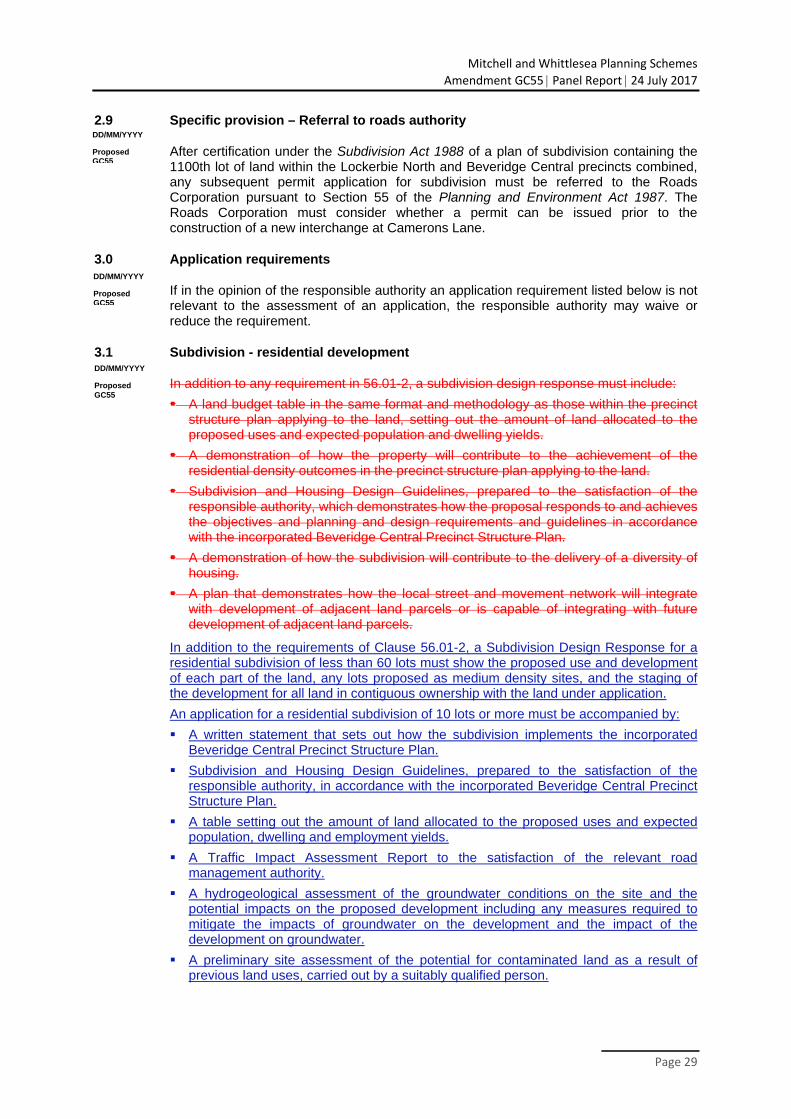
• An application for the subdivision of land that creates a super lot, balance lot, or any lot shown as ‘medium density site’ on an approved plan of subdivision is exempt from the garden area requirements specified at Clause 32.08‐3 and Clause 32.08‐4 of the Mitchell Planning Scheme.
D. Amend the exhibited form of Clause 3.1 of the Schedule to the Urban Growth Zone, Subdivision to read:
• In addition to the requirements of Clause 56.01‐2, a Subdivision Design Response for a residential subdivision of less than 60 lots must show the proposed use and development of each part of the land, any lots proposed as medium density sites, and the staging of the development for all land in contiguous ownership with the land under application.
Mitchell and Whittlesea Planning Schemes
Amendment GC55 Panel Report 24 July 2017
E. Amend the PSP to accord with the changes agreed at the Hearing and documented in Appendix C to the controls for the curtilage of John Kelly’s former house and the abutting land.
F. Vary the Public Acquisition Overlay (PAO) based on further refinement of the Rankin Street design gradeline (as proposed at the Hearing) to apply the reduced acquisition area.
G. Adopt the agreed changes to projects within the Precinct Infrastructure Plan (PIP) to vary road profiles, intersection arrangements and amend the PIP to apply these changes.
H. Amend the open space plan in the PSP to relocate Local Sports Reserve SR‐01 as proposed, onto the corner of Lithgow Street and Patterson Street.
I. Amend the land budget to reflect the relocation of the open space area including removing property 35 from project SR‐01 and make consequential changes to other plans, tables and figures as necessary.
J. Delete open space area LP‐04 from Plan 6 Open Space and the PSP.
K. Assign the land from LP‐04 for residential use and make consequential amendments to the land budget and other plans in the PSP.
(ii) Recommendations
Based on the reasons set out in this Report, the Panel recommends that Mitchell and Whittlesea Planning Schemes Amendment GC55 be adopted as exhibited subject to the following changes:
1. The agreed changes documented in Appendix C.
2. Insert a new provision in Clause 3.1 to the Schedule to the Urban Growth Zone as follows:
An application for a residential subdivision must show and include information as to how any lot of 400 square metres or greater can comply with the provisions of Clause 32.08‐3.
(iii) Further recommendation
The Panel makes the following further recommendation:
3. VicRoads review the access arrangements for land affected by the project road alignments to minimise or restore access.
Mitchell and Whittlesea Planning Schemes
Amendment GC55 Panel Report 24 July 2017
Page 1
1 Introduction
1.1 Location and context
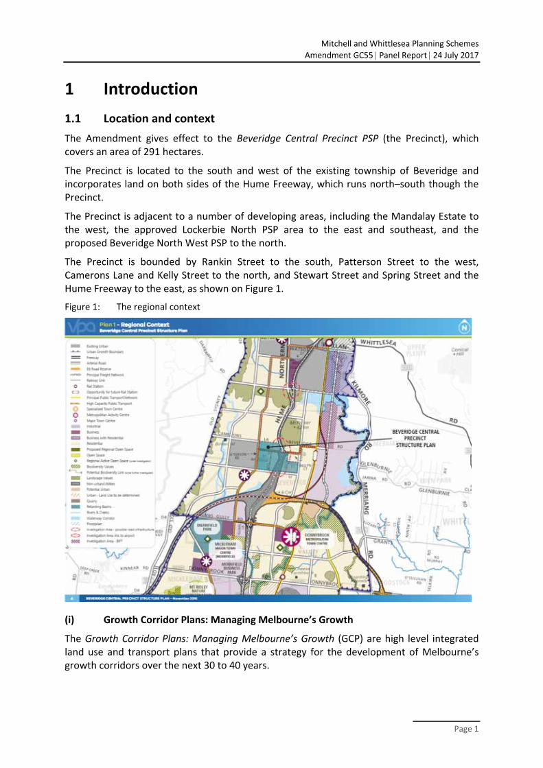
The Amendment gives effect to the Beveridge Central Precinct PSP (the Precinct), which covers an area of 291 hectares.
The Precinct is located to the south and west of the existing township of Beveridge and incorporates land on both sides of the Hume Freeway, which runs north–south though the Precinct.
The Precinct is adjacent to a number of developing areas, including the Mandalay Estate to the west, the approved Lockerbie North PSP area to the east and southeast, and the proposed Beveridge North West PSP to the north.
The Precinct is bounded by Rankin Street to the south, Patterson Street to the west, Camerons Lane and Kelly Street to the north, and Stewart Street and Spring Street and the Hume Freeway to the east, as shown on Figure 1.
Figure 1: The regional context
(i) Growth Corridor Plans: Managing Melbourne’s Growth
The Growth Corridor Plans: Managing Melbourne’s Growth (GCP) are high level integrated land use and transport plans that provide a strategy for the development of Melbourne’s growth corridors over the next 30 to 40 years.
Mitchell and Whittlesea Planning Schemes
Amendment GC55 Panel Report 24 July 2017
Page 2
The North GCP and Plan Melbourne outlines key existing and future infrastructure items in proximity to the Precinct that will provide direct or flow‐on benefits to future residents in the area, including:
roads and public transport - the Melbourne‐Sydney rail line which will act as an integral part of the Northern
Growth Corridor with development opportunities focused around this asset - connected high capacity public transport corridors with the potential for rail - bus capable roads within the Precinct for local bus routes - E6 transport corridor / Outer Metropolitan Ring Road - Beveridge Interstate Freight Terminal (BIFT) - the Hume Freeway
nearby completed PSPs including Lockerbie, Lockerbie North and Merrifield West
community, health and education facilities - La Trobe University and RMIT at Bundoora, Kangan Institute at Broadmeadows
and Craigieburn and NMIT at Epping and Greensborough which will provide the northern corridor with post compulsory education opportunities
- Northern Hospital at Epping and Kilmore and District Hospital - Primary, secondary and tertiary health services provided by the Northern
Hospital, Epping and development of super clinics at Wallan and South Morang
employment - Metropolitan Activity Centres are identified in Plan Melbourne at
Broadmeadows, Epping and Lockerbie - industrial employment precincts at Wollert, Mickleham and Donnybrook Road
open space and biodiversity.
The approved North Growth Corridor Plan (2012) identifies the Precinct as primarily residential with the Hume Freeway bisecting the Precinct.
1.2 The Amendment
(i) Purpose of the Amendment
The Amendment proposes changes to the Mitchell and Whittlesea Planning Schemes (the Schemes) to facilitate development in Beveridge Central, which is predominantly zoned Urban Growth Zone (UGZ), in accordance with the vision for urban growth outlined in the Beveridge Central PSP.
To ensure consistency in wording of referral requirements in statutory provisions, the Amendment includes an update to the UGZ Schedule 2 (Lockerbie North PSP).
(ii) Amendment description
Specifically, the Amendment proposes the following changes to the Mitchell and Whittlesea Planning Schemes:
rezone the existing Urban Growth Zone within the Precinct area to Urban Growth Zone Schedule 5 (UGZ5), and insert a new Schedule 5 to require use and development to be generally in accordance with the Beveridge Central PSP
Mitchell and Whittlesea Planning Schemes
Amendment GC55 Panel Report 24 July 2017
Page 3
replace Schedule 2 of the Urban Growth Zone (UGZ2) in the Mitchell and Whittlesea Planning Schemes to provide consistent application referral requirements to VicRoads for subdivision in the Beveridge Central and Lockerbie North precincts
rezone existing Farming Zone (FZ) in the Precinct to UGZ5
rezone existing Rural Conservation Zone (RCZ) in the Precinct to UGZ5
delete the Vegetation Protection Overlay Schedule 2 (VPO2) from the Precinct
delete the Salinity Management Overlay (SMO) from the Precinct
amend the Public Acquisition Overlay (PAO7) map to redefine the outline of the PAO7 area to include land along the northern side of Camerons Lane east and west of the Hume Highway (this land is not within the Precinct); include land along the southern side of Camerons Lane and the northern side of Rankin Street east and west of the Hume Highway; and, delete the existing PAO7 area along the east and west side of the Hume Highway between Lithgow Street and Rankin Street
amend the Heritage Overlay Schedule 332 (HO332) map to correct the anomaly with regards to the land the overlay is applied to – currently HO332 incorrectly applies to 27 Spring Street, however, the actual location of the remnant chimney that HO332 protects is located within the Hume Freeway road reserve between the south bound lanes and the south bound on ramp
amend the Heritage Overlay Schedule 4 (HO4) map to reduce the overlay area to reflect the extent of Victorian Heritage Register (VHR940) land for the former ‘Kelly House’
amend the Schedule to Clause 52.17 to exempt permit requirements for native vegetation removal within the Precinct
amend the Schedule to Clause 66.04 of the Mitchell and Whittlesea Planning Schemes to include a referral to the Roads Corporation and relevant floodplain management authority
incorporate the following document: - Beveridge Central Precinct Structure Plan, November 2016.
1.3 Procedural issues
The Panel was initially appointed under delegation from the Minister for Planning on 16 February 2017 as Lester Townsend (Chair) and Geoff Underwood. As Mr Townsend was unable to attend the Directions Hearing the Panel was reconstituted on 29 March 2017 as Geoff Underwood (Chair) and Trevor McCullough. On 11 April 2017, the Panel was reconstituted with Lester Townsend (Chair) and Geoff Underwood.
Mitchell and Whittlesea Planning Schemes
Amendment GC55 Panel Report 24 July 2017
Page 4
2 The plan and the issues
2.1 What is proposed
The PSP1 describes the vision for the Precinct:
Beveridge Central is a precinct that builds upon the existing sense of community and history of the Beveridge Township, while reinforcing its social and physical connections to newer development occurring in this part of the North Growth Corridor.
Beveridge Central is expected to change from a rural‐residential community into a well serviced, urban community defined by two future neighbourhoods bisected by the Hume Freeway. The eastern side will have a strong relationship with the existing Beveridge Township and development in the Lockerbie North Precinct; the western side connecting to the future Beveridge North‐West and Beveridge South‐West Precincts and existing Mandalay Estate.
There is a focus on creating a high amenity landscape character by featuring extensive landscaping opportunities and green streets within the existing wide road reserves.
A cycling and path network along streets will also connect key destinations such as local parks, the sporting reserve and convenience centres. Highlighting the Precinct’s heritage features provides a sense of place for future residents through the preservation and enhancement of Aboriginal and post‐contact heritage places and provides mechanisms to ensure the ongoing protection of these places.
To service the needs of future residents the Precinct will be connected to social and community infrastructure in immediate neighbouring areas. The neighbourhood infrastructure needs of the community will be largely met within the Precinct itself, with high quality open spaces and a sports field. Shopping and commercial services will be readily accessible immediately adjacent to the Precinct in new town centres in Mandalay and Lockerbie North, with small scale retail needs provided by three local convenience centres within the Precinct. In the longer term, the Precinct will be accessible to higher‐order services, shopping and jobs at the Beveridge Major Town Centre to the southeast of the Precinct.
Beveridge Central Precinct will have strong transport connections to key destinations via the Hume Freeway, a new railway station at Beveridge, and the future Outer Metropolitan Ring … Road, approximately 2 km to the south.
1 PSP Page 9.
Mitchell and Whittlesea Planning Schemes
Amendment GC55 Panel Report 24 July 2017
Page 5
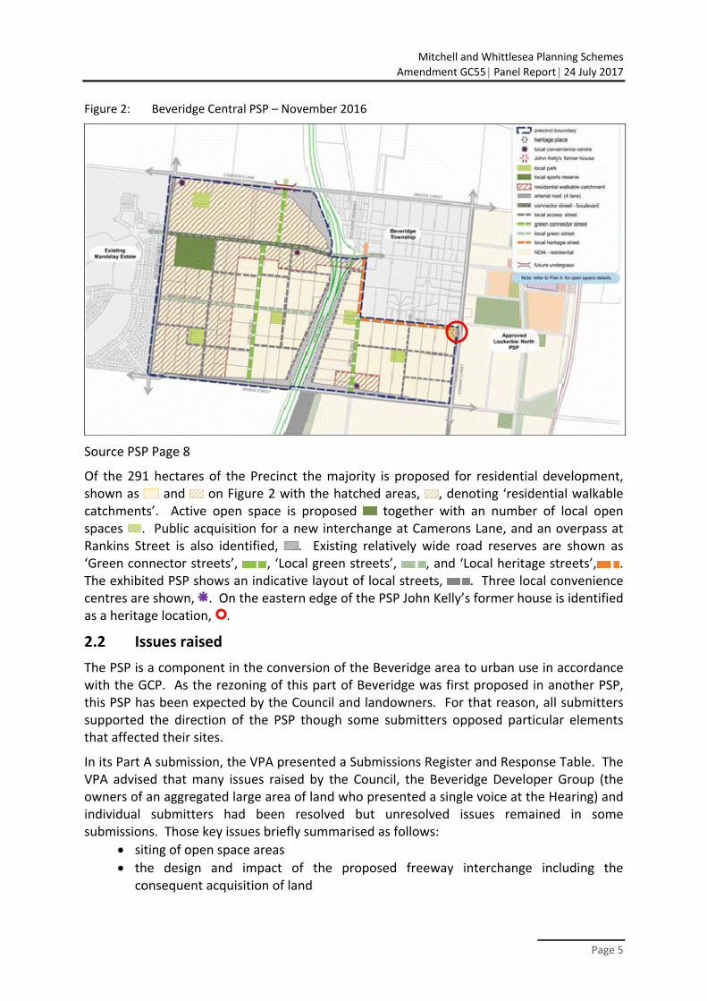
Figure 2: Beveridge Central PSP – November 2016
Source PSP Page 8
Of the 291 hectares of the Precinct the majority is proposed for residential development, shown as and on Figure 2 with the hatched areas, , denoting ‘residential walkable catchments’. Active open space is proposed together with an number of local open spaces . Public acquisition for a new interchange at Camerons Lane, and an overpass at Rankins Street is also identified, . Existing relatively wide road reserves are shown as ‘Green connector streets’, , ‘Local green streets’, , and ‘Local heritage streets’, . The exhibited PSP shows an indicative layout of local streets, . Three local convenience centres are shown, . On the eastern edge of the PSP John Kelly’s former house is identified as a heritage location, .
2.2 Issues raised
The PSP is a component in the conversion of the Beveridge area to urban use in accordance with the GCP. As the rezoning of this part of Beveridge was first proposed in another PSP, this PSP has been expected by the Council and landowners. For that reason, all submitters supported the direction of the PSP though some submitters opposed particular elements that affected their sites.
In its Part A submission, the VPA presented a Submissions Register and Response Table. The VPA advised that many issues raised by the Council, the Beveridge Developer Group (the owners of an aggregated large area of land who presented a single voice at the Hearing) and individual submitters had been resolved but unresolved issues remained in some submissions. Those key issues briefly summarised as follows:
siting of open space areas
the design and impact of the proposed freeway interchange including the consequent acquisition of land
Mitchell and Whittlesea Planning Schemes
Amendment GC55 Panel Report 24 July 2017
Page 6
the absence of an ICP and uncertainty of costs that may fall to the Council.
The Submissions Register and Response Table listed the numerous issues that had been resolved. They include submissions from landowners who do not continue with their issue as well as the submission from Heritage Victoria about the preservation of the former Kelly House.
The Panel accepts those matters as agreed or resolved with the VPA and makes no further reference to them.
2.3 Overall assessment and issues dealt with in this Report
(i) Overall assessment
The Panel considered all written submissions made in response to the exhibition of the Amendment; as well as further submissions, evidence and other material presented to it during the Hearing, and observations from an unaccompanied site visit.
The Panel has reviewed a large volume of material. The Panel has had to be selective in referring to the more relevant or determinative material in this Report. All submissions and materials have been considered by the Panel in reaching its conclusions, regardless of whether they are specifically mentioned in this Report.
The VPA provided a response to the Strategic Assessment Guidelines as part of the Explanatory Report.
The Panel has reviewed the VPA’s response and the policy context of the Amendment.
Mitchell Shire Council submitted2 that:
By way of summary, it is Council position that the Beveridge Central PSP itself is principally sound. However, there are some concerns that arise due to the absence of an accompanying [Infrastructure Contributions Plan]. In that context, it is conceptually and practically difficult to assess a plan involving the provision of infrastructure to new communities without access to a plan for funding that infrastructure.
The Panel concludes that the Amendment is supported by, and implements, the relevant sections of the State and Local Planning Policy Framework, and is consistent with the relevant Ministerial Directions and Practice Notes. The Amendment is well founded and strategically justified, and the Amendment should proceed subject to addressing the more specific issues raised in submissions as discussed in the following chapters.
The Panel recommends:
That the Mitchell and Whittlesea Planning Schemes Amendment GC55 be adopted as exhibited subject to the changes outlined in this Report.
(ii) Detailed resolved issues
The role of the Panel is to consider submissions to the exhibited Amendment.
2 Mitchell Shire Council submission para 5.
Mitchell and Whittlesea Planning Schemes
Amendment GC55 Panel Report 24 July 2017
Page 7
The VPA submitted:3
Since the exhibition of the … Amendment the VPA has met with submitters to discuss the range of issues. Where possible officers from Mitchell Shire Council and relevant State Agencies have been present and contributed to the discussions that have led to the resolution of issues. These discussions have resulted in proposed changes to the PSP and associated documents. A comprehensive list of all changes agreed to thus far is provided in Appendix 2 – Changes Matrix.
The VPA submitted it had considered whether any of the changes could impact on other landowners and notified any other affected landowner of the potential change.
At the close of the Hearing the Panel indicated that it proposed to formally recommend that the Amendment be changed to implement the agreements between the VPA, the Shire of Mitchell and individual submitters.
The Panel concluded that it was appropriate that the VPA as the planning authority prepare and present a list of agreed matters. The Panel directed the VPA to prepare such a list.
The Panel indicated that it would proceed on the basis that the VPA:
had made an accurate assessment of whether or not issues are resolved
had only agreed to changes that achieve appropriate planning outcomes and where other affected land owners are aware of the proposed change.
A list of proposed changes was received on 9 June 2017, and is presented in Appendix C with some formatting changes.
The Panel has not examined all aspects of the PSP in detail, but rather has concentrated on unresolved matters. It accepts the VPA’s advice that the changes represent an appropriate resolution of the issues raised.
The Panel had the benefit of a table documenting the proposed changes (the ‘changes matrix’), and submissions from Mr Black and Mitchell Shire Council. The Panel notes that as a result of the changes, two parties no longer sought to be heard.
The Panel recommends:
Make the agreed changes as documented in Appendix C.
(iii) Issues dealt with in this Report
A number of agreed changes are significant, and the Panel records a brief summary of these and notes its support.
This Report deals with these changes under the following headings:
Resolved issues - Applied zoning - Dwelling density - Garden area controls
3 VPA Part A submission page 4.

Mitchell and Whittlesea Planning Schemes
Amendment GC55 Panel Report 24 July 2017
Page 8
- Kelly house planning controls
Unresolved issues - Acquisition of land for the freeway interchange - Treatment of local roads and road projects in the Precinct Infrastructure Plan - Location of open space.
Mitchell and Whittlesea Planning Schemes
Amendment GC55 Panel Report 24 July 2017
Page 9
3 Resolved issues
3.1 Applied zoning
The VPA submitted:
There are also two categories of agreed changes that are more overarching than the various site specific changes. Each category of this type of change is explained in the following sections for the assistance of the Panel. Each of these categories represents a refinement of the earlier direction of the Planning Scheme Amendments, in response to submissions.
Applied Residential Zoning (proposed change in response to Council and Beveridge Central Developer Group submissions)
The VPA now proposes to apply the GRZ over the entirety of residential land within the Beveridge Central PSP.
This includes a change to the Future Urban Structure to delete the ‘hatched’ area indicating a 400 m residential walkable catchment from town centres and the future Principal Public Transport Network. The Residential Growth Zone is currently the applied zone for this area, with the VPA proposing to apply the General Residential Zone to the entirety of residential land including the previously hatched area.
This change is a consequence of the introduction of the new reformed residential zones on 27 March 2017 and negotiations with Council and developers.
The use of the GRZ was not contested. The Panel accepts the GRZ as the applied zone.
The Panel notes the following agreed changes: A. Apply the GRZ to the residential areas in the PSP and make appropriate changes to
the PSP and the planning documents.
3.2 Dwelling density
The VPA submitted:
Dwelling Density (Proposed change in response to Council and Beveridge Central Developer Group submissions)
The VPA now proposes to require that the subdivision of land within the PSP area must deliver an overall average density of 15 dwellings per hectare. Council and the Beveridge Central Developer Group (Insight Planning) submitted that the exhibited density of 16.5 dwellings per hectare would be difficult to achieve given the untested residential market considerations within the area.
This will alter requirements, guidelines, population/dwelling calculations and wording within the PSP document.
The main parties, the VPA, Council and the Beveridge Landowners Group, agreed that a density of 16.5 dwelling per hectare in the unknown market of Beveridge would be difficult to achieve. They agreed that an overall average density of 15 was more suited.
Mitchell and Whittlesea Planning Schemes
Amendment GC55 Panel Report 24 July 2017
Page 10
There was no contest to the variation of the density. The Panel accepts the 15 lots per hectare in this PSP.
The Panel notes the following agreed changes: B. Amend the requirements, guidelines, population/dwelling calculations and wording
within the PSP document to substitute 15 lots per hectare in lieu of 16.5 lots per hectare.
3.3 Garden area controls
(i) Evidence and submissions
The VPA advised that consequent to its proposal to adopt the GRZ across residential land in the PSP, an amendment was required to the Schedule to the UGZ to apply an exemption from the garden area provisions of the GRZ to all medium density sites. The VPA proposed an additional provision in Clause 2 to Schedule 5:
Specific provision – Medium density development
An application for the subdivision of land that creates a super lot, balance lot, or any lot shown as ‘medium density site’ on an approved plan of subdivision is exempt from the garden area requirements specified at Clause 32.08‐3 and Clause 32.08‐4 of the Mitchell Planning Scheme.
The Mitchell Shire Council submitted that to ensure the garden area provisions apply to lots of 400 square metres or larger, an additional provision as follows be inserted in Clause 3.1 to the schedule.
An application for a residential subdivision must show and include information as to how each lot which is 400 square metres or greater can comply with the provisions of Clause 32.08‐3.
Mr Black supported the VPA changes. He submitted that “the ‘specific provision’ exemption approach detailed by the VPA is supported as it is standard practice to identify ‘medium density sites’ during the subdivision process as these also assist in achieving increased density [or] lot yield outcomes”.
(ii) Discussion
The garden area provisions are the result of statewide changes to the residential zones that came into effect through Amendment VC110 in March 2017. The garden area requirement increases the amount of garden space that must be provided for new residential development on lots of nominated sizes in the Neighbourhood Residential Zone and the GRZ. The provisions are mandatory and cannot be varied. The proposal before the Panel is an exemption from the provisions in an emerging urban area where development is subject to compliance with a PSP that will create its own character and which requires a specific form of development including lot layout and density outcomes.
The effect of the exemption is to defer the need to show the layout of lots greater than 400 square metres in area identified for medium density use until a plan of development is submitted at the permit stage when the suitability of a layout and compliance with relevant
Mitchell and Whittlesea Planning Schemes
Amendment GC55 Panel Report 24 July 2017
Page 11
planning scheme provisions can be assessed. The Panel notes that the parties support to an exemption, albeit with slightly different approaches.
The Panel adopts the proposals of both the VPA and Mitchell Shire Council. That is, the changes by the VPA to add a new subclause 2 as drafted and the changes to Clause 3 as well as the addition to subclause 3 as proposed by Mitchell Shire Council (but with minor changes to the wording). The application of both proposals will provide clarity of the control.
(iii) Conclusions
The Panel concludes:
that the proposed variations to the garden area provisions are appropriate and an acceptable means to achieve compliance with the planning schemes
that the changes as proposed by the VPA and the Mitchell Shire Council to insert new provisions into Clause 2 and to vary the wording of the exhibited form of Clause 3, Subdivision will add clarity to the controls and are adopted.
The Panel notes the following agreed changes: C. Insert a new provision into clause 2 of the Urban Growth Zone Schedule to read:
Specific provision – Medium density development
An application for the subdivision of land that creates a super lot, balance lot, or any lot shown as ‘medium density site’ on an approved plan of subdivision is exempt from the garden area requirements specified at Clause 32.08‐3 and Clause 32.08‐4 of the Mitchell Planning Scheme.
D. Amend the exhibited form of Clause 3.1 of the Urban Growth Zone Schedule , Subdivision to read:
In addition to the requirements of Clause 56.01‐2, a Subdivision Design Response for a residential subdivision of less than 60 lots must show the proposed use and development of each part of the land, any lots proposed as medium density sites, and the staging of the development for all land in contiguous ownership with the land under application.
The Panel recommends:
Insert a new provision in Clause 3.1 of the Urban Growth Zone Schedule as follows:
An application for a residential subdivision must show and include information as to how any lot of 400 square metres or greater can comply with the provisions of Clause 32.08‐3.
3.4 Kelly House planning controls
(i) Evidence and submissions
The PSP identified the presence of ‘John Kelly’s former house’ (VHR HO940/HO4); it proposed controls to protect the house and surrounds through:
… a set of principles for the adaptive re‐use of the building and interpretation of the heritage in the local park that will inform the future use of the site with
Mitchell and Whittlesea Planning Schemes
Amendment GC55 Panel Report 24 July 2017
Page 12
engagement from Council, Heritage Victoria, State Government and other key stakeholders.
The PSP has delineated the building and curtilage which forms the heritage conservation area as shown in the Kelly House Concept Plan at Figure 1. The surrounding land is planned as a local park to complement and protect the heritage site from intrusive development and provide opportunities for a potential visitor or interpretation centre and adjoining playground and path network.
Heritage Victoria was a submitter to the Amendment. The submission followed the announced purchase of the heritage listed property and sought clarification of matters relating to the preservation of the place and to the proposed road around the site. Later, Heritage Victoria advised that it had come to an agreed position with the VPA and withdrew its submission. The VPA advised that the outcome would be confirmed through amendments to requirements in the PSP about the site area, the layout of the open space around the site, including a reduction in area from that exhibited in the PSP, as well as any subdivision of the place and of land nearby to protect the interface to the place.
The Mitchell Shire Council supported the heritage initiatives for the preservation and interpretation of Kelly House, including subdivision control over land to the west and south of the place. Mitchell Shire Council also sought advice about the management of the property and the development of the proposed heritage trail.
(ii) Discussion
The PSP contains specific requirements and guidelines for the treatment of the site and land around the place for road and open space purposes. A public park next to the house is proposed as one way of adding to the place and to draw visitors. The creation of a heritage trail to link the site and other heritage features in Beveridge is also proposed, and is supported by the Mitchell Shire Council.
John Kelly’s former house is an important part of Victorian heritage. There was no issue between the parties that the place must be protected nor that the manner of the controls as proposed and as presented to the Panel will assist in achieving the goal.
The Panel accepts there is more detail to be resolved before the final form of restoration and management is settled. The issues are about ‘how’, rather than ‘if’, the place will be protected.
It is notable that Heritage Victoria has supported the proposals put to the Panel. In turn, the Panel is assisted by that support.
(iii) Conclusions
The Panel concludes:
that the heritage provisions of the PSP as proposed and as amended during the Hearing can be supported on the basis that they will lead to the preservation of an important element of Victoria’s heritage

Mitchell and Whittlesea Planning Schemes
Amendment GC55 Panel Report 24 July 2017
Page 13
that consultation between the VPA, Heritage Victoria and Mitchell Shire Council will assist the parties in resolving the detail of the preservation of John Kelly’s former house and in future planning for the site and other relevant issues such as the heritage trail in Beveridge.
The Panel notes the following agreed changes: E. Amend the PSP to accord with the changes agreed at the Hearing to the controls for
the curtilage of John Kelly’s former house and the abutting land.
Mitchell and Whittlesea Planning Schemes
Amendment GC55 Panel Report 24 July 2017
Page 14
4 Unresolved issues
4.1 Acquisition of land for the freeway interchange
(i) Evidence and submissions
VicRoads explained4 the Hume Freeway Interchange Strategy adopted in July 2014:
Strategy was developed in consultation and agreement with the then Metropolitan Planning Authority to address the future freeway access requirements for the growth corridor.
Strategy is based on a strategic transport model (based on Victorian Integrated Transport Model) and detailed capacity analysis for Hume Freeway for short (up to 2026), medium (up to 2036) and long term (up to and beyond 2046).
In reference to the Beveridge Central PSP the strategy proposes
Camerons Lane – new full diamond interchange
Existing Lithgow Street interchange – decommission (retain local underpass)
Rankin Street – new half diamond (southern ramps).
The Amendment puts these proposals into effect by removing redundant PAO and establishing new PAO.
Submissions were made by landowners affected by the proposed acquisition of land for the Camerons Lane interchange. They include:
Submission 1 for land at 1 Spring Street
Submission 8 for land at 90 Minton Street
Submission 15 for land at 62 Arrowsmith Street.
Mr Black’s submission for the Landowners Group (submission 11) referred to the PAO. Mr Black stated “Having worked closely with VicRoads on reviewing the PAO the Group is comfortable that the extent of the PAO, as reduced post exhibition”. The submission went on to recommend changes to the PSP to confirm positions as agreed with VicRoads on the extent of the acquisition and the treatment of freeway interface areas.
(ii) Discussion
The location of the Camerons Lane interchange is not within the PSP area but is exhibited as part of Amendment GC55 because the creation of new access into Beveridge and the Beveridge Central PSP area is critical to service the new urban area. Both the VPA and VicRoads believe the interchange is vital to the development of the PSP area.
The importance of the road changes was summarised by Mr Black:
4 VicRoads PowerPoint presentation Document 4.
Mitchell and Whittlesea Planning Schemes
Amendment GC55 Panel Report 24 July 2017
Page 15
25. It is understood that the upgrade of the Hume Freeway corridor is necessary to service the northern growth corridor and the proposed freeway interchanges at Camerons Lane and Rankin Street are needed to service the future Beveridge and Lockerbie communities.
The submitters expressed concern that the alignment of the interchange and associated roadworks will impact in whole or in part on their properties. Plans tabled by VicRoads confirm the extent of land area required for the interchange. On the east side of the Hume Freeway where Submitters 1 and 8 are located, the impact comes mostly from the widening of existing roads and the extent of the run‐off area from the freeway. On the west side, the impact comes from the land take for the siting of the off‐ramp that requires a large area to accommodate a ramp constructed above current ground levels.
In its presentation, VicRoads provided a history of planning for road improvements in the northern corridor and a broad context for the revised road proposals. In addition to meeting the needs of the Beveridge Township, the road arrangements are important to link to the Hume Highway, the proposed Outer Metropolitan Ring Road and the proposed Beveridge Intermodal Freight Terminal.
In response to submissions, VicRoads advised the Panel that access restoration to properties adjacent to the freeway north of Rankin Street will be considered as part of development in the Precinct. The Panel agrees this is desirable. The plans tabled by VicRoads confirm the submitters concerns about reduced access to their properties (and other properties not the subject of submissions). For example, the alignment on the north side of Minton Street affects abutting property and the route of Old Sydney Road, as well as, property belonging to the submitters on the south side. The Panel accepts the goal of restoring access where possible and sees merit in further consideration of alignments that might reduce the extent of acquisition.
Mr Black supported the reduction to the acquisition area on the west side of the interchange; he sought the substitution of the plan tabled by VicRoads showing the refinement of the PAO. He also sought changes to the description of the freeway interface area and clarification that the classification of a freeway interface street applies only to land south of Lithgow Street. The Panel accepts these changes as agreed by VicRoads and the VPA at the Hearing.
The creation of the new interchange is beyond question. As a result, the alignment must follow a suitable design which then defines the boundary of the PAO. The Panel endorses the VicRoads aim of minimising and reducing the land to be acquired. The submitters will still have their land acquired or affected but the proposal is well considered and has been designed to minimise impacts. The same situation applies with the VicRoads intention to look to restore access to affected property.
(iii) Conclusions
The Panel concludes:
that the projects proposed by VicRoads are critical to the development of Beveridge and are supported
Mitchell and Whittlesea Planning Schemes
Amendment GC55 Panel Report 24 July 2017
Page 16
the use of the Public Acquisition Overlay is the appropriate mechanism to facilitate the projects; the Panel supports the removal of redundant overlays and the creation of a new PAO as proposed
VicRoads proposed review of access arrangements is supported – while this is unlikely to be before approval of the Amendment and therefore before the PAO is applied, it is desirable that the impact of the PAO on access be minimised.
the substitution of plans as proposed by Mr Black to confirm the PAO and the freeway interface design concept should be made.
The Panel notes the following agreed changes: F. Vary the PAO as proposed at the Hearing to apply the reduced acquisition area.
The Panel recommends:
That VicRoads review the access arrangements for land affected by the project road alignments to minimise or restore access.
4.2 Treatment of local roads and road projects in the Precinct Infrastructure Plan
(i) What is the issue
Plans in the exhibited PSP including the Future Urban Structure Plan, the Street Network Plan, the Public Transport Plan and the PIP showed a network of local roads. The VPA Part A submission outlined the nature of improvements to roads within the PSP and stated:
… the proposed local road network provides a robust structure for traffic and transport movement within and throughout the Precinct that will ultimately meet expected traffic demand.
The local roads for inclusion in the PIP are shown on Plan 11 and listed in table 7; the legend to Plan 8 describes the local roads as Key Local Access Street(s). The VPA said this was on the basis that construction of the roads was essential to facilitate development of small sized lots within the PSP and to assist with the sequencing of development.
The issue for the Panel is how to respond to the competing submissions where the VPA and Mr Black support the use of the ICP to fund certain local roads and projects, while Mitchell Shire Council opposed the inclusion of those projects which it fears will consume limited ICP funds.
(ii) Submissions
The VPA sees the projects included in the PIP as essential to the development of the PSP; the ICP is the preferred way of funding this essential infrastructure.
On the other hand, the Mitchell Shire Council is concerned it cannot determine if the ICP will have sufficient funds to pay for all the projects and at the risk that Mitchell Shire Council will have to meet any shortfall without a supplementary levy. Mitchell Shire Council submitted:
23. The preparation of an ICP has not occurred concurrently with the preparation of the Beveridge Central PSP. This has resulted in no costings being provided to demonstrate that the projects identified in the [Precinct Infrastructure Plan]
Mitchell and Whittlesea Planning Schemes
Amendment GC55 Panel Report 24 July 2017
Page 17
PIP at Table 7 of the PSP could be funded through a standard levy under the ICP system.
24. Furthermore, while Council is supportive of some local roads being implemented through the ICP system, this is not consistent with the assumptions made in the review which led to the preparation of a standard levy for road projects generally. Accordingly, Council’s support to include local road projects is subject to the following caveats:
the local road project to be delivered provides enabling infrastructure for future development that would otherwise be difficult to provide due to fragmented ownership; and
there is evidence demonstrating that the funding of the road project can be accommodated under a standard levy.
25. In this context, there are three (3) local road projects identified within the PIP which appear at first blush to be excessive. In each case Council submits that at least at this stage, it should only be the intersections that are proposed for ICP funding with the roads becoming (as they normally are) developer works unless it can be demonstrated that these roads can be accommodated under a standard levy.
To support the inclusion of local roads, Mr Black submitted:
58. The Precinct Infrastructure Plan includes a range of community, recreation and transport infrastructure required to support the development of the Precinct.
59. Due to the highly fragmented small lot nature of this Precinct there is a requirement to also fund the local road network.
60. Put simply, no single lot could afford to ‘bring forward’ infrastructure, such as road upgrades as the cost could not be carried by a small development.
61. As such, the developer group has been working together to ensure that key roads and services are delivered and funded jointly so as to share the burden of the enabling infrastructure.
The changes sought by Mitchell Shire Council are the removal from the PIP of road project RD‐04, the construction of Lewis Street as a connector road, project RD‐06, the acquisition of land and construction of Whiteside Street as a local access street, and RD‐07 the construction of Spring Street as a connector street between Rankin and Lithgow Streets.
Mr Black disagreed with the removal of those roads. He submitted that projects RD – 04, RD – 06 and RD – 07 should be included in the ICP because projects RD – 04 and RD – 06 are required:
… to deliver Melbourne Water’s drainage strategy and the entire length of Lewis Street is required to be delivered to connect the drainage to the retarding basin to the south of the Precinct, deliver sewer connections to the required pump station and provide access to all the individual lots.
Other variations to projects were proposed by Mitchell Shire Council and Mr Black. Both supported changes to road project RD‐01 for Camerons Lane and for project RD‐03 for
Mitchell and Whittlesea Planning Schemes
Amendment GC55 Panel Report 24 July 2017
Page 18
Rankin Street to be constructed between Patterson Street and the PAO. The VPA agreed with the submissions.
Mitchell Shire Council sought the inclusion of the project IT‐02 for the intersection of Stewart and Lithgow Streets. Mr Black sought the removal of roundabouts and cross intersections along Lithgow Street which he said had been agreed with the VPA so as to avoid unnecessary intersection costs. Projects IN‐08 and IN‐02 will now be combined to become one offset intersection in the PIP.
Mitchell Shire Council was also concerned at the funding of future arterial roads and interchange, namely Camerons Lane and Rankin Street, which it said needs to be reviewed. Mitchell Shire Council said there needs to be consistency between the approved Lockerbie North DCP and the PIP within the Precinct, particularly with regard to those infrastructure items identified for external apportionment within the Lockerbie North DCP. Mitchell Shire Council provided a table to identify those elements of the PIP and the Lockerbie North DCP which are not fully funding and where:
… the assumption is that Council is to bear the 15 per cent cost of the two infrastructure projects and Council does not have the financial capacity to absorb such costs.
Council’s submission set out its recommended changes to the PSP on this issue of funding generally and particularly local roads.
32. Mitchell submits that it is essential that the PSP not be approved until the ICP is finalised. Therefore, Council submits that it would be appropriate for the Panel to recommend that:
32.1 The VPA commits in writing to Mitchell that the drafting of the ICP will be finalised prior to the gazettal of this Amendment so that the Amendment implementing the Beveridge Central PSP is approved only concurrently with an amendment implementing an agreed ICP for the same land; and
32.2 The VPA (or other responsible body) directly involve Mitchell during the preparation of the ICP.
32.3 Those projects shown as partially unfunded in Appendix 1 be included in an ICP or existing DCP.
(iii) Discussion
The Panel agrees with Mitchell Shire Council that the construction of local streets is usually the responsibility of the developer; the inclusion of local streets in this PSP is therefore unusual. However, the VPA approach makes sense because funding needs to be assured to facilitate development and to achieve the reasonable planning outcome of sequenced development. The parties shared that view during the Hearing and sought a way of overcoming the Council’s concern at the uncertain level of funds available in the ICP. The VPA approach is first to prepare an ICP to determine the balance of costs to revenue then, if necessary, to consider a supplementary levy if the ICP falls short. The Council expressed concern that the Beveridge market might feel the impact of a supplementary levy, but it is one way of obtaining required funds if the need arises.
Mitchell and Whittlesea Planning Schemes
Amendment GC55 Panel Report 24 July 2017
Page 19
The land budget in the PSP identifies 80 properties in the PSP area of 291 hectares. That is not a large number compared to some PSPs but most of these are small lots which limits the capacity for joined‐up development without a collaboration of owners as has been achieved with the Landowners Group. The VPA anticipates difficulties in the development phase; the solution is to provide funding for projects that individual landowners could otherwise find difficult to raise. Mr Black summarised the situation in his submission:
68. Importantly, provision of enabling infrastructure is critically important in this Precinct as no single project can reasonably afford to deliver the required infrastructure upfront.
69. If there is no infrastructure, there will be no development and essentially no funds to purchase public land for open space, which result in greater risk exposure for Council. As such, the local road network must be funded, which is not a new concept ... [for example in] Greenvale Central PSP.
The Panel supports a facilitative approach to development and the inclusion in this PSP of projects not usually items for an ICP. The onus is on the VPA in the preparation of the ICP to include only those projects identified and supported by the parties and to ensure that the cost estimates are as accurate as possible at the time of preparation of the ICP. The Panel urges the VPA to consult with Mitchell Shire Council during the preparation of the ICP.
The PIP is part of the PSP, but the ICP is not. The Panel considers that the approach is to identify the infrastructure components that are needed from a strategic or development facilitation point of view, and then to cost these items. The infrastructure list should not be shaped to achieve a predetermined budget, or standard levy amount. The Panel can do no more than consider and respond to submissions about the projects before it and to comment on the general approach to the provision of infrastructure.
The Panel notes and endorses the VPA commitment to delay seeking approval of the Amendment until an ICP is prepared. Assessing the PSP and ICP together will reduce the risk of misidentifying projects and overestimating the cost of infrastructure items; and consultation with Mitchell Shire Council will further reduce that risk.
(iv) Conclusions
The Panel concludes:
that a facilitative approach to development within the PSP area is appropriate
that the agreed changes to projects within the PIP should be made and that it supports the inclusion and treatment of local roads and projects to achieve the reasonable planning outcome of sequenced development
that engagement with Mitchell Shire Council during the preparation of the ICP is desirable, to help ensure the final selection of projects for inclusion in the ICP considers the cost‐efficient provision of infrastructure.
The Panel notes the following agreed changes: G. Adopt the agreed changes to projects within PIP to vary road profiles and to vary
intersection arrangements and amend the PIP to apply these changes.
Mitchell and Whittlesea Planning Schemes
Amendment GC55 Panel Report 24 July 2017
Page 20
4.3 Location of open space
The Panel received submissions about the relocation of areas of active and passive open space. These submissions raised:
strategic planning issues, that is, a claim that open space was not needed or would be better from a planning point of view in another location
financial issues, that is, submissions about the personal hardship of land owners of land identified for open space.
The Panel does not doubt the impact of the location of the open space on the financial plans of the submitters. The issue for the Panel is balancing the personal hardship with public policy.
On the one hand, it is tempting to support submissions based on the heart felt submissions of individuals, if not simply because it would seem to solve an immediate problem. On the other hand, shifting areas of open space in response to such submissions runs the risk of undermining orderly planning and reduce strategic planning decisions to favour those who seek a particular financial outcome in place of what is the best ‘on the ground’ outcome.
Ultimately decisions about the location of different features in a growth area should be made on the basis of the long term benefits for the people who ultimately live in the area, and the ability to create attractive and functional local areas.
4.3.1 Active open space
(i) What is the issue?
The PSP proposed 7.5 hectares of active open space (Local Sports Reserve SR‐01) to be used as playing fields, tennis courts and the construction of a 900 square metre sporting pavilion as an ICP item. As a result of submissions received, in conjunction with Mitchell Shire Council, the VPA reviewed the land area required and its location. The effect was to reduce the land area to 6.7 hectares and to move the site to the southeast corner of Lithgow Street and Patterson Street. The move relocated the open space off property 35 (submitter 2), moved the site farther from property 36 which resolved the submission of Mr Semple (submitter 21), but covered all of property 30 (submitter 10) and property 31 owned by Mr Ung (submitter 9) and remained entirely over property 34 owned by CDH Properties Pty Ltd, represented by Mr and Mrs Theodoulou (submitter 6).
Mr Ung and Mr and Mrs Theodoulou stated their land should be for residential use and that the open space should be located onto vacant land elsewhere. The VPA stated that the location is central to most residents of Beveridge Central, is accessible for residents of the Mandalay Estate which itself has no open space land for similar purposes, and is well positioned near community facilities including the site of the proposed school within the Mandalay Estate. Mitchell Shire Council supported the relocation of the active open space for similar reasons as well as the reduction in land area.
(ii) Discussion
Both the VPA and Mitchell Shire Council maintained the position that the open space was central, easily accessible and well located. Mr Montebello for Mitchell Shire Council stated
Mitchell and Whittlesea Planning Schemes
Amendment GC55 Panel Report 24 July 2017
Page 21
that while he acknowledged the passionate submissions of the affected landowners, none had argued that the identified land was unsuited for use as open space.
Plan 6 Open Space, in the PSP details the location of all open space areas across the Precinct. The only area for active sports is the one now proposed. It is clear to the Panel that an area for active sport is required. It is also clear that that the proposed uses can be sited within the reduced land area now before the Panel. The issue is where the space should be sited.
Moving the active open space land from one side of the road to the other resolves an issue for some landowners but impacts on another for more than the active open space project. Moving the sports fields would necessitate the shifting of a local park to another location and that brings complications for the landowner as well as the planning agencies. It is not as simple as the submitters suggest to simply relocate the active open space to vacant land nearby.
The Panel is persuaded by the merits of the revised location on the corner of Lithgow Street and Patterson Street, and accepts the reduced land area, but is not supportive of relocating the site elsewhere.
(iii) Recommendation
The Panel notes the following agreed changes: H. Amend the open space plan in the PSP to relocate Local Sports Reserve SR‐01 as
proposed onto the corner of Lithgow Street and Patterson Street I. Amend the land budget to reflect the relocation of the open space area including
removing property 35 from project SR‐01 and make consequential changes to other plans, tables and figures as necessary.
4.3.2 Passive open space areas
(i) What is the issue?
The PSP identifies six passive open space areas within the PSP totalling 6.7 hectares. The location of the open space areas is shown on Plan 6 in the PSP. The VPA Part A submission stated:
The network of local parks are distributed throughout the Precinct, with the aim of all residents being within a 400 m walkable catchment of open space. Where possible, they have been located to assist with the retention of notable precinct features.
The owner of one site whose land has been identified for park purposes has lodged a submission opposing the identification of half of their land and requesting that the park be moved to another site.
Mitchell Shire Council submitted that LP‐04 should be removed from the PSP with a compensatory increase in the size of LP‐05.
The issue for the Panel is to consider the merit of the submission(s) and to recommend if the park(s) should be relocated or varied as requested.
Mitchell and Whittlesea Planning Schemes
Amendment GC55 Panel Report 24 July 2017
Page 22
(ii) Evidence and submissions
Property 73 in the PSP is identified as the site local park LP‐02. The submission from the Whiteside Unit Trust (submission 4) opposed the siting of the park on the land at Whiteside Street. The submission stated that taking of half of the land would negate the reason for buying the land which was to enable the unit holders to build and occupy the land for themselves.
The VPA Part B submission at the Hearing advised the Panel
The preparation of a Precinct Structure Plan is guided by the [Growth Areas Authority] Precinct Structure Planning Guidelines, 2009 which sets out a range of principles and guidance for the distribution of a range of land uses typically expected in growth area precinct planning. It is the view of the VPA and Council that the local park meets the guidelines and should remain generally in the location shown in the exhibited PSP.
The Mitchell Shire Council submission did not address submission 4. However, the submissions made in response to submitters seeking the relocation of the active open space areas can be applied to the proposed relocation of passive open space areas. That is, it is not simply a matter of shifting open space from one site to another and that any opposing submission should demonstrate that the selected site is unsuitable for the purpose.
The submitter does not make an argument about the unsuitability of the land for open space use nor does it contest the open space principles underlying the PSP. In that circumstance, the Panel is left without a planning basis to judge the submission. The response must be to support the identification of local park LP‐02 on the site.
The Mitchell Shire Council written submission sought changes to the open space plan:
62.1 Delete local park (Item LP‐04) with consideration being given to the land open space area available in the open space budget then being used to increase the size of LP‐05.
62.2 Part 3.3 dealing with open space should be modified by the insertion of table which identifies the extent of encumbered and unencumbered open space within the Beveridge Central PSP of the various properties that it rests within to act as an adjunct to the Table at Part 4.1 of the Appendices. The Table at Part 4.1 only shows what is defined as ‘credited open space’ without any insight in relation to the encumbered/unencumbered nature of that land.
62.3 Guideline 20 should be moved so as to become a Requirement.
62.4 Requirement 29 should be modified to by inserting a reference to energy efficient / smart before the word lighting.
There was no elaboration of the submission. However, the Panel consideration of the issues was made easier by the VPA advising in the changes register that it agreed to make those changes except for the deletion of local park LP‐04. The VPA was silent on the matter at the Hearing but the post Hearing response agreed the local park will be deleted from plan.
Mitchell and Whittlesea Planning Schemes
Amendment GC55 Panel Report 24 July 2017
Page 23
The second limb of the Mitchell Shire Council submission is that the freed‐up land area should be used to expand local park LP‐05. The Panel notes however, that LP‐05 is the proposed open space area adjacent to John Kelly’s former house. Presentations to the Hearing about the curtilage of the heritage place did not address the prospect of additional land as a result of a change to the opens space allocations. In fact, the presentations reduced the amount of land around the house and tightened the planning controls to protect the place. For these reasons, the Panel does not support Council’s proposed increase to the area of LP‐05.
(iii) Discussion
Noting that the VPA has agreed to delete open space area LP‐04 which is located on the east side of the Hume Freeway on Spring Street, the Panel came to that conclusion for its own reasons.
Plan 6 illustrates that the 400 metre walkable catchment served by that location includes approximately half of the catchment on the west side of the freeway. The freeway will be a large physical barrier making it impossible, unsafe and difficult to cross from one side to the other, there is unlikely to be cross‐use of the park by residents on the west side. In any event, residents on the west side within the catchment of LP‐04 are close to the proposed park LP‐02 and are likely to make use of that park. The Panel notes that park LP‐02 is the park opposed by submitter 4.
Local park LP‐06 is centred in the land area in the PSP on the east side of the freeway. That open space area commands most of the land on the east side save for the area adjacent to the route of the freeway. The Panel believes that local park LP‐06 meets the open space principles presented by the VPA and is adequate to serve the east side community.
The Panel agrees with the VPA and Mitchell Shire Council that LP‐04 be deleted from the open space plan and the PSP.
The Panel further notes that the area of the PSP on the east side of the Hume Freeway is approximately one‐sixth of the total PSP area. It is adjacent to the Lockerbie North approved PSP area and, according to Plan 6, within the catchment of an area of open space to the south in that PSP area. The area is also served by open space in the Beveridge Township so future residents not falling within a 400 metre walkable catchment of LP‐06 will not be distant from active and passive open space.
(iv) Conclusions
The Panel concludes:
it does not support the relocation of open space area LP‐02.
that it supports the deletion of open space area LP‐04, and the freed‐up land can be made available for residential use.
that it does not support the increase in size of open space area LP‐05 at the site of John Kelly’s former house.
The Panel notes the following agreed changes: J. Delete open space area LP‐04 from Plan 6 Open Space and the PSP.

Mitchell and Whittlesea Planning Schemes
Amendment GC55 Panel Report 24 July 2017
Page 24
Assign the land for residential use and make consequential amendments to the land budget and other plans in the PSP.
Mitchell and Whittlesea Planning Schemes
Amendment GC55 Panel Report 24 July 2017
Page 25
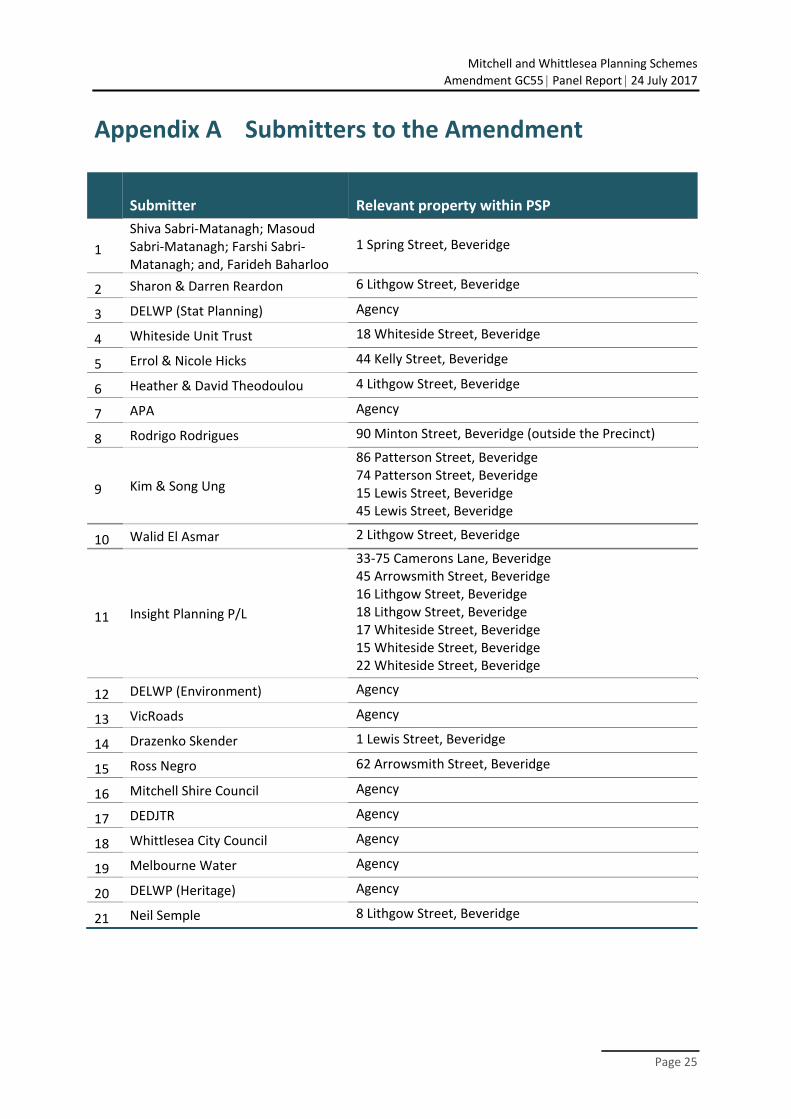
Appendix A Submitters to the Amendment
Submitter Relevant property within PSP
1
Shiva Sabri‐Matanagh; Masoud Sabri‐Matanagh; Farshi Sabri‐Matanagh; and, Farideh Baharloo
1 Spring Street, Beveridge
2 Sharon & Darren Reardon 6 Lithgow Street, Beveridge
3 DELWP (Stat Planning) Agency
4 Whiteside Unit Trust 18 Whiteside Street, Beveridge
5 Errol & Nicole Hicks 44 Kelly Street, Beveridge
6 Heather & David Theodoulou 4 Lithgow Street, Beveridge
7 APA Agency
8 Rodrigo Rodrigues 90 Minton Street, Beveridge (outside the Precinct)
9 Kim & Song Ung
86 Patterson Street, Beveridge 74 Patterson Street, Beveridge 15 Lewis Street, Beveridge 45 Lewis Street, Beveridge
10 Walid El Asmar 2 Lithgow Street, Beveridge
11 Insight Planning P/L
33‐75 Camerons Lane, Beveridge 45 Arrowsmith Street, Beveridge 16 Lithgow Street, Beveridge 18 Lithgow Street, Beveridge 17 Whiteside Street, Beveridge 15 Whiteside Street, Beveridge 22 Whiteside Street, Beveridge
12 DELWP (Environment) Agency
13 VicRoads Agency
14 Drazenko Skender 1 Lewis Street, Beveridge
15 Ross Negro 62 Arrowsmith Street, Beveridge
16 Mitchell Shire Council Agency
17 DEDJTR Agency
18 Whittlesea City Council Agency
19 Melbourne Water Agency
20 DELWP (Heritage) Agency
21 Neil Semple 8 Lithgow Street, Beveridge
Mitchell and Whittlesea Planning Schemes
Amendment GC55 Panel Report 24 July 2017
Page 26
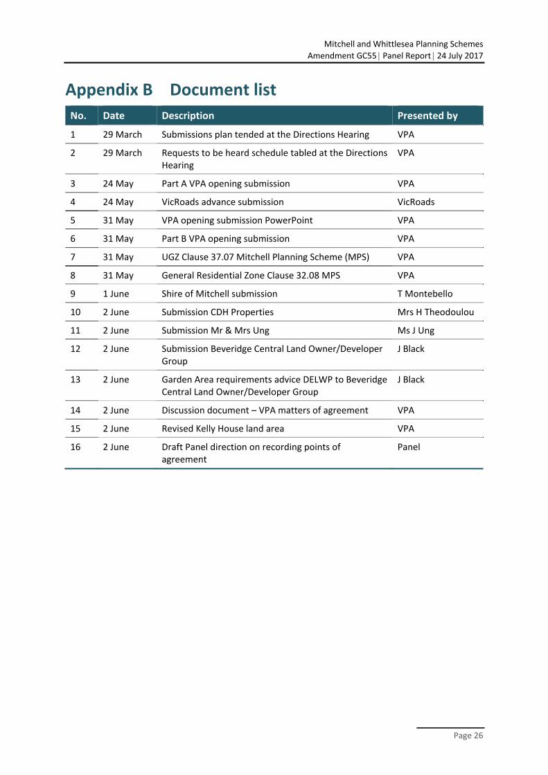
Appendix B Document list
No. Date Description Presented by
1 29 March Submissions plan tended at the Directions Hearing VPA
2 29 March Requests to be heard schedule tabled at the Directions Hearing
VPA
3 24 May Part A VPA opening submission VPA
4 24 May VicRoads advance submission VicRoads
5 31 May VPA opening submission PowerPoint VPA
6 31 May Part B VPA opening submission VPA
7 31 May UGZ Clause 37.07 Mitchell Planning Scheme (MPS) VPA
8 31 May General Residential Zone Clause 32.08 MPS VPA
9 1 June Shire of Mitchell submission T Montebello
10 2 June Submission CDH Properties Mrs H Theodoulou
11 2 June Submission Mr & Mrs Ung Ms J Ung
12 2 June Submission Beveridge Central Land Owner/Developer Group
J Black
13 2 June Garden Area requirements advice DELWP to Beveridge Central Land Owner/Developer Group
J Black
14 2 June Discussion document – VPA matters of agreement VPA
15 2 June Revised Kelly House land area VPA
16 2 June Draft Panel direction on recording points of agreement
Panel
Mitchell and Whittlesea Planning Schemes
Amendment GC55 Panel Report 24 July 2017
Page 27
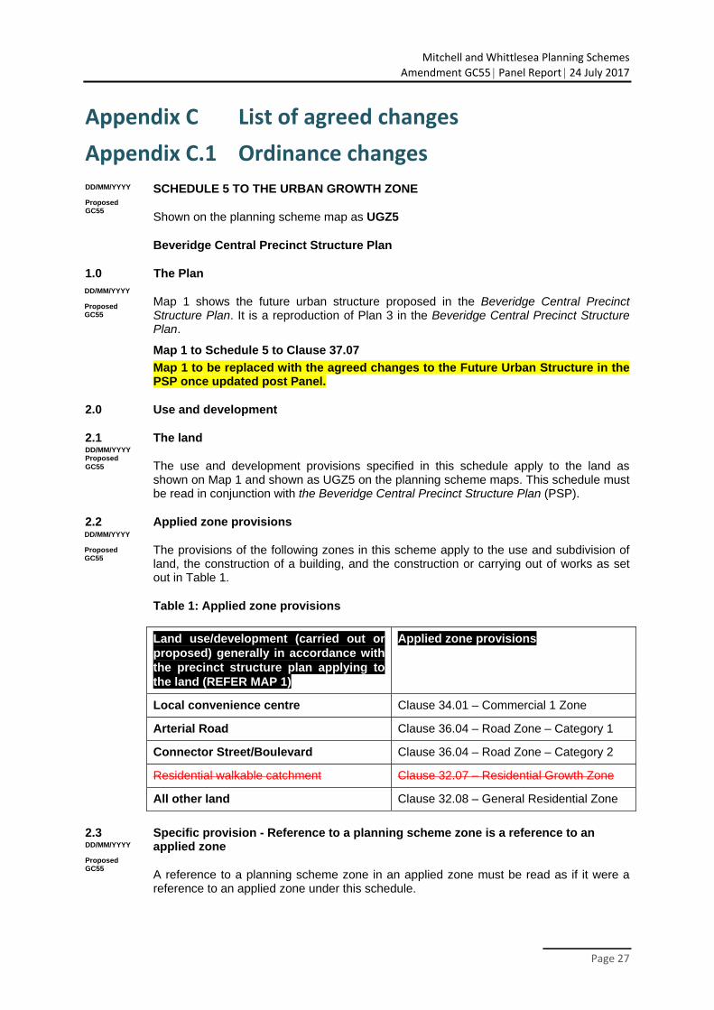
Appendix C List of agreed changes
Appendix C.1 Ordinance changes
SCHEDULE 5 TO THE URBAN GROWTH ZONE
Shown on the planning scheme map as UGZ5
Beveridge Central Precinct Structure Plan
1.0 The Plan
Map 1 shows the future urban structure proposed in the Beveridge Central Precinct Structure Plan. It is a reproduction of Plan 3 in the Beveridge Central Precinct Structure Plan.
Map 1 to Schedule 5 to Clause 37.07
Map 1 to be replaced with the agreed changes to the Future Urban Structure in the PSP once updated post Panel.
2.0 Use and development
2.1 The land
The use and development provisions specified in this schedule apply to the land as shown on Map 1 and shown as UGZ5 on the planning scheme maps. This schedule must be read in conjunction with the Beveridge Central Precinct Structure Plan (PSP).
2.2 Applied zone provisions
The provisions of the following zones in this scheme apply to the use and subdivision of land, the construction of a building, and the construction or carrying out of works as set out in Table 1.
Table 1: Applied zone provisions
Land use/development (carried out or proposed) generally in accordance with the precinct structure plan applying to the land (REFER MAP 1)
Applied zone provisions
Local convenience centre Clause 34.01 – Commercial 1 Zone
Arterial Road Clause 36.04 – Road Zone – Category 1
Connector Street/Boulevard Clause 36.04 – Road Zone – Category 2
Residential walkable catchment Clause 32.07 – Residential Growth Zone
All other land Clause 32.08 – General Residential Zone
2.3 Specific provision - Reference to a planning scheme zone is a reference to an applied zone
A reference to a planning scheme zone in an applied zone must be read as if it were a reference to an applied zone under this schedule.
DD/MM/YYYY
Proposed GC55
DD/MM/YYYY
Proposed GC55
DD/MM/YYYY
Proposed GC55
DD/MM/YYYY Proposed GC55
DD/MM/YYYY
Proposed GC55
Mitchell and Whittlesea Planning Schemes
Amendment GC55 Panel Report 24 July 2017
Page 28
Note: e.g. The General Residential Zone specifies ‘Car wash’ as a Section 2 Use with the condition, ‘The site must adjoin, or have access to, a road in a Road Zone.’ In this instance the condition should be read as, ‘The site must adjoin, or have access to, a road in a Road Zone or an applied Road Zone in the Urban Growth Zone schedule applying to the land’.
2.4 Specific provision – Use and development of future public land
A permit is not required to use or develop land shown in the Beveridge Central Precinct Structure Plan as open space local parks or sporting reserves provided the use or development is carried out generally in accordance with the Beveridge Central Precinct Structure Plan and with the prior written consent of Mitchell Shire Council.
2.5 Specific provision – Use of land
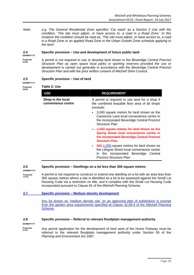
Table 2: Use
USE REQUIREMENT
Shop in the local convenience centre
A permit is required to use land for a shop if the combined leasable floor area of all shops exceeds:
3,000 square metres for land shown as the Camerons Lane local convenience centre in the incorporated Beveridge Central Precinct Structure Plan.
1,000 square metres for land shown as the Spring Street local convenience centre in the incorporated Beveridge Central Precinct Structure Plan.
500 1,000 square metres for land shown as the Lithgow Street local convenience centre in the incorporated Beveridge Central Precinct Structure Plan.
2.6 Specific provision – Dwellings on a lot less than 300 square metres
A permit is not required to construct or extend one dwelling on a lot with an area less than 300 square metres where a site is identified as a lot to be assessed against the Small Lot Housing Code via a restriction on title, and it complies with the Small Lot Housing Code incorporated pursuant to Clause 81 of the Mitchell Planning Scheme.
2.7 Specific provision – Medium density development
Any lot shown as ‘medium density site’ on an approved plan of subdivision is exempt from the garden area requirements specified at Clause 32.08-4 of the Mitchell Planning Scheme.
2.8 Specific provision – Referral to relevant floodplain management authority
Any permit application for the development of land west of the Hume Freeway must be referred to the relevant floodplain management authority under Section 55 of the Planning and Environment Act 1987.
DD/MM/YYYY
Proposed GC55
DD/MM/YYYY
Proposed GC55
DD/MM/YYYY
Proposed GC55
DD/MM/YYYY
Proposed GC55
Mitchell and Whittlesea Planning Schemes
Amendment GC55 Panel Report 24 July 2017
Page 29
2.9 Specific provision – Referral to roads authority
After certification under the Subdivision Act 1988 of a plan of subdivision containing the 1100th lot of land within the Lockerbie North and Beveridge Central precincts combined, any subsequent permit application for subdivision must be referred to the Roads Corporation pursuant to Section 55 of the Planning and Environment Act 1987. The Roads Corporation must consider whether a permit can be issued prior to the construction of a new interchange at Camerons Lane.
3.0 Application requirements
If in the opinion of the responsible authority an application requirement listed below is not relevant to the assessment of an application, the responsible authority may waive or reduce the requirement.
3.1 Subdivision - residential development
In addition to any requirement in 56.01-2, a subdivision design response must include:
A land budget table in the same format and methodology as those within the precinct structure plan applying to the land, setting out the amount of land allocated to the proposed uses and expected population and dwelling yields.
A demonstration of how the property will contribute to the achievement of the residential density outcomes in the precinct structure plan applying to the land.
Subdivision and Housing Design Guidelines, prepared to the satisfaction of the responsible authority, which demonstrates how the proposal responds to and achieves the objectives and planning and design requirements and guidelines in accordance with the incorporated Beveridge Central Precinct Structure Plan.
A demonstration of how the subdivision will contribute to the delivery of a diversity of housing.
A plan that demonstrates how the local street and movement network will integrate with development of adjacent land parcels or is capable of integrating with future development of adjacent land parcels.
In addition to the requirements of Clause 56.01-2, a Subdivision Design Response for a residential subdivision of less than 60 lots must show the proposed use and development of each part of the land, any lots proposed as medium density sites, and the staging of the development for all land in contiguous ownership with the land under application.
An application for a residential subdivision of 10 lots or more must be accompanied by:
A written statement that sets out how the subdivision implements the incorporated Beveridge Central Precinct Structure Plan.
Subdivision and Housing Design Guidelines, prepared to the satisfaction of the responsible authority, in accordance with the incorporated Beveridge Central Precinct Structure Plan.
A table setting out the amount of land allocated to the proposed uses and expected population, dwelling and employment yields.
A Traffic Impact Assessment Report to the satisfaction of the relevant road management authority.
A hydrogeological assessment of the groundwater conditions on the site and the potential impacts on the proposed development including any measures required to mitigate the impacts of groundwater on the development and the impact of the development on groundwater.
A preliminary site assessment of the potential for contaminated land as a result of previous land uses, carried out by a suitably qualified person.
DD/MM/YYYY
Proposed GC55
DD/MM/YYYY
Proposed GC55
DD/MM/YYYY
Proposed GC55
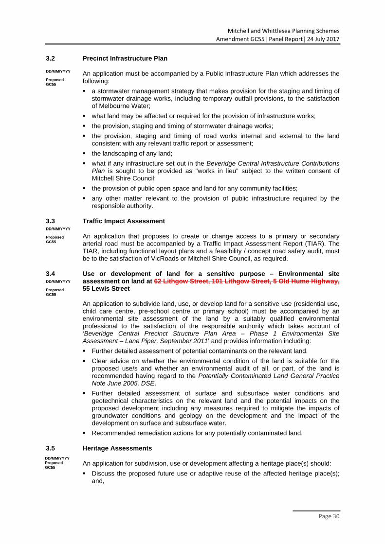
Mitchell and Whittlesea Planning Schemes
Amendment GC55 Panel Report 24 July 2017
Page 30
3.2 Precinct Infrastructure Plan
An application must be accompanied by a Public Infrastructure Plan which addresses the following:
a stormwater management strategy that makes provision for the staging and timing of stormwater drainage works, including temporary outfall provisions, to the satisfaction of Melbourne Water;
what land may be affected or required for the provision of infrastructure works;
the provision, staging and timing of stormwater drainage works;
the provision, staging and timing of road works internal and external to the land consistent with any relevant traffic report or assessment;
the landscaping of any land;
what if any infrastructure set out in the Beveridge Central Infrastructure Contributions Plan is sought to be provided as "works in lieu" subject to the written consent of Mitchell Shire Council;
the provision of public open space and land for any community facilities;
any other matter relevant to the provision of public infrastructure required by the responsible authority.
3.3 Traffic Impact Assessment
An application that proposes to create or change access to a primary or secondary arterial road must be accompanied by a Traffic Impact Assessment Report (TIAR). The TIAR, including functional layout plans and a feasibility / concept road safety audit, must be to the satisfaction of VicRoads or Mitchell Shire Council, as required.
3.4 Use or development of land for a sensitive purpose – Environmental site assessment on land at 62 Lithgow Street, 101 Lithgow Street, 5 Old Hume Highway, 55 Lewis Street
An application to subdivide land, use, or develop land for a sensitive use (residential use, child care centre, pre-school centre or primary school) must be accompanied by an environmental site assessment of the land by a suitably qualified environmental professional to the satisfaction of the responsible authority which takes account of ‘Beveridge Central Precinct Structure Plan Area – Phase 1 Environmental Site Assessment – Lane Piper, September 2011’ and provides information including:
Further detailed assessment of potential contaminants on the relevant land.
Clear advice on whether the environmental condition of the land is suitable for the proposed use/s and whether an environmental audit of all, or part, of the land is recommended having regard to the Potentially Contaminated Land General Practice Note June 2005, DSE.
Further detailed assessment of surface and subsurface water conditions and geotechnical characteristics on the relevant land and the potential impacts on the proposed development including any measures required to mitigate the impacts of groundwater conditions and geology on the development and the impact of the development on surface and subsurface water.
Recommended remediation actions for any potentially contaminated land.
3.5 Heritage Assessments
An application for subdivision, use or development affecting a heritage place(s) should:
Discuss the proposed future use or adaptive reuse of the affected heritage place(s); and,
DD/MM/YYYY
Proposed GC55
DD/MM/YYYY
Proposed GC55
DD/MM/YYYY
Proposed GC55
DD/MM/YYYY Proposed GC55
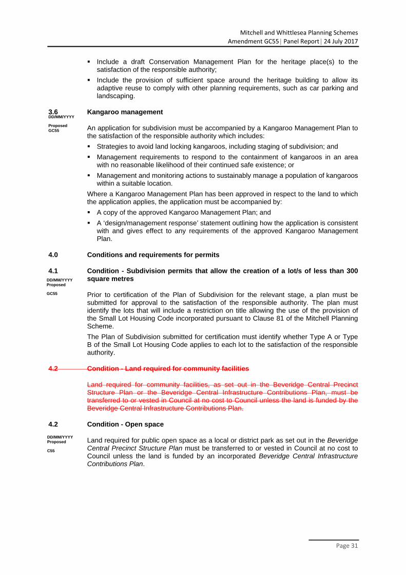
Mitchell and Whittlesea Planning Schemes
Amendment GC55 Panel Report 24 July 2017
Page 31
Include a draft Conservation Management Plan for the heritage place(s) to the satisfaction of the responsible authority;
Include the provision of sufficient space around the heritage building to allow its adaptive reuse to comply with other planning requirements, such as car parking and landscaping.
3.6 Kangaroo management
An application for subdivision must be accompanied by a Kangaroo Management Plan to the satisfaction of the responsible authority which includes:
Strategies to avoid land locking kangaroos, including staging of subdivision; and
Management requirements to respond to the containment of kangaroos in an area with no reasonable likelihood of their continued safe existence; or
Management and monitoring actions to sustainably manage a population of kangaroos within a suitable location.
Where a Kangaroo Management Plan has been approved in respect to the land to which the application applies, the application must be accompanied by:
A copy of the approved Kangaroo Management Plan; and
A ‘design/management response’ statement outlining how the application is consistent with and gives effect to any requirements of the approved Kangaroo Management Plan.
4.0 Conditions and requirements for permits
4.1 Condition - Subdivision permits that allow the creation of a lot/s of less than 300 square metres
Prior to certification of the Plan of Subdivision for the relevant stage, a plan must be submitted for approval to the satisfaction of the responsible authority. The plan must identify the lots that will include a restriction on title allowing the use of the provision of the Small Lot Housing Code incorporated pursuant to Clause 81 of the Mitchell Planning Scheme.
The Plan of Subdivision submitted for certification must identify whether Type A or Type B of the Small Lot Housing Code applies to each lot to the satisfaction of the responsible authority.
4.2 Condition - Land required for community facilities
Land required for community facilities, as set out in the Beveridge Central Precinct Structure Plan or the Beveridge Central Infrastructure Contributions Plan, must be transferred to or vested in Council at no cost to Council unless the land is funded by the Beveridge Central Infrastructure Contributions Plan.
4.2 Condition - Open space
Land required for public open space as a local or district park as set out in the Beveridge Central Precinct Structure Plan must be transferred to or vested in Council at no cost to Council unless the land is funded by an incorporated Beveridge Central Infrastructure Contributions Plan.
DD/MM/YYYY
Proposed GC55
DD/MM/YYYY Proposed
C55
DD/MM/YYYY Proposed
GC55
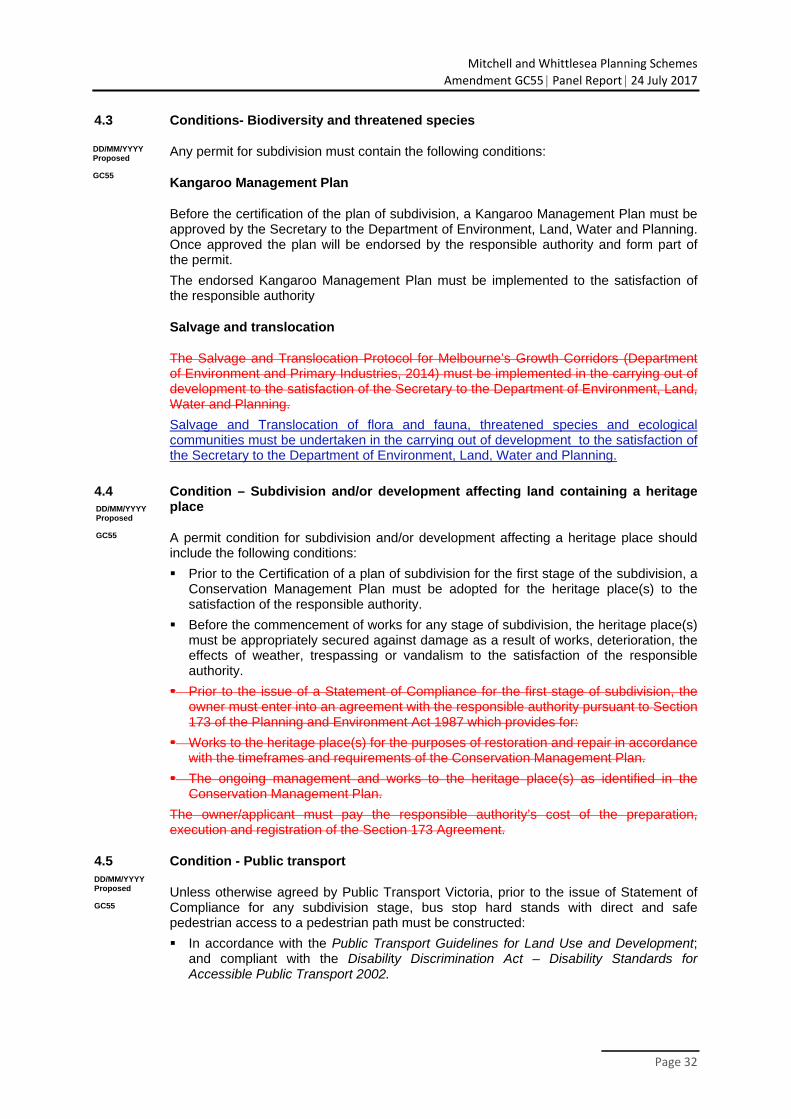
Mitchell and Whittlesea Planning Schemes
Amendment GC55 Panel Report 24 July 2017
Page 32
4.3 Conditions- Biodiversity and threatened species
Any permit for subdivision must contain the following conditions:
Kangaroo Management Plan
Before the certification of the plan of subdivision, a Kangaroo Management Plan must be approved by the Secretary to the Department of Environment, Land, Water and Planning. Once approved the plan will be endorsed by the responsible authority and form part of the permit.
The endorsed Kangaroo Management Plan must be implemented to the satisfaction of the responsible authority
Salvage and translocation
The Salvage and Translocation Protocol for Melbourne’s Growth Corridors (Department of Environment and Primary Industries, 2014) must be implemented in the carrying out of development to the satisfaction of the Secretary to the Department of Environment, Land, Water and Planning.
Salvage and Translocation of flora and fauna, threatened species and ecological communities must be undertaken in the carrying out of development to the satisfaction of the Secretary to the Department of Environment, Land, Water and Planning.
4.4 Condition – Subdivision and/or development affecting land containing a heritage
place
A permit condition for subdivision and/or development affecting a heritage place should include the following conditions:
Prior to the Certification of a plan of subdivision for the first stage of the subdivision, a Conservation Management Plan must be adopted for the heritage place(s) to the satisfaction of the responsible authority.
Before the commencement of works for any stage of subdivision, the heritage place(s) must be appropriately secured against damage as a result of works, deterioration, the effects of weather, trespassing or vandalism to the satisfaction of the responsible authority.
Prior to the issue of a Statement of Compliance for the first stage of subdivision, the owner must enter into an agreement with the responsible authority pursuant to Section 173 of the Planning and Environment Act 1987 which provides for:
Works to the heritage place(s) for the purposes of restoration and repair in accordance with the timeframes and requirements of the Conservation Management Plan.
The ongoing management and works to the heritage place(s) as identified in the Conservation Management Plan.
The owner/applicant must pay the responsible authority’s cost of the preparation, execution and registration of the Section 173 Agreement.
4.5 Condition - Public transport
Unless otherwise agreed by Public Transport Victoria, prior to the issue of Statement of Compliance for any subdivision stage, bus stop hard stands with direct and safe pedestrian access to a pedestrian path must be constructed:
In accordance with the Public Transport Guidelines for Land Use and Development; and compliant with the Disability Discrimination Act – Disability Standards for Accessible Public Transport 2002.
DD/MM/YYYY Proposed
GC55
DD/MM/YYYY Proposed
GC55
DD/MM/YYYY Proposed
GC55
Mitchell and Whittlesea Planning Schemes
Amendment GC55 Panel Report 24 July 2017
Page 33
At locations approved by Public Transport Victoria, at no cost to Public Transport Victoria, and to the satisfaction of Public Transport Victoria.
4.6 Condition – Road network
Any permit for subdivision or building and works must contain the following condition:
Prior to the certification of a plan of subdivision, the plan of subdivision must show the land affected by the widening of the road reserve which is required to provide road widening and/or right of way flaring for the ultimate design of any adjacent intersection.
Land required for road widening including right of way flaring for the ultimate design of any intersection within an existing or proposed arterial road must be transferred to or vested in council at no cost to the acquiring agency unless funded by the Beveridge Central Infrastructure Contributions Plan.
4.7 Condition - Precinct Infrastructure Plan
Any permit for subdivision must contain the following condition:
Prior to the certification of a plan of subdivision or at such other time which is agreed between Council and the owner, if required by the responsible authority or the owner, the owner must enter into an agreement or agreements under Section 173 of the Planning and Environment Act 1987 which provides for:
The implementation of the Public Infrastructure Plan approved under this permit.
The purchase and/or reimbursement by the responsible authority for any provision of public open space in excess of the amount specified in the schedule to Clause 52.01.
The timing of any payments to be made to the owner having regard to the availability of funds in the open space account.
4.8 Condition – Use or develop land for a sensitive purpose – Environmental Site Assessment for land at 62 Lithgow Street, 101 Lithgow Street, 5 Old Hume Highway, and 55 Lewis Street
Before a plan of subdivision is certified under the Subdivision Act 1988, the recommendations of the Phase 2 Environmental Site Assessment submitted must be carried out to the satisfaction of the responsible authority.
Upon receipt of the further testing report the owner must comply with any further requirements made by the responsible authority after having regard to the guidance set out in the General Practice Note on Potentially Contaminated Land June 2005 (DSE). The plan of subdivision must not be certified until the responsible authority is satisfied that the land is suitable for the intended use.
5.0 Advertising signs
The advertising sign category for the land is the category specified in the zone applied zone to the land at Clause 2.2 of this schedule.
5.1 Land and home sales signs
Despite the provisions of Clause 52.05, signs promoting the sale of land or homes on the land (or on adjoining land in the same ownership) may be displayed without a permit provided:
the advertisement area for each sign does not exceed 10 square metres;
only one sign is displayed per road frontage. Where the property has a road frontage of more than 150 metres multiple signs may be erected provided there is a minimum
DD/MM/YYYY Proposed
GC55
DD/MM/YYYY Proposed GC55
DD/MM/YYYY Proposed
GC55
DD/MM/YYYY Proposed
GC55
DD/MM/YYYY Proposed
GC55
Mitchell and Whittlesea Planning Schemes
Amendment GC55 Panel Report 24 July 2017
Page 34
of 150 metres distance between each sign, with a total of not more than 4 signs per frontage;
the sign is not animated, scrolling, electronic or internally illuminated sign;
the sign is not displayed longer than 21 days after the sale (not settlement) of the last lot; and
the sign is setback a minimum of 750mm from the property boundary.
A permit may be granted to display a sign promoting the sale of land or homes on the land (or on adjoining land in the same ownership) with an area greater than 10 square metres.
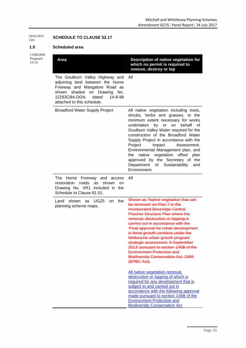
Mitchell and Whittlesea Planning Schemes
Amendment GC55 Panel Report 24 July 2017
Page 35
SCHEDULE TO CLAUSE 52.17
1.0 Scheduled area
Area Description of native vegetation for which no permit is required to remove, destroy or lop
The Goulburn Valley Highway and adjoining land between the Hume Freeway and Mangalore Road as shown shaded on Drawing No. 12263CBA.DGN dated 14-8-98 attached to this schedule.
All
Broadford Water Supply Project All native vegetation including trees, shrubs, herbs and grasses, to the minimum extent necessary for works undertaken by or on behalf of Goulburn Valley Water required for the construction of the Broadford Water Supply Project in accordance with the Project Impact Assessment. Environmental Management plan, and the native vegetation offset plan approved by the Secretary of the Department of Sustainability and Environment.
The Hume Freeway and access restoration roads as shown on Drawing No. VR1 included in the Schedule to Clause 81.01.
All
Land shown as UGZ5 on the planning scheme maps.
Shown as ‘Native vegetation that can be removed’ on Plan 7 in the incorporated Beveridge Central Precinct Structure Plan where the removal, destruction or lopping is carried out in accordance with the ‘Final approval for urban development in three growth corridors under the Melbourne urban growth program strategic assessment, 5 September 2013’ pursuant to section 146B of the Environment Protection and Biodiversity Conservation Act, 1999 (EPBC Act).
All native vegetation removal, destruction or lopping of which is required for any development that is subject to and carried out in accordance with the following approval made pursuant to section 146B of the Environment Protection and Biodiversity Conservation Act
13/08/2009 Proposed GC55
29/03/2012 C83
Mitchell and Whittlesea Planning Schemes
Amendment GC55 Panel Report 24 July 2017
Page 36
1999(Cth) and with the final approval for urban development in three growth corridors under the Melbourne urban growth program strategic assessment, 5 September 2013.
2.0 Scheduled weed
Area Description of weed
None specified
3.0 Utility installation code of practice
Name of code of practice
Goulburn-Murray Water Native Vegetation Code of Practice, February 2011
15/09/2008 VC49
29/03/2012 C83
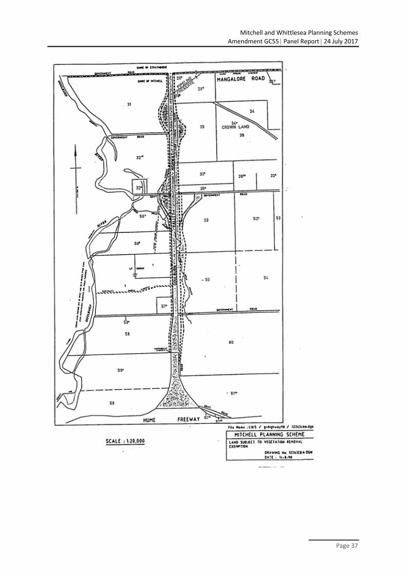
Mitchell and Whittlesea Planning Schemes
Amendment GC55 Panel Report 24 July 2017
Page 37
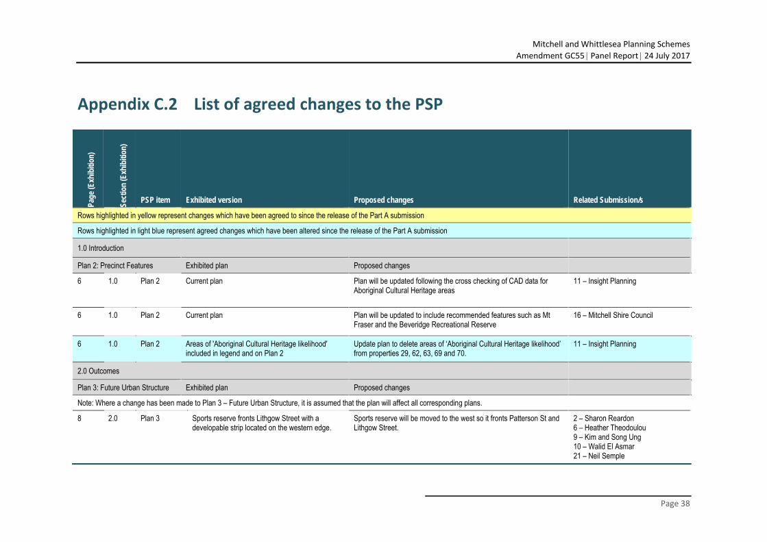
Mitchell and Whittlesea Planning Schemes
Amendment GC55 Panel Report 24 July 2017
Page 38
Appendix C.2 List of agreed changes to the PSP
Page
(Exh
ibiti
on)
Sect
ion
(Exh
ibiti
on)
PSP item Exhibited version Proposed changes Related Submission/s
Rows highlighted in yellow represent changes which have been agreed to since the release of the Part A submission
Rows highlighted in light blue represent agreed changes which have been altered since the release of the Part A submission
1.0 Introduction
Plan 2: Precinct Features Exhibited plan Proposed changes
6 1.0 Plan 2 Current plan Plan will be updated following the cross checking of CAD data for Aboriginal Cultural Heritage areas
11 – Insight Planning
6 1.0 Plan 2 Current plan Plan will be updated to include recommended features such as Mt Fraser and the Beveridge Recreational Reserve
16 – Mitchell Shire Council
6 1.0 Plan 2 Areas of 'Aboriginal Cultural Heritage likelihood' included in legend and on Plan 2
Update plan to delete areas of ‘Aboriginal Cultural Heritage likelihood’ from properties 29, 62, 63, 69 and 70.
11 – Insight Planning
2.0 Outcomes
Plan 3: Future Urban Structure Exhibited plan Proposed changes
Note: Where a change has been made to Plan 3 – Future Urban Structure, it is assumed that the plan will affect all corresponding plans.
8 2.0 Plan 3 Sports reserve fronts Lithgow Street with a developable strip located on the western edge.
Sports reserve will be moved to the west so it fronts Patterson St and Lithgow Street.
2 – Sharon Reardon 6 – Heather Theodoulou 9 – Kim and Song Ung 10 – Walid El Asmar 21 – Neil Semple
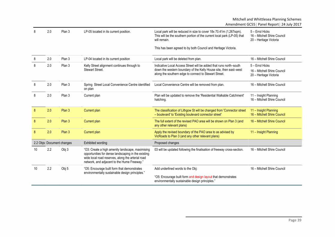
Mitchell and Whittlesea Planning Schemes
Amendment GC55 Panel Report 24 July 2017
Page 39
8 2.0 Plan 3 LP-05 located in its current position. Local park will be reduced in size to cover 18x 70.41m (1,267sqm). This will be the southern portion of the current local park (LP-05) that will remain. This has been agreed to by both Council and Heritage Victoria.
5 – Errol Hicks 16 – Mitchell Shire Council 20 – Heritage Victoria
8 2.0 Plan 3 LP-04 located in its current position Local park will be deleted from plan. 16 – Mitchell Shire Council
8 2.0 Plan 3 Kelly Street alignment continues through to Stewart Street.
Indicative Local Access Street will be added that runs north–south down the western boundary of the Kelly House site, then east–west along the southern edge to connect to Stewart Street.
5 – Errol Hicks 16 – Mitchell Shire Council 20 – Heritage Victoria
8 2.0 Plan 3 Spring Street Local Convenience Centre identified on plan
Local Convenience Centre will be removed from plan. 16 – Mitchell Shire Council
8 2.0 Plan 3 Current plan Plan will be updated to remove the 'Residential Walkable Catchment' hatching.
11 – Insight Planning 16 – Mitchell Shire Council
8 2.0 Plan 3 Current plan The classification of Lithgow St will be changed from 'Connector street – boulevard' to 'Existing boulevard connector street'
11 – Insight Planning 16 – Mitchell Shire Council
8 2.0 Plan 3 Current plan The full extent of the revised PAO area will be shown on Plan 3 (and any other relevant plans)
16 – Mitchell Shire Council
8 2.0 Plan 3 Current plan Apply the revised boundary of the PAO area to as advised by VicRoads to Plan 3 (and any other relevant plans)
11 – Insight Planning
2.2 Objs: Document changes Exhibited wording Proposed changes
10 2.2 Obj 3 “O3: Create a high amenity landscape, maximising opportunities for dense landscaping in the existing wide local road reserves, along the arterial road network, and adjacent to the Hume Freeway.”
03 will be updated following the finalisation of freeway cross-section. 16 – Mitchell Shire Council
10 2.2 Obj 5 “O5: Encourage built form that demonstrates environmentally sustainable design principles.”
Add underlined words to the Obj: “O5: Encourage built form and design layout that demonstrates environmentally sustainable design principles.”
16 – Mitchell Shire Council
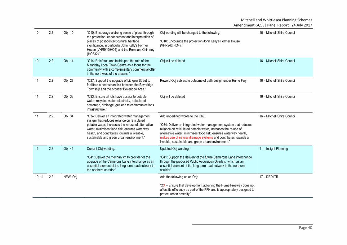
Mitchell and Whittlesea Planning Schemes
Amendment GC55 Panel Report 24 July 2017
Page 40
10 2.2 Obj 10 “O10: Encourage a strong sense of place through the protection, enhancement and interpretation of places of post-contact cultural heritage significance, in particular John Kelly's Former House (VHR940/HO4) and the Remnant Chimney (HO332).”
Obj wording will be changed to the following: “O10: Encourage the protection John Kelly's Former House (VHR940/HO4).”
16 – Mitchell Shire Council
10 2.2 Obj 14 “O14: Reinforce and build upon the role of the Mandalay Local Town Centre as a focus for the community with a complementary commercial offer in the northwest of the precinct.”
Obj will be deleted 16 – Mitchell Shire Council
11 2.2 Obj 27 “O27: Support the upgrade of Lithgow Street to facilitate a pedestrian link between the Beveridge Township and the broader Beveridge Area.”
Reword Obj subject to outcome of path design under Hume Fwy 16 – Mitchell Shire Council
11 2.2 Obj 33 “O33: Ensure all lots have access to potable water, recycled water, electricity, reticulated sewerage, drainage, gas and telecommunications infrastructure.”
Obj will be deleted
16 – Mitchell Shire Council
11 2.2 Obj 34 “O34: Deliver an integrated water management system that reduces reliance on reticulated potable water, increases the re-use of alternative water, minimises flood risk, ensures waterway health, and contributes towards a liveable, sustainable and green urban environment.”
Add underlined words to the Obj: “O34: Deliver an integrated water management system that reduces reliance on reticulated potable water, increases the re-use of alternative water, minimises flood risk, ensures waterway health, makes use of natural drainage systems and contributes towards a liveable, sustainable and green urban environment.”
16 – Mitchell Shire Council
11 2.2 Obj 41 Current Obj wording: “O41: Deliver the mechanism to provide for the upgrade of the Camerons Lane interchange as an essential element of the long term road network in the northern corridor.”
Updated Obj wording: “O41: Support the delivery of the future Camerons Lane interchange through the proposed Public Acquisition Overlay, which as an essential element of the long term road network in the northern corridor”
11 – Insight Planning
10, 11 2.2 NEW Obj
Add the following as an Obj: ‘OX – Ensure that development adjoining the Hume Freeway does not affect its efficiency as part of the PFN and is appropriately designed to protect urban amenity.’
17 – DEDJTR
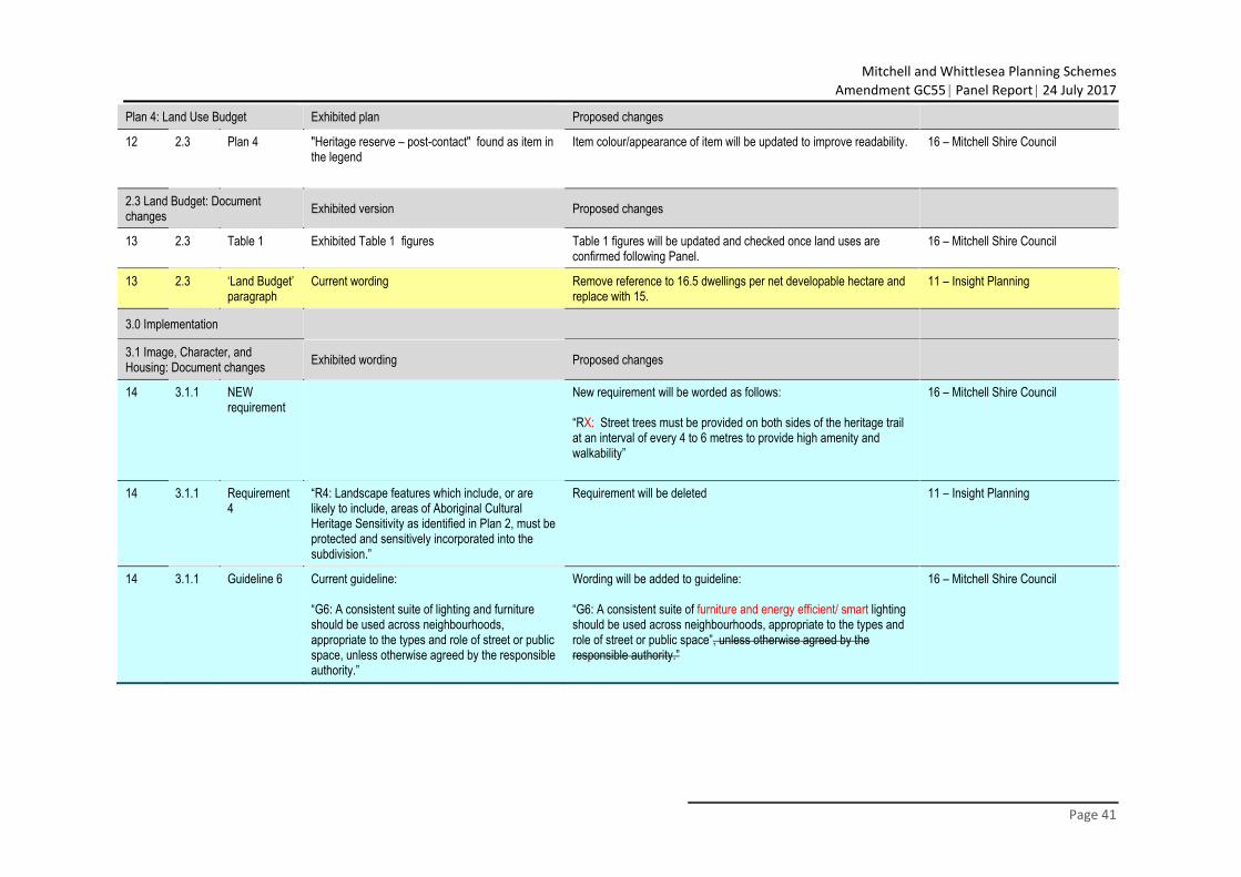
Mitchell and Whittlesea Planning Schemes
Amendment GC55 Panel Report 24 July 2017
Page 41
Plan 4: Land Use Budget Exhibited plan Proposed changes
12 2.3 Plan 4 "Heritage reserve – post-contact" found as item in the legend
Item colour/appearance of item will be updated to improve readability. 16 – Mitchell Shire Council
2.3 Land Budget: Document changes Exhibited version Proposed changes
13 2.3 Table 1 Exhibited Table 1 figures Table 1 figures will be updated and checked once land uses are confirmed following Panel.
16 – Mitchell Shire Council
13 2.3 ‘Land Budget’ paragraph
Current wording Remove reference to 16.5 dwellings per net developable hectare and replace with 15.
11 – Insight Planning
3.0 Implementation
3.1 Image, Character, and Housing: Document changes Exhibited wording Proposed changes
14 3.1.1 NEW requirement
New requirement will be worded as follows: “RX: Street trees must be provided on both sides of the heritage trail at an interval of every 4 to 6 metres to provide high amenity and walkability”
16 – Mitchell Shire Council
14 3.1.1 Requirement 4
“R4: Landscape features which include, or are likely to include, areas of Aboriginal Cultural Heritage Sensitivity as identified in Plan 2, must be protected and sensitively incorporated into the subdivision.”
Requirement will be deleted 11 – Insight Planning
14 3.1.1 Guideline 6 Current guideline: “G6: A consistent suite of lighting and furniture should be used across neighbourhoods, appropriate to the types and role of street or public space, unless otherwise agreed by the responsible authority.”
Wording will be added to guideline: “G6: A consistent suite of furniture and energy efficient/ smart lighting should be used across neighbourhoods, appropriate to the types and role of street or public space”, unless otherwise agreed by the responsible authority.”
16 – Mitchell Shire Council
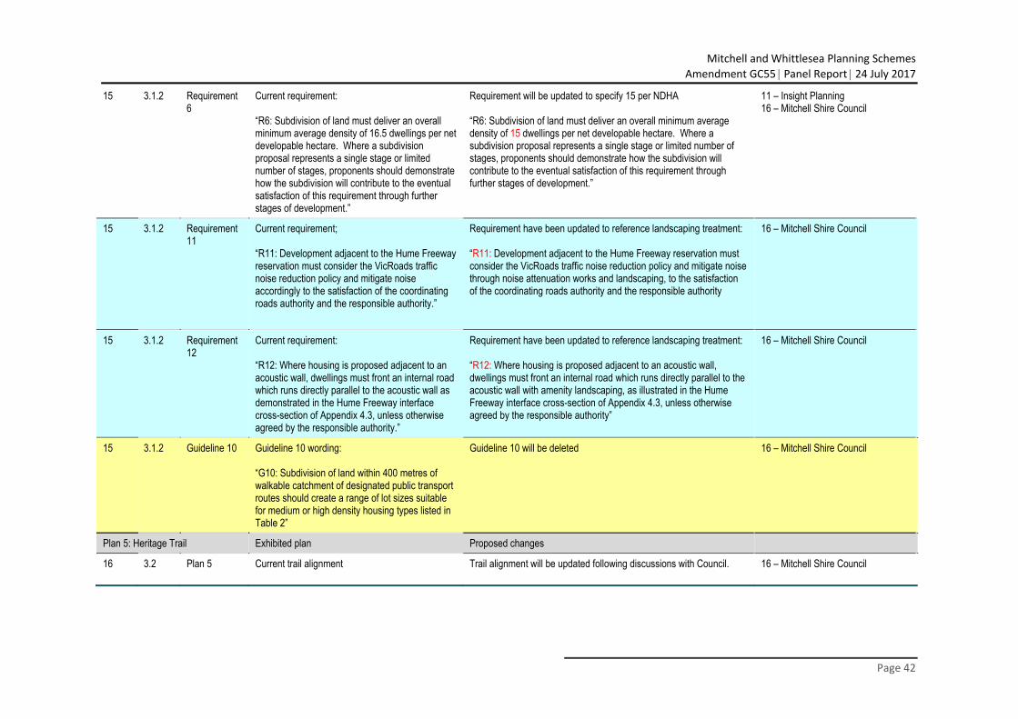
Mitchell and Whittlesea Planning Schemes
Amendment GC55 Panel Report 24 July 2017
Page 42
15 3.1.2 Requirement 6
Current requirement: “R6: Subdivision of land must deliver an overall minimum average density of 16.5 dwellings per net developable hectare. Where a subdivision proposal represents a single stage or limited number of stages, proponents should demonstrate how the subdivision will contribute to the eventual satisfaction of this requirement through further stages of development.”
Requirement will be updated to specify 15 per NDHA “R6: Subdivision of land must deliver an overall minimum average density of 15 dwellings per net developable hectare. Where a subdivision proposal represents a single stage or limited number of stages, proponents should demonstrate how the subdivision will contribute to the eventual satisfaction of this requirement through further stages of development.”
11 – Insight Planning 16 – Mitchell Shire Council
15 3.1.2 Requirement 11
Current requirement; “R11: Development adjacent to the Hume Freeway reservation must consider the VicRoads traffic noise reduction policy and mitigate noise accordingly to the satisfaction of the coordinating roads authority and the responsible authority.”
Requirement have been updated to reference landscaping treatment: “R11: Development adjacent to the Hume Freeway reservation must consider the VicRoads traffic noise reduction policy and mitigate noise through noise attenuation works and landscaping, to the satisfaction of the coordinating roads authority and the responsible authority
16 – Mitchell Shire Council
15 3.1.2 Requirement 12
Current requirement: “R12: Where housing is proposed adjacent to an acoustic wall, dwellings must front an internal road which runs directly parallel to the acoustic wall as demonstrated in the Hume Freeway interface cross-section of Appendix 4.3, unless otherwise agreed by the responsible authority.”
Requirement have been updated to reference landscaping treatment: “R12: Where housing is proposed adjacent to an acoustic wall, dwellings must front an internal road which runs directly parallel to the acoustic wall with amenity landscaping, as illustrated in the Hume Freeway interface cross-section of Appendix 4.3, unless otherwise agreed by the responsible authority”
16 – Mitchell Shire Council
15 3.1.2 Guideline 10 Guideline 10 wording: “G10: Subdivision of land within 400 metres of walkable catchment of designated public transport routes should create a range of lot sizes suitable for medium or high density housing types listed in Table 2”
Guideline 10 will be deleted 16 – Mitchell Shire Council
Plan 5: Heritage Trail Exhibited plan Proposed changes
16 3.2 Plan 5 Current trail alignment Trail alignment will be updated following discussions with Council. 16 – Mitchell Shire Council
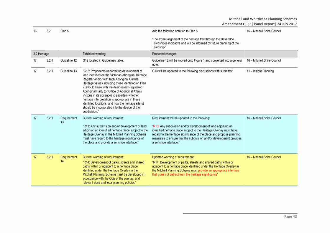
Mitchell and Whittlesea Planning Schemes
Amendment GC55 Panel Report 24 July 2017
Page 43
16 3.2 Plan 5 Add the following notation to Plan 5: ‘The extent/alignment of the heritage trail through the Beveridge Township is indicative and will be informed by future planning of the Township.'
16 – Mitchell Shire Council
3.2 Heritage Exhibited wording Proposed changes
17 3.2.1 Guideline 12 G12 located in Guidelines table. Guideline 12 will be moved onto Figure 1 and converted into a general note.
16 – Mitchell Shire Council
17 3.2.1 Guideline 13 “G13: Proponents undertaking development of land identified on the Victorian Aboriginal Heritage Register and/or with high Aboriginal Cultural Heritage values including those identified on Plan 2, should liaise with the designated Registered Aboriginal Party (or Office of Aboriginal Affairs Victoria in its absence) to ascertain whether heritage interpretation is appropriate in these identified locations, and how the heritage site(s) should be incorporated into the design of the subdivision.”
G13 will be updated to the following discussions with submitter: 11 – Insight Planning
17 3.2.1 Requirement 13
Current wording of requirement: “R13: Any subdivision and/or development of land adjoining an identified heritage place subject to the Heritage Overlay in the Mitchell Planning Scheme must have regard to the heritage significance of the place and provide a sensitive interface.”
Requirement will be updated to the following: “R13: Any subdivision and/or development of land adjoining an identified heritage place subject to the Heritage Overlay must have regard to the heritage significance of the place and propose planning measures to ensure that the subdivision and/or development provides a sensitive interface.”
16 – Mitchell Shire Council
17 3.2.1 Requirement 14
Current wording of requirement: “R14: Development of parks, streets and shared paths within or adjacent to a heritage place identified under the Heritage Overlay in the Mitchell Planning Scheme must be developed in accordance with the Objs of the overlay, and relevant state and local planning policies”
Updated wording of requirement: “R14: Development of parks, streets and shared paths within or adjacent to a heritage place identified under the Heritage Overlay in the Mitchell Planning Scheme must provide an appropriate interface that does not detract from the heritage significance”
16 – Mitchell Shire Council
Mitchell and Whittlesea Planning Schemes
Amendment GC55 Panel Report 24 July 2017
Page 44
17 3.2.1 Requirement 16
Current wording of requirement: “R16: Any subdivision and/or development of land on or adjoining the Kelly House heritage site (VHR HO940/HO04) must have regard to the heritage significance of the site, provide a sensitive interface and respond to Figure 1 and Appendix 4.6.”
Requirement will be updated to the following: “R16: Any subdivision and/or development of land on or adjoining the Kelly House heritage site (VHR HO940/HO4) must have regard to the heritage significance of the heritage place and propose planning measures to ensure that the subdivision and/or development provides a sensitive interface and responses to the concept shown in Figure 1 and Appendix 4.6”
16 – Mitchell Shire Council
17 3.2.1 Guideline 14 Current wording of guideline “G14: The heritage trail should tell a story of the area's local history, both Aboriginal and post-contact cultural heritage, through appropriate interpretive installations in consultation with relevant stakeholders.”
Guideline will be deleted 16 – Mitchell Shire Council
17 3.2.1 NEW Guideline
A new guideline will be added referencing the intent for a varied pavement treatment along the heritage trail (subject to Council approval)
16 – Mitchell Shire Council
17 3.2.1 3.2.1 – Heritage Trail “The PSP aims to highlight areas of significance through the opportunity for a Heritage Trail linking each point of interest as shown on Plan 5 in this PSP. The Heritage Trail may include directional signage, information posts and two potential visitor/interpretation centres at the John Kelly's Former House site and the Post Office site. A varied pavement...”
Section 3.2.1 wording will be updated to the following “The PSP aims to highlight areas of significance through the opportunity for a Heritage Trail linking each point of interest as shown on Plan 5 in this PSP. The Heritage Trail may include directional signage, information posts and a potential visitor/interpretation centre at the John Kelly's Former House site. A varied pavement...”
16 – Mitchell Shire Council
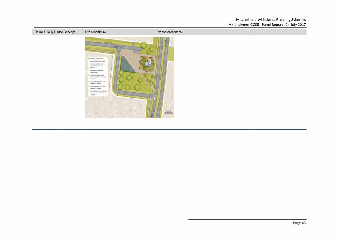
Mitchell and Whittlesea Planning Schemes
Amendment GC55 Panel Report 24 July 2017
Page 45
Figure 1: Kelly House Concept Exhibited figure Proposed changes
Mitchell and Whittlesea Planning Schemes
Amendment GC55 Panel Report 24 July 2017
Page 46
18 3.2 Figure 1 Current figure Figure will be updated following agreements between Council and Heritage Victoria (pending landowner approval). Changes to Figure 1 include: A) Amend the measurements of the proposed site; B) Reword general note 2 to provide clarity that the local park area will be funded by the ICP; C) A general note will be added to specify an alternative treatment for the local park area; D) Remove the forth dot point above General Notes. This will be replaced with a general note which will clarify that traffic management and traffic safety measures for the land surrounding the conservation area are to be investigated at the same time of more detailed planning for the proposed interpretation/ visitor centre; E) Reword the first 'Interpretive environment' point to replace 'public open space' with 'public area'; F) Remove any references to 'exotic vegetation'. G) Include general note that the concept plan is subject to the findings of the feasibility analysis and is a potential option.
5 – Errol Hicks 16 – Mitchell Shire Council 20 – Heritage Victoria
18 3.2.1 Figure 1 Guideline 12 will be added to Figure 1 and converted into a general note. It will also be updated to include a reference that the Heritage Overlay enables the potential for prohibited uses to be permitted within this heritage place.
16 – Mitchell Shire Council
Plan 6: Open Space Exhibited plan Proposed changes
20 3.3 Plan 6
Mitchell and Whittlesea Planning Schemes
Amendment GC55 Panel Report 24 July 2017
Page 47
3.3 Open Space Exhibited wording Proposed changes
21 3.3.1 Guideline 20 Current guideline “G20: Water-sensitive urban design principles should be used so that excess run-off water from within, or where appropriate, external to the park, is directed to support park planning and/or rain gardens rather than being diverted to drains, to the satisfaction of the responsible authority.”
Guideline will be changed to a requirement “RX: Water-sensitive urban design principles must be used so that excess run-off water from within, or where appropriate, external to the park, is directed to support park planning and/or rain gardens rather than being diverted to drains, to the satisfaction of the responsible authority.”
16 – Mitchell Shire Council
21 3.3.1 Requirement 23 Requirement 27
Current requirements: “R23: Lots directly fronting open space must provide for a primary point of access from a footpath or shared path proximate to the lot boundary.” “R27: Where a street frontage to a park is not provided, lots must provide for a 4 metre "Paper Road" to the satisfaction of the responsible authority.”
Requirements will be combine 11 – Insight Planning
21 3.3.1 Requirement 24 Requirement 28
Current requirements: “R24: In exceptional circumstances, any lots backing onto open space, whether encumbered or unencumbered, must be low scale and visually permeable to facilitate public safety and surveillance.” “R28: Any fencing of open space, whether encumbered or unencumbered, must be low scale and visually permeable to facilitate public safety and surveillance.”
Requirements will be combine 11 – Insight Planning
21 3.3.1 Requirement 29
Current requirement “R29: Appropriate scaled lighting must be installed along all major pedestrian thoroughfares traversing public open space and cycling network to the satisfaction of the responsible authority.”
Requirement wording will be updated to include underlined wording “R29: Appropriate scaled energy efficient/ smart lighting must be installed along all major pedestrian thoroughfares traversing public open space and cycling network to the satisfaction of the responsible authority.”
16 – Mitchell Shire Council
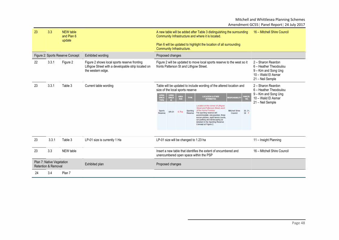
Mitchell and Whittlesea Planning Schemes
Amendment GC55 Panel Report 24 July 2017
Page 48
23 3.3 NEW table and Plan 6 update
A new table will be added after Table 3 distinguishing the surrounding Community Infrastructure and where it is located. Plan 6 will be updated to highlight the location of all surrounding Community Infrastructure.
16 – Mitchell Shire Council
Figure 2: Sports Reserve Concept Exhibited wording Proposed changes
22 3.3.1 Figure 2 Figure 2 shows local sports reserve fronting Lithgow Street with a developable strip located on the western edge.
Figure 2 will be updated to move local sports reserve to the west so it fronts Patterson St and Lithgow Street.
2 – Sharon Reardon 6 – Heather Theodoulou 9 – Kim and Song Ung 10 – Walid El Asmar 21 – Neil Semple
23 3.3.1 Table 3 Current table wording Table will be updated to include wording of the altered location and size of the local sports reserve
2 – Sharon Reardon 6 – Heather Theodoulou 9 – Kim and Song Ung 10 – Walid El Asmar 21 – Neil Semple
23 3.3.1 Table 3 LP-01 size is currently 1 Ha LP-01 size will be changed to 1.23 ha 11 – Insight Planning
23 3.3 NEW table Insert a new table that identifies the extent of encumbered and unencumbered open space within the PSP
16 – Mitchell Shire Council
Plan 7: Native Vegetation Retention & Removal Exhibited plan Proposed changes
24 3.4 Plan 7
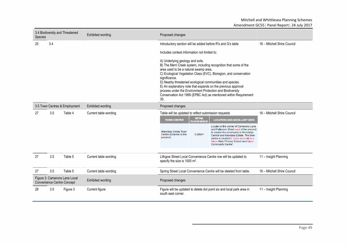
Mitchell and Whittlesea Planning Schemes
Amendment GC55 Panel Report 24 July 2017
Page 49
3.4 Biodiversity and Threatened Species Exhibited wording Proposed changes
25 3.4 Introductory section will be added before R's and G's table Includes context information not limited to: A) Underlying geology and soils. B) The Merri Creek system, including recognition that some of the area used to be a natural swamp area. C) Ecological Vegetation Class (EVC), Bioregion, and conservation significance. D) Nearby threatened ecological communities and species. E) An explanatory note that expands on the previous approval process under the Environment Protection and Biodiversity Conservation Act 1999 (EPBC Act) as mentioned within Requirement 30.
16 – Mitchell Shire Council
3.5 Town Centres & Employment Exhibited wording Proposed changes
27 3.5 Table 4 Current table wording Table will be updated to reflect submission requests 16 – Mitchell Shire Council
27 3.5 Table 5 Current table wording Lithgow Street Local Convenience Centre row will be updated to specify the size is 1000 m2.
11 – Insight Planning
27 3.5 Table 5 Current table wording Spring Street Local Convenience Centre will be deleted from table. 16 – Mitchell Shire Council
Figure 3: Camerons Lane Local Convenience Centre Concept Exhibited wording Proposed changes
28 3.5 Figure 3 Current figure Figure will be updated to delete dot point six and local park area in south east corner.
11 – Insight Planning
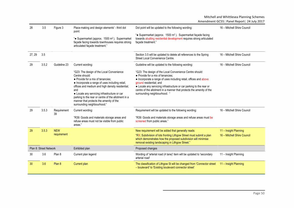
Mitchell and Whittlesea Planning Schemes
Amendment GC55 Panel Report 24 July 2017
Page 50
28 3.5 Figure 3 Place-making and design elements' - third dot point: “● Supermarket (approx. 1500 m2 ). Supermarket façade facing towards townhouses requires strong articulated façade treatment.”
Dot point will be updated to the following wording: “● Supermarket (approx. 1500 m2 ). Supermarket façade facing towards abutting residential development requires strong articulated façade treatment.”
16 – Mitchell Shire Council
27, 29 3.5 Section 3.5 will be updated to delete all references to the Spring Street Local Convenience Centre.
16 – Mitchell Shire Council
29 3.5.2 Guideline 23 Current wording: “G23: The design of the Local Convenience Centre should: ● Provide for a mix of tenancies; ● Incorporate a range of uses including retail, offices and medium and high density residential; and ● Locate any servicing infrastructure or car parking to the rear or centre of the allotment in a manner that protects the amenity of the surrounding neighbourhood.“
Guideline will be updated to the following wording: “G23: The design of the Local Convenience Centre should: ● Provide for a mix of tenancies; ● Incorporate a range of uses including retail, offices and above ground residential; and ● Locate any servicing infrastructure or car parking to the rear or centre of the allotment in a manner that protects the amenity of the surrounding neighbourhood. “
16 – Mitchell Shire Council
29 3.5.3 Requirement 39
Current wording: “R39: Goods and materials storage areas and refuse areas must not be visible from public areas.”
Requirement will be updated to the following wording: “R39: Goods and materials storage areas and refuse areas must be screened from public areas.”
16 – Mitchell Shire Council
29 3.5.3 NEW requirement
New requirement will be added that generally reads: “RX: Subdivision of lots fronting Lithgow Street must submit a plan which demonstrates how the proposed subdivision will minimise removal existing landscaping in Lithgow Street.”
11 – Insight Planning 16 – Mitchell Shire Council
Plan 8: Street Network Exhibited plan Proposed changes
30 3.6 Plan 8 Current plan legend Wording of 'arterial road (4 lane)' item will be updated to 'secondary arterial road'
11 – Insight Planning
30 3.6 Plan 8 Current plan The classification of Lithgow St will be changed from 'Connector street – boulevard' to 'Existing boulevard connector street’
11 – Insight Planning
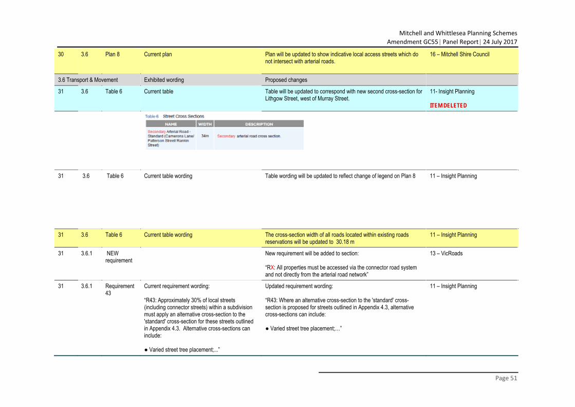
Mitchell and Whittlesea Planning Schemes
Amendment GC55 Panel Report 24 July 2017
Page 51
30 3.6 Plan 8 Current plan Plan will be updated to show indicative local access streets which do not intersect with arterial roads.
16 – Mitchell Shire Council
3.6 Transport & Movement Exhibited wording Proposed changes
31 3.6 Table 6 Current table Table will be updated to correspond with new second cross-section for Lithgow Street, west of Murray Street.
11- Insight Planning ITEM DELETED
31 3.6 Table 6 Current table wording Table wording will be updated to reflect change of legend on Plan 8 11 – Insight Planning
31 3.6 Table 6 Current table wording The cross-section width of all roads located within existing roads reservations will be updated to 30.18 m
11 – Insight Planning
31 3.6.1 NEW requirement
New requirement will be added to section: “RX: All properties must be accessed via the connector road system and not directly from the arterial road network”
13 – VicRoads
31 3.6.1 Requirement 43
Current requirement wording: “R43: Approximately 30% of local streets (including connector streets) within a subdivision must apply an alternative cross-section to the 'standard' cross-section for these streets outlined in Appendix 4.3. Alternative cross-sections can include: ● Varied street tree placement;...”
Updated requirement wording: “R43: Where an alternative cross-section to the 'standard' cross-section is proposed for streets outlined in Appendix 4.3, alternative cross-sections can include: ● Varied street tree placement;…”
11 – Insight Planning
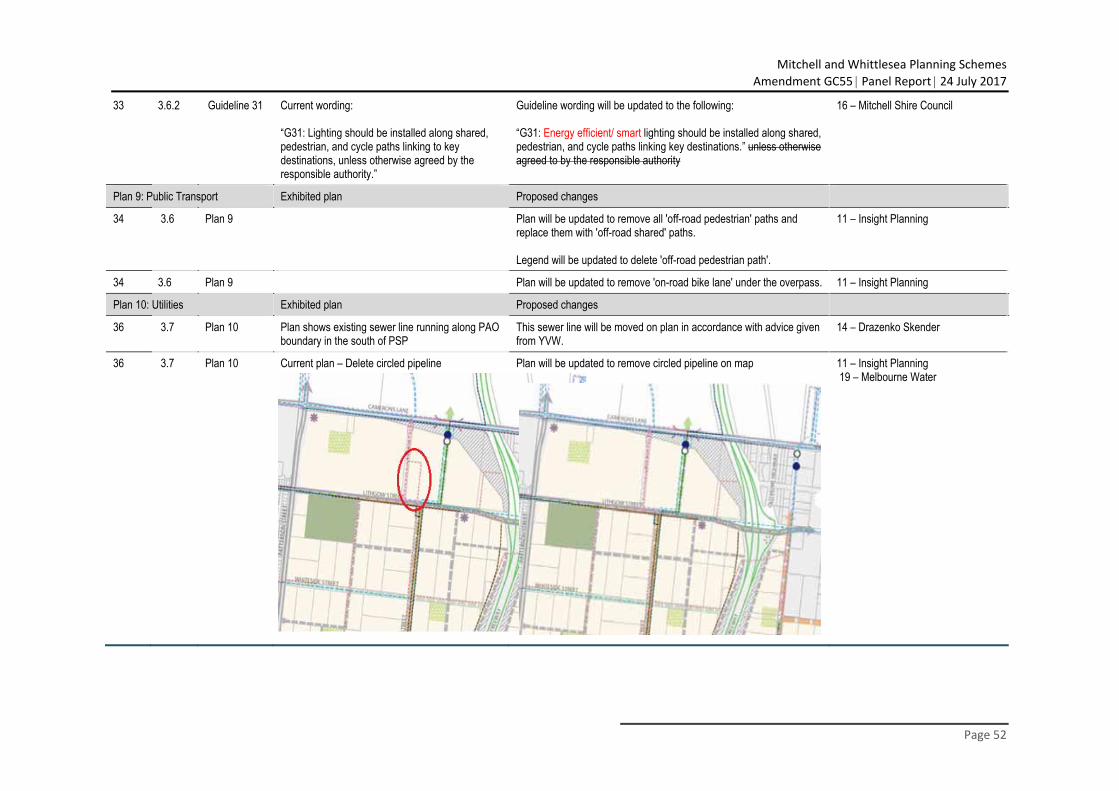
Mitchell and Whittlesea Planning Schemes
Amendment GC55 Panel Report 24 July 2017
Page 52
33 3.6.2 Guideline 31 Current wording: “G31: Lighting should be installed along shared, pedestrian, and cycle paths linking to key destinations, unless otherwise agreed by the responsible authority.”
Guideline wording will be updated to the following: “G31: Energy efficient/ smart lighting should be installed along shared, pedestrian, and cycle paths linking key destinations.” unless otherwise agreed to by the responsible authority
16 – Mitchell Shire Council
Plan 9: Public Transport Exhibited plan Proposed changes
34 3.6 Plan 9 Plan will be updated to remove all 'off-road pedestrian' paths and replace them with 'off-road shared' paths. Legend will be updated to delete 'off-road pedestrian path'.
11 – Insight Planning
34 3.6 Plan 9 Plan will be updated to remove 'on-road bike lane' under the overpass. 11 – Insight Planning
Plan 10: Utilities Exhibited plan Proposed changes
36 3.7 Plan 10 Plan shows existing sewer line running along PAO boundary in the south of PSP
This sewer line will be moved on plan in accordance with advice given from YVW.
14 – Drazenko Skender
36 3.7 Plan 10 Current plan – Delete circled pipeline Plan will be updated to remove circled pipeline on map 11 – Insight Planning 19 – Melbourne Water
Mitchell and Whittlesea Planning Schemes
Amendment GC55 Panel Report 24 July 2017
Page 53
3.7 Integrated Water Management & Utilities Exhibited wording Proposed changes
37 3.7.1
NEW requirement
N/A Include new requirement with wording generally aligned to the following: “With reference to the Drainage and Flooding Investigation undertaken by Engeny, lots must be filled above the 100-year flood level to the satisfaction of Melbourne Water”
19 – Melbourne Water
3.8 Precinct Infrastructure Plan & Development Staging Exhibited wording Proposed changes
39 3.8.1 Current section wording Development Service Scheme Drainage for the precinct is not covered by the Beveridge Central Infrastructure Contributions Plan as the relevant authority for outfall drainage is Melbourne Water. Melbourne Water has prepared a Development Service Scheme (DSS) which applies to the precinct. Under the DSS, developers are required to pay a levy for each developable hectare of land which is included in a planning permit application. Alternative stormwater quality treatments may be provided subject to agreement with Melbourne Water.
Section wording will be updated to the following Development Service Scheme Drainage for the precinct is not covered by the Beveridge Central Infrastructure Contributions Plan as the relevant authority for main outfall drainage is Melbourne Water. Melbourne Water has prepared a Development Service Scheme (DSS) which applies to the precinct. Under the DSS, developers are required to pay a levy for each developable hectare of land which is included in a planning permit application. Alternative stormwater quality treatments may be provided subject to agreement with Melbourne Water. Local drainage is to be constructed by developers in addition to the DSS drainage works.
19 – Melbourne Water
Plan 11: Precinct Infrastructure Projects Exhibited plan Proposed changes
40 3.8 Plan 11 Intersection project at Lewis and Rankin St (IN-07) not included in Plan 11
Plan 11 updated to include IN-07 11 – Insight Planning
40, 41 3.8 Table 7, Plan 11
An intersection at Spring St and Lithgow St is not identified on Plan 11 or Table 7. A roundabout is not shown at the intersection of Lithgow St and the Old Hume Fwy / southbound entry ramp.
INX item will be added to Plan 11 and Table 7, described as a roundabout INX item will be added to Plan 11 and Table 7, described as developer works (Mandalay)
16 – Mitchell Shire Council
Mitchell and Whittlesea Planning Schemes
Amendment GC55 Panel Report 24 July 2017
Page 54
40, 41 3.8 Table 7, Plan 11
No signalised pedestrian crossing located at the intersection of Whiteside St and Patterson St.
New item ‘PED02’ signalised pedestrian crossing will be added to Plan 11 immediately north of IN-05 and added Table 7.
16 – Mitchell Shire Council
40, 41 3.8 Table 7, Plan 11
The intersection of Lewis St and Rankin St which is identified in Plan 8 as a T-intersection is not shown in ICP (Plan 11 or Table 7)
Intersection will be included in Plan 11 and Table 7 11 – Insight Planning ITEM DELETED (VicRoads project)
40, 41 3.8 Table 7, Plan 11
Two roundabout intersections shown as IN-02 and IN-08 on Plan 11 and in Table 7
Delete IN-02 and IN-08 from both Plan 11 and Table 7. Add new offset intersection project (IN-0X) which was recommended by Traffix Group's Traffic report supplied by Jason Black.
11 – Insight Planning
41 3.8 Table 7 Table will be updated to include Local Parks in PSP area once ICP is prepared.
11 – Insight Planning
41 3.8 Table 7 RD-01 title column: “Camerons Lane – East–West Secondary Arterial between Patterson and Lewis Street”
Updated title column wording: “Camerons Lane – East–West Primary Arterial between Patterson Street and existing Malcolm Street”
11 – Insight Planning
41 3.8 Table 7 RD-03 title column: “Rankin Street: east–west Secondary Arterial between Patterson Street and Lewis Street”
Updated title column wording: “Rankin Street: east–west secondary arterial from Patterson Street to Lewis Street”
11- Insight Planning
42 3.8 Table 7 Current Table 7 98-IT02 wording Wording in table to be updated so that the lead agency is Mitchell Shire Council and is included as an ICP project.
16 – Mitchell Shire Council
42 3.8 Table 7 RD-PED01 described as a 'shared path' and not included in the ICP.
The pedestrian underpass will include a fenced off pedestrian path on the north side with an on-road bike path. This project is subject to ongoing consultation with Council and VicRoads.
16 – Mitchell Shire Council
44 3.8 Table 7 59-SR04 current 59-SR04 updated to become 98-OS06 and include reference to the Lockerbie North DCP.
16 – Mitchell Shire Council
44 3.8 Table 7 Project description for first Drainage Infrastructure item: “Construction of pipeline infrastructure along Lewis Street”
Correction will be made to the table: “Construction of pipeline infrastructure along Spring Street”
19 – Melbourne Water
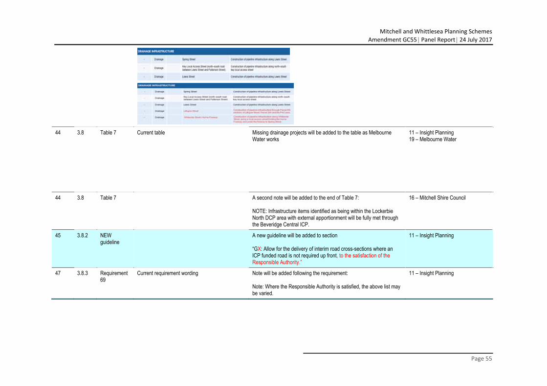
Mitchell and Whittlesea Planning Schemes
Amendment GC55 Panel Report 24 July 2017
Page 55
44 3.8 Table 7 Current table Missing drainage projects will be added to the table as Melbourne
Water works 11 – Insight Planning 19 – Melbourne Water
44 3.8 Table 7 A second note will be added to the end of Table 7: NOTE: Infrastructure items identified as being within the Lockerbie North DCP area with external apportionment will be fully met through the Beveridge Central ICP.
16 – Mitchell Shire Council
45 3.8.2 NEW guideline
A new guideline will be added to section “GX: Allow for the delivery of interim road cross-sections where an ICP funded road is not required up front, to the satisfaction of the Responsible Authority.”
11 – Insight Planning
47 3.8.3 Requirement 69
Current requirement wording Note will be added following the requirement: Note: Where the Responsible Authority is satisfied, the above list may be varied.
11 – Insight Planning
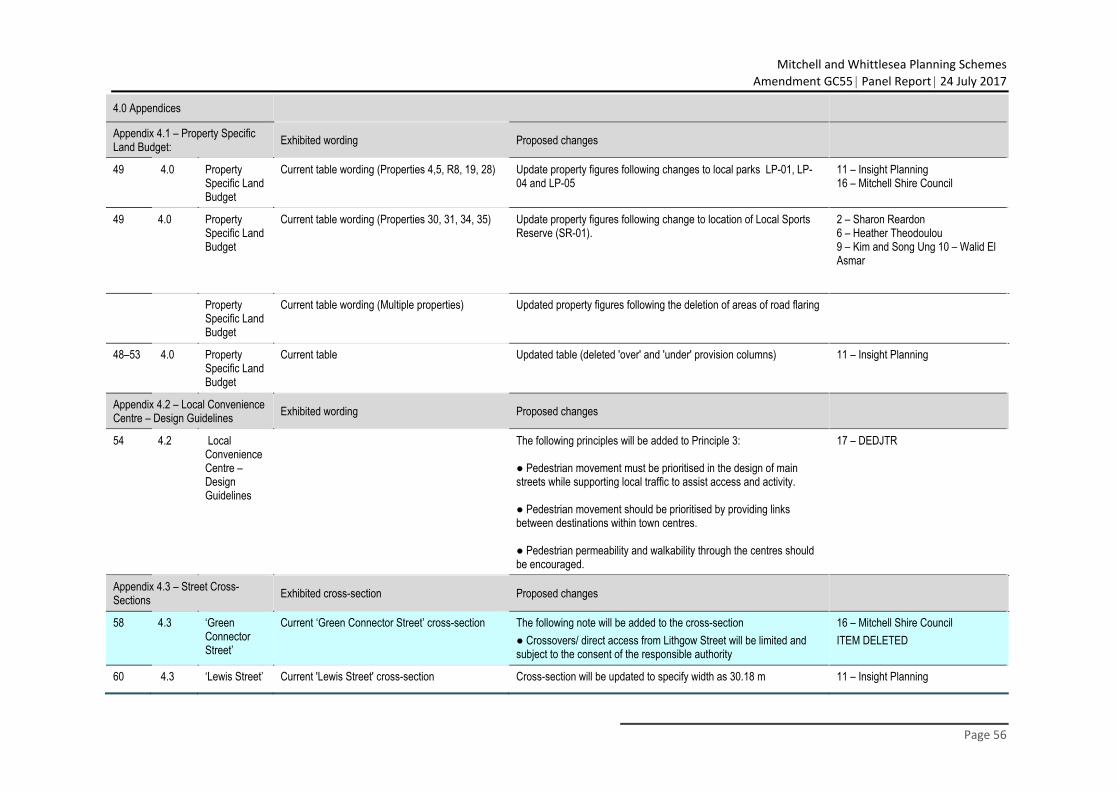
Mitchell and Whittlesea Planning Schemes
Amendment GC55 Panel Report 24 July 2017
Page 56
4.0 Appendices
Appendix 4.1 – Property Specific Land Budget: Exhibited wording Proposed changes
49 4.0 Property Specific Land Budget
Current table wording (Properties 4,5, R8, 19, 28) Update property figures following changes to local parks LP-01, LP-04 and LP-05
11 – Insight Planning 16 – Mitchell Shire Council
49 4.0 Property Specific Land Budget
Current table wording (Properties 30, 31, 34, 35) Update property figures following change to location of Local Sports Reserve (SR-01).
2 – Sharon Reardon 6 – Heather Theodoulou 9 – Kim and Song Ung 10 – Walid El Asmar
Property Specific Land Budget
Current table wording (Multiple properties) Updated property figures following the deletion of areas of road flaring
48–53 4.0 Property Specific Land Budget
Current table Updated table (deleted 'over' and 'under' provision columns) 11 – Insight Planning
Appendix 4.2 – Local Convenience Centre – Design Guidelines Exhibited wording Proposed changes
54 4.2 Local Convenience Centre – Design Guidelines
The following principles will be added to Principle 3: ● Pedestrian movement must be prioritised in the design of main streets while supporting local traffic to assist access and activity. ● Pedestrian movement should be prioritised by providing links between destinations within town centres. ● Pedestrian permeability and walkability through the centres should be encouraged.
17 – DEDJTR
Appendix 4.3 – Street Cross-Sections Exhibited cross-section Proposed changes
58 4.3 ‘Green Connector Street’
Current ‘Green Connector Street’ cross-section The following note will be added to the cross-section ● Crossovers/ direct access from Lithgow Street will be limited and subject to the consent of the responsible authority
16 – Mitchell Shire Council ITEM DELETED
60 4.3 ‘Lewis Street’ Current 'Lewis Street' cross-section Cross-section will be updated to specify width as 30.18 m 11 – Insight Planning
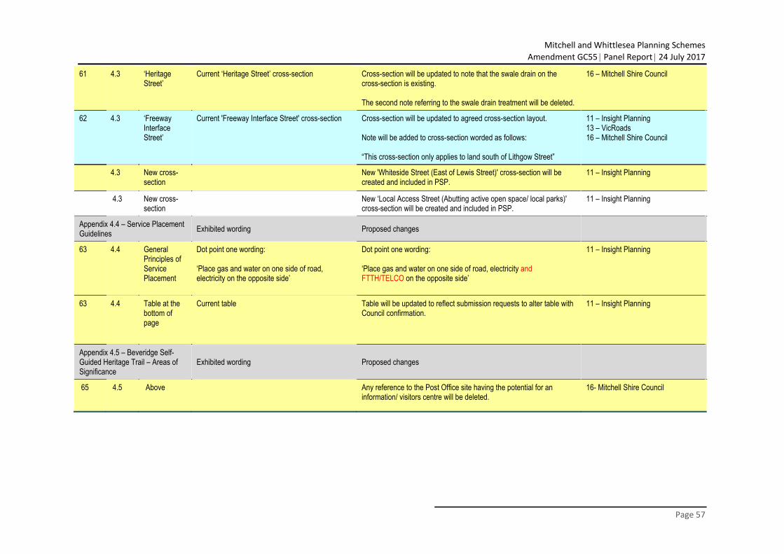
Mitchell and Whittlesea Planning Schemes
Amendment GC55 Panel Report 24 July 2017
Page 57
61 4.3 ‘Heritage Street’
Current ‘Heritage Street’ cross-section Cross-section will be updated to note that the swale drain on the cross-section is existing. The second note referring to the swale drain treatment will be deleted.
16 – Mitchell Shire Council
62 4.3 ‘Freeway Interface Street’
Current 'Freeway Interface Street' cross-section Cross-section will be updated to agreed cross-section layout. Note will be added to cross-section worded as follows: “This cross-section only applies to land south of Lithgow Street”
11 – Insight Planning 13 – VicRoads 16 – Mitchell Shire Council
4.3 New cross-section
New 'Whiteside Street (East of Lewis Street)' cross-section will be created and included in PSP.
11 – Insight Planning
4.3 New cross-section
New ‘Local Access Street (Abutting active open space/ local parks)' cross-section will be created and included in PSP.
11 – Insight Planning
Appendix 4.4 – Service Placement Guidelines Exhibited wording Proposed changes
63 4.4 General Principles of Service Placement
Dot point one wording: ‘Place gas and water on one side of road, electricity on the opposite side’
Dot point one wording: ‘Place gas and water on one side of road, electricity and FTTH/TELCO on the opposite side’
11 – Insight Planning
63 4.4 Table at the bottom of page
Current table Table will be updated to reflect submission requests to alter table with Council confirmation.
11 – Insight Planning
Appendix 4.5 – Beveridge Self-Guided Heritage Trail – Areas of Significance
Exhibited wording Proposed changes
65 4.5 Above Any reference to the Post Office site having the potential for an information/ visitors centre will be deleted.
16- Mitchell Shire Council
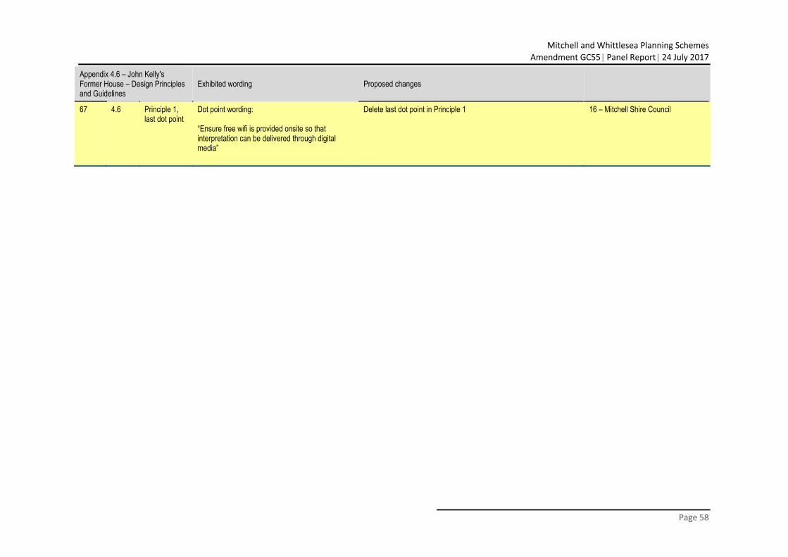
Mitchell and Whittlesea Planning Schemes
Amendment GC55 Panel Report 24 July 2017
Page 58
Appendix 4.6 – John Kelly's Former House – Design Principles and Guidelines
Exhibited wording Proposed changes
67 4.6 Principle 1, last dot point
Dot point wording: “Ensure free wifi is provided onsite so that interpretation can be delivered through digital media”
Delete last dot point in Principle 1 16 – Mitchell Shire Council