planning and environment act 1987dsewebapps.dse.vic.gov.au/shared/atsattachment1.nsf/...planning and...
TRANSCRIPT

Planning and Environment Act 1987
Panel Report
Wangaratta Planning Scheme Amendment C67
Oxley Township Development Plan
Front page
30 March 2017

Planning and Environment Act 1987
Panel Report pursuant to section 25 of the Act
Wangaratta Planning Scheme Amendment C67
Oxley Township Development Plan
30 March 2017
Brett Davis, Chair

Wangaratta Planning Scheme Amendment C67 Panel Report 30 March 2017
Page 1
Contents Page
1 Introduction ................................................................................................................ 6
1.1 The Amendment ...................................................................................................... 6 1.2 Procedural issues ..................................................................................................... 9 1.3 Issues dealt with in this report .............................................................................. 11
2 Planning context ....................................................................................................... 12
2.1 Policy framework ................................................................................................... 12 2.2 Planning scheme provisions .................................................................................. 15 2.3 Ministerial Directions and Practice Notes ............................................................. 15 2.4 Conclusion ............................................................................................................. 16
3 Oxley Township Development Plan ........................................................................... 17
3.1 The issues .............................................................................................................. 17 3.2 Submissions ........................................................................................................... 17 3.3 Discussion .............................................................................................................. 27 3.4 Conclusions ............................................................................................................ 29 3.5 Recommendation .................................................................................................. 30
Appendix A Submitters to the Amendment
Appendix B Document list
Appendix C North East Water submission
List of Tables Page
Table 1 Post‐exhibition changes ........................................................................................ 10
Table 2 Key issues identified by submitters ....................................................................... 17
Table 3 Consultation undertaken by Council ..................................................................... 24
List of Figures Page
Figure 1 Oxley Precincts ........................................................................................................ 7
Figure 2 Amendment area ..................................................................................................... 9
Figure 3 R M Nominees land ............................................................................................... 19
Figure 4 Zoning of subject land and surrounds ................................................................... 20
Figure 5 Ely Street (Precinct B) ............................................................................................ 21

Wangaratta Planning Scheme Amendment C67 Panel Report 30 March 2017
Page 2
List of Abbreviations
DPO Development Plan Overlay
FZ Farming Zone
GMW Goulburn‐Murray Water
LDRZ Low Density Residential Zone
LPPF Local Planning Policy Framework
PPRZ Public Park and Recreation Zone
PUZ Public Use Zone
RLZ Rural Living Zone
SPPF State Planning Policy Framework
Oxley TDP Oxley Township Development Plan

Wangaratta Planning Scheme Amendment C67 Panel Report 30 March 2017
Page 3
Overview
Amendment Summary
The Amendment Wangaratta Planning Scheme Amendment C67
Common name Oxley Township Development Plan
Brief description The Amendment proposes to implement the key objectives and short term actions of the Oxley Township Development Plan (September 2015, Revised December 2016) into the Wangaratta Planning and amend the Schedule to the Low Density Residential Zone (LDRZ) in accordance with the recommendations of the Oxley Township Development Plan (TDP).
Subject Land The Amendment applies to land in the Oxley Township
Planning Authority Rural City of Wangaratta
Authorisation The Department of Environment, Land, Water and Planning (DELWP) advised that Council may prepare the Amendment without authorisation (11 August 2016).
Exhibition Between 8 September and 10 October 2016
Submissions Number of Submissions: 13 (including one late submission) Opposed: 9
Panel Process
The Panel Trevor McCullough (Chair) appointed 20 December 2016. On 20 January 2017 the appointment was cancelled due to availability issues, and Brett Davis was appointed as Chair.
Directions Hearing The Panel did not consider a directions hearing was required
Panel Hearing Rural City of Wangaratta offices, 28 February 2017
Site Inspections Unaccompanied, 27 February 2017
Appearances Rural City of Wangaratta represented by Ms Meghan Kelly
Mr Neil Barclay (and representing Mr John Lang)
Mr Bruce Phillips
Mr Nick Vlahandreas, Oxley and Company representing Mr Ross Brown
Date of this Report 30 March 2017

Wangaratta Planning Scheme Amendment C67 Panel Report 30 March 2017
Page 4
Executive summary
(i) Summary
Wangaratta Planning Scheme Amendment C67 (the Amendment) proposes to implement the key objectives, both immediate and ongoing, of the Oxley Township Development Plan, September 2015, Revised December 2016 (TDP). Oxley is located approximately 13 kilometres south east of Wangaratta.
The Amendment was exhibited between September and October 2016. Thirteen submissions were received with 9 unresolved.
Key issues raised in submissions included:
Overdevelopment and subdivision
Future investigation area
The consultation process
TDP and mapping anomalies, open space along the King River
Open space
Other issues.
The majority of submitters were concerned with aspects of overdevelopment and subdivision. The Amendment proposes to amend the schedule to the Low Density Residential Zone to change the minimum lot size from 2,000 square metres to 4,000 square metres. The Panel concluded that these issues were not exacerbated by this Amendment (the ability to apply for subdivision currently exists and is not proposed to be removed) and as a result the Panel does not support those submissions.
The Amendment identifies a ‘Future Investigation Area’. A submission sought to have this land rezoned as part of this Amendment to the Township Zone (TZ). The Panel finds that there is no strategic basis for the rezoning as there is not a demonstrated need. The Panel notes that the rezoning requests put forward by the submitter were not part of the Oxley TDP, nor were they exhibited and forms the view that this would constitute a transformation of the Amendment and is not supported.
A number of submissions requested changes to the Oxley TDP, and Council has attempted to capture these by providing a revised TDP, dated December 2016.
The Panel supports changes proposed by Council in its revised post‐exhibition documentation included in its ‘Right of Reply’ on 8 March 2017, as the changes generally addresses mapping and other minor changes to the Oxley TDP. Of note for this Panel are the changes to the local policy plans at Clauses 21.07 and 22.09. The Panel has made a separate recommendation on these plans, based on submissions relating to the possible north‐south road shown on those plans.
The Panel concludes that the Amendment is based on a detailed strategic basis provided by the Oxley TDP. The Panel is satisfied that the Amendment generally supports and is consistent with the broader policy context of the State Planning Policy Framework (SPPF) and Local Planning Policy Framework (LPPF). It has considered all submissions and concludes that the Amendment should be supported and is strategically justified.

Wangaratta Planning Scheme Amendment C67 Panel Report 30 March 2017
Page 5
A submission from North East Water has suggested a tidy up of various anomalies in the existing and proposed local policy section. The Panel takes the view that these changes could be considered as administrative as they would not transform the Amendment.
(ii) Recommendation
Based on the reasons set out in this report, the Panel recommends that Wangaratta Planning Scheme Amendment C67 be adopted as exhibited subject to the following:
Include the post‐exhibition changes contained in Council’s Right of Reply dated 8 1.March 2017 (Document 7) along with the following further revisions: a) Amend the legend to the plans at Clauses 21.07 and 22.09 to read ‘possible
future‐north south connector road.’ b) Delete the reference to the term ‘potential location for indicative road’ from
Clause 22.09. c) Undertake a final drafting review to correct grammatical errors identified in
the North East Water submission contained in Appendix C of this report.

Wangaratta Planning Scheme Amendment C67 Panel Report 30 March 2017
Page 6
1 Introduction
1.1 The Amendment
(i) Amendment description
Wangaratta Planning Scheme Amendment C67 (the Amendment) proposes to implement the key objectives, short term and ongoing actions, of the Oxley Township Development Plan (September 2015)1 (TDP) by:
Amending the Local Planning Policy Framework to include the TDP; and
Amending the Schedule to the LDRZ.
Specifically, the Amendment (as noted in the Explanatory Report):
amends Clause 21.07 Rural Townships and Settlements to implement the key objectives and recommendations of the Oxley Township Development Plan, September 2015
amends Clause 21.12 to include the Oxley Township Development Plan, September 2015 as a reference document in the Scheme
amends Clause 21.14 Public Open Space and Clause 22.09 Public Open Space Contributions to include the key objectives and recommendations of the Oxley Township Development Plan, September 2015 (and Glenrowan and Milawa Township Development Plans, September 2015) and include the Access and Movement Plan (which is adapted from the design response plan) to illustrate the location and prevision of current and future open space
inserts a new Clause 22.10 Oxley Township to include the key recommendation of the Oxley Township Precinct Plan
amends the Schedule to Clause 32.03 (Low Density Residential Zone) to vary the minimum subdivision lot size to reflect the recommendations of the Oxley Township Development Plan, September 2015.
(ii) Purpose of the Amendment
The Amendment is required to plan for the future of Oxley and implement actions from the Oxley TDP. Preparing Township Development Plans for the three towns of Glenrowan, Oxley and Milawa was a key strategic direction of the Wangaratta Population and Housing Strategy 2013, which was recently adopted by Council.
As there is some development interest in the Oxley Township and its surrounds, the TDP outlines steps to achieve development goals in a sustainable and planned manner.
The TDP identifies the following precincts:
Precinct A – Central core
Precinct B – LDRZ north
Precinct C – LDRZ south and east
1 Subsequently, as a response to submissions, Council has updated the Oxley TDP and proposes to include
the December 2016 version as part of this Amendment.

Wangaratta Planning Scheme Amendment C67 Panel Report 30 March 2017
Page 7
Precinct D – LDRZ adjacent to King River
Precinct E – Low density far south
Precinct F – FZ
Precinct G – FZ in western corner
Precinct H – Triangular land in the west
Precinct I – Farming land in close proximity to study area.
Figure 1 Oxley Precincts2
The “Oxley Design Response” at Section 6.5 of the Oxley TDP states that the key objectives are to:
Support subdivision and development in the town core that is responsive to and enhances the rural streetscape character;
Ensure land is capable of being adequately drained and serviced prior to any rezoning or approvals that would result in intensification of development;
Encourage low density development to the south of the town core at a variety of lot sizes that responds to servicing access;
Enhance the amenity and accessibility opportunities of the King River by progressively creating a linear open space reserve along the river floodplain with shared path (in public land only) and active development interface;
Recognise the Oxley primary school and the surrounding rural residents are part of the town;
2 Oxley Township Development Plan September 2015, pg.9.

Wangaratta Planning Scheme Amendment C67 Panel Report 30 March 2017
Page 8
Improve the connections between the township and the sporting precinct to the south by providing a footpath from Snow Road along Oxley‐Meadows Creek Road;
Enhance gateways to township through built form and open space;
Encourage opportunities for use of alternative modes of transport through upgrades and additions to pedestrian/cycle links;
Support the network relationship between Oxley and Milawa;
Encourage rural businesses to establish in between the two settlements and discourage linear extensions of residential development;
Support the distinction between urban and rural by acknowledging Oxley Meadow Creek Road as the logical eastern extent of residential development;
Encourage permeable and connected subdivision design that respects the existing rural character.
(iii) The subject land
The Amendment applies to land shown in Figure 2.
Oxley is a township of approximately 350 residents, and is located 13 kilometres southeast of Wangaratta and approximately 17 kilometres northeast of Glenrowan. Oxley is located within the Milawa Gourmet Region and King Valley Region and is close to Wangaratta’s regional services. Council stated that it is likely Oxley will experience development pressure in the future as a result of recent upgrades to services such as the provision of reticulated sewerage, and changes to the minimum lot sizes within the LDRZ.
The TDP states under Section 6.2:
Oxley residents value its natural surrounds and close proximity to Wangaratta. The small farm gate businesses add to Oxley’s character and its strategic location in the centre of the gourmet and wine region attracts many visitors. There is funding for a recreational vehicle (RV) dumping point in Oxley. This together with the caravan park accommodates, among other things, the tourist caravan market.
The Population and Housing Strategy 2013 identified Oxley as one of the three rural townships with the potential to accommodate future population growth. The TDP provides guidance on the following:
Appropriate location and density of development
Making use of existing infrastructure
Protecting the amenity of the existing community.

Wangaratta Planning Scheme Amendment C67 Panel Report 30 March 2017
Page 9
Figure 2 Amendment area
1.2 Procedural issues
(i) Post‐exhibition changes
Council submitted a post‐exhibition set of documents with minor changes, including the December 2016 version of the Oxley TDP as highlighted in section 1.1 of this report. The Panel queried some of the changes as not all documents had track changes clearly marked. Council explained it had difficulty with mapping and translation of the changes. Council was given an additional week to produce the complete set of post‐exhibition changes.
In its right of reply, submitted 8 March 2017, Council submitted the following documents which were revised after the exhibition process and the Panel hearing:

Wangaratta Planning Scheme Amendment C67 Panel Report 30 March 2017
Page 10
Document Change
Explanatory Report
Appendix 1 a
Page 1
Updated the exhibited Oxley TDP (Map) contained in the Explanatory report, with the Oxley Township Development Plan Revised, December, 2016 (Map).
Page 4
2nd paragraph, removed reference to reticulated water for firefighting purposing.
Clause 21.07 Townships and Rural Townships
Appendix 1 b
Page 6
Updated the exhibited Oxley TDP (Map) contained in Clause 21.07, with the amended map from Oxley Township Development Plan Revised, December, 2016.
Clause 21.14 Public Open Space
Appendix 1 c
Grammatical change only
Clause 22.09 Public Open Space Contributions
Appendix 1 d
Page 5
Updated the exhibited Oxley Access Open Space and Movement Plan
Status: Incomplete mapping change, (IT matters unresolved).
Clause 22.10 Oxley Township
Appendix 1 e
Page 4
Updated the exhibited Oxley Precincts (Map), contained in Clause 22.10 with the amended map from the Oxley Township Development Plan Revised, December, 2016
Status: Incomplete mapping change, (IT matters unresolved).
Schedule to Clause 32.03 (Low Density Residential Zone)
Appendix 1 f
Page 1
Updated the wording contained in the schedule to the Low Density Residential Zone, this is for the purpose of having consistent wording with changes proposed by Wangaratta C61
Table 1 Post‐exhibition changes3
A complete set of the mapping changes were included in an unlocked format to the Panel. As the Panel has recommended minor changes to these plans, they are not included in this report.
3 Council right of reply, 8 March 2017.

Wangaratta Planning Scheme Amendment C67 Panel Report 30 March 2017
Page 11
1.3 Issues dealt with in this report
The Panel considered all written submissions made in response to the exhibition of the Amendment; as well as further submissions, evidence and other material presented to it during the Hearing, and observations from its site visits.
The Panel has reviewed a large volume of material and has been selective in referring to the more relevant or determinative material in the report. All submissions and materials have been considered by the Panel in reaching its conclusions, regardless of whether they are specifically mentioned in this report.
This report deals with the issues under the following headings:
Overdevelopment and subdivision
Future investigation area
Consultation process
Mapping anomalies and content of the Oxley TDP
Open space location
Why the Development Plan Overlay is not appropriate
Referral Authorities.

Wangaratta Planning Scheme Amendment C67 Panel Report 30 March 2017
Page 12
2 Planning context
Council provided a response to the Strategic Assessment Guidelines as part of the Explanatory Report.
The Panel has reviewed Council’s response and the policy context of the Amendment, and has made a brief appraisal of the relevant zone and overlay controls and other relevant planning strategies.
2.1 Policy framework
(i) State Planning Policy Framework
Council submitted that the Amendment is supported by the following clauses in the SPPF:
Clause 11.05 (Regional Development) – the implementation of the TDP is consistent with the Hume Regional Growth Plan. Oxley is part of a network of rural townships providing housing diversity and supporting the development of Wangaratta as a regional city. In addition, the Oxley TDP provides guidance of the best location for future development that meets housing requirements.
Clause 12 (Environment and Landscape Values) – the Amendment is consistent with this clause as it encourages residential development to be confined to a defined township area where reticulated services are available, and the riparian zone adjacent to the King River is protected.
Clause 14 (Natural Resource Management) – Council stated that “The consolidation of residential activity within a designated township boundary protects the surrounding productive farmland, water catchments and significant remnant vegetation from the potential detrimental impacts associated with residential development”.
Clause 15.02 (Sustainable Development) – the TDP promotes connectivity, accordingly encouraging low energy forms of transport such as walking and cycling.
Clause 15.03 (Heritage) – the Oxley TDP recognises the significance of heritage places and that these play a significant role to the cultural identity of Oxley.
Clause 16.02 (Housing Form) – the TDP provides for a variety of housing options to meet the needs of the current and future community, which includes the rural residential lifestyle opportunity. It further identifies appropriate locations for residential land to reduce amenity issues between residents and higher impact agricultural activity and to protect surrounding agricultural land.
Clause 17.03 (Tourism) – the TDP identifies tourism opportunities by focusing on the importance of the gourmet region and the natural landscape.
Clause 18.02 (Movement Networks, specifically sustainable personal transport) – the TDP identifies pedestrian and cycle networks to promote sustainable personal transport networks.
Clause 19.03‐2 (Water Supply) – the recent introduction of reticulated sewerage into Oxley provides current housing and planned residential development opportunities to connect sewerage to avoid impacts on waterways, and protect the surrounding water supply catchments from possible urban contamination.

Wangaratta Planning Scheme Amendment C67 Panel Report 30 March 2017
Page 13
(ii) Local Planning Policy Framework
Council submitted that the Amendment supports the following local planning objectives:
Clause 21.03 and 21.04 (Vision and Strategic Direction) – Council noted that the TDP was developed giving consideration to the Community Vision embedded in the Municipal Strategic Statement and supports directions outlined in the Oxley TDP. Clause 21.03 states:
The vision for the municipality is a long term community‐created approach for land use planning until the year 2030. This vision is an integrated approach that includes social, economic and environmental considerations. Core components of this vision are that the municipality and community will:
Be a vibrant, diverse and secure place to live
Facilitate a growing and sustainable economy and employment base
Preserve and enhance our heritage and the environment.
Clause 21.05 (Rural Land Use and Agriculture) – Council noted that this clause supports traditional agriculture and emerging industries.
Clause 21.07 (Rural Townships and Settlements) – This clause has been revised to Townships and Rural Townships. Council noted that this clause provides guidance around the fair, orderly, sustainable and economic use of land in townships.
Clause 21.08 and Clause 22.04 (Economic Development and Tourism) – the Amendment is consistent with this clause by implementing a framework that supports existing and new tourism opportunities in the core of the township.
Clause 21.10 (Oxley Township) – The proposed new clause 21.10 states the following in relation to the Oxley Township:
The Oxley Township Development Plan … establishes a vision to protect the rural character of Oxley as part of a network of rural townships within the municipality. This plan delivers policy to implement the vision by reinforcing the rural character of Oxley, uploading the ‘farm gate’ character, providing opportunity for new development which is of a scale and complimentary to the character of the town, supporting surrounding farming activity and small scale tourism. An enhanced and connected pedestrian and cycle network linking the township to its recreation reserve and King River and surrounding natural environment is also the focus of this plan.
The township has been divided into precincts, each with its own distinct character. The objectives are:
Objective 1 ‐ To focus township development in Precinct A – Central Core
Objective 2 – To ensure appropriate subdivision within Precinct B – Low Density North and Precinct C – Low Density South and East
Objective 3 – To enhance the amenity and accessibility opportunities in Precinct D – Low Density Adjacent to King River
Objective 4 – Retain the low density character in Precinct E – Low Density Farm South

Wangaratta Planning Scheme Amendment C67 Panel Report 30 March 2017
Page 14
Objective 5 – To retain the Farming Zone in Precinct F – Farming
Objective 6 – To encourage the establishment of rural business in Precinct G – Farming Zone in West Corner
Objective 7 – To support connectivity to Precinct H – Triangular Land in the West (outside rural township)
Clause 21.08 and clause 22.04 (Economic Development and Tourism) – The implementation of the TDP supports the local economy and tourism and provides for the land use and planning framework to support existing and new tourist opportunities.
Clauses 21.14 and 22.09 (Public Open Space) – The Amendment identifies and makes provision for future linear networks linking existing open space networks and community facilities.
(iii) Other planning strategies or policies used in formulating the Amendment
Wangaratta Planning Scheme Amendment C26 (2005)
Wangaratta C26 was based on a review of the Wangaratta Planning Scheme. It proposed to extensively rezone land in Oxley for residential purposes. The C26 Panel did not support the extent of rezoning proposed, stating that further strategic work was required. Council stated that the TDP addresses the need for further strategic work prior to implementing changes to the Wangaratta Planning Scheme.
Oxley Community Plan (2012)
Council considered that the implementation of the Oxley TDP will assist with implementation of key goals of the Oxley Community Plan. Council stated that proposed changes to the Schedule to the LDRZ are consistent with the objectives the community has identified through the Oxley Community Plan.
King Valley to Milawa Masterplan (Draft)
The King Valley to Milawa Masterplan (Draft) identifies opportunities and issues focusing on economic prosperity within the King Valley to Milawa region.
Population and Housing Strategy (2013)
The Population and Housing Strategy, whilst not a reference document in the planning scheme, provided analysis of population trends within the municipality. It also outlines the housing needs for the Rural City of Wangaratta projected to 2031. The strategy describes Oxley as “… a well located, serviced township that will play a role in supporting projected population growth”. It identifies Oxley as having a high growth forecast which equates to approximately five dwellings per year to accommodate this rate of growth.
Council stated that the changes sought through the Amendment are supportive of incremental growth, which addresses population change over a 20 year period.
Hume Regional Growth Plan
The Rural City of Wangaratta, including the township of Oxley, is located within the Hume region. The Hume Regional Growth Plan (July 2014) identifies the potential for Wangaratta

Wangaratta Planning Scheme Amendment C67 Panel Report 30 March 2017
Page 15
to accommodate medium‐high growth, and that popular tourist areas such as Oxley play an important role in accommodating growth.
2.2 Planning scheme provisions
(i) Zones
No changes are proposed to the existing zones as part of this Amendment.
The Amendment proposes to change the Schedule to the LDRZ to vary the minimum subdivision lot size to reflect the recommendations of the Oxley TDP.
(ii) Overlays
The western boundary of Oxley is covered by the Flood Overlay and Land Subject to Inundation Overlay due to its proximity to the King River. There is also a section of the Public Use Zone in the northern portion of Oxley that is an anabranch of the river and is also subject to the Flood Overlay.
2.3 Ministerial Directions and Practice Notes
(i) Ministerial Directions
Council submitted that the Amendment meets the relevant requirements of the following Ministerial Directions:
Ministerial Direction No 11 ‐ Strategic Assessment of Amendments (and Planning Practice Note 46 (Strategic Assessment Guidelines)).
The Form and Content of Planning Schemes under Section 7(5) of the Act.
(ii) Planning Practice Notes
PPN13 – Incorporated and Reference Documents
This Practice Note is applied in determining the status of the Oxley TDP. Council stated that most relevant material from the Oxley TDP has been implemented through the appropriate planning tools proposed by Amendment C67. Council submitted:
Making the Oxley Township Development Plan, Revised December, 2016 a reference document to the Wangaratta Planning Scheme gives the document statutory weight and assists the reader to understand the policy context in which provisions have been determined. Given the extensive implementation of the immediate and ongoing and short term actions of the Oxley TDP it is not considered necessary to incorporate this document.
PPN37 – Rural Residential Development
This Practice Note is applied when planning for rural residential use and development and notes that the LDRZ is considered to be a rural residential zone.
PPN46 – Strategic Assessment Guidelines
Practice Note 46, along with Ministerial Direction 11, seeks to ensure that a comprehensive strategic assessment of planning scheme Amendments and their outcomes is undertaken.

Wangaratta Planning Scheme Amendment C67 Panel Report 30 March 2017
Page 16
PPN64 – Local Planning for Bushfire Protection
This Practice Note provides guidance for bushfire protection. Council stated that the Amendment is not expected to generate an increased bushfire hazard, and that the CFA provided feedback on the development of the Oxley TDP.
2.4 Conclusion
The Panel concludes that the Amendment is supported by, and implements, the relevant sections of the State and Local Planning Policy Framework, and is consistent with the relevant Ministerial Directions and Practice Notes. The Amendment is well founded and strategically justified, and should proceed.

Wangaratta Planning Scheme Amendment C67 Panel Report 30 March 2017
Page 17
3 Oxley Township Development Plan
3.1 The issues
Council submitted a table outlining common themes raised in submissions and these are contained in the table below.
Issue Raised by Submitters
Ground water quality #1
Subdivision #2, #3, #4, #6, #7, #8
Contents of the Oxley TDP #3, #6, #7, #8, #9, #11 #12
Mapping in the Oxley TDP #5, #7, #8, #9, #11
Other matters beyond the scope of Amendment C67 #9
Access to the King River #7, #8, #9, #12
Consultation process #7, #8
Location of Open Space (including linear open space) #7, #8, #9, #11, #12
Overdevelopment #7, #8
Request to rezone in accordance with the long term recommendations
#10
Table 2 Key issues identified by submitters4
3.2 Submissions
(i) Overdevelopment and subdivision
The majority of submitters (2, 3, 4, 6, 7, 8) were concerned with the potential for overdevelopment, or development out of character with the existing Oxley area. Mr Phillips (submitter 2) raised concerns with the ability to subdivide at higher densities. Mr Lang, represented by Mr Neil Barclay at the Hearing, stated that “the idea of retention of the rural characteristics of the township is not aided by the ability to have suburban sized blocks within the sewered square”.
Council submitted that that this situation does not change as a result of this Amendment. That is, the ability to subdivide currently exists under the current TZ and the issues raised by Mr Phillips and Mr Lang are more likely to be addressed if and when planning applications to subdivide are lodged. It noted that the schedule to the LDRZ proposes a change to the minimum lot size from 2000 square metres to 4000 square metres, and that this has potential to reduce impacts on the traffic network. Accordingly, if this Amendment does not take place, future subdivision could be at a higher density and the impacts on the traffic network could potentially be increased.
4 Council submission to the Panel (Document 1) pg.33.

Wangaratta Planning Scheme Amendment C67 Panel Report 30 March 2017
Page 18
Submitters questioned overdevelopment potential along the King River. Council noted that the Amendment will not result in overdevelopment along the King River, as no land within the Oxley Township adjoining the King River will be rezoned. In addition, an increase in lot size means that the impact of residential development along the river front could potentially be reduced.
Council advised:
No land within the Oxley Township, adjoining the King River will be rezoned. An increase in lot size (as shown in the Schedule to Clause 32.05) means there is potential is to lessen the impact of residential development along the river front.
Council stated that:
lot sizes have been informed by a range of considerations including population demographic and housing analysis, infrastructure provision (including availability and upgrade of sewerage infrastructure), rural character and zoning provisions, and market trends (demand).
Council stated that the rationale for lot sizes is influenced by a number of factors, however due to the incremental nature of expected growth for Oxley, there is no change to the zoning provisions.
A number of submissions raised the issue of their property prices being affected. Council submitted:
There are a range of factors that influence property prices. These can include:
Size of land Government land subsidies and taxes
Interest rates (for home loans)
Market forces
Environmental considerations (for example if the land is affected by flooding).
Council submitted that whilst individual property value is a concern for some land owners, it is considered beyond the scope of what this Amendment can consider.
(ii) Future investigation area
Mr. Nick Vlahandreas of Oxley and Company submitted on behalf of R M Nominees Pty Ltd, the owner of land on the northern periphery of the Oxley TDP (submitter 10). Land referred to as Part A is located on the northern fringe of the Oxley township; and Part B is located on the Western side of Ely Street (Figure 3).
Their submission supports rezoning this land from FZ to Rural Living Zone (RLZ) and from LDRZ to TZ on the basis of its historical context, the suitability of the land for development and for the orderly planning of the Oxley township.

Wangaratta Planning Scheme Amendment C67 Panel Report 30 March 2017
Page 19
Figure 3 R M Nominees land5
At the Hearing, a question was raised by Council as to whether or not an element of this submission, relating to Ely Street, had been formally raised as a submission to the Amendment. The Panel requested Council address this element formally in its right of reply.
In its right of reply, Council summarised the Oxley and Company submission as follows:
Request 1: A request to rezone land located in Precinct I (of the Oxley TDP) from Farming Zone (FZ) to Rural Living Zone (RLZ) (Shown as area A in figure 3).
Request 2: A request to rezone land located in Precinct B (of the Oxley Township Development Plan), located along Ely Street, from Low Density Residential Zone (LDRZ) to Township Zone (TZ). (Area B in figure 3)
Request 3: A request that public land located in Precinct B (of the Oxley Township Development Plan), be identified in its own precinct to guide its development and meet community expectations.
Request 1 – Morse Lane (Precinct I)
This request relates to land at Morse Lane, Oxley shown in Figure 3 (area A) on the northern periphery of the Oxley township. The land is currently zoned FZ1 with a minimum 40 hectare lot size.
5 Oxley and Company submission (Document 2) pg. 4.
A
B

Wangaratta Planning Scheme Amendment C67 Panel Report 30 March 2017
Page 20
In written submission, Mr Brown (submitter 10) supported rezoning of his land from FZ to RLZ and from LDRZ to TZ, for the following reasons:
The rezoning is consistent with the historical planning for the township of Oxley;
The subject land is located adjacent to land zoned Low Density Residential and Township and rezoning of the subject land will be consistent with development of the surrounding area;
The land, that is not subject to flooding, has no site constraints and is suitable for residential development;
The land can be connected to all services including reticulated water and sewer.6
At the hearing, Oxley and Company, on behalf of Mr Brown (R M Nominees) argued that the land on the northern fringe of the township should be rezoned to RLZ to facilitate an aged care farming development for farmers wishing to transition to smaller lots, as it was included within the “Future Investigation Area”, and this has historically been identified within the township boundary. Oxley and Company provided a zoning plan to illustrate the subject land is located on the fringe of the LDRZ but importantly is still within the township boundary (Figure 4).
Figure 4 Zoning of subject land and surrounds7
Mr Vlahandreas submitted:
it would make sense for the Development Plan boundary to be amended to include Part A of the subject land for the orderly planning of the township. This would then create a better strategic link to the proposed Clause 21.07 and Clause 22.10 as the land would be within the Plan area and these provisions
6 Document 2, p3. 7 Oxley and Company submission (Document 2) pg. 6.

Wangaratta Planning Scheme Amendment C67 Panel Report 30 March 2017
Page 21
could be taken into consideration for any application for a planning permit. The amendment as proposed does not neatly reference Part A of the subject land in the Wangaratta Planning Scheme. Its nexus is as a precinct within the Plan but outside of the development plan area; it would be more reasonable to include Part A of the subject land within the development plan area.
Oxley and Company submitted that if rezoned, this land would be used for a ‘social enterprise’ project for rural producers transitioning from full time employment to retirement.
Request 2 – Ely Street (Precinct B)
At the Hearing Oxley and Company introduced a request to rezone land at Ely Street from LDRZ to TZ.
Figure 5 Ely Street (Precinct B)8
Oxley and Company stated that the proposal to rezone land shown in Figure 5 of the subject land to the TZ should be supported. It was submitted that the land is capable of sustaining residential development as it is not being used for agriculture, it can be connected to all available services, and there are few remaining vacant township zoned lots within Oxley.
Council noted that the submission to the Panel on Ely Street is based on a previous submission to the draft TDP, which was received during a consultation process held in March 2015. At this time, Council resolved not to support this request. The reasons for not supporting the requested changes included:
This is inconsistent with the recommendations of the Oxley Township Development Plan.
Part of this land is subject to inundation (land coloured blue in Figure 5)
Council submitted that this project and rezoning can be considered by a future Amendment, following an appropriate strategic study is undertaken and the outcomes fit with the vision and recommendations of the Oxley TDP. As this matter was not specifically raised in the submission to the Amendment, Council reiterated it does not support the rezoning of this land. It submitted that supporting this request would constitute a transformation of the Amendment.
8 Council Right of Reply 8 March 2017, p6.

Wangaratta Planning Scheme Amendment C67 Panel Report 30 March 2017
Page 22
Council submitted that facilitating this request would cause fragmentation of the land, (noting that there is a property located to the south which is also currently zoned LDRZ), and the creation of an ‘island’ TZ lot. It noted:
Development can occur within the LDRZ without the need to rezone the land. The proposal for a potential three lot subdivision could be facilitated within the existing LDRZ, if the proposed development could be connected to reticulated sewerage infrastructure, based on the minimum lot size of 2000 square meters.
The LDRZ ensures a transition between the Central Core (Precinct A) and surrounding farming land and associated activities. Further it assists in retaining rural character by maintaining a level separation between residential housing.
The projected growth in encouraged in the Central Core as the preferred location.
In Precinct B ‐ Low Density North Growth opportunities are considered to be long‐term.
There is land supply to accommodate a high growth scenario (i.e. provision of 5 houses per year) without the need to rezone in the short term.
Request 3 – Public Use Zone land
Oxley and Company submitted to the Panel that the PUZ land in Precinct B of the Oxley TDP located along Ely Street, should comprise its own precinct. Council advised it had considered this request (and the idea to develop this site into a public reserve) in a submission to the draft Oxley TDP and whilst the concept was supported, it did not make changes to the draft Oxley TDP. Council’s reasons for this included:
The land contained in Public Use Zone (PUZ) is currently used for drainage purposes.
The idea to use the site for a recreational purpose is not precluded in the future. In Councils response to this matter, it was advised that this concept could be investigated as part of a separate process, for example an infrastructure project.
(iii) Consultation process
Mr Lang (submitter 7), Mr and Mrs Barclay (submitter 8) expressed concerns with the consultation process, (both for the Amendment and in the development of the Oxley TDP).
Council submitted that extensive consultation occurred and that changes to documents to respond to feedback from submitters have occurred where possible. Table 3 outlines the extent of consultation undertaken. Council noted that its consultation has been undertaken in accordance with the requirements of the Planning and Environment Act (1987).

Wangaratta Planning Scheme Amendment C67 Panel Report 30 March 2017
Page 23
Date Staging Purpose Stakeholders Involved
Consultation Process
July, 2014 Stage 1 Consultation:
Key Stakeholder ‐ Issues and Opportunities Consultation
Site Analysis
Informing the content of the Oxley Township Development Plan
Targeted Stakeholders:
‐ Government Authorities and Service Providers
‐ Landowners
‐ Development Industry
‐ Interactive information sessions (for each targeted stakeholder group, including an Oxley Community Workshop, held at the Oxley Shire Hall, on 4 July, 2014)
‐ Verbal submissions recorded
‐ Written submissions accepted where provided
February, 2015 Stage 2 Consultation: Full Community Consultation Process
Draft Township Development Plan
Reviewing the draft Oxley Township Development Plan
All Stakeholders ‐ Invitation for written submissions
April, 2015
(pre‐Councils consideration of the Council Report to adopt the Oxley TDP)
Pre Council Report (considering the adoption of the Oxley TDP)
Submitters requested meeting with Administrators
Targeted Stakeholders:
A group of 6 land owners
‐ Site Meeting ‐ Submitters further explained matters raised in submissions
April, 2015 Council Report: Adopting the Oxley TDP/Seek Authorisation to exhibit a planning scheme Amendment
Targeted Stakeholders:
Submitters to the Oxley Township Development Plan
‐ Information Letter ‐ Stakeholders informed of the Council's adoption of the Oxley TDP (with changes)

Wangaratta Planning Scheme Amendment C67 Panel Report 30 March 2017
Page 24
Date Staging Purpose Stakeholders Involved
Consultation Process
September, 2016 C67 Exhibition Process:
Community input and feedback to the Amendment
All Stakeholders ‐ Invitation for written submissions to the Amendment
‐ Information Drop‐In Session
‐ Frequently Asked Questions
November, 2016 Post Exhibition Meeting:
To gain a further understand the issues raised in submissions
To provide information to submitters about the Amendment process and the types of matters raised in submissions
Targeted Stakeholders:
Submitters (who were land owners)
‐ Group Meeting
‐ Frequently Asked Questions clarification material
Table 3 Consultation undertaken by Council
(iv) Mapping anomalies and content of the Oxley TDP
A number of submitters (3, 5, 6, 7, 8, 9, 11, 12) questioned mapping and contents of the Oxley TDP. Mr Lang and Mr Barclay raised issues with the proposed north‐south connector road being located through their properties. Mr Barclay sought clarification on the LDRZ and PPRZ adjacent to the King River.
Mr Barclay submitted that the location of open space shown had moved in and out of his property boundary in various iterations of the plan and expressed frustration with the process. An interface to public amenity had appeared where the aforementioned road was and a ‘caterpillar’ like balloon appeared on the legend for a North‐South connector road. Mr Barclay spoke of frustration with the process, outlining a chronology of events that included Commissioners at the Council meeting him on site and promising to rectify mapping errors. He submitted:
The latest incarnation is as good as we can expect to get but for the words to say “future north south connector road required for connectivity, activated when multi‐lot subdivision occurs … faith is at a low level.”

Wangaratta Planning Scheme Amendment C67 Panel Report 30 March 2017
Page 25
Ms Judy Gore (submitter 5) noted that maps for 1163 Wangaratta‐Whitfield Road are inaccurate and “slices” through the centre of their property. Ms Gore requested modification of the plan and that the boundary follows the boundary of Wangaratta Whitfield Road as it is today and not as it was in the late 1950’s. Ms Helen and Mr John Fawcett (submitter 6) submitted that mapping shows buildings in Johnson Street that do not exist, and argued that 70 Johnson Street is suitable for further development. The submitter also questioned the mapping of 41 Shadforth Street.
Council submitted that, although these requests are outside the scope of the Amendment, there was opportunity to “review and update the Oxley TDP.” The TDP has been revised and re‐adopted by Council in December 2016. Table 1 of this report outlines the specific requests and changes.
(v) Open space location
Issues raised by submitters included:
open Space should be provided (in a variety of different locations), with particular opposition to further with linear open space along the King River
objection to using private land for open space links (particularly along the King River)
Mr Patrick and Ms Wendy Richardson (submitter 9) opposes the proposed walking/bicycle track along the south side of the King River. Ms Dianne Feldtmann (submitter 11) proffered a range of suggestions regarding a shared path, pedestrian network, the location of north‐south connector road, and the potential location of an indicative road. Ms Sally Rodgers (submitter 12) commented on the pathway on the King River, inaccuracies in the road and crown land alignment of the river end of Macartney Street.
Council submitted that future pedestrian links are shown on public land, and referred to in Clause 22.09. Council explained that the pedestrian links will not be on private land. To provide context to this concern, in the development of the Oxley TDP a Council submitted a number of issues were identified:
An initial draft of the Oxley TDP showed the existing and proposed pedestrian trails over the boundary of private land holdings. The affected plans were Oxley Township Development Plan map (the plan which is proposed to be implemented via Clause 21.07) and the Oxley Design Response map (the plan which is adapted proposed to be implemented via Clause 22.09 as the Oxley Access Movement and Open Space Plan).
This was not the intention of the plan.
Council submitted that it has rectified these issues in subsequent drafts and the final Oxley TDP and in the post exhibition Amendment documents. It noted that the Amendment itself does not deliver pedestrian and bike paths (or other associated infrastructure).
The Panel queried the role of Clause 22.09 in relation to the function of Clause 52.01 in setting out public open space requirements. Council advised:

Wangaratta Planning Scheme Amendment C67 Panel Report 30 March 2017
Page 26
The Schedule to Clause 52.01 Public Open Space Contributions and Subdivision specifies that in residentially zoned land and commercially zoned land a 5% contribution (either in land or cash in lieu) is required.
This applies to land in the Low Density Residential Zone (LDRZ) and Township Zone (TZ), which are the residential zones contained within the Oxley Township and the Wangaratta Planning Scheme.
The purpose of changes to Clause 21.14 and Clause 22.09 are to guide where a land contribution is required and where a cash in lieu contribution is required.
It is not proposed to make changes to Clause 52.01 as the necessary provisions exist, and this Clause 22.09 is proposing guidance in how to apply it in a township context.
Council submitted that Clauses 21.14 and 22.09 are trying to achieve a targeted location for the provision of future open space. Put simply, if there is a subdivision requirement for an open space contribution, and the land is located along the King River, there would be a preference to provide the open space as an in‐kind contribution. This would add to the existing public land which is subject to flooding and otherwise not suitable for residential development.
Council outlined that the Oxley TDP was updated to reflect public access being available. As this content is contained in the Reference Document, it concluded that further changes can be made without the need for a planning scheme Amendment.
(vi) Why the Development Plan Overlay is not appropriate
The Panel queried whether the use of a Development Plan Overlay (DPO) was appropriate. Council submitted that the implementation of the DPO was not pursued because in the Amendment, noting that the DPO would remove third party notice appeal rights for an established community. That is, if a planning permit application for submission is lodged with Council and is generally in accordance with an approved Development Plan, adjoining residents will not receive notification and have no opportunity to make a submission to Council. Council did not consider it fair or equitable for the existing community as the area has a substantial existing population.
In addition, Council considered that the use of a DPO is a duplication of existing policy. As the township development is directly translated into the LPPF, the use of a DPO would duplicate what has already been achieved through local policy.
(vii) Referral Authorities
Goulburn‐Murray Water
Goulburn‐Murray Water (GMW) raised issues regarding future subdivision and imposed a conditional measure. Council submitted:
It is noted that surface and groundwater is an important consideration in the planning process. This Amendment does not propose subdivision.

Wangaratta Planning Scheme Amendment C67 Panel Report 30 March 2017
Page 27
Council submitted that in the case of a planning permit application, ‘North East Planning Referral Committee – Guidelines for Protection of Water Quality’ are followed. Subdivision applications in a ‘Special Water Catchment’ are referred to the relevant water board or water supply authority (as a determining authority). Permit conditions, like the requirement for a building envelope, can be applied.
VicRoads
The Panel sought clarification on the VicRoads submission to the Amendment. VicRoads identified a need to upgrade Snow Road/King Street intersection and stated any upgrade would be at no cost to them. Council advised that it met with VicRoads during the exhibition period and noted Snow Road was a VicRoads controlled road. Council submitted that the potential for development and increased traffic would still potentially occur should this Amendment not proceed. It reiterated that no subdivision is proposed to occur as a result of this Amendment.
North East Water
This submission was received after the closing date for submissions and after Council had considered submissions to the Amendment at the ordinary meeting held on 13 December, 2016. Council was advised of this submission and how officers intended to address its contents at a briefing held on 13 February 2017.
Council sought clarification from North East Water about the intention of a point relating bushfire risk in the Explanatory Report and subsequent minor rewording to address this point. Council advised that clarification was provided in written correspondence. Subsequently the CFA was notified of Councils intention to the change to the Explanatory Report to address the North East Water submission.
A further request to include a strategy at Clause 21.07 Townships and Rural Townships Oxley relating to the protection of the Wangaratta Wastewater Treatment Plant was sought. Council submitted that it is not appropriate to include a policy protecting infrastructure in Wangaratta in this clause as Wangaratta is not a township or a rural township, nor was it part of the exhibited Amendment.
North East Water provided commentary on grammatical errors contained within the existing and proposed LPPF.
3.3 Discussion
Overdevelopment and subdivision
The Panel notes that this Amendment does not propose subdivision. In a case of a planning permit application, subdivision applications are referred to the relevant water board or water authority (as determining authority). In the case of GMW, they would have opportunity to apply their conditions through that process.
Many of the submitters’ concerns regarding overdevelopment would be addressed by way of any formal planning permit applications that may be lodged in the future. Increasing the minimum lot size to 4,000 square meters goes some way to reduce the concern regarding higher densities, and is consistent with the intent of the Oxley TDP.

Wangaratta Planning Scheme Amendment C67 Panel Report 30 March 2017
Page 28
R M Nominees land / Future Investigation Area
The Panel notes from the Oxley TDP that land in Precinct I has been flagged for residential development in the long term (subject to further strategic justification). The Panel was not presented with any compelling evidence to suggest that the change occur now, and the change sought to rezone the land is considered to be a transformation of the existing Amendment.
The Panel agrees with Council that the social enterprise project and rezoning should be considered by a future Amendment, following an appropriate strategic study is undertaken and the outcomes fit with the vision and recommendations of the Oxley TDP.
On the matter of the Ely Street site introduced by Oxley and Company at the Hearing, the Panel agrees with Council that it would constitute a transformation of the Amendment and is not supported. The Panel notes that Council has previously taken submission on this matter through the Oxley TDP process and not supported its merits.
The Panel would encourage the landowner and its representative to include this parcel and their social enterprise project in one larger amendment with appropriate justification. It would need to be mindful of future growth aspirations of the Oxley TDP.
Consultation process
The Panel is satisfied that the consultation process undertaken has been extensive and has been undertaken in accordance with the requirements of the Planning and Environment Act (1987).
Property values
Regarding the possible effect on property values, the Panel adopts the observations made by the Boroondara C153 Panel:
The social and economic effects most likely to be relevant are those of a broad community nature rather than those of a personal kind. This has been the long standing approach taken to such issues in planning decision making by both planning panels and VCAT.
North‐South Road and content of the Oxley TDP
Given the long‐standing nature of some of the errors that were continually applied to Mr Barclay and Mr Lang’s properties, the Panel has reviewed the post‐exhibition maps proposed to be included as part of Clause 21.07 and Clause 22.09 and concludes that Council should amend the reference to the ‘future‐north south connector road’ to insert ‘possible’ at the beginning. At Clause 22.09, this wording should replace the phrase ‘potential location for indicative road’ for consistency. This allows flexibility if and when detailed design and subdivision occurs in this hatched area.
The Panel agrees with Council regarding VicRoads position on the Snow Road upgrade. It notes there is no statutory mechanism proposed as part of this Amendment that could trigger the requirement for, or the prescription of an intersection upgrade in the scheme. The request for an intersection can be addressed through a different process for example, listed on capital works program, or a Development Contributions Plan.

Wangaratta Planning Scheme Amendment C67 Panel Report 30 March 2017
Page 29
North East Water
The Panel agrees with Council in not supporting the North East Water request to include a strategy at Clause 21.07 protecting the Wangaratta Wastewater Treatment Plant. The Panel concludes it is appropriate to include this strategy in a clause that relates to Wangaratta (as a place or a rural city) or a part of the scheme relating to infrastructure. This strategy would be more appropriately implemented through the implementation of the Planning Scheme Review (Council is currently working on) or a site specific Amendment.
The Panel endorses the grammatical corrections put forward by North East Water in its submission dated 21 December 2016. These are contained in Appendix C of this report. Some of these are not the subject of the Amendment, however the Panel sees no transformational element to correcting anomalies or grammar and these should be included. Council should undertake a final review of these changes to ensure consistency in drafting occurs prior to submitting the Amendment to the Minister.
The Amendment proposes a comprehensive review of the factors affecting the Oxley Township, providing a vision for land use and development which allows for modest growth. Changes are primarily embedded in the Local Planning Policy Framework, to provide guidance to all Planning Scheme users.
The Panel concludes that the post exhibition Amendment documents have generally rectified mapping anomalies and pedestrian and bike paths (or other associated infrastructure) are delivered through mechanisms other than the Amendment. What the Oxley TDP does is provide guidance as to where resources for open space infrastructure should be focused in the future.
3.4 Conclusions
The Panel concludes:
There is no immediate need to consider rezoning requests. The land owned by R M Nominees can be considered by a future Amendment, following an appropriate strategic study and justification. To rezone the land now would be a transformation of the Amendment and is not supported.
Issues of mapping in the Oxley TDP have been largely resolved by Council. The Panel has recommended minor changes to plans at Clause 21.07 and Clause 21.09.
Drafting issues, such as those raised by North East Water can be included as part of a ‘tidy up’ of grammatical or spelling errors.
The amendment does not propose subdivision and many of the submitters concerns regarding overdevelopment would be addressed by way of any formal planning permit applications that may be lodged in the future. Increasing the minimum lot size to 4,000 square meters goes some way to reinforce this.
The Amendment, with the post‐exhibition changes is strategically justified and should be supported.

Wangaratta Planning Scheme Amendment C67 Panel Report 30 March 2017
Page 30
3.5 Recommendation
Based on the reasons set out in this report, the Panel recommends that Wangaratta Planning Scheme Amendment C67 be adopted as exhibited subject to the following:
Include the post‐exhibition changes contained in Council’s Right of Reply dated 8 1.March 2017 (Document 7) along with the following further revisions: a) Amend the legend to the plans at Clauses 21.07 and 22.09 to read ‘possible
future‐north south connector road.’ b) Delete the reference to the term ‘potential location for indicative road’ from
Clause 22.09. c) Undertake a final drafting review to correct grammatical errors identified in
the North East Water submission contained in Appendix C of this report.

Wangaratta Planning Scheme Amendment C67 Panel Report 30 March 2017
Page 31
Appendix A Submitters to the Amendment
No. Submitter
1 Goulburn‐Murray Water
2 Bruce Phillips
3 Janet Heath
4 VicRoads
5 W D Gore
6 Helen and John Fawcett
7 John Lang
8 Neil and Lynette Barclay
9 Patrick and Wendy Richardson
10 Ross Brown
11 Dianne P Feldtmann
12 Sally Rodgers
13 North East Water
Wangaratta Planning Scheme Amendment C67 Panel Report 30 March 2017
Page 32
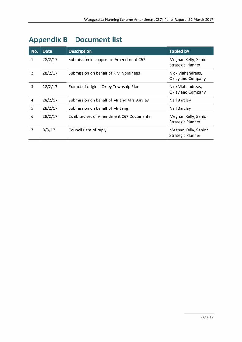
Appendix B Document list
No. Date Description Tabled by
1 28/2/17 Submission in support of Amendment C67 Meghan Kelly, Senior Strategic Planner
2 28/2/17 Submission on behalf of R M Nominees Nick Vlahandreas, Oxley and Company
3 28/2/17 Extract of original Oxley Township Plan Nick Vlahandreas, Oxley and Company
4 28/2/17 Submission on behalf of Mr and Mrs Barclay Neil Barclay
5 28/2/17 Submission on behalf of Mr Lang Neil Barclay
6 28/2/17 Exhibited set of Amendment C67 Documents Meghan Kelly, Senior Strategic Planner
7 8/3/17 Council right of reply Meghan Kelly, Senior Strategic Planner

Wangaratta Planning Scheme Amendment C67 Panel Report 30 March 2017
Page 33
Appendix C North East Water submission