plane surveying – levellingazlanppd.tripod.com/ujianduapiket.pdf · plane surveying – levelling...
TRANSCRIPT
Plane Surveying – Levelling Civil Engineering 235 Department of Civil Engineering, UBC
Page 1 of 8
Introduction:
Levelling is a means by which surveyors can determine the elevation of points, using other known points as
references. Levelling is perhaps the most basic of surveying operations and forms an important fundamental
part of almost every surveying project.
Equipment:
Levelling is carried out by the use of: a Spirit Level, often called an Engineer’s Level, and a level rod. The level
rod resembles a large fold-up ruler but is not accurately referred to as such.
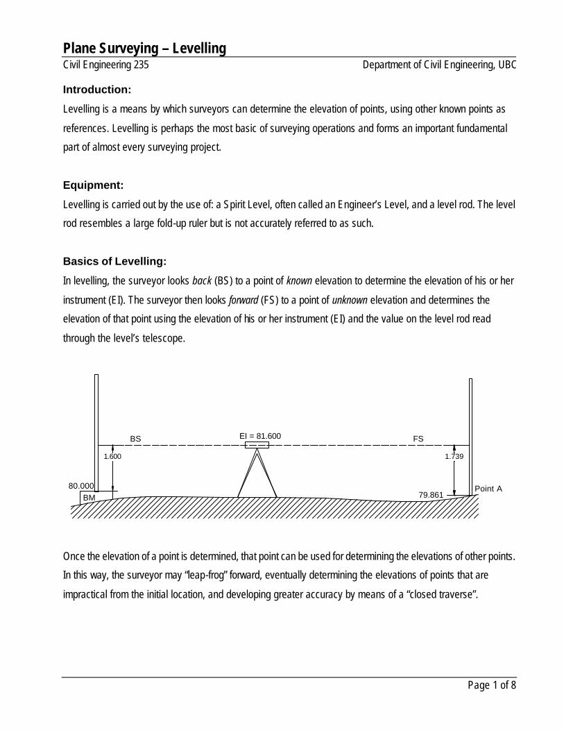
Basics of Levelling:
In levelling, the surveyor looks back (BS) to a point of known elevation to determine the elevation of his or her
instrument (EI). The surveyor then looks forward (FS) to a point of unknown elevation and determines the
elevation of that point using the elevation of his or her instrument (EI) and the value on the level rod read
through the level’s telescope.
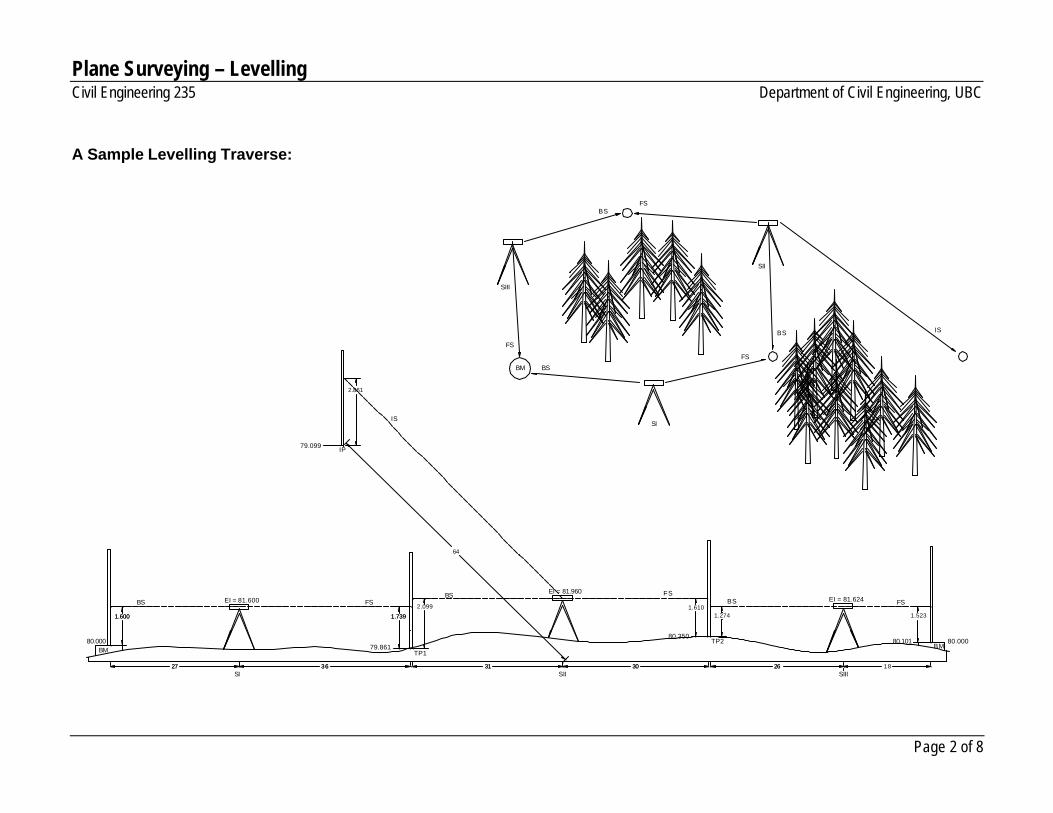
Once the elevation of a point is determined, that point can be used for determining the elevations of other points.
In this way, the surveyor may “leap-frog” forward, eventually determining the elevations of points that are
impractical from the initial location, and developing greater accuracy by means of a “closed traverse”.
BM80.000
BS FS
Point A
EI = 81.600
79.861
1.600 1.739
Plane Surveying – Levelling Civil Engineering 235 Department of Civil Engineering, UBC
Page 2 of 8
A Sample Levelling Traverse:
BM80.000
BS FS
TP1
EI = 81.600
79.861
1.600 1.739
EI = 81.960EI = 81.624
2.099
BS
1.274
BS1.610
1.523
FSFS
TP280.350
80.101
27 36 31 30 26 18SI SII SIII
80.000BM
2630313627
1.7391.600
IS
2.861
79.099 IP
IS
FS
FS
FS
BS
BS
BS
SI
BM
SII
SIII
64
Plane Surveying – Levelling Civil Engineering 235 Department of Civil Engineering, UBC
Page 3 of 8
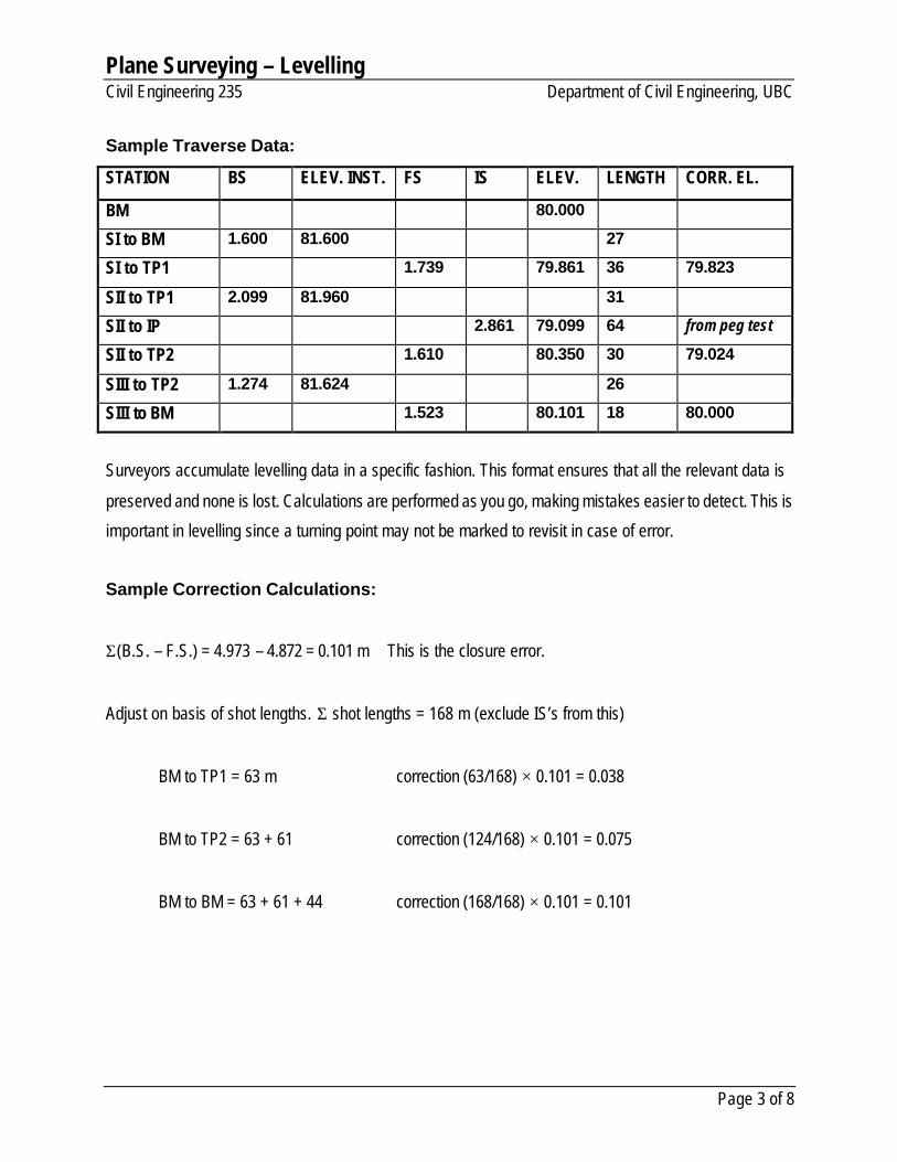
Sample Traverse Data:
STATION BS ELEV. INST. FS IS ELEV. LENGTH CORR. EL.
BM 80.000
SI to BM 1.600 81.600 27
SI to TP1 1.739 79.861 36 79.823
SII to TP1 2.099 81.960 31
SII to IP 2.861 79.099 64 from peg test
SII to TP2 1.610 80.350 30 79.024
SIII to TP2 1.274 81.624 26
SIII to BM 1.523 80.101 18 80.000
Surveyors accumulate levelling data in a specific fashion. This format ensures that all the relevant data is
preserved and none is lost. Calculations are performed as you go, making mistakes easier to detect. This is
important in levelling since a turning point may not be marked to revisit in case of error.
Sample Correction Calculations:
Σ(B.S. – F.S.) = 4.973 – 4.872 = 0.101 m This is the closure error.
Adjust on basis of shot lengths. Σ shot lengths = 168 m (exclude IS’s from this)
BM to TP1 = 63 m correction (63/168) × 0.101 = 0.038
BM to TP2 = 63 + 61 correction (124/168) × 0.101 = 0.075
BM to BM = 63 + 61 + 44 correction (168/168) × 0.101 = 0.101
Plane Surveying – Levelling Civil Engineering 235 Department of Civil Engineering, UBC
Page 4 of 8
Accuracy in Levelling:
In levelling, we want to determine the difference in elevation between A and B. However, a Spirit Level may
not be perfectly aligned – that is, the telescope may not be aligned correctly with the level plane described
by the level bubble.
Definitions:
B at reading actual Aat reading actual
B to shot of length Ato shot of length
==
==
badd
B
A
telescope through seen B at reading telescope through seen A at reading
ntmisalignme telescope to due B at component error ntmisalignme telescope to due A at component error
====
T
T
B
A
baee
[ ] [ ]
( ) ( )
[ ] [ ] 0 and/or ifonly
:therefore
and
and
=−=−=−
−+−=−
−−−=−
==
−=−=
ABTT
ABTT
BTAT
BbAa
bTaT
ddbaba
ddbaba
dbdaba
dede
ebbeaa
0tan
tan
tantan
tantan
θ
θ
θθ
θθ
AB
a b
dA dB
error angle, theta
eB
bT
eA
aT
error angle, theta
Plane Surveying – Levelling Civil Engineering 235 Department of Civil Engineering, UBC
Page 5 of 8
AB
a b
dA dB
dB'dA'
a'
A
b'
B
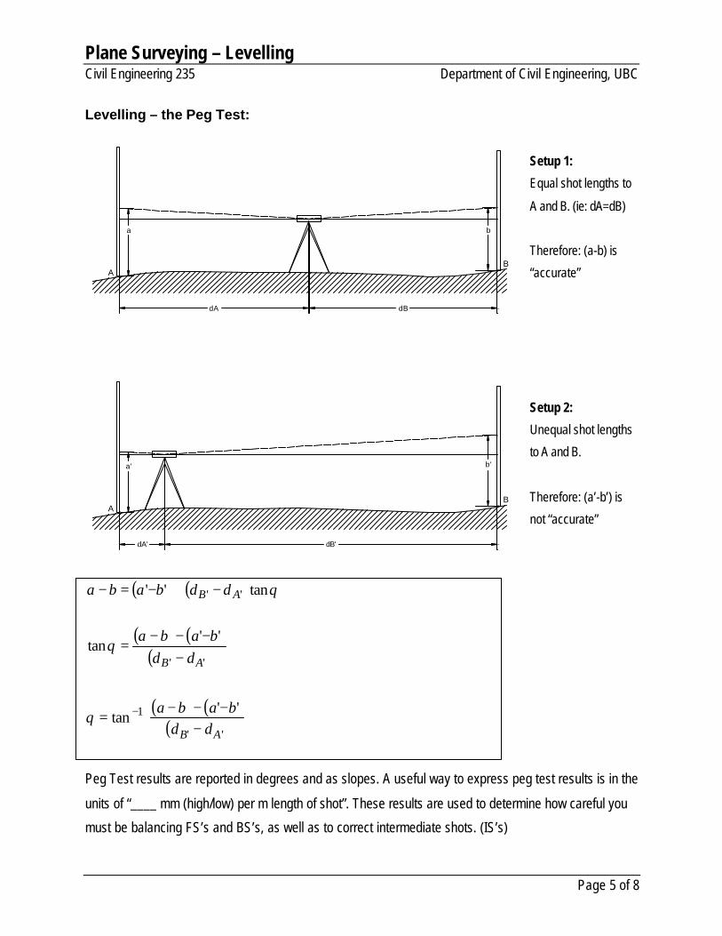
Levelling – the Peg Test:
Setup 1:
Equal shot lengths to
A and B. (ie: dA=dB)
Therefore: (a-b) is
“accurate”
Setup 2:
Unequal shot lengths
to A and B.
Therefore: (a’-b’) is
not “accurate”
( ) ( )
( ) ( )( )
( ) ( )( )
−
−−−=
−−−−
=
−+−=−
−
''
1
''
''
''tan
''tan
tan''
AB
AB
AB
ddbaba
ddbaba
ddbaba
θ
θ
θ
Peg Test results are reported in degrees and as slopes. A useful way to express peg test results is in the
units of “____ mm (high/low) per m length of shot”. These results are used to determine how careful you
must be balancing FS’s and BS’s, as well as to correct intermediate shots. (IS’s)
Plane Surveying – Levelling Civil Engineering 235 Department of Civil Engineering, UBC
Page 6 of 8
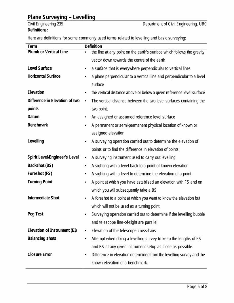
Definitions:
Here are definitions for some commonly used terms related to levelling and basic surveying:
Term Definition Plumb or Vertical Line • the line at any point on the earth’s surface which follows the gravity
vector down towards the centre of the earth
Level Surface • a surface that is everywhere perpendicular to vertical lines
Horizontal Surface • a plane perpendicular to a vertical line and perpendicular to a level
surface
Elevation • the vertical distance above or below a given reference level surface
Difference in Elevation of two
points
• The vertical distance between the two level surfaces containing the
two points
Datum • An assigned or assumed reference level surface
Benchmark • A permanent or semi-permanent physical location of known or
assigned elevation
Levelling • A surveying operation carried out to determine the elevation of
points or to find the difference in elevation of points
Spirit Level/Engineer’s Level • A surveying instrument used to carry out levelling
Backshot (BS) • A sighting with a level back to a point of known elevation
Foreshot (FS) • A sighting with a level to determine the elevation of a point
Turning Point • A point at which you have establised an elevation with FS and on
which you will subsequently take a BS
Intermediate Shot • A foreshot to a point at which you want to know the elevation but
which will not be used as a turning point
Peg Test • Surveying operation carried out to determine if the levelling bubble
and telescope line-of-sight are parallel
Elevation of Instrument (EI) • Elevation of the telescope cross-hairs
Balancing shots • Attempt when doing a levelling survey to keep the lengths of FS
and BS at any given instrument setup as close as possible.
Closure Error • Difference in elevation determined from the levelling survey and the
known elevation of a benchmark.
Plane Surveying – Levelling Civil Engineering 235 Department of Civil Engineering, UBC
Page 7 of 8
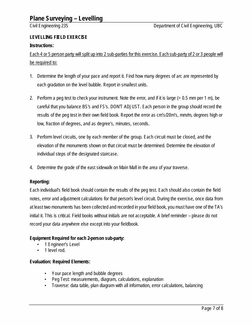
LEVELLING FIELD EXERCISE
Instructions:
Each 4 or 5 person party will split up into 2 sub-parties for this exercise. Each sub-party of 2 or 3 people will
be required to:
1. Determine the length of your pace and report it. Find how many degrees of arc are represented by
each gradation on the level bubble. Report in smallest units.
2. Perform a peg test to check your instrument. Note the error, and if it is large (> 0.5 mm per 1 m), be
careful that you balance BS's and FS's. DON'T ADJUST. Each person in the group should record the
results of the peg test in their own field book. Report the error as cm’s/20m’s, mm/m, degrees high or
low, fraction of degrees, and as degree’s, minutes, seconds.
3. Perform level circuits, one by each member of the group. Each circuit must be closed, and the
elevation of the monuments shown on that circuit must be determined. Determine the elevation of
individual steps of the designated staircase.
4. Determine the grade of the east sidewalk on Main Mall in the area of your traverse.
Reporting:
Each individual's field book should contain the results of the peg test. Each should also contain the field
notes, error and adjustment calculations for that person’s level circuit. During the exercise, once data from
at least two monuments has been collected and recorded in your field book, you must have one of the TA’s
initial it. This is critical. Field books without initials are not acceptable. A brief reminder – please do not
record your data anywhere else except into your fieldbook.
Equipment Required for each 2-person sub-party:
• 1 Engineer’s Level • 1 level rod.
Evaluation: Required Elements:
• Your pace length and bubble degrees • Peg Test: measurements, diagram, calculations, explanation • Traverse: data table, plan diagram with all information, error calculations, balancing
Plane Surveying – Levelling Civil Engineering 235 Department of Civil Engineering, UBC
Page 8 of 8
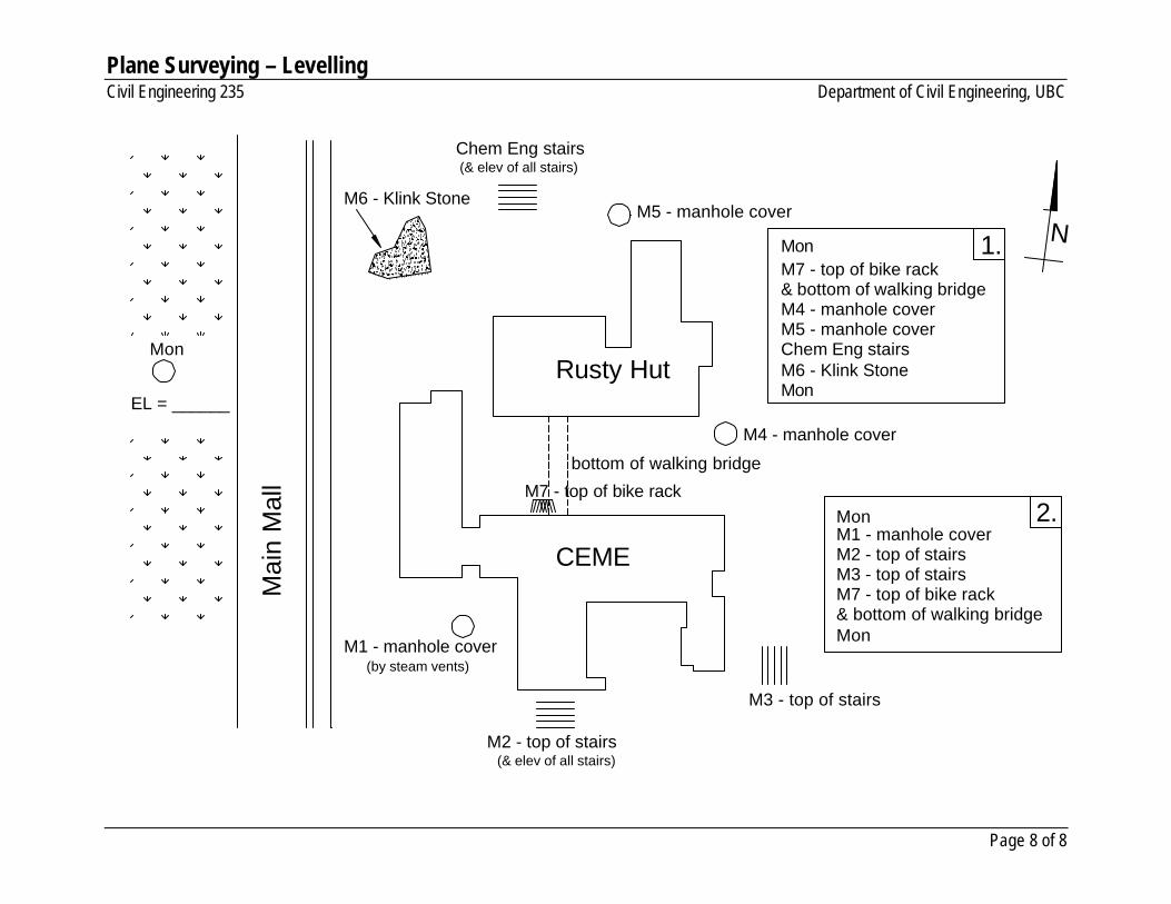
Rusty Hut
CEMEM1 - manhole coverM2 - top of stairsM3 - top of stairsM7 - top of bike rack
Mon
Mon
M7 - top of bike rack& bottom of walking bridgeM4 - manhole coverM5 - manhole coverChem Eng stairsM6 - Klink StoneMon
Mon
EL = ______
M1 - manhole cover
M2 - top of stairs
M3 - top of stairs
M7 - top of bike rack
bottom of walking bridge
M4 - manhole cover
M5 - manhole cover
Chem Eng stairs
(& elev of all stairs)
M6 - Klink Stone
Mon
Mai
n M
all
N1.
2.
(& elev of all stairs)
(by steam vents)
& bottom of walking bridge