plan amendment no. 2017-04 - fairfax county, virginia · plan amendment no. 2017-04 ... west of the...
TRANSCRIPT


Plan Amendment No. 2017-04 Adopted January 23, 2018
Page 1 of 11
AMENDMENT TO THE COMPREHENSIVE PLAN (2017 EDITION)
The following changes to the Comprehensive Plan have been adopted by the Board of Supervisors. Text proposed to be added is shown as underlined and text proposed to be deleted is shown with a strikethrough. MODIFY: Fairfax County Comprehensive Plan, 2013 Edition, Area IV, Mount Vernon
Planning District, as amended through 3-14-2017, MV1 Huntington Community Planning Sector, page 103:
“Transit Development Area Conditions and Recommendations … North of the Huntington Station Shopping Center is a block of older duplex houses that are directly across from the station facilities. Redevelopment in Jefferson Manor is not recommended outside of Land Unit L (see Figure 23) to limit the impact upon the Jefferson Manor neighborhood and nearby subdivisions. To the west of the WMATA property is the 19-acre Huntington Club Condominiums. Due to its location immediately adjacent to the Huntington Metrorail Station, this site presents an opportunity for redevelopment. West of the Huntington Club Condominiums, Fort Lyon Heights is a stable residential neighborhood which serves as a boundary to the Transit Development Area. On the north side of Huntington Avenue, across from the station, is an area of partially undeveloped land which is appropriate for Metro-related development. Land Units C, D and G are within a five-minute walk of the station and are bounded by the Huntington community on the east, Cameron Run on the north, and an office building on Telegraph Road to the west.”
MODIFY: Fairfax County Comprehensive Plan, 2013 Edition, Area IV, Mount Vernon
Planning District, as amended through 3-14-2017, MV1 - Huntington Community Planning Sector, Transit Development Area Conditions and Recommendations, page 105-108:
“The maximum level of development for the Transit Development Area is the following:
• 1,470,000 gross square feet of office space; - Up to 120,000 square feet may be converted to hotel use in Land Unit I;
• 105,000 gross square feet of retail space; • 3,462 dwelling units; • 200-room hotel with conference facilities or an additional 250 dwelling
units on Land Unit E; and • In Land Unit L, and additional 50,000 to 85,000 gross square feet of retail
and office space.

Plan Amendment No. 2017-04
Adopted January 23, 2018
Page 2 of 11
• Up to 275,000 gross square feet of additional development on Parcel 83-1 ((1)) 33 of Land Unit G.”
MODIFY: Fairfax County Comprehensive Plan, 2013 Edition, Area IV, Mount Vernon
Planning District, as amended through 3-14-2017, MV1 Huntington Community Planning Sector, page 122 (to separate Land Unit G text):
“Land Units G, H, J, and K (Telegraph Road/North Kings Highway/ Huntington Avenue Area) This area is comprised of land units that lie generally to the south and east of the intersection of Telegraph Road and North Kings Highway (Land Units G, H, I, J, and K). The major land uses in this area are highway-oriented retail uses and stable residential subdivisions. Land Unit G is a triangle of land that is bounded by Huntington Avenue, Cameron Run and the Metrorail guideway, and falls partially within the Transit Development Area. It The western portion of Land Unit G (Parcels 83-1 ((1)) 33, 45 and 45A) is developed with office and industrial uses and, except as noted below, is planned for redevelopment to office use with an FAR up to .30 and a maximum height of 40 feet. This reflects the majority of current development in this land unit. The eastern portion of Land Unit G (Parcels 83-1 ((1)) 34D, 34E and 34F) is planned and approved for mixed-use redevelopment consisting of multi-family residential, office and hotel uses. The portion of Parcel 83-1 ((1)) 42 within this land unit is planned for office use with an option for residential use as noted in the recommendations for Land Units C and D. The uses on Parcel 45 are currently industrial uses. A significant portion of this lot may be acquired for right-of-way for planned roadway and interchange improvements to the Telegraph Road/North Kings Highway/Huntington Avenue intersections. If any publicly owned land remains after the interchange is built, it should be retained as public open space. “An option for mixed-use development of residential and/or office, hotel, and supporting restaurant/retail uses on Parcel 83-1 ((1)) 33 may be appropriate up to a maximum of 3.0 FAR (approximately 275,000 gross square feet (GSF) of development), and a maximum height of 165 feet, subject to full consolidation of Parcels 83-1 ((1)) 33, 45 and 45a. If full consolidation cannot be achieved, said redevelopment option for Parcel 83-1 ((1)) 33 should be limited to a maximum of 2.6 FAR (approximately 240,000 GSF). The primary access for such development should be consolidated to Robinson Way, along the east boundary of Parcel 33. Redevelopment is expected to consist of high-quality architecture and landscaping that represents an attractive, if not iconic, gateway to the Huntington Transit Station Area. All areas that are subject to 100-year floodplain, RPA, and EQC should be ecologically restored and revegetated, to the extent possible, and utilized as a public open-space/recreational area that connects to similar neighboring areas along Cameron Run. Streetscape improvements along Huntington Avenue and Robinson

Plan Amendment No. 2017-04 Adopted January 23, 2018
Page 3 of 11
Way should be coordinated with neighboring development, including undergrounding of remaining overhead utility lines along Huntington Avenue. Consideration should be given to including green roofs and/or solar panels on rooftops. Any redevelopment per this Plan option should also include stormwater quantity and quality control measures that are substantially more extensive than minimum requirements, with the goal of reducing the total runoff volume. The emphasis should be on low-impact development (LID) techniques and best-management practices (BMPs) that evapotranspire water, filter water through vegetation and/or soil, return water into the ground, or re-use water, and should include features such as rooftop landscaping. Stormwater management measures that are sufficient to attain the stormwater-related credit(s) of the most current version of the Leadership in Energy and Environmental Design for New Construction (LEED®-NC) or Leadership in Energy and Environmental Design for Core and Shell (LEED®-CS) rating systems (or third-party equivalent of these credits) should be provided. If this goal is demonstrated not to be achievable, all measures should be implemented to the extent possible in support of this goal. Parcels 83-1 ((1)) 34CD, 34E and 34F falls within the Transit Development Area. This parcel is are planned for a mixture of residential, office and restaurant/retail uses at 2.0 to 3.0 FAR, and a maximum height of 165 feet. The residential component should be limited to approximately one-half of the total development. The design should include environmental elements including buildings designed to meet the criteria for LEED Silver green building certification. In addition to the previous guidance, any Rredevelopment of the site in Land Unit G should include, at a minimum, the following elements:
• Provision of high-quality architecture and pedestrian focused site design, which should include street oriented building forms and mitigation of visual impacts of structured parking;
• Provision of on-site affordable and workforce housing;
• Restoration and revegetation of the Resource Protection Area;
• Integration of an urban park as a wayside area along the planned Cameron Run Trail;
• Provision of integrated pedestrian and bicycle systems with features such as covered and secure bicycle storage facilities, walkways, trails and sidewalks, amenities such as street trees, benches, bus shelters, and adequate lighting;
• Provision of environmental elements into the design, including buildings designed to meet the criteria for LEED Silver green building certification;
• Buildings should be designed to accommodate telecommunications antennas and equipment cabinets in a way that is compatible with the building’s architecture and conceals the antennas and equipment from surrounding properties and roadways by flush mounting or screening antennas and

Plan Amendment No. 2017-04
Adopted January 23, 2018
Page 4 of 11
concealing related equipment behind screen walls or building features;
• The impact on parks and recreation should be mitigated per policies contained in Objective 6 of the Parks and Recreation section of the Policy Plan; and
• Adherence to the adopted Transit Oriented Development Guidelines contained in Appendix 11 of the Land Use section of the Policy Plan.”
Land Units H, J, and K (Telegraph Road/North Kings Highway/Huntington Avenue Area) This area is comprised of land units that lie generally to the south and east of the intersection of Telegraph Road and North Kings Highway (Land Units H, J, and K). The major land uses in this area are highway-oriented retail uses and stable residential subdivisions. Land Unit H contains highway-oriented retail use located at the intersections of Telegraph Road with North Kings Highway and Huntington Avenue. Land Unit H is planned for retail use up to .35 FAR. A significant portion of this land unit may be required as right-of-way for the planned roadway and interchange improvements of the Telegraph Road/North Kings Highway/ Huntington Avenue intersections. Therefore, no substantial redevelopment or new development should occur prior to the construction of the planned road improvements. South and east of the Telegraph Road/North Kings Highway/Huntington Avenue intersection is an area of stable residential development, shown as Land Units I and J in Figure 22. The Crider Park subdivision is located along Kathryn Street between North Kings Highway and Huntington Avenue and should be maintained as a stable neighborhood at a planned density of 3-4 dwelling units per acre. The use of Kathryn Street for non-local “cut-through” traffic should be discouraged. The remainder of Land Unit J is comprised of Fort Lyon Heights subdivision on the west side of North Kings Highway. This subdivision of single-family detached homes is planned for residential use at a density of 3-4 dwelling units per acre. Both of these subdivisions should be maintained as stable residential neighborhoods. At the intersection of Telegraph Road and Farmington Drive, Land Unit K is planned for retail use up to .25 FAR where retail uses currently exist and residential use at 3-4 dwelling units per acre where existing residential development is located and as shown on the Plan map.

Plan Amendment No. 2017-04 Adopted January 23, 2018
Page 5 of 11
MODIFY FIGURE: Fairfax County Comprehensive Plan, 2013 Edition, Area IV, Mount Vernon
Planning District, as amended through 3-14-2017, MV1 Huntington Community Planning Sector, Figure 22, “Huntington Transit Station Area”, page 101, to add Parcel 33 to Transit Development Area.
Plan Amendment No. 2017-04
Adopted January 23, 2018
Page 6 of 11
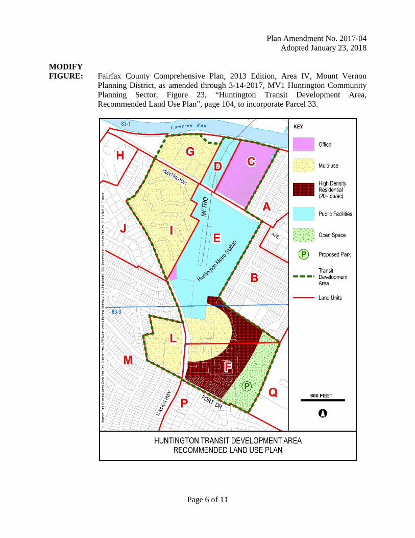
MODIFY FIGURE: Fairfax County Comprehensive Plan, 2013 Edition, Area IV, Mount Vernon
Planning District, as amended through 3-14-2017, MV1 Huntington Community Planning Sector, Figure 23, “Huntington Transit Development Area, Recommended Land Use Plan”, page 104, to incorporate Parcel 33.

Plan Amendment No. 2017-04 Adopted January 23, 2018
Page 7 of 11
MODIFY FIGURE: Fairfax County Comprehensive Plan, 2013 Edition, Area IV, Mount Vernon
Planning District, as amended through 3-14-2017, MV1 Huntington Community Planning Sector, Figure 24, “Huntington Transit Station Area, Pedestrian Circulation”, page 106, to incorporate Parcel 33.

Plan Amendment No. 2017-04
Adopted January 23, 2018
Page 8 of 11
MODIFY FIGURE: Fairfax County Comprehensive Plan, 2013 Edition, Area IV, Mount Vernon
Planning District, as amended through 3-14-2017, MV1 Huntington Community Planning Sector, Figure 25, “Huntington Transit Development Area, Height Limits”, page 107, to incorporate Parcel 33.

Plan Amendment No. 2017-04 Adopted January 23, 2018
Page 9 of 11
MODIFY FIGURE: Fairfax County Comprehensive Plan, 2013 Edition, Area IV, Mount Vernon
Planning District, as amended through 3-14-2017, MV1 Huntington Community Planning Sector, Figure 26, “Huntington Transit Development Area, Open Space and Landscaped Buffers”, page 108, to incorporate Parcel 33.
Plan Amendment No. 2017-04
Adopted January 23, 2018
Page 10 of 11
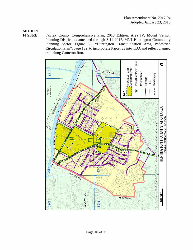
MODIFY FIGURE: Fairfax County Comprehensive Plan, 2013 Edition, Area IV, Mount Vernon
Planning District, as amended through 3-14-2017, MV1 Huntington Community Planning Sector, Figure 33, “Huntington Transit Station Area, Pedestrian Circulation Plan”, page 132, to incorporate Parcel 33 into TDA and reflect planned trail along Cameron Run.

Plan Amendment No. 2017-04 Adopted January 23, 2018
Page 11 of 11
Additional figures within the Comprehensive Plan may be changed to reflect the addition of Parcel 33 into the Transit Development Area. COMPREHENSIVE LAND USE PLAN MAP: The Comprehensive Land Use Plan map will not change. COUNTYWIDE TRANSPORTATION PLAN MAP: The Countywide Transportation Plan map will not change.