amendment no. 2013-04 - fairfax county
TRANSCRIPT


Amendment No. 2013-04 Adopted January 28, 2014
AMENDMENT TO THE COMPREHENSIVE PLAN (2013 EDITION)
The following changes to the Comprehensive Plan have been adopted by the Board of Supervisors. To identify changes from the previously adopted Plan, new text is shown with underline and deleted text shown with strikethrough. MODIFY: Fairfax County Comprehensive Plan, 2013 Edition, Area IV, Mount
Vernon Planning District, as amended through 4-9-2013; Richmond Highway Corridor Area, North Gateway and Penn Daw Community Business Centers, page 31:
“North Gateway Community Business Center . . .
Redevelopment in this area is anticipated to occur adjacent to the Capital Beltway primarily at the location of the auto dealerships. This area is planned to redevelop as a to high-rise residential or in the alternative, as a varied height, mixed-use project including residential, office, hotel and retail uses or in the alternative as high rise residential use. These planned uses complement the advantageous location near rail transit/transportation oriented location and are compatible with the surrounding character and density.
. . .” MODIFY: Fairfax County Comprehensive Plan, 2013 Edition, Area IV, Mount
Vernon Planning District, as amended through 4-9-2013; Richmond Highway Corridor Area, North Gateway and Penn Daw Community Business Centers, North Gateway Community Business Center, page 33-34:
“Sub-unit A-1
The area along the northwest side of Richmond Highway between the Capital Beltway and Old Richmond Highway I-495 and northeast of Huntington Avenue is planned for retail, office and/or residential uses up to .50 FAR.
Sub-units A-1 and A-2 may be appropriate for redevelopment at a higher intensity in the future when areawide transportation issues can be addressed. The plan for the mixture of uses and intensity should be evaluated following the completion of transportation studies for the Huntington area and the Richmond Highway Corridor, when mitigation strategies are identified.
As an option, mixed-use development to include residential, office, hotel and retail uses at an intensity up to 1.01.65 FAR may be appropriate as part of a unified redevelopment with substantial consolidation of Sub-unitsA-1 and A-2. If substantial consolidation is not achievable, an
Page 1 of 10

Amendment No. 2013-04 Adopted January 28, 2014
alternative may be pursued that logically consolidates parcels in Sub-unit A-1 and/or Sub-unit A-2 in order to provide the extension of Fort Hunt Road to Cameron Run Terrace in the initial phase. Further, a master plan for redevelopment of both Sub-units should be prepared to demonstrate how the future integration of unconsolidated parcels can be achieved. if the following conditions are met.
In either option, the following conditions should be met:
• A mix of uses, which may include office, retail and residential, is provided;
• Substantial and logical parcel consolidation is achieved;
• Pedestrian and vehicular connections are provided;
• Project Urban design and layout provide a high quality development
elements incorporating the recommendations found at the end of the Richmond Highway Corridor section, such as complete streets, public art, pedestrian plazas, cultural/recreation facilities, landscaped open space, landmarks or building designs which will denote this area as a focal point of the North Gateway Community Business Center are included;
• A pedestrian circulation system is provided. Circulation should
encourage pedestrian traffic within the development, and to and from adjacent developments, the Huntington Metrorail Station, and existing and planned pedestrian and bicycle routes, such as the Cameron Run Trail and other planned facilities. Streetscaping that includes elements such as space for outdoor dining, pedestrian sidewalks, landscaping, crosswalks, bicycle facilities, on-street parking, lighting, and/or transit accommodations, should be incorporated in the internal transportation network within the development. Adequate, well-positioned and safe pedestrian crossings across Richmond Highway and Huntington Avenue, with ramps, pavement markings and pedestrian countdown signals, should also be provided;
• A parking management program that may include parking reductions, providing less parking than required by code is prepared;
• Parking is consolidated into structures and integrated into the
streetscape in order to avoid adverse visual impacts to major pedestrian, bicycle, or vehicular corridors. Façade treatment of parking structures should contribute to the visual appeal of the streetscape. Surface parking lots should be avoided or located in the rear of the buildings when necessary;
• The A thorough traffic impact analysis of the proposed development
is thoroughly analyzed and mitigated so that Huntington Avenue and Richmond Highway adjacent to the site will operate at levels of service no less than Level of Service D conducted with appropriate mitigation identified. Grade separated interchanges, new or extended
Page 2 of 10

Amendment No. 2013-04 Adopted January 28, 2014
roadways, roadway widening, and/or intersection turn lane improvements should be considered to assist in alleviating traffic congestion through the immediate area;
• An efficient, pedestrian friendly, internal grid design for vehicular
circulation system is provided. Access points are consolidated, and placed away from existing intersections and operate at levels of service no less than Level of Service D;
• Old Richmond Highway should be vacated between Cameron Run
Terrace and Richmond Highway, and the extension of Fort Hunt Road from Richmond Highway to Cameron Run Terrace should be constructed with any redevelopment of the subject area as shown on Figure 13;
• Access points should be consolidated. Adequate storage capacity
at the site access points should be provided to accommodate anticipated turn lane demands, into and out of the site;
• Adequate right-of-way is provided for the planned, grade-separated
interchange at Richmond Highway and Huntington Avenue/Fort Hunt Road or for suitable, at-grade alternative mitigation developed through further study, and for any adjacent intersection, bicycle/pedestrian improvements, and/or road widenings to be defined through further study;
• A pedestrian circulation system which encourages pedestrian traffic
within the development, to adjacent developments and to the Huntington Metro Station is provided;
• Adequate measures to mitigate against environmental impact should
be provided. The related floodplain and wetland areas should be protected in accordance with Plan objectives, as well as, other applicable guidelines and regulations; and
• Urban design elements, such as public art, pedestrian plazas,
cultural/recreation facilities, landscaped open space, streetscaping, landmarks or building designs which will denote this area as a focal point of the North Gateway Community Business Center are included. The urban design recommendations found at the end of this Plan should be used as a guide.
• Any proposed site design is coordinated with existing and planned
transit in the area with bus shelters; • A substantial Transportation Demand Management (TDM) program
should be implemented as a component of the transportation mitigation. The TDM program should consider, but is not limited to, the following elements:
o A TDM trip reduction goal of 30 percent should be sought for the
office component of the site,
Page 3 of 10

Amendment No. 2013-04 Adopted January 28, 2014
o A TDM coordinator, o A commuter center/kiosk, o Incentives for residents and office workers to use alternative
modes, such as transit, carpools, vanpools, bicycles and walking and to participate in flexible work schedules, alternative work schedules and teleworking,
o Provision of, or funding for, long-term shuttle service and/or
enhanced transit connections between the site, other area development, and the Huntington Metrorail Station, and
o Covered and secure bicycle storage facilities and shower/locker
facilities;
• A contribution for area-wide transportation improvements, including roadway and other multi-modal improvements that are generally proportional to the share of trips generated by the proposed development is provided at each improvement location. The contribution at each improvement location should be calculated based on a comparison of site generated trips versus regional/through trips;
• A linear park along the shoreline of Cameron Run that includes
wayside areas with benches and construction of a portion of the proposed Cameron Run trail is provided;
• The Cameron Run floodplain is re-vegetated and the Resource
Protection Area restored to the maximum extent possible; • The amount of impervious surfaces is reduced to the maximum extent
possible; if this is not achievable, there is no net increase in impervious surfaces;
• The total volume of stormwater runoff released from the site post-
development for the 2-year, 24-hour storm should be at least 25% less than the total volume of runoff released in the existing condition for the same storm;
• Stormwater runoff is controlled such that either (a) the total
phosphorus load for the property is no greater than what would be required for new development pursuant to Virginia’s Stormwater Regulations and the County’s Stormwater Management Ordinance; or (b) an equivalent level of water quality control is provided;
• As an alternative to the previous two bullets, stormwater management
measures may be provided sufficient to attain the Rainwater Management credit(s) of the most current version of LEED-New Construction or LEED-Core and Shell rating system;
• As an alternative to the previous three bullets, stormwater management
measures/and or downstream improvements may be pursued to optimize site-specific stormwater management and/or stream
Page 4 of 10

Amendment No. 2013-04 Adopted January 28, 2014
protection/restoration efforts, consistent with the adopted watershed management plan(s) that is/are applicable to the site. Such efforts should be designed to protect downstream receiving waters by reducing stormwater runoff volumes and peak flows from existing and proposed impervious surfaces to the maximum extent practicable, consistent with watershed plan goals; and
• A noise study is prepared to determine the extent of noise impacts and
appropriate mitigation measures for interior areas of any residential, hotel and office uses and if necessary, outdoor activity areas.
As an alternative option, future redevelopment of Sub-unit A-1 northwest of Old Richmond Highway for residential use up to 30 dwelling units per acre to be compatible with the surrounding high-rise residential uses may be appropriate. Substantial parcel consolidation, minimization of access points, provision of an efficient internal circulation pattern and mitigation of environmental and transportation impacts are required. See land use recommendations for Sub-units A-2 and B-2 for additional options. Sub-unit A-2
The redevelopment of the "island" formed by Richmond Highway and Old Richmond Highway would enhance the "gateway" character of this area and should be encouraged. Consolidation of all parcels within this "island" and redevelopment of this area with neighborhood-serving retail use up to .25 FAR is recommended. Building orientation should be to Richmond Highway but access should be to Old Richmond Highway. As an option, if Sub-unit A-2 is fully substantially consolidated and included in a unified mixed-use development plan with Sub-unit A-1, then Sub-unit A-2 may be appropriate for mixed-use development at an intensity up to 1.0 1.65 FAR. If substantial consolidation with Sub-unit A-1 is not achievable, an alternative option for logical consolidation of Sub-unit A-2 with at least Tax Map Parcel 83-2((1))2A is recommended for mixed-use development to include residential, office, hotel and retail uses at a lower intensity than the maximum of 1.65 FAR. In addition to meeting the same conditions stated in the land use recommendation for Sub-unit A-1, as part of this mixed-use development, Old Richmond Highway should be vacated between Cameron Run Terrace and Richmond Highway and access should be provided from Richmond Highway Sub-unit A-1.
Page 5 of 10

Amendment No. 2013-04 Adopted January 28, 2014
MODIFY FIGURE: Fairfax County Comprehensive Plan, 2013 Edition, Area IV, Mount Vernon
Planning District, amended through 4-9-2013, Figure 2, “Countywide Transportation Recommendations, Mount Vernon Planning District,” page 6, as follows:
At the intersection of Richmond Highway and Huntington Avenue, replace
the symbol and note that refers to the recommendation of a grade separated interchange, with the symbol and note that explains that further study is required to establish preliminary concepts and/or limits of restricted access.
FIGURE 2
Page 6 of 10
Amendment No. 2013-04 Adopted January 28, 2014
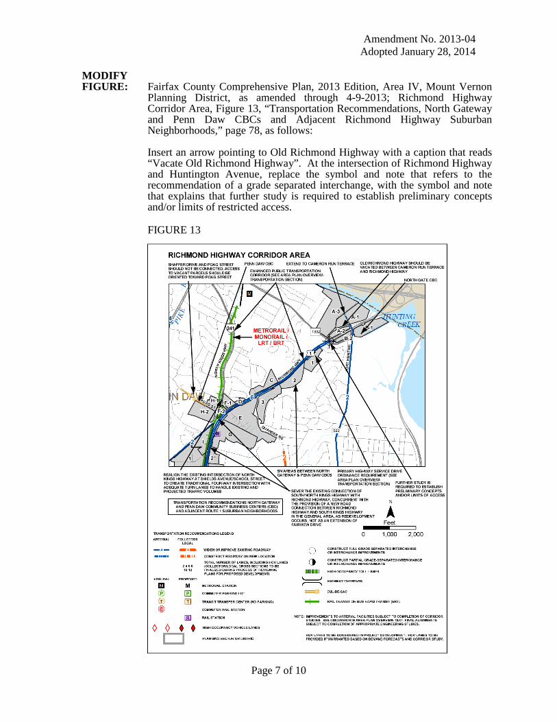
MODIFY FIGURE: Fairfax County Comprehensive Plan, 2013 Edition, Area IV, Mount Vernon
Planning District, as amended through 4-9-2013; Richmond Highway Corridor Area, Figure 13, “Transportation Recommendations, North Gateway and Penn Daw CBCs and Adjacent Richmond Highway Suburban Neighborhoods,” page 78, as follows:
Insert an arrow pointing to Old Richmond Highway with a caption that reads “Vacate Old Richmond Highway”. At the intersection of Richmond Highway and Huntington Avenue, replace the symbol and note that refers to the recommendation of a grade separated interchange, with the symbol and note that explains that further study is required to establish preliminary concepts and/or limits of restricted access.
FIGURE 13
Page 7 of 10

Amendment No. 2013-04 Adopted January 28, 2014
MODIFY FIGURE: Fairfax County Comprehensive Plan, 2013 Edition, Area IV, Mount Vernon
Planning District, as amended through 4-9-2013; MV1-Huntington Community Planning Sector, Figure 29, “Transportation Recommendations,” page 123, as follows:
Insert an arrow pointing to Old Richmond Highway with a caption that reads
“Vacate Old Richmond Highway”. At the intersection of Richmond Highway and Huntington Avenue, replace the symbol and note that refers to the recommendation of a grade separated interchange, with the symbol and note that explains that further study is required to establish preliminary concepts and/or limits of restricted access.
FIGURE 29
Page 8 of 10

Amendment No. 2013-04 Adopted January 28, 2014
MODIFY FIGURE: Fairfax County Comprehensive Plan, 2013 Edition, Area IV, Mount Vernon
Planning District, as amended through 4-9-2013, MV1-Huntington Community Planning Sector, Figure 30, “Access Recommendations,” page 124, as follows:
Insert an arrow pointing to Old Richmond Highway with a caption that reads “Vacate Old Richmond Highway”. At the intersection of Richmond Highway and Huntington Avenue, replace the symbol and note that refers to the recommendation of a grade separated interchange, with the symbol and note that explains that further study is required to establish preliminary concepts and/or limits of restricted access. FIGURE 30
Page 9 of 10

Amendment No. 2013-04 Adopted January 28, 2014
MODIFY FIGURES: Fairfax County Comprehensive Plan, 2013 Edition, Area IV, Mount
Vernon Planning District, as amended through 4-9-2013, the following figures will be updated to reflect revisions made to figures 2, 13, 29 and 30:
• Figure 32, page 126, “Interchange Recommendations, MV1-
Huntington Community Planning Sector;”
• Figure 39, page 138, “Interchange Recommendations, MV2 - Hybla Valley Community Planning Sector;”
• Figure 43, page 145, “MV3 - Belle Haven Community Planning Sector, Transportation Recommendations;”
• Figure 44, page 146, “Access Recommendations , MV3 - Belle Haven Community Planning Sector;”
• Figure 46, page 148, “Interchange Recommendations, MV3 - Belle Haven Community Planning Sector;”
• Figure 50, page 155, “Transportation Recommendations, MV4 – Wellington Community Planning Sector;”
PLAN MAP: The Comprehensive Plan map will not change.
Page 10 of 10