phytoecological characterization of groupings plants in the bab azhar… · phytoecological...
TRANSCRIPT

International Journal of Scientific & Engineering Research, Volume 7, Issue 9, September-2016 1363 ISSN 2229-5518
IJSER © 2016 http://www.ijser.org
Phytoecological characterization of groupings plants in the Bab Azhar’s cork
oak forest (Morocco)
Fatima Zahra BELLAGHMOUCH, Taoufik AMINI, El Hassan Elharchli and Khalid DERRAZ Abstract: The objective assigned to this research work is the description of the State of the place, through the joint study of the factors of the environment, of the parameters of the settlement and vegetation, to determine the responsible ecological descriptors of the distribution of the vegetation at the level of the Bab Azhar montado. The treated aspects concern, the study and mapping of vegetation based on numerical analysis (factorial correspondences analysis). 201releves has been made by a stratified sampling guided, according to three types of descriptors: topoclimatics, substrate, and stand types. The results show that the Bab Azharmontado presents a significant floristic wealth. Indeed, the analysis helped to identify six vegetation (containing 77 species) which are distinguished by their floristic composition. The spatial distribution of these units is based on the nature of soil (texture, depth and soil moisture), topography (exposure, altitude) and the degree of openness of the over story. Key words: Phytoecology, vegetation, Montado, Bab Azhar Morocco.
—————————— —————————— I. Introduction Located on the mountain massif of the tabular Middle Atlas on a total of 39 896,75 ha, Bab Azhar forest is characterized by diverse plant formations, clearly dominated by either pure or mixed Cork oak, green oak, cedar, zeen oak and cedar (A.E.F.C.S. 1996). The forest has been the subject of three studies of facilities whose main objective was to foster the production of Cork from reproduction, which is known by its excellent quality, something that makes it the first choice in Morocco (HCEFLCD, 2011).Ecologically, the ecosys- tem of oak Cork forest of Bab Azhar meets in Thermomediterrannieen (700-1100 m) sub- humid to humid temperate; the Mesomedi- terraneen (1100-1500) wet charge, and theSupramediterraneen wet cold on North and West. The annual average rainfall varies from 571.40 mm/year to Tahla to 876.08mm/year at Tazekka. The Oaks is bounded by edaphic factors (calcifuge species). As soon as you go from primary field to the calcareous soil, the Cork oak disappears almost momentarily (Metro and wild, 1955).In order a valuation and sustainable management of the Bab Azharmontado through understanding its workings, we conducted this study for thecharacterization of the composition and diversity of vegetation
Biology Department, Laboratory of Functional Ecology and Environment.
Faculty of Sciences and Techniques - Fez, Sidi Mohamed Ben Abdellah University, Morocco
Correspondent author: [email protected]
II. Material and methods 1. Inventory of vegetation and environment Map of settlement patterns developed by ourselves, using photos aerial mission 2008, served as basis for the distribution of our vegetation surveys in different plant formations for Cork. The distribution of the statements was made according to a stratified sampling guided by the change of the vegetation and three types of stratificators: Topoclimate (altitude(m), exposure, the topographic position and slope (%)), substrate and stand types. Statements have been made on a surface that may contain almost all of the species of the floristic uniform plant community, or area minimum (Guinochet,) 1973. At the level of each floristic survey, there was information about its location using GPS, features ecological and morphometric for the station and all species by assigning to each species two indices including the first expresses the abundance-dominance and the second represents sociability (Braun-Blanquet, 1932).
IJSER
International Journal of Scientific & Engineering Research, Volume 7, Issue 9, September-2016 1364 ISSN 2229-5518
IJSER © 2016 http://www.ijser.org
2. The data processing
Data processing has been operated by the analysis factorial of matches (AFC), which is one of the most widely used methods for the digital study of vegetation. This method has been used in this area by many researchers, including Dagnelie (1960), M'Hirit (1982), Achhal (1986), Zine El Abidine (1988), Ezzahiri (1989), Amini (2008), Bellaghmouch (2008), Aafi (2011) et Dossou (2012). This analysis is often used to sum up the structure of a distribution of species data set and connect the ecological conditions of the stations with species that are characteristic (Ezzahiri, 1989). To identify the characteristic species of a group to which they belong, we appealed to the characterization of the species index which is defined by the following formula (October, 1982):
Index of characterization (IC)=2 f(x)/ (F(x) + N)
Where f (x) = frequency of the species 'x' in the Group F (x) = General frequency of species 'x' in the AFC N = number of statements of the Group As a result, more this report tends to 1, more 'x' is 'characteristic' of the concerned group (Vedrenne, 1982).
3. Vegetation mapping Map of vegetation reflects the results of the study of vegetation. As the locations of surveys have been spotted with their contact information, we merged all the surveys that are similar and which have affinities Commons and we have postponed on topographic background at the 1: 50,000 the limits of the strata identified from aerial photographs. In order to validate the identified strata and their
delimitation, a field verification was conducted through control points chosen so as to cover at least each of the individual units. This method has already been used successfully by Amini (2008) and Bellaghmouch (2008) on the ecosystems of the Oriental to the Morocco coast
III. RESULTS AND DISCUSSION
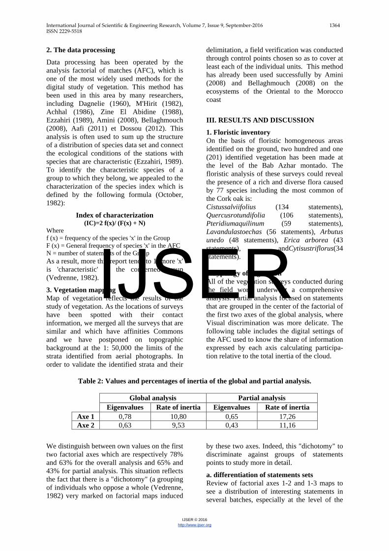
1. Floristic inventory On the basis of floristic homogeneous areas identified on the ground, two hundred and one (201) identified vegetation has been made at the level of the Bab Azhar montado. The floristic analysis of these surveys could reveal the presence of a rich and diverse flora caused by 77 species including the most common of the Cork oak is: Cistussalviifolius (134 statements), Quercusrotundifolia (106 statements), Pteridiumaquilinum (59 statements), Lavandulastoechas (56 statements), Arbutus unedo (48 statements), Erica arborea (43 statements), andCytisustriflorus(34 statements). 2.Typology of vegetation All of the vegetation surveys conducted during the field work underwent a comprehensive analysis. Partial analysis focused on statements that are grouped in the center of the factorial of the first two axes of the global analysis, where Visual discrimination was more delicate. The following table includes the digital settings of the AFC used to know the share of information expressed by each axis calculating participa- tion relative to the total inertia of the cloud.
Table 2: Values and percentages of inertia of the global and partial analysis.
Global analysis Partial analysis Eigenvalues Rate of inertia Eigenvalues Rate of inertia
Axe 1 0,78 10,80 0,65 17,26 Axe 2 0,63 9,53 0,43 11,16
We distinguish between own values on the first two factorial axes which are respectively 78% and 63% for the overall analysis and 65% and 43% for partial analysis. This situation reflects the fact that there is a "dichotomy" (a grouping of individuals who oppose a whole (Vedrenne, 1982) very marked on factorial maps induced
by these two axes. Indeed, this "dichotomy" to discriminate against groups of statements points to study more in detail.
a. differentiation of statements sets Review of factorial axes 1-2 and 1-3 maps to see a distribution of interesting statements in several batches, especially at the level of the
IJSER

International Journal of Scientific & Engineering Research, Volume 7, Issue 9, September-2016 1365 ISSN 2229-5518
IJSER © 2016 http://www.ijser.org
plan 1-2 which absorbs the maximum information (rate of inertia is 20,33% and 28.42% for the overall analysis and partial). On these plans, we identified six groupings, which are the following (figure 1 and 2): * Global analysis: -The group 'A', containing the following species: Fraxinusangustifolia, Salix humilis, Prunusavium, Quercusfaginea, Nerium oleander, Taxusbaccata, Celtisaustralisand Pistaciaterebinthus. -The group 'B', containing the following species: PistaciaAtlantica, Oleaeuropea var. sylvestris, Ceratoniasiliqua, Calycotomespinosa, Centranthuscalcitrapa, Ceratoniasiliquaand Asperulahirta.
* Partial analysis:
-The group 'C', containing the following species: Pteridiumaquilinum, Cytisustrifloru and Chamaeropshumilis. -The group 'D', containing the following species: Cistussalviifolius, Quercusrotundifolia, Erica arborea, Lavandulastoechas, Lavandulapedunculata, Phillyrealatifolia, Cytisustriflorus and UlexBoivinii.
-The group 'E', containing the following species: Arbutus unedo, Phillyrealatifolia, Quercuscanariensi, and Erica arborea.
-The group 'F', containing the following species: Lavandulastoechas, Cistussalvii- folius, CistuscrispusandThymus riatarum.Lavandulastoechas, Cistussalvii- folius, Cistuscrispus et Thymus riatarum.
IJSER

International Journal of Scientific & Engineering Research, Volume 7, Issue 9, September-2016 1366 ISSN 2229-5518
IJSER © 2016 http://www.ijser.org
(b) Interpretation of the axes
Interpretation were brought on the first two axes using the relative contributions of species, because all records and species are matched and the significance of the species is the same.
* Global analysis:
The observed sequence of natural groups along the first axis (F1) translated this axis may be interpreted as axis of soil moisture. From the negative side to the positive side of the axis, statements containing species riverine forest in the group 'A' that grow along streams where the soil moisture is high against surveys in areas of low humidity of the soil.
Axis 2 revealed two types of groups of species. The first group, on the negative side of the axis, corresponds to records located on clayey soils. Especially Fraxinusangustifolia, and Prunusavium species are indicators of this type of environment.
The second group, on the positive side, brings together records on rocky soils, which implies as well that this second axis translated the texture of the soil from the more clayey negative pole at the positive pole more Rocky.
* Partial analysis:
On the basis of the ecological value of species, the first axis can be interpreted in two ways. It shows the depth of the soil and the degree of
openness of the overstory, because on the negative side, meet species that thrive on shallow soils and under clear stands, while on the other side fall into order characteristic species of the deep soils and stands firm.
Along the second axis, the sequence found translated natural groups that this axis explains the exhibition, from the negative side to the positive side of the axis of North South exposures exposures.
1. description of vegetation
We recall first of all that our area belongs in phytosociological terms to the Querceteailicis class (. BR - BL. 1947) that is set for the whole of the Mediterranean region. This class groups in the forest of Bab Azhar all of forest and preforestiers groups. In fact, it brings together all the sclerophyllous formations (Benabid 2000). So, to characterize vegetation at the level of the Bab Azharmontado, we took into account the relative contributions of the species on the same poles of axes used to individualize these sets as well as the characterization of the species index.
-Fraxinusangustifolia (A) grouping: it is a group characterized by the following species: Fraxinusangustifolia (IC = 0, 93), Salix humilis (IC = 0, 73), Prunusavium (IC = 0, 57) and Quercuscanariensis (IC = 0, 45).
IJSER
International Journal of Scientific & Engineering Research, Volume 7, Issue 9, September-2016 1367 ISSN 2229-5518
IJSER © 2016 http://www.ijser.org
It corresponds to a group to ripiysilves that develop along the wadis (Dmnat, Azhar, Irhaleme...) and especially in the lower funds on intermediate to friable shale, clay-silty soils in loess, deep, little degraded and having a high humidity, strong enough slopes to strong rate, between 800 and 1200 m above sea level on an area of 159 ha or 2% of the total surface of the Oaks.
At the group level, we usually attend a high often clear and degraded oak Cork forest around the enclaves, where regeneration is almost non-existent to low.
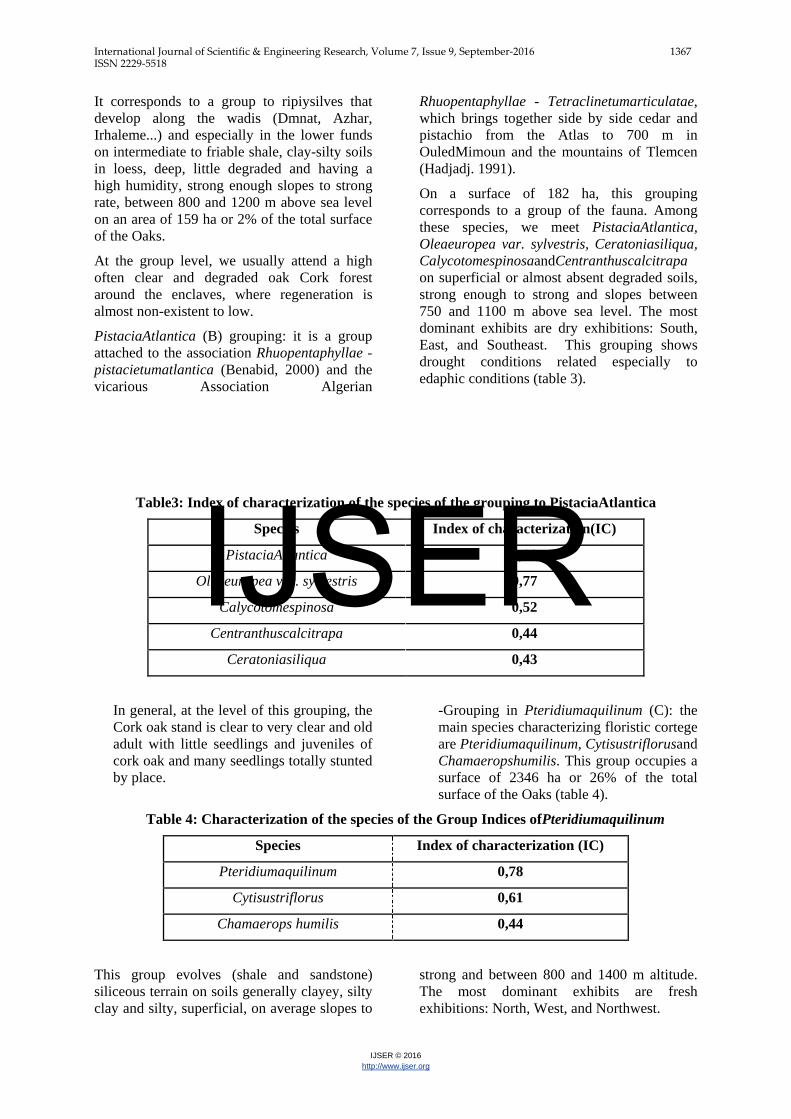
PistaciaAtlantica (B) grouping: it is a group attached to the association Rhuopentaphyllae - pistacietumatlantica (Benabid, 2000) and the vicarious Association Algerian
Rhuopentaphyllae - Tetraclinetumarticulatae, which brings together side by side cedar and pistachio from the Atlas to 700 m in OuledMimoun and the mountains of Tlemcen (Hadjadj. 1991).
On a surface of 182 ha, this grouping corresponds to a group of the fauna. Among these species, we meet PistaciaAtlantica, Oleaeuropea var. sylvestris, Ceratoniasiliqua, CalycotomespinosaandCentranthuscalcitrapa on superficial or almost absent degraded soils, strong enough to strong and slopes between 750 and 1100 m above sea level. The most dominant exhibits are dry exhibitions: South, East, and Southeast. This grouping shows drought conditions related especially to edaphic conditions (table 3).
Table3: Index of characterization of the species of the grouping to PistaciaAtlantica
Species Index of characterization(IC) PistaciaAtlantica 0,88
Oleaeuropea var. sylvestris 0,77 Calycotomespinosa 0,52
Centranthuscalcitrapa 0,44 Ceratoniasiliqua 0,43
In general, at the level of this grouping, the Cork oak stand is clear to very clear and old adult with little seedlings and juveniles of cork oak and many seedlings totally stunted by place.
-Grouping in Pteridiumaquilinum (C): the main species characterizing floristic cortege are Pteridiumaquilinum, Cytisustriflorusand Chamaeropshumilis. This group occupies a surface of 2346 ha or 26% of the total surface of the Oaks (table 4).
Table 4: Characterization of the species of the Group Indices ofPteridiumaquilinum
Species Index of characterization (IC) Pteridiumaquilinum 0,78
Cytisustriflorus 0,61 Chamaerops humilis 0,44
This group evolves (shale and sandstone) siliceous terrain on soils generally clayey, silty clay and silty, superficial, on average slopes to
strong and between 800 and 1400 m altitude. The most dominant exhibits are fresh exhibitions: North, West, and Northwest.
IJSER
International Journal of Scientific & Engineering Research, Volume 7, Issue 9, September-2016 1368 ISSN 2229-5518
IJSER © 2016 http://www.ijser.org
It presents a progressive dynamics. Indeed, reflecting advanced degradation transpar species tend to occupy the sunniest circles (Benabid, 2000). So the mutilation of the Bab Azharmontado resulted in the almost continuous training in Pteridiumaquilinum sometimes excluding the other species of the plant group, dotted with old and tortuous individuals of oak Cork with a generally low rate of regeneration by seedlings.
Of after Søndergaard (1969), training in Pteridiumaquilinum on deep and well fed soil water protect seedlings against strong sunstroke in the summer. However on North slopes, and in the empty strongly invade by ground of bracken, the Cork oak regeneration is compromised
-Grouping (D): Cistussalviifolius it appears throughout the cantons of the Bab Azhar Oaks
on a surface of 3469 ha. This group evolves on substrates generally siliceous, clay-silty soil to silty, Sandy by place, superficial, little degraded to very degraded, on average slopes to strong, between 600 and 1500 m altitude and under training generally identified. The most dominating exhibitions are hot exhibitions (South, East, Southeast and Southwest).
This group is characterized by the following species: Cistussalviifolius, Quercusrotundifolia, Erica arborea and Lavandulastoechas. Of after Hissein (1994), this grouping reflects ecological conditions increasingly bad (shallow, Rocky soils and strong runoff) thing that explains the low seeding rate in this environment.
Table 5: Indices of characterization of the species of the Cistussalviifolius grouping
Species Index of characterization (IC) Cistussalviifolius 0,78
Quercus rotundifolia 0,53 Lavandulastoechas 0,46
Erica arborea 0.41
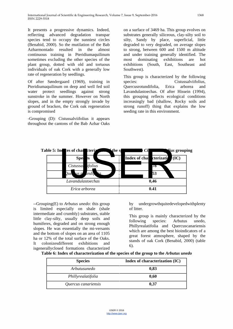
--Grouping(E) to Arbutus unedo: this group is limited especially on shale (shale intermediate and crumbly) substrates, stable little clay-silty, usually deep soils and humiferes, degraded and on strong enough slopes. He was essentially the mi-versants and the bottom of slopes on an area of 1105 ha or 12% of the total surface of the Oaks. It colonizesdifferent exhibitions and isgenerallyclosed formations characterized
by undergrowthquitedevelopedwithplenty of litter.
This group is mainly characterized by the following species: Arbutus unedo, Phillyrealatifolia and Quercuscanariensis which are among the best bioindicators of a great forest atmosphere, shaped by the stands of oak Cork (Benabid, 2000) (table 6).
Table 6: Index of characterization of the species of the group to the Arbutus unedo
Species Index of characterization (IC) Arbutusunedo 0,83
Phillyrealatifolia 0,60 Quercus canariensis 0,37
IJSER

International Journal of Scientific & Engineering Research, Volume 7, Issue 9, September-2016 1369 ISSN 2229-5518
IJSER © 2016 http://www.ijser.org
-Grouping (F) toLavandulastoechas: Besides that Lavandulastoechas, we encounter the following species Cistussalviifolius, Cistuscrispus and
Thymus riatarum, which are the main species characterizing the floristic cortege of this group (table 7).
Table 7: Index of characterization of the species of the grouping to Lavandulastoechas
Species Index of characterization (IC) Lavandulastoechas 0,55
Cistuscrispus 0,33 Cistussalviifolius 0,23 Thymus riatarum 0,23
This group evolves ground shale (shale intermediate and crumbly), on soil clay-silty, clayey and silty, usually deep, strong enough slopes to strong, between 700 and 1300 m altitude and on a surface of 1693 ha is 19% of the total surface of the Oaks. The most dominant exhibits are fresh exhibitions: North, West, and Northwest.
At the level of certain parcels and especially next to the enclaves, the strong pressure exerted by the riparian population through illegal logging, overgrazing or by the topping of trees, the grouping is in the process of matorralisation where the rate of regeneration of cork oak is almost nil. Moreover, althoughscattered State, naturalregeneration of Cork are.
As well, and according to the AFC, we have identified six plant communities that stand out for their floristic composition as well as their spatial distribution. Environmental factors involved significantly in the discrimination of vegetation (Ababouand al., 2009).This study reveals that the nature of soil (texture, depth and soil moisture), topography (exposure, altitude) and the degree of openness of the overstory are the determinants.
This look is relatively preserved. Arbutus unedo, Cytisustriflorus, Viburnum tinus, Phillyrealatifolia, Quercuscanariensis, grouped in the grouping to Arbutus unedo, are among the best bioindicators of a great forest atmosphere (Benabid, 2000) where the Cork oak stands in its ecological optimum.
Furthermore, based on the analysis of the areas occupied by each group, the Cistussalviifolius
(D) grouping is the most dominant, it occupies more than one-third of the total surface of the Oaks. This shows some degradation of the Oaks, which has brought about the occupation of the sunniest circles transpar species (Benabid 1976, Benabid, 2000,Aimé 1976, Arianoutsou&Margaris 1982, Meurer& al. 1986, Fennane 1987, Meurer 1988, Neff 1995, Bergmeir 1997 andFerrandis& al. 1999). Such as Cistussalviifolius, Genistatricuspidata, CalicotomespinosaandAmpelodesmosmauritanica. These species are found in one group plant by Zeddam (2007) at the level of the Oaks of the Senhadja-Gherbes in Algeria in the fire circles as well as by Aafi (2007) at the level of the OakspfMaamora in the Morocco where the found group is in the process of matorralisation due to the pressure exerted or under legal cuts undertaken by forest managers or illicit withdrawals by the riparian population. .
IV. CONCLUSION
The phytoecologic by the digital method (AFC) of the Bab Azharmontado study to highlight the diversity of vegetation of this ecosystem, which gives one of the best qualities of Cork to the Morocco. Today, the Oaks is subject to certain pressures, especially on its periphery and around the enclaves, something which justifies the need for conservation. Subsequent studies are needed to understand the pressure that is exerted on it in order to develop strategies for conservation of this ecosystem.
IJSER

International Journal of Scientific & Engineering Research, Volume 7, Issue 9, September-2016 1370 ISSN 2229-5518
IJSER © 2016 http://www.ijser.org
Figure 3: Map of vegetation of the Bab AzharOaks
IJSER

International Journal of Scientific & Engineering Research, Volume 7, Issue 9, September-2016 1371 ISSN 2229-5518
IJSER © 2016 http://www.ijser.org
REFERENCES
A.E.F.C.S. 1996 : Administration des Eaux et Forêts et la Conservation des Sols : Procès verbal d’aménagement de la forêt de Bab Azhar
Aafi A., 2011 :Evaluation de la biodiversité des écosystèmes naturels du Maroc: Etude de la diversité floristique de l'écosystème de chêne-liège de la forêt de la Maamora (Maroc), Editions Universitaires européennes, Sarrebruck, Allemagne, 169p.
Aafi A., 2007 :Etude de la diversité floristique de l'écosystème de chêne-liège de la forêt de la Maamora (Maroc), Thèse Doct,, Es -Sc, Agronomiques, IAV Hassan II, Rabat, 190p.
Ababou A, Chouieb M, Khader M, Mederbal K, Bentayeb Z, Saidi D, 2009 : Analyse des associations végétales de la plaine salée du Bas-Cheliff, Algérie. Acta Biol. Par., Curitiba 38 (1-2) : 75-91.
Achhal A., 1986 : Etude phytosociologique et dendrométrique des écosystèmes forestiers du bassin versant du N’Fiss (Haut Atlas central), Thèse de doctorat, Faculté des sciences St Jérôme, Aix Marseille III, 204p.
Aimé, S. 1976: Contribution à l’étude écologique du chêne-liège. Etude de quelques limites. Thèse Doct. – Nice.
Amini T., Khattabi A., Ezzahiri M. et Zine El Abidine A., 2008 : Cartographie des groupements végétaux des sites : lagune de Nador, commune de Beni Chiker et commune de Boudinar, Projet ACCMA, ENFI, Salé, Maroc, 46P.
Arianoutsou, M. &Margaris, N. S. 1982: Phryganic (east mediterranean) ecosystems and fire. –Ecol. Medit. 8(1/2): 473-480.
Bellaghmouch F.Z., Ezzahiri M., Khattabi A., Belghazi B. 2008 : Descriptionécologique du site Saaidia-Ras El Ma, Projet ACCMA, ENFI, Salé, Maroc, 29P.
Benabid, A. 1976: Etude écologique, phytosociologique et sylvo-pastorale de la tetraclinaie de l’Amsittene. Thèse Doct. – Marseille.
Benabid A., 2000 : Flore et Ecosystèmes du Maroc, Evaluation et Préservation de la Biodiversité, Presse de Kalila Wa Dimna, Rabat, Maroc, 359 p.
Bergmeier, E. 1997: Combined effects of fire and grazing on phrygana vegetation - a case study in SW Crete (Greece). – Ecol. Medit. 23(3/4): 1-10.
Braun-Blanquet, J. 1932. Plant sociology: the study of plant communities. McGray Hill, New York, 439p.
Braun-BIanquet J., 1947 : Les groupements végétaux supérieurs de la France.
Dagnelie P., 1960 : Quelques problèmes statistiques posés sur l’analyse factorielle en phytosociologie, Institut agronomique Gembloux, 430-437p.
Dossou M. Etienne1, Lougbégnon O. Toussaint, Houessou G. Laurent, Teka S. Oscar, Tente A.H. Brice 2012 : Caractérisation phytoécologique et structurale des groupements végétaux de la forêt marécageuse d’Agonvè et de ses milieux connexes au Sud-Bénin, J. Appl. Biosci53: 3821 – 3830, 10p.
Ezzahiri M., 1989 : Application de l’analyse numérique à l’étude phytoécologique et sylvicole de la cédraie de Sidi M’Guild. Thèse de Doctorat. Es-sciences, Agronomique I.A.V. Hassan II, Rabat. Maroc, 147p.
Ferrandis, P., Herranz, J. & Martinez-Sanchez, J. 1999: Fire impact on a maquis soil seed bank Cabaneros national park (Central Spain). – Israel J. Pl. Sci. 47: 17-26.
IJSER

International Journal of Scientific & Engineering Research, Volume 7, Issue 9, September-2016 1372 ISSN 2229-5518
IJSER © 2016 http://www.ijser.org
Guinochet M., 1973 : Phytosociologie. Ed. Masson et Cie., Paris, France, 277 p.
HCEFLCD, 2011 : les techniques de classement et indice de qualité du liège, Haut Commissariat aux Eaux et Forets et à la Lutte Contre la Désertification, Maroc, 7P.
HADJADJ AOUL S., 1991 : Les peuplements de Tetraclinaisarticulata sur le littoral d’Oran (Algérie). Écol. médit., XVII, 63-78.
HISSEIN H., 1994 : Evaluation de la régénération naturelle par semis dans la subéraie de Bab Azhar à l’intérieur des parcelles clôturées, Mémoire de 3ème cycle, ENFI, 72p.
M’hirit O., 1982 : Le cèdre de l’Atlas. Répartition. Croissance et traitement sylvicole. Texte à publier aux actes du XIX congrès mondial de l’IUFRO. Montréal, Canada, 17p.
Metro A. et Sauvage Ch., 1955 : Flore des végétaux ligneux de la Mâamora, Rabat, 498 p.
Meurer M. & Steinbach J.,1986: Effects of goat browsing on some floristic component in the Maquis and garrigue of Northern Tunisia. – Pp. 132-133 in: Proceedings of the 2nd International Rangeland Congres I, Adelaide 1984. – Canberra.
Neff C., 1995: Feux de forêts dans les paysages de garrigues méditerranéennes, méthodes d’évaluation des risques du potentiel dangereux. Exemplede la Vaunage (Midi français). – Bul. Soc. Nat. Nîmes et Gard. 60: 58-65.
Sondergaard P., 1969 : Essai de semis de chêne liège (Quercus suber L.) dans la forêt de Babazhar. Une subéraie de montagne. Ann. Rech. Forest. Tome 25. pp : 16-29, Rabat.
Vedrenne G., 1982 : Analyse multi variable et la mise en évidence d’indicateurs biologiques, Application à l’étage méditerranéen de Provence calcaire. Thèse de doctorat Université de droit, d’économie et des sciences d’Aix-Marseille, 110 p.
Zeddam A., Meurer M. &Neff Ch., 2007: Impact des activités humaines sur la végétation de la forêt des Senhadja-Gherbès, Skikda, Algérie. Bocconea 21: 283-289.
Zine El Abidine A., 1988 : Analyse de la diversité phytoécologique des forêts du chêne zeen (Quercus ja
IJSER