oil exploration in the dreki area on the jan mayen ridge
TRANSCRIPT

Oil exploration in the Dreki area on the Jan Mayen Ridge
Proposal for a plan to offer exclusive exploration and production licences for oil and gas in the Dreki area (Dragon area) on the
Jan Mayen Ridge, northeast of Iceland and a Strategic Environmental Assessment (SEA) of the proposed plan
Ministry of Industry March 2007

2
Table of content
Executive summary ...................................................................................................................................... 4 1. Introduction ............................................................................................................................................ 14
1.1. Working methods, gathering of data and other preparation...............................................................15 1.2. Organisation of the report ..................................................................................................................18
2. Plan for prospecting, exploration and production of oil in the northern part of the Dreki area .... 20 2.1. Demarcation of the area covered by the plan.....................................................................................20 2.2. Possible operations and progression ..................................................................................................23 2.3. Possible field and production scenarios in the Dreki Area ................................................................23 2.4. Onshore infrastructure .......................................................................................................................27
2.4.1. Onshore service centre...............................................................................................................27 2.4.2. Maritime transport services .......................................................................................................27 2.4.3. Helicopter operations ................................................................................................................27
2.5. Possible impact factors ......................................................................................................................27 2.6. Timetable ...........................................................................................................................................27
2.6.1. Current preparation...................................................................................................................27 2.6.2. Preparation for the licensing process ........................................................................................27 2.6.3. Planned progress of prospecting, exploration and production..................................................27
2.7. Alternatives........................................................................................................................................28 2.8 Next steps ...........................................................................................................................................28
3. About strategic environmental assessments ......................................................................................... 30 4. Legal framework and administration................................................................................................... 31
4.1. Licenses to prospect, explore and produce hydrocarbons..................................................................31 4.1.1. License to prospect.....................................................................................................................31 4.1.2. Exploration and production license ...........................................................................................32 4.1.3. Other licences and obligations of licensees according to the Hydrocarbon Act........................32
4.2. Administration related to prospecting, exploration and production of oil and gas ............................34 4.2.1. List of legislation related to prospecting, exploration and production of oil and gas ...............34
4.3. Taxes and fees....................................................................................................................................37 4.4. The Jan Mayen Agreement ................................................................................................................37
5. Economical impact ................................................................................................................................. 38 6. Health, safety and environmental issues............................................................................................... 41 7. Geology of the Jan Mayen area and indications of oil and gas prospects.......................................... 42
7.1. The opening of the North Atlantic and Stratigraphy of the Jan Mayen Ridge...................................42 7.2. Hydrocarbon potential of the Jan Mayen area ...................................................................................43
7.2.1. Indications of oil and gas...........................................................................................................45 7.2.2. Resource estimate ......................................................................................................................45
8. Climate and oceanography .................................................................................................................... 47 8.1. Climate and pack ice..........................................................................................................................47
8.1.1. Daylight conditions ....................................................................................................................47 8.1.2. Air temperature..........................................................................................................................47 8.1.3. Precipitation ..............................................................................................................................48 8.1.4. Fog and visibility .......................................................................................................................48 8.1.5. Wind currents.............................................................................................................................49 8.1.6. Pack ice......................................................................................................................................49 8.1.7. Icing ...........................................................................................................................................50
8.2. Sea temperature, wave heights and ocean currents............................................................................50 9. Biological resources in the northern part of the Dreki Area .............................................................. 55
9.1. Marine biota and exploited fish stocks ..............................................................................................55 9.1.1. Marine chemistry .......................................................................................................................55 9.1.2. Phytoplankton ............................................................................................................................56 9.1.3. Zooplankton ...............................................................................................................................56

3
9.1.4. Benthos.......................................................................................................................................57 9.1.5. Fish stocks..................................................................................................................................57
9.1.5.1. Capelin ............................................................................................................................................... 58 9.1.5.2. Herring ............................................................................................................................................... 59
9.1.6. Whales........................................................................................................................................61 9.1.7. Seals and polar bears.................................................................................................................61 9.1.8. Summary and conclusions..........................................................................................................61
9.2. Birdlife in the northern part of the Dreki area on the Jan Mayen Ridge............................................63 9.2.1. Summary ....................................................................................................................................66
10. Other activities in the Dreki Area ....................................................................................................... 68 11. Evaluation of the plan's possible environmental impact................................................................... 69
11.1. Introduction......................................................................................................................................69 11.2. Environmental impact......................................................................................................................69
11.2.1. Prospecting ..............................................................................................................................69 11.2.1.1. Description of operations ................................................................................................................. 69 11.2.1.2. Environmental impact ...................................................................................................................... 69 11.2.1.3. Licenses, surveillance and monitoring ............................................................................................. 70
11.2.2. Exploration ..............................................................................................................................71 11.2.2.1. Description of operations ................................................................................................................. 71 11.2.2.2. Environmental impact ...................................................................................................................... 71 11.2.2.3. Licenses, surveillance and monitoring ............................................................................................. 73
11.2.3. Production................................................................................................................................73 11.2.3.1. Description of operations ................................................................................................................. 73 11.2.3.2. Environmental impact ...................................................................................................................... 74 11.2.3.3. Licenses, surveillance and monitoring ............................................................................................. 75
11.2.4. Decommissioning .....................................................................................................................76 11.2.4.1. Description of operations ................................................................................................................. 76 11.2.4.2. Environmental impact ...................................................................................................................... 76 11.2.4.3. Licenses, surveillance and monitoring ............................................................................................. 76
11.3. Preparedness and organisation of response to acute marine pollution .............................................76 11.4. Summary of possible impacts ..........................................................................................................78 11.5. Development and events if exploration and production of oil in the Dreki area do not happen ......81
12. Conclusions ........................................................................................................................................... 82 12.1. Environmental impact......................................................................................................................82 12.2. Existing knowledge..........................................................................................................................84 12.3. Proposals for further data collection ................................................................................................86 12.4. Overall conclusions..........................................................................................................................87
References ................................................................................................................................................... 88 List of supporting documents and background information ................................................................ 100

4
Executive summary The Ministry of Industry hereby submits for public discussion and comments this report which includes a proposal for a plan to issue exclusive licenses for exploration and production of oil and gas in the northern part of the Dreki area on the Jan Mayen Ridge, along with a strategic environmental assessment of the proposed plan.
This report, with the proposed plan for oil exploration in the Dreki area and the strategic environmental assessment, will be presented to the general public and other stakeholders, with a request for their comments. The deadline for submitting comments is 23 May 2007. The deadline for comments has been extended to 16 July 2007.
Preparation of the proposed plan and the environmental report The proposal for this plan and the environmental report were prepared in close consultation and cooperation with eight ministries and 12 government agencies on the basis of two resolutions passed by the Icelandic Government in 2005 and 2006. The results of that work, which is presented in this report, includes a review of the existing legal frame and health, safety and environmental issues, as well as an evaluation of potential hydrocarbon resources in the Dreki area on the basis of current knowledge. Furthermore, an assessment on the geology, biota and climate in the Dreki area, and a strategic environmental assessment of the plan were prepared in accordance with the Act on the strategic environmental assessment of plans. An assessment has also been made of what important information is lacking, along with proposed remedies. The main conclusions from this work can be found in this report; in addition, references are made to supplementary materials for further information.
Strategic environmental assessment of plans and environmental impact assessment of operations The report evaluates the effect of the plan on the environment in accordance with Act No. 105/2006 on strategic environmental assessment of plans which transposes the European Union’s Strategic Environmental Assessment (SEA) Directive into Icelandic law. It is important to keep in mind that the strategic environmental assessment of a plan is not intended to be as exhaustive as the environmental impact assessment required for individual projects involving prospecting, exploration and production of oil if the plan is approved. Both exploration and production drilling are, for example, operations requiring environmental impact assessment in accordance with Act No. 106/2000 on environmental impact assessment which transposes the European Union’s Environmental Impact Assessment (EIA) Directive into Icelandic law.
The proposed plan According to the proposal, the plan entails granting exclusive licenses for exploration and production of oil and gas in the northern part of the Dreki area, which covers about 42,700 km². An international agreement between Iceland and Norway on the continental shelf between Iceland and Jan Mayen applies to part of the area, and this part covers 12,720 km² or almost 30% of the area.
Three alternatives are presented in the report: 1. To offer exclusive exploration and production licenses throughout the northern
part of the Dreki area in accordance with the proposed plan. 2. To limit the proposed licensing area to the most prospective areas.

5
3. Not to issue any exclusive exploration and production licenses in the area, either temporarily or for the indefinite future.
Demarcation of the area covered by the plan The northern part of the Dreki area refers to an ocean area in the Icelandic exclusive economic zone which is lying east of 11.5° W and north of 67° N and is demarcated to the east and north by Iceland’s 200-mile exclusive economic zone.
Exploration of the area's geology and evaluation of possible oil and gas resources The report discusses the geology of the Dreki area and presents the first evaluation of hydrocarbon resources in the area on the basis of geological data. The current research done on hydrocarbon resources in the area entails geophysical measurements (including seismic surveys) carried out under the auspices of the Icelandic and Norwegian governments as well as seismic data acquired by privately owned oil exploration companies, and the results look promising regarding the possibility that a economically recoverable quantity of oil and gas may be found there. However, further exploration, including exploratory drilling, is required to verify whether oil will be found in the area.
Construction related to prospecting, exploration and production of oil and gas Prospecting, exploration and production of oil and gas entail various kinds of construction and effects.
The prospecting phase does not require direct construction in the area but temporarily results in increased ship traffic in a relatively remote and unfrequented area. The prospecting phase mostly involves ship traffic, with vessels sailing predetermined routes doing seismic surveys (i.e., transmitting sound waves to the bottom and measuring their reflection), in addition to limited sampling from the surface layers of the ocean floor. The measures can last for several months during the summer, but they are geographically confined and temporary.
The exploration phase entails operations and construction in the prospecting area in addition to continuing measurements falling under the prospecting phase. The exploration phase specifically involves exploratory drilling, which is a complicated operation under the circumstances prevailing in the area. The drilling is done either from special drilling ships or drilling platforms floating in the sea. After the exploratory drilling is finished, diverse testing of the well. Possible pollution from such operations must therefore be assumed from the outset, in addition to the operations' effects on the environment. If exploratory drilling is promising, it may be advantageous to set up production equipment and necessary support facilities.
Production of oil or gas from sedimentary layers lying at a great depth is a technically difficult and complicated industrial activity that can have diverse effects on the surrounding environment. Drilling, pipes, the handling of oil and/or gas, activities aboard a production unit, living quarters for employees and other habitation, logistics, pollutants coming up with oil or used in the production processes, handling of waste and transport of oil from the production area are all sources of pollution and other environmentally damaging effects that must be kept in mind from the beginning. The drilling of production wells is not much different from the drilling of exploratory wells, which has already been discussed. Undersea construction, such as the laying of pipelines and build-up of various structures like pumping stations, has a direct impact on the ocean floor and the living conditions of benthic species in the area.

6
There are various factors of uncertainty regarding this plan. For example, there is uncertainty about how much interest oil companies have in prospecting for oil and gas in the area, and whether a recoverable quantity of oil and gas will be found in the area. No precise determination has been made of what methods will be used for drilling or production, if any, in the area, but this plan provides for strict antipollution requirements to counteract pollution of the environment; in addition, there will be strict requirements regarding safety since the conditions in the area are difficult. In addition, many questions will not be answered until evaluation is made of the environmental impact of individual operations in the area, such as the environmental impact assessment of particular wells. However, there do not appear to be any technological limitations to producing oil and gas in the area if such resources should be found there. Proven and cost effective technologies are presently available and may be further improved before developments offshore Iceland will be realised
Scenarios of the possible progress of prospecting, exploration and production Because of uncertainty regarding the possible progress of prospecting, exploration and production of oil and gas in the northern part of the Dreki area, the oil and gas exploration and production consultancy group Sagex AS prepared a report for the Ministry of Industry, part of which presented four scenarios on the possible development of exploration and production in the area. One scenario assumed that no oil or gas was found in the area, but in three instances the assumption was that varying quantities of oil were found, and in one of the instances it was also assumed that a sufficient quantity of gas was found to justify piping it to land and building up a production plant to compress and ship the gas.
Sagex estimated the cost of prospecting and exploration to be 15-26 billion Icelandic króna (ISK), based on the various scenarios regarding the number of exploratory wells. If oil or gas were found in the area, the initialisation cost of producing oil and gas and the preparations involved for doing so could range from ISK 200 billion to ISK 580 billion, based on various scenarios on the total quantity of oil and gas in the area; in addition, the annual operating costs of production could be in the range of ISK 6-17 billion.1 These amounts are based on the price level for 2005, but the initialisation cost has greatly increased since then. Exploitation of both oil and gas appears possible and to be commercially attractive, indicating a strong incentive to explore the Jan Mayen Ridge. The limit size for possible economic exploitation of an oil field is in the region of 10-20 million standard m3 of oil.
Legal framework Accompanying the plan is an evaluation of the legal and administrative framework in the areas involved in the activities of prospecting, exploration and production of oil and gas. Clearly, some amendments to laws and regulations are required if the decision is made to grant exclusive licenses for exploration and production. Many instances involve simple amendments, for example, to ensure that the scope of current law covers the planned activities.
Relation of the plan to domestic policy formulation and international agreements The main government plans related to the oil exploration plan are a policy on sustainable development and a strategy on the ocean, and the oil exploration plan is in accordance with the policy formulation set out there. 1 The meaning of the term billion in the English translation of this report is thousands of millions.

7
Iceland has ratified a number of international agreements which address either directly or indirectly the environmental impact of prospecting, exploration and production of petroleum substances. The main agreements are the OSPAR Convention on protection of the Northeast Atlantic, MARPOL 73/78, a protocol related to the International Convention for the Prevention of Pollution from Ships, and the European Economic Area (EEA) Agreement. The main provisions of the OSPAR Convention were incorporated into Icelandic law through Act No. 7/1998 on hygiene and antipollution measures and Act No. 33/2004 on marine and coastal antipollution measures. The provisions of the MARPOL Protocol and its annexes form the basis of Act No. 33/2004 on marine and coastal antipollution measures, as well as regulations that have been set under the authority of the act. Furthermore, on the basis of the EEA Agreement, EU directives and regulations that are intended to reduce the environmental impact of oil operations, e.g. through regulations and standards for operating companies, have been transposed into Icelandic law.
Taxes and fees When making decisions about fees and the collection of taxes, it is important, on one hand, to ensure that an acceptable dividend from oil operations will accrue to the Icelandic State and, on the other, that the combined collection of taxes on oil operations in Iceland do not exceed what is common in Iceland's neighbouring countries, to ensure that the tax environment in Iceland will be fully competitive vis-à-vis neighbouring countries.
A special working group under the leadership of the Ministry of Finance was established to consider taxes and fees related to oil operations in Iceland's neighbouring countries, and this work is still in progress. One of the biggest issue that has to be decided before licenses are granted for exploration and production of oil and gas is whether to levy a special tax on the profit of such operations in Iceland, as has been done in some other countries; in addition, consideration must also be given to whether production fees should be collected and if the Icelandic State should take part of licenses.
Economic impact The discovery of economically recoverable quantity of oil and gas on the Jan Mayen Ridge could have a strong economic impact on the Icelandic economy. Domestic production could rise considerably at the peak of operations and production in the oil sector. The revenues of the State Treasury can be expected to increase substantially. In this regard it is possible that a specific resource tax would be levied on the sector, in addition to the general 18% corporate tax. Revenues from this taxation could be channelled into a special oil fund. The government's expenditures related to the oil sector will probably be a small fraction of the revenues expected to flow into the State Treasury from direct taxes. The external balance of the national economy, i.e., the balance of trade and the balance of payments vis-à-vis other countries, could fluctuate, which would be manifested in an increased deficit and indebtedness during the period of build-up of the oil sector. However, a turnaround can be expected in this area when full oil production is reached. Internal balance could be disturbed by increased inflationary pressure and possible ripple effects through a stronger exchange rate of the Icelandic króna. Offsetting such effects entails the use of traditional monetary and budgetary instruments; in addition, the establishment of a special oil fund, as mentioned above, could be considered.

8
Security and work safety It is important that the companies obtaining licenses to engage in oil exploration or begin oil production and related activities on Iceland's continental shelf manage their environmental matters and issues regarding work safety in conformity with the best practices. In this regard, all tasks are important, whether they involve prospecting, testing wells, experimental production if oil or gas is found, setting up production plants if oil or gas resources prove to be in economically recoverable quantity, production, storage and transport of oil or gas, or decommissioning and cleanup in a production area when production is finished. Provisions shall be made for ensuring the safety and health of employees through efficient management of work safety affairs. This, in short, entails preparation of risk assessments for tasks, systematic preparation of preventive measures, preparation of a safety and health plan, and there shall be active internal monitoring at companies engaged in oil exploration and production. In this way, their experience and knowledge shall be utilised as much as possible. The Administration of Occupational Safety and Health shall follow up on whether the companies fulfil their obligations in this regard.
Response to illness and accidents Despite the Jan Mayen area being in the Coast Guard's search and rescue area, a license holder is obligated to ensure employees' safety by providing them with medical services and a means of transport to hospital in the event of illness or accident. A license holder must also see to it that there is rescue equipment in the area. Because of this, exploration and production companies have entered into search and rescue (SAR) agreements with third parties. Response to pollution Today the Coast Guard operates two Coast Guard ships that have no antipollution equipment. A new Coast Guard ship is expected in 2009, and a tender offer provides for its being equipped with antipollution equipment and tanks to take on polluted sea water. The Coast Guard's current surveillance airplane does not have technical equipment to detect pollution, but such equipment will be in a new surveillance airplane that was tendered in 2006.
The Environment and Food Agency is responsible for responding to acute pollution within Iceland's pollution control zone (and exclusive economic zone). Regarding responses, the agency works closely with the Icelandic Coast Guard and Iceland Maritime Administration, in addition to various kinds of consultants, for example, the Marine Research Institute. The Environment and Food Agency has also taken part in diverse intergovernmental collaborations regarding readiness and response to acute pollution.
Responses to pollution accidents can be divided into three categories, according to the scope of the pollution. If a relatively small and demarcated mishap is involved, it can be assumed that employees will take care of it, i.e., if measures are deemed necessary at all. If the incident proves to be larger than is possible to control with the manpower and equipment at the location, response parties will come out from the land. Because of the location, such assistance can come from two directions, on one hand, from Iceland, but it is also possible that calling for assistance from Norway would be more suitable, especially in instances where a pollution accident's scope proves to be great, requiring a lot of equipment and expertise. Iceland is a member of a collaboration of European states

9
on readiness and response to acute pollution accidents, and the Environment and Food Agency can request equipment and expert assistance as needed.
Climate and condition of the sea The average temperature in the northern part of the Dreki area is below 10°C year-round, but the period January through March is usually coldest (average temperature -2°C to 0°C). The month of August is usually warmest (average temperature 7°C to 8°C). There is frequent precipitation, especially in the fall and winter. The average annual precipitation is near 700 mm, which is less than in Reykjavík. The distribution throughout the year is similar to the closest coastal areas of Jan Mayen and in Iceland's East Fjords. Precipitation, in the form of rain, sleet and snow, is quite heavy in the winter low pressure systems. If the temperature is close to freezing, the snow can form icing on the windward side of structures. Observations from weather stations in Iceland and Jan Mayen indicate that fog is the most common impairment to visibility in the northern part of the Dreki area, and it is most frequent in the summer. Precipitation, especially snow, can cause poor visibility in the winter. From December to March the average wind speed is about 10 m/s and about 6 m/s in the summer.
Sea temperature in the Dreki area is about 0°C to 1°C during the winter, but up to 7°C in late summer. Most of the time the sea surface temperature is higher than air temperature, because of the advection of cool air from the north. This difference in temperature between the air and the sea is, however, negligible during the summer.
It seems that the wave height in the Dreki area is generally significantly lower than in the area south and west of Iceland or at the west coast of Norway. In the Dreki area the wave height reached once in 100 years is about 12 m, while the corresponding wave height off the west coast of Norway is 14 to 16 m. The mean of the highest wave height reached in the Dreki Area once a year, as well as the waveheight reached in 98% of cases, is around 5-6 m.
Little pack ice has drifted into the area in recent decades although the pack-ice period 1965 to 1971 is an exception. The southwest corner of the area has nevertheless been free of ice during this time. Icing creates temporary problems during the winter, but its frequency varies greatly from year to year, and increased frequency is related to the periods characterised as pack-ice years. Increased probability of heavy icing is associated with spindrift in sharp northerly winds. The main weather related difficulties for oil production in the northern part of the Dreki area are considered to be the risk of icing in the winter and lack of good visibility (more likely in the summer). There are proposals for further meteorological observations in the area.
Biota No islands or skerries rise out of the sea in the Dreki area, and the biota in the northern part of the area is therefore primarily in the ocean, but birds also go through looking for food or passing over on their way to other areas. Commercial fisheries are related solely to fish stocks, especially pelagic species.
Large changes have occurred in the biota of the ocean area between Iceland and Jan Mayen in recent decades. The changes are associated with the shifting equilibrium between cold currents to the north and the flow of the Atlantic sea north of Iceland around the West Fjords. These changes have then been reflected in changes occurring, for example, in the distribution and migration pattern of herring in the 1960s and changes in

10
the migration pattern of capelin in recent years. There is little information about the hydrography and currents in the Dreki area. The picture we have of the system of currents in the area and its surroundings builds on indirect observations of the specific gravity distribution and sea surface elevation. On the other hand, direct current measurements are lacking.
The biomass of zooplankton is greater near the Dreki area than in most places around Iceland. The area is an important feeding ground for organisms nourished by zooplankton, like pelagic fish, especially herring and probably capelin, but it is also important for whales.
There are several samples of benthic species in the Dreki area that show great variability in the type of bottom and benthic communities. There are many sensitive benthic species in the north seas that are confined to specific features on the sea bottom. Any disturbance of the bottom can have a serious effect on the species' communities. It is therefore necessary to map the area likely to be disturbed because of operations, especially with respect to sensitive or rare habitats and species.
There is no information available about the demersal fish in the area. Part of the explanation can be that the area is not near any known fishing area and is rather deep. On the other hand, there is a possibility that delimited stocks of deep-sea fish are there. Such stocks have been found under similar conditions off the continental shelf south and west of Iceland.
The whale counts that have been done do not detect possible changes in the distribution of whales caused by activities in so small an area as that of the oil exploration area. For this purpose much tighter search lines and more frequent counts would be required. It is most efficient to make such counts from an airplane, but ships and other surveillance trips in the area could also be utilised. During such trips, skin samples could also be collected for genetic analysis to cast light on the whale stocks' types, which is important in evaluating the potential impact on stocks.
The number and distribution of seals in the Dreki area depends primarily on the presence of pack ice there, but the edge of the pack ice in recent decades has been at a considerable distance to the west of the Dreki area.
The Dreki area is probably traversed by dozens of species of sea birds over the entire year. It can also be assumed that each species shows great variability in distribution and number depending on the season, how long they remain in the area, the feeding conditions, and where suitable food is each time, depending on the ice conditions, etc. Based on the available knowledge, it can be assumed that the most common species in the contemplated oil area are fulmar, black-legged kittiwake, Brünnich's guillemot, common guillemot, puffin, razorbill and little auk. These species are among the most common ones in the North Atlantic.
Impact on fisheries Insofar as known, no attempts at fisheries of demersal fish stocks have been made in the northern part of the Dreki area, and knowledge is therefore scarce regarding demersal fish in these areas. Pelagic fish generally frequents a much larger area than demersal fish, and their migrations vary from year to year. Capelin has not been caught in the northern part of the Dreki area over the last several years. On the other hand, herring from the Atlanto-Scandic herring stock in the area has generally been caught every third or fourth year on

11
average, according to the experience obtained since 1994. The greatest quantity caught in the area was in 1998, nearly 4800 tons, versus about 1500 tons in 1996.
Impact on maritime and air transport and other activities Oil exploration activities in the Dreki area should not affect maritime transport, as the main sailing routes for transport ships or tankers to the North American continent from the area north of Norway lie both to the south and north of Iceland, and these two routes pass, for the most part, on each side of the northern part of the Dreki area. Oil exploration activities in the Dreki area should not affect flight routes, and no other activities are known in this area that could be affected by prospecting, exploration and production of oil.
Strategic environmental assessment of the proposed plan In parallel with preparation of the plan, a strategic environmental assessment of the plan has been carried out in accordance with Act No. 105/2006 on strategic environmental assessment of plans. The possible environmental effects of prospecting, exploration and production of oil and gas in the northern part of the Dreki area were evaluated along with the risk of accidents, and the monitoring required, should the plan be approved. It is important to keep in mind that a strategic environmental assessment of a plan is never as exhaustive as an environmental impact assessment of the environmental effects of construction that may be required because of particular aspects of these activities. Those aspects, e.g., exploratory and production drilling, are subject to licensing and call for an exhaustive assessment of their environmental impact in accordance with Act No. 106/2000 on environmental impact assessment.
The processes of prospecting, exploration and other preparations for the production of oil and gas from the ocean floor are long and complex since every single aspect impacts the environment. If the results of exploration are positive, and economically recoverable quantity of oil or gas is found in the ocean area, this adds to the scope. Oil production is a polluting activity that has an impact on the environment, especially if accidents occur, and oil streams out into the ocean. On an international scale such activities are in fact well monitored and international agreements and diverse international collaborations aim at minimising the environmental impact and reducing pollution of the ocean, air and biota. Here, the process of preparation, construction and operations are divided into four distinct phases: Prospecting, exploration, production and decommissioning.
The conditions in the Dreki area are special in many ways, and knowledge about environmental factors in the area is limited. It is therefore necessary to execute preparatory explorations carefully and ensure that antipollution measures, readiness and organisation of responses are based on these circumstances. The most modern technology must be applied, and the safety of employees and the environment must be kept especially in mind. Under the auspices of the OSPAR Convention on protection of the Northeast Atlantic, numerous resolutions, directions and instructions have been approved on prospecting, exploration and production of oil and gas from the ocean floor, and considerable work with the same aims has likewise been done under the auspices of the Arctic Council, including guidelines and policy formulation on ways and criteria.
The prospecting phase is accompanied by little, if any, construction; the activities are rather based on measurements with the assistance of seismic surveys, in addition to demarcated sampling from the top layers of sea bed. The main environmental impact is noise from an air gun used during the measurements. Research has shown that whales

12
avoid the noise and alter their diving pattern for a distance from the source of up to 20 km. Since this involves a limited and demarcated activity, no special measures are deemed necessary because of this.
The exploration phase entails direct operations on the ocean floor since exploratory wells are drilled, either from a drilling ship or from drilling platforms floating in the sea. After the drilling is finished, diverse experiments and testing follow, especially if the drilling produces results. The timing of the drilling must be kept in mind since the biota of the area flourishes greatly at the height of summer. On the other hand, the risk of drilling accidents increases in the winter. The substances used in connection with drilling, exploration and production are monitored
Production The drilling of production wells is not much different from drilling exploratory wells. On the other hand, oil production involves extensive operations and build-up that must be thoroughly considered before being initiated. Subsea operations have direct impact on the ocean floor and the living conditions of benthic species in the area. The release of substances from production deteriorates the quality of the ocean space. The installation and operation of production equipment entails considerable emission of gases into the atmosphere, for example, because of power generation, burning of excess gas, testing of wells, leaks of wandering organic gases, traffic from supply ships and other logistics.
At this stage, it is not known whether special provisions must be made in the area beyond the relevant general provisions of international agreements and Icelandic law. The main risk regarding the environmental impact of prospecting, exploration and production of oil in the Dreki area is related to possible accidents, e.g., if a blow-out occurs; accidents occur in storage of the oil or an oil tanker is damaged so that a sizeable acute pollution incident happens in the area although such accidents are extremely rare.
Decommissioning of production equipment is an inseparable part of the production, and it must therefore be kept in mind when organising and building up the operations. There could be quite a bit of environmental impact from the decommissioning: disturbance of the ocean floor, noise, pollution from production remains and from the machinery used during the operations.
Conclusion of the strategic environmental assessment of the plan. The environmental impact of prospecting, exploration and production of oil and gas increases with each phase. It is completely uncertain how possible license holders will plan their operations, and while this information is not available, there is no basis for a detailed discussion of environmental impact until during the process of environmental impact assessment and licensing. Each phase goes through a licensing process aimed at minimising environmental impact, for example, by making requirements on antipollution measures, limiting the use of hazardous substances, work processes and active internal monitoring. Oil production is a polluting activity, but damaging effects can be limited with purposeful internal monitoring, strict requirements in operating licenses, monitoring of the activities and surveillance of the environment. An Arctic region is involved where taking special precautions is necessary, taking into account international agreements applying to such regions, and it is therefore necessary that antipollution measures, readiness and organisation of responses be based on these circumstances. The most modern technology must be applied, and the safety of employees and the environment must especially be kept in mind.

13
The main risk regarding the environmental impact of prospecting, exploration and production of oil in the Dreki area is related to possible accidents, e.g., if a blow-out occurs, accidents occur in storage of the oil or an oil tanker is damaged so that a sizeable pollution incident happens in the area, although such accidents are extremely rare.
Conclusions and proposals After having considered the information available on environmental factors in the area and the possible effects on the environment of granting licenses by definition, description and evaluation of the probable substantial environmental impact of implementing the plan, it is recommended that this plan, along with the environmental report, be approved by the Government, and on the basis of the plan, that preparation be started for the granting of exclusive licenses for exploration and production of oil and gas in the northern part of the Dreki area or in the most prospective areas within it.
It is recommended that further demarcation of the area where exclusive licenses will be offered be carried out in consultation with oil exploration companies and specialists in this field.
The need for further research on the climate and nature in the Dreki area must be evaluated on the basis of the presented proposals, as well as whether the Government should organise the research, or whether that obligation shall be put on companies granted exclusive licenses for exploration and production of oil and gas in the area.
If it is decided to begin the licensing process in accordance with the above-specified proposals, the next step will be further preparation, and at least one or two years of work can be assumed to lie ahead before it will be possible to grant exclusive licenses for exploration and production of oil and gas in the northern part of the Dreki area.

14
1. Introduction In the spring of 2005, the Icelandic Government approved a proposal of the Minister of Industry to begin preparation for the possible granting of exclusive licenses for the prospecting, exploration and production of oil and gas in the northern part of the Dreki area2 on the Jan Mayen Ridge, more precisely north of 67°N (see Figure 2.1).
The conclusions of prospecting expeditions in these areas indicate that oil and gas can be found in the above-mentioned area, cf. more detailed discussion in Section 7, but further research and exploration is however required to verify this. There are no apparent technological hindrances to producing oil and gas in the area if such resources should be found. Proven and cost effective technologies are presently available and may be further improved before developments offshore Iceland will be realised.
This report presents a proposed plan on the possible granting of exclusive licenses for exploration and production of oil and gas in the northern part of the Dreki area; the Ministry of Industry is responsible for the plan. The goal is for the plan to contain the information necessary to enable taking a decision about whether to begin granting licenses for the prospecting, exploration and production of oil and gas in the northern part of the Dreki area and initiate the licensing process.
In parallel with preparation of the plan, a strategic environmental assessment has been done in accordance with Act No. 105/2006 on strategic environmental assessments, which provides that the one organising a plan shall see to such an evaluation being done, and a strategic environmental assessment shall be prepared explaining the plan's impact on the environment. Particular aspects of projects, such as deep drilling, production, transport and storage of oil and gas are also covered by the provisions of Act No. 106/2000 on the evaluation of the environmental impact assessment of construction projects. A strategic environmental assessment in accordance with Act No. 105/2006 is presented in this report, see specifically Section 3, where the goals of the strategic environmental assessment are set out, Section 9, which deals with biota, and Section 11 where an evaluation of the possible environmental effects is presented, along with the conclusions in Section 12.
In accordance with the Act on the strategic environmental assessment of plans, the National Planning Agency has been consulted during preparation of the report. The report, with a proposed plan for oil exploration in the Dreki area, along with the strategic environmental assessment, will be presented to statutorily required parties for opinions; in addition, it will be presented to the general public and other local stakeholders in Iceland. The area covered by the plan is on the boundary of ocean areas under the control of other states, and the plan and strategic environmental assessment will therefore also be presented to the relevant states in accordance with the provisions of the Act on the strategic environmental assessment of plans, which was enacted to introduce into Icelandic law European Union Directive, No. 2001/42/EC on the Assessment of the
2 The Dreki area refers to the ocean area in the Icelandic exclusive economic zone that is demarcated to the west by 11°30' W longitude and to the east by Iceland's 200-mile limit. The name derives from the relevant national guardian spirit on Iceland's coat of arms, referring to the lie of the area east of Iceland, and is adopted, among other things, so as not to have to identify the area with place names in another state's jurisdiction. The name was first used publicly in an opening speech by the Minister of Industry at the Icelandic Energy Congress in 2006.

15
Effects of Certain Plans and Programmes on the Environment.3 The above-specified stakeholders will be given an opportunity to present their comments regarding environmental effects of the plan before it is approved; in processing the plan, the strategic environmental assessment and the comments received on the proposed plan and strategic environmental assessment, as well as comments received from other states on the impact there, will be taken into consideration.
At the conclusion of the above-specified consultation and presentation, the final plan along with the strategic environmental assessment will be presented to the Government, which, after receiving a proposal from the Minister of Industry, will decide on the next step in the matter. If there is to be licensing, further operations falling under the Act on the environmental impact assessment of projects will be subjected to independent environmental impact evaluations.
1.1. Working methods, gathering of data and other preparation The start of the work presented here, as has been mentioned, can be traced to 2005 when the Government approved a proposal from the Minister of Industry on starting preparation for granting exclusive licenses for exploration and production of oil and other hydrocarbons4 in Icelandic territory. To follow up on that decision, the Government approved in March 2006 the establishment of a special High Level Committee on Oil Exploration Affairs to supervise the project and ensure its progress. The Committee is chaired by the General Secretary of the Ministry of Industry and other Members of the Committee are the General Secretaries of the Ministry of Finance, Ministry of Social Affairs, Ministry of Justice, Ministry for the Environment, Ministry of Transport, Ministry of Foreign Affairs and Ministry of Fisheries, as the project involves tasks that fall under these eight ministries. The Director General of the National Energy Authority of Iceland is also a member of the High Level Committee. To assist the High Level Committee with its work there are three working groups of experts from the relevant ministries and agencies under them. Working group 1, chaired by Gudjón Axel Gudjónsson Head of the Energy Department in the Ministry of Industry, supervises the coordination of the three working groups' efforts. Among the group's other tasks is the discussion and re-examination of the Hydrocarbons Act and other acts related to the project, formulation of licensing terms, administration in the field of oil exploration and oil production, basic premises of oil exploration and presentation of the arrangement of oil exploration. Other members of the group are Hreinn Hrafnkelsson and Lárus Ólafsson from the Ministry of Industry, Anna Sigríður Arnardóttir from the Ministry of Justice, Hanna Sigríður Gunnsteinsdóttir, Ministry of Social Affairs, Ingvi Már Pálsson, Ministry of Finance, Svanhvít Axelsdóttir, Ministry of Transport, Arndís Steinþórsdóttir, Ministry of Fisheries, Kristín Linda
3 Directive 2001/42/EC on the assessment of the effects of certain plans and programmes on the environment. 4 Act No. 13/2001 on prospecting, exploration and production of hydrocarbons was passed by the Icelandic Parliament in 2001. The act covers prospecting, exploration and production of hydrocarbons and transport of them through a pipe system outside net-laying areas in Iceland's jurisdiction, exclusive economic zone and continental shelf. According to the act, hydrocarbons means crude oil, natural gas or other kinds of hydrocarbons created by nature in soil layers beneath the ocean floor that can be utilized in gaseous or liquid form.

16
Árnadóttir, Ministry for the Environment, Tómas H. Heiðar, Ministry of Foreign Affairs and Kristinn Einarsson from the National Energy Authority of Iceland. Working Group 2, which is headed by Ingvi Már Pálsson, from the Ministry of Finance, deals with taxes, fees and financial terms in licenses as well as economic and labour issues. Other members of the group are Benedikt Valsson, Ministry of Finance, Hreinn Hrafnkelsson, Ministry of Industry and Gissur Pétursson, Director General of the Directorate of Labour. Working Group 3, headed by Kristín Linda Árnadóttir, from the Ministry for the Environment, deals with the arrangement of environmental, work safety and hygiene issues, gathering of basic information on the natural environment of the Jan Mayen area (including geology, climate, pack ice, sea temperature, wave height and ocean currents, birdlife, the marine biota and fish stocks), environmental protection and antipollution measures, as well as the impact of oil exploration and oil production on other activities. Other members of the group are Hreinn Hrafnkelsson, Ministry of Industry, Ólafur S. Ástþórsson, The Icelandic Marine Research Institute, Anna Sigríður Arnardóttir, Ministry of Justice, Ragnar Baldursson, Ministry of Foreign Affairs, Dagmar Sigurðardóttir, the Icelandic Coast Guard, Kristinn Einarsson, National Energy Authority, Steinar Þór Guðlaugsson, Iceland GeoSurvey, Gísli Viggósson, the Icelandic Maritime Administration, Sigurbjörg Gísladóttir, the Environment and Food Agency and Eyjólfur Sæmundsson and Sigfús Jón Sigurðsson from the Administration of Occupational Safety and Health. Furthermore, the Icelandic Meteorological Office and the Icelandic Institute of Natural History prepared reports for this group and advice was provided from other agencies, such as the Icelandic Radiation Protection Institute and the Icelandic Civil Aviation Administration. The Ministry of Industry is in charge of oil exploration issues in Iceland, and this report is prepared by the High Level Committee on Oil Exploration Affairs and three working groups operating under the Committee's auspices. The High Level Committee established a special editorial committee to coordinate the efforts of the working groups and supervise preparation of the report, but each working group bears professional responsibility for the work assigned to the group. The members of the editorial committee are Hreinn Hrafnkelsson, Kristinn Einarsson and Kristín Linda Árnadóttir. Overview of the working methods for the oil exploration project is shown in figure 1.1.

17
Figure 1.1. Overview of the working methods for the oil exploration project.
Information was also gathered on the management of oil exploration in neighbouring countries, and information-gathering trips were taken to the oil exploration authorities in the Faroe Islands and Norway. It should also be mentioned that a consultative committee on continental shelf and oil exploration affairs has safeguarded Icelandic interests regarding oil exploration and continental shelf issues since it was appointed by the Minister of Industry in February 1999, and the work here is based, among other things, on the preparatory work of the consultative committee.
The oil and gas exploration and production consultancy group Sagex AS prepared a report on the premises for prospecting, exploration and production of oil in the northern part of the Dreki area, possible development and scenarios that this report draws on in many places. In addition, reports were prepared on economic affairs, taxes and fees, tasks of the Coast Guard, and environment and hygiene protection, and their main conclusions can be found in Sections 5 and 6 of the report.
The Icelandic Marine Research Institute, Iceland GeoSurvey, the Icelandic Institute of Natural History, Iceland Maritime Administration, the Environment and Food Agency and the Icelandic Meteorological Office have prepared reports on the climate and natural environment in the Dreki area, and a summary of their main conclusions can be found in Sections 7-11 of this report.
Overview of these expert reports and their authors is shown in table 1.1.
High Level Committee on Oil Exploration Affairs
Working Group 1 Coordination, revision of
the legal framework
Working Group 2 Taxes, fees, economic and
labour issues
Working Group 3 Health, safety and
environmental issues
Editorial Committee
Expert reports

18
Table 1.1. List of expert reports related to the oil exploration
Name of report Authors Verkefni Landhelgisgæslunnar vegna leitar, rannsókna og vinnslu kolvetnis á landgrunni Íslands (The Coast Guard’s tasks related to oil and gas exploration and production)
Ministry of Justice: Anna Sigríður Arnardóttir
Skattar og gjöld vegna olíuleitar í íslenskri lögsögu (Taxes and fees)
Ministry of Finance: Ingvi Már Pálsson
Efnahags- og atvinnumál (socio-economic impact) Ministry of Finance: Benedikt Valsson, Sjór, lífríki og fiskistofnar á olíuleitarsvæðinu við Jan Mayen (Conditions of the sea, biological resources and fish stocks in the Jan Mayen area)
The Icelandic Marine Research Institute: Karl Gunnarsson, Ásta Guðmundsdóttir, Ástþór Gíslason, Gísli Víkingsson, Hafsteinn Guð-finnsson, Héðinn Valdimarsson, Hjálmar Vil-hjálmsson, Kristinn Guðmundsson, Kristján Kristinsson, Ólafur Karvel Pálsson, Sigmar Stein-grímsson, Sólveig Ólafsdóttir, Sveinn Svein-björnsson and Þorvaldur Gunnlaugsson
Yfirlit um jarðfræði Jan Mayen-svæðisins og hugsan-legar kolvetnislindir (Geology of the Jan Mayen area and indications of oil and gas prospects)
Iceland GeoSurvey: Bjarni Richter and Steinar Þór Guðlaugsson
Fuglalíf á fyrirhuguðum olíuleitarsvæðum á Jan Mayen hryggnum (Birdlife on the Jan Mayen Ridge)
The Icelandic Institute of Natural History: Ævar Petersen
Preparations for awarding licences for exploration and production of hydrocarbons: Basic premises, possible development paths and scenarios
Sagex AS
Öldufar við olíuleit á Drekasvæðinu (Wave heights and ocean currents)
Icelandic Maritime Administration: Gísli Viggósson, Ingunn Erna Jónsdóttir and Eysteinn Már Sigurðsson
Fyrirkomulag umhverfisverndarmála ásamt þeim hluta hollustuverndarmála sem fellur undir verksvið Umhverfisstofnunar (Environmental protection)
The Environment and Food Agency: Kristján Geirsson
Greinargerð um veðurfar og hafís á Drekasvæði við Jan Mayen-hrygginn (Climate and pack ice in the Dreki Area)
Icelandic Meteorological Office: Ásdís Auðunsdóttir, Guðmundur Hafsteinsson and Trausti Jónsson
The expert reports on specialised areas were presented at a special meeting with the three working groups in February 2007. Following that, another meeting of the three working groups with the authors of the reports and the main specialists was held, where the oil exploration plan was reviewed along with the substance of the expert reports, and discussions on the possible environmental effects of the plan. In addition, the editorial committee held a special meeting with experts from the Marine Research Institute to review certain factors. The goal of the above-mentioned meetings was to obtain the discussion of specialists from different sectors on possible environmental effects of the plan on the basis of information on natural conditions and the nature and scope of the activities. The evaluation of the plan's possible effects, which is set out in Section 11 of this report, is based on the views of the experts. 1.2. Organisation of the report The organisation of the report is as follows. The proposed plan on prospecting, exploration and production of oil and gas in the northern part of the Dreki area is presented in chapter 2, along with four different scenarios for possible exploration and production in the area. The timetable for the

19
current work and the next steps are also outlined in this chapter, along with alternatives to the proposed action. Chapter 3 provides an overview of the main aspects of the strategic environmental assessment process. The consultation process for the preparation of this report is also described in this chapter as well as the public hearing process. This chapter has not been translated into English as the process is in line with the provisions of the European Union Directive 2001/42/EC on the assessment of the effects of certain plans and programmes on the environment (the strategic environmental assessment Directive), which has been transposed into Icelandic law. Chapter 4 describes the legal framework for oil and gas licensing together with an overview of other legislation and controls in relation to the oil and gas industry offshore. Taxes and fees are also discussed in this chapter, as well as the main aspects of the Agreement between Iceland and Norway on the Continental Shelf in the area between Iceland and Jan Mayen. Chapter 5 summarises the possible economical impact of licensing, based on the exploration and production scenarios presented in chapter 2. This chapter has not been translated into English Health, safety and environmental issues are discussed in chapter 6 along with the relation of the plan to domestic policy formulation and international agreements. The chapter also includes discussions on characteristics of oil and response to pollution incidents. This chapter has not been translated into English.
Chapter 7 describes the geology of the Jan Mayen area and indications of oil and gas resources in the Dreki Area. Chapter 8 deals with the climate and condition of the sea in the Dreki area. Chapter 9 describes the biological resources in the northern part of the Dreki Area, with emphasis on marine biota, fish stocks, whales and birdlife.
Chapter 10 summarises other activities in the Dreki area and its neighbouring area which have to be considered in relation to prospecting, exploration and production of oil and gas. In chapter 11 the plan’s possible environmental impact is assessed, divided according to the effects at each stage of the four main parts of oil production: prospecting, exploration, production and decommissioning.
Finally, the main conclusions regarding the possible environmental implications of the proposed plan are summarised in chapter 12, along with proposals for further data collection.
20
2. Plan for prospecting, exploration and production of oil in the northern part of the Dreki area
It is considered possible that oil or gas resources are located in the northern part of the Dreki area on the Jan Mayen Ridge, and the decision has been made to present a proposal for a plan on issuing exclusive licenses for exploration and production of oil and gas in that area. The aim of the plan is to promote sensible utilisation of these resources for the benefit of the nation and in reconciliation with the environment and the society. Another goal is that the plan shall contain information necessary to enable decision-making on whether license issuing for exploration and production of oil and gas in the northern part of the Dreki area should begin. The activities that the plan addresses primarily entail prospecting and exploration with seismic surveys and drilling with drilling ships or semi-submersible drilling platforms, testing of wells and experimental production if oil or gas is found. It also entails the setting up of production facilities if oil and gas resources prove to be in economically recoverable quantity, production, storage and transport of oil and gas while production is advantageous, and decommissioning and cleanup of production areas when production is concluded. The approach and content of the plan regarding demarcation of the area and the activities are described in Sections 2.1 and 2.2. The conclusions of the plan are found in Section 12, which further specifies the premises and conditions that would be set for issuing licenses for exploration and production of oil and gas in the northern part of the Dreki area.
A decision to offer exploration and production licenses must build on an overview of present and necessary administration and legal frame and on a relevant summary of the present knowledge of the natural environment and environmental factors that, on one hand, are causative factors in the development of prospecting, exploration and production of oil and gas and, on the other, can possibly be affected by the exploration and production. This overview and summary, as well as a substantive treatment of the matter until a decision is made on the next step, must also fulfil the provisions of the Act on the environmental impact of plans.
There is no requirement to gather all the basic information that may be necessary regarding prospecting, exploration and production of oil and gas in the area, but rather emphasis is placed on ensuring, insofar as possible, that the government has an overview of the main factors on the basis of current knowledge and available data, knows what information is lacking, when this has to be available, and how it can be gathered efficiently. It should also be stated that operations in an allocated license area, such as drilling, production and cleanup when production is finished, are nevertheless subject to a statutorily required environmental impact assessment of projects.
2.1. Demarcation of the area covered by the plan The northern part of the Dreki area is in the northernmost and easternmost part of the Icelandic exclusive economic zone, lying north of the 67th parallel N and east of 10° 30'W, up to the 200-mile boundary of Iceland's exclusive economic zone to the north and east, as shown in Figure 2.1.

21
The northern part of the Dreki area is about 42,700 km². An international agreement between Iceland and Norway on the continental shelf between Iceland and Jan Mayen applies to part of the area, and this part covers 12,720 km² or almost 30% of the area.
Figure 2.1. The northern part of the Dreki area is the wedge-shaped section in the middle of the figure. Within the demarcating line, the area is covered by a fine-meshed reticule (15' x 20' rectangles). A smaller section is marked off in the northeast part of the wedge; this is the area subject to provisions of an agreement made in 1981 between Iceland and Norway. Interesting formations regarding prospecting and exploration for oil and gas in the sediments in these parts cover up to 4400 km² (oblong areas indicated by black lines). Part of them (about 800 km²) stretches into the Norwegian fishery zone around Jan Mayen, but about 3600 km² in the northern part of the Dreki area are in Iceland’s exclusive economic zone.
Iceland and Norway carried out joint feasibility studies on the Jan Mayen Ridge from 1985 to 1992, and, following this, the collected data were offered for sale. The data include 5150 km of seismic surveys, along with several refractive, magnetic and gravimetric measurements.
In July 2001 the oil exploration company, InSeis, obtained a three-year license for oil prospecting in the northern part of the Dreki area and took 2800 km of seismic surveys the same year. The oil exploration company TGS-NOPEC also obtained a prospecting license for the southern part of the Dreki area and on the continental shelf east of Iceland for one month in 2002 and obtained about 800 km of seismic surveys. The data from these two companies are also for sale.
Interesting formations regarding prospecting and exploring for oil and gas in the sediments in the northern part of the Dreki area cover up to 4400 km², according to a

22
report from the oil and gas exploration and production consultancy group Sagex AS, which is based on data from the InSeis expedition in 2001. These prospects are shown in Figure 2.1 (oblong areas demarcated with black lines). Part of them (about 800 km²) stretch into the Norwegian fishery zone around Jan Mayen,5 but about 3600 km² in the northern part of the Dreki area are in Iceland's exclusive economic zone.
The ocean depth above the formations of interest in the northern part of the Dreki area is generally from 1000 to 1500 m (Sagex, 2006).6 It can be assumed that drilling would have to go as much as 3000-3500 m below the ocean floor to reach possible oil and gas resources.
Figure 2.1 shows the northern part of the Dreki area divided into blocks of one fourth of a degree of latitude (15') from north to south and one third of a degree of longitude (20') from east to west, which is the same size of blocks as Norwegians generally use for license tenders. The surface area of such a block depends on the latitude, and the average size in the northern part of the Dreki area is about 390 km², which gives 110 possible blocks for allocation. This size of blocks will probably be the reference basis if licenses are granted in the area, but the final decision about this has not been taken The main emphasis will probably be on offering licenses for further exploration in the areas where finding oil and gas seems to have the highest probability, based on findings from previous exploration, and those areas are demarcated separately in Figure 2.1. Section 7 of the report has a more detailed discussion of resource evaluation on the basis of current knowledge.
It can be said that in recent years further surveys of this kind or interest in exclusive licenses for exploration have been in abeyance. There are three possible explanations: first, prevailing technology hardly permitted economic oil production in the area; second, there have been sufficient promising oil exploration areas elsewhere in the world, and, third, it is expensive to begin operations in the area because of its location. As time has passed, all of these factors have nevertheless changed in favour of oil exploration in the Dreki area. Thus, experience has been gained from drilling for oil at a similar or greater ocean depth (e.g., in the Gulf of Mexico) and in a similar natural environment and under similar environmental conditions (e.g., the Barents Sea).
In many places, oil production in older areas has possibly reached its peak or has even begun to decrease, despite the fact that additional costs have often been incurred on the utilisation. The available data also indicate that in the northern part of the Dreki area there are also large prospects in the sediments covering about 3600 km² within Icelandic jurisdiction that could potentially collect oil and gas; see Figure 2.1 and more detailed discussion in Section 7. The greater part of the interesting area is at a depth of less than 1500 m. For these reasons, the Icelandic government must now be ready to respond appropriately to increased interest from oil companies in oil and gas exploration within the Icelandic exclusive economic zone. 7 5 The Norwegian fishery zone around Jan Mayen is one of three zones established by Norway, see: http://www.fisheries.no/management_control/economic_zones/economic_zone.htm 6 The depth of the ocean in approximately one eighth of the area (less than 5200 km2) is 750-1500 m; in up to two thirds of the area (about 28,400 km2) the depth is 1500-2000 m, but for about one fifth (less than 9100 km2) the depth is 2000-3000 m. 7 It is considered probable that oil and gas resources could also be found in two other areas off Iceland: on one hand, in the Gammur Area on the continental shelf of North Iceland and, on the other, in the Bergrisi Area west of Hatton-Rockall, to which several states lay claim. The northern part of the Dreki area is regarded as the most promising area for oil prospecting under current circumstances.

23
2.2. Possible operations and progression This plan covers possible licensing of prospecting, exploration and production of oil and gas in the northern part of the Dreki area. It presents the premises that shall apply in the area regarding the granting of licenses and the conditions for construction and operations. Below is an explanation of what kinds of construction and operations may be anticipated in the area if there is such licensing. Regarding more detailed conditions and premises for licensing, reference is made to the conclusions in Section 12 of the report.
The activities that this plan addresses primarily entail prospecting and exploration with seismic surveys and drilling with drilling ships or semi-submersible drilling platforms, along with associated testing of wells and experimental production if oil or gas is found. It also entails the setting up of production facilities if oil or gas resources prove to be in economically recoverable quantity, production, storage and transport of oil and gas while production is advantageous, and decommissioning and cleanup of production areas when production is concluded. As previously mentioned, an agreement from 1981 with Norway applies to part of the area; among other things, the agreement discusses the mutual rights of the states to participate in these activities. Possible operations regarding prospecting, exploration, production and decommissioning are described in subchapters 2.2.1-2.2.6, but those subchapters have not been translated into English.
2.3. Possible field and production scenarios in the Dreki Area Exploration and field developments at the Jan Mayen Ridge will be performed in a typical frontier area with little or no existing infrastructure for oil and gas production, limited logistic services and the need to develop emergency preparedness systems for the offshore operations. Because of uncertainty regarding the possible progress of prospecting, exploration and production of oil and gas in the northern part of the Dreki area, the oil and gas exploration and production consultancy group Sagex AS prepared a report for the Ministry of Industry, part of which presented four scenarios on the possible development of exploration and production in the area. The four exploration and field development scenarios are presented in this section.8 Oil and gas production profiles in the scenarios have been constructed based on experience data from other petroleum regions and modified to suit the intent of this particular study. They do not in any respect represent any work based on geological and petrophysical data from the designated study areas at the Jan Mayen Ridge. The objective of this scenario-based evaluation is to present some examples of typical oil and gas field development solutions that could be applicable to exploit possible petroleum resources at the Jan Mayen Ridge, illustrate the economic potential of developing moderate to small oil fields and to assess a possible potential of both oil and gas developments.
8 More detailed discussion on the four scenarios can be found in the report, Preparation for awarding licences for exploration and production of hydrocarbons. Basic premises, possible development paths and scenarios. The report was prepared by Sagex AS in 2006.

24
For this study the prospective area has been sub-divided into Area 1 and Area 2. Area 1 has been selected to represent an oil region and Area 2 a gas and oil region. It is further considered that Area 1 is the most promising regarding a fast track development requiring a stand-alone oil solution only and that Area 2 is better suited for development when some offshore infrastructure is in place and the region is more mature. Therefore, plans for exploration start with Area 1.
Exploration is envisaged to be phased activities that start in Area 1 and subsequently in Area 2. Timing of events will be generated by the results of each exploration well. The four scenarios are generated from an event of dry holes only to possible substantial gas and oil reserves in two development areas.
Scenario 1 – Exploration phase only, no discoveries Scenario 1 represents an alternative where the exploration activities result in no discoveries. The exploration phase will commence by acquisition of area and infill seismic and G&G studies with the objective to identify prospects for exploration drilling. It is assumed that a total of 32000 km of seismic lines will be acquired as a basis for decision on where to position the first exploration well. Seismic acquisition and interpretation may take 1- 2 years.
Drilling of an exploration well may take from 3 to 6 months depending on drilling depth, geology, pressure, weather conditions and a possible drill stem test. Eight exploration wells will be drilled in two areas (Area 1 and Area 2).
Scenario 1 represents an alternative of no discoveries and Area 1 and 2 are relinquished after a series of dry holes. Estimated exploration cost is 230 million USD. It is assumed that all services for logistics including helicopters and supply boats, and supply base are rented. Assumed personnel requirements for Scenario 1 are 5-10 oil company employees on the drilling rig and 5-10 employees on the onshore supply base.
Scenario 2 – Small to moderate size oil field development Scenario 2 represents an alternative where one moderate size oil field is discovered and where further exploration leads to a discovery of two additional smaller oil fields. Scenario 2 assumes that ten exploration wells are drilled in the two areas, with discoveries and oil developments of Area 1 whilst Area 2 is dry.
Scenario 2 illustrates a development of 1-3 small to moderate size stand alone oil developments in Area 1 where all direct production, storage and export of oil and gas are performed offshore. An onshore base including management, technical functions, supply base and logistics functions, will support the offshore operations.
Estimated exploration costs are 300 million USD. Estimated development costs are for: - 3 Oil Fields 3200 million USD and max yearly operating cost 100 million USD - 2 Oil Fields 2600 million USD and max yearly operating cost 80 million USD - 1 Oil Field 1900 million USD and max yearly operating cost 60 million USD
It is assumed that all services for logistics including helicopters and supply boats, and supply base are rented.
Assumed personnel requirements for Scenario 2: - Oil company; 10-15 employees

25
- Supply base and service personnel, 20-30 employees - Offshore manning 60- 100 operators, maintenance and service personnel each rotation
Scenario 3 - Oil and Gas Field Development Scenario 3 represents an alternative where two oil fields are discovered in one area and three moderate size gas fields and one moderate size oil field is discovered in another area.
Scenario 3 assumes that 15 exploration wells are drilled in the two areas with oil discoveries and oil developments of Area 1 and primarily gas and condensate discoveries and a gas/condensate development of Area 2. Scenario 3 illustrates an integrated development between two areas, a potential for use of common infrastructure between licensees and the potential for exploitation of gas resources at the Jan Mayen Ridge. The production of oil and gas will include all aspects of upstream oil and gas production with offshore and onshore direct production and onshore support functions.
For Area 1 a phased and integrated development of two oil fields (identical to Scenario 2 with two fields) is envisaged with a subsea development and an FPSO as field centre. The produced gas will initially be injected into the reservoir, but later produced and transferred for export through a pipeline to the processing platform in Area 2.
Area 2 is envisaged to be a phased subsea development with a floating Semi Submersible Production Platform as field centre and an FSO for storage and offloading of condensate. The area consists of several fields that are connected to the field production centre through pipelines from individual satellite field manifolds. The subsea wells are connected to the manifolds by flowlines and control of each field is maintained by means of service umbilicals.
Estimated exploration costs are 410 million USD. Estimated investment costs are million 9200 USD. Max yearly operating costs for Area 1 are 80 million USD and 190million USD for Area 2. It is assumed that all services for logistics including helicopters and supply boats, and supply base are rented. Offshore storage tanker FSO is assumed to be leased.
Assumed personnel requirements for Scenario 3 - Oil Company; 30 -50 employees - LNG facilities including operators, maintenance and service personnel 100-150 employees (not included in the present SEA) - Offshore manning 120-200 operators, maintenance and service personnel each rotation.
The possibility of a gas pipeline from the area to the shore and accompanying onshore LNG facilities is considered to be rather vague and far into the future. Therefore, this feature of scenario 3 is only considered in the basic economic calculations, while the natural, environmental and socio-economic factors are not evaluated in the present SEA.
Scenario 4 - Two Oil Field Developments Scenario 4 represents an alternative to Scenario 3 where the gas discoveries are substituted by two oil discoveries. Scenario 4 represents an alternative to Scenario 3 with oil discoveries in Area 2 rather than gas. Oil development of Area 1 is identical to Scenario 3.
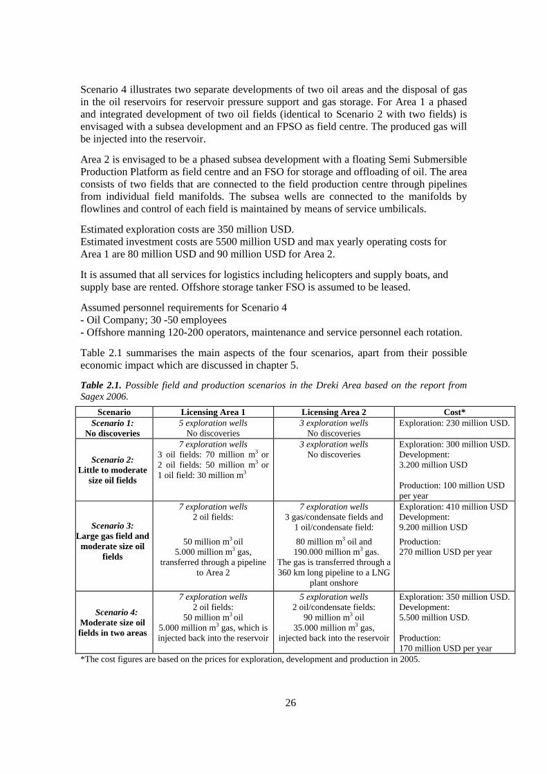
26
Scenario 4 illustrates two separate developments of two oil areas and the disposal of gas in the oil reservoirs for reservoir pressure support and gas storage. For Area 1 a phased and integrated development of two oil fields (identical to Scenario 2 with two fields) is envisaged with a subsea development and an FPSO as field centre. The produced gas will be injected into the reservoir.
Area 2 is envisaged to be a phased subsea development with a floating Semi Submersible Production Platform as field centre and an FSO for storage and offloading of oil. The area consists of two fields that are connected to the field production centre through pipelines from individual field manifolds. The subsea wells are connected to the manifolds by flowlines and control of each field is maintained by means of service umbilicals.
Estimated exploration costs are 350 million USD. Estimated investment costs are 5500 million USD and max yearly operating costs for Area 1 are 80 million USD and 90 million USD for Area 2.
It is assumed that all services for logistics including helicopters and supply boats, and supply base are rented. Offshore storage tanker FSO is assumed to be leased.
Assumed personnel requirements for Scenario 4 - Oil Company; 30 -50 employees - Offshore manning 120-200 operators, maintenance and service personnel each rotation.
Table 2.1 summarises the main aspects of the four scenarios, apart from their possible economic impact which are discussed in chapter 5.
Table 2.1. Possible field and production scenarios in the Dreki Area based on the report from Sagex 2006.
Scenario Licensing Area 1 Licensing Area 2 Cost* Scenario 1:
No discoveries 5 exploration wells
No discoveries 3 exploration wells
No discoveries Exploration: 230 million USD.
Scenario 2: Little to moderate
size oil fields
7 exploration wells 3 oil fields: 70 million m3 or 2 oil fields: 50 million m3 or 1 oil field: 30 million m3
3 exploration wells No discoveries
Exploration: 300 million USD. Development: 3.200 million USD Production: 100 million USD per year
Scenario 3: Large gas field and moderate size oil
fields
7 exploration wells 2 oil fields:
50 million m3 oil 5.000 million m3 gas,
transferred through a pipeline to Area 2
7 exploration wells 3 gas/condensate fields and
1 oil/condensate field:
80 million m3 oil and 190.000 million m3 gas.
The gas is transferred through a 360 km long pipeline to a LNG
plant onshore
Exploration: 410 million USD Development: 9.200 million USD
Production: 270 million USD per year
Scenario 4: Moderate size oil fields in two areas
7 exploration wells 2 oil fields:
50 million m3 oil 5.000 million m3 gas, which is injected back into the reservoir
5 exploration wells 2 oil/condensate fields:
90 million m3 oil 35.000 million m3 gas,
injected back into the reservoir
Exploration: 350 million USD. Development: 5.500 million USD. Production: 170 million USD per year
*The cost figures are based on the prices for exploration, development and production in 2005.

27
2.4. Onshore infrastructure 2.4.1. Onshore service centre
2.4.2. Maritime transport services 2.4.3. Helicopter operations
Chapter 2.4 and its subchapters have not been translated into English.
2.5. Possible impact factors This part has not been translated into English, but the impact factors are discussed further in chapter 11.
2.6. Timetable This section reviews the main stages of the current preparation as well as preparation for the licensing process if a decision is made to initiate it. It also discusses the planned progress of prospecting, exploration and production after a license has been issued.
2.6.1. Current preparation The start of the work presented here, as has been mentioned, can be traced to 2005 when the Government approved a proposal from the Minister of Industry on starting preparations for granting exclusive licenses for exploration and production of oil and other hydrocarbons in Icelandic territory.
2.6.2. Preparation for the licensing process If a decision is made to start the licensing process, further preparation will ensue that can be estimated to take at least 1-2 years. Table 2.3 shows a summary of the main tasks that it can be assumed will have to be done before issuing exclusive licenses for exploration and production of oil in the Dreki area will be possible. Table 2.3. Summary of planned preparatory work for licensing 2007-2009
2007-2008 3-6 months Advice from foreign specialists and interested parties on the arrangement of oil exploration
affairs and licensing 3 months Presentation to oil companies of plans on the issue of licenses, giving the companies an
opportunity to designate areas for which they think licenses should be issued for exploration and production (nomination round)
1 month Demarcation of areas for which exploration and production licenses should be offered 2-3 months Advertisement of tender in Official Journal of the European Union (15-45 day wait for
publication) Advertisement of tender in Iceland and abroad International conference on oil exploration on the Jan Mayen Ridge (and preparation for the conference)
3 months Applications received for at least 90 days 2-3 months Applications evaluated. Negotiations with applicants 2008-2009 Exploration and production licenses issued in the second half of 2008/first half of 2009
2.6.3. Planned progress of prospecting, exploration and production
After exploration and production licenses have been issued, preparation will ensue along with license holders' exploration. A report prepared by the oil and gas exploration and production consultancy group Sagex AS for the Ministry of Industry states that at least 9 years can be expected to pass from the issue of exploration and production licenses to the

28
start of production, i.e., assuming that oil in economically recoverable quantity is found in the area.9 Exhaustive prospecting with seismic surveys, to better demarcate the most promising areas, can be expected to start in the summer of 2008 or 2009. If the findings of those measurements are considered positive, preparations of exploratory drilling will ensue, which could possibly begin in 2010 or 2011.
Exploratory drilling can take some time, and if oil is found, long and exhaustive preparation can be expected for, on the one hand, production drilling and, on the other, the production itself. If oil is found relatively early in the process, production could conceivably start in 2017 or 2018, as can be seen in Table 2.4. On the other hand, it shall be reiterated that it is still uncertain whether oil and/or gas is to be found in the area.
Table 2.4. Summary of planned progress of prospecting, exploration and production 2008-2018
2008-2009 Prospecting with seismic surveys and processing of data 2009 Exploration and preparation of exploration drilling Exploration drilling starts Preparation of production drilling and production 2017/2018 Production begins
2.7. Alternatives
The alternatives proposed for the development of possible oil and gas resources within the Dreki area have been identified as: 1. To offer licenses throughout the northern part of the Dreki area (42,700 km2) in
accordance with the plan. 2. To restrict the size of the licensing area from what the plan provides for to the 5-10
thousand km2 considered most promising for finding oil and gas. 3. Not to offer any licenses in the area, either temporarily or for the indefinite future. The possible effects of these three alternatives are examined later in this report, specifically in Section 11, which deals with evaluation of the possible effects, and Section 12, which summarises the main conclusions. 2.8 Next steps After completing the public hearing process, and after taking into consideration the comments received there, a final report will be issued in the summer 2007. On the basis of that report, it will be decided whether a licensing process should be started for issuing exclusive licenses for exploration and production of oil in the Dreki area. If it is decided that a licensing process should be initiated, at least one year of preparation can be expected before it will be possible to issue exclusive licenses for exploration and production of oil in the northern part of the Dreki area. It will therefore probably not be possible to issue such exclusive licenses until mid-next year at the earliest.
9 Sagex AS (2006). Preparations for awarding licences for exploration and production of hydrocarbons. Basic premises, possible development paths and scenarios.

29
Those preparatory efforts must include consideration of tax matters and before licenses are issued, a decision must be taken on whether to levy a special tax on the profit of oil activities, as is done in most of Iceland's neighbouring states. On the basis of presented proposals, the need for further research on the climate and natural environment in the Dreki area must also be evaluated; as well, it must be determined whether the government should organise that research, or whether this task will be partially or entirely in the hands of the companies obtaining exclusive licenses for exploration and production of oil in the area. If exploration and production in the area come to pass, then the operations that could involve great environmental impact, e.g., exploration and production drilling, must go through environmental impact assessment and therefore call for more research into, for example, the natural environment and biosphere.

30
3. About strategic environmental assessments
Summary The European Union Directive 2001/42/EC on the assessment of the effects of certain plans and programmes on the environment (the strategic environmental assessment Directive) has been transposed into Icelandic legislation and in this chapter the main aspects of the Icelandic Act on strategic environmental assessments of plans and programmes are discussed, as well as the difference between strategic environmental assessments of plans and programmes and environmental impact assessment. This chapter has not been translated into English as the Icelandic legislation is in line with the provisions of the European Union Directive 2001/42/EC on the assessment of the effects of certain plans and programmes on the environment.
The public consultation process
This report was published at the end of March 2007 and is now in public consultation.
The deadline for making comments on the report is 16 July 2007. All comments will be published on the homepage of the Ministry of Industry. Comments can be sent by mail or e-mail to the Ministry of Industry, Arnarhvoli, 150 Reykjavik. For further information about the report, contact Hreinn Hrafnkelsson, Ministry of Industry, ([email protected]) and Kristinn Einarsson, National Energy Authority ([email protected]). The report, along with supplementary materials, can be found on the homepage of the Ministry of Industry (www.idnadarraduneyti.is).

31
4. Legal framework and administration Exploration for oil and gas in Icelandic waters is regulated by the Act on prospecting, exploration and production of hydrocarbons (Hydrocarbon Act of 2001 as amended in 2007). The Act applies to the Icelandic territorial sea and exclusive economic zone and the Icelandic continental shelf. Hydrocarbon accumulations in this area are owned by the Icelandic State and a license from the National Energy Authority (Orkustofnun) is required for prospecting, exploration and production of hydrocarbons.10 Petroleum activities are subject to general Icelandic laws and regulations on taxation, environmental protection, health and safety. The corporate income tax rate is 18 %. Iceland is a member of the European Economic Area. The European Union directive on the conditions for granting and using authorisations for the prospection, exploration and production of hydrocarbons (Directive 94/22/EC), and other relevant EU legislation, therefore applies to petroleum activities in Icelandic waters. The National Energy Authority is, besides awarding prospecting, exploration and production licenses, responsible for monitoring hydrocarbon prospecting, exploration and production activities and archiving the data generated by such activities. The National Energy Authority also coordinates the response of Icelandic authorities to requests from oil companies for information regarding petroleum activities.
4.1. Licenses for prospecting, exploration and production of hydrocarbons The Hydrocarbon Act has provisions for two types of licenses: a prospecting license and an exploration and production license.
4.1.1. License to prospect
Prospecting licenses are issued on the basis of Rules adopted on 18 July 2001. They are granted for a maximum period of three years at a time. A model prospecting license is available. According to the Hydrocarbon Act, prospecting means investigating general conditions for the formation and conservation of hydrocarbons, delimiting areas where such conditions are favourable and searching for hydrocarbon accumulations by measurements from air, land, sea or the seabed or by taking samples from the seabed top strata, e.g. with shallow drilling or taking cores. The Icelandic authorities have an open door policy for companies that are interested in obtaining nonexclusive licenses for prospecting. To date two prospecting licenses have been awarded in Icelandic waters based on the new legal framework. The oil exploration company InSeis (now Wavefield-InSeis) was awarded a 3-year prospecting license on the southern Jan Mayen Ridge from 19 July 2001. TGS-NOPEC was awarded a one-month prospecting license from 24 April 2002 in a partly overlapping region further south on the Jan Mayen Ridge. Both companies acquired seismic reflection data under their licenses and have put seismic data up for sale. Several other companies have also shown interest in prospecting on the Icelandic continental shelf.
10 Unofficial translation of the Hydrocarbon Act can be found at the homepage of the Ministry of Industry: http://eng.idnadarraduneyti.is/media/Acrobat/Hydrocarbont.pdf
32
4.1.2. Exploration and production license
Exploration licenses can be granted for a period of up to 12 years and extended for up to two years at a time to a maximum total duration of 16 years. Once the holder of an exploration license has fulfilled conditions specified in the license, he will have priority for an extension of the license for production for up to 30 years. According to the Hydrocarbon Act, exploration means: 1. Prospecting for hydrocarbons. 2. Evaluation of size, position and production properties of a hydrocarbon accumulation by drilling exploration wells and borehole measurements. Production, according to the Hydrocarbon Act, means production of hydrocarbons from a hydrocarbon accumulation, including drilling of production wells, pumping or conduction of hydrocarbons to the surface, pumping down hydrocarbons and other materials, treatment and storage of hydrocarbons for transport, loading of hydrocarbons as well as constructing, installing, operating and decommissioning an offshore installation meant for such a production. Rules for the granting of exploration and production licences have not yet been adopted and no such licences have been awarded. However, as discussed earlier, this report includes a proposal for a plan on offering exclusive exploration and production licenses in the Dreki Area on the Icelandic part of the Jan Mayen-ridge in the near future. A decision on whether to grant such licenses will most likely be taken in the second half of 2007. 4.1.3. Other licenses and obligations of licensees according to the Hydrocarbon Act
Article 11 of the Hydrocarbon Act describes the content of an exploration and production license. An exploration and production license shall state i.a. the duration of the license, the geographical limits of the exploration or production area that the license applies to and the licensee's obligations with regard to the production of hydrocarbons, i.a. provisions on the location and depth of boreholes for production and recharge and on production rates. The license shall also specify the licensee's duty of reporting and notification to the National Energy Authority, including the duty to deliver samples and data and how this delivery is to take place, and provisions for safety and environmental protection, as appropriate. Furthermore, the license shall also state the licensee's purchase of insurance at a recognized insurance company, banker's indemnity or other collateral that the National Energy Authority considers equal, to cover possible liability for damages caused by activity of the licensee. Finally, the license shall include provisions on the disposal of production systems and equipment at the end of the license term, as well as on the closure of offshore installations and bases that have been used for exploration or production activities. A provision may be set for the license to be re-evaluated within a set period of time, given that the preconditions for the provisions of the license have changed. The Minister of Industry may by regulation decide on further stipulations regarding licenses for exploration and production.

33
The National Energy Authority may stipulate that obligations according to an exploration and production license remain after the license period is over, the license returned or withdrawn. If the licensee does not meet his obligations according to an exploration and production license the National Energy Authority may demand that the licensee pay the cost associated with meeting the obligation, in part or in full. When exploring for and producing hydrocarbons every measure of safety shall be taken and the activity shall be in accordance with good international practice for similar situations. The activity shall not endanger or hinder needlessly communication, fisheries or other activities. Drilling into strata under the seabed may only begin when the National Energy Authority has accepted the equipment, drilling plans and working arrangements. The building and installation of an offshore installation and the production of hydrocarbons requires the consent of the National Energy Authority. If a licensee wants to commence such an activity he shall present a field development and production plan the National Energy Authority for approval. The National Energy Authority may alter a previously approved field development and production plan in order to ensure that the activity is safe and economical or if it is in the public interest to demand it. Decommissioning of an offshore installation, including cessation of maintenance, is subject to the consent of the National Energy Authority. A licensee shall present to the National Energy Authority for approval a plan for decommissioning an offshore installation containing i.a. information on how the decommissioning will take place. At the decommissioning of an offshore installation it will normally be removed as a whole or partly. The National Energy Authority can, however, agree to its continued use for exploration and production of hydrocarbons or other kind of use. If there is reason to assume that a licensee does not have the financial ability to pay for the cost of decommissioning an offshore installation the National Energy Authority can at any time demand of the licensee that he prove his ability to pay or provide necessary guarantees. The construction and operation of piping equipment for the production or transportation of hydrocarbons is subject to the permission of the National Energy Authority. A permission shall i.a. include conditions on the organisation of the equipment, the use of the equipment by others and payment for the use. The construction and operation of piping equipment on behalf of another state for the transportation of hydrocarbons across the Icelandic continental shelf is subject to the consent of the National Energy Authority. Where an accumulation of hydrocarbons extends into areas where two or more parties have a license to explore and produce the licensees must make an agreement of co-operation regarding exploration and production from the accumulation. The agreement of co-operation is subject to the consent of the National Energy Authority. If the licensees
34
do not reach an agreement within a suitable time the National Energy Authority may decide its contents. If an accumulation of hydrocarbons extends into another state’s continental shelf and an agreement of co-operation regarding exploration of and production from the hydrocarbon accumulation has been reached between that state and the Icelandic state the National Energy Authority may oblige licensees on the Icelandic continental shelf to take part in the co-operation and set further conditions regarding the participation. If the National Energy Authority deems it sensible to exploit two or more accumulations of hydrocarbons together due to economic considerations he can, having consulted the licensee, demand such a co-exploitation. The National Energy Authority may oblige the licensee to allow other licensees, for payment, access to equipment and transportation with such a co-exploitation in mind. If the licensees do not reach an agreement about payments for the use the payments shall be decided by the National Energy Authority. The National Energy Authority shall consult the Ministry of Fisheries and the Ministry for the Environment before granting a license for exploration and production, permission or a license for particular activities according the Act.
4.2. Administration related to prospecting, exploration and production of oil and gas
Summary Several Ministries and government agencies will be associated with administration related to prospecting, exploration and production of oil and gas. The relevant Ministries have evaluated the legal and administrative framework in the areas involved in the activities of prospecting, exploration and production of oil and gas and listed the most relevant acts (see 4.2.1). Clearly, some amendments to laws and regulations are required if the decision is made to grant exclusive licenses for prospecting, exploration and production. Many instances involve simple amendments, for example, to ensure that the scope of current law covers the planned activities. Extensive consultation and cooperation between the relevant Ministries and agencies will be necessary if the proposed plan for issuing licenses will be approved. Therefore a special consultation and cooperation committee should be established in order to facilitate consultation and cooperation.
4.2.1. List of legislation related to prospecting, exploration and production of oil and gas Some amendments to existing legislation are required if the decision is made to grant exclusive licenses for prospecting, exploration and production. Many instances involve simple amendments, for example, to ensure that the scope of current legislation covers the planned activities. Following is a list of the most relevant Icelandic laws and regulations related to prospecting, exploration and production of oil and gas.

35
Ministry of Justice: Lög um Landhelgisgæslu Íslands, nr. 52/2006. Lög um samræmda neyðarsímsvörun, nr. 25/1995.
Ministry of Social Affairs : Lög nr. 55/1980, um starfskjör launafólks og skyldutryggingu lífeyrisréttinda, með síðari breytingum. Lög nr. 80/1938, stéttarfélög og vinnudeilur, með síðari breytingum. Lög nr. 46/1980, um aðbúnað, hollustuhætti og öryggi á vinnustöðum, með síðari breytingum. Lög nr. 47/1993, um frjálsan atvinnu- og búseturétt launafólks innan Evrópska efnahagssvæðisins, með síðari breytingum. Lög nr. 54/2001, um starfskjör starfsmanna sem starfa tímabundið á Íslandi á vegum erlendra fyrirtækja. Lög nr. 97/2002, um atvinnuréttindi útlendinga, með síðari breytingum. Lög nr. 72/2002, um réttarstöðu starfsmanna við aðilaskipti að fyrirtækjum. Lög nr. 139/2003, um tímabundna ráðningu starfsmanna. Lög nr. 10/2004, um starfsmenn í hlutastörfum. Lög nr. 139/2005, um starfsmannaleigur. Lög nr. 88/2003, um Ábyrgðasjóð launa. Lög nr. 95/2000, um fæðingar- og foreldraorlof. Lög nr. 22/2006, um greiðslur til foreldra langveikra eða alvarlegra fatlaðra barna. Lög nr. 54/2006, um atvinnuleysistryggingar. Lög nr. 55/2006, um vinnumarkaðsaðgerðir.
Ministry of Finanace: Lög nr. 90/2003, um tekjuskatt.
Ministry of Health: Lög nr. 44/2002, um geislavarnir.
Ministry of Industry : • Lög um leit, rannsóknir og vinnslu kolvetnis, nr. 13/2001. • Reglur um veitingu leyfa til leitar að kolvetni, nr. 553/2001. • Lög um Orkustofnun, nr. 87/2003. • Reglugerð um Orkustofnun, nr. 308/2004.
Ministry of Transport : I. Maritime Lög 6/1996 um Siglingastofnun Íslands. Lög nr. 47/2003 um eftirlit með skipum. Reglugerð nr. 786/1998 um ráðstafanir er stuðla að bættu öryggi og heilsu starfsmanna um borð í skipum. Reglugerð nr. 179/1985 um hávaðamörk í íslenskum skipum. Reglugerð nr. 680/2004 um vinnu- og hvíldartíma skipverja á farþega- og flutningaskipum. Reglugerð nr. 440/1980 reglur um vinnuöryggi á flutningaskipum og farþegaskipum. Reglugerð nr. 429/1995 um öryggisráðstafanir við vinnu í lokuðum rýmum. Lög nr. 46/1980 aðbúnað, hollustuhætti og öryggi á vinnustöðum. Lög nr. 41/2003 um vaktstöð siglinga – reglugerð 672/2006. Lög nr. 50/2004 um siglingavernd. Lög nr. 68/2000 um rannsókn sjóslysa - reglugerð nr. 133/2001. Lög nr. 31/1996 um köfun - reglugerð nr. 535/2001 um köfun. Lög nr. 132/1998 um vitamál. Lög nr. 33/2004 um mengunarvarnir, Lög nr. 146/2000 um mælingu skipa. Lög nr. 115/1985 um skráningu skipa. II. Aviation : Loftferðalög, nr. 60/1998, með síðari breytingum. Reglugerð 193/2006, um flutningaflug. Lög nr. 35/2004, um rannsókn flugslysa – reglugerð 80/2006 og reglugerð 53/2006.
Ministry of Fisheries: Lög nr. 79/1997, um veiðar í fiskveiðilandhelgi Íslands (heimild til að banna með reglugerðum veiðar á tilteknum svæðum).

36
Ministry for the Environment: Lög nr. 33/2004 um varnir gegn mengun hafs og stranda með síðari breytingum. Reglur nr. 8/1971 um varnir gegn óhreinkun sjávar af völdum olíu. Reglur nr. 33/1990 um bann við notkun á gróðurhrindandi efnum sem innihalda lífræn efnasambönd tins (tríbútýltin). Reglugerð nr. 715/1995 um varnir gegn mengun sjávar frá skipum. Reglugerð nr. 465/1998 um viðbrögð við bráðamengun sjávar sbr. reglugerð nr. 203/1999. Reglugerð nr. 527/1999 um varnir gegn mengun sjávar vegna eitraðra efna í fljótandi formi sem flutt eru í geymum skipa. Reglugerð nr. 619/2000 um bann við notkun á efnum sem innihalda kvikasilfurssambönd, arsenefnasambönd og lífræn efnasambönd tins (tribútýltin), sbr. 878/2002. Reglugerð nr. 792/2004 um móttöku á úrgangi frá skipum. Reglugerð nr. 800/2004 um umskipun olíu á rúmsjó. Reglugerð nr. 801/2004 um varnir gegn sorpmengun frá skipum. Reglugerð nr. 824/2005 um takmörkun á notkun skaðlegra gróðurhindrandi efna og/eða búnaðar á skip. Reglugerð nr. 1078/2005 um tryggingar skipa og starfsemi á landi vegna bráðmengunar. Lög nr. 7/1998 um hollustuhætti og mengunarvarnir með síðari breytingum. Reglugerð nr. 533/1993, um kæli og varmadælukerfi með ósoneyðandi kælimiðlum sbr. breytingar nr. 384/1997 og 137/1999 Reglugerð nr. 160/2007 um varnir gegn hættu á stórslysum af völdum hættulegra efna Reglugerð nr. 323/1998 um innflutning, notkun og förgun PCB, PCT og umhverfisskaðlegra staðgengilsefna þeirra. Reglugerð nr. 785/1999 um starfsleyfi fyrir atvinnurekstur sem getur haft í för með sér mengun. Reglugerð nr. 786/1999 um mengunarvarnaeftirlit, sbr. nr. 850/2000, nr. 49/2001. Reglugerð nr. 787/1999 um loftgæði. Reglugerð nr. 798/1999 um fráveitur og skólp. Reglugerð nr. 799/1999 um meðhöndlun seyru. Reglugerð nr. 802/1999 um losunarmörk, umhverfismörk og gæðamarkamið fyrir losun á kadmíum í yfirborðsvatn. Reglugerð nr. 805/1999 um úrgang. Reglugerð nr. 806/1999 um spilliefni, sbr. nr. 169/2002. Reglugerð nr. 809/1999 um olíuúrgang. Reglugerð nr. 810/1999 um skrá yfir spilliefni og annan úrgang. Reglugerð nr. 184/2002 um skrá yfir spilliefni og annan úrgang, sbr. nr. 428/2003. Reglugerð nr. 851/2002 um grænt bókhald. Reglugerð nr. 941/2002 um hollustuhætti, sbr. nr. 674/2005. Reglugerð nr. 224/2005 um gildistöku EES-gerða um umsjón og eftirlit með flutningi úrgangs innan, til og frá Evrópubandalaginu. Reglugerð nr. 990/2005 um frjálsa þátttöku fyrirtækja og stofnana í umhverfisstjórnunarkerfi bandalagsins (EMAS). Lög nr. 14/1979, um heimild fyrir ríkisstjórnina til að staðfesta fyrir Íslands hönd þrjá alþjóðasamninga um varnir gegn mengun sjávar af völdum olíu (um ábyrgð eigenda og útgerða olíuflutningaskipa, rétt strandríkja til íhlutunar og um stofnun alþjóðasjóðs um bætur vegna mengunartjóns af völdum olíu sem flutt er í farmtönkum skipa). Lög nr. 106/2000, um mat á umhverfisáhrifum. Reglugerð nr. 1123/2005, um mat á umhverfisáhrifum. Lög nr. 105/2006, um mat á umhverfisáhrifum áætlana. Skipulags- og byggingarlög, nr. 73/1997, með síðari breytingum. Skipulagsreglugerð, nr. 400/1998. Lög nr. 52/1988, um eiturefni og hættuleg efni með síðari breytingum. Lög nr. 75/2000, um brunavarnir Lög nr. 55/2003, um meðhöndlun úrgangs Ministry of Foreign Affairs : Jan Mayen-samkomulagið um hið afmarkaða landgrunnsvæði milli Íslands og Jan Mayen. Landgrunnsmál Íslands á alþjóðavettvangi.

37
4.3. Taxes and fees
Summary When making decisions about fees and the collection of taxes, it is important, on one hand, to ensure that an acceptable dividend from oil operations will accrue to the Icelandic State and, on the other, that the combined collection of taxes on oil operations in Iceland do not exceed what is common in Iceland's neighbouring countries, to ensure that the tax environment in Iceland will be fully competitive vis-à-vis neighbouring countries.
A special working group under the leadership of the Ministry of Finance was established to consider taxes and fees related to oil operations in Iceland's neighbouring countries, and this work is still in progress. The biggest issue to take a stand on before licenses are granted for exploration and production of oil and gas is whether to levy a special tax on the profit of such operations in Iceland, as has been done in some other countries; in addition, consideration must also be given to whether production fees should be collected or if the Icelandic State should take part of licenses. 4.4. The Jan Mayen Agreement on the Continental Shelf in the area between Iceland
and Jan Mayen
Summary The northern part of the Dreki area covers about 42,700 km² (see figure 2.1). An international agreement between Iceland and Norway on the continental shelf between Iceland and Jan Mayen applies to part of the area, and this part covers 12,720 km² or almost 30% of the area. Within this area, Norway is entitled to participate with a share of 25 percent in petroleum activities and Iceland has the same right in approximately 32.750 km² area on the Norwegian side. The Governments of Norway and Iceland have jointly surveyed the agreement area and put seismic data packages up for sale. Unofficial English translation of the Agreement can found at the homepage of the Ministry of Industry.11
11 See: http://eng.idnadarraduneyti.is/media/Acrobat/Jan_Mayen_Agreement.pdf

38
5. Economical impact Summary
The discovery of economically recoverable quantity of oil and gas on the Jan Mayen Ridge could have a strong economic impact on the Icelandic economy. Domestic production could rise considerably at the peak of operations and production in the oil sector. The revenues of the State Treasury can be expected to increase substantially (see table 5.5). In this regard it is possible that a specific resource tax would be levied on the sector, in addition to the general 18% corporate tax. Revenues from this taxation could be channelled into a special oil fund. The government's expenditures related to the oil sector will probably be a small fraction of the revenues expected to flow into the State Treasury from direct taxes. The external balance of the national economy, i.e., the balance of trade and the balance of payments vis-à-vis other countries, could fluctuate, which would be manifested in an increased deficit and indebtedness during the period of build-up of the oil sector. However, a turnaround can be expected in this area when full oil production is reached. Internal balance could be disturbed by increased inflationary pressure and possible ripple effects through a stronger exchange rate of the Icelandic króna. Offsetting such effects entails the use of traditional monetary and budgetary instruments; in addition, the establishment of a special oil fund, as mentioned above, could be considered.
- - - - - -
As discussed earlier, the oil and gas exploration and production consultancy group Sagex AS prepared a report for the Ministry of Industry, which included four scenarios on the possible development of exploration and production in the Dreki area12
Table 5.1 summarises the main aspects of the four exploration and production scenarios from the Sagex report (see chapter 2.3 for further description of the scenarios).
Table 5.1. Summary of the four exploration and production scenarios (2005 price level).
12 Sagex (2006), Preparation for awarding licences for exploration and production of hydrocarbons. Basic premises, possible development paths and scenarios.
Scenarios 1 2 3 4
Oil Million m3 0 70 130 140 Gas Billion m3 0 0 195 0 Income Billion ISK 0 960 3600 1900 Prospecting and exploration Billion ISK 15 19 26 22 Development Billion ISK 0 202 580 347 Yearly operating costs Billion ISK 0 6 17 11 Personnel requirements No. of jobs 20 260 750 450 Net present value *) Billion ISK -8 79 164 176 Internal rate of return **) 0 28% 26% 33% *) 12% discount rate.**) Discount rate at which investment has zero net present value. Source: SAGEX (2006) and calculations from the Ministry of Finance.

39
According to Sagex AS, exploitation of both oil and gas appears possible and to be commercially attractive, indicating a strong incentive to explore the Jan Mayen Ridge. The limit size for possible economic exploitation of an oil field is in the region of 10-20 million standard m3 of oil. Basic assumptions: � All costs and revenues are given in real 2005 terms and does not account for tax and
government take. � Oil Price: 35 USD for barrel of oil. � Gas Price: NOK 1,00 for standard m3, net of LNG transport. � Discount Rate: 12% in real terms
Discount rates vary between oil companies. The 12% discount rate is considered to be within the range presently used by the oil and gas industry. However, the discount rate is basically a company specific or government specific choice. From a government perspective a discount rate of 7- 8% could be applicable considering that the risk adjustment is of considerably less significance to the society at large compared to an oil company.
Development cost: The total development cost for scenario 2 is estimated 202 billion Icelandic króna (ISK), 580 billion ISK for scenario 3 and 347 billion ISK for scenario 4 (see table 5.1). Figure 5.1 shows an estimation of the development cost by year for the four scenarios. Figure 5.1. Development costs, in billions ISK.
0
20
40
60
80
100
120
2007
2009
2011
2013
2015
2017
2019
2021
2023
2025
2027
2029
Scenario 1 Scenario 2 Scenario 3 Scenario 4

40
Income: The total income for scenario 2 is estimated 960 billion ISK, 3600 billion ISK for scenario 3 and 1900 billion ISK for scenario 4 (see table 5.1). Figure 5.2 shows an estimation of the distribution of the income for the four scenarios.
Figure 5.2. Estimated oil and gas income, in billions ISK.
Tax revenues: One of the biggest issues that have to be decided before exploration and production licenses are granted is whether to levy a special tax on the profit of such operations in Iceland, as has been done in some other countries. Table 5.5 shows the estimated total aggregate tax revenues over the production period, based on different tax levels.
Table 5.5. Total aggregate tax revenues over the production period. Billions ISK.
Tax percentage
18% 20% 30% 50%
Scenario 2 – one oil field 16 27 36 46
Scenario 2 – three oil fields 96 160 213 266
Scenario 3 395 658 877 1.097
Scenario 4 153 256 341 426
0
50
100
150
200
250
300
2016
2018
2020
2022
2024
2026
2028
2030
2032
2034
2036
2038
2040
2042
2044
2046
2048
2050
Scenario 2 Scenario 3 Scenario 4

41
6. Health, safety and environmental issues
Summary It is important that the companies obtaining licenses to engage in oil exploration or begin oil production and related activities on Iceland's continental shelf manage their environmental matters and issues regarding work safety in conformity with the best practices. In this regard, all tasks are important, whether they involve prospecting, testing wells, experimental production if oil or gas is found, setting up production plants if oil or gas resources prove to be in economically recoverable quantity, production, storage and transport of oil or gas, or decommissioning and cleanup in a production area when production is finished. Provisions shall be made for ensuring the safety and health of employees through efficient management of work safety affairs. This, in short, entails preparation of risk assessments for tasks, systematic preparation of preventive measures, preparation of a safety and health plan, and there shall be active internal monitoring at companies engaged in oil exploration and production. In this way, their experience and knowledge shall be utilised as much as possible. The Administration of Occupational Safety and Health shall follow up on whether the companies fulfil their obligations in this regard. The main government plans related to the oil exploration plan are a policy on sustainable development and a strategy on the ocean, and the oil exploration plan is in accordance with the policy formulation set out there.
Iceland has ratified a number of international agreements which address either directly or indirectly the environmental impact of prospecting, exploration and production of petroleum substances. The main agreements are the OSPAR Convention on protection of the Northeast Atlantic, MARPOL 73/78, a protocol related to the International Convention for the Prevention of Pollution from Ships, and the European Economic Area (EEA) Agreement. The main provisions of the OSPAR Convention were incorporated into Icelandic law through Act No. 7/1998 on hygiene and antipollution measures and Act No. 33/2004 on marine and coastal antipollution measures. The provisions of the MARPOL Protocol and its annexes form the basis of Act No. 33/2004 on marine and coastal antipollution measures, as well as regulations that have been set under the authority of the act. Furthermore, on the basis of the EEA Agreement, EU directives and regulations that are intended to reduce the environmental impact of oil operations, e.g. through regulations and standards for operating companies, have been transposed into Icelandic law. This chapter has not been translated into English.

42
7. Geology of the Jan Mayen area and indications of oil and gas prospects
The Jan Mayen Ridge is a complex system that reaches southwards from the Jan Mayen Transform. This ridge system is believed to be mostly of continental origin, but shows transitional and oceanic crust characteristics at the margins. The Jan Mayen Ridge is believed to be a part of the continental shelf of Greenland, but it has, due to a complicated rifting history of the northeast Atlantic, ended up in the middle of the ocean floor between Norway and Greenland.
The ridge can be divided into two main components, the main ridge in the north and the southern ridge complex. The main ridge reaches from the transform in the north to the Jan Mayen trough, which separates the two main features. The northern main ridge is well defined, continuous and stands higher than the southern part. The southern part is composed of several smaller ridges which become indistinct to the south and disappear beneath sediments and lavas closer to Iceland.
7.1. The opening of the North Atlantic and Stratigraphy of the Jan Mayen Ridge In the beginning of the opening of the northeastern Atlantic, in early Eocene, the continental crust splitted from south to north. About 54 million years ago, a spreading ridge was formed east of the Jan Mayen area. Greenland and Norway began to drift apart and the Jan Mayen area was still attached to the continent of Greenland. This spreading ridge is now called the Aegir Ridge. The rift continued in this way until about 44 million years ago, when a new spreading ridge began to form to the west of Aegir Ridge. This ridge gradually protruded northwards. Before that happened, a considerable amount of stretching had occurred west of the Jan Mayen Ridge. The new spreading ridge split the Jan Mayen Ridge away from the continent of Greenland and it is called the Kolbeinsey Ridge today. Both these spreading ridges were active in parallel for about 18 million years. The Kolbeinsey Ridge was most active in the south to begin with but gradually protruded northwards but at the same time the activity at Aegir Ridge diminished gradually from south to north. That caused the Jan Mayen Ridge to rotate counter clockwise. Finally about 26-30 million years ago the activity at Aegir Ridge ceased and the seafloor-spreading is only active at Kolbeinsey Ridge. From that time onward, the Jan Mayen Ridge gradually moves away from Greenland. Before the opening of the northeast Atlantic the area had gone through extensive rifting back to Permian times. When the continental crust broke, stretched and subsided, a
Era Period Epoch Million years
Holocene - 0,1 Quaternary
Pleistocene 0,1-1,65
Pliocene 1,65-5
Miocene 5-24
Oligocene 24-37
Eocene 37-58
Ceno-zoic
Tertiary
Paleocene 58-65
Cretaceous 65-146
Jurassic 144-208
Meso-zoic
triassic 208-245
Permian 245-286
Carboniferous 286-360
Devonian 360-408
Silurian 408-438
Ordovician 438-505
Paleo-zoic
Cambrium 505-570
Proterozoic 540-2500
Archean 2500-4600
43
shallow ocean formed where thick sediments accumulated. Large continental blocks tilted and halfgrabens formed where sediments settled at the same time. In middle and upper Jurassic a claystone was formed with high organic content. This clay formation (Kimmeridge clay) is the main source rock all around the northeast Atlantic today. When the rifting ended in late Jurassic the subsidence continued throughout the Cretaceous period and more sediments accumulated. In late Cretaceous/beginning of Tertiary the rifting resumed and ended in the breakup of the continent. Oceanic crust formed in early Eocene (app. 54 million years ago). Lava flows and intrusions covered the sediments on the eastern slopes of the Jan Mayen Ridge, which at this stage was still attached to the continent of Greenland. This formed dipping reflectors as the oceanic crust thickened. At 45-50 million years ago the lavas no longer managed to flow over the Jan Mayen Ridge and the older lavas were covered with sediments. These sediments are mostly derived from the old basement rocks of Greenland. At this time, rifting started to the west of the Jan Mayen Ridge and the continental crust began to break up. The seafloor-spreading at Aegir Ridge diminished as the spreading protruded northwards on the Kolbeinsey Ridge. The Jan Mayen Ridge rose above sea-level about 30 million years ago and was heavily eroded. Up to 1000 - 1500 metres were eroded away and settled on both flanks of the ridge. Finally at about 20 million years ago the ridge had subsided again below sea-level. The sedimentary accumulation was now much slower in calm, deep waters. Until today the Jan Mayen Ridge has cooled and subsided even further as it drifted out into the middle of the northeast Atlantic.
7.2. Hydrocarbon potential of the Jan Mayen area As stated earlier the geological history of the Jan Mayen Ridge is much older than the opening of the northeast Atlantic. The older strata of the ridge are analogous to those of the continental shelfs of Norway and Greenland. On both these shelf’s hydrocarbon occurrences have been proven and on the continental shelf of Norway a massive production of oil and gas is a fact. The following criteria must though be present so that any occurrence can be considered a resource. 1. Source rock: Organic material must be present, be buried and mature suitably. The
main source rock around the northeast Atlantic is a clay formation, formed in middle and upper Jurassic. Since this source rock is all around the northeast Atlantic, it is likely that it also occurs at the Jan Mayen Ridge. It is also possible that anoxic conditions formed source rocks in the beginning of Eocene
2. Reservoir rocks (reservoir sand): Sandstone is mostly the reservoir rocks in all the area around the northeast Atlantic. In the older sediments it is sandstone from the Jurassic and late Cretaceous periods. In sediments younger than the Cretaceous, it’s expected that sandstones from Eocene and Oligocene could be good reservoir rocks.
3. Cap rock (seal rock): In the area around the northeast Atlantic it is mostly claystone from the Cretaceous and Eocene periods that covers the reservoir rocks and seals the traps.
4. Traps (prospect): There are three types of traps that could be present. a. Structure traps, but they are blocks containing sand layers which rotated and
subsided with the blocks. Clay later seals it off. b. Stratigraphic traps are sand lenses or layers with limited distribution, such as
fans, cones and wedges, that transport into the basins, while clay is still accumulating, and seals off the lenses/layers.
c. Domes form when later tectonics form a dome or vault, bending the sedimentary layers, making them convex.

44
Figure 7.1 shows the essential elements needed for a petroleum system to generate, migrate and accumulate hydrocarbons in the subsurface.
Figure 7.1. Petroleum system illustration, showing the essential elements needed for a petroleum system to generate, migrate and accumulate hydrocarbons in the subsurface. Sagex (2006).13
Following these criteria there could be three different hydrocarbon plays regarding the Jan Mayen area. Play 1: • Area: Western and eastern slopes of the main ridge, as well as the southern ridge complex. • Source rock: Eocene or older source rock. • Reservoir rock: Eocene/Oligocene sandstone. • Cap rock: Eocene or younger clays. • Traps: Stratigraphically isolated traps made of sandstone lenses, cones and wedges in halfgrabens
around rotated blocks. • Remark. It is probable that source rock older than Eocene is over-matured in the western flanks of the
main Jan Mayen Ridge. It is not known if that also applies to the southern ridge complex.
Play 2. • Area: The whole Jan Mayen Ridge. • Source rock: Eocene or older source rock. • Reservoir rocks: Eocene or older sandstones. • Cap rock: Mesozoic clays or younger. • Traps: Structure traps in rotated blocks which contain sandstone. The blocks have rotated and covered
with younger clay layers. • Remark: It is probable that this type of trap may leak at the top of the main ridge as well as locally at
the southern ridge complex where the blocks are insufficiently buried. The source rocks older than
13 Evaluation of the petroleum potential of the Jan Mayen Ridge is in an early stage, based on limited amounts of seismic data and geological analogues with other better know areas. However, the interpretation of the seismic data has identified basins with sediment thickness up to 8km and structural highs capable of acting as hydrocarbon traps. The crucial elements such as source rock, reservoir rock and seal rock as well as generation, migration and accumulation of hydrocarbons, see figure 1, are likely to be present. See Sagex (2006), Preparations for awarding licenses for exploration and production of hydrocarbons. Basic premises, possible development paths and scenarios, p. 7. The report can be found at the homepage of the Ministry of Industry in Iceland: http://www.idnadarraduneyti.is/frettir/fylgiskjol-med-oliuskyrslu/
45
Eocene may be over-matured in the western slopes of the main ridge. It is not known if that also applies to the southern ridge complex.
Play 3. • Area: Western and eastern slopes of the main ridge, as well as the southern ridge complex. • Source rock: Eocene or older source rock. • Reservoir rock: Eocene/Oligocene sandstone. • Cap rock: Eocene or younger clays. • Traps: Sandstones formed in depressions, that due to later tectonic events, fold and become convex.
7.2.1. Indications of oil and gas A few indications of oil and/or gas have been seen in data from Jan Mayen Ridge. The main indications are: • Amplitude anomalies. These are various types of anomalies in seismic sections,
indicating possible hydrocarbons in the sediments. • Pockmarks. These features are well known and have been seen on the Jan Mayen
Ridge. They are usually connected to migration of gas in the sediments. • Gas in top sediments and water column. Direct indications of gas have been found.
Further studies showed that the results were not decisive enough to prove the presence of thermogenic hydrocarbons.
7.2.2. Resource estimate Even though there are indications of hydrocarbons in the Jan Mayen area, it must be kept in mind that they are not conclusive. Absolute outcome is not to be expected until one or more drillings have taken place. Loose estimate indicates that the northern Dreki-area (which is the area where the Jan Mayen Ridge enters the Icelandic Exclusive Economic Zone – see figure 7.1) can be divided into three subareas, regarding resource estimate.
1. The main ridge area (both northern ridge and southern ridge complex) where lavas and intrusions do not limit seismic research.
2. Areas where lavas and intrusions limit seismic research, but odds are that older sediments are to be found underneath the volcanic.
3. The outer margins (to the east and west) which lie close to or on oceanic crust. Area 1 is the most accessible, within the northern Dreki-area, for further research. This area is about 10000 km2 in size and covers the southern ridge complex as well as the southernmost part of the main ridge. The oil and gas exploration and production consultancy group Sagex AS has estimated that up to 3600 km2 within area 1 could be possible prospect areas (see figure 7.2).

46
Figure7.2. Structure map of the Jan Mayen Ridge. Also indicated are possible prospect areas, according to Sagex, which covers approximately 4400 km2, where 3600 km2 are within the northern Dreki-area. Red, stippled line is the northern Dreki-area which covers about 43000 km2. The black, stippled area is the contract area between Iceland and Norway, which covers about 46000 km2. *This is a summary of a report by Bjarni Richter and Steinar Þór Guðlaugsson, from Iceland GeoSurvey. The full report in Icelandic can be found at the homepage of the Ministry of Industry: http://www.idnadarraduneyti.is/media/Acrobat/Jardfr_Jan-Mayen-hryggur_ISOR-2007-004.pdf

47
8. Climate and oceanography This section deals with the climate and oceanography of the Jan Mayen area. The section on climate is based on a summary from a specialist report by Ásdís Audunsdóttir, Gudmundur Hafsteinsson and Trausti Jónsson from the Icelandic Meteorological Office. The report can be accessed on the home pages of the Ministry of Industry.14
8.1. Climate and pack ice Climate is very important for oil exploration and oil production. It affects the cost of the activities and even restricts them. Special weather conditions, such as high wind speed, icing and fog, can cause accidents, damage or disturbances. They can also be important when pollution shall be prevented, responded to or reduced, its scope and consequences evaluated or its dispersion and effects monitored. For example, antipollution equipment must be designed with respect to weather conditions, and if there is a pollution accident, it can be important to predict the effect of wind on surface currents and drifting of an oil slick.
It is also important to reckon with the condition of the sea, such as its temperature, waves and ocean currents, since this affects the activities and the dynamics of possible pollution as well as its seriousness.
8.1.1. Daylight conditions In the northern part of the Dreki area, there is daylight around the clock from the beginning of May until just before mid-August. The sun does not set for a two-month period at the height of summer. On the other hand, the sun is not seen for one month in the winter, from the beginning of December to early January, and there is less than ten hours of daylight for nearly four months, from the latter part of October through mid-February.
8.1.2. Air temperature Although there is little direct information about the climate on the Jan Mayen Ridge, it can be asserted that an open ocean climate prevails there (see Figure 8.1).
Figure 8.1. Air temperature 1958-2001 at 68°30'N and 9°W according to ERA-40 data. The frequency distribution of the air temperature in each month is shown (four observations per day). Half of the observations fall within the boxes, and the median is indicated with a horizontal line. The other half of the observations falls on the interval indicated with dotted lines, but a few rare instances are indicated with circles (Ásdís Audunsdóttir et al. 2007) 14 The full report on climate and pack ice in Icelandic can be found at the homepage of the Ministry of Industry: http://www.idnadarraduneyti.is/media/Acrobat/Vedurfar_hafis_Jan_Mayen-hryggur.pdf

48
The average temperature is below 10°C year-round, but the period January through March is usually coldest (average temperature -2°C to 0°C). August is usually the warmest month (average temperature 7°C to 8°C). The annual temperature fluctuation is small, but it is within the characteristics of open-ocean climate. In years when there is pack ice in or near the area, the seasonal temperature fluctuations can be much greater, and then the number of days with temperatures below -10°C greatly increases. The summer temperature seldom exceeds 13°C, and the winter temperature seldom falls below -15°C.
8.1.3. Precipitation
There is frequent precipitation, especially in the fall and winter. The average annual precipitation is near 700 mm, which is rather less than in Reykjavik. The distribution throughout the year is similar to the closest coastal areas of Jan Mayen and in Iceland's East Fjords. The precipitation often falls from weather systems moving over the area with low pressure systems, then lasting for several hours at a time. Drizzle is commonest in late summer, but its quantity is small although it can spoil visibility. The spring and early summer is the driest time of the year. Heavy showers are seldom seen in the summer, but more often in the fall. From mid-May through October, the most common form of precipitation is rain, but otherwise snow or sleet. Precipitation, in the form of rain, sleet and snow, is quite heavy in the winter low-pressure systems. Snowfall can be expected to reach 25-30 cm per 24-hour period. If the temperature is close to freezing, the snow can form icing on the windward side of structures.
8.1.4. Fog and visibility
There are no direct references on visibility in the northern part of the Dreki area, but observations from weather stations in Iceland and Jan Mayen indicate that fog is the commonest impairment to visibility in these areas (Figure 8.2), and it is most frequent in the summer. Precipitation, especially snow, also makes for poor visibility in the winter. The determination of visibility depends somewhat on the horizon and landscape; in addition, observers' visual evaluations can vary. Automatic instruments for weather observation provide only indirect clues about visibility.

49
Figure 8.2. Fog frequency during observation periods in Jan Mayen and Dalatangi 1997-2006, as a percentage of all observations. It must be noted that fog in the surrounding area is also counted even though the visibility at the station itself exceeds 1 km. (Ásdís Audunsdóttir et al. 2007).
8.1.5. Wind currents The average wind speed in the northern part of the Dreki area is greater in the winter and than the summer. From December to March the average wind speed is about 10 m/s versus about 6 m/s in the summer. This is a bit more than at the weather stations in Jan Mayen where the wind is about 8 m/s in the winter and under 5 m/s in the summer, or at Dalatangi, where it is about 7 m/s in the winter and 5 m/s in the summer. It is noteworthy that the wind exceeds 11 m/s about a third of the time in winter but less than 5% of the time in summer. Nevertheless, the frequency of storms in the area is similar to what it is on the east coast of Iceland and in Jan Mayen.
8.1.6. Pack ice Little pack ice has drifted into the area in recent decades although the pack-ice period 1965 to 1971 is an exception, as is seen in Figure 8.3. The southwest corner of the area has nevertheless been free of ice during this period, insofar as known, but the frequency of ice increases greatly in the northwesternmost part of the area and west of there.
Fog frequency in Jan Mayen and Dalatangi 1997 to 2006
Jan Mayen Dalatangi
1 2 3 4 5 6 7 8 9 10 11 12
Month
0
2
4
6
8
10
12
14
16
18
20
% of all observations

50
Figure 8.3. Time series of ice density( 0=no pack ice to 1=completely covered with pack ice) at 68°30'N and 9°W, based on ERA-40 data (Ásdís Audunsdóttir et al. 2007)
8.1.7. Icing Icing creates temporary problems during the winter, but its frequency varies greatly from year to year, and increased frequency is related to the periods characterised as pack-ice years (see Figure 8.3). Icing caused by freezing rains or freezing drizzle hardly creates problems of strength or stability although it can be treacherous while working. Increased probability of heavy icing is associated with spindrift in sharp northerly winds, and the proximity of pack ice can be expected to increase the likelihood of extremely heavy icing (>4 cm/hr) since pack ice cools both the air and the sea. The nature of the risk of icing is different for helicopter flights than for ships and drilling platforms. There, the most important factor is icing in the clouds, precipitation and fog, but it must also be kept in mind that spindrift icing, which is considered insubstantial for ships, can create risks for landing on helicopter platforms. In the opinion of The Icelandic Meteorological Office, the main risk of icing is in the winter, while poor visibility because of fog is most likely in the summer, which could cause difficulties during production in the northern part of the Dreki area. This could nonetheless threaten the safety of employees and hinder services to them.
8.2. Sea temperature, wave heights and ocean currents
Sea surface temperature, wave heights and ocean currents are important environmental factors that can severely affect oil exploration and oil production at sea. Sea temperature (Fig. 8.8), especially at the surface influences safety of personnel, ice accumulation on structures and degradation of oil products in case of oil spills. This part is based on a report prepared by experts from the Icelandic Maritime Administration.15
15 The full report in Icelandic can be found at the homepage of the Ministry of Industry: http://www.idnadarraduneyti.is/media/Acrobat/Oldufar_Jan_Mayen-hryggur.pdf
1950 1960 1970 1980 1990 2000 2010 0
0.05
0.1
0.15
0.2
0.25
0.3
0.35
0.4Pack ice from ERA40 at 6830N, 9V

51
Sea temperature in the Dreki area is about 0°C to 1°C during the winter, but up to 7°C in late summer. Most of the time the sea surface temperature is higher than air temperature, because of the advection of cool air from the north. This difference in temperature between the air and the sea is, however, negligible during the summer.
Figure 8.8. Reconstructed sea surface temperature in °C by month (left) and difference between air and sea temperature (right) at 68°30’ N and 9° W for the years 1958-2001 according to ERA-40 database. Half the values are inside the boxes and the median is indicated with the horizontal line. The dispersion of the other half of the values is shown by the vertical line and individual outliers are marked with circles (Ásdís Auðunsdóttir et al. 2007).
Heavy waves can interfere with measurements, drilling and production operations, cause accidents and damage to structure and equipment. All decisions regarding the kind of equipment that suits drilling operations, oil production and preventing pollution must consider this.
It seems that the waves in the Dreki area are generally significantly smaller than in the area south and west of Iceland (Fig. 8.9) or at the west coast of Norway (Fig. 8.10). In the Dreki area the wave height reached once in 100 years is about 12 m, while the corresponding wave height off the west coast of Norway is 14 to 16 m. The mean of the highest wave height reached in the Dreki Area once a year, as well as the waveheight reached in 98% of cases, is around 5-6 m as figure 8.9 shows.

52
Figure 8.9. Potential wave heights in meters in Icelandic waters based on model calculations. Upper Value gives waveheight reached in 98% of cases. Middle value the mean of the highest wave height reached once a year and lowest value gives a highest wave height reached once during a 100 years period (Gísli Viggósson et al. 2007).
Figure 8.10. Hundred year potential wave height and frequencies off the Norwegian west coast (NTS 1999)
Ocean currents both at the surface and below are important in dispersing pollutants. In case of oil products spilling into the ocean it is important that a good knowledge exists of the surface currents. The surface currents are largely affected by wind and models simulating drifting of oilfilm on the surface of the ocean must be able to accommodate for the wind. Both public authorities and oil companies have to possess information about

53
these oceanographic parameters for the oil prospect area and account for them in their planning and development.
What kinds of observations are necessary for each phase in oil prospecting and exploitation needs to be evaluated. Also one has to consider what data is needed, what research has to be conducted, what kind of monitoring has to take place, what information service is needed, and what are the different roles of government institutions and private companies.
A general overview of the surface currents is presented in figure 8.11. The Dreki area is in the north-eastern part of an extensive counterclockwise current circulation between Iceland and Jan Mayen. This circulation is fed with cold polar water of the east-Greenland current from the west and Atlantic water from the Norwegian Sea from the southeast and east. If this current system dominates it may keep oil spills trapped in the area for extended periods.
There are, however, no direct current measurements from the Dreki area and therefore knowledge of the current system is presently only based on indirect evidence from density gradients, satellite altimetry and modelling using limited data.
Figure 8.11. General current systems of the Nordic Seas. Shaded area shows the approximate location of the northern part of the Dreki area (Marine Research Institute 2007). It is considered necessary to mount ADCP current profilers on the seafloor for a period of one year to get a more reliable knowledge of the ocean currents in the prospect area. In addition, profile measurements with a ship-mounted ADCP on transects along and

54
perpendicular to the Kolbeinsey Ridge should be made three times; i.e. when the seafloor-mounted current profiler is deployed and recovered and once in between. This would make modelling of currents in the area easier and much more reliable.
It would be advisable to use similar moored-buoy mounted installations for weather and wave monitoring to gain at the same time further knowledge of the climate and the general oceanography in the area.

55
9. Biological resources in the northern part of the Dreki Area
No islands or skerries are found in the sea in the Dreki area. Living organisms are therefore primarily found in the sea, although birds probably frequent the area when migrating or in search for food. Exploited living resources in the area are fish stocks, mainly of pelagic species. This chapter is based on a report prepared by experts from the Icelandic Marine Research Institute.
9.1. Marine biota and exploited fish stocks
It is important to consider marine biota and exploited fish stocks when oil prospecting and exploration starts in a new area. Ship traffic, acoustic surveying and spill of pollutants during drilling and then production can have negative effects on the biota. One can minimise these effects by detailed planning and careful conduct and it is in the hands of the government to set rules and codes for the operations. Rational measures to secure minimal environmental effects can though not be implemented without sound knowledge in one hand of the oil exploration and drilling operations and on the other hand the marine biota and its vulnerability towards disturbances caused by the operations.
This chapter describes the characteristics of the marine biota and fish stocks in the oil prospect area south of Jan Mayen on the basis of current knowledge and available data. Emphasis is on species and exploited fish stocks potentially exposed to threats from oil exploration and production operations, how they are affected and whether certain areas or seasons are more important than others in that respect. Also an evaluation of what kind of observations and monitoring of biological parameters are necessary for oil exploration and production. Furthermore it is considered what information service and what kind of inspection is needed and the respective role of governmental institutions or private companies.
9.1.1. Marine chemistry
The concentration of nutrients in seawater at the end of winter is influenced by thickness of the mixed layer in winter. The depth of the mixed layer is dependent upon climatic conditions and is considerably less in the Iceland Sea north of Iceland than in the Atlantic waters west of Iceland.
Figure 9.1. Hydrographic sampling stations in Iceland Sea presented in the database of Marine Research Institute in Reykjavík, each point often represents more than one sample (Marine Research Institute 2007).

56
The nutrient concentration in the surface waters is consequently lower in the north. The plankton production potential is affected by nitrate availability in the surface layers.
9.1.2. Phytoplankton
Results show that the primary production in the sea around Iceland is highly variable between areas and between years. In the offshore area north of Iceland the primary production is generally lower than in the area south and west of Iceland. The species diversity seems to be rather low in the area nearby the Dreki area. Studies in the Iceland Sea also have shown that the species composition is quite different from the species in the Atlantic water of the south and the west coast. Frequent and extensive cloud cover in the area makes it difficult to monitor the phytoplankton growth on regular basis. By combining all available satellite images for a certain period it is possible to obtain a rough estimate of the phytoplankton biomass for that period. On the bases of the satellite images and knowledge of the depth distribution of phytoplankton in the area it is possible to model the annual cycle of primary production in the area (Fig. 9.2).
Figure 9.2. Satellite image of phytoplankton distribution (indicated by concentrations of chlorophyll) at sea surface in the waters around Iceland in late May 2003 (at the time maximum biomass in the area south of Jan Mayen). Black areas are land or clouds. Blue is sea surface without vegetation; green is with low biomass and yellow and red show areas of high phytoplankton biomass. Red ellipse encircles the island of Jan Mayen (http://oceancolor.gsfc.nasa.gov/cgi/level3.pl).
9.1.3. Zooplankton
It can be said that there already exists sufficient knowledge of zooplankton to describe the main features of the Dreki area as regards to biomass and species composition as well as for long term variations in these parameters. In general the biomass of zooplankton is high in the area in comparison with other areas around Iceland. Arctic and polar species are dominant and therefore plans for further studies on those parameters are not proposed in connection with oil exploration and production in the area.
Most zooplankton species have little or no possibilities of moving in the water column and drift passively with currents. In the open sea currents may carry the plankton long distances and therefore the zooplankton is not suitable for monitoring local effects of
Iceland
57
pollution. Many zooplankton species are, however, relatively sensitive to oil pollution and especially to exposure to oil derivatives such as PAH’s
The zooplanktons take in these substances directly when dissolved in seawater, as part of their food or they may swallow small oil particles of similar size as their food. The effects of the PAH’s on the zooplankton are dependent of their concentrations. Moderate effects are physiological disturbances, abnormal behaviour and metabolic disorder, as well as effects on growth and development and reproduction. High concentrations can be lethal.
In the open ocean extensive distribution and high growth rate along with relatively fast water replacement by currents usually mean that zooplankton recovers relatively fast after oil pollution. The PAH’s on the other hand tend to accumulate in marine organisms especially at higher levels in the food chain. The Dreki area is part of the feeding grounds for capelin and herring that feed on zooplankton. PAH-substances that are taken in by zooplankton are therefore likely to be transferred to these species, preying on the zooplankton. Before starting oil drilling and production in the area it is important to investigate the background concentrations of these substances in the Dreki area. After production starts the concentrations of PAH’s in marine organisms should be monitored.
To obtain baseline levels it is proposed that concentrations of PAH’s be measured in the following key-zooplankton species, all abundant in the Dreki-area: Calanus finmarchcius, C. hyperboreus, Oithona spp., Thysanoessa longicaudata, Parathemisto libellula.
9.1.4. Benthos
A few samples of benthic organisms have been taken in the Dreki area and these show enormous variations in species composition mainly according to substrate type. The conservational values of benthic communities have been assessed according to rareness of species, sensitivity of the habitats towards disturbance and the time they take to recover. Examples of sensitive benthic habitats in deep waters in Nordic waters are the coldwater coral reefs, build up by the stony coral Lophelia pertusa.
According to International agreements (e.g. EES or OSPAR) Icelanders are expected to avoid disturbing certain marine habitat types and species of conservational value. Amongst benthic species at high northern latitudes there are many sensitive sessile species. To evaluate the risk of disturbing or destroying sensitive species and habitats in the area it is proposed that habitat maps are made for areas likely to be affected by the planned oil drilling and production in the Dreki area. This incorporates making of detailed topographic maps for use in the context of the habitat mapping where ROV’s and benthic sampling gear must be used. Similar procedures have been successfully used for seafloor habitat mapping in a number of places.
9.1.5. Fish stocks
There is no information available regarding demersal fish species in the Dreki area neither in the MRI’s database nor elsewhere. This does not necessarily mean that there is no fish in the area but only that they have not been the subject of investigation in the area. South of Iceland areas within similar depth range and topography are known to be frequented by various exploitable stocks of deepwater fish. It should though be kept in mind that near bottom temperatures are considerably lower in the Dreki area than at similar depths off the south coast of Iceland and therefore any potential resources are likely to be smaller. Nevertheless deep water redfish (Sebastes marinus) is currently

58
being fished in the Norwegian Sea not far from the area and it therefore it can not be excluded that demersal fish species may be found in exploitable quantities in the Dreki area.
Three large pelagic fish stocks are found in the area north of Iceland, capelin, herring and blue whiting. Of these species capelin and especially herring are known to frequent the Dreki area. Blue whiting has on the other hand a more southern distribution i.e. on the Icelandic continental shelf south of the area.
9.1.5.1. Capelin
During the 80’s of the last century capelin frequented the area between Iceland and Jan Mayen for summer feeding. For a number of years during that period capelin was caught near the Dreki area in late summer and in autumn. There is, however, evidence indicating that the capelin has changed its migration pattern during the last decade and that it is now more or less confined to the western part of the Iceland Sea and in the Denmark Strait far to the west of the oil prospect area. The reasons for these changes in behaviour are not known and it is impossible to tell if they are temporary or permanent, nor can one tell whether the capelin will change to former migration pattern if the situation changes again or a completely different pattern will arise. Capelin is one of the most important commercial fish stocks that is found in the Iceland Sea. In addition to its commercial importance it is a very important prey species forming the dietary basis for many other fish species, birds and mammals. It is therefore important to prevent anthropogenic deterioration of the environmental conditions that the capelin or its fisheries depends on.

59
Figure 9.3. Distribution of capelin catches in the years 1992 to 2005. No capelin catches occurred in the northern part of the Dreki area during this period (Marine Research Institute 2007).
9.1.5.2. Herring
The atlanto-scandian herring has feeding migrations into the Dreki area and has been caught there for a number of years. It seems likely that the main potential disturbance concerning fish would be from seismic or acoustic devises used during oil prospecting and from oil spills during experimental drilling and production related activities. On the other hand there is no evidence to show that acoustic or seismic operations during oil prospecting have had any effects on fish stocks. Oil and oil derivatives are known to affect fish larvae and fry that drift with currents but these products are not known to

60
affect mature fish. Mature herring is found in the Dreki area on feeding migrations at least during some years but it is unlikely that larvae or fry of herring drift into the area as spawning grounds are far away. There is therefore no reason to fear that oil prospecting, exploration and production will affect the migration and survival of herring in the area.
Figure 9.4. Distribution of catches of the Atlanto-scandian herring during the years 1994 to 2006, according to log books of herring boats. In some of these years a moderate amount of herring was caught in the northern part of the Dreki area (Marine Research Institute 2007).

61
9.1.6. Whales
Knowledge about possible effects of oil exploration and production on cetaceans (whales, dolphins and porpoises) is incomplete. It seems unlikely that there are severe direct effects of oil pollution on cetaceans like those shown for feathered or furry animals. Indirect effects such as consumption of polluted prey or declining food resources are more uncertain. There are indications of severe physical damage of the inner ear of whales caused by noise from military sonar exercises at sea. Noise from air guns used for oil prospecting or oil drilling has been shown to disturb whales at up to 20 km distance from the sound source and drive them away. These indications of possible disturbing effects of oil prospecting give a reason to monitor and study the effects of oil exploration on whales in the Dreki area.
The sea around Jan Mayen is generally rich in whales, but the density during the summer is a little less in the Dreki area than elsewhere in the region especially to the west and the north of Jan Mayen. The most common species in the area are the northern bottlenose whale (Hyperoodon ampullatus), fin whale (Balaenoptera physalus) and killer whale (Orcinus orca).
Very little is known about the winter distribution of North Atlantic whales but generally it is thought that the larger whales (baleen whales and sperm whale) migrate to the northern seas for feeding during May to October and back again to the south for the winter although individuals of most species have been observed in Icelandic waters in winter. It is clear that extensive surveys like the North Atlantic Sightings Surveys (NASS), conducted at approximately 6 years intervals are not suited for detecting changes in whale distribution due to disturbance from oil activities in a small area such as the Dreki area. For such information a much denser grid and more frequent surveys are needed. Probably the best method is by aerial surveys but it is equally advisable to use the opportunity of ship observations if there are research ships monitoring in the area. At the same time skin biopsy samples could be collected for genetic analysis to shed some light on the stock structure of the whales in the area.
9.1.7. Seals and polar bears The number and distribution of seals and polar bears in the Dreki area depends primarily on the presence of pack ice there, but the edge of the pack ice in recent decades has been considerably west of the Dreki area.
9.1.8. Summary and conclusions
Marked changes have taken place in the environmental conditions in Iceland Sea in the last decades. The changes are due to shifting balance between cold polar water coming from the north and warm Atlantic water flowing to the area north of Iceland from the south, past the NW peninsula of Iceland. These changes are mirrored in changes that have been observed in the distribution and migration pattern of the Atlanto-scandian herring in 1965 to 1970 and furthermore in changes that seem to being taking place in the migration pattern of the capelin during the last few years.
There is limited knowledge on the hydrography and currents in the Dreki area. The limited information available is derived from indirect evidence of density gradients and satellite altimetry, and computer modelling work based on small datasets. Direct current measurements are badly missing from the area.

62
Biomass of zooplankton is higher in the Dreki area than in most other areas around Iceland although production is generally low. The area is an important feeding area for planktivorous species like pelagic fish, especially herring and capelin but also for baleen whales.
A few samples of benthic animals are available from the Dreki area. These are from diverse benthic substrates and show a great variation in abundance and diversity. Amongst benthic animals inhabiting the Nordic seas there are several important structure forming species that are slow growing and sensitive to disturbance. It is therefore important to map the benthic communities and habitats in areas where there is potential danger of disturbance from oil prospecting, exploration and production. There is no information on the occurrence of demersal fish in the area. It is, however, possible that the area harbours separate deep-sea fish stocks but this remains to be studied. Such stocks have been discovered in similar physical environmental conditions to the outside of the continental shelf south and west of Iceland but at somewhat higher temperatures.
Due to the relatively small size of the Dreki area the ongoing North Atlantic whale sightings program undertaken by MRI and other institutes is not likely to show changes in whale distribution due to disturbance from oil activities. For that a more intensive monitoring program with both aerial and shipboard observations is needed in the area. 16
16 This chapter is based on a report prepared by experts from the Icelandic Marine Research Institute. The full report in Icelandic can be found at the homepage of the Ministry of Industry: http://www.idnadarraduneyti.is/media/Acrobat/Sjor_fiskar_Jan_Mayen-hryggur.pdf

63
9.2. Birdlife in the northern part of the Dreki area on the Jan Mayen Ridge This part deals with birdlife, seabirds in particular, in the intended oil exploration regions in the northeast part of the Icelandic Economic Zone. Current knowledge of the birdlife of this marine region is summarised. This region is discussed in relation to the neighbouring ocean areas in the NE-Atlantic. Data collection, related to seabirds and oil explorations, in the neighbouring countries is also discussed. Little direct information is available of the bird life in the said regions. Three research projects fall within this area but only slightly (Brown 1984; Joiris & Tahon 1987, 1989, Joiris 2000; Arnþór Garðarsson 2001). In early autumn a more thorough investigation took place to the west but outside these regions (Petersen 1993, 1995), as part of a multi-disciplinary ocean project, Greenland Sea Project. The most common species in these ocean areas are Fulmar, Black-legged Kittiwake, Brünnich´s Guillemot, Common Guillemot, Common Puffin, and Little Auk, while around 40 bird species can be expected at different times of year. Most of them are breeding birds in the countries north and east of Iceland. Selected works of the bird fauna of these countries are given in the text. The most recent overview of population sizes in the same countries are found in Asbirk et al. (1997) and report on database of seabird colonies in Bakken et al. (2006). A number of at-sea investigations on seabirds have been carried out in neighbouring ocean regions, i.e. western Atlantic: Brown et al. (1975), Brown (1986), Lock, Petrie & Griswold (1997); Greenland: Mehlum (1989), Merkel et al. (2002); British Isles: Blake et al. (1983), Skov et al. (1995), Bloor et al. (1996), Stone et al. (1996), Pollock et al. (1997, 2000); Faeroes: Danielsen et al. (1990), Bloor et al. (1996), Taylor & Reid (2001), Skov et al. (2002); Iceland: Danielsen et al. (1990), Petersen (1995), Arnþór Garðarsson (1997, 1999, 2001); Svalbard and Barents Sea: Mehlum (1989), Isaksen & Bakken (1995). These references can be used with regard to further decisions, such as on methodology, for comparison with bird life elsewhere, estimate of the importance of certain areas, etc.
Seabirds are generally long-lived with slow population turn-over. They are particularly sensitive towards oil pollution and other factors, which can have decisive effects on their survival, not the least the mature segment of the population (adult survival). Seabirds travel long distances between their breeding colonies in the north (on Jan Mayen, Svalbard, North-Norway, and Russia) and the wintering areas, varying in extent between species. There is no comprehensive overview of the migrations of birds through the regions in question, but their wintering areas are primarily along the west coast of Greenland, off Newfoundland and Iceland. Parts of the populations stay put in the Arctic, not the least in the Barents Sea. A number of papers are available on the migratory habits of individual bird species, but usually limited to individual countries. Notable exceptions are analyses of the migrations of the Brünnich´s Guillemot and the Common Guillemot from all the breeding areas from Britain and Germany in the south and north towards Greenland, Iceland, Norway and Russia. This work is done under the auspices of the Circumpolar Seabird Group (CBird), an expert group under CAFF (Conservation of Arctic Flora and Fauna). CAFF is one of the permanent working groups of the Arctic Council, a cooperative forum of the eight Arctic countries.
Figure 9.5 shows the main migration routes of different populations of the Brünnich´s Guillemot from the breeding colonies to the wintering areas.

64
Figure 9.5. Main migration routes of different populations of the Brünnich´s Guillemot (Thick-billed Murre), from the breeding colonies to the wintering areas. From CAFF/CBird 2006. Seabird populations vary in size and variably large parts of their populations migrate south in autumn and also where to they travel, not only dependent on species but also age and stage of maturity. The timing of their migrations also varies but on the prospective oil regions the bird life is presumably greatest in spring and autumn, less so in summer when most birds are at their breeding stations, although some species (e.g. Fulmar and auks) travel hundreds if not thousands of kilometres from their breeding colonies in search of food. Nonetheless many immature birds are to be found feeding on the open seas, since seabirds do not start breeding until several years old, some as old as 10 years.
A number of environmental factors effect the species composition of seabirds, as well as their numbers. Oceanographic and meteorological factors (such as sea temperature and wind force) are important, which interplay with biological aspects (e.g. species diversity and biomass). Seabirds feed mostly on zooplankton and small fish, e.g. Capelin and Herring. In Arctic oceans sea ice is an important determining factor, which can act both in a negative and positive way on the bird fauna. Sea ice edges, polynyas, current borders and up-wellings are all important feeding areas for seabirds.
In preparation for oil leasing and oil drilling in the neighbouring countries three main aspects can be identified in connection with seabirds; (1) compiling data on species, distribution and numbers; (2) interpret the data relative to sensitivity of different species to pollution, disturbance and other influencing factors; (3) integrate seabird data with other environmental material (vulnerability atlas, oil sensitivity map).
No research on seabirds has been carried out in direct connection with oil explorations in Iceland. In Greenland Environmental Impact Assessments (EIAs) are needed for such
65
plans. An oil sensitivity map from Greenland can be found on the homepage of the Geological Survey of Denmark and Greenland (GEUS).17
Presently the most comprehensive research on seabirds with regard to oil developments takes place in Norway, in particular when attention was directed towards N-Norway and the Barents Sea. In recent years much work has been put into a management plan for the Barents Sea and Lofoten region.18 An ambitious program called SEAPOP was initiated to map and monitor seabird populations in N-Norway.19 No research in connection with oil development has been taking place on Jan Mayen. Parallel to oil plans in the Faeroes biologists collected data on species, distribution and numbers of seabirds. In Britain much research has been conducted at sea in connection with oil developments and transportation during last four decades.
Oil pollution at sea is a major threat to seabirds. The literature on the effects of oil on seabirds is extensive. Effects due to disturbance are generally considered to be of minor importance, while ships, platforms and other oil installations are known to attract birds and induce mortality. A working group on seabirds within ICES, the International Council on the Exploration of the Sea, has put together an overview of the sensitivity of various seabirds towards oil pollution. In a number of countries work has, among others, been directed at producing a so-called Oil Vulnerability Index (OVI) for seabird species. This issue is also covered in the Arctic Council’s Oil and Gas Assessment, expected in 2007. Within the Arctic Council a group of seabird biologists contributed to the assessment, but the report is to be found on the homepage of AMAP, the Arctic Monitoring and Assessment Programme.20 Research related to oil exploration and oil drilling aims at, among others, to try and avoid biologically sensitive areas. The main suggestions from the aforementioned ICES working group (Working Group on Seabird Ecology (WGSE) 2002: 35) are:
• OVI should include empirical scientifically derived information on the characteristics of species relating to their vulnerability to oil pollution
• Any necessary subjective scoring or weighing of scores is probably best done through agreement across a range of relevant specialists
• Consideration should be given to the taxonomic level chosen for the biogeographic population assessment
• Scientifically-derived information on distribution and abundance should be included in assessments of the relative vulnerabilities of areas
• The effects of varying survey effort within an area need to be allowed for when comparing the apparent vulnerabilities of bird communities between areas. Preferably, sufficient survey should be undertaken to minimise this effect
• Area vulnerability indices should be calculated at the high spatial resolution in areas of high bird density and high coverage, but may be at lower spatial resolution in areas of low birds density or survey coverage
17 The oil sensitivity map from Greenland can be found on the following website: http://www.geus.dk/departments/quaternary-marine-geol/oliespild_v_gr/atlas.pdf#search=%22oil%20sensitivity%20map%20greenland%22 18 The management plan for the Barents Sea and Lofoten region can be found on the following website: http://www.regjeringen.no/nb/dep/md/tema/Svalbard_og_polaromradene/Forvaltningsplan-Barentshavet.html?id=87148 19 Information on SEAPOP: http://www.seapop.no 20 The report, Assessment of Oil and Gas Activities in the Arctic, can be found at: http://www.amap.no/MiscTempFiles/OGA%20Outline%20-%20January%202006.doc
66
In case of oil incidents another methodology aims at modelling the expected bird mortality; some are density-dependent models while others are density-independent models. The ICES working group compiled an overview of the effects of the most recent oil disasters in Europe on seabirds, i.e. Amoco Cadiz 1978, Stylis 1980, Braer 1993, Sea Empress 1996, Erika 1999, Prestige 2002, and Tricolor 2003 (Working Group on Seabird Ecology (WGSE) 2005).
Seabird expertise in the neighbouring countries are found at the following institutes: Greenland: Grönlands Naturinstitut, Nuuk; Dansk Miljøundersøgelser, Afdeling for Arktisk Miljø, Roskilde, Denmark; Faeroes: Føroya náttúrugripasavn, Tórshavn; Joint Nature Conservation Committee, Aberdeen, Scotland; Norway (incl. Svalbard and Jan Mayen): Norwegian Institute of Nature Research (NINA), Trondheim; Norsk Polar Institutt, Tromsö; Tromsø University Museum, Tromsø; Norwegian Institute of Nature Research (NINA), Polar Environmental Centre, Tromsø; Norwegian Polar Institute, Polar Environmental Centre, Tromsø; Britain: Joint Nature Conservation Committee, Aberdeen, Scotland.
The knowledge of seabirds at sea is considerably better in the neighbouring countries compared to the Icelandic Economic Zone. This has been acquired not the least in conjunction with certain developments, including oil explorations. The knowledge is most comprehensive around the British Isles and in the North Sea, while this is considerable in regions around Faeroes, in the Barents Sea, around Svalbard and the Greenland west coast. The main knowledge gap in the Northeast Atlantic, are the Icelandic ocean areas, around Jan Mayen, and along the east coast of Greenland. The lack of information in Icelandic waters is even more striking if one considers the large numbers of breeding seabirds (cf. Bakken et al. 2006).
In relation to oil explorations the emphasis should be placed on the issues below as related to seabirds:
(1) Investigate the species, numbers and distribution of seabirds at different times of year
(2) Analyse materials on seabird numbers and distribution in relation to distribution of Capelin, Herring and zooplankton, which are expected to form the primary food species for seabirds in the proposed oil exploration region.
(3) Examine the origin of seabirds travelling through the said ocean region (4) Compile an overview of seabird colonies on nearby land, including NE-Iceland
and Jan Mayen, and their feeding areas (5) Later, if plans on oil exploration go ahead, it is important to develop a monitoring
program, based on the results from item (1), for bird life in the area
9.2.1. Summary Tens of bird species may be expected to traverse the Dreki area during the year. Each species can also be expected to show variability in distribution and numbers according to the season, as for the time spent in the area, in feeding habits according to the food available, the ice conditions, etc. Judging from the information available at present, the main species to be expected in the area are Fulmar (Fulmarus glacialis), Kittiwake (Rissa tridactyla), Brünnich’s Guillemot (Uria lomvia), Common Guillemot (Uria aalge), Common Puffin (Fratercula arctica), Razorbill (Alca torda) and Little Auk (Alle alle). These species are among the most common ones in the northeastern Atlantic. More rarely seen species are without doubt crossing the area, as e.g. Longtailed Duck (Clangula

67
hyemalis), Iceland Gull (Larus glaucoides), Glaucous Gull (Larus hyperboreus) and Black Guillemots (Cepphus grylle) that guest the Iceland area during winter, as well as Long-tailed Skua (Stercorarius longicaudus), Pomarine Skua (Stercorarius pomarinus) and Icory Gull (Pagophila eburnea) that are migrating guests or rarely seen in Iceland. Some species that are abundant in Iceland or south of Iceland, as e.g. Gannet (Sula bassana), Great Skua (Stercorarius skua) and Common Guillemot (Uria aalge) often go northwards seasonally as they are seeking food, and might cross the Dreki area for that purposes.
In order to get good overview on sea birds and the relative importance of particular ocean areas for them, one must study bird life in these areas during different seasons, as the distribution of species and their abundance is variable over the year. The present observations indicate that birds are not abundant in the Dreki area during the summer. It is likely that more birds are to be seen both in spring and during the autumn, as they are migrating across the area. It is also likely that some species, as e.g. Common Puffin (Fratercula arctica), are to be seen there during the winter season.21
2 The Icelandic version of the report can be found on the homepage of the Ministry of Industry in Iceland: http://www.idnadarraduneyti.is/media/Acrobat/Fuglalif-a-Jan-Mayen-hryggnum_lokautgafa_handrits.pdf

68
10. Other activities in the Dreki Area Summary
Fisheries
Insofar as known, no attempts at fisheries of demersal fish stocks have been made in the northern part of the Dreki area, and knowledge is therefore scarce regarding demersal fish in these areas. Pelagic fish generally frequents a much larger area than demersal fish, and their migrations vary from year to year. Capelin has not been caught in the northern part of the Dreki area over the last several years. On the other hand, herring from the Atlanto-Scandic herring stock in the area has generally been caught every third or fourth year on average, according to the experience obtained since 1994. The greatest quantity caught in the area was in 1998, nearly 4800 tons, versus about 1500 tons in 1996.
Maritime and air transport and other activities Oil exploration activities in the Dreki area should not affect maritime transport, as the main sailing routes for transport ships to the North American continent from the area north of Norway lie both to the south and north of Iceland, and these two routes pass, for the most part, on each side of the northern part of the Dreki area. Oil exploration activities in the Dreki area should not affect flight routes, and no other activities are known in this area that could be affected by prospecting, exploration and production of oil.
Possible impact in other countries The northern part of the Dreki area is located next to the Norwegian fishery zone around Jan Mayen and it can be assumed that the proposed plan will have similar implications there as in the Dreki area. It is not considered likely that the proposed plan will have impact on other countries because of currents in the area and the distance of the northern part of the Dreki area to other countries.
69
11. Evaluation of the plan's possible environmental impact 11.1. Introduction
The processes of prospecting, exploration and other preparations for oil production are long and complex since the diverse procedures and equipment that is used can each by itself impact the environment. If the results of exploration are positive, and economically recoverable quantity of oil or gas is found in the ocean area, this adds to the scope. It is natural to divide this process into several demarcated steps, cf. Section 2.2. The discussion below evaluates the plan's possible environmental impact, divided according to the effects at each stage of the four main parts of oil production: prospecting, exploration, production and decommissioning (see Section 11.2 and Table 11). Section 11.3 has a separate discussion of readiness and response to pollution accidents.
11.2. Environmental impact 11.2.1. Prospecting
11.2.1.1. Description of operations The prospecting phase does not require direct construction in the area but temporarily results in increased ship traffic in an area that has not much ship traffic today. The prospecting phase mostly involves ship traffic, with vessels sailing predetermined routes and sending seismic waves to the ocean floor and measuring their reflection, in addition to limited sampling from the surface layers of the ocean floor. The measures can take several months during the summer, but they are confined geographically and in time. 11.2.1.2. Environmental impact The main environmental impact of the prospecting phase is noise pollution, which can affect whales. Exploration in areas where oil prospecting or production goes on indicates that whalebone whales (Arctic right whales and Californian grey whales) avoid the racket of oil prospecting (air gun) and drilling, changing their diving patterns by a distance of up to 20 km (see Section 9.1). There is nevertheless no knowledge of noise pollution from oil prospecting or drilling resulting directly in damage to whales' hearing organs. Although there is not much information available on the matter, it is also possible that birds and possibly fish avoid noise pollution. There is continuous pollution from sailing ships, but the pollution is not considered to be significant if statutory requirements on antipollution measures are observed. Drainage from engine rooms and living quarters, emissions and the possible discharge of refuse are the main factors, and, in this regard, each and every ship is obligated to fulfil the provisions of the MARPOL 73/78, International Convention for the Prevention of Pollution from Ships. Accidents involving prospecting ships are conceivable, possible collision with icebergs or other ships, breakdown of equipment or unspecified human error. Ships that are likely to take part in prospecting can carry several hundred tons of oil. As described in Section 8.2, the current system in the contemplated prospecting area is complex since different current systems intersect, forming an oceanic gyre (see Figure 8.1). Hydrodynamical data from oceanographical measurements in the area are in fact extremely scarce, and there is

70
therefore at present quite a bit of uncertainty about how oil leaking from a vessel would disperse. 11.2.1.3. Licenses, surveillance and monitoring Activities during the prospecting phase are subject to a prospecting license in accordance with Act No. 13/2001, and before licensing, the opinions of the Ministry of Fisheries and Ministry for the Environment shall be sought. Measures taken while prospecting are neither subject to an environmental impact assessment under Act No. 106/2000 nor required to have an operating license under Act No. 7/1998, and there is deemed to be no reason to anticipate considerable pollution from the activity. Table 11.1. Possible environmental impact from operations associated with prospecting, exploration and production of oil or gas in the Dreki area.
Operation factors, equipment and
machinery Impact factors Possible environmental impact Ships while sailing Discharge/emission from ships Marine pollution, air pollution
Pro
spec
t-in
g
Seismic soundings Ship dragging equipment cables, air gun
Local noise pollution, temporary effects Impact on whales and birds
Seismic soundings Ship dragging equipment cables
Local noise pollution, temporary effects Impact on whales and birds
Exploratory drilling Drilling ships/floating drilling platform
Anchoring for drilling ships or drilling platform, drill cuttings, drill liquid, concrete.
Change in the type of seabed and effect on the ocean floor fauna around the well.
Drainage and emission from bits and machinery, water, mud, etc.
Marine pollution, air pollution
Drainage and emission from ship/platform
Marine pollution, air pollution
Acute pollution incidents- well blow-out, damage to ship
Acute marine pollution, impact on plankton, fish, birds and the ecosystem in general.
Res
earc
h
Shipments from supply ship from nearby port.
Discharge/emission from ships Marine pollution, air pollution
Production drilling Drilling ships/floating drilling platform
Anchoring for drilling ships or drilling platform, drill cuttings, drill liquid, concrete.
Change in the type of bottom and effect on the ocean floor fauna around the well.
Drainage and emission from bits and machinery, water, mud, etc.
Marine pollution, air pollution
Separation of oil, gas and water Marine pollution Discharge of produced water Marine pollution, radioactivity Discharge and burning of gas Marine pollution, acidification Drainage and emission from
ship/platform Marine pollution, air pollution
Acute pollution incidents - well blow-out, damage to ship
Acute marine pollution, impact on plankton, fish, birds and the ecosystem in general.
Laying of subsea pipes Ships, submarines, work platforms
Anchoring for pipes, excavation or evening out, disturbance from operations
Change in the type of bottom and effect on the ocean floor fauna around the well.
Operations on the seafloor. Ships, submarines, work platforms.
Anchoring for pipes, excavation or evening out, disturbance from operations
Change in the type of seabed and effect on the ocean floor fauna around the well. P
rep
arat
ion
fo
r o
il p
rod
uct
ion
Build-up of production equipment. Ships, submarines, work platforms.
Anchoring for pipes, excavation or evening out, disturbance from operations
Marine pollution, air pollution
Production drilling Drilling ships/floating drilling platform
Anchoring for drilling ships or drilling platform, drill cuttings, drill liquid, concrete.
Change in the type of seabed and effect on the ocean floor fauna around the well.
Drainage and emission from bits and machinery, water, mud, etc.
Marine pollution, air pollution
Pro
du
ctio
n
Drainage and emission from ship/platform
Marine pollution, air pollution
71
Acute pollution incidents - well blow-out, damage to ship
Marine pollution
Shipments from supply ship from nearby port.
Discharge/emission from ships Marine pollution, air pollution
Production Separation of oil, gas and water Marine pollution
Production platform, offshore terminal
Discharge of produced water Marine pollution, radioactivity
Cleaning of pipes and waste disposal Marine pollution, radioactivity
Discharge and burning of gas Marine pollution, acidification
Pumping into storage units and/or tankers
Marine pollution
Cooling water from machinery Marine pollution
Discharge/emission from ship/platform Marine pollution, air pollution
Acute pollution incidents - well blow-out, damage to ship
Acute marine pollution, impact on plankton, fish, birds and the ecosystem in general.
Removal of production units. Ships, submarines, work platforms.
Dismantling and cutting of units, possibly containing oil Marine pollution, air pollution
Dec
om
mis
sio
nin
g
Operations on the seafloor. Ships, submarines, work platforms.
Excavations, disturbance from operations
Change in the type of seabed and effect on the ocean floor fauna around the well.
11.2.2. Exploration
11.2.2.1. Description of operations In addition to continuing indirect measurements falling under the prospecting phase, the exploration phase entails direct operations and construction in the prospecting area. The exploration phase specifically involves exploratory drilling, which must be deemed a complicated operation with regard to the circumstances prevailing in the area. The drilling is done either from special drilling ships or semi-submerged drilling platforms. After the exploratory drilling is finished, diverse testing of the well begins that specifically aims at finding signs of oil. Possible pollution from such operations must therefore be assumed from the outset, in addition to the effect of the operations on the environment. 11.2.2.2. Environmental impact Regarding seismic surveys, similar environmental effects are expected as during the prospecting phase. On the other hand, drilling entails changes to the ocean floor, and pollutants are discharged into the environment. Disturbance can be expected because of anchoring for the drilling ship/drilling platform, as well as around the top of the well. At first, drill cuttings will be discharged directly into the sea, but thereafter they are segregated from drilling liquid, stored in prams and then pumped back into the well or transported to land for burial. A decision on the cleanup of drill cuttings must be based on a detailed survey of the type and ecosystem of the ocean floor around the planned drilling sites and must be a condition of licensing operations. General knowledge of the site is essential for comparison and as a basis for surveillance. At this stage there is a shortage of data to evaluate what the environmental impact can be from drilling, and much is to be considered in this regard. One aspect is the timing of drilling, taking into consideration the environmental impact on the ecosystem. Based on the available information about the ecosystem (see Section 9), special consideration must be given to the effect on zooplankton, capelin and herring, in addition to great uncertainty

72
regarding seabirds and whales although it is most likely that they follow food into the area. Diverse substances are used in drilling, e.g., drilling fluid, lubrication for drill shafts, concrete for pipe linings, etc. These substances have been classified with respect to their effect on the environment, including in work under the auspices of the OSPAR Convention (PLONOR), and their use can be subject to limitations. It is not possible at this time to specify precisely what materials will be used since that depends in part on companies, circumstances and the environment. It is the point of view of the Icelandic government's that substances used shall not have negative impact on the environment. In this regard, the provisions of the OSPAR Convention as well as current laws will be followed. During summertime, capelin (and in some years herring) usually migrate north to the ocean around Iceland in search of food. In recent years, however, there has been observed considerable variation of the migration behaviour of capelin and herring around Iceland, see Section 9.1. Capelin and/or herring can nevertheless be expected in the area over the summer months when zooplankton is at a peak. After exploratory drilling is finished, diverse testing of the well begins that specifically aims at finding signs of oil. In legally prescribed processes for assessment of environmental impacts and preparation for operating licenses for the drilling, the impacts of testing are also included. The environmental impact of drilling into the ocean floor can be diverse, but various things can be done to reduce it. The risk is mainly during drilling, and it is therefore possible to choose the time of the year in order to minimise damaging effects on the ecosystem if accidents occur. Much of the available data indicates that it would be most suitable to limit drilling and testing to the winter months, e.g., during the period from September and into February and March. Further checking of such limitation is nevertheless required, among other things, with respect to employees' safety, other pollution risk and antipollution measures for drilling and testing. Based on current knowledge, it is not deemed likely that exploratory drilling, as such, will have a considerable impact on social or economic conditions in Northeast Iceland. However, such impact should be examined further in relations to environmental impact assessment of exploratory drilling.
It is not considered likely that an exploratory well would have much environmental impact beyond the boundaries of Iceland’s exclusive economic zone, unless in the case of an acute pollution incident. The main possibilities of acute pollution stem, on one hand, from a drilling ship or platform and, on the other, from oil or gas being found during drilling. In those instances there is an added risk of blow-out where crude oil or gas would stream from the well into the environment close to the seafloor. There can also be incidents where a considerable quantity of crude oil pours out to the ocean surface.
It is difficult to estimate the likelihood of a blow-out of a well. In general the risk is greater if a gas area is involved since it is often under more pressure than oil resources, and a greater risk of accidents can be assumed when drilling in an unexplored area rather than one where there has been previous drilling. The condition of the bedrock at the

73
relevant site is also important. In Norway the probability of a blow-out in the Barents Sea has been estimated to be about 3.0 x 10⁻⁴, which means that one out of every 3300 wells can be expected to go out of control; this probability is based on data from wells in the North Sea and the Gulf of Mexico.22
If care is taken to minimise the use of hazardous substances, and emphasis is put on the use of environmentally friendly and approved substances when drilling, it is unlikely that a significant pollution incident will occur because of the use of substances or chemical compounds. Nevertheless, nothing can be decided in this regard before the licence holder submits its proposals for drilling in relations to the environmental impact assessment and preparation for an operating license. Because of the possibility of acute pollution from exploration wells, doing a risk assessment is urgent, and the project owner shall present a contingency plan for accidents and acute pollution during evaluation of environmental impact and application for an operating license. 11.2.2.3. Licenses, surveillance and monitoring Drilling falls under the Environmental Impact Assessment Act; in addition, such an activity requires an operating license in accordance with the Act on Hygienic and Pollution Control, and during these processes there will be more detailed discussion of the execution of drilling, handling of pollutants and antipollution measures. The party granting an operating license also monitors that the activities fulfil the provisions of the license.
Before beginning exploratory drilling, an evaluation of the status of the environment around the well must be done. This includes mapping of the seafloor and its type, benthic communities and the ecosystem in the water column up to the surface, as well as the concentration of main pollutants (especially PAH) in bottom sediment, organisms and the sea. A detailed listing of the substances that must be monitored depends on which substances are used when drilling. Provisions on monitoring and surveillance are set out in operating licenses, and it is natural that they be discussed in an environmental impact assessment.
11.2.3. Production 11.2.3.1. Description of operations If exploratory drilling is promising, it may be advantageous to set up production equipment and necessary support facilities. Production of oil or gas from strata lying at a great depth is a technically difficult and complicated industrial activity having diverse effects on the surrounding environment. Drilling, pipes, the handling of oil and/or gas, activities aboard a production unit, living quarters for employees and other habitation, logistics, pollutants coming up with oil or used because of the production, the handling of waste and transport of oil from the installation are all sources of pollution and other damaging effects for the environment that must be kept in mind from the beginning.
The drilling of a production well is not much different from the drilling of an exploratory well, which has already been discussed. Submarine construction, such as the laying of
22 Det Norske Veritas, 2006. Hydro oil & energy. Miljörettet risiko- og beredskapsanalyse – Nucula (p. 15). Report no. 2006-1170. Also, see Hydro's operating license application for drilling and the Nucula area in the Barents Sea (p. 2 in Annex 2 of the application) at: http://www.sft.no/dokument____38739.aspx?attachment=true

74
pipelines and build-up of various structures like pumping stations, has a direct impact on the ocean floor and the living conditions of benthic species in the area.
It is possible that a pipeline from the offshore terminal to Iceland will be constructed. That possibility is not discussed in this report since such a project exceeds the mandate of this plan. If a pipeline will be needed such project would be submitted for a separate environmental impact assessment.
11.2.3.2. Environmental impact The installation and operation of production equipment entails considerable emission of gases into the atmosphere, for example, because of power generation, possible burning of excess gas, testing of wells, leaks of volatile organic compounds, traffic from supply vessels and other logistics. At this stage, there is no perceived need for special provisions in the area beyond the relevant general provisions of international agreements and Icelandic law since the area is far from land, and there is little risk of negative impact on the ecosystem during daily operations. Mainly, international agreements, such as OSPAR, MARPOL 73/78, LRTAP and the United Nations Framework Convention on Climate Change (UNFCCC), must be taken into consideration and appropriate requirements set. This aspect must be further discussed in an environmental impact assessment of exploratory drilling and before authorising production.
The discharge of produced water must be considered separately since it can contain diverse pollutants, including heavy metals, organic substances and, possibly, natural, low-emission radioactive substances (radium). The same applies to other discharge coming from production. There can be a perceptible impact on zooplankton and other life forms seeking food in the area. A detailed account of this aspect will not be presented here since such somewhat depends on whether and to what extent crude oil will be treated at the site. An environmental impact assessment of drilling exploratory wells and other evaluation of the production phase would discuss this aspect; in addition, an operating license would address these points.
Care must be taken when dealing with various kinds of waste generated during the production and handling of oil. The general practice is to transport all waste to land, with the possible exception of garbage from habitations, in accordance with Annex V of the MARPOL Convention.
The possibility of transporting life forms to the area in the ballast water of tankers must be kept in mind. In fact, the risk is completely unknown, being governed, for example, by a tanker's port of departure, the time of year, chance and the possibility of the life form involved surviving in the environment of the area. From a general perspective, the density of life forms in the open ocean is less than in coastal areas, which are the main locations that tankers take on ballast water. On the other hand, the possibility of damage is considerable, and there are known examples of life forms completely subverting the ecosystem of their new home. Here, one must therefore maintain a precautionary perspective even though the probability is considered low.
Production from oil resources demands extensive logistics and the build-up of facilities in a nearby area. Shipments and logistics must be handled to prevent or, at any rate, minimise impact on people's health and pollution of the environment. The organisation of transport involves numerous aspects related to more areas than the environment alone.

75
Production of oil and gas in the northern part of the Dreki area will have impact beyond Iceland's jurisdiction although the likelihood there undeniably depends on the final location of the production as well as other factors. Various things can go wrong regarding production of oil on the high seas. A blow-out of a well, breakdown or damage of pipes, a breakdown or accident in a production unit, an accident in transferring oil into storage units or tankers, etc. The main considerations for oil pollution are the same as for exploration, but the possible quantity is nevertheless greater.
Precise preventive measures, defined work processes, trained manpower, efficient contingency plans and appropriate equipments reduce the likelihood and scope of accidents.
If production of oil or gas will start in the Icelandic exclusive economic zone, it would have unspecified social and economic effects. The scope of operations would actually depend greatly on how much service the operators would seek in Iceland, especially in Northeast Iceland. A more detailed discussion of this topic is found in Section 5.
11.2.3.3. Licenses, surveillance and monitoring The various aspects of oil production are subject individually, and no less jointly, to numerous licenses related to environmental impacts. The drilling of each well is subject to an environmental impact assessment, as is the actual production, and the same pertains to operating licenses granted by the Environment and Food Agency. The same applies to possible operations and activities accompanying such industry operations. It is not deemed possible here to discuss all of the ways and methods within the realm of consideration, but discussion of such matters will take place in the course of an environmental impact assessment.
Controlling the environmental impacts of oil production activities is complex. It is assumed that active internal control will be maintained, and such is actually necessary since official pollution control will be limited to a certain degree because of distance and isolation. Other control of the activities will be primarily two-pronged: evaluations of the condition in accordance with provisions of an operating license, monitoring and evaluation of its results, in addition to general monitoring of pollution of the marine area surrounding the activities.
Monitoring is part of the pollution-control of activities, and one of the main aspects of this task is to check whether provisions of the operating license are abided by, and that it serves its function. Before monitoring can start, basic information about environmental factors in the area involved must be available. It must also be possible to segregate the impact of the activities subjected to monitoring from other factors, including natural variability. The monitoring must be directed at all the factors actually or probably affected by the activities involved.
The main elements that monitoring must be directed toward are: • Condition of the ocean floor (changes in the type of bottom and the ecosystem on
and in the ocean floor) • Concentration of pollutants in sediments surrounding the area of operations • Concentration of pollutants in the water column surrounding the area of
operations • Concentration of pollutants in the main ecosystems of the area (zooplankton,
capelin, herring, sea birds and whales)

76
• Condition of the ecosystem around the area of operations (benthic communities, demersal fish)
• Discharge of pollutants into the air, sea and sea floor, in addition to noise
The main pollutants that will be monitored are PAH, heavy metals, radioactivity and signs of substances planned for use, for example, for drilling and treating oil at the site. In other respects, it is not possible at this time to further specify the substances or how great the scope of control and monitoring of the activities will be, plans for internal control, the quantity and type of substances planned for use, directing the scope and nature of monitoring and monitoring of the activities. This aspect will be further addressed in processes regarding environmental impact assessment and in the request for an operating license.
11.2.4. Decommissioning 11.2.4.1. Description of operations Decommissioning of production installations is an inseparable part of the production, and it must therefore be kept in mind during the organising and build-up phase of the installations. Decommissioning is a complex activity just as the build-up and activities of an offshore terminal. The activities cannot be described in greater detail since it is entirely uncertain how the operations will be conducted, e.g., how the build-up of the installations will be arranged.
11.2.4.2. Environmental impact There could be quite a bit of environmental impact from decommissioning: disturbance of the ocean floor, noise, pollution from production remains and from the machinery used during the operations. Although the risk of pollution from decommissioning is diverse, it is generally considered likely that nothing new will surface here regarding the risk of pollution accidents to the extent that it will require a separate defined response. At this time there seems to be no reason for a detailed discussion of this aspect since the location or scope of such decommissioning is not known.
11.2.4.3. Licenses, surveillance and monitoring It must be kept in mind that the OSPAR Convention specifies provisions that must be taken into consideration regarding decommissioning, as, in fact, does the London Convention of 1972 (and the 1996 Protocol thereto) and the Guidelines of the International Maritime Organization (IMO). The activities require an operational license, and it must be assumed that decommissioning will also be discussed in an environmental impact assessment.
Monitoring of the effects of production continues at this stage, and the same parties as in the production phase are responsible for the pollution-control.
11.3. Preparedness and organisation of response to acute marine pollution Despite multifaceted requirements on antipollution measures, sailing safety and training of employees, the possibility of accidents occurring because of oil prospecting, exploration, production or decommissioning cannot be precluded. The risk of pollution incidents is quite variable, depending on the components of prospecting, exploration, production and decommissioning, as has already been described.
77
Nevertheless, the effects an oil pollution incident would have on the area's ecosystem undeniably depends on whether the oil streams out at the bottom, in the water column or on the surface, the type and characteristics of the oil, the season, ambient temperature and naturally the quantity of spilled oil (see Section 6 on oil characteristics). The main components of the ecosystem in the area are zooplankton, benthic communities, fish stocks, and possibly birds. If benthic species in the surroundings of an area planned for drilling prove to have high conservation value, special consideration must be given to requirements in OSPAR and other international agreements to avoid disturbance of specified habitats and species having clear conservation value. Thought must be specifically given to the drifting of oil pollution from the area even though it is far from land, among other things, because of possible effects beyond the boundaries of the exclusive economic zone. For this purpose research must be done on the condition of the sea, temperature, salinity and currents (both on the surface and down the water column to the bottom), in addition to climatological factors, such as wind and waves. Based on these data a dispersion model must be made, evaluating the statistical probability of oil distribution, depending on its nature, origin of pollution and condition of the environment, including the season. The findings of such research and calculations must be available before a license will be issued for exploratory drilling. Nevertheless, it must be considered unlikely that oil pollution from the area will ever reach land as the distance is too great for that. The first step towards preparation against the risk of acute pollution is precise control of activities. Nevertheless, there is deemed to be no reason to specifically monitor ship traffic because of prospecting, but as soon as exploratory drilling begins, the scope of operations increases considerably; ships will come more often, and there will be diverse risk of accidents. There are various ways to maintain control on ship traffic: with airplanes, instruments aboard the drilling ship (drilling platform) and satellite surveillance, in addition to traditional monitoring by the Icelandic Coast Guard (see the discussion in Section 6 on the characteristics of oil). Monitoring of ships sailing in the area must be improved since the range of the current Automatic Identifying System (AIS) vessel control does not extend that far from the coast. International rules apply to the marking and equipment of exploratory vessels, drilling platforms and offshore terminals as well as to sailing in their vicinity. Consideration must be given to whether exhaustive management of sailing routes in the area should be taken up if the scope of operations increases. The Environment and Food Agency is responsible for responding to acute pollution within Iceland's pollution control zone (and exclusive economic zone). Regarding responses, the agency works closely with the Icelandic Coast Guard and Iceland Maritime Administration, in addition to various kinds of consultants, for example, the Marine Research Institute. The Environment and Food Agency has also taken part in diverse collaborations between states regarding preparedness and response to acute pollution. In this aspect the Copenhagen Agreement can be specifically mentioned, for it deals with the Nordic countries' mutual support in the event of acute marine pollution by oil or other harmful substances. Under the auspices of the Arctic Council (EPPR), instructions on response to oil pollution in Arctic regions have been assembled, and they are a part of the Environment and Food Agency's contingency plan.

78
Responses to pollution incidents can be divided into three categories, according to the extent of the pollution. If a relatively small and demarcated mishap is involved, it can be assumed that employees will take care of it, i.e., if measures are deemed necessary at all. If the incident proves to be larger than is possible to control with the manpower and equipment at the site, response parties come from the shore. Because of the location, such assistance can come from two directions, on one hand, from Iceland, but it is also possible that calling for assistance from Norway would be more suitable. In instances where a pollution incident's scope proves to be great, requiring a lot of equipment and expertise, Iceland is a member of a collaboration of European states for readiness and response to acute pollution accidents, and the Environment and Food Agency can request equipment and expert assistance if needed. Also, see the discussion in Section 6 on the characteristics of oil. The Environment and Food Agency's current counter pollution equipment is not specially aimed at measures on the open sea. The equipment consists of booms designed for use in shallow waters and along the coastline, oil skimmers that can be used either along coasts or in the open ocean, inflatable containers, and equipment to spray dispersion agents and diverse equipment to clean up beaches.
It is important that the Ministry for the Environment and the Ministry of Justice, in consultation with the Coast Guard, make a plan on the equipment required to enable a response to pollution in the Jan Mayen-Ridge area if production of hydrocarbons begins there. It is also desirable to enter into bilateral agreements with neighbouring countries on mutual assistance in this area. Increased control on marine pollution calls for a special service agreement between the Ministry for the Environment, or even the Ministry of Industry, with the Coast Guard, cf. Article 4 (5) of Act No. 52/2006. Production and exploratory licenses would nevertheless have to provide for the license holder to have adequate equipment to respond to pollution.
Renewal of the Coast Guard's fleet of vessels and aircraft has begun. Monitoring by satellite must be specially considered if oil is found in the Icelandic exclusive economic zone. The location of the Dreki area necessitates active antipollution measures since the site is within the Arctic, where environmental conditions make response to acute pollution difficult, and provision must be made for requiring on-site equipment for initial response to acute pollution. The Environment and Food Agency must also take the planned operations and increased ship traffic in the Icelandic exclusive economic zone into consideration and reconsider preparedness, responses and equipment for combating acute pollution in the open ocean.
The making of a concise sensitivity map and contingency plan for the area between Iceland, Norway and the Faroe Islands is under consideration. If this is decided upon, an evaluation must be made of whether to extend it north to Jan Mayen, thus including possible oil pollution from prospecting, exploration and production of oil and gas in the Dreki area.
11.4. Summary of possible impacts Prospecting, exploration or production of hydrocarbons have not previously been carried through in Icelandic jurisdiction, and there is therefore much to consider regarding possible undesirable effects of such operations and activities on the environment and ecosystem in the planned oil exploration area on the Jan Mayen Ridge. Conditions in the

79
area are in many regards special since it is far from land, a little-explored area outside of the main sailing routes and fishing areas, in the Arctic with ocean depths generally between 1000-2000 m. Knowledge of environmental factors is in many cases limited; all logistic routes are long; the weather can be dicey, daylight short and visibility low; probabilities indicate that it could be foggy in the summer, and although pack ice does not appear to be common in the ocean area involved here, the possibility of pack ice and icebergs must be anticipated. Provisions must be made for employees' safety, and transport routes to and from the area of operations must be ensured.
Oil production is a polluting activity that has negative impact on the environment. Damaging effects can be limited with purposeful internal control, appropriate requirements in operating licenses, control of the activities and monitoring of the environment. It is therefore necessary for counter pollution measures, preparedness and response organisation to be based on these circumstances. The most modern technology must be applied, and the safety of employees and the environment must be specifically kept in mind. Under the auspices of the OSPAR Convention for the Protection of the Marine Environment of the North-East Atlantic, numerous decisions, recommendations and guidelines have been approved on prospecting, exploration and production of offshore oil and gas industry, and considerable work with the same aims has likewise been done under the auspices of the Arctic Council, including the issue of guidelines and policy formulation on ways and criteria.
Generally, the ocean's ecosystem is more impoverished in the open ocean than in coastal seas. The importance of zooplankton as food for capelin maturing in the summer must nevertheless be kept in mind. Zooplankton is sensitive to oil pollution, especially PAH substances, and it is therefore important to keep specifically in mind the evaluation of the concentration and dispersion of oil substances surrounding the planned oil production area before starting operations, as well as monitoring the conditions surrounding it. There is uncertainty regarding the dispersion of pollutants and the drift routes since there are few direct measurements of currents and weather patterns in the area, and it is urgent to improve this before licensing direct operations.
The main risk regarding the environmental impact of prospecting, exploration and production of oil in the Dreki area appears to be the unlikely events of blow-out of a well, incidents in storage of the oil or an oil tanker being damaged so that a significant acute pollution would occur in the area.

80
Table 11.2. Overview of the classification and evaluation of possible environmental impacts
Operational factors, equipment and machinery Impact factors F
ishe
ries
Sailing of ships Discharge/emission from ships L LSeismic surroundings Ship drags equipment cables, air gun
Confined noise pollution, temporary effects
N L L
Seismic surroundings Ship drags equipment cables, air gun
Confined noise pollution, temporary effects
N L L
Exploratory drilling Drilling ship/ floating drilling platform
Anchors for drilling ship or drilling platform, drill cuttings, drilling fluid, concrete N L N L L L
Drainage and emissions from ship/platform, water, mud, etc. N N N N N L L
Discharge/emission from ships L LAcute pollution incidents – well blowout, ship damage L N M M M M N L M N N L
Shipments by supply ship from a nearby port
Discharge/emission from ship L L
Production drilling Drilling ship/ floating drilling platform
Anchors for drilling ship or drilling platform, drill cuttings, drilling fluid, concrete L N L N L L L
Drainage and emission from ship/platform, water, mud, etc. N N N N N L L
Separation of oil, gas and water N N L L LDischarge of produced water N L L LDischarge and incineration of gas N LDrainage and emission from ship/platform
L L
Pollution accident – out-of-control well, ship damage L N M M M M N L M N N L
Laying of subsea pipelines Ships, submarines, work platforms.
Anchors for pipes, excavation or evening out, disturbance because of operations N L N L L
Operations on the seafloor Ships, submarines, work platforms.
Anchors for pipes, excavation or evening out, disturbance because of operations N L N L L
Build-up of production equipment Ships, submarines, work platforms.
Anchors for pipes, excavation or evening out, disturbance because of operations N L N L L
Production drilling Drilling ships/floating drilling platform
Anchors for drilling ship or drilling platform, drill cuttings, drilling fluid, concrete N L N L L L
Drainage and emission from bits and machinery, water, mud etc. N N N N N L L
Drainage and emission from ship/platform
Acute pollution incidents –well blow-out, ship damage L N M M M M N L M N N L
Shipments from supply ship from nearby port.
Discharge/emission from ship L L
Production Production platform, offshore terminal
Separation of oil, gas and water
N N L L L
Discharge of produced water N L L LCleaning of pipes and waste disposal NDischarge and burning of gas N LPumping into storage units and/or tankers
L N L
Cooling water from machinery LDischarge/emission from ship/platform L LAcute pollution accidents - well blow-out, damage to ship L N M M M M N L M N N L
Operations on the seafloor. Ships, submarines, work platforms.
Dismantling and cutting of units possibly containing oil L N L N L L L
Operations on the seafloor. Ships, submarines, work platforms.
Excavations, disturbance from operations N L N L L L
Legend
LNM
Pro
spec
tin
gE
xplo
rati
on
Pro
du
ctio
nD
emo
litio
nP
rep
arat
ion
fo
r o
il p
rod
uct
ion
Wha
les
Atm
osph
ere
Bot
tom
type
Sea
con
ditio
n
Ben
thic
spe
cies
Possibly discernible impact without affecting ecological systems over the long run and then local and reversible environmental impact
Possibly some impact on ecological systems or circumstances although local and reversible
Possibility great and conceivably long-lasting impact on ecological systems and other utilization
Sea
bird
s
Dem
ersa
l fis
h
Sai
ling
No impact or not worth remarking
Phy
topl
ankt
on
Zoo
plan
kton
Pel
agic
fish

81
The specified environmental effects are set out as explanation and for comparison but are not necessarily final or completely descriptive of particular aspects. A more detailed explanation of the environmental impact of operations will be made at later stages (such as for exploratory licenses, environmental impact assessment and operating licenses). 11.5. Development and events if exploration and production of oil in the Dreki area
do not happen If the proposed plan to offer exclusive licenses for prospecting, exploration and production of oil in the northern part of the Dreki area are not approved, and nothing comes of exploration and production of oil in the area, the ecosystem in the area can be expected to continue and develop without the load associated with operations because of oil activities. On the other hand, it is clear that the traffic of the oil tankers across nearby areas will increase over the next several years despite the plan not becoming a reality, and the risk of oil pollution will therefore exist even though the proposed plan is not carried out. It can also be pointed out that Norway might begin exploring for oil and gas on the Jan Mayen Ridge, within the zone around Jan Mayen, in the next several years or decades, and this could have some impact on the ecosystem of the adjacent Dreki area. Finally, it can be pointed out that climate changes caused by human activity are deemed to have more impact on the Arctic regions than they have on the average in the rest of the world, and other diverse changes in the environment will inevitably accompany them.

82
12. Conclusions 12.1. Environmental impact
The processes of prospecting, exploration and other preparations for oil production from the ocean floor are long and complex since every single aspect impacts the environment. If the results of exploration are positive, and economically recoverable quantity of oil or gas is found in the ocean area, this adds to the scope. Oil production is a polluting activity that has impact on the environment, especially if accidents occur, and oil streams out into the ocean. On an international scale such activities are in fact well monitored and international agreements and diverse international collaborations aim at minimising the environmental impact and reducing pollution of the ocean, air and biota. Here the processes of preparation, construction and operation are divided into four distinct phases: prospecting, exploration, production and decommissioning. The conditions in the Dreki area are special in many ways, and knowledge of environmental factors in the area is limited. It is therefore necessary to execute preparatory explorations carefully and ensure that antipollution measures, readiness and organisation of responses are based on these circumstances. The most modern technology must be applied, and the safety of employees and the environment must be specifically kept in mind. Under the auspices of the OSPAR Convention on protection of the Northeast Atlantic, numerous resolutions, directions and instructions have been approved on prospecting, exploration and production of oil and gas from the ocean floor, and considerable work with the same aims has likewise been done under the auspices of the Arctic Council, including guidelines and policy formulation on ways and criteria. The prospecting phase is accompanied by little construction, if any; the activities are rather based on measurements with the assistance of seismic surveys, in addition to demarcated sampling from the top layers of the ocean floor. The main environmental impact is noise from an air gun used during the measurements. Research has shown that whales avoid the noise and alter their diving pattern for a distance from the source of up to 20 km. Since this involves a limited and demarcated activity, no special measures are deemed necessary because of this. The exploration phase entails direct operations on the ocean floor since exploratory wells are drilled, either from a drilling ship or from drilling platforms floating in the sea. After the drilling is finished, diverse experiments and tests follow, especially if the drilling produces positive results. The timing of the drilling must be kept in mind since the biota of the area flourishes greatly at the height of summer. On the other hand, the risk of drilling accidents increases in the winter. The substances used in connection with drilling, exploration and production are monitored The production phase. Drilling production wells is not much different from drilling exploratory wells. On the other hand, oil production involves extensive operations and build-up that must be thoroughly considered before being initiated. Undersea operations have direct impact on the ocean floor and the living conditions of benthic species in the area. The release of substances from production deteriorates the quality of the ocean space. The installation and operation of production equipment entails considerable emission of gases into the atmosphere, for example, because of power generation,

83
burning of excess gas, testing of wells, leaks of wandering organic gases, traffic from supply ships and other logistics. At this stage, it is not known whether special provisions must be made in the area beyond the relevant general provisions of international agreements and Icelandic law. The main risk regarding the environmental impact of prospecting, exploration and production of oil in the Dreki area appears to be the unlikely event of a blow-out of a well, accidents in storage of the oil or if an oil tanker is damaged so that a sizeable acute pollution incident happens in the area. Decommissioning of production equipment is an inseparable part of the production, and it must therefore be kept in mind when organising and building up the operations. There could be quite a bit of environmental impact from the decommissioning: disturbance of the ocean floor, noise, pollution from production remains and from the machinery used during the operations. Conclusions. The environmental impact of prospecting, exploration and production of oil and gas increases with each phase. It is completely uncertain how possible license holders will plan their operations, and while this information is not available, there is no basis for a detailed discussion of environmental impacts until in the processes of environmental impact assessment and licensing phase. Each phase goes through a licensing process aimed at minimising environmental impact, for example, by making requirements on antipollution measures, limiting the use of hazardous substances, designing work processes and active internal monitoring. The impact of oil on the environment is especially determined by five factors: the quantity of the oil, its type (light/heavy), location of the pollution, weather conditions and type of sediment of the coast. The Dreki area is in the middle of the ocean, and pollution going into the ocean from oil production can be expected to disperse and dilute relatively quickly. Generally, the ocean's biosphere is more impoverished in the open ocean than in coastal seas. The importance of zooplankton as food for capelin maturing in the summer must nevertheless be kept in mind. Zooplankton is sensitive to oil pollution, and it is therefore important to keep specifically in mind the evaluation of the concentration and dispersion of oil substances surrounding the planned oil production area before starting operations, as well as surveillance of the conditions surrounding it. Oil production is a polluting operation, but damaging effects can be limited with purposeful internal monitoring, appropriate requirements in operating licenses, monitoring of the activities and surveillance of the environment. An Arctic region is involved where special precautions are necessary, taking into account international agreements applying to such regions, and it is therefore necessary that antipollution measures, readiness and organisation of responses be based on these circumstances. The most modern technology must be applied, and the safety of employees and the environment must be specifically kept in mind. The main risk regarding the environmental impact of prospecting, exploration and production of oil in the Dreki area is related to possible accidents, e.g., if a well goes out of control (blow-out), accidents occur in storage of the oil, or an oil tanker is damaged so

84
that a sizeable acute pollution incidents occurs in the area although such accidents are extremely rare.
12.2. Existing knowledge When evaluating whether research related to exploration for oil and gas should be under the auspices of the State or the auspices of the private companies applying for exclusive licenses for this purpose, it should be kept in mind that it is actually the State that finally bears most of the cost. This happens either directly, or it happens indirectly because of the full deduction of the exploration costs from profit before the companies' payments of taxes or production fees to the State begin. First and foremost, it must be kept in mind when exploration under the auspices of the State is organised and decided, how unavoidable it is to do in the beginning, how to foster the utmost efficiency in exploration, and what data and information serve the overall interests of both the State and companies during exploration and production in the relevant area. In nearby states the experience has been that exploration is engaged in by State institutions, State partnerships and companies and private companies. The result of the foregoing is also that qualified State institutions organise and engage in exploration, collect and preserve data from all parties, evaluate the data as a whole, and formulate and publicize their opinions on exploration by private companies, when relevant, for example, for the purpose of fostering efficiency. A preliminary survey of the sediments on the Jan Mayen Ridge, using geophysical methods, has been done under the auspices of the Icelandic and Norwegian governments. In the wake of the survey, oil exploration companies have done further exploration in the Dreki area. Data from this exploration are for sale. It is just as likely that further prospecting and interpretation of the findings with the latest methods will be done under the auspices of oil exploration companies before it comes to oil companies competing for exclusive licenses for exploratory drilling and production in the northern part of the Dreki area following a tender. There is little direct information about the climate on the Jan Mayen Ridge. The evaluation of the climate, pack ice, sea temperature and ocean currents is based on coordinated model calculations that again build on measurements made from land stations, available data from ships and buoys and remote sensing. In the northern part of the Dreki area, the average temperature is below 10°C year-round, but the period January through March is usually the coldest (average temperature -2°C to 0°C). The month of August is usually the warmest (average temperature 7°C to 8°C). There is frequent precipitation, especially in the fall and winter. The average annual precipitation is near 700 mm, which is rather less than in Reykjavik. The distribution throughout the year is similar to the closest coastal areas of Jan Mayen and in Iceland's East Fjords. Precipitation, in the form of rain, sleet and snow, is quite heavy in the winter low-pressure systems. Snowfall can be expected to reach 25-30 cm per 24-hour period. If the temperature is close to freezing, the snow can form icing on the windward side of structures. Observations from weather stations in Iceland and Jan Mayen indicate that fog is the most common impairment to visibility in the northern part of the Dreki area, and it is most frequent in the summer. Precipitation, especially snow, also makes for poor visibility in the winter. From December to March the average wind speed is about 10 m/s and about 6 m/s in the summer. This is a bit more than at the weather stations on Jan

85
Mayen where the wind is about 8 m/s in the winter and under 5 m/s in the summer, or at Dalatangi in eastern Iceland, where it is about 7 m/s in the winter and 5 m/s in the summer. Little pack ice has drifted into the area in recent decades, with the exception of the pack-ice period 1965 to 1971. The southwest corner of the area has nevertheless been free of ice during this time, insofar as known. Icing creates temporary problems during the winter, but its frequency varies greatly from year to year, and increased frequency is related to the periods characterised as pack-ice years. Increased probability of heavy icing is associated with spindrift in sharp northerly winds, and the proximity of pack ice can be expected to increase the likelihood of extreme icing (>4 cm/hr) since it cools both the air and the sea. The nature of the risk of icing is different for helicopter flights than for ships and drilling platforms. There the most important factor is icing in the clouds, precipitation and fog, but it must be also kept in mind that spindrift icing, which is considered insubstantial for ships, can create risks for landing on helicopter platforms. The main climatological risks, icing in the winter and lack of good visibility in the summer, can cause difficulties during oil production in the northern part of the Dreki area. Large changes have occurred in the biota of the ocean area between Iceland and Jan Mayen in recent decades. The changes are associated with the shifting equilibrium between cold currents to the north and the flow of the Atlantic sea north of Iceland from the West Fjords. These changes have then been reflected in changes occurring, for example, in the distribution and migration pattern of herring in the 1960s and changes in the migration pattern of capelin in recent years. There is little information about the hydrography and currents in the Dreki area. The picture we have of the system of currents in the area and its surroundings builds on indirect observations of specific gravity distribution and sea surface elevation. On the other hand, direct current measurements are lacking. The biomass of zooplankton is greater near the Dreki area than in most places around Iceland. The area is an important feeding ground for organisms nourished by zooplankton, like pelagic fish, especially herring and probably capelin, but it is also important for whales. There are several samples of benthic species in the Dreki area that show great variability in the type of bottom and benthic communities. There are many sensitive benthic species in the north seas that are confined to specific features on the sea bottom. There is no information available about demersal fish stocks in the area. Part of the explanation can be that the area is not near any known fishing area and is rather deep. On the other hand, there is a possibility that delimited stocks of deep-sea fish could be found there. Such stocks have been found under similar conditions off the continental shelf south and west of Iceland. The whale counts that have been done do not detect possible changes in the distribution of whales caused by activities in so small an area as that of the oil exploration area. For this purpose much denser search lines and more frequent counts would be required. It is

86
most efficient to make such counts from an airplane, but ships and other surveillance trips in the area could also be utilised. During such trips, skin samples could also be collected for genetic analysis to cast light on the whale stocks' types, which is important in evaluating the potential impact on stocks.
The number and distribution of seals in the Dreki area depends primarily on the presence of pack ice there. Several species of seal follow the pack ice edge off East Greenland, but in cold years the cover of ice can reach east of Jan Mayen. There are mainly three species involved: Greenland seal (Phoca groenlandica), bladdernose (Cystophora cristata) and ringed seal (Phoca hispida). The seals travel seasonally north and south along the edge of the ice. In recent decades the pack ice edge has been considerably west of the Dreki area. Based on the available knowledge, it can be assumed that the commonest bird species in the contemplated oil area are fulmar, black-legged kittiwake, Brünnich's guillemot, common guillemot, puffin, razorbill and little auk. These species are among the commonest in the North Atlantic. Nevertheless, without doubt more seldom-seen species also travel through the area.
12.3. Proposals for further data collection No observational buoys are or have been in operation in the northern part of the Dreki area, and observations are therefore lacking to verify both the weather models and oceanographic models used as reference. It is considered necessary to do local current measurements for at least one year to get a better picture of ocean currents in the northern part of the Dreki area, and, in addition, three cross-section measurements by ship, both along the Jan Mayen Ridge and across it, at the same time as measuring buoys would be put down and taken up and once in between. After this, substantial improvement of current models of the area could be made. It would be advisable, at the same time, to put out buoys for weather and wave measurements in the same areas and, in the most efficient way, simultaneously increase direct knowledge of both the climate and sea conditions in the area. As a minimum, such weather and wave buoys would have to be operated for two years to cover variability sufficiently. It should be kept in mind that it is not possible to make direct observations of visibility with automatic instruments; this can only be done at manned stations. Before beginning exploratory drilling, it is necessary to collect information on the quantity of PAH substances in the main species of organisms in the area. It is also necessary to monitor the quantity of these substances in organisms after exploratory and production drilling begin. Any disturbance of the sea floor can have a serious effect on the benthic communities. It is therefore necessary to map the areas likely to be disturbed because of operations, especially with respect to sensitive or rare habitats and species. Multibeam measurements have been used to good effect in mapping the bottom type, and the information has then been used as an indication of the habitat of sensitive and rare benthic species. Better and more precise depth charts than before will be simultaneously obtained of the areas involved and can also be utilised for any kind of other exploration and operations.

87
12.4. Overall conclusions As emerged in the first part of the report, the alternatives on which position must be taken regarding the plan presented here are as follows:
1. To offer licenses throughout the northern part of the Dreki area in accordance with the plan.
2. To restrict the size of the licensing area from what the plan provides for to the 5-10 thousand km2 considered most promising for finding oil and gas.
3. Not to offer any licenses in the area, either temporarily or for the indefinite future. This report has summarised the plan's substance and aims and described the factors in the environment important to the plan's material and geographical scope, as well as the environmental factors and characteristics that are likely to be substantially affected by execution of the plan. After having considered the available information on environmental factors in the area and the possible effects of granting licenses on the environment, by definition, description and evaluation of the probable substantial environmental impact of the plan's execution, it is recommended that the first and second alternatives be approved as realistic, but that the third alternative should be rejected. It is recommended that determination of the number of exclusive licenses and more detailed demarcation of the area, for which tenders of exclusive licenses for prospecting, exploration and production of oil will be made, be carried out in consultation with oil exploration companies and specialists in this field.

88
References Aagaard, K., L.K. Coachman 1968. The East Greenland Current I and II. ARCTIC, Journal of the Arctic Institute of North America 21, No 3.
Andrews, J.H. & K.T. Standring (eds.) 1980. Marine Oil Pollution and Birds. RSPB, Sandy, Bedfordshire. 126 s.
Anker-Nilssen, T. 1987. Metoder til konsekvensanalyser olje/sjöfugl. Viltrapport 44: 1-114.
Anker-Nilssen, T. 1994. Identifikasjon og prioritering av miljøressurser ved akutte oljeutslipp langs norskekysten og på Svalbard. NINA Oppdragsmelding 310. 18 s.
Anker-Nilssen, T., V. Bakken & K.-B. Strann 1988. Konsekvensanalyse olje/sjöfugl ved pertroleumsvirksomhet i Barentshavet sör for 74°30´N. Viltrapport 46. 98 s.
Anker-Nilssen, T., J.E. Østnes, P.T. Smiseth & T.H. Heggberget 1994. Mulige konsekvenser for sjøfugl ved petroleumsvirksomhet på Nornefeltet, Midt-norsk sokkel. NINA Oppdragsmelding 260: 66 s.
Anker-Nilssen, T., V. Bakken, H. Strøm, A.N. Golovkin, V.V. Bianki & I.P. Tatarinkova (eds.) 2000. The status of marine birds breeding in the Barents Sea region. Norsk Polarinst. Rapport nr. 113. 213 s.
Anker-Nilssen, T., J.O. Bustnes, K.E. Erikstad, P. Fauchald, S.-H. Lorentsen, T. Tveraa, H. Strøm & R.T. Barrett 2005. SEAPOP. Et nasjonalt sjøfuglprogram for styrket beslutningsstøtte i marine områder. NINA Rapport 1. 66 s.
Anker-Nilssen, T., R.T. Barrett, J.O. Bustnes, K.E. Erikstad, P. Fauchald, S.-H. Lorentsen, H. Steen, H. Strøm, G.H. Systad & T. Tveraa 2006. SEAPOP studies in the Lofoten and Barents Sea area in 2005. NINA Report 127. 38 s.
Anon. 1987. Greenland Sea Project. An international plan of the Arctic Ocean Science Board, 2. útg. Alfred Wegener Institute for Polar and Marine Research, Bremerhaven.
Anon 1998. Report on surveys of the distribution, abundance and migration of the Norwegian spring-spawning herring, other pelagic fish and the environment of the Norwegian Sea and adjacent waters in late winter, spring and summer of 1998. ICES CM 1998/D:3.
Anon 2000. Miljøhandlingsplan for Jan Mayen (År 2000 til 2005). Fylkemannen Nordland. Miljøvernavdelingen. Rapport 2/2000. 45 s.
Anon, 2003. Report of the Northern Pelagic and Blue Whiting working group. ICES CM 2003/ACFM: 23.
Anon. 2005a. Report of the North Western Working Group. ICES CM 2005/ACFM: 21.
Anon. 2005b. The Annual ICES Ocean Climate Status Summary 2004/2005. ICES Cooperatice Research Report no 275.
Anon. 2006a. Nytjastofnar sjávar 2005/2006. Aflahorfur fiskveiðiárið 2006/2007. Hafrannsóknastofnunin. Fjölrit 126, 190 s.
Anon. 2006b. Þættir úr vistfræði sjávar við Ísland 2005. Hafrannsóknastofnunin. Fjölrit 126, 34 s.
Anon 2006c. Report of the Planning Group on Northeast Atlantic Pelagic Ecosystem Surveys (PGNAPES). ICES CM 2006/RMC:08.
Arnþór Garðarsson 1997. Dreifing sjófugla vestan Íslands. Hafrannsóknastofnun. Fjölrit 57: 241-248.
Arnþór Garðarsson 1999. The density of seabirds west of Iceland. Rit Fiskideildar 16: 155-169.
Arnþór Garðarsson 2001. Dreifing sjófugla á hafinu við austanvert Ísland (austan 21º V). Ráðstefna um rannsóknir á lífríki sjávar á vegum Lýðveldissjóðs árin 1995-1999. 23. febrúar 2001.
Asbirk, S., L. Berg, G. Hardeng, P. Koskimies & Ævar Petersen 1997. Population sizes and trends of birds in the Nordic countries 1978-1994. Nordic Council of Ministers. TemaNord 1997: 614. 88 s.
Árni Friðriksson 1944. Norðurlandssíldin. (The herring of the north coast of Iceland. In Icelandic, English summary). Rit Fiskideildar 1, 1-340.

89
Ásdís Auðunsdóttir, Guðmundur Hafsteinsson, Trausti Jónsson 2007. Greinargerð um veðurfar og hafís á Jan Mayen-hryggnum. Veðurstofa Íslands, Reykjavík, 43 s.
Ásta Guðmundsdóttir, Þorsteinn Sigurðsson 2004. Veiðar og útbreiðsla íslensku sumargotssíldarinnar að haust- og vetrarlagi árin 1978-2003. Hafrannsóknastofnunin, Fjölrit, 104, 1-42
Ástþór Gíslason 2005. Seasonal and spatial variability in egg production and biomass of Calanus finmarchicus around Iceland. Marine Ecology Progress Series 286, 177-192.
Ástþór Gíslason, Ólafur S. Ástþórsson 1998. Seasonal variations in biomass, abundance and com-position of zooplankton in the subarctic waters north of Iceland. Polar Biology 20, 85-94.
Bakken, V. 1991. The distribution and diel movements of Brunnich's Guillemot Uria lomvia in ice covered waters in the Barents Sea, February/March 1987. Deep-Sea Res. Part B Oceanogr. Lit. Rev. 38(1): 476.
Bakken, V. & F. Mehlum 2005. Wintering areas and recovery rates of Brünnich's Guillemots Uria lomvia ringed in the Svalbard Archipelago. Arctic 58(3): 268-275.
Bakken, V., O. Runde & E. Tjørve 2003. Norsk ringmerkingsatlas. Vol. 1. Lommer - Alkefugler. Stavanger Museum, Stavanger. 431 s.
Bakken, V., D. Boertmann, A. Mosbech, B. Olsen, Ævar Petersen, H. Ström & H. Goodwin 2006. Nordic Seabird Colony Databases: Results of a Nordic project on seabird breeding colonies in Faroes, Greenland, Iceland, Jan Mayen and Svalbard. TemaNord 2006: 512. 96 s.
Begg, G.S., J.B. Reid, M.L. Tasker & A. Webb 1997. Assessing the vulnerability of seabirds to oil pollution: sensitivity to spatial scale. Colonial Waterbirds 20: 339-352.
Benvenuti, S., F. Bonadonna, L. Dall´Antonia & Guðmundur A. Guðmundsson 1998. Foraging flights of breeding Thick-billed Murres (Uria lomvia) as revealed by bird-borne direction recorders. Auk 115(1): 57-66.
Bjarni Richter, Steinar Þór Guðlaugsson 2007. Yfirlit um jarðfræði Jan Mayen-svæðisins og hugsan-legar kolvetnislindir. Íslenskar orkurannsóknir, ÍSOR-2007/004, Reykjavík, 33 s.
Bjarni Sæmundsson 1934. Probable influence of changes in temperature on the marine fauna of Iceland. Rapports et Proces-Verbaux 96(1), 1-6.
Blake, B.F., M.L. Tasker, P.H. Jones & T.J. Dixon 1983. Distribution of seabirds in the North Sea (Final report of the Nature Conservancy Council's Seabirds at Sea Team, November 1979 - November 1982). Nature Cons. Council, Edinburgh. 443 s.
Blindheim, J., Svein Oesterhus 2005. The Nordic Seas: Main oceanographic features. The Nordic Seas: An Integrated Perspective, AGU Monograph Series 158, 370 s.
Bloor, P.D., J.B. Reid, A. Webb, G. Begg & M.L. Tasker 1996. The distribution of seabirds and cetaceans between the Shetland and Faroe Islands. JNCC Report no. 226.
Boertmann, D. 1994. An annotated checklist to the birds of Greenland. Medd. Grønland, Biosci. 38: 1-63.
Boertmann, D., A. Mosbech, K. Falk & K. Kampp 1996. Seabird colonies in western Greenland (60°-79°30' N. lat.). NERI Tech. Rep. no. 170. 148 s.
Boertmann, D., P. Lyngs, F.R. Merkel & A. Mosbech 2004. The significance of Southwest Greenland as winter quarters for seabirds. Bird Cons. Int. 14: 87-112.
Borchers, D.L. et al. 2005. Analyses of the NASS 1987 and 2001 minke whale cue counting surveys taking account of distance estimation errors. NAMMCO Sci. Publ. 6.
Braarud, T. 1935. The “Öst” Expedition to the Denmark strait 1929. II. The phytoplankton and its condition of growth. Norske Vidensk. Akad. Hvalråd. Skr. nr. 4.
Bradstreet, M.S.W. & W.E. Cross 1982. Trophic relationships at high arctic ice edges. Arctic 35(1): 1-12.

90
Bráðamengunarnefnd 1997. Viðbúnaður við bráðum mengunaróhöppum á sjó (Gagnaskrá). Umhverfisráðuneytið. 112 s.
Bráðamengunarnefnd 2004. Vákort af suður- og vesturströnd Íslands frá Vík í Mýrdal að Öndverðarnesi. Umhverfisráðuneytið. 39 s. + kort.
Brown, R.G.B. 1984. Seabirds in the Greenland, Barents and Norwegian Seas, February-April 1982. Polar Research NS 2: 1-18.
Brown, R.G.B. 1986. Revised Atlas of Eastern Canadian Seabirds. (I. Shipboard suveys). Can. Wildl. Serv. 111 s.
Brown, R.G.B., D.N. Nettleship, P. Germain, C.E. Tull & T. Davis 1975. Atlas of eastern Canadian seabirds. Can. Wildl. Serv. 220 s.
Buch, E., Svend-Aage Malmberg 1988. Greenland Sea Project. Internal Report No. 5.
Buch, E, S-A Malmberg, Stefán Kristmannsson 1996. Arctic Ocean deep water masses in the western Iceland Sea. Journal of Geophysical Research 101, 11,965-11,973.
CAFF/CBird 2006. Murres (Distribution in the North Atlantic). Veggspjald.
Camphuysen, C.J. 1989. Beached bird surveys in the Netherlands 1915-1988 (Seabird mortality in the southern North Sea since the early days of oil pollution). Tech. Rapp. Vogelbescherming 1. 322 s.
Carter, I.C., J.M. Williams, A. Webb & M.L. Tasker 1993. Seabird concentrations in the North Sea: An atlas of vulnerability to surface pollutants. JNCC, Peterborough. 39 s.
Conciliation Commission 1981. Report and Recommendations to the Governments of Iceland and Norway from the Conciliation Commission on the Continental Shelf Area between Iceland and Jan Mayen. Washington D.C, 1981.
Conover, R.J. 1988. Comparative life histories in the genera Calanus and Neocalanus in high latitudes of the northern hemisphere. Hydrobiologia 167/168, 127-142.
Dall´Antonia, L., Guðmundur A. Guðmundsson & S. Benvenuti 2001. Time allocation and foraging pattern of chick-rearing Razorbills in northwest Iceland. Condor 103(3): 469-480.
Dalpadado, P., Ellertsen, B., Melle, W., Skjoldal, H.R. 1998. Summer distribution patterns and biomass estimates of macrozooplankton and micronecton in the Nordic seas. Sarsia 83, 103-116.
Danielsen, F., H. Skov, J. Durinck & D. Bloch 1990. Marine distribution of seabirds in the Northeast Atlantic between Iceland and Scotland, June-September 1987 and 1988. Dansk Orn. Foren. Tidsskr. 84(1-2): 45-63.
Davíð Egilson & Ævar Petersen 1993. Olíuslysið við Hjaltland í janúar 1993. Náttúrufr. 62(3-4): 113-123.
Dement´ev, G.P., N.A. Gladkov, E.S. Ptushenko, E.P. Spangenberg, A.M. Sudilovskaya 1951-54. The Birds of the Soviet Union. Translated from Russian by A. Birron and Z.S. Cole. - Jerusalem : Israel Progr. for Sci. Transl., 1966-1970. 6 bindi, myndir + kort.
Deutsches Hydrographisches Institut, 1980. Handbuch für das Europäisches Nordmeer. Hamborg, Þýskaland.
DNV Consulting 2005. Areas vulnerable to acute oil pollution in the Norwegian Barents Sea. Report no. 2005-0456.
Drange, Dokken, Furevik, Gerdes, Berger ritsj. 2005. The Nordic Seas: An integrated perspective. AGU Monograph Series 158, 370 s.
Droplaug Ólafsdóttir, Gísli A. Víkingsson 2004. Andarnefja. In: Páll Hersteinsson (ed.), Íslensk spendýr. Vaka-Helgafell, 176-179.
Droplaug Ólafsdóttir, Gísli A. Víkingsson 2004. Búrhvalur. In: Páll Hersteinsson (ed.), Íslensk spendýr. Vaka-Helgafell, 186-191.
Dunnet, G.M. 1982. Oil pollution and seabird population. Phil. Trans. Roy. Soc. Lond. B 297: 413-427.
91
Falk, K., J.-K. Jensen & K. Kampp 1992. Winter diet of Atlantic Puffins (Fratercula arctica) in the Northeast Atlantic. Colonial Waterbirds 15(2): 230-235.
Finnur Guðmundsson 1937. Das Oberflächen netzplankton der islandischen Küsten gewässer nach den Ergebnissen einer Rundfahrt. Ber. D. Wiss. Komm. f. Meeresforschung N.F. 8.
Fjeld, P.E. & V. Bakken 1993. Sårbarhets- og verneverdianalyse for sjøfugl i forbindele med leteboring etter olje/gass i Barentshavet nord (Forslag til supplerende undersøkelser). Norsk Polarinst. Medd. nr. 123. 67 s.
Ford, R.G., J.A. Wiens, D. Heineman & G.L. Hunt 1982. Modelling the sensitivity of colonially breeding marine birds to oil spills: Guillemot and Kittiwake populations on Pribilof Islands, Bering Sea. J. Appl. Ecol. 19(1): 1-31.
Franeker, J.A. van, C.J. Camphuysen & F. Mehlum 1998. The birds of Jan Mayen. Circumpolar J. 13: 28-43.
Gísli Viggósson, Ingunn Erna Jónsdóttir, Eysteinn Már Sigurðsson 2007. Öldufar við olíuleit á Drekasvæðinu. Siglingastofnun, Reykjavík, 138 s.
Gabrielsen, G.W. & H. Strøm 2004. Seabird research and monitoring on Jan Mayen. s. 181-194, in: S. Skreslet (ed.). Jan Mayen Island in Scientific Focus. Chapter 17. NATO Advanced Research Workshop. Kluwer Academic Publishers. i-xv+363 s.
GESAMP 1977. Impact of oil on the marine environment. Gesamp Rep. Stud. no. 6. 250 s.
Gísli A. Víkingsson,., Þorvaldur Gunnlaugsson, Sverrir D. Halldórsson, Droplaug Ólafsdóttir 2002. NASS-2001 - Icelandic shipboard survey report. IWC SC/54/O9, 20 pp.
Gísli A. Víkingsson 2004. Steypireyður. In: Páll Hersteinsson (ed.), Íslensk spendýr. Vaka-Helgafell, 200-203.
Gísli A. Víkingsson 2004. Hnúfubakur. In: Páll Hersteinsson (ed.), Íslensk spendýr. Vaka-Helgafell, 224-229.
Gísli A. Víkingsson 2004. Háhyrningur. In: Páll Hersteinsson (ed.), Íslensk spendýr. Vaka-Helgafell, 166-171.
Gísli A. Víkingsson 2004. Hrefna. In: Páll Hersteinsson (ed.), Íslensk spendýr. Vaka-Helgafell, 218-223.
Gísli A. Víkingsson 2004. Langreyður. In: Páll Hersteinsson (ed.), Íslensk spendýr. Vaka-Helgafell, 204-211.
Gísli A. Víkingsson 2004. Sandreyður. In: Páll Hersteinsson (ed.), Íslensk spendýr. Vaka-Helgafell, 212-217.
Gísli A. Víkingsson and Héðinn Valdimarsson 2006. Hvalir og umhverfisþættir. Þættir úr vistfræði sjávar. Hafrannsóknastofnunin fjölrit nr. 125.: 30-33.
Gísli A. Víkingsson, Pike D.G., Desportes G., Øien N., Þorvaldur Gunnlaugsson and Bloch, D. 2007. Distribution and abundance of fin whales (Balaenoptera physalus) in the Northeast and Central Atlantic as inferred from the North Atlantic Sightings Surveys 1987-2001. NAMMCO Sci.Publ. vol 7 (in press).
Gould, P.J. & D.J. Forsell 1989. Techniques for shipbord surveys of marine birds. Fish and Wildl. Tech. Rep. 25. i-iii+22 s.
GSP Group 1990. Greenland Sea Project. (A venture toward improved understanding of the ocean's role in climate). EOS 71(24): 750-751, 754-755.
Gunnar Stefánsson, Jóhann Sigurjónsson, Gísli Víkingsson 1997. Um samspil þorsks, loðnu, rækju og skíðishvala á Íslandsmiðum. In: Fjölstofnarannsóknir 1992–1995. Ólafur K. Pálsson og Jakob Jakobsson (eds.). Hafrannsóknastofnunin, Fjölrit 57, s. 367–377.
Hafrannsóknastofnunin 2007. Sjór, lífríki og fiskistofnar á olíuleitarsvæðinu við Jan Mayen. Reykjavík, 78 s. Ed.: Karl Gunnarsson.

92
Hafsteinn G. Guðfinnsson 1977. Rannsóknir á þörungasvifi á tveim stöðvum í sjónum norðan Íslands í maí-júní 1961-1974. 4. árs verkefni við Háskóla Íslands, 90 s.
Haftorn, S. 1971. Norges fugler. Universitetsforlaget, Oslo. i-xx+862 s.
Haraldur A. Einarsson 1997. Fæða ýsu (Melanogrammus aeglefinus) við Ísland. In: Fjölstofnarannsóknir 1992–1995. Ólafur K. Pálsson og Jakob Jakobsson (eds.). Hafrannsóknastofnunin, Fjölrit 57, 69–77
Helland-Hansen, B., F. Nansen. 1909. The Norwegian Sea. Its physical oceanography based upon the Norwegian researches 1900-1904. Report on Norwegian Fishery and Marine Investigations, Vol. II, Part I, No. 2, 390 s.
Hentschel, E. 1933. Untersuchungen über das Kleinplankton an den Küsten von Island. Ber. D. Wiss. Komm. Meeresforsch. N.F. 6.
Hentschel, E. 1937. Über den Ursprung der Heringsnahrung im Norden von Island. Ber. D. Wiss. Komm. f. Meeresforsch. N.F. 8.
Héðinn Valdimarsson, Svend-Aage Malmberg 1999. Near-surface circulation in Icelandic waters derived from satellite tracked drifters. Rit Fiskideildar 16, 23-39.
Hirche, H.-J. 1991. Distribution of dominant calanoid copepod species in the Greenland Sea during late fall. Polar Biology 11, 351-362.
Hirche, H.-J. 1997. Life cycle of the copepod Calanus hyperboreus in the Greenland Sea. Marine Biology 128, 607-618.
Hjálmar Vilhjálmsson 1994. The Icelandic capelin stock. Capelin Mallotus villosus (Muller) in the Iceland, Greenland, Jan Mayen area. Rit Fiskideildar 13(1), 281 s.
Hjálmar Vilhjálmsson 1997. Climatic variations and some examples of their effects on the marine ecology of Icelandic and Greenland waters, in particular during the present century. Rit fiskideildar 15(1), 7-29.
Hjálmar Vilhjálmsson 2002. Capelin (Mallotus villosus) in the Iceland–East Greenland–Jan Mayen ecosystem. ICES Journal of Marine Science 216, 870-883.
Hjálmar Vilhjálmsson, Eyjólfur Friðgeirsson 1975. A review of 0-group surveys in the Iceland-East-Greenland area in the years 1970-1974. ICES CM 1975/H:34.
Holmes, W.N. & J. Cronshaw 1977. Biological effects of petroleum on marine birds. Pp. 359-398 in: D.C. Malins (ed.). Effects of petroleum on arctic and subarctic marine environments and organisms. Vol. II. Biological effects. Acad. Press, New York.
Hope Jones, P., J.-Y. Monnat, C.J. Cadbury & T.J. Stowe 1978. Birds oiled during the Amoco Cadiz incident - an interim report. Mar. Poll. Bull. 9(11): 307-310.
Huse G., Toresen R. 1996. A comparative study of the feeding habits of herring (Clupea harengus, Clupidae, L) and capelin (Mallotus villousus, Osmeridae, Müller) in the Barents Sea. Sarsia 81, 143-153.
Höskuldur Björnsson, Halldór Narfi Stefánsson, Hersir Sigurgeirsson, Gunnar Stefánsson 1997. BORMICON. Líkan til könnunar á samspili fiskstofna í norðurhöfum In: Fjölstofnarannsóknir 1992–1995. Ólafur K. Pálsson og Jakob Jakobsson (eds.). Hafrannsóknastofnunin, Fjölrit 57, 379–411.
Iðnaðar- og viðskiptaráðuneyti 1998. Leit að olíu við Ísland og á nálægum hafsbotni. Skýrsla starfshóps iðnaðarráðherra. Reykjavík, 12 s.
Isaksen, K. & V. Bakken 1995. Seabird Populations in the Barents Sea. Source data for the impact assessment of the effects of oil drilling activity. Norsk Polarinst. Medd. 135.
Isaksen, K., V. Bakken & Ø. Wiig 1998. Potential effects on seabirds and marine mammals of petroleum activity in the Northern Barents Sea. Norsk Polarinst. Medd. 154.
Jakob Jakobsson 1969. On herring migrations in relation to changes in sea temperature. Jökull 19, 134-145

93
Jakob Jakobsson 1985. Monitoring and management of the Northeast Atlantic herring stocks. Canadian Journal of Fisheries and Aquatic Sciences 42, 207-221.
Jakob Jakobsson, Gunnar Stefánsson 1999. Management of summer-spawning herring off Iceland. ICES Journal of Marine Science 56, 827-833.
Jakob Jakobsson, Egill Jónsson, Ásta Guðmundsdóttir 1996. The North Icelandic herring fishery and the Atlanto-Scandian herring 1939-1969. ICES CM 1996/H:30 14 s.
Jakob Jakobsson, O.J. Østvedt 1999. A review of joint investigations on the distribution of herring in the Norwegian and Iceland Seas 1950-1970. Rit Fiskideildar 16, 209-238.
Jespersen, P. 1920. On the occurrence of the post larval stages of the herring and the “lodde” (Clupea harengus L. and Mallotus villosus O.F.M.) at Iceland and the Faroes. Medd. fra Comm. For Havunders. Ser. Fiskeri 6(1), 1-25.
Jespersen, P. 1940a. Non-parasitic Copepoda. Zoology of Iceland 3, 1-116.
Jespersen, P. 1940b. Investigations on the quantity and distribution of zooplankton in Icelandic waters. Meddelelser fra Kommissjonen for Danmarks Havundersøkelser, (Serie Plankton) 3(5), 1-77.
JNCC 1998. United Kingdom Digital Marine Atlas (UKDMAP) - Version 3, July 1998. Nat. Environ. Res. Council/Brit. Oceanogr. Data Centre, Bidston Obs., Birkenhead, Merseyside, LA3 7RA.
Joiris, C.R. 2000. Summer at-sea distribution of seabirds and marine mammals in polar ecosystems: a comparison between the European Arctic seas and the Wedell Sea, Antarctica. J. Mar. Syst. 27: 267-276.
Joiris, C. & J. Tahon 1987. Distribution of seabirds and cetaceans in the Northeast Atlantic and Arctic Oceans, June – August 1985. Rapp. Procés-Verbaux Réunions 188: 251.
Joiris, C. & J. Tahon 1989. Distribution of seabirds and cetaceans in the N.E. Atlantic and Arctic Oceans, June – August 1985. ICES Symposium 1987. Poster no. 101. 1 s.
Jóhann Sigurjónsson, Anton Galan, Gísli Víkingsson 2000. A note of stomach contents of minke whales (Balaenoptera acutorostrata) in Icelandic waters. NAMMCO Sci. Publ. 2, 82-90.
Jóhann Sigurjónsson and Gísli A. Víkingsson 1997. Seasonal abundance of and estimated food consumption by cetaceans in Icelandic and adjacent waters. Journal of the Northwest. Atl. Fish. Sci., 22:271-287.
Jóhann Sigurjónsson, Þorvaldur Gunnlaugsson. and Payne, M. 1989. NASS-87: Shipboard sightings surveys in Icelandic and adjacent waters June-July 1987. Rep. int. Whal. Commn 39:395-409.
Jóhann Sigurjónsson, Þorvaldur Gunnlaugsson, Ensor, P. Newcomer, M. and Gísli Víkingsson 1991. North Atlantic Sightings Survey 1989 (NASS-89): Shipboard surveys in Icelandic and adjacent waters July-August 1989. Rep. int. Whal. Commn 41:559-572.
Jóhann Sigurjónsson, Gísli Víkingsson, Þorvaldur Gunnlaugsson, and Halldórsson, S.D. 1996. North Atlantic Sightings Survey 1995 (NASS-95): Shipboard surveys in Icelandic and adjacent waters June- July 1995. Preliminary cruise report. SC/4/17 for the NAMMCO Scientific Committee.
Jón Sólmundsson 1997. Fæða grálúðu (Reinhardtius hippoglossoides) á íslenskum hafsvæðum. In Fjölstofnarannsóknir 1992–1995. Ólafur K. Pálsson og Jakob Jakobsson (eds.). Hafrannsóknastofnunin, Fjölrit 57, 101–110.
Jutta Magnússon 1966. On capelin larvae (Mallotus villosus, O.F. Müller) in Icelandic waters during the years 1960 to 1964. Rit Fiskideildar 4(4), 1-36.
Kalnay, E., Kanamitsu, M., Kistler, R., Collins, W., Deaven, D., Gandin, L., Iredell, M.,Saha, S., White, G., Woollen, J., Zhu, Y., Leetmaa, A., Reynolds, R., Chelliah, M., Ebisuzaki, W., Higgins, W., Janowiak, J., Mo, K. C., Ropelewski, C., Wang, J., Jenne, R., and Joseph, D. 1996. ‘NCEP/NCAR 40-year reanalysis project’, Bulletin of the American Meteorological Society 77, 437-471.

94
Kaplan F.O. 2000. Feeding habits of harp and hooded seals in Greenland waters. In: Gísli Víkingsson, F.O. Kaplan (eds.) NAMMCO Scientific publication 2, 50-64.
King, J.G. & G.A. Sanger 1979. Oil vulnerability index for marine oriented birds. Wildlife Res. Rep. 11: 227-239.
Kristinn Guðmundsson 1998. Long-term variation in phytoplankton productivity during spring in Icelandic waters. ICES Journal of Marine Science 55, 635-643.
Kristinn Guðmundsson, Kristín Valsdóttir 2004. Frumframleiðnimælingar á Hafrannsóknastofnuninni árin 1958-1999: Umfang, aðferðir og úrvinnsla. Hafrannsóknastofnunin, Fjölrit 107, 56 s.
Kristján Geirsson 2007. Fyrirkomulag umhverfisverndarmála ásamt þeim hluta hollustuverndarmála sem fellur undir verksvið Umhverfisstofnunar. Umhverfisstofnun, Reykjavík (handrit).
Kristján Lilliendahl, Jón Sólmundsson 1997. An estimate of summer food consumption of six seabird species in Iceland. ICES Journal of Marine Science 54, 624–639.
Lance, B.K., D.B. Irons, S.J. Kendall & L.L. McDonald 1999. Marine Bird and Sea Otter population abundance of Prince William Sound, Alaska: Trends following the T/V Exxon Valdez Oil Spill, 1989-98. Exxon Valdez Oil spill Restoration Project Annual Report. U.S. Fish & Wildl. Serv., Migrat. Bird Managem., Anchorage, Alaska. 117 s.
Lorentsen, S.-H., T. Anker-Nilssen, R.T. Kroglund & J.E. Østnes 1993. Konsekvensanalyse olje/sjøfugl for petroleumsvirksomhet i norsk del av Skagerrak. NINA Forskningsrapport 39. 84 s.
Lock, A.R., J. Petrie & A. Griswold 1997. PIROP - A database for mapping seabird distribution. Can. Wildl. Serv. Atlantic Region. 48 s.
Lúðvík Kristjánsson 1980. Íslenskir sjávarhættir 1. Bókaútgáfa Menningarsjóðs. 472 s.
Lyngs, P. 2003. Migration and winter ranges of birds in Greenland. Dansk Orn. Foren. Tidsskr. 97(1): 1-167.
Margrét Vala Kristjánsdóttir 2006. Undirbúningur fyrir veitingu leyfa til rannsóknar og vinnslu kolvetnis. Skýrsla unnin fyrir samráðsnefnd um landgrunns- og olíuleitarmál. Orkustofnun, OS-2006/006, Reykjavík, 136 s.
Marshall, S.M., & Orr, A.P. 1972. The biology of a marine copepod. Reprinted by Springer Verlag, Berlin, 195 s.
Mehlum, F. 1984. Konsentrasjoner av sjöfugl langs kanten af isbreer og utenfor breelver på Svalbard. Fauna 37(4): 156-160.
Mehlum, F. 1989. Summer distribution of seabirds in northern Greenland and Barents Seas. Norsk Polarinst. nr. 191.
Mehlum, F. 1990. Seabird distribution in the northern Barents Sea marginal icezone during late summer. Polar Res. 8: 61-65.
Mehlum, F. & V. Bakken 1988. AKUP - Sluttrapport Sjøfuglundersøkelsernord for 74º N/Bjørnøya. Norsk Polar Inst., Oslo. 179 s.
Mehlum, F. & V. Bakken 1993. Seabirds in Svalbard (Norway): Status, recent changes and management. s. 155-171, in: D.N. Nettleship, J. Burger & M. Gochfield (eds.). Seabirds on Islands: Threats, Case Studies & Action Plans. Birdlife Cons. Ser. 1. 318 s.
Mehlum, F. & K. Isaksen 1995. The effects of sea ice on the distribution of seabirds in the northern Barents Sea. Pp. 123-132, in: K. Isaksen & V. Bakken (eds.). Seabird Populations in the Barents Sea. Source data for the impact assessment of the effects of oil drilling activity. Norsk Polarinst. Medd. 135.
Mehlum, F., G.L. Hunt Jr., M.B. Decker & N. Nordlund 1998. Hydrographic features, cetaceans and the foraging of marine birds in the northwestern Barents Sea. Arctic 51: 243-252.

95
Melle W, Ellertsen B., Skjoldal H.R. 2004. Zooplankton: The link to higher trophic levels. In: Skjoldal HR, Sætre R, Færnö A, Misund OA and Röttingen I (eds.) The Norwegian Sea Ecosystem. Tapir Academic Press, Trondheim, s. 137-202
Merkel, F.R., A. Mosbech, D. Boertmann & L. Grondahl 2002. Winter seabird distribution and abundance off south-western Greenland, 1999. Polar Res. 21(1): 17-36.
Moe, K.A., T. Anker-Nilssen, V. Bakken, O.W. Brude, P. Fossum, S.H. Lorentsen & G.M. Skeie 1999. Spesielt Miljøfølsomme Områder (SMO) og petroleumsvirksomhet. Implementering av kriterier for identifikasjon av SMO i norske farvann med fokus på oljeforurensning. Alpha Miljørådgivning-Havforskningsinstituttet-Norsk institutt for naturforskning-Norsk Polarinstitutt. Alpha Rapport 1007-1. Alpha Miljørådgivning. 51 s.+ Web-Atlas CD-ROM.
Mork, K.A. 2006. Fysikk (sirkulasjon, vannmasser og klima) i Ökosystem Norske havet í Havets ressurser og miljö 2006.
Mortensen, J. 2004. Satellite altimetry and circulation in the Denmark Strait and adjacent seas. Hafrannsóknastofnunin, Fjölrit. 108, 90s.
Mosbech, A. 2000. Predicting impacts of oil spills - Can ecological science cope? (A case study concerning birds in Environmental Impact Assessments). Nat. Env. Res. Inst., Denmark. 126 s.
Mosbech, A. & S.R. Johnson 1999. Late winter distribution and abundance of sea-associated birds in south-western Greenland, the Davis Strait and southern Baffin Bay. Polar Res. 18(1): 1-17.
Mosbech, A., D. Boertmann, L. Grøndahl, F. von Platen, S.S. Nielsen, N. Nielsen, M. Rasch & H. Kapel 2000. Developing an environmental oil spill sensitivity atlas for the West Greenland coastal zone. s. 269-280 in: D. Bartlett & J. Smith. GIS for Coastal Zone Management. CRC Press.
Mosbech, A., K.L. Anthonsen, A. Blyth, D. Boertmann, E. Buch, D. Cake, L. Grøndahl, K.Q. Hansen, H. Kapel, S. Nielsen, F. von Platen, S. Potter & M. Rasch 2000. Environmental Oil Spill Sensitivity Atlas for the West Greenland Coastal Zone (Internet-version). The Danish Energy Agency, Ministry of Environment and Energy.
NAMMCO (North Atlantic Marine Mammal Commission) 1995. Report of the joint meeting of the Scientific Committee working groups on northern bottlenose and killer whales and management procedures. NAMMCO Annual Report 1995: 89-99.
Norderhaug, M. 1989. Svalbards fugler. Dreyer, Oslo. 101 s.
Olje- og energidepartmentet 1997. Oljeleting i det nordlige Barentshavet (Sammenfatning av mulige virkninger). Oslo. Oktober.
Norwegian Technology Standards Institution (NTS), 1999. NORSOK Standard. Actions and Action Effects. N-003 Rev.1, 1999. Osló, 85 s.
Overland, J.E., 1990. Prediction of Vessel Icing for Near-Freezing Sea Temperatures. Weather and Forecasting, 5, 62-77.
Ólafur K. Pálsson 1974. Investigations on the food of young fish (0-group) in Icelandic waters. (In Icelandic. English summary). Náttúrufræðingurinn 44(1), 1-21
Ólafur K. Pálsson, Jakob Jakobsson (eds.) 1997. Fjölstofnarannsóknir 1992 – 1995. Hafrannsóknastofnunin, Fjölrit 57.
Ólafur S. Ástþórsson, Ástþór Gíslason 1995. Long term changes in zooplankton biomass in Icelandic waters in spring. ICES Journal of Marine Science 52, 657-668.
Ólafur S. Ástþórsson, Ástþór Gíslason 1997a. Biology of euphausiids in the subarctic waters north of Iceland. Marine Biology 129, 319-330.
Ólafur S. Ástþórsson, Ástþór Gíslason 1997b. On the food of capelin in the subarctic waters north of Iceland Sarsia 82, 81-86.
Ólafur S. Ástþórsson, Ástþór Gíslason 2002. Seasonal variations in abundance, development and vertical distribution of Calanus finmarchicus, C. hyperboreus and C. glacialis in the East Icelandic Current. Journal of Plankton Research 25, 843-854.

96
Ólafur S. Ástþórsson, Ástþór Gíslason, Ásta Guðmundsdóttir 1994. Distribution, abundance and length of pelagic juvenile cod in Icelandic waters in relation to environmental conditions. In: Jakob Jakobsson [et al.] (eds.): Cod and Climate Change, Reykjavík 1993. ICES Marine Science Symposia 198, 529-541.
Ólafur S. Ástþórsson, Ástþór Gíslason, Guðmundur S. Jónsson 1995. Zooplankton biomasss and composition in the western Iceland Sea during autumn. Extended Abstracts Volume from a Symposium on Nordic Seas, Hamburg. Arctic Ocean Science Board and Sonderforschungsbereich „Processes relevant to climate“, 21-24.
Paulsen, O. 1904. Plankton investigation in the waters around Iceland. Med. Om. Havundersøg. Kbh. Serie Plankton I, 1.
Paulsen, O. 1906. Studies on the biology of Calanus finmarchicus in the waters round Iceland. Meddelelser fra Kommissjonen for Havundersøkelser, (Serie Plankton) 1(4), 1-21.
Paulsen, O. 1909. Plankton investigation in the waters around Iceland and in the North Atlantic in 1904. Med.KOm.Havundersøg. Kbh.Serie Plankton I, 8.
Petersen, I.K. 1993. Fugleforekomster på havet mellom Nordisland, Jan Mayen og Østgrønland. s. 28 in: Bestandsendringer hos alkefugl i Norden. Nordisk Workshop, Trondheim, Óbirt skýrls. 54 s.
Petersen, I.K. 1995. Alkefugles antal og fordeling i forhold til hydrografi og produktionsforhold i havet mellem Island, Jan Mayen og Østgrønland efterårene 1987 til 1991. Köbenhavns Universitet. Specialrapport i Ornithologi. 61 s.
Peterson, C.H., S.D. Rice, J.W. Short, D. Esler, J.L. Bodkin, B.E. Ballachey & D.B. Irons 2003. Long-term ecosystem response to the Exxon Valdez oil spill. Science 302: 2082-2086.
Pike, D.G., Þorvaldur Gunnlaugsson, Gísli A. Víkingsson, G. Desportes, B. Mikkelson 2003. Surface abundance of northern bottlenose whales (Hyperoodon ampulatus) from NASS-1995 and 2001 shipboard surveys. NAMMCO/SC/11/AE/11, 12 s.
Pike, D.G., C.G.M. Paxton, Þorvaldur Gunnlaugsson, Gísli A. Víkingsson 2004. Trends in the distribution and abundance of cetaceans in Icelandic coastal waters from areal surveys, 1986-2001 NAMMCO SC/12/11, 48 s.
Pike, D.G, Gísli A. Víkingsson, Þorvaldur Gunnlaugsson og Øien N. 2007a. A note on the distribution and abundance of blue whales (Balaenoptera musculus) in the Central and Northeast North Atlantic. NAMMCO Sci.Publ. vol 7.
Pike, D.G., Þorvaldur Gunnlaugsson, Gísli A. Víkingsson., Desportes, G. and Bloch, D. 2007b. Estimates of the abundance of minke whales (Balaenoptera acutorostrata) from Faroese and Icelandic NASS shipboard surveys. NAMMCO Sci.Publ. vol 7.
Podelov, V., K.T. Nielssen, V. Svetoshev, T. Haug. 2000. Feeding habits of harp (Phoca groenlandica) and hooded seals (Cystophora cristata) during lata winter, spring and early summer in the Greenland Sea. In: Gísli Víkingsson, F.O. Kaplan (eds.) NAMMCO Scientific publication 2, 40-49.
Pollock, C., J.B. Reid, A. Webb & M.L. Tasker 1997. The distribution of seabirds and cetaceans in the waters around Ireland. JNCC Report no. 297.
Pollock, C.M., R. Mavor, C.R. Weir, A. Reid, R.W. White, M.L. Tasker, A. Webb & J.B. Reid 2000. The distribution of seabirds and marine mammals in the Atlantic Frontier, north and west of Scotland. JNCC, Peterborough.
Poulain P-M, A. Warnas, P.P. Niiler 1996. Near surface circulation of the Nordic Seas as mesured by Lagrangian drifters. Journal of Geohysical Research, 101, C8.,18237-18258.
Reeves, R.R. 1998. Distribution, aboundance and biology of ringed seals (Phoca hispida): an overview. In: Heide-Jörgensen, M.P., C. Lydersen (eds.) NAMMCO Scientific publication 1, 229-241.
Richardson, W.J. 1995., Green, C.R., Malme, C.I. og Thomson, D.H. 1995. Marine mammals and noice. Academic Press, San Diego, CA.

97
Robertson, A. 1998. Petroleum hydrocarbons. In: AMAP Assessment Report: Arctic Pollution Issues. Arctic Monitoiring and Assessment Programme (AMAP), Oslo, Norway, 661-716.
Rowles, T., Ketten, D., Ewing, R. o.fl. 2000. Mass stranding of multible cetacean species in the Bahamas on March 15-17, 2000. IWC SC/52/E28.
Sagex AS 2006. Preparations for awarding licenses for exploration and production of hydrocarbons. Project G-1. Basic premises, possible development paths and scenarios. Iðnaðarráðuneytið, Reykjavík, 65 s.
Samuels, W.B. & A. Ladino 1983. Calculation of seabird population recovery from potential oilspills in the mid-Atlantic region of the United States. Ecol. Model. 21: 63-84.
Schäfer, P., W. Ritzrau, M. Schlüter, J. Thiede (eds.) 2001. The Northern North Atlantic. A Changing Environment. Springer Verlag Heidelberg, 500 s.
Seip, K.L., E. Sandersen, F. Mehlum & J. Ryssdal 1991. Damages to seabirds from oil spills: comparing simulation results and vulnerability indexes. Ecol. Model. 53(1-2): 39-59.
Siegstad, H. P.B. Neve, M.P Heide-Jörgensen, T. Härkönen 1998. The diet of ringed seal (Phoca hispida) in Greenland. In: Heide-Jörgensen, M.P., C. Lydersen (eds.) NAMMCO Scientific publication 1, 9-45.
Sigurður Þ. Jónsson 1997. Fæða ufsa (Pollachius virens) við Ísland. In: Fjölstofnarannsóknir 1992–1995, Ólafur K. Pálsson og Jakob Jakobsson (eds.). Hafrannsóknastofnunin, Fjölrit 57, 45–56.
Skaug, H.J., Øien, N., Schweder, T. and Bøthun, G. 2004. Abundance of minke whales (Balaenoptera acutorostrata) in the Northeast Atlantic: variability in time and space. Can. J. Fish. Aquat. Sci. 61: 870–886.
Skov, H., J. Durinck, M.F. Leopold & M.L. Tasker 1995. Important Bird Areas for seabirds in the North Sea (including the Channel and the Kattegat). BirdLife Int., Cambridge. 156 s.
Skov, H., A. Upton, J. Reid, A. Webb, S. Taylor & J. Durinck 2002. Dispersion and vulnerability of marine birds in Faroese waters. Joint Nature Conservation Committee, Aberdeen. 106 s.
Speich, S.M, D.A. Manuwal & T.R. Wahl 1991. The bird/habitat oil index - a habitat vulnerability index based on avian utilization. Wildl. Soc. Bull. 19(2): 216-221.
Statens forurensningstilsyn 2004. Beredskap mot akutt forurensning (Model for prioritering av miljøressurser ved akutte oljeutslipp langs kysten). Statens forurensningstilsyn 1765/2000. 17 s.
Steemann-Nielsen, E. 1935. The production of phytoplankton at the Faroe Isles, Iceland, East Greenland and the waters around. Medd. fra Kom. for Danm. Fiskeri- og Havundersökelser. Plankton. Bind III. Nr, 1.
Steingrímur Jónsson 1991. Seasonal and interannual variability of wind stress curl over the Nordic Seas. Journal of Geophysical Research 96, 2649–2659.
Steingrímur Jónsson, 1992. Sources of fresh water in the Iceland Sea and the mechanisms governing its interannual variability. ICES Marine Science Symposia 196, 62–67.
Steingrímur Jónsson, Jóhannes Briem 2003. The transport of water and fresh water with the East Icelandic Current. ICES CM 2003/T:05.
Steingrímur Jónsson, Héðinn Valdimarsson 2004. A new path for the Denmark Strait overflow water from the Iceland Sea to the Denmark Strait. Geophysical Research Letters, 31, L03305.
Stone, C.J., A. Webb, C. Barton, N. Ratcliffe, T.C. Reed, M.L. Tasker, C.J. Camphuysen, M.W. Pienowski 1995. An atlas of seabird distribution in north-west European waters. Joint Nature Conservation Committee, Peterborough. 326 s.
Strøm, H., I.J. Øien, J. Opheim, E.A. Kuznetsov & G.V. Khakhin 1994. Seabird censuses on Novaya Zemlja 1994. Norwegian Ornithological Soc. Report no. 2-1994. 38 s.
Sveinn Sveinbjörnsson, Einar Hjörleifsson 2001. Report on the 0-group fish survey in Icelandic waters, August-September 2001. Addendum to the NWWG-report. ICES C.M. 2001/ACFM: 20.

98
Sveinn Sveinbjörnsson, Einar Hjörleifsson 2002. Report on the 0-group fish survey in Icelandic waters, August 2002. Addendum to the NWWG-report. ICES C.M. 2002/ACFM: 20.
Sveinn Sveinbjörnsson, Einar Hjörleifsson 2003. Report on the 0-group fish survey in Icelandic waters, August 2003. Addendum to the NWWG-report. ICES C.M. 2001/ACFM: 20.
Swift, J.H. 1980. Seasonal processes in the Iceland Sea. Ph.D. Thesis, University of Washington.
Swift, J.H., Knut Aagaard, Svend-Aage Malmberg 1980. The contribution of the Denmark Strait overflow to the deep North Atlantic. Deep-Sea Research 27, 29-42.
Swift, J.H., Knut Aagaard 1981. Seasonal transitions and water mass formation in the Icleand and Greenland Seas. Deep Sea Research 28, 1107-1129.
Tasker, M.L. & M.W. Pienkowski 1987. Vulnerable concentrations of birds in the North Sea. Nature Conservancy Council, Peterborough. 39 s.
Tasker, M.L., P. Hope-Jones, T. Dixon & B.F. Blake 1984. Counting seabirds at sea from ships: a review of methods employed and a suggestion for a standardized approach. Auk 101(3): 567-577.
Tasker, M.L., A. Webb, A.J. Hall, M.W. Pienkowski & D.R. Langlow 1989. Seabirds in the North Sea. (Final report of phase 2 of the Nature Conservancy Council Seabirds at Sea Project November 1983 – October 1986). Nature Conservancy Council, Aberdeen. 336 s.
Tasker, M.L., A. Webb, N.M. Harrison & M.W. Pienkowski 1990. Vulnerable concentrations of marine birds west of Britain. Joint Nature Conservation Committee, Peterborough.
Taylor, S.J. & J.B. Reid 2001. The distribution of seabirds and cetaceans around the Faroe Islands. Joint Nature Conservation Committee. 68 s.
UK Hydrographic Office 2004. The Mariner’s Handbook, (8th edition), Somerset, England.
Umhverfisráðuneyti, sjávarútvegsráðuneyti, utanríkisráðuneyti 2004. Hafið. Stefna íslenskra stjórnvalda. Reykjavík.
Uppala, S.M. o.fl., 2005. The ERA-40 re-analysis, Quarterly Journal of the Royal Meteorological Society, 131, 2961-3012.
Unnsteinn Stefánsson 1962. North Icelandic Waters. Rit Fiskideildar 3, 1-269.
Unnsteinn Stefánsson 1999. Hafið, Háskólaútgáfan 480 s.
Wells, P.G., Percy, J.A. 1985. Effects of oil on Arctic invertebrates. In: Engelhardt,FR (ed.), Petroeleum effects in the Arctic environment. Elsevier Applied Science Publishers Essex, England, 101-156.
Webb, A., N.M. Harrison, G.M. Leaper, R.D. Steele, M.L. Tasker & M.W. Pienkowski 1990. Seabird distribution west of Britain (Seabird distribution west of Britain.(Final report of phase 3 of the Nature Conservancy Council Seabirds at Sea Project November 1986 - March 1990). Nature Conservancy Council, Aberdeen. 282 s.
Webb, A., A. Stronach, M.L.Tasker & C.J. Stone 1995. Vulnerable concentrations of seabirds south and west of Britain. Joint Nature Conservation Committee, Peterborough.
Wiese, F.K. 2002. Estimation and impacts of seabird mortality from chronic marine oil pollution off the coast of Newfoundland. Mem. Univ. Newfoundland. Ph.D. thesis. 321 s.
Wiese, F.K. & I.L. Jones 2001. Experimental support for a new drift block design to assess seabird mortality from oil pollution. Auk 118(4): 1062-1068.
Wiese, F.K., W.A. Montevecchi, G.K. Davoren, F. Huettmann, A.W. Diamond & J. Linke 2001. Seabirds at risk around offshore oil platforms in the North-west Atlantic. Marine Poll. Bull. 42(12): 1285-1290.
With, C. 1915. Copepoda I. Calanoida Amphascandria. Den Danske Ingolf Expedition 3(4), 1-270.
Williams, J.M., M.L. Tasker, I.C. Carter & A. Webb 1995. A method of assessing seabird vulnerability to surface pollutants. Ibis 137 (suppl.): 147-152.

99
Working Group on Seabird Ecology (WGSE) 2002. Report of the Working Group on Seabird Ecology (WGSE). ICES CM 2002/C:04. Ref. ACME, ACE, E and F. 72 s.
Working Group on Seabird Ecology (WGSE) 2005. Report of the Working Group on Seabird Ecology (WGSE). ICES CM 2005/G: 07. Ref. ACME, ACE. 49 s.
Working Group on Seabird Ecology (WGSE) 2006. Report of the Working Group on Seabird Ecology (WGSE). ICES CM 2006/LRC:08. Ref. ACE, ACME. 80 s.
Würsig, B. og Richardson, W.J. 2002. Effects of noice. Encyclopedia of marine mammals. Academic Press, 1414 s.
Þorsteinn Sigurðsson, Ólafur S. Ástþórsson 1991. Aspects of the feeding of capelin (Mallotus villosus)during autumn and early winter in the waters north of icleand. ICES CM 1991/H49, 16 s.
Þorvaldur Gunnlaugsson, Gísli Víkingsson 2001. Trends in humpback whale (Megaptera novaeangliae) sightings rates from aerial surveys in Icelandic waters during 1986-2001. NAMMCO, SC/9/18 2001, 6 s.
Þorvaldur Gunnlaugsson, Gísli A. Víkingsson, Pike, D.G. 2004. Comparison of sightings rates from NASS and other dedicated cetacean vessel effort around Iceland during 1982 to 2003. IWC SC/56/O 5.
Þorvaldur Gunnlaugsson, Jóhann Sigurjónsson 1990. NASS-87: Estimation of whale abundance based on observations made onboard Icelandic and Faroese surey vessels. Rep.int.Whal.Commn, 40: 571-80.
Þórunn Þórðardóttir 1956. Undersøkelser av fytoplanktonet i fire snitt ut fra Islands nordkyst 31/7-9/8, 1950. Supplert ved tre statsjoner fra juni 1953. Magistergradsoppgave i marin biologi, 177 s.
Þórunn Þórðardóttir 1976. Preliminary assessment of the annual production in the shelf area around Iceland. ICES CM 1976 / L: 32 Plankton Committee.
Þórunn Þórðardóttir 1977a. Framleiðni þörungasvifsins í sjónum við Ísland. Rit Landverndar 5, 33-42.
Þórunn Þórðardóttir 1977b. Primary production in North Icelandic Waters in relation to recent climatic changes. In: Polar Oceans. Proceedings of the polar oceans conference held at McGill University, Montreal, May 1974, bls. 655-665, ritstýrt af M.J.Dunbar. Arctic Institute of America, Canada. 681 s.
Þórunn Þórðardóttir 1984. Primary production north of Iceland in relation to water masses in May-June 1970-1980. ICES CM 1984/L:20, 17 s.
Ævar Petersen 1998. Íslenskir fuglar. Vaka-Helgafell, Reykjavík. 312 s.
Ævar Petersen 2007. Fuglalíf á fyrirhuguðum olíuleitarsvæðum á Jan Mayen hryggnum. Náttúrufræðistofnun Íslands, Reykjavík, 27 s.
Øien, N. 2003. Distribution and abundance of large whales in the Northeast Atlantic, 1995. SC/11/MF/10 for the NAMMCO Scientific Committee.
Øien, N. & Hartvedt, S. 2003. Distribution of fin whales in the Northeast Atlantic, based in incidental sightings, 1967-2002. SC/11/MF/18 for the NAMMCO Scientific Committee, 4 s.
Øien, N. 2004. Distribution and abundance of large whales in the northeast Atlantic, based on data from partial coverages 1996-2001. NAMMCO SC/12/20.
Øien, N. and Bøthun, G. 2005. Trends in local abundance of large whales in the Northeast Atlantic, based on Norwegian surveys 1987-2004. IWC SC/57/O11.
100
List of supporting documents and background information
• List of data (seismic datasets) on the Icelandic continental shelf (from the website of the National Energy Authority). Website: http://www.os.is/Apps/WebObjects/Orkustofnun.woa/wa/dp?id=2370
• Information on the legal framework for oil and gas exploration and production in Iceland (from the website of the National Energy Authority). Website: http://www.os.is/Apps/WebObjects/Orkustofnun.woa/wa/dp?id=2347
• Act no. 13/2001, on prospecting, exploration and production of hydrocarbons, as amended by Act no 49/2007. (Unofficial translation). Website: http://eng.idnadarraduneyti.is/media/Acrobat/Hydrocarbont.pdf
• Agreement between Iceland and Norway on the continental shelf in the area between Iceland and Jan Mayen, 22 October 1981 (unofficial translation). Website: http://eng.idnadarraduneyti.is/media/Acrobat/Jan_Mayen_Agreement.pdf See also the United Nation’s Delimitation Treaties Infobase: http://www.un.org/Depts/los/LEGISLATIONANDTREATIES/PDFFILES/TREATIES/ISL-NOR1981CS.PDF
• Key documents describing the Icelandic framework for hydrocarbon activities
(from the website of the National Energy Authority). Website: http://www.os.is/Apps/WebObjects/Orkustofnun.woa/wa/dp?id=2371
• Preparations for awarding licenses for exploration and production of hydrocarbons in Icelandic waters. Basic premises, possible development paths and scenarios. Report prepared for the Ministry of Industry in 2006 by the oil & gas exploration and production consultancy group Sagex AS. http://www.idnadarraduneyti.is/media/Acrobat/SAGEX_Project_G-1_Report.pdf
• The Icelandic version of this report: http://www.idnadarraduneyti.is/utgefid-efni/skyrslur/nr/2466
• Supporting documents in Icelandic. Website: http://www.idnadarraduneyti.is/frettir/fylgiskjol-med-oliuskyrslu/