history of geology and research of the jan mayen micro
TRANSCRIPT

History of geology and research of the Jan Mayen
Micro-Continent and its associated exploration risks.
Anett Blischke, Iceland GeoSurvey
Þórarinn S. Arnarson, National Energy Authority
Karl Gunnarsson, Iceland GeoSurvey
ORKUSTOFNUN National Energy Authority
30th Nordic Geological Winter Meeting, Reykjavík, January 12, 2012

The North-Dreki
Licensing Area
Location Reference
North Dreki is part of the Jan
Mayen Micro-Continent
(JMMC) with indications of
continental strata and
suitable structures
Expected similarities to
licensing areas on and off
East-Greenland and off
Norway (proven
hydrocarbon provinces in
the Møre and Vøring basins)
Jan Mayen
North-Dreki
ORKUSTOFNUN National Energy Authority
30th Nordic Geological Winter Meeting, Reykjavík, January 12, 2012

Exploration History of the Jan Mayen Area
Late 1970´s – 1980´s first main phase of exploration activities by Academia and the NPD / NEA, 2D
seismic reflection and refraction data acquisition, sea floor sampling and DSDP drilling program.
Mid 1990´s regional gravity and magnetic modeling project and ODP drilling campaigns.
Early 2000´s – re-activation of 2D seismic reflection and refraction data acquisitions and re-assessment
of JM.
2007 – SEA „Dreki - Strategic Environmental Assessment“ by the Icelandic Government to re-activate oil
& gas exploration activities.
2009 – 1st Icelandic Hydrocarbon Exploration Licensing Round
Since 2008 – Second main phase exploration activities by NEA-ÍSOR / NGU / NPD / Academia &
Industry of re-assessing of the Jan Mayen historic- and recent data (2D seismic acquisitions, re-
processing and analysis, sea floor core & ROV sampling, seep studies, high resolution bathymetry,
aeromagnetic survey, gravity modeling)
2011-2012 – 2nd Icelandic Hydrocarbon Exploration Licensing Round
ORKUSTOFNUN National Energy Authority
30th Nordic Geological Winter Meeting, Reykjavík, January 12, 2012

Data Control
Vintage, reprocessed and infill 2D seismic or refraction surveys – ongoing
acquisitions and research (NPD, Spectrum, TGS).
• Progress : - imaging resolution
- sub-Paleocene basalt imaging improvements
- very much improved igneous province interpretations
• Main Questions : - basin areas still masked by Neogene volcanism
- lack of deep stratigraphic pre-Paleocene ties and
resulting guess-work
- velocity modeling
ORKUSTOFNUN National Energy Authority
30th Nordic Geological Winter Meeting, Reykjavík, January 12, 2012

2D Seismic reflection data surveys over the Jan Mayen Area
NPD-NEA Surveys Commercial Surveys
2009 Spectrum commercial survey,
reprocessed JM-85 & JM-88 data
2009 CGG Veritas,
reprocessed part of
the IS-JMS-01 data
2011 Spectrum
acquired data set
2012 IS-JMR-01
(2001) data set
becomes public
TGS
ORKUSTOFNUN National Energy Authority
30th Nordic Geological Winter Meeting, Reykjavík, January 12, 2012
NPD Infill 2D
JMR Survey
2011-2012
confidential

Data Control
Magnetic and gravity surveying and modeling – ongoing acquisitions and research
(NGU, NEA).
• Progress : - studies; NEA 1995, Rey S. 2003 UiB
- NGU compilations of magnetic and gravity data interpretations,
dynamic modeling and publications focused on Jan Mayen
(in press)
- refining margins between oceanic plate and micro-continent
updated heat flow data estimate
• Main Questions : - lack of high res surveys for detailed interpretation of complex
tectonic and volcanic structures, e.g. igneous vs. stratigraphic
areas, possible magnetic anomalies vs. seismic interpretations, etc.
ORKUSTOFNUN National Energy Authority
30th Nordic Geological Winter Meeting, Reykjavík, January 12, 2012
ORKUSTOFNUN National Energy Authority
30th Nordic Geological Winter Meeting, Reykjavík, January 12, 2012
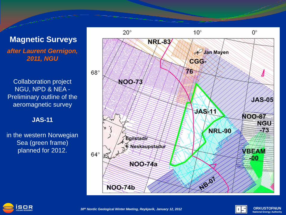
Magnetic Surveys
after Laurent Gernigon,
2011, NGU
Collaboration project
NGU, NPD & NEA -
Preliminary outline of the
aeromagnetic survey
JAS-11
in the western Norwegian
Sea (green frame)
planned for 2012.

Data Control
High resolution bathymetry surveys (2008 HÍ & NEA, 2010 NPD)
Actual “hard” data – boreholes, seafloor core, grab or dredge samples – ongoing
governmental and commercial research (NEA-Fugro, NPD, VBPR-TGS).
• Progress : - evidence for presence of pre-Tertiary strata
- evidence for presence of organic rich shales
- key markers to define southeastern- and western basalt
provinces including updated heat flow data estimate
- shallow seismic ties down to Middle Eocene at ridges crests
• Main Question : - lack of deep stratigraphic pre-Paleocene well control with
resulting necessary risk mitigating parameters, e.g. age control,
reservoir-seal characteristics, basin modeling, velocity modeling,
etc.
ORKUSTOFNUN National Energy Authority
30th Nordic Geological Winter Meeting, Reykjavík, January 12, 2012

DSDP : 5 wells during Leg 38 in 1974
ODP : 1 well during Leg 151 in 1993
ODP : 2 wells during Leg 162 in 1995
Cores provide density and velocity measurements to
enable a depth – seismic tie (TWT) to confirm the Top
Eocene marker for 3 wells on the Ridge.
Seafloor sampling (core, dredge & ROV grab)
• NEA & NPD 2010
• NPD 2011
• VBPR 2011
2011 samples indicate pre-Tertiary strata with
sandstone of good quality that can act as a reservoir
rock. In addition, it found rocks of an age that act as
source rocks in Greenland .
Detailed analysis are in progress at NPD, UiB &
VBPR-TGS.
Borehole & Seafloor Samples
around the Jan Mayen Area
Reached into
BASALT approx.
40-44 Ma (Talwani
et al, 1976)
approx. magnetic
anomaly 19-20,
Middle Eocene
Reached into
BASALT
18.8 ± 1.7Ma
(Talwani et al,
1976)
approx. magnetic
anomaly 6,
around top Early
Miocene
ORKUSTOFNUN National Energy Authority
30th Nordic Geological Winter Meeting, Reykjavík, January 12, 2012
ROV outcrop
sampling on steep
ridge flanks, NPD
& University of
Bergen in
summer 2011 over
the Noth-Dreki
area.

What do we know?
Best analogue comparison with East Greenland exploration examples and Møre Basin for
the Norwegian side.
Post Paleocene sedimentary rocks of sufficient thickness and age in the ridge flank areas.
Indications and first preliminary evidence of pre-opening sedimentary strata of possibly
Paleozoic, Triassic-Jurassic and maybe Cretaceous age – especially underneath the west
flank areas of the ridge, i.e. Jan Mayen Basin.
Potential reservoir rocks, focus on locally shallow marine to generally marine deposits,
especially submarine fans / turbidite deposits for post Paleocene deposits, and possibly
focus on limestone platform to continental deposits for the pre-opening formations.
Potential traps present, both structural and stratigraphic.
Hydrocarbon maturation is probably high, more gas prone if sufficient source rocks are
present and a more detailed influence of igneous activity needs to be included.
ORKUSTOFNUN National Energy Authority
30th Nordic Geological Winter Meeting, Reykjavík, January 12, 2012

Regional Correlations important for comparison to the history of the JMMC Collage based on results of recent research publications and observations at the JMMC
7
Wollaston
Foreland
ORKUSTOFNUN National Energy Authority
30th Nordic Geological Winter Meeting, Reykjavík, January 12, 2012
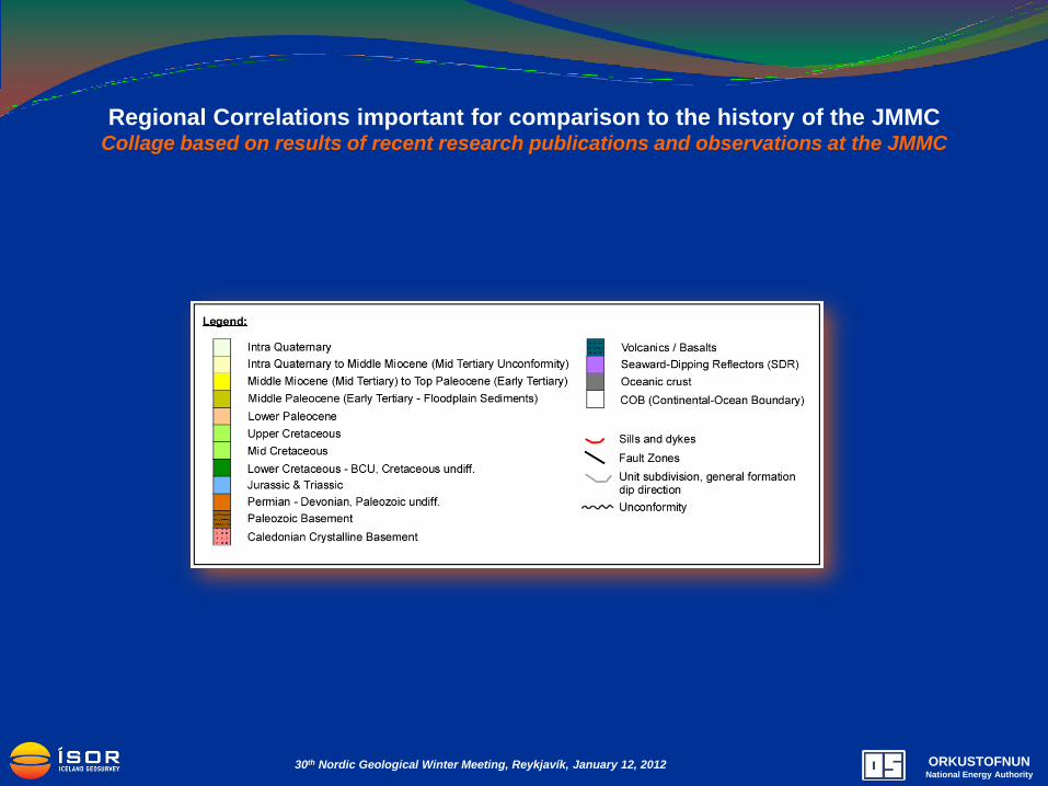
Regional Correlations important for comparison to the history of the JMMC Collage based on results of recent research publications and observations at the JMMC
ORKUSTOFNUN National Energy Authority
30th Nordic Geological Winter Meeting, Reykjavík, January 12, 2012

Regional Correlations important for comparison to the history of the JMMC Collage based on results of recent research publications and observations at the JMMC
50 km
10 m
s
10 k
m
50 km
2
Vøring Basin
Modified after Brekke, H. et al, 2000
5
Møre Basin
Modified after Brekke, H. et al, 2000
1
Danmarkshavn & Thetis Basins
Modified after Dinkelman, M.G. et al, 2010
6
Kangerlussuaq
Modified after Henriksen, N. et al, 2008
3
Jameson Land Basin, Liverpool High & Basin
Modified after Henriksen, N. et al, 2008
4
Jan Mayen Micro-Continent
?
7
Wollaston
Foreland
Modified after
Henriksen, N. et
al, 2009
?
?
ORKUSTOFNUN National Energy Authority
30th Nordic Geological Winter Meeting, Reykjavík, January 12, 2012

Top Paleocene Structure Map (Depth Range: 170m – 6100m)
Structural Compartmentalization of the JMMC
Early to Late Oligocene composite sheet
of flat-lying intrusive covering subsided
continental crust just before oceanic
crust started to form on the Kolbeinsey
Ridge and the Iceland Plateau.
SDR (Seaward Dipping Reflectors)
Important Fault / Fractures Zones that
influence and subdivide the JMR.
Top Paleocene Faults
Minor reverse faulting visible
(poss. since the Middle Miocene parallel
the opening of the Kolbeinsey Ridge)
ORKUSTOFNUN National Energy Authority
30th Nordic Geological Winter Meeting, Reykjavík, January 12, 2012

NPD-NEA Surveys
Conceptual model –
seismic data comparison
Key line interpretation at the JMMC
ORKUSTOFNUN National Energy Authority
30th Nordic Geological Winter Meeting, Reykjavík, January 12, 2012

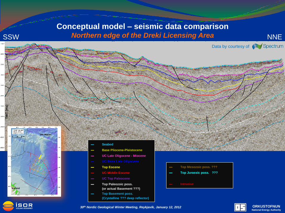
Conceptual model – seismic data comparison Northern edge of the Dreki Licensing Area
ORKUSTOFNUN National Energy Authority
30th Nordic Geological Winter Meeting, Reykjavík, January 12, 2012

ORKUSTOFNUN National Energy Authority
30th Nordic Geological Winter Meeting, Reykjavík, January 12, 2012
?
Jan
Mayen
Tro
ug
h
?
NNE SSW
New 2D Seismic Quality Data = More Possibilities for Data Interpretation Possible Sub Tertiary unconformities become better visible below the Top Paleocene
▬ Seabed
▬ Late Oligocene - Miocene
▬ Base Late Oligocene
▬ Top Eocene
▬ UC Middle Eocene
▬ UC Top Paleocene
▬ UC Late Paleocene poss.
▬ Top Mesozoic poss.
▬ Top Paleozoic poss.
(or actual Basement ???)
▬ Top Basement poss.
(Crystalline ??? deep reflector)
Data by courtesy of
Conceptual model – seismic data comparison Northern edge of the Dreki Licensing Area
▬ Seabed
▬ Base Pliocene-Pleistocene
▬ UC Late Oligocene - Miocene
▬ UC Base Late Oligocene
▬ Top Eocene
▬ UC Middle Eocene
▬ UC Top Paleocene
▬ Top Paleozoic poss.
(or actual Basement ???)
▬ Top Basement poss.
(Crystalline ??? deep reflector)
▬ Top Mesozoic poss. ???
▬ Top Jurassic poss. ???
▬ Intrusive
Data by courtesy of
NNE SSW
ORKUSTOFNUN National Energy Authority
30th Nordic Geological Winter Meeting, Reykjavík, January 12, 2012
TW
T (
ms)

ORKUSTOFNUN National Energy Authority
30th Nordic Geological Winter Meeting, Reykjavík, January 12, 2012
▬ Seabed
▬ Base Pliocene-Pleistocene
▬ Late Oligocene - Miocene
▬ Base Late Oligocene
▬ Top Eocene
▬ UC Middle Eocene
▬ UC Top Paleocene
▬ Top Paleozoic poss.
(or actual Basement ???)
▬ Top Basement poss.
(Crystalline ??? deep reflector)
Conceptual model – seismic data comparison Northern edge of the Dreki Licensing Area
Data by courtesy of

Volcanic Zones of JMMC Possible scenario
SDR (Seaward Dipping Reflectors)
Poss. post break-up, larger intrusions
Volcanic complexes poss. just above
the top Paleocene marker
44-40Ma Anomaly 19-20 Basalt
province
Probably oceanic ridges / transition area
Possible Rift area between Anomalies
20 & 13
Jan Mayen Trough shallow intrusions
Early to Late Oligocene composite sheet
of flat-lying intrusive (Anomalies >6)
Important Fault / Fractures Zones that
influence and subdivide the JMR.
ORKUSTOFNUN National Energy Authority
30th Nordic Geological Winter Meeting, Reykjavík, January 12, 2012

Seismic data – Timing of Intrusions
▬ Seabed
▬ Pleistocene - Pliocene
▬ UC Late Oligocene - Miocene
▬ UC Base Late Oligocene
▬ Top Eocene
▬ UC Middle Eocene
▬ UC Top Paleocene
▬ Eocene – Oligocene Intrusive
Data by courtesy of
NNE SSW
ORKUSTOFNUN National Energy Authority
30th Nordic Geological Winter Meeting, Reykjavík, January 12, 2012
900m T
WT
(ms)

Exploration risk factors for
prospectivity
Data – Interpretation certainty
Pre-Tertiary Strata – Reservoir & Source
Post-Paleocene Strata – Reservoir & Seal
Heat Flow – Maturity of Source Rock
Structure & Timing – Trap & Seal
Depth & Location – Accessibility
ORKUSTOFNUN National Energy Authority
30th Nordic Geological Winter Meeting, Reykjavík, January 12, 2012
SDR
Top Paleocene Structure map, shallow intrusion (green ploy.)
Risk mitigation
for a better understanding of the Jan Mayen Ridge area
More NNE-SSW 2D seismic lines and denser line grid over areas of interest for a better
structural and facies interpretation
(NPD is conducting an infill 2D seismic survey that also crosses into Icelandic waters
2011 & 2012.)
High resolution magnetic and gravity survey across the complete area of the Southern
Ridge complex
(NGU is flying a high resolution aerial magnetic survey close east to JMR in 2012.)
Additional sea floor sampling campaign (core, grab or dredge sampling) along seismic lines
on the western flank of the ridge, preferably on steep ridge flanks that expose older strata.
(NPD has completed a ROV sampling campaign in 2011, researching presently the
results. VBPR-TGS has completed their sampling campaign in 2011, presently
researching the results, open for purchase in February 2012.)
ORKUSTOFNUN National Energy Authority
30th Nordic Geological Winter Meeting, Reykjavík, January 12, 2012

Risk mitigation
for a better understanding of the Jan Mayen Ridge area
Basin modeling study using more recent (e.g. Rey, 2003) geothermal gradient model,
estimating degree of maturity assuming that source rocks are present, also in direct
comparison with studies that have been done for the Jameson Land Basin area in East
Greenland.
New long offset and low frequency 2D seismic survey along the outer coast of the
“Scoresby Sund” and “Blosseville Kyst” along the East-Greenland coast, where the
western end of the possible Jan Mayen Basin lies.
Possibly conduct a more detailed “outcrop” study at the steep Jan Mayen ridges of the
southeastern ridge complex to support analogue comparison studies between the JMMC
and the Møre basin for the sub-basalt formations, especially for the Mesozoic aged
formations.
Deep stratigraphic well in the shallower waters into the Main Ridge high, to show if a
Mesozoic or Paleozoic strata exists of sufficient thickness and quality – or if the complex
structures and patterns correspond to primarily intrusive complexes.
ORKUSTOFNUN National Energy Authority
30th Nordic Geological Winter Meeting, Reykjavík, January 12, 2012

Thank you very much for your attention !
Acknowledgements:
Kristinn Einarsson, Inga Dóra Gudmundsdóttir, Lárus Ólafsson, Thorvaldur Bragason at NEA
Sigurveig Árnadóttir, Gunnlaugur M. Einarsson, Bjarni Richter at Iceland Geosurvey
Bryndís Bandsdóttir, University of Iceland
ORKUSTOFNUN National Energy Authority
30th Nordic Geological Winter Meeting, Reykjavík, January 12, 2012