ohio grape-wine electronic newsletter · on tuesday afternoon ... will still see significant rain...
TRANSCRIPT

Ohio Grape-Wine Electronic Newsletter
Editor: David Scurlock, Viticulture Outreach Specialist
Department of Horticulture and Crop Science Ohio Agricultural Research and Development Center
1680 Madison Avenue Wooster, OH 44691-4096
HUwww.oardc.ohio-state.edu/grapeweb/
UH
10 September 2015 (22)
Content: Editor Note: Weather Forecasting Harvest Weather Forecast for Ohio SWD Update Know Your Grape and Wine Experts __________________________________________________________
Editor Note: Weather Forecasting by Dave Scurlock, OSU/OARDC Viticulture Outreach Specialist This year I have been hearing a lot of prognostication about El Nino/ɛl ˈniːnjoʊ/ (Spanish pronunciation: [el ˈniɲo]) is the warm phase of the El Niño Southern Oscillation (commonly called ENSO) and is associated with a band of warm ocean water that develops in the central and east-central equatorial Pacific (between approximately the International Date Line and 120°W), including off the Pacific coast of South America. El Niño Southern Oscillation refers to the cycle of warm and cold temperatures, as measured by sea surface temperature, SST, of the tropical central and eastern Pacific Ocean. El Niño is accompanied by high air pressure in the western Pacific and low air pressure in the eastern Pacific. The cool phase of ENSO is called "La Niña" with SST in the eastern Pacific below average and air pressures high in the eastern and low in western Pacific. The ENSO cycle, both El Niño and La Niña, causes global changes of both temperatures and rainfall.[2][3] Mechanisms that cause the oscillation remain under study.
I am always a little befuddled every fall about the differences between El Nino and La Nina and so I resorted to my favorite weather forecaster David Tolleris, who is responsible for putting out the
I hope you will find David’s forecast for September 9 through October 6 helpful. I spoke with David last week and he is predicting a warmer and drier fall through mid- December, after that snow and cold. It is very difficult to predict out that far but that is his best scientific prediction. This means that harvest and hilling operations should be better than normal years to get accomplished. Let’s Hope for the BEST! I would like to Thank David Tolleris from all of us growers in Ohio for putting together this meteorological scientific look into the future.
David’s contact information is below.
DT WxRisk.com 804-715-8330 Office 804-307-8070 Cell twitter @WXRISKCOM Facebook https://www.facebook.com/WxRisk
1
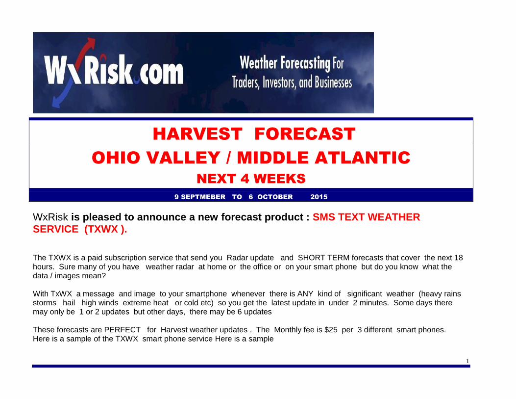
HARVEST FORECAST
OHIO VALLEY / MIDDLE ATLANTIC
NEXT 4 WEEKS
9 SEPTMEBER TO 6 OCTOBER 2015
WxRisk is pleased to announce a new forecast product : SMS TEXT WEATHER SERVICE (TXWX ).
The TXWX is a paid subscription service that send you Radar update and SHORT TERM forecasts that cover the next 18 hours. Sure many of you have weather radar at home or the office or on your smart phone but do you know what the data / images mean? With TxWX a message and image to your smartphone whenever there is ANY kind of significant weather (heavy rains storms hail high winds extreme heat or cold etc) so you get the latest update in under 2 minutes. Some days there may only be 1 or 2 updates but other days, there may be 6 updates These forecasts are PERFECT for Harvest weather updates . The Monthly fee is $25 per 3 different smart phones. Here is a sample of the TXWX smart phone service Here is a sample

2
**************************************************
Even though we are now passed the Labor Day holiday and moving towards the Middle September, there still does not
appear to be any break in the summertime heat across much of the eastern third of the country, especially over the Middle
Atlantic region. On Tuesday afternoon Richmond and Washington, DC reached 92°, Philadelphia reached 94°, Harrisburg
and NYC reached 95°, and Boston set a record of 96°. Pittsburgh reached 91°, Columbus OH reached 88, Dayton 89 and
Zanesville 91

3
This is even more impressive when we keep in mind that the normal Max
temperature for September 8, for Richmond its 83°, for Washington, DC, 82°,
LaGuardia in New York City, 77°, Pittsburgh 76°, and Boston 75° and Columbus
Ohio 75.
However, for the past 2 weeks WXRISK has have been talking about the potential
for a significant cool down in the Eastern third of the US for this weekend. The
models have been advertising a major trough or "DIP" in the jet stream, developing
over the upper Midwest over the next few days. This trough amplifies or expands in
its size and depth, as it sweeps across the Midwest and towards the East Coast
this weekend.
At the surface, this is going to produce TWO cold fronts. The first cold front is going to arrive over the Ohio Valley on
Wednesday evening into Thursday morning and reach the Appalachian mountains Thursday afternoon The front will move
into the interior portions of the Middle Atlantic region on Thursday night and Friday morning. This cold front will bring
widespread moderate to heavy rains and thunderstorms Wednesday night and Thursday Morning to southern Ohio until
evening. Heavy rains/ storms will spread across all areas of the Middle Atlantic as well as eastern portions of Kentucky and
Tennessee Thursday afternoon and evening
4
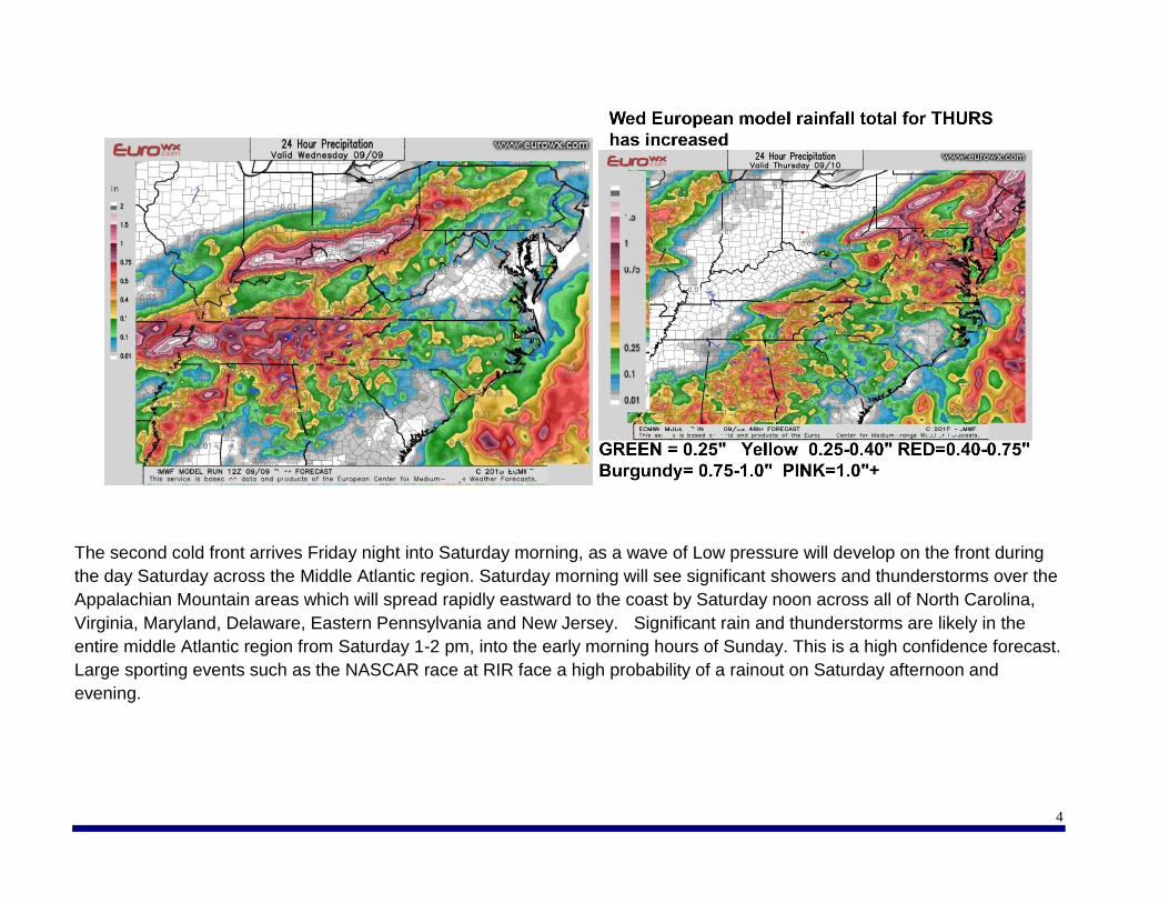
The second cold front arrives Friday night into Saturday morning, as a wave of Low pressure will develop on the front during
the day Saturday across the Middle Atlantic region. Saturday morning will see significant showers and thunderstorms over the
Appalachian Mountain areas which will spread rapidly eastward to the coast by Saturday noon across all of North Carolina,
Virginia, Maryland, Delaware, Eastern Pennsylvania and New Jersey. Significant rain and thunderstorms are likely in the
entire middle Atlantic region from Saturday 1-2 pm, into the early morning hours of Sunday. This is a high confidence forecast.
Large sporting events such as the NASCAR race at RIR face a high probability of a rainout on Saturday afternoon and
evening.

5
The good news is that the cold front will clear the coast on Sunday morning from west to east. This means that the Ohio valley
and interior portions of the Middle Atlantic, as well as the Appalachian Mountains should start off sunny on Sunday, and
continue to remain sunny most of the day along with breezy and Autumn like weather. However, the coastal areas from
Virginia to New England, there is some uncertainty as to how fast the cold front will clear the coast. There may still be some
clouds and early morning lingering showers across central and eastern North Carolina, Virginia, central and eastern Maryland,
Delaware, southeastern Pennsylvania, and Southern New Jersey on Sunday morning. But by noon on Sunday, skies should
be partly to mostly sunny, breezy, and rather autumn like with much cooler temperatures.
To the north, it is likely that much of Pennsylvania, New Jersey, and New York, including the New York City metro area and
Long Island, as well as all of New England, will still see significant rain and heavy showers Sunday morning. However, by
Sunday afternoon all the rain should be over and done with across New England and New York State, and the sun should be
out along with gusty northwest winds and rather cool autumn like conditions.
6
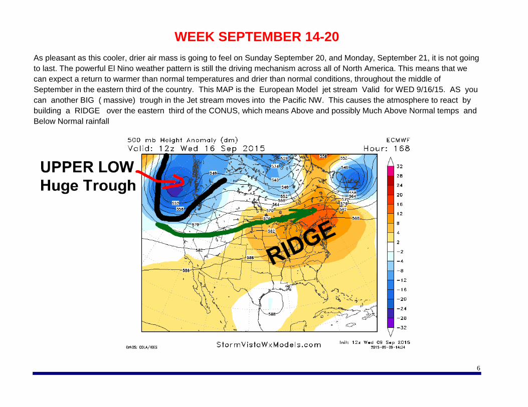
WEEK SEPTEMBER 14-20
As pleasant as this cooler, drier air mass is going to feel on Sunday September 20, and Monday, September 21, it is not going
to last. The powerful El Nino weather pattern is still the driving mechanism across all of North America. This means that we
can expect a return to warmer than normal temperatures and drier than normal conditions, throughout the middle of
September in the eastern third of the country. This MAP is the European Model jet stream Valid for WED 9/16/15. AS you
can another BIG ( massive) trough in the Jet stream moves into the Pacific NW. This causes the atmosphere to react by
building a RIDGE over the eastern third of the CONUS, which means Above and possibly Much Above Normal temps and
Below Normal rainfall

7
This image shows how warm/ hot SEPT 16-17-18-19-20 might be
8
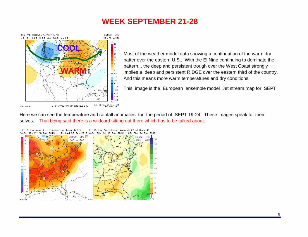
WEEK SEPTEMBER 21-28
Most of the weather model data showing a continuation of the warm dry
patter over the eastern U.S.. With the El Nino continuing to dominate the
pattern... the deep and persistent trough over the West Coast strongly
implies a deep and persistent RIDGE over the eastern third of the country.
And this means more warm temperatures and dry conditions.
This image is the European ensemble model Jet stream map for SEPT
Here we can see the temperature and rainfall anomalies for the period of SEPT 19-24. These images speak for them
selves. That being said there is a wildcard sitting out there which has to be talked about.

9
Over the past several days the European model has been developing a tropical system over the southwest portions of the
Gulf of Mexico sometime around September 15. The European model has been showing this for the past five days so it has
a lot of consistency. Since the European model the vastly superior weather model to the American or GFS Model the
European consistency in depicting a possible tropical storm or hurricane in the Western Gulf of Mexico needs to be
considered as a real possibility.
This image is from the Wednesday afternoon European model and shows a category two hurricane off the Texas Coast
headed for Louisiana. The concern we have is at the upper air pattern over the eastern portions of the country clearly support
the remains of the system being pulled north eastward into Tennessee Kentucky and up towards west Virginia and Virginia
sometime around September 21-23

10
Obviously this is quite a long way out and rather speculative. But if this
system or to develop and the upper air pattern remains as the models are
depicting it could bring significant rains during the last week of September
especially over the mound areas of Tennessee a Kentucky West Virginia
and Virginia.
WEEK #4 SEPT 29- OCT 6
The overall pattern has not changed much. The eastern third of the
country continues to see above normal temperatures with near normal
rainfall across New England, the Great Lakes, and the upper Midwest. In
the Middle Atlantic, rainfall amounts look to be somewhat below normal.
Spotted Wing Update by Dave Scurlock OSU/OARDC Viticulture Outreach Specialist
Spotted Wing Drosophila captures are on the upswing in Wooster. We have been trapping since the sugars reached 150 brix, which is the ideal time to expect the SWD to come in on grapes. Our last spray was Baythroid. Most of these sprays are only effective for 7 to 10 days under ideal conditions. Like any other pesticide material they are broken down by light and diminished by rain. Most pesticides can be considered to be half gone after receiving an inch of rain and vines need to be retreated if you have received 2 inches of precipitation. We have not receive any real measurable amounts of rain since the last application of Baythroid but, within 7 days after our last insecticide application we did capture double the amount of SWD’s we had caught before the Baythroid spray. This indicates to me that populations may be exploding and trapping and identification needs to be performed at regular (every other day) intervals to knock the population down. If you do not have any fruit to protect then you do not need to worry about SWD as much. Dr. Celeste Welty has a nice fact sheet (* see link below) that will help you with both identification and chemical controls. The chemical control portion also contains PHI information. http://entomology.osu.edu/welty/pdf/SWD_Ohio_handoutV8.pdf

OSU Grape & Wine Research & Outreach Specialist Please contact the following Research, Extension/Outreach Specialists, and Educators if you have any questions relating to their respective field of expertise.
Contact Information Area of Expertise & Assistance
Provided Name & Address Phone Email & Website
Dr. Mike Ellis, Emeritus Professor Dept. Plant Pathology 224 Selby Hall ‐‐ OARDC 1680 Madison Avenue Wooster, OH 44691
330‐263‐3849
E‐mail: [email protected] *After Dec.1 2014 Website: http://www.oardc.ohio‐ state.edu/fruitpathology/
Grape diseases and control. Recommendation on grape fungicides
Dr. Celeste Welty Dept. of Entomology Columbus, Ohio
614‐292‐2803
E‐mail: [email protected]
Fruit and vegetable Insects
Dr. Doug Doohan, Professor Dept. Horticulture & Crop Science 205 Gourley Hall – OARDC 1680 Madison Avenue Wooster, OH 44691
330‐202‐3593
E‐mail: [email protected] Website: www.oardc.ohio‐ state.edu/weedworkshop/default.asp
Vineyard weeds and control. Recommendation on herbicides
Dr. Imed Dami, Associate Professor & Viticulture State Specialist Dept. Horticulture & Crop Science 216 Gourley Hall – OARDC 1680 Madison Avenue Wooster, OH 44691
330‐263‐3882
E‐mail: [email protected] Website: oardc.osu.edu/grapeweb/
Viticulture research and statewide extension & outreach programs. Recommendation on variety selection. Imed is the primary research contact of the viticulture program.

Contact Information
Area of Expertise& Assistance Provided
Name & Address Phone Email & Website
David Scurlock, Viticulture Outreach Specialist 118 Gourley Hall – OARDC 1680 Madison Avenue Wooster, OH 44691
330‐263‐3825
E‐mail: [email protected] Website: oardc.osu.edu/grapeweb/
Evaluation of site suitability for vineyard establishment and all aspects of grape production practices in northern Ohio. David is the primary extension contact of the viticulture program
Todd Steiner, Enology Program Manager & Outreach Specialist Dept. Horticulture & Crop Science 118 Gourley Hall – OARDC 1680 Madison Avenue Wooster, OH 44691
330‐263‐3881
E‐mail: [email protected] Website: oardc.osu.edu/grapeweb/
Commercial wine production, sensory evaluation, laboratory analysis/setup and winery establishment. Todd is the primary research and extension contact of the enology program
Dr. Gary Gao , Small Fruit Specialist and Associate Professor, OSU South Centers 1864 Shyville Road, Piketon, OH 45661 OSU Campus in Columbus Room 256B, Howlett Hall, 2001 Fyffe Ct Columbus, OH 43201
740-289-2071 ext.123 Fax:740-289-4591
E-mail: [email protected] Website: http://southcenters.osu.edu/
Viticulture Research and Outreach, VEAP visits in southern Ohio, vineyard management practices, soil fertility and plant nutrition, fruit quality improvement, variety evaluation, table and wine grape production
Station Manager Ashtabula Agricultural Research Station 2625 South Ridge Road Kingsville, OH 44048
440‐224‐0273
E‐mail: Website: www.oardc.ohio‐ state.edu/branches/branchinfo.asp?id=1
Winegrape production in Northeast Ohio, especially vinifera varieties
Contact Information
Area of Expertise& Assistance Provided
Name & Address Phone
Email & Website
David Marrison, County Extension Director, Associate Professor & Extension Educator, OSU Extension‐Ashtabula County 39 Wall Street Jefferson, Ohio 44047
440‐576‐9008 Ext. 106
E‐mail: [email protected] Website: ashtabula.osu.edu
Vineyard and winery economics, estate planning and Extension programs in Northeast Ohio