the diurnal cycle of winds, rain, and clouds over taiwan ... at al.pdf · winds in late afternoon...
TRANSCRIPT

The Diurnal Cycle of Winds, Rain, and Clouds over Taiwan during theMei-Yu, Summer, and Autumn Rainfall Regimes
BRANDON WESLEY JOHN KERNS* AND YI-LENG CHEN
Department of Meteorology, School of Ocean and Earth Science and Technology,
University of Hawaii at Manoa, Honolulu, Hawaii
MEI-YU CHANG
Central Weather Bureau, Taipei, Taiwan
(Manuscript received 15 April 2009, in final form 20 August 2009)
ABSTRACT
The diurnal variations in surface winds, rain, and clouds over Taiwan are presented for three rainfall
regimes: the mei-yu (16 May–15 June), summer (16 July–31 August), and autumn (16 September–15 Oc-
tober). Though the magnitude of diurnal island divergence and convergence is similar under each regime, the
diurnal variations of rain and clouds vary considerably between the regimes. These differences are related to
the seasonal changes in environment winds, stability, moisture, and weather systems. In addition to oro-
graphic lifting on the windward side, rainfall occurrences for all three rainfall regimes are strongly modulated
by the diurnal heating cycle with an afternoon maximum. The largest day–night differences in rainfall occur
in summer and the smallest differences occur in autumn. The upper-level high cloud (,235 K) frequencies
have a pronounced afternoon maximum over the mountainous areas in the afternoon because of combined
effects of orographic lifting and solar heating. These clouds are advected downstream by the upper-level
winds in late afternoon and early evening. The highest afternoon high cloud frequencies occur in summer
(.30%) with the lowest upper-level cloud cover in autumn (;10%). In autumn, most of the orographic
showers on the eastern and northeastern windward side in the late afternoon and early evening are not from
deep clouds. The weak early-morning rainfall maxima for all three seasons are related to the localized
boundary layer convergence due to the orographic blocking of the prevailing winds and their interactions
with the offshore/land breeze. During disturbed, prefrontal periods in the mei-yu, bands of high clouds and
rain tend to develop in the early morning in the convergence zone off the northwest coast. These rainbands
are responsible for the early-morning rainfall maximum on the northwest coast. They do not occur in summer
or autumn.
1. Introduction
Taiwan is subject to the northeast monsoon from Sep-
tember to early May, and the southwest monsoon domi-
nates for the rest of the year (Murakami 1958; Ramage
1971; Tao and Chen 1987; Boyle and Chen 1987). The
seasonal changes of prevailing wind and atmospheric sta-
bility give Taiwan five distinct rainfall regimes:1 winter,
spring, mei-yu, summer, and autumn (Chen and Chen
2003). The autumn, winter, and spring rainfall regimes
occur within the northeast monsoon. The mei-yu and
summer rainfall regimes occur during the southwest mon-
soon. In general, the heaviest and most frequent rainfall
occurs on the windward side of the island for each re-
gime. However, heavy rainfall (.100 mm day21, which
is likely to cause flash flooding in the steep terrain of
Taiwan) is not common in winter and spring because of* Current affiliation: Rosenstiel School of Marine and Atmo-
spheric Science, University of Miami, Miami, Florida.
Corresponding author address: Dr. Yi-Leng Chen, Department
of Meteorology, SOEST, University of Hawaii at Manoa, Hono-
lulu, HI 96822.
E-mail: [email protected]
1 Because of Taiwan’s unique location within the East Asian
monsoon, the rainfall regimes do not exactly correspond with the
four seasons (winter, spring, summer, and autumn) usually dis-
cussed in climatology literature.
FEBRUARY 2010 K E R N S E T A L . 497
DOI: 10.1175/2009MWR3031.1
� 2010 American Meteorological Society

greater atmospheric stability. Thus, there are three main
distinct rainfall regimes over Taiwan: mei-yu (16 May–
15 June), summer (15 July–31 August), and autumn
(16 September–15 October; Chen and Chen 2003).
These three regimes are characterized by different en-
vironment flow characteristics, stability, moisture, and
embedded weather disturbances.
During the mei-yu regime (16 May–15 June), the
mean large-scale flow over Taiwan is characterized by
southwesterly flow increasing with height (Figs. 1a and
2a). However, the island experiences wind fluctuations
associated with the passage of mei-yu fronts (Chen and
Li 1995). The postfrontal cold northeasterlies are gen-
erally less than 1 km deep (Chen et al. 1989; Trier et al.
1990). The thermodynamic stratification around Taiwan
during the mei-yu is conditionally unstable within the
warm, moist southwesterly monsoon flow (Chen and Chen
2003). The combination of low–midlevel wind shear,
FIG. 1. Average atmospheric soundings at Taipei for
the (a) mei-yu, (b) summer, and (c) autumn. The curve
on the left of each plot is the RH profile. The hodo-
graphs in the upper right are from 1000 up to 200 hPa.
For the wind barbs, 5 kt is a half barb, and 10 kt is a full
barb.
498 M O N T H L Y W E A T H E R R E V I E W VOLUME 138

conditional instability, and abundant moisture favors the
formation of organized mesoscale convective systems in
the southwest monsoon, especially associated with a mei-yu
front (Wang et al. 1990; Lin et al. 1990). Heavy rainfall is
most common on the west side of the Central Mountain
Range (CMR) during the mei-yu often caused by the
interaction of synoptic and subsynoptic weather systems
with the terrain of Taiwan (Li et al. 1997; Teng et al. 2000;
Chen et al. 2007). However, heavy rainfall can also occur
in the northeast part of Taiwan during brief periods fol-
lowing the passage of mei-yu fronts. In some instances,
heavy rain could possibly occur merely from the in-
teraction of the terrain and local circulations with the
environment flow (Chen et al. 1991; Akaeda et al. 1995).
In mid-June, concurrent with the seasonal change of
the upper-level winds from westerlies to northeasterlies
over Taiwan, the mei-yu trough migrates northward to
the Yangtze River Valley and Japan as the mei-yu re-
gime comes to an end over Taiwan (Chen 1993). After
the seasonal change, the upper-level northeasterlies
along the southeastern flank of the Tibetan high prevail
over Taiwan (Figs. 1b and 2b), preventing most baro-
clinic systems in the midlatitude westerlies from affect-
ing Taiwan (Chen 1993). Another rainfall peak occurs
during 15 July–31 August and is classified as the sum-
mer rainy regime over Taiwan (Chen and Chen 2003).
Though summer is the most unstable regime considered
(Table 1), it is not the peak in annual rainfall for many
stations over Taiwan except for the eastern and south-
eastern areas, where heavy rainfall frequently occurs
when a tropical cyclone from the western Pacific moves
westward and affects Taiwan (Chen and Chen 2003).
FIG. 2. Wind roses at Penghu for the (a) mei-yu, (b) summer, and
(c) autumn. The range rings are relative frequencies of occurrence.
The hourly winds are binned according to direction and wind speed
(shading).
FEBRUARY 2010 K E R N S E T A L . 499

Organized mesoscale systems (aside from tropical cy-
clones) are less common than in the mei-yu regime. The
diurnal cycle in summer is most representative of the
influence of the island circulations along with little in-
teraction with the environment.
Autumn occurs after the onset of the northeast mon-
soon (Figs. 1c and 2c), and it is the most stable regime
considered. The low-level environment winds during
autumn are the strongest of the three main rainfall re-
gimes. Autumn also features the lowest mean CAPE
and positive mean lifted index (LI) (Table 1c). Autumn
is the last chance for deep convection before the winter
regime sets in with cold surges (Chen and Chen 2003).
Rainfall reaches a secondary seasonal peak in the north-
east part of Taiwan as this area is on the windward side
of the northeasterly monsoon flow.
In addition to large-scale conditions, island-induced
flows such as: flow blocking, orographic lifting, and di-
urnal circulations and their interactions with the large-
scale flow also affect the timing and location of rainfall
occurrences in a mountainous island like Taiwan and in
many different parts of the world (Grossman and Durran
1984; Ogura and Yoshizaki 1988; Oki and Musiake 1994;
Akaeda et al. 1995; Li et al. 1997; Li and Chen 1998; Yeh
and Chen 1998; Teng et al. 2000; Chen and Chen 2003;
Dairaku et al. 2004). Taiwan is an ideal place to study
the interactions between the large-scale environment
and the local island forcing because of its exposure to
a variety of planetary and synoptic-scale weather sce-
narios and a dense surface observation network. The na-
ture of the local island forcing depends on the prevailing
flow and atmospheric stability as well as individual weather
disturbances that may affect Taiwan (e.g., squall lines and
typhoons). The terrain of Taiwan is dominated by the
CMR with average ridge elevation around 2.5 km and
peaks above 3 km (Fig. 3). The terrain of Taiwan is a sig-
nificant obstacle to the low-level flow. With a mean ridge
height of h ; 2.5 km, a mean low-level wind speed of
5–10 m s21, and a Brunt–Vaisala frequency of ;0.01 s21,
the Froude number (Fr 5 U/Nh) is Fr ; 0.2–0.4. When
O(Fr) , 1, the terrain presents an obstacle to the flow, and
flow blocking occurs (Overland and Bond 1995). Similar
to the Big Island of Hawaii (Smolarkiewicz et al. 1988),
the prevailing flow is blocked by the CMR in Taiwan with
leeside vortices (Sun et al. 1991; Sun and Chern 1993).
Ramage (1952) found a strong afternoon maximum
over northern Taiwan but weak morning and afternoon
maxima in the south, for May–August. The Taiwan
Area Mesoscale Experiment (TAMEX) was conducted
from 1 May to 29 June 1987 (Kuo and Chen 1990).
Johnson and Bresch (1991) found that the early after-
noon rainfall maxima occurred at 100–500-m elevation.
Yeh and Chen (1998) documented the diurnal cycle of
several regions of the island during TAMEX. The di-
urnal maximum was 1–2 h earlier [starting at 1500 local
time (LT)]2 on the windward (west) lower slopes (500–
1000-m elevation) than in the high terrain. The diurnal
cycle near the southwest and northwest coasts was not
pronounced with weak early-morning maxima. On the
lee side of Taiwan (east), the diurnal rainfall maximum
was delayed until 1700–2000 LT. Note that during
TAMEX, there were only 85 hourly rain gauges that are
unevenly distributed over Taiwan.
Krishtawal and Krishnamurti (2001) used rainfall
estimated by the Tropical Rainfall Measuring Mission
(TRMM) for May–September 1998 to document the
diurnal cycle of rainfall over Taiwan. They found a
dominant afternoon maximum with secondary morn-
ing (;0600–0700 LT) and nighttime (;2200–0000 LT)
maxima. Furthermore, that study suggested that the
TRMM-estimated rainfall in the Taiwan Strait also
has a diurnal cycle with a late-night to early-morning
maximum.
In 1993, Taiwan’s Central Weather Bureau (CWB)
installed and began to use the Automatic Rainfall and
Meteorological Telemetry System (ARMTS) to aid in
flash flood forecasting (Central Weather Bureau 1995;
Hsu 1998). Chen et al. (1999) used the ARMTS rain
gauges available during 1993–97 and 25 conventional
stations over Taiwan to study the rainfall diurnal cycle
TABLE 1. Mean and std devs of convective indices calculated
from soundings taken at Taipei during the (a) mei-yu, (b) summer,
and (c) autumn: CAPE (J kg21), LI (8C), and PW (mm). Note that
while the mean LI is slightly positive for the mei-yu, it is negative at
nearby stations. During the mei-yu the conditions alternate be-
tween unstable prefrontal and stable postfrontal.
Avg Std dev
(a) Mei-yu
CAPE 460 742
LI 0.61 3.8
PW 54 10
(b) Summer
CAPE 947 790
LI 22.3 2.2
PW 57 9.3
(c) Autumn
CAPE 336 497
LI 0.85 3.3
PW 49 10
2 Local time is UTC 1 8 h. Taiwan does not observe daylight
savings time. Local sunrise (sunset) ranges from 0500 (1845) in
June to 0600 (1715) by the end of October. Local noon is within
10 min of solar noon, except near the end of October, when solar
noon occurs at ;1140 LT.
500 M O N T H L Y W E A T H E R R E V I E W VOLUME 138
averaged over the entire southwest monsoon period
(May–August). They found dominant afternoon max-
ima with secondary morning maxima over the western
coastal plain near the mountains. Their analysis of the
seasonal cycle showed that stations in the northwest
experience rainfall maxima in May (mei-yu) while those
over the southwest coastal plain have rainfall maxima
in August (summer). However, they did not discuss
the diurnal cycle of rainfall of the mei-yu and summer
separately. In this study, in addition to island-averaged
diurnal rainfall variations, detailed horizontal distribu-
tions of diurnal rainfall variations for mei-yu, summer,
and autumn rainfall regimes were investigated. The
spatial variability of diurnal rainfall variations is af-
fected by the environment flow, the interactions be-
tween the environment flow and local winds, and
individual weather systems embedded in the flow. The
goals of this study are to use the ARMTS database to
distinguish between the diurnal wind, rainfall, and cloud
patterns characteristic of the mei-yu, summer, and au-
tumn and to study the island effects on rainfall diurnal
cycle under different rainfall regimes. Additionally, the
diurnal climatology of cold clouds measured by geosta-
tionary infrared (IR) satellite data is used to determine
the diurnal cycle of cloudiness over the island as well as
over the open ocean.
2. Data and methods
a. Hourly rainfall
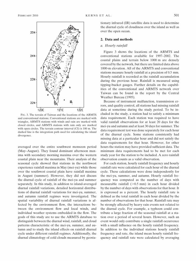
Figure 3 shows the locations of the ARMTS and
conventional stations available for 1997–2002. The
coastal plains and terrain below 1000 m are densely
covered by the network, but there are limited data above
1000-m elevation. All of the ARMTS and conventional
stations measure hourly rainfall at a precision of 0.5 mm.
Hourly rainfall is recorded as the rainfall accumulation
during the previous hour. Rainfall is measured using
tipping-bucket gauges. Further details on the capabil-
ities of the conventional and ARMTS network over
Taiwan can be found in the report by the Central
Weather Bureau (1995).
Because of instrument malfunction, transmission er-
rors, and quality control, all stations had missing rainfall
data at sometime during the study period. To be in-
cluded in the study, a station had to satisfy a minimum
data requirement. Each station was required to have
valid rainfall observations for at least 20 days for the
mei-yu and autumn and at least 30 days for summer. The
data requirement test was done separately for each hour
of the diurnal cycle. Some stations consistently had
missing data at a particular hour and did not satisfy the
data requirements for that hour. However, for other
hours the station may have provided sufficient data. The
minimum data requirements had to be met for each
study year for the station to be included. A zero rainfall
observation counts as a valid observation.
For each station, hourly rainfall frequency and hourly
rainfall rate were calculated for each hour of the diurnal
cycle. These calculations were done independently for
the mei-yu, summer, and autumn. Hourly rainfall fre-
quency was computed as the number of days with
measurable rainfall (.0.5 mm) in each hour divided
by the number of days with observations for that hour. It
is expressed as a percent. The hourly rainfall rate is
defined as the total rainfall in each hour divided by the
number of observations for that hour. Rainfall rate may
be strongly affected by heavy rain events not related to
the diurnal cycle. For example, a typhoon could con-
tribute a large fraction of the seasonal rainfall at a sta-
tion over a period of several hours. However, such an
event would only contribute a single rainfall occurrence
with a small influence on the hourly rainfall frequency.
In addition to the individual stations hourly rainfall
frequency and rate, the island mean hourly rainfall fre-
quency and rainfall rate were calculated by averaging
FIG. 3. The terrain of Taiwan and the locations of the ARMTS
and conventional stations. Conventional stations are marked with
triangles, ARMTS stations with winds and rain are marked with
closed circles, and ARMTS stations with rain only are marked
with open circles. The terrain contour interval (CI) is 100 m. The
dashed line is the integration path used for calculating the island
divergence.
FEBRUARY 2010 K E R N S E T A L . 501

the hourly rainfall frequency and rate for all of the sta-
tions for each hour.
While the afternoon rainfall frequency and rate peak
is easy to see in the diurnal composite time series of is-
land mean rainfall frequency and rate, some stations had
their rainfall rate and/or frequency maximum during the
morning or evening. The time series of rainfall fre-
quency and rain rate were examined qualitatively to
determine which stations have diurnal rainfall maxima
during the morning and evening transition periods
(0700–0800 and 1900–2000 LT, respectively). The max-
ima at each chosen station were at least 5% above the
diurnal mean background for rain frequency and
0.4 mm h21 higher for rain rate for at least 2 consecutive
hours ending on the hour. Because the timing of the
maxima for hourly rainfall frequency and hourly rain
rate may not coincide at exactly the same hour, espe-
cially during the transition period, both are presented.
b. Hourly winds
Hourly winds are recorded at the conventional sta-
tions and at select ARMTS stations as shown in Fig. 3.
Winds are measured by the standard wind vane and cup
instrumentation with a precision of 0.1 m s21. Wind
observations are recorded as the winds at the particular
hour. The ARMTS wind data are of less quality than the
conventional station winds. Wind data were used only
for days with at least 18 h of wind data, except at four
conventional stations (Tanshui, Ilan, Tungchitao, and
Yushan, Taiwan) where wind measurements were made
only at 0200, 0500, 0800, 0900, 1100, 1400, 1700, 2000,
2100, and 2300 LT for some years. Because the data
from these stations are more reliable than the ARMTS
measurements, an exception to the 18-h of data day21
rule was granted for these stations.
The hourly mean winds were computed by taking the
vector average of all observations for each hour. Wind
steadiness, the ratio of the speed of the vector mean
wind to the average of the individual wind speeds, was
also computed. High wind steadiness indicates that the
wind direction is consistent from day to day. Wind
steadiness is a better indication of the consistency of the
wind direction than the magnitude of the mean wind
vector because it is less dependent on wind speed.
Hourly island mean divergence was calculated using
the line integral technique with the path illustrated in
Fig. 3. For each line segment, the component of the
hourly mean wind normal to the segment was multiplied
by the length of the segment. The mean divergence
within the line integral boundary was obtained by
summing all segments and dividing by the total area. The
diurnal mean island divergence was subtracted from the
hourly divergence.
The surface winds measured at Penghu, Taiwan
(23.578N, 119.568E, elevation 11 m), within the Taiwan
Strait are taken to be representative of the open-ocean
low-level flow. Wind roses are presented for this station
to depict the dominant low-level environment flow.
c. Atmospheric soundings
Routine atmospheric soundings were available at
Taipei, Taiwan (25.038N, 121.518E). The soundings
taken at Taipei may be influenced by local terrain. This
is especially relevant for the winds below ;700 hPa. The
low-level flow is better depicted using the wind roses
from Penghu (23.578N, 119.568E).
Several convective indices were computed for each
sounding individually and the mean and standard de-
viations computed. The CAPE and LI were calculated
using a parcel with the mean temperature, dewpoint,
and pressure from the lowest 500 m of the atmosphere.
The precipitable water (PW) was also computed for
each sounding. The sounding data were obtained from
the University of Wyoming.
d. Infrared satellite data
The infrared channel of the Geostationary Meteoro-
logical Satellite-5 (GMS-5) was used in this study. These
data have been archived and geo-mapped at Kochi
University, Japan. Using the IR satellite data from 1997
to 2002, the hourly frequencies (ratio of occurrences to
total observations) of high cloud (,235 K) occurrence
were computed at each 5 km by 5 km pixel. The 235-K
threshold qualitatively represents the products of deep
convection (Fu et al. 1990).
3. Rainfall variations and diurnal wind evolution
Rainfall frequencies and rates are overall highest in
the mei-yu compared with summer and autumn (Figs. 4
and 5). During the mei-yu, rainfall frequencies are above
30% with averaged rain rates .1 mm h21 over the in-
terior mountains west of the CMR ridgeline (Fig. 4a).
Therefore, during the course of the 30-day mei-yu regime
these stations receive ;700 mm of rain. This is more than
most parts of the western United States receive in an
average year. At lower elevations, rainfall frequencies
range between 10% and 20% with rain rates of 0.1–
0.8 mm h21. The contrast between the windward and
leeward sides, relative to the mean southwesterly flow
(Fig. 1a), is not significant. Rainfall tends to occur in the
northeast part of Taiwan after the passage of a mei-yu
front. After the frontal passage, the winds become
northerly for a period of time, which is illustrated by the
wind rose in Fig. 2a. In summer, rainfall rates and fre-
quencies are lower than the mei-yu except over southwest
502 M O N T H L Y W E A T H E R R E V I E W VOLUME 138

Taiwan and the mountainous interior (Figs. 4b and 5b).
In contrast to the mei-yu, the southwest (windward)
side of Taiwan is much rainier than the northeast (lee)
side. The persistent southerly wind in summer (Fig. 2b)
leads to enhanced rainfall over southwest Taiwan as
the warm, moist monsoon flow impinges on the CMR. In
autumn, elevated rain frequencies of .15% and rain rates
.0.8 mm h21 only occur in the northeast part of Taiwan.
Though the environment is more stable in autumn (Fig. 1;
Table 1), orographic precipitation occurs in the northeast
part of Taiwan due to the persistent and relatively strong
northeast monsoon flow (Figs. 1c and 2c).
As expected, the diurnal variation in surface winds is
significant under each regime. In general, the offshore–
katabatic winds dominate in the early morning and the
onshore anabatic flow during the daytime (Figs. 6, 7, and 8).
However, the wind steadiness of the onshore and off-
shore winds varies with location and regime.
For the mei-yu and summer, the early-morning off-
shore flow is more steady (wind steadiness $ 0.7) on the
east side of Taiwan than on the west side (;0.5; Figs. 6a
and 7a). In contrast, the afternoon onshore–upslope flow
has higher wind steadiness on the west side of Taiwan
than the east side (Fig. 6c). During the mei-yu, on the
west side of Taiwan, the prevailing southwest flow op-
poses the katabatic flow (Fig. 6a) with flow deceleration
and splitting upstream (Chen and Li 1995) at night and
complements the anabatic flow in the afternoon (Fig. 6c).
For most stations, afternoon sea breezes are relatively
strong (.2 m s21) as compared with nighttime land
breezes (0.5–1.5 m s21). At 1900 LT, the winds along
the north and east sides resemble blocking pattern under
shallow postfrontal northeasterly flow. At that time,
winds are weak over northeast coast with easterly winds
over the north shore and northerly winds along the east
coast (Fig. 6d). During the evening transition, winds
along the southeast coast turn counterclockwise as found
by Yeh and Chen (1998). Over northern Taiwan, winds
turn clockwise during the evening transition (Figs. 6c,d)
and become weak offshore flow around sunrise (Fig. 6a).
Summer is closest to undisturbed environment flow, and
flow blocking is less important compared with the mei-yu.
In summer, the afternoon anabatic winds are most per-
sistent in the northeast part of Taiwan (Fig. 7c). In the
mei-yu and summer, the winds are less persistent during
the morning and evening transitions than at other times
of the day (Figs. 6 and 7), reflecting the fact that the
diurnal wind shift may occur at slightly different times
under different synoptic conditions.
The wind direction is most persistent in autumn (Fig. 8).
Many stations have wind steadiness above 7.0 throughout
the diurnal cycle. This is related to the strong persistent
FIG. 4. Rainfall frequencies for the three regimes as a whole: (a) mei-yu, (b) summer, and (c) autumn. The rainfall
frequencies are the percentage of all hourly observations made that had measurable rainfall (.0.5 mm).
FEBRUARY 2010 K E R N S E T A L . 503

northeast monsoon flow that prevails in autumn. In au-
tumn, orographic blocking by the prevailing northeasterly
monsoon flow is significant and this has an effect on the
diurnal wind variations. Over the windward north-
eastern coast, winds are relatively weak because of
orographic blocking. The airflow there exhibits a weak
offshore wind component at night with a relatively low
steadiness (0.1–0.6) and an onshore wind component dur-
ing the day. Along the northern Taiwan coast, northeast-
erly winds are persistent but are the weakest in the early
morning when the land surface is the coldest before sun-
rise. Along the southeastern coast, winds are more or less
parallel to the coast with a northerly wind component
during the evening and early-morning transitions. Winds
there have an offshore wind component at night and an
onshore wind component during the day. In the south-
west part of Taiwan, wind steadiness is relatively low
(,0.6) in the morning, and there are clear diurnal wind
shifts. Clearly, the northeast monsoon flow is blocked by
the CMR allowing onshore flow to develop in southwest
Taiwan in the afternoon. It is shown later that in au-
tumn, the southwest part of Taiwan is the only place
where afternoon convection is preferred.
The magnitudes of the maximum morning divergence
(;2 3 1025 s21) and early afternoon maximum con-
vergence (;24 3 1025 s21) are similar to the results of
Yeh and Chen (1998) for the 1987 mei-yu (Fig. 9a).
There are small seasonal variations in island-scale con-
vergence between the regimes. Similar to the findings of
Yeh and Chen (1998) for the mei-yu, the island-averaged
rainfall maxima for all three regimes occur in the late
afternoon (1600–1700 LT), which is 3 h later than
the maximum early afternoon convergence (1300 LT;
Figs. 9b,c).3 The largest day–night differences in rainfall
occurrences and rate averaged over the island are ob-
served in summer with the smallest differences in au-
tumn. Autumn is associated with the lowest afternoon
peak rainfall frequency and amount and the smallest
diurnal amplitudes in rainfall variations. However, the
afternoon convergence in autumn is similar to the af-
ternoon convergence during mei-yu and is only slightly
smaller than summer. In addition to the development of
the onshore/offshore flow in response to the diurnal
heating cycle, the rainfall occurrences in Taiwan are
also related to stability, moisture, prevailing winds, and
large-scale weather patterns. Autumn is associated with
less unstable and drier conditions as compared with
mei-yu and summer (Table 1). In contrast, the greatest
FIG. 5. Mean hourly rain rate for the three regimes as a whole: (a) mei-yu, (b) summer, and (c) autumn. Rain rate is
the total rainfall divided by the number of total observations; that it, it is not the conditional rain rate of observations
with precipitation.
3 The minimum statistically significant (0.01 level) hourly dif-
ference is 1.8% for rain frequency and 0.09 mm h21 for rain rate.
These values were determined somewhat pessimistically using the
t test with an assumed sample size of 200 and std devs of 10% and
0.5 mm h21, respectively.
504 M O N T H L Y W E A T H E R R E V I E W VOLUME 138

instability is observed in summer with a pronounced
afternoon rainfall peak.
Rainfall frequencies and rates are higher during mei-yu
than in summer and autumn because of the frequent
arrival of the mei-yu fronts over the Taiwan area from
southern China (Kuo and Chen 1990; Chen 1993). The
enhanced rainfall frequency, rate, and percentage of high
cloud in the early morning is not related to island-induced
FIG. 6. Mean (1997–2002) winds and wind steadiness at select times during the mei-yu. Half barbs are 0.5 m s21, full barbs are 1.0 m s21,
and pennants are 5.0 m s21. The terrain CI is 1000 m. Wind steadiness is given at the stem of each wind barb.
FIG. 7. As in Fig. 4, but for summer.
FEBRUARY 2010 K E R N S E T A L . 505

convergence. The island circulation is divergent at that
time. Instead, it appears to be related to a unique inter-
action between the environment flow and the CMR,
mainly during disturbed periods preceding mei-yu frontal
passages. This is discussed further in the next section.
4. Mei-yu
a. Diurnal rainfall patterns
Figure 10 presents the hourly rainfall frequencies over
Taiwan for select times of day; the times are chosen to
emphasize the contrast between the nighttime and af-
ternoon conditions but also include the transition pe-
riods in the early morning and early evening. For most
stations, there is a significant afternoon maximum in
rainfall occurrence in response to solar heating over
land. Except at stations along the west coast, an after-
noon rainfall maximum is clearly evident (Fig. 10c) with
the highest hourly rainfall frequencies (.40%) in the
mountainous terrain during the afternoon maximum.
Yeh and Chen (1998) show that more than 50% of rainfall
over mountain interior during TAMEX occurred dur-
ing undisturbed periods as afternoon orographic showers.
Maximum afternoon rainfall occurrences are also ob-
served over northern, northeastern, and eastern lower
slopes as a result of the development of upslope flow in
the afternoon hours. The seasonal mean winds vary
throughout Taiwan. The southern half of Taiwan expe-
riences weak mean southwesterly winds, and the northern
half of Taiwan experiences weak mean northeasterlies.
The weak winds are the average of the postfrontal
northeasterlies and the southwest monsoon flow.
At night, rainfall over the western plain, and along
the western and eastern coasts, is infrequent (,10%;
Fig. 10a). Higher rainfall frequencies (10%–20%) are
found over southwestern Taiwan, western slopes, and
northern and northeastern Taiwan. Rainfall at night
over southern and southwestern Taiwan is mainly due to
drifting of rain showers inland under prefrontal south-
west monsoon flow and during mei-yu frontal passages.
Rainfall over western windward slopes at night is caused
by relatively weak orographic showers under disturbed
weather. Northern and northeastern Taiwan is on the
windward side under the postfrontal northeasterly flow.
Rainfall there mainly occurs during and immediately
after frontal passages.
After sunrise, rainfall occurrences increase over the
coastal plains, western windward lower slopes, and
southwest Taiwan. Along the west and northwest
coasts, the rainfall frequencies are the highest (10%–
15%) in the early morning during the diurnal cycle
(Fig. 10b) and relatively low in the afternoon (Fig. 10c).
As shown in Figs. 11a,b, several stations on west and
northwest Taiwan have a maximum rainfall occurrence
during the morning transition (0600–0900 LT). These
rainfall maxima occur before the onset of onshore flow
and the shifting of island-scale mean divergence to
convergence around 0900–1000 LT (Fig. 9a). As will be
FIG. 8. As in Fig. 4, but for autumn.
506 M O N T H L Y W E A T H E R R E V I E W VOLUME 138

discussed later, the maximum morning rainfall occur-
rences over the west and northwest parts of Taiwan are
associated with disturbed weather periods during the
passage of mei-yu fronts. The weak early-morning rain-
fall maximum over southwestern Taiwan (Figs. 11a,b) is
apparently caused by rain showers embedded within the
south-southwesterly monsoon flow. These rainshowers
drift inland and are enhanced by the convergence be-
tween the offshore flow (Fig. 6) and the decelerating
incoming monsoon flow. Over the northern coast, weak
early-morning rainfall maximum mainly occurs under
postfrontal flow as a result of convergence between de-
celerating northeasterly flow and the offshore flow.
During the evening transition, most stations on the
east side of the island experience evening rainfall max-
ima (Figs. 11c,d). Because of the westerly vertical shear
(Fig. 1), remnant convection from the afternoon maxi-
mum over the mountainous terrain is likely to move
eastward bringing rain to the southeastern side of Taiwan,
where the terrain is lower, in the evening (Figs. 11c,d). It
may be enhanced by local convergence between the
northerly winds along the coast and the deflected south-
westerly flow around the southern tip of Taiwan.
b. Diurnal cloud patterns
At night (0200 LT), deep convective clouds with
cloud-top temperatures ,235 K are infrequent (5%–
10%) with maximum occurrence (.10%) over the ocean
south of Taiwan, where the southwest monsoon flow is
prevalent. The cold cloud frequencies south of Taiwan
FIG. 9. (a) Mean hourly island divergence within the integration path in Fig. 3, (b) hourly rainfall frequency
averaged over all stations, (c) hourly rain rate averaged over all stations, and (d) hourly percent coverage of 235-K
cloud tops in the vicinity of Taiwan. Note that in (d) there are missing data for hours 12 and 23.
FEBRUARY 2010 K E R N S E T A L . 507

exceed 10% throughout the diurnal cycle (Fig. 12). North
of Taiwan, postfrontal northeasterlies are common with
suppressed deep convection (Chen 1993). Along the
northern coast, there is no early-morning local maximum
in cold cloud (Fig. 12b). As discussed earlier, the early-
morning rainfall maximum there (Figs. 11a,b) mainly
occurs under relatively stable postfrontal northeasterly
flow. The low cold cloud frequencies over land (,10%) at
night suggest that rainfall over land at night is mainly
from scattered showers rather than deep convection.
FIG. 10. Hourly rainfall frequencies (%) for selected times during the mei-yu for 1997–2002. The 1000-m terrain contour is drawn. The
rainfall frequencies are the percentage of all observations ending on the particular hour that had measurable rainfall (.0.5 mm).
FIG. 11. The stations with relative rainfall frequency (plus sign) and rainfall rate (multiplication sign) maxima during the morning and
evening transition, mei-yu. Stations with asterisks have both rainfall frequency and rainfall-rate maxima. The dots represent stations with
neither rain frequency nor rain-rate maxima at the particular hour. The terrain CI is 1000 m.
508 M O N T H L Y W E A T H E R R E V I E W VOLUME 138

In the afternoon, high cloud frequencies increase to
above 20% (Fig. 12c) associated with the afternoon
convection. The upper-level anvils are advected north-
eastward by the upper-level winds. High cloud fre-
quencies off the southwestern coast upstream also have an
afternoon maximum (.16%). In the evening, the maxi-
mum in cold cloud coverage is east of Taiwan (Fig. 12d)
with a maximum over the southeastern coast consistent
with the observed evening rainfall maximum there. Note
that, even though a north–south cold cloud axis has been
advected east of the ridge axis of the CMR by the upper-
level westerly flow, frequent rainfall occurrences con-
tinue on the western and southwestern windward slopes
in the early evening and diminish in the late evening
(Fig. 10d).
The rainfall maxima observed on the west and
northwest of Taiwan during the early morning is related
to a maximum in high cloud occurrences that does not
occur in summer and autumn (Fig. 13). The rainfall max-
imum is related to an axis of enhanced cold cloud fre-
quencies that appears (.10%) in the Taiwan Strait around
0400 LT (Fig. 14a) and evolves into well-defined con-
vective cloud maximum axis along the coast by 0600 LT
(Fig. 14b). In the early morning, this high cloud axis
continues to move inland (Fig. 14c).
The axis of high cloud frequencies over the northwest
coast does not seem to be a regular day-to-day occur-
rence. Enhanced early-morning convection has also
been observed over the Taiwan Strait from TRMM data
by Krishtawal and Krishnamurti (2001). Furthermore,
they found that during May and June 1998, the morning
rainfall occurred in distinct ‘‘surges’’ while the afternoon
rainfall was more regular. Yeh and Chen (1998) found
that during TAMEX, more than 80% of rainfall over
northwest Taiwan occurred during frontal passages.
Under a strong southwest flow in the prefrontal envi-
ronment, a mesoscale barrier jet frequently occurs along
the northwest coast of Taiwan (Chen and Chen 1995;
Chen and Li 1995; Li and Chen 1998), where the oro-
graphic blocking creates a windward ridge–leeside
trough pattern (Chen et al. 1989; Trier et al. 1990; Chen
and Hui 1992). The convergence zone between the
barrier jet and the southwest monsoon flow and/or
frontal wind shift line is a favored area for deep con-
vection (Li et al. 1997; Yeh and Chen 2002, 2003). Also,
the barrier jet serves to transport low-level moisture
from south of Taiwan to the area of enhanced conver-
gence. The barrier jet is most significant in the early
morning as the mei-yu front approaches. Furthermore,
the offshore flow is the strongest in the early morning,
providing additional boundary layer convergence (Li
et al. 1997).
In the early morning, high cloud frequencies offshore
of the southwest coast and south of Taiwan are more
frequent in the mei-yu than other two regimes (Fig. 14).
It appears that mesoscale convective systems are fre-
quently embedded within the southwest monsoon flow
in the mei-yu. Furthermore, the convective activities are
FIG. 12. Frequencies (%) of brightness temperatures below 235 K during the mei-yu for 1997–2002. The terrain CI is 1000 m. Nine-point
smoothing has been applied twice. The CI is 4% starting with 12%.
FEBRUARY 2010 K E R N S E T A L . 509

enhanced by flow deceleration upstream off the south-
west coast as a result of orographic blocking.
5. Summer
a. Diurnal rainfall patterns
Throughout the diurnal cycle most stations have
lesser rainfall occurrences in summer than in the mei-yu
(Figs. 4b and 9b). At night, without the presence of
synoptic disturbances, rainfall occurrences are infre-
quent (,10%) except over a small area over windward
south-southwestern Taiwan (Fig. 15a). In the early
morning, in sharp contrast to the mei-yu, rainfall fre-
quencies over the entire island are less than 10% except
over southwestern Taiwan (Fig. 15b). The weak early-
morning rainfall maximum over southwestern Taiwan is
apparently caused by rain showers embedded within the
south-southwesterly monsoon flow. These rain showers
drift inland and are enhanced by the convergence be-
tween the offshore flow (Fig. 7a) and the decelerating
incoming monsoon flow. At 1600 LT, rainfall frequen-
cies are greater than 20% over southwestern Taiwan,
western slopes, and northeastern slopes with the highest
values exceeding 35%–40% over the southwestern
windward slopes of the CMR (Fig. 15c) because of the
development of onshore–upslope flow in the afternoon
hours (Fig. 7c). At 2000 LT, the rainfall frequencies are
still elevated over the mountainous interior, the south-
western windward side, and the northeastern slopes
(Fig. 15d).
In summer, only a few stations over southwestern
Taiwan have weak maximum rainfall occurrences during
the morning transition (Figs. 16a,b). Without a frequent
northeast–southwest cloud band and the prefrontal
FIG. 13. Frequencies (%) of brightness temperatures below 235 K at 0500 LST during the
(a) mei-yu, (b) summer, and (c) autumn for 1997–2002. The terrain CI is 1000 m. Nine-point
smoothing has been applied twice. The CI is 2% starting with 10%.
FIG. 14. Frequencies (%) of brightness temperatures below
235 K during the mei-yu for 1997–2002. The terrain CI is 1000 m.
Nine-point smoothing has been applied twice. The CI is 2%
starting with 10%.
510 M O N T H L Y W E A T H E R R E V I E W VOLUME 138

strong southwesterly flow as found during the mei-yu
regime, there are no significant morning rain maxima on
the northwest and west Taiwan as compared with the
mei-yu. The occurrences of the morning rainfall maxi-
mum over western Taiwan noted by Chen et al. (1999)
and Krishtawal and Krishnamurti (2001) do not occur in
summer. Furthermore, under the weak summer south-
southwesterly monsoon flow, northern-northeastern
Taiwan is always on the lee side, in contrast to the
postfrontal northeasterly flow during the mei-yu. Thus,
the weak early-morning maximum rainfall occurrences
due to the convergence between the postfrontal north-
easterly flow and the offshore flow along the northern
and northeastern coasts found in mei-yu (Figs. 11a,b)
are also absent in summer (Figs. 16a,b).
Many stations on the west side of Taiwan have their
rainfall maxima during the evening transition (Figs. 16c,d).
There is a tendency for the location of the evening rainfall
maximum to move westward from the mountainous in-
terior to the coast between 1800 and 210 LT. There are
two factors that may explain the evening rainfall maxi-
mum on the west coast of Taiwan. First, in many cases, the
outflow boundaries from storms over the mountainous
interior may initiate secondary convection farther west.
Also, anvils from the interior convection, with mainly
stratiform rain, would move primarily westward under
the environmental easterly shear configuration (Fig. 1b).
This is in sharp contrast to the mei-yu, in which the
evening rainfall maxima occur over the east-southeast
parts of Taiwan as remnants of orographically rain-
showers move eastward due to westerly vertical wind
shear.
b. Diurnal cloud patterns
As in the mei-yu, high clouds peak in the afternoon
throughout the Taiwan area (Fig. 17). However, the
maximum cold cloud frequency is located over the
western coastal plain (Fig. 17c) well west of the location
of maximum rainfall occurrences (Fig. 15c). Unlike the
mei-yu, cold clouds in summer occur primarily west of
the area of peak rainfall over the mountainous interior
in the afternoon and early evening. The high clouds as-
sociated with the orographic showers within the moun-
tain interior are advected westward by the upper-level
northeasterly winds from the areas of convection to the
southwestern coastal plain. Furthermore, over the ocean
south of Taiwan, high cloud frequencies are slightly
higher in the late afternoon (Fig. 17c) than other time
periods during the day.
6. Autumn
a. Diurnal rainfall patterns
It is during autumn that the strongest contrast in
rainfall occurrences between the windward and leeward
sides is observed, for it is this regime that has the strongest
persistent environmental winds (Figs. 1 and 2) with rela-
tively stable stratification (Table 1). At 0200 LT, west of
the CMR, rainfall frequencies were below 5%, whereas
FIG. 15. As in Fig. 8, but for summer.
FEBRUARY 2010 K E R N S E T A L . 511

east of the CMR, rainfall frequencies were about 10%–
25%, with the highest values in northeastern Taiwan in the
afternoon hours (Fig. 18). This northeast/southwest con-
trast is a persistent feature throughout the diurnal cycle.
The spatial contrast in rainfall occurrence in autumn sug-
gests that most of the rainfall is generated by orographic
uplift and enhanced by a stronger upslope wind compo-
nent in the afternoon hours. On the lee side (southwest) of
Taiwan, rainfall mainly occurs on the leeside slopes in the
afternoon (Fig. 18c).
In the early morning, the weak early-morning maxi-
mum rainfall occurrences over western Taiwan coast
and many stations inland found during mei-yu and
southwestern Taiwan found in summer are absent as
FIG. 16. As in Fig. 9, but for summer.
FIG. 17. As in Fig. 10, but for summer.
512 M O N T H L Y W E A T H E R R E V I E W VOLUME 138
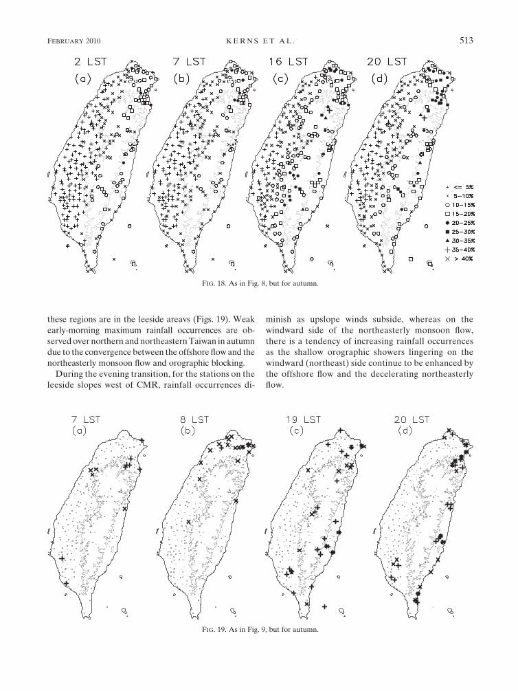
these regions are in the leeside areavs (Figs. 19). Weak
early-morning maximum rainfall occurrences are ob-
served over northern and northeastern Taiwan in autumn
due to the convergence between the offshore flow and the
northeasterly monsoon flow and orographic blocking.
During the evening transition, for the stations on the
leeside slopes west of CMR, rainfall occurrences di-
minish as upslope winds subside, whereas on the
windward side of the northeasterly monsoon flow,
there is a tendency of increasing rainfall occurrences
as the shallow orographic showers lingering on the
windward (northeast) side continue to be enhanced by
the offshore flow and the decelerating northeasterly
flow.
FIG. 18. As in Fig. 8, but for autumn.
FIG. 19. As in Fig. 9, but for autumn.
FEBRUARY 2010 K E R N S E T A L . 513

b. Diurnal cloud patterns
In contrast to both the mei-yu and summer, autumn
deep convective cloud frequencies are less than 10%
throughout the diurnal cycle except in the afternoon
over the a small area over the southwestern slopes of
CMR (Fig. 20). This afternoon maximum (.10%) is
collocated with the rainfall frequency maximum over the
mountainous interior of southwestern Taiwan (Fig. 20c)
without extensive anvils. This is related to the fact that
the instability is the least in autumn among the three
regimes (Table 1).
Over northeastern Taiwan there is no pronounced
maximum in cold cloud occurrence, where the rainfall
occurrences are more frequent than the other areas with
an afternoon maximum. This suggests that most of the
rainfall over northeastern Taiwan during autumn does
not occur from deep convection, but from relatively
shallow orographic showers.
7. Summary and conclusions
The diurnal cycle of winds, rainfall, and high clouds is
investigated for three distinct rainfall regimes over
Taiwan (Chen and Chen 2003): mei-yu (16 May–15 June),
summer (16 July–31 August), and autumn (16 September–
31 October) to highlight the factors that determine the
island-scale weather under different large-scale condi-
tions. In all three regimes, the mean surface diurnal winds
are dominated by the daytime upslope–onshore flow and
the nighttime downslope–offshore flow. The exception
is along the northern Taiwan coast in autumn, where the
northeasterly flow prevails throughout the diurnal cycle.
The overall strength of the diurnal winds, as measured
by island divergence, is similar under each regime. Even
though the strongest insolation occurs in summer, the
early-morning divergence and afternoon convergence
are not significantly higher than for the mei-yu or au-
tumn. For all three regimes, rainfall occurrences, rain
rates, and cold cloud coverage are strongly modulated
by the diurnal heating cycle with a pronounced late af-
ternoon (;1600 LT) maximum.
For most stations, rainfall is most frequent in the mei-yu
throughout the diurnal cycle as compared with other
regimes because of the frequent arrival of mei-yu fronts
from southern China. In the mei-yu, a distinct second-
ary rainfall maximum occurs in the early morning.
Rainfall at late night and early morning is mainly due to
drifting of rain showers inland and scattered orographic
showers during mei-yu frontal passages. Rainfall often
organizes into bands off the northwest coast, where the
south-southwest barrier jet meets the prefrontal south-
west flow. This occurs preferentially in the early morning
because the atmosphere is more stable, which favors
a strong barrier jet. Also, in the prefrontal environment
strong southwest winds impinge on the CMR and are
deflected northward, leading to the formation of the
barrier jet. This distinctive phenomenon does not occur
FIG. 20. Frequencies (%) of brightness temperatures below 235 K during the mei-yu for 1997–2002. The terrain CI is 1000 m. Nine-point
smoothing has been applied twice. The CI is 2% starting with 10%.
514 M O N T H L Y W E A T H E R R E V I E W VOLUME 138

in summer (which lacks frontal passages with a strong
prefrontal southwest flow) or autumn (which is domi-
nated by stable northeast monsoon flow).
The summer conditions with light environmental winds
and infrequent synoptic disturbances may be interpreted
to represent the undisturbed diurnally induced island
circulations. Summer is the period with the most signifi-
cant daytime–nighttime contrast in rainfall occurrences.
In summer, the afternoon convection over the western
mountain slopes is most pronounced in summer. The
atmosphere is most unstable in summer, and there are
relatively few disturbances embedded in the environ-
ment flow to trigger convection. At night, there is little
contrast between the mountains and coastal areas in
terms of convective cloud frequencies (,10%). Rainfall
at night is also infrequent (,10%) over land. The after-
noon maximum in convective and cold cloud frequencies
(.30%) occurs over the west-southwestern coastal plain,
whereas the rainfall maximum is over the mountain
slopes. It is apparent that the upper-level anvils associ-
ated with the afternoon convection are carried westward
by the upper-level easterlies.
In autumn, the prevailing flow is northeast and the
environment is more stable. Afternoon rainfall maxima
from deep convection occur only over a very limited
area of the southwest CMR slopes, where the northeast
monsoon flow is blocked by the CMR. Afternoon
maximum rainfall frequencies (.30%) occur in the
north and east of the island on the windward side.
However, cold cloud is infrequent (,10%) in these area.
Most of the rainfall there is generated by orographic
uplift and flow blocking enhanced by a stronger upslope
flow component in the afternoon hours.
The stations with rainfall maxima during the transi-
tion periods have also been considered for each regime.
The weak early-morning rainfall maximum is mainly
related to the interaction between the prevailing winds
and the island-induced airflow. During the mei-yu, the
weak early-morning rainfall maximum over the north-
ern coast mainly occurs under the postfrontal flow as a
result of convergence between the decelerating north-
easterly flow and the offshore flow. In the early morning,
high cloud frequencies offshore of the southwest coast
and south of Taiwan are more frequent in the mei-yu
than other regimes. It appears that mesoscale convec-
tive systems are frequently embedded within the south-
west monsoon flow in the mei-yu. Furthermore, the
convective activities are enhanced by flow deceleration
upstream off the southwest coast. In summer, weak early-
morning rainfall maximum is observed over southwest-
ern Taiwan related to the convergence between the
offshore flow and the decelerating incoming southwest
monsoon flow. In autumn, weak early-morning maxima
occur on the northern and northeastern windward side
due to orographic blocking and the convergence be-
tween the offshore flow and the northeast monsoon
flow.
In the mei-yu and summer, weak evening rain maxima
are related to remnant afternoon convection in the
mountainous interior that is advected by the upper-level
winds. In the mei-yu, with upper-level westerlies, the
afternoon convection on the western windward slopes
moves eastward resulting in weak evening rainfall
maximum over southeastern Taiwan where the ridge
axis of the Central Mountain Range is lower. It may be
enhanced by local convergence between the northerly
winds along the east and southeast coasts and the
deflected southwesterly flow around the southern tip of
Taiwan. In summer, with upper-level northeasterlies,
the upper-level anvils are advected southwestward with
weak evening rainfall maximum along the west and
southwest Taiwan coasts. In autumn, rainfall frequen-
cies over the southwestern lee side diminish, whereas on
the windward side, some stations that recorded a weak
evening maximum as the shallow orographic showers
lingering on the windward side are enhanced by the
convergence between the offshore flow and the de-
celerating incoming flow.
Acknowledgments. We thank Diana Henderson, who
helped with editing the manuscript, and Prof. C.-S. Chen
for comments and assistance. Dr. Robert Grossman and
anonymous reviewers provided valuable feedback that
greatly improved the manuscript. The ARMTS and
routine surface data were obtained from the Central
Weather Bureau. This research was supported by the
National Science Foundation under Grant ATM-0140387.
The authors also appreciate the support of the Pacific
Disaster Center, Kihei, Hawaii; the U.S. Forest Service; and
the U.S. Department of Agriculture under Cooperative
Agreement 05-JV-11272165-015.
REFERENCES
Akaeda, K., J. Reisner, and D. Parsons, 1995: The role of mesoscale
and topographically induced circulations initiating a flash
flood observed during the TAMEX project. Mon. Wea. Rev.,
123, 1720–1739.
Boyle, J. S., and G. T. J. Chen, 1987: Synoptic aspects of the
wintertime East Asian monsoon. Monsoon Meteorology,
C. P. Chang and T. N. Krishnamurti, Eds., Oxford University
Press, 125–160.
Central Weather Bureau, 1995: The Basic Information of Meteo-
rological Observation Statistic (in Chinese). 4th ed. Central
Weather Bureau, 163 pp. [Available from the Central
Weather Bureau, 64 Kung-Yun Rd., Taipei 100, Taiwan.]
Chen, C.-S., and Y.-L. Chen, 2003: The rainfall characteristics of
Taiwan. Mon. Wea. Rev., 131, 1323–1341.
FEBRUARY 2010 K E R N S E T A L . 515

——, W.-S. Chen, and Z. Deng, 1991: A study of a mountain-
generated precipitation system in northern Taiwan during
TAMEX IOP 8. Mon. Wea. Rev., 119, 2574–2607.
——, Y.-L. Chen, C.-L. Liu, P.-L. Lin, and W.-C. Chen, 2007:
Statistics of heavy rainfall occurrences in Taiwan. Wea. Fore-
casting, 22, 981–1002.
Chen, T. C., M. C. Yen, J. C. Hsieh, and R. W. Arrit, 1999: Diurnal
and seasonal variations of the rainfall measured by the auto-
matic rainfall and telemetry system in Taiwan. Bull. Amer.
Meteor. Soc., 80, 2299–2312.
Chen, X. A., and Y. L. Chen, 1995: Development of low level jets
(LLJs) during TAMEX. Mon. Wea. Rev., 123, 1695–1719.
Chen, Y.-L., 1993: Some synoptic-scale aspects of the surface fronts
over southern China during TAMEX. Mon. Wea. Rev., 121,
50–65.
——, and N. B.-F. Hui, 1992: Analysis of a relatively dry front
during the Taiwan Area Mesoscale Experiment TAMEX.
Mon. Wea. Rev., 120, 2442–2468.
——, and J. Li, 1995: Characteristics of surface airflow and pressure
patterns over the island of Taiwan during TAMEX. Mon.
Wea. Rev., 123, 695–716.
——, Y.-X. Zhang, and N. B.-F. Hui, 1989: Analysis of a surface
front during the early summer rainy season over Taiwan. Mon.
Wea. Rev., 117, 909–931.
Dairaku, K., S. Emori, and T. Oki, 2004: Rainfall amount, intensity,
duration, and frequency relationships in the Mae Chaem wa-
tershed in southeast Asia. J. Hydrometeor., 5, 458–470.
Fu, R., A. D. Del Genio, and W. M. Rossow, 1990: Behavior of
deep convective clouds in the tropical Pacific deduced from
ISCCP radiances. J. Climate, 3, 1129–1152.
Grossman, R. L., and D. R. Durran, 1984: Interaction of low-level
flow with the Western Ghat Mountains and offshore convec-
tion in the summer monsoon. Mon. Wea. Rev., 112, 652–672.
Hsu, J., 1998: ARMTS up and running in Taiwan. Vaisala News,
146, 24–26.
Johnson, R. H., and J. F. Bresch, 1991: Diagnosed characteristics of
precipitation systems over Taiwan during the May-June 1987
TAMEX. Mon. Wea. Rev., 119, 2540–2557.
Kuo, Y. H., and G. T.-J. Chen, 1990: Taiwan Area Mesoscale Ex-
periment: An overview. Bull. Amer. Meteor. Soc., 71, 488–503.
Krishtawal, C. M., and T. N. Krishnamurti, 2001: Diurnal variation
of summer rainfall over Taiwan and its detection using TRMM
observations. J. Appl. Meteor., 40, 331–344.
Li, J., and Y.-L. Chen, 1998: Barrier jets during TAMEX. Mon.
Wea. Rev., 126, 959–971.
——, ——, and W.-C. Lee, 1997: Analysis of a heavy rainfall event
during TAMEX. Mon. Wea. Rev., 125, 1060–1082.
Lin, Y.-J., H. Shen, T.-C. C. Wang, Z.-S. Deng, and R. W. Pasken,
1990: Characteristics of a subtropical squall line determined
from TAMEX dual-Doppler data. Part II: Dynamic and
thermodynamic structures and momentum budgets. J. Atmos.
Sci., 47, 2382–2399.
Murakami, T., 1958: The sudden change of upper westerlies near
the Tibetan Plateau at the beginning of the summer season.
J. Meteor. Soc. Japan, 36, 239–247.
Ogura, Y., and M. Yoshizaki, 1988: Numerical study of orographic-
convective precipitation over the Eastern Arabian Sea and the
Ghat Mountains during the summer monsoon. J. Atmos. Sci.,
45, 2097–2122.
Oki, T., and K. Musiake, 1994: Seasonal change of the diurnal cycle
of precipitation over Japan and Malaysia. J. Appl. Meteor., 33,1445–1463.
Overland, J. E., and N. A. Bond, 1995: Observations and scale
analysis of coastal wind jets. Mon. Wea. Rev., 123, 2934–2941.
Ramage, C. S., 1952: Diurnal variation of summer rainfall over east
China, Korea, and Japan. J. Meteor., 9, 83–86.
——, 1971: Monsoon Meteorology. Academic Press, 296 pp.
Smolarkiewicz, P. K., R. M. Rasmussen, and T. L. Clark, 1988: On
the dynamics of Hawaiian cloud bands: Island forcing. J. At-
mos. Sci., 45, 1872–1905.
Sun, W.-Y., and J.-D. Chern, 1993: Diurnal variation of lee vor-
tices in Taiwan and the surrounding area. J. Atmos. Sci., 50,3404–3430.
——, ——, C.-C. Wu, and W.-R. Hsu, 1991: Numerical simulation
of mesoscale circulation in Taiwan and surrounding area.
Mon. Wea. Rev., 119, 2558–2573.
Tao, S., and L. Chen, 1987: A review of recent research on the East
Asian monsoon in China. Monsoon Meteorology, C. P. Chang
and T. N. Krishnamurti, Eds., Oxford University Press, 60–92.
Teng, J.-H., C.-S. Chen, T.-C. C. Wang, and Y.-L. Chen, 2000:
Orographic effects on a squall line system over Taiwan. Mon.
Wea. Rev., 128, 1123–1138.
Trier, S. B., D. B. Parsons, and T.-J. Matejika, 1990: Observations
of a subtropical cold front in a region of complex terrain. Mon.
Wea. Rev., 118, 2449–2470.
Wang, T.-C. Chen, Y.-J. Lin, H. Shen, and R. W. Pasken, 1990:
Characteristics of a subtropical squall line determined from
TAMEX dual-Doppler data. Part I: Kinematic structure.
J. Atmos. Sci., 47, 2357–2381.
Yeh, H.-C., and Y.-L. Chen, 1998: Characteristics of rainfall dis-
tributions over Taiwan during the Taiwan Area Mesoscale
Experiment (TAMEX). J. Appl. Meteor., 37, 1457–1469.
——, and ——, 2002: The role of offshore convergence on coastal
rainfall during TAMEX IOP 3. Mon. Wea. Rev., 130, 2709–
2730.
——, and ——, 2003: Numerical simulations of the barrier jet over
northwestern Taiwan during the mei-yu season. Mon. Wea.
Rev., 131, 1396–1407.
516 M O N T H L Y W E A T H E R R E V I E W VOLUME 138