objectives of planning in victoria
DESCRIPTION
This relates to a post on our blog: http://wp.me/PT5m2-mx.TRANSCRIPT

OBJECTIVES OF PLANNING IN VICTORIA PAGE 1 OF 1
THE OBJECTIVES OF PLANNING IN VICTORIA
Planning Schemes in Victoria must seek to achieve the objectives of planning in Victoria asset out in Section 4(1) of the Planning & Environment Act 1987. These objectives are:
To provide for the fair, orderly, economic and sustainable use and development of land. To provide for the protection of natural and man-made resources and the maintenance
of ecological processes and genetic diversity. To secure a pleasant, efficient and safe working, living and recreational environment
for all Victorians and visitors to Victoria. To conserve and enhance those buildings, areas or other places which are of scientific,
aesthetic, architectural or historical interest, or otherwise of special cultural value. To protect public utilities and other assets and enable the orderly provision and coordi-
nation of public utilities and other facilities for the benefit of the community. To facilitate development in accordance with the objectives set out in the points above. To balance the present and future interests of all Victorians.
19/01/2006VC37

PURPOSES OF THIS PLANNING SCHEME PAGE 1 OF 1
PURPOSES OF THIS PLANNING SCHEME
To provide a clear and consistent framework within which decisions about the use and de-velopment of land can be made.
To express state, regional, local and community expectations for areas and land uses.
To provide for the implementation of State, regional and local policies affecting land useand development.
19/01/2006VC37
TABLE OF CONTENTS PAGE 1 OF 8
CONTENTS
14 MAY 2007
SECTION CLAUSE
Objectives of planning in Victoria
Purposes of this planning scheme
CONTENTS
Contents
USER GUIDE User guide
STATE PLANNING
POLICY
FRAMEWORK
10
11
11.01
11.02
11.03
State Planning Policy Framework
Introduction, goal and principles
Introduction
Goal
Principles of land use and development planning
12
12.01
12.02
12.03
12.04
12.05
12.06
12.07
12.08
12.09
Metropolitan development
A more compact city
Better management of metropolitan growth
Networks with the regional cities
A more prosperous city
A great place to be
A fairer city
A greener city
Better transport links
Geographic strategies
13
[no content]
14
14.01
Settlement
Planning for urban settlement
15
15.01
15.02
15.03
15.04
15.05
15.06
15.07
15.08
15.09
15.10
15.11
15.12
Environment
Protection of catchments, waterways and groundwater
Floodplain management
Salinity
Air quality
Noise abatement
Soil contamination
Protection from wildfire
Coastal areas
Conservation of native flora and fauna
Open space
Heritage
Energy efficiency

TABLE OF CONTENTS PAGE 2 OF 8
SECTION CLAUSE
15.13
15.14
Alpine Areas
Renewable energy
16
16.01
16.02
16.03
16.04
16.05
Housing
Residential development for single dwellings
Medium density housing
Rural living and rural residential development
Crisis accommodation and community care units
Affordable housing
17
17.01
17.02
17.03
17.04
17.05
17.06
17.07
17.08
17.09
17.10
Economic development
Activity centres
Business
Industry
Tourism
Agriculture
Intensive animal industries
Forestry and timber production
Mineral resources
Extractive industry
Apiculture
18
18.01
18.02
18.03
18.04
18.05
18.06
18.07
18.08
18.09
18.10
18.11
18.12
18.13
Infrastructure
Declared highways, railways and tramways
Car parking and public transport access to development
Bicycle transport
Airfields
Ports
Health facilities
Education facilities
Survey infrastructure
Water supply, sewerage and drainage
Waste management
High pressure pipelines
Developer contributions to infrastructure
Telecommunications
19
19.01
19.02
19.03
19.04
Particular uses and development
Subdivision
Gaming
Design and built form
Brothels
LOCAL PLANNING
POLICY
FRAMEWORK
20
21
22
Operation of the Local Planning Policy Framework
Municipal Strategic Statement
Local Planning Policies

TABLE OF CONTENTS PAGE 3 OF 8
SECTION CLAUSE
ZONES 30
31
Zones
Operation of zones
32
32.01
32.02
32.03
32.04
32.05
32.06
Residential Zones
Residential 1 Zone
Residential 2 Zone
Low Density Residential Zone
Mixed Use Zone
Township Zone
Residential 3 Zone
33
33.01
33.02
33.03
Industrial Zones
Industrial 1 Zone
Industrial 2 Zone
Industrial 3 Zone
34
34.01
34.02
34.03
34.04
34.05
Business Zones
Business 1 Zone
Business 2 Zone
Business 3 Zone
Business 4 Zone
Business 5 Zone
35
35.01
35.02
35.03
35.04
35.05
35.06
35.07
35.08
Rural Zones
Rural Zone
Environmental Rural Zone
Rural Living Zone
Green Wedge Zone
Green Wedge A Zone
Rural Conservation Zone
Farming Zone
Rural Activity Zone
36
36.01
36.02
36.03
36.04
Public Land Zones
Public Use Zone
Public Park and Recreation Zone
Public Conservation and Resource Zone
Road Zone
37
37.01
37.02
37.03
37.04
37.05
Special Purpose Zones
Special Use Zone
Comprehensive Development Zone
Urban Floodway Zone
Capital City Zone
Docklands Zone

TABLE OF CONTENTS PAGE 4 OF 8
SECTION CLAUSE
37.06 Priority Development Zone
OVERLAYS 40
41
Overlays
Operation of overlays
42
42.01
42.02
42.03
Environment and Landscape Overlays
Environmental Significance Overlay
Vegetation Protection Overlay
Significant Landscape Overlay
43
43.01
43.02
43.03
43.04
43.05
Heritage and Built Form Overlays
Heritage Overlay
Design and Development Overlay
Incorporated Plan Overlay
Development Plan Overlay
Neighbourhood Character Overlay
44
44.01
44.02
44.03
44.04
44.05
44.06
44.07
Land Management Overlays
Erosion Management Overlay
Salinity Management Overlay
Floodway Overlay
Land Subject to Inundation Overlay
Special Building Overlay
Wildfire Management Overlay
State Resource Overlay
45
45.01
45.02
45.03
45.04
45.05
45.06
45.07
45.08
Other Overlays
Public Acquisition Overlay
Airport Environs Overlay
Environmental Audit Overlay
Road Closure Overlay
Restructure Overlay
Development Contributions Plan Overlay
City Link Project Overlay
Melbourne Airport Environs Overlay
PARTICULAR
PROVISIONS
50
51
52
52.01
52.02
52.03
52.04
52.05
52.06
52.07
52.08
Particular provisions
Operation of particular provisions
[no content]
Public open space contribution and subdivision
Easements, restrictions and reserves
Specific sites and exclusions
Satellite dish
Advertising signs
Car parking
Loading and unloading of vehicles
Earth resource exploration and development

TABLE OF CONTENTS PAGE 5 OF 8
SECTION CLAUSE
52.09
52.10
52.11
Extractive industry and extractive industry interest areas
Uses with adverse amenity potential
Home occupation
52.12
52.13
52.14
52.15
52.16
52.17
52.18
52.19
52.20
52.21
52.22
52.23
52.24
52.25
52.26
52.27
52.28
52.29
52.30
52.31
52.32
52.33
52.34
52.35
52.36
Service station
Car wash
Motor vehicle, boat or caravan sales
Heliport
Post box
Native vegetation
Timber production
Telecommunications facility
Convenience restaurant and take-away food premises
Private tennis court
Crisis accommodation
Shared housing
Community care unit
Crematorium
Cattle feedlot
Licensed premises
Gaming
Land adjacent to a Road Zone, Category 1, or a Public
Acquisition Overlay for a Category 1 road
Freeway service centre
Broiler farm
Wind energy facility
Shipping container storage
Bicycle facilities
Urban context report and design response for residential
development of four or more storeys
Integrated public transport planning
53
Upper Yarra Valley and Dandenong Ranges Region
54
54.01
54.02
54.03
54.04
54.05
54.06
One dwelling on a lot
Neighbourhood and site description and design response
Neighbourhood character
Site layout and building massing
Amenity impacts
On-site amenity and facilities
Detailed design
55
55.01
55.02
55.03
55.04
Two or more dwellings on a lot and residential buildings
Neighbourhood and site description and design response
Neighbourhood character and infrastructure
Site layout and building massing
Amenity impacts

TABLE OF CONTENTS PAGE 6 OF 8
SECTION CLAUSE
55.05
55.06
On-site amenity and facilities
Detailed design
56
56.01
56.02
56.03
56.04
56.05
56.06
56.07
56.08
56.09
56.10
Residential subdivision
Subdivision site and context description and design response
Policy implementation
Livable and sustainable communities
Lot design
Urban landscape
Access and mobility management
Integrated water management
Site management
Utilities
Transitional arrangements
57 Metropolitan green wedge land
GENERAL
PROVISIONS
60
61
61.01
61.02
61.03
61.04
61.05
61.06
62
62.01
62.02
62.03
62.04
62.05
63
63.01
63.02
63.03
63.04
63.05
63.06
63.07
63.08
63.09
63.10
63.11
General provisions
Administration of this scheme
Administration and enforcement of this scheme
What area is covered by this scheme?
What does this scheme consist of?
When did this scheme begin?
Effect of this scheme
Determination of boundaries
Uses, buildings, works, subdivisions and demolition not
requiring a permit
Uses not requiring a permit
Buildings and works
Events on public land
Subdivisions not requiring a permit
Demolition
Existing uses
Extent of existing use rights
Characterisation of use
Effect of definitions on existing use rights
Section 1 uses
Section 2 and 3 uses
Expiration of existing use rights
Compliance with codes of practice
Alternative use
Shop conditions
Damaged or destroyed buildings or works
Proof of continuous use

TABLE OF CONTENTS PAGE 7 OF 8
SECTION CLAUSE
63.12
64
64.01
64.02
65
65.01
65.02
66
66.01
66.02
66.03
66.04
66.05
66.06
67
67.01
67.02
67.03
67.04
Decision guidelines
General provisions for use of land
Land used for more than one use
Land used in conjunction with another use
Decision guidelines
Approval of an application or plan
Approval of an application to subdivide land
Referrals and notice provisions
Subdivision
Use and development
Referral of permit applications under other State standard
provisions
Referral of permit applications under local provisions
Notice of permit applications under State standard provisions
Notice of permit applications under local provisions
Applications under Section 96 of the Act
Exemptions from Section 96(1) and 96(2) of the Act
Notice requirements
Notice requirements - native vegetation
Notice exemption
DEFINITIONS 70
71
72
73
74
75
75.01
75.02
75.03
75.04
75.05
75.06
75.07
75.08
75.09
75.10
Definitions
Meaning of words
General terms
Outdoor advertising terms
Land use terms
Nesting diagrams
Accommodation group
Agriculture group
Child care centre group
Education centre group
Industry group
Leisure and recreation group
Earth resource exploration and development group
Office Group
Place of assembly group
Pleasure boat facility group

TABLE OF CONTENTS PAGE 8 OF 8
SECTION CLAUSE
75.11
75.12
75.13
75.14
75.15
75.16
Retail premises group
Retail premises group (sub-group of shop)
Transport terminal group
Utility installation group
Warehouse group
Land use terms that are not nested
INCORPORATED
DOCUMENTS
80
81
81.01
Incorporated Documents
Documents incorporated in this scheme
Table of documents incorporated in this scheme
LIST OF
AMENDMENTS
List of amendments to this scheme
LIST OF
AMENDMENTS TO
THE VICTORIA
PLANNING
PROVISIONS

USER GUIDE PAGE 1 OF 5
USER GUIDE1. What is a planning scheme?
A planning scheme sets out policies and requirements for the use, development and protec-tion of land. There is a planning scheme for every municipality in Victoria.
2. Who is affected by this planning scheme?
All people and corporations must comply with this scheme. Every State Minister, govern-ment department, public authority and municipal council must also comply unless specifi-cally exempted by the Government.
3. What does this scheme consist of?
This scheme consists of a written document and any maps, plans or other documents incor-porated in it (see Clause 81). It contains-
The objectives of planning in Victoria. Purposes of this planning scheme. The User Guide. A State Planning Policy Framework. A Local Planning Policy Framework. Zone and overlay provisions. Particular provisions. General provisions. Definitions. Incorporated documents
The State Planning Policy Framework covers strategic issues of State importance. It listspolicies under six headings - settlement, environment, housing, economic development, in-frastructure, and particular uses and development. Every planning scheme in Victoria con-tains this policy framework, which is identical in all schemes.
The Local Planning Policy Framework contains a municipal strategic statement and localplanning policies. The framework identifies long term directions about land use and devel-opment in the municipality; presents a vision for its community and other stakeholders; andprovides the rationale for the zone and overlay requirements and particular provisions inthe scheme.
The Zone and Overlay requirements and Particular provisions show -
The type of use and development allowed in each zone. Additional requirements for subdivision, buildings and works on land that is affected by
an overlay. Requirements for any specific uses and development.
The General provisions provide information on the administration of this scheme and otherrelated matters. Definitions advise on the meaning of words in this scheme.
19/01/2006VC37

USER GUIDE PAGE 2 OF 5
Effect of this planning scheme
4. How do I use this planning scheme?
The planning scheme map
The planning scheme map shows how land is zoned and whether it is affected by an over-lay. This information is indicated by a letter and number code that is explained on the frontpage of each map: For example, R1Z stands for Residential 1 Zone.
To find out the effect these requirements have on your land, it is necessary to refer to thewritten document.
The written document
Policy frameworks (Clauses 11 to 22)
The State and Local Planning Policy Frameworks contain the long term directions and out-comes sought by this scheme. These are implemented through the Zone, Overlay and Par-ticular provisions requirements. It is important to refer to both frameworks whenconsidering the requirements of the scheme.
Zone requirements (Clauses 31 to 37)
A zone controls land use and development. Each zone includes a description of its purposeand the requirements that apply regarding land use, subdivision and the construction andcarrying out of buildings and works.
Each zone lists land uses in three sections:
Section 1 Uses that do not require a permit.
Section 2 Uses that require a permit.
Section 3 Uses that are prohibited.
Uses that are not specifically mentioned are covered by a reference to 'any other use'. Thisis usually found in Section 2, but is occasionally found in Section 3.
Sometimes a use in Section 1 or Section 2 must meet specified conditions. If these are notmet, the use may require a permit or may be prohibited.
Note that the three sections refer to the use of land, not to the development of land.
Development of land includes the construction of a building, carrying out works (such asclearing vegetation), subdividing land or buildings, or displaying signs. The zones indicatewhether a planning permit is required to construct a building or carry out works. Somebuildings and works, such as fences and underground services, usually do not require apermit. These are listed in Clause 62 of the scheme under Uses, buildings, works, subdivi-sions and demolition not requiring a permit.
Overlay requirements (Clauses 41 to 45)
Overlays affect subdivisions, buildings and works. They operate in addition to the zonerequirements and generally concern environmental, landscape, heritage, built form, andland and site management issues. It is essential to check whether an overlay applies to yourland before commencing any use or development.
Particular provisions (Clauses 51 to 56)
Other planning requirements may apply to particular uses or development. These may beadvertising signs, car parking or specified types of use. Such requirements are listed under
USER GUIDE PAGE 3 OF 5
Particular provisions. It is essential to check whether any of these requirements apply toyour land before commencing any use or development.
General provisions (Clauses 61 to 67)
The general provisions provide information on:
The administration of this scheme. The operation of existing uses and land used for more than one use. Uses, buildings, works, subdivisions and demolition not requiring a permit. Matters that Council must consider before deciding on a proposal under this scheme.
Definitions (Clauses 71 to 75)
Words used in this scheme have their common meaning unless they are defined in thescheme, the Planning and Environment Act 1987 or in other relevant legislation. The pur-pose of defining a word is to limit its meaning to a particular interpretation or to explain themeaning of a word or phrase peculiar to this scheme. You should check whether any wordor term is defined to ensure you understand its meaning within the context of the scheme.
If in doubt about the meaning of a word that is not defined, ask a Council planning officerfor assistance.
5. How do I find out about requirements affecting my land?
You should first speak to a Council planning officer to find out how this scheme affectsyour land. The scheme is available for inspection at your Council office, and at the De-partment of Sustainability and Environment, 80 Collins Street, Melbourne or its regionaloffices.
You can also apply for a planning certificate for a particular parcel of land. This will statethe planning scheme zone and overlay requirements that apply to that land as shown on thescheme map. Note that the certificate does not state the strategies or policies that apply tothe land under the scheme’s policy frameworks.
A person selling land must make a planning certificate available to a purchaser before acontract to buy the land is signed.
6. Changes to this planning scheme
This scheme is not a static document and is likely to change over time. A Council planningofficer can tell you if an amendment affecting your land has been prepared. This informa-tion is also shown on a planning certificate.
Application to use or develop land
7. The need for early discussion with Council
If you propose to use or develop land, first discuss the proposal in detail with a Councilplanning officer. Early discussion will confirm whether a permit is necessary and identifyany other requirements.
8. Making a planning permit application
If a permit is required, an Application for Planning Permit form must be filled out andlodged with responsible authority, which is usually the Council.

USER GUIDE PAGE 4 OF 5
The application must include all necessary supporting information such as plans, reportsand photographs so that the proposal is fully described and can be understood by all inter-ested parties.
The Planning and Environment Act 1987 requires the payment of a fee for the processingof applications. Details of the fee can be obtained from Council.
In some circumstances, the Minister for Planning or another person may administer parts ofthis scheme. A Council planning officer can advise you what to do in such cases.
9. Considering and giving notice of the application
In considering an application, Council will in most cases decide whether material detrimentmay be caused to any person and, if so, it must give them an opportunity to comment on theproposal.
There are a number of ways of giving notice of an application, including notifying theowners and occupiers of nearby properties, and placing notices on the land and in a news-paper circulating in the area.
With some applications, Council will seek the views of other government or public agen-cies before making a decision. It may also ask you to provide more information.
Once any necessary advertising has been completed and other agencies have had time tocomment, the application will be decided.
In making its decision, Council must assess an application against the strategies and desiredoutcomes outlined in the scheme’s policy frameworks. Any other matters that the schemespecifies must also be taken into account.
10. The decision
Following consideration of your application, Council will decide to either:
Issue a permit. Issue a notice of decision to grant a permit (which gives objectors a set time in which to
appeal). Refuse to grant a permit.
A permit can be issued with or without conditions, and a proposal can only begin and con-tinue if all the conditions on the permit are met.
11. Do I have a right of appeal against a decision?
In many cases, yes. Your rights to a review of a Council decision are usually explained inthe document that conveys advice of Council’s decision. Additional information on re-views of decision may be obtained from the Victorian Civil and Administrative Tribunal,Planning List, 55 King Street, Melbourne 3000 - Phone (03) 9628 9777.
12. What is the difference between building and planning permits?
Planning permits must not be confused with building permits. Building permits are issuedunder the Victoria Building Regulations and generally relate only to the constructional as-pects of a building or other development.
A building permit is required in most cases involving development. You should consult abuilding surveyor if any building is proposed. If a planning permit is required, it must beobtained before a building permit can be issued.

USER GUIDE PAGE 5 OF 5
Need more help?
Contact a Council planning officer if you:
Have a general enquiry about this scheme. Are unsure what requirements apply to your land. Are unsure of the steps in the planning application process. Would like to know how this scheme may be changed. Want a planning application form. Want to buy a copy of this scheme or an amendment.
Publications that may help are:
Using Victoria's Planning System VCAT Practice Notes
The planning publications can be obtained from the Department of Sustainability and Envi-ronment Planning Information Centre, 8 Nicholson Street, Melbourne 3002 - Phone (03)9637 8151, and on the Department’s web site, www.dse.vic.gov.au. VCAT publicationscan be obtained from the VCAT web site, www.vcat.vic.gov.au.
Relevant legislation includes:
Planning and Environment Act 1987 and the Planning and Environment Regulations1998
Victorian Civil and Administrative Tribunal Act 1998 Tribunals and Licensing Authorities (Miscellaneous Amendments) Act 1998
Copies of legislation are usually available for perusal at your local library or they may bepurchased from Information Victoria, 356 Collins Street, Melbourne 3000 - phone toll free1 300 366 356 or (03) 9603 9940. They are also available at the Victorian Legislation andParliamentary Documents Home Page, www.dms.dpc.vic.gov.au.

StatePlanning
PolicyFramework


STATE PLANNING POLICY FRAMEWORK - CLAUSE 10 PAGE 1 OF 1
10 STATE PLANNING POLICY FRAMEWORK
This section sets out the State Planning Policies which apply to all land in Victoria.
These policies must be taken into account when preparing amendments to this scheme or making decisions under this scheme.
19/01/2006 VC37

STATE PLANNING POLICY FRAMEWORK - CLAUSE 11 PAGE 1 OF 3
11 INTRODUCTION, GOAL AND PRINCIPLES
11.01 Introduction
The purpose of State policy in planning schemes is to inform planning authorities andresponsible authorities of those aspects of State level planning policy which they are to takeinto account and give effect to in planning and administering their respective areas. It is theState Government's expectation that planning and responsible authorities will endeavour tointegrate the range of policies relevant to the issues to be determined and balanceconflicting objectives in favour of net community benefit and sustainable development.
Planning policies are directed to land use and development, as circumscribed by thePlanning and Environment Act 1987, a primary objective of which is to provide for thefair, orderly, economic and sustainable use and development of land.
Planning, under the Planning and Environment Act 1987, is to encompass and integraterelevant environmental, social and economic factors. It is directed towards the interests ofsustainable development for the benefit of present and future generations, on the basis ofrelevant policy and legislation. Planning authorities and responsible authorities areresponsible for the effective planning and management of land use and development intheir districts for the broad interests of the community, through the preparation of strategicplans, statutory plans, development and conservation plans, development contributionplans, and other relevant plans to achieve the objectives of the Act.
The State Planning Policy Framework provides a context for spatial planning and decisionmaking by planning and responsible authorities. It is comprised of a statement of generalprinciples for land use and development planning and specific policies dealing withsectoral issues. The specific policies encompass objectives, generic implementationtechniques applying across Victoria in relation to the specified policy and geographicstrategies that set out directions for particular areas. Planning and responsible authoritiesmust take account of and give effect to both the general principles and the specific policiesapplicable to issues before them to ensure integrated decision-making.
The State Planning Policy Framework is dynamic and will be built upon as the governmentdevelops and refines policy, and changed as the needs of the community change.
11.02 Goal
The State Planning Policy Framework seeks to ensure that the objectives of planning inVictoria (as set out in Section 4 of the Planning and Environment Act 1987) are fosteredthrough appropriate land use and development planning policies and practices whichintegrate relevant environmental, social and economic factors in the interests of netcommunity benefit and sustainable development.
11.03 Principles of land use and development planning
Society has various needs and expectations such as land for settlement, protection of theenvironment, economic well-being, various social needs, proper management of resourcesand infrastructure. Planning aims to meet these by addressing aspects of economic,environmental and social well-being affected by land use and development.
Following are seven statements of general principles that elaborate upon the objectives ofplanning in Victoria and describe the factors that influence good decision-making in landuse and development planning. A planning authority preparing amendments to a planningscheme or a responsible authority administering a scheme must consider these overarchingand interlocking principles as well as relevant specific policies in Clauses 14 to 19.
11.03-1 Settlement
Planning is to anticipate and respond to the needs of existing and future communitiesthrough provision of zoned and serviced land for housing, employment, recreation and
19/01/2006VC37
19/01/2006VC37
19/01/2006VC37
19/01/2006VC37
19/01/2006VC37

STATE PLANNING POLICY FRAMEWORK - CLAUSE 11 PAGE 2 OF 3
open space, commercial and community facilities and infrastructure. Planning is torecognise the need for, and as far as practicable contribute towards:
Health and safety. Diversity of choice. Adaptation in response to changing technology. Economic viability. A high standard of urban design and amenity. Energy efficiency. Prevention of pollution to land, water and air. Protection of environmentally sensitive areas and natural resources. Accessibility. Land use and transport integration.
11.03-2 Environment
Environment and resource management principles for ecologically sustainabledevelopment have been established by international and national agreements. Foremostamongst the national agreements is the Inter-Governmental Agreement on theEnvironment, which sets out key principles for environmental policy in Australia. Otheragreements include the National Strategy for Ecologically Sustainable Development,National Greenhouse Response Strategy, the National Water Quality ManagementStrategy, The National Strategy for the Conservation of Australia’s Biological Diversityand the National Forest Policy Statement. The National Environment Protection Council ispreparing National Environment Protection Measures to provide a common policyframework for environmental quality throughout Australia.
These national agreements, strategies and policies provide a broad framework for thedevelopment of strategies and policies at the State level to encourage sustainable land useand development. In Victoria these include State environment protection policies madeunder the Environment Protection Act 1970, which are binding on all sectors of theVictorian community. The Flora and Fauna Guarantee Strategy (Victoria’s Biodiversity,Department of Natural Resources and Environment 1997) provides a framework forconservation of biodiversity in Victoria, in the wider context of ecologically sustainabledevelopment. Victoria’s Native Vegetation Management – a Framework for Action(Department of Natural Resources and Environment 2002), establishes the goal of NetGain of native vegetation, and the principles for achieving this.
Planning is to contribute to the protection of air, land and water quality and theconservation of natural ecosystems, resources, energy and cultural heritage. In particular,planning should:
Adopt a best practice environmental management and risk management approach whichaims to avoid or minimise environmental degradation and hazards.
Prevent environmental problems created by siting incompatible land uses closetogether.
Help to protect the health of ecological systems and the biodiversity they support(including ecosystems, habitats, species and genetic diversity).
Protect areas and sites with significant historic, architectural, aesthetic, scientific andcultural values.
11.03-3 Management of resources
Planning is to assist in the conservation and wise use of natural resources including energy,water, land, flora, fauna and minerals to support both environmental quality and sustainabledevelopment over the long term through judicious decisions on the location, pattern andtiming of development.
Integrated catchment planning for land use and resource management provides the basis forplanning to protect waterways and water quality, and to minimise flood hazards, drainageinfrastructure costs and downstream impacts, including on estuarine, coastal and marineenvironments.
19/01/2006VC37
19/01/2006VC37

STATE PLANNING POLICY FRAMEWORK - CLAUSE 11 PAGE 3 OF 3
Nine regional Catchment Management Authorities have been established across the State tolead planning for catchment management and be responsible for floodplain and rivermanagement outside metropolitan Melbourne, with the Port Phillip and WesternportCatchment Management Authority having responsibility for catchments including themetropolitan area. These authorities are responsible for overseeing sustainable land andwater management and natural resource development within the framework of regionalcatchment strategies approved by the Minister for Environment.
Land Conservation Council recommendations approved by Government provide a contextfor management of resources on public lands and should be recognised as a significantcomponent of integrated local area planning. When making planning decisions affectingCrown land, the role of the Department of Sustainability and Environment and Committeesof Management as managers of Crown land must also be recognised.
11.03-4 Infrastructure
Planning for development of urban physical and community infrastructure should enable itto be provided in a way that is efficient, equitable, accessible and timely. Growth andredevelopment of settlements should be planned in a manner that allows for the logical andefficient provision and maintenance of infrastructure, including the setting aside of land forthe construction of future transport routes.
Strategic planning should facilitate efficient use of existing urban infrastructure and humanservices. Providers of urban infrastructure, whether public or private bodies, are to beguided by planning policies and should assist strategic land use planning. Planningauthorities are to consider the use of development contributions (levies) in the funding ofinfrastructure.
11.03-5 Economic well-being
Planning is to contribute to the economic well-being of communities and the State as awhole by supporting and fostering economic growth and development by providing land,facilitating decisions, and resolving land use conflicts, so that each district may build on itsstrengths and achieve its economic potential.
11.03-6 Social needs
Planning is to recognise social needs by providing land for a range of accessiblecommunity resources, such as affordable housing, places of employment, open space, andeducation, cultural, health and community support (mental, aged, disabled, youth andfamily services) facilities. Land use and development planning must support thedevelopment and maintenance of communities with adequate and safe physical and socialenvironments for their residents, through the appropriate location of uses and developmentsand quality of urban design.
11.03-7 Regional co-operation
Some issues dealt with by planning and responsible authorities have impacts that extendbeyond municipal boundaries. These impacts may be economic, social or environmentaland particularly arise around such issues as coordinated planning for transport and waterinfrastructure, catchment management, including floodplain management and water qualityprotection, and waste management.
Consistent with the objectives of local government under the Local Government Act 1989,municipal planning authorities are required to identify the potential for regional impacts intheir decision-making and co-ordinate strategic planning with their neighbours and otherpublic bodies to achieve sustainable development and effective and efficient use ofresources.
19/01/2006VC37
19/01/2006VC37
19/01/2006VC37
19/01/2006VC37

12 METROPOLITAN DEVELOPMENT 17/09 007 /2VC45
Operation
This clause provides specific objectives and strategies for Metropolitan Melbourne. These are in addition to the principles of land use and development planning in Clause 11 and the relevant specific objectives and strategies in Clauses 14 to 19.
In the event that a strategy in Clauses 14 to 19 is different from a strategy set out in this clause, the strategy in this clause applies.
Application
This clause applies to Metropolitan Melbourne.
The objectives and related strategies aim to ensure that land use and transport planning and investment always contribute to economic, social and environmental goals.
The objectives and strategies also influence municipalities beyond Metropolitan Melbourne and should be taken into account where relevant.
12.01 A more compact city 19/01/2006 VC37
12.01-1 Objective 19/01/2006 VC37
To facilitate sustainable development that takes full advantage of existing settlement patterns, and investment in transport and communication, water and sewerage and social facilities.
12.01-2 Strategies 19/01/2006 VC37
Activity centres
Concentrate new development at activity centres near current infrastructure and in areas best able to cope with change. Development is to respond to its landscape, valued built form and cultural context and achieve sustainable objectives.
Build up activity centres as a focus for high-quality development, activity and living for the whole community by:
Developing a network of activity centres that:
Comprises a range of centres that differ in size and function.
Is a focus for business, shopping, working, leisure and community facilities.
Provides different types of housing, including forms of higher density housing.
Is connected by public transport.
Maximises choice in services, employment and social interaction.
Ensuring activity centres are developed in a way that:
Reduces the number of private motorised trips by concentrating activities that generate high numbers of (non-freight) trips in highly accessible locations.
Encourages economic activity and business synergies.
STATE PLANNING POLICY FRAMEWORK - CLAUSE 12 PAGE 1 OF 20

Broadens the mix of uses appropriate to the type of centre and needs of the population served.
Provides focal points for the community.
Improves access by walking, cycling and public transport to services and facilities for local and regional populations.
Supports the development of the Principal Public Transport Network.
Ensuring planning for activity centres:
Sets the strategic framework for the use and development of land in and around the centre and gives clear direction in relation to preferred locations for investment.
Supports the role and function of the centre given its classification, the policies for housing intensification, and development of the public transport network.
Improves the social, economic and environmental performance and amenity of the centre.
Broadening the base of activity in centres that are currently dominated by shopping to include a wider range of services over longer hours by:
Locating significant new education, justice, community, administrative and health facilities that attract users from large geographic areas in or on the edge of Principal or Major Activity Centres with good public transport.
Locating new small scale education, health and community facilities that meet local needs in or next to Neighbourhood Activity Centres.
Defining the role and function of activity centres, preferred uses, scale of development and links to the public transport system based on five classifications of activity centres comprising the Central Activities District, Principal Activity Centres, Major Activity Centres, Specialised Activity Centres and Neighbourhood Activity Centres.
Central Activities District
Supporting the role of the Central Activities District as Metropolitan Melbourne’s largest centre of activity with the greatest variety of uses and functions including commercial, retail, housing, highly specialised personal services, education, government and tourism.
Reinforcing the Central Activities District as the preferred location for activities that have State or national significance, and for activities that generate a significant number of trips from the metropolitan area and beyond.
Principal and Major Activity Centres
Developing Principal and Major Activity Centres to accommodate ongoing investment and change in retail, office, service and residential markets.
Ensuring Principal and Major Activity Centres:
Have a mix of activities that generate high number of trips including business, retail, services and entertainment.
Are well served by multiple public transport routes and are on the Principal Public Transport Network or capable of linking to that network.
Have, for Principal Activity Centres, a large catchment covering several suburbs and attracting activities that meet metropolitan needs.
STATE PLANNING POLICY FRAMEWORK - CLAUSE 12 PAGE 2 OF 20

Have the potential to grow and support intensive housing developments without conflicting with surrounding land-uses.
Locating new Principal and Major Activity Centres on the Principal Public Transport Network or linking them to the network as part of developing the site.
Broadening the role of stand-alone centres to provide a greater mix of uses and improving linkages to the Principal Public Transport Network.
Ensuring Principal Activity Centres are a focus for a range of government and community activities, services and investment and are priority locations for government investment and support.
Giving priority to Principal Activity Centres for investment and the location of significant land uses where catchments overlap in any part of the network of centres.
Encouraging Major Activity Centres with good public transport links to grow in preference to other centres with poor public transport links serving the same catchment.
Specialised Activity Centres
Ensuring Melbourne Airport, major university campuses and key research and development precincts, including the specialised precincts of particular importance to the State’s innovation, are developed as Specialised Activity Centres.
Reinforcing the specialised economic functions of the Specialised Activity Centres and supporting use and development consistent with the primary specialist function of the centre.
Encouraging complementary mixed-uses that do not compete with nearby Principal or Major Activity Centres or inhibit the centre’s specialised role.
Locating Specialised Activity Centres on the Principal Public Transport Network.
Neighbourhood Activity Centres
Ensuring Neighbourhood Activity Centres:
Have a mix of uses that meet local convenience needs.
Are accessible to a viable user population by walking and cycling.
Are accessible by local bus services with public transport links to Principal or Major Activity Centres.
Are an important community focal point.
Encouraging higher density housing in and around Neighbourhood Activity Centres that is designed to fit the context and enhances the character of the area while providing a variety of housing options for different types of households.
Providing for new Neighbourhood Activity Centres in the redevelopment of middle and outer suburbs and the development of new growth areas.
Out-of-Centre Development
Ensuring that proposals or expansion of single use retail, commercial and recreational facilities outside activity centres are discouraged by giving preference to locations in or on the border of an activity centre.
Ensuring that out-of-centre proposals are only considered where the proposed use or development is of net benefit to the community in the region served by the proposal.
STATE PLANNING POLICY FRAMEWORK - CLAUSE 12 PAGE 3 OF 20

Discouraging large sports and entertainment facilities of metropolitan, State or national significance in out-of-centre locations unless they are on the Principal Public Transport Network and in locations that are highly accessible to their catchment of users.
Housing
Locate a substantial proportion of new housing in or close to activity centres and other strategic redevelopment sites that offer good access to services and transport by: Increasing the proportion of housing to be developed within the established urban area,
particularly at activity centres and other strategic sites, and reduce the share of new dwellings in greenfield and dispersed development areas.
Encouraging higher density housing development on sites that are well located in relation to activity centres and public transport.
Ensuring housing stock matches changing demand by widening housing choice, particularly in the middle and outer suburbs.
Supporting opportunities for a wide range of income groups to choose housing in well-serviced locations.
Identifying strategic redevelopment sites for large residential development that are:
In and around the Central Activities District.
In or within easy walking distance of Principal or Major Activity Centres.
In or beside Neighbourhood Activity Centres that are served by public transport.
On or abut tram, train, light rail and bus routes that are part of the Principal Public Transport Network and close to Principal or Major Activity Centres.
In or near major modal public transport interchanges that are not in Principal or Major Activity Centres.
Able to provide 10 or more dwelling units, close to activity centres and well served by public transport.
Ensuring planning for growth areas provides for a mix of housing types and higher housing densities around activity centres.
Ensuring an adequate supply of redevelopment opportunities within the established urban area to reduce the pressure for fringe development.
Ensuring all new development appropriately responds to its landscape, valued built form and cultural context.
12.02 Better management of metropolitan growth 19/01/2006 VC37
12.02-1 Objective 19/01/2006 VC37
To locate metropolitan growth close to transport corridors and services and provide efficient and effective infrastructure to create benefits for sustainability while protecting primary production, major sources of raw materials and valued environmental areas.
STATE PLANNING POLICY FRAMEWORK - CLAUSE 12 PAGE 4 OF 20

12.02-2 Strategies 01/09/2006 VC41
Urban growth boundary
Establish an urban growth boundary to set clear limits to Metropolitan Melbourne’s urban development by:
Defining the urban area of Metropolitan Melbourne with an urban growth boundary to manage outward expansion, to facilitate achievement of a compact city, to protect non-urban areas and to ensure ready access to infrastructure in the key transport corridors.
Defining the non-urban area of Melbourne to be retained for rural and agricultural uses, natural resources, landscape, heritage, open space and conservation values.
Containing urban development within the established urban growth boundary. Any change to the urban growth boundary must only occur to reflect the needs demonstrated in the designated growth areas.
Protecting the continued rural use of land within the urban growth boundary until conversion to urban use is required and the extension of urban services is approved as part of the sequencing of development.
Growth areas
Concentrate urban expansion into growth areas that are served by high-capacity public transport by:
Encouraging new development in those growth areas best served by existing major rail lines within the Werribee, Hume, Epping, Pakenham and Cranbourne corridors.
Ensuring the ongoing provision of land and supporting infrastructure and ensuring sufficient land is available to meet forecast demand.
Developing growth areas that will:
Implement the strategic directions within the Growth Area Framework Plans (Department of Sustainability and Environment 2006).
Achieve increases in average housing density significantly higher than 10 dwellings per hectare.
Deliver timely and adequate provision of public transport and local and regional infrastructure, in line with a preferred sequence of land release.
Provide for significant amounts of local employment opportunities.
Create a network of mixed-use activity centres and developing an urban form based on Neighbourhood Principles.
Meet housing needs by providing a diversity of housing type and distribution.
Restrict low-density rural residential development that would compromise future development at higher densities.
Retain unique characteristics of established areas incorporated into new communities to protect and manage natural resources and areas of heritage, cultural and environmental significance.
Create well planned, easy to maintain and safe streets and neighbourhoods that reduce opportunities for crime, improve perceptions of safety and increase levels of community participation.
Manage the sequence of development in growth areas so that services are available from early in the life of new communities by:
STATE PLANNING POLICY FRAMEWORK - CLAUSE 12 PAGE 5 OF 20

Defining preferred development sequences in growth areas to better coordinate infrastructure planning and funding.
Ensuring that new land is released in growth areas in a timely fashion to facilitate coordinated and cost-efficient provision of local and regional infrastructure.
Requiring new development to make a financial contribution to the provision of infrastructure such as public facilities, public transport and roads.
Monitoring land supply and demand for housing and industry to ensure 15 year continuous land supply.
Developing structure plans before land is zoned for urban development consistent with the Precinct Structure Plan Guidelines (Department of Sustainability and Environment 2006) to:
Ensure greater housing choice, diversity and affordability.
Develop vibrant, well serviced activity centres.
Provide sustainable transport networks.
Deliver accessible community facilities and infrastructure.
Create multi-use, linked open space networks.
Boost employment and commercial activity.
Increase environmental sustainability.
Green wedges
Protect the green wedges of Metropolitan Melbourne from inappropriate development by:
Ensuring strategic planning and land management of each green wedge area to promote and encourage its key features and related values.
Supporting development in the green wedge that provides for environmental, economic and social benefits.
Consolidating new residential development with existing settlements and in locations where planned services are available and green wedge area values can be protected.
Planning and protecting major transport facilities that serve the wider Victorian community, such as airports and ports with their associated access corridors.
Protecting important productive agricultural areas such as Werribee South, the Maribyrnong River flats, the Yarra Valley, Westernport and the Mornington Peninsula.
Protecting areas of environmental, landscape and scenic value.
Protecting significant resources of stone, sand and other mineral resources for extraction purposes.
12.03 Networks with the regional cities 19/01/2006 VC37
12.03-1 Objective 19/01/2006 VC37
To develop Metropolitan Melbourne and the surrounding regional cites as a network of cities to provide a choice of places to live, set up business and find a job.
STATE PLANNING POLICY FRAMEWORK - CLAUSE 12 PAGE 6 OF 20
12.03-2 Strategies 19/01/2006 VC37
Regional cities
Promote the growth of regional cities and key towns on regional transport corridors as part of a ‘networked cities’ model by:
Planning and supporting regional centres of Geelong, Ballarat, Bendigo and the towns of the Latrobe Valley that are close to Metropolitan Melbourne as viable alternative urban locations to Metropolitan Melbourne.
Ensuring that infrastructure services are in place so that Geelong, Ballarat, Bendigo and the towns of the Latrobe Valley and their surrounding regions are able to take advantage of opportunities for growth that will accrue from improved linkages to Metropolitan Melbourne.
Encouraging planning for regional areas and cities that:
Delivers an adequate supply of land for housing and industry to meet forecast growth.
Ensures that new development is supported by strong transport links that provide an appropriate choice of travel.
Limits the impact of urban development on non-urban areas and supports development in those areas that can accommodate growth.
Protects conservation and heritage values and the surrounding natural resource base.
Develops and reinforces the distinctive roles and character of each city.
Fosters the development of towns around the regional cities that are on regional transport routes.
Rural residential development
To control development in rural areas to protect agriculture and avoid inappropriate rural residential development by:
Reducing the proportion of new housing development provided in rural areas and encouraging the consolidation in existing settlements where investment in physical and community infrastructure and services has already been made.
Ensuring planning for rural living avoids or significantly reduces adverse economic, social and environmental impacts by:
Maintaining the long-term sustainable use and management of existing natural resource attributes in activities such as agricultural production.
Protecting existing landscape values and environmental qualities such as water quality, native vegetation, biodiversity and habitat.
Minimising or avoiding property servicing costs carried by local and State governments.
Discouraging development of isolated small lots in rural zones from use for rural living or other incompatible uses.
Encouraging consolidation of existing isolated small lots in rural zones.
STATE PLANNING POLICY FRAMEWORK - CLAUSE 12 PAGE 7 OF 20

12.04 A more prosperous city 19/01/2006 VC37
12.04-1 Objective 19/01/2006 VC37
To create a strong and innovative economy.
12.04-2 Strategies 19/01/2006 VC37
Resource management
Maintain access to productive natural resources and an adequate supply of well-located land for energy generation, infrastructure and industry by:
Providing an adequate supply of industrial land in appropriate locations including sufficient stocks of large sites for strategic investment.
Protecting natural resource-based industries, industrial land and energy infrastructure against competing and incompatible uses.
Protecting the Laverton North and Dandenong heavy industrial areas from inappropriate development and maintaining adequate buffer distances from sensitive or incompatible uses.
Protecting strategic deposits of sand, mineral and stone, to maintain their potential for exploitation.
Protecting areas with potential to recycle water for forestry, agriculture or other uses that can use treated effluent of an appropriate quality.
Encouraging manufacturing and storage industries that generate significant volumes of freight to locate close to air, rail and road freight terminals.
Developing appropriate infrastructure to meet community demand for energy services and setting aside suitable land for future energy infrastructure.
Ensuring adequate separation between existing and future infrastructure and residential areas.
Concentrating industrial development in locations near road and rail freight networks.
Preventing the loss of industrial land to uses that are better located in Principal and Major Activity Centres to ensure there is an adequate supply of industrial land for all categories of industry.
Central Melbourne
Strengthen Central Melbourne’s capital city functions and its role as the primary business, retail, sport and entertainment hub for the metropolitan area by:
Maintaining and building on Central Melbourne’s role as a major hub of transport and communications networks and the State’s gateway to the global economy as Victoria’s largest and most varied centre of business, tourist, cultural, entertainment, research and government activities, attracting globally-oriented business activities and tourists from overseas and interstate.
Improving the quality and capacity of the public transport system in Central Melbourne.
Maintaining high standards of Central Melbourne’s parks and gardens, conference and exhibition facilities, museums, concert halls and art galleries and other public buildings and high standards of urban design.
STATE PLANNING POLICY FRAMEWORK - CLAUSE 12 PAGE 8 OF 20

Locating large-scale sport and entertainment facilities of State or national significance within Central Melbourne and close to the Principal Public Transport Network with the Yarra River Precinct being Victoria’s premier sport, recreation and entertainment destination.
Developing the Yarra River precinct as a vibrant waterfront environment for tourism, commercial and residential activity with high-quality pedestrian and cycling linkages.
Retaining the Central Activities District as the prime office and retailing centre for the metropolitan areas as well as a major destination for visitors.
Developing Southbank and Docklands as mixed residential and commercial precincts.
Supporting research focused uses around the biotechnology research, education and production precinct centred in Parkville that are sympathetic to the character and amenity of the area.
Transport and freight
Further develop the key transport gateways and freight links and maintain Victoria’s position as the nation’s premier logistics centre by:
Identifying and protecting options for access to, and future development at, the ports of Melbourne, Geelong and Hastings.
Ensuring port areas are protected by adequate buffers to minimise land-use conflict.
Improving rail freight access to ports.
Ensuring that planning and development of the Fishermans Bend precinct does not jeopardise the needs of the Port of Melbourne as a working port and as one of the State’s most important transport gateways.
Retaining the Port of Hastings as a long-term option for future port development should the ports of Melbourne and Geelong no longer meet the State’s needs.
Protecting the region’s airports from incompatible land-uses.
Ensuring that in the planning of airports, land-use decisions are integrated, appropriate land-use buffers are in place and provision is made for associated businesses that service airports.
Ensuring the planning of airports identifies and encourages activities that complement the role of the airport and enables the operator to effectively develop the airport to be efficient and functional and contributes to the aviation needs of the State.
Protecting the curfew-free status of Melbourne Airport.
Protecting the environs of Avalon Airport so it can operate as a full-size jet airport focusing on freight, training and services for the Geelong region.
Preserving long-term options for a new general aviation airport south-east of Metropolitan Melbourne by ensuring urban development does not infringe on possible sites, buffer zones or flight paths.
Recognising Essendon Airport’s current role in providing specialised functions related to aviation, freight and logistics and its potential future role as a significant employment and residential precinct that builds on the current functions.
Maintaining Point Cook Airfield as an operating airport complementary to Moorabbin Airport.
Recognising Moorabbin Airport as an important regional and State aviation asset by supporting its continued use as a general aviation airport, ensuring future development at the site encourages uses that support and enhance the State’s aviation industry and
STATE PLANNING POLICY FRAMEWORK - CLAUSE 12 PAGE 9 OF 20

supporting opportunities to extend activities at the airport that improve access to regional Victoria.
Ensuring suitable sites for intermodal freight terminals at key locations around Metropolitan Melbourne including Tottenham, Somerton and Dandenong are protected.
Improving the freight and logistics network to optimise freight handling.
Innovation and knowledge economy
Create opportunities for innovation and the knowledge economy within existing and emerging industries, research and education by:
Encouraging the expansion and development of logistics and communications infrastructure.
Supporting the development of business clusters.
Promoting a physical environment that is conducive to innovation and to creative activities.
Encouraging the provision of infrastructure that helps people to be innovative and creative, learn new skills and start new businesses in activity centres and near public transport.
Improving access to tertiary education facilities by concentrating new facilities around existing campuses and requiring new campuses in outer suburbs to be located in Principal and Major Activity Centres or as part of Specialised Activity Centres.
Developing the area around Monash University and the Synchrotron site as a Specialised Activity Centre.
Improving access to community-based information and training through further developing libraries as community learning centres.
Supporting well-located, appropriate and low-cost premises for not-for-profit or start-up enterprises.
Telecommunications
Encourage the continued deployment of broadband telecommunications services that are easily accessible by:
Increasing and improving access for all sectors of the community throughout the region to the broadband telecommunications trunk network.
Supporting access to transport and other public corridors for the deployment of broadband networks in order to encourage infrastructure investment and reduce investor risk.
12.05 A great place to be 17/09/2007 VC45
12.05-1 Objective 19/01/2006 VC37
To create urban environments that are of better quality, safer and more functional, provide more open space and an easily recognisable sense of place and cultural identity.
STATE PLANNING POLICY FRAMEWORK - CLAUSE 12 PAGE 10 OF 20
12.05-2 Strategies 17/09/2007 VC45
Urban design
Promote good urban design to make the environment more liveable and attractive by:
Ensuring new development or redevelopment contributes to community and cultural life by improving safety, diversity and choice, the quality of living and working environments, accessibility and inclusiveness and environmental sustainability.
Requiring development to respond to its context in terms of urban character, cultural heritage, natural features, surrounding landscape and climate.
Ensuring sensitive landscape areas such as the bays and coastlines are protected and that new development does not detract from their natural quality.
Ensuring transport corridors integrate land use planning, urban design and transport planning and are developed and managed with particular attention to urban design aspects such as open space potential and the use of vegetation to maintain wildlife corridors and greenhouse sinks.
Improving the landscape qualities, open space linkages and environmental performance in green wedges and conservation areas and non-urban areas.
Cultural identity and neighbourhood character
Recognise and protect cultural identity, neighbourhood character and sense of place by:
Ensuring development responds and contributes to existing sense of place and cultural identity.
Ensuring development recognises distinctive urban forms and layout and their relationship to landscape and vegetation.
Ensuring development responds to its context and reinforces special characteristics of local environment and place by emphasising:
The underlying natural landscape character.
The heritage values and built form that reflect community identity.
The values, needs and aspirations of the community.
Safety
Improve community safety and encourage neighbourhood design that makes people feel safe by:
Ensuring the design of buildings, public spaces and the mix of activities contribute to safety and perceptions of safety.
Supporting initiatives that provide safer walking and cycling routes and improved safety for people using public transport.
Ensuring suitable locations for police stations and fire brigade, ambulance and emergency services are provided for in or near activity centres. In newly developing areas these services should be located together.
STATE PLANNING POLICY FRAMEWORK - CLAUSE 12 PAGE 11 OF 20

Heritage
Protect heritage places and values by:
Supporting the identification, conservation, protection and management of cultural heritage.
Conserving places of Aboriginal and post contact cultural heritage significance.
Encouraging appropriate development that respects established cultural heritage values.
Supporting adaptive reuse of heritage buildings whose use has become redundant.
Neighbourhood design
Promote excellent neighbourhood design to create attractive, walkable and diverse communities by:
Applying Neighbourhood Principles to the development of new areas and to major redevelopment of existing areas, to create liveable neighbourhoods. These principles include:
An urban structure where networks of neighbourhoods are clustered to support larger activity centres on the Principal Public Transport Network.
Compact neighbourhoods that are oriented around walkable distances between activities and where neighbourhood centres provide access to services and facilities to meet day-to-day needs.
Reduced dependence on car use because public transport is easy to use, there are safe and attractive spaces for walking and cycling, and subdivision layouts allow easy movement through and between neighbourhoods.
A range of lot sizes and housing types to satisfy the needs and aspirations of different groups of people.
Integration of housing, workplaces, shopping, recreation and community services, to provide a mix and level of activity that attracts people, creates a safe environment, stimulates interaction and provides a lively community focus.
A range of open spaces to meet a variety of needs, with links to open space networks and regional parks where possible.
A strong sense of place created because neighbourhood development emphasises existing cultural heritage values, attractive built form and landscape character.
Environmentally friendly development that includes improved energy efficiency, water conservation, local management of stormwater and waste water treatment, less waste and reduced air pollution.
Protection and enhancement of native habitat and discouragement of the spread and planting of noxious weeds.
Comprehensively planning new areas as sustainable communities that offer high-quality, frequent and safe local and regional public transport and a range of local activities for living, working and recreation.
Clustering of complementary facilities in Neighbourhood Activity Centres to provide good and easy access, opportunities for co-location and the sharing of resources and support for local economic activity.
STATE PLANNING POLICY FRAMEWORK - CLAUSE 12 PAGE 12 OF 20
Open space
Improve the quality and distribution of open space and ensure long-term protection of public open space by:
Applying open space planning principles to the planning and management of public open space. These principles include:
Encouraging management plans or explicit statements of management objectives for urban parks to be developed.
Ensuring exclusive occupation of parkland by community organisations is restricted to activities consistent with management objectives of the park to maximise broad community access to open space.
Ensuring the provision of buildings and infrastructure is consistent with the management objectives of the park.
Protecting large regional parks and significant conservation areas.
Ensuring land identified as critical to the completion of open space links is transferred for open space purposes.
Ensuring public access is not prevented by developments along stream banks and foreshores.
Ensuring public land immediately adjoining waterways and coastlines remains in public ownership.
Protecting the overall network of open space by ensuring that where there is a change in land use or in the nature of occupation resulting in a reduction of open space, the overall network of open space is protected by the addition of replacement parkland of equal or greater size and quality.
Providing new parkland in growth areas and in areas that have an undersupply of parkland.
Ensuring that urban open space provides for nature conservation, recreation and play, formal and informal sport, social interaction and peace and solitude. Community sports facilities should be accommodated in a way that is not detrimental to other park activities.
Protecting sites and features of high scientific, nature conservation, biodiversity, heritage, geological or landscape value.
Ensuring open space is designed to accommodate people of all abilities, ages and cultures.
Rectify gaps in the network of metropolitan open space by creating new parks and ensure major open space corridors are protected and enhanced by:
Developing open space networks in growth areas, where existing open space is limited and demand is growing, and in the surrounding region of Metropolitan Melbourne including:
Werribee River Regional Park
Werribee Township Regional Park
Kororoit Creek Regional Park
Merri Creek Regional park
Toolern Creek Regional Park
Cranbourne Regional Park
Creating continuous open space links and trails along the:
STATE PLANNING POLICY FRAMEWORK - CLAUSE 12 PAGE 13 OF 20

Western Coastal parklands (linking Point Gellibrand, Point Cook and Werribee)
Merri Creek parklands (extending to Craigieburn)
Maribyrnong River parklands
Frankston parklands (linking existing parks from Carrum to Mornington)
Providing long term planning protection to meet demand for future open space along the Plenty Gorge parklands, Yarra Valley parklands, Cardinia Creek parklands, Heatherton/Dingley ‘Sandbelt’ parklands and Dandenong Valley parklands.
Ensuring development does not compromise the Yarra River and Maribyrnong River corridors and other waterways as significant open space, recreation, aesthetic, conservation and tourism assets.
Continuing the development of the lower Yarra River as a focus for sport, entertainment and leisure.
Coastal areas
Improve the environmental health of the bays and their catchments by:
Reducing major environmental pressures associated with urban growth and development within catchments of Port Phillip Bay and Western Port by:
Requiring growth area planning to protect significant natural assets.
Improving the quality of stormwater entering waterways, particularly that emanating from construction sites and road development.
Improving waterway management arrangements for the whole of the Port Phillip Bay and Western Port catchments.
Protect coastal and foreshore environments and improve public access and recreation facilities around Port Phillip Bay and Western Port by: Requiring coastal planning and management to be consistent with the Victorian Coastal
Strategy 2002.
Managing privately owned foreshore consistently with the adjoining public land.
Tourism
Maintain and develop Metropolitan Melbourne as a desirable tourist destination by:
Maintaining Melbourne's position as a destination in its own right and as a gateway to regional Victoria by:
Facilitating local, national and global connections and alliances.
Developing city precincts and promenades.
Revitalising the retail core of the Central Activities District.
Nurturing artistic and cultural life.
Improving public facilities, amenities and access.
Maintaining city safety.
Providing information and leisure services.
Integrating communications systems.
Improving transport infrastructure.
Ensuring efficient resource use.
STATE PLANNING POLICY FRAMEWORK - CLAUSE 12 PAGE 14 OF 20

Protecting biodiversity.
12.06 A fairer city 19/01/2006 VC37
12.06-1 Objective 19/01/2006 VC37
To provide fairer access to and distribution of social and cultural infrastructure.
12.06-2 Strategies 31/10/2006 VC43
Affordable housing
Increase the supply of well-located affordable housing by:
Encouraging a significant proportion of new development, including development at activity centres and strategic redevelopment sites, to be affordable for households on low to moderate incomes.
Facilitating a mix of private, affordable and social housing in activity centres, strategic redevelopment sites and Transit Cities projects.
Ensuring the redevelopment and renewal of public housing stock better meets community needs.
Social and physical infrastructure
Plan for a more equitable distribution of social infrastructure by:
Identifying gaps and deficiencies in social and cultural infrastructure and encouraging their location in activity centres, especially those identified as Principal Activity Centres.
Improve the coordination and timing of the installation of services and infrastructure in new development areas by:
Ensuring effective working arrangements between State government agencies, non-government service providers and local councils to coordinate installation of infrastructure and services in new development areas.
Supporting opportunities to co-locate facilities.
Culture and the arts
Develop a strong cultural environment and increase access to arts, recreation and other cultural facilities by:
Encouraging a wider range of arts, cultural and entertainment facilities including cinemas, restaurants, nightclubs and live theatres, at Principal and Major Activity Centres.
Reinforcing the existing major precincts for arts, sports and major events of Statewide appeal and establishing new facilities at locations well served by public transport.
STATE PLANNING POLICY FRAMEWORK - CLAUSE 12 PAGE 15 OF 20

12.07 A greener city 19/01/2006 VC37
12.07-1 Objective 19/01/2006 VC37
To minimise impacts on the environment to create a sustainable path for future growth and development.
12.07-2 Strategies 19/01/2006 VC37
Water resources
Ensure that water resources are managed in a sustainable way by:
Protecting Melbourne’s water catchments and water supply facilities to ensure the continued availability of clean, high-quality drinking water.
Encouraging the use of alternative water sources such as rainwater tanks, stormwater and recycled water by governments, developers and households.
Protecting reservoirs, water mains and local storage facilities from potential contaminations.
Ensuring that planning for water supply, sewerage and drainage works receives high priority in early planning for new developments.
Ensuring the development of new urban areas and green spaces takes advantage of any opportunities for effluent recycling.
Waste management
Reduce the amount of waste generated and encourage increased reuse and recycling of waste materials by:
Establishing new sites and facilities to safely manage Victoria’s solid hazardous waste in areas that will be viable long term and do not adversely affect sensitive land uses.
Providing sufficient waste management facilities to promote recycling.
Encouraging waste generators and businesses that use or recycle waste to locate near each other.
Ensuring buffers for waste management facilities are protected and maintained.
Energy use
Contribute to national and international efforts to reduce energy usage and greenhouse gas emission by:
Ensuring that building and subdivision design improves efficiency in energy use.
Improving efficiency in energy use through greater use of renewable energy.
Ensuring Victoria’s greenhouse sinks are protected and enhanced by controlling land clearing, containing the growth of Metropolitan Melbourne and supporting revegetation programs.
STATE PLANNING POLICY FRAMEWORK - CLAUSE 12 PAGE 16 OF 20

Stormwater management
Reduce the impact of stormwater on bays and catchments by:
Supporting integrated planning of stormwater quality through a mix of on-site measures and developer contributions.
Mitigating stormwater pollution from construction sites.
Ensuring stormwater and groundwater entering wetlands do not have a detrimental effect on the wetlands.
Incorporating water-sensitive urban design techniques into developments to:
Protect and enhance natural water systems.
Integrate stormwater treatment into the landscape.
Protect quality of water.
Reduce run-off and peak flows.
Minimise drainage and infrastructure costs.
Groundwater
Protect groundwater and land resources by:
Preventing the establishment of incompatible land uses in aquifer recharge or saline discharge areas and in potable water catchments.
Encouraging the siting, design, operation and rehabilitation of landfills to reduce impact on groundwater and surface water.
Air quality
Ensure that land-use and transport planning and infrastructure provision contribute to improved air quality by:
Integrating transport and land-use planning to improve transport accessibility and connections.
Locating key developments that generate high volumes of trips in Principal and Major Activity Centres.
Providing infrastructure for public transport, walking and cycling.
Native habitat and biodiversity
Protect native habitat and areas of important biodiversity through appropriate land-use planning by:
Developing regional catchment strategies to guide Landcare projects, local landscape plans and whole farm plans.
Developing native vegetation management plans to achieve a net gain in native vegetation by improving and creating habitats.
Protecting critically important flora and fauna habitat and important landscapes such as the coastal areas, the Dandenong and Yarra Ranges, the Yarra Valley, Western Port and the Mornington Peninsula.
STATE PLANNING POLICY FRAMEWORK - CLAUSE 12 PAGE 17 OF 20

12.08 Better transport links 19/01/2006 VC37
12.08-1 Objective 19/01/2006 VC37
To create a more sustainable transport system by integrating land-use and transport.
12.08-2 Strategies 19/01/2006 VC37
Principal Public Transport Network
Upgrade and develop the Principal Public Transport Network and local public transport services to connect activity centres and link Melbourne to the regional cities by:
Establishing fast train services that serve key regional cities and townships and connect them with Principal and Major Activity Centres along the radial routes leading to Central Melbourne.
Improving connections to Principal and Major Activity Centres that are not adequately serviced by the Principal Public Transport Network and public transport services and interchanges at stand alone shopping centres.
Ensuring new activity centres are connected to the Principal Public Transport Network as they develop.
Identifying key strategic transport corridors capable of providing fast, reliable and frequent public transport services.
Supporting the Principal Public Transport Network with a comprehensive network of local public transport services.
Designing local bus services to meet the need for local travel as well as providing for connections to the Principal Public Transport Network.
Achieving greater use of public transport by increasing densities, maximising the use of existing infrastructure and improving the viability of the public transport operation.
Improve the operation of the existing public transport network with faster, more reliable and efficient on-road and rail public transport by:
Improving the movement, efficiency and reliability of the road-based public transport by road-space management measures including transit lanes, clearways, traffic-light prioritisation and stop design.
Improving the rail network by identifying and treating rail ‘red spots’ and expanding rail corridor speed and loading capacities.
Transport planning
Plan urban development to make jobs and community services more accessible by:
Coordinating improvements to public transport, walking and cycling networks with the ongoing development and redevelopment of the urban area.
Concentrating key trip generators such as higher density residential development and Principal, Major and Specialised Activity Centres on the Principal Public Transport Network.
Requiring integrated transport plans to be prepared for all new major residential, commercial and industrial developments.
STATE PLANNING POLICY FRAMEWORK - CLAUSE 12 PAGE 18 OF 20

Providing routing, bus stop and interchange arrangements for public transport services in new development areas.
Providing safe pedestrian and cycling access to activity centres, public transport interchanges and other strategic redevelopment sites.
Coordinate development of all transport modes to provide a comprehensive transport system by:
Requiring transport system management plans for key transport corridors and for major investment proposals.
Reserving land for strategic transport infrastructure.
Incorporating the provision of public transport and cycling infrastructure in all major new State and local government road projects.
Review transport practices, including design, construction and management, to reduce environmental impacts by:
Careful selection of sites for freight generating facilities to minimise associated operational and transport impacts to other urban development and transport networks.
Road network
Manage the road system to achieve integration, choice and balance by developing an efficient and safe network and making the most of existing infrastructure by:
Making better use of roads for all road uses through such techniques as the provision of wider footpaths, bicycle lanes, transit lanes (for buses and taxis) and specific freight routes.
Selectively expanding and upgrading the road network to provide for:
High-quality connections between regional cities.
Upgrading of key freight routes.
Ongoing development in outer suburban areas.
Higher standards of on-road public transport.
Improved key cross-town arterial links in the outer suburbs.
Improving road networks where public transport is not viable, and where the road development is compatible with the Neighbourhood Principles and urban design objectives.
Improving roads in developing outer-suburban areas to cater for car, public transport, and freight, commercial and service users.
Improving the management of key freight routes to make freight operations more efficient while reducing their external impacts.
Ensuring that road space complements land use and is managed to meet community and business needs.
Upgrading major arterial road links from Metropolitan Melbourne to regional cities.
Walking and cycling
Give more priority to walking and cycling in planning urban development and in managing the road system and neighbourhoods by:
STATE PLANNING POLICY FRAMEWORK - CLAUSE 12 PAGE 19 OF 20

Ensuring Neighbourhood Activity Centres are located within convenient walking distance in the design of new subdivisions.
Encouraging the use of walking and cycling by creating environments that are safe and attractive.
Developing high quality pedestrian environments that are accessible to footpath-bound vehicles such as wheelchairs, prams and scooters.
Developing local cycling networks and new cycling facilities that link to and complement the metropolitan-wide network of bicycle routes – the Principal Bicycle Network.
Providing improved facilities, particularly storage, for cyclists at public transport interchanges and rail stations.
Providing bicycle end of trip facilities in commercial buildings.
Promote the use of sustainable personal transport options by:
Ensuring development provides opportunities to create more sustainable transport options such as walking, cycling and public transport.
12.09 Geographic strategies 01/09/2006 VC41
Decision making by planning and responsible authorities must have regard to the following incorporated documents (as relevant):
Activity Centres and Principal Public Transport Network Plan (2003).
Growth Area Framework Plans (Department of Sustainability and Environment 2006)
and the following reference documents (as relevant):
Melbourne 2030 – Planning for Sustainable Growth (Department of Infrastructure 2002).
Precinct Structure Plan Guidelines (Department of Sustainability and Environment 2006)
Upper Yarra Valley and Dandenong Ranges Region - Regional Strategy Plan (1996).
Port Phillip and Westernport Regional Catchment Strategy (Port Phillip Regional Catchment and Land Protection Board 1997).
Victorian Coastal Strategy (Victorian Coastal Council 2002)
Victorian Heritage Strategy (Heritage Victoria 2000)
Linking People and Spaces: A Strategy for Melbourne’s Open Space Network (Parks Victoria 2002)
Growing Victoria Together (Department of Premier and Cabinet 2001)
The Victorian Greenhouse Strategy (Department of Natural Resources and Environment 2002)
Flora and Fauna Guarantee Strategy: Victoria’s Biodiversity (Department of Natural Resources and Environment 1997)
Maribyrnong River – Vision for Recreational and Tourism Development (Melbourne Parks and Waterways 1996).
STATE PLANNING POLICY FRAMEWORK - CLAUSE 12 PAGE 20 OF 20

STATE PLANNING POLICY FRAMEWORK - CLAUSE 13 PAGE 1 OF 1
13 [no content]19/01/2006VC37

STATE PLANNING POLICY FRAMEWORK – CLAUSE 14 PAGE 1 OF 1
14 SETTLEMENT
14.01 Planning for urban settlement
14.01-1 Objective
To ensure a sufficient supply of land is available for residential, commercial, industrial,recreational, institutional and other public uses.
To facilitate the orderly development of urban areas.
14.01-2 General implementation
Planning authorities should plan to accommodate projected population growth over at leasta 10 year period, taking account of opportunities for redevelopment and intensification ofexisting urban areas as well as the limits of land capability and natural hazards,environmental quality and the costs of providing infrastructure.
In planning for urban growth, planning authorities should encourage consolidation ofexisting urban areas while respecting neighbourhood character. Planning authorities shouldencourage higher density and mixed use development near public transport routes.
Planning authorities should facilitate the orderly development of developing urban areasthrough the preparation of structure plans. The plans should take into account the strategicand physical context of the location, provide for the development of sustainable andliveable urban areas in an integrated manner, facilitate the development of walkableneighbourhoods and facilitate the logical and efficient provision of infrastructure.
Structure plans may consist of a hierarchy of plans that provide the broad planningframework for an area as well as the more detailed planning requirements forneighbourhoods and precincts within an area. Planning authorities should facilitate thepreparation of a hierarchy of plans appropriate for the development of an area.
Responsible authorities should use any relevant structure plan in considering applicationsfor subdivision.
Environmentally sensitive areas with significant recreational value such as the Dandenongand Macedon Ranges, the Upper Yarra Valley, Western Port and Port Phillip Bays and theirforeshores, the Mornington Peninsula, the Yarra and Maribyrnong Rivers and the MerriCreek, the Grampians, the Gippsland Lakes and its foreshore, the coastal areas and theirforeshores and the Alpine areas as well as nominated urban conservation areas, historicbuildings and precincts should be protected from development which would diminish theirenvironmental conservation or recreation values.
Decision making by planning and responsible authorities must be consistent with anyrelevant requirements of State environment protection policies as varied from time to time,including the Air Environment, Waters of Victoria and specific catchment policies, Controlof Noise from Commerce, Industry and Trade, Control of Music Noise from PublicPremises, and Siting and Management of Landfills Receiving Municipal Wastes.
14.01-3 Geographic strategies
In planning for urban growth, planning authorities should have particular regard to theVictorian Government population projections and land supply estimates.
19/01/2006VC37
19/01/2006VC37
19/01/2006VC37
19/01/2006VC37
19/01/2006VC37

15 ENVIRONMENT 17/09/2007 VC45
15.01 Protection of catchments, waterways and groundwater 19/01/2006 VC37
15.01-1 Objective 19/01/2006 VC37 To assist the protection and, where possible, restoration of catchments, waterways, water
bodies, groundwater, and the marine environment.
15.01-2 General implementation 19/01/2006 VC37
Decision-making by planning and responsible authorities must be consistent with any relevant requirements of State environment protection policies as varied from time to time (Waters of Victoria and specific catchment policies).
Catchment planning and management
Planning authorities must have regard to relevant aspects of:
Any regional catchment strategies approved under the Catchment and Land Protection Act 1994 and any associated implementation plan or strategy, including regional vegetation plans, regional drainage plans, regional development plans, catchment action plans, landcare plans, and management plans for roadsides, soil, salinity, water quality and nutrients, floodplains, heritage rivers, river frontages and waterways.
Any Action Statements and management plans prepared under the Flora and Fauna Guarantee Act 1988.
Any special area plans approved under the Catchment and Land Protection Act 1994. Planning and responsible authorities should coordinate their activities with those of the Boards of catchment management authorities appointed under the Catchment and Land Protection Act 1994 and consider any relevant management plan or works program approved by a catchment management authority.
Planning and responsible authorities should consider the impacts of catchment management on downstream water quality and freshwater, coastal and marine environments and, where possible should encourage:
The retention of natural drainage corridors with vegetated buffer zones at least 30m wide along waterways to maintain the natural drainage function, stream habitat and wildlife corridors and landscape values, to minimise erosion of stream banks and verges and to reduce polluted surface runoff from adjacent land uses.
Measures to minimise the quantity and retard the flow of stormwater runoff from developed areas.
Measures, including the preservation of floodplain or other land for wetlands and retention basins, to filter sediment and wastes from stormwater prior to its discharge into waterways.
Responsible authorities should ensure that works at or near waterways provide for the protection and enhancement of the environmental qualities of waterways and their instream uses and are consistent with Guidelines for Stabilising Waterways (Rural Water Commission 1991) and Environmental Guidelines for River Management Works (Department of Conservation and Environment 1990), and should have regard to any relevant river restoration plans or waterway management works programs approved by a catchment management authority.
STATE PLANNING POLICY FRAMEWORK - CLAUSE 15 PAGE 1 OF 13

Water quality protection
Planning and responsible authorities should ensure that land use activities potentially discharging contaminated runoff or wastes to waterways are sited and managed to minimise such discharges and to protect the quality of surface water and ground water resources, rivers, streams, wetlands, estuaries and marine environments.
Incompatible land use activities should be discouraged in areas subject to flooding, severe soil degradation, groundwater salinity or geotechnical hazards where the land cannot be sustainably managed to ensure minimum impact on downstream water quality or flow volumes.
Planning and responsible authorities should ensure land use and development proposals minimise nutrient contributions to waterways and water bodies and the potential for the development of algal blooms, consistent with the Preliminary Nutrient Guidelines for Victorian Inland Streams (EPA 1995), the Victorian Nutrient Management Strategy (Government of Victoria 1995) and the Urban Stormwater Best Practice Environmental Management Guidelines (CSIRO 1999).
Responsible authorities should use appropriate measures to restrict sediment discharges from construction sites in accordance with Construction Techniques for Sediment Pollution Control (EPA 1991) and Environmental Guidelines for Major Construction Sites (EPA 1995).
Planning and responsible authorities should utilise mapped information available from the Department of Sustainability and Environment to identify the beneficial uses of groundwater resources and have regard to potential impacts on these resources of proposed land use or development.
15.01-3 Geographic strategies 19/01/2006 VC37
Planning and responsible authorities should have regard to regional catchment strategies where relevant.
For land adjoining the Murray River, planning and responsible authorities should consider the recommendations of the Murray River Regional Environmental Plan No 2 (REP2) of New South Wales.
15.02 Floodplain management 19/01/2006 VC37
15.02-1 Objective 19/01/2006 VC37
To assist the protection of:
Life, property and community infrastructure from flood hazard.
The natural flood carrying capacity of rivers, streams and floodways.
The flood storage function of floodplains and waterways.
Floodplain areas of environmental significance.
15.02-2 General implementation 19/01/2006 VC37 Planning controls for areas subject to flooding should be consistent throughout the State.
Flood risk must be considered in the preparation of planning schemes and land use planning decisions to avoid intensifying the impacts of flooding through inappropriately located uses and developments.
Planning authorities should have regard to the following documents when preparing planning schemes for areas affected by flooding:
STATE PLANNING POLICY FRAMEWORK - CLAUSE 15 PAGE 2 OF 13

Regional catchment strategies and special area plans approved by the Minister for Environment and Water.
State environment protection policies as varied from time to time (Waters of Victoria and specific catchment policies).
Any floodplain management manual of policy and practice, or catchment management or floodplain management strategy adopted by the relevant responsible floodplain management authority.
Any best practice environmental management guidelines for stormwater adopted by the Environment Protection Authority.
Land affected by flooding, including floodway areas, as verified by the relevant floodplain management authority, should be shown on planning scheme maps. Land affected by flooding is land inundated by the 1 in 100 year flood event or as determined by the floodplain management authority.
Emergency facilities (including hospitals, ambulance stations, police stations, fire stations, transport facilities, communications facilities, community shelters and education centres) must be located outside the 1 in 100 year floodplain and, where possible, at levels above the height of the probable maximum flood.
Developments and uses which involve the storage or disposal of environmentally hazardous industrial and agricultural chemicals or wastes and other dangerous goods (including piggeries, poultry farms, feedlots and sewage treatment plants) must not be located on floodplains unless site design and management is such that potential contact between such substances and floodwaters is prevented, without affecting the flood carrying and flood storage functions of the floodplain.
15.03 Salinity 19/01/2006 VC37
15.03-1 Objective 19/01/2006 VC37 To minimise the impact of salinity and rising watertables on land uses, buildings and
infrastructure in rural and urban areas and areas of environmental significance and reduce salt loads in rivers.
15.03-2 General implementation 19/01/2006 VC37
Planning and responsible authorities should use zoning, overlay controls and permit conditions to:
Promote vegetation retention and replanting in aquifer recharge areas contributing to groundwater salinity problems.
Prevent inappropriate development in areas affected by groundwater salinity.
Planning authorities should have regard to the following documents in planning for areas affected by salinity:
A Local Government Planning Guide for Dryland Salinity (Department of Conservation and Natural Resources 1995).
Any relevant regional catchment strategy and any associated implementation plan or strategy (particularly salinity management plans and regional vegetation plans), as well as special area plans approved under the Catchment and Land Protection Act 1994.
STATE PLANNING POLICY FRAMEWORK - CLAUSE 15 PAGE 3 OF 13

15.04 Air quality 19/01/2006 VC37
15.04-1 Objective 19/01/2006 VC37 To assist the protection and improvement of air quality.
15.04-2 General implementation 19/01/2006 VC37
Decision-making by planning and responsible authorities must be consistent with any relevant requirements of the State environment protection policy (The Air Environment) as varied from time to time.
Planning and responsible authorities should ensure that development is not prejudiced and community amenity is not reduced by air emissions by ensuring, wherever possible, that there is suitable separation between potentially amenity reducing and sensitive land uses and developments. Consideration should be given to Recommended Buffer Distances for Industrial Residual Air Emissions (EPA 1990) to determine the extent of separation.
Responsible authorities should have regard to the potential for conflict between land uses or development within a zone due to air emission impacts.
15.05 Noise abatement 19/01/2006 VC37
15.05-1 Objective 19/01/2006 VC37
To assist the control of noise effects on sensitive land uses.
15.05-2 General implementation 19/01/2006 VC37
Planning and responsible authorities should ensure that development is not prejudiced and community amenity is not reduced by noise emissions, using a range of building design, urban design and land use separation techniques as appropriate to the land use functions and character of the area.
Decision-making by planning and responsible authorities must be consistent with any relevant aspects of the following documents:
State environment protection policy (Control of Noise from Commerce, Industry and Trade) No N-1 (in metropolitan Melbourne).
Interim Guidelines for Control of Noise From Industry in Country Victoria (EPA 1989).
State environment protection policy (Control of Music Noise from Public Premises).
15.06 Soil contamination 17/09/2007 VC45
15.06-1 Objective 19/01/2006 VC37 To ensure that potentially contaminated land is suitable for its intended future use and
development, and that contaminated land is used safely.
STATE PLANNING POLICY FRAMEWORK - CLAUSE 15 PAGE 4 OF 13

15.06-2 General implementation 17/09/2007 VC45 Minister’s Direction No. 1 under the Planning and Environment Act 1987 applies to the
preparation of a planning scheme or amendment which would have the effect of allowing land used or known to have been used for industry, mining or the storage of chemicals, gas, wastes or liquid fuel to be used for agriculture, public open space or a residential use, a child care centre, a pre-school centre or a primary school.
In considering applications for use of land used or known to have been used for industry, mining or the storage of chemicals, gas, wastes or liquid fuel, responsible authorities should require applicants to provide adequate information on the potential for contamination to have adverse effects on the future land use.
Planning and responsible authorities should have regard to the following documents when making decisions regarding contaminated land:
State Environment Protection Policy - Prevention and Management of Contamination of Land (June 2005)
National Environment Protection (Assessment of Site Contamination) Measure (National Environment Protection Authority, 1999)
Relevant Information Bulletins published by the Environment Protection Authority.
15.07 Protection from wildfire 19/01/2006 VC37
15.07-1 Objective 19/01/2006 VC37 To assist the minimisation of risk to life, property, the natural environment and community
infrastructure from wildfire.
15.07-2 General implementation 09/10/2006 VC42 In consultation with relevant fire authorities, planning authorities must identify wildfire
risk environments in planning schemes.
Fire hazards must be considered in planning decisions affecting wildfire risk environments to avoid intensifying the risk through inappropriately located or designed uses or developments.
Planning and responsible authorities must have regard to the following documents when considering land use or development in wildfire risk environments:
Municipal Fire Prevention Plans.
Code of Practice for Fire Management on Public Land (Department of Sustainability and Environment, Revision No. 1 February 2006).
Bushfire Prone Areas (Building Control Commission and Country Fire Authority 1995).
Wildfire Intensity Maps prepared by the Country Fire Authority.
Building in bushfire-prone areas - CSIRO & Standards Australia (SAA HB36-1993), May 1993.
Requirements for Water Supplies and Access for Subdivisions in Residential 1 and 2 and Township Zones (Country Fire Authority 2004).
Planning Conditions and Guidelines for Subdivisions (Country Fire Authority 1991).
Any relevant regional catchment strategy.
STATE PLANNING POLICY FRAMEWORK - CLAUSE 15 PAGE 5 OF 13

The advice of the relevant fire authority should be sought if compliance with the above codes of practice or guidelines is not likely or additional measures are believed necessary.
15.08 Coastal Areas 17/09/2007 VC45
15.08-1 Objective 09/10/2006 VC42 To protect and enhance the natural ecosystems and landscapes of the coastal and marine
environment.
To ensure sustainable use of natural coastal resources.
To achieve development that provides an environmental, social and economic balance.
To recognise and enhance the community’s value of the coast.
15.08-2 Strategies 17/09/2007 VC45
General
Land use and development planning should be coordinated with the requirements of the Coastal Management Act 1995 to:
Provide clear direction for the future sustainable use of the coast, including the marine environment, for recreation, conservation, tourism, commerce and similar uses in appropriate areas.
Protect and maintain areas of environmental significance.
Identify suitable areas and opportunities for improved facilities.
Decision-making by planning authorities and responsible authorities should be consistent with the hierarchy of principles for coastal planning and management as set out in the Victorian Coastal Strategy 2002, which are:
1. Provide for the protection of significant environmental features.
2. Ensure the sustainable use of natural coastal resources.
3. Undertake integrated planning and provide direction for the future.
When the above principles have been considered and addressed:
4. Facilitate suitable development on the coast within existing modified and resilient environments where the demand for services is evident and requires management.
Planning for coastal areas should:
Identify a clear settlement boundary around coastal settlements to ensure that growth in coastal areas is planned and coastal values protected. Where no settlement boundary is identified, the extent of a settlement is defined by the extent of existing urban zoned land and any land identified on a plan in the planning scheme for future urban settlement.
Direct residential and other urban development and infrastructure within defined settlement boundaries of existing settlements that are capable of accommodating growth.
Encourage urban renewal and redevelopment opportunities within existing settlements to reduce the demand for urban sprawl.
Avoid linear urban sprawl along the coastal edge and ribbon development within rural landscapes and preserve areas between settlements for non-urban use.
STATE PLANNING POLICY FRAMEWORK - CLAUSE 15 PAGE 6 OF 13

Ensure development respects the character of coastal settlements.
Ensure development is sensitively sited and designed.
Protect identified visually significant landscapes, views and vistas in coastal areas.
Protect non-urban areas for their visual landscape, environmental, agricultural and recreational qualities.
Retain the existing subdivision patterns and non-urban uses between settlements.
Encourage opportunities to restructure old and inappropriate subdivisions to reduce development impacts on the environment.
Identify and avoid development in areas susceptible to flooding (both river and coastal inundation), landslip, erosion, coastal acid sulfate soils, wildfire or geotechnical risk.
Avoid development within the primary sand dunes and in low lying coastal areas.
Avoid disturbance of coastal acid sulfate soils.
Encourage revegetation of cleared land abutting coastal reserves.
Encourage ecological sustainable coastal and marine tourism in suitable locations.
Protect cultural heritage, including Aboriginal places, from inappropriate development.
Great Ocean Road Region
Planning for the Great Ocean Road Region should:
Protect the landscape and environment by:
Protecting public land and parks and identified significant landscapes.
Ensuring development responds to the identified landscape character of the area.
Managing the impact of development on catchments and coastal areas.
Managing the impact of development on the environmental and cultural values of the area.
Manage the growth of towns by: Respecting the character of coastal towns and promoting best practice design for
new development.
Directing urban growth to strategically identified areas.
Encouraging environmentally sustainable development.
Improve the management of access and transport by:
Managing the Great Ocean Road for tourism and regional access.
Enhancing the safety and travelling experience of the Great Ocean Road.
Improving the safety and operational performance of the inland routes from the Princes Highway to the Great Ocean Road.
Providing travel choices to and within the region.
Encourage sustainable tourism and resource use by:
Developing a network of tourism opportunities throughout the region.
Supporting tourism activities that provide environmental, economic and social benefits.
Supporting the land use and transport needs of key regional industries including tourism.
STATE PLANNING POLICY FRAMEWORK - CLAUSE 15 PAGE 7 OF 13

Using natural resources with care.
15.08-3 Geographic strategies 09/10/2006 VC42
Decision making by planning and responsible authorities should be consistent with:
The Victorian Coastal Strategy 2002.
The Great Ocean Road Region - A Land Use and Transport Strategy (Department of Sustainability and Environment, 2004)
The purpose for which land is reserved under the Crown Land (Reserves) Act 1978.
Any relevant State environment protection policy.
Any relevant coastal action plan or management plan approved under the Coastal Management Act 1995 or National Parks Act 1975.
Any approved recommendations from the Land Conservation Council or the Victorian Environment Assessment Council.
and have regard to (as relevant): The Coastal Spaces Landscape Assessment Study (Department of Sustainability and
Environment, 2006).
The Great Ocean Road Landscape Assessment Study (Department of Sustainability and Environment, 2004).
The Siting and Design Guidelines for Structures on the Victorian Coast (Victorian Coastal Council, 1998).
15.09 Conservation of native flora and fauna 19/01/2006 VC37
15.09-1 Objective 19/01/2006 VC37
To assist the protection and conservation of biodiversity, including native vegetation retention and provision of habitats for native plants and animals and control of pest plants and animals.
15.09-2 General implementation 16/03/2006 VC38 Planning authorities should have regard to The National Strategy for the Conservation of
Australia’s Biological Diversity (Department of Environment, Sport and Territories 1996), any Strategy, relevant Governor-in-Council orders and Action Statements prepared under the Flora and Fauna Guarantee Act 1988, and any relevant regional catchment strategy and associated implementation plans and strategies, particularly regional vegetation plans and roadside management strategies, as well as special area plans approved under the Catchment and Land Protection Act 1994, when preparing planning scheme amendments or municipal strategic statements affecting native vegetation, flora, fauna, waterways or wetlands.
Planning authorities should utilise mapped information available from the Department of Sustainability and Environment to identify areas of significant native vegetation and biodiversity.
Decision-making by planning and responsible authorities should:
Assist the protection of conservation values of national parks and conservation reserves.
STATE PLANNING POLICY FRAMEWORK - CLAUSE 15 PAGE 8 OF 13

Assist the conservation of the habitats of threatened and endangered species and communities as identified under the Flora and Fauna Guarantee Act 1988, including communities under-represented in conservation reserves such as native grasslands, grassy woodlands and wetlands.
Address potentially threatening processes identified under the Flora and Fauna Guarantee Act 1988.
Assist re-establishment of links between isolated habitat remnants. Planning and responsible authorities must have regard to Victoria’s Native Vegetation Management – A Framework for Action (Department of Natural Resources and Environment 2002). If a permit is required to remove native vegetation, or an amendment to this scheme or an application for subdivision could result in the removal of native vegetation, planning and responsible authorities should follow the three-step approach as defined in the Framework. This is achieved firstly, as a priority, by avoiding the removal of native vegetation; secondly, if the removal of native vegetation cannot be avoided, by minimising the loss of native vegetation through appropriate consideration in planning processes and expert input into project design or management; and thirdly, by identifying appropriate offset actions.
Planning and responsible authorities must ensure that any changes in land use or development would not adversely affect the habitat values of wetlands and wetland wildlife habitats designated under the Convention on Wetlands of International Importance (the Ramsar Convention) or utilised by species designated under the Japan-Australia Migratory Birds Agreement (JAMBA) or the China-Australia Migratory Birds Agreement (CAMBA).
Planning and responsible authorities should consider the potential impacts of land use and development on the spread of plant and animal pests from areas of known infestation into natural ecosystems.
Responsible authorities should ensure that the siting of new buildings and works minimises the removal or fragmentation of native vegetation.
Responsible authorities should encourage the use of property vegetation plans or works programs and consider the need to protect waterways and soil from degradation that may result from the loss of native vegetation and the use of voluntary conservation agreements between land owners and the Department of Sustainability and Environment.
15.10 Open space 19/01/2006 VC37
15.10-1 Objective 19/01/2006 VC37
To assist creation of a diverse and integrated network of public open space commensurate with the needs of urban communities and rural areas.
15.10-2 General implementation 19/01/2006 VC37 Planning authorities should plan for regional open space networks to be used for recreation
and conservation of natural and cultural environments.
Planning and responsible authorities should ensure that open space networks:
Are linked through the provision of walking and cycle trails and rights of way.
Are integrated with open space contributions from abutting subdivisions.
Incorporate, where possible, links between major parks and activity areas, along waterways and natural drainage corridors, connecting places of natural and cultural interest, as well as maintaining public accessibility on public land immediately adjoining waterways and coasts.
STATE PLANNING POLICY FRAMEWORK - CLAUSE 15 PAGE 9 OF 13
Planning and responsible authorities should ensure that land is set aside and developed in residential areas for local recreational use and to create pedestrian and bicycle links to commercial and community facilities.
Planning and responsible authorities should ensure that land use and development adjoining regional open space networks, national parks and conservation reserves complements the open space in terms of visual and noise impacts, treatment of waste water to reduce turbidity or pollution and preservation of vegetation.
15.11 Heritage 17/09/2007 VC45
15.11-1 Objective 19/01/2006 VC37
To assist the conservation of places that have natural, environmental, aesthetic, historic, cultural, scientific or social significance or other special value important for scientific and research purposes, as a means of understanding our past, as well as maintaining and enhancing Victoria’s image and making a contribution to the economic and cultural growth of the State.
15.11-2 General implementation 17/09/2007 VC45
Planning and responsible authorities should identify, conserve and protect places of natural or cultural value from inappropriate development. These include:
Places of botanical, zoological or other scientific importance, including national parks and conservation reserves and the habitats of rare or endangered plants and animals.
Places and sites of geological, palaeontological or other scientific importance, including rock formations and fossil sites.
Places of Aboriginal cultural heritage significance and historical and archaeological sites.
Sites associated with the European discovery, exploration and settlement of Victoria.
Important buildings, structures, parks, gardens, sites, areas, landscapes, towns and other places associated with the historic and cultural development of Victoria, including places associated with pastoral expansion, gold mining, industrial development and the economic expansion and growth of Victoria.
Planning and responsible authorities should take account of the findings and recommendations of the Victorian Heritage Council and the provisions of the Heritage Act 1995.
Planning and responsible authorities must take account of the requirements of the Aboriginal Heritage Act 2006.
Planning and responsible authorities must take account of the requirements of the Victorian Archaeological and Aboriginal Relics Preservation Act 1972, the Commonwealth Aboriginal and Torres Strait Islander Heritage Protection Act 1984 and the views of local Aboriginal communities in providing for the conservation and enhancement of places, sites and objects of Aboriginal cultural heritage value.
Planning authorities should have regard to Local Government Heritage Guidelines (Department of Planning and Housing 1991) when preparing planning schemes or amendments to assist the conservation and enhancement of places, sites and objects of non-Aboriginal cultural heritage value.
STATE PLANNING POLICY FRAMEWORK - CLAUSE 15 PAGE 10 OF 13

15.12 Energy efficiency 19/01/2006 VC37
15.12-1 Objective 19/01/2006 VC37 To encourage land use and development that is consistent with the efficient use of energy
and the minimisation of greenhouse gas emissions.
15.12-2 General implementation 19/01/2006 VC37
Planning and responsible authorities should:
Promote energy efficient building and subdivision design.
Promote consolidation of urban development and integration of land use and transport.
Encourage retention of existing vegetation or revegetation as part of subdivision and development proposals.
15.13 Alpine areas 17/09/2007 VC45
15.13-1 Objective 19/01/2006 VC37 To protect and manage significant environmental features and ecosystems and facilitate
sustainable use and development of Alpine Resorts for year round use and activity, and to provide a framework for the planning of the alpine areas.
15.13-2 General implementation 17/09/2007 VC45 The Alpine Resorts 2020 Strategy provides a framework for the sustainable long term
planning and management of Victoria’s six alpine resorts: Falls Creek, Lake Mountain, Mount Baw Baw, Mount Buller, Mount Hotham and Mount Stirling. Planning and responsible authorities should have regard to the strategic directions contained within the Alpine Resorts 2020 Strategy.
Planning and responsible authorities, in conjunction with the Resort Management Boards, should develop, monitor and regularly review Alpine Resort Environmental Management Plans and Comprehensive Development Plans for each alpine resort, recognising their unique characteristics, constraints and opportunities. In doing so, the distinct environments, infrastructure needs and capabilities to support different activities of the alpine resorts of Falls Creek, Lake Mountain, Mt Baw Baw, Mt Buller, Mt. Hotham and Mt Stirling and other alpine areas should be considered.
Planning and responsible authorities should maintain a close working relationship with Resort Management Boards recognising that ongoing implementation of approved plans and management of developments is crucial to the effective operation of the alpine resorts and protection of alpine resources.
Planning authorities and responsible authorities should:
Take into account the sensitive and fragile nature of the alpine environment.
Ensure that there is a mixture of uses and developments to cater for users of the alpine areas in all seasons.
Provide for the development of consolidated alpine villages, including a diverse range of employment, social and economic opportunities.
STATE PLANNING POLICY FRAMEWORK - CLAUSE 15 PAGE 11 OF 13

Ensure that proposals for use and development are generally in accordance with any approved Comprehensive Development Plan and comply with any approved Alpine Resort Environmental Management Plan.
Encourage best practice for low impact and environmentally sensitive management that minimise disturbance of indigenous flora and fauna and sensitive landscape in both construction and operation of all developments.
Encourage best practice in design that responds to the alpine character and histories derived from Aboriginal cultural heritage and post contact European heritage including mining, logging, grazing and recreation.
Planning and responsible authorities should ensure that increases in skier, pedestrian and vehicular activity in the resorts do not compromise public safety or the accessibility and capacity of skifields, services, commercial activity and development of trailheads.
Planning and responsible authorities should have regard to the Alpine Development Code 1997 and to any relevant approved Land Conservation Council or Environment Conservation Council recommendations.
Decision making by planning and responsible authorities should be consistent with any relevant State environment protection policy as varied form time to time.
15.13-3 Geographic Strategies 19/01/2006 VC37 In planning for Alpine areas planning authorities and responsible authorities should:
Promote development for active recreation solely at Falls Creek, Lake Mountain, Mt Buffalo, Mt Baw Baw, Mt Buller and Mt Hotham.
Promote intensive residential and commercial development at Falls Creek, Mt Baw Baw, Mt Buller and Mt Hotham.
Maintain Mt Stirling as an all season nature based tourist, recreational and educational resource.
Planning authorities should have regard to:
The Memorandum of Understanding in relation to the Co-operative Management of the Australian Alps National Parks agreed to by the member states and territories of Victoria, Australian Capital Territory and New South Wales.
Any approved management plans and guidelines endorsed by the Minister for Environment and Water.
Alpine Resorts 2020 Strategy.
15.14 Renewable energy 19/01/2006 VC37
15.14-1 Objective 19/01/2006 VC37 To promote the provision of renewable energy, including wind energy facilities, in a
manner that ensures appropriate siting and design considerations are met.
15.14-2 General implementation 19/01/2006 VC37 Energy underpins the economy and quality of life of all Victorians. The Government is
committed to achieving a more sustainable energy future for all Victorians by:
Contributing to national and international efforts to reduce greenhouse emissions by reducing the long term dependency on energy from fossil fuels.
STATE PLANNING POLICY FRAMEWORK - CLAUSE 15 PAGE 12 OF 13
Increasing the security and diversity of Victoria’s energy supply by increasing the proportion supplied from renewable sources including wind energy.
Encouraging and supporting the development of sustainable industries. Planning should contribute to the provision of renewable energy by facilitating wind energy development in appropriate locations. In particular, planning should:
Facilitate the consideration of wind energy development proposals.
Recognise that economically viable wind energy facilities are dependent on locations with consistently strong winds over the year and that such sites are likely to be close to the exposed coastline and may be highly localised.
Consider the economic and environmental benefits to the broader community of renewable energy generation and the effects on the local environment.
In planning for wind energy facilities, planning and responsible authorities must take into account the Policy and Planning Guidelines for Development of Wind Energy Facilities in Victoria, 2003.
STATE PLANNING POLICY FRAMEWORK - CLAUSE 15 PAGE 13 OF 13

STATE PLANNING POLICY FRAMEWORK - CLAUSE 16 PAGE 1 OF 3
16 HOUSING
16.01 Residential development for single dwellings
16.01-1 Objective
To encourage:
� Subdivisions in locations with access to physical and community infrastructure and
providing a range of lot sizes, a convenient and safe road network, appropriate
pedestrian and cycle paths, sufficient useable public open space and low vulnerability to
fire.
� Residential development that is cost-effective in infrastructure provision and use, energy
efficient, incorporates water-sensitive design principles and encourages public transport
use.
� Opportunities for increased residential densities to help consolidate urban areas.
16.01-2 General implementation
Maximum use should be made of Clause 56 to plan subdivisions for development of single
houses.
16.02 Medium density housing
16.02-1 Objective
To encourage the development of well-designed medium-density housing which:
� Respects the neighbourhood character.
� Improves housing choice.
� Makes better use of existing infrastructure.
� Improves energy efficiency of housing.
16.02-2 General implementation
Responsible authorities should use Clause 54 and Clause 55 in considering applications for
medium-density housing.
16.03 Rural living and rural residential development
16.03-1 Objective
To identify land suitable for rural living and rural residential development.
16.03-2 General implementation
Minister’s Direction No 6, Rural Residential Development applies to the preparation of
planning scheme amendments to allow rural residential development.
19/01/2006 VC37
19/01/2006 VC37
19/01/2006 VC37
19/01/2006 VC37
19/01/2006 VC37
19/01/2006 VC37
19/01/2006 VC37
19/01/2006 VC37
19/01/2006 VC37
19/01/2006 VC37

STATE PLANNING POLICY FRAMEWORK - CLAUSE 16 PAGE 2 OF 3
Land should only be zoned for rural living or rural residential development where it:
� Is located close to existing towns and urban centres, but not in areas that will be required
for fully serviced urban development.
� Can be supplied with electricity and water and good quality road access.
Land should not be zoned for rural living or rural residential development if it will encroach
on high quality productive agricultural land or adversely impact on waterways or other
natural resources.
Planning authorities and responsible authorities, in considering proposed residential
development in the vicinity of:
� Cattle feedlots, should have regard to the Victorian Code for Cattle Feedlots
(Department of Agriculture, Energy and Minerals, 1995).
� Broiler farms, should have regard to the Victorian Code for Broiler Farms, September
2001.
16.04 Crisis accommodation and community care units
16.04-1 Objective
To encourage the establishment of crisis accommodation and community care units in
residential areas and to ensure that their location is kept confidential.
16.04-2 General implementation
Planning schemes must not require a planning permit for or prohibit the use of a dwelling of
up to 10 habitable rooms in a residential area as shared housing or crisis accommodation.
Planning schemes must not identify the site of a community care unit or a dwelling used for
crisis accommodation as having that use.
Planning schemes must not require a permit for or prohibit the use of buildings for
community care units (with accommodation for no more than 20 clients plus supervisory
staff) in areas used mainly for housing.
16.05 Affordable housing
16.05-1 Objective
To deliver more affordable housing closer to jobs, transport and services.
16.05-2 Strategies
Improve housing affordability by:
� Ensuring land supply continues to be sufficient to meet demand.
� Increasing choice in housing type, tenure and cost to meet the needs of households as
they move through life cycle changes and to support diverse communities.
� Promoting good housing and urban design to minimise negative environmental impacts
and keep down costs for residents and the wider community.
Increase the supply of well-located affordable housing by:
19/01/2006 VC37
19/01/2006 VC37
19/01/2006 VC37
31/10/2006 VC43
31/10/2006 VC43
31/10/2006 VC43
STATE PLANNING POLICY FRAMEWORK - CLAUSE 16 PAGE 3 OF 3
� Encouraging a significant proportion of new development, including development at
activity centres and strategic redevelopment sites, to be affordable for households on
low to moderate incomes.
� Facilitating a mix of private, affordable and social housing in activity centres, strategic
redevelopment sites and Transit Cities projects.
� Ensuring the redevelopment and renewal of public housing stock better meets
community needs.

STATE PLANNING POLICY FRAMEWORK - CLAUSE 17 PAGE 1 OF 7
17 ECONOMIC DEVELOPMENT
17.01 Activity centres
17.01-1 Objective
To encourage the concentration of major retail, commercial, administrative, entertainmentand cultural developments into activity centres (including strip shopping centres) whichprovide a variety of land uses and are highly accessible to the community.
17.01-2 General implementation
Activity centres should be planned to:
Provide a range of shopping facilities in locations which are readily accessible to thecommunity.
Incorporate and integrate a variety of land uses, including retail, office, education,human services, community facilities, recreation, entertainment and residential useswhere appropriate.
Provide good accessibility by all available modes of transport (particularly publictransport) and safe pedestrian and cycling routes, and to encourage multi-purpose trip-making to such centres.
Facilitate ease of pedestrian movement between components of centres, public transportinterchanges and parking areas.
Maximise opportunities for the co-location, multiple use and sharing of facilities. Provide child care facilities to a level consistent with the role of the centres. Minimise the effects of commercial development on the amenity of residential and
parkland areas, for example as a result of traffic congestion, noise or overshadowing. Provide attractive environments for community activities.
17.02 Business
17.02-1 Objective
To encourage developments which meet community’s needs for retail, entertainment, officeand other commercial services and provide net community benefit in relation toaccessibility, efficient infrastructure use and the aggregation and sustainability ofcommercial facilities.
17.02-2 General implementation
Commercial facilities should be located in existing or planned activity centres unless theyare:
New freestanding commercial developments in new residential areas which haveextensive potential for population growth or will accommodate facilities that improvethe overall level of accessibility for the community, particularly by public transport.
New convenience shopping facilities to provide for the needs of the local population innew residential areas and within, or immediately adjacent to, existing commercialcentres.
Outlets of trade-related goods or services directly serving or ancillary to industry andwhich have adequate on-site car parking.
17/09/2007VC45
19/01/2006VC37
19/01/2006VC37
19/01/2006VC37
19/01/2006VC37
19/01/2006VC37
19/01/2006VC37

STATE PLANNING POLICY FRAMEWORK - CLAUSE 17 PAGE 2 OF 7
Cinema based entertainment facilities should be located within or on the periphery ofexisting or planned activity centres and should not require a permit for use in activity centrezones. Such facilities are not encouraged on freestanding sites.
A five year time limit for commencement should be attached to the planning approval for allshopping centres or expansions of over 1,000 square metres in floorspace.
17.03 Industry
17.03-1 Objective
To ensure availability of land for industry and to facilitate the sustainable development andoperation of industry and research and development activity.
17.03-2 General implementation
Industrial activity in industrial zones should be protected from the encroachment ofunplanned commercial, residential and other sensitive uses which would adversely affectindustry viability.
Planning authorities should zone land for industrial development in urban growth areaswhere good access for employees and freight transport is available and where appropriatebuffer areas can be provided between the proposed industrial land and nearby sensitive landuses.
Planning authorities should protect the quantum of large areas of industrial land of statesignificance to ensure availability of land for major industrial development, particularly forindustries and storage facilities that require significant threshold distances from sensitiveuses. Industrial areas of state significance include but are not limited to:
Dandenong South in the City of Greater Dandenong; Campbellfield and Somerton in the City of Hume and Thomastown in the City of
Whittlesea; and Laverton North in the City of Wyndham and Derrimut in the City of Brimbank.
Existing industrial areas that include key manufacturing or processing industries; a majorclustering of allied industries; key industrial infrastructure should be protected and carefullyplanned where possible to facilitate further industrial development.
Responsible authorities should not approve non-industrial land uses which will prejudicethe availability of land for future industrial requirements in industrial zones.
Adequate separation and buffer areas must be provided between sensitive uses andoffensive or dangerous industries and quarries to ensure that residents are not affected byadverse environmental effects, nuisance or exposure to hazards. Planning and responsibleauthorities must have regard to Recommended Buffer Distances for Industrial Residual AirEmissions (EPA 1990) and promote best practice risk and environmental management.
Responsible authorities should ensure that industrial activities requiring substantialthreshold distances are located in the core of suitably zoned industrial areas and encourageactivities with minimal threshold requirements to locate towards the perimeter of the zone.
Responsible authorities should, where possible, minimise inter-industry conflict andencourage like industries to locate within the same area.
Planning and responsible authorities should consult with the Victorian WorkCoverAuthority on requirements for industrial land use or development under the DangerousGoods Act 1985 and associated legislation and the Occupational Health and Safety (MajorHazard Facilities) Regulations 2000.
Industrial uses that meet appropriate standards of safety and amenity should be encouragedto locate within activity centres.
19/01/2006VC37
19/01/2006VC37
09/10/2006VC42

STATE PLANNING POLICY FRAMEWORK - CLAUSE 17 PAGE 3 OF 7
17.04 Tourism
17.04-1 Objective
To encourage tourism development to maximise the employment and long-term economic,social and cultural benefits of developing the State as a competitive domestic andinternational tourist destination.
17.04-2 General implementation
Planning and responsible authorities should encourage the development of a range of welldesigned and sited tourist facilities, including integrated resorts, motel accommodation andsmaller scale operations such as host farm, bed and breakfast and retail opportunities.Facilities should have access to suitable transport and be compatible with and build uponthe assets and qualities of surrounding urban or rural activities and cultural and naturalattractions.
Responsible authorities should use the Planning and Building Tourism from Concept toReality: Guidelines for Planning and Developing Tourism Projects in Victoria (TourismVictoria, 2000) in considering applications for tourist development.
17.04-3 Geographic strategies
Planning and responsible authorities should have regard to any relevant regional tourismdevelopment strategy.
17.05 Agriculture
17.05-1 Objective
To ensure that the State’s agricultural base is protected from the unplanned loss ofproductive agricultural land due to permanent changes of land use and to enable protectionof productive farmland which is of strategic significance in the local or regional context.
17.05-2 General implementation
Land capability is a fundamental factor for consideration in rural land use planning.
Planning authorities should consult with the Department of Primary Industries and utiliseavailable information to identify areas of productive agricultural land.
Regional and State, as well as local, issues and characteristics should be taken into accountin the assessment of agricultural quality and productivity.
Permanent removal of productive agricultural land from the State's agricultural base mustnot be undertaken without consideration of its economic importance for the agriculturalproduction and processing sectors.
Planning should support effective agricultural production and processing infrastructure,rural industry and farm-related retailing and assist genuine farming enterprises to adjustflexibly to market changes.
Planning and responsible authorities should encourage sustainable land use.
Planning should provide encouragement for sustainable agriculture and support and assistthe development of innovative approaches to sustainable practices.
Subdivision of productive agricultural land should not detract from the long-termproductive capacity of the land.
19/01/2006VC37
19/01/2006VC37
19/01/2006VC37
19/01/2006VC37
19/01/2006VC37
19/01/2006VC37
19/01/2006VC37

STATE PLANNING POLICY FRAMEWORK - CLAUSE 17 PAGE 4 OF 7
In assessing rural development proposals, planning and responsible authorities must balancethe potential off-site effects of rural land use proposals (such as degradation of soil or waterquality and land salinisation) which might affect productive agricultural land against thebenefits of the proposals.
In considering a proposal to subdivide or develop agricultural land, the following factorsmust be considered:
The desirability and impacts of removing the land from primary production, given itsagricultural productivity.
The impacts of the proposed subdivision or development on the continuation of primaryproduction on adjacent land, with particular regard to land values and to the viability ofinfrastructure for such production.
The compatibility between the proposed or likely development and the existing uses ofthe surrounding land.
Assessment of the land capability.
Where inappropriate subdivisions exist on productive agricultural land, priority should begiven by planning authorities to their re-structure.
Planning and responsible authorities should consider the potential impacts of land use anddevelopment on the spread of plant and animal pests from areas of known infestation intoagricultural areas.
In considering proposals for land based aquaculture facilities, responsible authorities shouldhave regard to the Planning Guidelines for Land Based Aquaculture in Victoria(Department of Primary Industries, No. 21, September 2005).
17.06 Intensive animal industries
17.06-1 Objective
To facilitate the establishment and expansion of cattle feedlots, piggeries, poultry farms andother intensive animal industries in a manner consistent with orderly and proper planningand protection of the environment.
17.06-2 General implementation
In considering proposals for use and development of cattle feedlots, responsible authoritiesmust have regard to the Victorian Code for Cattle Feedlots (Department of Agriculture,Energy and Minerals 1995).
In considering proposals for use and development of piggeries, responsible authoritiesshould have regard to the Code of Practice: Piggeries (Health Commission of Victoria andDepartment of Food and Agriculture 1992).
In considering proposals for use and development of broiler farms, responsible authoritiesmust have regard to the Victorian Code for Broiler Farms, September 2001.
17.07 Forestry and timber production
17.07-1 Objective
To facilitate the establishment, management and harvesting of plantations, harvesting oftimber from native forests and the development of forest based industries consistent with theNational Forest Policy Statement (1992) and the Plantations 2020 Vision (1997).
19/01/2006VC37
19/01/2006VC37
19/01/2006VC37
17/09/2007VC45
17/09/2007VC45

STATE PLANNING POLICY FRAMEWORK - CLAUSE 17 PAGE 5 OF 7
17.07-2 General implementation
Planning and responsible authorities should consider environmental, social and economicfactors in planning for forestry and timber production activities, including protection ofwater quality and soil stability. Timber production in native forests should be conducted inan environmentally sustainable manner.
Planning and responsible authorities should promote the establishment of softwood andhardwood plantations on predominantly cleared land as well as other areas subject to orcontributing to land and water degradation.
Planning authorities should identify areas which may be suitably used and developed forplantation timber production.
Timber production (except agroforestry, windbreaks and commercial plantations of 5hectares or less) is to be conducted in accordance with the Code of Practice for TimberProduction 2007 (Department of Sustainability and Environment).
17.08 Mineral resources
17.08-1 Objective
To protect identified mineral resources, to encourage mineral exploration and mining inaccordance with acceptable environmental standards and to provide a consistent planningapproval process.
17.08-2 General implementation
Planning schemes must not prohibit or require approval for mineral exploration. Mineralexploration is to be managed solely under the Mineral Resources (SustainableDevelopment) Act 1990.
The provisions of the Planning and Environment Act 1987, the Mineral Resources(Sustainable Development) Act 1990, the Environment Protection Act 1970, theEnvironment Effects Act 1978, the Flora and Fauna Guarantee Act 1988 and the AboriginalHeritage Act 2006 should be applied to mining activities in a timely and coordinatedmanner.
Planning and responsible authorities should endeavour to maintain access to landprospective for mining where this is consistent with overall planning considerations andapplication of acceptable environmental practice.
Planning schemes should recognise the possible need to provide mining infrastructure inurban areas with mineral deposits.
17.08-3 Geographic strategies
Planning and responsible authorities in Central Gippsland must act to protect the browncoal resource and should ensure that: Changes in use and development of land overlying coal resources, as generally defined
in Framework of the Future (Minister for Industry, Technology and Resources andMinister for Planning and Environment, 1987) and the Land Over Coal and Buffer AreaStudy (Ministry for Planning and Environment, 1988), do not compromise the winningor processing of coal.
Coal-related development is adequately separated from residential or other sensitiveuses and main transport corridors by buffer areas to minimise adverse effects such asnoise, dust, fire, earth subsidence, and visual intrusion.
Uses and development within the buffer areas are compatible with uses and developmentadjacent to these areas.
17/09/2007VC45
17/09/2007VC45
19/01/2006VC37
17/09/2007VC45
19/01/2006VC37

STATE PLANNING POLICY FRAMEWORK - CLAUSE 17 PAGE 6 OF 7
17.09 Extractive industry
17.09-1 Objective
To identify and protect stone resources accessible to major markets and to provide aconsistent planning approval process for extraction in accordance with acceptableenvironmental standards.
17.09-2 General implementation
Except for costeaning and bulk sampling activities, planning schemes must allow the useand development of land for search for stone without planning approval.
Planning schemes must not prohibit extractive industry in non-urban zones, except if it isprohibited by an Act of Parliament.
The provisions of the Planning and Environment Act 1987 and the Extractive IndustriesDevelopment Act 1995, the Environment Protection Act 1970 relevant State environmentprotection policies, the Flora and Fauna Guarantee Act 1988 and the Aboriginal HeritageAct 2006 should be applied to extractive industry activities in a timely and coordinatedmanner.
Provision for buffer areas between new extractive industries and sensitive land uses shouldbe determined on the following principles:
Clearly defined buffer areas appropriate to the nature of the proposed extractive uses,which are to be owned or controlled by the proponent of an extractive industry, arespecified in an application for permit.
Performance standards for the buffer area are set in accordance with requirements of theExtractive Industries Development Regulations 1996 or a work authority or a permit andhave regard to the zoning of the land surrounding the extractive industry.
Activities within land zoned for public use may be taken into consideration indetermining the buffer areas.
Provision for buffer areas between existing extractive industries and sensitive land usesshould be determined on the following principles:
The buffer areas are determined so that appropriate limits on effects can be met at thesensitive locations using practical and readily available technology.
The required buffers are taken into consideration if a change of land use in the vicinityof the extractive industry is proposed.
Land within the buffer areas may be used for purposes that are not adversely affected bythe extractive industry.
17.09-3 Geographic strategies
The long term protection of stone resources in Victoria is to be generally in accordancewith:
Provisions and recommendations expressed in Extractive Industry Interest Area,Melbourne Supply Area – Extractive Industry Interest Area Review, Geological Surveyof Victoria, Technical Record 2003/2 (Department of Primary Industries 2003) for stoneresources in the Melbourne Supply Area.
The concept of the Extractive Industry Interest Areas expressed in Extractive IndustryInterest Areas, Melbourne Supply Area Geological Survey of Victoria, TechnicalRecord 1996/1 (Department of Natural Resources and Environment 1996) for theremainder of Victoria. Extractive Industry Interest Areas have been defined for theBallarat, Bendigo, Geelong and Latrobe Supply Areas.
17/09/2007VC45
19/01/2006VC37
17/09/2007VC45
19/01/2006VC37

STATE PLANNING POLICY FRAMEWORK - CLAUSE 17 PAGE 7 OF 7
17.10 Apiculture
17.10-1 Objective
To facilitate the use of land for apiculture including the proper location and management ofbee hives for the production of honey and other apiary products and for the pollination ofcrops, and to ensure that the location and density of bee hives have a minimal impact onpeople.
17.10-2 General implementation
In considering a proposal for apiculture, responsible authorities should have regard to theApiary Code of Practice, May 1997 and any relevant scientific reports.
19/01/2006VC37
19/01/2006VC37
19/01/2006VC37

18 INFRASTRUCTURE 17/09 2007 /VC45
18.01 Declared highways, railways and tramways 19/01/2006 VC37
18.01-1 Objective 19/01/2006 VC37 To integrate land use and transport planning around existing and planned declared
highways, railways, principal bus routes and tram lines.
18.01-2 General implementation 19/01/2006 VC37
Transport routes should be located to achieve the greatest overall benefit to the community and with regard to making the best use of existing social, cultural and economic infrastructure, minimising impacts on the environment and optimising accessibility, safety, emergency access, service and amenity.
New transport routes and adjoining land uses should be located and designed to minimise disruption of residential communities and their amenity.
New uses or development of land near an existing or proposed transport route should be planned or regulated to avoid detriment to, and where possible enhance, the service, safety and amenity desirable for that transport route in the short and long terms.
Higher land use densities and mixed use developments should be encouraged near railway stations, major bus terminals, transport interchanges, tramways and principal bus routes. Pedestrian access to public transport should be facilitated and safeguarded.
The design of transport routes and nearby areas should be planned and regulated to achieve visual standards appropriate to the importance of the route with particular reference to landscaping, the control of outdoor advertising and, where appropriate, the provision of buffer zones and resting places.
The design of transport routes must provide for grade separation at railway crossings except with the approval of the Minister for Transport.
18.01-3 Geographic strategies 19/01 2006 /VC37 Planning and responsible authorities should have regard to any relevant highway strategy
published by VicRoads when preparing planning scheme amendments or considering permit applications for the location of transport routes or developments that are in proximity to major transport routes.
18.02 Car parking and public transport access to development 19/01/2006 VC37
18.02-1 Objective 19/01/2006 VC37 To ensure access is provided to developments in accordance with forecast demand taking
advantage of all available modes of transport and to minimise impact on existing transport networks and the amenity of surrounding areas.
18.02-2 General implementation 19/01/2006 VC37 Consideration should be given to all modes of travel, including walking, cycling, public
transport, taxis and private vehicles (passenger and freight) in providing for access to new developments.
The integration of public transport services should be encouraged in new development.
STATE PLANNING POLICY FRAMEWORK - CLAUSE 18 PAGE 1 OF 8

In allocating or requiring land to be set aside for car parking, planning and responsible authorities should:
Have regard to the existing and potential modes of access including public transport, the demand for off-street car parking, road capacity and the potential for demand management of car parking.
Encourage the efficient provision of car parking through the consolidation of car parking facilities.
Planning and responsible authorities should prepare or require parking precinct plans for the design and location of local car parking to:
Protect the role and function of nearby roads, enable easy and efficient use and the movement and delivery of goods.
Achieve a high standard of urban design and protect the amenity of the locality, including the amenity of pedestrians and other road users.
Create a safe environment for users, particularly at night.
Facilitate the use of public transport. The amenity of residential precincts should be protected from the effects of road congestion created by on-street parking.
Adequate provision for taxi ranks should be planned as part of activity centres, transport interchanges and major commercial, retail and community facilities.
18.02-3 Geographic strategies 19/01/2006 VC37 In the City of Melbourne, on-site car parking in the CBD and Southbank is to be limited in
view of limited road capacity, good access to public transport and the need to preserve pedestrian amenity.
18.03 Bicycle transport 19/01/2006 VC37
18.03-1 Objective 19/01/2006 VC37 To integrate planning for bicycle travel with land use and development planning and
encourage cycling as an alternative mode of travel.
18.03-2 General implementation 19/01/2006 VC37 Wherever possible, off-road bicycle networks should be planned for in new urban
development.
Responsible authorities should require that adequate bicycle parking and related facilities to meet demand be provided at education, recreation, shopping and community facilities when issuing planning approvals. Bicycle facilities should be developed in accordance with Guide to Traffic Engineering Practice Part 14-Bicycles (AUSTROADS 1993).
18.03-3 Geographic strategies 19/01/2006 VC37 Planning and responsible authorities should have regard to Victoria for Bikes (State Bicycle
Committee 1994) in their decision-making affecting bicycle plans, including the location of routes.
STATE PLANNING POLICY FRAMEWORK - CLAUSE 18 PAGE 2 OF 8

18.04 Airfields 19/01/2006 VC37
18.04-1 Objective 19/01/2006 VC37 To facilitate the siting of airfields and extensions to airfields, restrict incompatible land use
and development in the vicinity of airfields, and recognise and strengthen the role of airfields as focal points within the State's economic and transport infrastructure.
18.04-2 General implementation 19/01 2006 /VC37
New airfields should not be located in areas which have greater long-term value to the community for other purposes.
The location of airfields, existing and potential development nearby, and the land-based transport system required to serve them should be planned as an integrated operation.
The visual amenity and impact of any use or development of land on the approaches to an airfield should be planned to be consistent with the status of the airfield.
Planning for areas around all airfields should:
Preclude any new use or development which could prejudice the safety or efficiency of an airfield.
Take into account the detrimental effects of aircraft operations (such as noise) in regulating and restricting the use and development of affected land.
Preclude any new use or development which could prejudice future extensions to an existing airfield or aeronautical operations in accordance with an approved strategy or master plan for that airfield.
18.04-3 Geographic strategies 14/05/2007 VC30
Melbourne Airport
Planning for areas around Melbourne Airport should:
Strengthen the role of Melbourne Airport as a key focal point within the State's economic and transport infrastructure.
Ensure the effective and competitive operation of Melbourne Airport at both national and international levels.
Ensure any new use or development does not prejudice the optimum usage of Melbourne Airport.
Ensure any new use or development does not prejudice the curfew-free operation of Melbourne Airport.
Planning and responsible authorities must have regard to the Melbourne Airport Master Plan (Australia Pacific Airports (Melbourne) Pty Ltd, September 2003), the Melbourne Airport Strategy (Government of Victoria/Federal Airports Corporation, approved 1990) and its associated Final Environmental Impact Statement in relation to planning decisions affecting land in the vicinity of the Melbourne Airport. In making decisions, reference should be made to the Melbourne Airport Ultimate Capacity (2003) Australian Noise Exposure Forecast (ANEF) endorsed for technical accuracy by the Manager, Environment Monitoring Section, Air Services Australia, Canberra on 9 July 2003.
Avalon Airport
Planning and responsible authorities should have regard to the Avalon Airport Strategy (Department of Business and Employment/AeroSpace Technologies of Australia 1993) and its associated Aircraft Noise Exposure Concepts.
STATE PLANNING POLICY FRAMEWORK - CLAUSE 18 PAGE 3 OF 8

18.05 Ports 19/01/2006 VC37
18.05-1 Objective 19/01 006 /2VC37
To recognise the importance to Victoria of economically sustainable major ports (Melbourne, Geelong, Portland, Hastings) by planning for appropriate access, terminal areas and depot areas.
To plan the land resources adjacent to ports to facilitate the efficient operation of the port and port-related uses and minimise adverse impacts on surrounding urban development and the environment.
18.05-2 General implementation 19/01/2006 VC37
The land resources adjacent to ports should be protected to preserve their value for uses which depend upon or gain significant economic advantage from proximity to the ports’ particular shipping operations.
Port and industrial development should be physically separated from sensitive urban development by the establishment of appropriate buffers which reduce the impact of vibration, intrusive lighting, noise and air emissions from port activities.
Planning for the use of land adjacent to ports should aim to achieve and maintain a high standard of environmental quality, be integrated with policies for the protection of the environment generally and of marine environments in particular and take into account planning for adjacent areas and the relevant catchment.
18.05-3 Geographic strategies 19/01 006 /2VC37
Planning for land-based port and port-related facilities adjacent to the deep channel in the North Arm of Western Port Bay (the mainland between Hann's Inlet and Watson's Inlet and to the east of the Tyabb Fault and the Clyde Monocline) should have regard to Statement of Planning Policy No 1 - Western Port (1970-varied 1976).
Planning for the future development of the Hastings port industrial area is to be undertaken in accordance with the Hastings Port Industrial Area Land Use Structure Plan (Department of Planning and Development 1996).
18.06 Health facilities 19/01/2006 VC37
18.06-1 Objective 19/01/2006 VC37 To assist the integration of health facilities with local and regional communities.
18.06-2 General implementation 19/01/2006 VC37 Planning and responsible authorities should facilitate the location of health-related facilities
(including acute health, aged care, disability services and community care facilities) with consideration given to demographic trends, the existing and future demand requirements and the integration of services into communities.
Consideration should be given to planning public and private developments together and to including some degree of flexibility in use.
Hospitals and other large health service facilities should be located in areas highly accessible to public and private transport.
Adequate car parking facilities should be provided for staff and visitors.
STATE PLANNING POLICY FRAMEWORK - CLAUSE 18 PAGE 4 OF 8

18.07 Education facilities 19/01/2006 VC37
18.07-1 Objective 19/01/2006 VC37
To assist the integration of education facilities with local and regional communities.
18.07-2 General implementation 19/01/2006 VC37
Secondary and tertiary education facilities should be located in areas which are highly accessible to public transport. Primary education facilities should be located to maximise access by walking.
Tertiary education facilities should be encouraged to locate within or adjacent to activity centres.
In planning for the location of education facilities, planning authorities should consider demographic trends, the existing and future demand requirements and the integration of facilities into communities.
In planning areas near to education facilities, adjoining streets and accessways should be designed to encourage safe bicycle and pedestrian access.
18.08 Survey infrastructure 19/01/2006 VC37
18.08-1 Objective 19/01/2006 VC37 To protect geodetic sites (survey marks) that support infrastructure projects, land
development, survey, mapping and geographical information systems.
18.08-2 General implementation 19/01/2006 VC37 Planning and responsible authorities should be aware of the location of survey marks
established by the Office of the Surveyor-General and ensure that planning decisions do not prejudice their safekeeping.
18.09 Water supply, sewerage and drainage 19/01/2006 VC37
18.09-1 Objective 19/01/2006 VC37 To plan for the provision of water supply, sewerage and drainage services that efficiently
and effectively meet State and community needs and protect the environment.
18.09-2 General implementation 19/01/2006 VC37
Planning and responsible authorities should ensure that water quality in water supply catchments is protected from possible contamination by urban, industrial and agricultural land uses.
Urban development must be provided with sewerage at the time of subdivision, or lots created by the subdivision must be capable of adequately treating and retaining all domestic wastewater within the boundaries of each lot consistent with the Guidelines for Environmental Management - Septic Tanks Code of Practice, Publication 891 (EPA 2003) and relevant State environment protection policies.
STATE PLANNING POLICY FRAMEWORK - CLAUSE 18 PAGE 5 OF 8
Planning and responsible authorities should ensure that:
planning for urban stormwater drainage systems considers the catchment context and is coordinated with adjacent municipalities.
best environmental management practice is used where practicable in the design and management of urban stormwater drainage systems, including measures to reduce peak flows and assist screening, filtering and treatment of stormwater, to enhance flood protection and minimise impacts on water quality in receiving waters.
drainage systems are protected where practicable from the intrusion of litter, in accordance with strategies set out in Victoria’s Litter Reduction Strategy (EPA 1995).
The re-use of wastewater including urban run-off, treated sewage effluent and run-off from irrigated farmland should be encouraged where appropriate, consistent with the Guidelines for Wastewater Re-use (EPA 1996).
18.09-3 Geographic strategies 19/01/2006 VC37 Metropolitan councils should have regard to the Litter Prevention and Control Strategy for
the Greater Melbourne Area (Waste Management Council 1995).
Planning and responsible authorities should have regard to the Urban Stormwater Best Practice Environmental Management Guidelines (CSIRO 1999).
18.10 Waste management 19/01 006 /2VC37
18.10-1 Objective 19/01/2006 VC37 To assist control of the generation, transport and disposal of wastes so as to prevent
pollution and land degradation.
18.10-2 General implementation 19/01/2006 VC37 The siting and management of waste disposal facilities must be in accordance with State
environment protection policy (Siting and Management of Landfills Receiving Municipal Wastes) and relevant regional waste management plans.
18.10-3 Geographic strategies 19/01/2006 VC37 Planning authorities should have regard to Victoria’s Litter Reduction Strategy (EPA 1995)
and participate in the development of regional waste management plans.
Planning and responsible authorities in the metropolitan area should have regard to the Litter Prevention and Control Strategy for the Greater Melbourne Area (Waste Management Council, 1995).
18.11 High pressure pipelines 19/01/2006 VC37
18.11-1 Objective 19/01/2006 VC37
To plan for the development of pipeline infrastructure subject to the Pipelines Act 1967 to ensure that gas, oil and other substances are safely delivered to users at minimal risk to people and the environment.
STATE PLANNING POLICY FRAMEWORK - CLAUSE 18 PAGE 6 OF 8

18.11-2 General implementation 19/01/2006 VC37
Existing transmission-pressure gas pipelines should be recognised in planning schemes and protected from further encroachment by residential development or other sensitive land uses, unless suitable additional protection of pipelines is provided.
The siting of new pipelines should be planned along routes with adequate buffers to residences, zoned residential land and other sensitive land uses and with minimal impacts on waterways, wetlands, flora and fauna, erosion prone areas and other environmentally sensitive sites.
Planning for pipeline easements should ensure appropriate provision for environmental management during construction and on-going operation.
18.12 Developer contributions to infrastructure 17/09/2007 VC45
18.12-1 Objective 19/01 2006 /VC37
To facilitate the timely provision of planned infrastructure to communities through the preparation and implementation of development contributions plans.
18.12-2 General implementation 17/09/2007 VC45 Development Contributions Plans, prepared and approved under the Planning and
Environment Act 1987, should be used to manage contributions towards infrastructure.
Development contributions may be collected on the basis of an approved Development Contributions Plan.
When preparing Development Contributions Plans planning authorities should have regard to the Development Contributions Guidelines (Department of Sustainability and Environment, June 2003 – as amended March 2007).
18.13 Telecommunications 19/01/2006 VC37
18.13-1 Objective 19/01/2006 VC37
To recognise the importance of telecommunications to all aspect of modern life and the essential and beneficial contribution of modern telecommunications facilities to local communities and the State and national economy.
18.13-2 General implementation 19/01/2006 VC37 Planning decisions should recognise that telecommunications is an essential utility service
and, in particular, should:
Facilitate the upgrading and maintenance of telecommunications facilities.
Ensure that modern telecommunications facilities are widely accessible to business, industry and the community.
Facilitate the orderly growth of telecommunications by recognising that new communications technology needs to meet the continuous and growing demand for better communications and multi-media facilities in business, domestic, entertainment and community services.
Reflect the economic contribution of telecommunications through improvements in business and industrial technology, rapid communication, and helping business and industry remain competitive and provide increased employment opportunities.
STATE PLANNING POLICY FRAMEWORK - CLAUSE 18 PAGE 7 OF 8

Planning schemes should not prohibit the use of land for a telecommunications facility in any zone.
Planning decisions should reflect a reasonable balance between the provision of important telecommunications services and the need to protect the environment from adverse impacts arising from telecommunications infrastructure.
Planning decisions should reflect the national implications of a telecommunications network and the need for consistency in infrastructure design and placement. A Code of Practice for Telecommunications Facilities in Victoria should be used in the consideration of applications for the use and development of telecommunications facilities and sites.
STATE PLANNING POLICY FRAMEWORK - CLAUSE 18 PAGE 8 OF 8

19 PARTICULAR USES AND DEVELOPMENT 17/09/2007 VC45
19.01 Subdivision 17/09/2007 VC45
19.01-1 Objective 09/10/2006 VC42
To ensure the design of subdivisions achieves attractive, livable and sustainable neighbourhoods.
To control the subdivision and consolidation of land and the removal and variation of easements and restrictions through planning schemes, within the framework of the Planning and Environment Act 1987 and the Subdivision Act 1988.
19.01-2 General implementation 17/09/2007 VC45
In the development of new residential areas and in the redevelopment of existing areas, subdivision should be designed to create livable and sustainable communities by:
Contributing to an urban structure where networks of neighbourhoods are clustered to support larger activity centres on the regional public transport network.
Creating compact neighbourhoods that have walkable distances between activities and where neighbourhood centres provide access to services and facilities to meet day to day needs.
Creating a range of open spaces to meet a variety of needs with links to open space networks and regional parks where possible.
Providing a range of lot sizes to suit a variety of dwelling and household types to meet the needs and aspirations of different groups of people.
Integrating housing, work, shopping, recreation and community services to provide a mix and level of activity that attracts people, creates a safe environment, stimulates interaction and provides a lively community focus.
Contributing to reducing car dependence by allowing for: public transport that is easy to use; safe and attractive spaces and networks for walking and cycling; and subdivision layouts that allow easy movement within and between neighbourhoods.
Contributing to environmentally sustainable development by designing energy efficient lots, incorporating water conservation, stormwater management and waste water treatment techniques and promoting waste reduction and reduced air pollution.
Contributing to an attractive built environment by creating neighbourhoods that emphasise existing cultural heritage values, well designed built form and landscape character.
Protecting and enhancing native habitat and discouraging the spread and planting of noxious weeds.
Being accessible to people with disabilities.
Planning schemes should enable:
Referral of applications for subdivision and plans of subdivision to relevant statutory authorities and relevant Government agencies responsible for water, sewerage, drainage, electricity, gas and telecommunications services, the management of water supply and drainage catchments, the management of fire risk areas, the allocation of water rights or access to a freeway, highway, main road, tourist road or forest road.
STATE PLANNING POLICY FRAMEWORK - CLAUSE 19 PAGE 1 OF 4

The placing of open space requirements on development proposals.
The removal or variation of easements and restrictions to enable use or development that complies with planning schemes after the interests of affected people are considered.
The adjustment of boundaries to comply with other legislation.
19.02 [no content] 18/10/2006 VC39
19.03 Design and built form 19/01/2006 VC37
19.03-1 Objective 19/01/2006 VC37 To achieve high quality urban design and architecture that:
Reflects the particular characteristics, aspirations and cultural identity of the community.
Enhances livability, diversity, amenity and safety of the public realm.
Promotes attractiveness of towns and cities within broader strategic contexts.
19.03-2 General Implementation 19/01/2006 VC37 Development should achieve architectural and urban design outcomes that contribute
positively to local urban character and enhance the public realm while minimising detrimental impact on neighbouring properties.
Responsible authorities should require that all permit applications for:
Non-residential development include a site analysis and descriptive statement explaining how the proposed development responds to the site and its context.
Residential development other than residential development of four or more storeys or which is not covered by Clause 54, Clause 55 or Clause 56 include a site analysis and descriptive statement explaining how the proposed development responds to the site and its context.
Residential development of four or more storeys include an urban context report and design response explaining how the design responds to the existing urban context and preferred future development of the area.
For development proposals for non-residential development or residential development not covered by Clause 54, Clause 55 or Clause 56, planning and responsible authorities must have regard to the following design principles:
Context
Development must take into account the natural, cultural and strategic context of its location.
A comprehensive site analysis should be the starting point of the design process and form the basis for consideration of height, scale and massing of new development.
STATE PLANNING POLICY FRAMEWORK - CLAUSE 19 PAGE 2 OF 4

The public realm
The public realm, which includes main pedestrian spaces, streets, squares, parks and walkways, should be protected and enhanced.
Safety
New development should create urban environments that enhance personal safety and property security and where people feel safe to live, work and move in at any time.
Landmarks, views and vistas
Landmarks, views and vistas should be protected and enhanced or, where appropriate, created by new additions to the built environment.
Pedestrian spaces
Design of the relationship between buildings and footpaths and other pedestrian spaces, including the arrangement of adjoining activities, entrances, windows, and architectural decoration, should enhance the visual and social experience of the observer.
Heritage
New development should respect, but not simply copy, historic precedents and create a worthy legacy for future generations.
Consolidation of sites and empty sites
New development should contribute to the “complexity” and diversity of the built environment.
Site consolidation should not result in street frontages that are out of keeping with the “complexity” and “rhythm” of existing streetscapes.
The development process should be managed so that sites are not in an unattractive, neglected state for excessive periods and the impacts from vacant sites are minimised.
Light and shade
Enjoyment of the public realm should be enhanced by a desirable balance of sunlight and shade.
This balance should not be compromised by undesirable overshadowing or exposure to the sun.
Energy and resource efficiency
All building, subdivision and engineering works should promote more efficient use of resources and energy efficiency.
Architectural quality
New development should aspire to the high standards in architecture and urban design.
STATE PLANNING POLICY FRAMEWORK - CLAUSE 19 PAGE 3 OF 4
Any rooftop plant, lift over-runs, service entries, communication devices, and other technical attachment should be treated as part of the overall design.
Landscape architecture
Recognition should be given to the setting in which buildings are designed and the integrating role of landscape architecture.
Planning authorities should emphasise urban design policies and frameworks for key locations or precincts.
19.03-3 Geographic strategies 19/01/2006 VC37
Planning and responsible authorities should have regard to the following documents:
Design Guidelines for Higher Density Residential Development (Department of Sustainability and Environment 2004) in assessing the design and built form of residential development of four or more storeys.
Activity Centre Design Guidelines (Department of Sustainability and Environment 2005) in preparing activity centre structure plans and in assessing the design and built form of new development in activity centres.
Safer Design Guidelines for Victoria (Crime Prevention Victoria and Department of Sustainability and Environment 2005) in assessing the design and built form of new development.
19.04 Brothels 19/01/2006 VC37
19.04-1 Objective 19/01/2006 VC37 To provide consistent planning controls for the establishment and expansion of brothels
throughout Victoria coordinated with the provisions of the Prostitution Control Act 1994.
19.04-2 General implementation 19/01/2006 VC37
Responsible authorities should consider the matters set out in section 73 of the Prostitution Control Act 1994 before deciding an application to use or develop land for a brothel. Responsible authorities should refuse a permit to use or develop land for a brothel in accordance with the restrictions contained in section 74 of the Prostitution Control Act 1994, unless section 76(2) of that Act applies.
If the effect of:
An application to amend a permit in accordance with section 87 of the Act, or
A request to amend a permit in accordance with section 73 of the Act, or
A request to amend plans, drawings or other documents under a permit in accordance with section 62(3) of the Act,
is to expand or extend the use or development of a brothel, the application or request should be determined as if it were an application for permit for a use or development of land for the purposes of the operation of a brothel in accordance with Part 4 of the Prostitution Control Act 1994.
STATE PLANNING POLICY FRAMEWORK - CLAUSE 19 PAGE 4 OF 4

Local Planning
Policy Framework
Zones

OPERATION OF THE LOCAL PLANNING POLICY FRAMEWORK PAGE 1 OF 1
20 OPERATION OF THE LOCAL PLANNING POLICY FRAMEWORK
This section sets out the Municipal Strategic Statement and the Local Planning Policies that apply to the area covered by this scheme.
20.01 Operation of the Municipal Strategic Statement
The Municipal Strategic Statement (MSS) is a concise statement of the key strategic planning, land use and development objectives for the municipality and the strategies and actions for achieving the objectives. It furthers the objectives of planning in Victoria to the extent that the State Planning Policy Framework is applicable to the municipality and local issues. It provides the strategic basis for the application of the zones, overlays and particular provisions in the planning scheme and decision making by the responsible authority.
The MSS provides an opportunity for an integrated approach to planning across all areas of council and should clearly express links to the corporate plan. The MSS is dynamic and enables community involvement in its ongoing review. The MSS will be built upon as responsible authorities develop and refine their strategic directions in response to the changing needs of the community.
When preparing amendments to this scheme and before making decisions about permit applications, planning and responsible authorities must take the MSS into account.
20.02 Operation of the Local Planning Policies
Local Planning Policies are tools used to implement the objectives and strategies of the Municipal Strategic Statement.
A Local Planning Policy (LPP) is a policy statement of intent or expectation. It states what the responsible authority will do in specified circumstances or the responsible authority’s expectation of what should happen. The LPP gives the responsible authority an opportunity to state its view of a planning issue and its intentions for an area. An LPP provides guidance to decision making on a day to day basis. It can help the community to understand how the responsible authority will consider a proposal. The consistent application of policy over time should achieve a desired outcome.
When preparing amendments to this scheme and before making decisions about permit applications, planning and responsible authorities must take the LPPs into account.
19/01/2006 VC37
19/01/2006 VC37
19/01/2006 VC37

Overlays
Zones


ZONES – CLAUSE 30 PAGE 1 OF 1
30 ZONES
This section sets out the zones which apply in this scheme. 19/01/2006 VC37

OPERATION OF ZONES PAGE 1 OF 1
31 OPERATION OF ZONES
In each zone and schedule to a zone which contains a table of uses, the controls over theuse of land are divided into three sections.
19/01/2006VC37

SECTION USES PAGE 1 OF 1
31.01 Section 1 Uses
A use in Section 1 does not require a permit. Any condition opposite the use must be met.If the condition is not met, the use is in Section 2 and requires a permit unless the use isspecifically included in Section 3 as a use that does not meet the Section 1 condition.
31.02 Section 2 Uses
A use in Section 2 requires a permit. Any condition opposite the use must be met. If thecondition is not met, the use is prohibited.
Making decisions about section 2 uses
Because a use is in Section 2 does not imply that a permit should or will be granted. Theresponsible authority must decide whether the proposal will produce acceptable outcomesin terms of the State Planning Policy Framework, the Local Planning Policy Framework,the purpose and decision guidelines of the zone and any of the other decision guidelines inClause 65.
31.03 Section 3 Uses
A use in Section 3 is prohibited.
19/01/2006VC37
19/01/2006VC37
19/01/2006VC37

RESIDENTIAL ZONES PAGE 1 OF 1
32 RESIDENTIAL ZONES19/01/2006VC37

RESIDENTIAL 1 ZONE PAGE 1 OF 6
32.01 RESIDENTIAL 1 ZONE
Shown on the planning scheme map as R1Z.
Purpose
To implement the State Planning Policy Framework and the Local Planning Policy Framework, including the Municipal Strategic Statement and local planning policies.
To provide for residential development at a range of densities with a variety of dwellings to meet the housing needs of all households.
To encourage residential development that respects the neighbourhood character.
In appropriate locations, to allow educational, recreational, religious, community and a limited range of other non-residential uses to serve local community needs.
32.01-1 Table of uses
Section 1 - Permit not required USE CONDITION Animal keeping (other than Animal
boarding) Must be no more than 2 animals.
Apiculture Must meet the requirements of the ApiaryCode of Practice, May 1997.
Bed and breakfast No more than 6 persons may beaccommodated away from their normal placeof residence. At least 1 car parking space must be providedfor each 2 persons able to be accommodatedaway from their normal place of residence.
Carnival Must meet the requirements of A ‘GoodNeighbour’ Code of Practice for a Circus orCarnival, October 1997.
Circus Must meet the requirements of A ‘GoodNeighbour’ Code of Practice for a Circus orCarnival, October 1997.
Dependent person's unit Must be the only dependent person's unit onthe lot.
Dwelling (other than Bed and breakfast) Home occupation Informal outdoor recreation Mineral exploration
Mining Must meet the requirements of Clause 52.08-2.
Minor utility installation Natural systems
19/01/2006 VC37
19/01/2006 VC37

RESIDENTIAL 1 ZONE PAGE 2 OF 6
Section 1 - Permit not required (continued) USE CONDITION
Place of worship Must be no social or recreation activities. The gross floor area of all buildings must not exceed 180 square metres. The site must not exceed 1200 square metres. The site must adjoin, or have access to, a road in a Road Zone.
Railway Road
Search for stone Must not be costeaning or bulk sampling.
Telecommunications facility Buildings and works must meet the requirements of Clause 52.19.
Tramway
Section 2 - Permit required
USE CONDITION
Accommodation (other than Dependent person's unit and Dwelling)
Agriculture (other than Animal keeping, Animal training, Apiculture, Horse stables, and Intensive animal husbandry)
Animal keeping (other than Animal boarding) – if the Section 1 condition is not met
Must be no more than 5 animals.
Car park Must be used in conjunction with another use in Section 1 or 2.
Car wash The site must adjoin, or have access to, a road in a Road Zone.
Community market
Convenience restaurant The site must adjoin, or have access to, a road in a Road Zone.
Convenience shop The leasable floor area must not exceed 80 square metres.
Food and drink premises (other than Convenience restaurant and Take away food premises)
Leisure and recreation (other than Informal outdoor recreation and Motor racing track)
Medical centre Mineral, stone, or soil extraction (other
than Extractive industry, Mineral exploration, Mining, and Search for stone)

RESIDENTIAL 1 ZONE PAGE 3 OF 6
Section 2 - Permit required (continued) USE CONDITION
Place of assembly (other than Amusement parlour, Carnival, Circus, Nightclub, and Place of worship)
Plant nursery
Service station The site must either: Adjoin a business zone or industrial
zone. Adjoin, or have access to, a road in a
Road Zone. The site must not exceed either: 3000 square metres. 3600 square metres if it adjoins on two
boundaries a road in a Road Zone.
Store Must be in a building, not a dwelling, and usedto store equipment, goods, or motor vehiclesused in conjunction with the occupation of aresident of a dwelling on the lot.
Take away food premises The site must adjoin, or have access to, aroad in a Road Zone.
Utility installation (other than Minor utility installation and Telecommunications facility)
Any other use not in Section 1 or 3
Section 3 - Prohibited
USE
Amusement parlour Animal boarding Animal training Brothel Cinema based entertainment facility Extractive industry Horse stables Industry (other than Car wash) Intensive animal husbandry Motor racing track Nightclub Office (other than Medical centre) Retail premises (other than Community market, Convenience shop, Food and drink
premises, and Plant nursery) Saleyard Transport terminal Warehouse (other than Store)

RESIDENTIAL 1 ZONE PAGE 4 OF 6
32.01-2 Subdivision
Permit requirement
A permit is required to subdivide land.
An application to subdivide land, other than an application to subdivide land into lots each containing an existing dwelling or car parking space, must meet the requirements of Clause 56 and:
Must meet all of the objectives included in the clauses specified in the following table.
Should meet all of the standards included in the clauses specified in the following table.
Class of subdivision Objectives and standards to be met
60 or more lots All except Clause 56.03-5.
16 – 59 lots All except Clauses 56.03-1 to 56.03-3, 56.03-5, 56.06-1 and 56.06-3.
3 – 15 lots All except Clauses 56.02-1, 56.03-1 to 56.03-4, 56.05-2, 56.06-1, 56.06-3 and 56.06-6.
2 lots Clauses 56.03-5, 56.04-2, 56.04-3, 56.04-5, 56.06-8 to 56.09-2.
Exemption from notice and review
An application to subdivide land into lots each containing an existing dwelling or car parking space is exempt from the notice requirements of Section 52(1)(a), (b) and (d), the decision requirements of Section 64(1), (2) and (3) and the review rights of Section 82(1) of the Act.
Decision guidelines
Before deciding on an application, in addition to the decision guidelines in Clause 65, the responsible authority must consider, as appropriate:
The State Planning Policy Framework and the Local Planning Policy Framework, including the Municipal Strategic Statement and local planning policies.
The objectives and standards of Clause 56.
32.01-3 Construction and extension of one dwelling on a lot
Permit requirement
A permit is required to construct or extend one dwelling on:
A lot of less than 300 square metres.
A lot of between 300 square metres and 500 square metres if specified in the schedule to this zone.
The construction or extension of a dwelling includes a front fence within 3 metres of a street if the fence exceeds the maximum height specified in Clause 54.06-2.
A development must meet the requirements of Clause 54.
09/10/2006 VC42
30/08/2006 VC40

RESIDENTIAL 1 ZONE PAGE 5 OF 6
No permit required
No permit is required to construct or extend:
Works normal to a dwelling.
An open-sided pergola or verandah with a finished floor level not more than 800 mm above natural ground level and a maximum building height not more than 3 metres above natural ground level.
An outbuilding with a gross floor area not more than 10 square metres and a maximum building height not more than 3 metres above natural ground level.
A deck with a finished floor level not more than 800 mm above natural ground level.
A domestic swimming pool or spa and associated mechanical equipment and safety fencing.
This does not apply to the construction or extension of a garage or carport.
Decision guidelines
Before deciding on an application, in addition to the decision guidelines in Clause 65, the responsible authority must consider, as appropriate:
The State Planning Policy Framework and the Local Planning Policy Framework, including the Municipal Strategic Statement and local planning policies.
The objectives, standards and decision guidelines of Clause 54.
32.01-4 Construction and extension of two or more dwellings on a lot, dwellings on common property and residential buildings
Permit requirement
A permit is required to:
Construct a dwelling if there is at least one dwelling existing on the lot.
Construct two or more dwellings on a lot.
Extend a dwelling if there are two or more dwellings on the lot.
Construct or extend a dwelling on common property.
Construct or extend a residential building. The construction or extension of a dwelling or a residential building includes a front fence within 3 metres of a street if the fence exceeds the maximum height specified in Clause 55.06-2.
A development must meet the requirements of Clause 55. This does not apply to a development of four or more storeys, excluding a basement.
A permit is not required to construct one dependent person’s unit on a lot.
Decision guidelines
Before deciding on an application, in addition to the decision guidelines in Clause 65, the responsible authority must consider, as appropriate:
The State Planning Policy Framework and the Local Planning Policy Framework, including the Municipal Strategic Statement and local planning policies.
The objectives, standards and decision guidelines of Clause 55.
19/01/2006 VC37

RESIDENTIAL 1 ZONE PAGE 6 OF 6
32.01-5 Requirements of Clause 54 and Clause 55
The schedule to this zone may specify the requirements of:
Standards A3, A4, A5, A10, A17 and A20 of Clause 54 of this scheme.
Standards B6, B7, B8, B17, B28 and B32 of Clause 55 of this scheme. If a requirement is not specified in the schedule to this zone, the requirement set out in the relevant standard of Clause 54 or Clause 55 applies.
32.01-6 Buildings and works associated with a Section 2 use
A permit is required to construct a building or construct or carry out works for a use in Section 2 of Clause 32.01-1.
32.01-7 Advertising signs
Advertising sign requirements are at Clause 52.05. This zone is in Category 3.
Notes: Refer to the State Planning Policy Framework and the Local Planning Policy Framework, including the Municipal Strategic Statement, for strategies and policies which may affect the use and development of land.
Check whether an overlay also applies to the land.
Other requirements may also apply. These can be found at Particular Provisions.
19/01/2006 VC37
19/01/2006 VC37
19/01/2006 VC37

RESIDENTIAL 2 ZONE PAGE 1 OF 6
32.02 RESIDENTIAL 2 ZONE
Shown on the planning scheme map as R2Z.
Purpose
To implement the State Planning Policy Framework and the Local Planning Policy Framework, including the Municipal Strategic Statement and local planning policies.
To encourage residential development at medium or higher densities to make optimum use of the facilities and services available.
To encourage residential development that respects the neighbourhood character.
In appropriate locations, to allow educational, recreational, religious, community and a limited range of other non-residential uses to serve local community needs.
32.02-1 Table of uses
Section 1 - Permit not required USE CONDITION
Animal keeping (other than Animal boarding)
Must be no more than 2 animals.
Apiculture Must meet the requirements of the Apiary Code of Practice, May 1997.
Bed and breakfast No more than 6 persons may be accommodated away from their normal place of residence. At least 1 car parking space must be provided for each 2 persons able to be accommodated away from their normal place of residence.
Carnival Must meet the requirements of A ‘Good Neighbour’ Code of Practice for a Circus or Carnival, October 1997.
Circus Must meet the requirements of A ‘Good Neighbour’ Code of Practice for a Circus or Carnival, October 1997.
Dependent person's unit Must be the only dependent person's unit on the lot.
Dwelling (other than Bed and breakfast) Home occupation Informal outdoor recreation Mineral exploration
Mining Must meet the requirements of Clause 52.08-2.
Minor utility installation Natural systems
Place of worship Must be no social or recreation activities. The gross floor area of all buildings must not
19/01/2006 VC37
19/01/2006 VC37

RESIDENTIAL 2 ZONE PAGE 2 OF 6
USE CONDITION exceed 180 square metres. The site must not exceed 1200 square metres. The site must adjoin, or have access to, a road in a Road Zone.
Railway Road
Search for stone Must not be costeaning or bulk sampling.
Telecommunications facility Buildings and works must meet the requirements of Clause 52.19.
Tramway
Section 2 - Permit required
USE CONDITION
Accommodation (other than Dependent person's unit and Dwelling)
Agriculture (other than Animal keeping, Animal training, Apiculture, Horse stables, and Intensive animal husbandry)
Animal keeping (other than Animal boarding) – if the Section 1 condition is not met
Must be no more than 5 animals.
Car park Must be used in conjunction with another use in Section 1 or 2.
Car wash The site must adjoin, or have access to, a road in a Road Zone.
Community market
Convenience restaurant The site must adjoin, or have access to, a road in a Road Zone.
Convenience shop The leasable floor area must not exceed 80 square metres.
Food and drink premises (other than Convenience restaurant and Take away food premises)
Leisure and recreation (other than Informal outdoor recreation and Motor racing track)
Medical centre Mineral, stone, or soil extraction (other
than Extractive industry, Mineral exploration, Mining, and Search for stone)
Place of assembly (other than Amusement parlour, Carnival, Circus, Nightclub, and Place of worship)
Plant nursery
Service station The site must either:

RESIDENTIAL 2 ZONE PAGE 3 OF 6
USE CONDITION • Adjoin a business zone or industrial
zone. • Adjoin, or have access to, a road in a
Road Zone.
The site must not exceed either: • 3000 square metres. • 3600 square metres if it adjoins on two
boundaries a road in a Road Zone.
Store Must be in a building, not a dwelling, and used to store equipment, goods, or motor vehicles used in conjunction with the occupation of a resident of a dwelling on the lot.
Take away food premises
The site must adjoin, or have access to, a road in a Road Zone.
Utility installation (other than Minor utility installation and Telecommunications facility)
Any other use not in Section 1 or 3
Section 3 - Prohibited USE
Amusement parlour
Animal boarding
Animal training
Brothel
Cinema based entertainment facility
Extractive industry
Horse stables
Industry (other than Car wash)
Intensive animal husbandry
Motor racing track
Nightclub
Office (other than Medical centre)
Retail premises (other than Community market, Convenience shop, Food and drink premises, and Plant nursery)
Saleyard
Transport terminal
Warehouse (other than Store)

RESIDENTIAL 2 ZONE PAGE 4 OF 6
32.02-2 Subdivision
Permit requirement
A permit is required to subdivide land.
An application to subdivide land, other than an application to subdivide land into lots each containing an existing dwelling or car parking space, must meet the requirements of Clause 56 and:
Must meet all of the objectives included in the clauses specified in the following table.
Should meet all of the standards included in the clauses specified in the following table.
Class of subdivision Objectives and standards to be met
60 or more lots All except Clause 56.03-5.
16 – 59 lots All except Clauses 56.03-1 to 56.03-3, 56.03-5, 56.06-1 and 56.06-3.
3 – 15 lots All except Clauses 56.02-1, 56.03-1 to 56.03-4, 56.05-2, 56.06-1, 56.06-3 and 56.06-6.
2 lots Clauses 56.03-5, 56.04-2, 56.04-3, 56.04-5, 56.06-8 to 56.09-2.
Exemption from notice and review
An application is exempt from the notice requirements of Section 52(1)(a), (b) and (d), the decision requirements of Section 64(1), (2) and (3) and the review rights of Section 82(1) of the Act.
Decision guidelines
Before deciding on an application, in addition to the decision guidelines in Clause 65, the responsible authority must consider, as appropriate:
The State Planning Policy Framework and the Local Planning Policy Framework, including the Municipal Strategic Statement and local planning policies.
The objectives and standards of Clause 56.
32.02-3 Construction and extension of one dwelling on a lot
Permit requirement
A permit is required to construct or extend one dwelling on:
A lot of less than 300 square metres.
A lot of between 300 square metres and 500 square metres if specified in the schedule to this zone.
The construction or extension of a dwelling includes a front fence within 3 metres of a street if the fence exceeds the maximum height specified in Clause 54.06-2.
A development must meet the requirements of Clause 54.
09/10/2006 VC42
30/08/2006 VC40

RESIDENTIAL 2 ZONE PAGE 5 OF 6
No permit required
No permit is required to construct or extend:
Works normal to a dwelling.
An open-sided pergola or verandah with a finished floor level not more than 800 mm above natural ground level and a maximum building height not more than 3 metres above natural ground level.
An outbuilding with a gross floor area not more than 10 square metres and a maximum building height not more than 3 metres above natural ground level.
A deck with a finished floor level not more than 800 mm above natural ground level.
A domestic swimming pool or spa and associated mechanical equipment and safety fencing.
This does not apply to the construction or extension of a garage or carport.
Exemption from notice and review
An application is exempt from the notice requirements of Section 52(1)(a), (b) and (d), the decision requirements of Section 64(1), (2) and (3) and the review rights of Section 82(1) of the Act.
Decision guidelines
Before deciding on an application, in addition to the decision guidelines in Clause 65, the responsible authority must consider, as appropriate:
The State Planning Policy Framework and the Local Planning Policy Framework, including the Municipal Strategic Statement and local planning policies.
The objectives, standards and decision guidelines of Clause 54.
32.02-4 Construction and extension of two or more dwellings on a lot, dwellings on common property and residential buildings
Permit requirement
A permit is required to:
Construct a dwelling if there is at least one dwelling existing on the lot.
Construct two or more dwellings on a lot.
Extend a dwelling if there are two or more dwellings on the lot.
Construct or extend a dwelling on common property.
Construct or extend a residential building. The construction or extension of a dwelling or a residential building includes a front fence within 3 metres of a street if the fence exceeds the maximum height specified in Clause 55.06-2.
A development must meet the requirements of Clause 55. This does not apply to a development of four or more storeys, excluding a basement.
A permit is not required to construct one dependent person’s unit on a lot.
19/01/2006 VC37

RESIDENTIAL 2 ZONE PAGE 6 OF 6
Exemption from notice and review
An application is exempt from the notice requirements of Section 52(1)(a), (b) and (d), the decision requirements of Section 64(1), (2) and (3) and the review rights of Section 82(1) of the Act.
Decision guidelines
Before deciding on an application, in addition to the decision guidelines in Clause 65, the responsible authority must consider, as appropriate:
The State Planning Policy Framework and the Local Planning Policy Framework, including the Municipal Strategic Statement and local planning policies.
The objectives, standards and decision guidelines of Clause 55.
32.02-5 Requirements of Clause 54 and Clause 55
The schedule to this zone may specify the requirements of:
Standards A3, A4, A5, A10, A17 and A20 of Clause 54 of this scheme.
Standards B6, B7, B8, B17, B28 and B32 of Clause 55 of this scheme. If a requirement is not specified in the schedule to this zone, the requirement set out in the relevant standard of Clause 54 or Clause 55 applies.
32.02-6 Buildings and works associated with a Section 2 use
A permit is required to construct a building or construct or carry out works for a use in Section 2 of Clause 32.02-1.
32.02-7 Advertising signs
Advertising sign requirements are at Clause 52.05. This zone is in Category 3.
Notes: Refer to the State Planning Policy Framework and the Local Planning Policy Framework, including the Municipal Strategic Statement, for strategies and policies which may affect the use and development of land.
Check whether an overlay also applies to the land.
Other requirements may also apply. These can be found at Particular Provisions.
19/01/2006 VC37
19/01/2006 VC37
19/01/2006 VC37

LOW DENSITY RESIDENTIAL ZONE PAGE 1 OF 5
32.03 LOW DENSITY RESIDENTIAL ZONE
Shown on the planning scheme map as LDRZ with a number (if shown).
Purpose
To implement the State Planning Policy Framework and the Local Planning Policy Framework, including the Municipal Strategic Statement and local planning policies.
To provide for low-density residential development on lots which, in the absence of reticulated sewerage, can treat and retain all wastewater.
32.03-1 Table of uses
Section 1 - Permit not required
USE CONDITION
Animal keeping (other than Animal boarding)
Must be no more than 2 animals.
Apiculture Must meet the requirements of the ApiaryCode of Practice, May 1997.
Bed and breakfast No more than 6 persons may be accommodated away from their normal place of residence. At least 1 car parking space must be providedfor each 2 persons able to be accommodatedaway from their normal place of residence.
Carnival Must meet the requirements of A ‘GoodNeighbour’ Code of Practice for a Circus orCarnival, October 1997.
Circus Must meet the requirements of A ‘GoodNeighbour’ Code of Practice for a Circus orCarnival, October 1997.
Dependent person's unit Must be the only dependent person's unit onthe lot. Must meet the requirements of Clause 32.03-2.
Dwelling (other than Bed and breakfast) Must be the only dwelling on the lot. Must meet the requirements of Clause 32.03-2.
Home occupation Informal outdoor recreation Mineral exploration
Mining Must meet the requirements of Clause 52.08-2.
Minor utility installation Natural systems Railway Road
Search for stone Must not be costeaning or bulk sampling.
19/01/2006 VC37
19/01/2006 VC37

LOW DENSITY RESIDENTIAL ZONE PAGE 2 OF 5
USE CONDITION
Telecommunications facility Buildings and works must meet therequirements of Clause 52.19.
Tramway Section 2 - Permit required
USE CONDITION
Accommodation (other than Dependent person's unit and Dwelling)
Agriculture (other than Animal keeping, Apiculture and Intensive animal husbandry)
Animal boarding
Animal keeping (other than Animal boarding) – if the Section 1 condition is not met
Must be no more than 5 animals.
Car park Must be used in conjunction with another use in Section 1 or 2.
Car wash The site must adjoin, or have access to, a road in a Road Zone.
Community market
Convenience restaurant The site must adjoin, or have access to, a road in a Road Zone.
Convenience shop The leasable floor area must not exceed 80 square metres.
Dependent person’s unit – if the Section 1 condition is not met
Must meet the requirements of Clause 32.03-2.
Dwelling (other than Bed and breakfast) - if the Section 1 condition is not met
Must result in no more than two dwellings on the lot. Must meet the requirements of Clause 32.03-2.
Food and drink premises (other than Convenience restaurant and Take away food premises)
Leisure and recreation (other than Informal outdoor recreation and Motor racing track)
Medical centre Mineral, stone, or soil extraction (other
than Extractive industry, Mineral exploration, Mining, and Search for stone)
Place of assembly (other than Amusement parlour, Carnival, Circus, and Nightclub)
Plant nursery
Service station The site must either:

LOW DENSITY RESIDENTIAL ZONE PAGE 3 OF 5
USE CONDITION
• Adjoin a business zone or industrial zone.
• Adjoin, or have access to, a road in a Road Zone.
The site must not exceed either:
• 3000 square metres.
• 3600 square metres if it adjoins on two boundaries a road in a Road Zone.
Store Must be in a building, not a dwelling, and used to store equipment, goods, or motor vehicles used in conjunction with the occupation of a resident of a dwelling on the lot.
Take away food premises The site must adjoin, or have access to, a road in a Road Zone.
Utility installation (other than Minor utility installation and Telecommunications facility)
Any other use not in Section 1 or 3
Section 3 – Prohibited
USE
Amusement parlour
Brothel
Cinema based entertainment facility
Extractive industry
Industry (other than Car wash)
Intensive animal husbandry
Motor racing track
Nightclub
Office (other than Medical centre)
Retail premises (other than Community market, Convenience shop, Food and drink premises, and Plant nursery)
Saleyard
Transport terminal
Warehouse (other than Store)
32.03-2 Use for one or two dwellings or a dependent person’s unit
A lot may be used for one or two dwellings provided the following requirements are met:
Each dwelling must be connected to reticulated sewerage, if available. If reticulated sewerage is not available, all wastewater from each dwelling must be treated and retained within the lot in accordance with the State Environment Protection Policy (Waters of Victoria) under the Environment Protection Act 1970.
19/01/2006 VC37

LOW DENSITY RESIDENTIAL ZONE PAGE 4 OF 5
Each dwelling must be connected to a reticulated potable water supply or have an alternative potable water supply, with appropriate storage capacity, to the satisfaction of the responsible authority.
Each dwelling must be connected to a reticulated electricity supply or have an alternative energy supply to the satisfaction of the responsible authority.
These requirements also apply to a dependent person’s unit.
32.03-3 Subdivision
Permit requirement
A permit is required to subdivide land.
Each lot must be at least the area specified for the land in a schedule to this zone. Any area specified must be at least 0.4 hectare. If no area is specified, each lot must be at least 0.4 hectare.
A permit may be granted to create lots smaller than 0.4 hectare if the subdivision:
Excises land which is required for a road or a utility installation.
Provides for the re-subdivision of existing lots and the number of lots is not increased.
Application requirements
An application must be accompanied by a site analysis, documenting the site in terms of land form, vegetation coverage and the relationship with surrounding land, and a report explaining how the proposed subdivision has responded to the site analysis. The report must:
In the absence of reticulated sewerage, include a land assessment which demonstrates that each lot is capable of treating and retaining all wastewater in accordance with the State Environment Protection Policy (Waters of Victoria) under the Environment Protection Act 1970.
Show for each lot:
A building envelope and driveway to the envelope.
Existing vegetation.
In the absence of reticulated sewerage, an effluent disposal area.
Show how the proposed subdivision relates to the existing or likely use and development of adjoining and nearby land.
If a staged subdivision, show how the balance of the land may be subdivided.
Decision guidelines
Before deciding on an application, in addition to the decision guidelines in Clause 65, the responsible authority must consider, as appropriate:
The State Planning Policy Framework and the Local Planning Policy Framework, including the Municipal Strategic Statement and local planning policies.
The protection and enhancement of the natural environment and character of the area including the retention of vegetation and faunal habitat and the need to plant vegetation along waterways, gullies, ridgelines and property boundaries.
The availability and provision of utility services, including sewerage, water, drainage, electricity, gas and telecommunications.
09/10/2006 VC42

LOW DENSITY RESIDENTIAL ZONE PAGE 5 OF 5
In the absence of reticulated sewerage:
The capability of the lot to treat and retain all wastewater in accordance with the State Environment Protection Policy (Waters of Victoria) under the Environment Protection Act 1970.
The benefits of restricting the size of lots to the minimum required to treat and retain all wastewater in accordance with the State Environment Protection Policy (Waters of Victoria).
The benefits of restricting the size of lots to generally no more than 2 hectares to enable lots to be efficiently maintained without the need for agricultural techniques and equipment.
The relevant standards of Clauses 56.07-1 to 56.07-4.
32.03-4 Buildings and works
A permit is required to construct or carry out any of the following:
A building or works associated with a use in Section 2 of Clause 32.03-1.
An outbuilding which has dimensions greater than those specified in the schedule to this zone.
32.03-5 Advertising signs
Advertising sign requirements are at Clause 52.05. This zone is in Category 3.
Notes: Refer to the State Planning Policy Framework and the Local Planning Policy Framework, including the Municipal Strategic Statement, for strategies and policies which may affect the use and development of land.
Check whether an overlay also applies to the land.
Other requirements may also apply. These can be found at Particular Provisions.
19/01/2006 VC37
19/01/2006 VC37

MIXED USE ZONE PAGE 1 OF 6
32.04 MIXED USE ZONE
Shown on the planning scheme map as MUZ.
Purpose
To implement the State Planning Policy Framework and the Local Planning Policy Framework, including the Municipal Strategic Statement and local planning policies.
To provide for a range of residential, commercial, industrial and other uses which complement the mixed-use function of the locality.
To encourage residential development that respects the neighbourhood character.
32.04-1 Table of uses
Section 1 – Permit not required
USE CONDITION
Animal keeping (other than Animal boarding)
Must be no more than 2 animals.
Apiculture Must meet the requirements of the ApiaryCode of Practice, May 1997.
Bed and breakfast No more than 6 persons may be accommodated away from their normal place of residence. At least 1 car parking space must be providedfor each 2 persons able to be accommodatedaway from their normal place of residence.
Carnival Must meet the requirements of A ‘GoodNeighbour’ Code of Practice for a Circus orCarnival, October 1997.
Circus Must meet the requirements of A ‘GoodNeighbour’ Code of Practice for a Circus orCarnival, October 1997.
Dependent person’s unit Must be the only dependent person’s unit onthe lot.
Dwelling (other than Bed and breakfast) Home occupation Informal outdoor recreation Mineral exploration
Mining Must meet the requirements of Clause 52.08-2.
Minor utility installation Natural systems
Place of worship Must be no social or recreation activities. The gross floor area of all buildings must notexceed 180 square metres. The site must not exceed 1200 squaremetres. The site must adjoin, or have access to, a
19/01/2006 VC37
19/01/2006 VC37
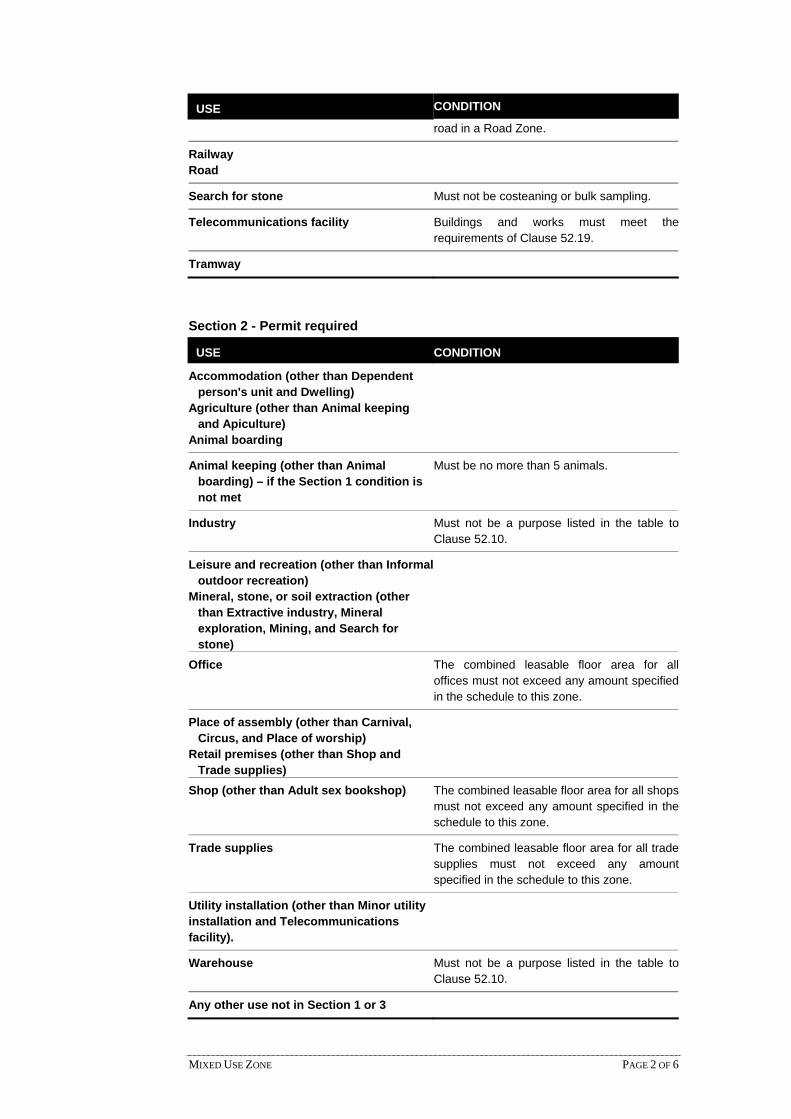
MIXED USE ZONE PAGE 2 OF 6
USE CONDITION
road in a Road Zone.
Railway Road
Search for stone Must not be costeaning or bulk sampling.
Telecommunications facility Buildings and works must meet therequirements of Clause 52.19.
Tramway
Section 2 - Permit required
USE CONDITION
Accommodation (other than Dependent person's unit and Dwelling)
Agriculture (other than Animal keeping and Apiculture)
Animal boarding
Animal keeping (other than Animal boarding) – if the Section 1 condition is not met
Must be no more than 5 animals.
Industry Must not be a purpose listed in the table toClause 52.10.
Leisure and recreation (other than Informal outdoor recreation)
Mineral, stone, or soil extraction (other than Extractive industry, Mineral exploration, Mining, and Search for stone)
Office The combined leasable floor area for alloffices must not exceed any amount specifiedin the schedule to this zone.
Place of assembly (other than Carnival, Circus, and Place of worship)
Retail premises (other than Shop and Trade supplies)
Shop (other than Adult sex bookshop) The combined leasable floor area for all shopsmust not exceed any amount specified in theschedule to this zone.
Trade supplies The combined leasable floor area for all tradesupplies must not exceed any amountspecified in the schedule to this zone.
Utility installation (other than Minor utility installation and Telecommunications facility).
Warehouse Must not be a purpose listed in the table toClause 52.10.
Any other use not in Section 1 or 3

MIXED USE ZONE PAGE 3 OF 6
Section 3 - Prohibited
USE
Adult sex bookshop
Brothel
Extractive industry
32.04-2 Use for industry and warehouse
Amenity of the neighbourhood
The use of land for an industry or warehouse must not adversely affect the amenity of the neighbourhood, including through:
The transport of materials or goods to or from the land.
The appearance of any stored materials or goods.
Traffic generated by the use.
Emissions from the land.
Application requirements
Unless the circumstances do not require, an application to use land for an industry or warehouse must be accompanied by the following information:
The purpose of the use and the types of activities to be carried out.
The type and quantity of materials and goods to be stored, processed or produced.
Whether a Works Approval or Waste Discharge Licence is required from the Environment Protection Authority.
Whether a notification under the Occupational Health and Safety (Major Hazard Facilities) Regulations 2000 is required, a licence under the Dangerous Goods Act 1995 is required, or a fire protection quantity under the Dangerous Goods (Storage and Handling) Regulations 2000 is exceeded.
How land not required for immediate use is to be maintained.
The likely effects, if any, on the neighbourhood, including noise levels, traffic, air-borne emissions, emissions to land and water, light spill, glare, solar access and hours of operation (including the hours of delivery and dispatch of materials and goods).
Decision guidelines
Before deciding on an application to use land for an industry or warehouse, in addition to the decision guidelines in Clause 65, the responsible authority must consider, as appropriate:
The State Planning Policy Framework and the Local Planning Policy Framework, including the Municipal Strategic Statement and local planning policies.
The effect that existing uses on adjoining or nearby land may have on the proposed use.
The design of buildings, including provision for solar access.
The availability and provision of utility services.
The effect of traffic to be generated by the use.
09/10/2006 VC42

MIXED USE ZONE PAGE 4 OF 6
The interim use of those parts of the land not required for the proposed use.
32.04-3 Subdivision
Permit requirement
A permit is required to subdivide land.
An application to subdivide land, other than an application to subdivide land into lots each containing an existing dwelling or car parking space, must meet the requirements of Clause 56 and:
Must meet all of the objectives included in the clauses specified in the following table.
Should meet all of the standards included in the clauses specified in the following table.
Class of subdivision Objectives and standards to be met
60 or more lots All except Clause 56.03-5.
16 – 59 lots All except Clauses 56.03-1 to 56.03-3, 56.03-5, 56.06-1 and 56.06-3.
3 – 15 lots All except Clauses 56.02-1, 56.03-1 to 56.03-4, 56.05-2, 56.06-1, 56.06-3 and 56.06-6.
2 lots Clauses 56.03-5, 56.04-2, 56.04-3, 56.04-5, 56.06-8 to 56.09-2.
Exemption from notice and review
An application is exempt from the notice requirements of Section 52(1)(a), (b) and (d), the decision requirements of Section 64(1), (2) and (3) and the review rights of Section 82(1) of the Act.
Decision guidelines
Before deciding on an application, in addition to the decision guidelines in Clause 65, the responsible authority must consider, as appropriate:
The State Planning Policy Framework and the Local Planning Policy Framework, including the Municipal Strategic Statement and local planning policies.
The objectives and standards of Clause 56.
32.04-4 Construction and extension of one dwelling on a lot
Permit requirement
A permit is required to construct or extend one dwelling on:
A lot of less than 300 square metres.
A lot of between 300 square metres and 500 square metres if specified in the schedule to this zone.
The construction or extension of a dwelling includes a front fence within 3 metres of a street if the fence exceeds the maximum height specified in Clause 54.06-2.
A development must meet the requirements of Clause 54.
09/10/2006 VC42
30/08/2006 VC40

MIXED USE ZONE PAGE 5 OF 6
No permit required
No permit is required to construct or extend:
Works normal to a dwelling.
An open-sided pergola or verandah with a finished floor level not more than 800 mm above natural ground level and a maximum building height not more than 3 metres above natural ground level.
An outbuilding with a gross floor area not more than 10 square metres and a maximum building height not more than 3 metres above natural ground level.
A deck with a finished floor level not more than 800 mm above natural ground level.
A domestic swimming pool or spa and associated mechanical equipment and safety fencing.
This does not apply to the construction or extension of a garage or carport.
Decision guidelines
Before deciding on an application, in addition to the decision guidelines in Clause 65, the responsible authority must consider, as appropriate:
The State Planning Policy Framework and the Local Planning Policy Framework, including the Municipal Strategic Statement and local planning policies.
The objectives, standards and decision guidelines of Clause 54.
32.04-5 Construction and extension of two or more dwellings on a lot, dwellings on common property and residential buildings
Permit requirement
A permit is required to:
Construct a dwelling if there is at least one dwelling existing on the lot.
Construct two or more dwellings on a lot.
Extend a dwelling if there are two or more dwellings on the lot.
Construct or extend a dwelling on common property.
Construct or extend a residential building. The construction or extension of a dwelling or a residential building includes a front fence within 3 metres of a street if the fence exceeds the maximum height specified in Clause 55.06-2.
A development must meet the requirements of Clause 55. This does not apply to a development of four or more storeys, excluding a basement.
A permit is not required to construct one dependent person’s unit on a lot.
Decision guidelines
Before deciding on an application, in addition to the decision guidelines in Clause 65, the responsible authority must consider, as appropriate:
The State Planning Policy Framework and the Local Planning Policy Framework, including the Municipal Strategic Statement and local planning policies.
19/01/2006 VC37
MIXED USE ZONE PAGE 6 OF 6
The objectives, standards and decision guidelines of Clause 55.
32.04-6 Requirements of Clause 54 and Clause 55
The schedule to this zone may specify the requirements of:
Standards A3, A4, A5, A10, A17 and A20 of Clause 54 of this scheme.
Standards B6, B7, B8, B17, B28 and B32 of Clause 55 of this scheme. If a requirement is not specified in the schedule to this zone, the requirement set out in the relevant standard of Clause 54 or Clause 55 applies.
32.04-7 Buildings and works associated with a Section 2 use
A permit is required to construct a building or construct or carry out works for a use in Section 2 of Clause 32.04-1.
32.04-8 Advertising signs
Advertising sign requirements are at Clause 52.05. This zone is in Category 3.
Notes: Refer to the State Planning Policy Framework and the Local Planning Policy Framework, including the Municipal Strategic Statement, for strategies and policies which may affect the use and development of land.
Check whether an overlay also applies to the land.
Other requirements may also apply. These can be found at Particular Provisions.
19/01/2006 VC37
19/01/2006 VC37
19/01/2006 VC37

TOWNSHIP ZONE PAGE 1 OF 7
32.05 TOWNSHIP ZONE
Shown on the planning scheme map as TZ.
Purpose
To implement the State Planning Policy Framework and the Local Planning Policy Framework, including the Municipal Strategic Statement and local planning policies.
To provide for residential development and a range of commercial, industrial and other uses in small towns.
To encourage residential development that respects the neighbourhood character.
32.05-1 Table of uses
Section 1 - Permit not required
USE CONDITION
Animal keeping (other than Animal boarding)
Must be no more than 2 animals.
Apiculture Must meet the requirements of the Apiary Code of Practice, May 1997.
Bed and breakfast No more than 6 persons may be accommodated away from their normal place of residence. At least 1 car parking space must be provided for each 2 persons able to be accommodated away from their normal place of residence.
Carnival Must meet the requirements of A ‘Good Neighbour‘ Code of Practice for a Circus or Carnival, October 1997.
Circus Must meet the requirements of A ‘Good Neighbour‘ Code of Practice for a Circus or Carnival, October 1997.
Dependent person's unit
Must be the only dependent person's unit on the lot. Must meet the requirements of Clause 32.05-2.
Dwelling (other than Bed and breakfast)
Must meet the requirements of Clause 32.05-2.
Home occupation Informal outdoor recreation Mineral exploration
Mining Must meet the requirements of Clause 52.08-2.
Minor utility installation Natural systems
Place of worship Must be no social or recreation activities. The gross floor area of all buildings must not exceed 180 square metres.
19/01/2006 VC37
19/01/2006 VC37

TOWNSHIP ZONE PAGE 2 OF 7
USE CONDITION The site must not exceed 1200 square metres.
The site must adjoin, or have access to, a road in a Road Zone.
Railway Road
Search for stone Must not be costeaning or bulk sampling.
Telecommunications facility Buildings and works must meet the requirements of Clause 52.19.
Tramway
Section 2 - Permit required
USE CONDITION
Accommodation (other than Dependent person's unit and Dwelling)
Agriculture (other than Animal keeping, Apiculture and Intensive animal husbandry)
Animal boarding
Animal keeping (other than Animal boarding) – if the Section 1 condition is not met
Must be no more than 5 animals.
Dependent person's unit - if the Section 1 condition is not met
Must meet the requirements of Clause 32.05-2.
Industry (other than Refuse disposal) Must not be a purpose listed in the table to Clause 52.10.
Leisure and recreation (other than Informal outdoor recreation and Motor racing track)
Mineral, stone, or soil extraction (other than Extractive industry, Mineral exploration, Mining, and Search for stone)
Place of assembly (other than Carnival, Circus, and Place of worship)
Retail premises (other than Adult sex bookshop)
Utility installation (other than Minor utility installation and Telecommunications facility)
Warehouse Must not be a purpose listed in the table to Clause 52.10.
Any other use not in Section 1 or 3

TOWNSHIP ZONE PAGE 3 OF 7
Section 3 - Prohibited
USE
Adult sex bookshop
Brothel
Dwelling – if the Section 1 condition is not met
Extractive industry
Intensive animal husbandry
Motor racing track
Refuse disposal
Saleyard
32.05-2 Use for a dwelling or a dependent person’s unit
A lot may be used for a dwelling provided the following requirements are met:
Each dwelling must be connected to reticulated sewerage, if available. If reticulated sewerage is not available, all wastewater from each dwelling must be treated and retained within the lot in accordance with the State Environment Protection Policy (Waters of Victoria) under the Environment Protection Act 1970.
Each dwelling must be connected to a reticulated potable water supply or have an alternative potable water supply, with appropriate storage capacity, to the satisfaction of the responsible authority.
Each dwelling must be connected to a reticulated electricity supply or have an alternative energy supply to the satisfaction of the responsible authority.
These requirements also apply to a dependent person’s unit.
32.05-3 Use for industry and warehouse
Amenity of the neighbourhood
The use of land for an industry or warehouse must not adversely affect the amenity of the neighbourhood, including through:
The transport of materials or goods to or from the land.
The appearance of any stored materials or goods.
Traffic generated by the use.
Emissions from the land.
Application requirements
Unless the circumstances do not require, an application to use land for an industry or warehouse must be accompanied by the following information:
The purpose of the use and the types of activities to be carried out.
The type and quantity of materials and goods to be stored, processed or produced.
Whether a Works Approval or Waste Discharge Licence is required from the Environment Protection Authority.
19/01/2006 VC37
09/10/2006 VC42

TOWNSHIP ZONE PAGE 4 OF 7
Whether a notification under the Occupational Health and Safety (Major Hazard Facilities) Regulations 2000 is required, a licence under the Dangerous Goods Act 1995 is required, or a fire protection quantity under the Dangerous Goods (Storage and Handling) Regulations 2000 is exceeded.
How land not required for immediate use is to be maintained.
The likely effects, if any, on the neighbourhood, including noise levels, traffic, air-borne emissions, emissions to land and water, light spill, glare, solar access and hours of operation (including the hours of delivery and despatch of materials and goods).
Decision guidelines
Before deciding on an application to use land for an industry or warehouse, in addition to the decision guidelines in Clause 65, the responsible authority must consider, as appropriate:
The State Planning Policy Framework and the Local Planning Policy Framework, including the Municipal Strategic Statement and local planning policies.
The effect that existing uses on adjoining or nearby land may have on the proposed use.
The design of buildings, including provision for solar access.
The availability and provision of utility services.
The effect of traffic to be generated by the use.
The interim use of those parts of the land not required for the proposed use.
32.05-4 Subdivision
Permit requirement
A permit is required to subdivide land.
An application to subdivide land, other than an application to subdivide land into lots each containing an existing dwelling or car parking space, must meet the requirements of Clause 56 and:
Must meet all of the objectives included in the clauses specified in the following table.
Should meet all of the standards included in the clauses specified in the following table.
Class of subdivision Objectives and standards to be met
16 or more lots Clauses 56.02-1, 56.03-5, 56.04-2 to 56.04-5, 56.05-1, 56.05-2, 56.06-2, 56.06-4, 56.06-5, 56.06-7, 56.06-8 and 56.07-1 to 56.09-4.
3 – 15 lots Clauses 56.03-5, 56.04-2 to 56.04-5, 56.05-1, 56.06-2, 56.06-4, 56.06-5, 56.06-7 and 56.06-8 to 56.09-4.
2 lots Clauses 56.03-5, 56.04-2, 56.04-3, 56.04-5 and 56.06-8 to 56.09-2.
Each lot must be provided with reticulated sewerage, if available. If reticulated sewerage is not available, the application must be accompanied by:
A land assessment which demonstrates that each lot is capable of treating and retaining all wastewater in accordance with the State Environment Protection Policy (Waters of Victoria) under the Environment Protection Act 1970.
09/10/2006 VC42

TOWNSHIP ZONE PAGE 5 OF 7
A plan which shows a building envelope and effluent disposal area for each lot.
Decision guidelines
Before deciding on an application, in addition to the decision guidelines in Clause 65, the responsible authority must consider, as appropriate:
The State Planning Policy Framework and the Local Planning Policy Framework, including the Municipal Strategic Statement and local planning policies.
The objectives and standards of Clause 56.
32.05-5 Construction and extension of one dwelling on a lot
Permit requirement
A permit is required to construct or extend one dwelling on:
A lot of less than 300 square metres.
A lot of between 300 square metres and 500 square metres if specified in the schedule to this zone.
The construction or extension of a dwelling includes a front fence within 3 metres of a street if the fence exceeds the maximum height specified in Clause 54.06-2.
A development must meet the requirements of Clause 54.
No permit required
No permit is required to construct or extend:
Works normal to a dwelling.
An open-sided pergola or verandah with a finished floor level not more than 800 mm above natural ground level and a maximum building height not more than 3 metres above natural ground level.
An outbuilding with a gross floor area not more than 10 square metres and a maximum building height not more than 3 metres above natural ground level.
A deck with a finished floor level not more than 800 mm above natural ground level.
A domestic swimming pool or spa and associated mechanical equipment and safety fencing.
This does not apply to the construction or extension of a garage or carport.
Decision guidelines
Before deciding on an application, in addition to the decision guidelines in Clause 65, the responsible authority must consider, as appropriate:
The State Planning Policy Framework and the Local Planning Policy Framework, including the Municipal Strategic Statement and local planning policies.
The objectives, standards and decision guidelines of Clause 54.
30/08/2006 VC40

TOWNSHIP ZONE PAGE 6 OF 7
32.05-6 Construction and extension of two or more dwellings on a lot, dwellings on common property and residential buildings
Permit requirement
A permit is required to:
Construct a dwelling if there is at least one dwelling existing on the lot.
Construct two or more dwellings on a lot.
Extend a dwelling if there are two or more dwellings on the lot.
Construct or extend a dwelling on common property.
Construct or extend a residential building. The construction or extension of a dwelling or a residential building includes a front fence within 3 metres of a street if the fence exceeds the maximum height specified in Clause 55.06-2.
A development must meet the requirements of Clause 55. This does not apply to a development of four or more storeys, excluding a basement.
A permit is not required to construct one dependent person’s unit on a lot.
Decision guidelines
Before deciding on an application, in addition to the decision guidelines in Clause 65, the responsible authority must consider, as appropriate:
The State Planning Policy Framework and the Local Planning Policy Framework, including the Municipal Strategic Statement and local planning policies.
The objectives, standards and decision guidelines of Clause 55.
32.05-7 Requirements of Clause 54 and Clause 55
The schedule to this zone may specify the requirements of:
Standards A3, A4, A5, A10, A17 and A20 of Clause 54 of this scheme.
Standards B6, B7, B8, B17, B28 and B32 of Clause 55 of this scheme. If a requirement is not specified in the schedule to this zone, the requirement set out in the relevant standard of Clause 54 or Clause 55 applies.
32.05-8 Buildings and works associated with a Section 2 use
A permit is required to construct a building or construct or carry out works for a use in Section 2 of Clause 32.05-1.
32.05-9 Decision guidelines
Before deciding on an application to use or subdivide land, construct or extend a dwelling or residential building, construct a building or construct or carry out works, in addition to the decision guidelines in Clause 65, the responsible authority must consider, as appropriate:
The State Planning Policy Framework and the Local Planning Policy Framework, including the Municipal Strategic Statement and local planning policies.
19/01/2006 VC37
19/01/2006 VC37
19/01/2006 VC37
19/01/2006 VC37

TOWNSHIP ZONE PAGE 7 OF 7
The protection and enhancement of the character of the town and surrounding area including the retention of vegetation.
The availability and provision of utility services, including sewerage, water, drainage, electricity, gas and telecommunications.
In the absence of reticulated sewerage, the capability of the lot to treat and retain all wastewater in accordance with the State Environment Protection Policy (Waters of Victoria) under the Environment Protection Act 1970.
The design of buildings, including provision for solar access.
The need for a verandah along the front or side of commercial buildings to provide shelter for pedestrians.
Provision of car parking and loading bay facilities and landscaping.
32.05-10 Advertising signs
Advertising sign requirements are at Clause 52.05. This zone is in Category 3.
Notes: Refer to the State Planning Policy Framework and the Local Planning Policy Framework, including the Municipal Strategic Statement, for strategies and policies which may affect the use and development of land.
Check whether an overlay also applies to the land.
Other requirements may also apply. These can be found at Particular Provisions.
19/01/2006 VC37

32.06 RESIDENTIAL 3 ZONE
Shown on the planning scheme map as R3Z.
Purpose
To implement the State Planning Policy Framework and the Local Planning Policy Framework, including the Municipal Strategic Statement and local planning policies.
To provide for residential development at a range of densities with a variety of dwellings to meet the housing needs of all households.
To encourage residential development that respects the neighbourhood character.
To limit the maximum height of a dwelling or residential building.
In appropriate locations, to allow educational, recreational, religious, community and a limited range of other non-residential uses to serve local community needs.
32.06-1 Table of uses
Section 1 - Permit not required
USE CONDITION Animal keeping (other than Animal
boarding) Must be no more than 2 animals.
Apiculture Must meet the requirements of the Apiary Code of Practice, May 1997.
Bed and breakfast No more than 6 persons may be accommodated away from their normal place of residence. At least 1 car parking space must be provided for each 2 persons able to be accommodated away from their normal place of residence.
Carnival Must meet the requirements of A ‘Good Neighbour’ Code of Practice for a Circus or Carnival, October 1997.
Circus Must meet the requirements of A ‘Good Neighbour’ Code of Practice for a Circus or Carnival, October 1997.
Dependent person's unit Must be the only dependent person's unit on the lot.
Dwelling (other than Bed and breakfast) Home occupation Informal outdoor recreation Mineral exploration
Mining Must meet the requirements of Clause 52.08-2.
Minor utility installation Natural systems
Place of worship Must be no social or recreation activities. The gross floor area of all buildings must not exceed 180 square metres. The site must not exceed 1200 square
19/01/2006 VC37
17/09/2007 VC45
RESIDENTIAL 3 ZONE PAGE 1 OF 6

USE CONDITION metres. The site must adjoin, or have access to, a road in a Road Zone.
Railway Road
Search for stone Must not be costeaning or bulk sampling.
Telecommunications facility Buildings and works must meet the requirements of Clause 52.19.
Tramway
Section 2 - Permit required
USE CONDITION
Accommodation (other than Dependent person's unit and Dwelling)
Agriculture (other than Animal keeping, Animal training, Apiculture, Horse stables, and Intensive animal husbandry)
Animal keeping (other than Animal boarding) – if the Section 1 condition is not met
Must be no more than 5 animals.
Car park Must be used in conjunction with another use in Section 1 or 2.
Car wash The site must adjoin, or have access to, a road in a Road Zone.
Community market
Convenience restaurant The site must adjoin, or have access to, a road in a Road Zone.
Convenience shop The leasable floor area must not exceed 80 square metres.
Food and drink premises (other than Convenience restaurant and Take away food premises)
Leisure and recreation (other than Informal outdoor recreation and Motor racing track)
Medical centre Mineral, stone, or soil extraction (other
than Extractive industry, Mineral exploration, Mining, and Search for stone)
Place of assembly (other than Amusement parlour, Carnival, Circus, Nightclub, and Place of worship)
Plant nursery
Service station The site must either: Adjoin a business zone or industrial
zone.
RESIDENTIAL 3 ZONE PAGE 2 OF 6

USE CONDITION Adjoin, or have access to, a road in a
Road Zone. The site must not exceed either:
3000 square metres.
3600 square metres if it adjoins on two boundaries a road in a Road Zone.
Store Must be in a building, not a dwelling, and used to store equipment, goods, or motor vehicles used in conjunction with the occupation of a resident of a dwelling on the lot.
Take away food premises The site must adjoin, or have access to, a road in a Road Zone.
Utility installation (other than Minor utility installation and Telecommunications facility)
Any other use not in Section 1 or 3
Section 3 - Prohibited
USE
Amusement parlour Animal boarding Animal training Brothel Cinema based entertainment facility Extractive industry Horse stables Industry (other than Car wash) Intensive animal husbandry Motor racing track Nightclub Office (other than Medical centre) Retail premises (other than Community market, Convenience shop, Food and drink
premises, and Plant nursery) Saleyard Transport terminal Warehouse (other than Store)
32.06-2 Subdivision 09/10/2006 VC42
Permit requirement
A permit is required to subdivide land.
An application to subdivide land, other than an application to subdivide land into lots each containing an existing dwelling or car parking space, must meet the requirements of Clause 56 and:
Must meet all of the objectives included in the clauses specified in the following table.
Should meet all of the standards included in the clauses specified in the following table.
RESIDENTIAL 3 ZONE PAGE 3 OF 6

Class of subdivision Objectives and standards to be met
60 or more lots All except Clause 56.03-5.
16 – 59 lots All except Clauses 56.03-1 to 56.03-3, 56.03-5, 56.06-1 and 56.06-3.
3 – 15 lots All except Clauses 56.02-1, 56.03-1 to 56.03-4, 56.05-2, 56.06-1, 56.06-3 and 56.06-6.
2 lots Clauses 56.03-5, 56.04-2, 56.04-3, 56.04-5, 56.06-8 to 56.09-2.
Exemption from notice and review
An application to subdivide land into lots each containing an existing dwelling or car parking space is exempt from the notice requirements of Section 52(1)(a), (b) and (d), the decision requirements of Section 64(1), (2) and (3) and the review rights of Section 82(1) of the Act.
Decision guidelines
Before deciding on an application, in addition to the decision guidelines in Clause 65, the responsible authority must consider, as appropriate:
The State Planning Policy Framework and the Local Planning Policy Framework, including the Municipal Strategic Statement and local planning policies.
The objectives and standards of Clause 56.
32.06-3 Construction and extension of one dwelling on a lot 30/08/2006 VC40
Permit requirement
A permit is required to construct or extend one dwelling on:
A lot of less than 300 square metres.
A lot of between 300 square metres and 500 square metres if specified in the schedule to this zone.
The construction or extension of a dwelling includes a front fence within 3 metres of a street if the fence exceeds the maximum height specified in Clause 54.06-2.
A development must meet the requirements of Clause 54.
No permit required
No permit is required to construct or extend:
Works normal to a dwelling.
An open-sided pergola or verandah with a finished floor level not more than 800 mm above natural ground level and a maximum building height not more than 3 metres above natural ground level.
An outbuilding with a gross floor area not more than 10 square metres and a maximum building height not more than 3 metres above natural ground level.
A deck with a finished floor level not more than 800 mm above natural ground level.
A domestic swimming pool or spa and associated mechanical equipment and safety fencing.
RESIDENTIAL 3 ZONE PAGE 4 OF 6

This does not apply to the construction or extension of a garage or carport.
Decision guidelines
Before deciding on an application, in addition to the decision guidelines in Clause 65, the responsible authority must consider, as appropriate:
The State Planning Policy Framework and the Local Planning Policy Framework, including the Municipal Strategic Statement and local planning policies.
The objectives, standards and decision guidelines of Clause 54.
32.06-4 Construction and extension of two or more dwellings on a lot, dwellings on common property and residential buildings 19/01/2006
VC37
Permit requirement
A permit is required to:
Construct a dwelling if there is at least one dwelling existing on the lot.
Construct two or more dwellings on a lot.
Extend a dwelling if there are two or more dwellings on the lot.
Construct or extend a dwelling on common property.
Construct or extend a residential building. The construction or extension of a dwelling or a residential building includes a front fence within 3 metres of a street if the fence exceeds the maximum height specified in Clause 55.06-2.
A development must meet the requirements of Clause 55.
A permit is not required to construct one dependent person’s unit on a lot.
Decision guidelines
Before deciding on an application, in addition to the decision guidelines in Clause 65, the responsible authority must consider, as appropriate:
The State Planning Policy Framework and the Local Planning Policy Framework, including the Municipal Strategic Statement and local planning policies.
The objectives, standards and decision guidelines of Clause 55.
32.06-5 Maximum building height of a dwelling or residential building 19/01/2006 VC37 The maximum building height of a dwelling or residential building must not exceed 9
metres, unless the slope of the natural ground level at any cross section wider than 8 metres of the site of the building is 2.5 degrees or more, in which case the maximum building height must not exceed 10 metres.
This does not apply to:
An extension of an existing dwelling or residential building that exceeds the specified building height provided that the extension does not exceed the existing building height.
A dwelling or residential building which exceeds the specified building height for which a valid planning or building permit was in effect prior to the introduction of this provision.
RESIDENTIAL 3 ZONE PAGE 5 OF 6

32.06-6 Requirements of Clause 54 and Clause 55
19/01/2006 VC37 The schedule to this zone may specify the requirements of:
Standards A3, A5, A10, A17 and A20 of Clause 54 of this scheme.
Standards B6, B8, B17, B28 and B32 of Clause 55 of this scheme. If a requirement is not specified in the schedule to this zone, the requirement set out in the relevant standard of Clause 54 or Clause 55 applies.
32.06-7 Buildings and works associated with a Section 2 use 17/09/2007 VC45 A permit is required to construct a building or construct or carry out works for a use in
Section 2 of Clause 32.06-1.
32.06-8 Advertising signs 19/01/2006 VC37
Advertising sign requirements are at Clause 52.05. This zone is in Category 3.
Notes: Refer to the State Planning Policy Framework and the Local Planning Policy Framework, including the Municipal Strategic Statement, for strategies and policies which may affect the use and development of land.
Check whether an overlay also applies to the land.
Other requirements may also apply. These can be found at Particular Provisions.
RESIDENTIAL 3 ZONE PAGE 6 OF 6

INDUSTRIAL ZONES PAGE 1 OF 1
33 INDUSTRIAL ZONES19/01/2006VC37

INDUSTRIAL 1 ZONE PAGE 1 OF 7
33.01 INDUSTRIAL 1 ZONE
Shown on the planning scheme map as IN1Z.
Purpose
To implement the State Planning Policy Framework and the Local Planning Policy Framework, including the Municipal Strategic Statement and local planning policies.
To provide for manufacturing industry, the storage and distribution of goods and associated uses in a manner which does not affect the safety and amenity of local communities.
33.01-1 Table of uses
Section 1 - Permit not required
USE CONDITION
Apiculture Must meet the requirements of the ApiaryCode of Practice, May 1997.
Carnival Must meet the requirements of A ‘GoodNeighbour’ Code of Practice for a Circus orCarnival, October 1997.
Circus Must meet the requirements of A ‘GoodNeighbour’ Code of Practice for a Circus orCarnival, October 1997.
Crop raising Extensive animal husbandry Home occupation
Industry (other than Materials recycling)
Must not be a purpose shown with a Note 1 orNote 2 in the table to Clause 52.10. The land must be at least the followingdistances from land (not a road) which is in aresidential zone, Business 5 Zone, CapitalCity Zone or Docklands Zone, land used for ahospital or an education centre or land in aPublic Acquisition Overlay to be acquired for ahospital or an education centre:
• The threshold distance, for a purposelisted in the table to Clause 52.10.
• 30 metres, for a purpose not listed in thetable to Clause 52.10.
Must not adversely affect the amenity of theneighbourhood, including through the:
• Transport of materials, goods orcommodities to or from the land.
• Appearance of any stored goods ormaterials.
• Emission of noise, artificial light, vibration,odour, fumes, smoke, vapour, steam,soot, ash, dust, waste water, wasteproducts, grit or oil.
Informal outdoor recreation
19/01/2006 VC37
19/01/2006 VC37

INDUSTRIAL 1 ZONE PAGE 2 OF 7
USE CONDITION Mail centre Mineral exploration
Mining Must meet the requirements of Clause 52.08-2.
Minor utility installation Natural systems Railway Road
Search for stone Must not be costeaning or bulk sampling.
Service station The land must be at least 30 metres from land(not a road) which is in a residential zone,Business 5 Zone, Capital City Zone orDocklands Zone, land used for a hospital oran education centre or land in a PublicAcquisition Overlay to be acquired for ahospital or an education centre.
Shipping container storage Must not be a purpose shown with a Note 1 orNote 2 in the table to Clause 52.10.
The land must be at least the followingdistances from land (not a road) which is in aresidential zone, Business 5 Zone, CapitalCity Zone or Docklands Zone, land used for ahospital or an education centre or land in aPublic Acquisition Overlay to be acquired for ahospital or an education centre:
• The threshold distance, for a purposelisted in the table to Clause 52.10.
• 100 metres, for a purpose not listed in thetable to Clause 52.10.
The site must adjoin, or have access to, aroad in a Road Zone.
Shipping containers must be setback at least9 metres from a road in a Road Zone.
The height of shipping container stacks mustnot exceed 6 containers or 16 metres,whichever is the lesser.
Must not adversely affect the amenity of theneighbourhood, including through the:
• Transport of materials, goods orcommodities to or from the land.
• Appearance of any stored goods ormaterials.
• Emission of noise, artificial light, vibration,odour, fumes, smoke, vapour, steam,soot, ash, dust, waste water, wasteproducts, grit or oil.
Telecommunications facility Buildings and works must meet therequirements of Clause 52.19.
Tramway

INDUSTRIAL 1 ZONE PAGE 3 OF 7
USE CONDITION
Warehouse (other than Mail centre and Shipping container storage)
Must not be a purpose shown with a Note 1 orNote 2 in the table to Clause 52.10. The land must be at least the followingdistances from land (not a road) which is in aresidential zone, Business 5 Zone, CapitalCity Zone or Docklands Zone, land used for ahospital or an education centre or land in aPublic Acquisition Overlay to be acquired for ahospital or an education centre:
• The threshold distance, for a purposelisted in the table to Clause 52.10.
• 30 metres, for a purpose not listed in thetable to Clause 52.10.
Must not adversely affect the amenity of theneighbourhood, including through the:
• Transport of materials, goods orcommodities to or from the land.
• Appearance of any stored goods ormaterials.
• Emission of noise, artificial light, vibration,odour, fumes, smoke, vapour, steam,soot, ash, dust, waste water, wasteproducts, grit or oil.
Section 2 - Permit required
USE CONDITION
Adult sex bookshop Must be at least 200 metres (measured by theshortest route reasonably accessible on foot)from a residential zone or Business 5 Zone,land used for a hospital, primary school orsecondary school or land in a PublicAcquisition Overlay to be acquired for ahospital, primary school or secondary school.
Agriculture (other than Apiculture, Crop raising, Extensive animal husbandry, and Intensive animal husbandry)
Caretaker's house Convenience shop
Education centre Must not be a primary or secondary school.
Equestrian supplies Leisure and recreation (other than Informal
outdoor recreation)
Lighting shop Must be in one occupation with a leasablefloor area of at least the amount specified inthe schedule to this zone. If no amount isspecified, the leasable floor area must be atleast 500 square metres.
Materials recycling The land must be at least 30 metres from land(not a road) which is in a residential zone orBusiness 5 Zone, land used for a hospital or

INDUSTRIAL 1 ZONE PAGE 4 OF 7
USE CONDITION an education centre or land in a PublicAcquisition Overlay to be acquired for ahospital or an education centre.
Mineral, stone, or soil extraction (other than Mineral exploration, Mining, and Search for stone)
Office The leasable floor area must not exceed 500square metres.
Party supplies Place of assembly (other than Carnival and Circus)
Restricted retail premises (other than Equestrian supplies, Lighting shop, and Party supplies)
Must be in one occupation with a leasablefloor area of at least the amount specified inthe schedule to this zone. If no amount isspecified, the leasable floor area must be atleast 1000 square metres.
Retail premises (other than Shop)
Utility installation (other than Minor utility installation and Telecommunications facility).
Any gas holder, or sewerage or refusetreatment or disposal works, must be at least30 metres from land (not a road) which is in aresidential zone, Business 5 Zone, CapitalCity Zone or Docklands Zone land used for ahospital or an education centre or land in aPublic Acquisition Overlay to be acquired for ahospital or an education centre.
Any other use not in Section 1 or 3
Section 3 - Prohibited
USE
Accommodation (other than Caretaker's house)
Cinema based entertainment facility
Hospital
Intensive animal husbandry
Shop (other than Adult sex bookshop, Convenience shop and Restricted retail premises)
33.01-2 Use of land
Application requirements
An application to use land for an industry or warehouse must be accompanied by the following information, as appropriate:
The purpose of the use and the types of processes to be utilised.
09/10/2006 VC42

INDUSTRIAL 1 ZONE PAGE 5 OF 7
The type and quantity of goods to be stored, processed or produced.
How land not required for immediate use is to be maintained.
Whether a Works Approval or Waste Discharge Licence is required from the Environment Protection Authority.
Whether a notification under the Occupational Health and Safety (Major Hazard Facilities) Regulations 2000 is required, a licence under the Dangerous Goods Act 1995 is required, or a fire protection quantity under the Dangerous Goods (Storage and Handling) Regulations 2000 is exceeded.
The likely effects, if any, on the neighbourhood, including:
Noise levels.
Air-borne emissions.
Emissions to land or water.
Traffic, including the hours of delivery and despatch.
Light spill or glare.
Decision guidelines
Before deciding on an application, in addition to the decision guidelines in Clause 65, the responsible authority must consider, as appropriate:
The State Planning Policy Framework and the Local Planning Policy Framework, including the Municipal Strategic Statement and local planning policies.
The effect that the use may have on nearby existing or proposed residential areas or other uses which are sensitive to industrial off-site effects, having regard to any comments or directions of the referral authorities.
The effect that nearby industries may have on the proposed use.
The drainage of the land.
The availability of and connection to services.
The effect of traffic to be generated on roads.
The interim use of those parts of the land not required for the proposed use.
33.01-3 Subdivision
Permit requirement
A permit is required to subdivide land.
Exemption from notice and review
An application is exempt from the notice requirements of Section 52(1)(a), (b) and (d), the decision requirements of Section 64(1), (2) and (3) and the review rights of Section 82(1) of the Act. This exemption does not apply to land within 30 metres of land (not a road) which is in a residential zone or Business 5 Zone, land used for a hospital or an education centre or land in a Public Acquisition Overlay to be acquired for a hospital or an education centre.
19/01/2006 VC37

INDUSTRIAL 1 ZONE PAGE 6 OF 7
Decision guidelines
Before deciding on an application, in addition to the decision guidelines in Clause 65, the responsible authority must consider, as appropriate:
The State Planning Policy Framework and the Local Planning Policy Framework, including the Municipal Strategic Statement and local planning policies.
Any natural or cultural values on or near the land.
Streetscape character.
Landscape treatment.
Interface with non-industrial areas.
33.01-4 Buildings and works
Permit requirement
A permit is required to construct a building or construct or carry out works.
This does not apply to a building or works which:
Rearrange, alter or renew plant if the area or height of the plant is not increased.
Are used for crop raising, extensive animal husbandry or informal outdoor recreation.
Application requirements
An application to construct a building or construct or carry out works must be accompanied by the following information, as appropriate:
A plan drawn to scale which shows:
The boundaries and dimensions of the site.
Adjoining roads.
Relevant ground levels.
The layout of existing and proposed buildings and works.
Driveways and vehicle parking and loading areas.
Proposed landscape areas.
External storage and waste treatment areas.
Elevation drawings to scale which show the colour and materials of all buildings and works.
Construction details of all drainage works, driveways and vehicle parking and loading areas.
A landscape layout which includes the description of vegetation to be planted, the surfaces to be constructed, a site works specification and the method of preparing, draining, watering and maintaining the landscape area.
Exemption from notice and review
An application is exempt from the notice requirements of Section 52(1)(a), (b) and (d), the decision requirements of Section 64(1), (2) and (3) and the review rights of Section 82(1) of the Act. This exemption does not apply to an application for a building or works within 30 metres of land (not a road) which is in a residential zone or Business 5 Zone, land used
09/10/2006 VC42

INDUSTRIAL 1 ZONE PAGE 7 OF 7
for a hospital or an education centre or land in a Public Acquisition Overlay to be acquired for a hospital or an education centre.
Decision guidelines
Before deciding on an application, in addition to the decision guidelines in Clause 65, the responsible authority must consider, as appropriate:
The State Planning Policy Framework and the Local Planning Policy Framework, including the Municipal Strategic Statement and local planning policies.
Any natural or cultural values on or near the land.
Streetscape character.
Built form.
Landscape treatment.
Interface with non-industrial areas.
Parking and site access.
Loading and service areas.
Outdoor storage.
Lighting.
Stormwater discharge.
Maintenance
All buildings and works must be maintained in good order and appearance to the satisfaction of the responsible authority.
33.01-5 Advertising signs
Advertising sign requirements are at Clause 52.05. This zone is in Category 2.
Notes: Refer to the State Planning Policy Framework and the Local Planning Policy Framework, including the Municipal Strategic Statement, for strategies and policies which may affect the use and development of land.
Check whether an overlay also applies to the land.
Other requirements may also apply. These can be found at Particular Provisions.
19/01/2006 VC37

INDUSTRIAL 2 ZONE PAGE 1 OF 6
33.02 INDUSTRIAL 2 ZONE
Shown on the planning scheme map as IN2Z.
Purpose
To implement the State Planning Policy Framework and the Local Planning Policy Framework, including the Municipal Strategic Statement and local planning policies.
To provide for manufacturing industry, the storage and distribution of goods and associated facilities in a manner which does not affect the safety and amenity of local communities.
To promote manufacturing industries and storage facilities that require a substantial threshold distance within the core of the zone.
To keep the core of the zone free of uses which are suitable for location elsewhere so as to be available for manufacturing industries and storage facilities that require a substantial threshold distance as the need for these arises.
33.02-1 Table of uses
Section 1 - Permit not required
USE CONDITION
Apiculture Must meet the requirements of the ApiaryCode of Practice, May 1997.
Crop raising Extensive animal husbandry Home occupation
Informal outdoor recreation Mineral exploration
Mining Must meet the requirements of Clause 52.08-2.
Minor utility installation Natural systems Railway Road
Search for stone Must not be costeaning or bulk sampling.
Service station
Telecommunications facility Buildings and works must meet therequirements of Clause 52.19.
Tramway
19/01/2006 VC37
19/01/2006 VC37

INDUSTRIAL 2 ZONE PAGE 2 OF 6
Section 2 - Permit required
USE CONDITION
Adult sex bookshop Must be at least 200 metres (measured by the shortest route reasonably accessible on foot) from a residential zone or Business 5 Zone, land used for a hospital, primary school or secondary school or land in a Public Acquisition Overlay to be acquired for a hospital, primary school or secondary school.
Agriculture (other than Apiculture, Crop raising, Extensive animal husbandry, and Intensive animal husbandry)
Caretaker's house Convenience shop
Education centre Must not be a primary or secondary school.
Equestrian supplies Industry Leisure and recreation (other than Informal
outdoor recreation) Mineral, stone, or soil extraction (other
than Mineral exploration, Mining, and Search for stone)
Office The leasable floor area must not exceed 500 square metres.
Party supplies Retail premises (other than Shop)
Utility installation (other than Minor utility installation and Telecommunications facility
Warehouse Any other use not in Section 1 or 3
Section 3 - Prohibited
USE
Accommodation (other than Caretaker's house)
Cinema based entertainment facility
Display home
Hospital
Intensive animal husbandry
Place of assembly
Shop (other than Adult sex bookshop, Convenience shop, Equestrian supplies, and Party supplies)
Veterinary centre

INDUSTRIAL 2 ZONE PAGE 3 OF 6
33.02-2 Use of land
Application requirements
An application to use land for an industry or warehouse must be accompanied by the following information, as appropriate:
The suitability of the industry or warehouse being located in the core of the zone, where the land is more than 1500 metres from land (not a road) which is in a residential zone, Business 5 Zone, Capital City Zone or Docklands Zone, land used for a hospital or an education centre or land in a Public Acquisition Overlay to be acquired for a hospital or an education centre and the industry or warehouse is a purpose which is listed in the Table to Clause 52.10 as requiring a threshold distance of less than 1500 metres, or is not listed in the Table.
The purpose of the use and the types of processes to be utilised.
The type and quantity of goods to be stored, processed or produced.
How land not required for immediate use is to be maintained.
Whether a Works Approval or Waste Discharge Licence is required from the Environment Protection Authority.
Whether a notification under the Occupational Health and Safety (Major Hazard Facilities) Regulations 2000 is required, a licence under the Dangerous Goods Act 1995 is required, or a fire protection quantity under the Dangerous Goods (Storage and Handling) Regulations 2000 is exceeded.
The likely effects, if any, on the neighbourhood, including:
Noise levels.
Air-borne emissions.
Emissions to land or water.
Traffic, including the hours of delivery and dispatch.
Light spill or glare.
Exemption from notice and review
An application is exempt from the notice requirements of Section 52(1)(a), (b) and (d), the decision requirements of Section 64(1), (2) and (3) and the review rights of Section 82(1) of the Act.
This exemption does not apply to land within 30 metres from land (not a road) which is in a residential zone, Business 5 Zone, Capital City Zone or Docklands Zone, land used for a hospital or an education centre or land in a Public Acquisition Overlay to be acquired for a hospital or an education centre.
Decision guidelines
Before deciding on an application, in addition to the decision guidelines in Clause 65, the responsible authority must consider, as appropriate:
The State Planning Policy Framework and the Local Planning Policy Framework, including the Municipal Strategic Statement and local planning policies.
The suitability of the industry or warehouse being located in the core of the zone, where the land is more than 1500 metres from land (not a road) which is in a residential zone, Business 5 Zone, Capital City Zone or Docklands Zone, land used for a hospital or an
09/10/2006 VC42

INDUSTRIAL 2 ZONE PAGE 4 OF 6
education centre or land in a Public Acquisition Overlay to be acquired for a hospital or an education centre and the industry or warehouse is a purpose which is listed in the Table to Clause 52.10 as requiring a threshold distance of less than 1500 metres, or is not listed in the Table.
The effect that the use may have on nearby existing or proposed residential areas or other uses which are sensitive to industrial off-site effects, having regard to any comments or directions of the referral authorities.
The effect that nearby industries may have on the proposed use.
The drainage of the land.
The availability of and connection to services.
The effect of traffic to be generated on roads.
The interim use of those parts of the land not required for the proposed use.
33.02-3 Subdivision
Permit requirement
A permit is required to subdivide land.
Exemption from notice and review
An application is exempt from the notice requirements of Section 52(1)(a), (b) and (d), the decision requirements of Section 64(1), (2) and (3) and the review rights of Section 82(1) of the Act. This exemption does not apply to land within 30 metres from land (not a road) which is in a residential zone or Business 5 Zone, land used for a hospital or an education centre or land in a Public Acquisition Overlay to be acquired for a hospital or an education centre.
Decision guidelines
Before deciding on an application, in addition to the decision guidelines in Clause 65, the responsible authority must consider, as appropriate:
The State Planning Policy Framework and the Local Planning Policy Framework, including the Municipal Strategic Statement and local planning policies.
Any natural or cultural values on or near the land.
Streetscape character.
Landscape treatment.
Interface with non-industrial areas.
The suitability of the proposed lots for the types of industries and warehouses shown in the table to Clause 52.10.
33.02-4 Buildings and works
Permit requirement
A permit is required to construct a building or construct or carry out works.
This does not apply to a building or works which:
Rearrange, alter or renew plant if the area or height of the plant is not increased.
19/01/2006 VC37
09/10/2006 VC42

INDUSTRIAL 2 ZONE PAGE 5 OF 6
Are used for crop raising, extensive animal husbandry or informal outdoor recreation.
Application requirements
An application to construct a building or construct or carry out works must be accompanied by the following information, as appropriate:
A plan drawn to scale which shows:
The boundaries and dimensions of the site.
Adjoining roads.
Relevant ground levels.
The layout of existing and proposed buildings and works.
Driveways and vehicle parking and loading areas.
Proposed landscape areas.
External storage and waste treatment areas.
Elevation drawings to scale which show the colour and materials of all buildings and works.
Construction details of all drainage works, driveways and vehicle parking and loading areas.
A landscape layout which includes the description of vegetation to be planted, the surfaces to be constructed, a site works specification and the method of preparing, draining, watering and maintaining the landscape area.
Exemption from notice and review
An application is exempt from the notice requirements of Section 52(1)(a), (b) and (d), the decision requirements of Section 64(1), (2) and (3) and the review rights of Section 82(1) of the Act. This exemption does not apply to an application for a building or works within 30 metres of land (not a road) which is in a residential zone or Business 5 Zone, land used for a hospital or an education centre or land in a Public Acquisition Overlay to be acquired for a hospital or an education centre.
Decision guidelines
Before deciding on an application, in addition to the decision guidelines in Clause 65, the responsible authority must consider, as appropriate:
The State Planning Policy Framework and the Local Planning Policy Framework, including the Municipal Strategic Statement and local planning policies.
The suitability of the proposed buildings or works for the types of industries and warehouses shown in the table to Clause 52.10.
Any natural or cultural values on or near the land.
Streetscape character.
Built form.
Landscape treatment.
Interface with non-industrial areas.
Parking and site access.
Loading and service areas.

INDUSTRIAL 2 ZONE PAGE 6 OF 6
Outdoor Storage.
Lighting.
Stormwater discharge.
Maintenance
All buildings and works must be maintained in good order and appearance to the satisfaction of the responsible authority.
33.02-5 Advertising signs
Advertising sign requirements are at Clause 52.05. This zone is in Category 2.
Notes: Refer to the State Planning Policy Framework and the Local Planning Policy Framework, including the Municipal Strategic Statement, for strategies and policies which may affect the use and development of land.
Check whether an overlay also applies to the land.
Other requirements may also apply. These can be found at Particular Provisions.
19/01/2006 VC37

INDUSTRIAL 3 ZONE PAGE 1 OF 6
33.03 INDUSTRIAL 3 ZONE
Shown on the planning scheme map as IN3Z.
Purpose
To implement the State Planning Policy Framework and the Local Planning Policy Framework, including the Municipal Strategic Statement and local planning policies.
To provide for industries and associated uses in specific areas where special consideration of the nature and impacts of industrial uses is required or to avoid inter-industry conflict.
To provide a buffer between the Industrial 1 Zone or Industrial 2 Zone and local communities, which allows for industries and associated uses compatible with the nearby community.
To ensure that uses do not affect the safety and amenity of adjacent, more sensitive land uses.
33.03-1 Table of uses
Section 1 - Permit not required
USE CONDITION
Apiculture Must meet the requirements of the Apiary Code of Practice, May 1997.
Carnival Must meet the requirements of A ‘Good Neighbour’ Code of Practice for a Circus or Carnival, October 1997.
Circus Must meet the requirements of A ‘Good Neighbour’ Code of Practice for a Circus or Carnival, October 1997.
Crop raising Extensive animal husbandry Home occupation Informal outdoor recreation Mail centre Mineral exploration
Mining Must meet the requirements of Clause 52.08-2.
Minor utility installation Natural systems Railway Road
Search for stone Must not be costeaning or bulk sampling.
Service station The land must be at least 30 metres from land (not a road) which is in a residential zone, Business 5 Zone, Capital City Zone or Docklands Zone, land used for a hospital or an education centre or land in a Public Acquisition Overlay to be acquired for a hospital or an education centre.
Telecommunications facility Buildings and works must meet the
19/01/2006 VC37
19/01/2006 VC37

INDUSTRIAL 3 ZONE PAGE 2 OF 6
USE CONDITION requirements of Clause 52.19.
Tramway
Section 2 - Permit required
USE CONDITION
Adult sex bookshop
Must be at least 200 metres (measured by the shortest route reasonably accessible on foot) from a residential zone or Business 5 Zone, land used for a hospital, primary school or secondary school or land in a Public Acquisition Overlay to be acquired for a hospital, primary school or secondary school.
Agriculture (other than Apiculture, Crop raising, Extensive animal husbandry, and Intensive animal husbandry)
Caretaker's house Convenience shop
.
Education centre Must not be a primary or secondary school.
Equestrian supplies Industry
Leisure and recreation (other than Informal outdoor recreation, Major sports and recreation facility, and Motor racing track)
Lighting shop Must be in one occupation with a leasable floor area of at least the amount specified in the schedule to this zone. If no amount is specified, the leasable floor area must be at least 500 square metres.
Mineral, stone, or soil extraction (other than Extractive industry, Mineral exploration, Mining, and Search for stone)
Office The leasable floor area must not exceed 500 square metres.
Party supplies Place of Assembly (other than Carnival
and Circus) Retail premises (other than Shop)
Restricted retail premises (other than Equestrian supplies, Lighting shop, and Party supplies)
Must be in one occupation with a leasable floor area of at least the amount specified in the schedule to this zone. If no amount is specified, the leasable floor area must be at least 1000 square metres.
Utility installation (other than Minor utility installation and Telecommunications facility)
Warehouse (other than Mail centre)

INDUSTRIAL 3 ZONE PAGE 3 OF 6
USE CONDITION Any other use not in Section 1 or 3
Section 3 - Prohibited
USE
Accommodation (other than Caretaker's house)
Cinema based entertainment facility
Extractive industry
Hospital
Intensive animal husbandry
Major sports and recreation facility
Motor racing track
Shop (other than Adult sex bookshop, Convenience shop, and Restricted retail premises)
33.03-2 Use of land
Amenity of the neighbourhood
A use must not adversely affect the amenity of the neighbourhood, including through the:
Transport of materials, goods or commodities to or from the land.
Appearance of any stored goods or materials.
Emission of noise, artificial light, vibration, odour, fumes, smoke, vapour, steam, soot, ash, dust, waste water, waste products, grit or oil.
Application requirements
An application to use land for an industry or warehouse must be accompanied by the following information, as appropriate:
The purpose of the use and the types of processes to be utilised.
The type and quantity of goods to be stored, processed or produced.
How land not required for immediate use is to be maintained.
Whether a Works Approval or Waste Discharge Licence is required from the Environment Protection Authority.
Whether a notification under the Occupational Health and Safety (Major Hazard Facilities) Regulations 2000 is required, a licence under the Dangerous Goods Act 1995 is required, or a fire protection quantity under the Dangerous Goods (Storage and Handling) Regulations 2000 is exceeded.
The likely effects, if any, on the neighbourhood, including:
Noise levels.
Air-borne emissions.
Emissions to land or water.
Traffic, including the hours of delivery and despatch.
09/10/2006 VC42

INDUSTRIAL 3 ZONE PAGE 4 OF 6
Light spill or glare.
Decision guidelines
Before deciding on an application, in addition to the decision guidelines in Clause 65, the responsible authority must consider, as appropriate:
The State Planning Policy Framework and the Local Planning Policy Framework, including the Municipal Strategic Statement and local planning policies.
The effect that the use may have on nearby existing or proposed residential areas or other uses which are sensitive to industrial off-site effects, having regard to any comments or directions of the referral authorities.
The effect that nearby industries may have on the proposed use.
The drainage of the land.
The availability of and connection to services.
The effect of traffic to be generated on roads.
The interim use of those parts of the land not required for the proposed use.
The effect on nearby industries.
33.03-3 Subdivision
Permit requirement
A permit is required to subdivide land.
Exemption from notice and review
An application is exempt from the notice requirements of Section 52(1)(a), (b) and (d), the decision requirements of Section 64(1), (2) and (3) and the review rights of Section 82(1) of the Act. This exemption does not apply to land within 30 metres from land (not a road) which is in a residential zone or Business 5 Zone, land used for a hospital or an education centre or land in a Public Acquisition Overlay to be acquired for a hospital or an education centre.
Decision guidelines
Before deciding on an application, in addition to the decision guidelines in Clause 65, the responsible authority must consider, as appropriate:
The State Planning Policy Framework and the Local Planning Policy Framework, including the Municipal Strategic Statement and local planning policies.
Any natural or cultural values on or near the land.
Streetscape character.
Landscape treatment.
Interface with non-industrial areas.
19/01/2006 VC37

INDUSTRIAL 3 ZONE PAGE 5 OF 6
33.03-4 Buildings and works
Permit requirement
A permit is required to construct a building or construct or carry out works.
This does not apply to a building or works which:
Rearrange, alter or renew plant if the area or height of the plant is not increased.
Are used for crop raising, extensive animal husbandry or informal outdoor recreation.
Application requirements
An application to construct a building or construct or carry out works must be accompanied by the following information, as appropriate:
A plan drawn to scale which shows:
The boundaries and dimensions of the site.
Adjoining roads.
Relevant ground levels.
The layout of existing and proposed buildings and works.
Driveways and vehicle parking and loading areas.
Proposed landscape areas.
External storage and waste treatment areas.
Elevation drawings to scale which show the colour and materials of all buildings and works.
Construction details of all drainage works, driveways and vehicle parking and loading areas.
A landscape layout which includes the description of vegetation to be planted, the surfaces to be constructed, a site works specification and the method of preparing, draining, watering and maintaining the landscape area.
Decision guidelines
Before deciding on an application, in addition to the decision guidelines in Clause 65, the responsible authority must consider, as appropriate:
The State Planning Policy Framework and the Local Planning Policy Framework, including the Municipal Strategic Statement and local planning policies.
Any natural or cultural values on or near the land.
Streetscape character.
Built form.
Landscape treatment.
Interface with non-industrial areas.
Parking and site access.
Loading and service areas.
Outdoor storage.
Lighting.
09/10/2006 VC42

INDUSTRIAL 3 ZONE PAGE 6 OF 6
Stormwater discharge.
The effect on nearby industries.
Maintenance
All buildings and works must be maintained in good order and appearance to the satisfaction of the responsible authority.
33.03-5 Advertising signs
Advertising sign requirements are at Clause 52.05. This zone is in Category 2.
Notes: Refer to the State Planning Policy Framework and the Local Planning Policy Framework, including the Municipal Strategic Statement, for strategies and policies which may affect the use and development of land.
Check whether an overlay also applies to the land.
Other requirements may also apply. These can be found at Particular Provisions.
19/01/2006 VC37

BUSINESS ZONES PAGE 1 OF 1
34 BUSINESS ZONES19/01/2006VC37

BUSINESS 1 ZONE PAGE 1 OF 7
34.01 BUSINESS 1 ZONE
Shown on the planning scheme map as B1Z.
Purpose
To implement the State Planning Policy Framework and the Local Planning Policy Framework, including the Municipal Strategic Statement and local planning policies.
To encourage the intensive development of business centres for retailing and other complementary commercial, entertainment and community uses.
34.01-1 Table of uses
Section 1 - Permit not required
USE CONDITION
Apiculture Must meet the requirements of the ApiaryCode of Practice, May 1997.
Betting agency Caretaker’s house
Carnival Must meet the requirements of A ‘GoodNeighbour’ Code of Practice for a Circus orCarnival, October 1997.
Child care centre Any frontage at ground floor level must notexceed 2 metres and access must not beshared with a dwelling (other than acaretaker's house).
Cinema Cinema based entertainment facility
Circus Must meet the requirements of A ‘GoodNeighbour’ Code of Practice for a Circus orCarnival, October 1997.
Dwelling (other than Bed and breakfast and Caretaker’s house)
Any frontage at ground floor level must notexceed 2 metres.
Education centre Any frontage at ground floor level must notexceed 10 metres and access must not beshared with a dwelling (other than acaretaker’s house). Must not be a primary or secondary school.
Electoral office May be used for only 4 months before anelection and 2 weeks after an election.
Food and drink premises (other than Hotel, Restaurant and Tavern)
Home occupation Informal outdoor recreation Mineral exploration
Mining Must meet the requirements of Clause 52.08-2.
Minor utility installation
19/01/2006 VC37
19/01/2006 VC37
BUSINESS 1 ZONE PAGE 2 OF 7
USE CONDITION Natural systems
Office (other than Electoral office) The combined leasable floor area for alloffices must not exceed any amount specifiedin the schedule to this zone. Any frontage at ground floor level must notexceed 2 metres and access must not beshared with a dwelling (other than acaretaker’s house), unless the office is abank, real estate agency, travel agency, orany other office where the floor spaceadjoining the frontage is a customer servicearea accessible to the public.
Postal agency Railway
Restaurant Must not be on land specified in the scheduleto this zone.
Road
Search for stone Must not be costeaning or bulk sampling.
Shop (other than Adult sex bookshop) The combined leasable floor area for allshops must not exceed any amount specifiedin the schedule to this zone.
Telecommunications facility Buildings and works must meet therequirements of Clause 52.19.
Trade supplies The combined leasable floor area for all tradesupplies must not exceed any amountspecified in the schedule to this zone.
Tramway
Section 2 - Permit required
USE CONDITION
Accommodation (other than Corrective institution and Dwelling)
Adult sex bookshop Must be at least 200 metres (measured by theshortest route reasonably accessible on foot)from a residential zone or Business 5 Zone,land used for a hospital, primary school orsecondary school or land in a PublicAcquisition Overlay to be acquired for ahospital, primary school or secondary school.
Agriculture (other than Apiculture, Intensive animal husbandry)
Bed and breakfast Hotel
Industry Must not be a purpose listed in the table toClause 52.10.
Leisure and recreation facility (other than Informal outdoor recreation, Major sports

BUSINESS 1 ZONE PAGE 3 OF 7
USE CONDITION and recreation facility, and Motor racing track)
Mineral, stone, or soil extraction (other than Extractive industry, Mineral exploration, Mining, and Search for stone)
Place of assembly (other than Carnival, Cinema, and Circus)
Retail premises (other than Betting agency, Food and drink premises, Postal agency, Shop, and Trade supplies)
Tavern Utility installation (other than Minor utility
installation and Telecommunications facility)
Warehouse Must not be a purpose listed in the table toClause 52.10.
Any other use not in Section 1 or 3
Section 3 - Prohibited
USE
Corrective institution
Extractive industry
Intensive animal husbandry
Major sports and recreation facility
Motor racing track
34.01-2 Use of land
Amenity of the neighbourhood
A use must not detrimentally affect the amenity of the neighbourhood, including through the:
Transport of materials, goods or commodities to or from the land.
Appearance of any building, works or materials.
Emission of noise, artificial light, vibration, smell, fumes, smoke, vapour, steam, soot, ash, dust, waste water, waste products, grit or oil.
Application requirements
An application to use land must be accompanied by the following information, as appropriate:
The purpose of the use and the types of activities which will be carried out.
The likely effects, if any, on adjoining land, including noise levels, traffic, the hours of delivery and despatch of goods and materials, hours of operation and light spill, solar access and glare.
The means of maintaining land not required for immediate use.
09/10/2006 VC42

BUSINESS 1 ZONE PAGE 4 OF 7
If an industry or warehouse:
The type and quantity of goods to be stored, processed or produced.
Whether a Works Approval or Waste Discharge Licence is required from the Environment Protection Authority.
Whether a notification under the Occupational Health and Safety (Major Hazard Facilities) Regulations 2000 is required, a licence under the Dangerous Goods Act 1995 is required, or a fire protection quantity under the Dangerous Goods (Storage and Handling) Regulations 2000 is exceeded.
The likely effects on adjoining land, including air-borne emissions and emissions to land and water.
Decision guidelines
Before deciding on an application, in addition to the decision guidelines in Clause 65, the responsible authority must consider, as appropriate:
The State Planning Policy Framework and the Local Planning Policy Framework, including the Municipal Strategic Statement and local planning policies.
The effect that existing uses may have on the proposed use.
The drainage of the land.
The availability of and connection to services.
The effect of traffic to be generated on roads.
The interim use of those parts of the land not required for the proposed use.
34.01-3 Subdivision
Permit requirement
A permit is required to subdivide land.
Exemption from notice and review
An application is exempt from the notice requirements of Section 52(1)(a), (b) and (d), the decision requirements of Section 64(1), (2) and (3) and the review rights of Section 82(1) of the Act. This exemption does not apply to land within 30 metres of land (not a road) which is in a residential zone or Business 5 Zone, land used for a hospital or an education centre or land in a Public Acquisition Overlay to be acquired for a hospital or an education centre.
Decision guidelines
Before deciding on an application, in addition to the decision guidelines in Clause 65, the responsible authority must consider, as appropriate:
The State Planning Policy Framework and the Local Planning Policy Framework, including the Municipal Strategic Statement and local planning policies.
Provision for vehicles providing for supplies, waste removal and emergency services and public transport.
The interface with adjoining zones, especially the relationship with residential areas.
The effect the subdivision will have on the potential of the area to accommodate the uses which will maintain or enhance its competitive strengths.
19/01/2006 VC37

BUSINESS 1 ZONE PAGE 5 OF 7
34.01-4 Buildings and works
Permit requirement
A permit is required to construct a building or construct or carry out works. This includes the internal rearrangement of a building if the maximum leasable floor area specified in the schedule to this zone is exceeded.
This does not apply to:
The installation of an automatic teller machine.
An alteration to an existing building façade provided:
The alteration does not include the installation of an external roller shutter.
At least 80 per cent of the building facade at ground floor level is maintained as an entry or window with clear glazing.
An awning that projects over a road if it is authorised by the relevant public land manager.
Application requirements
An application to construct a building or construct or carry out works must be accompanied by the following information, as appropriate:
A plan drawn to scale which shows:
The boundaries and dimensions of the site.
Adjoining roads.
The location, height and purpose of buildings and works on adjoining land.
Relevant ground levels.
The layout of existing and proposed buildings and works.
All driveway, car parking and loading areas.
Proposed landscape areas.
All external storage and waste treatment areas.
Areas not required for immediate use.
Elevation drawings to scale showing the colour and materials of all buildings and works.
Construction details of all drainage works, driveways, vehicle parking and loading areas.
A landscape layout which includes the description of vegetation to be planted, the surfaces to be constructed, site works specification and method of preparing, draining, watering and maintaining the landscape area.
Exemption from notice and review
An application is exempt from the notice requirements of Section 52(1)(a), (b) and (d), the decision requirements of Section 64(1), (2) and (3) and the review rights of Section 82(1) of the Act. This exemption does not apply to an application for a building or works within 30 metres of land (not a road) which is in a residential zone or Business 5 Zone, land used for a hospital or an education centre or land in a Public Acquisition Overlay to be acquired for a hospital or an education centre.
30/08/2006 VC40

BUSINESS 1 ZONE PAGE 6 OF 7
Decision guidelines
Before deciding on an application, in addition to the decision guidelines in Clause 65, the responsible authority must consider, as appropriate:
The State Planning Policy Framework and the Local Planning Policy Framework, including the Municipal Strategic Statement and local planning policies.
The movement of pedestrians and cyclists, and vehicles providing for supplies, waste removal, emergency services and public transport.
The provision of car parking.
The interface with adjoining zones, especially the relationship with residential areas.
The streetscape, including the conservation of buildings, the design of verandahs, access from the street front, protecting active frontages to pedestrian areas, the treatment of the fronts and backs of buildings and their appurtenances, illumination of buildings or their immediate spaces and the landscaping of land adjoining a road.
The storage of rubbish and materials for recycling.
Defining the responsibility for the maintenance of buildings, landscaping and paved areas.
The availability of and connection to services.
The design of buildings to provide for solar access.
The objectives, standards and decision guidelines of Clause 54 and Clause 55. This does not apply to a development of four or more storeys, excluding a basement.
Maintenance
All buildings and works must be maintained in good order and appearance to the satisfaction of the responsible authority.
34.01-5 Neighbourhood and site description and design response
An application for any of the following must be accompanied by a neighbourhood and site description and a design response as described in Clause 54.01:
Construction or extension of one dwelling on a lot of less than 300 square metres.
Construction of a dwelling if there is at least one dwelling existing on the lot.
Construction of two or more dwellings on a lot.
Extension of a dwelling if there are two or more dwellings on the lot.
Construction or extension of a dwelling on common property.
Construction or extension of a residential building.
Satisfactory neighbourhood and site description before notice and decision
The responsible authority must inform the applicant in writing:
Before notice of an application is given, or
If notice of an application is not required to be given, before deciding the application,
that the neighbourhood and site description meets the requirements of Clause 54.01 and is satisfactory or does not meet the requirements of Clause 54.01 and is not satisfactory.
19/01/2006 VC37

BUSINESS 1 ZONE PAGE 7 OF 7
If the responsible authority decides that the neighbourhood and site description is not satisfactory, it may require more information from the applicant under Section 54 of the Act.
The responsible authority must not require notice of an application to be given or decide an application until it is satisfied that the neighbourhood and site description meets the requirements of Clause 54.01 and is satisfactory.
This does not apply if the responsible authority refuses an application under Section 52(1A) of the Act.
34.01-6 Advertising signs
Advertising sign requirements are at Clause 52.05. This zone is in Category 1.
Notes: Refer to the State Planning Policy Framework and the Local Planning Policy Framework, including the Municipal Strategic Statement, for strategies and policies which may affect the use and development of land.
Check whether an overlay also applies to the land.
Other requirements may also apply. These can be found at Particular Provisions.
19/01/2006 VC37

BUSINESS 2 ZONE PAGE 1 OF 7
34.02 BUSINESS 2 ZONE
Shown on the planning scheme map as B2Z.
Purpose
To implement the State Planning Policy Framework and the Local Planning Policy Framework, including the Municipal Strategic Statement and local planning policies.
To encourage the development of offices and associated commercial uses.
34.02-1 Table of uses
Section 1 - Permit not required
USE CONDITION
Apiculture
Must meet the requirements of the ApiaryCode of Practice, May 1997.
Caretaker's house
Carnival
Must meet the requirements of A ‘GoodNeighbour’ Code of Practice for a Circus orCarnival, October 1997.
Circus
Must meet the requirements of A ‘GoodNeighbour’ Code of Practice for a Circus orCarnival, October 1997.
Home occupation Informal outdoor recreation Mineral exploration
Mining Must meet the requirements of Clause 52.08-2.
Minor utility installation Natural systems
Office The combined leasable floor area for alloffices must not exceed any amount specifiedin the schedule to this zone.
Postal agency Railway Road
Search for stone Must not be costeaning or bulk sampling.
Telecommunications facility Buildings and works must meet therequirements of Clause 52.19.
Tramway
19/01/2006 VC37
19/01/2006 VC37

BUSINESS 2 ZONE PAGE 2 OF 7
Section 2 - Permit required
USE CONDITION
Accommodation (other than Caretaker's house and Corrective institution)
Adult sex bookshop Must be at least 200 metres (measured by theshortest route reasonably accessible on foot)from a residential zone or Business 5 Zone,land used for a hospital, primary school orsecondary school or land in a PublicAcquisition Overlay to be acquired for ahospital, primary school or secondary school.
The combined leasable floor area for all shopsmust not exceed any amount specified in theschedule to this zone.
Agriculture (other than Apiculture and Intensive animal husbandry)
Industry Must not be a purpose listed in the table toClause 52.10.
Leisure and recreation (other than Informal outdoor recreation, Major sports and recreation facility, and Motor racing track)
Mineral, stone, or soil extraction (other than Extractive industry, Mineral exploration, Mining, and Search for stone)
Place of assembly (other than Carnival and Circus)
Retail premises (other than Postal agency, Shop, and Timber yard)
Shop (other than Adult sex bookshop)
The combined leasable floor area for all shopsmust not exceed any amount specified in theschedule to this zone.
Utility installation (other than Minor utility installation and Telecommunications facility)
Warehouse
Must not be a purpose listed in the table to Clause 52.10.
Any other use not in Section 1 or 3

BUSINESS 2 ZONE PAGE 3 OF 7
Section 3 - Prohibited
USE
Corrective institution
Extractive industry
Intensive animal husbandry
Major sports and recreation facility
Motor racing track
Timber yard
34.02-2 Use of land
Amenity of the neighbourhood
A use must not detrimentally affect the amenity of the neighbourhood, including through the:
Transport of materials, goods or commodities to or from the land.
Appearance of any building, works or materials.
Emission of noise, artificial light, vibration, smell, fumes, smoke, vapour, steam, soot, ash, dust, waste water, waste products, grit or oil.
Application requirements
An application to use land must be accompanied by the following information, as appropriate:
The purpose of the use and the types of activities which will be carried out.
The likely effects, if any, on adjoining land, including noise levels, traffic, the hours of delivery and dispatch of goods and materials, hours of operation and light spill, solar access and glare.
The means of maintaining land not required for immediate use.
If an industry or warehouse:
The type and quantity of goods to be stored, processed or produced.
Whether a Works Approval or Waste Discharge Licence is required from the Environment Protection Authority.
Whether a notification under the Occupational Health and Safety (Major Hazard Facilities) Regulations 2000 is required, a licence under the Dangerous Goods Act 1995 is required, or a fire protection quantity under the Dangerous Goods (Storage and Handling) Regulations 2000 is exceeded.
The likely effects on adjoining land, including air-borne emissions and emissions to land and water.
Decision guidelines
Before deciding on an application, in addition to the decision guidelines in Clause 65, the responsible authority must consider, as appropriate:
09/10/2006 VC42

BUSINESS 2 ZONE PAGE 4 OF 7
The State Planning Policy Framework and the Local Planning Policy Framework, including the Municipal Strategic Statement and local planning policies.
The effect that existing uses may have on the proposed use.
The drainage of the land.
The availability of and connection to services.
The effect of traffic to be generated on roads.
The interim use of those parts of the land not required for the proposed use.
34.02-3 Subdivision
Permit requirement
A permit is required to subdivide land.
Exemption from notice and review
An application is exempt from the notice requirements of Section 52(1)(a), (b) and (d), the decision requirements of Section 64(1), (2) and (3) and the review rights of Section 82(1) of the Act. This exemption does not apply to land within 30 metres of land (not a road) which is in a residential zone or Business 5 Zone, land used for a hospital or an education centre or land in a Public Acquisition Overlay to be acquired for a hospital or an education centre.
Decision guidelines
Before deciding on an application, in addition to the decision guidelines in Clause 65, the responsible authority must consider, as appropriate:
The State Planning Policy Framework and the Local Planning Policy Framework, including the Municipal Strategic Statement and local planning policies.
Provision for vehicles providing for supplies, waste removal and emergency services and public transport.
The interface with adjoining zones, especially the relationship with residential areas.
The effect the subdivision will have on the potential of the area to accommodate the uses which will maintain or enhance its competitive strengths.
34.02-4 Buildings and works
Permit requirement
A permit is required to construct a building or construct or carry out works. This includes the internal rearrangement of a building if the maximum leasable floor area specified in the schedule to this zone is exceeded.
This does not apply to:
The installation of an automatic teller machine.
An alteration to an existing building façade provided:
The alteration does not include the installation of an external roller shutter.
At least 80 per cent of the building facade at ground floor level is maintained as an entry or window with clear glazing.
19/01/2006 VC37
30/08/2006 VC40

BUSINESS 2 ZONE PAGE 5 OF 7
An awning that projects over a road if it is authorised by the relevant public land manager.
Application requirements
An application to construct a building or construct or carry out works must be accompanied by the following information, as appropriate:
A plan drawn to scale which shows:
The boundaries and dimensions of the site.
Adjoining roads.
The location, height and purpose of buildings and works on adjoining land.
Relevant ground levels.
The layout of existing and proposed buildings and works.
All driveway, car parking and loading areas.
Proposed landscape areas.
All external storage and waste treatment areas.
Areas not required for immediate use.
Elevation drawings to scale showing the colour and materials of all buildings and works.
Construction details of all drainage works, driveways, vehicle parking and loading areas.
A landscape layout which includes the description of vegetation to be planted, the surfaces to be constructed, site works specification and method of preparing, draining, watering and maintaining the landscape area.
Exemption from notice and review
An application is exempt from the notice requirements of Section 52(1)(a), (b) and (d), the decision requirements of Section 64(1), (2) and (3) and the review rights of Section 82(1) of the Act. This exemption does not apply to an application for a building or works within 30 metres of land (not a road) which is in a residential zone or Business 5 Zone, land used for a hospital or an education centre or land in a Public Acquisition Overlay to be acquired for a hospital or an education centre.
Decision guidelines
Before deciding on an application, in addition to the decision guidelines in Clause 65, the responsible authority must consider, as appropriate:
The State Planning Policy Framework and the Local Planning Policy Framework, including the Municipal Strategic Statement and local planning policies.
The movement of pedestrians and cyclists, and vehicles providing for supplies, waste removal, emergency services and public transport.
The provision of car parking.
The interface with adjoining zones, especially the relationship with residential areas.
The streetscape, including the conservation of buildings, the design of verandahs, access from the street front, protecting active frontages to pedestrian areas, the

BUSINESS 2 ZONE PAGE 6 OF 7
treatment of the fronts and backs of buildings and their appurtenances, illumination of buildings or their immediate spaces and landscaping of land adjoining a road.
The storage of rubbish and materials for recycling.
Defining the responsibility for the maintenance of buildings, landscaping and paved areas.
The availability of and connection to services.
The design of buildings to provide for solar access.
The objectives, standards and decision guidelines of Clause 54 and Clause 55. This does not apply to a development of four or more storeys, excluding a basement.
Maintenance
All buildings and works must be maintained in good order and appearance to the satisfaction of the responsible authority.
34.02-5 Neighbourhood and site description and design response
An application for any of the following must be accompanied by a neighbourhood and site description and a design response as described in Clause 54.01:
Construction or extension of one dwelling on a lot of less than 300 square metres.
Construction of a dwelling if there is at least one dwelling existing on the lot.
Construction of two or more dwellings on a lot.
Extension of a dwelling if there are two or more dwellings on the lot.
Construction or extension of a dwelling on common property.
Construction or extension of a residential building.
Satisfactory neighbourhood and site description before notice and decision
The responsible authority must inform the applicant in writing:
Before notice of an application is given; or
If notice of an application is not required to be given, before deciding the application,
that the neighbourhood and site description meets the requirements of Clause 54.01 and is satisfactory or does not meet the requirements of Clause 54.01 and is not satisfactory.
If the responsible authority decides that the neighbourhood and site description is not satisfactory, it may require more information from the applicant under Section 54 of the Act.
The responsible authority must not require notice of an application to be given or decide an application until it is satisfied that the neighbourhood and site description meets the requirements of Clause 54.01 and is satisfactory.
This does not apply if the responsible authority refuses an application under Section 52(1A) of the Act.
34.02-6 Advertising signs
Advertising sign requirements are at Clause 52.05. This zone is in Category 2.
19/01/2006 VC37
19/01/2006 VC37

BUSINESS 2 ZONE PAGE 7 OF 7
Notes: Refer to the State Planning Policy Framework and the Local Planning Policy Framework, including the Municipal Strategic Statement, for strategies and policies which may affect the use and development of land.
Check whether an overlay also applies to the land.
Other requirements may also apply. These can be found at Particular Provisions.
BUSINESS 3 ZONE PAGE 1 OF 7
34.03 BUSINESS 3 ZONE
Shown on the planning scheme map as B3Z.
Purpose
To implement the State Planning Policy Framework and the Local Planning Policy Framework, including the Municipal Strategic Statement and local planning policies.
To encourage the integrated development of offices and manufacturing industries and associated commercial and industrial uses.
34.03-1 Table of uses
Section 1 - Permit not required
USE CONDITION
Apiculture Must meet the requirements of the ApiaryCode of Practice, May 1997.
Carnival Must meet the requirements of A 'GoodNeighbour’ Code of Practice for a Circus orCarnival, October 1997.
Circus
Must meet the requirements of A 'GoodNeighbour’ Code of Practice for a Circus orCarnival, October 1997.
Home occupation
Industry (other than Materials recycling) Must not be a purpose shown with a Note 1 orNote 2 in the table to Clause 52.10.
The land must be at least the followingdistances from land (not a road) which is in aresidential zone, Business 5 Zone, CapitalCity Zone or Docklands Zone, land used for ahospital or an education centre or land in aPublic Acquisition Overlay to be acquired for ahospital or an education centre:
• The threshold distance, for a purposelisted in the table to Clause 52.10.
• 30 metres, for a purpose not listed in thetable to Clause 52.10.
Informal outdoor recreation Mail centre Mineral exploration
Mining Must meet the requirements of Clause 52.08-2.
Minor utility installation Natural systems
Office The combined leasable floor area for alloffices must not exceed any amount specifiedin the schedule to this zone.
19/01/2006 VC37
19/01/2006 VC37

BUSINESS 3 ZONE PAGE 2 OF 7
USE CONDITION
Postal agency Railway Road
Search for stone Must not be costeaning or bulk sampling.
Telecommunications facility Buildings and works must meet therequirements of Clause 52.19
Tramway
Warehouse (other than Mail centre and Shipping container storage)
Must not be a purpose shown with a Note 1 orNote 2 in the table to Clause 52.10. The land must be at least the followingdistances from land (not a road) which is in aresidential zone, Business 5 Zone, CapitalCity Zone or Docklands Zone, land used for ahospital or an education centre or land in aPublic Acquisition Overlay to be acquired for ahospital or an education centre:
• The threshold distance, for a purposelisted in the table to Clause 52.10.
• 30 metres, for a purpose not listed in thetable to Clause 52.10.
Section 2 - Permit required
USE CONDITION
Adult sex bookshop Must be at least 200 metres (measured by theshortest route reasonably accessible on foot)from a residential zone or Business 5 Zone,land used for a hospital, primary school orsecondary school or land in a PublicAcquisition Overlay to be acquired for ahospital, primary school or secondary school.
Agriculture (other than Apiculture and Intensive animal husbandry)
Caretaker's house Convenience shop
Education centre Must not be a primary or secondary school.
Equestrian supplies
Leisure and recreation (other than Informal outdoor recreation, Major sports and recreation facility, and Motor racing track)
Lighting shop Must be in one occupation with a leasablefloor area of at least the amount specified inthe schedule to this zone. If no amount isspecified, the leasable floor area must be atleast 500 square metres.
Materials recycling

BUSINESS 3 ZONE PAGE 3 OF 7
USE CONDITION
Mineral, stone, or soil extraction (other than Extractive industry, Mineral exploration, Mining, and Search for stone)
Party supplies Place of assembly (other than Carnival or
Circus)
Restricted retail premises (other than Equestrian supplies, Lighting shop, and Party supplies)
Must be in one occupation with a leasablefloor area of at least the amount specified inthe schedule to this zone. If no amount isspecified, the leasable floor area must be atleast 1000 square metres.
Retail premises (other than Postal agency and Shop)
Shipping container storage Utility installation (other than Minor utility
installation and Telecommunications facility)
Any other use not in Section 1 or 3
Section 3 - Prohibited
USE
Accommodation (other than Caretaker's house)
Extractive industry
Hospital
Intensive animal husbandry
Major sports and recreation facility
Motor racing track
Shop (other than Adult sex bookshop, Convenience shop, and Restricted retail premises)
34.03-2 Use of land
Amenity of the neighbourhood
A use must not detrimentally affect the amenity of the neighbourhood, including through the:
Transport of materials, goods or commodities to or from the land.
Appearance of any building, works or materials.
Emission of noise, artificial light, vibration, smell, fumes, smoke, vapour, steam, soot, ash, dust, waste water, waste products, grit or oil.
Application requirements
An application to use land must be accompanied by the following information, as appropriate:
09/10/2006 VC42

BUSINESS 3 ZONE PAGE 4 OF 7
The purpose of the use and the types of activities which will be carried out.
The likely effects, if any, on adjoining land, including noise levels, traffic, the hours of delivery and despatch of goods or materials, hours of operation and light spill, solar access and glare.
The means of maintaining areas not required for immediate use.
If an industry or warehouse:
The type and quantity of goods to be stored, processed or produced.
Whether a Works Approval, or Waste Discharge Licence is required from the Environment Protection Authority.
Whether a notification under the Occupational Health and Safety (Major Hazard Facilities) Regulations 2000 is required, a licence under the Dangerous Goods Act 1995 is required, or a fire protection quantity under the Dangerous Goods (Storage and Handling) Regulations 2000 is exceeded.
The likely effects on adjoining land, including air-borne emissions and emissions to land and water.
Decision guidelines
Before deciding on an application, in addition to the decision guidelines in Clause 65, the responsible authority must consider, as appropriate:
The State Planning Policy Framework and the Local Planning Policy Framework, including the Municipal Strategic Statement and local planning policies.
The effect that existing uses may have on the proposed use.
The drainage of the land.
The availability of and connection to services.
The effect of traffic to be generated on roads.
The interim use of those parts of the land not required for the proposed use.
If an industry or warehouse, the effect that the use may have on nearby existing or proposed residential areas or other uses which are sensitive to industrial off-site effects, having regard to any comments or directions of the referral authorities.
34.03-3 Subdivision
Permit requirement
A permit is required to subdivide land.
Exemption from notice and review
An application is exempt from the notice requirements of Section 52(1)(a), (b) and (d), the decision requirements of Section 64(1), (2) and (3) and the review rights of Section 82(1) of the Act. This exemption does not apply to land within 30 metres of land (not a road) which is in a residential zone or Business 5 Zone, land used for a hospital or an education centre or land in a Public Acquisition Overlay to be acquired for a hospital or an education centre.
19/01/2006 VC37

BUSINESS 3 ZONE PAGE 5 OF 7
Decision guidelines
Before deciding on an application, in addition to the decision guidelines in Clause 65, the responsible authority must consider, as appropriate:
The State Planning Policy Framework and the Local Planning Policy Framework, including the Municipal Strategic Statement and local planning policies.
The effect the subdivision will have on the potential of the area to accommodate the uses which will maintain or enhance its competitive strengths.
Any natural or cultural values on or near the land.
Streetscape character.
Landscape treatment.
The interface with adjoining zones, especially the relationship with residential areas.
34.03-4 Buildings and works
Permit requirement
A permit is required to construct a building or construct or carry out works. This includes the internal rearrangement of a building if the maximum leasable floor area specified in the schedule to this zone is exceeded.
This does not apply to:
The installation of an automatic teller machine.
An alteration to an existing building façade provided:
The alteration does not include the installation of an external roller shutter.
At least 80 per cent of the building facade at ground floor level is maintained as an entry or window with clear glazing.
An awning that projects over a road if it is authorised by the relevant public land manager.
Application requirements
An application to construct a building or construct or carry out works must be accompanied by the following information, as appropriate:
A plan drawn to scale which shows:
The boundaries and dimensions of the site.
Adjoining roads.
The location, height and purpose of buildings and works on adjoining land.
Relevant ground levels.
The layout of existing and proposed buildings and works.
All driveway, car parking and loading areas.
Proposed landscape areas.
All external storage and waste treatment areas.
Areas not required for immediate use.
30/08/2006 VC40

BUSINESS 3 ZONE PAGE 6 OF 7
Elevation drawings to scale showing the colour and materials of all buildings and works.
Construction details of all drainage works, driveways, vehicle parking and loading areas.
A landscape layout which includes the description of vegetation to be planted, the surfaces to be constructed, site works specification and method of preparing, draining, watering and maintaining the landscape area.
Exemption from notice and review
An application is exempt from the notice requirements of Section 52(1)(a), (b) and (d), the decision requirements of Section 64(1), (2) and (3) and the review rights of Section 82(1) of the Act. This exemption does not apply to an application for a building or works within 30 metres of land (not a road) which is in a residential zone or Business 5 Zone, land used for a hospital or an education centre or land in a Public Acquisition Overlay to be acquired for a hospital or an education centre.
Decision guidelines
Before deciding on an application, in addition to the decision guidelines in Clause 65, the responsible authority must consider, as appropriate:
The State Planning Policy Framework and the Local Planning Policy Framework, including the Municipal Strategic Statement and local planning policies.
The movement of pedestrians and cyclists, and vehicles providing for supplies, waste removal, emergency services and public transport.
The provision of car parking.
The streetscape, including the conservation of buildings, the design of verandahs, access from the street front, protecting active frontages to pedestrian areas, the treatment of the fronts and backs of buildings and their appurtenances, illumination of buildings or their immediate spaces and landscaping of land adjoining a road.
Defining the responsibility for the maintenance of buildings, landscaping and paved areas.
The availability of and connection to services.
Any natural or cultural values on or nearby the land.
Interface with non industrial areas.
Outdoor storage, lighting, and storm water discharge.
The design of buildings to provide for solar access.
Maintenance
All buildings and works must be maintained in good order and appearance to the satisfaction of the responsible authority.
34.03-5 Advertising signs
Advertising sign requirements are at Clause 52.05. This zone is in Category 2.
19/01/2006 VC37

BUSINESS 3 ZONE PAGE 7 OF 7
Notes: Refer to the State Planning Policy Framework and the Local Planning Policy Framework, including the Municipal Strategic Statement, for strategies and policies which may affect the use and development of land.
Check whether an overlay also applies to the land.
Other requirements may also apply. These can be found at Particular Provisions.

BUSINESS 4 ZONE PAGE 1 OF 7
34.04 BUSINESS 4 ZONE
Shown on the planning scheme map as B4Z.
Purpose
To implement the State Planning Policy Framework and the Local Planning Policy Framework, including the Municipal Strategic Statement and local planning policies.
To encourage the development of a mix of bulky goods retailing and manufacturing industry and their associated business services.
34.04-1 Table of uses
Section 1 - Permit not required
USE CONDITION
Apiculture Must meet the requirements of the ApiaryCode of Practice, May 1997.
Carnival Must meet the requirements of A ‘GoodNeighbour’ Code of Practice for a Circus orCarnival, October 1997.
Circus Must meet the requirements of A ‘GoodNeighbour’ Code of Practice for a Circus orCarnival, October 1997.
Electoral office May be used for only 4 months before anelection and 2 weeks after an election.
Equestrian supplies The combined leasable floor area for allrestricted retail premises must not exceed anyamount specified in the schedule to this zone.
Industry (other than Materials recycling) Must not be a purpose shown with a Note 1 orNote 2 in the table to Clause 52.10. The land must be at least the followingdistances from land (not a road) which is in aresidential zone, Business 5 Zone, CapitalCity Zone or Docklands Zone, land used for ahospital or an education centre or land in aPublic Acquisition Overlay to be acquired for ahospital or an education centre:
• The threshold distance, for a purposelisted in the table distance Clause 52.10.
• 30 metres, for a purpose not listed in thetable to Clause 52.10.
Informal outdoor recreation
Lighting shop Must be in one occupation with a leasablefloor area of at least the amount specified inthe schedule to this zone. If no amount isspecified, the leasable floor area must be atleast 500 square metres.
The combined leasable floor area for all
19/01/2006 VC37
30/08/2006 VC40

BUSINESS 4 ZONE PAGE 2 OF 7
USE CONDITION restricted retail premises must not exceed anyamount specified in the schedule to this zone.
Mail centre Mineral exploration
Mining Must meet the requirements of Clause 52.08-2.
Minor utility installation Natural systems
Party supplies The combined leasable floor area for allrestricted retail premises must not exceed anyamount specified in the schedule to this zone.
Railway
Restricted retail premises (other than Equestrian supplies, Lighting shop, and Party supplies)
Must be in one occupation with a leasablefloor area of at least the amount specified inthe schedule to this zone. If no amount isspecified, the leasable floor area must be atleast 1000 square metres.
The combined leasable floor area for allrestricted retail premises must not exceed anyamount specified in the schedule to this zone.
Road
Search for stone Must not be costeaning or bulk sampling.
Service station The land must be at least 30 metres from land(not a road) which is in a residential zone orBusiness 5 Zone, land used for a hospital oran education centre or land in a PublicAcquisition Overlay to be acquired for ahospital or an education centre.
Telecommunications facility Buildings and works must meet therequirements of Clause 52.19.
Trade supplies The combined leasable floor area for all tradesupplies must not exceed any amountspecified in the schedule to this zone.
Tramway
Warehouse (other than Mail centre and Shipping container storage)
Must not be a purpose shown with a Note 1 orNote 2 in the table to Clause 52.10. The land must be at least the followingdistances from land (not a road) which is aresidential zone, Business 5 Zone, CapitalCity Zone or Docklands Zone, land used for ahospital or an education centre or land in aPublic Acquisition Overlay to be acquired for ahospital or an education centre:
• The threshold distance, for a purposelisted in the table to Clause 52.10.
• 30 metres, for a purpose not listed in thetable to Clause 52.10.

BUSINESS 4 ZONE PAGE 3 OF 7
Section 2 - Permit required
USE CONDITION
Adult sex bookshop Must be at least 200 metres (measured by theshortest route reasonably accessible on foot)from a residential zone or Business 5 Zone,land used for a hospital, primary school orsecondary school or land in a PublicAcquisition Overlay to be acquired for ahospital, primary school or secondary school.
Agriculture (other than Apiculture and Intensive animal husbandry)
Caretaker's house Convenience shop
Education centre Must not be a primary or secondary school.
Leisure and recreation (other than Informal outdoor recreation, Major sports and recreation facility, and Motor racing track)
Materials recycling Mineral, stone, or soil extraction (other
than Extractive industry, Mineral exploration, Mining, and Search for stone)
Motel
Office (other than Electoral office) The leasable floor area must not exceed 500square metres.
Place of assembly (other than Carnival and Circus)
Retail premises (other than Shop and Trade supplies)
Shipping container storage Utility installation (other than Minor utility
installation and Telecommunications facility)
Any other use not in Section 1 or 3

BUSINESS 4 ZONE PAGE 4 OF 7
Section 3 - Prohibited
USE
Accommodation (other than Caretaker's house and Motel )
Extractive industry
Hospital
Intensive animal husbandry
Major sports and recreation facility
Motor racing track
Shop (other than Adult sex bookshop, Convenience shop, and Restricted retail premises)
34.04-2 Use of land
Amenity of the neighbourhood
A use must not detrimentally affect the amenity of the neighbourhood, including through the:
Transport of materials, goods or commodities to or from the land.
Appearance of any building, works or materials.
Emission of noise, artificial light, vibration, smell, fumes, smoke, vapour, steam, soot, ash, dust, waste water, waste products, grit or oil.
Application requirements
An application to use land must be accompanied by the following information, as appropriate:
The purpose of the use and the types of activities which will be carried out.
The likely effects, if any, on nearby land including noise levels, traffic, the hours of delivery and despatch of goods and materials, hours of operation and light spill, solar access and glare.
The means of maintaining areas not required for immediate use.
If an industry or warehouse:
The type and quantity of goods to be stored, processed or produced.
Whether a Works Approval, or Waste Discharge Licence is required from the Environment Protection Authority.
Whether a notification under the Occupational Health and Safety (Major Hazard Facilities) Regulations 2000 is required, a licence under the Dangerous Goods Act 1995 is required, or a fire protection quantity under the Dangerous Goods (Storage and Handling) Regulations 2000 is exceeded.
The likely effects on adjoining land, including air-borne emissions and emissions to land and water.
09/10/2006 VC42

BUSINESS 4 ZONE PAGE 5 OF 7
Decision guidelines
Before deciding on an application, in addition to the decision guidelines in Clause 65, the responsible authority must consider, as appropriate:
The State Planning Policy Framework and the Local Planning Policy Framework, including the Municipal Strategic Statement and local planning policies.
The effect that existing uses may have on the proposed use.
The drainage of the land.
The availability of and connection to services.
The effect of traffic to be generated on roads.
The interim use of those parts of the land not required for the proposed use.
If an industry or warehouse, the effect that the use may have on nearby existing or proposed residential areas or other uses which are sensitive to industrial off-site effects, having regard to any comments or directions of the referral authorities.
34.04-3 Subdivision
Permit requirement
A permit is required to subdivide land.
Exemption from notice and review
An application is exempt from the notice requirements of Section 52(1)(a), (b) and (d), the decision requirements of Section 64(1), (2) and (3) and the review rights of Section 82(1) of the Act. This exemption does not apply to land within 30 metres of land (not a road) which is in a residential zone or Business 5 Zone, land used for a hospital or an education centre or land in a Public Acquisition Overlay to be acquired for a hospital or an education centre.
Decision guidelines
Before deciding on an application, in addition to the decision guidelines in Clause 65, the responsible authority must consider, as appropriate:
The State Planning Policy Framework and the Local Planning Policy Framework, including the Municipal Strategic Statement and local planning policies.
The effect the subdivision will have on the potential of the area to accommodate the uses which will maintain or enhance its competitive strengths.
Any natural or cultural values on or near the land.
Streetscape character.
Landscape treatment.
The interface with adjoining zones, especially the relationship with residential areas.
19/01/2006 VC37

BUSINESS 4 ZONE PAGE 6 OF 7
34.04-4 Buildings and works
Permit requirement
A permit is required to construct a building or construct or carry out works. This includes the internal rearrangement of a building if the maximum leasable floor area specified in the schedule to this zone is exceeded.
This does not apply to:
The installation of an automatic teller machine.
An alteration to an existing building façade provided:
The alteration does not include the installation of an external roller shutter.
At least 80 per cent of the building facade at ground floor level is maintained as an entry or window with clear glazing.
An awning that projects over a road if it is authorised by the relevant public land manager.
Application requirements
An application to construct a building or construct or carry out works must be accompanied by the following information, as appropriate:
A plan drawn to scale which shows:
The boundaries and dimensions of the site.
Adjoining roads.
The location, height and purpose of buildings and works on adjoining land.
Relevant ground levels.
The layout of existing and proposed buildings and works.
All driveway, car parking and loading areas.
Proposed landscape areas.
All external storage and waste treatment areas.
Areas not required for immediate use.
Elevation drawings to scale showing the colour and materials of all buildings and works.
Construction details of all drainage works, driveways, vehicle parking and loading areas.
A landscape layout which includes the description of vegetation to be planted, the surfaces to be constructed, site works specification and method of preparing, draining, watering and maintaining the landscape area.
Exemption from notice and review
An application is exempt from the notice requirements of Section 52(1)(a), (b) and (d), the decision requirements of Section 64(1), (2) and (3) and the review rights of Section 82(1) of the Act. This exemption does not apply to an application for a building or works within 30 metres of land (not a road) which is in a residential zone or Business 5 Zone, land used for a hospital or an education centre or land in a Public Acquisition Overlay to be acquired for a hospital or an education centre.
30/08/2006 VC40

BUSINESS 4 ZONE PAGE 7 OF 7
Decision guidelines
Before deciding on an application, in addition to the decision guidelines in Clause 65, the responsible authority must consider, as appropriate:
The State Planning Policy Framework and the Local Planning Policy Framework, including the Municipal Strategic Statement and local planning policies.
The movement of pedestrians and cyclists, and vehicles providing for supplies, waste removal, emergency services and public transport.
The provision of car parking.
The streetscape, including the conservation of buildings, the design of verandahs, access from the street front, protecting active frontages to pedestrian areas, the treatment of the fronts and backs of buildings and their appurtenances, including outdoor advertising structures, illumination of buildings or their immediate spaces and landscaping of land adjoining a road.
Defining the responsibility for the maintenance of buildings, landscaping and paved areas.
The availability of and connection to services.
Any natural or cultural values on or near the land.
Interface with non industrial areas.
Outdoor storage, lighting and storm water discharge.
The design of buildings to provide for solar access.
Maintenance
All buildings and works must be maintained in good order and appearance to the satisfaction of the responsible authority.
34.04-5 Advertising signs
Advertising sign requirements are at Clause 52.05. This zone is in Category 1.
Notes: Refer to the State Planning Policy Framework and the Local Planning Policy Framework,
including the Municipal Strategic Statement, for strategies and policies which may affect the use and development of land.
Check whether an overlay also applies to the land.
Other requirements may also apply. These can be found at Particular Provisions.
19/01/2006 VC37

BUSINESS 5 ZONE PAGE 1 OF 6
34.05 BUSINESS 5 ZONE
Shown on the planning scheme map as B5Z.
Purpose
To implement the State Planning Policy Framework and the Local Planning Policy
Framework, including the Municipal Strategic Statement and local planning policies.
To encourage the development of offices or multi-dwelling units with common access from
the street.
34.05-1 Table of uses
Section 1 - Permit not required
USE CONDITION
Apiculture Must meet the requirements of the Apiary
Code of Practice, May 1997.
Caretaker's house
Carnival
Must meet the requirements of A ‘Good
Neighbour’ Code of Practice for a Circus or
Carnival, October 1997.
Circus Must meet the requirements of A ‘Good
Neighbour’ Code of Practice for a Circus or
Carnival, October 1997.
Dwelling (other than
Bed and breakfast and Caretaker's
house)
Must not be in the same building as an office.
Home occupation
Informal outdoor recreation
Mineral exploration
Mining Must meet the requirements of Clause 52.08-
2.
Minor utility installation
Natural systems
Office Must not be in the same building as a
dwelling (other than a caretaker’s house).
Railway
Road
Search for stone Must not be costeaning or bulk sampling.
Telecommunications facility Buildings and works must meet the
requirements of Clause 52.19.
Tramway
19/01/2006 VC37
19/01/2006 VC37

BUSINESS 5 ZONE PAGE 2 OF 6
Section 2 - Permit required
USE CONDITION
Accommodation (other than Corrective
institution and Dwelling)
Agriculture (other than Animal keeping,
Animal training, Apiculture, Horse
stables, and Intensive animal husbandry)
Bed and breakfast
Convenience shop
Leisure and recreation (other than
Informal outdoor recreation, Major
sports and recreation facility, and Motor
racing track)
Mineral, stone, or soil extraction (other
than Extractive industry, Mineral
exploration, Mining, and Search for
stone)
Place of assembly (other than Carnival and
Circus)
Plant nursery
Retail premises (other than Landscape
gardening supplies, Shop and Trade
supplies)
Service station The site must either:
• Adjoin another business zone or industrial
zone.
• Adjoin, or have access to, a road in a
Road Zone.
The site must not exceed either:
• 3000 square metres.
• 3600 square metres if it adjoins on two
boundaries a road in a Road Zone.
Utility installation (other than Minor utility
installation and Telecommunications
facility)
Any other use not in Section 1 or 3
Section 3 - Prohibited
USE
Animal keeping
Animal training
Brothel
Corrective institution
Extractive industry
Horse stables
Industry

BUSINESS 5 ZONE PAGE 3 OF 6
USE
Intensive animal husbandry
Landscape gardening supplies (other than Plant nursery)
Major sports and recreation facility
Motor racing track
Shop (other than Convenience shop)
Trade supplies
Transport terminal
Warehouse
34.05-2 Use of land
Amenity of the neighbourhood
A use must not detrimentally affect the amenity of the neighbourhood, including through
the:
� Transport of materials, goods or commodities to or from the land.
� Appearance of any building, works or materials.
� Emission of noise, artificial light, vibration, smell, fumes, smoke, vapour, steam, soot,
ash, dust, waste water, waste products, grit or oil.
Application requirements
An application to use land must be accompanied by the following information, as
appropriate:
� The purpose of the use and the types of activities which will be carried out.
� The likely effects, if any, on adjoining land including noise levels, traffic, the hours of
delivery and dispatch of goods and materials, hours of operation and light spill, solar
access and glare.
� Maintenance of areas not required for immediate use.
Decision guidelines
Before deciding on an application, in addition to the decision guidelines in Clause 65, the
responsible authority must consider, as appropriate:
� The State Planning Policy Framework and the Local Planning Policy Framework,
including the Municipal Strategic Statement and local planning policies.
� The effect that existing uses may have on the proposed use.
� The drainage of the land.
� The availability of and connection to services.
� The effect of traffic to be generated on roads.
� The interim use of those parts of the land not required for the proposed use.
19/01/2006 VC37

BUSINESS 5 ZONE PAGE 4 OF 6
34.05-3 Subdivision
Permit requirement
A permit is required to subdivide land.
Exemption from notice and review
An application is exempt from the notice requirements of Section 52(1)(a), (b) and (d), the
decision requirements of Section 64(1), (2) and (3) and the review rights of Section 82(1) of
the Act. This exemption does not apply to land within 30 metres of land (not a road) which
is in a residential zone, land used for a hospital or an education centre or land in a Public
Acquisition Overlay to be acquired for a hospital or an education centre.
Decision guidelines
Before deciding on an application, in addition to the decision guidelines in Clause 65, the
responsible authority must consider, as appropriate:
� The State Planning Policy Framework and the Local Planning Policy Framework,
including the Municipal Strategic Statement and local planning policies.
� Provision for vehicles providing for supplies, waste removal and emergency services
and public transport.
� The interface with adjoining zones, especially the relationship with residential areas.
� The effect the subdivision will have on the potential of the area to accommodate the uses
which will maintain or enhance its competitive strengths.
34.05-4 Buildings and works
Permit requirement
A permit is required to construct a building or construct or carry out works.
This does not apply to:
� The installation of an automatic teller machine.
� An alteration to an existing building façade provided:
� The alteration does not include the installation of an external roller shutter.
� At least 80 per cent of the building facade at ground floor level is maintained as an
entry or window with clear glazing.
� An awning that projects over a road if it is authorised by the relevant public land
manager.
Application requirements
An application to construct a building or construct or carry out works must be accompanied
by the following information, as appropriate:
� A plan drawn to scale which shows:
� The boundaries and dimensions of the site.
� Adjoining roads.
� The location, height and purpose of buildings and works on adjoining land.
19/01/2006 VC37
30/08/2006 VC40
BUSINESS 5 ZONE PAGE 5 OF 6
� Relevant ground levels.
� The layout of existing and proposed buildings and works.
� All driveway, car parking and loading areas.
� Proposed landscape areas.
� All external storage and waste treatment areas.
� Areas not required for immediate use.
� Elevation drawings to scale showing the colour and materials of all buildings and works.
� Construction details of all drainage works, driveways, vehicle parking and loading areas.
� A landscape layout which includes the description of vegetation to be planted, the
surfaces to be constructed, site works specification and method of preparing, draining,
watering and maintaining the landscape area.
Exemption from notice and review
An application is exempt from the notice requirements of Section 52(1)(a), (b) and (d), the
decision requirements of Section 64(1), (2) and (3) and the review rights of Section 82(1) of
the Act. This exemption does not apply to an application for a building or works within 30
metres of land (not a road) which is in a residential zone, land used for a hospital or an
education centre or land in a Public Acquisition Overlay to be acquired for a hospital or an
education centre.
Decision guidelines
Before deciding on an application, in addition to the decision guidelines in Clause 65, the
responsible authority must consider, as appropriate:
� The State Planning Policy Framework and the Local Planning Policy Framework,
including the Municipal Strategic Statement and local planning policies.
� The movement of pedestrians and cyclists, and vehicles providing for supplies, waste
removal, emergency services and public transport.
� The provision of car parking for customers, staff and residents.
� The interface with adjoining zones, especially the relationship with residential areas.
� The streetscape, including the conservation of buildings, access from the street front,
protecting active frontages to pedestrian areas, the treatment of the fronts and backs of
buildings and their appurtenances, illumination of buildings or their immediate spaces
and landscaping of land adjoining a road.
� The storage of rubbish and materials for recycling.
� Defining the responsibility for the maintenance of buildings, landscaping and paved
areas.
� The availability of and connection to services.
� The design of buildings to provide for solar access.
� The objectives, standards and decision guidelines of Clause 54 and Clause 55. This does
not apply to a development of four or more storeys, excluding a basement.
Maintenance
All buildings and works must be maintained in good order and appearance to the
satisfaction of the responsible authority.

BUSINESS 5 ZONE PAGE 6 OF 6
34.05-5 Neighbourhood and site description and design response
An application for any of the following must be accompanied by a neighbourhood and site
description and a design response as described in Clause 54.01:
� Construction or extension of one dwelling on a lot of less than 300 square metres.
� Construction of a dwelling if there is at least one dwelling existing on the lot.
� Construction of two or more dwellings on a lot.
� Extension of a dwelling if there are two or more dwellings on the lot.
� Construction or extension of a dwelling on common property.
� Construction or extension of a residential building.
Satisfactory neighbourhood and site description before notice and decision
The responsible authority must inform the applicant in writing:
� Before notice of an application is given, or
� If notice of an application is not required to be given, before deciding the application,
that the neighbourhood and site description meets the requirements of Clause 54.01 and
is satisfactory or does not meet the requirements of Clause 54.01 and is not satisfactory.
If the responsible authority decides that the neighbourhood and site description is not
satisfactory, it may require more information from the applicant under Section 54 of the
Act.
The responsible authority must not require notice of an application to be given or decide an
application until it is satisfied that the neighbourhood and site description meets the
requirements of Clause 54.01 and is satisfactory.
This does not apply if the responsible authority refuses an application under Section 52(1A)
of the Act.
34.05-6 Advertising signs
Advertising sign requirements are at Clause 52.05. This zone is in Category 3.
Notes: Refer to the State Planning Policy Framework and the Local Planning Policy Framework,
including the Municipal Strategic Statement, for strategies and policies which may affect
the use and development of land.
Check whether an overlay also applies to the land.
Other requirements may also apply. These can be found at Particular Provisions.
19/01/2006 VC37
19/01/2006 VC37

RURAL ZONE PAGE 1 OF 1
35 RURAL ZONES19/01/2006VC37

RURAL ZONE PAGE 1 OF 7
35.01 RURAL ZONE
Shown on the planning scheme map as RUZ with a number (if shown).
Purpose
To implement the State Planning Policy Framework and the Local Planning PolicyFramework, including the Municipal Strategic Statement and local planning policies.
To provide for the sustainable use of land for Extensive animal husbandry (includingdairying and grazing) and Crop raising (including Horticulture and Timber production).
To encourage:
An integrated approach to land management.
Protection and creation of an effective rural infrastructure and land resource.
Improvement of existing agricultural techniques.
Protection and enhancement of the bio-diversity of the area.
Value adding to agricultural products at source.
Promotion of economic development compatible with rural activities.
Development of new sustainable rural enterprises.
To ensure that subdivision promotes effective land management practices andinfrastructure provision.
35.01-1 Table of uses
Section 1 - Permit not required
USE CONDITION
Animal keeping (other than Animalboarding)
Must be no more than 5 animals.
Apiculture Must meet the requirements of the Apiary Codeof Practice, May 1997.
Bed and breakfast No more than 6 persons may beaccommodated away from their normal place ofresidence.
At least 1 car parking space must be providedfor each 2 persons able to be accommodatedaway from their normal place of residence.
Carnival Must meet the requirements of A ‘GoodNeighbour’ Code of Practice for a Circus orCarnival, October 1997.
Cattle feedlot Must meet the requirements of Clause 52.26.
The total number of cattle to be housed in thecattle feedlot must be 1000 or less.
The site must be located outside a specialwater supply catchment under the Catchment
19/01/2006VC37
19/01/2006VC37

RURAL ZONE PAGE 2 OF 7
USE CONDITION
and Land Protection Act 1994.
The site must be located outside a catchmentarea listed in Appendix 2 of the Victorian Codefor Cattle Feedlots - August 1995.
Circus Must meet the requirements of A ‘GoodNeighbour’ Code of Practice for a Circus orCarnival, October 1997.
Crop raising (other than Rice growingand Timber production)
Dependent person's unit Must be the only dependent person’s unit onthe lot.
Must meet the requirements of Clause 35.01-2.
Dwelling (other than Bed andbreakfast)
The lot must be at least the area specified in aschedule to this zone. If no area isspecified, the lot must be at least 40 hectares.
Must be the only dwelling on the lot.
Must meet the requirements of Clause 35.01-2.
Extensive animal husbandryHome occupationInformal outdoor recreationMineral exploration
Mining Must meet the requirements of Clause 52.08-2.
Minor utility installationNatural systemsRailwayRoad
Search for stone Must not be costeaning or bulk sampling.
Telecommunications facility Buildings and works must meet therequirements of Clause 52.19.
Timber production Must meet the requirements of Clause 52.18.
The plantation area must not exceed any areaspecified in a schedule to this zone. Any areaspecified must be at least 40 hectares.
The total plantation area (existing andproposed) on contiguous land which was in thesame ownership on or after 28 October 1993must not exceed any scheduled area.
The plantation must not be within 100 metresof:
• Any dwelling in separate ownership.
• Any land zoned for residential, business orindustrial use.
• Any site specified on a permit which is in

RURAL ZONE PAGE 3 OF 7
USE CONDITION
force which permits a dwelling to beconstructed.
The plantation must not be within 20 metres ofa powerline whether on private or public land,except with the consent of the relevantelectricity supply or distribution authority.
Tramway
Section 2 - Permit required
USE CONDITION
Accommodation (other than Dependentperson’s unit and Dwelling)
Agriculture (other than Animal keeping,Apiculture, Broiler farm, Cattlefeedlot, Crop raising and Extensiveanimal husbandry)
Animal boarding
Broiler farm Must meet the requirements of Clause 52.31
Cattle feedlot - if the Section 1condition is not met
Must meet the requirements of Clause 52.26.
The site must be located outside a catchmentarea listed in Appendix 2 of the Victorian Codefor Cattle Feedlots - August 1995.
Convenience shop The site must not have direct access to a ruralfreeway.
Dependent person’s unit - if theSection 1 condition is not met
Must meet the requirements of Clause 35.01-2.
Dwelling (other than Bed andbreakfast) - if the Section 1 conditionis not met
Must meet the requirements of Clause 35.01-2.
Equestrian supplies
Freeway service centre Must meet the requirements of Clause 52.30.
Leisure and recreation (other thanInformal outdoor recreation)
Mineral, stone, or soil extraction (otherthan Mineral exploration, Mining, andSearch for stone)
Place of assembly (other than Carnivaland Circus)
Retail premises (other than Shop) The site must not have direct access to a ruralfreeway.
Rice growing
Service station The site must not have direct access to a ruralfreeway.

RURAL ZONE PAGE 4 OF 7
USE CONDITION
Timber production - if the Section 1condition is not met
Must meet the requirements of Clause 52.18.
Utility installation (other than Minorutility installation andTelecommunications facility)
Any other use not in Section 1 or 3
Section 3 - Prohibited
USE
Brothel
Cinema based entertainment facility
Shop (other than Convenience shop and Equestrian supplies)
35.01-2 Dwellings
A lot may be used for one or more dwellings provided the following requirements are met:
Access to a dwelling must be provided via an all-weather road with dimensionsadequate to accommodate emergency vehicles to the satisfaction of the responsibleauthority.
The dwelling must be connected to a reticulated sewerage system or if not available, thewaste water must be treated and retained on-site in accordance with the StateEnvironment Protection Policy (Waters of Victoria) under the Environment ProtectionAct 1970.
The dwelling must be connected to a reticulated potable water supply or have analternative potable water supply with adequate storage for domestic use as well as forfire fighting purposes to the satisfaction of the responsible authority.
The dwelling must be connected to a reticulated electricity supply or have an alternativeenergy source to the satisfaction of the responsible authority.
These requirements also apply to a dependent person’s unit.
35.01-3 Buildings and works
A permit is required to construct or carry out any of the following:
A building or works associated with a use in Section 2 of Clause 35.01-1.
Earthworks specified in a schedule to this zone, if on land specified in a schedule.
A building which is within any of the following setbacks:
100 metres from a Road Zone Category 1 or land in a Public Acquisition Overlay tobe acquired for a road, Category 1.
40 metres from a Road Zone Category 2 or land in a Public Acquisition Overlay tobe acquired for a road, Category 2.
20 metres from any other road.
5 metres from any other boundary.
19/01/2006VC37
19/01/2006VC37

RURAL ZONE PAGE 5 OF 7
100 metres from a dwelling not in the same ownership.
100 metres from a waterway, wetlands or designated flood plain.
A dam which is any of the following:
A capacity greater than that specified in the schedule to this zone.
On a permanent waterway.
Diverts water from a permanent waterway.
An outbuilding which has dimensions greater than those specified in the schedule tothis zone.
35.01-4 Subdivision
A permit is required to subdivide land.
Each lot must be at least the area specified for the land in a schedule to this zone. If no areais specified, each lot must be at least 40 hectares.
A permit may be granted to create smaller lots if any of the following apply:
The subdivision is the re-subdivision of existing lots. The number of lots must not beincreased and all lots must be at least 0.4 hectare.
The number of lots is no more than the number the land could be subdivided into inaccordance with a schedule to this zone. All lots must be at least 0.4 hectare. Anagreement under Section 173 of the Act must be entered into with the owner of each lotcreated which ensures that the land may not be further subdivided so as to increase thenumber of lots, unless creating a lot for an existing dwelling. The agreement must beregistered on title.
The subdivision is to create a lot for an existing dwelling. Only one additional lotwhich does not contain a dwelling may be created in the subdivision. Each lot must beat least 0.4 hectare.
The subdivision is by a public authority or utility service provider to create a lot for autility installation.
35.01-5 Application requirements
An application to subdivide land must be accompanied by a report which explains how theproposed subdivision:
Promotes the purposes of this zone.
Responds to the decision guidelines for this zone.
Responds to any additional objectives and performance requirements set out in anyrelevant Local Planning Policy in this scheme.
35.01-6 Decision guidelines
Before deciding on an application to use or subdivide land, construct a building orconstruct or carry out works, in addition to the decision guidelines in Clause 65, theresponsible authority must consider, as appropriate:
19/01/2006VC37
19/01/2006VC37
19/01/2006VC37

RURAL ZONE PAGE 6 OF 7
General issues
The State Planning Policy Framework and the Local Planning Policy Framework,including the Municipal Strategic Statement and local planning policies.
Any Catchment and Land Protection Strategy and policies applying to the land.
The capability of the land to accommodate the proposed use or development,addressing site quality attributes including soil type, soil fertility, soil structure, soilpermeability, aspect, contour and drainage patterns.
How the use or development relates to rural land use, rural diversification and naturalresource management.
Whether the dwelling is reasonably required for the operation of the rural activityconducted on the land.
Rural issues
The maintenance of farm production and the impact on the rural economy.
Whether the site is suitable for the use or development and the compatibility of theproposal with adjoining and nearby farming and other land uses.
The farm size and the productive capacity of the site to sustain the rural enterprise andwhether the use or development will have an adverse impact on surrounding land uses.
The need to prepare an integrated land management plan.
The requirements of any existing or proposed rural industry.
The impact on the existing and proposed rural infrastructure.
An assessment of industry requirements, growth expectations, staging of thedevelopment and investment requirements.
Environmental issues
An assessment of the likely environmental impact on the natural physical features andresources of the area and in particular any impact caused by the proposal on soil andwater quality and by the emission of noise, dust and odours.
The impact of the use or development on the flora, fauna and landscape features of thelocality.
The protection and enhancement of the natural environment and the character of thearea, including the retention of vegetation and fauna habitat and the need to revegetateland including riparian buffers along waterways, gullies, ridge lines, propertyboundaries, discharge and recharge areas.
The impact on the character and appearance of the area or features of architectural,historic or scientific significance or of natural scenic beauty or importance.
Design and siting issues
The design, colours and materials to be used and the siting, including the provision ofdevelopment and effluent envelopes for any building or works.
The impact of the use or development on the existing and surrounding rural uses.

RURAL ZONE PAGE 7 OF 7
The location of any building or works with respect to the natural environment, majorroads, vistas and water features and the measures to be undertaken to minimise anyadverse impacts.
The location and design of existing and proposed roads and their impact on thelandscape and whether the use or development will cause significant traffic generationwhich will require additional traffic management programs to be initiated.
The location and design of existing and proposed infrastructure services including gas,water, drainage, telecommunications and sewerage facilities.
35.01-7 Advertising signs
Advertising sign requirements are at Clause 52.05. This zone is in Category 3.
Notes: Refer to the State Planning Policy Framework and the Local Planning Policy Framework,including the Municipal Strategic Statement, for strategies and policies which may affectthe use and development of land.
Check whether an overlay also applies to the land.
Other requirements may also apply. These can be found at Particular Provisions.
19/01/2006VC37

ENVIRONMENTAL RURAL ZONE PAGE 1 OF 7
35.02 ENVIRONMENTAL RURAL ZONE
Shown on the planning scheme map as ERZ with a number (if shown).
Purpose
To implement the State Planning Policy Framework and the Local Planning PolicyFramework, including the Municipal Strategic Statement and local planning policies.
To give effect to the environmental outcome specified in the schedule to this zone.
To conserve and permanently maintain flora and fauna species, soil and water quality andareas of historic, archaeological and scientific interest and areas of natural scenic beauty orimportance so that the viability of natural eco-systems and the natural and historicenvironment is enhanced.
To encourage development and the use of the land which is in accordance with soundmanagement and land capability practices, and which takes into account the environmentalsensitivity and the bio-diversity of the locality.
To ensure that subdivision promotes effective land management practices andinfrastructure provision.
35.02-1 Table of uses
Section 1 - Permit not required
USE CONDITION
Animal keeping (other than Animalboarding)
Must be no more than 2 animals.
Apiculture Must meet the requirements of the Apiary Codeof Practice, May 1997.
Bed and breakfast No more than 6 persons may beaccommodated away from their normal place ofresidence.
At least 1 car parking space must be providedfor each 2 persons able to be accommodatedaway from their normal place of residence.
Carnival Must meet the requirements of A ‘GoodNeighbour’ Code of Practice for a Circus orCarnival, October 1997.
Circus Must meet the requirements of A ‘GoodNeighbour’ Code of Practice for a Circus orCarnival, October 1997.
Dependent person's unit Must be the only dependent person’s unit onthe lot.
Must meet the requirements of Clause 35.02-2.
Home occupationInformal outdoor recreationMineral explorationMining Must meet the requirements of Clause 52.08-2.
19/01/2006VC37
19/01/2006VC37

ENVIRONMENTAL RURAL ZONE PAGE 2 OF 7
USE CONDITION
Minor utility installationNatural systemsRailwayRoad
Search for stone Must not be costeaning or bulk sampling.
Telecommunications facility Buildings and works must meet therequirements of Clause 52.19.
Tramway
Section 2 - Permit required
USE CONDITION
Accommodation (other thanDependent person’s unit andDwelling)
Agriculture (other than Animalkeeping, Apiculture, Intensive animalhusbandry, and Timber production)
Car park Must be used in conjunction with another usein Section 1 or 2.
Car wash The site must adjoin, or have access to, a roadin a Road Zone.
Community market
Convenience restaurant The site must adjoin, or have access to, a roadin a Road Zone.
The site must not have direct access to a ruralfreeway.
Convenience shop The leaseable floor area must not exceed 80square metres.
The site must not have direct access to a ruralfreeway.
Dependent person’s unit - if theSection 1 condition is not met
Must meet the requirements of Clause 35.02-2.
Dwelling (other than Bed andbreakfast)
Must meet the requirements of Clause 35.02-2.
Food and drink premises (other thanConvenience restaurant and Takeaway food premises)
The site must not have direct access to a ruralfreeway.
Freeway service centre Must meet the requirements of Clause 52.30.
Leisure and recreation (other thanInformal outdoor recreation andMotor racing track)
Medical centre

ENVIRONMENTAL RURAL ZONE PAGE 3 OF 7
USE CONDITION
Mineral, stone, or soil extraction(other than Mineral exploration,Mining, and Search for stone)
Place of assembly (other thanAmusement parlour, Carnival,Circus, and Nightclub)
Plant nursery
Postal agency
Primary produce sales
Rural industry (other than Abattoirand Sawmill)
Service station The site must either:
• Adjoin a business zone or industrial zone.
• Adjoin, or have access to, a road in a RoadZone.
The site must not exceed either:
• 3000 square metres.
• 3600 square metres if it adjoins on twoboundaries a road in a Road Zone.
The site must not have direct access to a ruralfreeway.
Store Must be in a building, not a dwelling, and usedto store equipment, goods, or motor vehiclesused in conjunction with the occupation of aresident of a dwelling on the lot.
Take away food premises The site must adjoin, or have access to, aroad in a Road Zone.
The site must not have direct access to a ruralfreeway.
Timber production Must meet the requirements of Clause 52.18.
Utility installation (other than Minorutility installation andTelecommunications facility)
Any other use not in Section 1 or 3

ENVIRONMENTAL RURAL ZONE PAGE 4 OF 7
Section 3 - Prohibited
USE
Abattoir
Amusement parlour
Animal boarding
Brothel
Cinema based entertainment facility
Industry (other than Car wash and Rural industry)
Intensive animal husbandry
Motor racing track
Nightclub
Office (other than Medical centre)
Retail premises (other than Community market, Convenience shop, Food and drinkpremises, Plant nursery, Postal agency, and Primary produce sales)
Saleyard
Sawmill
Transport terminal
Warehouse (other than Store)
35.02-2 Dwellings
A lot may be used for one or more dwellings provided the following requirements are met:
Access to a dwelling must be provided via an all-weather road with dimensionsadequate to accommodate emergency vehicles to the satisfaction of the responsibleauthority.
The dwelling must be connected to a reticulated sewerage system or if not available, thewaste water must be treated and retained on-site in accordance with the StateEnvironment Protection Policy (Waters of Victoria) under the Environment ProtectionAct 1970.
The dwelling must be connected to a reticulated potable water supply or have analternative potable water supply with adequate storage for domestic use as well as forfire fighting purposes to the satisfaction of the responsible authority.
The dwelling must be connected to a reticulated electricity supply or have an alternativeenergy source to the satisfaction of the responsible authority.
These requirements also apply to a dependent person’s unit.
35.02-3 Buildings and works
A permit is required to construct or carry out any of the following:
A building or works associated with a use in Section 2 of Clause 35.02-1.
Earthworks specified in a schedule to this zone, if on land specified in a schedule.
A building which is within any of the following setbacks:
19/01/2006VC37
19/01/2006VC37

ENVIRONMENTAL RURAL ZONE PAGE 5 OF 7
100 metres from a Road Zone Category 1 or land in a Public Acquisition Overlay tobe acquired for a road, Category 1.
40 metres from a Road Zone Category 2 or land in a Public Acquisition Overlay tobe acquired for a road, Category 2.
20 metres from any other road.
5 metres from any other boundary.
100 metres from a dwelling not in the same ownership.
100 metres from a waterway, wetlands or designated flood plain.
A dam which is any of the following:
A capacity greater than that specified in the schedule to this zone.
In a permanent waterway.
Diverts water from a permanent waterway.
An outbuilding which has dimensions greater than those specified in the schedule tothis zone.
35.02-4 Subdivision
A permit is required to subdivide land.
Each lot must be at least the area specified for the land in a schedule to this zone.
A permit may be granted to create smaller lots if any of the following apply:
The subdivision is the re-subdivision of existing lots. The number of lots must not beincreased and all lots must be at least 0.4 hectare.
The number of lots is no more than the number the land could be subdivided into inaccordance with a schedule to this zone. All lots must be at least 0.4 hectare. Anagreement under Section 173 of the Act must be entered into with the owner of each lotcreated which ensures that the land may not be further subdivided so as to increase thenumber of lots. The agreement must be registered on title.
The subdivision is by a public authority or utility service provider to create a lot for autility installation.
35.02-5 Application requirements
An application to subdivide land must be accompanied by a report which explains how theproposed subdivision:
Promotes the purposes of this zone.
Responds to the decision guidelines for this zone.
Responds to any additional objectives and performance requirements set out in anyrelevant Local Planning Policy in this scheme.
35.02-6 Decision guidelines
Before deciding on an application to use or subdivide land, construct a building orconstruct or carry out works, in addition to the decision guidelines in Clause 65, theresponsible authority must consider, as appropriate:
19/01/2006VC37
19/01/2006VC37
19/01/2006VC37

ENVIRONMENTAL RURAL ZONE PAGE 6 OF 7
General issues
The State Planning Policy Framework and the Local Planning Policy Framework,including the Municipal Strategic Statement and local planning policies.
Any Catchment and Land Protection Strategy and policies applying to the land.
The capability of the land to accommodate the proposed use or development,addressing site quality attributes including soil type, soil fertility, soil structure, soilpermeability, aspect, contour and drainage patterns.
How the use or development relates to natural resource management.
Whether the dwelling is reasonably required for the operation of the environmentalrural activity conducted on the land.
Rural issues
Whether the site is suitable for the use or development and the compatibility of theproposal with adjoining and nearby land uses.
The farm size and the productive capacity of the site to sustain the rural enterprise andwhether the use or development will have an adverse impact on surrounding land uses.
The need to prepare an integrated land management plan.
The impact on the existing and proposed infrastructure.
Environmental issues
An assessment of the likely environmental impact on the natural physical features andresources of the area and in particular any impact caused by the proposal on soil andwater quality and by the emission of noise, dust and odours.
The impact of the use or development on the flora, fauna and landscape features of thelocality.
The protection and enhancement of the natural environment and the character of thearea, including the retention of vegetation and fauna habitat and the need to revegetateland including riparian buffers along waterways, gullies, ridge lines, propertyboundaries, discharge areas and recharge areas.
The impact on the character and appearance of the area or features of architectural,historic or scientific significance or of natural scenic beauty or importance.
Design and siting issues
The design, colours and materials to be used and the siting, including the provision ofdevelopment and effluent envelopes for any building or works.
The impact of the use or development on the existing and surrounding rural uses.
The location of any building or works with respect to the natural environment, majorroads, vistas and water features and the measures to be undertaken to minimise anyadverse impacts.
The location and design of existing and proposed roads and their impact on thelandscape and whether the use or development will cause significant traffic generationwhich will require additional traffic management programs to be initiated.
The location and design of existing and proposed infrastructure services including gas,water, drainage, telecommunications and sewerage facilities.

ENVIRONMENTAL RURAL ZONE PAGE 7 OF 7
35.02-7 Advertising signs
Advertising sign requirements are at Clause 52.05. This zone is in Category 4.
Notes: Refer to the State Planning Policy Framework and the Local Planning Policy Framework,including the Municipal Strategic Statement, for strategies and policies which may affectthe use and development of land.
Check whether an overlay also applies to the land.
Other requirements may also apply. These can be found at Particular Provisions.
19/01/2006VC37

RURAL LIVING ZONE PAGE 1 of 6
35.03 RURAL LIVING ZONE
Shown on the planning scheme map as RLZ with a number.
Purpose
To implement the State Planning Policy Framework and the Local Planning PolicyFramework, including the Municipal Strategic Statement and local planning policies.
To provide for residential use in a rural environment.
To provide for agricultural land uses which do not adversely affect the amenity ofsurrounding land uses.
To protect and enhance the natural resources, biodiversity and landscape and heritagevalues of the area.
To encourage use and development of land based on comprehensive and sustainable landmanagement practices and infrastructure provision.
35.03-1 Table of uses
Section 1 - Permit not required
USE CONDITION
Animal keeping (other than Animalboarding)
Must be no more than 2 animals.
Apiculture Must meet the requirements of the Apiary Codeof Practice, May 1997.
Bed and breakfast No more than 6 persons may beaccommodated away from their normal place ofresidence.
At least 1 car parking space must be providedfor each 2 persons able to be accommodatedaway from their normal place of residence.
CarnivalCircus
Must meet the requirements of A ‘GoodNeighbour’ Code of Practice for a Circus orCarnival, October 1997.
Dependent person's unit Must be the only dependent person’s unit onthe lot.
Must meet the requirements of Clause 35.03-2.
Dwelling (other than Bed andbreakfast)
The lot must be at least the area specified in aschedule to this zone. If no area is specified,the lot must be at least 8 hectares.
Must be the only dwelling on the lot.
Must meet the requirements of Clause 35.03-2.
Home occupationInformal outdoor recreationMineral exploration
Mining Must meet the requirements of Clause 52.08-2.
19/01/2006VC37
19/01/2006VC37

RURAL LIVING ZONE PAGE 2 of 6
USE CONDITION
Minor utility installationNatural systemsRailwayRoad
Search for stone Must not be costeaning or bulk sampling.
Telecommunications facility Buildings and works must meet therequirements of Clause 52.19.
Tramway
Section 2 - Permit required
USE CONDITION
Accommodation (other than Dependentperson’s unit and Dwelling)
Agriculture (other than Animal keeping,Apiculture, Intensive animalhusbandry and Timber production)
Animal boarding
Car park Must be used in conjunction with another use inSection 1 or 2.
Community market
Convenience shop The leaseable floor area must not exceed 80square metres.
The site must not have direct access to a ruralfreeway.
Dependent person’s unit - if theSection 1 condition is not met
Dwelling (other than Bed andbreakfast) - if the Section 1 conditionis not met
Must meet the requirements of Clause 35.03-2.
Freeway service centre Must meet the requirements of Clause 52.30.
Hotel The site must not have direct access to a ruralfreeway.
Leisure and recreation (other thanInformal outdoor recreation andMotor racing track)
Medical centreMineral, stone, or soil extraction (other
than Mineral exploration, Mining, andSearch for stone)
Place of assembly (other thanAmusement parlour, Carnival, Circus,and Nightclub)
Plant nurseryPostal agencyPrimary produce sales

RURAL LIVING ZONE PAGE 3 of 6
USE CONDITION
Restaurant The site must not have direct access to a ruralfreeway.
Rural industry (other than Abattoir andSawmill)
Service station The site must either:
• Adjoin a business zone or industrial zone.• Adjoin, or have access to, a road in a Road
Zone.
The site must not exceed either:
• 3000 square metres.• 3600 square metres if it adjoins on two
boundaries a road in a Road Zone.
The site must not have direct access to a ruralfreeway.
Store Must be in a building, not a dwelling, and usedto store equipment, goods, or motor vehiclesused in conjunction with the occupation of aresident of a dwelling on the lot.
Tavern The site must not have direct access to a ruralfreeway.
Timber production Must meet the requirements of Clause 52.18.
Utility installation (other than Minorutility installation andTelecommunications facility)
Any other use not in Section 1 or 3

RURAL LIVING ZONE PAGE 4 of 6
Section 3 - Prohibited
USE
Abattoir
Amusement parlour
Brothel
Cinema based entertainment facility
Industry (other than Rural Industry)
Intensive animal husbandry
Motor racing track
Nightclub
Office (other than Medical centre)
Retail premises (other than Community market, Convenience shop, Hotel, Plantnursery, Postal agency, Primary produce sales, Restaurant and Tavern)
Saleyard
Sawmill
Transport terminal
Warehouse (other than Store)
35.03-2 Use of land for a dwelling
A lot used for a dwelling must meet the following requirements:
Access to the dwelling must be provided via an all-weather road with dimensionsadequate to accommodate emergency vehicles.
The dwelling must be connected to a reticulated sewerage system or if not available,the waste water must be treated and retained on-site in accordance with the StateEnvironment Protection Policy (Waters of Victoria) under the EnvironmentProtection Act 1970.
The dwelling must be connected to a reticulated potable water supply or have analternative potable water supply with adequate storage for domestic use as well as forfire fighting purposes.
The dwelling must be connected to a reticulated electricity supply or have analternative energy source.
These requirements also apply to a dependent person’s unit.
35.03-3 Subdivision
A permit is required to subdivide land.
Each lot must be at least the area specified for the land in a schedule to this zone. If noarea is specified, each lot must be at least 8 hectares.
A permit may be granted to create smaller lots if any of the following apply:
The subdivision is the re-subdivision of existing lots and the number of lots is notincreased. An agreement under Section 173 of the Act must be entered into with theowner of each lot created which ensures that the land may not be further subdividedso as to increase the number of lots. The agreement must be registered on title.
19/01/2006VC37
19/01/2006VC37

RURAL LIVING ZONE PAGE 5 of 6
The number of lots is no more than the number the land could be subdivided into inaccordance with a schedule to this zone. An agreement under Section 173 of the Actmust be entered into with the owner of each lot created which ensures that the landmay not be further subdivided so as to increase the number of lots. The agreementmust be registered on title.
The subdivision is by a public authority or utility service provider to create a lot for autility installation.
35.03-4 Buildings and works
A permit is required to construct or carry out any of the following:
A building or works associated with a use in Section 2 of Clause 35.03-1. This doesnot apply to an alteration or extension to an existing dwelling with a floor area of nomore than the area specified in a schedule to this zone or, if no area is specified, 50square metres.
Earthworks specified in a schedule to this zone, if on land specified in a schedule.
A building which is within any of the following setbacks:
The setback from a Road Zone Category 1 or land in a Public Acquisition Overlayto be acquired for a road, Category 1 specified in the schedule to this zone or, ifno setback is specified, 30 metres.
The setback from any other road or boundary specified in the schedule to thiszone.
The setback from a dwelling not in the same ownership specified in the scheduleto this zone.
100 metres from a waterway, wetlands or designated flood plain.
35.03-5 Decision guidelines
Before deciding on an application to use or subdivide land, construct a building orconstruct or carry out works, in addition to the decision guidelines in Clause 65, theresponsible authority must consider, as appropriate:
General issues
The State Planning Policy Framework and the Local Planning Policy Framework,including the Municipal Strategic Statement and local planning policies.
Any Regional Catchment Strategy and associated plan applying to the land.
The capability of the land to accommodate the proposed use or development.
Whether the site is suitable for the use or development and whether the proposal iscompatible with adjoining and nearby land uses.
Agricultural issues
The capacity of the site to sustain the agricultural use.
Any integrated land management plan prepared for the site.
The potential for the future expansion of the use or development and the impact ofthis on adjoining and nearby agricultural and other land uses.
19/01/2006VC37
19/01/2006VC37

RURAL LIVING ZONE PAGE 6 of 6
Environmental issues
The impact on the natural physical features and resources of the area and in particularany impact caused by the proposal on soil and water quality and by the emission ofnoise, dust and odours.
The impact of the use or development on the flora, fauna and landscape features ofthe locality.
The need to protect and enhance the biodiversity of the area, including the need toretain vegetation and faunal habitat and the need to revegetate land including riparianbuffers along waterways, gullies, ridgelines, property boundaries and saline dischargeand recharge area.
The location of on-site effluent disposal areas to minimise the impact of nutrientloads on waterways and native vegetation.
Design and siting issues
The impact of the siting, design, height, bulk, colours and materials to be used, on thenatural environment, major roads, vistas and water features and the measures to beundertaken to minimise any adverse impacts.
The impact on the character and appearance of the area or features of architectural,historic or scientific significance or of natural scenic beauty or importance.
The location and design of existing and proposed infrastructure including roads, gas,water, drainage, telecommunications and sewerage facilities.
Whether the use or development will require traffic management measures.
35.03-6 Advertising signs
Advertising sign requirements are at Clause 52.05. This zone is in Category 3.
Notes: Refer to the State Planning Policy Framework and the Local Planning Policy Framework,including the Municipal Strategic Statement, for strategies and policies which may affectthe use and development of land.
Check whether an overlay also applies to the land.
Other requirements may also apply. These can be found at Particular Provisions.
19/01/2006VC37

35.04 GREEN WEDGE ZONE
Shown on the planning scheme map as GWZ with a number (if shown).
Purpose
To implement the State Planning Policy Framework and the Local Planning Policy Framework, including the Municipal Strategic Statement and local planning policies.
To recognise, protect and conserve green wedge land for its agricultural, environmental, historic, landscape, recreational and tourism opportunities, and mineral and stone resources.
To encourage use and development that is consistent with sustainable land management practices.
To encourage sustainable farming activities and provide opportunity for a variety of productive agricultural uses.
To protect, conserve and enhance the cultural heritage significance and the character of open rural and scenic non-urban landscapes.
To protect and enhance the biodiversity of the area.
35.04-1 Table of uses
Section 1 - Permit not required
USE CONDITION
Animal keeping (other than Animal boarding)
Must be no more than 5 animals.
Apiculture Must meet the requirements of the Apiary Code of Practice, May 1997.
Bed and breakfast No more than 6 persons may be accommodated away from their normal place of residence.
At least 1 car parking space must be provided for each 2 persons able to be accommodated away from their normal place of residence.
Carnival Circus
Must meet the requirements of A ‘Good Neighbour’ Code of Practice for a Circus or Carnival, October 1997.
Crop raising (other than Rice growing and Timber production)
Extensive animal husbandry Home occupation Informal outdoor recreation Mineral exploration
Mining Must meet the requirements of Clause 52.08-2.
Minor utility installation Natural systems Railway Road
Search for stone Must not be costeaning or bulk sampling.
31/10/2006 VC43
17/09/2007 VC45
GREEN WEDGE ZONE PAGE 1 OF 8

USE CONDITION
Telecommunications facility Buildings and works must meet the requirements of Clause 52.19.
Tramway
Section 2 - Permit required
USE CONDITION
Agriculture (other than Animal keeping, Apiculture, Broiler farm, Cattle feedlot, Crop raising and Extensive animal husbandry)
Animal boarding
Broiler farm Must meet the requirements of Clause 52.31.
Camping and caravan park
Car park Must be used in conjunction with another use in Section 1 or 2.
Cattle feedlot Must meet the requirements of Clause 52.26.
The site must be located outside a catchment area listed in Appendix 2 of the Victorian Code for Cattle Feedlots – August 1995.
Corrective institution
Dependent person’s unit Must be the only dependent person’s unit on the lot.
Must meet the requirements of Clause 35.04-2.
Dwelling (other than Bed and breakfast)
Must be the only dwelling on the lot. This does not apply to the replacement of an existing dwelling if the existing dwelling is removed or altered (so it can no longer be used as a dwelling) within one month of the occupation of the replacement dwelling.
Must meet the requirements of Clause 35.04-2.
Exhibition centre
Freeway service centre Must meet the requirements of Clause 52.30.
Freezing and cool storage The goods stored must be agricultural produce, or products used in agriculture.
Function centre Must be used in conjunction with Agriculture, Outdoor recreation facility, Rural industry, or Winery.
The number of patrons present at any time must not exceed the number specified in a schedule to the zone or 150 patrons, whichever is the lesser.
The lot on which the use is conducted must be at least the minimum subdivision area specified
GREEN WEDGE ZONE PAGE 2 OF 8

USE CONDITION
in a schedule to this zone. If no area is specified, the lot must be at least 40 hectares.
Group accommodation Must be used in conjunction with Agriculture, Outdoor recreation facility, Rural industry, or Winery.
The number of dwellings must not exceed the number specified in a schedule to the zone or 40 dwellings, whichever is the lesser.
The lot on which the use is conducted must be at least the minimum subdivision area specified in a schedule to this zone. If no area is specified, the lot must be at least 40 hectares.
Hall Host farm
Indoor recreation facility Must be for equestrian based leisure, recreation, or sport.
Leisure and recreation (other than Indoor recreation facility, Informal outdoor recreation, Major sports and recreation facility, and Motor racing track)
Major sports and recreation facility Must be for outdoor leisure, recreation, or sport.
Manufacturing sales Must be an incidental part of Rural industry.
Market
Materials recycling Must be used in conjunction with Refuse disposal or Refuse transfer station.
Must not include the collecting, dismantling, storing, recycling or selling of used or scrap construction and demolition materials.
Milk depot Mineral, stone, or soil extraction (other than Mineral exploration, Mining, and Search for stone)
Place of worship Plant nursery Primary produce sales Refuse disposal
Refuse transfer station Must not include the collecting, storing or processing of used or scrap construction and demolition materials.
Research and development centre Research centre
Must be used in conjunction with Agriculture, Natural systems, Rural industry, or Winery.
The lot on which the use is conducted must be at least the minimum subdivision area specified in a schedule to this zone. If no area is specified, the lot must be at least 40 hectares.
Residential building (other than Must be used in conjunction with Agriculture,
GREEN WEDGE ZONE PAGE 3 OF 8

USE CONDITION
Residential hotel) Outdoor recreation facility, Rural industry, or Winery.
Must be used to provide accommodation for persons away from their normal place of residence.
The lot on which the use is conducted must be at least the minimum subdivision area specified in a schedule to this zone. If no area is specified, the lot must be at least 40 hectares.
Residential hotel Must be used in conjunction with Agriculture, Outdoor recreation facility, Rural industry, or Winery.
The number of bedrooms must not exceed the number specified in a schedule to the zone or 80 bedrooms, whichever is the lesser.
The lot on which the use is conducted must be at least the minimum subdivision area specified in a schedule to this zone. If no area is specified, the lot must be at least 40 hectares.
Restaurant Must be used in conjunction with Agriculture, Outdoor recreation facility, Rural industry, or Winery.
The number of patrons present must not exceed the number specified in a schedule to the zone or 150 patrons, whichever is the lesser.
If used in conjunction with Function centre, the total number of patrons present at any time must not exceed the number specified in a schedule to the zone or 150 patrons, whichever is the lesser.
The lot on which the use is conducted must be at least the minimum subdivision area specified in a schedule to this zone. If no area is specified, the lot must be at least 40 hectares.
Restricted place of assembly Must not be used for more than 30 days in a calendar year.
Rice growing Rural industry Rural store Solid fuel depot
Timber production Must meet the requirements of Clause 52.18.
Utility installation (other than Minor utility installation and Telecommunications facility)
Vehicle store Any other use not in Section 1 or 3
GREEN WEDGE ZONE PAGE 4 OF 8

Section 3 - Prohibited
USE
Accommodation (other than Camping and caravan park, Corrective institution, Dependent person’s unit, Dwelling, Group accommodation, Host farm, and Residential building)
Brothel Child care centre Cinema based entertainment facility Display home Education centre Funeral parlour Hospital Industry (other than Materials recycling, Refuse disposal, Refuse transfer station, Research and development centre, and Rural industry) Motor racing track Office Place of assembly (other than Carnival, Circus, Exhibition centre, Function centre,
Hall, Place of worship, and Restricted place of assembly) Retail premises (other than Manufacturing sales, Market, Plant nursery, Primary
produce sales, and Restaurant) Service station Warehouse (other than Freezing and cool storage, Milk depot, Rural store, Solid fuel
depot, and Vehicle store)
35.04-2 Use of land for a dwelling 19/01/2006 VC37 A lot used for a dwelling must meet the following requirements:
Access to the dwelling must be provided via an all-weather road with dimensions adequate to accommodate emergency vehicles.
The dwelling must be connected to a reticulated sewerage system or if not available, the waste water must be treated and retained on-site in accordance with the State Environment Protection Policy (Waters of Victoria) under the Environment Protection Act 1970.
The dwelling must be connected to a reticulated potable water supply or have an alternative potable water supply with adequate storage for domestic use as well as for fire fighting purposes.
The dwelling must be connected to a reticulated electricity supply or have an alternative energy source.
These requirements also apply to a dependent person’s unit.
35.04-3 Subdivision 19/01/2006 VC37 A permit is required to subdivide land.
Each lot must be at least the area specified for the land in a schedule to this zone. If no area is specified, each lot must be at least 40 hectares.
A permit may be granted to create smaller lots if any of the following apply:
The subdivision is the re-subdivision of existing lots, the number of lots is not increased, and the number of dwellings that the land could be used for does not increase. An agreement under Section 173 of the Act must be entered into with the owner of each lot created which ensures that the land may not be further subdivided so as to increase the number of lots. The agreement must be registered on title. The
GREEN WEDGE ZONE PAGE 5 OF 8

requirement to enter into an agreement only applies to a lot which could be further subdivided in accordance with this scheme.
The subdivision is by a public authority or utility service provider to create a lot for a utility installation.
35.04-4 Long term lease or licence for Accommodation 31/10/2006 VC43 A permit is required to lease or license a portion of a lot for a period of more than 10 years
if the portion is to be leased or licensed for the purpose of Accommodation.
Each portion of a lot leased or licensed for the purpose of Accommodation must be at least the minimum subdivision area specified for the land in a schedule to this zone. If no area is specified, each portion of a lot leased or licensed for the purpose of Accommodation must be at least 40 hectares.
35.04-5 Buildings and works 31/10/2006 VC43 A permit is required to construct or carry out any of the following:
A building or works associated with a use in Section 2 of Clause 35.04-1. This does not apply to:
An alteration or extension to an existing dwelling with a floor area of no more than the area specified in a schedule to this zone or, if no area is specified, 50 square metres.
An alteration or extension to an existing building used for agriculture with a floor area of no more than the area specified in a schedule to this zone or, if no area is specified, 100 square metres. The building must not be used to keep, board, breed or train animals.
Earthworks specified in a schedule to this zone, if on land specified in a schedule.
A building which is within any of the following setbacks:
100 metres from a Road Zone Category 1 or land in a Public Acquisition Overlay to be acquired for a road, Category 1.
40 metres from a Road Zone Category 2 or land in a Public Acquisition Overlay to be acquired for a road, Category 2.
20 metres from any other road.
5 metres from any other boundary.
100 metres from a dwelling not in the same ownership.
100 metres from a waterway, wetlands or designated flood plain.
35.04-6 Decision guidelines 17/09/2007 VC45 Before deciding on an application to use or subdivide land, lease or license a portion of a
lot for a period of more than 10 years if the portion is to be leased or licensed for the purpose of Accommodation, construct a building or construct or carry out works, in addition to the decision guidelines in Clause 65, the responsible authority must consider, as appropriate:
General issues
The State Planning Policy Framework and the Local Planning Policy Framework, including the Municipal Strategic Statement and local planning policies.
GREEN WEDGE ZONE PAGE 6 OF 8

Any Regional Catchment Strategy and associated plan applying to the land.
The capability of the land to accommodate the proposed use or development.
How the use or development relates to rural land use, rural diversification, natural resource management, natural or cultural heritage management, recreation or tourism.
Whether the site is suitable for the use or development and the compatibility of the proposal with adjoining land uses.
Whether the use or development is essential to the health, safety or well-being of the State or area but is not appropriate to locate in an urban area because of the effect it may have on existing or proposed urban areas or the effect that existing or proposed urban areas may have on the proposed use or development.
The need to minimise adverse impacts on the character and appearance of the area or features of architectural, scientific or cultural heritage significance, or of natural scenic beauty.
Rural issues
The maintenance of agricultural production and the impact on the rural economy.
The environmental capacity of the site to sustain the rural enterprise.
The need to prepare an integrated land management plan.
The impact on the existing and proposed rural infrastructure.
The potential for the future expansion of the use or development and the impact of this on adjoining and nearby agriculture and other land uses.
The protection and retention of land for future sustainable agricultural activities.
Environmental issues
The impact of the use or development on the flora and fauna on the site and its surrounds.
The need to protect and enhance the biodiversity of the area, including the retention of vegetation and faunal habitat and the need to revegetate land including riparian buffers along waterways, gullies, ridgelines, property boundaries and saline discharge and recharge area.
How the use or development relates to sustainable land management and the need to prepare an integrated land management plan.
The location of on site effluent disposal areas to minimise impact of nutrient loads on waterways and native vegetation.
Design and siting issues
The need to minimise any adverse impacts of siting, design, height, bulk, and colours and materials to be used, on landscape features, major roads and vistas.
The location and design of existing and proposed infrastructure services which minimises the visual impact on the landscape.
The need to minimise adverse impacts on the character and appearance of the area or features of archaeological, historic or scientific significance or of natural scenic beauty or importance.
GREEN WEDGE ZONE PAGE 7 OF 8

35.04-7 Advertising signs 31/10/2006 VC43
Advertising sign requirements are at Clause 52.05. This zone is in Category 3.
35.04-8 Transitional arrangements for permit applications 31/10/2006 VC43 The requirements of Clause 35.04-1 as in force immediately before 31 October 2006
continue to apply to a permit application made before that date.
This Clause does not apply after 31 October 2007.
Notes: Refer to the State Planning Policy Framework and the Local Planning Policy Framework, including the Municipal Strategic Statement, for strategies and policies which may affect the use and development of land.
Check whether an overlay also applies to the land.
Other requirements may also apply. These can be found at Particular Provisions.
GREEN WEDGE ZONE PAGE 8 OF 8

35.05 GREEN WEDGE A ZONE
Shown on the planning scheme map as GWAZ with a number (if shown).
Purpose
To implement the State Planning Policy Framework and the Local Planning Policy Framework, including the Municipal Strategic Statement and local planning policies.
To protect, conserve and enhance the biodiversity, natural resources, scenic landscapes and heritage values of the area.
To ensure that use and development promotes sustainable land management practices and infrastructure provision.
To protect, conserve and enhance the cultural heritage significance and the character of rural and scenic non-urban landscapes.
To recognise and protect the amenity of existing rural living areas.
35.05-1 Table of uses
Section 1 - Permit not required
USE CONDITION
Animal keeping (other than Animal boarding)
Must be no more than 2 animals.
Apiculture Must meet the requirements of the Apiary Code of Practice, May 1997.
Bed and breakfast No more than 6 persons may be accommodated away from their normal place of residence.
At least 1 car parking space must be provided for each 2 persons able to be accommodated away from their normal place of residence.
Carnival
Circus
Must meet the requirements of A ‘Good Neighbour’ Code of Practice for a Circus or Carnival, October 1997.
Home occupation
Informal outdoor recreation
Mineral exploration
Mining Must meet the requirements of Clause 52.08-2.
Minor utility installation
Natural systems
Railway
Road
Search for stone Must not be costeaning or bulk sampling.
Telecommunications facility Buildings and works must meet the requirements of Clause 52.19.
31/10 006 /2VC43
17/09/2007 VC45
GREEN WEDGE A ZONE PAGE 1 OF 8

USE CONDITION
Tramway
Section 2 - Permit required
USE CONDITION
Agriculture (other than Animal keeping, Apiculture, Intensive animal husbandry and Timber production)
Animal boarding
Camping and Caravan Park
Car park Must be used in conjunction with another use in Section 1 or 2.
Community market
Corrective institution
Dependent person’s unit Must be the only dependent person’s unit on the lot.
Must meet the requirements of Clause 35.05-2.
Dwelling (other than Bed and breakfast)
Must be the only dwelling on the lot. This does not apply to the replacement of an existing dwelling if the existing dwelling is removed or altered (so it can no longer be used as a dwelling) within one month of the occupation of the replacement dwelling.
Must meet the requirements of Clause 35.05-2.
Exhibition centre
Freeway service centre Must meet the requirements of Clause 52.30.
Freezing and cool storage The goods stored must be agricultural produce, or products used in agriculture.
Must be in a building, not a dwelling, and used to store equipment, goods, or motor vehicles used in conjunction with the occupation of a resident of a dwelling on the lot.
Function centre Must be used in conjunction with Agriculture, Outdoor recreation facility, Rural industry, or Winery.
The number of patrons present at any time must not exceed the number specified in a schedule to the zone or 150 patrons, whichever is the lesser.
The lot on which the use is conducted must be at least the minimum subdivision area specified in a schedule to this zone. If no area is specified, the lot must be at least 8 hectares.
Group accommodation Must be used in conjunction with Agriculture, Outdoor recreation facility, Rural industry, or
GREEN WEDGE A ZONE PAGE 2 OF 8

USE CONDITION
Winery.
The number of dwellings must not exceed the number specified in a schedule to the zone or 40 dwellings, whichever is the lesser.
The lot on which the use is conducted must be at least the minimum subdivision area specified in a schedule to this zone. If no area is specified, the lot must be at least 8 hectares.
Hall
Host farm
Indoor recreation facility Must be for equestrian based leisure, recreation, or sport.
Leisure and recreation (other than Informal outdoor recreation, Indoor recreation facility, Major sports and recreation facility, and Motor racing track)
Major sports and recreation facility
Must be for outdoor leisure, recreation, or sport.
Mineral, stone, or soil extraction (other than Mineral exploration, Mining, and Search for stone)
Place of worship
Plant nursery
Primary produce sales
Research centre Must be used in conjunction with Agriculture, Natural systems, Rural industry, or Winery.
The lot on which the use is conducted must be at least the minimum subdivision area specified in a schedule to this zone. If no area is specified, the lot must be at least 8 hectares.
Residential building (other than Residential hotel)
Must be used in conjunction with Agriculture, Outdoor recreation facility, Rural industry, or Winery.
Must be used to provide accommodation for persons away from their normal place of residence.
The lot on which the use is conducted must be at least the minimum subdivision area specified in a schedule to this zone. If no area is specified, the lot must be at least 8 hectares.
Restaurant Must be used in conjunction with Agriculture, Outdoor recreation facility, Rural industry, or Winery.
GREEN WEDGE A ZONE PAGE 3 OF 8

USE CONDITION
The number of patrons present must not exceed the number specified in a schedule to the zone or 150 patrons, whichever is the lesser.
If used in conjunction with Function centre, the total number of patrons present at any time must not exceed the number specified in a schedule to the zone or 150 patrons, whichever is the lesser.
The lot on which the use is conducted must be at least the minimum subdivision area specified in a schedule to this zone. If no area is specified, the lot must be at least 8 hectares.
Restricted place of assembly Must not be used for more than 30 days in a calendar year.
Rural industry (other than Abattoir and Sawmill)
Rural store Must be in a building, not a dwelling, and used to store equipment, goods, or motor vehicles used in conjunction with the occupation of a resident of a dwelling on the lot.
Timber production Must meet the requirements of Clause 52.18.
Utility installation (other than Minor utility installation and Telecommunications facility)
Vehicle store Must be in a building not a dwelling and used to store motor vehicles used in conjunction with the occupation of a resident of a dwelling on the lot.
Any other use not in Section 1 or 3
Section 3- Prohibited
USE
Abattoir
Accommodation (other than Camping and caravan park, Corrective institution, Dependant person’s unit, Dwelling, Group accommodation, Host farm, and Residential building)
Brothel
Child care centre
Cinema based entertainment facility
Display home
Education centre
Funeral parlour
Hospital
GREEN WEDGE A ZONE PAGE 4 OF 8
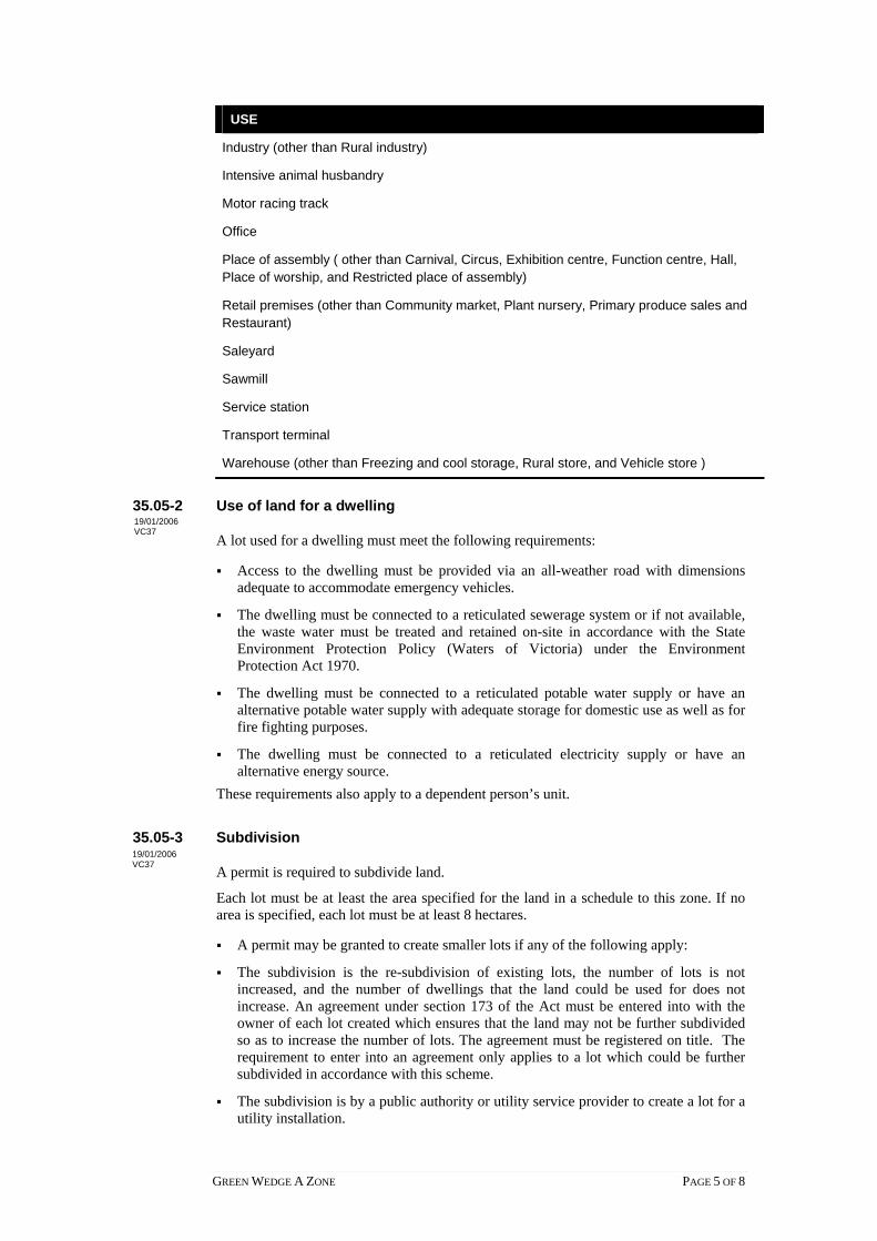
USE
Industry (other than Rural industry)
Intensive animal husbandry
Motor racing track
Office
Place of assembly ( other than Carnival, Circus, Exhibition centre, Function centre, Hall, Place of worship, and Restricted place of assembly)
Retail premises (other than Community market, Plant nursery, Primary produce sales and Restaurant)
Saleyard
Sawmill
Service station
Transport terminal
Warehouse (other than Freezing and cool storage, Rural store, and Vehicle store )
35.05-2 Use of land for a dwelling 19/01/2006 VC37
A lot used for a dwelling must meet the following requirements:
Access to the dwelling must be provided via an all-weather road with dimensions adequate to accommodate emergency vehicles.
The dwelling must be connected to a reticulated sewerage system or if not available, the waste water must be treated and retained on-site in accordance with the State Environment Protection Policy (Waters of Victoria) under the Environment Protection Act 1970.
The dwelling must be connected to a reticulated potable water supply or have an alternative potable water supply with adequate storage for domestic use as well as for fire fighting purposes.
The dwelling must be connected to a reticulated electricity supply or have an alternative energy source.
These requirements also apply to a dependent person’s unit.
35.05-3 Subdivision 19/01/2006 VC37 A permit is required to subdivide land.
Each lot must be at least the area specified for the land in a schedule to this zone. If no area is specified, each lot must be at least 8 hectares.
A permit may be granted to create smaller lots if any of the following apply:
The subdivision is the re-subdivision of existing lots, the number of lots is not increased, and the number of dwellings that the land could be used for does not increase. An agreement under section 173 of the Act must be entered into with the owner of each lot created which ensures that the land may not be further subdivided so as to increase the number of lots. The agreement must be registered on title. The requirement to enter into an agreement only applies to a lot which could be further subdivided in accordance with this scheme.
The subdivision is by a public authority or utility service provider to create a lot for a utility installation.
GREEN WEDGE A ZONE PAGE 5 OF 8

35.05-4 Long term lease or licence for Accommodation 31/10 2006 /VC43
A permit is required to lease or license a portion of a lot for a period of more than 10 years if the portion is to be leased or licensed for the purpose of Accommodation.
Each portion of a lot leased or licensed for the purpose of Accommodation must be at least the minimum subdivision area specified for the land in a schedule to this zone. If no area is specified, each portion of a lot leased or licensed for the purpose of Accommodation must be at least 8 hectares.
35.05-5 Buildings and works 31/10 2006 /VC43
A permit is required to construct or carry out any of the following:
A building or works associated with a use in Section 2 of Clause 35.05-1. This does not apply to an alteration or extension to an existing dwelling with a floor area of no more than the area specified in a schedule to this zone or, if no area is specified, 50 square metres.
Earthworks specified in a schedule to this zone, if on land specified in a schedule.
A building which is within any of the following setbacks:
30 metres from a Road Zone Category 1 or land in a Public Acquisition Overlay to be acquired for a road, Category 1.
20 metres from a Road Zone Category 2 or land in a Public Acquisition Overlay to be acquired for a road, Category 2.
10 metres from any other road.
5 metres from any other boundary.
30 metres from a dwelling not in the same ownership.
100 metres from a waterway, wetlands or designated flood plain.
35.05-6 Decision guidelines 17/09 2007 /VC45 Before deciding on an application to use or subdivide land, lease or license a portion of a
lot for a period of more than 10 years if the portion is to be leased or licensed for the purpose of Accommodation, construct a building or construct or carry out works, in addition to the decision guidelines in Clause 65, the responsible authority must consider, as appropriate:
General issues
The State Planning Policy Framework and the Local Planning Policy Framework, including the Municipal Strategic Statement and local planning policies.
Any Regional Catchment Strategy and associated plan applying to the land.
The capability of the land to accommodate the proposed use or development, addressing site quality attributes including soil type, soil fertility, soil structure, soil permeability, aspect, contour and drainage patterns.
How the use or development relates to agricultural land use, rural diversification and natural resource management.
Whether the site is suitable for the use or development and whether the proposal will have an adverse impact on surrounding land uses.
The need to protect the amenity of existing residents.
GREEN WEDGE A ZONE PAGE 6 OF 8

The need to minimise adverse impacts on the character and appearance of the area or features of architectural, scientific or cultural heritage significance, or of natural scenic beauty or importance.
Rural issues
The maintenance of agricultural production and the impact on the local rural economy.
The need to prepare an integrated land management plan.
The impact on the existing and proposed rural infrastructure.
The potential for the future expansion of the use or development and the impact of this on adjoining and nearby agricultural and other land uses.
Protection and retention of land for future sustainable agricultural activities.
Environmental issues
The impact of the use or development on the flora and fauna on the site and its surrounds.
An assessment of the likely environmental impact on the natural physical features and resources of the area and in particular any impact caused by the proposal on soil and water quality and by the emission of effluent, noise, dust and odours.
The need to protect and enhance the biodiversity of the area, including the retention of vegetation and fauna habitat and the revegetation of land including riparian buffers along waterways, gullies, ridge lines, property boundaries and saline recharge and discharge areas.
How the use or development relates to sustainable land management and the need to prepare a sustainable land management plan.
The location of on site effluent disposal areas to minimise impact of nutrient loads on waterways and native vegetation.
Design and siting issues
The need to minimise adverse impacts of the siting, design, height, bulk, colours and materials to be used on major roads, landscape features and vistas.
The location and design of existing and proposed infrastructure services including gas, water, drainage, telecommunications and sewerage facilities which minimise the visual impact on the landscape.
The location and design of existing and proposed roads and their impact on the landscape and whether the use or development will require traffic management programs.
35.05-7 Advertising signs 31/10/2006 VC43
Advertising sign requirements are at Clause 52.05. This zone is in Category 3.
35.05-8 Transitional arrangements for permit applications 31/10/2006 VC43
The requirements of Clause 35.05-1 as in force immediately before 31 October 2006 continue to apply to a permit application made before that date.
This Clause does not apply after 31 October 2007.
GREEN WEDGE A ZONE PAGE 7 OF 8

Notes: Refer to the State Planning Policy Framework and the Local Planning Policy Framework, including the Municipal Strategic Statement, for strategies and policies which may affect the use and development of land.
Check whether an overlay also applies to the land.
Other requirements may also apply. These can be found at Particular Provisions.
GREEN WEDGE A ZONE PAGE 8 OF 8

RURAL CONSERVATION ZONE PAGE 1 of 6
35.06 RURAL CONSERVATION ZONE
Shown on the planning scheme map as RCZ with a number (if shown).
Purpose
To implement the State Planning Policy Framework and the Local Planning Policy
Framework, including the Municipal Strategic Statement and local planning policies.
To conserve the values specified in the schedule to this zone.
To protect and enhance the natural environment and natural processes for their historic,
archaeological and scientific interest, landscape, faunal habitat and cultural values.
To protect and enhance natural resources and the biodiversity of the area.
To encourage development and use of land which is consistent with sustainable land
management and land capability practices, and which takes into account the conservation
values and environmental sensitivity of the locality.
To provide for agricultural use consistent with the conservation of environmental and
landscape values of the area.
To conserve and enhance the cultural significance and character of open rural and scenic
non urban landscapes.
35.06-1 Table of uses
Section 1 - Permit not required
USE CONDITION
Animal keeping (other than Animal
boarding)
Must be no more than 2 animals.
Apiculture Must meet the requirements of the Apiary
Code of Practice, May 1997.
Bed and breakfast No more than 6 persons may be
accommodated away from their normal place
of residence.
At least 1 car parking space must be provided
for each 2 persons able to be accommodated
away from their normal place of residence.
Carnival
Circus
Must meet the requirements of A ‘Good
Neighbour’ Code of Practice for a Circus or
Carnival, October 1997.
Geothermal energy extraction Must meet the requirements of Clause 52.08-
4
Home occupation
Informal outdoor recreation
Mineral exploration
Mining Must meet the requirements of Clause 52.08-
2.
Minor utility installation
Natural systems
19/01/2006 VC37
31/10/2006 VC43

RURAL CONSERVATION ZONE PAGE 2 of 6
USE CONDITION
Railway
Road
Search for stone Must not be costeaning or bulk sampling.
Telecommunications facility Buildings and works must meet the
requirements of Clause 52.19.
Tramway
Section 2 - Permit required
USE CONDITION
Agriculture (other than Animal keeping,
Apiculture, Intensive animal husbandry,
and Timber production)
Car park Must be used in conjunction with another use
in Section 1 or 2.
Community market
Dependent person’s unit Must be the only dependent person’s unit on
the lot.
Must meet the requirements of Clause 35.06-
2.
Dwelling (other than Bed and breakfast) Must be the only dwelling on the lot. This
does not apply to the replacement of an
existing dwelling if the existing dwelling is
removed or altered (so it can no longer be
used as a dwelling) within one month of the
occupation of the replacement dwelling.
Must meet the requirements of Clause 35.06-
2.
Emergency services facility
Freezing and cool storage The goods stored must be agricultural
produce, or products used in agriculture.
Group accommodation Must be used in conjunction with Agriculture,
Rural industry, or Winery.
Must be no more than 6 dwellings.
The lot on which the use is conducted must
be at least the minimum subdivision area
specified in a schedule to this zone. If no
area is specified, the lot must be at least 40
hectares. This condition only applies to land
in Metropolitan Melbourne.
Host farm
Interpretation centre
Mineral, stone or soil extraction (other
than Mineral exploration, Geothermal

RURAL CONSERVATION ZONE PAGE 3 of 6
USE CONDITION
energy extraction, Mining, and Search for
stone)
Plant nursery
Pleasure boat facility
Primary produce sales
Residential hotel Must be used in conjunction with Agriculture,
Rural industry, or Winery.
The number of bedrooms must not exceed
the number specified in a schedule to the
zone or 80 bedrooms, whichever is the lesser.
The lot on which the use is conducted must
be at least the minimum subdivision area
specified in a schedule to this zone. If no
area is specified, the lot must be at least 40
hectares. This condition only applies to land
in Metropolitan Melbourne.
Restaurant Must be used in conjunction with Agriculture,
Rural industry, or Winery.
The number of patrons present must not
exceed the number specified in a schedule to
the zone or 150 patrons, whichever is the
lesser.
The lot on which the use is conducted must
be at least the minimum subdivision area
specified in a schedule to this zone. If no
area is specified, the lot must be at least 40
hectares. This condition only applies to land
in Metropolitan Melbourne.
Rural industry (other than Abattoir and
Sawmill)
Rural store
Timber production Must meet the requirements of Clause 52.18.
Utility installation (other than Minor utility
installation and Telecommunications
facility)
Wind energy facility
Winery
Section 3 - Prohibited
USE
Abattoir
Accommodation (other than Dependent person’s unit, Dwelling, Group accommodation,
Host farm, and Residential hotel)
Animal boarding

RURAL CONSERVATION ZONE PAGE 4 of 6
Industry (other than Rural industry)
Intensive animal husbandry
Leisure and recreation (other than Informal outdoor recreation)
Retail premises (other than Community market, Plant nursery, Primary produce sales, and
Restaurant)
Place of assembly (other than Carnival and Circus)
Sawmill
Warehouse (other than Freezing and cool storage, and Rural store)
Any other use not in Section 1 or 2
35.06-2 Use of land for a dwelling
A lot used for a dwelling must meet the following requirements:
� Access to the dwelling must be provided via an all-weather road with dimensions
adequate to accommodate emergency vehicles.
� The dwelling must be connected to a reticulated sewerage system or if not available,
the waste water must be treated and retained on-site in accordance with the State
Environment Protection Policy (Waters of Victoria) under the Environment
Protection Act 1970.
� The dwelling must be connected to a reticulated potable water supply or have an
alternative potable water supply with adequate storage for domestic use as well as for
fire fighting purposes.
� The dwelling must be connected to a reticulated electricity supply or have an
alternative energy source.
These requirements also apply to a dependent person’s unit.
35.06-3 Subdivision
A permit is required to subdivide land.
Each lot must be at least the area specified for the land in a schedule to this zone. If no
area is specified, each lot must be at least 40 hectares.
A permit may be granted to create smaller lots if any of the following apply:
� The subdivision is the re-subdivision of existing lots, the number of lots is not
increased, and the number of dwellings that the land could be used for does not
increase. An agreement under Section 173 of the Act must be entered into with the
owner of each lot created which ensures that the land may not be further subdivided
so as to increase the number of lots. The agreement must be registered on title. The
requirement to enter into an agreement only applies to a lot which could be further
subdivided in accordance with this scheme.
� The subdivision is by a public authority or utility service provider to create a lot for a
utility installation.
35.06-4 Long term lease or licence for Accommodation
A permit is required to lease or license a portion of a lot for a period of more than 10
years if the portion is to be leased or licensed for the purpose of Accommodation.
Each portion of a lot leased or licensed for the purpose of Accommodation must be at
least the area specified as the minimum subdivision area for the land in a schedule to this
19/01/2006 VC37
19/01/2006 VC37
31/10/2006 VC43

RURAL CONSERVATION ZONE PAGE 5 of 6
zone. If no area is specified, each portion of a lot leased or licensed for the purpose of
Accommodation must be at least 40 hectares.
This provision only applies to land in Metropolitan Melbourne.
35.06-5 Buildings and works
A permit is required to construct or carry out any of the following:
� A building or works associated with a use in Section 2 of Clause 35.06-1. This does
not apply to:
� An alteration or extension to an existing dwelling with a floor area of no more than
the area specified in a schedule to this zone or, if no area is specified, 50 square
metres.
� An alteration or extension to an existing building used for agriculture with a floor
area of no more than the area specified in a schedule to this zone or, if no area is
specified, 50 square metres. The building must not be used to keep, board, breed or
train animals.
� Earthworks specified in a schedule to this zone, if on land specified in a schedule.
� A building which is within any of the following setbacks:
� 100 metres from a Road Zone Category 1 or land in a Public Acquisition Overlay
to be acquired for a road, Category 1.
� 40 metres from a Road Zone Category 2 or land in a Public Acquisition Overlay
to be acquired for a road, Category 2.
� 20 metres from any other road.
� 5 metres from any other boundary.
� 100 metres from a dwelling not in the same ownership.
� 100 metres from a waterway, wetlands or designated flood plain.
35.06-6 Decision guidelines
Before deciding on an application to use or subdivide land, lease or license a portion of a
lot for a period of more than 10 years if the portion is to be leased or licensed for the
purpose of Accommodation, construct a building or construct or carry out works, in
addition to the decision guidelines in Clause 65, the responsible authority must consider,
as appropriate:
General issues
� The State Planning Policy Framework and the Local Planning Policy Framework,
including the Municipal Strategic Statement and local planning policies.
� Any Regional Catchment Strategy and associated plan applying to the land.
� The capability of the land to accommodate the proposed use or development.
� How the use or development conserves the values identified for the land in the
schedule.
� Whether use or development protects and enhances the environmental, agricultural
and landscape qualities of the site and its surrounds.
� Whether the site is suitable for the use or development and the compatibility of the
proposal with adjoining land uses.
31/10/2006 VC43
31/10/2006 VC43

RURAL CONSERVATION ZONE PAGE 6 of 6
Rural issues
� The environmental capacity of the site to sustain the rural enterprise.
� The need to prepare an integrated land management plan.
� The impact on the existing and proposed infrastructure.
� Whether the use or development will have an adverse impact on surrounding land
uses.
Environmental issues
� An assessment of the likely environmental impact on the biodiversity and in
particular the flora and fauna of the area.
� The protection and enhancement of the natural environment of the area, including the
retention of vegetation and faunal habitats and the need to revegetate land including
riparian buffers along waterways, gullies, ridgelines, property boundaries and saline
discharge and recharge areas.
� How the use and development relates to sustainable land management and the need to
prepare an integrated land management plan which addresses the protection and
enhancement of native vegetation and waterways, stabilisation of soil and pest plant
and animal control.
� The location of on site effluent disposal areas to minimise the impact of nutrient loads
on waterways and native vegetation.
Design and siting issues
� The need to minimise any adverse impacts of siting, design, height, bulk, and colours
and materials to be used, on landscape features, major roads and vistas.
� The location and design of existing and proposed infrastructure services which
minimises the visual impact on the landscape.
� The need to minimise adverse impacts on the character and appearance of the area or
features of archaeological, historic or scientific significance or of natural scenic
beauty or importance.
� The location and design of roads and existing and proposed infrastructure services to
minimise the visual impact on the landscape.
35.06-7 Advertising signs
Advertising sign requirements are at Clause 52.05. This zone is in Category 4.
35.06-8 Transitional arrangements for permit applications
The requirements of Clause 35.06-1 as in force immediately before 31 October 2006
continue to apply to a permit application made before that date.
This Clause does not apply after 31 October 2007.
Notes: Refer to the State Planning Policy Framework and the Local Planning Policy Framework,
including the Municipal Strategic Statement, for strategies and policies which may affect
the use and development of land.
Check whether an overlay also applies to the land.
Other requirements may also apply. These can be found at Particular Provisions.
31/10/2006 VC43
31/10/2006 VC43

35.07 FARMING ZONE 17/09/2007 VC45
Shown on the planning scheme map as FZ with a number.
Purpose
To implement the State Planning Policy Framework and the Local Planning Policy Framework, including the Municipal Strategic Statement and local planning policies.
To provide for the use of land for agriculture.
To encourage the retention of productive agricultural land.
To ensure that non-agricultural uses, particularly dwellings, do not adversely affect the use of land for agriculture.
To encourage use and development of land based on comprehensive and sustainable land management practices and infrastructure provision.
To protect and enhance natural resources and the biodiversity of the area.
35.07-1 Table of uses
Section 1 – Permit not required
USE CONDITION
Agriculture (other than Animal keeping, Apiculture, Intensive animal husbandry, Rice growing and Timber production)
Animal keeping (other than Animal boarding)
Must be no more than 5 animals.
Apiculture Must meet the requirements of the Apiary Code of Practice, May 1997.
Bed and breakfast No more than 6 persons may be accommodated away from their normal place of residence.
At least 1 car parking space must be provided for each 2 persons able to be accommodated away from their normal place of residence.
Cattle feedlot Must meet the requirements of Clause 52.26.
The total number of cattle to be housed in the cattle feedlot must be 1000 or less.
The site must be located outside a special water supply catchment under the Catchment and Land Protection Act 1994.
The site must be located outside a catchment area listed in Appendix 2 of the Victorian Code for Cattle Feedlots – August 1995.
Carnival Circus
Must meet the requirements of A ‘Good Neighbour’ Code of Practice for a Circus or Carnival, October 1997.
17/09/2007 VC45
FARMING ZONE PAGE 1 of 7

USE CONDITION
Dependent person’s unit Must be the only dependent person’s unit on the lot.
Must meet the requirements of Clause 35.07-2.
Dwelling (other than Bed and breakfast)
Must be the only dwelling on the lot.
The lot must be at least the area specified in a schedule to this zone. If no area is specified, the lot must be at least 40 hectares.
Must meet the requirements of Clause 35.07-2.
Geothermal energy extraction Must meet the requirements of Clause 52.08-4
Home occupation Informal outdoor recreation Mineral exploration
Mining Must meet the requirements of Clause 52.08-2.
Minor utility installation Natural systems Railway Road
Search for stone Must not be costeaning or bulk sampling.
Telecommunications facility Buildings and works must meet the requirements of Clause 52.19.
Timber production Must meet the requirements of Clause 52.18.
The plantation area must not exceed any area specified in a schedule to this zone. Any area specified must be at least 40 hectares.
The total plantation area (existing and proposed) on contiguous land which was in the same ownership on or after 28 October 1993 must not exceed any scheduled area.
The plantation must not be within 100 metres of:
• Any dwelling in separate ownership.
• Any land zoned for residential, business or industrial use.
• Any site specified on a permit which is in force which permits a dwelling to be constructed.
The plantation must not be within 20 metres of a powerline whether on private or public land, except with the consent of the relevant electricity supply or distribution authority.
Tramway
FARMING ZONE PAGE 2 of 7

Section 2 – Permit required
USE CONDITION
Animal boarding
Broiler farm Must meet the requirements of Clause 52.31.
Car park Must be used in conjunction with another use in Section 1 or 2.
Cattle feedlot – if the Section 1 condition is not met
Must meet the requirements of Clause 52.26.
The site must be located outside a catchment area listed in Appendix 2 of the Victorian Code for Cattle Feedlots – August 1995.
Cemetery Community market Crematorium
Dependent person’s unit – if the Section 1 condition is not met
Dwelling (other than Bed and breakfast) – if the Section 1 condition is not met
Must meet the requirements of Clause 35.07-2.
Emergency services facility
Freeway service centre Must meet the requirements of Clause 52.30.
Freezing and cool storage
Group accommodation Must be used in conjunction with Agriculture, Outdoor recreation facility, Rural industry, or Winery. Must be no more than 6 dwellings.
Host farm Intensive animal husbandry (other than
Broiler farm and Cattle feedlot) Interpretation centre Leisure and recreation (other than
Informal outdoor recreation and Motor racing track)
Manufacturing sales Mineral, stone, or soil extraction (other
than Mineral exploration, Geothermal energy extraction, Mining, and Search for stone)
Place of assembly (other than Carnival and Circus)
Must not be used for more than 10 days in a calender year.
Primary produce sales
Residential hotel Restaurant
Must be used in conjunction with Agriculture, Outdoor recreation facility, Rural industry, or Winery.
Rice growing Rural industry Rural store
FARMING ZONE PAGE 3 of 7

USE CONDITION
Saleyard
Store (other than Freezing and cool storage and Rural store)
Must be in a building, not a dwelling, and used to store equipment, goods, or motor vehicles used in conjunction with the occupation of a resident of a dwelling on the lot.
Timber production – if the Section 1 condition is not met
Must meet the requirements of Clause 52.18.
Utility installation (other than Minor utility installation and Telecommunications facility)
Veterinary centre Wind energy facility Winery
Section 3 - Prohibited
USE
Accommodation (other than Dependent person’s unit, Dwelling, Group accommodation, Host farm and Residential hotel)
Industry (other than Rural industry) Motor racing track Retail premises (other than Community market, Manufacturing sales, Primary
produce sales and Restaurant) Warehouse (other than Store) Any other use not in Section 1 or 2
35.07-2 Use of land for a dwelling 19/01 2006 /VC37
A lot used for a dwelling must meet the following requirements:
Access to the dwelling must be provided via an all-weather road with dimensions adequate to accommodate emergency vehicles.
The dwelling must be connected to a reticulated sewerage system or if not available, the waste water must be treated and retained on-site in accordance with the State Environment Protection Policy (Waters of Victoria) under the Environment Protection Act 1970.
The dwelling must be connected to a reticulated potable water supply or have an alternative potable water supply with adequate storage for domestic use as well as for fire fighting purposes.
The dwelling must be connected to a reticulated electricity supply or have an alternative energy source.
These requirements also apply to a dependent person’s unit.
35.07-3 Subdivision 19/01/2006 VC37
A permit is required to subdivide land.
Each lot must be at least the area specified for the land in a schedule to this zone. If no area is specified, each lot must be at least 40 hectares.
A permit may be granted to create smaller lots if any of the following apply:
FARMING ZONE PAGE 4 of 7

The subdivision is to create a lot for an existing dwelling. The subdivision must be a two lot subdivision. An agreement under Section 173 of the Act must be entered into with the owner of each lot created which ensures that the land may not be further subdivided so as to create a smaller lot for an existing dwelling. The agreement must be registered on title.
The subdivision is the re-subdivision of existing lots and the number of lots is not increased. An agreement under Section 173 of the Act must be entered into with the owner of each lot created which ensures that the land may not be further subdivided so as to increase the number of lots. The agreement must be registered on title.
The subdivision is by a public authority or utility service provider to create a lot for a utility installation.
35.07-4 Buildings and works 19/01/2006 VC37 A permit is required to construct or carry out any of the following:
A building or works associated with a use in Section 2 of Clause 35.07-1. This does not apply to:
An alteration or extension to an existing dwelling with a floor area of no more than the area specified in a schedule to this zone or, if no area specified, 50 square metres.
An alteration or extension to an existing building used for agriculture with a floor area of no more than the area specified in the schedule to this zone or, if no area specified, 100 square metres. The building must not be used to keep, board, breed or train animals.
Earthworks specified in a schedule to this zone, if on land specified in a schedule.
A building which is within any of the following setbacks: The setback from a Road Zone Category 1 or land in a Public Acquisition Overlay
to be acquired for a road, Category 1 specified in a schedule to this zone or, if no setback is specified, 50 metres.
The setback from any other road or boundary specified in a schedule to this zone. The setback from a dwelling not in the same ownership specified in a schedule to
this zone. 100 metres from a waterway, wetlands or designated flood plain.
35.07-5 Application requirements for dwellings 19/01/2006 VC37 An application to use a lot for a dwelling must be accompanied by a written statement
which explains how the proposed dwelling responds to the decision guidelines for dwellings in the zone.
35.07-6 Decision guidelines 19/01 2006 /VC37
Before deciding on an application to use or subdivide land, construct a building or construct or carry out works, in addition to the decision guidelines in Clause 65, the responsible authority must consider, as appropriate:
General issues
The State Planning Policy Framework and the Local Planning Policy Framework, including the Municipal Strategic Statement and local planning policies.
Any Regional Catchment Strategy and associated plan applying to the land.
FARMING ZONE PAGE 5 of 7

The capability of the land to accommodate the proposed use or development, including the disposal of effluent.
How the use or development relates to sustainable land management.
Whether the site is suitable for the use or development and whether the proposal is compatible with adjoining and nearby land uses.
Agricultural issues
Whether the use or development will support and enhance agricultural production.
Whether the use or development will permanently remove land from agricultural production.
The potential for the use or development to limit the operation and expansion of adjoining and nearby agricultural uses.
The capacity of the site to sustain the agricultural use.
The agricultural qualities of the land, such as soil quality, access to water and access to rural infrastructure.
Any integrated land management plan prepared for the site.
Dwelling issues
Whether the dwelling will result in the loss or fragmentation of productive agricultural land.
Whether the dwelling is reasonably required for the operation of the agricultural activity conducted on the land.
Whether the dwelling will be adversely affected by agricultural activities on adjacent and nearby land due to dust, noise, odour, use of chemicals and farm machinery, traffic and hours of operation.
Whether the dwelling will adversely affect the operation and expansion of adjoining and nearby agricultural uses.
The potential for the proposal to lead to a concentration or proliferation of dwellings in the area and the impact of this on the use of the land for agriculture.
Environmental issues
The impact of the proposal on the natural physical features and resources of the area, in particular on soil and water quality.
The impact of the use or development on the flora and fauna on the site and its surrounds.
The need to protect and enhance the biodiversity of the area, including the retention of vegetation and faunal habitat and the need to revegetate land including riparian buffers along waterways, gullies, ridgelines, property boundaries and saline discharge and recharge area.
The location of on-site effluent disposal areas to minimise the impact of nutrient loads on waterways and native vegetation.
Design and siting issues
The need to locate buildings in one area to avoid any adverse impacts on surrounding agricultural uses and to minimise the loss of productive agricultural land.
FARMING ZONE PAGE 6 of 7

The impact of the siting, design, height, bulk, colours and materials to be used, on the natural environment, major roads, vistas and water features and the measures to be undertaken to minimise any adverse impacts.
The impact on the character and appearance of the area or features of architectural, historic or scientific significance or of natural scenic beauty or importance.
The location and design of existing and proposed infrastructure including roads, gas, water, drainage, telecommunications and sewerage facilities.
Whether the use and development will require traffic management measures.
35.07-7 Advertising signs 19/01/2006 VC37 Advertising sign requirements are at Clause 52.05. This zone is in Category 4.
Notes: Refer to the State Planning Policy Framework and the Local Planning Policy Framework, including the Municipal Strategic Statement, for strategies and policies which may affect the use and development of land.
Check whether an overlay also applies to the land.
Other requirements may also apply. These can be found at Particular Provisions.
FARMING ZONE PAGE 7 of 7

35.08 RURAL ACTIVITY ZONE
Shown on the planning scheme map as RAZ with a number.
Purpose
To implement the State Planning Policy Framework and the Local Planning Policy Framework, including the Municipal Strategic Statement and local planning policies.
To provide for the use of land for agriculture.
To provide for other uses and development, in appropriate locations, which are compatible with agriculture and the environmental and landscape characteristics of the area.
To ensure that use and development does not adversely affect surrounding land uses.
To provide for the use and development of land for the specific purposes identified in a schedule to this zone.
To protect and enhance natural resources and the biodiversity of the area.
To encourage use and development of land based on comprehensive and sustainable land management practices and infrastructure provision.
35.08-1 Table of uses
Section 1 - Permit not required
USE CONDITION
Agriculture (other than Animal keeping, Apiculture, Intensive animal husbandry, Rice growing and Timber production)
Animal keeping (other than Animal boarding)
Must be no more than 5 animals.
Apiculture Must meet the requirements of the Apiary Code of Practice, May 1997.
Bed and breakfast No more than 6 persons may be accommodated away from their normal place of residence.
At least 1 car parking space must be provided for each 2 persons able to be accommodated away from their normal place of residence.
Carnival Must meet the requirements of A ‘Good Neighbour’ Code of Practice for a Circus or Carnival, October 1997.
Cattle feedlot
Must meet the requirements of Clause 52.26.
The total number of cattle to be housed in the cattle feedlot must be 1000 or less.
The site must be located outside a special water supply catchment under the Catchment and Land Protection Act 1994.
The site must be located outside a catchment area listed in Appendix 2 of the Victorian Code
09/10/2006 VC42
17/09/2007 VC45
RURAL ACTIVITY ZONE PAGE 1 of 7

USE CONDITION
for Cattle Feedlots - August 1995.
Circus Must meet the requirements of A ‘Good Neighbour’ Code of Practice for a Circus or Carnival, October 1997.
Dependent person's unit Must be the only dependent person’s unit on the lot.
Must meet the requirements of Clause 35.08-2.
Geothermal energy extraction Must meet the requirements of Clause 52.08-4
Home occupation
Informal outdoor recreation
Mineral exploration
Mining Must meet the requirements of Clause 52.08-2.
Minor utility installation
Natural systems
Railway
Road
Search for stone Must not be costeaning or bulk sampling.
Telecommunications facility Must meet the requirements of Clause 52.19.
Timber production Must meet the requirements of Clause 52.18.
The plantation area must not exceed any area specified in a schedule to this zone. Any area specified must be at least 40 hectares.
The total plantation area (existing and proposed) on contiguous land which was in the same ownership on or after 28 October 1993 must not exceed any scheduled area.
The plantation must not be within 100 metres of:
Any dwelling in separate ownership.
Any land zoned for residential, business or industrial use.
Any site specified on a permit which is in force which permits a dwelling to be constructed.
The plantation must not be within 20 metres of a powerline whether on private or public land, except with the consent of the relevant electricity supply or distribution authority.
Tramway
RURAL ACTIVITY ZONE PAGE 2 of 7

Section 2 - Permit required
USE CONDITION
Animal boarding Backpackers’ lodge
Broiler farm Must meet the requirements of Clause 52.31.
Camping and caravan park
Cattle feedlot - if the Section 1 condition is not met
Must meet the requirements of Clause 52.26.
The site must be located outside a catchment area listed in Appendix 2 of the Victorian Code for Cattle Feedlots - August 1995.
Community market
Convenience shop The site must not have direct access to a rural freeway.
Dependent person’s unit - if the Section 1 condition is not met
Dwelling (other than Bed and breakfast)
Must meet the requirements of Clause 35.08-2.
Equestrian supplies
Freeway service centre Must meet the requirements of Clause 52.30.
Group accommodation Host farm Hotel Intensive animal husbandry (other than
Broiler farm and Cattle feedlot) Landscape gardening supplies Leisure and recreation (other than
Informal outdoor recreation) Manufacturing sales Mineral, stone, or soil extraction (other
than Mineral exploration, Geothermal energy extraction, Mining, and Search for stone)
Place of assembly (other than Amusement parlour, Carnival, Circus, and Nightclub)
Primary produce sales Residential hotel Restaurant Rice growing Rural industry
Service station The site must not have direct access to a rural freeway.
Store Tavern
Timber production - if the Section 1 condition is not met
Must meet the requirements of Clause 52.18.
RURAL ACTIVITY ZONE PAGE 3 of 7

USE CONDITION
Utility installation (other than Minor utility installation and Telecommunications facility)
Winery Any other use not in Section 1 or 3
Section 3 - Prohibited
USE
Accommodation (other than Backpackers’ lodge, Camping and caravan park, Dependent person’s unit, Dwelling, Group accommodation, Host farm, and Residential hotel)
Amusement parlour
Brothel
Child care centre
Cinema based entertainment facility
Industry (other than Rural industry)
Nightclub
Office
Retail premises (other than Community market, Convenience shop, Equestrian supplies, Hotel, Landscape gardening supplies, Manufacturing sales, Primary produce sales, Restaurant and Tavern)
Transport terminal
Warehouse (other than Store)
35.08-2 Use of land for a dwelling 19/01/2006 VC37 A lot used for a dwelling must meet the following requirements:
Access to the dwelling must be provided via an all-weather road with dimensions adequate to accommodate emergency vehicles.
The dwelling must be connected to a reticulated sewerage system or if not available, the waste water must be treated and retained on-site in accordance with the State Environment Protection Policy (Waters of Victoria) under the Environment Protection Act 1970.
The dwelling must be connected to a reticulated potable water supply or have an alternative potable water supply with adequate storage for domestic use as well as for fire fighting purposes.
The dwelling must be connected to a reticulated electricity supply or have an alternative energy source.
These requirements also apply to a dependent person’s unit.
RURAL ACTIVITY ZONE PAGE 4 of 7

35.08-3 Subdivision 19/01/2006 VC37
A permit is required to subdivide land.
Each lot must be at least the area specified for the land in a schedule to this zone.
A permit may be granted to create smaller lots if any of the following apply:
The subdivision is to create a lot for an existing dwelling. The subdivision must be a two lot subdivision and one lot must be at least the area specified for the land in a schedule to this zone. An agreement under Section 173 of the Act must be entered into with the owner of each lot created which ensures that the land must not be further subdivided so as to create a smaller lot for an existing dwelling. The agreement must be registered on title.
The subdivision is the re-subdivision of existing lots and the number of lots is not increased. An agreement under Section 173 of the Act must be entered into with the owner of each lot created which ensures that the land may not be further subdivided so as to increase the number of lots. The agreement must be registered on title.
The number of lots is no more than the number the land could be subdivided into in accordance with a schedule to this zone. At least one lot must be at least the area specified for the land in a schedule to this zone. An agreement under Section 173 of the Act must be entered into with the owner of each lot created which ensures that the land may not be further subdivided so as to increase the number of lots, unless creating a lot for an existing dwelling. The agreement must be registered on title.
The subdivision is by a public authority or utility service provider to create a lot for a utility installation.
35.08-4 Buildings and works 19/01/2006 VC37
A permit is required to construct or carry out any of the following:
A building or works associated with a use in Section 2 of Clause 35.08-1. This does not apply to:
An alteration or extension to an existing dwelling with a floor area of no more than the area specified in a schedule to this zone or, if no area specified, 50 square metres.
An alteration or extension to an existing building used for agriculture with a floor area of no more than the area specified in the schedule to this zone or, if no area specified, 100 square metres. The building must not be used to keep, board, breed or train animals.
Earthworks specified in a schedule to this zone, if on land specified in a schedule.
A building which is within any of the following setbacks:
The setback from a Road Zone Category 1 or land in a Public Acquisition Overlay to be acquired for a road, Category 1 specified in a schedule to this zone or, if no setback is specified, 50 metres.
The setback from any other road or boundary specified in a schedule to this zone.
The setback from a dwelling not in the same ownership specified in a schedule to this zone.
100 metres from a waterway, wetlands or designated flood plain.
RURAL ACTIVITY ZONE PAGE 5 of 7

35.08-5 Decision guidelines 19/01/2006 VC37
Before deciding on an application to use or subdivide land, construct a building or construct or carry out works, in addition to the decision guidelines in Clause 65, the responsible authority must consider, as appropriate:
General issues
The State Planning Policy Framework and the Local Planning Policy Framework, including the Municipal Strategic Statement and local planning policies.
Any Regional Catchment Strategy and associated plan applying to the land.
The capability of the land to accommodate the proposed use or development, including the disposal of effluent.
How the use or development relates to sustainable land management.
Whether the site is suitable for the use and development and whether the proposal is compatible with adjoining and nearby land uses.
Agricultural issues
Whether the use or development will support and enhance agricultural production.
The potential for the use or development to limit the operation and expansion of adjoining and nearby agricultural uses.
The capacity of the site to sustain the agricultural use.
The agricultural qualities of the land, such as soil quality, access to water and access to rural infrastructure.
Any integrated land management plan prepared for the site.
Dwelling issues
Whether the dwelling will result in the loss or fragmentation of productive agricultural land.
Whether the dwelling will be adversely affected by agricultural activities on adjacent and nearby land due to dust, noise, odour, use of chemicals and farm machinery, traffic and hours of operation.
Whether the dwelling will adversely affect the operation and expansion of adjoining and nearby agricultural uses.
Environmental issues
The impact of the proposal on the natural physical features and resources of the area, in particular on soil and water quality.
The impact of the use or development on the flora, fauna and landscape features of the locality.
The need to protect and enhance the biodiversity of the area, including the retention of vegetation and faunal habitat and the need to revegetate land including riparian buffers along waterways, gullies, ridgelines, property boundaries and saline discharge and recharge area.
The location of on-site effluent disposal areas to minimise the impact of nutrient loads on waterways and native vegetation.
RURAL ACTIVITY ZONE PAGE 6 of 7

Design and siting issues
The impact of the siting, design, height, bulk, colours and materials to be used, on the natural environment, major roads, vistas and water features and the measures to be undertaken to minimise any adverse impacts.
The impact on the character and appearance of the area or features of architectural, historic or scientific significance or of natural scenic beauty or importance.
The location and design of existing and proposed infrastructure including roads, gas, water, drainage, telecommunications and sewerage facilities.
Whether the use or development will require traffic management measures.
35.08-6 Advertising signs 19/01/2006 VC37
Advertising sign requirements are at Clause 52.05. This zone is in Category 3.
Notes: Refer to the State Planning Policy Framework and the Local Planning Policy Framework, including the Municipal Strategic Statement, for strategies and policies which may affect the use and development of land.
Check whether an overlay also applies to the land.
Other requirements may also apply. These can be found at Particular Provisions.
RURAL ACTIVITY ZONE PAGE 7 of 7

PUBLIC USE ZONE PAGE 1 OF 1
36 PUBLIC LAND ZONES19/01/2006VC37

PUBLIC USE ZONE PAGE 1 OF 3
36.01 PUBLIC USE ZONE
Shown on the planning scheme map as PUZ with a number.
Purpose
To implement the State Planning Policy Framework and the Local Planning PolicyFramework, including the Municipal Strategic Statement and local planning policies.
To recognise public land use for public utility and community services and facilities.
To provide for associated uses that are consistent with the intent of the public landreservation or purpose.
36.01-1 Table of uses
Section 1 - Permit not required
USE CONDITION
Apiculture Must meet the requirements of the ApiaryCode of Practice, May 1997.
Carnival Must meet the requirements of ‘A ‘GoodNeighbour’ Code of Practice for a Circus orCarnival, October 1997.
Circus Must meet the requirements of ‘A ‘GoodNeighbour’ Code of Practice for a Circus orCarnival, October 1997.
Mineral exploration
Mining Must meet the requirements of Clause 52.08-2.
Natural systemsRailway
Railway station The total leasable floor area for the selling offood, drink and other convenience goods andservices must not exceed 50 square metres.
Road
Search for stone Must not be costeaning or bulk sampling.
Telecommunications facility Buildings and works must meet therequirements of Clause 52.19
Tramway
Any other use The use must be for the purpose described inthe table to Clause 36.01-6 whichcorresponds to the notation on the planningscheme map.
The use must be carried out by or on behalfof the public land manager.
19/01/2006VC37
19/01/2006VC37

PUBLIC USE ZONE PAGE 2 OF 3
Section 2 - Permit required
USE CONDITION
Section 3 - Prohibited
USE
Nil
36.01-2 Permit requirement
A permit is required to:
Construct a building or construct or carry out works for any use in Section 2 of Clause36.01-1. This does not apply to navigational beacons and aids.
Subdivide land.
36.01-3 Application requirements
An application for a permit by a person other than the relevant public land manager mustbe accompanied by the written consent of the public land manager, indicating that thepublic land manager consents generally or conditionally either:
To the application for permit being made.
To the application for permit being made and to the proposed use or development.
36.01-4 Decision guidelines
Before deciding on an application to use or subdivide land, construct a building orconstruct or carry out works, in addition to the decision guidelines in Clause 65, theresponsible authority must consider, as appropriate:
The State Planning Policy Framework and the Local Planning Policy Framework,including the Municipal Strategic Statement and local planning policies.
The comments of any Minister or public land manager having responsibility for the careor management of the land or adjacent land.
Whether the development is appropriately located and designed, including inaccordance with any relevant use, design or siting guidelines.
36.01-5 Permit not required
A permit is not required to use land, or to construct a building or construct or carry outworks on land, listed in a schedule to this zone, provided any condition in the schedule iscomplied with.
19/01/2006VC37
19/01/2006VC37
19/01/2006VC37
19/01/2006VC37

PUBLIC USE ZONE PAGE 3 OF 3
36.01-6 Table of public land use
Shown on the planning scheme map Purpose of public land use
PUZ1 Service & Utility
PUZ2 Education
PUZ3 Health & Community
PUZ4 Transport
PUZ5 Cemetery/Crematorium
PUZ6 Local Government
PUZ7 Other public use
36.01-7 Advertising signs
Advertising sign requirements are at Clause 52.05. This zone, except for the PUZ4(Transport), is in Category 4 unless a different requirement is specified in the schedule tothis zone.
For land within the PUZ4 (Transport), the category of advertising control which applies isthe category which applies to the adjoining zone nearest to the land. If land is equidistantfrom two or more adjoining zones, the least restrictive category applies.
Note: Refer to the State Planning Policy Framework and the Local Planning Policy Framework,including the Municipal Strategic Statement, for strategies and policies which may affectthe use and development of land.
Check whether an overlay also applies to the land.
Other requirements may also apply. These can be found at Particular Provisions.
19/01/2006VC37
19/01/2006VC37

PUBLIC PARK AND RECREATION ZONE PAGE 1 OF 4
36.02 PUBLIC PARK AND RECREATION ZONE
Shown on the planning scheme map as PPRZ.
Purpose
To implement the State Planning Policy Framework and the Local Planning PolicyFramework, including the Municipal Strategic Statement and local planning policies.
To recognise areas for public recreation and open space.
To protect and conserve areas of significance where appropriate.
To provide for commercial uses where appropriate.
36.02-1 Table of uses
Section 1 - Permit not required
USE CONDITION
Apiculture Must meet the requirements of the ApiaryCode of Practice, May 1997.
Carnival Must meet the requirements of A ‘GoodNeighbour’ Code of Practice for a Circus orCarnival, October 1997.
Circus Must meet the requirements of A ‘GoodNeighbour’ Code of Practice for a Circus orCarnival, October 1997.
Mineral exploration
Mining Must meet the requirements of Clause52.08-2.
Informal outdoor recreation
Natural systems
Open sports ground Must be conducted by or on behalf of thepublic land manager.
Must not be on coastal Crown land underthe Coastal Management Act 1995.
Road
Search for stone Must not be costeaning or bulk sampling.
Telecommunications facility Buildings and works must meet therequirements of Clause 52.19
19/01/2006VC37
19/01/2006VC37

PUBLIC PARK AND RECREATION ZONE PAGE 2 OF 4
USE CONDITION
Contractor’s depotHeliportOfficeRetail premisesStoreAny other use not in Section 3
Must be either of the following:
• A use conducted by or on behalf of apublic land manager or Parks Victoriaunder the relevant provisions of theLocal Government Act 1989, theReference Areas Act 1978, the NationalParks Act 1975, the Fisheries Act 1995,the Wildlife Act 1975, the Forest Act1958, the Water Industry Act 1994, theWater Act 1989, the Marine Act 1988,the Port of Melbourne Authority Act1958, or the Crown Land (Reserves) Act1978.
• A use specified in an Incorporated planin a schedule to this zone.
Section 2 - Permit required
USE CONDITION
Contractor’s depot - if the Section 1condition is not met
Must be associated with the public land use.
Heliport - if the Section 1 condition is notmet
Must be associated with the public land use.
Office - if the Section 1 condition is notmet
Must be associated with the public land use.
Retail premises - if the Section 1condition is not met
Must be associated with the public land use.
Store - if the Section 1 condition is notmet
Must be associated with the public land use.
Section 3 - Prohibited
USE
Brothel
Cinema based entertainment facility
Corrective institution
Display home
Funeral parlour
Industry
Saleyard
Transport terminal (other than Heliport)
Veterinary centre
Warehouse (other than Store)

PUBLIC PARK AND RECREATION ZONE PAGE 3 OF 4
36.02-2 Permit requirement
A permit is required to:
Construct a building or construct or carry out works. This does not apply to:
Pathways, trails, seating, picnic tables, drinking taps, shelters, barbeques, rubbishbins, security lighting, irrigation, drainage or underground infrastructure.
Playground equipment or sporting equipment, provided these facilities do notoccupy more than 10 square metres of parkland.
Navigational beacons and aids.
Planting or landscaping.
Fencing that is 1 metre or less in height above ground level.
A building or works shown in an Incorporated plan which applies to the land.
A building or works carried out by or on behalf of a public land manager or ParksVictoria under the Local Government Act 1989, the Reference Areas Act 1978, theNational Parks Act 1975, the Fisheries Act 1995, the Wildlife Act 1975, the ForestAct 1958, the Water Industry Act 1994, the Water Act 1989, the Marine Act 1988,the Port of Melbourne Authority Act 1958 or the Crown Land (Reserves) Act 1978.
Subdivide land.
36.02-3 Application requirements
An application for a permit by a person other than the relevant public land manager mustbe accompanied by the written consent of the public land manager, indicating that thepublic land manager consents generally or conditionally either:
To the application for permit being made.
To the application for permit being made and to the proposed use or development.
36.02-4 Exemption from notice and review
An application to subdivide land which is consistent with an Incorporated plan is exemptfrom the notice requirements of Section 52(1) (a), (b) and (d), the decision requirements ofSection 64(1), (2) and (3) and the review rights of Section 82(1) of the Act.
36.02-5 Decision guidelines
Before deciding on an application to use or subdivide land, construct a building orconstruct or carry out works, in addition to the decision guidelines in Clause 65, theresponsible authority must consider, as appropriate:
The State Planning Policy Framework and the Local Planning Policy Framework,including the Municipal Strategic Statement and local planning policies.
The comments of any public land manager or other relevant land manager havingresponsibility for the care or management of the land or adjacent land.
Whether the development is appropriately located and designed, including inaccordance with any relevant use, design or siting guidelines.
36.02-6 Incorporated plan
An Incorporated plan is a plan which shows the way the land is to be used and developed.An Incorporated plan may include the following information:
19/01/2006VC37
19/01/2006VC37
19/01/2006VC37
19/01/2006VC37
19/01/2006VC37

PUBLIC PARK AND RECREATION ZONE PAGE 4 OF 4
Recognition of existing use and how the area is to be developed.
The building envelope of any proposed buildings.
Details of any proposed buildings or works.
The location of pedestrian or vehicle access points or car parking areas.
The location of any areas for specific uses or a schedule of specific uses which areallowed without permit.
Topographic details including any proposed cut and fill.
The location of existing and proposed features.
The location of existing native and other vegetation and any proposed landscapingworks or areas of vegetation to be added or removed.
The identification of sites of flora or fauna significance (including, in particular, anypotentially threatened species or significant habitat) or other places of cultural heritageor scientific value.
The Incorporated plan must be consistent with the intent of the public land reservationunder any Act and make reference to relevant policies and guidelines.
An Incorporated plan may be prepared in parts or stages.
36.02-7 Use and development of land identified in a schedule
Land identified in a schedule to this zone may be used and developed in accordance withthe schedule or the specific controls contained in an incorporated document correspondingto the land, provided any condition in the schedule or incorporated document is compliedwith.
36.02-8 Advertising signs
Advertising sign requirements are at Clause 52.05. This zone is in Category 4 unless adifferent requirement is specified in the schedule to this zone.
Note: Refer to the State Planning Policy Framework and the Local Planning Policy Framework,including the Municipal Strategic Statement, for strategies and policies which may affectthe use and development of the land.
Check whether an overlay also applies to the land.
Other requirements may also apply. These can be found at Particular Provisions.
19/01/2006VC37
19/01/2006VC37

PUBLIC CONSERVATION AND RESOURCE ZONE PAGE 1 OF 5
36.03 PUBLIC CONSERVATION AND RESOURCE ZONE
Shown on the planning scheme map as PCRZ.
Purpose
To implement the State Planning Policy Framework and the Local Planning PolicyFramework, including the Municipal Strategic Statement and local planning policies.
To protect and conserve the natural environment and natural processes for their historic,scientific, landscape, habitat or cultural values.
To provide facilities which assist in public education and interpretation of the naturalenvironment with minimal degradation of the natural environment or natural processes.
To provide for appropriate resource based uses.
36.03-1 Table of uses
Section 1 - Permit not required
USE CONDITION
Apiculture Must meet the requirements of the ApiaryCode of Practice, May 1997.
Boat launching facilityCamping and caravan parkCaretaker’s houseCar parkInformal outdoor recreationInterpretation centreJettyKioskMarine dredging
Must be either of the following:
• A use conducted by or on behalf of apublic land manager or Parks Victoriaunder the relevant provisions of the LocalGovernment Act 1989, the ReferenceAreas Act 1978, the National Parks Act1975, the Fisheries Act 1995, the WildlifeAct 1975, the Forest Act 1958, the WaterIndustry Act 1994, the Water Act 1989, theMarine Act 1988, the Port of MelbourneAuthority Act 1958 or the Crown Land(Reserves) Act 1978.
• Specified in an Incorporated plan in aschedule to this zone.
Mineral exploration
Mineral, stone or soil extraction (otherthan Mineral exploration, Mining, andSearch for stone)
Must be either of the following:
• A use conducted by or on behalf of apublic land manager or Parks Victoriaunder the relevant provisions of the LocalGovernment Act 1989, the ReferenceAreas Act 1978, the National Parks Act1975, the Fisheries Act 1995, the WildlifeAct 1975, the Forest Act 1958, the WaterIndustry Act 1994, the Water Act 1989, theMarine Act 1988, the Port of MelbourneAuthority Act 1958 or the Crown Land(Reserves) Act 1978.
• Specified in an Incorporated plan in aschedule to this zone.
19/01/2006VC37
19/01/2006VC37

PUBLIC CONSERVATION AND RESOURCE ZONE PAGE 2 OF 5
USE CONDITION
Mining Must meet the requirements of Clause 52.08-2.
Mooring pole Must be either of the following:
• A use conducted by or on behalf of apublic land manager or Parks Victoriaunder the relevant provisions of the LocalGovernment Act 1989, the ReferenceAreas Act 1978, the National Parks Act1975, the Fisheries Act 1995, the WildlifeAct 1975, the Forest Act 1958, the WaterIndustry Act 1994, the Water Act 1989, theMarine Act 1988, the Port of MelbourneAuthority Act 1958 or the Crown Land(Reserves) Act 1978.
• Specified in an Incorporated plan in aschedule to this zone.
Natural systems
Open sports ground
Pier
Pontoon
Road
Must be either of the following:
• A use conducted by or on behalf of apublic land manager or Parks Victoriaunder the relevant provisions of the LocalGovernment Act 1989, the ReferenceAreas Act 1978, the National Parks Act1975, the Fisheries Act 1995, the WildlifeAct 1975, the Forest Act 1958, the WaterIndustry Act 1994, the Water Act 1989, theMarine Act 1988, the Port of MelbourneAuthority Act 1958 or the Crown Land(Reserves) Act 1978.
• Specified in an Incorporated plan in aschedule to this zone.
Search for stone Must not be costeaning or bulk sampling.
Telecommunications facility Buildings and works must meet therequirements of Clause 52.19
Utility installation (other thanTelecommunications facility)
Must be either of the following:
• A use conducted by or on behalf of apublic land manager or Parks Victoriaunder the relevant provisions of the LocalGovernment Act 1989, the ReferenceAreas Act 1978, the National Parks Act1975, the Fisheries Act 1995, the WildlifeAct 1975, the Forest Act 1958, the WaterIndustry Act 1994, the Water Act 1989, theMarine Act 1988, the Port of MelbourneAuthority Act 1958 or the Crown Land(Reserves) Act 1978.
• Specified in an Incorporated plan in aschedule to this zone.

PUBLIC CONSERVATION AND RESOURCE ZONE PAGE 3 OF 5
USE CONDITION
Any other use not in Section 2 or 3 Must be a use conducted by or on behalf of apublic land manager or Parks Victoria underthe relevant provisions of the LocalGovernment Act 1989, the Reference AreasAct 1978, the National Parks Act 1975, theFisheries Act 1995, the Wildlife Act 1975, theForest Act 1958, the Water Industry Act 1994,the Water Act 1989, the Marine Act 1988, thePort of Melbourne Authority Act 1958 or theCrown Land (Reserves) Act 1978.
Section 2 - Permit required
USE CONDITION
Wind energy facility • Must not be located on land reservedunder the National Parks Act 1975.
• Must meet the requirements of Clause52.32.
Section 3 - Prohibited
USE
The use in Section 1 described as ‘Anyother use not in Section 2 or 3’ – if theSection 1 condition is not met
36.03-2 Permit requirement
A permit is required to:
Construct a building or construct or carry out works. This does not apply to:
Planting or landscaping.
A building or works shown in an Incorporated plan which applies to the land.
A building or works carried out by or on behalf of a public land manager or ParksVictoria under the Local Government Act 1989, the Reference Areas Act 1978, theNational Parks Act 1975, the Fisheries Act 1995, the Wildlife Act 1975, the ForestAct 1958, the Water Industry Act 1994, the Water Act 1989, the Marine Act 1988,the Port of Melbourne Authority Act 1958 or the Crown Land (Reserves) Act 1978.
Subdivide land.
36.03-3 Application requirements
An application for a permit by a person other than the relevant public land manager mustbe accompanied by the written consent of the public land manager, indicating that thepublic land manager consents generally or conditionally either:
To the application for permit being made.
To the application for permit being made and to the proposed use or development.
19/01/2006VC37
19/01/2006VC37

PUBLIC CONSERVATION AND RESOURCE ZONE PAGE 4 OF 5
36.03-4 Exemption from notice and review
An application to subdivide land which is consistent with an Incorporated plan is exemptfrom the notice requirements of Section 52(1) (a), (b), and (d), the decision requirements ofSections 64(1), (2) and (3) and the review rights of Section 82(1) of the Act.
36.03-5 Decision guidelines
Before deciding on an application to use or subdivide land, construct a building orconstruct or carry out works, in addition to the decision guidelines in Clause 65, theresponsible authority must consider, as appropriate:
The State Planning Policy Framework and the Local Planning Policy Framework,including the Municipal Strategic Statement and local planning policies.
The comments of any public land manager or other relevant land manager havingresponsibility for the care or management of the land or adjacent land.
Whether the development is appropriately located and designed, including inaccordance with any relevant use, design or siting guidelines.
36.03-6 Incorporated plan
An Incorporated plan is a plan which shows the way the land is to be used and developed.An Incorporated plan may include the following information:
Recognition of existing use and how the area is to be developed.
The building envelope of any proposed buildings.
Details of proposed buildings or works.
The location of pedestrian or vehicle access points or car parking areas.
The location of any areas for specific uses and a schedule of specific uses which areallowed without permit.
Topographic details including any proposed cut and fill.
The location of existing and proposed features.
The location of existing native or other vegetation and any proposed landscaping worksor areas of vegetation to be added or removed.
The identification of sites of flora or fauna significance (including, in particular, anypotentially threatened species or significant habitat) or other places of cultural, heritageor scientific value.
The Incorporated plan must be consistent with the intent of the public land reservationunder any Act and make reference to relevant policies and guidelines.
An Incorporated plan may be prepared in parts or stages.
36.03-7 Use and development of land identified in a schedule
Land identified in a schedule to this zone may be used and developed in accordance withthe schedule or the specific controls contained in an incorporated document correspondingto the land, provided any condition in the schedule or incorporated document is compliedwith.
19/01/2006VC37
19/01/2006VC37
19/01/2006VC37
19/01/2006VC37

PUBLIC CONSERVATION AND RESOURCE ZONE PAGE 5 OF 5
36.03-8 Advertising signs
Advertising sign controls are at Clause 52.05. This zone is in Category 4 unless a differentrequirement is specified in the schedule to this zone.
Note: Refer to the State Planning Policy Framework and the Local Planning Policy Framework,including the Municipal Strategic Statement, for strategies and policies which may affectthe use and development of land.
Check whether an overlay also applies to the land.
Other requirements may also apply. These can be found at Particular Provisions.
19/01/2006VC37

ROAD ZONE PAGE 1 OF 2
36.04 ROAD ZONE
Shown on the planning scheme map as RDZ1 for a Category 1 road and RDZ2 for aCategory 2 road.
Purpose
To implement the State Planning Policy Framework and the Local Planning PolicyFramework, including the Municipal Strategic Statement and local planning policies.
To identify significant existing roads.
To identify land which has been acquired for a significant proposed road.
36.04-1 Table of uses
Section 1 - Permit not required
USE CONDITION
Apiculture Must meet the requirements of the ApiaryCode of Practice, May 1997.
Mineral exploration
Mining Must meet the requirements of Clause 52.08-2.
Minor utility installationNatural systemsRailwayRoad
Search for stone Must not be costeaning or bulk sampling.
Telecommunications facility Buildings and works must meet therequirements of Clause 52.19
Tramway
Section 2 - Permit required
USE CONDITION
Mineral, stone or soil extraction (otherthan Mineral exploration, Mining, andSearch for stone)
Utility installation (other than Minor utilityinstallation and Telecommunicationsfacility)
Any other use not in Section 1 or 3
Section 3 - Prohibited
USE
Nil
19/01/2006VC37
19/01/2006VC37

ROAD ZONE PAGE 2 OF 2
36.04-2 Permit requirement
A permit is required to:
Construct a building or construct or carry out works for a use in Section 2 of Clause36.04-1.
Subdivide land.
36.04-3 Decision guidelines
Before deciding on an application, in addition to the decision guidelines in Clause 65, theresponsible authority must consider:
The State Planning Policy Framework and the Local Planning Policy Framework,including the Municipal Strategic Statement and local planning policies.
The views of the relevant road authority.
The effect of the proposal on the operation of the road and on public safety.
36.04-4 Advertising signs
Advertising sign controls are at Clause 52.05. A permit is required to display a sign overthe road formation or over land within 600 millimetres of the road formation. For otherland in this zone, the category of advertising control which applies is the category whichapplies to the adjoining zone nearest to the land. If land is equidistant from two or moreadjoining zones, the least restrictive category applies.
Notes: Refer to the State Planning Policy Framework and the Local Planning Policy Framework,including the Municipal Strategic Statement, for strategies and policies which may affectthe use and development of land.
Check whether an overlay also applies to the land.
Other requirements may also apply. These can be found at Particular Provisions.
19/01/2006VC37
19/01/2006VC37
19/01/2006VC37

SPECIAL USE ZONE PAGE 1 OF 1
37 SPECIAL PURPOSE ZONES19/01/2006VC37

SPECIAL USE ZONE PAGE 1 OF 3
37.01 SPECIAL USE ZONE
Shown on the planning scheme map as SUZ with a number.
Purpose
To implement the State Planning Policy Framework and the Local Planning PolicyFramework, including the Municipal Strategic Statement and local planning policies.
To recognise or provide for the use and development of land for specific purposes asidentified in a schedule in this zone.
37.01-1 Table of uses
Section 1 - Permit not required
USE CONDITION
Any use in Section 1 of the schedule tothis zone
Must comply with any condition in Section 1 ofthe schedule to this zone
Section 2 - Permit required
USE CONDITION
Any use in Section 2 of the schedule tothis zone
Must comply with any condition in Section 2 ofthe schedule to this zone.
Any other use not in Section 1 or 3 of theschedule to this zone
Section 3 - Prohibited
USE
Any use in Section 3 of the schedule to this zone
37.01-2 Use of land
Any requirement in the schedule to this zone must be met.
Application requirements
An application to use land must be accompanied by any information specified in theschedule to this zone.
Exemption from notice and review
The schedule to this zone may specify that an application is exempt from the noticerequirements of Section 52(1)(a), (b) and (d), the decision requirements of Section 64(1),(2) and (3) and the review rights of Section 82(1) of the Act.
Decision guidelines
Before deciding on an application, in addition to the decision guidelines in Clause 65, theresponsible authority must consider, as appropriate:
19/01/2006VC37
19/01/2006VC37
19/01/2006VC37

SPECIAL USE ZONE PAGE 2 OF 3
The State Planning Policy Framework and the Local Planning Policy Framework,including the Municipal Strategic Statement and local planning policies.
Any guidelines in the schedule to this zone.
37.01-3 Subdivision
Permit requirement
A permit is required to subdivide land.
Any requirement in the schedule to this zone must be met.
Application requirements
An application to subdivide land must be accompanied by any information specified in theschedule to this zone.
Exemption from notice and review
The schedule to this zone may specify that an application is exempt from the noticerequirements of Section 52(1)(a), (b) and (d), the decision requirements of Section 64(1),(2) and (3) and the review rights of Section 82(1) of the Act.
Decision guidelines
Before deciding on an application, in addition to the decision guidelines in Clause 65, theresponsible authority must consider, as appropriate:
The State Planning Policy Framework and the Local Planning Policy Framework,including the Municipal Strategic Statement and local planning policies.
Any guidelines in the schedule to this zone.
37.01-4 Buildings and works
Permit requirement
A permit is required to construct a building or construct or carry out works unless theschedule to this zone specifies otherwise.
Any requirement in the schedule to this zone must be met.
Application requirements
An application to construct a building or construct or carry out works must be accompaniedby any information specified in the schedule to this zone.
Exemption from notice and review
The schedule to this zone may specify that an application is exempt from the noticerequirements of Section 52(1)(a), (b) and (d), the decision requirements of Section 64(1),(2) and (3) and the review rights of Section 82(1) of the Act.
19/01/2006VC37
19/01/2006VC37

SPECIAL USE ZONE PAGE 3 OF 3
Decision guidelines
Before deciding on an application, in addition to the decision guidelines in Clause 65, theresponsible authority must consider, as appropriate:
The State Planning Policy Framework and the Local Planning Policy Framework,including the Municipal Strategic Statement and local planning policies.
Any guidelines in the schedule to this zone.
37.01-5 Advertising signs
Advertising sign requirements are at Clause 52.05. This zone is in Category 3 unless aschedule to this zone specifies a different category.
Notes: Refer to the State Planning Policy Framework and the Local Planning Policy Framework,including the Municipal Strategic Statement, for strategies and policies which may affectthe use and development of land
Check whether an overlay also applies to the land.
Other requirements may also apply. These can be found at Particular Provisions.
19/01/2006VC37

COMPREHENSIVE DEVELOPMENT ZONE PAGE 1 OF 3
37.02 COMPREHENSIVE DEVELOPMENT ZONE
Shown on the planning scheme map as CDZ with a number.
Purpose
To implement the State Planning Policy Framework and the Local Planning Policy Framework, including the Municipal Strategic Statement and local planning policies.
To provide for a range of uses and the development of land in accordance with a comprehensive development plan incorporated in this scheme.
37.02-1 Table of uses
Section 1 - Permit not required
USE CONDITION
Any use in Section 1 of the schedule to this zone
Must comply with any condition in Section 1 ofthe schedule to this zone.
Section 2 - Permit required
USE CONDITION
Any use in Section 2 of the schedule to this zone
Must comply with any condition in Section 2 ofthe schedule to this zone.
Any other use not in Section 1 or 3 of the schedule to this zone
Section 3 - Prohibited
USE
Any use in Section 3 of the schedule to this zone
37.02-2 Use of land
Any requirement in the schedule to this zone must be met.
Application requirements
An application to use land must be accompanied by any information specified in the schedule to this zone.
Exemption from notice and review
The schedule to this zone may specify that an application is exempt from the notice requirements of Section 52(1)(a), (b) and (d), the decision requirements of Section 64(1), (2) and (3) and the review rights of Section 82(1) of the Act.
Decision guidelines
Before deciding on an application, in addition to the decision guidelines in Clause 65, the responsible authority must consider, as appropriate:
19/01/2006 VC37
19/01/2006 VC37
19/01/2006 VC37

COMPREHENSIVE DEVELOPMENT ZONE PAGE 2 OF 3
The State Planning Policy Framework and the Local Planning Policy Framework, including the Municipal Strategic Statement and local planning policies.
Any guidelines in the schedule to this zone.
37.02-3 Subdivision
Permit requirement
A permit is required to subdivide land.
Any requirement in the schedule to this zone must be met.
Application requirements
An application to subdivide land for residential development, other than an application to subdivide land into lots each containing an existing dwelling or car parking space, must meet the requirements of Clause 56 and:
Must meet all of the objectives included in the clauses specified in the following table.
Should meet all of the standards included in the clauses specified in the following table.
Class of subdivision Objectives and standards to be met
60 or more lots All except Clause 56.03-5.
16 – 59 lots All except Clauses 56.03-1 to 56.03-3, 56.03-5, 56.06-1 and 56.06-3.
3 – 15 lots All except Clauses 56.02-1, 56.03-1 to 56.03-4, 56.05-2, 56.06-1, 56.06-3 and 56.06-6.
2 lots Clauses 56.03-5, 56.04-2, 56.04-3, 56.04-5, 56.06-8 to 56.09-2.
An application to subdivide land must be accompanied by any information specified in the schedule to this zone.
Exemption from notice and review
The schedule to this zone may specify that an application is exempt from the notice requirements of Section 52(1)(a), (b) and (d), the decision requirements of Section 64(1), (2) and (3) and the review rights of Section 82(1) of the Act.
Decision guidelines
Before deciding on an application, in addition to the decision guidelines in Clause 65, the responsible authority must consider, as appropriate:
The State Planning Policy Framework and the Local Planning Policy Framework, including the Municipal Strategic Statement and local planning policies.
The objectives and standards of Clause 56. Any guidelines in the schedule to this zone.
09/10/2006 VC42

COMPREHENSIVE DEVELOPMENT ZONE PAGE 3 OF 3
37.02-4 Buildings and works
Permit requirement
A permit is required to construct a building or construct or carry out works unless the schedule to this zone specifies otherwise.
Any requirement in the schedule to this zone must be met.
Application requirements
An application to construct a building or construct or carry out works must be accompanied by any information specified in the schedule to this zone.
Exemption from notice and review
An application is exempt from the notice requirements of Section 52(1)(a), (b) and (d), the decision requirements of Section 64(1), (2) and (3) and the review rights of Section 82(1) of the Act if it is generally consistent with the comprehensive development plan.
The schedule to this zone may specify that other applications are also exempt from the notice requirements of Section 52(1)(a), (b) and (d), the decision requirements of Section 64(1), (2) and (3) and the review rights of Section 82(1) of the Act.
Decision guidelines
Before deciding on an application, in addition to the decision guidelines in Clause 65, the responsible authority must consider, as appropriate:
The State Planning Policy Framework and the Local Planning Policy Framework, including the Municipal Strategic Statement and local planning policies.
Any guidelines in the schedule to this zone.
37.02-5 Advertising signs
Advertising sign requirements are at Clause 52.05. This zone is in Category 3 unless a schedule to this zone specifies a different category.
Notes: Refer to the State Planning Policy Framework and the Local Planning Policy Framework,
including the Municipal Strategic Statement, for strategies and policies which may affect the use and development of land.
Check whether an overlay also applies to the land.
Other requirements may also apply. These can be found at Particular Provisions.
19/01/2006 VC37
19/01/2006 VC37

URBAN FLOODWAY ZONE PAGE 1 OF 3
37.03 URBAN FLOODWAY ZONE
Shown on the planning scheme map as UFZ.
Purpose
To implement the State Planning Policy Framework and the Local Planning PolicyFramework, including the Municipal Strategic Statement and local planning policies.
To identify waterways, major floodpaths, drainage depressions and high hazard areaswithin urban areas which have the greatest risk and frequency of being affected byflooding.
To ensure that any development maintains the free passage and temporary storage offloodwater, minimises flood damage and is compatible with flood hazard, local drainageconditions and the minimisation of soil erosion, sedimentation and silting.
To reflect any declarations under Division 4 of Part 10 of the Water Act, 1989.
To protect water quality and waterways as natural resources in accordance with theprovisions of relevant State Environment Protection Policies, and particularly in accordancewith Clauses 33 and 35 of the State Environment Protection Policy (Waters of Victoria).
37.03-1 Table of uses
Section 1 - Permit not required
USE CONDITION
Apiculture Must meet the requirements of the ApiaryCode of Practice, May 1997.
Extensive animal husbandry
Informal outdoor recreationMineral explorationMining Must meet the requirements of Clause 52.08-
2.
Natural systems
Search for stone Must not be costeaning or bulk sampling.
Telecommunications facility Buildings and works must meet therequirements of Clause 52.19
Section 2 - Permit required
USE CONDITIONAgriculture (other than Apiculture and
Extensive animal husbandry)Leisure and recreation (other than
Informal outdoor recreation, Indoorrecreation facility, and Motor racingtrack)
Mineral, stone or soil extraction (otherthan Mineral exploration, Mining, andSearch for stone)
RoadUtility installation (other than
Telecommunications facility)
19/01/2006VC37
19/01/2006VC37
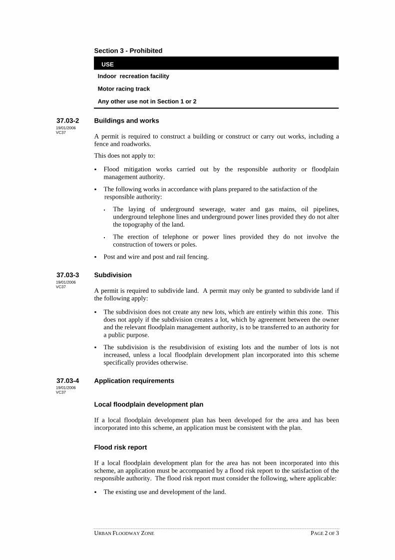
URBAN FLOODWAY ZONE PAGE 2 OF 3
Section 3 - Prohibited
USE
Indoor recreation facility
Motor racing track
Any other use not in Section 1 or 2
37.03-2 Buildings and works
A permit is required to construct a building or construct or carry out works, including afence and roadworks.
This does not apply to:
Flood mitigation works carried out by the responsible authority or floodplainmanagement authority.
The following works in accordance with plans prepared to the satisfaction of the responsible authority:
The laying of underground sewerage, water and gas mains, oil pipelines,underground telephone lines and underground power lines provided they do not alterthe topography of the land.
The erection of telephone or power lines provided they do not involve theconstruction of towers or poles.
Post and wire and post and rail fencing.
37.03-3 Subdivision
A permit is required to subdivide land. A permit may only be granted to subdivide land ifthe following apply:
The subdivision does not create any new lots, which are entirely within this zone. Thisdoes not apply if the subdivision creates a lot, which by agreement between the ownerand the relevant floodplain management authority, is to be transferred to an authority fora public purpose.
The subdivision is the resubdivision of existing lots and the number of lots is notincreased, unless a local floodplain development plan incorporated into this schemespecifically provides otherwise.
37.03-4 Application requirements
Local floodplain development plan
If a local floodplain development plan has been developed for the area and has beenincorporated into this scheme, an application must be consistent with the plan.
Flood risk report
If a local floodplain development plan for the area has not been incorporated into thisscheme, an application must be accompanied by a flood risk report to the satisfaction of theresponsible authority. The flood risk report must consider the following, where applicable:
The existing use and development of the land.
19/01/2006VC37
19/01/2006VC37
19/01/2006VC37

URBAN FLOODWAY ZONE PAGE 3 OF 3
Whether the proposed use or development could be located on flood-free land or landwith a lesser flood hazard outside this zone.
The susceptibility of the development to flooding and flood damage.
The potential flood risk to life, health and safety associated with the development.Flood risk factors to consider include:
The frequency, duration, extent, depth and velocity of flooding of the site andaccessway.
The flood warning time available.
The danger to the occupants of the development, other floodplain residents andemergency personnel if the site or accessway is flooded.
The effect of the development on redirecting or obstructing floodwater, stormwater ordrainage water and the effect of the development on reducing flood storage andincreasing flood levels and flow velocities.
The effects of the development on environmental values such as natural habitat, streamstability, erosion, water quality and sites of scientific significance.
37.03-5 Referral of applications
An application must be referred to the relevant floodplain management authority underSection 55 of the Act unless in the opinion of the responsible authority the proposalsatisfies requirements or conditions previously agreed in writing between the responsibleauthority and the floodplain management authority.
37.03-6 Decision guidelines
Before deciding on an application, in addition to the decision guidelines in Clause 65, theresponsible authority must consider, as appropriate:
The State Planning Policy Framework and the Local Planning Policy Framework,including the Municipal Strategic Statement and local planning policies.
The local floodplain development plan or flood risk report.
Any comments of the relevant floodplain management authority.
37.03-7 Advertising signs
Advertising sign requirements are at Clause 52.05. This zone is in Category 4 unless aschedule to this zone specifies a different category.
Notes: Refer to the State Planning Policy Framework and the Local Planning Policy Framework,including the Municipal Strategic Statement, for strategies and policies which may affectthe use and development of land.
Check whether an overlay also applies to the land.
Other requirements may also apply. These can be found at Particular Provisions.
19/01/2006VC37
19/01/2006VC37
19/01/2006VC37

CAPITAL CITY ZONE PAGE 1 OF 3
37.04 CAPITAL CITY ZONE
Shown on the planning scheme map as CCZ with a number.
Purpose
To implement the State Planning Policy Framework and the Local Planning PolicyFramework, including the Municipal Strategic Statement and local planning policies.
To enhance the role of Melbourne’s central city as the capital of Victoria and as an areaof national and international importance.
To recognise or provide for the use and development of land for specific purposes asidentified in a schedule to this zone.
To create through good urban design an attractive, pleasurable, safe and stimulatingenvironment.
37.04-1 Table of uses
Section 1 - Permit not required
USE CONDITION
Any use in Section 1 of the schedule tothis zone
Must comply with any condition in Section 1 ofthe schedule to this zone.
Section 2 - Permit required
USE CONDITION
Any use in Section 2 of the schedule tothis zone
Must comply with any condition in Section 2 ofthe schedule to this zone.
Any other use not in Section 1 or 3 of theschedule to this zone
Section 3 - Prohibited
USE
Any use in Section 3 of the schedule to this zone
37.04-2 Use of land
Any requirement in the schedule to this zone must be met.
Application requirements
An application to use land must be accompanied by any information specified in theschedule to this zone.
Exemption from notice and review
The schedule to this zone may specify that an application is exempt from the noticerequirements of Section 52(1)(a), (b) and (d), the decision requirements of Section 64(1),(2) and (3) and the review rights of Section 82(1) of the Act.
19/01/2006VC37
19/01/2006VC37
19/01/2006VC37

CAPITAL CITY ZONE PAGE 2 OF 3
Decision guidelines
Before deciding on an application, in addition to the decision guidelines in Clause 65, theresponsible authority must consider, as appropriate:
The State Planning Policy Framework and the Local Planning Policy Framework,including the Municipal Strategic Statement and local planning policies.
Any guidelines in the schedule to this zone.
37.04-3 Subdivision
Permit requirement
A permit is required subdivide land unless the schedule to this zone specifies otherwise.
Any requirement in the schedule to this zone must be met.
Application requirements
An application to subdivide land must be accompanied by any information specified in theschedule to this zone.
Exemption from notice and review
The schedule to this zone may specify that an application is exempt from the noticerequirements of Section 52(1)(a), (b) and (d), the decision requirements of Section 64(1),(2) and (3) and the review rights of Section 82(1) of the Act.
Decision guidelines
Before deciding on an application, in addition to the decision guidelines in Clause 65, theresponsible authority must consider, as appropriate:
The State Planning Policy Framework and the Local Planning Policy Framework,including the Municipal Strategic Statement and local planning policies.
Any guidelines in the schedule to this zone.
37.04-4 Buildings and works
Permit requirement
A permit is required to construct a building or construct or carry out works unless theschedule to this zone specifies otherwise.
A permit is required to demolish or remove a building or works if specified in the scheduleto this zone.
Any requirement in the schedule to this zone must be met.
Application requirements
An application to construct a building or construct or carry out works must be accompaniedby any information specified in the schedule to this zone.
19/01/2006VC37
19/01/2006VC37

CAPITAL CITY ZONE PAGE 3 OF 3
Exemption from notice and review
The schedule to this zone may specify that an application is exempt from the noticerequirements of Section 52(1)(a), (b) and (d), the decision requirements of Section 64(1),(2) and (3) and the review rights of Section 82(1) of the Act.
Decision guidelines
Before deciding on an application, in addition to the decision guidelines in Clause 65, theresponsible authority must consider, as appropriate:
The State Planning Policy Framework and the Local Planning Policy Framework,including the Municipal Strategic Statement and local planning policies.
Any guidelines in the schedule to this zone.
37.04-5 Advertising signs
Advertising sign requirements are at Clause 52.05. This zone is not in a category atClauses 52.05-6 to 52.05-10.
A permit is required to construct and display a sign unless the schedule to this zonespecifies otherwise.
Any requirement in the schedule to this zone must be met.
Exemption from notice and review
The schedule to this zone may specify that an application is exempt from the noticerequirements of Section 52(1)(a), (b) and (d), the decision requirements of Section 64(1),(2) and (3) and the review rights of Section 82(1) of the Act.
Notes: Refer to the State Planning Policy Framework and the Local Planning Policy Framework,including the Municipal Strategic Statement, for strategies and policies which may affectthe use and development of land.
Check whether an overlay also applies to the land.
Other requirements may also apply. These can be found at Particular Provisions.
19/01/2006VC37

DOCKLANDS ZONE PAGE 1 OF 4
37.05 DOCKLANDS ZONE
Shown on the planning scheme map as DZ with a number.
Purpose
To implement the State Planning Policy Framework and the Local Planning PolicyFramework, including the Municipal Strategic Statement and local planning policies.
To provide for the development of the Melbourne Docklands area in a manner consistentwith the development strategy adopted by the Docklands Authority.
To ensure that use and development take account of the unique nature of the waterenvironment.
To encourage a variety of dwelling types within the Melbourne Docklands area to suit adiversity of needs.
To ensure that development takes account of the relationship of the Melbourne Docklandsarea to the central city and the policies relating to the future development of central city andother parts of the capital city.
To encourage visual and physical linkages between the Melbourne Docklands and adjacentareas, in particular the central city.
To provide for the conservation and enhancement of buildings, areas and places ofscientific, aesthetic, architectural or historical significance.
37.05-1 Table of uses
Section 1 - Permit not required
USE CONDITION
Any use in Section 1 of the schedule tothis zone
Must comply with any condition in Section 1 ofthe schedule to this zone.
Section 2 - Permit required
USE CONDITION
Any use in Section 2 of the schedule tothis zone
Must comply with any condition in Section 2 ofthe schedule to this zone.
Any other use not in Section 1 or 3 of theschedule to this zone
Section 3 - Prohibited
USE
Any use in Section 3 of the schedule to this zone
37.05-2 Use of land
Any requirement in the schedule to this zone must be met.
19/01/2006VC37
19/01/2006VC37
19/01/2006VC37

DOCKLANDS ZONE PAGE 2 OF 4
Application requirements
An application to use land must be accompanied by any information specified in theschedule to this zone.
Exemption from notice and review
The schedule to this zone may specify that an application is exempt from the noticerequirements of Section 52(1)(a), (b) and (d), the decision requirements of Section 64(1),(2) and (3) and the review rights of Section 82(1) of the Act.
Decision guidelines
Before deciding on an application, in addition to the decision guidelines in Clause 65, theresponsible authority must consider, as appropriate:
The State Planning Policy Framework and the Local Planning Policy Framework,including the Municipal Strategic Statement and local planning policies.
The Melbourne Docklands Environmental Management Plan.
Any guidelines in the schedule to this zone.
37.05-3 Subdivision
Permit requirement
A permit is required to subdivide land unless the schedule to this zone specifies otherwise.
Any requirement in the schedule to this zone must be met.
Application requirements
An application to subdivide land must be accompanied by any information specified in theschedule to this zone.
Exemption from notice and review
The schedule to this zone may specify that an application is exempt from the noticerequirements of Section 52(1)(a), (b) and (d), the decision requirements of Section 64(1),(2) and (3) and the review rights of Section 82(1) of the Act.
Decision guidelines
Before deciding on an application, in addition to the decision guidelines in Clause 65, theresponsible authority must consider, as appropriate:
The State Planning Policy Framework and the Local Planning Policy Framework,including the Municipal Strategic Statement and local planning policies.
Any guidelines in the schedule to this zone.
19/01/2006VC37

DOCKLANDS ZONE PAGE 3 OF 4
37.05-4 Buildings and works
Permit requirement
A permit is required to construct a building or construct or carry out works unless theschedule to this zone specifies otherwise.
A permit is required to demolish a building or works unless the schedule to this zonespecifies otherwise.
Any requirement in the schedule to this zone must be met.
Application requirements
An application to construct a building or construct or carry out works must be accompaniedby the following information as appropriate:
An urban design context statement (that is, how the development relates to thesurrounding areas) including details of:
The urban design and landscaping of the site, in the context of its surrounding area.
Pedestrian, watercraft and vehicle (including motorcycle and bicycle) accesslocations, and how the development relates to the Access and Mobility Frameworkin the Melbourne Docklands Urban Design Guidelines.
The provision of infrastructure on the site, and how the development relates to theoverall infrastructure network of the Melbourne Docklands area.
How the development provides for the conservation of and is compatible withbuildings, areas or other places of scientific, aesthetic, architectural or historicalimportance where applicable.
Any proposed demolition.
The location, height, dimensions, design and floor area of all buildings and works.
Elevations detailing facade articulation and external materials, colours and finishes.
Proposed uses within all buildings.
Stages, if any, in which the land is to be developed.
Proposed vehicle (including motorcycle and bicycle) access and parking arrangements.
The location of public transport facilities relative to the proposal, access to them and,where appropriate, proposed passenger facilities.
Provision for vehicle loading areas, including the location of rubbish storage andremoval facilities.
The location, layout and planting schedule for all landscaped areas.
Any other requirement in the schedule to this zone.
Exemption from notice and review
The schedule to this zone may specify that an application is exempt from the noticerequirements of Section 52(1)(a), (b) and (d), the decision requirements of Section 64(1),(2) and (3) and the review rights of Section 82(1) of the Act.
19/01/2006VC37

DOCKLANDS ZONE PAGE 4 OF 4
Decision guidelines
Before deciding on an application, in addition to the decision guidelines in Clause 65, theresponsible authority must consider, as appropriate:
The State Planning Policy Framework and the Local Planning Policy Framework,including the Municipal Strategic Statement and local planning policies.
The Melbourne Docklands Urban Design Guidelines.
Any guidelines in the schedule to this zone.
37.05-5 Car parking
Any requirement in relation to car parking in the schedule to this zone must be met. Theprovisions of the Clause 52.06-1 and 52.06-4 do not apply to land in this zone.
37.05-6 Advertising signs
Advertising sign requirements are at Clause 52.05. This zone is in Category 3 unless adifferent requirement is specified in the schedule to this zone.
Notes: Refer to the State Planning Policy Framework and the Local Planning Policy Framework,including the Municipal Strategic Statement, for strategies and policies which may affectthe use and development of land.
Check whether an overlay also applies to the land.
Other requirements may also apply. These can be found at Particular Provisions.
19/01/2006VC37
19/01/2006VC37

PRIORITY DEVELOPMENT ZONE PAGE 1 OF 3
37.06 PRIORITY DEVELOPMENT ZONE
Shown on the planning scheme map as PDZ with a number.
Purpose
To implement the State Planning Policy Framework and the Local Planning Policy Framework, including the Municipal Strategic Statement and local planning policies.
To recognise or provide for the use and development of land for projects and areas of regional or State significance.
To provide for a range of uses and the development of land in accordance with a plan incorporated in this scheme.
37.06-1 Table of uses
Section 1 - Permit not required
USE CONDITION
Any use in Section 1 of the schedule to this zone
Must comply with any condition in Section 1 of the schedule to this zone.
Section 2 - Permit required
USE CONDITION
Any use in Section 2 of the schedule to this zone
Must comply with any condition in Section 2 of the schedule to this zone.
Any other use not in Section 1 or 3 of the schedule to this zone
Section 3 - Prohibited
USE
Any use in Section 3 of the schedule to this zone
37.06-2 Use of land
Any requirement in the schedule to this zone must be met.
37.06-3 Subdivision
Permit requirement
A permit is required to subdivide land.
An application to subdivide land for residential development, other than an application to subdivide land into lots each containing an existing dwelling or car parking space, must meet the requirements of Clause 56 and:
Must meet all of the objectives included in the clauses specified in the following table.
Should meet all of the standards included in the clauses specified in the following table.
19/01/2006 VC37
19/01/2006 VC37
19/01/2006 VC37
09/10/2006 VC42

PRIORITY DEVELOPMENT ZONE PAGE 2 OF 3
Class of subdivision Objectives and standards to be met
60 or more lots All except Clause 56.03-5.
16 – 59 lots All except Clauses 56.03-1 to 56.03-3, 56.03-5, 56.06-1 and 56.06-3.
3 – 15 lots All except Clauses 56.02-1, 56.03-1 to 56.03-4, 56.05-2, 56.06-1, 56.06-3 and 56.06-6.
2 lots Clauses 56.03-5, 56.04-2, 56.04-3, 56.04-5, 56.06-8 to 56.09-2.
Any requirement in the schedule to this zone must be met.
37.06-4 Buildings and works
Permit requirement
A permit is required to construct a building or construct or carry out works unless the schedule to this zone specifies otherwise.
Any requirement in the schedule to this zone must be met.
37.06-5 Application requirements
An application to use land, to subdivide land or to construct a building or construct or carry out works must be accompanied by any information specified in the schedule to this zone.
37.06-6 Exemption from notice and review
An application under any provision of this scheme which is generally in accordance with the incorporated plan is exempt from the notice requirements of Section 52(1)(a), (b) and (d), the decision requirements of Section 64(1), (2) and (3) and the review rights of Section 82(1) of the Act unless the schedule to this zone specifies otherwise.
37.06-7 Decision guidelines
Before deciding on an application, in addition to the decision guidelines in Clause 65, the responsible authority must consider, as appropriate:
The State Planning Policy Framework and the Local Planning Policy Framework, including the Municipal Strategic Statement and local planning policies.
The objectives and standards of Clause 56.
Any guidelines in the schedule to this zone.
37.06-8 Advertising signs
Advertising sign requirements are at Clause 52.05. This zone is in Category 3 unless a schedule to this zone specifies a different category.
37.06-9 Other provisions of the scheme
The schedule to this zone may specify that other provisions of the scheme do not apply.
19/01/2006 VC37
19/01/2006 VC37
19/01/2006 VC37
09/10/2006 VC42
19/01/2006 VC37
19/01/2006 VC37

PRIORITY DEVELOPMENT ZONE PAGE 3 OF 3
Notes: Refer to the State Planning Policy Framework and the Local Planning Policy Framework,
including the Municipal Strategic Statement, for strategies and policies which may affect the use and development of land.
Check whether an overlay also applies to the land.
Other requirements may also apply. These can be found at Particular Provisions.

Overlays
Overlays


OVERLAYS – CLAUSE 40 PAGE 1 OF 1
40 OVERLAYS
This section sets out the overlays which apply in this scheme. 19/01/2006 VC37

OPERATION OF OVERLAYS PAGE 1 OF 1
41 OPERATION OF OVERLAYS
If an overlay is shown on the planning scheme map, the provisions of the overlay applyin addition to the provisions of the zone and any other provision of this scheme.
Because a permit can be granted does not imply that a permit should or will be granted.The responsible authority must decide whether the proposal will produce acceptableoutcomes in terms of the State Planning Policy Framework, the Local Planning PolicyFramework, the purpose and decision guidelines of the overlay and any of the otherdecision guidelines in Clause 65.
19/01/2006VC37

ENVIRONMENTAL AND LANDSCAPE OVERLAYS PAGE 1 OF 1
42 ENVIRONMENTAL AND LANDSCAPE OVERLAYS19/01/2006VC37
42.01 ENVIRONMENTAL SIGNIFICANCE OVERLAY 17/09/2007 VC45 Shown on the planning scheme map as ESO with a number.
Purpose
To implement the State Planning Policy Framework and the Local Planning Policy Framework, including the Municipal Strategic Statement and local planning policies.
To identify areas where the development of land may be affected by environmental constraints.
To ensure that development is compatible with identified environmental values.
42.01-1 Environmental significance and objective 19/01/2006 VC37 A schedule to this overlay must contain:
A statement of environmental significance.
The environmental objective to be achieved.
42.01-2 Permit requirement 17/09/2007 VC45 A permit is required to:
Construct a building or construct or carry out works. This does not apply if a schedule to this overlay specifically states that a permit is not required.
Construct a fence if specified in a schedule to this overlay.
Subdivide land. This does not apply if a schedule to this overlay specifically states that a permit is not required.
Remove, destroy or lop any vegetation. This does not apply:
If a schedule to this overlay specifically states that a permit is not required.
If the vegetation has been planted for pasture, timber production or any other crop.
To any action which is necessary to keep the whole or any part of any vegetation clear of an electric line provided the action is carried out in accordance with a code of practice prepared under Part 8 of the Electricity Safety Act 1998.
To any action necessary to remove, destroy or lop vegetation situated within electricity supply easements in accordance with any code of practice prepared in accordance with Part 8 of the Electricity Safety Act 1998 in order to minimise the risk of bushfire ignition in the proximity of electricity lines.
If the vegetation presents an immediate risk of personal injury or damage to property.
If the removal, destruction or lopping of vegetation is necessary for emergency access or emergency works by a public authority or municipal council.
If the removal, destruction or lopping of vegetation is necessary for fire fighting measures, periodic fuel reduction burning, or the making of fire breaks up to 6 metres wide.
To the removal of ground fuel within 30 metres of a building.
If the removal, destruction or lopping of vegetation is in accordance with a fire prevention notice under:
ENVIRONMENTAL SIGNIFICANCE OVERLAY PAGE 1 OF 2

Section 65 of the Forests Act 1958.
Section 41 of the Country Fire Authority Act 1958.
Section 8 of the Local Government Act 1989.
To the removal, destruction or lopping of the minimum extent of vegetation necessary for establishing sight-lines for the measurement of land by surveyors in the exercise of their profession, and if using hand held tools.
If the vegetation is proclaimed as a noxious weed or is bracken (Pteridium esculentum).
If the removal, destruction or lopping of vegetation is in accordance with a notice under the Catchment and Land Protection Act 1994.
If the vegetation is burgan (Kunzea ericoides, previously Leptospermum phylicoides) or manuka (Leptospermum scoparium) and is on land which meets each of the following conditions:
It is outside the Metropolitan Region.
It is more than 30 metres from a waterway.
It is being re-established or maintained for cultivation or pasture.
Ground slopes are less than 30 percent.
To the removal, destruction or lopping of the minimum extent of vegetation necessary to remove burrows for vermin control subject to in the case of native vegetation removal the written agreement of an officer of the Department responsible for administering the Flora and Fauna Guarantee Act 1988. The total area in one ownership to be destroyed must not exceed 10 hectares.
To the removal, destruction or lopping of vegetation necessary for mineral exploration or mining authorised by an approved work plan and in accordance with an authority to commence work issued under the Mineral Resources (Sustainable Development) Act 1990.
To the removal, destruction or lopping of native vegetation necessary for geothermal energy exploration or extraction carried out in accordance with the Geothermal Energy Resources Act 2005.
42.01-3 Decision guidelines 19/01/2006 VC37 Before deciding on an application, in addition to the decision guidelines in Clause 65, the
responsible authority must consider, as appropriate:
The State Planning Policy Framework and the Local Planning Policy Framework, including the Municipal Strategic Statement and local planning policies.
The statement of environmental significance and the environmental objective contained in a schedule to this overlay.
Any other matters specified in a schedule to this overlay.
Notes: Refer to the State Planning Policy Framework and the Local Planning Policy Framework, including the Municipal Strategic Statement, for strategies and policies which may affect the use and development of land.
Check the requirements of the zone which applies to the land.
Other requirements may also apply. These can be found at Particular Provisions.
ENVIRONMENTAL SIGNIFICANCE OVERLAY PAGE 2 OF 2

42.02 VEGETATION PROTECTION OVERLAY 17/09/2007 VC45 Shown on the planning scheme map as VPO with a number.
Purpose
To implement the State Planning Policy Framework and the Local Planning Policy Framework, including the Municipal Strategic Statement and local planning policies.
To protect areas of significant vegetation.
To ensure that development minimises loss of vegetation.
To preserve existing trees and other vegetation.
To recognise vegetation protection areas as locations of special significance, natural beauty, interest and importance.
To maintain and enhance habitat and habitat corridors for indigenous fauna.
To encourage the regeneration of native vegetation.
42.02-1 Vegetation significance and objective 19/01/2006 VC37 A schedule to this overlay must contain:
A statement of the nature and significance of the vegetation to be protected.
The vegetation protection objective to be achieved.
42.02-2 Permit requirement 17/09/2007 VC45 A permit is required to remove, destroy or lop any vegetation specified in a schedule to this
overlay.
This does not apply:
If the vegetation has been planted for pasture, timber production or any other crop.
To any action which is necessary to keep the whole or any part of any vegetation clear of an electric line provided the action is carried out in accordance with a code of practice prepared under Part 8 of the Electricity Safety Act 1998.
To any action necessary to remove, destroy or lop vegetation situated within electricity supply easements in accordance with any code of practice prepared in accordance with Part 8 of the Electricity Safety Act 1998 in order to minimise the risk of bushfire ignition in the proximity of electricity lines.
If the vegetation presents an immediate risk of personal injury or damage to property.
If the removal, destruction or lopping of vegetation is necessary for emergency access or emergency works by a public authority or municipal council.
If the removal, destruction, or lopping of vegetation is necessary for fire fighting measures, periodic fuel reduction burning, or the making of fire breaks up to 6 metres wide.
To the removal of ground fuel within 30 metres of a building.
If the removal, destruction or lopping of vegetation is in accordance with a fire prevention notice under:
Section 65 of the Forests Act 1958.
Section 41 of the Country Fire Authority Act 1958.
VEGETATION PROTECTION OVERLAY PAGE 1 OF 3

Section 8 of the Local Government Act 1989.
To the removal, destruction or lopping of the minimum extent of vegetation necessary for establishing sight-lines for the measurement of land by surveyors in the exercise of their profession, and if using hand held tools.
If the vegetation is proclaimed as a noxious weed or is bracken (Pteridium esculentum).
If the removal, destruction or lopping of vegetation is in accordance with a notice under the Catchment and Land Protection Act 1994.
If the vegetation is burgan (Kunzea ericoides (previously Leptospermum phylicoides)) or manuka (Leptospermum scoparium) and is on land which meets each of the following conditions:
It is outside the Metropolitan Region.
It is more than 30 metres from a waterway.
It is being re-established or maintained for cultivation or pasture.
Ground slopes are less than 30 percent.
To the removal, destruction or lopping of the minimum extent of vegetation necessary to remove burrows for vermin control subject to in the case of native vegetation removal the written agreement of an officer of the Department responsible for administering the Flora and Fauna Guarantee Act 1988. The total area in one ownership to be destroyed must not exceed 10 hectares.
To the removal, destruction or lopping of vegetation necessary for mineral exploration or mining authorised by an approved work plan and in accordance with an authority to commence work issued under the Mineral Resources (Sustainable Development) Act 1990.
To the removal, destruction or lopping of native vegetation necessary for geothermal energy exploration or extraction carried out in accordance with the Geothermal Energy Resources Act 2005.
42.02-3 Decision guidelines 19/01/2006 VC37 Before deciding on an application, in addition to the decision guidelines in Clause 65, the
responsible authority must consider, as appropriate:
The State Planning Policy Framework and the Local Planning Policy Framework, including the Municipal Strategic Statement and local planning policies.
The statement of the nature and significance of the vegetation to be protected and the vegetation protection objective contained in a schedule to this overlay.
The effect of the proposed use, building, works or subdivision on the nature and type of vegetation to be protected.
The role of native vegetation in conserving flora and fauna.
The need to retain native or other vegetation if it is rare, supports rare species of flora or fauna or forms part of a wildlife corridor.
The need to retain vegetation which prevents or limits adverse effects on ground water recharge.
The need to retain vegetation:
Where ground slopes exceed 20 percent.
Within 30 metres of a waterway or wetland.
On land where the soil or subsoil may become unstable if cleared.
VEGETATION PROTECTION OVERLAY PAGE 2 OF 3

On land subject to or which may contribute to soil erosion, slippage or salinisation.
In areas where the removal, destruction or lopping of vegetation could adversely affect the integrity or long term preservation of an identified site of scientific, nature conservation or cultural significance.
Which is of heritage or cultural significance.
Any relevant permit to remove, destroy or lop vegetation in accordance with a land management plan or works program.
Whether the application includes a land management plan or works program.
Whether provision is made or is to be made to establish and maintain vegetation elsewhere on the land.
Any other matters specified in a schedule to this overlay.
Note: Refer to the State Planning Policy Framework and the Local Planning Policy Framework, including the Municipal Strategic Statement, for strategies and policies which may affect the use and development of the land.
Check the requirements of the zone which applies to the land.
Other requirements may also apply. These can be found at Particular Provisions.
VEGETATION PROTECTION OVERLAY PAGE 3 OF 3

42.03 SIGNIFICANT LANDSCAPE OVERLAY 17/09/2007 VC45
Shown on the planning scheme map as SLO with a number.
Purpose
To implement the State Planning Policy Framework and the Local Planning Policy Framework, including the Municipal Strategic Statement and local planning policies.
To identify significant landscapes.
To conserve and enhance the character of significant landscapes.
42.03-1 Landscape character and objectives 19/01/2006 VC37 A schedule to this overlay must contain:
A statement of the nature and key elements of the landscape.
The landscape character objective to be achieved.
42.03-2 Permit requirement 17/09/2007 VC45 A permit is required to:
Construct a building or construct or carry out works. This does not apply:
If a schedule to this overlay specifically states that a permit is not required.
To the conduct of agricultural activities including ploughing and fencing (but not the construction of dams) unless a specific requirement for that activity is specified in a schedule to this overlay.
Construct a fence if specified in the schedule to this overlay.
Remove, destroy or lop any vegetation specified in a schedule to this overlay. This does not apply:
If the vegetation has been planted for pasture, timber production or any other crop.
To any action which is necessary to keep the whole or any part of any vegetation clear of an electric line provided the action is carried out in accordance with a code of practice prepared under Part 8 of the Electricity Safety Act 1998.
To any action necessary to remove, destroy or lop vegetation situated within electricity supply easements in accordance with any code of practice prepared in accordance with Part 8 of the Electricity Safety Act 1998 in order to minimise the risk of bushfire ignition in the proximity of electricity lines.
If the vegetation presents an immediate risk of personal injury or damage to property.
If the removal, destruction or lopping of vegetation is necessary for emergency access or emergency works by a public authority or municipal council.
If the removal, destruction or lopping of vegetation is necessary for fire fighting measures, periodic fuel reduction burning, or the making of fire breaks up to 6 metres wide.
To the removal of ground fuel within 30 metres of a building.
If the removal, destruction or lopping of vegetation is in accordance with a fire prevention notice under:
SIGNIFICANT LANDSCAPE OVERLAY PAGE 1 OF 3

Section 65 of the Forests Act 1958.
Section 41 of the Country Fire Authority Act 1958.
Section 8 of the Local Government Act 1989.
To the removal, destruction or lopping of the minimum extent of vegetation necessary for establishing sight-lines for the measurement of land by surveyors in the exercise of their profession, and if using hand held tools.
If the vegetation is proclaimed as a noxious weed or is bracken (Pteridium esculentum).
If the removal, destruction or lopping of vegetation is in accordance with a notice under the Catchment and Land Protection Act 1994.
If the vegetation is burgan (Kunzea ericoides (previously Leptospermum phylicoides)) or manuka (Leptospermum scoparium) and is on land which meets each of the following conditions:
It is outside the Metropolitan Region.
It is more than 30 metres from a waterway.
It is being re-established or maintained for cultivation or pasture.
Ground slopes are less than 30 percent.
To the removal, destruction or lopping of the minimum extent of vegetation necessary to remove burrows for vermin control subject to in the case of native vegetation removal the written agreement of an officer of the Department responsible for administering the Flora and Fauna Guarantee Act 1988. The total area in one ownership to be destroyed must not exceed 10 hectares.
To the removal, destruction or lopping of vegetation necessary for mineral exploration or mining authorised by an approved work plan and in accordance with an authority to commence work issued under the Mineral Resources (Sustainable Development) Act 1990.
To the removal, destruction or lopping of native vegetation necessary for geothermal energy exploration or extraction carried out in accordance with the Geothermal Energy Resources Act 2005.
42.03-3 Decision guidelines 19/01/2006 VC37 Before deciding on an application, in addition to the decision guidelines in Clause 65, the
responsible authority must consider , as appropriate:
The State Planning Policy Framework and the Local Planning Policy Framework, including the Municipal Strategic Statement and local planning policies.
The statement of the nature and key elements of the landscape and the landscape character objective contained in a schedule to this overlay.
The conservation and enhancement of the landscape values of the area.
The impact of the proposed buildings and works on the landscape due to height, bulk, colour, general appearance or the need to remove vegetation.
The extent to which the buildings and works are designed to enhance or promote the landscape character objectives of the area.
The impact of buildings and works on significant views.
Any other matters specified in a schedule to this overlay.
SIGNIFICANT LANDSCAPE OVERLAY PAGE 2 OF 3

Note: Refer to the State Planning Policy Framework and the Local Planning Policy Framework, including the Municipal Strategic Statement, for strategies and policies which may affect the use and development of the land.
Check the requirements of the zone which applies to the land.
Other requirements may also apply. These can be found at Particular Provisions.
SIGNIFICANT LANDSCAPE OVERLAY PAGE 3 OF 3

HERITAGE AND BUILT FORM OVERLAYS PAGE 1 OF 1
43 HERITAGE AND BUILT FORM OVERLAYS19/01/2006VC37

43.01 HERITAGE OVERLAY 17/09/2007 VC45
Shown on the planning scheme map as HO with a number (if shown).
Purpose
To implement the State Planning Policy Framework and the Local Planning Policy Framework, including the Municipal Strategic Statement and local planning policies.
To conserve and enhance heritage places of natural or cultural significance.
To conserve and enhance those elements which contribute to the significance of heritage places.
To ensure that development does not adversely affect the significance of heritage places.
To conserve specifically identified heritage places by allowing a use that would otherwise be prohibited if this will demonstrably assist with the conservation of the significance of the heritage place.
Scope
The requirements of this overlay apply to heritage places specified in the schedule to this overlay. A heritage place includes both the listed heritage item and its associated land. Heritage places may also be shown on the planning scheme map.
43.01-1 Permit requirement 30/08/2006 VC40 A permit is required to:
Subdivide or consolidate land.
Demolish or remove a building.
Construct a building or construct or carry out works, including:
Domestic services normal to a dwelling if the services are visible from a street (other than a lane) or public park.
A domestic rainwater tank if the rainwater tank is visible from a street (other than a lane) or public park.
A fence.
Road works and street furniture other than traffic signals, traffic signs, fire hydrants, parking meters, post boxes and seating.
Externally alter a building by structural work, rendering, sandblasting or in any other way.
Construct or display a sign.
Externally paint a building if the schedule to this overlay identifies the heritage place as one where external paint controls apply.
Externally paint an unpainted surface.
Externally paint a building if the painting constitutes an advertisement.
Internally alter a building if the schedule to this overlay identifies the heritage place as one where internal alteration controls apply.
Carry out repairs and routine maintenance which change the appearance of a heritage place or which are not undertaken to the same details, specifications and materials.
HERITAGE OVERLAY PAGE 1 OF 4

Remove, destroy, prune or lop a tree if the schedule to this overlay identifies the heritage place as one where tree controls apply. This does not apply:
To any action which is necessary to keep the whole or any part of a tree clear of an electric line provided the action is carried out in accordance with a code of practice prepared under Section 86 of the Electricity Safety Act 1998.
If the tree presents an immediate risk of personal injury or damage to property.
43.01-2 No permit required 30/08/2006 VC40 No permit is required:
For anything done in accordance with an incorporated plan specified in a schedule to this overlay.
For interments, burials and erection of monuments, re-use of graves, burial of cremated remains and exhumation of remains in accordance with the Cemeteries and Crematoria Act 2003
To develop a heritage place which is included on the Victorian Heritage Register if either:
A permit for the development has been granted under the Heritage Act 1995.
The development is exempt under Section 66 of the Heritage Act 1995.
43.01-3 Exemption from notice and review 30/08/2006 VC40 An application under this overlay for any of the following classes of development is
exempt from the notice requirements of Section 52(1) (a), (b) and (d), the decision requirements of Section 64(1), (2) and (3) and the review rights of Section 82(1) of the Act:
Demolition or removal of an outbuilding (including a carport, garage, pergola, shed or similar structure) unless the outbuilding is identified in the schedule to this overlay.
Demolition or removal of a fence unless the fence is identified in the schedule to this overlay.
External alteration of a building if the alteration does not adversely affect the natural or cultural significance of the heritage place.
External painting.
Construction of a fence.
Construction of a carport, garage, pergola, shed or similar structure.
Construction of a vehicle cross-over.
Construction of a domestic swimming pool or spa and associated mechanical equipment and safety fencing.
Construction of a tennis court.
Construction of a domestic rainwater tank.
Construction or display of a sign.
Pruning of a tree.
Construction of seating, picnic tables, drinking taps, barbeques, rubbish bins, security lighting, irrigation, drainage or underground infrastructure, bollards, telephone boxes.
HERITAGE OVERLAY PAGE 2 OF 4

43.01-4 Decision guidelines 09/10/2006 VC42 Before deciding on an application, in addition to the decision guidelines in Clause 65, the
responsible authority must consider, as appropriate:
The State Planning Policy Framework and the Local Planning Policy Framework, including the Municipal Strategic Statement and local planning policies.
The significance of the heritage place and whether the proposal will adversely affect the natural or cultural significance of the place.
Any applicable heritage study and any applicable conservation policy.
Whether the location, bulk, form or appearance of the proposed building will adversely affect the significance of the heritage place.
Whether the location, bulk, form and appearance of the proposed building is in keeping with the character and appearance of adjacent buildings and the heritage place.
Whether the demolition, removal or external alteration will adversely affect the significance of the heritage place.
Whether the proposed works will adversely affect the significance, character or appearance of the heritage place.
Whether the proposed subdivision or consolidation will adversely affect the significance of the heritage place.
Whether the proposed subdivision or consolidation may result in development which will adversely affect the significance, character or appearance of the heritage place.
Whether the proposed sign will adversely affect the significance, character or appearance of the heritage place.
Whether the pruning, lopping or development will adversely affect the health, appearance or significance of the tree.
43.01-5 Use of a heritage place 30/08/2006 VC40
A permit may be granted to use a heritage place for a use which would otherwise be prohibited if all of the following apply:
The schedule to this overlay identifies the heritage place as one where prohibited uses may be permitted.
The use will not adversely affect the significance of the heritage place.
The benefits obtained from the use can be demonstrably applied towards the conservation of the heritage place.
Decision guidelines
Before deciding on an application, in addition to the decision guidelines in Clause 65, the responsible authority must consider, as appropriate:
The views of the Heritage Council if the heritage place is included on the Victorian Heritage Register and is subject to the requirements of the Heritage Act 1995.
The effect of the use on the amenity of the area.
43.01-6 Aboriginal heritage places 17/09/2007 VC45
A heritage place identified in the schedule to this overlay as an Aboriginal heritage place is also subject to the requirements of the Aboriginal Heritage Act 2006.
HERITAGE OVERLAY PAGE 3 OF 4

Notes: Refer to the State Planning Policy Framework and the Local Planning Policy Framework, including the Municipal Strategic Statement, for strategies and policies which may affect the use and development of land
Check the requirements of the zone which applies to the land.
Other requirements may also apply. These can be found at Particular Provisions.
HERITAGE OVERLAY PAGE 4 OF 4

DESIGN AND DEVELOPMENT OVERLAY PAGE 1 OF 3
43.02 DESIGN AND DEVELOPMENT OVERLAY
Shown on the planning scheme map as DDO with a number.
Purpose
To implement the State Planning Policy Framework and the Local Planning PolicyFramework, including the Municipal Strategic Statement and local planning policies.
To identify areas which are affected by specific requirements relating to the design andbuilt form of new development.
43.02-1 Design objectives
A schedule to this overlay must contain a statement of the design objectives to be achievedfor the area affected by the schedule.
43.02-2 Buildings and works
Permit requirement
A permit is required to:
Construct a building or construct or carry out works. This does not apply:
If a schedule to this overlay specifically states that a permit is not required.
To the construction of an outdoor swimming pool associated with a dwelling unlessa specific requirement for this matter is specified in a schedule to this overlay.
Construct a fence if specified in a schedule to this overlay.Buildings and works must be constructed in accordance with any requirements in aschedule to this overlay. A schedule may include requirements relating to:
Building setbacks.
Building height.
Plot ratio.
Landscaping.
Any other requirements relating to the design or built form of new development.
A permit may be granted to construct a building or construct or carry out works which arenot in accordance with any requirement in a schedule to this overlay, unless the schedulespecifies otherwise.
Exemption from notice and review
A schedule to this overlay may specify that an application is exempt from the noticerequirements of Section 52(1)(a), (b) and (d), the decision requirements of Section 64(1),(2) and (3) and the review rights of Section 82(1) of the Act.
19/01/2006VC37
19/01/2006VC37
19/01/2006VC37

DESIGN AND DEVELOPMENT OVERLAY PAGE 2 OF 3
43.02-3 Subdivision
Permit requirement
A permit is required to subdivide land.
This does not apply if a schedule to this overlay specifically states that a permit is notrequired.
Subdivision must occur in accordance with any lot size or other requirement specified in aschedule to this overlay.
A permit may be granted to subdivide land which is not in accordance with any lot size orother requirement in a schedule to this overlay, unless the schedule specifies otherwise.
Exemption from notice and review
A schedule to this overlay may specify that an application is exempt from the noticerequirements of Section 52(1)(a), (b) and (d), the decision requirements of Section 64(1),(2) and (3) and the review rights of Section 82(1) of the Act.
43.02-4 Advertising signs
Advertising sign controls are at Clause 52.05 unless otherwise specified in a schedule tothis overlay.
43.02-5 Decision guidelines
Before deciding on an application, in addition to the decision guidelines in Clause 65, theresponsible authority must consider, as appropriate:
The State Planning Policy Framework and the Local Planning Policy Framework,including the Municipal Strategic Statement and local planning policies.
The design objectives of the relevant schedule to this overlay.
The provisions of any relevant policies and urban design guidelines.
Whether the bulk, location and appearance of any proposed buildings and works will bein keeping with the character and appearance of adjacent buildings, the streetscape orthe area.
Whether the design, form, layout, proportion and scale of any proposed buildings andworks is compatible with the period, style, form, proportion, and scale of any identifiedheritage places surrounding the site.
Whether any proposed landscaping or removal of vegetation will be in keeping with thecharacter and appearance of adjacent buildings, the streetscape or the area.
The layout and appearance of areas set aside for car parking, access and egress, loadingand unloading and the location of any proposed off street car parking
Whether subdivision will result in development which is not in keeping with thecharacter and appearance of adjacent buildings, the streetscape or the area.
Any other matters specified in a schedule to this overlay.
19/01/2006VC37
19/01/2006VC37
19/01/2006VC37

DESIGN AND DEVELOPMENT OVERLAY PAGE 3 OF 3
Notes: Refer to the State Planning Policy Framework and the Local Planning Policy Framework,including the Municipal Strategic Statement, for strategies and policies which may affectthe use and development of land.
Check the requirements of the zone which applies to the land.
Other requirements may also apply. These can be found at Particular Provisions.

INCORPORATED PLAN OVERLAY PAGE 1 OF 2
43.03 INCORPORATED PLAN OVERLAY
Shown on the planning scheme map as IPO with a number.
Purpose
To implement the State Planning Policy Framework and the Local Planning Policy Framework, including the Municipal Strategic Statement and local planning policies.
To identify areas which require:
The form and conditions of future use and development to be shown on an incorporated plan before a permit can be granted to use or develop the land.
A planning scheme amendment before the incorporated plan can be changed. To exempt an application from notice and review if it is generally in accordance with an incorporated plan.
43.03-1 Requirement before a permit is granted
A permit must not be granted to use or subdivide land, construct a building or construct or carry out works until an incorporated plan has been incorporated into this scheme.
This does not apply if a schedule to this overlay specifically states that a permit may be granted before an incorporated plan has been incorporated into this scheme.
A permit granted must:
Be generally in accordance with the incorporated plan, unless a schedule to this overlay specifies otherwise.
Include any conditions or requirements specified in a schedule to this overlay.
43.03-2 Exemption from notice and review
An application under any provision of this scheme which is generally in accordance with the incorporated plan is exempt from the notice requirements of Section 52(1)(a), (b) and (d), the decision requirements of Section 64(1), (2) and (3) and the review rights of Section 82(1) of the Act.
43.03-3 Decision guidelines
Before deciding on an application under any provision of this scheme which is not generally in accordance with the incorporated plan, in addition to the decision guidelines in Clause 65, the responsible authority must consider:
The State Planning Policy Framework and the Local Planning Policy Framework, including the Municipal Strategic Statement and local planning policies.
The incorporated plan.
Any other matters specified in a schedule to this overlay.
43.03-4 Preparation of the incorporated plan
The incorporated plan may consist of plans or other documents and may, with the agreement of the planning authority, be prepared and implemented in stages.
19/01/2006 VC37
19/01/2006 VC37
19/01/2006 VC37
19/01/2006 VC37
09/10/2006 VC42

INCORPORATED PLAN OVERLAY PAGE 2 OF 2
An incorporated plan that provides for residential subdivision in the Residential 1 Zone, Residential 2 Zone, Residential 3 Zone, Mixed Use Zone, Township Zone, Comprehensive Development Zone and Priority Development Zone must meet the requirements of Clause 56 as specified in the zone.
The incorporated plan must describe:
The land to which the plan applies.
The proposed use and development of each part of the land.
Any other requirements specified for the plan in a schedule to this overlay.
Notes: Refer to the State Planning Policy Framework and the Local Planning Policy Framework, including the Municipal Strategic Statement, for strategies and policies which may affect the use and development of land.
Check the requirements of the zone which applies to the land.
Other requirements may also apply. These can be found at Particular Provisions.

DEVELOPMENT PLAN OVERLAY PAGE 1 OF 2
43.04 DEVELOPMENT PLAN OVERLAY
Shown on the planning scheme map as DPO with a number.
Purpose
To implement the State Planning Policy Framework and the Local Planning Policy Framework, including the Municipal Strategic Statement and local planning policies.
To identify areas which require the form and conditions of future use and development to be shown on a development plan before a permit can be granted to use or develop the land.
To exempt an application from notice and review if it is generally in accordance with a development plan.
43.04-1 Requirement before a permit is granted
A permit must not be granted to use or subdivide land, construct a building or construct or carry out works until a development plan has been prepared to the satisfaction of the responsible authority.
This does not apply if a schedule to this overlay specifically states that a permit may be granted before a development plan has been prepared to the satisfaction of the responsible authority.
A permit granted must:
Be generally in accordance with the development plan.
Include any conditions or requirements specified in a schedule to this overlay.
43.04-2 Exemption from notice and appeal
An application under any provision of this scheme which is generally in accordance with the development plan is exempt from the notice requirements of Section 52(1)(a), (b) and (d), the decision requirements of Section 64(1), (2) and (3) and the review rights of Section 82(1) of the Act.
43.04-3 Preparation of the development plan
The development plan may consist of plans or other documents and may, with the agreement of the responsible authority, be prepared and implemented in stages.
A development plan that provides for residential subdivision in the Residential 1 Zone, Residential 2 Zone, Residential 3 Zone, Mixed Use Zone, Township Zone, Comprehensive Development Zone and Priority Development Zone must meet the requirements of Clause 56 as specified in the zone.
The development plan must describe:
The land to which the plan applies.
The proposed use and development of each part of the land.
Any other requirements specified for the plan in a schedule to this overlay.
The development plan may be amended to the satisfaction of the responsible authority.
Notes: Refer to the State Planning Policy Framework and the Local Planning Policy Framework, including the Municipal Strategic Statement, for strategies and policies which may affect the use and development of land.
19/01/2006 VC37
19/01/2006 VC37
19/01/2006 VC37
09/10/2006 VC42

DEVELOPMENT PLAN OVERLAY PAGE 2 OF 2
Check the requirements of the zone which applies to the land.
Other requirements may also apply. These can be found at Particular Provisions.

NEIGHBOURHOOD CHARACTER OVERLAY PAGE 1 OF 2
43.05 NEIGHBOURHOOD CHARACTER OVERLAY
Shown on the planning scheme map as NCO with a number.
Purpose
To implement the State Planning Policy Framework and the Local Planning PolicyFramework, including the Municipal Strategic Statement and local planning policies.
To identify areas of existing or preferred neighbourhood character.
To ensure that development respects the neighbourhood character.
To prevent, where necessary, the removal of buildings and vegetation before theneighbourhood character features of the site and the new development have been evaluated.
43.05-1 Neighbourhood character statement and objectives
A schedule to this overlay must contain:
A statement of the key features of the neighbourhood character.
The neighbourhood character objectives to be achieved for the area affected by theschedule.
43.05-2 Permit requirement
A permit is required to:
Construct a building or construct or carry out works. This does not apply to:
The construction of an outdoor swimming pool associated with a dwelling unless aspecific requirement for this matter is specified in a schedule to this overlay.
The construction or extension of an outbuilding normal to a dwelling unless aspecific requirement for this matter is specified in a schedule to this overlay.
Demolish or remove a building if specified in a schedule to this overlay.
Remove, destroy or lop trees if specified in a schedule to this overlay. This does notapply:
To a tree that is less than 5 metres in height or has a trunk circumference of less than0.5 metre measured 1 metre above ground level.
To any action which is necessary to keep the whole or any part of a tree clear of anelectric line provided the action is carried out in accordance with a code of practiceprepared under Section 86 of the Electricity Safety Act 1998.
If the tree presents an immediate risk of personal injury or damage to property.
If the removal, destruction or lopping of the tree is necessary for emergency accessand emergency works by a public authority or municipal council.
43.05-3 Modification to Clause 54 and Clause 55 standards
A schedule to this overlay may modify:
The requirements of any standard of Clause 54, including any requirements specified inthe schedule to the Residential 1 Zone, Residential 2 Zone, Residential 3 Zone, MixedUse Zone or Township Zone. This does not apply to Standards A1, A12, A13, A14 andA16 of Clause 54.
19/01/2006VC37
19/01/2006VC37
19/01/2006VC37
19/01/2006VC37

NEIGHBOURHOOD CHARACTER OVERLAY PAGE 2 OF 2
The requirements of any standard of Clause 55, including any requirements specified inthe schedule to the Residential 1 Zone, Residential 2 Zone, Residential 3 Zone, MixedUse Zone or Township Zone. This does not apply to Standards B1, B2, B3, B4, B19,B20, B21 and B27 of Clause 55.
43.05-4 Exemption from notice and review
An application under this overlay for any of the following classes of development isexempt from the notice requirements of Section 52(1) (a), (b) and (d), the decisionrequirements of Section 64(1), (2) and (3) and the review rights of Section 82(1) of the Act:
Demolition or removal of an outbuilding normal to a dwelling.
Construction of a swimming pool.
43.05-5 Decision guidelines
Before deciding on an application, in addition to the decision guidelines of Clause 65, theresponsible authority must consider, as appropriate:
The State Planning Policy Framework and the Local Planning Policy Framework,including the Municipal Strategic Statement and local planning policies.
The statement of the key features of the neighbourhood character and theneighbourhood character objectives contained in a schedule to this overlay.
Whether the location, layout and form of the proposed development respects theneighbourhood character.
The contribution that the existing building makes to the neighbourhood character.
Whether the site is to remain vacant or is to be developed for another purpose.
The contribution that the tree makes to the neighbourhood character.
The health of the tree.
Any proposed landscape improvements.
Any matter specified in a schedule to this overlay.
Notes: Refer to the State Planning Policy Framework and the Local Planning Policy Framework,including the Municipal Strategic Statement, for strategies and policies which may affectthe use and development of the land.
Check the requirements of the zone which applies to the land.
Other requirements may also apply. These can be found at Particular Provisions.
19/01/2006VC37
19/01/2006VC37

LAND MANAGEMENT OVERLAYS PAGE 1 OF 1
44 LAND MANAGEMENT OVERLAYS19/01/2006VC37

44.01 EROSION MANAGEMENT OVERLAY 17/09/2007 VC45
Shown on the planning scheme map as EMO with a number (if shown).
Purpose
To implement the State Planning Policy Framework and the Local Planning Policy Framework, including the Municipal Strategic Statement and local planning policies.
To protect areas prone to erosion, landslip or other land degradation processes, by minimising land disturbance and inappropriate development.
44.01-1 Buildings and works 19/01/2006 VC37 A permit is required to construct a building or construct or carry out works.
This does not apply if a schedule to this overlay specifically states that a permit is not required.
44.01-2 Vegetation removal 17/09/2007 VC45 A permit is required to remove, destroy or lop any vegetation. This does not apply:
If a schedule to this overlay specifically states that a permit is not required.
If the vegetation has been planted for pasture, timber production or any other crop.
To any action which is necessary to keep the whole or any part of any vegetation clear of an electric line provided the action is carried out in accordance with a code of practice prepared under Part 8 of the Electricity Safety Act 1998.
To any action necessary to remove, destroy or lop vegetation situated within electricity supply easements in accordance with any code of practice prepared in accordance with Part 8 of the Electricity Safety Act 1998 in order to minimise the risk of bushfire ignition in the proximity of electricity lines.
If the vegetation presents an immediate risk of personal injury or damage to property.
If the removal, destruction or lopping of vegetation is necessary for emergency access or emergency works by a public authority or municipal council.
If the removal, destruction or lopping of vegetation is necessary for fire fighting measures, periodic fuel reduction burning, or the making of fire breaks up to 6 metres wide.
To the removal of ground fuel within 30 metres of a building.
If the removal, destruction or lopping of vegetation is in accordance with a fire prevention notice under:
Section 65 of the Forests Act 1958.
Section 41 of the Country Fire Authority Act 1958.
Section 8 of the Local Government act 1989.
To the removal, destruction or lopping of the minimum extent of vegetation necessary for establishing sight-lines for the measurement of land by surveyors in the exercise of their profession, and if using hand held tools.
If the vegetation is proclaimed as a noxious weed or is bracken (Pteridium esculentum).
EROSION MANAGEMENT OVERLAY PAGE 1 OF 3

If the removal, destruction or lopping of vegetation is in accordance with a notice under the Catchment and Land Protection Act 1994.
If the vegetation is burgan (Kunzea ericoides, previously Leptospermum phylicoides) or manuka (Leptospermum scoparium) and is on land which meets each of the following conditions:
It is outside the Metropolitan Region.
It is more than 30 metres from a waterway.
It is being re-established or maintained for cultivation or pasture.
Ground slopes are less than 30 percent.
To the removal, destruction or lopping of the minimum extent of vegetation necessary to remove burrows for vermin control subject to in the case of native vegetation removal the written agreement of an officer of the Department responsible for administering the Flora and Fauna Guarantee Act 1988. The total area in one ownership to be destroyed must not exceed 10 hectares.
To the removal, destruction or lopping of vegetation necessary for mineral exploration or mining authorised by an approved work plan and in accordance with an authority to commence work issued under the Mineral Resources (Sustainable Development) Act 1990.
To the removal, destruction or lopping of native vegetation necessary for geothermal energy exploration or extraction carried out in accordance with the Geothermal Energy Resources Act 2005.
44.01-3 Subdivision 19/01/2006 VC37 A permit is required to subdivide land.
44.01-4 Application requirements 19/01/2006 VC37 An application must be accompanied by any information specified in a schedule to this
overlay and information showing:
The existing site conditions, including land gradient and the extent of any existing erosion, landslip or other land degradation.
The extent of any proposed earthworks.
The means proposed to stabilise disturbed areas.
44.01-5 Exemption from notice and review 19/01/2006 VC37 An application under this overlay is exempt from the notice requirements of Section
52(1)(a), (b) and (d), the decision requirements of Section 64(1), (2) and (3) and the review rights of Section 82(1) of the Act.
44.01-6 Decision guidelines 19/01/2006 VC37 Before deciding on an application, in addition to the decision guidelines in Clause 65, the
responsible authority must consider, as appropriate:
The State Planning Policy Framework and the Local Planning Policy Framework, including the Municipal Strategic Statement and local planning policies.
Regional Catchment Strategy (Catchment and Land Protection Act 1994).
EROSION MANAGEMENT OVERLAY PAGE 2 OF 3
Environmental Guidelines for Major Construction Sites, Environment Protection Authority, February 1996.
Construction Techniques for Sediment Pollution Control, Environment Protection Authority, May 1991.
Control of Erosion on Construction Sites, Soil Conservation Authority.
Your Dam, an Asset or a Liability, Department of Conservation and Natural Resources.
Any proposed measures to manage concentrated runoff and site drainage.
Any proposed measures to minimise the extent of soil disturbance.
Whether the removal of vegetation will increase the possibility of erosion, the susceptibility to landslip or other land degradation processes, and whether such removal is consistent with sustainable land management.
The need to stabilise disturbed areas by engineering works or revegetation.
Whether the land is capable of providing a building envelope which is not subject to high or severe erosion concern.
Whether buildings or works are likely to cause erosion or landslip.
Whether access and servicing of the site or building envelope is likely to result in erosion or landslip.
Land Capability Report (if prepared) as developed by the Department of Sustainability and Environment, Centre for Land Protection Resource.
Any technical information or reports required to be provided by a schedule to this overlay.
Notes: Refer to the State Planning Policy Framework and the Local Planning Policy Framework, including the Municipal Strategic Statement, for strategies and policies which may affect the use and development of land.
Check the requirements of the zone which applies to the land.
Other requirements may also apply. These can be found at Particular Provisions.
EROSION MANAGEMENT OVERLAY PAGE 3 OF 3

44.02 SALINITY MANAGEMENT OVERLAY 17/09/2007 VC45 Shown on the planning scheme map as SMO with a number (if shown).
Purpose
To implement the State Planning Policy Framework and the Local Planning Policy Framework, including the Municipal Strategic Statement and local planning policies.
To identify areas subject to saline ground water discharge or high ground water recharge.
To facilitate the stabilisation of areas affected by salinity.
To encourage revegetation of areas which contribute to salinity.
To encourage development to be undertaken in a manner which brings about a reduction in salinity recharge.
To ensure development is compatible with site capability and the retention of vegetation, and complies with the objectives of any salinity management plan for the area.
To prevent damage to buildings and infrastructure from saline discharge and high watertable.
44.02-1 Buildings and works 31/10/2006 VC43
A permit is required to construct a building or construct or carry out works. This does not apply:
If a schedule to this overlay specifically states that a permit is not required.
To salinity management works carried out in accordance with any Regional Catchment Strategy and associated plan applying to the land.
To an alteration to an existing building where there is no increase in floor area and no increase in waste water disposal. This exemption does not apply to alterations required as part of remedial works for salt or high water table damage.
To a building used for agriculture with a floor area of less than 100 square metres where there is no increase in waste water disposal.
44.02-2 Subdivision 31/10/2006 VC43
A permit is required to subdivide land.
44.02-3 Removal of vegetation 17/09/2007 VC45 A permit is required to remove, destroy or lop any vegetation. This does not apply:
If a schedule to this overlay specifically states that a permit is not required.
If the vegetation has been planted for pasture, timber production or any other crop.
To any action which is necessary to keep the whole or any part of any vegetation clear of an electric line provided the action is carried out in accordance with a code of practice prepared under Part 8 of the Electricity Safety Act 1998.
To any action necessary to remove, destroy or lop vegetation situated within electricity supply easements in accordance with any code of practice prepared in accordance with Part 8 of the Electricity Safety Act 1998 in order to minimise the risk of bushfire ignition in the proximity of electricity lines.
SALINITY MANAGEMENT OVERLAY PAGE 1 OF 4

If the vegetation presents an immediate risk of personal injury or damage to property.
If the removal, destruction or lopping of vegetation is necessary for emergency access or emergency works by a public authority or municipal council.
If the removal, destruction or lopping of vegetation is necessary for fire fighting measures, periodic fuel reduction burning, or the making of fire breaks up to 6 metres wide.
To the removal of ground fuel within 30 metres of a building.
If the removal, destruction or lopping of vegetation is in accordance with a fire prevention notice under:
Section 65 of the Forests Act 1958.
Section 41 of the Country Fire Authority Act 1958.
Section 8 of the Local Government Act 1989.
To the removal, destruction or lopping of the minimum extent of vegetation necessary for establishing sight-lines for the measurement of land by surveyors in the exercise of their profession, and if using hand held tools.
If the vegetation is proclaimed as a noxious weed or is bracken (Pteridium esculentum).
If the removal, destruction or lopping of vegetation is in accordance with a notice under the Catchment and Land Protection Act 1994.
If the vegetation is burgan (Kunzea ericoides [previously Leptospermum phylicoides]) or manuka (Leptospermum scoparium) and is on land which meets each of the following conditions:
It is outside the Metropolitan Region.
It is more than 30 metres from a waterway.
It is being re-established or maintained for cultivation or pasture.
Ground slopes are less than 30 percent.
To the removal, destruction or lopping of the minimum extent of vegetation necessary to remove burrows for vermin control subject to in the case of native vegetation removal the written agreement of an officer of the Department responsible for administering the Flora and Fauna Guarantee Act 1988. The total area in one ownership to be destroyed must not exceed 10 hectares.
To the removal, destruction or lopping of vegetation necessary for mineral exploration or mining authorised by an approved work plan and in accordance with an authority to commence work issued under the Mineral Resources (Sustainable Development) Act 1990.
To the removal, destruction or lopping of native vegetation necessary for geothermal energy exploration or extraction carried out in accordance with the Geothermal Energy Resources Act 2005.
44.02-4 Application requirements 31/10/2006 VC43 An application must be accompanied by the following information, as appropriate:
The source of water supply.
Water use requirements and effluent or water disposal provision.
Any existing vegetation proposed to be removed.
SALINITY MANAGEMENT OVERLAY PAGE 2 OF 4

Details of the species, location and density of any proposed landscaping.
The water balance under the current land use and any proposed land use.
Title and ownership details.
Topographic information including natural contours of the land, highlighting significant ridges, hill tops and crests, slopes in excess of 25 percent (1:4), low lying areas, drainage lines, waterways, springs, dams, lakes, wetlands and other environmental features on or in close proximity to the subject area.
Geology types.
Location and area of outcropping bedrock.
Soil types.
Size and location of high recharge areas and discharge areas from the site inspection, soil types, soil depth, and soil percolation rates/infiltration.
Size and location of discharge areas and areas of high salinity risk from the site inspection, including the identification of shallow watertable within 3 metres of the surface (depth to watertable), and soil salinity from soil tests or vegetative indicators.
Area of land and the proportion of the development site identified as high recharge or discharge areas.
Location, species and condition of existing vegetation (both native and exotic species).
Existing degraded areas and recommendations for land management practices and remedial works required to overcome any existing or potential land degradation.
44.02-5 Exemption from notice and review 31/10/2006 VC43 An application under this overlay is exempt from the notice requirements of Section
52(1)(a), (b) and (d), the decision requirements of Section 64(1), (2) and (3) and the review rights of Section 82(1) of the Act.
44.02-6 Referral of applications 31/10/2006 VC43
Before deciding on any application, the responsible authority must refer the application and any site capability report to the Department of Sustainability and Environment under Section 55 of the Planning and Environment Act, 1987 unless in the opinion of the responsible authority the proposal satisfies requirements or conditions previously agreed in writing between the responsible authority and the Department of Sustainability and Environment.
44.02-7 Decision guidelines 31/10/2006 VC43 Before deciding on an application, in addition to the decision guidelines in Clause 65, the
responsible authority must consider, as appropriate:
The State Planning Policy Framework and the Local Planning Policy Framework, including the Municipal Strategic Statement and local planning policies.
The State Environmental Protection Policy, (Waters of Victoria).
The Regional Landcare Plan applicable to the catchment.
The Catchment Salinity Management Plan to the particular catchment.
A Local Government Planning Guide for Dry Land Salinity - Department Conservation and Natural Resources, 1995.
SALINITY MANAGEMENT OVERLAY PAGE 3 OF 4

The need to augment tree planting and the establishment of deep-rooted, high water-use pasture species to reduce rainfall accessions to the watertable in high recharge areas.
The need for planting of salt-tolerant species to stabilise and lower ground water levels in discharge areas.
The need for stock-proof fencing of discharge and high discharge areas to enable effective stock management for site stabilisation.
Any proposed landscaping and the need to preserve existing vegetation, particularly in high recharge and high discharge areas.
Any land management plan, works program, or farm plan applicable to the land.
The design, siting and servicing of the development and the extent of earthworks.
The appropriateness of the proposed use or development having regard to the sensitivity and constraints of the land and the capability of the land to accommodate the use or development.
Notes: Refer to the State Planning Policy Framework and the Local Planning Policy Framework, including the Municipal Strategic Statement, for strategies and policies which may affect the use and development of land.
Check whether an overlay also applies to the land.
Other requirements may also apply. These can be found at Particular Provisions.
SALINITY MANAGEMENT OVERLAY PAGE 4 OF 4

FLOODWAY OVERLAY PAGE 1 OF 3
44.03 FLOODWAY OVERLAY
Shown on the planning scheme map as FO or RFO with a number (if shown).
Purpose
To implement the State Planning Policy Framework and the Local Planning PolicyFramework, including the Municipal Strategic Statement and local planning policies.
To identify waterways, major floodpaths, drainage depressions and high hazard areas whichhave the greatest risk and frequency of being affected by flooding.
To ensure that any development maintains the free passage and temporary storage offloodwater, minimises flood damage and is compatible with flood hazard, local drainageconditions and the minimisation of soil erosion, sedimentation and silting.
To reflect any declarations under Division 4 of Part 10 of the Water Act, 1989 if adeclaration has been made.
To protect water quality and waterways as natural resources in accordance with theprovisions of relevant State Environment Protection Policies, and particularly in accordancewith Clauses 33 and 35 of the State Environment Protection Policy (Waters of Victoria).
44.03-1 Buildings and works
A permit is required to construct a building or to construct or carry out works, including afence and roadworks.
This does not apply:
If a schedule to this overlay specifically states that a permit is not required.
To flood mitigation works carried out by the responsible authority or floodplainmanagement authority.
To the following works in accordance with plans prepared to the satisfaction of the responsible authority:
The laying of underground sewerage, water and gas mains, oil pipelines,underground telephone lines and underground power lines provided they do not alterthe topography of the land.
The erection of telephone or power lines provided they do not involve theconstruction of towers or poles.
To post and wire and post and rail fencing.
44.03-2 Subdivision
A permit is required to subdivide land. A permit may only be granted to subdivide land ifthe following apply:
The subdivision does not create any new lots, which are entirely within this overlay.This does not apply if the subdivision creates a lot, which by agreement between theowner and the relevant floodplain management authority, is to be transferred to anauthority for a public purpose.
The subdivision is the resubdivision of existing lots and the number of lots is notincreased, unless a local floodplain development plan incorporated into this schemespecifically provides otherwise.
19/01/2006VC37
19/01/2006VC37
19/01/2006VC37

FLOODWAY OVERLAY PAGE 2 OF 3
44.03-3 Application requirements
Local floodplain development plan
If a local floodplain development plan has been developed for the area and has beenincorporated into this scheme, an application must be consistent with the plan.
Flood risk report
If a local floodplain development plan for the area has not been incorporated into thisscheme, an application must be accompanied by a flood risk report to the satisfaction of theresponsible authority, which must consider the following, where applicable:
The State Planning Policy Framework and the Local Planning Policy Framework.
The existing use and development of the land.
Whether the proposed use or development could be located on flood-free land or landwith a lesser flood hazard outside this overlay.
The susceptibility of the development to flooding and flood damage.
The potential flood risk to life, health and safety associated with the development.Flood risk factors to consider include:
The frequency, duration, extent, depth and velocity of flooding of the site andaccessway.
The flood warning time available.
The danger to the occupants of the development, other floodplain residents andemergency personnel if the site or accessway is flooded.
The effect of the development on redirecting or obstructing floodwater, stormwater ordrainage water and the effect of the development on reducing flood storage andincreasing flood levels and flow velocities.
The effects of the development on environmental values such as natural habitat, streamstability, erosion, water quality and sites of scientific significance.
44.03-4 Exemption from notice and review
An application under this overlay is exempt from the notice requirements of Section52(1)(a), (b) and (d), the decision requirements of Section 64(1), (2) and (3) and the reviewrights of Section 82(1) of the Act.
44.03-5 Referral of applications
An application must be referred to the relevant floodplain management authority underSection 55 of the Act unless in the opinion of the responsible authority the proposalsatisfies requirements or conditions previously agreed in writing between the responsibleauthority and the floodplain management authority.
44.03-6 Decision guidelines
Before deciding on an application, in addition to the decision guidelines in Clause 65, theresponsible authority must consider, as appropriate:
The State Planning Policy Framework and the Local Planning Policy Framework,including the Municipal Strategic Statement and local planning policies.
The local floodplain development plan or flood risk report.
19/01/2006VC37
19/01/2006VC37
19/01/2006VC37
19/01/2006VC37

FLOODWAY OVERLAY PAGE 3 OF 3
Any comments of the relevant floodplain management authority.
Notes: Refer to the State Planning Policy Framework and the Local Planning Policy Framework,including the Municipal Strategic Statement, for strategies and policies which may affectthe use and development of land.
Check the requirements of the zone which applies to the land.
Other requirements may also apply. These can be found at Particular Provisions.

LAND SUBJECT TO INUNDATION OVERLAY PAGE 1 OF 2
44.04 LAND SUBJECT TO INUNDATION OVERLAY
Shown on the planning scheme map as LSIO with a number (if shown).
Purpose
To implement the State Planning Policy Framework and the Local Planning PolicyFramework, including the Municipal Strategic Statement and local planning policies.
To identify land in a flood storage or flood fringe area affected by the 1 in 100 year flood orany other area determined by the floodplain management authority.
To ensure that development maintains the free passage and temporary storage offloodwaters, minimises flood damage, is compatible with the flood hazard and localdrainage conditions and will not cause any significant rise in flood level or flow velocity.
To reflect any declaration under Division 4 of Part 10 of the Water Act, 1989 where adeclaration has been made.
To protect water quality in accordance with the provisions of relevant State EnvironmentProtection Policies, particularly in accordance with Clauses 33 and 35 of the StateEnvironment Protection Policy (Waters of Victoria).
44.04-1 Buildings and works
A permit is required to construct a building or to construct or carry out works, including afence and roadworks.
This does not apply:
If a schedule to this overlay specifically states that a permit is not required.
To flood mitigation works carried out by the responsible authority or floodplainmanagement authority.
To the following works in accordance with plans prepared to the satisfaction of the responsible authority:
The laying of underground sewerage, water and gas mains, oil pipelines,underground telephone lines and underground power lines provided they do not alterthe topography of the land.
The erection of telephone or power lines provided they do not involve theconstruction of towers or poles.
To post and wire and post and rail fencing.
44.04-2 Subdivision
A permit is required to subdivide land.
44.04-3 Application requirements
Local floodplain development plan
If a local floodplain development plan has been developed for the area and has beenincorporated into this scheme, an application must be consistent with the plan.
19/01/2006VC37
19/01/2006VC37
19/01/2006VC37
19/01/2006VC37

LAND SUBJECT TO INUNDATION OVERLAY PAGE 2 OF 2
44.04-4 Exemption from notice and review
An application under this overlay is exempt from the notice requirements of Section52(1)(a), (b) and (d), the decision requirements of Section 64(1), (2) and (3) and the reviewrights of Section 82(1) of the Act.
44.04-5 Referral of applications
An application must be referred to the relevant floodplain management authority underSection 55 of the Act unless in the opinion of the responsible authority, the proposalsatisfies requirements or conditions previously agreed in writing between the responsibleauthority and the floodplain management authority.
44.04-6 Decision guidelines
Before deciding on an application, in addition to the decision guidelines in Clause 65, theresponsible authority must consider, as appropriate:
The State Planning Policy Framework and the Local Planning Policy Framework,including the Municipal Strategic Statement and local planning policies.
Any local floodplain development plan.
Any comments from the relevant floodplain management authority.
The existing use and development of the land.
Whether the proposed use or development could be located on flood-free land or landwith a lesser flood hazard outside this overlay.
The susceptibility of the development to flooding and flood damage.
The potential flood risk to life, health and safety associated with the development.Flood risk factors to consider include:
The frequency, duration, extent, depth and velocity of flooding of the site andaccessway.
The flood warning time available.
The danger to the occupants of the development, other floodplain residents andemergency personnel if the site or accessway is flooded.
The effect of the development on redirecting or obstructing floodwater, stormwater ordrainage water and the effect of the development on reducing flood storage andincreasing flood levels and flow velocities.
The effect of the development on environmental values such as natural habitat, streamstability, erosion, water quality and sites of scientific significance.
Notes: Refer to the State Planning Policy Framework and the Local Planning Policy Framework,including the Municipal Strategic Statement, for strategies and policies which may affectthe use and development of land.
Check the requirements of the zone which applies to the land.
Other requirements may also apply. These can be found at Particular Provisions.
19/01/2006VC37
19/01/2006VC37
19/01/2006VC37

SPECIAL BUILDING OVERLAY PAGE 1 OF 3
44.05 SPECIAL BUILDING OVERLAY
Shown on the planning scheme map as SBO with a number (if shown).
Purpose
To implement the State Planning Policy Framework and the Local Planning PolicyFramework, including the Municipal Strategic Statement and local planning policies.
To identify land in urban areas liable to inundation by overland flows from the urbandrainage system as determined by, or in consultation with, the floodplain managementauthority.
To ensure that development maintains the free passage and temporary storage offloodwaters, minimises flood damage, is compatible with the flood hazard and localdrainage conditions and will not cause any significant rise in flood level or flow velocity.
To protect water quality in accordance with the provisions of relevant State EnvironmentProtection Policies, particularly in accordance with Clauses 33 and 35 of the StateEnvironment Protection Policy (Waters of Victoria).
44.05-1 Buildings and works
A permit is required to construct a building or to construct or carry out works, including afence and roadworks.
This does not apply:
If a schedule to this overlay specifically states that a permit is not required.
To flood mitigation works carried out by the responsible authority or floodplainmanagement authority.
To the following works in accordance with plans prepared to the satisfaction of theresponsible authority:
The laying of underground sewerage, water and gas mains, oil pipelines,underground telephone lines and underground power lines provided they do not alterthe topography of the land.
The erection of telephone or power lines provided they do not involve theconstruction of towers or poles designed to operate at more than 66,000 volts.
To landscaping, driveways, vehicle cross overs, footpaths or bicycle paths if there is nosignificant change to existing surface levels, or if the relevant floodplain managementauthority has agreed in writing that the flowpath is not obstructed.
To roadworks and associated works if this is limited to resurfacing the existing road orthe relevant floodplain management authority has agreed in writing that the flowpath isnot obstructed.
To an extension of less than 20 square metres in floor area to an existing building (notincluding an outbuilding), where the floor levels are constructed to at least 300mmabove the flood level or if the relevant floodplain management authority has agreed inwriting that the flowpath is not obstructed.
To an upper storey extension to an existing building.
To an alteration to an existing building where the original building footprint remains thesame and floor levels are constructed to at least 300mm above flood level.
To an outbuilding (including replacement of an existing building) if the outbuilding isless than 10 square metres in floor area and constructed to at least 150mm above the
19/01/2006VC37
19/01/2006VC37

SPECIAL BUILDING OVERLAY PAGE 2 OF 3
flood level or the relevant floodplain management authority has agreed in writing thatthe flowpath is not obstructed.
To a replacement building (not including an outbuilding) if it is constructed to at least300mm above the flood level and the original building footprint remains the same. Theresponsible authority may require evidence of the existing building envelope.
To fencing with at least 25% openings and with the plinth at least 300mm above theflood level.
To a replacement fence in the same location and of the same type and materials as theexisting fence.
To a pergola or an open deck area with unenclosed foundations.
To a carport constructed over an existing carspace.
To an in-ground swimming pool and associated security fencing, where the perimeteredging of the pool is constructed at natural surface levels and excavated material isremoved from the flowpath.
To a tennis court at existing surface level with fencing designed to minimise obstructionto flows.
To an aviary or other enclosure for a domestic animal if it is less than 10 square metresin floor area at ground level.
To open sided verandahs, open sided picnic shelters, barbeques and park furniture(excluding playground equipment) if there is less than 30mm change to existing surfacelevels.
To radio masts, light poles or advertising signs on posts or attached to buildings.
44.05-2 Subdivision
A permit is required to subdivide land.
44.05-3 Application requirements
Unless otherwise agreed in writing by the relevant floodplain management authority, anapplication to construct a building or construct or carry out works must be accompanied bya site plan which shows, as appropriate:
The boundaries and dimensions of the site.
Relevant existing and proposed ground levels, to Australian Height Datum, taken by orunder the direction or supervision of a licensed land surveyor.
The layout, size and use of existing and proposed buildings and works, includingvehicle parking areas.
Floor levels of any existing and proposed buildings to Australian Height Datum.
Cross sectional details of any basement entry ramps and other basement entries toAustralian Height Datum, showing floor levels of entry and exit areas and drainagedetails.
Local floodplain development plan
If a local floodplain development plan has been developed for the area and has beenincorporated into this scheme, an application must be consistent with the plan.
19/01/2006VC37
19/01/2006VC37

SPECIAL BUILDING OVERLAY PAGE 3 OF 3
44.05-4 Exemption from notice and review
An application under this overlay is exempt from the notice requirements of Section52(1)(a), (b) and (d), the decision requirements of Section 64(1), (2) and (3) and the reviewrights of Section 82(1) of the Act.
44.05-5 Referral of applications
An application must be referred to the relevant floodplain management authority underSection 55 of the Act unless in the opinion of the responsible authority, the proposalsatisfies requirements or conditions previously agreed to in writing between the responsibleauthority and the floodplain management authority.
44.05-6 Decision guidelines
Before deciding on an application, in addition to the decision guidelines in Clause 65, theresponsible authority must consider, as appropriate:
The State Planning Policy Framework and the Local Planning Policy Framework,including the Municipal Strategic Statement and local planning policies.
Any local floodplain development plan.
Any comments from the relevant floodplain management authority.
The existing use and development of the land.
Whether the proposed use or development could be located on flood-free land or landwith a lesser flood hazard outside this overlay.
The susceptibility of the development to flooding and flood damage.
Flood risk factors to consider include:
The frequency, duration, extent, depth and velocity of flooding of the site andaccessway.
The flood warning time available.
The danger to the occupants of the development, other floodplain residents andemergency personnel if the site or accessway is flooded.
The effect of the development on redirecting or obstructing floodwater, stormwater ordrainage water and the effect of the development on reducing flood storage andincreasing flood levels and flow velocities.
Notes: Refer to the State Planning Policy Framework and the Local Planning Policy Framework,including the Municipal Strategic Statement, for strategies and policies which may affectthe use and development of land.
Check the requirements of the zone which applies to the land.
Other requirements may also apply. These can be found at Particular Provisions.
19/01/2006VC37
19/01/2006VC37
19/01/2006VC37

WILDFIRE MANAGEMENT OVERLAY PAGE 1 OF 5
44.06 WILDFIRE MANAGEMENT OVERLAY
Shown on the planning scheme map as WMO.
Purpose
To implement the State Planning Policy Framework and the Local Planning PolicyFramework, including the Municipal Strategic Statement and local planning policies.
To identify areas where the intensity of wildfire is significant and likely to pose a threat tolife and property.
To ensure that development which is likely to increase the number of people in the overlayarea:
Satisfies the specified fire protection objectives.
Does not significantly increase the threat to life and surrounding property from wildfire.To detail the minimum fire protection outcomes that will assist to protect life and propertyfrom the threat of wildfire.
44.06-1 Buildings and works
Permit requirement
A permit is required to construct a building or construct or carry out works associated withthe following uses:
Accommodation
Child care centre
Education centre
Hospital
Industry
Place of assembly
Retail premises
Timber productionThis does not apply to any of the following:
A building or works consistent with a fire risk management plan, where the fire riskmanagement plan has been prepared to the requirements of the relevant fire authorityand has been submitted to, and is to the satisfaction of, the responsible authority priorto the commencement of building or works.
An alteration or extension to an existing building used for accommodation less than50% of the floor area of the existing building.
A building or works with a floor area of less than 100 square metres ancillary to adwelling not used for accommodation.
Application requirement
An application to construct a building or construct or carry out works must be accompaniedby a statement which demonstrates that all fire protection requirements for water supply,access, buildings and works, vegetation and any other relevant matter have been considered
19/01/2006VC37
19/01/2006VC37

WILDFIRE MANAGEMENT OVERLAY PAGE 2 OF 5
and incorporated. The statement must show how the following objectives and outcomes areachieved, as appropriate:
Water supply
OBJECTIVE OUTCOME
To ensure that water isavailable to landholders andemergency services to enablelife and property to be defendedfrom wildfire.
A reticulated or non-reticulated water supply mustprovide a water discharge to provide an appropriatelevel of protection to assets.
The water supply must be maintained, accessible andable to be effectively employed for personal and firebrigade use at all times.
The water supply system must include an outlet andconnectors compatible with standard fire brigadeequipment.
Access
OBJECTIVE OUTCOME
To ensure that safe access isprovided for emergency andother vehicles at all times.
Appropriate access to, and surrounding, the propertyand the water supply must be provided to allowemergency and other vehicles to traverse with easeand safety.
The property has a road that provides suitable accessfor emergency vehicles and which:
Has adequate width and a stable surface, with nohorizontal or vehicle encroachments whichrestrict emergency vehicles.
Is not a dead-end road, unless there areadequate passing bays.
Is sufficient to allow two vehicles to pass or hasadequate passing bays.
Buildings and works
OBJECTIVE OUTCOME
To ensure that the design andsiting of buildings and worksimproves protection for life andminimises the level of fireimpact.
The design and siting of any building or works,including outbuildings, driveways, vegetation andstorage areas for flammable materials, must minimisethe fire risk to life and property.
The design of any building must incorporate fireprotection construction features to prevent the entryand build up of embers to the building and reduce thelikelihood of direct flame contact.
The siting of any building in relation to slope, access,aspect, orientation and vegetation must minimise thefire risk to life and property.

WILDFIRE MANAGEMENT OVERLAY PAGE 3 OF 5
Vegetation
OBJECTIVE OUTCOME
To ensure that fuel (ground fueland shrubs) is managed toreduce potential fire intensity inthe vicinity of buildings.
A building protection zone, landscaped to reduce fuelload, distribution and continuity, must be establishedto inhibit the spread of fire and minimise the fire riskto life and property.
44.06-2 Subdivision
Permit requirement
A permit is required to subdivide land.
Application requirements
An application for subdivision must be accompanied by a statement which demonstratesthat all fire protection requirements for protective features, access, water supply, publicopen space and vegetation have been considered and incorporated. The statement mustshow how the following objectives and outcomes are achieved, as appropriate.
Protective Features
OBJECTIVE OUTCOME
To ensure that the level ofprotection from fire in terms ofthe level of fire risk andpotential loss of life is reducedby the design, siting and layoutof the subdivision.
Topographical features must be utilised to bestadvantage to prevent the spread of wildfire both intothe subdivision and within the subdivision.
The subdivision must be designed so that the buildingprotection zone is separated from the hazard by afuel modified buffer zone.
A building protection zone must be maintained byplanning the subdivision to allow for the setback ofbuildings within the building envelope.
Access
OBJECTIVE OUTCOME
To ensure that both public andprivate access is designed toprovide safe access foremergency and other vehiclesat all times.
Access to and within the subdivision must take intoaccount:
The type and density of development.
The type and source of fire hazard.
The requirements of emergency vehicles.
The need to provide for simultaneousevacuation.
The road network should provide at least two accessoptions.
19/01/2006VC37

WILDFIRE MANAGEMENT OVERLAY PAGE 4 OF 5
Water requirements
OBJECTIVE OUTCOME
To ensure adequate quantitiesof water are available tolandholders or emergencyservices to enable life andproperty to be defended fromfire.
Reticulated areas
If the subdivision has provision for a reticulated watersupply, the minimum water flow rate measured at anyhydrant must not be less than 270 litres/minute.
If the building envelope is more than 130 metres fromthe nearest hydrant, a supply of static water on site oran additional street hydrant or hydrant must besupplied.
Non-reticulated areas
A supply of water solely for fire-fighting purposesmust be maintained in an accessible location at alltimes.
Public Open Space
OBJECTIVE OUTCOME
To provide a fuel managedbuffer between a potential orexisting fire hazard andsubdivision.
Areas of public open space should be used as a fuelmodification buffer zone where appropriate.
Vegetation
OBJECTIVE OUTCOME
To ensure that the subdivisionis designed to recognise theeffect of vegetation on the levelof fire intensity.
The design of the subdivision must consider:
The location of vegetation in relation to existingand potential building envelopes and its potentialto increase the fire risk to property.
The ability of vegetation to be used as awindbreak to protect buildings from radiated heatand windblown debris.
44.06-3 Referral of applications
An application must be referred to the relevant fire authority under Section 55 of the Actunless in the opinion of the responsible authority the proposal satisfies requirements orconditions previously agreed in writing between the responsible authority and the fireauthority.
44.06-4 Exemption from notice and review
An application under this overlay is exempt from the notice requirements of Section52(1)(a), (b) and (d), the decision requirements of Section 64(1), (2) and (3) and the reviewrights of Section 82(1) of the Act.
19/01/2006VC37
19/01/2006VC37

WILDFIRE MANAGEMENT OVERLAY PAGE 5 OF 5
44.06-5 Decision guidelines
Before deciding on an application, in addition to the decision guidelines in Clause 65, theresponsible authority must consider, as appropriate:
The State Planning Policy Framework and the Local Planning Policy Framework,including the Municipal Strategic Statement and local planning policies.
The views of the relevant fire authority.
Whether the design and siting of any proposed building, works or access roadappropriately meets the objectives and outcomes of this overlay.
Any adopted municipal fire prevention plan.
The principles and guidelines included in:
Design and Siting Guidelines, Bushfire Protection for Rural Houses, Country FireAuthority and Ministry for Planning and Environment, 1990.
Planning Conditions and Guidelines for Subdivisions, Country Fire Authority, 1991.
Building in Bushfire-Prone Areas - CSIRO & Standards Australia (SAA HB36-1993), May 1993.
Notes: Refer to the State Planning Policy Framework and the Local Planning Policy Framework,including the Municipal Strategic Statement, for strategies and policies which may affect theuse and development of land.
Check the requirements of the zone which applies to the land.
Other requirements may also apply. These can be found at Particular Provisions.
19/01/2006VC37
STATE RESOURCE OVERLAY PAGE 1 OF 2
44.07 STATE RESOURCE OVERLAY
Shown on the planning scheme map as SRO with a number.
Purpose
To implement the State Planning Policy Framework and the Local Planning PolicyFramework, including the Municipal Strategic Statement and local planning policies.
To protect areas of mineral, stone and other resources, which have been identified as beingof State significance, from development that would prejudice the current or futureproductive use of the resource.
44.07-1 Statement of resource significance
A schedule to this overlay must contain a statement of the significance of the resource inthe area affected by the schedule.
44.07-2 Management objective
A schedule to this overlay must contain a statement of the management objective to beachieved for the area affected by the schedule.
44.07-3 Application requirements
An application under the zone to construct a building or construct or carry out works orsubdivide land specified in a schedule to this overlay must be accompanied by a reportwhich explains how the building, works or subdivision:
Is consistent with the management objective specified in the schedule.
Responds to the decision guidelines.
44.07-4 Referral of applications
An application of a kind specified in a schedule to this overlay must be referred to thespecified referral authority in accordance with Section 55 of the Act.
44.07-5 Decision guidelines
Before deciding on an application of a kind specified in a schedule to this overlay, inaddition to the decision guidelines in Clause 65, the responsible authority must consider, asappropriate:
The State Planning Policy Framework and the Local Planning Policy Framework,including the Municipal Strategic Statement and local planning policies.
The significance of the future productive use of the resource to the State.
When the resource is likely to be required for extraction.
The desirability of preventing any long term major capital development or intensivesubdivision and associated residential development on the land which may adverselyimpact on the future productive use of the resource.
Any other matters specified in the schedule to this overlay.
19/01/2006VC37
19/01/2006VC37
19/01/2006VC37
19/01/2006VC37
19/01/2006VC37
19/01/2006VC37

STATE RESOURCE OVERLAY PAGE 2 OF 2
Notes: Refer to the State Planning Policy Framework and the Local Planning Policy Framework,including the Municipal Strategic Statement, for strategies and policies which may affectthe use and development of land.
Check the requirements of the zone which applies to the land.
Other requirements may also apply. These can be found at Particular Provisions.

OTHER OVERLAYS PAGE 1 OF 1
45 OTHER OVERLAYS19/01/2006VC37

45.01 PUBLIC ACQUISITION OVERLAY 17/09/2007 VC45 Shown on the planning scheme map as PAO with a number.
Purpose
To implement the State Planning Policy Framework and the Local Planning Policy Framework, including the Municipal Strategic Statement and local planning policies.
To identify land which is proposed to be acquired by a public authority.
To reserve land for a public purpose and to ensure that changes to the use or development of the land do not prejudice the purpose for which the land is to be acquired.
45.01-1 Permit required 19/01/2006 VC37 A permit is required to:
Use land for any Section 1 or Section 2 use in the zone.
Construct a building or construct or carry out works.
Damage, demolish or remove a building or works.
Damage, remove, destroy or lop any vegetation. This does not apply:
If the vegetation has been planted for pasture, timber production or any other crop.
To any action which is necessary to keep the whole or any part of a tree clear of an electric line provided the action is carried out in accordance with a code of practice prepared under Section 86 of the Electricity Safety Act 1998.
If the vegetation presents an immediate risk of personal injury or damage to property.
Subdivide land.
This does not apply:
To a public authority responsible for acquiring the land if the land has been acquired and any of the above matters for which a permit is required is consistent with the purpose for which the land was acquired.
To a public authority or a municipal council if the responsible authority, after consulting with the public authority responsible for acquiring the land, is satisfied that any of the above matters for which a permit is required is consistent with the purpose for which the land is to be acquired.
45.01-2 Exemption from notice and review 17/09/2007 VC45 An application under this overlay is exempt from the notice requirements of Section
52(1)(a), (b) and (d), the decision requirements of Section 64(1), (2) and (3) and the review rights of Section 82(1) of the Act.
45.01-3 Referral of applications 19/01/2006 VC37
An application must be referred under Section 55 of the Act to the authority responsible for acquiring the land.
PUBLIC ACQUISITION OVERLAY PAGE 1 OF 2

45.01-4 Decision guidelines 19/01/2006 VC37
Before deciding on an application, in addition to the decision guidelines in Clause 65, the responsible authority must consider, as appropriate:
The State Planning Policy Framework and the Local Planning Policy Framework, including the Municipal Strategic Statement and local planning policies.
The effect of the proposed use or development on the purpose for which the land is to be acquired as specified in the schedule to this overlay.
A permit granted under this clause may be conditional on:
The extent of alterations and extensions to an existing building and works, and the materials that may be used.
The location, dimensions, design and material or a new building or works.
The demolition, removal or alteration of any buildings or works.
The demolition or removal of buildings or works constructed or carried out in accordance with a permit under this clause.
No compensation being payable for the demolition or removal of any buildings or works constructed under the permit.
45.01-5 Land not to be spoiled or wasted 19/01/2006 VC37
Land must not be spoiled or wasted so as to adversely affect the use of the land for the purpose for which it is to be acquired.
45.01-6 Reservation for public purpose 19/01/2006 VC37 Any land included in a Public Acquisition Overlay is reserved for a public purpose within
the meaning of the Planning and Environment Act 1987, the Land Acquisition and Compensation Act 1986 or any other act.
Notes: Refer to the State Planning Policy Framework and the Local Planning Policy Framework, including the Municipal Strategic Statement, for strategies and policies which may affect the use and development of land.
Check the requirements of the zone which applies to the land.
Other requirements may also apply. These can be found at Particular Provisions.
PUBLIC ACQUISITION OVERLAY PAGE 2 OF 2

AIRPORT ENVIRONS OVERLAY PAGE 1 OF 2
45.02 AIRPORT ENVIRONS OVERLAY
Shown on the planning scheme map as AEO with a number.
Purpose
To implement the State Planning Policy Framework and the Local Planning Policy Framework, including the Municipal Strategic Statement and local planning policies.
To identify areas which are or will be subject to high levels of aircraft noise, including areas where the use of land for uses sensitive to aircraft noise will need to be restricted.
To ensure that land use and development are compatible with the operation of airports in accordance with the appropriate airport strategy or master plan and with safe air navigation for aircraft approaching and departing the airfield.
To assist in shielding people from the impact of aircraft noise by requiring appropriate noise attenuation measures in new dwellings and other noise sensitive buildings.
To limit the number of people residing in the area or likely to be subject to significant levels of aircraft noise.
45.02-1 Use of land
Any requirement in a schedule to this overlay must be met.
45.02-2 Construction of buildings
Any new building must be constructed so as to comply with any noise attenuation measures required by Section 3 of Australian Standard AS 2021-2000, Acoustics - Aircraft Noise Intrusion - Building Siting and Construction, issued by Standards Australia International Ltd.
Note: In Section 3 of Australian Standard AS 2021-2000, Table 3.3 refers to both building types and activities within those buildings. Each building type listed has its ordinary meaning and should not be interpreted as defined in this scheme.
45.02-3 Subdivision
A permit is required to subdivide land.
An application to subdivide land must be referred to the airport owner under Section 55 of the Act unless in the opinion of the responsible authority the proposal satisfies requirements or conditions previously agreed in writing between the responsible authority and the airport owner.
45.02-4 Exemption from notice and review
An application under this overlay is exempt from the notice requirements of Section 52(1)(a), (b) and (d), the decision requirements of Section 64(1), (2) and (3) and the review rights of Section 82(1) of the Act.
45.02-5 Decision guidelines
Before deciding on an application, in addition to the decision guidelines in Clause 65, the responsible authority must consider, as appropriate:
14/05/2007 VC30
19/01/2006 VC37
19/01/2006 VC37
19/01/2006 VC37
19/01/2006 VC37
14/05/2007 VC30

AIRPORT ENVIRONS OVERLAY PAGE 2 OF 2
The State Planning Policy Framework and the Local Planning Policy Framework, including the Municipal Strategic Statement and local planning policies.
Whether the proposal will result in an increase in the number of dwellings and people affected by aircraft noise.
Whether the proposal is compatible with the present and future operation of the airport in accordance with the appropriate airport strategy or master plan.
Whether the design of the building incorporates appropriate noise attenuation measures. The views of the airport owner.
Notes: Refer to the State Planning Policy Framework and the Local Planning Policy Framework, including the Municipal Strategic Statement, for strategies and policies which may affect the use and development of land.
Check the requirements of the zone which applies to the land.
Other requirements may also apply. These can be found at Particular Provisions.

ENVIRONMENTAL AUDIT OVERLAY PAGE 1 OF 1
45.03 ENVIRONMENTAL AUDIT OVERLAY
Shown on the planning scheme map as EAO
Purpose
To implement the State Planning Policy Framework and the Local Planning PolicyFramework, including the Municipal Strategic Statement and local planning policies.
To ensure that potentially contaminated land is suitable for a use which could besignificantly adversely affected by any contamination.
45.03-1 Requirement
Before a sensitive use (residential use, child care centre, pre-school centre or primaryschool) commences or before the construction or carrying out of buildings and works inassociation with a sensitive use commences, either:
A certificate of environmental audit must be issued for the land in accordance with PartIXD of the Environment Protection Act 1970, or
An environmental auditor appointed under the Environment Protection Act 1970 mustmake a statement in accordance with Part IXD of that Act that the environmentalconditions of the land are suitable for the sensitive use.
Notes: Refer to the State Planning Policy Framework and the Local Planning Policy Framework,including the Municipal Strategic Statement, for strategies and policies which may affect theuse and development of land.
Check the requirements of the zone which applies to the land.
Other requirements may also apply. These can be found at Particular Provisions.
19/01/2006VC37
19/01/2006VC37

ROAD CLOSURE OVERLAY PAGE 1 OF 1
45.04 ROAD CLOSURE OVERLAY
Shown on the planning scheme map as RXO.
Purpose
To implement the State Planning Policy Framework and the Local Planning PolicyFramework, including the Municipal Strategic Statement and local planning policies.
To identify a road that is closed by an amendment to this planning scheme.
45.04-1 Road closure
A road included in this overlay is closed on the date notice of approval of the amendment ispublished in the Government Gazette.
45.04-2 Decision guidelines
Before deciding on an application, in addition to the decision guidelines in Clause 65, theresponsible authority must consider, as appropriate:
The State Planning Policy Framework and the Local Planning Policy Framework,including the Municipal Strategic Statement and local planning policies.
That the road is closed.
Notes: Refer to the State Planning Policy Framework and the Local Planning Policy Framework,including the Municipal Strategic Statement, for strategies and policies which may affectthe use and development of land.
Check the requirements of the zone which applies to the land.
Other requirements may also apply. These can be found at Particular Provisions.
19/01/2006VC37
19/01/2006VC37
19/01/2006VC37

RESTRUCTURE OVERLAY PAGE 1 OF 2
45.05 RESTRUCTURE OVERLAY
Shown on the planning scheme map as RO with a number.
Purpose
To implement the State Planning Policy Framework and the Local Planning PolicyFramework, including the Municipal Strategic Statement and local planning policies.
To identify old and inappropriate subdivisions which are to be restructured.
To preserve and enhance the amenity of the area and reduce the environmental impacts ofdwellings and other development.
45.05-1 Subdivision
A permit is required to subdivide land.
A subdivision must be in accordance with a restructure plan for the land listed in theschedule to this overlay. This does not apply if the subdivision is for one of the followingpurposes and no additional lots or subdivision potential is created:
To realign boundaries between lots that have been consolidated in accordance with therestructure plan.
To consolidate a restructure lot with a section of closed road or other land not includedin a proposed restructure lot.
Each lot must be provided with reticulated sewerage if available. If reticulated sewerage isnot available, the application must be accompanied by: A land assessment report which demonstrates that each lot is capable of treating and
retaining all waste water in accordance with the State Environment Protection Policy(Waters of Victoria) under the Environment Protection Act 1970.
A plan which indicates the building envelope and effluent disposal area for each lot.Before deciding on an application to subdivide land into residential lots, the responsibleauthority must consider Clause 56.
45.05-2 Dwellings and other buildings
A permit is required to construct or extend a dwelling or other building.
A permit must be in accordance with a restructure plan for the land listed in a schedule tothis overlay. This does not apply if:
No restructure plan is listed in the schedule and the permit is required to extend anexisting dwelling or other building.
The land is a lot for which a permit has been granted under Clause 45.05-1.
45.05-3 Exemption from notice and review
An application under this overlay is exempt from the notice requirements of Section52(1)(a), (b) and (d), the decision requirements of Section 64(1), (2) and (3) and the reviewrights of Section 82(1) of the Act.
19/01/2006VC37
19/01/2006VC37
19/01/2006VC37
19/01/2006VC37

RESTRUCTURE OVERLAY PAGE 2 OF 2
45.05-4 Decision guidelines
Before deciding on an application, in addition to the decision guidelines in Clause 65, theresponsible authority must consider, as appropriate:
The State Planning Policy Framework and the Local Planning Policy Framework,including the Municipal Strategic Statement and local planning policies.
The objectives of the restructure plan for the area.
Appropriate measures to cope with any environmental hazard or constraint affecting theland, including slope, drainage, salinity and erosion.
The protection and enhancement of the natural environment and the character of thearea including the retention of vegetation and fauna habitats and the need to revegetatealong waterways, gullies, ridge lines and property boundaries.
The availability of utility services, including sewerage, water, drainage, electricity, gasand telecommunications.
The relationship of the intended use and development to the existing or likely use anddevelopment of adjoining and nearby land.
The effect on surrounding uses, especially agricultural uses and nearby public land.
The design of buildings.
Notes: Refer to the State Planning Policy Framework and the Local Planning Policy Framework,including the Municipal Strategic Statement, for strategies and policies which may affectthe use and development of land.
Check the requirements of the zone which applies to the land.
Other requirements may also apply. These can be found at Particular Provisions.
19/01/2006VC37

DEVELOPMENT CONTRIBUTIONS PLAN OVERLAY PAGE 1 OF 2
45.06 DEVELOPMENT CONTRIBUTIONS PLAN OVERLAY
Shown on the planning scheme map as DCPO with a number.
Purpose
To implement the State Planning Policy Framework and the Local Planning PolicyFramework, including the Municipal Strategic Statement and local planning policies.
To identify areas which require the preparation of a development contributions plan for thepurpose of levying contributions for the provision of works, services and facilities beforedevelopment can commence.
45.06-1 Development contributions plan
A permit must not be granted to subdivide land, construct a building or construct or carryout works until a development contributions plan has been incorporated into this scheme.
This does not apply to the construction of a building, the construction or carrying out ofworks or a subdivision specifically excluded by a schedule to this overlay.
A permit granted must:
Be consistent with the provisions of the relevant development contributions plan.
Include any conditions required to give effect to any contributions or levies imposed,conditions or requirements set out in the relevant schedule to this overlay.
45.06-2 Preparation of a development contributions plan
The development contributions plan may consist of plans or other documents and may,with the agreement of the planning authority, be prepared and implemented in stages.
The development contributions plan must:
Specify the area to which the plan applies.
Set out the works, services and facilities to be funded through the plan, including thestaging of the provision of those works, services and facilities.
Relate the need for the works, services or facilities to the proposed development of landin the area.
Specify the estimated costs of each of the works, services and facilities.
Specify the proportion of the total estimated costs of the works, services and facilitieswhich is to be funded by a development infrastructure levy or community infrastructurelevy or both.
Specify the land in the area and the types of development in respect of which a levy ispayable and the method for determining the levy payable in respect of any developmentof land.
Provide for the procedures for the collection of a development infrastructure levy inrespect to any development for which a permit is not required.
The development contributions plan may:
Exempt certain land or certain types of development from payment of a developmentinfrastructure levy or community infrastructure levy or both.
Provide for different rates or amounts of levy to be payable in respect of different typesof development of land or different parts of the area.
19/01/2006VC37
19/01/2006VC37
19/01/2006VC37

DEVELOPMENT CONTRIBUTIONS PLAN OVERLAY PAGE 2 OF 2
Notes: Refer to the State Planning Policy Framework and the Local Planning Policy Framework,including the Municipal Strategic Statement, for strategies and policies which may affectthe use and development of land.
Check the requirements of the zone which applies to the land.
Other requirements may also apply. These can be found at Particular Provisions.

CITY LINK PROJECT OVERLAY PAGE 1 OF 2
45.07 CITY LINK PROJECT OVERLAY
Shown on the planning scheme map as CLPO.
Purpose
To implement the State Planning Policy Framework and the Local Planning PolicyFramework, including the Municipal Strategic Statement and local planning policies.
To ensure the efficient construction, operation and maintenance of the Melbourne CityLink Project and the Exhibition Street Extension Project.
To ensure that the display of a Business identification sign on land no longer required forthe Melbourne City Link Project or the Exhibition Street Extension Project is limited to alevel that does not compete with the display of signs shown on the plan titled "MelbourneCity Link Project - Advertising Sign Locations November 2003".
45.07-1 Use and development
A permit is not required to use or develop land in the City Link Project area if the use ordevelopment is part of the Melbourne City Link Project or the Exhibition Street ExtensionProject.
45.07-2 Outdoor advertising signs - permit not required
A permit is not required to display an outdoor advertising sign if the sign is in a location orarea identified on the plan titled "Melbourne City Link Project - Advertising LocationsNovember 2003";
Except in locations shown on the plan where signs are prohibited, additional outdooradvertising signs may be displayed without a permit for a period not exceeding four yearsfrom the date of approval (or other such period approved by the Minister) provided that aplan of the sign showing its location and dimensions is approved by the Minister.
In deciding whether or not to approve a plan the Minister must consider:
The visual impact of the sign on the road and the surrounding area.
The effect of the sign on the safe and efficient operation of the road.
Any government policy or agreement relating to the Melbourne City Link Project.
45.07-3 Business identification signs - permit required
In locations shown as “prohibited area for advertising signs” on the plan titled “MelbourneCity Link Project - Advertising Sign Locations November 2003”, a permit may be grantedto display a Business identification sign provided: The land is no longer under the control of the Melbourne City Link Project or the
Exhibition Street Extension Project.
The sign is not prohibited by the advertising requirements of the zone and Clause 52.05- Advertising Signs.
Written advice from the relevant Government agency that the land is no longer part of theMelbourne City Link Project or the Exhibition Street Extension Project is sufficientevidence of the status of the land pursuant to this clause.
In deciding whether or not to grant a permit for a Business identification sign theresponsible authority must consider in addition to the decision guidelines under Clause52.05:
19/01/2006VC37
19/01/2006VC37
19/01/2006VC37
19/01/2006VC37

CITY LINK PROJECT OVERLAY PAGE 2 OF 2
Whether the Business identification sign detracts from the visual prominence of signsidentified on the plan titled "Melbourne City Link Project - Advertising Sign LocationsNovember 2003".
45.07-4 Control building
A permit is not required to use and develop the Link Control Site under the Melbourne CityLink Act 1995, for buildings housing link control rooms and ancillary activities, providedthe building does not exceed 3 storeys in height and is generally in accordance with plans,Ref Nos: A-SBI-AR-404 A, SK-SB1-4087 A to SK-SBI-4090 A (inclusive), SBI-AR-4001 Revision C, SBI-AR-4002 Revision C, SBI-AR-4030 Revision B, SBI-LS-4102Revision C, and SBI-CI-4701 Revision A.
A permit is required to use and develop the Link Control Site under the Melbourne CityLink Act 1995 if the building to house the link control rooms and ancillary activities for theCity Link Project exceeds 3 storeys in height or is not generally in accordance with theplans.
45.07-5 Other scheme requirements
No other requirement of the scheme applies to a use or development of land in the CityLink Project area if the use or development is for the purpose of the Melbourne City LinkProject or the Exhibition Street Extension Project. This provision prevails over anyinconsistent provision in this scheme, in accordance with Section 7(4) of the Act.
45.07-6 Referral of applications
An application must be referred under Section 55 of the Act to the Roads Corporation.
45.07-7 Definitions
In this clause:
Melbourne City Link Project has the same meaning as in the Melbourne City Link Act1995.
Exhibition Street Extension Project has the same meaning as in the Melbourne City LinkAct 1995.
Notes: Refer to the State Planning Policy Framework and the Local Planning Policy Framework,including the Municipal Strategic Statement, for strategies and policies which may affectthe use and development of land.
Check the requirements of the zone which applies to the land.
Other requirements may also apply. These can be found at Particular Provisions.
19/01/2006VC37
19/01/2006VC37
19/01/2006VC37
19/01/2006VC37

MELBOURNE AIRPORT ENVIRONS OVERLAY PAGE 1 OF 2
45.08 MELBOURNE AIRPORT ENVIRONS OVERLAY
Shown on the planning scheme map as MAEO with a number.
Purpose
To implement the State Planning Policy Framework and the Local Planning Policy Framework, including the Municipal Strategic Statement and local planning policies.
To ensure that land use and development are compatible with the operation of Melbourne Airport in accordance with the relevant airport strategy or master plan and with safe air navigation for aircraft approaching and departing the airfield.
To assist in shielding people from the impact of aircraft noise by requiring appropriate noise attenuation measures in dwellings and other noise sensitive buildings.
To provide for appropriate levels of noise attenuation depending on the level of forecasted noise exposure.
45.08-1 Use of land
Any requirement in a schedule to this overlay must be met.
45.08-2 Buildings and works
Any requirement in a schedule to this overlay must be met.
Any building for which a permit is required under this overlay must be constructed so as to comply with any noise attenuation measures required by Section 3 of Australian Standard AS 2021-2000, Acoustics - Aircraft Noise Intrusion - Building Siting and Construction, issued by Standards Australia International Ltd.
Note: In Section 3 of Australian Standard AS 2021-2000, Table 3.3 refers to both building types and activities within those buildings. Each building type listed has its ordinary meaning and should not be interpreted as defined in this scheme.
45.08-3 Subdivision
A permit is required to subdivide land.
Subdivision must occur in accordance with any lot size or other requirement specified in a schedule to this overlay.
45.08-4 Decision guidelines
Before deciding on an application, in addition to the decision guidelines in Clause 65, the responsible authority must consider, as appropriate: The State Planning Policy Framework and the Local Planning Policy Framework,
including the Municipal Strategic Statement and local planning policies.
Whether the proposal will result in an increase in the number of dwellings and people affected by aircraft noise.
Whether the proposal is compatible with the present and future operation of the airport in accordance with the current Melbourne Airport Master Plan approved in accordance with the Airports Act 1996.
Location of the development in relation to the criteria set out in Table 2.1 Building Site Acceptability Based on ANEF Zones in Australian Standard AS 2021-2000.
14/05/2007 VC30
14/05/2007 VC30
14/05/2007 VC30
14/05/2007 VC30
14/05/2007 VC30

MELBOURNE AIRPORT ENVIRONS OVERLAY PAGE 2 OF 2
45.08-5 Exemption from notice
An application is exempt from the notice requirements of Section 52(1)(a), (b) and (d) of the Act.
45.08-6 Notification requirements
In accordance with Section 52(1)(c) of the Act, notice of an application to use land, subdivide land or to construct a building or construct or carry out works must be given to the airport lessee company of Melbourne Airport in accordance with the Commonwealth Airports Act 1996, unless otherwise agreed in writing between the responsible authority and the airport lessee. The notice must be accompanied by a copy of the application, existing condition and development plans.
45.08-7 Transitional arrangements for building permits
The requirements of Clause 45.08 do not apply to any development for which a building permit issued pursuant to the Building Act 1993 prior to 14 May 2007.
This sub-clause does not apply after 14 May 2008.
45.08-8 Transitional arrangements for permit applications
The requirements of the planning scheme as in force immediately before 14 May 2007 continue to apply to a permit application made before that date.
This sub-clause does not apply after 14 May 2008.
Notes: Refer to the State Planning Policy Framework and the Local Planning Policy Framework, including the Municipal Strategic Statement, for strategies and policies which may affect the use and development of land.
Check the requirements of the zone which applies to the land.
Other requirements may also apply. These can be found at Particular Provisions.
14/05/2007 VC30
14/05/2007 VC30
14/05/2007 VC30
14/05/2007 VC30

ParticularProvisions


PARTICULAR PROVISIONS - CLAUSE 50 PAGE 1 OF 1
50 PARTICULAR PROVISIONS
This section sets out Particular Provisions which apply to the matters specified. 19/01/2006 VC37

PARTICULAR PROVISIONS - CLAUSE 51 PAGE 1 OF 1
51 OPERATION OF PARTICULAR PROVISIONS
The requirements of these particular provisions apply to the specified categories of use anddevelopment and other matters in addition to any provisions which apply due to any otherprovision of this scheme.
19/01/2006VC37

PARTICULAR PROVISIONS - CLAUSE 52 PAGE 1 OF 1
52 [no content]19/01/2006VC37

PARTICULAR PROVISIONS - CLAUSE 52.01 PAGE 1 OF 1
52.01 PUBLIC OPEN SPACE CONTRIBUTION AND SUBDIVISION
A person who proposes to subdivide land must make a contribution to the council forpublic open space in an amount specified in the schedule to this clause (being a percentageof the land intended to be used for residential, industrial or commercial purposes, or apercentage of the site value of such land, or a combination of both). If no amount isspecified, a contribution for public open space may still be required under Section 18 of theSubdivision Act 1988.
A public open space contribution may be made only once for any of the land to besubdivided. This does not apply to the subdivision of a building if a public open spacerequirement was not made under Section 569H of the Local Government Act 1958 orSection 21A of the Building Control Act 1981 when the building was constructed.
A subdivision is exempt from a public open space requirement, in accordance with Section18(8) of the Subdivision Act 1988, if:
It is one of the following classes of subdivision: Class 1: The subdivision of a building used for residential purposes provided each
lot contains part of the building. The building must have been constructed or usedfor residential purposes immediately before 30 October 1989 or a planning permitmust have been issued for the building to be constructed or used for residentialpurposes immediately before that date.
Class 2: The subdivision of a commercial or industrial building provided each lotcontains part of the building.
It is for the purpose of excising land to be transferred to a public authority, council or aMinister for a utility installation.
It subdivides land into two lots and the council considers it unlikely that each lot will befurther subdivided.
19/01/2006VC37

PARTICULAR PROVISIONS - CLAUSE 52.02 PAGE 1 OF 1
52.02 EASEMENTS, RESTRICTIONS AND RESERVES
A permit is required before a person proceeds:
Under Section 23 of the Subdivision Act 1988 to create, vary or remove an easement orrestriction or vary or remove a condition in the nature of an easement in a Crown grant.
Under Section 24A of the Subdivision Act 1988.
Under Section 36 of the Subdivision Act 1988 to acquire or remove an easement orremove a right of way.
This does not apply:
If the action is required or authorised by the schedule to this clause.
In the circumstances set out in Section 6A(3) of the Planning and Environment Act1987.
If the person proceeds under Section 362A of the Land Act 1958.
In the case of a person proceeding under Section 36 of the Subdivision Act 1988, if thecouncil or a referral authority gives a written statement in accordance with Section36(1)(a) or (b) of that Act.
In this clause, restriction has the same meaning as in the Subdivision Act 1988.
Note: Section 23 of the Subdivision Act 1988 provides that either the council or the personbenefiting from the direction must lodge a certified plan at the Titles Office forregistration.
19/01/2006VC37

PARTICULAR PROVISIONS - CLAUSE 52.03 PAGE 1 OF 1
52.03 SPECIFIC SITES AND EXCLUSIONS
Purpose
To recognise specific controls designed to achieve a particular land use and development outcome existing on the approval date.
To provide in extraordinary circumstances specific controls designed to achieve a particular land use and development outcome.
Use or development
Land identified in the schedule to this clause may be used or developed in accordance with the specific controls contained in the incorporated document corresponding to that land. The specific controls may:
allow the land to be used or developed in a manner that would otherwise be prohibited or restricted;
prohibit or restrict the use or development of the land beyond the controls that may otherwise apply;
exclude any other control in this scheme.
Expiry of a specific control
If a specific control contained in an incorporated document identified in the schedule to this clause allows a particular use or development, that control will expire if any of the following circumstances applies:
The development and use is not started within two years of the approval date or another date specified in the incorporated document.
The development is not completed within one year of the date of commencement of works or another date specified in the incorporated document.
The responsible authority may extend the periods referred to if a request is made in writing before the expiry date or within three months afterwards.
Upon expiry of the specific control, the land may be used and developed only in accordance with the provisions of this scheme.
19/01/2006 VC37
52.04 SATELLITE DISH
Purpose 17/09/2007 VC45
To provide an opportunity to consider the impact of a satellite dish attached to a building or structure listed in a schedule to the Heritage Overlay.
To provide an opportunity to consider the effect of a satellite dish on the amenity of residential areas.
Scope
This clause applies to:
A building or structure listed in a schedule to the Heritage Overlay.
Land in a Residential 1 Zone, Residential 2 Zone, Residential 3 Zone, Low Density Residential Zone, Mixed Use Zone or Township Zone.
Permit requirement
A permit is required to use land or to construct or install or carry out works for a satellite dish (whether or not it forms part of a network) even if it is ancillary to another use on the land.
This does not apply to a satellite dish with a diameter:
Less than 1.2 metres.
Between 1.2 metres and 2.4 metres if the dish is not visible from an adjoining property.
Decision Guidelines
Before deciding on an application, in addition to the decision guidelines in clause 65, the responsible authority must consider the effect of the satellite dish on the visual amenity of nearby land.
PARTICULAR PROVISIONS - CLAUSE 52.04 PAGE 1 OF 1

52.05 ADVERTISING SIGNS
Purpose 17/09/2007 VC45
To allow adequate and effective signs appropriate to each zone.
To provide for the orderly display of signs.
To ensure that signs do not cause loss of amenity or adversely affect the natural or built environment or the safety, appearance or efficiency of a road.
52.05-1 Requirements
Advertising categories 17/09/2007 VC45
Clauses 52.05-7 to 52.05-10 specify categories of advertising control. The zone provisions specify which category of advertising control applies to the zone.
A sign in Section 1 of the category may be displayed without a permit, but a condition opposite the sign must be met. If the condition is not met, the sign requires a permit unless specifically included in Section 3 as a sign that does not meet the Section 1 condition.
A sign in Section 2 may be displayed only with a permit and a condition opposite the sign must be met. If the condition is not met, the sign is prohibited.
A sign in Section 3 is prohibited and must not be displayed.
Some overlays require a permit for Section 1 signs.
If a sign can be interpreted in more than one way, the most restrictive requirement must be met.
Referral of an application for permit
An application to display an electronic billboard sign within 60 metres of a freeway or arterial road declared under the Road Management Act 2004 must be referred in accordance with Section 55 of the Planning and Environment Act 1987 to the referral authority specified in Clause 66.03 or a schedule to that clause.
Expiry of permit
A permit for a sign other than a major promotion sign expires on the date specified in the permit. If no date is specified, the expiry date is 15 years from the date of issue of the permit.
52.05-2 Decision guidelines 17/09/2007 VC45 Before deciding on an application to display a sign, in addition to the decision guidelines in
Clause 65, the responsible authority must consider:
The effect of the sign on the amenity of the area including the need to avoid visual disorder or clutter of signs.
The effect of the sign on the built environment or the landscape, with particular thought to its effect on any objects of scenic, historic, architectural, scientific or cultural interest.
The need for identification and the opportunities for adequate identification on the site and nearby.
The advertising pattern and theme in the area and the number of signs of the same type.
PARTICULAR PROVISIONS - CLAUSE 52.05 PAGE 1 OF 7

The effect of the sign on existing signs.
The size and likely impact of the sign having regard to the size of the premises on which it is to be displayed and the scale of surrounding buildings.
The effect of the sign on the safety, warning and security of premises and public areas.
The effect of the sign on the appearance and efficiency of a road, railway, waterway or other public way, having particular regard to the sign’s colour, brightness and location.
The effect of the sign on road safety. A sign is a safety hazard if the sign: Obstructs a driver’s line of sight at an intersection, curve or point of egress from an
adjacent property. Obstructs a driver’s view of a traffic control device, or is likely to create a confusing
or dominating background which might reduce the clarity or effectiveness of a traffic control device.
Could dazzle or distract drivers due to its size, design or colouring, or it being illuminated, reflective, animated or flashing.
Is at a location where particular concentration is required, such as a high pedestrian volume intersection.
Is likely to be mistaken for a traffic control device, because it contains red, green or yellow lighting, or has red circles, octagons, crosses, triangles or arrows.
Requires close study from a moving or stationary vehicle in a location where the vehicle would be unprotected from passing traffic.
Invites drivers to turn where there is fast moving traffic or the sign is so close to the turning point that there is no time to signal and turn safely.
Is within 100 metres of a rural railway crossing. Has insufficient clearance from vehicles on the carriageway. Could mislead drivers or be mistaken as an instruction to drivers.
52.05-3 Signs not requiring a permit 17/09/2007 VC45
A permit is not required to display the following signs:
A sign identifying the functions or property of a government department, public authority or municipal council, but not a promotion sign displayed at the direction of any of these bodies.
A sign controlling traffic on a public road, railway, tramway, water or in the air, provided it is displayed at the direction of a government department, public authority or municipal council.
A sign at a hospital that gives direction to emergency facilities.
A sign in a road reserve which gives direction or guidance about a tourist attraction, service or facility of interest to road users. The sign must be displayed to the satisfaction of the road authority.
A sign required by statute or regulation, provided it is strictly in accordance with the requirement.
A sign at a railway station for the information of people using the station.
A sign on a showground, on a motor racing track or on a major sports and recreation facility, provided the advertisement cannot be seen from nearby land.
A sign with an advertisement area not exceeding 1 square metre to each premises that provides information about a place of worship. It must not be an animated or internally-illuminated sign.
A sign inside a building that cannot generally be seen outside.
A sign with an advertisement area not exceeding 2 square metres concerning construction work on the land. Only one sign may be displayed, it must not be an
PARTICULAR PROVISIONS - CLAUSE 52.05 PAGE 2 OF 7

animated or internally-illuminated sign and it must be removed when the work is completed.
A sign with an advertisement area not exceeding 5 square metres publicising a local educational, cultural, political, religious, social or recreational event not held for commercial purposes. Only one sign may be displayed on the land, it must not be an animated or internally-illuminated sign and it must not be displayed longer than 14 days after the event is held or 3 months, whichever is sooner. A sign publicising a local political event may include information about a candidate for an election.
A sign publicising a special event on the land or in the building on which it is displayed, provided no more than 8 signs are displayed in a calendar year and the total number of days the signs are displayed does not exceed 28 in that calendar year. The sign must be removed when the event is finished.
A sign with an advertisement area not exceeding 2 square metres publicising the sale of goods or livestock on the land or in the building on which it is displayed, provided the land or building is not normally used for that purpose. Only one sign may be displayed, it must not be an animated or internally-illuminated sign and it must not be displayed longer than 3 months without a permit.
A sign with an advertisement area not exceeding 10 square metres publicising the sale or letting of the property on which it is displayed. Only one sign may be displayed, it must not be an animated sign and it must not be displayed longer than 7 days after the sale date. A permit may be granted for:
The advertisement area to exceed 10 square metres if the sign concerns more than 20 lots.
The sign to be displayed on land excised from the subdivision and transferred to the municipal council.
The sign to be displayed longer than 7 days after the sale date. No permit is required to fly the Australian flag or to display the flag on a building, painted or otherwise represented, provided it is correctly dimensioned and coloured in accordance with the Flags Act 1953.
52.05-4 Existing signs 19/01/2006 VC37 A sign that was lawfully displayed on the approval date or that was being constructed on
that date may be displayed or continue to be displayed and may be repaired and maintained.
A lawfully displayed advertisement may be renewed or replaced. However, a permit is required:
To renew or replace the advertisement of an animated or internally-illuminated sign.
If the advertisement area is to be increased.
If the renewal or replacement would result in a different type of sign. A sign that is reconstructed must meet the relevant advertising sign requirements.
52.05-5 Major promotion sign 17/09/2007 VC45
Purpose
To achieve high quality visual standards for the siting of major promotion signs.
PARTICULAR PROVISIONS - CLAUSE 52.05 PAGE 3 OF 7

To ensure that the signs are not detrimental to the appearance of their surroundings or the safe and efficient operation of the route through the application of consistent planning controls.
Exemption from notice and appeal
An application for a major promotion sign is exempt from the notice requirements of Section 52(1)(a), (b) and (d), the decision requirements of Section 64(1), (2) and (3) and the review rights of Section 82 (1) of the Act provided the sign:
Is to be displayed within an area listed in the schedule to this clause.
Meets any condition listed in the schedule to this clause.
Permit requirement
A permit for a major promotion sign must include conditions that specify:
An expiry date, which is not less than 10 years or more than 25 years from the date of issue of the permit unless a local policy specifies a different expiry requirement.
That the sign must not:
Dazzle or distract drivers due to its colouring.
Be able to be mistaken for a traffic signal because it has, for example, red circles, octagons, crosses or triangles.
Be able to be mistaken as an instruction to drivers. A major promotion sign displayed in accordance with a permit granted between 19 September 1993, and 18 September 1997, may continue to be displayed until 18 September 2008.
Decision guidelines
Before deciding on an application, in addition to the decision guidelines in Clause 52.05-2 and Clause 65, the responsible authority must consider, as appropriate:
The effect of the proposed major promotion sign on:
Significant streetscapes, buildings and skylines.
The visual appearance of a significant view corridor, viewline, gateway location or landmark site identified in a framework plan or local policy.
Residential areas and heritage places.
Open space and waterways. When determining the effect of a proposed major promotion sign, the following locational principles must be taken into account:
Major promotion signs are encouraged in commercial and industrial locations in a manner which complements or enhances the character of the area.
Major promotion signs are discouraged along forest and tourist roads, scenic routes or landscaped sections of freeways.
Major promotion signs are discouraged within open space reserves or corridors and around waterways.
Major promotion signs are discouraged where they will form a dominant visual element from residential areas, within a heritage place or where they will obstruct significant viewlines.
PARTICULAR PROVISIONS - CLAUSE 52.05 PAGE 4 OF 7
In areas with a strong built form character, major promotion signs are encouraged only where they are not a dominant element in the streetscape and except for transparent feature signs (such as neon signs), are discouraged from being erected on the roof of a building.
52.05-6 Category 1 - Business areas
Minimum limitation
Purpose
To provide for identification and promotion signs and signs that add vitality and colour to business areas.
Section 1 - Permit not required
SIGN CONDITION
Bed and breakfast sign Business identification
sign Home occupation sign Promotion sign
The total advertisement area of all signs to each premises mustnot exceed 8 sq m. This does not include a sign with anadvertisement area not exceeding 1.5 sq m that is below averandah or, if no verandah, that is less than 3.7 m abovepavement level.
Direction sign
Internally-illuminated sign
The total advertisement area to each premises must not exceed1.5 sq m.
No part of the sign may be above a verandah or, if no verandah,more than 3.7 m above pavement level.
The sign must be more than 30 m from a residential zone orpedestrian or traffic lights.
Section 2 - Permit required
SIGN CONDITION
Any sign not in Section 1
Section 3 - Prohibited
SIGN CONDITION
Nil
19/01/2006 VC37
PARTICULAR PROVISIONS - CLAUSE 52.05 PAGE 5 OF 7

52.05-7 Category 2 - Office and industrial 19/01/2006 VC37 Low limitation
Purpose
To provide for adequate identification signs and signs that are appropriate to office and industrial areas.
Section 1 - Permit not required
SIGN CONDITION
Bed and breakfast sign Business identification
sign Home occupation sign Pole sign
The total advertisement area of all signs to each premises mustnot exceed 8 sq m. This does not include a direction sign.
Direction sign Only one to each premises.
Internally-illuminated sign
The advertisement area must not exceed 1.5 sq m. The sign mustbe more than 30 m from a residential zone or pedestrian or trafficlights.
Section 2 - Permit required
SIGN CONDITION
Any sign not in Section 1
Section 3 - Prohibited
SIGN CONDITION
Nil
52.05-8 Category 3 - High amenity areas 19/01/2006 VC37 Medium limitation
Purpose
To ensure that signs in high-amenity areas are orderly, of good design and do not detract from the appearance of the building on which a sign is displayed or the surrounding area.
Section 1 - Permit not required
SIGN CONDITION
Bed and breakfast sign Home occupation sign
Only one to each premises. The advertisement area must not exceed 0.2 sq m.
Direction sign
PARTICULAR PROVISIONS - CLAUSE 52.05 PAGE 6 OF 7

Section 2 - Permit required
SIGN CONDITION
Above-verandah sign Business identification
sign Floodlit sign
High-wall sign Must be a business logo or street number.
Internally-illuminated sign
Pole sign
Promotion sign The advertisement area must not exceed 2 sq m.
Reflective sign
Section 3 - Prohibited
SIGN CONDITION
Any sign not in Sections 1 or 2
52.05-9 Category 4 - Sensitive areas 19/01/2006 VC37 Maximum limitation
Purpose
To provide for unobtrusive signs in areas requiring strong amenity control.
Section 1 - Permit not required
SIGN CONDITION
Bed and breakfast sign Home occupation sign
Only one to each premises. The advertisement area must not exceed 0.2 sq m.
Direction sign
Section 2 - Permit required
SIGN CONDITION
Business identification sign
The total advertisement area to each premises must not exceed 3sq m.
Floodlit sign
Section 3 - Prohibited
SIGN CONDITION
Any sign not in Sections 1 or 2
PARTICULAR PROVISIONS - CLAUSE 52.05 PAGE 7 OF 7

PARTICULAR PROVISIONS - CLAUSE 52.06 PAGE 1 OF 6
52.06 CAR PARKING
Purpose
To ensure that car parking facilities are provided in accordance with:
The State Planning Policy Framework and the Local Planning Policy Frameworkincluding the Municipal Strategic Statement and local planning policies.
Any parking precinct plan.To provide the opportunity to use parking precinct plans in appropriate locations.
To promote the efficient use of car spaces through the consolidation of car parkingfacilities.
To ensure the provision of an appropriate number of car spaces having regard to theactivities on the land and the nature of the locality.
To ensure that the design and location of car parking areas:
Does not adversely affect the amenity of the locality, in particular the amenity ofpedestrians and other road users.
Achieves a high standard of urban design.
Creates a safe environment for users, particularly at night.
Enables easy and efficient use.
Protects the role and function of nearby roads.
Facilitates the use of public transport and the movement and delivery of goods.
52.06-1 Car spaces
Provision of car spaces
A new use must not commence or the floor area of an existing use must not be increaseduntil the required car spaces have been provided on the land.
Where the floor area occupied by an existing use is increased, the parking requirement onlyapplies to the floor area of any extension of the use or site area provided the existingnumber of car spaces is not reduced.
Number of car spaces required
The table at Clause 52.06-5 sets out the number of car spaces required for uses not coveredby a parking precinct plan or another clause. The requirement for car spaces for a use listedin column 1 of the table is the product of columns 2 and 3 of the table.
A permit may be granted to reduce or to waive the number of car spaces required by thetable.
Where a use is not specified in the table at Clause 52.06-5, an adequate number of carspaces must be provided to the satisfaction of the responsible authority.
These requirements do not apply if there is a parking requirement for the particular useunder another clause or in a parking precinct plan.
19/01/2006VC37
19/01/2006VC37
PARTICULAR PROVISIONS - CLAUSE 52.06 PAGE 2 OF 6
Decision guidelines
Before a requirement for car spaces is reduced or waived, the applicant must satisfy theresponsible authority that the reduced provision is justified due to:
Any relevant parking precinct plan.
The availability of car parking in the locality.
The availability of public transport in the locality.
Any reduction in car parking demand due to the sharing of car spaces by multiple uses,either because of variation of car parking demand over time or because of efficienciesgained from the consolidation of shared car parking spaces.
Any car parking deficiency or surplus associated with the existing use of the land.
Any credit which should be allowed for a car parking demand deemed to have beenprovided in association with a use which existed before the change of parkingrequirement.
Local traffic management.
Local amenity including pedestrian amenity.
An empirical assessment of car parking demand.
Any other relevant consideration.
52.06-2 Design and construction
Car parking plan
Before any use commences or any building or works associated with that use or an existinguse is constructed, a plan must be prepared to the satisfaction of the responsible authorityshowing all required car spaces, access lanes, driveways and associated works andlandscaping.
Provision before commencement
Before any use commences or any new building is occupied, the car spaces, access lanes,driveways and associated works and landscaping shown on the plan must, to thesatisfaction of the responsible authority, be provided and available for use and be:
Formed to such levels and drained so that they can be used in accordance with the plan.
Treated with an all-weather seal or some other durable surface.
Line-marked or provided with some other adequate means of showing the car spaces.
Decision guidelines
Before deciding that any plan is satisfactory, in addition to the decision guidelines inClause 65, the responsible authority must consider:
Any relevant parking precinct plan.
Whether the layout of car spaces and access lanes are consistent with Clause 52.06-5 ora variation generally in accordance with Australian Standard AS2890.1 - 1993, Parkingfacilities, Part 1: Off-street car parking.
The protection and enhancement of the streetscape.
19/01/2006VC37

PARTICULAR PROVISIONS - CLAUSE 52.06 PAGE 3 OF 6
The provision of landscaping for screening and shade.
The design and construction standards proposed for paving, drainage, line marking,signage, lighting and other relevant matters.
The provision for pedestrian movement within and around the parking area.
The measures proposed to enhance the security of people using the parking area.
The provision of parking facilities for cyclists and disabled people.
The type and size of vehicle likely to use the parking area.
The ease and safety with which vehicles gain access to the site and circulate within theparking area.
The need for the required car spaces to adjoin the premises used by each occupier, if theland is occupied by more than one occupier.
52.06-3 Design of car spaces and accessways
Design requirements
Accessways should:
Be at least 3 metres wide.
Have an internal radius of at least 4 metres at changes of direction or intersections or bewider than 4.2 metres.
Provide a turning space so that cars can exit the site in a forward direction if theaccessway serves four or more car spaces or connects to a road in a Road Zone.
Provide a passing area at the entrance at least 5 metres wide and 7 metres long if theaccessway serves ten or more spaces and is either more than 50 metres long or connectsto a road in a Road Zone.
Car spaces and accessways should have the following minimum dimensions:
Angle of car spaces toaccessway
Accessway width Car park width Car park length
Parallel 3.6 m 2.3 m 6.7 m
45° 3.5 m 2.6 m 4.9 m
60° 4.9 m 2.6 m 4.9 m
90° 6.4 m 2.6 m 4.9 m
5.8 m 2.8 m 4.9 m
5.2 m 3.0 m 4.9 m
4.8 m 3.2 m 4.9 m
A building may project into the space if it is at least 2.1 metres above the space.
If entry to the car space is from a road, the width of the accessway may include the road.
If an accessway to 4 or more car spaces is from land in a Road Zone, the access to the carspaces must be at least 6 metres from the frontage.
19/01/2006VC37

PARTICULAR PROVISIONS - CLAUSE 52.06 PAGE 4 OF 6
Variation of requirement
A permit may be granted to vary any dimension or requirement of this clause. Beforedeciding on an application, the responsible authority must consider:
Whether the dimensions and layout of car spaces and access lanes are generally inaccordance with Australian Standard AS2890.1 - 1993, Parking facilities, Part 1: Off-street car parking.
Any relevant parking precinct plan.
52.06-4 Dwellings and residential buildings
The requirements of Clauses 52.06 do not apply to an application to construct or extend adwelling or a residential building under any provision of this scheme if the land is in theResidential 1 Zone, Residential 2 Zone, Mixed Use Zone or Township Zone unless thedevelopment is four or more storeys, excluding a basement.
52.06-5 Car parking table
USE CAR SPACE MEASURE RATE
Residential building, other thanspecified in this table
Car spaces to each lodging room 1
Caretaker’s house Car spaces to each dwelling 1
Dwelling, other than Caretaker’shouse if at least 2 on a lot
Car spaces to each dwelling 2
Shop other than specified in this table Car spaces to each 100 sq m ofleasable floor area
8
Betting agencyMarket
Car spaces to each 100 sq m ofnet floor area
8
Restaurant Car spaces to each seat availableto the public
0.6
Office other than specified in this tablePostal agency
Car spaces to each 100 sq m ofnet floor area
3.5
Hotel or Tavern Car spaces to each 100 sq m ofbar floor area available to thepublic, plus
60
Car spaces to each 100 sq m oflounge floor area available to thepublic
30
Motel Car spaces to each unit, plus
Car spaces to each residentemployee, plus
Car spaces to each 100 sq m ofmotel service floor area notavailable for use by guests
1
1
2
Industry other than specified in thistable
Mail centre
Car spaces to each 100 sq m ofnet floor area
2.9
19/01/2006VC37
19/01/2006VC37

PARTICULAR PROVISIONS - CLAUSE 52.06 PAGE 5 OF 6
USE CAR SPACE MEASURE RATE
Materials recyclingFuel depotMilk depotMotor repairs
Percentage of site area to be setaside for car spaces and accesslanes, but not driveways
10
Plant nurserySaleyardStore other than specified in this tableTimber yardUtility installation
Percentage of site area to be setaside for car spaces and accesslanes, but not driveways
10
Freezing and cool storageWarehouse other than specified in this
table
Car spaces to each 100 sq m ofnet floor area
1.5
Display home Car spaces to each dwelling forfive or fewer contiguous dwellings,plus
Car spaces to each additionalcontiguous dwelling
5
2
Medical centreVeterinary centre
Car spaces to each practitioner 5
Hospital Car spaces to each bed availablefor use by patients
1.3
Place of assemblyFuneral parlour
Car spaces to each seat or toeach sq m of net floor area,whichever is greater
0.3
Golf course Car spaces to each hole 4
Bowling green Car spaces to each rink 6
Squash court other than inconjunction with a dwelling
Car spaces to each court 3
Swimming pool other than inconjunction with a dwelling
Car spaces to each 100 sq m ofsite
5.6
Tennis court other than in conjunctionwith a dwelling
Car spaces to each court 4
Primary school Car spaces to each employee 1
Secondary school Car spaces to each employee 1.2
Tertiary institution Car spaces to each full-timestudent and three part-timestudents
0.6
Convenience shop if the leasable floorarea exceeds 80 sq m
Car spaces to each premises 10
52.06-6 Parking precinct plan
A parking precinct plan is a strategic plan relating to parking of cars and other vehicleswithin a defined area which is incorporated into this scheme and listed in the schedule tothis clause. A parking precinct plan may form part of a more general land use or otherstrategic plan or policy.
19/01/2006VC37

PARTICULAR PROVISIONS - CLAUSE 52.06 PAGE 6 OF 6
A parking precinct plan may specify different requirements to those set out in the table atClause 52.06-5.
The parking precinct plan must include the following information:
The purpose of the plan.
The area to which the plan applies.
The parking outcomes to be achieved by the parking precinct plan.
An assessment of car parking demand and supply in the precinct.
Any locational, financial, landscape or other actions or requirements necessary toimplement the parking precinct plan.

PARTICULAR PROVISIONS - CLAUSE 52.07 PAGE 1 OF 1
52.07 LOADING AND UNLOADING OF VEHICLES
Purpose
To set aside land for loading and unloading commercial vehicles to prevent loss of amenityand adverse effect on traffic flow and road safety.
Requirements to be met
No building or works may be constructed for the manufacture, servicing, storage or sale ofgoods or materials unless:
Space is provided on the land for loading and unloading vehicles as specified in thetable below.
The driveway to the loading bay is at least 3.6 metres wide. If a driveway changesdirection or intersects another driveway, the internal radius at the change of direction orintersection must be at least 6 metres.
The road that provides access to the loading bay is at least 3.6 metres wide.
A permit may be granted to reduce or waive these requirements if either:
The land area is insufficient.
Adequate provision is made for loading and unloading vehicles to the satisfaction of theresponsible authority.
FLOOR AREA OF BUILDING MINIMUM LOADING BAY DIMENSIONS
2,600 sq m or less in single occupation Area 27.4 sq mLength 7.6 mWidth 3.6 mHeight clearance 4.0 m
For every additional 1,800 sq m or part Additional 18 sq m
19/01/2006VC37

52.08 EARTH RESOURCE EXPLORATION AND DEVELOPMENT 17/09/2007 VC45
Purpose
To allow land to be used and developed for mineral exploration without the need for a permit.
To ensure that mining and geothermal energy extraction are not prohibited land uses.
To allow land to be used and developed for mining or geothermal energy extraction either subject to a permit (except in those areas where a permit is not required) or subject to the preparation of an environmental effects statement under the Environment Effects Act 1978.
To ensure that mining or geothermal energy extraction is carried out in accordance with acceptable environmental standards.
52.08-1 Mineral exploration 19/01/2006 VC37 17/09/2007 VC45 Land may be used or developed for mineral exploration carried out under a licence issued
under the Mineral Resources (Sustainable Development) Act 1990, without the need for a permit.
52.08-2 Mining 17/09/2007 VC45
Permit requirement
A permit is required to use or develop land for mining.
This does not apply if either:
An environment effects statement has been prepared under the Environment Effects Act 1978 and mining is exempt from the requirement to obtain a permit under Section 42 or Section 42A of the Mineral Resources (Sustainable Development) Act 1990.
The mining is in accordance with and within an area covered by a mining licence granted or Order made by the Governor in Council under Section 47A of the Electricity Industry Act 1993.
52.08-3 Geothermal Energy Exploration 09/10/2006 VC42 Land may be used or developed for geothermal energy exploration carried out under a
permit granted under the Geothermal Energy Resources Act 2005, without the need for a permit.
52.08-4 Geothermal Energy Extraction 09/10/2006 VC42
Permit requirement
A permit is required to use or develop land for geothermal energy extraction.
This does not apply if an environment effects statement has been prepared under the Environment Effects Act 1978 and geothermal energy extraction is exempt from the requirement to obtain a permit under Section 62 of the Geothermal Energy Resources Act 2005.
PARTICULAR PROVISIONS - CLAUSE 52.08 PAGE 1 OF 1

52.09 EXTRACTIVE INDUSTRY AND EXTRACTIVE INDUSTRY INTEREST AREAS
Purpose 17/09/2007 VC45
To ensure that use and development of land for extractive industry does not adversely affect the environment or amenity of the area during or after extraction.
To ensure that excavated areas can be appropriately rehabilitated.
To ensure that sand and stone resources, which may be required by the community for future use, are protected from inappropriate development.
52.09-1 Application 19/01/2006 VC37 These provisions apply to:
The use and development of land for extractive industry.
The use and development of land within a designated extractive industry interest area.
The use and development of land within 500 metres of an extractive industry.
52.09-2 Requirements 19/01/2006 VC37
Cessation of use
Permits for extractive industry must not include conditions which require the use to cease by a specified date unless either:
The subject land is situated in or adjoins land which is being developed or is proposed to be developed for urban purposes.
Such condition is suggested by the applicant.
Boundary setback
Except with a permit, no alteration may be made to the natural condition or topography of the land within 20 metres of the boundary of the land. This does not apply to driveways, drains, bund walls or landscaping.
Screen planting
Shrubs and trees must be planted and maintained to screen activity on the site to the satisfaction of the responsible authority.
Parking areas
Parking areas must be provided for employees’ cars and all vehicles used on the site to the satisfaction of the responsible authority.
52.09-3 Decision guidelines 17/09/2007 VC45 Before deciding on an application, in addition to the decision guidelines in Clause 65,
responsible authority must consider, as appropriate:
The effect of the proposed extractive industry on any native flora and fauna on and near the land.
PARTICULAR PROVISIONS - CLAUSE 52.09 PAGE 1 OF 2

The impact of the extractive industry operations on sites of cultural and historic significance, including any effects on Aboriginal places.
The effect of the extractive industry operation on the natural and cultural landscape of the surrounding land and the locality generally.
The ability of the extractive industry operation to contain any resultant industrial emissions within the boundaries of the subject land in accordance with the Regulations associated with the Extractive Industries Development Act 1995 and other relevant regulations.
The effect of vehicular traffic, noise, blasting, dust and vibration on the amenity of the surrounding area.
The ability to rehabilitate the affected land to a form or for a use which is compatible with the natural systems or visual appearance of the surrounding area.
The ability to rehabilitate the land so it can be used for a purpose or purposes beneficial to the community.
The effect of the proposed extractive industry on groundwater and quality and the impact on any affected water uses.
The impact of the proposed extractive industry on surface drainage and surface water quality.
Any proposed provisions, conditions or requirements in a ‘Work Authority’ to be issued under the Extractive Industries Development Act 1995.
52.09-4 Notice of an application 19/01/2006 VC37
Notice of the kinds of application listed below must be given under Section 52(1)(c) of the Act to the person or body specified as a person or body to be notified in Clause 66.05:
An application to use or subdivide land or construct a building for Accommodation, Child care centre, Education centre or Hospital:
Within an Extractive Industry Interest Area.
On land which is within 500 metres of land on which a work authority has been applied for or granted under the Extractive Industries Development Act 1995.
An application which to construct a building or construct or carry out works on land for which a work authority has been applied for or granted under the Extractive Industries Development Act 1995.
These requirements do not apply to an extension to buildings or works.
PARTICULAR PROVISIONS - CLAUSE 52.09 PAGE 2 OF 2

PARTICULAR PROVISIONS - CLAUSE 52.10 PAGE 1 OF 4
52.10 USES WITH ADVERSE AMENITY POTENTIAL
Purpose
To define those types of industries and warehouses which if not appropriately designed andlocated may cause offence or unacceptable risk to the neighbourhood.
Definition
The threshold distance referred to in the table to this clause is the minimum distance fromany part of the land of the proposed use or buildings and works to land (not a road) in aresidential zone, Business 5 Zone, Capital City Zone or Docklands Zone, land used for ahospital or an education centre or land in a Public Acquisition Overlay to be acquired for ahospital or an education centre.
NOTE 1 of the table: The threshold distance is variable, dependent on the processes to beused and the materials to be processed or stored.
NOTE 2 of the table: An assessment of risk to the safety of people located off the land maybe required.
Table to Clause 52.10
TYPE OF PRODUCTION, USE OR STORAGE(PURPOSE)
THRESHOLDDISTANCE (METRES)
NOTES
Food, Beverages & Tobacco
Abattoir: 500
Smallgoods production 100
Manufacture of milk products: 300
Production of vegetable oils and fats using solvents: 300
Flour mill: 300
Bakery (other than one ancillary to a shop): 100
Seafood processor: 500
Maltworks: 300
Tobacco and cigarette production: 500
Poultry processing works 100
Freezing and cool storage 150
Milk depot 100
Food or beverage production other than above: Note 1
Textiles
Dyeing or finishing of cotton, linen and woollen yarnsand textiles:
300
Carpet backing with latex: 300
19/01/2006VC37

PARTICULAR PROVISIONS - CLAUSE 52.10 PAGE 2 OF 4
TYPE OF PRODUCTION, USE OR STORAGE(PURPOSE)
THRESHOLDDISTANCE (METRES)
NOTES
Production of artificial fibres & textiles:• cellulose nitrate or viscose fibre, cellophane or
artificial rubber• other synthetic fibres and textiles
1,000
500
Note 2
Note 2
Treatment or production of textiles:• using carbon disulphide• using other substances
500 Note 2Note 1
Rope, cordage and twine production: 100
Wool scouring: 200
Wood, Wood Products & Furniture
Sawmill: 500
Charcoal production:• by the retort process• other than by the retort process
5001,000
Wood preservation plant: 100
Wood-fibre or wood-chip products: 1,500
Joinery: 100
Paper & Paper Products:
Paper or paper pulp production:• involving combustion of sulphur or sulphur
containing materials• from semi-processed materials• from prepared cellulose & rags• by other methods than above
5,000
100200
Note 2
Note 1
Chemical, Petroleum & Coal Products
Chemical Fertiliser production: 1,000 Note 2
Industrial gases production: 1,000 Note 2
Polyester resins production 1,000 Note 2
Synthetic resins & rubber production other thanabove:
1,000 Note 2
Ammunition, explosives and fireworks production: 1,000 Note 2
Formaldehyde production: 300 Note 2
Paints and inks :• manufacture• blending and mixing only
1,000300
Note 2
Pharmaceutical and veterinary production: 1,000
Biocides production and storage: 1,000
Soap and other detergents production: 300
Cosmetics and toilet preparations production: 100
Inks production: 300

PARTICULAR PROVISIONS - CLAUSE 52.10 PAGE 3 OF 4
TYPE OF PRODUCTION, USE OR STORAGE(PURPOSE)
THRESHOLDDISTANCE (METRES)
NOTES
Petroleum refinery: 2,000 Note 2
Briquette production: 300
Other petroleum or coal production: 500 Note 2
Organic industrial chemicals production other thanabove:
1,000 Note 2
Inorganic industrial chemicals production other thanabove:
1,000 Note 2
Chemical products other than above: 300 Note 2
Non-metallic Mineral Products
Glass and glass production including glass wool: 500
Rock wool manufacture: 500
Clay bricks, tiles and pipe refractories, with a designproduction rate exceeding 10,000 tonnes a year:
200
Cement production in amounts:• up to 5,000 tonnes a year• between 5,000 & 150,000 tonnes a year• exceeding 150,000 tonnes a year
3005001,000
Concrete batching plant: 300
Bitumen batching plant: 500
Concrete article or stone article production: 100
Plaster or plaster articles production: 100
Basic Metal Products
Works producing iron or steel products in amounts:• up to 1,000,000 tonnes a year• exceeding 1,000,000 tonnes a year
1001,000
Production of non-ferrous metals as:• aluminium by electrolysis• other non-ferrous metals in amounts:
. up to 100 tonnes a year
. between 100 & 2,000 tonnes a year
. exceeding 2,000 tonnes a year
2,000
100300500
Fabricated Metal Products
Structural or sheet metal production: 500
Works producing iron or steel products in amounts:• up to 1,000,000 tonnes per year• exceeding 1,000,000 tonnes per year
1001,000
Boiler makers 100
Abrasive blast cleaning: Note 1
Miscellaneous Manufacturing
Rendering and casings works: 1,000

PARTICULAR PROVISIONS - CLAUSE 52.10 PAGE 4 OF 4
TYPE OF PRODUCTION, USE OR STORAGE(PURPOSE)
THRESHOLDDISTANCE (METRES)
NOTES
Leather tanning and dressing: 300
Leather and artificial leather goods production: 300
Rubber production, using either organic solvents orcarbon black:
300 Note 2
Fibreglass production: 200
Printing and coating works with heated curing ovens: 500
Transport and Storage
Storage of petroleum products and crude oil in tanksexceeding 2,000 tonnes capacity:• with fixed roofs• with floating roofs
300100
Note 2
Grain elevators: 300
Storage of wet-salted or unprocessed hides: 300
Storage of bulk volatile organic compounds inquantities greater than 1,000 tonnes: 1,000 Note 2
Sanitary and garbage disposal in:• Landfill• Recycling and composting centre 200
Note 1
Sanitary and garbage storage and treatment intransfer station
300
Depot for refuse collection vehicles 100
Temporary storage of industrial wastes: 300 Note 2
Treatment of aqueous waste: 200 Note 2
Treatment of organic waste: 500 Note 2
Waste incinerator for:• Woodwaste• Plastic or rubber waste• Chemical, biomedical or organic waste
300500 Note 2
Notes 1,2
Recreation, Personal & Other Services
Industrial dry cleaning: 100 Note 2
Industrial laundry: 100
Other Premises
Panel beating: 100
Composting: Note 1
Rural industry handling, processing or packingagricultural produce:
300

PARTICULAR PROVISIONS - CLAUSE 52.11 PAGE 1 OF 2
52.11 HOME OCCUPATION
Purpose
To ensure that the amenity of the neighbourhood is not adversely affected by an occupationconducted in or from a dwelling.
52.11-1 Requirements to be met
A home occupation must meet the following requirements:
The person conducting the home occupation must use the dwelling as their principalplace of residence.
No more than one person who does not live in the dwelling may work in theoccupation.
The gross floor area used in conducting the occupation including the storage of anymaterials or goods must not exceed 50 square metres or one-third of the gross floor areaof the dwelling, whichever is the lesser.
The occupation must not impose a load on any utility greater than normally required fordomestic use.
The occupation must not adversely affect the amenity of the neighbourhood in any wayincluding:
The appearance of any building, works or materials used.
The parking of motor vehicles.
The transporting of materials or goods to or from the dwelling.
The hours of operation.
Electrical interference.
The storage of chemicals, gasses or other hazardous materials.
Emissions from the site.
No motor vehicle may be serviced or repaired for gain.
Only one commercial vehicle (a commercial goods vehicle, commercial passengervehicle or tow truck within the meaning of the Transport Act 1983), not exceeding 2tonnes capacity and with or without a trailer registered to a resident of the dwelling maybe present at any time. The vehicle must not be fuelled or repaired on the site.
No goods other than goods manufactured or serviced in the home occupation may beoffered for sale.
Materials used or goods manufactured, serviced or repaired in the home occupationmust be stored within a building.
No goods manufactured, serviced or repaired may be displayed so that they are visiblefrom outside the site.
52.11-2 Permit required
Despite the requirements of Clause 52.11-1, a permit may be granted for a homeoccupation:
Which allows no more than two persons who do not live in the dwelling to work in theoccupation; or
19/01/2006VC37
19/01/2006VC37
19/01/2006VC37

PARTICULAR PROVISIONS - CLAUSE 52.11 PAGE 2 OF 2
Which has a floor area not exceeding 100 square metres or one-third of the gross floorarea of the dwelling, whichever is the lesser.
Which allows no more than one additional commercial vehicle (a commercial goodsvehicle, commercial passenger vehicle or tow truck within the meaning of the TransportAct 1983), not exceeding two tonnes capacity and with or without a trailer registered toa resident of the dwelling, to be present at any time.
Decision Guidelines
Before deciding on an application, in addition to the decision guidelines in Clause 65, theresponsible authority must consider, as appropriate:
Whether there is a need for additional parking or loading facilities.
The effect of any vehicle parking, storage or washing facilities on the amenity andcharacter of the street.
Whether the site is suitable for the particular home occupation and is compatible withthe surrounding use and development.
Whether there is a need for landscaping to screen any outbuildings or car parking orloading areas or any other area relating to the home occupation.

PARTICULAR PROVISIONS - CLAUSE 52.12 PAGE 1 OF 2
52.12 SERVICE STATION
Purpose
To ensure that amenity, site layout and design are considered when land is to be used for aservice station, especially if the site adjoins a residential zone.
To ensure that use of land for a service station does not impair traffic flow or road safety.
52.12-1 Requirements to be met
Land may be used for a service station only if the following requirements are met. A permitmay be granted to vary the requirements, if the responsible authority considers a betterdesign solution will result.
Site area and dimensions
The site must be at least 1,080 square metres.
The frontage must be at least 36 metres (30 metres if the site is on a corner) and the depthat least 30 metres.
Crossovers
No more than 2 vehicle crossovers may service the site from a road and at the roadalignment a crossover must be:
No wider than 7.7 metres.
At least 4.5 metres from another crossover on the site.
At least 4.5 metres from another road or if a splayed corner, at least 7.7 metres from thesplay.
At least 1.8 metres from a crossover on another property.
Kerb or barrier
Except at crossovers, a kerb or barrier must be built along the road alignment to prevent thepassage of vehicles.
Road setbacks
A wall of a building must be at least 9 metres from a road.
A canopy must be at least 2.5 metres from a road.
Petrol pumps, pump islands, water and air supply points and storage tank filling pointsmust be at least 3.6 metres from a road.
Petrol tankers must be wholly on the site when storage tanks are being filled.
Driveway space must be sufficient to enable a vehicle 13.8 metres by 2.5 metres to enterand leave the site without reversing.
No vehicle may be serviced unless it is wholly on the site.
19/01/2006VC37
19/01/2006VC37

PARTICULAR PROVISIONS - CLAUSE 52.12 PAGE 2 OF 2
Discharge of waste
Waste from a vehicle wash area must drain into a public sewer or a settlement and oilseparation system. The system must comply with the Environment Protection Act 1970 andbe installed to the satisfaction of the responsible authority.
Amenity requirements
The amenity of the locality must not be adversely affected by activity on the site, theappearance of any building, works or materials, emissions from the premises or in anyother way.
Trailers for hire
If trailers are for hire on the site:
The site must be at least 1,080 square metres.
All trailers must be wholly on the site and must not encroach on landscaping or carparking areas or accessways.
On a corner site, a trailer higher than 1 metre must be parked at least 9 metres from thecorner.
Adjoining residential zone
If the site adjoins a residential zone:
A landscape buffer strip at least 3 metres wide along the common boundary must beplanted and maintained to the satisfaction of the responsible authority.
External lights must be directed away from the residential zone to prevent light spill andglare.

PARTICULAR PROVISIONS - CLAUSE 52.13 PAGE 1OF 2
52.13 CAR WASH
Purpose
To ensure that amenity, site layout and design are considered when land is to be used for acar wash, especially if the site adjoins a residential zone.
To ensure that use of land for a car wash does not impair traffic flow or road safety.
Requirements to be met
Land may be used for a car wash only if the following requirements are met. A permit maybe granted to vary the requirements, if the responsible authority considers a better designsolution will result.
Crossovers
No more than 2 vehicle crossovers may give access to the site from a road and at the roadalignment a crossover must be:
No wider than 7.7 metres.
At least 4.5 metres from another crossover on the site.
At least 7.7 metres from another road or if a splayed corner, at least 7.7 metres from thesplay.
At least 1.8 metres from a crossover on another property.
Kerb or barrier
Except at crossovers, a kerb or barrier must be built along the road alignment to prevent thepassage of vehicles.
Queuing lane
A queuing lane on the site must be able to accommodate at least 10 vehicles before entry toa car wash.
If petrol is available for sale to vehicles queuing to be washed, the lane must be able toaccommodate at least 10 vehicles before the petrol-selling point.
The lane must be clearly shown on the ground and marked for use only by vehiclesqueuing to be washed.
The area between the exit from a car wash and the nearest crossover must be able toaccommodate at least 2 vehicles in single file.
Discharge of waste
Waste from a vehicle wash area must drain into a public sewer or a settlement and oilseparation system. The system must comply with the Environment Protection Act 1970 andbe installed to the satisfaction of the responsible authority.
19/01/2006VC37

PARTICULAR PROVISIONS - CLAUSE 52.13 PAGE 2OF 2
Amenity requirements
The amenity of the locality must not be adversely affected by activity on the site, theappearance of any building, works or materials, emissions from the premises or in anyother way.
No building or works may be of temporary or portable construction.
Adjoining residential zone
If the site adjoins a residential zone, a landscape buffer strip at least 3 wide metres alongthe common boundary must be planted and maintained to the satisfaction of the responsibleauthority.

PARTICULAR PROVISIONS - CLAUSE 52.14 PAGE 1 OF 1
52.14 MOTOR VEHICLE, BOAT OR CARAVAN SALES
Purpose
To ensure that amenity, site layout and design are considered when land is to be used formotor vehicle, boat or caravan sales, especially if the site adjoins a residential zone.
To ensure that use of land for motor vehicle, boat or caravan sales does not impair trafficflow or road safety.
Requirements to be met
Land may be used for motor vehicle, boat or caravan sales only if the followingrequirements are met. A permit may be granted to vary the requirements.
No more than 2 vehicle crossovers may service the site from a road and at the roadalignment a crossover must be no wider than 9.2 metres.
Except at crossovers, a kerb or barrier must be built along the road alignment to preventthe passage of vehicles and to prevent vehicles protruding beyond the site boundary.
Except where a kerb or barrier is installed, the area within 6 metres of the road must besealed to the satisfaction of the responsible authority.
No building other than an office with a floor area not exceeding 19 square metres andtoilet facilities may be built on the site.
The site must contain a concrete bay for washing vehicles and waste from the bay mustdrain into a public sewer or a settlement and oil separation system. The system mustcomply with the Environment Protection Act 1970 and be installed to the satisfaction ofthe responsible authority.
Vehicles may be washed only in the washing bay.
Water from the site must be discharged by an underground pipe to an approved outlet tothe satisfaction of the responsible authority.
No vehicle for sale or hire may be displayed on an adjacent road.
No vehicle may be repaired on the site.
An area of at least 1 space to each 10 spaces or part must be set aside on the site forcustomer and employee car parking and for valuing vehicles. The area must be clearlymarked by a sign reading `customer parking’ with the letters at least 50 millimetreshigh.
On a car sales or hire site, the number of cars for sale or hire must not exceed 1 to each30 square metres of site area.
If the site is more than one lot it must be consolidated into one title.
If the site adjoins a residential zone:
A landscape buffer strip at least 3 metres wide must be provided on the site alongthe common boundary and planted and maintained to the satisfaction of theresponsible authority.
Except for the landscape buffer strip, all of the site not occupied by buildings mustbe sealed to prevent dust.
External lights must be directed away from the residential zone to prevent light spilland glare.
19/01/2006VC37

PARTICULAR PROVISIONS - CLAUSE 52.15 PAGE 1 OF 1
52.15 HELIPORT
Purpose
To provide an opportunity to consider the effect of a heliport or helipad on the amenity ofsurrounding areas.
Permit requirement
A permit is required to use or develop any land for a heliport or helipad even if it isancillary to another use on the land.
19/01/2006VC37

PARTICULAR PROVISIONS - CLAUSE 52.16 PAGE 1 OF 1
52.16 POST BOX
Purpose
To conserve historic post boxes.
Permit requirement
A permit is required to demolish or remove a post box constructed before 1930.
19/01/2006VC37

52.17 NATIVE VEGETATION
Purpose 17/09 2007 /VC45
To protect and conserve native vegetation to reduce the impact of land and water degradation and provide habitat for plants and animals. To achieve the following objectives: To avoid the removal of native vegetation. If the removal of native vegetation cannot be avoided, to minimise the removal of native
vegetation through appropriate planning and design. To appropriately offset the loss of native vegetation.
To provide for the management and removal of native vegetation in accordance with a native vegetation precinct plan or property vegetation plan. To manage vegetation near buildings to reduce the threat to life and property from wildfire.
52.17-1 Permit requirement 16/03 2006 /VC38 A permit is required to remove, destroy or lop native vegetation. This does not apply:
If the table to Clause 52.17-6 specifically states that a permit is not required. To the removal, destruction or lopping of native vegetation specified in the schedule to
this clause. To an area specified in the schedule to this clause. If the removal, destruction or lopping of native vegetation is in accordance with a native
vegetation precinct plan specified in the schedule to this clause.
52.17-2 Application requirements 16/03/2006 VC38 An application to remove, destroy or lop native vegetation must be accompanied by the
following information, as appropriate:
A photograph or site plan (drawn to scale) showing the boundaries of the site, existing native vegetation and the native vegetation to be removed.
A description of the native vegetation to be removed, including the extent and type of native vegetation, the number and size of any trees to be removed and, if possible, the Ecological Vegetation Class of the native vegetation.
Topographic information, highlighting ridges, crests and hilltops, streams and waterways, slopes of more than 20 percent, drainage lines, low lying areas, saline discharge areas, and areas of existing erosion.
A written explanation of the steps that have been taken to: Avoid the removal of native vegetation, where possible. Minimise the removal of native vegetation. Appropriately offset the loss of native vegetation, if required.
A copy of any property vegetation plan that applies to the site.
52.17-3 Native vegetation precinct plans 16/03/2006 VC38 A native vegetation precinct plan is a plan relating to native vegetation within a defined
area which is incorporated into this scheme and listed in the schedule to this clause.
A native vegetation precinct plan may form part of a more general strategic or precinct structure plan.
A native vegetation precinct plan may require specified works to be provided or specified payments to be made to offset the removal, destruction or lopping of native vegetation.
PARTICULAR PROVISIONS - CLAUSE 52.17 PAGE 1 OF 7

The native vegetation precinct plan must:
Specify the purpose of the plan. Specify the area to which the plan applies. Specify the native vegetation to be retained and the native vegetation to be removed,
destroyed or lopped. Set out the works, payments or other actions necessary to offset the removal, destruction
or lopping of native vegetation. Relate the need for the works, payments or other actions to the proposed removal,
destruction or lopping of native vegetation in the area. Provide for the procedures for the collection of any payments.
52.17-4 Property vegetation plans 16/03/2006 VC38 Any permit granted to remove, destroy or lop native vegetation in accordance with a
property vegetation plan:
May include conditions which reflect relevant restrictions or obligations contained in that plan.
Must include the following condition: “This permit will expire if one of the following circumstances applies:
- the development or any stage of it does not start within ten years of the date of this permit.
- the development or any stage of it is not completed within ten years of the date of this permit.”
52.17-5 Decision guidelines 17/09/2007 VC45 Before deciding on an application, in addition to the decision guidelines in Clause 65, the
responsible authority must consider, as appropriate:
General issues
Victoria’s Native Vegetation Management – A Framework for Action (Department of
Natural Resources and Environment 2002). Whether the proposed development can be located and designed to avoid the removal of
native vegetation. Whether the proposed development is located and designed to minimise the removal of
native vegetation. The need to offset the loss of native vegetation having regard to the conservation
significance of the vegetation. The conservation and enhancement of the area. The preservation of and impact on the natural environment or landscape values. Any relevant approved Regional Vegetation Plan. Whether the proposed development is in accordance with any property vegetation plan
that applies to the site. The cumulative impact of native vegetation removal on biodiversity conservation and
management.
PARTICULAR PROVISIONS - CLAUSE 52.17 PAGE 2 OF 7

Land protection The role of the native vegetation in:
Protecting water quality and waterway and riparian ecosystems, particularly within 30 metres of a wetland or waterway and in special water supply catchment areas listed in the Catchment and Land Protection Act 1994.
Preventing land degradation, including soil erosion, salinisation, acidity, instability and water logging, particularly: - Where ground slopes are more than 20 per cent.
- On land which is subject to soil erosion or slippage.
- In harsh environments, such as coastal or alpine areas.
Preventing adverse effects on groundwater recharge, particularly on land where groundwater recharge to saline watertables occurs or which is in proximity to a discharge area.
Whether the proposed works will adversely affect the land protection role of the native vegetation.
The need to mitigate any adverse impacts of native vegetation removal. Conservation significance
The conservation status of the native vegetation. The quality and condition of the vegetation The strategic location of the native vegetation in the local landscape. Whether the native vegetation is a threatened community, or provides habitat for
threatened fauna or flora, as listed in the Flora and Fauna Guarantee Act 1988. Whether the removal of the native vegetation could jeopardise the integrity or long term
preservation of an identified site of scientific, nature conservation or cultural significance.
Offsets
The conservation significance of the native vegetation. The offset criteria in Victoria’s Native Vegetation Management – A Framework for
Action (Department of Natural Resources and Environment 2002). Offset requirements in an approved Regional Vegetation Plan. The long term security of the offset.
Timber production
In the case of timber production, the benefit of including a condition requiring
operations to be carried out in accordance with any relevant code of practice under Part 5 of the Conservation, Forests and Lands Act 1987.
Aboriginal cultural heritage
The conservation of native vegetation protected under the Aboriginal Heritage Act 2006.
PARTICULAR PROVISIONS - CLAUSE 52.17 PAGE 3 OF 7

52.17-6 Table of exemptions
No permit is required to remove, destroy or lop native vegetation if any of the following apply:
Site area The native vegetation is on land which, together with all contiguous land in one ownership, has an area of less than 0.4 hectare.
Dead vegetation The native vegetation is dead.
Emergency works The native vegetation presents an immediate risk of personal injury or damage to property.
The removal, destruction or lopping of native vegetation is necessary for emergency access or emergency works by a public authority or municipal council.
Buildings To the removal, destruction or lopping of the minimum extent of native vegetation necessary for the construction, use and maintenance of: A dwelling. Any building or works which are ancillary to a dwelling
including tennis courts, barbecues, swimming pools, utility services or vehicle accessways.
Any building, including utility services or vehicle accessways which are ancillary to the building.
To the removal, destruction or lopping of native vegetation within 10 metres of a building.
Fire The removal, destruction or lopping of native vegetation is necessary for fire fighting measures, periodic fuel reduction burning, or the making of fire breaks up to 6 metres wide.
The lopping of any part of a tree overhanging the roof of a building used for accommodation is necessary for fire protection.
The removal, destruction or lopping of native vegetation (other than a tree) is within 30 metres of a building used for accommodation provided: At least 50 percent of native shrubs are retained. Native grasses are kept to at least a height of 100
millimetres.
The removal, destruction or lopping of native vegetation (other than a tree) is within the distance of a building used for accommodation specified in the Table to Clause 52.17-7, provided: Before the vegetation removal, destruction or lopping
starts, a plan is prepared and submitted to the Department of Sustainability and Environment that shows, within 100 metres of the building:
The northwestern and eastern zones of the building as shown in the Diagram to Clause 52.17-7.
The slope of the land and the direction of the slope from the building in each zone.
The vegetation type within each zone. The native vegetation is on land in the same ownership as
the land on which the building is located.
17/09/2007 VC45
PARTICULAR PROVISIONS - CLAUSE 52.17 PAGE 4 OF 7

No permit is required to remove, destroy or lop native vegetation if any of the following apply:
At least 50 percent of native shrubs are retained. Native grasses are kept to at least a height of 100
millimetres.
The removal, destruction or lopping of native vegetation is in accordance with a fire prevention notice under: Section 65 of the Forests Act 1958. Section 41 of the Country Fire Authority Act 1958. Section 8 of the Local Government Act 1989.
The action is necessary to keep the whole or any part of any native vegetation clear of an electric line provided the action is carried out in accordance with a code of practice prepared under Part 8 of the Electricity Safety Act 1998.
The action is necessary to remove, destroy or lop vegetation situated within electricity supply easements in accordance with any code of practice prepared in accordance with Part 8 of the Electricity Safety Act 1998 in order to minimise the risk of bushfire ignition in the proximity of electricity lines.
Planted vegetation or harvesting
The native vegetation has been planted for timber production, agroforestry (the simultaneous and substantial production of forest and other agricultural products from the same land unit), shelter belts, woodlots, street trees, gardens, horticultural purposes or the like.
To timber harvesting carried out under licence from the Secretary to the Department of Sustainability and Environment.
Extractive industry The removal, destruction or lopping of native vegetation is necessary for carrying on an extractive industry, including an extractive industry authorised by a work authority under the Extractive Industries Development Act 1995. This does not apply to an extractive industry exempted under Section 5 of the Extractive Industries Development Act 1995.
Surveying To the removal, destruction or lopping of the minimum extent of native vegetation necessary for establishing sight-lines for the measurement of land by surveyors in the exercise of their profession, and if using hand held tools.
Rural activities To the removal, destruction or lopping of the minimum extent of native vegetation necessary for the construction, operation or maintenance of a farm structure, including a dam (other than on a stream), tracks, bores, windmills, tankstands, fences, stockyards, loading ramps, sheds and the like. This does not include the removal, destruction or lopping of native vegetation required for the installation or operation of a central pivot irrigation system.
The native vegetation is seedlings or regrowth less than 10 years old and if the land is being re-established or maintained for cultivation or pasture.
The removal, destruction or lopping of native vegetation is in accordance with a land use condition or land management notice under the Catchment and Land Protection Act 1994.
To the cutting of reasonable amounts of wood for personal
PARTICULAR PROVISIONS - CLAUSE 52.17 PAGE 5 OF 7

No permit is required to remove, destroy or lop native vegetation if any of the following apply:
use by the owner or occupier of the land.
To the removal, destruction or lopping of native vegetation as a result of grazing by domestic stock. This includes unused roads specified under Section 400 of the Land Act 1958.
Stock movements on roads
To the removal, destruction or lopping of native vegetation as a result of moving stock along a road. This does not include the removal, destruction or lopping of native vegetation as a result of holding the stock in a temporary fence (including an electric fence) on a roadside for the purpose of feeding.
Weeds and vermin The native vegetation is proclaimed as a noxious weed or is bracken (Pteridium esculentum).
The removal, destruction or lopping of native vegetation is in accordance with a notice under the Catchment and Land Protection Act 1994.
The native vegetation is burgan (Kunzea ericoides, previously Leptospermum phylicoides) or manuka (Leptospermum scoparium) and is on land which meets each of the following conditions: It is outside the Metropolitan Region. It is more than 30 metres from a water course. It is being re-established or maintained for cultivation or
pasture. Ground slopes are less than 30 percent.
To the removal, destruction or lopping of the minimum extent of vegetation necessary to remove burrows for vermin control subject to the written agreement of an officer of the Department responsible for administering the Flora and Fauna Guarantee Act 1988. The total area in one ownership to be destroyed must not exceed 10 hectares.
Utility services To the removal, destruction or lopping of the minimum extent of native vegetation necessary to maintain public utility services for the transmission of water, sewage, gas, electricity, electronic communications or the like.
To the removal, destruction or lopping of the minimum extent of native vegetation necessary to continue the activity on land which has previously been cleared where seedlings or regrowth are less than 10 years old and the land is: Within the formation of a road or railway line. On or adjacent to a helipad, airfield or the like. In an existing gravel pit. On crown land or land owned by a public authority or
municipal council.
Mineral exploration and mining
To the removal, destruction or lopping of native vegetation necessary for mineral exploration or mining authorised by an approved work plan and in accordance with an authority to commence work issued under the Mineral Resources (Sustainable Development) Act 1990.
PARTICULAR PROVISIONS - CLAUSE 52.17 PAGE 6 OF 7
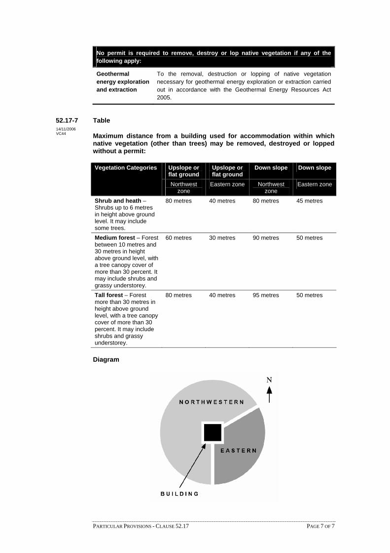
No permit is required to remove, destroy or lop native vegetation if any of the following apply:
Geothermal energy exploration and extraction
To the removal, destruction or lopping of native vegetation necessary for geothermal energy exploration or extraction carried out in accordance with the Geothermal Energy Resources Act 2005.
52.17-7 Table 14/11/2006 VC44 Maximum distance from a building used for accommodation within which
native vegetation (other than trees) may be removed, destroyed or lopped without a permit:
Upslope or Upslope or flat ground flat ground
Down slope Down slope Vegetation Categories
Northwest Northwest Eastern zone Eastern zone zone zone
Shrub and heath – Shrubs up to 6 metres in height above ground level. It may include some trees.
80 metres 40 metres 80 metres 45 metres
Medium forest – Forest between 10 metres and 30 metres in height above ground level, with a tree canopy cover of more than 30 percent. It may include shrubs and grassy understorey.
60 metres 30 metres 90 metres 50 metres
Tall forest – Forest more than 30 metres in height above ground level, with a tree canopy cover of more than 30 percent. It may include shrubs and grassy understorey.
80 metres 40 metres 95 metres 50 metres
Diagram
PARTICULAR PROVISIONS - CLAUSE 52.17 PAGE 7 OF 7

52.18 TIMBER PRODUCTION 17/09/2007 VC45
52.18-1 Timber production on Crown land 17/09/2007 VC45 Any requirement of this scheme which:
requires timber production to be conducted in a particular way
requires that a permit be obtained to use or develop land for timber production or to carry out timber production in a particular way
requires that some aspect of timber production be carried out to the satisfaction of the responsible authority
does not apply to timber production on unalienated land of the Crown managed and controlled by the Minister responsible for administering the Forests Act 1958 and the Sustainable Forests (Timber) Act 2004, or the Secretary to the Department of Sustainability and Environment, whether or not occupied under a licence or other right. All requirements of this scheme apply to Crown land which has been leased.
52.18-2 Timber production to comply with the Code of Practice for Timber Production 17/09/2007
VC45
All timber production activities (except agroforestry (the simultaneous and substantial production of forest and other agricultural products from the same land unit), windbreaks and commercial plantations of 5 hectares or less) must comply with the Code of Practice for Timber Production 2007 (Department of Sustainability and Environment). In accordance with Section 6(4A) of the Planning and Environment Act 1987, this applies whether the use of land for timber production is commenced before or after the coming into effect of this requirement.
The Code must be complied with to the satisfaction of the responsible authority.
A permit may require that matters required by the Code must be done to the satisfaction of the responsible authority or a Minister, public authority or referral authority, and may require the responsible authority to seek comments from any other person or authority before making a decision.
52.18-3 Removal of native vegetation 19/01/2006 VC37
If land is to be used for timber production the provisions of Clause 52.17 do not apply and no permit is required for the removal, destruction or lopping of native vegetation if any of the following apply:
The native vegetation consists of seedlings or regrowth less than 10 years old on land which has previously been cleared.
The native vegetation is proclaimed as a noxious weed or is bracken (Pteridium esculentum).
The Secretary to the Department of Sustainability and Environment is satisfied that the land receives more than 550mm of rainfall per annum and does not support vegetation in which all the following apply: The number of native plant species exceeds the number of non-native plant species.
The cover of native plant species (as measured by projected foliar cover) exceeds the cover of the non-native plant species.
The number of native plant species native to the locality exceeds the number of native plant species non-native to the locality.
In determining the above, a site of 5 hectares with a minimum width of 100 metres must be considered. If the land has an area less than 5 hectares the total site must be considered.
PARTICULAR PROVISIONS - CLAUSE 52.18 PAGE 1 OF 2

52.18-4 Road repairs
19/01/2006 VC37
After a Timber Harvesting Plan is lodged with the responsible authority under the Code and before the commencement of harvesting operations, the responsible authority, in consultation with the forest owner or manager, must establish the condition of any roads which are proposed to be used as a cartage route.
The forest owner or manager must advise the responsible authority when harvesting operations are complete. After receiving this advice, the responsible authority, in consultation with the forest owner or manager, must establish the condition of any roads which were used as a cartage route.
It is the responsibility of the forest owner or manager to restore any roads which were used as a cartage route to the same condition that they were in before the commencement of harvesting operations to the extent of any damage caused as a result of the harvesting operations.
The cartage of timber associated with harvesting operations is extraordinary traffic for the purpose of Section 112 of the Road Management Act 2004.
52.18-5 Decision guidelines 17/09/2007 VC45 Before deciding on an application to use or develop land for timber production, in addition
to the decision guidelines in Clause 65, the responsible authority must consider:
The need to encourage plantation establishment and timber production in locations where it is of significance to national, state and regional economies, and in areas affected by salinity and other forms of land degradation.
The role of native forest and plantations in: Protecting water quality.
Conserving flora and fauna.
Preventing land degradation, including soil erosion, salinisation and water logging.
Preventing adverse effects on groundwater recharge. The preservation of and impact on the natural environment, cultural heritage and visual
amenity. Whether it is appropriate to require environmental protection standards greater than
those in the Code.
PARTICULAR PROVISIONS - CLAUSE 52.18 PAGE 2 OF 2

PARTICULAR PROVISIONS - CLAUSE 52.19 PAGE 1 OF 3
52.19 TELECOMMUNICATIONS FACILITY
Purpose
To ensure that telecommunications infrastructure and services are provided in an efficientand cost effective manner to meet community needs.
To ensure the application of consistent provisions for telecommunications facilities.
To encourage an effective statewide telecommunications network in a manner consistentwith the economic, environmental and social objectives of planning in Victoria as set out inSection 4 of the Planning and Environment Act 1987.
To encourage the provision of telecommunications facilities with minimal impact on theamenity of the area.
52.19-1 Application
These provisions apply to the construction of a building or the construction or carrying outof works associated with the use of land for a Telecommunications facility. They apply tothe extent permitted under the Telecommunications Act 1997 (Cwth) and determinationsmade under that Act by the Commonwealth Minister for Communications, InformationTechnology and the Arts, including the Telecommunications (Low-impact Facilities)Determination 1997.
52.19-2 Permit requirement
A permit is required to construct a building or construct or carry out works for aTelecommunications facility.
This does not apply to:
Buildings and works associated with:
A low-impact facility as described in the Telecommunications (Low-impact)Facilities Determination 1997.
The inspection and maintenance of a Telecommunications facility as defined in theTelecommunications Act 1997 (Cwth).
A facility authorised by a Facilities Installation Permit issued under theTelecommunications Act 1997 (Cwth).
A temporary defence facility.
The connection of a building, structure, caravan or mobile home to aTelecommunications line forming part of a Telecommunications network.
Any Telecommunications facility described in A Code of Practice forTelecommunications Facilities in Victoria which complies with the requirements ofthe Code.
Buildings and works associated with activities which are:
Authorised under Clause 6(2) of Division 3 of Schedule 3 of theTelecommunications Act 1997 (Cwth).
Carried out by bodies listed in Sections 46 to 51 (inclusive) of theTelecommunications Act 1997 (Cwth) pursuant to legislation applying to thosebodies.
19/01/2006VC37
19/01/2006VC37
19/01/2006VC37

PARTICULAR PROVISIONS - CLAUSE 52.19 PAGE 2 OF 3
52.19-3 Land in public ownership
An application for a permit on land in a public land zone by a person other than therelevant public land manager, must be accompanied by the written consent of the publicland manager indicating that the public land manager consents generally or conditionallyeither:
To the application for permit being made.
To the application for permit being made and to the proposed use or development.
52.19-4 Exemption from notice and appeal
An application for a permit is exempt from the notice requirements of Section 52(1)(a), (b)and (d), the decision requirements of Section 64(1), (2) and (3) and the review rights ofSection 82(1) of the Act unless:
The Telecommunications facility is:
A radio communications dish greater than 1.2 metres in diameter or
A Telecommunications tower (other than a low-impact facility described in theTelecommunications (Low-impact Facilities) Determination 1997).
The land is located in an Environmental Significance Overlay, a Vegetation ProtectionOverlay, a Significant Landscape Overlay, a Heritage Overlay, a Design andDevelopment Overlay or an Erosion Management Overlay.
The land is public land not in a public land zone and the responsible authority is not thepublic land manager.
52.19-5 Application requirements
An application for permit must be accompanied by the following information asappropriate to the proposal and the location:
A site analysis and design response explaining how the proposed facility addresses theprinciples for the design, siting, construction and operation of telecommunicationsfacilities and the requirements in A Code of Practice for Telecommunications Facilitiesin Victoria.
Site boundaries and dimensions.
The purpose and location of all buildings and works required in the construction of thefacility.
The location of all existing buildings and works to be retained and demolished.
The location of all proposed buildings and works including dimensions, elevations,materials, colours and finishes.
The location and use of all buildings on adjoining properties.
The location of all adjoining streets and access ways.
Australian Height Datum levels.
Natural drainage lines, watercourses, coastal dunes, beach systems and wetlands.
Proposals for the rehabilitation of the land on which development is to occur.
Roads and parking areas.
Materials, landscaping, external lighting, colour and reflectivity.
19/01/2006VC37
19/01/2006VC37
19/01/2006VC37

PARTICULAR PROVISIONS - CLAUSE 52.19 PAGE 3 OF 3
52.19-6 Decision guidelines
Before deciding on an application, in addition to the decision guidelines of Clause 65, theresponsible authority must consider, as appropriate:
The principles for the design, siting, construction and operation of aTelecommunications facility set out in A Code of Practice for TelecommunicationsFacilities in Victoria.
The effect of the proposal on adjacent land.
If the Telecommunications facility is located in an Environmental Significance Overlay,a Vegetation Protection Overlay, a Significant Landscape Overlay, a Heritage Overlay,a Design and Development Overlay or an Erosion Management Overlay, the decisionguidelines in those overlays and the schedules to those overlays.
19/01/2006VC37

PARTICULAR PROVISIONS - CLAUSE 52.20 PAGE 1 OF 2
52.20 CONVENIENCE RESTAURANT AND TAKE-AWAY FOOD PREMISES
Scope
These requirements only apply to residential zones.
Decision guidelines
Before deciding on an application to use land for a convenience restaurant or take-awayfood premises or to construct a building or construct or carry out works associated with aconvenience restaurant or take-away food premises, in addition to the decision guidelinesin Clause 65, the responsible authority must consider, as appropriate:
Any policy in this scheme relating to convenience restaurants or take-away foodpremises.
Whether the location is appropriate for a convenience restaurant or take-away foodpremises having regard to:
Amenity of the neighbourhood.
Proximity of the land to non residential uses and zones.
Effect of the use on heritage and environment features.
Capacity of the land to contain significant off-site effects.
Access to land in a Road Zone.
The suitability of the land for a residential use.
The effect on the amenity or character of the street or neighbourhood having regard to:
Massing and proportions of any building.
Ground floor height above ground level.
Ceiling heights.
Roof form and pitch.
Facade articulation.
Window and door proportions.
Building features including verandahs, towers, eaves, parapets and decorativeelements.
Building materials, patterns textures and colours.
Whether the site layout and the design of buildings, noise attenuation measures,landscaping, car parking, vehicle access lanes, loading bays, rubbish bins, plant andequipment, lights, advertising signs, drive through facilities and playgrounds aredesigned to prevent significant loss of amenity to adjoining land due to noise, emissionof noise, emission of light or glare, loss of privacy, litter or odour.
Whether any special measure may be necessary to protect the amenity of adjoining landin residential use, including buffer planting, noise attenuation measures and littercollection arrangements.
The adequacy of traffic measures to:
Provide safe pedestrian movement.
19/01/2006VC37

PARTICULAR PROVISIONS - CLAUSE 52.20 PAGE 2 OF 2
Achieve safe, efficient vehicle movement on site and access to and egress from theland.
Avoid disruption to traffic flow on land in a Road Zone.
Prevent inappropriate use of local residential streets.
The adequacy of car parking, loading and drive through queuing spacing toaccommodate customers at peak periods and employee requirements on the land.

PARTICULAR PROVISIONS - CLAUSE 52.21 PAGE 1 OF 2
52.21 PRIVATE TENNIS COURT
Purpose
To ensure that tennis courts used in association with a dwelling are sited and constructed tominimise the effects of the development on nearby properties.
To ensure that the use of tennis courts in association with a dwelling does not causeunreasonable disturbance to adjoining residents or adversely affect the residential amenityof adjoining areas.
52.21-1 Scope
This clause applies to any private tennis court which is used in association with a dwelling.
52.21-2 Permit requirement
A permit is not required under any provision of this scheme to construct, use or illuminatea private tennis court if the performance requirements specified in the Code of Practice -Private Tennis Court Development Revision 1 March 1999 are met.
A permit is required to construct, use or illuminate a private tennis court:
If any of the performance requirements specified in the Code of Practice - PrivateTennis Court Development Revision 1 March 1999 are not met.
If the land is in an Environmental Significance Overlay, a Vegetation ProtectionOverlay, a Significant Landscape Overlay, a Heritage Overlay, an Urban FloodwayZone, a Floodway Overlay or a Land Subject to Inundation Overlay and a permit isrequired for any of the following:
To construct a building or construct or carry out works.
To remove, destroy, prune or lop a tree or vegetation.
52.21-3 Application requirements
Unless the circumstances do not require, an application under this clause must beaccompanied by the following information:
A copy of title of the land.
A layout plan to a scale of not less than 1:200.
The location of dwellings on adjoining land within 10 metres of the court site showinghabitable room windows.
Existing and proposed site levels.
Location of vegetation to be removed.
Proposed landscaping.
Illumination levels and the position and height of light poles and fencing.
Description of fencing material.
The location of easements.
Volume of excavated material to be brought to or removed from the site.
Means of access to the site.
19/01/2006VC37
19/01/2006VC37
19/01/2006VC37
19/01/2006VC37

PARTICULAR PROVISIONS - CLAUSE 52.21 PAGE 2 OF 2
Construction method and timing.
52.21-4 Notice provisions
An application for a permit to construct, use or illuminate a private tennis court under anyprovision of this scheme is exempt from the notice requirements of Section 52(1)(a), (b)and (d) of the Act.
In accordance with Section 52(1)(c) of the Act notice of an application to construct, use orilluminate a private tennis court under any provision of this scheme must be given byordinary post to the owners and occupiers of adjoining and opposite properties.
52.21-5 Decision guidelines
Before deciding on an application under this Clause, in addition to the decision guidelinesin Clause 65, the responsible authority must consider the relevant objectives andconsiderations specified in the Code of Practice - Private Tennis Court DevelopmentRevision 1 March 1999.
19/01/2006VC37
19/01/2006VC37
PARTICULAR PROVISIONS - CLAUSE 52.22 PAGE 1 OF 1
52.22 CRISIS ACCOMMODATION
A permit is not required to use a building, including outbuildings normal to a dwelling, tohouse people and any dependants at times of personal emergency or crisis if the buildingmeets all of the following requirements:
Is in an area or zone which is used mainly for housing.
Provides self contained accommodation.
Does not have more than 10 habitable rooms.
19/01/2006VC37

PARTICULAR PROVISIONS - CLAUSE 52.23 PAGE 1 OF 1
52.23 SHARED HOUSING
A permit is not required to use a building, including outbuildings normal to a dwelling, tohouse a person, people and any dependants or 2 or more people (including people withintellectual disabilities) if the building meets all of the following requirements:
Is in an area or zone which is used mainly for housing.
Provides self contained accommodation.
Does not have more than 10 habitable rooms.
19/01/2006VC37

PARTICULAR PROVISIONS - CLAUSE 52.24 PAGE 1 OF 1
52.24 COMMUNITY CARE UNIT
A permit is not required to use a building for services funded by the Department of HumanServices which provide self contained accommodation for its clients if all of the followingrequirements are met:
The building or buildings are in an area or zone which is used mainly for housing.
No more than 20 clients plus supervisory staff are accommodated on the site.
19/01/2006VC37

PARTICULAR PROVISIONS - CLAUSE 52.25 PAGE 1 OF 1
52.25 CREMATORIUM
Purpose
To ensure that crematoria in cemeteries are developed and used in an appropriate manner.
Permit required
A permit is required to develop and use a crematorium on land that is used for cemeterypurposes.
This does not apply to land in the Springvale Crematorium.
Decision guidelines
Before deciding on an application to use and develop land for a crematorium, in addition tothe decision guidelines in Clause 65, the responsible authority must consider:
The provision of landscaping and screen planting.
The location and design of the buildings to be constructed.
The effect on traffic movement generated by the use.
The provision of parking facilities.
19/01/2006VC37

PARTICULAR PROVISIONS - CLAUSE 52.26 PAGE 1 OF 1
52.26 CATTLE FEEDLOT
Purpose
To facilitate the establishment and expansion of cattle feedlots in Victoria in a mannerwhich is consistent with orderly and proper planning and the protection of the environment.
Requirements to be met
All use and development of cattle feedlots must comply with the Victorian Code for CattleFeedlots - August 1995.
The Code must be complied with to the satisfaction of the responsible authority.
19/01/2006VC37
PARTICULAR PROVISIONS - CLAUSE 52.27 PAGE 1 OF 1
52.27 LICENSED PREMISES
Scope
These provisions apply to premises licensed, or to be licensed, under the Liquor ControlReform Act 1998.
Permit required
A permit is required to use land to sell or consume liquor if any of the following apply:
A licence is required under the Liquor Control Reform Act 1998.
A different licence, or class of licence is required from that which is in force.
The hours of trading allowed under any licence are to be extended.
This does not apply if any of the following apply:
To a limited licence.
To a licence to manufacture liquor.
To a licence to sell only packaged liquor for consumption elsewhere.
If the schedule to this clause specifies that a permit is not required to use land to sell orconsume liquor under a particular type of licence.
The schedule to this clause may specify that a permit may not be granted to use land to sellor consume liquor under a particular type of licence.
19/01/2006VC37

52.28 GAMING
17/09/2007 VC45
52.28-1 Purpose 18/10/2006 VC39 To ensure that gaming machines are situated in appropriate locations and premises.
To ensure the social and economic impacts of the location of gaming machines are considered. To prohibit gaming machines in specified shopping complexes and strip shopping centres.
52.28-2 Permit requirement 18/10/2006 VC39 A permit is required to install or use a gaming machine.
This does not apply in either of the following circumstances: Clause 52.28-3 or Clause 52.28-4 specifically prohibit a gaming machine.
the gaming machine is in an approved venue under the Gambling Regulation Act 2003 on 18 October 2006 and the maximum number of gaming machines for the approved venue on 18 October 2006 is not exceeded.
52.28-3 Prohibition of a gaming machine in a shopping complex 18/10/2006 VC39 Installation or use of a gaming machine is prohibited on land specified in a schedule to this
clause. This does not apply to a gaming machine in an approved venue under the Gambling Regulation Act 2003 on 18 October 2006; and the maximum number of gaming machines for the approved venue on 18 October 2006 is not exceeded.
52.28-4 Prohibition of a gaming machine in a strip shopping centre 18/10/2006 VC39 Installation or use of a gaming machine is prohibited in a strip shopping centre if:
the strip shopping centre is specified in the schedule to this clause. the schedule provides that a gaming machine is prohibited in all strip shopping centres on land covered by this planning scheme.
This does not apply to a gaming machine in an approved venue under the Gambling Regulation Act 2003 on 18 October 2006; and the maximum number of gaming machines for the approved venue on 18 October 2006 is not exceeded. A strip shopping centre is an area that meets all of the following requirements:
it is zoned for business use; it consists of at least two separate buildings on at least two separate and adjoining lots; it is an area in which a significant proportion of the buildings are shops; it is an area in which a significant proportion of the lots abut a road accessible to the public generally;
but it does not include the Capital City Zone in the Melbourne Planning Scheme.
52.28-5 Transitional arrangements 17/09/2007 VC45 The requirements of Clause 52.28 as in force immediately before 18 October 2006 continue
to apply to a gaming machine referred to in a transitional application and permitted in the determination of a transitional application if a planning permit was not required immediately before 18 October 2006 for that gaming machine.
PARTICULAR PROVISIONS - CLAUSE 52.28 PAGE 1 OF 2

In this clause, "transitional application" means an application or request made, and not determined, before 18 October 2006 to the Victorian Commission for Gambling Regulation under the Gambling Regulation Act 2003 for either:
an approval of premises for gaming, or variation of approval of premises for gaming, or
amendment of conditions of a venue operator's licence to vary the number of permitted gaming machines for an approved venue.
52.28-6 Decision guidelines 18/10/2006 VC39
Before deciding on an application, in addition to the decision guidelines of Clause 65, the responsible authority must consider, as appropriate:
The State Planning Policy Framework and the Local Planning Policy Framework, including the Municipal Strategic Statement and local planning policies. The compatibility of the proposal with adjoining and nearby land uses. The capability of the site to accommodate the proposal. Whether the gaming premises provides a full range of hotel facilities or services to patrons or a full range of club facilities or services to members and patrons.
PARTICULAR PROVISIONS - CLAUSE 52.28 PAGE 2 OF 2

PARTICULAR PROVISIONS - CLAUSE 52.29 PAGE 1 OF 2
52.29 LAND ADJACENT TO A ROAD ZONE, CATEGORY 1, OR A PUBLIC ACQUISITION OVERLAY FOR A CATEGORY 1 ROAD
Purpose
To ensure appropriate access to identified roads.
To ensure appropriate subdivision of land adjacent to identified roads.
Scope
This clause applies to land adjacent to a Road Zone, Category 1, or a Public Acquisition Overlay if the purpose of acquisition is for a Category 1 road.
Permit requirement
A permit is required to:
Create or alter access to:
A road in a Road Zone, Category 1.
Land in a Public Acquisition Overlay if the purpose of acquisition is for a Category 1 road.
Subdivide land adjacent to:
A road in a Road Zone, Category 1.
Land in a Public Acquisition Overlay if the purpose of acquisition is for a Category 1 road.
Referral of applications
An application to create or alter access to, or to subdivide land adjacent to, a road declared as a freeway or arterial road under the Road Management Act 2004, land owned by the Roads Corporation for the purpose of a road, or land in a Public Acquisition Overlay if the Roads Corporation is the authority responsible for acquiring the land, must be referred to the Roads Corporation under Section 55 of the Act. This does not apply to:
Boundary realignments.
Subdivisions of existing buildings already connected to services and requiring no new access.
Two lot subdivisions requiring no new access.
Proposals which, in the opinion of the responsible authority, satisfy requirements or conditions previously agreed in writing between the responsible authority and the Roads Corporation.
Any other application must be referred to the owner of, or the authority responsible for acquiring, the adjacent land in the Road Zone, Category 1, or the Public Acquisition Overlay.
Decision guidelines
Before deciding on an application, in addition to the decision guidelines in Clause 65, the responsible authority must consider:
09/10/2006 VC42

PARTICULAR PROVISIONS - CLAUSE 52.29 PAGE 2 OF 2
The State Planning Policy Framework and the Local Planning Policy Framework, including the Municipal Strategic Statement and local planning policies.
The views of the relevant road authority.
The effect of the proposal on the operation of the road and on public safety.
Any policy made by the relevant road authority pursuant to Schedule 2, Clause 3 of the Road Management Act 2004 regarding access between a controlled access road and adjacent land.

PARTICULAR PROVISIONS - CLAUSE 52.30 PAGE 1 OF 2
52.30 FREEWAY SERVICE CENTRE
Purpose
To ensure that freeway service centres are appropriately designed and located.
To ensure that access to a freeway service centre from a freeway is designed to therequirements of the Roads Corporation.
To ensure that freeway service centres with access to a rural freeway provide only essentialservices and facilities which encourage drivers to stop and take an effective break atappropriate intervals in the interests of driver safety.
To ensure that any new freeway service centre meets an identifiable need to provideessential services and facilities along a freeway where those services and facilities are notreadily available.
To ensure that the use of land for a freeway service centre does not adversely affect theamenity of surrounding land uses.
52.30-1 Requirements to be met
Facilities and services
A freeway service centre must provide only essential services and facilities. Theseessential services and facilities must be available at all times. Essential services andfacilities that a freeway service centre must include are:
Designated parking areas.
Undercover fuel sales area for petrol, diesel and LPG.
An area of not more than 240 square metres for the sale of food, drinks and otherconvenience goods.
An indoor sit-down eating area.
A safe play area for children.
Public toilets.
A public telephone.A freeway service centre with access to a rural freeway must also provide local andregional tourist information.
A freeway service centre must not include:
Mechanical repairs (other than the emergency repair of vehicles).
Retail facilities of more than 240 square metres.
Video hire.
Post office services or facilities.
Entertainment facilities, amusement machines or gaming machines.
The sale, distribution or consumption of alcohol unless associated with a residentialhotel/motel.
Car or truck wash facilities.A freeway service centre with access to a rural freeway must not include overnightaccommodation (other than for a caretaker or site manager).
19/01/2006VC37
19/01/2006VC37

PARTICULAR PROVISIONS - CLAUSE 52.30 PAGE 2 OF 2
Access to freeway service centres
No vehicular access between a freeway service centre with access to a metropolitanfreeway and the local road network may be permitted.
An application to use or develop land for a freeway service centre must be referred to theRoads Corporation in accordance with Section 55 of the Act.
A permit must not be granted for a freeway service centre until approval for access to thefreeway has been given by the Roads Corporation.
In accordance with Section 62(1)(a) of the Act, a permit granted for a freeway servicecentre must include the condition:
“This permit will expire if one of the following circumstances applies:
The development is not commenced within two years of the date of this permit.
The development is not completed within four years of the date of this permit.The responsible authority may extend the periods referred to if a request is made in writingbefore the permit expires or within three months afterwards.”
Metropolitan freeway service centre adjoining a residential zone
If the site for a freeway service centre with access to a metropolitan freeway adjoins aresidential zone:
A landscape buffer at least 3 metres wide must be provided on the site along thecommon boundary and must be planted and maintained to the satisfaction of theresponsible authority.
Except for the landscape buffer strip, all of the site not occupied by buildings must besealed to prevent dust.
External lights must be directed away from the residential zone to prevent light spill andglare.
52.30-2 Decision guidelines
Before deciding on an application, in addition to the decision guidelines in Clause 65, theresponsible authority must consider:
The State Planning Policy Framework and the Local Planning Policy Framework,including the Municipal Strategic Statement and local planning policies.
The Freeway Service Centres Design Guidelines, May 1997.
19/01/2006VC37

PARTICULAR PROVISIONS - CLAUSE 52.31 PAGE 1 OF 1
52.31 BROILER FARM
Purpose
To facilitate the establishment and expansion of broiler farms in a manner that is consistentwith orderly and proper planning and the protection of the environment.
Scope
This clause applies to land used or developed or proposed to be used or developed for abroiler farm.
Requirement
A broiler farm must comply with the Victorian Code for Broiler Farms, September 2001.
A permit for a new Class C broiler farm, as described in the Victorian Code for BroilerFarms, September 2001, must not be granted after 26 September 2001.
Exemption from notice and review
An application for a permit is exempt from the notice requirements of Section 52 (1)(a), (b)and (d), the decision requirements of Section 64(1), (2) and (3) and the review rights ofSection 82(1) of the Act if the proposal meets the requirements of a Class A farm specifiedin the Victorian Code for Broiler Farms, September 2001.
19/01/2006VC37
52.32 WIND ENERGY FACILITY 17/09/2007 VC45
Purpose
To facilitate the establishment and expansion of wind energy facilities, in appropriate locations, with minimal impact on the amenity of the area.
Scope
This clause applies to land used and developed or proposed to be used and developed for a wind energy facility.
Application requirements
An application must be accompanied by the following information, as appropriate:
A site analysis and design response.
Development plan(s) including the layout and height of the wind turbines and associated buildings and works, materials, reflectivity, colour, lighting, landscaping, connection to the electricity grid, access roads and parking areas.
The location of all dwellings within a 500 metre radius of the site.
Calculation of greenhouse benefits.
Photomontages or other visual simulations illustrating the development from key vantage points.
An assessment of the impact of the proposal on any avifauna listed under the Flora and Fauna Guarantee Act 1988 or Environment Protection and Biodiversity Conservation Act 1999.
An assessment of the noise impact of the proposal based on the New Zealand Standard NZ6808:1998, Acoustics – The Assessment and Measurement of Sound from Wind Turbine Generators.
An assessment of other potential amenity impacts such as blade glint, shadow flicker, electromagnetic interference.
Impact upon any nearby airfields (within a 30 kilometre radius).
Impact upon Aboriginal cultural heritage or European cultural heritage.
An environmental management plan including any rehabilitation and monitoring.
Decision guidelines
Before deciding on an application, in addition to the decision guidelines of Clause 65, the responsible authority must consider, as appropriate:
The views of the Sustainable Energy Association of Victoria about the contribution of the proposal to reducing greenhouse gas emissions.
The effect of the proposal on the surrounding area in terms of noise, blade glint, shadow flicker and electromagnetic interference.
The impact of the development on significant views, including visual corridors and sightlines.
The impact of the facility on the natural environment and natural systems.
PARTICULAR PROVISIONS - CLAUSE 52.32 PAGE 1 OF 2

The impact of the facility on cultural heritage.
The views of the Civil Aviation Safety Authority if within a 30 kilometre radius of an airfield.
The Policy and Planning Guidelines for Development of Wind Energy Facilities in Victoria, 2003.
PARTICULAR PROVISIONS - CLAUSE 52.32 PAGE 2 OF 2

PARTICULAR PROVISIONS - CLAUSE 52.33 PAGE 1 OF 2
52.33 SHIPPING CONTAINER STORAGE
Scope
This clause applies to all land except land which is in a Special Use Zone established forthe purpose of port and port-related activities.
52.33-1 Decision guidelines
Before deciding on an application to use land for shipping container storage, or construct abuilding or construct or carry out works associated with shipping container storage, inaddition to the decision guidelines in Clause 65, the responsible authority must consider, asappropriate:
Whether the location is appropriate for shipping container storage having regard to:
The zoning of the land.
Amenity of the neighbourhood.
Proximity of the land to residential uses and zones or other sensitive uses.
Access to a road in a Road Zone.
Access to rail facilities.
Capacity and suitability of the road network to accommodate the type and volume ofvehicle traffic generated by the use.
Capacity of the site to accommodate the proposed use.
The effect on the environment and the amenity and character of the neighbourhoodhaving regard to:
Existing and planned use of land in the neighbourhood.
Location, height and setback of shipping container stacks, particularly near roadboundaries.
Location of facilities for the cleaning, repair, servicing, painting or fumigation ofshipping containers.
Hours of operation.
Design, construction and maintenance of external storage and vehicle movementareas.
Treatment and disposal of wastewater.
Whether the site layout and the design of buildings, landscaping, vehicle access lanes,loading bays, wash bays, lighting and fencing are designed to avoid or minimise anysignificant off-site impacts due to the emission of noise, light, glare, dust, fumes ordrainage.
Whether any special measure may be necessary to protect the environment and theamenity of nearby sensitive uses, including noise attenuation measures, dustminimisation measures and waste storage arrangements.
The need for landscaping and fencing to screen or soften the appearance of shippingcontainer storage areas, particularly near road boundaries.
The adequacy and effect of the landscaping on the appearance of the site, taking intoaccount the streetscape character, the size of the site, and the height, mass and scale ofshipping container stacks on the site.
19/01/2006VC37
19/01/2006VC37

PARTICULAR PROVISIONS - CLAUSE 52.33 PAGE 2 OF 2
The adequacy of traffic measures to:
Achieve safe, efficient vehicle movement on site and access to and egress from theland.
Prevent inappropriate use of local residential streets.
The adequacy of truck parking, loading and truck queuing spacing to accommodatetruck movements at peak periods and employee requirements on the land.

PARTICULAR PROVISIONS – CLAUSE 52.34 PAGE 1 OF 4
52.34 BICYCLE FACILITIES
Purpose
To encourage cycling as a mode of transport.
To provide secure, accessible and convenient bicycle parking spaces and associated shower andchange facilities.
52.34-1 Provision of bicycle facilities
A new use must not commence or the floor area of an existing use must not be increased until therequired bicycle facilities and associated signage has been provided on the land.
Where the floor area occupied by an existing use is increased, the requirement for bicycle facilitiesonly applies to the increased floor area of the use.
52.34-2 Permit requirement
A permit may be granted to vary, reduce or waive any requirement of Clause 52.34-3 and Clause52.34-4.
Exemption from notice and review
An application is exempt from the notice requirements of Section 52(1)(a), (b) and (d), thedecision requirements of Section 64(1), (2) and (3) and the review rights of Section 82(1) of theAct.
Decision guidelines
Before deciding on an application, in addition to the decision guidelines in Clause 65, theresponsible authority must consider, as appropriate:
Whether the proposed number, location and design of bicycle facilities meets the purpose ofthis clause.
The location of the proposed land use and the distance a cyclist would need to travel to reachthe land.
The users of the land and their opportunities for bicycle travel.
Whether showers and change rooms provided on the land for users other than cyclists areavailable to cyclists.
The opportunities for sharing of bicycle facilities by multiple uses, either because of variationof bicycle parking demand over time or because of efficiencies gained from the consolidationof shared bicycle facilities.
Australian Standard AS 2890.3 1993 Parking facilities Part 3: Bicycle parking facilities.
Any relevant bicycle parking strategy or equivalent.
52.34-3 Required bicycle facilities
Tables 1, 2 and 3 to this clause set out the number and type of bicycle facilities required. Bicyclefacilities are required if the use is listed in column 1 of the table. The number of bicycle facilitiesrequired for a use is the sum of columns 2 and 3 of the tables.
If in calculating the number of bicycle facilities the result is not a whole number, the requirednumber of bicycle facilities is the nearest whole number. If the fraction is one-half, therequirement is the next whole number.
19/01/2006VC37
19/01/2006VC37
19/01/2006VC37
19/01/2006VC37

PARTICULAR PROVISIONS – CLAUSE 52.34 PAGE 2 OF 4
A bicycle space for an employee or resident must be provided either in a bicycle locker or at abicycle rail in a lockable compound.
A bicycle space for a visitor, shopper or student must be provided at a bicycle rail.
Table 1 to Clause 52.34-3 − Bicycle spaces
USE EMPLOYEE/RESIDENT VISITOR/SHOPPER/STUDENT
Amusement parlour None 2 plus 1 to each 50 sq m of netfloor area
Convenience restaurant 1 to each 25 sq m of floor areaavailable to the public
2
Dwelling In developments of four or morestoreys, 1 to each 5 dwellings
In developments of four or morestoreys, 1 to each 10 dwellings
Education centre otherthan specified in thistable
1 to each 20 employees 1 to each 20 full-time students
Hospital 1 to each 15 beds 1 to each 30 beds
Hotel 1 to each 25 sq m of bar floorarea available to the public, plus1 to each 100 sq m of loungefloor area available to the public
1 to each 25 sq m of bar floorarea available to the public, plus1 to each 100 sq m of loungefloor area available to the public
Industry other thanspecified in this table
1 to each 1000 sq m of net floorarea
None
Library 1 to each 500 sq m of net floorarea
4 plus 2 to each 200 sq m of netfloor area
Major sports andrecreation facility
1 to each 1500 spectator places 1 to each 250 spectator places
Market 1 to each 50 stalls 1 to each 10 stalls
Medical centre 1 to each 8 practitioners 1 to each 4 practitioners
Minor sports andrecreation facility
1 per 4 employees 1 to each 200 sq m of net floorarea
Motel 1 to each 40 rooms None
Nursing home 1 to each 7 beds 1 to each 60 beds
Office other thanspecified in this table
1 to each 300 sq m of net floorarea if the net floor areaexceeds 1000 sq m
1 to each 1000 sq m of net floorarea if the net floor areaexceeds 1000 sq m
Place of assembly otherthan specified in thistable
1 to each 1500 sq m of net floorarea
2 plus 1 to each 1500 sq m ofnet floor area
Primary school 1 to each 20 employees 1 to each 5 pupils over year 4
Residential buildingother than specified inthis table
In developments of four or morestoreys, 1 to each 10 lodgingrooms
In developments of four or morestoreys, 1 to each 10 lodgingrooms

PARTICULAR PROVISIONS – CLAUSE 52.34 PAGE 3 OF 4
USE EMPLOYEE/RESIDENT VISITOR/SHOPPER/STUDENT
Restaurant 1 to each 100 sq m of floor areaavailable to the public
2 plus 1 to each 200 sq m offloor area available to the publicif the floor area available to thepublic exceeds 400 sq m.
Retail premises otherthan specified in thistable
1 to each 300 sq m of leasablefloor area
1 to each 500 sq m of leasablefloor area
Secondary school 1 to each 20 employees 1 to each 5 pupils
Service industry 1 to each 800 sq m of net floorarea
None
Shop 1 to each 600 sq m of leasablefloor area if the leasable floorarea exceeds 1000 sq metres
1 to each 500 sq m of leasablefloor area if the leasable floorarea exceeds 1000 sq metres
Take-away food premises 1 to each 100 sq m of net floorarea
1 to each 50 sq m of net floorarea
Table 2 to Clause 52.34-3 − Showers
USE EMPLOYEE/RESIDENT VISITOR/SHOPPER/STUDENT
Any use listed in Table 1 If 5 or more employee bicyclespaces are required, 1 showerfor the first 5 employee bicyclespaces, plus 1 to each 10employee bicycle spacesthereafter.
None
Table 3 to Clause 52.34-3 – Change rooms
USE EMPLOYEE/RESIDENT VISITOR/SHOPPER/STUDENT
Any use listed in Table 1 1 change room or direct accessto a communal change room toeach shower. The change roommay be a combined shower andchange room.
None
52.34-4 Design of bicycle spaces
Bicycle spaces should:
Provide a space for a bicycle of minimum dimensions of 1.7 metres in length, 1.2 metres inheight and 0.7 metres in width at the handlebars.
Be located to allow a bicycle to be ridden to within 30 metres of the bicycle parking space.
Be located to provide convenient access from surrounding bicycle routes and main buildingentrances.
Not interfere with reasonable access to doorways, loading areas, access covers, furniture,services and infrastructure.
Not cause a hazard.
Be adequately lit during periods of use.
19/01/2006VC37

PARTICULAR PROVISIONS – CLAUSE 52.34 PAGE 4 OF 4
Bicycle rails
A bicycle rail must:
Be securely fixed to a wall or to the floor or ground.
Be in a highly visible location for bicycle security (when not in a compound).
Be of a shape that allows a cyclist to easily lock the bicycle frame and wheels.
Be located to allow easy access to park, lock and remove the bicycle.
Bicycle compounds and lockers
A bicycle compound or a bicycle locker must:
Be located to provide convenient access to other bicycle facilities including showers andchange rooms.
Be fully enclosed.
Be able to be locked.
If outside, provide weather protection for the bicycle.
A bicycle locker must provide a bicycle parking space for at least one bicycle.
A bicycle compound must:
Include wall or floor rails for bicycle parking.
Provide an internal access path of at least 1.5 metres in width.
52.34-5 Bicycle signage
If bicycle facilities are required by this clause, bicycle signage that directs the cyclists to thebicycle facilities must be provided to the satisfaction of the responsible authority.
Bicycle signage should:
Be at least 0.3 metres wide and 0.45 metres high.
Display a white bicycle on a blue background on the top half of the sign.
Display information about the direction of facilities on the bottom half of the sign.
19/01/2006VC37

PARTICULAR PROVISIONS - CLAUSE 52.35 PAGE 1 OF 2
52.35 URBAN CONTEXT REPORT AND DESIGN RESPONSE FOR RESIDENTIALDEVELOPMENT OF FOUR OR MORE STOREYS
Purpose
To ensure that an urban context report is prepared before a residential development of fouror more storeys is designed and that the design responds to the existing urban context andpreferred future development of the area.
52.35-01 Application requirements
An application for a residential development of four or more storeys must be accompaniedby:
An urban context report.
A design response.
52.35-02 Urban context report
The urban context report may use a site plan, photographs or other techniques and mustinclude:
An accurate description of:
Site shape, size, orientation and easements.
Levels and contours of the site and the difference in levels between the site andsurrounding properties.
The location and height of existing buildings on the site and surrounding properties.
The use of surrounding buildings.
The location of private open space of surrounding properties and the location of trees,fences and other landscape elements.
Solar access to the site and to surrounding properties.
Views to and from the site.
Street frontage features such as poles, street trees and kerb crossovers.
The location of local shops, public transport services and public open spaces withinwalking distance.
Movement systems through and around the site.
Any other notable feature or characteristic of the site.
An assessment of the characteristics of the area including:
Any environmental features such as vegetation, topography and significant views.
The pattern of subdivision.
Street design and landscape.
The pattern of development.
Building form, scale and rhythm.
Connection to the public realm.
Architectural style, building details and materials.
Social and economic activity.
19/01/2006VC37
19/01/2006VC37
19/01/2006VC37

PARTICULAR PROVISIONS - CLAUSE 52.35 PAGE 2 OF 2
Any other notable or cultural characteristics of the area.A written statement that describes:
Any relevant housing, neighbourhood character, urban design and landscape plan,strategy or policy set out in this scheme.
The strategic and local suitability of the site for residential development of four or morestoreys.
If in the opinion of the responsible authority a requirement of the urban context report is notrelevant to the evaluation of an application, the responsible authority may waive or reducethe requirement.
52.35-03 Satisfactory urban context report
The responsible authority must inform the applicant in writing:
Before notice of an application is given, or
If notice of an application is not required to be given, before deciding the application,
that the urban context report meets the requirements of Clause 52.35-02 and is satisfactoryor does not meet the requirements of Clause 52.35-02 and is not satisfactory.
If the responsible authority decides that the urban context report is not satisfactory, it mayrequire more information from the applicant under Section 54 of the Act.
The responsible authority must not require notice of an application to be given or decide anapplication until it is satisfied that the urban context report meets the requirements ofClause 52.35-02 and is satisfactory.
This does not apply if the responsible authority refuses an application under Section 52(1A)of the Act.
52.35-04 Design response
The design response must explain how the proposed design:
Responds to any relevant planning provision that applies to the land.
Responds to any relevant housing, neighbourhood character, urban design andlandscape plan, strategy or policy set out in this scheme.
Derives from and responds to the urban context report.The design response must include correctly proportioned street elevations or photographsshowing the development in the context of adjacent buildings. If in the opinion of theresponsible authority this requirement is not relevant to the evaluation of an application, itmay waive or reduce the requirement.
19/01/2006VC37
19/01/2006VC37

PARTICULAR PROVISIONS - CLAUSE 52.36 PAGE 1 OF 1
52.36 INTEGRATED PUBLIC TRANSPORT PLANNING
Purpose
To ensure development supports public transport usage.
To ensure that public transport facilities are provided to meet the needs of the scale of the development.
To integrate development and the transport system.
To ensure development incorporates adequate transport networks, public transport facilities and pedestrian linkages to these facilities.
52.36-1 Referral requirement
An application of the kind listed below must be referred in accordance with Section 55 of the Act to the Director of Public Transport.
An application to subdivide land, to construct a building or to construct or carry out works for any of the following:
A residential development comprising 60 or more dwellings or lots.
A new retail premises of 4000 or more square metres of leasable floor area.
An increase to the leasable floor area of an existing retail premises which is 20,000 or more square metres leasable floor area.
A commercial or office development of 10,000 or more square metres of leasable floor area.
An industrial subdivision of 20 or more lots.
A development which closes a road adjoining a public transport stop or which would use land within a closed road adjoining a public transport stop.
This does not apply to:
A proposal that, in the opinion of the responsible authority, satisfies requirements or conditions previously agreed to in writing between the responsible authority and the referral authority.
A development consistent with an adopted Structure Plan that has been prepared in consultation with and endorsed by the Public Transport Division of the Department of Infrastructure.
52.36-2 Referral requirement
An application that is referred under Clause 52.36-01 must be accompanied by a plan which sets out the following:
The proposed road network.
Connections to existing roads.
Existing and proposed traffic signalisation.
Existing and proposed public transport stops and infrastructure (including. shelters, indented bay/s, signage, pedestrian crossings and taxi ranks.
Pedestrian and bicycle paths and connections to stops.
09/10/2006 VC42
09/10/2006 VC42
09/10/2006 VC42

PARTICULAR PROVISIONS - CLAUSE 53 PAGE 1 OF 2
53 UPPER YARRA VALLEY AND DANDENONG RANGES REGION
Purpose
To facilitate consistency between the Yarra Ranges Planning Scheme and the Upper Yarra
Valley and Dandenong Ranges Regional Strategy Plan in accordance with Section 46F of
the Planning and Environment Act 1987.
19/01/2006 VC37
PARTICULAR PROVISIONS - CLAUSE 53 PAGE 2 OF 2
53.01 UPPER YARRA VALLEY AND DANDENONG RANGES REGION PROVISIONS
Scope
If there is an inconsistency between any provision in the schedule to this clause and any
other clause or provision of the Yarra Ranges Planning Scheme, the requirements of the
schedule to this clause prevail.
53.01-1 Permit requirement
A permit is required to:
� Construct a building or construct or carry out works. This does not apply if the schedule
to this clause specifically states that a permit is not required.
� Remove, destroy or lop any vegetation. This does not apply if the schedule to this
clause specifically states that a permit is not required.
Any permit issued must meet the requirements of the schedule to this clause.
53.01-2 Use of land
The use of land must meet the requirements of the schedule to this clause.
53.01-3 Subdivision of land
The subdivision of land must meet the requirements of the schedule to this clause.
53.01-4 Decision guidelines
Before deciding on an application, in addition to the decision guidelines in Clause 65, the
responsible authority must consider the State Planning Policy Framework and the Local
Planning Policy Framework, including the Municipal Strategic Statement and local planning
policies.
30/08/2006 VC40
30/08/2006 VC40
30/08/2006 VC40
30/08/2006 VC40
30/08/2006 VC40

PARTICULAR PROVISIONS - CLAUSE 54 PAGE 1 OF 1
54 ONE DWELLING ON A LOT
Purpose
To implement the State Planning Policy Framework and the Local Planning PolicyFramework, including the Municipal Strategic Statement and local planning policies.
To achieve residential development that respects the existing neighbourhood character orwhich contributes to a preferred neighbourhood character.
To encourage residential development that provides reasonable standards of amenity forexisting and new residents.
To encourage residential development that is responsive to the site and the neighbourhood.
Application
These provisions apply to an application to construct a building or construct or carry outworks associated with one dwelling on a lot under the provisions of:
A Residential 1 Zone, Residential 2 Zone, Residential 3 Zone, Mixed Use Zone orTownship Zone.
A Neighbourhood Character Overlay if the land is in a Residential 1 Zone, Residential 2Zone, Residential 3 Zone, Mixed Use Zone or Township Zone.
Operation
The provisions of this clause contain:
Objectives. An objective describes the desired outcome to be achieved in the completeddevelopment.
Standards. A standard contains the requirements to meet the objective.A standard should normally be met. However, if the responsible authority is satisfiedthat an application for an alternative design solution meets the objective, the alternativedesign solution may be considered.
Decision guidelines. The decision guidelines set out the matters that the responsibleauthority must consider before deciding if an application meets the objectives.
Requirements
A development:
Must meet all of the objectives of this clause. Should meet all of the standards of this clause.
If the schedule to a zone specifies a requirement of a standard different from a requirementset out in this clause, the requirement in the schedule to the zone applies.
If the land is included in a Neighbourhood Character Overlay and a schedule to the overlayspecifies a requirement of a standard different from a requirement set out in this clause or arequirement in the schedule to a zone, the requirement in the schedule to the overlayapplies.
If the land is included in an overlay, other than a Neighbourhood Character Overlay, and aschedule to the overlay specifies a requirement different from a requirement of a standardset out in this clause or a requirement of a standard set out in the schedule to a zone, therequirement in the overlay applies.
19/01/2006VC37

PARTICULAR PROVISIONS - CLAUSE 54.01 PAGE 1 OF 2
54.01 NEIGHBOURHOOD AND SITE DESCRIPTION AND DESIGN RESPONSE
An application must be accompanied by:
A neighbourhood and site description.
A design response.
54.01-1 Neighbourhood and site description
The neighbourhood and site description may use a site plan, photographs or othertechniques and must accurately describe:
In relation to the neighbourhood:
The built form, scale and character of surrounding development including frontfencing.
Architectural and roof styles.
Any other notable features or characteristics of the neighbourhood.
In relation to the site:
Site shape, size, orientation and easements.
Levels of the site and the difference in levels between the site and surroundingproperties.
Location of existing buildings on the site and on surrounding properties, includingthe location and height of walls built to the boundary of the site.
The use of surrounding buildings.
The location of secluded private open space and habitable room windows ofsurrounding properties which have an outlook to the site within 9 metres.
Solar access to the site and to surrounding properties.
Location of significant trees existing on the site and any significant trees removedfrom the site in the 12 months prior to the application being made, where known.
Any contaminated soils and filled areas, where known.
Views to and from the site.
Street frontage features such as poles, street trees and kerb crossovers.
Any other notable features or characteristics of the site.If in the opinion of the responsible authority a requirement of the neighbourhood and sitedescription is not relevant to the evaluation of an application, the responsible authority maywaive or reduce the requirement.
Satisfactory neighbourhood and site description
The responsible authority must inform the applicant in writing:
Before notice of an application is given, or
If notice of an application is not required to be given, before deciding the application,
that the neighbourhood and site description meets the requirements of Clause 54.01-1 and issatisfactory or does not meet the requirements of Clause 54.01-1 and is not satisfactory.
19/01/2006VC37
19/01/2006VC37

PARTICULAR PROVISIONS - CLAUSE 54.01 PAGE 2 OF 2
If the responsible authority decides that the neighbourhood and site description is notsatisfactory, it may require more information from the applicant under Section 54 of theAct.
The responsible authority must not require notice of an application to be given or decide anapplication until it is satisfied that the neighbourhood and site description meets therequirements of Clause 54.01-1 and is satisfactory.
This does not apply if the responsible authority refuses an application under Section 52(1A)of the Act.
54.01-2 Design response
The design response must explain how the proposed design:
Derives from and responds to the neighbourhood and site description.
Meets the objectives of Clause 54.
Responds to any neighbourhood character features for the area identified in a localplanning policy or a Neighbourhood Character Overlay.
The design response must include correctly proportioned street elevations or photographsshowing the development in the context of adjacent buildings. If in the opinion of theresponsible authority this requirement is not relevant to the evaluation of an application, itmay waive or reduce the requirement.
19/01/2006VC37

PARTICULAR PROVISIONS - CLAUSE 54.02 PAGE 1 OF 1
54.02 NEIGHBOURHOOD CHARACTER
54.02-1 Neighbourhood character objective
To ensure that the design respects the existing neighbourhood character or contributes to apreferred neighbourhood character.
To ensure that the design responds to the features of the site and the surrounding area.
Standard A1
The design response must be appropriate to the neighbourhood and the site.
The proposed design must respect the existing or preferred neighbourhood character andrespond to the features of the site.
Decision guidelines
Before deciding on an application, the responsible authority must consider:
Any relevant neighbourhood character objective, policy or statement set out in thisscheme.
The neighbourhood and site description.
The design response.
54.02-2 Integration with the street objective
To integrate the layout of development with the street.
Standard A2
Dwellings should be oriented to front existing and proposed streets.
High fencing in front of dwellings should be avoided if practicable.
Dwellings should be designed to promote the observation of abutting streets and anyabutting public open spaces.
Decision guidelines
Before deciding on an application, the responsible authority must consider:
Any relevant neighbourhood character objective, policy or statement set out in thisscheme.
The design response.
19/01/2006VC37
19/01/2006VC37
19/01/2006VC37

PARTICULAR PROVISIONS - CLAUSE 54.03 PAGE 1 OF 5
54.03 SITE LAYOUT AND BUILDING MASSING
54.03-1 Street setback objective
To ensure that the setbacks of buildings from a street respect the existing or preferredneighbourhood character and make efficient use of the site.
Standard A3
Walls of buildings should be set back from streets:
At least the distance specified in the schedule to the zone, or
If no distance is specified in the schedule to the zone, the distance specified in TableA1.
Porches, pergolas and verandahs that are less than 3.6 metres high and eaves may encroachnot more than 2.5 metres into the setbacks of this standard.
Table A1 Street setback
DEVELOPMENTCONTEXT
MINIMUM SETBACKFROM FRONT STREET(METRES)
MINIMUM SETBACKFROM A SIDE STREET(METRES)
There is an existing buildingon both the abuttingallotments facing the samestreet, and the site is not ona corner.
The average distance of thesetbacks of the front wallsof the existing buildings onthe abutting allotmentsfacing the front street or 9metres, whichever is thelesser.
Not applicable
There is an existing buildingon one abutting allotmentfacing the same street andno existing building on theother abutting allotmentfacing the same street, andthe site is not on a corner.
The same distance as thesetback of the front wall ofthe existing building on theabutting allotment facingthe front street or 9 metres,whichever is the lesser.
Not applicable
There is no existing buildingon either of the abuttingallotments facing the samestreet, and the site is not ona corner.
6 metres for streets in aRoad Zone, Category 1,and 4 metres for otherstreets.
Not applicable
19/01/2006VC37
19/01/2006VC37

PARTICULAR PROVISIONS - CLAUSE 54.03 PAGE 2 OF 5
DEVELOPMENTCONTEXT
MINIMUM SETBACKFROM FRONT STREET(METRES)
MINIMUM SETBACKFROM A SIDE STREET(METRES)
The site is on a corner. If there is a building on theabutting allotment facingthe front street, the samedistance as the setback ofthe front wall of the existingbuilding on the abuttingallotment facing the frontstreet or 9 metres,whichever is the lesser.
If there is no building on theabutting allotment facingthe front street, 6 metres forstreets in a Road Zone,Category 1, and 4 metresfor other streets.
The same distance as thesetback of the front wall ofany existing building on theabutting allotment facingthe side street or 2 metres,whichever is the lesser.
Decision guidelines
Before deciding on an application, the responsible authority must consider:
Any relevant neighbourhood character objective, policy or statement set out in thisscheme.
The design response.
Whether a different setback would be more appropriate taking into account theprevailing setbacks of existing buildings on nearby lots.
The visual impact of the building when viewed from the street and from adjoiningproperties.
The value of retaining vegetation within the front setback.
54.03-2 Building height objective
To ensure that the height of buildings respects the existing or preferred neighbourhoodcharacter.
Standard A4
The maximum building height should not exceed the maximum height specified in thezone, schedule to the zone or an overlay that applies to the land.
If no maximum height is specified in the zone, schedule to the zone or an overlay, themaximum building height should not exceed 9 metres, unless the slope of the naturalground level at any cross section wider than 8 metres of the site of the building is 2.5degrees or more, in which case the maximum building height should not exceed 10 metres.
Changes of building height between existing buildings and new buildings should begraduated.
Decision guidelines
19/01/2006VC37

PARTICULAR PROVISIONS - CLAUSE 54.03 PAGE 3 OF 5
Before deciding on an application, the responsible authority must consider:
Any relevant neighbourhood character objective, policy or statement set out in thisscheme.
The design response.
The effect of the slope of the site on the height of the building.
The relationship between the proposed building height and the height of existingadjacent buildings.
The visual impact of the building when viewed from the street and from adjoiningproperties.
54.03-3 Site coverage objective
To ensure that the site coverage respects the existing or preferred neighbourhood characterand responds to the features of the site.
Standard A5
The site area covered by buildings should not exceed:
The maximum site coverage specified in the schedule to the zone, or
If no maximum site coverage is specified in the schedule to the zone, 60 per cent.
Decision guidelines
Before deciding on an application, the responsible authority must consider:
Any relevant neighbourhood character objective, policy or statement set out in thisscheme.
The design response.
The existing site coverage and any constraints imposed by existing development or thefeatures of the site.
The site coverage of adjacent properties.
The effect of the visual bulk of the building and whether this is acceptable in theneighbourhood.
54.03-4 Permeability objectives
To reduce the impact of increased stormwater run-off on the drainage system.
To facilitate on-site stormwater infiltration.
Standard A6
At least 20 per cent of the site should not be covered by impervious surfaces.
Decision guidelines
Before deciding on an application, the responsible authority must consider:
The design response.
19/01/2006VC37
19/01/2006VC37

PARTICULAR PROVISIONS - CLAUSE 54.03 PAGE 4 OF 5
The existing site coverage and any constraints imposed by existing development.
The capacity of the drainage network to accommodate additional stormwater.
The capacity of the site to absorb run-off.
The practicality of achieving at least 20 per cent site coverage of pervious surfaces,particularly on lots of less than 300 square metres.
54.03-5 Energy efficiency protection objectives
To achieve and protect energy efficient dwellings.
To ensure the orientation and layout of development reduce fossil fuel energy use and makeappropriate use of daylight and solar energy.
Standard A7
Buildings should be:
Oriented to make appropriate use of solar energy.
Sited and designed to ensure that the energy efficiency of existing dwellings onadjoining lots is not unreasonably reduced.
Living areas and private open space should be located on the north side of the dwelling, ifpracticable.
Dwellings should be designed so that solar access to north-facing windows is maximised.
Decision guidelines
Before deciding on an application, the responsible authority must consider:
The design response.
The size, orientation and slope of the lot.
The existing amount of solar access to abutting properties.
The availability of solar access to north-facing windows on the site.
54.03-6 Significant trees objectives
To encourage development that respects the landscape character of the neighbourhood.
To encourage the retention of significant trees on the site.
Standard A8
Development should provide for the retention or planting of trees, where these are part ofthe neighbourhood character.
Development should provide for the replacement of any significant trees that have beenremoved in the 12 months prior to the application being made.
Decision guidelines
Before deciding on an application, the responsible authority must consider:
Any relevant neighbourhood character objective, policy or statement set out in thisscheme.
19/01/2006VC37
19/01/2006VC37

PARTICULAR PROVISIONS - CLAUSE 54.03 PAGE 5 OF 5
The design response.
The health of any trees that were removed or are proposed to be removed.
Whether a tree was removed to gain a development advantage.
54.03-7 Parking objective
To ensure that car parking is adequate for the needs of residents.
Standard A9
Two car spaces should be provided per dwelling with:
One space at least 6 metres long and 3.5 metres wide and covered or capable of beingcovered.
The second space at least 4.9 metres long and 2.6 metres wide.If the car spaces are provided in a garage, carport or otherwise constrained by walls, adouble space may be 5.5 metres wide measured inside the garage or carport.
A building may project into a car space if it is at least 2.1 metres above the space.
The requirements of this standard do not apply to extensions to existing dwellings.
Decision guidelines
Before deciding on an application, the responsible authority must consider:
The likely needs of users.
The practicality of providing car parking on the site, particularly for lots of less than300 square metres.
The reduction of on-street car parking spaces resulting from the provision of car parkingon the site, particularly for lots of less than 300 square metres.
The availability of public transport and on-street parking.
Any relevant local planning policy or parking precinct plan.
19/01/2006VC37

PARTICULAR PROVISIONS - CLAUSE 54.04 PAGE 1 OF 6
54.04 AMENITY IMPACTS
54.04-1 Side and rear setbacks objective
To ensure that the height and setback of a building from a boundary respects the existing orpreferred neighbourhood character and limits the impact on the amenity of existingdwellings.
Standard A10
A new building not on or within 150mm of a boundary should be set back from side or rearboundaries:
At least the distance specified in the schedule to the zone, or
If no distance is specified in the schedule to the zone, 1 metre, plus 0.3 metres for everymetre of height over 3.6 metres up to 6.9 metres, plus 1 metre for every metre of heightover 6.9 metres.
Sunblinds, verandahs, porches, eaves, fascias, gutters, masonry chimneys, flues, pipes,domestic fuel or water tanks, and heating or cooling equipment or other services mayencroach not more than 0.5 metres into the setbacks of this standard.
Landings having an area of not more than 2 square metres and less than 1 metre high,stairways, ramps, pergolas, shade sails and carports may encroach into the setbacks of thisstandard.
Diagram A1 Side and rear setbacks
Decision guidelines
Before deciding on an application, the responsible authority must consider:
Any relevant neighbourhood character objective, policy or statement set out in thisscheme.
The design response.
The impact on the amenity of the habitable room windows and secluded private openspace of existing dwellings.
Whether the wall is opposite an existing or simultaneously constructed wall built to theboundary.
19/01/2006VC37
19/01/2006VC37

PARTICULAR PROVISIONS - CLAUSE 54.04 PAGE 2 OF 6
Whether the wall abuts a side or rear lane.
54.04-2 Walls on boundaries objective
To ensure that the location, length and height of a wall on a boundary respects the existingor preferred neighbourhood character and limits the impact on the amenity of existingdwellings.
Standard A11
A new wall constructed on or within 150mm of a side or rear boundary of a lot or a carportconstructed on or within 1 metre of a side or rear boundary of a lot should not abut theboundary for a length of more than:
10 metres plus 25 per cent of the remaining length of the boundary of an adjoining lot,or
Where there are existing or simultaneously constructed walls or carports abutting theboundary on an abutting lot, the length of the existing or simultaneously constructedwalls or carports,
whichever is the greater.
A new wall or carport may fully abut a side or rear boundary where the slope and retainingwalls or fences would result in the effective height of the wall or carport being less than 2metres on the abutting property boundary.
A building on a boundary includes a building set back up to 150mm from a boundary.
The height of a new wall constructed on or within 150mm of a side or rear boundary or acarport constructed on or within 1 metre of a side or rear boundary should not exceed anaverage of 3 metres with no part higher than 3.6 metres unless abutting a higher existing orsimultaneously constructed wall.
Decision guidelines
Before deciding on an application, the responsible authority must consider:
Any relevant neighbourhood character objective, policy or statement set out in thisscheme.
The design response.
The extent to which walls on boundaries are part of the neighbourhood character.
The visual impact of the building when viewed from adjoining properties.
The impact on the amenity of existing dwellings.
The opportunity to minimise the length of walls on boundaries by aligning a new wallon a boundary with an existing wall on a lot of an adjoining property.
The orientation of the boundary that the wall is being built on.
The width of the lot.
The extent to which the slope and retaining walls or fences reduce the effective heightof the wall.
Whether the wall abuts a side or rear lane.
The need to increase the wall height to screen a box gutter.
19/01/2006VC37

PARTICULAR PROVISIONS - CLAUSE 54.04 PAGE 3 OF 6
54.04-3 Daylight to existing windows objective
To allow adequate daylight into existing habitable room windows.
Standard A12
Buildings opposite an existing habitable room window should provide for a light court tothe existing window that has a minimum area of 3 square metres and minimum dimensionof 1 metre clear to the sky. The calculation of the area may include land on the abutting lot.
Walls or carports more than 3 metres in height opposite an existing habitable room windowshould be set back from the window at least 50 per cent of the height of the new wall if thewall is within a 55 degree arc from the centre of the existing window. The arc may beswung to within 35 degrees of the plane of the wall containing the existing window.
Where the existing window is above ground floor level, the wall height is measured fromthe floor level of the room containing the window.
Diagram A2 Daylight to existing windows
Decision guidelines
Before deciding on an application, the responsible authority must consider:
The design response.
The extent to which the existing dwelling has provided for reasonable daylight access toits habitable rooms through the siting and orientation of its habitable room windows.
The impact on the amenity of existing dwellings.
54.04-4 North-facing windows objective
To allow adequate solar access to existing north-facing habitable room windows.
Standard A13
If a north-facing habitable room window of an existing dwelling is within 3 metres of aboundary on an abutting lot, a building should be setback from the boundary 1 metre, plus
19/01/2006VC37
19/01/2006VC37

PARTICULAR PROVISIONS - CLAUSE 54.04 PAGE 4 OF 6
0.6 metre for every metre of height over 3.6 metres up to 6.9 metres, plus 1 metre for everymetre of height over 6.9 metres, for a distance of 3 metres from the edge of each side of thewindow. A north-facing window is a window with an axis perpendicular to its surfaceoriented north 20 degrees west to north 30 degrees east.
Diagram A3 North-facing windows
Decision guidelines
Before deciding on an application, the responsible authority must consider:
The design response.
Existing sunlight to the north-facing habitable room window of the existing dwelling.
The impact on the amenity of existing dwellings.
54.04-5 Overshadowing open space objective
To ensure buildings do not unreasonably overshadow existing secluded private open space.
Standard A14
Where sunlight to the secluded private open space of an existing dwelling is reduced, atleast 75 per cent, or 40 square metres with minimum dimension of 3 metres, whichever isthe lesser area, of the secluded private open space should receive a minimum of five hoursof sunlight between 9 am and 3 pm on 22 September.
If existing sunlight to the secluded private open space of an existing dwelling is less thanthe requirements of this standard, the amount of sunlight should not be further reduced.
Decision guidelines
Before deciding on an application, the responsible authority must consider:
The design response.
The impact on the amenity of existing dwellings.
Existing sunlight penetration to the secluded private open space of the existingdwelling.
19/01/2006VC37

PARTICULAR PROVISIONS - CLAUSE 54.04 PAGE 5 OF 6
The time of day that sunlight is available to the secluded private open space of theexisting dwelling.
The effect of a reduction in sunlight on the existing use of the secluded private openspace.
54.04-6 Overlooking objective
To limit views into existing secluded private open space and habitable room windows.
Standard A15
A habitable room window, balcony, terrace, deck or patio should be located and designedto avoid direct views into the secluded private open space and habitable room windows ofan existing dwelling within a horizontal distance of 9 metres (measured at ground level) ofthe window, balcony, terrace, deck or patio. Views should be measured within a 45 degreeangle from the plane of the window or perimeter of the balcony, terrace, deck or patio, andfrom a height of 1.7 metres above floor level.
A habitable room window, balcony, terrace, deck or patio with a direct view into ahabitable room window of existing dwelling within a horizontal distance of 9 metres(measured at ground level) of the window, balcony, terrace, deck or patio should be either:
Offset a minimum of 1.5 metres from the edge of one window to the edge of the other,or
Have sill heights of at least 1.7 metres above floor level, or
Have obscure glazing in any part of the window below 1.7 metres above floor level, or
Have permanently fixed external screens to at least 1.7 metres above floor level and beno more than 25 per cent transparent.
Obscure glazing in any part of the window below 1.7 metres above floor level may beopenable provided that there are no direct views as specified in this standard.
Screens used to obscure a view should be:
Perforated panels or trellis with a maximum of 25 per cent openings or solid translucentpanels.
Permanent, fixed and durable.
Designed and coloured to blend in with the development.This standard does not apply to a new habitable room window, balcony, terrace, deck orpatio which faces a property boundary where there is a visual barrier at least 1.8 metreshigh and the floor level of the habitable room, balcony, terrace, deck or patio is less than0.8 metres above ground level at the boundary.
Diagram A4 Overlooking open space
19/01/2006VC37

PARTICULAR PROVISIONS - CLAUSE 54.04 PAGE 6 OF 6
Decision guidelines
Before deciding on an application, the responsible authority must consider:
The design response.
The impact on the amenity of the secluded private open space or habitable roomwindow.
The existing extent of overlooking into the secluded private open space and habitableroom windows of existing dwellings.
The internal daylight to and amenity of the proposed dwelling.

PARTICULAR PROVISIONS - CLAUSE 54.05 PAGE 1 OF 2
54.05 ON-SITE AMENITY AND FACILITIES
54.05-1 Daylight to new windows objective
To allow adequate daylight into new habitable room windows.
Standard A16
A window in a habitable room should be located to face:
An outdoor space clear to the sky or a light court with a minimum area of 3 squaremetres and minimum dimension of 1 metre clear to the sky, not including land on anabutting lot, or
A verandah provided it is open for at least one third of its perimeter, or
A carport provided it has two or more open sides and is open for at least one third of itsperimeter.
Decision guidelines
Before deciding on an application, the responsible authority must consider:
The design response.
Whether there are other windows in the habitable room which have access to daylight.
54.05-2 Private open space objective
To provide adequate private open space for the reasonable recreation and service needs ofresidents.
Standard A17
A dwelling should have private open space of an area and dimensions specified in theschedule to the zone.
If no area or dimensions is specified in the schedule to the zone, a dwelling should haveprivate open space consisting of an area of 80 square metres or 20 per cent of the area ofthe lot, whichever is the lesser, but not less than 40 square metres. At least one part of theprivate open space should consist of secluded private open space with a minimum area of25 square metres and a minimum dimension of 3 metres at the side or rear of the dwellingwith convenient access from a living room.
Decision guidelines
Before deciding on an application, the responsible authority must consider:
The design response.
The useability of the private open space, including its size and accessibility.
The availability of and access to public open space.
The orientation of the lot to the street and the sun.
19/01/2006VC37
19/01/2006VC37
19/01/2006VC37

PARTICULAR PROVISIONS - CLAUSE 54.05 PAGE 2 OF 2
54.05-3 Solar access to open space objective
To allow solar access into the secluded private open space of a new dwelling.
Standard A18
The private open space should be located on the north side of the dwelling, if practicable.
The southern boundary of secluded private open space should be set back from any wall onthe north of the space at least (2 + 0.9h) metres, where ‘h’ is the height of the wall.
Diagram A5 Solar access to open space
Decision guidelines
Before deciding on an application, the responsible authority must consider:
The design response.
The useability and amenity of the secluded private open space based on the sunlight itwill receive.
19/01/2006VC37

PARTICULAR PROVISIONS - CLAUSE 54.06 PAGE 1 OF 2
54.06 DETAILED DESIGN
54.06-1 Design detail objective
To encourage design detail that respects the existing or preferred neighbourhood character.
Standard A19
The design of buildings, including:
Facade articulation and detailing,
Window and door proportions,
Roof form, and
Verandahs, eaves and parapets,
should respect the existing or preferred neighbourhood character.
Garages and carports should be visually compatible with the development and the existingor preferred neighbourhood character.
Decision guidelines
Before deciding on an application, the responsible authority must consider:
Any relevant neighbourhood character objective, policy or statement set out in thisscheme.
The design response.
The effect on the visual bulk of the building and whether this is acceptable in theneighbourhood setting.
Whether the design is innovative and of a high architectural standard.
54.06-2 Front fences objective
To encourage front fence design that respects the existing or preferred neighbourhoodcharacter.
Standard A20
The design of front fences should complement the design of the dwelling and any frontfences on adjoining properties.
A front fence within 3 metres of a street should not exceed:
The maximum height specified in the schedule to the zone, or
If no maximum height is specified in the schedule to the zone, the maximum heightspecified in Table A2.
19/01/2006VC37
19/01/2006VC37
19/01/2006VC37

PARTICULAR PROVISIONS - CLAUSE 54.06 PAGE 2 OF 2
Table A2 Maximum front fence height
STREET CONTEXT MAXIMUM FRONT FENCE HEIGHT
Streets in a Road Zone, Category 1 2 metres
Other streets 1.5 metres
Decision guidelines
Before deciding on an application, the responsible authority must consider:
Any relevant neighbourhood character objective, policy or statement set out in thisscheme.
The design response.
The setback, height and appearance of front fences on adjacent properties.
The extent to which slope and retaining walls reduce the effective height of the frontfence.
Whether the fence is needed to minimise noise intrusion.

PARTICULAR PROVISIONS - CLAUSE 55 PAGE 1 OF 2
55 TWO OR MORE DWELLINGS ON A LOT AND RESIDENTIAL BUILDINGS
Purpose
To implement the State Planning Policy Framework and the Local Planning PolicyFramework, including the Municipal Strategic Statement and local planning policies.
To achieve residential development that respects the existing neighbourhood character orwhich contributes to a preferred neighbourhood character.
To encourage residential development that provides reasonable standards of amenity forexisting and new residents.
To encourage residential development that is responsive to the site and the neighbourhood.
Application
These provisions apply to an application to:
Construct a dwelling if there is at least one dwelling existing on the lot,
Construct two or more dwellings on a lot,
Extend a dwelling if there are two or more dwellings on the lot,
Construct or extend a dwelling on common property, or
Construct or extend a residential building,
in the Residential 1 Zone, Residential 2 Zone, Residential 3 Zone, Mixed Use Zone andTownship Zone.
These provisions do not apply to an application to construct or extend a development offour or more storeys, excluding a basement.
Operation
The provisions of this clause contain:
Objectives. An objective describes the desired outcome to be achieved in the completeddevelopment.
Standards. A standard contains the requirements to meet the objective.
A standard should normally be met. However, if the responsible authority is satisfiedthat an application for an alternative design solution meets the objective, the alternativedesign solution may be considered.
Decision guidelines. The decision guidelines set out the matters that the responsibleauthority must consider before deciding if an application meets the objectives.
Requirements
A development:
Must meet all of the objectives of this clause.
Should meet all of the standards of this clause.If the schedule to a zone specifies a requirement of a standard different from a requirementset out in this clause, the requirement in the schedule to the zone applies.
If the land is included in a Neighbourhood Character Overlay and a schedule to the overlayspecifies a requirement of a standard different from a requirement set out in this clause or a
19/01/2006VC37

PARTICULAR PROVISIONS - CLAUSE 55 PAGE 2 OF 2
requirement in the schedule to a zone, the requirement in the schedule to the overlayapplies.
If the land is included in an overlay, other than a Neighbourhood Character Overlay, and aschedule to the overlay specifies a requirement different from a requirement of a standardset out in this clause or a requirement of a standard set out in the schedule to a zone, therequirement in the overlay applies.
PARTICULAR PROVISIONS - CLAUSE 55.01 PAGE 1 OF 2
55.01 NEIGHBOURHOOD AND SITE DESCRIPTION AND DESIGN RESPONSE
An application must be accompanied by:
A neighbourhood and site description.
A design response.
55.01-1 Neighbourhood and site description
The neighbourhood and site description may use a site plan, photographs or othertechniques and must accurately describe:
In relation to the neighbourhood:
The pattern of development of the neighbourhood.
The built form, scale and character of surrounding development including frontfencing.
Architectural and roof styles.
Any other notable features or characteristics of the neighbourhood.
In relation to the site:
Site shape, size, orientation and easements.
Levels of the site and the difference in levels between the site and surroundingproperties.
The location of existing buildings on the site and on surrounding properties,including the location and height of walls built to the boundary of the site.
The use of surrounding buildings.
The location of secluded private open space and habitable room windows ofsurrounding properties which have an outlook to the site within 9 metres.
Solar access to the site and to surrounding properties.
Location of significant trees existing on the site and any significant trees removedfrom the site 12 months prior to the application being made, where known.
Any contaminated soils and filled areas, where known.
Views to and from the site.
Street frontage features such as poles, street trees and kerb crossovers.
The location of local shops, public transport services and public open spaceswithin walking distance.
Any other notable features or characteristics of the site.If in the opinion of the responsible authority a requirement of the neighbourhood and sitedescription is not relevant to the evaluation of an application, the responsible authority maywaive or reduce the requirement.
Satisfactory neighbourhood and site description
The responsible authority must inform the applicant in writing:
Before notice of an application is given, or
If notice of an application is not required to be given, before deciding the application,
19/01/2006VC37
19/01/2006VC37

PARTICULAR PROVISIONS - CLAUSE 55.01 PAGE 2 OF 2
that the neighbourhood and site description meets the requirements of Clause 55.01-1 and issatisfactory or does not meet the requirements of Clause 55.01-1 and is not satisfactory.
If the responsible authority decides that the neighbourhood and site description is notsatisfactory, it may require more information from the applicant under Section 54 of theAct.
The responsible authority must not require notice of an application to be given or decide anapplication until it is satisfied that the neighbourhood and site description meets therequirements of Clause 55.01-1 and is satisfactory.
This does not apply if the responsible authority refuses an application under Section 52(1A)of the Act.
55.01-2 Design response
The design response must explain how the proposed design:
Derives from and responds to the neighbourhood and site description.
Meets the objectives of Clause 55.
Responds to any neighbourhood character features for the area identified in a localplanning policy or a Neighbourhood Character Overlay.
The design response must include correctly proportioned street elevations or photographsshowing the development in the context of adjacent buildings. If in the opinion of theresponsible authority this requirement is not relevant to the evaluation of an application, itmay waive or reduce the requirement.
19/01/2006VC37

PARTICULAR PROVISIONS - CLAUSE 55.02 PAGE 1 OF 3
55.02 NEIGHBOURHOOD CHARACTER AND INFRASTRUCTURE
55.02-1 Neighbourhood character objectives
To ensure that the design respects the existing neighbourhood character or contributes to apreferred neighbourhood character.
To ensure that development responds to the features of the site and the surrounding area.
Standard B1
The design response must be appropriate to the neighbourhood and the site.
The proposed design must respect the existing or preferred neighbourhood character andrespond to the features of the site.
Decision guidelines
Before deciding on an application, the responsible authority must consider:
Any relevant neighbourhood character objective, policy or statement set out in thisscheme.
The neighbourhood and site description.
The design response.
55.02-2 Residential policy objectives
To ensure that residential development is provided in accordance with any policy forhousing in the State Planning Policy Framework and the Local Planning Policy Framework,including the Municipal Strategic Statement and local planning policies.
To support medium densities in areas where development can take advantage of publictransport and community infrastructure and services.
Standard B2
An application must be accompanied by a written statement to the satisfaction of theresponsible authority that describes how the development is consistent with any relevantpolicy for housing in the State Planning Policy Framework and the Local Planning PolicyFramework, including the Municipal Strategic Statement and local planning policies.
Decision guidelines
Before deciding on an application, the responsible authority must consider:
The State Planning Policy Framework and the Local Planning Policy Frameworkincluding the Municipal Strategic Statement and local planning policies.
The design response.
19/01/2006VC37
19/01/2006VC37
19/01/2006VC37

PARTICULAR PROVISIONS - CLAUSE 55.02 PAGE 2 OF 3
55.02-3 Dwelling diversity objective
To encourage a range of dwelling sizes and types in developments of ten or moredwellings.
Standard B3
Developments of ten or more dwellings should provide a range of dwelling sizes and types,including:
Dwellings with a different number of bedrooms.
At least one dwelling that contains a kitchen, bath or shower, and a toilet and washbasin at ground floor level.
55.02-4 Infrastructure objectives
To ensure development is provided with appropriate utility services and infrastructure.
To ensure development does not unreasonably overload the capacity of utility services andinfrastructure.
Standard B4
Development should be connected to reticulated services, including reticulated sewerage,drainage, electricity and gas, if available.
Development should not unreasonably exceed the capacity of utility services andinfrastructure, including reticulated services and roads.
In areas where utility services or infrastructure have little or no spare capacity,developments should provide for the upgrading of or mitigation of the impact on services orinfrastructure.
Decision guidelines
Before deciding on an application, the responsible authority must consider:
The capacity of the existing infrastructure.
In the absence of reticulated sewerage, the capacity of the development to treat andretain all wastewater in accordance with the State Environment Protection Policy(Waters of Victoria) under the Environment Protection Act 1970.
If the drainage system has little or no spare capacity, the capacity of the development toprovide for stormwater drainage mitigation or upgrading of the local drainage system.
55.02-5 Integration with the street objective
To integrate the layout of development with the street.
Standard B5
Developments should provide adequate vehicle and pedestrian links that maintain orenhance local accessibility.
Development should be oriented to front existing and proposed streets.
High fencing in front of dwellings should be avoided if practicable.
19/01/2006VC37
19/01/2006VC37
19/01/2006VC37

PARTICULAR PROVISIONS - CLAUSE 55.02 PAGE 3 OF 3
Development next to existing public open space should be laid out to complement the openspace.
Decision guidelines
Before deciding on an application, the responsible authority must consider:
Any relevant neighbourhood character objective, policy or statement set out in thisscheme.
The design response.

PARTICULAR PROVISIONS - CLAUSE 55.03 PAGE 1 OF 9
55.03 SITE LAYOUT AND BUILDING MASSING
55.03-1 Street setback objective
To ensure that the setbacks of buildings from a street respect the existing or preferred neighbourhood character and make efficient use of the site.
Standard B6
Walls of buildings should be set back from streets:
At least the distance specified in the schedule to the zone, or
If no distance is specified in the schedule to the zone, the distance specified in Table B1.
Porches, pergolas and verandahs that are less than 3.6 metres high and eaves may encroach not more than 2.5 metres into the setbacks of this standard.
Table B1 Street setback
DEVELOPMENT CONTEXT MINIMUM SETBACK FROM FRONT STREET (METRES)
MINIMUM SETBACK FROM A SIDE STREET (METRES)
There is an existing building on both the abutting allotments facing the same street, and the site is not on a corner.
The average distance of the setbacks of the front walls of the existing buildings on the abutting allotments facing the front street or 9 metres, whichever is the lesser.
Not applicable
There is an existing building on one abutting allotment facing the same street and no existing building on the other abutting allotment facing the same street, and the site is not on a corner.
The same distance as the setback of the front wall of the existing building on the abutting allotment facing the front street or 9 metres, whichever is the lesser.
Not applicable
There is no existing building on either of the abutting allotments facing the same street, and the site is not on a corner.
6 metres for streets in a Road Zone, Category 1, and 4 metres for other streets.
Not applicable
19/01/2006 VC37
19/01/2006 VC37

PARTICULAR PROVISIONS - CLAUSE 55.03 PAGE 2 OF 9
DEVELOPMENT CONTEXT MINIMUM SETBACK FROM FRONT STREET (METRES)
MINIMUM SETBACK FROM A SIDE STREET (METRES)
The site is on a corner. If there is a building on the abutting allotment facing the front street, the same distance as the setback of the front wall of the existing building on the abutting allotment facing the front street or 9 metres, whichever is the lesser.
If there is no building on the abutting allotment facing the front street, 6 metres for streets in a Road Zone, Category 1, and 4 metres for other streets.
Front walls of new development fronting the side street of a corner site should be setback at least the same distance as the setback of the front wall of any existing building on the abutting allotment facing the side street or 3 metres, whichever is the lesser.
Side walls of new development on a corner site should be setback the same distance as the setback of the front wall of any existing building on the abutting allotment facing the side street or 2 metres, whichever is the lesser.
Decision guidelines
Before deciding on an application, the responsible authority must consider:
Any relevant neighbourhood character objective, policy or statement set out in this scheme.
The design response.
Whether a different setback would be more appropriate taking into account the prevailing setbacks of existing buildings on nearby lots.
The visual impact of the building when viewed from the street and from adjoining properties.
The value of retaining vegetation within the front setback.
55.03-2 Building height objective
To ensure that the height of buildings respects the existing or preferred neighbourhood character.
Standard B7
The maximum building height should not exceed the maximum height specified in the zone, schedule to the zone or an overlay that applies to the land.
If no maximum height is specified in the zone, schedule to the zone or an overlay, the maximum building height should not exceed 9 metres, unless the slope of the natural ground level at any cross section wider than 8 metres of the site of the building is 2.5 degrees or more, in which case the maximum building height should not exceed 10 metres.
Changes of building height between existing buildings and new buildings should be graduated.
19/01/2006 VC37

PARTICULAR PROVISIONS - CLAUSE 55.03 PAGE 3 OF 9
Decision guidelines
Before deciding on an application, the responsible authority must consider:
Any relevant neighbourhood character objective, policy or statement set out in this scheme.
The design response.
The effect of the slope of the site on the height of the building.
The relationship between the proposed building height and the height of existing adjacent buildings.
The visual impact of the building when viewed from the street and from adjoining properties.
55.03-3 Site coverage objective
To ensure that the site coverage respects the existing or preferred neighbourhood character and responds to the features of the site.
Standard B8
The site area covered by buildings should not exceed:
The maximum site coverage specified in the schedule to the zone, or
If no maximum site coverage is specified in the schedule to the zone, 60 per cent.
Decision guidelines
Before deciding on an application, the responsible authority must consider:
Any relevant neighbourhood character objective, policy or statement set out in this scheme.
The design response.
The existing site coverage and any constraints imposed by existing development or the features of the site.
The site coverage of adjacent properties.
The effect of the visual bulk of the building and whether this is acceptable in the neighbourhood.
55.03-4 Permeability objectives
To reduce the impact of increased stormwater run-off on the drainage system.
To facilitate on-site stormwater infiltration.
Standard B9
At least 20 per cent of the site should not be covered by impervious surfaces.
Decision guidelines
Before deciding on an application, the responsible authority must consider:
19/01/2006 VC37
19/01/2006 VC37

PARTICULAR PROVISIONS - CLAUSE 55.03 PAGE 4 OF 9
The design response.
The existing site coverage and any constraints imposed by existing development.
The capacity of the drainage network to accommodate additional stormwater.
The capacity of the site to absorb run-off.
The practicality of achieving at least 20 per cent site coverage of pervious surfaces, particularly on lots of less than 300 square metres.
55.03-5 Energy efficiency objectives
To achieve and protect energy efficient dwellings and residential buildings.
To ensure the orientation and layout of development reduce fossil fuel energy use and make appropriate use of daylight and solar energy.
Standard B10
Buildings should be:
Oriented to make appropriate use of solar energy.
Sited and designed to ensure that the energy efficiency of existing dwellings on adjoining lots is not unreasonably reduced.
Living areas and private open space should be located on the north side of the development, if practicable.
Developments should be designed so that solar access to north-facing windows is maximised.
Decision guidelines
Before deciding on an application, the responsible authority must consider:
The design response.
The size, orientation and slope of the lot.
The existing amount of solar access to abutting properties.
The availability of solar access to north-facing windows on the site.
55.03-6 Open space objective
To integrate the layout of development with any public and communal open space provided in or adjacent to the development.
Standard B11
If any public or communal open space is provided on site, it should:
Be substantially fronted by dwellings, where appropriate.
Provide outlook for as many dwellings as practicable.
Be designed to protect any natural features on the site.
Be accessible and useable.
19/01/2006 VC37
19/01/2006 VC37

PARTICULAR PROVISIONS - CLAUSE 55.03 PAGE 5 OF 9
Decision guidelines
Before deciding on an application, the responsible authority must consider:
Any relevant plan or policy for open space in the State Planning Policy Framework and Local Planning Policy Framework, including the Municipal Strategic Statement and local planning policies.
The design response.
55.03-7 Safety objective
To ensure the layout of development provides for the safety and security of residents and property.
Standard B12
Entrances to dwellings and residential buildings should not be obscured or isolated from the street and internal accessways.
Planting which creates unsafe spaces along streets and accessways should be avoided.
Developments should be designed to provide good lighting, visibility and surveillance of car parks and internal accessways.
Private spaces within developments should be protected from inappropriate use as public thoroughfares.
Decision guideline
Before deciding on an application, the responsible authority must consider the design response.
55.03-8 Landscaping objectives
To encourage development that respects the landscape character of the neighbourhood.
To encourage development that maintains and enhances habitat for plants and animals in locations of habitat importance.
To provide appropriate landscaping.
To encourage the retention of mature vegetation on the site.
Standard B13
The landscape layout and design should:
Protect any predominant landscape features of the neighbourhood.
Take into account the soil type and drainage patterns of the site.
Allow for intended vegetation growth and structural protection of buildings.
In locations of habitat importance, maintain existing habitat and provide for new habitat for plants and animals.
Provide a safe, attractive and functional environment for residents. Development should provide for the retention or planting of trees, where these are part of the character of the neighbourhood.
19/01/2006 VC37
19/01/2006 VC37

PARTICULAR PROVISIONS - CLAUSE 55.03 PAGE 6 OF 9
Development should provide for the replacement of any significant trees that have been removed in the 12 months prior to the application being made.
The landscape design should specify landscape themes, vegetation (location and species), paving and lighting.
Decision guidelines
Before deciding on an application, the responsible authority must consider:
Any relevant neighbourhood character objective, policy or statement set out in this scheme.
Any relevant plan or policy for landscape design in the State Planning Policy Framework and Local Planning Policy Framework, including the Municipal Strategic Statement and local planning policies.
The design response.
The location and size of gardens and the predominant plant types in the neighbourhood.
The health of any trees to be removed.
Whether a tree was removed to gain a development advantage.
55.03-9 Access objectives
To ensure vehicle access to and from a development is safe, manageable and convenient.
To ensure the number and design of vehicle crossovers respects the neighbourhood character.
Standard B14
Accessways should:
Be designed to allow convenient, safe and efficient vehicle movements and connections within the development and to the street network.
Be designed to ensure vehicles can exit a development in a forwards direction if the accessway serves five or more car spaces, three or more dwellings, or connects to a road in a Road Zone.
Be at least 3 metres wide.
Have an internal radius of at least 4 metres at changes of direction.
Provide a passing area at the entrance that is at least 5 metres wide and 7 metres long if the accessway serves ten or more spaces and connects to a road in a Road Zone.
The width of accessways or car spaces should not exceed:
33 per cent of the street frontage, or
if the width of the street frontage is less than 20 metres, 40 per cent of the street frontage.
No more than one single-width crossover should be provided for each dwelling fronting a street.
The location of crossovers should maximise the retention of on-street car parking spaces.
The number of access points to a road in a Road Zone should be minimised.
Developments must provide for access for service, emergency and delivery vehicles.
09/10/2006 VC42

PARTICULAR PROVISIONS - CLAUSE 55.03 PAGE 7 OF 9
Decision guidelines
Before deciding on an application, the responsible authority must consider:
The design response.
The impact on the neighbourhood character.
The practicality of providing car parking on the site, particularly for lots of less than 300 square metres.
The reduction of on-street car parking spaces.
Traffic flows in the street and the safety of motorists and pedestrians.
The effect on any significant vegetation on the site and footpath.
The efficient use of the site.
For developments with accessways longer than 60 metres or serving 16 or more dwellings, the relevant standards of Clauses 56.06-2, 56.06-4, 56.06-5, 56.06-7 and 56.06-8.
55.03-10 Parking location objectives
To provide convenient parking for resident and visitor vehicles.
To avoid parking and traffic difficulties in the development and the neighbourhood.
To protect residents from vehicular noise within developments.
Standard B15
Car parking facilities should:
Be reasonably close and convenient to dwellings and residential buildings.
Be secure.
Be designed to allow safe and efficient movements within the development.
Be well ventilated if enclosed. Large parking areas should be broken up with trees, buildings or different surface treatments.
Shared accessways or car parks of other dwellings and residential buildings should be located at least 1.5 metres from the windows of habitable rooms. This setback may be reduced to 1 metre where there is a fence at least 1.5 metres high or where window sills are at least 1.4 metres above the accessway.
Decision guideline
Before deciding on an application, the responsible authority must consider the design response.
55.03-11 Parking provision objectives
To ensure that car and bicycle parking for residents and visitors is appropriate to the needs of residents.
To ensure that the design of parking and access areas is practical and attractive and that these areas can be easily maintained.
19/01/2006 VC37
19/01/2006 VC37

PARTICULAR PROVISIONS - CLAUSE 55.03 PAGE 8 OF 9
Standard B16
Car parking for residents should be provided as follows:
One space for each one or two bedroom dwelling.
Two spaces for each three or more bedroom dwelling, with one space under cover. Studies or studios that are separate rooms must be counted as bedrooms.
Developments of five or more dwellings should provide visitor car parking of one space for every five dwellings. The spaces should be clearly marked as visitor parking.
In developments of five or more dwellings, bicycle parking spaces should be provided.
Car spaces and accessways should have the minimum dimensions specified in Table B2.
Table B2 Car park and accessway dimensions
ANGLE OF CAR SPACES TO ACCESSWAY
ACCESSWAY WIDTH
CAR SPACE WIDTH
CAR SPACE LENGTH
Parallel 3.6 m 2.3 m 6.7 m
45° 3.5 m 2.6 m 4.9 m
60° 4.9 m 2.6 m 4.9 m
90° 6.4 m 2.6 m 4.9 m
5.8 m 2.8 m 4.9 m
5.2 m 3.0 m 4.9 m
4.8 m 3.2 m 4.9 m
A building may project into the space if it is at least 2.1 metres above the space.
Car spaces in garages, carports or otherwise constrained by walls should be at least 6 metres long and 3.5 metres wide for a single space and 5.5 metres wide for a double space measured inside the garage or carport.
Car parking facilities should:
Be designed for efficient use and management.
Minimise the area of hard surface.
Be designed, surfaced and graded to reduce run-off and allow stormwater to drain into the site.
Be lit.
Decision guidelines
Before deciding on an application, the responsible authority must consider:
The reduction in the demand for on-site parking in rental housing, managed by not for profit organisations, intended for residents likely to have a low level of car ownership.
The number, type and size of dwellings.
The availability of public transport and on-street parking.

PARTICULAR PROVISIONS - CLAUSE 55.03 PAGE 9 OF 9
The practicality of providing car parking on the site, particularly for lots of less than 300 square metres.
The reduction of on-street car parking spaces associated with the provision of car parking on the site, particularly for lots of less than 300 square metres.
Local traffic and parking management plans and safety considerations.
Any relevant local planning policy or parking precinct plan.

PARTICULAR PROVISIONS - CLAUSE 55.04 PAGE 1 OF 7
55.04 AMENITY IMPACTS
55.04-1 Side and rear setbacks objective
To ensure that the height and setback of a building from a boundary respects the existing orpreferred neighbourhood character and limits the impact on the amenity of existingdwellings.
Standard B17
A new building not on or within 150mm of a boundary should be set back from side or rearboundaries:
At least the distance specified in the schedule to the zone, or
If no distance is specified in the schedule to the zone, 1 metre, plus 0.3 metres for everymetre of height over 3.6 metres up to 6.9 metres, plus 1 metre for every metre of heightover 6.9 metres.
Sunblinds, verandahs, porches, eaves, fascias, gutters, masonry chimneys, flues, pipes,domestic fuel or water tanks, and heating or cooling equipment or other services mayencroach not more than 0.5 metres into the setbacks of this standard.
Landings having an area of not more than 2 square metres and less than 1 metre high,stairways, ramps, pergolas, shade sails and carports may encroach into the setbacks of thisstandard.
Diagram B1 Side and rear setbacks
Decision guidelines
Before deciding on an application, the responsible authority must consider:
Any relevant neighbourhood character objective, policy or statement set out in thisscheme.
The design response.
The impact on the amenity of the habitable room windows and secluded private openspace of existing dwellings.
19/01/2006VC37
19/01/2006VC37

PARTICULAR PROVISIONS - CLAUSE 55.04 PAGE 2 OF 7
Whether the wall is opposite an existing or simultaneously constructed wall built to theboundary.
Whether the wall abuts a side or rear lane.
55.04-2 Walls on boundaries objective
To ensure that the location, length and height of a wall on a boundary respects the existingor preferred neighbourhood character and limits the impact on the amenity of existingdwellings.
Standard B18
A new wall constructed on or within 150mm of a side or rear boundary of a lot or a carportconstructed on or within 1 metre of a side or rear boundary of lot should not abut theboundary for a length of more than:
10 metres plus 25 per cent of the remaining length of the boundary of an adjoining lot,or
Where there are existing or simultaneously constructed walls or carports abutting theboundary on an abutting lot, the length of the existing or simultaneously constructedwalls or carports,
whichever is the greater.
A new wall or carport may fully abut a side or rear boundary where slope and retainingwalls or fences would result in the effective height of the wall or carport being less than 2metres on the abutting property boundary.
A building on a boundary includes a building set back up to 150mm from a boundary.
The height of a new wall constructed on or within 150mm of a side or rear boundary or acarport constructed on or within 1 metre of a side or rear boundary should not exceed anaverage of 3 metres with no part higher than 3.6 metres unless abutting a higher existing orsimultaneously constructed wall.
Decision guidelines
Before deciding on an application, the responsible authority must consider:
Any relevant neighbourhood character objective, policy or statement set out in thisscheme.
The design response.
The extent to which walls on boundaries are part of the neighbourhood character.
The impact on the amenity of existing dwellings.
The opportunity to minimise the length of walls on boundaries by aligning a new wallon a boundary with an existing wall on a lot of an adjoining property.
The orientation of the boundary that the wall is being built on.
The width of the lot.
The extent to which the slope and retaining walls or fences reduce the effective heightof the wall.
Whether the wall abuts a side or rear lane.
The need to increase the wall height to screen a box gutter.
19/01/2006VC37

PARTICULAR PROVISIONS - CLAUSE 55.04 PAGE 3 OF 7
55.04-3 Daylight to existing windows objective
To allow adequate daylight into existing habitable room windows.
Standard B19
Buildings opposite an existing habitable room window should provide for a light court tothe existing window that has a minimum area of 3 square metres and minimum dimensionof 1 metre clear to the sky. The calculation of the area may include land on the abutting lot.
Walls or carports more than 3 metres in height opposite an existing habitable room windowshould be set back from the window at least 50 per cent of the height of the new wall if thewall is within a 55 degree arc from the centre of the existing window. The arc may beswung to within 35 degrees of the plane of the wall containing the existing window.
Where the existing window is above ground floor level, the wall height is measured fromthe floor level of the room containing the window.
Diagram B2 Daylight to existing windows
Decision guidelines
Before deciding on an application, the responsible authority must consider:
The design response.
The extent to which the existing dwelling has provided for reasonable daylight access toits habitable rooms through the siting and orientation of its habitable room windows.
The impact on the amenity of existing dwellings.
55.04-4 North-facing windows objective
To allow adequate solar access to existing north-facing habitable room windows.
Standard B20
If a north-facing habitable room window of an existing dwelling is within 3 metres of aboundary on an abutting lot, a building should be setback from the boundary 1 metre, plus0.6 metres for every metre of height over 3.6 metres up to 6.9 metres, plus 1 metre forevery metre of height over 6.9 metres, for a distance of 3 metres from the edge of each side
19/01/2006VC37
19/01/2006VC37

PARTICULAR PROVISIONS - CLAUSE 55.04 PAGE 4 OF 7
of the window. A north-facing window is a window with an axis perpendicular to itssurface oriented north 20 degrees west to north 30 degrees east.
Diagram B3 North-facing windows
Decision guidelines
Before deciding on an application, the responsible authority must consider:
The design response.
Existing sunlight to the north-facing habitable room window of the existing dwelling.
The impact on the amenity of existing dwellings.
55.04-5 Overshadowing open space objective
To ensure buildings do not significantly overshadow existing secluded private open space.
Standard B21
Where sunlight to the secluded private open space of an existing dwelling is reduced, atleast 75 per cent, or 40 square metres with minimum dimension of 3 metres, whichever isthe lesser area, of the secluded private open space should receive a minimum of five hoursof sunlight between 9 am and 3 pm on 22 September.
If existing sunlight to the secluded private open space of an existing dwelling is less thanthe requirements of this standard, the amount of sunlight should not be further reduced.
Decision guidelines
Before deciding on an application, the responsible authority must consider:
The design response.
The impact on the amenity of existing dwellings.
Existing sunlight penetration to the secluded private open space of the existingdwelling.
19/01/2006VC37

PARTICULAR PROVISIONS - CLAUSE 55.04 PAGE 5 OF 7
The time of day that sunlight will be available to the secluded private open space of theexisting dwelling.
The effect of a reduction in sunlight on the existing use of the existing secluded privateopen space.
55.04-6 Overlooking objective
To limit views into existing secluded private open space and habitable room windows.
Standard B22
A habitable room window, balcony, terrace, deck or patio should be located and designedto avoid direct views into the secluded private open space of an existing dwelling within ahorizontal distance of 9 metres (measured at ground level) of the window, balcony, terrace,deck or patio. Views should be measured within a 45 degree angle from the plane of thewindow or perimeter of the balcony, terrace, deck or patio, and from a height of 1.7 metresabove floor level.
A habitable room window, balcony, terrace, deck or patio with a direct view into ahabitable room window of existing dwelling within a horizontal distance of 9 metres(measured at ground level) of the window, balcony, terrace, deck or patio should be either:
Offset a minimum of 1.5 metres from the edge of one window to the edge of the other.
Have sill heights of at least 1.7 metres above floor level.
Have fixed, obscure glazing in any part of the window below 1.7 metre above floorlevel.
Have permanently fixed external screens to at least 1.7 metres above floor level and beno more than 25 per cent transparent.
Obscure glazing in any part of the window below 1.7 metres above floor level may beopenable provided that there are no direct views as specified in this standard.
Screens used to obscure a view should be:
Perforated panels or trellis with a maximum of 25 per cent openings or solid translucentpanels.
Permanent, fixed and durable.
Designed and coloured to blend in with the development.
This standard does not apply to a new habitable room window, balcony, terrace, deck orpatio which faces a property boundary where there is a visual barrier at least 1.8 metreshigh and the floor level of the habitable room, balcony, terrace, deck or patio is less than0.8 metres above ground level at the boundary.
19/01/2006VC37

PARTICULAR PROVISIONS - CLAUSE 55.04 PAGE 6 OF 7
Diagram B4 Overlooking open space
Decision guidelines
Before deciding on an application, the responsible authority must consider:
The design response.
The impact on the amenity of the secluded private open space or habitable roomwindow.
The existing extent of overlooking into the secluded private open space and habitableroom windows of existing dwellings.
The internal daylight to and amenity of the proposed dwelling or residential building.
55.04-7 Internal views objective
To limit views into the secluded private open space and habitable room windows ofdwellings and residential buildings within a development.
Standard B23
Windows and balconies should be designed to prevent overlooking of more than 50 percent of the secluded private open space of a lower-level dwelling or residential buildingdirectly below and within the same development.
Decision guideline
Before deciding on an application, the responsible authority must consider the designresponse.
55.04-8 Noise impacts objectives
To contain noise sources in developments that may affect existing dwellings.
To protect residents from external noise.
19/01/2006VC37
19/01/2006VC37

PARTICULAR PROVISIONS - CLAUSE 55.04 PAGE 7 OF 7
Standard B24
Noise sources, such as mechanical plant, should not be located near bedrooms ofimmediately adjacent existing dwellings.
Noise sensitive rooms and secluded private open spaces of new dwellings and residentialbuildings should take account of noise sources on immediately adjacent properties.
Dwellings and residential buildings close to busy roads, railway lines or industry should bedesigned to limit noise levels in habitable rooms.
Decision guideline
Before deciding on an application, the responsible authority must consider the designresponse.
PARTICULAR PROVISIONS - CLAUSE 55.05 PAGE 1 OF 3
55.05 ON-SITE AMENITY AND FACILITIES
55.05-1 Accessibility objective
To encourage the consideration of the needs of people with limited mobility in the designof developments.
Standard B25
The dwelling entries of the ground floor of dwellings and residential buildings should beaccessible or able to be easily made accessible to people with limited mobility.
55.05-2 Dwelling entry objective
To provide each dwelling or residential building with its own sense of identity.
Standard B26
Entries to dwellings and residential buildings should:
Be visible and easily identifiable from streets and other public areas.
Provide shelter, a sense of personal address and a transitional space around the entry.
55.05-3 Daylight to new windows objective
To allow adequate daylight into new habitable room windows.
Standard B27
A window in a habitable room should be located to face:
An outdoor space clear to the sky or a light court with a minimum area of 3 squaremetres and minimum dimension of 1 metre clear to the sky, not including land on anabutting lot, or
A verandah provided it is open for at least one third of its perimeter, or
A carport provided it has two or more open sides and is open for at least one third of itsperimeter.
Decision guidelines
Before deciding on an application, the responsible authority must consider:
The design response.
Whether there are other windows in the habitable room which have access to daylight.
55.05-4 Private open space objective
To provide adequate private open space for the reasonable recreation and service needs ofresidents.
19/01/2006VC37
19/01/2006VC37
19/01/2006VC37
19/01/2006VC37
19/01/2006VC37

PARTICULAR PROVISIONS - CLAUSE 55.05 PAGE 2 OF 3
Standard B28
A dwelling or residential building should have private open space of an area anddimensions specified in the schedule to the zone.
If no area or dimensions are specified in the schedule to the zone, a dwelling or residentialbuilding should have private open space consisting of:
An area of 40 square metres, with one part of the private open space to consist ofsecluded private open space at the side or rear of the dwelling or residential buildingwith a minimum area of 25 square metres, a minimum dimension of 3 metres andconvenient access from a living room, or
A balcony of 8 square metres with a minimum width of 1.6 metres and convenientaccess from a living room, or
A roof-top area of 10 square metres with a minimum width of 2 metres and convenientaccess from a living room.
Decision guidelines
Before deciding on an application, the responsible authority must consider:
The design response.
The useability of the private open space, including its size and accessibility.
The availability of and access to public or communal open space.
The orientation of the lot to the street and the sun.
55.05-5 Solar access to open space objective
To allow solar access into the secluded private open space of new dwellings and residentialbuildings.
Standard B29
The private open space should be located on the north side of the dwelling or residentialbuilding, if appropriate.
The southern boundary of secluded private open space should be set back from any wall onthe north of the space at least (2 + 0.9h) metres, where ‘h’ is the height of the wall.
19/01/2006VC37

PARTICULAR PROVISIONS - CLAUSE 55.05 PAGE 3 OF 3
Diagram B5 Solar access to open space
Decision guidelines
Before deciding on an application, the responsible authority must consider:
The design response.
The useability and amenity of the secluded private open space based on the sunlight itwill receive.
55.05-6 Storage objective
To provide adequate storage facilities for each dwelling.
Standard B30
Each dwelling should have convenient access to at least 6 cubic metres of externallyaccessible, secure storage space.
19/01/2006VC37

PARTICULAR PROVISIONS - CLAUSE 55.06 PAGE 1 OF 2
55.06 DETAILED DESIGN
55.06-1 Design detail objective
To encourage design detail that respects the existing or preferred neighbourhood character.
Standard B31
The design of buildings, including:
Facade articulation and detailing,
Window and door proportions,
Roof form, and
Verandahs, eaves and parapets,
should respect the existing or preferred neighbourhood character.
Garages and carports should be visually compatible with the development and the existingor preferred neighbourhood character.
Decision guidelines
Before deciding on an application, the responsible authority must consider:
Any relevant neighbourhood character objective, policy or statement set out in thisscheme.
The design response.
The effect on the visual bulk of the building and whether this is acceptable in theneighbourhood setting.
Whether the design is innovative and of a high architectural standard.
55.06-2 Front fences objective
To encourage front fence design that respects the existing or preferred neighbourhoodcharacter.
Standard B32
The design of front fences should complement the design of the dwelling or residentialbuilding and any front fences on adjoining properties.
A front fence within 3 metres of a street should not exceed:
The maximum height specified in the schedule to the zone, or
If no maximum height is specified in the schedule to the zone, the maximum heightspecified in Table B3.
19/01/2006VC37
19/01/2006VC37
19/01/2006VC37

PARTICULAR PROVISIONS - CLAUSE 55.06 PAGE 2 OF 2
Table B3 Maximum front fence height
STREET CONTEXT MAXIMUM FRONT FENCE HEIGHT
Streets in a Road Zone, Category 1 2 metres
Other streets 1.5 metres
Decision guidelines
Before deciding on an application, the responsible authority must consider:
Any relevant neighbourhood character objective, policy or statement set out in thisscheme.
The design response.
The setback, height and appearance of front fences on adjacent properties.
The extent to which slope and retaining walls reduce the effective height of the frontfence.
Whether the fence is needed to minimise noise intrusion.
55.06-3 Common property objectives
To ensure that communal open space, car parking, access areas and site facilities arepractical, attractive and easily maintained.
To avoid future management difficulties in areas of common ownership.
Standard B33
Developments should clearly delineate public, communal and private areas.
Common property, where provided, should be functional and capable of efficientmanagement.
55.06-4 Site services objectives
To ensure that site services can be installed and easily maintained.
To ensure that site facilities are accessible, adequate and attractive.
Standard B34
The design and layout of dwellings and residential buildings should provide sufficientspace (including easements where required) and facilities for services to be installed andmaintained efficiently and economically.
Bin and recycling enclosures, mailboxes and other site facilities should be adequate in size,durable, waterproof and blend in with the development.
Bin and recycling enclosures should be located for convenient access by residents.
Mailboxes should be provided and located for convenient access as required by AustraliaPost.
Decision guideline
Before deciding on an application, the responsible authority must consider the designresponse.
19/01/2006VC37
19/01/2006VC37

PARTICULAR PROVISIONS - CLAUSE 56 PAGE 1 OF 2
56 RESIDENTIAL SUBDIVISION
Purpose
To implement the State Planning Policy Framework and the Local Planning Policy Framework, including the Municipal Strategic Statement and local planning policies.
To create livable and sustainable neighbourhoods and urban places with character and identity.
To achieve residential subdivision outcomes that appropriately respond to the site and its context for:
Metropolitan Melbourne growth areas.
Infill sites within established residential areas.
Regional cities and towns.
To ensure residential subdivision design appropriately provides for:
Policy implementation.
Livable and sustainable communities.
Residential lot design.
Urban landscape.
Access and mobility management.
Integrated water management.
Site management.
Utilities.
Application
These provisions apply to an application to subdivide land in the Residential 1 Zone, Residential 2 Zone, Residential 3 Zone, Mixed Use Zone or Township Zone and any Comprehensive Development Zone or Priority Development Zone that provides for residential development.
These provisions do not apply to an application to subdivide land into lots each containing an existing dwelling or car parking space.
Operation
The provisions of this clause contain:
Objectives. An objective describes the desired outcome to be achieved in the completed subdivision.
Standards. A standard contains the requirements to meet the objective.
A standard should normally be met. However, if the responsible authority is satisfied that an application for an alternative design solution meets the objective, the alternative design solution may be considered.
09/10/2006 VC42
PARTICULAR PROVISIONS - CLAUSE 56 PAGE 2 OF 2
Requirement
An application to subdivide land:
Must be accompanied by a site and context description and a design response.
Must meet all of the objectives included in the clauses specified in the zone.
Should meet all of the standards included in the clauses specified in the zone.
Certification of standards
A subdivision may be certified by a person authorised by the Minister for Planning as meeting the requirements of a standard in this clause.
A standard that is certified as met is deemed to have met the objective of that standard.

PARTICULAR PROVISIONS - CLAUSE 56.01 PAGE 1 OF 3
56.01 SUBDIVISION SITE AND CONTEXT DESCRIPTION AND DESIGN RESPONSE
56.01-1 Subdivision site and context description
The site and context description may use a site plan, photographs or other techniques and must accurately describe:
In relation to the site:
Site shape, size, dimensions and orientation.
Levels and contours of the site.
Natural features including trees and other significant vegetation, drainage lines, water courses, wetlands, ridgelines and hill tops.
The siting and use of existing buildings and structures.
Street frontage features such as poles, street trees and kerb crossovers.
Access points.
Location of drainage and other utilities.
Easements.
Any identified natural or cultural features of the site.
Significant views to and from the site.
Noise and odour sources or other external influences.
Soil conditions, including any land affected by contamination, erosion, salinity, acid sulphate soils or fill.
Any other notable features or characteristics of the site.
Adjacent uses.
Any other factor affecting the capacity to develop the site including whether the site is affected by inundation.
An application for subdivision of 3 or more lots must also describe in relation to the
surrounding area:
The pattern of subdivision.
Existing land uses.
The location and use of existing buildings on adjacent land.
Abutting street and path widths, materials and detailing.
The location and type of significant vegetation.
An application for subdivision of 60 or more lots must also describe in relation to the surrounding area:
Location, distance and type of any nearby public open space and recreational facilities.
Direction and distances to local shops and community facilities.
Directions and walking distances to public transport routes and stops.
09/10/2006 VC42
09/10/2006 VC42

PARTICULAR PROVISIONS - CLAUSE 56.01 PAGE 2 OF 3
Direction and walking distances to existing neighbourhood, major and principal activity centres and major employment areas.
Existing transport routes, including freeways, arterial roads and streets connecting neighbourhoods.
Local street network including potential connections to adjacent subdivisions.
Traffic volumes and movements on adjacent roads and streets.
Pedestrian, bicycle and shared paths identifying whether their primary role is neighbourhood or regional access.
Any places of cultural significance.
Natural features including trees and other significant vegetation, drainage lines, water courses, wetlands, ridgelines and hill tops.
Proximity of any fire threats.
Pattern of ownership of adjoining lots.
If in the opinion of the responsible authority a requirement of the site and context description is not relevant to the assessment of an application, the responsible authority may waive or reduce the requirement.
Satisfactory subdivision site and context description
The responsible authority must inform the applicant in writing: Before notice of an application is given, or
If notice of an application is not required to be given, before deciding the application, that the site and context description meets the requirements of Clause 56.01-1 and is satisfactory or does not meet the requirements of Clause 56.01-1 and is not satisfactory.
If the responsible authority decides that the site and context description is not satisfactory, it may require more information from the applicant under Section 54 of the Act.
The responsible authority must not require notice of an application to be given or decide an application until it is satisfied that the site and context description meets the requirements of Clause 56.01-1 and is satisfactory.
This does not apply if the responsible authority refuses an application under Section 52(1A) of the Act.
56.01-2 Subdivision design response
The design response must explain how the proposed design: Derives from and responds to the site and context description.
Responds to any site and context features for the area identified in a local planning policy or a Neighbourhood Character Overlay.
Responds to any relevant objective, policy, strategy or plan set out for the area in this scheme.
Meets the relevant objectives of Clause 56.
The design response must include a dimensioned plan to scale showing the layout of the subdivision in context with the surrounding area. If in the opinion of the responsible authority this requirement is not relevant to the assessment of an application, it may waive or reduce the requirement.
09/10/2006 VC42

PARTICULAR PROVISIONS - CLAUSE 56.01 PAGE 3 OF 3
An application for subdivision of 60 or more lots must also include a plan that meets the requirements of Standard C2. The plan must also show the:
Proposed uses of each part of the site.
Natural features of the site and identify any features proposed to be altered.
Proposed integrated water management system.
Proposed staging of the subdivision.

PARTICULAR PROVISIONS - CLAUSE 56.02 PAGE 1 OF 1
56.02 POLICY IMPLEMENTATION
56.02-1 Strategic implementation objective
To ensure that the layout and design of a subdivision is consistent with and implements any objective, policy, strategy or plan for the area set out in this scheme.
Standard C1
An application must be accompanied by a written statement that describes how the subdivision is consistent with and implements any relevant growth area, activity centre, housing, access and mobility, community facilities, open space and recreation, landscape (including any native vegetation precinct plan) and urban design objective, policy, strategy or plan for the area set out in this scheme.
09/10/2006 VC42
09/10/2006 VC42

PARTICULAR PROVISIONS - CLAUSE 56.03 PAGE 1 OF 3
56.03 LIVABLE AND SUSTAINABLE COMMUNITIES
56.03-1 Compact and walkable neighbourhoods objectives
To create compact neighbourhoods that are oriented around easy walking distances to activity centres, schools and community facilities, public open space and public transport.
To allow easy movement through and between neighbourhoods for all people.
Standard C2
A subdivision should implement any relevant growth area or any approved land-use and development strategy, plan or policy for the area set out in this scheme.
An application for subdivision must include a plan of the layout of the subdivision that:
Meets the objectives (if relevant to the class of subdivision specified in the zone) of:
· Clause 56.03-2 Activity centres
· Clause 56.03-3 Planning for community facilities
· Clause 56.04-1 Lot diversity and distribution
· Clause 56.06-2 Walking and cycling network
· Clause 56.06-3 Public transport network
· Clause 56.06-4 Neighbourhood street network
Shows the 400 metre street walking distance around each existing or proposed bus stop, 600 metres street walking distance around each existing or proposed tram stop and 800 metres street walking distance around each existing or proposed railway station and shows the estimated number of dwellings within those distances.
Shows the layout of the subdivision in relation to the surrounding area.
Is designed to be accessible for people with disabilities.
56.03-2 Activity centre objective
To provide for mixed-use activity centres, including neighbourhood activity centres, of appropriate area and location.
Standard C3
A subdivision should implement any relevant activity centre strategy, plan or policy for the area set out in this scheme.
Subdivision should be supported by activity centres that are:
Accessible by neighbourhood and regional walking and cycling networks.
Served by public transport that is connected to the regional public transport network.
Located at public transport interchange points for the convenience of passengers and easy connections between public transport services.
Located on arterial roads or connector streets.
Of appropriate size to accommodate a mix of uses that meet local community needs.
09/10/2006 VC42
09/10/2006 VC42
09/10/2006 VC42

PARTICULAR PROVISIONS - CLAUSE 56.03 PAGE 2 OF 3
Oriented to support active street frontages, support street-based community interaction and pedestrian safety.
56.03-3 Planning for community facilities objective
To provide appropriately located sites for community facilities including schools, libraries, preschools and childcare, health services, police and fire stations, recreation and sports facilities.
Standard C4
A subdivision should:
Implement any relevant regional and local community facility strategy, plan or policy for the area set out in this scheme.
Locate community facilities on sites that are in or near activity centres and public transport.
School sites should:
Be integrated with the neighbourhood and located near activity centres.
Be located on walking and cycling networks.
Have a bus stop located along the school site boundary.
Have student drop-off zones, bus parking and on-street parking in addition to other street functions in abutting streets.
Adjoin the public open space network and community sporting and other recreation facilities.
Be integrated with community facilities.
Be located on land that is not affected by physical, environmental or other constraints.
Schools should be accessible by the Principal Public Transport Network in Metropolitan Melbourne and on the regional public transport network outside Metropolitan Melbourne.
Primary schools should be located on connector streets and not on arterial roads.
New State Government school sites must meet the requirements of the Department of Education and Training and abut at least two streets with sufficient widths to provide student drop-off zones, bus parking and on-street parking in addition to other street functions.
56.03-4 Built environment objective
To create urban places with identity and character.
Standard C5
The built environment should:
Implement any relevant urban design strategy, plan or policy for the area set out in this scheme.
Provide living and working environments that are functional, safe and attractive.
Provide an integrated layout, built form and urban landscape.
Contribute to a sense of place and cultural identity.
09/10/2006 VC42
09/10/2006 VC42

PARTICULAR PROVISIONS - CLAUSE 56.03 PAGE 3 OF 3
An application should describe the identity and character to be achieved and the elements that contribute to that identity and character.
56.03-5 Neighbourhood character objective
To design subdivisions that respond to neighbourhood character.
Standard C6
Subdivision should:
Respect the existing neighbourhood character or achieve a preferred neighbourhood character consistent with any relevant neighbourhood character objective, policy or statement set out in this scheme.
Respond to and integrate with the surrounding urban environment.
Protect significant vegetation and site features.
09/10/2006 VC42

PARTICULAR PROVISIONS - CLAUSE 56.04 PAGE 1 OF 3
56.04 LOT DESIGN
56.04-1 Lot diversity and distribution objectives
To achieve housing densities that support compact and walkable neighbourhoods and the efficient provision of public transport services.
To provide higher housing densities within walking distance of activity centres.
To achieve increased housing densities in designated growth areas.
To provide a range of lot sizes to suit a variety of dwelling and household types.
Standard C7
A subdivision should implement any relevant housing strategy, plan or policy for the area set out in this scheme.
Lot sizes and mix should achieve the average net residential density specified in any zone or overlay that applies to the land or in any relevant policy for the area set out in this scheme.
A range and mix of lot sizes should be provided including lots suitable for the development of:
Single dwellings.
Two dwellings or more.
Higher density housing.
Residential buildings and Retirement villages. Unless the site is constrained by topography or other site conditions, lot distribution should provide for 95 per cent of dwellings to be located no more than 400 metre street walking distance from the nearest existing or proposed bus stop, 600 metres street walking distance from the nearest existing or proposed tram stop and 800 metres street walking distance from the nearest existing or proposed railway station.
Lots of 300 square metres or less in area, lots suitable for the development of two dwellings or more, lots suitable for higher density housing and lots suitable for Residential buildings and Retirement villages should be located in and within 400 metres street walking distance of an activity centre.
56.04-2 Lot area and building envelopes objective
To provide lots with areas and dimensions that enable the appropriate siting and construction of a dwelling, solar access, private open space, vehicle access and parking, water management, easements and the retention of significant vegetation and site features.
Standard C8
An application to subdivide land that creates lots of less than 300 square metres should be accompanied by information that shows:
That the lots are consistent or contain building envelope that is consistent with a development approved under this scheme, or
That a dwelling may be constructed on each lot in accordance with the requirements of this scheme.
09/10/2006 VC42
09/10/2006 VC42
09/10/2006 VC42

PARTICULAR PROVISIONS - CLAUSE 56.04 PAGE 2 OF 3
Lots of between 300 square metres and 500 square metres should:
Contain a building envelope that is consistent with a development of the lot approved under this scheme, or
If no development of the lot has been approved under this scheme, contain a building envelope and be able to contain a rectangle measuring 10 metres by 15 metres, or 9 metres by 15 metres if a boundary wall is nominated as part of the building envelope.
If lots of between 300 square metres and 500 square metres are proposed to contain dwellings that are built to the boundary, the long axis of the lots should be within 30 degrees east and 20 degrees west of north unless there are significant physical constraints that make this difficult to achieve.
Lots greater than 500 square metres should be able to contain a rectangle measuring 10 metres by 15 metres, and may contain a building envelope.
A building envelope may specify or incorporate any relevant siting and design requirement. Any requirement should meet the relevant standards of Clause 54, unless:
The objectives of the relevant standards are met, and
The building envelope is shown as a restriction on a plan of subdivision registered under the Subdivision Act 1988, or is specified as a covenant in an agreement under Section 173 of the Act.
Where a lot with a building envelope adjoins a lot that is not on the same plan of subdivision or is not subject to the same agreement relating to the relevant building envelope:
The building envelope must meet Standards A10 and A11 of Clause 54 in relation to the adjoining lot, and
The building envelope must not regulate siting matters covered by Standards A12 to A15 (inclusive) of Clause 54 in relation to the adjoining lot. This should be specified in the relevant plan of subdivision or agreement.
Lot dimensions and building envelopes should protect:
Solar access for future dwellings and support the siting and design of dwellings that achieve the energy rating requirements of the Building Regulations.
Existing or proposed easements on lots.
Significant vegetation and site features.
56.04-3 Solar orientation of lots objective
To provide good solar orientation of lots and solar access for future dwellings.
Standard C9
Unless the site is constrained by topography or other site conditions, at least 70 percent of lots should have appropriate solar orientation.
Lots have appropriate solar orientation when:
The long axis of lots are within the range north 20 degrees west to north 30 degrees east, or east 20 degrees north to east 30 degrees south.
09/10/2006 VC42

PARTICULAR PROVISIONS - CLAUSE 56.04 PAGE 3 OF 3
Lots between 300 square metres and 500 square metres are proposed to contain dwellings that are built to the boundary, the long axis of the lots should be within 30 degrees east and 20 degrees west of north.
Dimensions of lots are adequate to protect solar access to the lot, taking into account likely dwelling size and the relationship of each lot to the street.
56.04-4 Street orientation objective
To provide a lot layout that contributes to community social interaction, personal safety and property security.
Standard C10
Subdivision should increase visibility and surveillance by:
Ensuring lots front all roads and streets and avoid the side or rear of lots being oriented to connector streets and arterial roads.
Providing lots of 300 square metres or less in area and lots for 2 or more dwellings around activity centres and public open space.
Ensuring streets and houses look onto public open space and avoiding sides and rears of lots along public open space boundaries.
Providing roads and streets along public open space boundaries.
56.04-5 Common area objectives
To identify common areas and the purpose for which the area is commonly held.
To ensure the provision of common area is appropriate and that necessary management arrangements are in place.
To maintain direct public access throughout the neighbourhood street network.
Standard C11
An application to subdivide land that creates common land must be accompanied by a plan and a report identifying:
The common area to be owned by the body corporate, including any streets and open space.
The reasons why the area should be commonly held.
Lots participating in the body corporate.
The proposed management arrangements including maintenance standards for streets and open spaces to be commonly held.
09/10/2006 VC42
09/10/2006 VC42

PARTICULAR PROVISIONS - CLAUSE 56.05 PAGE 1 OF 2
56.05 URBAN LANDSCAPE
56.05-1 Integrated urban landscape objectives
To provide attractive and continuous landscaping in streets and public open spaces that contribute to the character and identity of new neighbourhoods and urban places or to existing or preferred neighbourhood character in existing urban areas.
To incorporate natural and cultural features in the design of streets and public open space where appropriate.
To protect and enhance native habitat and discourage the planting and spread of noxious weeds.
To provide for integrated water management systems and contribute to drinking water conservation.
Standard C12
An application for subdivision that creates streets or public open space should be accompanied by a landscape design.
The landscape design should:
Implement any relevant streetscape, landscape, urban design or native vegetation precinct plan, strategy or policy for the area set out in this scheme.
Create attractive landscapes that visually emphasise streets and public open spaces.
Respond to the site and context description for the site and surrounding area.
Maintain significant vegetation where possible within an urban context.
Take account of the physical features of the land including landform, soil and climate.
Protect and enhance any significant natural and cultural features.
Protect and link areas of significant local habitat where appropriate.
Support integrated water management systems with appropriate landscape design techniques for managing urban run-off including wetlands and other water sensitive urban design features in streets and public open space.
Promote the use of drought tolerant and low maintenance plants and avoid species that are likely to spread into the surrounding environment.
Ensure landscaping supports surveillance and provides shade in streets, parks and public open space.
Develop appropriate landscapes for the intended use of public open space including areas for passive and active recreation, the exercising of pets, playgrounds and shaded areas.
Provide for walking and cycling networks that link with community facilities.
Provide appropriate pathways, signage, fencing, public lighting and street furniture.
Create low maintenance, durable landscapes that are capable of a long life. The landscape design must include a maintenance plan that sets out maintenance responsibilities, requirements and costs.
09/10/2006 VC42
09/10/2006 VC42
PARTICULAR PROVISIONS - CLAUSE 56.05 PAGE 2 OF 2
56.05-2 Public open space provision objectives
To provide a variety of open spaces with links to other open spaces and regional parks where possible.
To ensure that public open space of appropriate quality and quantity is provided in convenient locations to meet the recreational and social needs of the community.
To support active and healthy communities.
Standard C13
The provision of public open space should:
Implement any relevant open space plan, strategy or policy for the area set out in this scheme.
Provide a network of well-distributed regional and local open space that includes:
· Regional public open space where appropriate, including along foreshores, streams and permanent water bodies.
· Regional parks of at least 3 hectares, combining passive and active use, within 2 kilometres of all dwellings.
· Large local parks of at least 1 hectare for active and passive use, within 500 metres safe walking distance from all dwellings.
· Small local parks within 150 metres to 300 metres safe walking distance of all dwellings, where appropriate.
Include land used for drainage control or stream and floodway purposes if generally available for recreational use.
Be integrated with urban water management systems including watercourses and water bodies.
Incorporate natural and cultural features where appropriate.
Encourage shared use of active open space.
Adjoin schools and other community facilities where practical.
Meet the social, cultural, recreational and sporting needs of the community including different age groups and abilities.
Be linked to existing or proposed future public open spaces where appropriate.
Include publicly owned plazas or parks in activity centres where appropriate.
Land provided for public open space should be:
Of a quality, quantity and character that makes it fit for its potential functions.
Located so that every lot in the subdivision is within 500 metres street walking distance of existing or proposed public open space.
Related to the street and lot layout in a manner that promotes personal safety and surveillance of users of the public open space from streets along public open space boundaries.
Of an area and dimensions to allow easy adaptation to different uses in response to changing community sport and recreational preferences.
09/10/2006 VC42

PARTICULAR PROVISIONS - CLAUSE 56.06 PAGE 1 OF 10
56.06 ACCESS AND MOBILITY MANAGEMENT
56.06-1 Integrated mobility objectives
To achieve an urban structure where compact and walkable neighbourhoods are clustered to support larger activity centres on the Principal Public Transport Network in Metropolitan Melbourne and on the regional public transport network outside Metropolitan Melbourne.
To provide for walking (including persons with impaired mobility), cycling, public transport and other motor vehicles in an integrated manner.
To contribute to reduced car dependence, improved energy efficiency, reduced greenhouse gas emissions and reduced air pollution.
Standard C14
An application for a subdivision must include a plan of the layout of the neighbourhood that meets the objectives of:
Clause 56.06-2 Walking and cycling network.
Clause 56.06-3 Public transport network.
Clause 56.06-4 Neighbourhood street network.
56.06-2 Walking and cycling network objectives
To contribute to community health and well being by encouraging walking and cycling as part of the daily lives of residents, employees and visitors.
To provide safe and direct movement through and between neighbourhoods by pedestrians and cyclists.
To reduce car use, greenhouse gas emissions and air pollution.
Standard C15
The walking and cycling network should be designed to:
Implement any relevant regional and local walking and cycling strategy, plan or policy for the area set out in this scheme.
Link to any existing pedestrian and cycling networks.
Provide safe walkable distances to activity centres, community facilities, public transport stops and public open spaces.
Provide an interconnected and continuous network of safe, efficient and convenient footpaths, shared paths, cycle paths and cycle lanes based primarily on the network of arterial roads, neighbourhood streets and regional public open spaces.
Provide direct cycling routes for regional journeys to major activity centres, community facilities, public transport and other regional activities and for regional recreational cycling.
Ensure safe street and road crossings including the provision of traffic controls where required.
Provide an appropriate level of priority for pedestrians and cyclists.
09/10/2006 VC42
09/10/2006 VC42
09/10/2006 VC42

PARTICULAR PROVISIONS - CLAUSE 56.06 PAGE 2 OF 10
Have natural surveillance along streets and from abutting dwellings and be designed for personal safety and security particularly at night.
Be accessible to people with disabilities.
56.06-3 Public transport network objectives
To provide an arterial road and neighbourhood street network that supports a direct, efficient and safe public transport system.
To encourage maximum use of public transport.
Standard C16
The public transport network should be designed to:
Implement any relevant public transport strategy, plan or policy for the area set out in this scheme.
Connect new public transport routes to existing and proposed routes to the satisfaction of the relevant public transport authority.
Provide for public transport links between activity centres and other locations that attract people using the Principal Public Transport Network in Metropolitan Melbourne and the regional public transport network outside Metropolitan Melbourne.
Locate regional bus routes principally on arterial roads and locate local bus services principally on connector streets to provide:
· Safe and direct movement between activity centres without complicated turning manoeuvres.
· Direct travel between neighbourhoods and neighbourhood activity centres.
· A short and safe walk to a public transport stop from most dwellings.
56.06-4 Neighbourhood street network objective
To provide for direct, safe and easy movement through and between neighbourhoods for pedestrians, cyclists, public transport and other motor vehicles using the neighbourhood street network.
Standard C17
The neighbourhood street network must:
Take account of the existing mobility network of arterial roads, neighbourhood streets, cycle paths, cycle paths, footpaths and public transport routes.
Provide clear physical distinctions between arterial roads and neighbourhood street types.
Comply with the Roads Corporation’s arterial road access management policies.
Provide an appropriate speed environment and movement priority for the safe and easy movement of pedestrians and cyclists and for accessing public transport.
Provide safe and efficient access to activity centres for commercial and freight vehicles.
Provide safe and efficient access to all lots for service and emergency vehicles.
Provide safe movement for all vehicles.
09/10/2006 VC42
09/10/2006 VC42
PARTICULAR PROVISIONS - CLAUSE 56.06 PAGE 3 OF 10
Incorporate any necessary traffic control measures and traffic management infrastructure.
The neighbourhood street network should be designed to:
Implement any relevant transport strategy, plan or policy for the area set out in this scheme.
Include arterial roads at intervals of approximately 1.6 kilometres that have adequate reservation widths to accommodate long term movement demand.
Include connector streets approximately halfway between arterial roads and provide adequate reservation widths to accommodate long term movement demand.
Ensure connector streets align between neighbourhoods for direct and efficient movement of pedestrians, cyclists, public transport and other motor vehicles.
Provide an interconnected and continuous network of streets within and between neighbourhoods for use by pedestrians, cyclists, public transport and other vehicles.
Provide an appropriate level of local traffic dispersal.
Indicate the appropriate street type.
Provide a speed environment that is appropriate to the street type.
Provide a street environment that appropriately manages movement demand (volume, type and mix of pedestrians, cyclists, public transport and other motor vehicles).
Encourage appropriate and safe pedestrian, cyclist and driver behaviour.
Provide safe sharing of access lanes and access places by pedestrians, cyclists and vehicles.
Minimise the provision of culs-de-sac.
Provide for service and emergency vehicles to safely turn at the end of a dead-end street.
Facilitate solar orientation of lots.
Facilitate the provision of the walking and cycling network, integrated water management systems, utilities and planting of trees.
Contribute to the area’s character and identity.
Take account of any identified significant features.
56.06-5 Walking and cycling network detail objectives
To design and construct footpaths, shared path and cycle path networks that are safe, comfortable, well constructed and accessible for people with disabilities.
To design footpaths to accommodate wheelchairs, prams, scooters and other footpath bound vehicles.
Standard C18
Footpaths, shared paths, cycle paths and cycle lanes should be designed to:
Be part of a comprehensive design of the road or street reservation.
Be continuous and connect.
09/10/2006 VC42

PARTICULAR PROVISIONS - CLAUSE 56.06 PAGE 4 OF 10
Provide for public transport stops, street crossings for pedestrians and cyclists and kerb crossovers for access to lots.
Accommodate projected user volumes and mix.
Meet the requirements of Table C1.
Provide pavement edge, kerb, channel and crossover details that support safe travel for pedestrians, footpath bound vehicles and cyclists, perform required drainage functions and are structurally sound.
Provide appropriate signage.
Be constructed to allow access to lots without damage to the footpath or shared path surfaces.
Be constructed with a durable, non-skid surface.
Be of a quality and durability to ensure:
· Safe passage for pedestrians, cyclists, footpath bound vehicles and vehicles.
· Discharge of urban run-off.
· Preservation of all-weather access.
· Maintenance of a reasonable, comfortable riding quality.
· A minimum 20 year life span.
Be accessible to people with disabilities and include tactile ground surface indicators, audible signals and kerb ramps required for the movement of people with disabilities.
56.06-6 Public transport network detail objectives
To provide for the safe, efficient operation of public transport and the comfort and convenience of public transport users.
To provide public transport stops that are accessible to people with disabilities.
Standard C19
Bus priority measures must be provided along arterial roads forming part of the existing or proposed Principal Public Transport Network in Metropolitan Melbourne and the regional public transport network outside Metropolitan Melbourne to the requirements of the relevant roads authority.
Road alignment and geometry along bus routes should provide for the efficient, unimpeded movement of buses and the safety and comfort of passengers.
The design of public transport stops should not impede the movement of pedestrians.
Bus and tram stops should have:
Surveillance from streets and adjacent lots.
Safe street crossing conditions for pedestrians and cyclists.
Safe pedestrian crossings on arterial roads and at schools including the provision of traffic controls as required by the roads authority.
Continuous hard pavement from the footpath to the kerb.
Sufficient lighting and paved, sheltered waiting areas for forecast user volume at neighbourhood centres, schools and other locations with expected high patronage.
09/10/2006 VC42

PARTICULAR PROVISIONS - CLAUSE 56.06 PAGE 5 OF 10
Appropriate signage. Public transport stops and associated waiting areas should be accessible to people with disabilities and include tactile ground surface indicators, audible signals and kerb ramps required for the movement of people with physical disabilities.
56.06-7 Neighbourhood street network detail objective
To design and construct street carriageways and verges so that the street geometry and traffic speeds provide an accessible and safe neighbourhood street system for all users.
Standard C20
The design of streets and roads should:
Meet the requirements of Table C1. Where the widths of access lanes, access places, and access streets do not comply with the requirements of Table C1, the requirements of the relevant fire authority and roads authority must be met.
Provide street blocks that are generally between 120 metres and 240 metres in length and generally between 60 metres to 120 metres in width to facilitate pedestrian movement and control traffic speed.
Have verges of sufficient width to accommodate footpaths, shared paths, cycle paths, integrated water management, street tree planting, lighting and utility needs.
Have street geometry appropriate to the street type and function, the physical land characteristics and achieve a safe environment for all users.
Provide a low-speed environment while allowing all road users to proceed without unreasonable inconvenience or delay.
Provide a safe environment for all street users applying speed control measures where appropriate.
Ensure intersection layouts clearly indicate the travel path and priority of movement for pedestrians, cyclists and vehicles.
Provide a minimum 5 metre by 5 metre corner splay at junctions with arterial roads and a minimum 3 metre by 3 metre corner splay at other junctions unless site conditions justify a variation to achieve safe sight lines across corners.
Ensure streets are of sufficient strength to:
· Enable the carriage of vehicles.
· Avoid damage by construction vehicles and equipment.
Ensure street pavements are of sufficient quality and durability for the:
· Safe passage of pedestrians, cyclists and vehicles.
· Discharge of urban run-off.
· Preservation of all-weather access and maintenance of a reasonable, comfortable riding quality.
Ensure carriageways of planned arterial roads are designed to the requirements of the relevant road authority.
Ensure carriageways of neighbourhood streets are designed for a minimum 20 year life span.
Provide pavement edges, kerbs, channel and crossover details designed to:
09/10/2006 VC42

PARTICULAR PROVISIONS - CLAUSE 56.06 PAGE 6 OF 10
· Perform the required integrated water management functions.
· Delineate the edge of the carriageway for all street users.
· Provide efficient and comfortable access to abutting lots at appropriate locations.
· Contribute to streetscape design.
Provide for the safe and efficient collection of waste and recycling materials from lots.
Be accessible to people with disabilities. A street detail plan should be prepared that shows, as appropriate:
The street hierarchy and typical cross-sections for all street types.
Location of carriageway pavement, parking, bus stops, kerbs, crossovers, footpaths, tactile surface indicators, cycle paths and speed control and traffic management devices.
Water sensitive urban design features.
Location and species of proposed street trees and other vegetation.
Location of existing vegetation to be retained and proposed treatment to ensure its health.
Any relevant details for the design and location of street furniture, lighting, seats, bus stops, telephone boxes and mailboxes.
56.06-8 Lot access objective
To provide for safe vehicle access between roads and lots.
Standard C21
Vehicle access to lots abutting arterial roads should be provided from service roads, side or rear access lanes, access places or access streets where appropriate and in accordance with the access management requirements of the relevant roads authority.
Vehicle access to lots of 300 square metres or less in area and lots with a frontage of 7.5 metres or less should be provided via rear or side access lanes, places or streets.
The design and construction of a crossover should meet the requirements of the relevant road authority.
Table C1 Design of roads and neighbourhood streets
Access Lane A side or rear lane principally providing access to parking on lots with another street frontage.
Traffic volume1 300vpd
Target speed2 10kph
Carriageway width3 & parking provision within street reservation
5.5m6 wide with no parking spaces to be provided.
Appropriately signed.
Verge width4 No verge required.
09/10/2006 VC42

PARTICULAR PROVISIONS - CLAUSE 56.06 PAGE 7 OF 10
Kerbing5
Footpath provision None
Carriageway designed as a shared zone and appropriately signed.
Cycle path provision
None
Access Place A minor street providing local residential access with shared traffic, pedestrian and recreation use, but with pedestrian priority.
Traffic volume1 300vpd to1000vpd
Target speed2 15kph
Carriageway width3 & parking provision within street reservation
5.5m wide with 1 hard standing verge parking space per 2 lots.
or
5.5m wide with parking on carriageway - one side.
Appropriately signed.
Verge width4 7.5m minimum total width.
For services provide a minimum of 3.5m on one side and a minimum of 2.5m on the other.
Kerbing5 Semi-mountable rollover or flush and swale or other water sensitive urban design treatment area.
Footpath provision Not required if serving 5 dwellings or less and the carriageway is designed as a shared zone and appropriately signed.
or
1.5m wide footpath offset a minimum distance of 1m from the kerb.
Cycle path provision
None
Access Street - Level 1 A street providing local residential access where traffic is subservient, speed and volume are low and pedestrian and bicycle movements are facilitated.
Traffic volume1 1000vpd to 2000vpd
Target speed2 30kph
Carriageway width3 & parking provision within street reservation
5.5m wide with1 hard standing verge parking space per 2 lots.
Verge width4 4m minimum each side
Kerbing5 Semi-mountable rollover or flush and swale or other water sensitive urban design treatment area.

PARTICULAR PROVISIONS - CLAUSE 56.06 PAGE 8 OF 10
Footpath provision 1.5m wide footpaths on both sides.
Footpaths should be widened to 2.0m in vicinity of a school, shop or other activity centre.
Be offset a minimum distance of 1m from the kerb.
Cycle path provision
Carriageway designed as a shared zone and appropriately signed.
Access Street - Level 2 A street providing local residential access where traffic is subservient, speed and volume are low and pedestrian and bicycle movements are facilitated.
Traffic volume1 2000vpd to 3000vpd
Target speed2 40kph
Carriageway width3 & parking provision within street reservation
7m-7.5m7 wide with parking on both sides of carriageway
Verge width4 4.5m minimum each side
Kerbing5 Semi-mountable rollover or flush and swale or other water sensitive urban design treatment area.
Footpath provision 1.5m wide footpaths on both sides.
Footpaths should be widened to 2.0m in vicinity of a school, shop or other activity centre.
Be offset a minimum distance of 1m from the kerb.
Cycle path provision
Carriageway designed as a shared zone and appropriately signed.
Connector Street - Level 1 A street that carries higher volumes of traffic. It connects access places and access streets through and between neighbourhoods.
Traffic volume1 3000vpd
Target speed2 50kph8 reduced to 40kph at schools and 20kph at pedestrian and cycle crossing points.
Carriageway width3 & parking provision within street reservation
6m-6.5m wide with indented parking on both sides on a bus route.
or
7m-7.5m wide with indented parking on one side and kerbside parking opposite on a bus route.
or
7.2m-7.5m wide with parking on both sides of carriageway.
Verge width4 4.5m minimum each side with adequate road reserve width for widening for future bus route if required.

PARTICULAR PROVISIONS - CLAUSE 56.06 PAGE 9 OF 10
Kerbing5 Layback or flush and swale or other water sensitive urban design treatment area.
Footpath & cycle path provision
2.5m wide shared path on each side
or
1.5m wide footpath on each side and 1-1.5m cycle lane marked on carriageway on each side.
Connector Street - Level 2 A street that carries higher volumes of traffic. It connects access places and access streets through and between neighbourhoods.
Traffic volume1 3000vpd to 7000vpd
Target speed2 60kph9
Carriageway width3 & parking provision within street reservation
2 x 5.5m wide carriageways with central median. Parallel parking should be provided in locations that allow cars to exit in a forward direction.
or
7.2m-7.5m wide carriageway with indented parking on both sides and turning lanes at intersections with other Level 2 connector Streets and Arterial Roads.
Bus bays to be indented.
Verge width4 6m minimum each side (plus central median).
Kerbing5 Layback or flush and swale or other water sensitive urban design treatment area.
Footpath & cycle path provision
2.5m wide shared path on each side
or
1.5m wide footpath on each side and 1-1.5m cycle lane marked on carriageway on each side appropriately signed.
Arterial Road
Traffic volume1 Greater than 7000vpd
Target speed2 Arterial road design as required by the relevant roads authority.
Carriageway width3 & parking provision within street reservation
Arterial road design as required by the relevant roads authority.
Verge width4 Arterial road design as required by the relevant roads authority.
Kerbing5 Arterial road design as required by the relevant roads authority.
Footpath & cycle path provision
2.5m wide shared path on each side or as otherwise required by the relevant roads authority.

PARTICULAR PROVISIONS - CLAUSE 56.06 PAGE 10 OF 10
Key to Table C1:
1. Indicative maximum traffic volume for 24-hour period. These volumes depend upon location. Generation rates may vary between existing and newly developing areas.
2. Target speed is the desired speed at which motorists should travel. This is not necessarily the design speed and is not greater than the marked legal speed limit.
3. The maximum width within the range should be used when bus use is anticipated or when upright kerbs are used. Width is measured from kerb invert to kerb invert. Widening may be required at bends to allow for wider vehicle paths using appropriate Australian Standards for on street and off-street parking but should not negate the function of bends serving as slow points.
4. Verge width includes footpaths. Additional width may be required to accommodate a bicycle path.
5. Where drainage is not required a flush pavement edge treatment can be used. Layback kerbs are preferred for safety reasons. Upright kerbs may be considered for drainage purposes or in locations where on-street parking should be clearly defined and parking within the verge is not desired.
6. Turning requirements to access and egress parking on abutting lots may require additional carriageway width. The recommended carriageway width of 5.5m will provide adequate access to a standard 3.5m wide single garage built to the property line.
7. 7m-7.5m widths should be used when parking is required on each side.
8. 50kph is the default urban speed limit in Victoria.
9. Target speed must not exceed the legal speed limit.

PARTICULAR PROVISIONS - CLAUSE 56.07 PAGE 1 OF 3
56.07 INTEGRATED WATER MANAGEMENT
56.07-1 Drinking water supply objectives
To reduce the use of drinking water.
To provide an adequate, cost-effective supply of drinking water.
Standard C22
The supply of drinking water must be:
Designed and constructed in accordance with the requirements and to the satisfaction of the relevant water authority.
Provided to the boundary of all lots in the subdivision to the satisfaction of the relevant water authority.
56.07-2 Reused and recycled water objective
To provide for the substitution of drinking water for non-drinking purposes with reused and recycled water.
Standard C23
Reused and recycled water supply systems must be:
Designed, constructed and managed in accordance with the requirements and to the satisfaction of the relevant water authority, Environment Protection Authority and Department of Human Services.
Provided to the boundary of all lots in the subdivision where required by the relevant water authority.
56.07-3 Waste water management objective
To provide a waste water system that is adequate for the maintenance of public health and the management of effluent in an environmentally friendly manner.
Standard C24
Waste water systems must be:
Designed, constructed and managed in accordance with the requirements and to the satisfaction of the relevant water authority and the Environment Protection Authority.
Consistent with any relevant approved domestic waste water management plan. Reticulated waste water systems must be provided to the boundary of all lots in the subdivision where required by the relevant water authority.
09/10/2006 VC42
09/10/2006 VC42
09/10/2006 VC42
09/10/2006 VC42

PARTICULAR PROVISIONS - CLAUSE 56.07 PAGE 2 OF 3
56.07-4 Urban run-off management objectives
To minimise damage to properties and inconvenience to residents from urban run-off.
To ensure that the street operates adequately during major storm events and provides for public safety.
To minimise increases in stormwater run-off and protect the environmental values and physical characteristics of receiving waters from degradation by urban run-off.
Standard C25
The urban stormwater management system must be:
Designed and managed in accordance with the requirements and to the satisfaction of the relevant drainage authority.
Designed and managed in accordance with the requirements and to the satisfaction of the water authority where reuse of urban run-off is proposed.
Designed to meet the current best practice performance objectives for stormwater quality as contained in the Urban Stormwater – Best Practice Environmental Management Guidelines (Victorian Stormwater Committee 1999) as amended.
Designed to ensure that flows downstream of the subdivision site are restricted to pre-development levels unless increased flows are approved by the relevant drainage authority and there are no detrimental downstream impacts.
The stormwater management system should be integrated with the overall development plan including the street and public open space networks and landscape design.
For all storm events up to and including the 20% Average Exceedence Probability (AEP) standard:
Stormwater flows should be contained within the drainage system to the requirements of the relevant authority.
Ponding on roads should not occur for longer than 1 hour after the cessation of rainfall. For storm events greater than 20% AEP and up to and including 1% AEP standard:
Provision must be made for the safe and effective passage of stormwater flows.
All new lots should be free from inundation or to a lesser standard of flood protection where agreed by the relevant floodplain management authority.
Ensure that streets, footpaths and cycle paths that are subject to flooding meet the safety criteria da Vave < 0.35 m2/s (where, da = average depth in metres and Vave = average velocity in metres per second).
The design of the local drainage network should:
Ensure run-off is retarded to a standard required by the responsible drainage authority.
Ensure every lot is provided with drainage to a standard acceptable to the relevant drainage authority. Wherever possible, run-off should be directed to the front of the lot and discharged into the street drainage system or legal point of discharge.
Ensure that inlet and outlet structures take into account the effects of obstructions and debris build up. Any surcharge drainage pit should discharge into an overland flow in a safe and predetermined manner.
09/10/2006 VC42

PARTICULAR PROVISIONS - CLAUSE 56.07 PAGE 3 OF 3
Include water sensitive urban design features to manage run-off in streets and public open space. Where such features are provided, an application must describe maintenance responsibilities, requirements and costs.
Any flood mitigation works must be designed and constructed in accordance with the requirements of the relevant floodplain management authority.

PARTICULAR PROVISIONS - CLAUSE 56.08 PAGE 1 OF 1
56.08 SITE MANAGEMENT
56.08-1 Site management objectives
To protect drainage infrastructure and receiving waters from sedimentation and contamination.
To protect the site and surrounding area from environmental degradation or nuisance prior to and during construction of subdivision works.
To encourage the re-use of materials from the site and recycled materials in the construction of subdivisions where practicable.
Standard C26
A subdivision application must describe how the site will be managed prior to and during the construction period and may set out requirements for managing:
Erosion and sediment.
Dust.
Run-off.
Litter, concrete and other construction wastes.
Chemical contamination.
Vegetation and natural features planned for retention. Recycled material should be used for the construction of streets, shared paths and other infrastructure where practicable.
09/10/2006 VC42
09/10/2006 VC42

PARTICULAR PROVISIONS - CLAUSE 56.09 PAGE 1 OF 2
56.09 UTILITIES
55.09-1 Shared trenching objectives
To maximise the opportunities for shared trenching.
To minimise constraints on landscaping within street reserves.
Standard C27
Reticulated services for water, gas, electricity and telecommunications should be provided in shared trenching to minimise construction costs and land allocation for underground services.
56.09-2 Electricity, telecommunications and gas objectives
To provide public utilities to each lot in a timely, efficient and cost effective manner.
To reduce greenhouse gas emissions by supporting generation and use of electricity from renewable sources.
Standard C28
The electricity supply system must be designed in accordance with the requirements of the relevant electricity supply agency and be provided to the boundary of all lots in the subdivision to the satisfaction of the relevant electricity authority.
Arrangements that support the generation or use of renewable energy at a lot or neighbourhood level are encouraged.
The telecommunication system must be designed in accordance with the requirements of the relevant telecommunications servicing agency and should be consistent with any approved strategy, policy or plan for the provision of advanced telecommunications infrastructure, including fibre optic technology. The telecommunications system must be provided to the boundary of all lots in the subdivision to the satisfaction of the relevant telecommunications servicing authority.
Where available, the reticulated gas supply system must be designed in accordance with the requirements of the relevant gas supply agency and be provided to the boundary of all lots in the subdivision to the satisfaction of the relevant gas supply agency.
56.09-3 Fire hydrants objective
To provide fire hydrants and fire plugs in positions that enable fire fighters to access water safely, effectively and efficiently.
Standard C29
Fire hydrants should be provided:
A maximum distance of 120 metres from the rear of the each lot.
No more than 200 metres apart. Hydrants and fire plugs must be compatible with the relevant fire service equipment.
09/10/2006 VC42
09/10/2006 VC42
09/10/2006 VC42
09/10/2006 VC42

PARTICULAR PROVISIONS - CLAUSE 56.09 PAGE 2 OF 2
56.09-4 Public lighting objective
To provide public lighting to ensure the safety of pedestrians, cyclists and vehicles.
To provide pedestrians with a sense of personal safety at night.
To contribute to reducing greenhouse gas emissions and to saving energy.
Standard C30
Public lighting should be provided to streets, footpaths, public telephones, public transport stops and to major pedestrian and cycle paths including public open spaces that are likely to be well used at night to assist in providing safe passage for pedestrians, cyclists and vehicles.
Public lighting should be designed in accordance with the relevant Australian Standards.
Public lighting should be consistent with any strategy, policy or plan for the use of renewable energy and energy efficient fittings.
09/10/2006 VC42

PARTICULAR PROVISIONS - CLAUSE 56.10 PAGE 1 OF 1
56.10 TRANSITIONAL ARRANGEMENTS
Purpose
To provide transitional arrangements to permit applications made to the responsible authority before 9 October 2006.
Transitional arrangements for all planning schemes
The requirements of Clause 56 of the planning scheme as in force immediately before 9 October 2006 continue to apply to a permit application made before that date to the extent that, but for this clause, Clause 56 would apply to such an application.
Expiry
This clause does not apply after 9 October 2007.
09/10/2006 VC42

57 METROPOLITAN GREEN WEDGE LAND
Purpose
To protect metropolitan green wedge land from uses and development that would diminish its agricultural, environmental, cultural heritage, conservation, landscape natural resource or recreation values.
To protect productive agricultural land from incompatible uses and development.
To ensure that the scale of use is compatible with the non-urban character of metropolitan green wedge land.
To encourage the location of urban activities in urban areas.
To provide transitional arrangements for permit applications made to the responsible authority before 19 May 2004.
To provide deeming provisions for metropolitan green wedge land.
57.01 CORE PLANNING PROVISIONS
Application
These provisions apply to land outside an Urban Growth Boundary as shown on a planning scheme map in this scheme unless any of the following apply:
The land is in a Residential 1 Zone, Residential 2 Zone, Low Density Residential Zone, Mixed Use Zone, Township Zone, Industrial 1 Zone, Industrial 2 Zone, Industrial 3 Zone, Business 1 Zone, Business 2 Zone, Business 3 Zone, Business 4 Zone, Business 5 Zone, Public Use Zone, Public Park and Recreation Zone, Road Zone or Urban Floodway Zone.
The land is identified in the schedule to this clause.
57.01-1 Use of land
A use listed in the table to this clause is prohibited. This does not apply if a condition opposite the use is met.
Table to Clause 57.01-1
USE CONDITION
Accommodation (other than Camping and caravan park, Corrective institution, Dependent person’s unit, Dwelling, Group accommodation, Host farm, and Residential building)
Brothel Child care centre Cinema based entertainment facility Display home
Dwelling Must be the only dwelling on the lot. This does not apply to the replacement of an existing dwelling if the existing dwelling is removed or altered (so it can no longer be used as a dwelling) within one month of the occupation of the replacement dwelling.
Education centre
19/01/2006 VC37
19/01/2006 VC37
17/09/2007 VC45
PARTICULAR PROVISIONS – CLAUSE 57 PAGE 1 OF 4

USE CONDITION
Freezing and cool storage The goods stored must be agriculturalproduce, or products used in agriculture.
Function centre Must be used in conjunction with Agriculture,Outdoor recreation facility, Rural industry, orWinery.
No more than 150 patrons may be present atany time. If used in conjunction withRestaurant, the total number of patronspresent at any time must not exceed 150.
Funeral parlour
Group accommodation Must be used in conjunction with Agriculture,Outdoor recreation facility, Rural industry, orWinery.
Must be no more than 40 dwellings.
Hospital
Indoor recreation facility
Must be for equestrian based leisure,recreation, or sport.
Industry (other than Materials recycling, Refuse disposal, Refuse transfer station, Research and development centre, and Rural industry)
Major sports and recreation facility Must be for outdoor leisure, recreation, orsport.
Manufacturing sales Must be an incidental part of Rural industry.
Materials recycling Must be used in conjunction with Refusedisposal or Refuse transfer station.
Office Place of assembly (other than Carnival,
Circus, Exhibition centre, Function centre, Hall, Place of worship, and Restricted place of assembly)
Research and development centre Must be used in conjunction with Agriculture,Natural systems, Rural industry, or Winery.
Research centre Must be used in conjunction with Agriculture,Natural systems, Rural industry, or Winery.
Residential building (other than Residential hotel)
Must be used in conjunction with Agriculture,Outdoor recreation facility, Rural industry, orWinery.
Must be used to provide accommodation forpersons away from their normal place ofresidence.
Residential hotel Must be used in conjunction with Agriculture,Outdoor recreation facility, Rural industry, orWinery.
Must be no more than 80 bedrooms.
PARTICULAR PROVISIONS – CLAUSE 57 PAGE 2 OF 4
USE CONDITION
Restaurant Must be used in conjunction with Agriculture,Outdoor recreation facility, Rural industry, orWinery.
No more than 150 patrons may be present atany time. If used in conjunction with Functioncentre, the total number of patrons present atany time must not exceed 150.
Restricted place of assembly Must not be used for more than 30 days in acalendar year.
Retail premises (other than Manufacturing sales, Market, Plant nursery, Primary produce sales, and Restaurant)
Service station Warehouse (other than Freezing and cool
storage, Milk depot, Rural store, Solid fuel depot, and Vehicle store)
Wind energy facility Must not be on land in a Rural ConservationZone.
57.01-2 Subdivision 19/01/2006 VC37 The subdivision of land to create a lot that is smaller in area than the minimum area
specified for the land in the zone is prohibited unless:
The subdivision is the re-subdivision of existing lots, the number of lots is not increased, and the number of dwellings that the land could be used for does not increase. An agreement under Section 173 of the Act must be entered into with the owner of each lot created which ensures that the land may not be further subdivided so as to increase the number of lots. The agreement must be registered on title. The requirement to enter into an agreement only applies to a lot which could be further subdivided in accordance with this scheme.
The subdivision is by a public authority or utility service provider to create a lot for a utility installation.
57.01-3 Existing uses 19/01/2006 VC37 If an existing use right is established by these provisions, Clauses 63.05 and 63.08 apply to
the use as if the use were in Section 3 of a zone.
57.02 TRANSITIONAL ARRANGEMENTS FOR PERMIT APPLICATIONS 19/01/2006 VC37
The requirements of the planning scheme as in force immediately before 19 May 2004, continue to apply to a permit application made before that date to the extent that, but for this clause, Clauses 35.04, 35.05, 35.06 or 57.01 would apply to such an application. This does not apply to a permit application to subdivide land.
57.03 DEEMING PROVISIONS FOR LAND OUTSIDE AN URBAN GROWTH BOUNDARY 19/01/2006
VC37
Any reference in this planning scheme to a Rural Zone or a schedule to a Rural Zone as it applies to land outside an Urban Growth Boundary is deemed to be a reference to a Green Wedge Zone or a schedule to a Green Wedge Zone.
PARTICULAR PROVISIONS – CLAUSE 57 PAGE 3 OF 4

Any reference in this planning scheme to a Rural Living Zone or a schedule to a Rural Living Zone as it applies to land outside an Urban Growth Boundary is deemed to be a reference to a Green Wedge A Zone or a schedule to a Green Wedge A Zone.
Any reference in this planning scheme to an Environmental Rural Zone or a schedule to an Environmental Rural Zone as it applies to land outside an Urban Growth Boundary is deemed to be a reference to a Rural Conservation Zone or a schedule to a Rural Conservation Zone.
PARTICULAR PROVISIONS – CLAUSE 57 PAGE 4 OF 4

GeneralProvisions


GENERAL PROVISIONS - CLAUSE 60 PAGE 1 OF 1
60 GENERAL PROVISIONS
This section sets out provisions about the administration of this scheme, existing uses, decision guidelines, referral of applications and other matters.
19/01/2006 VC37

GENERAL PROVISIONS - CLAUSE 61 PAGE 1 OF 1
61 ADMINISTRATION OF THIS SCHEME19/01/2006VC37

GENERAL PROVISIONS - CLAUSE 61.01 PAGE 1 OF 1
61.01 Administration and enforcement of this scheme
The responsible authority for the administration and enforcement of this scheme isspecified in the schedule to this clause.
The person nominated under Section 198(1)(a) of the Act or the responsible authorityunder Section 198 (1)(b) of the Act, to whom a person may apply for a planning certificate,is specified in the schedule to this clause.
19/01/2006VC37

GENERAL PROVISIONS - CLAUSE 61.02 PAGE 1 OF 1
61.02 What area is covered by this scheme?
This planning scheme applies to the municipal district or other area specified in theschedule to this clause.
19/01/2006VC37

61.03 What does this scheme consist of? 17/09/2007 VC45 This scheme consists of this document, any maps specified in the schedule to this clause,
and any document incorporated in the scheme in accordance with the Act. A document is not incorporated in this scheme by reason only that it is referred to in the scheme.
This document consists of State standard provisions and local provisions. Local provisions are identified by the inclusion of the name of the planning scheme in the page header. All other provisions are State standard provisions.
GENERAL PROVISIONS - CLAUSE 61.03 PAGE 1 OF 1

GENERAL PROVISIONS - CLAUSE 61.04 PAGE 1 OF 1
61.04 When did this scheme begin?
This scheme began on the date specified in the schedule to this clause.19/01/2006VC37

GENERAL PROVISIONS - CLAUSE 61.05 PAGE 1 OF 1
61.05 Effect of this scheme
Land may be used or developed only in accordance with this scheme.
Land must not be developed unless the land as developed can be used in accordance withthis scheme.
If this scheme allows a particular use of land, it may be developed for that use provided allrequirements of the scheme are met.
19/01/2006VC37

GENERAL PROVISIONS - CLAUSE 61.06 PAGE 1 OF 1
61.06 Determination of boundaries
If a boundary in this scheme is not precisely shown on a planning scheme map or is nototherwise defined, the certificate issuing authority must determine the boundary if asked todo so and must notify the applicant within 60 days.
19/01/2006VC37

GENERAL PROVISIONS - CLAUSE 62 PAGE 1 OF 4
62 USES, BUILDINGS, WORKS, SUBDIVISIONS AND DEMOLITION NOT REQUIRING A PERMIT
62.01 Uses not requiring a permit
Any requirement in this scheme relating to the use of land does not apply to:
The use of land in a road if the use is associated with the use of adjoining land and is authorised by the Council under a local law.
The use of land in a road to trade from a stall, stand, motor vehicle, trailer, barrow or other similar device if the use is authorised by the Council under a local law.
The use of land for wind measurement by an anemometer for 3 years or less.
The use of land for Geothermal energy exploration carried out in accordance with the Geothermal Energy Resources Act 2005.
The use of land associated with geothermal extraction if the conditions of Clause 52.08-4 are met.
62.02 Buildings and works
Clauses 62.02-1 and 62.02-2 set out exemptions from permit requirements in this scheme relating to the construction of a building or the construction or carrying out of works. These exemptions do not apply to the removal, destruction or lopping of trees and the removal of vegetation. Exemptions for vegetation removal are set out in Clause 62.02-3.
62.02-1 Buildings and works not requiring a permit
Any requirement in this scheme relating to the construction of a building or the construction or carrying out of works does not apply to:
Buildings or works which provide for fire protection under relevant legislation.
Emergency works undertaken by, or on behalf of, a municipality, public authority or utility service provider in the exercise of any power conferred on them under any Act.
Maintenance works carried out by a municipality or public authority to prevent or alleviate flood damage.
An anemometer located on a site for 3 years or less.
Buildings and works associated with a use on adjoining land or street trading if authorised under a local law.
Gardening.
Buildings and works associated with a minor utility installation.
Buildings or works which are a modification necessary to comply with a direction under the Dangerous Goods Act 1985 or the Occupational Health and Safety Act 2004 or a Waste Discharge Licence, Works Approval or Pollution Abatement Notice under the Environment Protection Act 1970.
Buildings and works associated with a telecommunications facility if the requirements of Clause 52.19 are met.
Buildings and works associated with a dam if a licence is required to construct the dam or to take and use water from the dam under the Water Act 1989.
19/01/2006 VC37
09/10/2006 VC42
30/08/2006 VC40
09/10/2006 VC42

GENERAL PROVISIONS - CLAUSE 62 PAGE 2 OF 4
Buildings and works associated with a carnival or circus if the requirements of A ‘Good Neighbour’ Code of Practice for a Circus or Carnival, October 1997 are met.
A temporary shed or temporary structure for construction purposes, or a temporary portable land sales office located on the land for sale.
A children’s cubbyhouse.
A television antenna (but not a satellite dish).
External lighting normal to a dwelling.
Buildings and works associated with geothermal energy exploration carried out in accordance with the Geothermal Energy Resources Act 2005.
62.02-2 Buildings and works not requiring a permit unless specifically required by the planning scheme
Any requirement in this scheme relating to the construction of a building or the construction or carrying out of works does not apply to:
A fence.
A sign.
Roadworks.
Street furniture including post boxes, telephone booths, fire hydrants, bus shelters, art work, shade sails and traffic control devices.
Park furniture including seating, tables, shelters, rubbish bins, playground equipment, art work, barbeques, shade sails and drinking fountains.
Oil pipelines.
Buildings and works associated with a dependent person’s unit.
Buildings and works associated with mineral exploration.
Buildings and works associated with mining if the conditions of Clause 52.08-2 are met.
Buildings and works associated with search for stone. This does not apply to costeaning and bulk sampling.
The internal rearrangement of a building or works provided the gross floor area of the building, or the size of the works, is not increased and the number of dwellings is not increased.
Repairs and routine maintenance to an existing building or works.
Domestic services normal to a dwelling.
A domestic rainwater tank with a capacity of not more than 4500 litres.
Any works necessary to prevent soil erosion, or to ensure soil conservation or reclamation.
Buildings and works associated with geothermal extraction if the conditions of Clause 52.08-4 are met.
This does not apply if a permit is specifically required for any of these matters.
09/10/2006 VC42

GENERAL PROVISIONS - CLAUSE 62 PAGE 3 OF 4
62.02-3 Vegetation removal
Any requirement in this scheme relating to the construction or carrying out of works does not apply to the removal, destruction or lopping of trees and the removal of vegetation.
This does not apply if a permit is specifically required to remove, destroy or lop trees or to remove vegetation.
62.03 Events on public land
Any requirement in this scheme relating to the use of land or the construction of a building or the construction or carrying out of works does not apply to:
an event on public land; or
temporary buildings or works required for the event;
where that event has been authorised by the public land manager or by the council under a local law.
An event includes land used to provide temporary cultural or community activities and entertainment such as a concert, festival or exhibition.
This does not apply to public land where a local provision of this scheme specifically regulates an event for a particular site.
62.04 Subdivisions not requiring a permit
Any requirement in this scheme relating to the subdivision of land does not apply to:
A subdivision by an authority acquiring the land which does not create an additional lot.
A subdivision by a public authority or utility service provider which does not create an additional lot other than for the sole purpose of a minor utility installation. This does not apply if a permit is required to subdivide land under any overlay.
A subdivision by an authority acquiring the land which creates additional lots if the additional lots are severed parcels of land without legal access to an existing road and the additional lots are retained by the acquiring authority or sold to an abutting land owner on the condition that the lot be consolidated with abutting land.
A subdivision which realigns the common boundary between two lots if all the land is in one urban zone and any of the following apply: Any lot that is reduced in area meets the minimum lot area and minimum
dimensions (if any) specified for the zone. This does not apply if the area of the smaller lot is limited by a provision of this scheme, or by a condition of a planning permit.
There is no minimum lot area specified for the zone, the area of the smaller lot is more than 230 square metres, and the area of either lot is reduced by less than 30 square metres.
There is no minimum lot area specified for the zone, the area of the smaller lot is 230 square metres or less, and the area of either lot is reduced by less than 5 percent or by less than 30 square metres, which ever is lesser.
The new boundary coincides with a boundary fence that is more than five years old. This does not apply if all the land is in one ownership.
A subdivision which realigns the common boundary between two lots if all the land is in one non-urban zone, the re-subdivision does not allow the number of dwellings the whole of the land could be used for under this scheme to increase, and any of the following apply:
30/08/2006 VC40
19/01/2006 VC37
19/01/2006 VC37

GENERAL PROVISIONS - CLAUSE 62 PAGE 4 OF 4
Any lot that is reduced in area meets the minimum lot area and minimum dimensions (if any) specified for the zone. This does not apply if the area of the smaller lot is limited by a provision of this scheme, or by a condition of a planning permit.
There is no minimum lot area specified for the zone, and no part of the boundary is moved more than 1 metre. This does not apply if the area of the smaller lot would be less than the area specified by a condition of a planning permit.
There is no minimum lot area specified for the zone, the new boundary coincides with the location of a fence that is more than 5 years old, and no part of the boundary is moved more than 3 metres.
62.05 Demolition
A permit is not required for the demolition or removal of a building or works unless a permit is specifically required for demolition or removal.
19/01/2006 VC37

GENERAL PROVISIONS - CLAUSE 63 PAGE 1 OF 3
63 EXISTING USES
63.01 Extent of existing use rights
An existing use right is established in relation to use of land under this scheme if any of thefollowing apply:
The use was lawfully carried out immediately before the approval date.
A permit for the use had been granted immediately before the approval date and the usecommences before the permit expires.
A permit for the use has been granted under Clause 63.08 and the use commencesbefore the permit expires.
Proof of continuous use for 15 years is established under Clause 63.11.
The use is a lawful continuation by a utility service provider or other private body of ause previously carried on by a Minister, government department or public authority,even where the continuation of the use is no longer for a public purpose.
63.02 Characterisation of use
If a use of land is being characterised to assess the extent of any existing use right, the useis to be characterised by the purpose of the actual use at the relevant date, subject to anyconditions or restrictions applying to the use at that date, and not by the classification in thetable to Clause 74 or in Section 1, 2 or 3 of any zone.
63.03 Effect of definitions on existing use rights
The definition of a term in this scheme, or the amendment of any definition, does notincrease or restrict the extent of any existing use right established prior to the inclusion ofthe definition or amendment.
63.04 Section 1 uses
A use in Section 1 of a zone for which an existing use right is established may continueprovided any condition or restriction to which the use was subject and which applies to theuse in Section 1 of the zone continues to be met.
63.05 Sections 2 and 3 uses
A use in Section 2 or 3 of a zone for which an existing use right is established maycontinue provided:
No building or works are constructed or carried out without a permit. A permit must notbe granted unless the building or works complies with any other building or worksrequirement in this scheme.
Any condition or restriction to which the use was subject continues to be met. Thisincludes any implied restriction on the extent of the land subject to the existing use rightor the extent of activities within the use.
The amenity of the area is not damaged or further damaged by a change in the activitiesbeyond the limited purpose of the use preserved by the existing use right.
19/01/2006VC37
19/01/2006VC37
19/01/2006VC37
19/01/2006VC37
19/01/2006VC37
19/01/2006VC37

GENERAL PROVISIONS - CLAUSE 63 PAGE 2 OF 3
63.06 Expiration of existing use rights
An existing use right expires if either:
The use has stopped for a continuous period of 2 years, or has stopped for two or moreperiods which together total 2 years in any period of 3 years.
In the case of a use which is seasonal in nature, the use does not take place for 2 yearsin succession.
63.07 Compliance with codes of practice
A use for which an existing use right is established must comply with any relevant code ofpractice incorporated in this scheme if either:
The instrument of approval of the code of practice has been ratified by Parliament inaccordance with Section 55 of the Conservation Forests and Lands Act 1987.
The code of practice is approved or ratified by Parliament under an Act.
63.08 Alternative use
If land is used for a use in Section 3 of a zone for which an existing use right is established,a permit may be granted to use the land for an alternative use which does not comply withthis scheme. The responsible authority must be satisfied that the use of the land for thealternative use will be less detrimental to the amenity of the locality.
63.09 Shop conditions
A permit must not be granted to:
Construct or carry out a building or works under Clause 63.05 for a shop with aleasable floor area exceeding 500 square metres.
Use land under Clause 63.08 for a shop with a leasable floor area exceeding 500 squaremetres.
63.10 Damaged or destroyed buildings or works
If at least 50 percent of the gross floor area of a building or at least 50 percent of the areaof any works is damaged or destroyed so that the use cannot continue without the buildingor works being reconstructed, the land must be used in conformity with this scheme, unlessa permit is granted to continue the use, and to construct or carry out buildings or works.
63.11 Proof of continuous use
If, in relation to an application or proceeding under the Act or this scheme, including anapplication for a certificate of compliance under Section 97N of the Act, the extent of anyexisting use right for a period in excess of 15 years is in question, it is sufficient proof ofthe establishment of the existing use right if the use has been carried out continuously for15 years prior to the date of the application or proceeding.
An existing use right may be established under this clause even if the use did not complywith the scheme immediately prior to or during the 15 year period, unless either:
At any time before or after commencement of the 15 year period the use has been heldto be unlawful by a decision of a court or tribunal.
19/01/2006VC37
19/01/2006VC37
19/01/2006VC37
19/01/2006VC37
19/01/2006VC37
19/01/2006VC37

GENERAL PROVISIONS - CLAUSE 63 PAGE 3 OF 3
During the 15 year period, the responsible authority has clearly and unambiguouslygiven a written direction for the use to cease by reason of its non-compliance with thescheme.
63.12 Decision guidelines
Before deciding on an application under Clause 63.05, 63.08 or 63.10, in addition to thedecision guidelines in Clause 65 and any other requirements of the Act, the responsibleauthority must consider the extent to which compliance can be achieved with all schemerequirements that can reasonably be met.
19/01/2006VC37

GENERAL PROVISIONS - CLAUSE 64 PAGE 1 OF 1
64 GENERAL PROVISIONS FOR USE OF LAND
64.01 Land used for more than one use
If land is used for more than one use and one is not ancillary to the other, each use must
comply with this scheme.
64.02 Land used in conjunction with another use
If a provision of this scheme provides that a use of land must be used ‘in conjunction with’
another use of the land:
� there must be an essential association between the two uses; and
� the use must have a genuine, close and continuing functional relationship in its
operation with the other use.
31/10/2006 VC43
31/10/2006 VC43
31/10/2006 VC43

GENERAL PROVISIONS - CLAUSE 65 PAGE 1 OF 2
65 DECISION GUIDELINES
Because a permit can be granted does not imply that a permit should or will be granted.The responsible authority must decide whether the proposal will produce acceptableoutcomes in terms of the decision guidelines of this clause.
65.01 Approval of an application or plan
Before deciding on an application or approval of a plan, the responsible authority mustconsider, as appropriate:
The matters set out in Section 60 of the Act.
The State Planning Policy Framework and the Local Planning Policy Framework,including the Municipal Strategic Statement and local planning policies.
The purpose of the zone, overlay or other provision.
Any matter required to be considered in the zone, overlay or other provision.
The orderly planning of the area.
The effect on the amenity of the area.
The proximity of the land to any public land.
Factors likely to cause or contribute to land degradation, salinity or reduce waterquality.
Whether the proposed development is designed to maintain or improve the quality ofstormwater within and exiting the site.
The extent and character of native vegetation and the likelihood of its destruction.
Whether native vegetation is to be or can be protected, planted or allowed to regenerate.
The degree of flood, erosion or fire hazard associated with the location of the land andthe use, development or management of the land so as to minimise any such hazard.
65.02 Approval of an application to subdivide land
Before deciding on an application to subdivide land, the responsible authority must alsoconsider, as appropriate:
The suitability of the land for subdivision.
The existing use and possible future development of the land and nearby land.
The availability of subdivided land in the locality, and the need for the creation offurther lots.
The effect of development on the use or development of other land which has acommon means of drainage.
The subdivision pattern having regard to the physical characteristics of the landincluding existing vegetation.
The density of the proposed development.
The area and dimensions of each lot in the subdivision.
The layout of roads having regard to their function and relationship to existing roads.
The movement of pedestrians and vehicles throughout the subdivision and the ease ofaccess to all lots.
19/01/2006VC37
19/01/2006VC37
19/01/2006VC37

GENERAL PROVISIONS - CLAUSE 65 PAGE 2 OF 2
The provision and location of reserves for public open space and other communityfacilities.
The staging of the subdivision.
The design and siting of buildings having regard to safety and the risk of spread of fire.
The provision of off-street parking.
The provision and location of common property.
The functions of any body corporate.
The availability and provision of utility services, including water, sewerage, drainage,electricity and gas.
If the land is not sewered and no provision has been made for the land to be sewered,the capacity of the land to treat and retain all sewage and sullage within the boundariesof each lot.
Whether, in relation to subdivision plans, native vegetation can be protected throughsubdivision and siting of open space areas.

66 REFERRAL AND NOTICE PROVISIONS 17/09 2007 /VC45
Scope
These provisions set out the types of applications which must be referred under section 55 of the Act or for which notice must be given under Section 52(1)(c) of the Act. The provisions do not apply to the seeking of advice about an application or where a responsible authority may choose to give notice under another sub-section of Section 52(1) of the Act.
Referrals
Applications of the kind listed below in Clauses 66.01 and 66.02 must be referred to the person or body specified as a referral authority in accordance with Section 55 of the Act. This does not apply if in the opinion of the responsible authority, the proposal satisfies requirements or conditions previously agreed in writing between the responsible authority and the referral authority, or the referral authority has considered the proposal for which the application is made within the past three months and has stated in writing that it does not object to the granting of the permit for the proposal.
66.01 Subdivision 09/10/2006 VC42
Kind of application Referral authority
To subdivide land other than:
• Boundary realignments. • Subdivisions of existing buildings already
connected to services. • Two lot subdivisions.
• Subdivisions for the creation of lots to correspond with existing flats and car parking spaces.
The relevant water, drainage or sewerage authority
The relevant telecommunication authority The relevant electricity supply or distribution authority
The relevant gas supply authority
To subdivide land outside the metropolitan fire district which creates a road.
Country Fire Authority
To subdivide land if the only access to a lot is over Crown land which has not been reserved or proclaimed as a road.
Minister administering the Land Act 1958
To subdivide land crossed by a gas transmission pipeline or a gas transmission pipeline easement.
The relevant gas supply authority
To subdivide land within 60 metres of a major electricity transmission line (220 Kilovolts or more) or an electricity transmission easement.
The relevant electricity transmission authority
Note: A subdivision which does not require referral under Clause 66.01 must be referred if it is
listed as a requirement under any other provision of Clause 66.
GENERAL PROVISIONS - CLAUSE 66 PAGE 1 OF 9

66.01-1 Conditions on subdivisions not requiring referral 09/10/2006 VC42 Permits for subdivisions listed above as not requiring referral (other than for the creation of
lots to correspond with existing flats and car parking spaces) must contain the following conditions:
The owner of the land must enter into agreements with the relevant authorities for the provision of water supply, drainage, sewerage facilities, electricity, gas and telecommunication services to each lot shown on the endorsed plan in accordance with the authority’s requirements and relevant legislation at the time.
All existing and proposed easements and sites for existing or required utility services and roads on the land must be set aside in the plan of subdivision submitted for certification in favour of the relevant authority for which the easement or site is to be created.
The plan of subdivision submitted for certification under the Subdivision Act 1988 must be referred to the relevant authority in accordance with Section 8 of that Act.
66.01-2 Referrals under the Subdivision Act 09/10/2006 VC42 For the purpose of Section 8 of the Subdivision Act 1988 referral of a plan is only required
if:
A referral is required by a permit issued under this scheme. The plan must be referred to the relevant authority listed above.
A plan creates, varies or removes an easement or restriction likely to be of interest to a referral authority. The plan must be referred to the relevant referral authority above.
The only access to a lot on a plan is over Crown land and the Minister administering the Land Act 1958 has not consented or provision has not been made for a road to be reserved or proclaimed. The plan must be referred to that Minister.
In the opinion of the Council the plan may affect existing sewerage, water, drainage or other works. The plan must be referred to the referral authority responsible for those works.
66.02 Use and development 17/09/2007 VC45
Kind of application Referral authority
66.02-1 Works approval or licence
For a use or development requiring any of the following:
Works approval in accordance with Section 19A of the Environment Protection Act 1970.
A licence to discharge or emit waste in accordance with Section 20 of the Environment Protection Act 1970.
Amendment of a licence under Section 20A of the Environment Protection Act 1970.
09/10/2006 VC42 Environment Protection Authority
66.02-2 Mining To use or develop land for mining. Secretary to the Department administering
the Mineral Resources (Sustainable Development) Act 1990
17/09/2007 VC45
GENERAL PROVISIONS - CLAUSE 66 PAGE 2 OF 9

Kind of application Referral authority
66.02-3 Native vegetation To remove or destroy more than 15 native
trees if each tree has a trunk diameter of less than 40 centimetres at a height of 1.3 metres above ground level.
Secretary to the Department of Sustainability and Environment
09/10/2006 VC42
To remove or destroy more than 5 native trees if each tree has a trunk diameter of 40 centimetres or more at a height of 1.3 metres above ground level.
Secretary to the Department of Sustainability and Environment
To remove or destroy native vegetation which is in an Ecological Vegetation Class that has a Bioregional Conservation Status of Endangered, Vulnerable or Rare if the area to be cleared is more than 0.5 hectare.
Secretary to the Department of Sustainability and Environment
To remove or destroy native vegetation which is in an Ecological Vegetation Class that has a Bioregional Conservation Status of Depleted or Least Concern if the area to be cleared is more than 1 hectare.
Secretary to the Department of Sustainability and Environment
To remove, destroy or lop native vegetation if a property vegetation plan applies to the site.
Secretary to the Department of Sustainability and Environment
To remove, destroy or lop native vegetation on Crown land which is occupied or managed by the responsible authority.
Secretary to the Department of Sustainability and Environment
66.02-4 Cattle feedlot To use or develop land for a cattle feedlot. Minister for Agriculture
If the site is located within a special water supply catchment area under the Catchment and Land Protection Act 1994, the relevant water authority under the Water Act 1989 and the Secretary to the Department administering the Catchment and Land Protection Act 1994
09/10/2006 VC42
If the number of cattle is 5000 or more, the Environment Protection Authority
66.02-5 Major electricity line or easement To construct a building or construct or carry
out works on land within 60 metres of a major electricity transmission line (220 Kilovolts or more) or an electricity transmission easement.
09/10/2006 VC42 The relevant electricity transmission
authority
66.02-6 Special water supply catchment To use, subdivide or consolidate land, to
construct a building or construct or carry out works, or to demolish a building or works that are within a Special Water Supply Catchment Area listed in Schedule 5 of the Catchment
The relevant water board or water supply authority
09/10/2006 VC42
GENERAL PROVISIONS - CLAUSE 66 PAGE 3 OF 9

Kind of application Referral authority
and Land Protection Act 1994 and which provides water to a domestic supply.
This does not apply to an application for a sign, fence, roadworks or unenclosed building or works ancillary to a dwelling.
66.02-7 Timber production
To use or develop land for timber production by establishing a plantation.
09/10/2006 VC42 Secretary to the Department of
Sustainability and Environment
To use or develop land for timber production by harvesting timber from native forest, including thinning, if the area of native forest to be subjected to timber production operations is 10 hectares or greater.
Secretary to the Department of Sustainability and Environment
66.02-8 Industry or warehouse
To use land for an industry or warehouse for a purpose listed in the table to Clause 52.10 shown with a Note 1 or if the threshold distance is not to be met.
09/10/2006 VC42 Environment Protection Authority
To use land for an industry or warehouse for a purpose listed in the table to Clause 52.10 shown with a Note 2 and if any of the following apply:
A fire protection quantity is exceeded under the Dangerous Goods (Storage and Handling) Regulations 2000.
A notification is required under the Occupational Health and Safety (Major Hazard Facilities) Regulations 2000.
A licence is required under the Dangerous Goods (Explosives) Regulations 2000.
A licence is required under the Dangerous Goods (HCDG) Regulations 2000 and the use is not associated with agriculture.
The Victorian WorkCover Authority
To construct a building or construct or carry out works on land used for an industry or warehouse for a purpose listed in the table to Clause 52.10 and shown with a Note 2 if the area of the buildings and works will increase by more than 25 per cent and any of the following apply:
• A fire protection quantity is exceeded under the Dangerous Goods (Storage and Handling) Regulations 2000.
• A notification is required under the Occupational Health and Safety (Major Hazard Facilities) Regulations 2000.
• A licence is required under the Dangerous Goods (Explosives) Regulations 2000.
• A licence is required under the
The Victorian WorkCover Authority
GENERAL PROVISIONS - CLAUSE 66 PAGE 4 OF 9
Kind of application Referral authority
Dangerous Goods (HCDG) Regulations 2000 and the use is not associated with agriculture.
66.02-9 Extractive industry
To use or develop land for extractive industry.
Secretary to the Department administering the Extractive Industries Development Act 1995
Secretary to the Department administering the Archaeological and Aboriginal Relics Preservation Act 1972 and Part IIA of the Aboriginal and Torres Strait Islander Heritage Protection Act (Commonwealth) 1984
09/10/2006 VC42
Secretary to the Department administering the Heritage Act 1995
To use or develop land for extractive industry on Crown land or land abutting Crown land, other than a government road.
Secretary to the Department administering the Land Act 1958, Crown Land (Reserves) Act 1978, National Parks Act 1975 and Forests Act 1958.
To use or develop land for extractive industry In Special Areas declared under Section 27 of the Catchment and Land Protection Act 1994.
Secretary to the Department administering the Catchment and Land Protection Act 1994
To use or develop land for extractive industry on land where the use or development involves the removal or destruction of native vegetation if the total area to be cleared is 10 hectares or greater.
Secretary to the Department administering the Catchment and Land Protection Act 1994
To use or develop land for extractive industry on land which has been identified in this scheme as being subject to high erosion risk or areas identified as being subject to salinity management.
Secretary to the Department administering the Catchment and Land Protection Act 1994
To use or develop land for extractive industry in areas with communities or taxa listed or critical habitat determined under the Flora and Fauna Guarantee Act 1988.
Secretary to the Department administering the Flora and Fauna Guarantee Act 1988
To use or develop land for extractive industry on land which has been identified in this scheme as containing sites of flora or fauna significance.
Secretary to the Department administering the Flora and Fauna Guarantee Act 1988
To use or develop land for extractive industry on land which has been identified in this scheme as flood prone.
Secretary to the Department administering Section 201 of the Water Act 1989
To use or develop land for extractive industry if the land is intended to be used for land fill at a future date.
Environment Protection Authority
Roads Corporation To use or develop land for extractive industry:
GENERAL PROVISIONS - CLAUSE 66 PAGE 5 OF 9

Kind of application Referral authority
• On land which abuts a local road which intersects with a road declared as a freeway or an arterial road under the Road Management Act 2004 and if the development is expected to increase traffic movement at the intersection of the local road and the declared road by ten percent or more.
• On land which abuts a road declared as a freeway or an arterial road under the Road Management Act 2004. This does not apply to a development which generates less than one hundred commercial trips per day, with roadworks at the entrance to the site built in accordance with the requirements of the Roads Corporation and the declared road is not a freeway.
66.02-10 Geothermal energy extraction To use or develop land for geothermal
energy extraction. Secretary to the Department administering the Geothermal Energy Resources Act 2005
09/10/2006 VC42
66.03 Referral of permit applications under other State standard provisions 17/09/2007 VC45
An application of the kind listed below, where the planning scheme includes the specified clause, must be referred in accordance with Section 55 of the Act to the referral authority specified. This does not apply if in the opinion of the responsible authority, the proposal satisfies requirements or conditions previously agreed in writing between the responsible authority and the referral authority, or the referral authority has considered the proposal for which the application is made within the past three months and has stated in writing that it does not object to the granting of the permit for the proposal.
Clause Kind of application Referral authority
Clause 37.03-5 (UFZ)
An application under the zone Relevant floodplain management authority
Clause 44.02-3 (SMO)
An application under the overlay and any site capability report
Department of Sustainability and Environment
Clause 44.03-4 (FO)
An application under the overlay Relevant floodplain management authority
Clause 44.04-4 (LSIO)
An application under the overlay Relevant floodplain management authority
Clause 44.05-4 (SBO)
An application under the overlay Relevant floodplain management authority
Clause 44.06-3 (WMO)
An application under the overlay Relevant fire authority
GENERAL PROVISIONS - CLAUSE 66 PAGE 6 OF 9

Clause Kind of application Referral authority
Clause 44.07-4 (SRO)
An application of the kind specified in a schedule to the overlay
Referral authority specified in a schedule to the overlay
Clause 45.01-2 (PAO)
An application under the overlay Authority responsible for acquiring the land
Clause 45.07-5 (CLPO)
An application under the overlay Roads Corporation
Clause 52.05 An application to display an electronic billboard sign within 60 metres of a freeway or arterial road declared under the Road Management Act 2004.
Roads Corporation
Roads Corporation Clause 52.29 An application to create or alter access to, or to subdivide land adjacent to, a road declared as a freeway or an arterial road under the Road Management Act 2004, land owned by the Roads Corporation for the purpose of a road, or land in a PAO if the Roads Corporation is the authority responsible for acquiring the land, subject to exemptions specified in the clause
Any other application under the Clause Owner of, or the authority responsible for acquiring the adjacent land in the Road Zone, Category 1 or the PAO
Clause 52.30-1 An application to use or develop land for a Freeway service centre.
Roads Corporation
Clause 52.36-01 An application of the kind listed in the Clause.
Director of Public Transport
66.04 Referral of permit applications under local provisions 19/01/2006 VC37 In addition to the referral requirements of Clause 66.01, 66.02 and 66.03, an application of
the kind listed in the schedule to this clause must be referred in accordance with Section 55 of the Act to the referral authority specified in the schedule. This does not apply if in the opinion of the responsible authority, the proposal satisfies requirements or conditions previously agreed in writing between the responsible authority and the referral authority, or the referral authority has considered the proposal for which the application is made within the past three months and has stated in writing that it does not object to the granting of the permit for the proposal.
If a local provision of the scheme specifies a person or body as a referral authority for a kind of application or contains a referral requirement, and that specification or requirement is not included in the schedule to this clause, it is not a referral requirement under section 55 of the Act.
66.05 Notice of permit applications under State standard provisions 14/05/2007 VC30 Notice of an application of the kind listed below must be given in accordance with Section
52(1)(c) of the Act to the person or body specified as a person or body to be notified. This
GENERAL PROVISIONS - CLAUSE 66 PAGE 7 OF 9

does not apply if, in the opinion of the responsible authority, the proposal satisfies requirements or conditions previously agreed in writing between the responsible authority and the person or body to be notified.
Clause Kind of application Person or body to be notified
Clause 45.08-6 An application to use or subdivide land, or to construct a building or construct or carry out works.
The airport lessee company of Melbourne Airport in accordance with the Commonwealth Airports Act 1996
Clause 52.09-4 An application to use or subdivide land or construct a building for Accommodation, Child care centre, Education centre or Hospital:
Within an Extractive Industry Interest Area.
On land which is within 500 metres of land on which a work authority has been applied for or granted under the Extractive Industries Development Act 1995.
An application to construct a building or construct or carry out works on land for which a work authority has been applied for or granted under the Extractive Industries Development Act 1995.
These requirements do not apply to an extension to buildings or works.
The Secretary of the Department administering the Extractive Industries Development Act 1995
Clause 52.21 An application to construct, use or illuminate a private tennis court under any provision of this scheme.
The owners and occupiers of adjoining and opposite properties
Clause 67.02 An application for a permit which, except for the provisions of Clause 67, would be made to the Minister in accordance with Section 96 of the Act. This does not apply to an application for a sign or advertisement, or to remove, destroy or lop native vegetation under Clause 52.17 of this scheme
The owners and occupiers of adjoining land
The National Trust of Australia (Victoria), if the application relates to land on which there is a building classified by the Trust
Clause 67.03 An application for a permit to remove, destroy or lop native vegetation under Clause 52.17, which, except for the provisions of Clause 67, would be made to the Minister in accordance with Section 96 of the Act. This does not apply if the application is of a kind which must be referred to the Secretary under Section 55 of the Act.
The Secretary to the Department administering the Flora and Fauna Guarantee Act 1988
GENERAL PROVISIONS - CLAUSE 66 PAGE 8 OF 9

66.06 Notice of permit applications under local provisions
In addition to the notice requirements of Clause 66.05, notice of an application of the kind specified in the schedule to this clause must be given in accordance with Section 52(1)(c) of the Act to the person or body specified in the schedule. This does not apply if in the opinion of the responsible authority, the proposal satisfies requirements or conditions previously agreed in writing between the responsible authority and the person or body to be notified.
19/01 006 /2VC37
If a local provision of the scheme specifies a notice requirement and that requirement is not included in the schedule to this clause, it is not a notice requirement under Section 52(1)(c) of the Act.
GENERAL PROVISIONS - CLAUSE 66 PAGE 9 OF 9

GENERAL PROVISIONS - CLAUSE 67 PAGE 1 OF 2
67 APPLICATIONS UNDER SECTION 96 OF THE ACT
This clause applies to an application for a permit which, except for the provisions of thisclause, would be made to the Minister in accordance with Section 96 of the Act.
67.01 Exemptions from Section 96(1) and 96(2) of the Act
In accordance with Section 6(2)(ka) of the Act, the following classes of use anddevelopment are exempted from Section 96(1) and 96(2) of the Act:
CLASS 1
Use of land for -
Car park, camping and caravan park, community facility (including child care centre,maternal and infant welfare centre, neighbourhood house, place of assembly and toiletblock), dwelling, extractive industry, hospital, industry, leisure and recreation, office,residential village, retail premises or service station.
CLASS 2
Development of land for -
A Class 1 use, demolition of a building or works, lighting and floodlighting of a recreationfacility or building, sign or advertisement or subdivision.
CLASS 3
Any other use or development.
67.02 Notice requirements
In accordance with Section 52(1)(c) of the Act, notice must be given to:
The owners and occupiers of adjoining land.
The National Trust of Australia (Victoria), if the application relates to land on whichthere is a building classified by the Trust.
This does not apply to an application:
For a sign or advertisement.
To remove, destroy or lop native vegetation under Clause 52.17 of this scheme.
67.03 Notice requirements - native vegetation
In accordance with Section 52(1)(c) of the Act, notice of an application to remove, destroyor lop native vegetation under Clause 52.17 of this scheme must be given to the Secretaryto the Department administering the Flora and Fauna Guarantee Act 1988.
This does not apply if the application is of a kind which must be referred to the Secretaryunder Section 55 of the Act.
19/01/2006VC37
19/01/2006VC37
19/01/2006VC37
19/01/2006VC37

GENERAL PROVISIONS - CLAUSE 67 PAGE 2 OF 2
67.04 Notice exemption
In accordance with Section 52(4) of the Act, an application for a sign or advertisement onland managed, occupied or owned by the responsible authority is exempt from the noticerequirement of Clause 52(1)(a) of the Act.
19/01/2006VC37

Definitions


DEFINITIONS – CLAUSE 70 PAGE 1 OF 1
70 DEFINITIONS
This section sets out the meaning of terms used or defined in this scheme. 19/01/2006 VC37

DEFINITIONS – CLAUSE 71 PAGE 1 OF 1
71 MEANING OF WORDS
A term used in this planning scheme has its ordinary meaning unless that term is defined:
In this planning scheme.
In the Planning and Environment Act 1987 or the Interpretation of Legislation Act1984, in which case the term has the meaning given to it in those Acts unless it is de-fined differently in this scheme.
19/01/2006VC37

DEFINITIONS – CLAUSE 72 PAGE 1 OF 4
72 GENERAL TERMS
The following table lists general terms which may be used in this planning scheme. A term listed in the first column, under the heading "General Term", has the meaning set out be-side that term in the second column, under the heading "Definition".
GENERAL TERM DEFINITION
Act The Planning and Environment Act 1987.
Agricultural produc-tion
Any form of primary production of renewable commodities. It does not include extractive industry, mining, or timber production from native forest.
Anemometer A wind measuring mast.
Approval date The date this scheme began, or the date of notice in the Victoria Government Gazette of approval of an amendment to this scheme.
Basement A storey below ground level, or that projects no more than 1.2 metres above ground level.
Building height The vertical distance from natural ground level to the roof or parapet at any point.
Building Regulations The Building Regulations 1994.
Carriageway The area of a street reserve which is provided for the movement or parking of vehicles. It is determined by the invert of a kerb and channel and the point adjacent to the pavement edge for kerb (only) and edge strips.
Clear to the sky An unroofed area or area roofed with material that transmits 90 per cent of light.
Deflection angle The angle between two tangent sections of a carriageway.
Design speed The speed fixed for the design and correlation of the geometric features of a carriageway that influence vehicle operation. It is the speed which is not exceeded by 85 per cent of vehicles.
Domestic services normal to a dwelling
A domestic appliance or apparatus that is normal to and services a dwelling. It includes disabled access ramps and handrails, an air conditioner, cooling or heating system, a hot water service, a solar energy system, security systems and cameras, shade sails, a barbeque, downpipes and flues, a skylight, security screens, and the like.
Earthworks Land forming, laser grading, levee banks, raised access roads and tracks, building pads, storage embankments, channel banks and drain banks and associated structures.
Frontage The road alignment at the front of a lot. If a lot abuts two or more roads, the one to which the building, or proposed building, faces.
Gaming The playing of a gaming machine.
Gaming machine Has the same meaning as it has in the Gambling Regulation Act 2003.
Gross floor area The total floor area of a building, measured from the outside of
18/10/2006 VC39

DEFINITIONS – CLAUSE 72 PAGE 2 OF 4
GENERAL TERM DEFINITION external walls or the centre of party walls, and includes all roofed areas.
Ground level The natural level of a site at any point.
Habitable room Any room of a dwelling or residential building other than a bath-room, laundry, toilet, pantry, walk-in wardrobe, corridor, stair, lobby, photographic darkroom, clothes drying room and other space of a specialised nature occupied neither frequently nor for extended periods.
High quality produc-tive agricultural land
Land which is used for animal husbandry or crop raising, and is capable of continuing to sustain agricultural production, and:
a) is of prime, or very good, agricultural quality, having regard to soil type, growing season, and availability of infrastructure, and is of sufficient extent to support agricultural activities on an economically viable scale; or
b) has been identified through a regional, sub-regional, or local study as being of particularly good quality and strategic sig-nificance for agriculture in the regional or local context.
Land capability as-sessment
The assessment of the physical ability of the land to sustain spe-cific uses having regard to its management, and without long term on-site detriment to the environment.
Leasable floor area That part of the net floor area able to be leased. It does not in-clude public or common tenancy areas, such as malls, veran-dahs, or public conveniences.
Lot A part (consisting of one or more pieces) of any land (except a road, a reserve, or common property) shown on a plan, which can be disposed of separately and includes a unit or accessory unit on a registered plan of strata subdivision and a lot or acces-sory lot on a registered cluster plan.
Mean building height The vertical distance between the mean ground level and the finished roof height at its highest point.
Mean ground level One half the sum of the highest and lowest levels along ground level of the outer surface of all external building walls.
Metropolitan Mel-bourne
The area covered by the Banyule, Bayside, Boroondara, Brim-bank, Cardinia, Casey, Darebin, Frankston, Glen Eira, Greater Dandenong, Hobsons Bay, Hume, Kingston, Knox, Manning-ham, Maribyrnong, Maroondah, Melbourne, Melton, Monash, Moonee Valley, Moreland, Mornington Peninsula, Nillumbik, Port of Melbourne, Port Phillip, Stonnington, Whitehorse, Whittlesea, Wyndham, Yarra and Yarra Ranges Planning Schemes.
Mineral Any substance which occurs naturally as part of the earth's crust, including:
a) oil shale and coal; and b) hydrocarbons and mineral oils contained in oil shale or coal,
or extracted from oil shale or coal by chemical or industrial processes.
It does not include water, stone, or petroleum.
Movable building A structure, other than a tent, caravan, or vehicle, which is de-signed to be moved from place to place on more than one occa-

DEFINITIONS – CLAUSE 72 PAGE 3 OF 4
GENERAL TERM DEFINITION sion.
Native vegetation Plants that are indigenous to Victoria, including trees, shrubs, herbs, and grasses.
Net floor area The total floor area of all floors of all buildings on a site. It in-cludes half the width of any party wall and the full width of all other walls. It does not include the area of stairs, loading bays, accessways, or car parking areas, or any area occupied by ma-chinery required for air conditioning, heating, power supply, or lifts.
Plot ratio The gross floor area of all buildings on a site, divided by the area of the site.
Private open space An outdoor area of a dwelling or residential building or land for the exclusive use of the occupants.
Property vegetation plan
A plan which relates to the management of native vegetation within a property, and which is contained within an agreement made pursuant to section 69 of the Conservation, Forests and Lands Act 1987.
Prostitution The provision by one person to or for another person (whether or not of a different sex) of sexual services in return for payment or reward.
Public land manager The Minister, government department, public authority or mu-nicipal council having responsibility for the care or management of public land. In relation to Crown land reserved under an Act and managed or controlled by a committee of management, other than Parks Victoria or a municipal council, it means the Minister administering that Act and does not include the commit-tee of management.
Radio mast A mast, for radio transmission or reception in a dwelling, that is:
a) with antenna, more than 14 metres above the ground; b) if attached to a building, with antenna, more than 5 metres
above the roof line; c) including antenna, wider than 6 metres; or d) excluding antenna, wider than 50 centimetres at any point
exceeding 3 metres above the ground.
Retail The sale of goods or materials, in any quantity or manner, other than by wholesale.
Secluded private open space
That part of private open space primarily intended for outdoor living activities which enjoys a reasonable amount of privacy.
Setback The minimum distance from any allotment boundary to a build-ing.
Sexual services Has the same meaning as it has in the Prostitution Control Act 1994.
Site coverage The proportion of a site covered by buildings.
Stone Basalt, freestone, granite, limestone, sandstone, or other build-ing stone, or rock, ordinarily used for building, manufacturing, road making, or construction; or clay (not fine clay, bentonite, or kaolin), earth, gravel, quartz (not quartz crystals), sand, soil,

DEFINITIONS – CLAUSE 72 PAGE 4 OF 4
GENERAL TERM DEFINITION slate, or other similar material.
Storey That part of a building between floor levels. If there is no floor above, it is the part between the floor level and ceiling. It may include an attic, basement, built over car parking area, and mez-zanine.
Street leg length The distance between street intersections or junctions, or points and locations where vehicles must slow down, usually to a maximum speed of 20 kilometres per hour.
Street reserve Land set aside for a street pavement and verge.
Sustainable agricul-ture
The use of farming practices and systems which maintain or enhance:
a) the economic viability of agricultural production; b) the natural resource base; and c) other ecosystems which are influenced by agricultural activi-
ties.
Telecommunications line
A wire, cable, optic fibre, tube, conduit, waveguide or other physical medium used, or to be used, as a continuous artificial guide for or in connection with carrying communications by means of guided electromagnetic energy.
Telecommunications network
A system or series of systems that carries, or is capable of carry-ing, communications by means of guided and unguided electro-magnetic energy.
Telecommunications tower
A tower, pole or mast used as part of a Telecommunications network.
Tenement Land comprised in:
a) a lot which does not adjoin another lot in the same owner-ship; or
b) lots in the same ownership and which adjoin each other.
Lots are considered to adjoin each other if they are separated only by a stream, stream reserve, or unmade or unused gov-ernment road or rail reserve.
Utility service provider A person, other than a public authority or municipal council, hav-ing responsibility under an Act for the generation, transmission, distribution or supply of electricity, gas, power, telecommunica-tions, water supply, drainage or sewerage services.
Verge The part of the street reserve between the carriageway and the boundary of adjacent lots or other limit to the street reserve. It may accommodate public utilities, a footpath, indented parking, stormwater flows, street lighting poles and planting.
Wall height The vertical distance between the top of the eaves at the wall line, parapet or flat roof (not including a chimney), whichever is the highest, and the natural ground level.
Wholesale The sale of goods or materials, to be sold by others.

73 OUTDOOR ADVERTISING TERMS
The following table lists terms which may be used in this planning scheme in relation to outdoor advertising. A term listed in the first column, under the heading "Outdoor Adver-tising Term", has the meaning set out beside that term in the second column, under the heading "Definition".
OUTDOOR ADVERTIS-ING TERM
DEFINITION
Above-verandah sign A sign above a verandah or, if no verandah, that is more than 3.7 metres above pavement level, and which projects more than 0.3 metre outside the site.
Advertisement area The total area of an advertisement. If the advertisement does not rotate or move, the area is one side only.
Animated sign A sign that can move, contains moving parts, changes its message, flashes, or has a moving or flashing border.
Bed and breakfast sign A sign at a dwelling that advertises bed and breakfast ac-commodation in the dwelling.
Bunting sign An advertisement that consists of bunting, streamers, flags, windvanes, or the like.
Business identification sign
A sign that provides business identification information about a business or industry on the land where it is displayed. The information may include the name of the business or building, the street number of the business premises, the nature of the business, a business logo or other business identification in-formation.
Direction sign A sign not exceeding 0.3 square metre that directs vehicles or pedestrians. It does not include a sign that contains commer-cial information.
Electronic billboard sign A sign that can be updated electronically. It includes screens running television footage, large screen video displays and the like.
Floodlit sign A sign illuminated by external lighting provided for that pur-pose.
High-wall sign A sign on the wall of a building so that part of it is more than 10 metres above the ground.
Home occupation sign A sign at a dwelling that advertises a home occupation carried on in the dwelling, or on the land around the dwelling.
Internally illuminated sign
A sign illuminated by internal lighting or which contains lights or illuminated tubes arranged as an advertisement.
Major promotion sign A sign which is 18 square metres or greater that promotes goods, services, an event or any other matter, whether or not provided, undertaken or sold or for hire on the land or in the building on which the sign is sited.
Panel sign A sign with an advertisement area exceeding 10 square me-tres.
17/09/2007 VC45
DEFINITIONS - CLAUSE 73 PAGE 1 OF 2

OUTDOOR ADVERTIS- DEFINITION ING TERM
Pole sign A sign:
a) on a pole or pylon that is not part of a building or another structure;
b) that is no more than 7 metres above the ground; c) with an advertisement area not exceeding 6 square me-
tres; and d) that has a clearance under it of at least 2.7 metres.
Promotion sign A sign of less than 18 square metres that promotes goods, services, an event or any other matter, whether or not pro-vided, undertaken or sold or for hire on the land or in the building on which the sign is sited.
Reflective sign A sign finished with material specifically made to reflect exter-nal light.
Sign An advertisement and any structure built specifically to sup-port it.
Sky sign A sign:
a) on or above the roof of a building, but not a verandah; b) fixed to the wall of a building and which projects above
the wall; or c) fixed to a structure (not a building) so that part of it is
more than 7 metres above the ground.
DEFINITIONS - CLAUSE 73 PAGE 2 OF 2

74 LAND USE TERMS 17/09/2007 VC45 The following table lists terms which may be used in this planning scheme in relation to the
use of land. This list is not exhaustive. However, a term describing a use or activity in relation to land which is not listed in the table must not be characterised as a separate use of land if the term is obviously or commonly included within one or more of the terms listed in the table.
Meaning of terms
A term listed in the first column, under the heading "Land Use Term", has the meaning set out beside that term in the second column, under the heading "Definition".
No definition of listed term indicates ordinary meaning
A term listed in the first column, under the heading "Land Use Term", which does not have a meaning set out beside that term in the second column, under the heading "Definition", has its ordinary meaning.
Terms which specifically include other listed terms
A term listed in the first column, under the heading "Land Use Term", which has other terms listed beside it in the third column, under the heading "Includes", includes any term so listed in the third column and any term included within that term in the third column, but does not in-clude any other term listed in the first column.
A term listed in the first column which has other terms listed beside it in the third column may also include other terms which are not listed in the first column.
All terms listed in the third column are also listed in the first column.
Terms which do not specifically include other listed terms
If a term listed in the first column, under the heading "Land Use Term", does not have any term listed beside it in the third column, under the heading "Includes", that term does not in-clude any term listed in the first column.
However, a term listed in the first column which does not have any term listed beside it in the third column may include other terms which are not listed in the first column.
Terms which are included within other listed terms
A term listed in the first column, under the heading "Land Use Term", which has a term listed beside it in the fourth column, under the heading "Included in", is included within the term so listed in the fourth column and any term which includes that term in the fourth column.
All terms listed in the fourth column are also listed in the first column.
Terms which are not included within other listed terms
If a term listed in the first column, under the heading "Land Use Term", does not have a term listed beside it in the fourth column, under the heading "Included in", that term is not included within any other term listed in the first column.
DEFINITIONS – CLAUSE 74 PAGE 1 OF 22

LAND USE TERM DEFINITION INCLUDES INCLUDED IN
Abattoir Land used to slaughter ani-mals, including birds. It may include the processing of ani-mal products.
Rural industry
Accommodation Land used to accommodate persons.
Camping and caravan park
Corrective institution
Dependent person's unit
Dwelling Group accommoda-
tion Host farm Residential building Residential village Retirement village
Adult sex book-shop
Land used to sell or hire sexually explicit material, including:
a) publications classified as restricted under the Classi-fication (Publications, Films and Computer Games) (Enforcement) Act 1995; and
b) materials and devices (other than contraceptives and medical treatments) used in conjunction with sexual behaviour.
Shop
Agriculture Land used to:
a) propagate, cultivate or har-vest plants, including cere-als, flowers, fruit, seeds, trees, turf, and vegetables;
b) keep, breed, board, or train animals, including live-stock, and birds; or
c) propagate, cultivate, rear, or harvest living resources of the sea or inland waters.
Animal husbandry Aquaculture Crop raising
Airport Transport terminal
DEFINITIONS – CLAUSE 74 PAGE 2 OF 22

LAND USE TERM DEFINITION INCLUDES INCLUDED IN
Amusement parlour
A building that contains:
a) three or more coin, card, or token operated amusement machines;
b) one or more coin, card, or token operated amusement machines with more than one screen or console that can be played by three or more people simultane-ously; or
c) two or more coin, card, or token operated billiard, snooker, or pool tables.
It does not include coin, card, or token operated children's rides, amusement machines if there is the ability to receive a monetary reward, or premises used for a Hotel or Tavern.
Place of assembly
Animal boarding Land used to board domestic pets, such as boarding ken-nels and a cattery.
Animal keeping
Animal husbandry Land used to keep, breed, board, or train animals, includ-ing birds.
Animal keeping Animal training Apiculture Extensive animal
husbandry Horse stables Intensive animal
husbandry
Agriculture
Animal keeping Land used to:
a) breed or board domestic pets; or
b) keep, breed, or board rac-ing dogs.
Animal boarding Dog breeding Racing dog keeping
Animal husbandry
Animal training Land used to train animals. Horse riding school Racing dog training
Animal husbandry
Apiculture Land used to keep honeybee hives and to extract honey or other bee hive products.
Animal husbandry
Aquaculture Land used to keep or breed aquatic animals, or cultivate or propagate aquatic plants.
Agriculture
Art and craft centre
Land used to manufacture, display, and sell, works of art or craft, such as handicrafts, paintings, and sculptures.
DEFINITIONS – CLAUSE 74 PAGE 3 OF 22

LAND USE TERM DEFINITION INCLUDES INCLUDED IN
Art gallery
Land used to display works of art, including ceramics, furni-ture, glass, paintings, sculp-tures, and textiles.
Exhibition centre
Backpackers' lodge Residential build-ing
Bank Office
Beauty salon Shop
Bed and breakfast A dwelling used, by a resident of the dwelling, to provide ac-commodation for persons away from their normal place of residence.
Dwelling
Betting agency Land used for gambling by wagering, and where there is the ability to receive a mone-tary reward.
Gambling premises
Boarding house Residential build-ing
Boat and caravan storage
Land used to store boats, caravans, or vehicle-towed boat trailers.
Store
Boat launching facility
Land used to launch boats into the water and to retrieve boats from the water.
Boat ramp Slipway
Pleasure boat facility
Boat ramp Boat launching facility
Bottle shop Land used to sell packaged liquor for consumption off the premises.
Shop
Broiler farm Land used to keep and fatten chickens which are restrained and housed in sheds and in-tensively fed.
Intensive animal husbandry
Brothel Land made available for pros-titution by a person carrying on the business of providing prostitution services at the business’s premises.
Business college Education centre
Bus terminal Transport terminal
Cabaret Nightclub
Camping and caravan park
Land used to allow accommo-dation in caravans, cabins, tents, or the like.
Accommodation
DEFINITIONS – CLAUSE 74 PAGE 4 OF 22

LAND USE TERM DEFINITION INCLUDES INCLUDED IN
Caretaker's house A dwelling on the same site as a building, operation, or plant, and occupied by a supervisor of that building, operation, or plant.
Dwelling
Carnival Land, other than an Exhibition centre or trade fair, used for a temporary fair or amusements which provide entertainment such as side shows, merry-go-rounds, and stalls for games or snacks.
Place of assembly
Car park Land used to park motor vehi-cles.
Car sales Motor vehicle, boat, or caravan sales
Car wash Service industry
Cattle feedlot Land used to keep and fatten cattle which are restrained by pens or enclosures and inten-sively fed.
Intensive animal husbandry
Cemetery Land used to dispose of hu-man remains by burial. It may include funeral chapels or the like.
Child care centre Land used to care for five or more children who are not permanently resident on the land.
Kindergarten
Cinema Land used to provide screen based entertainment or infor-mation to the public.
Place of assembly
Cinema based entertainment facility
Land used to provide screen based entertainment or infor-mation to the public, in asso-ciation with the provision of meals or sporting, amuse-ment, entertainment, leisure or retail facilities.
Circus Land used, by performers, to provide entertainment such as acrobatic feats, tricks of skill, and exhibiting animals.
Place of assembly
Commercial display area
Land used only to display goods.
Warehouse
Community market
Market
DEFINITIONS – CLAUSE 74 PAGE 5 OF 22

LAND USE TERM DEFINITION INCLUDES INCLUDED IN
Conference centre Function centre
Convenience restaurant
Land used to prepare and sell food and drink for immediate consumption, where substan-tial provision is made for con-sumption both on and off the premises.
Food and drink premises
Convenience shop
A building with a leasable floor area of no more than 240 square metres, used to sell food, drinks, and other con-venience goods. It may also be used to hire convenience goods.
Shop
Corrective institution
Land used to hold and reform persons committed to it by the courts, such as a prison, re-mand centre, and other type of detention facility.
Accommodation
Crematorium Land used to cremate human remains. It may include fu-neral chapels or the like.
Crop raising Land used to propagate, culti-vate or harvest plants, includ-ing cereals, flowers, fruit, seeds, trees, turf, and vegeta-bles.
Horticulture Rice growing Timber production
Agriculture
Dancing school Indoor recreation facility
Department store Shop
Dependent person's unit
A movable building on the same lot as an existing dwell-ing and used to provide ac-commodation for a person dependent on a resident of the existing dwelling.
Accommodation
Display home A building constructed as a dwelling, but used for display, to encourage people to buy or construct similar dwellings.
Dog breeding Animal keeping
Drive-in theatre Place of assembly
Dry cleaner Service industry
Dwelling A building used as a self-contained residence which must include:
a) a kitchen sink;
Bed and breakfast Caretaker's house
Accommodation
DEFINITIONS – CLAUSE 74 PAGE 6 OF 22

LAND USE TERM DEFINITION INCLUDES INCLUDED IN b) food preparation facilities; c) a bath or shower; and d) a closet pan and wash ba-
sin.
It includes out-buildings and works normal to a dwelling.
Education centre Land used for education. Business college Employment training
centre Primary school Secondary school Tertiary institution
Electoral office An office used for electioneer-ing by a candidate in a local, State, or Federal Government election.
Office
Emergency services facility
Land used to provide facilities for emergency services, such as fire prevention and ambu-lance services. It may include administrative, operational or storage facilities associated with the provision of emer-gency services.
Employment train-ing centre
Education centre
Equestrian supplies
Restricted retail premises
Exhibition centre Land used to display works of art, artefacts, or historical, cultural, or other like works or artefacts.
Art gallery Museum
Place of assembly
Extensive animal husbandry
Land used to keep or breed farm animals, including birds, at an intensity where the ani-mals' main food source is ob-tained by grazing, browsing, or foraging on plants grown on the land. It includes:
a) emergency and supple-mentary feeding; and
b) the incidental penning and housing of animals, includ-ing birds, for brooding, weaning, dipping, or other husbandry purposes.
Animal husbandry
Extractive industry
Land used for the extraction or removal of stone from land for commercial use, or to use the stone for building, construc-
Mineral, stone, or soil extraction
DEFINITIONS – CLAUSE 74 PAGE 7 OF 22

LAND USE TERM DEFINITION INCLUDES INCLUDED IN tion, road or manufacturing works. It includes the treat-ment of stone or the manufac-ture of bricks, tiles, pottery, or cement products on, or adja-cent to, the land from which the stone is extracted.
Food and drink premises
Land used to prepare and sell food and drink for immediate consumption on, or off, the premises.
Convenience restaurant
Hotel Restaurant Take away food
premises Tavern
Retail premises
Freeway service centre
Land which has direct access to a freeway and is used to provide essential services and facilities which encourage drivers to stop and take an effective break in the interests of driver safety.
Freezing and cool storage
Store
Fuel depot Land used to store, sell, and distribute fuel.
Liquid fuel depot Solid fuel depot
Warehouse
Function centre Land used, by arrangement, to cater for private functions, and in which food and drink may be served. It may include entertainment and dancing.
Conference centre Reception centre
Place of assembly
Funeral parlour Land used to organise and conduct funerals, memorial services, or the like. It in-cludes the storage and prepa-ration of bodies for burial or cremation.
Gambling premises
Land used for gambling by gaming or wagering, and where there is the ability to receive a monetary reward.
Betting agency Gaming premises
Retail premises
Gaming premises Land used for gambling by gaming, and where there is the ability to receive a mone-tary reward.
Gambling premises
Garden supplies Land used to sell and distrib-ute garden supplies such as sand, soil, railway sleepers, screenings, rock, and the like.
Landscape gardening supplies
Geothermal en-ergy extraction
Land used for the purpose of extracting geothermal energy or geothermal energy re-
Mineral, stone, soil or geo-
DEFINITIONS – CLAUSE 74 PAGE 8 OF 22
LAND USE TERM DEFINITION INCLUDES INCLUDED IN sources for the purpose of capturing the heat energy from the resources in accor-dance with the Geothermal Energy Resources Act 2005. It includes any activity inciden-tal to this purpose including the construction and operation of pumps and pipes within the area in which the geothermal energy or geothermal energy resources are being extracted.
thermal energy extraction
Golf course Outdoor recreation facility
Golf driving range Outdoor recreation facility
Group accommo-dation
Land, in one ownership, con-taining a number of dwellings used to accommodate per-sons away from their normal place of residence.
Accommodation
Hairdresser Shop
Hall Place of assembly
Heliport Transport terminal
Home occupation An occupation carried on in a dwelling, or on the land around a dwelling, by a resi-dent of the dwelling. It may include a use defined else-where, but not a Brothel.
Horse riding school Animal training
Horse stables Animal husbandry
Horticulture Land used to propagate, culti-vate, or harvest flowers, fruit, vegetables, vines, or the like.
Market garden Crop raising
Hospital Land used to provide health services (including preventa-tive care, diagnosis, medical and surgical treatment, and counselling) to persons admit-ted as in-patients. It may in-clude the care or treatment of out-patients.
Hostel Residential build-ing
Host farm A farm used to provide ac-commodation for persons,
Accommodation
DEFINITIONS – CLAUSE 74 PAGE 9 OF 22

LAND USE TERM DEFINITION INCLUDES INCLUDED IN away from their normal place of residence, to experience farm living.
Hotel Land used to sell liquor for consumption on and off the premises. It may include ac-commodation, food for con-sumption on the premises, entertainment, dancing, amusement machines, and gambling.
Food and drink premises
Indoor recreation facility
A building used for indoor lei-sure, recreation, or sport.
Dancing school Minor sports and recreation facility
Industry Land used for any of the fol-lowing operations:
a) any process of manufac-ture;
b) dismantling or breaking up of any article;
c) treating waste materials; d) winning clay, gravel, rock,
sand, soil, stone, or other materials (other than Min-eral, stone, or soil extrac-tion);
e) laundering, repairing, ser-vicing or washing any arti-cle, machinery, or vehicle, other than on-site work on a building, works, or land; or
f) any process of testing or analysis.
If on the same land as any of these operations, it also in-cludes:
a) storing goods used in the operation or resulting from it;
b) providing amenities for people engaged in the op-eration;
c) selling by wholesale, goods resulting from the opera-tion; and
d) accounting or administra-tion in connection with the operation.
If Materials recycling, goods resulting from the operation may be sold by retail.
Materials recycling Refuse disposal Refuse transfer
station Research and de-
velopment centre Rural industry Service industry
DEFINITIONS – CLAUSE 74 PAGE 10 OF 22

LAND USE TERM DEFINITION INCLUDES INCLUDED IN
Informal outdoor recreation
Land open to the public and used by non-paying persons for leisure or recreation, such as a cycle track, picnic or bar-becue area, playground, and walking or jogging track.
Minor sports and recreation facility
Intensive animal husbandry
Land used to keep or breed farm animals, including birds, by importing most food from outside the enclosures. It does not include:
a) an abattoir or sale yard;
b) emergency and supple-mentary feeding if inciden-tal to the use of land for extensive animal hus-bandry; or
c) the penning and housing of animals, including birds, for brooding, weaning, dipping or other husbandry pur-poses if incidental to the use of land for extensive animal husbandry.
Broiler farm Cattle feedlot
Animal husbandry
Jetty Marina
Kindergarten Child care centre
Landscape gardening supplies
Land used to propagate, grow, and sell plants, or sell and distribute garden supplies.
Garden supplies Plant nursery
Retail premises
Laundromat Service industry
Leisure and recreation
Land used for leisure, recrea-tion, or sport.
Major sports and recreation facility
Minor sports and recreation facility
Motor racing track
Library Place of assembly
Lighting shop Restricted retail premises
Liquid fuel depot Land used to store, sell by wholesale, and distribute fuel.
Fuel depot
Mail centre Land used to sort mail for dis-tribution.
Warehouse
Major sports and recreation facility
Land used for leisure, recrea-tion or sport, and where there is substantial provision made for spectators, such as a grandstand, and to which spectators are usually charged
Race course Leisure and rec-reation
DEFINITIONS – CLAUSE 74 PAGE 11 OF 22

LAND USE TERM DEFINITION INCLUDES INCLUDED IN admission.
Manufacturing sales
Land used, as an incidental part of an industry, to retail goods made materially differ-ent on the land by that indus-try.
Retail premises
Marina Land used to moor boats, or store boats above or adjacent to the water. It may include boat recovery facilities, and facilities to repair, fuel, and maintain boats and boat ac-cessories.
Jetty Mooring pole Pier Pontoon
Pleasure boat facility
Market Land used to sell goods, in-cluding foodstuffs, from stalls.
Community market Trash and treasure
market
Retail premises
Market garden Horticulture
Materials recycling
Land used to collect, disman-tle, store, recycle, or sell, used or scrap materials.
Industry
Medical centre Land used to provide health services (including preventa-tive care, diagnosis, medical and surgical treatment, and counselling) to out-patients only.
Office
Milk depot Land used to receive milk and milk products for distribution to consumers, but where milk is not processed or pasteurised.
Warehouse
Mineral exploration
Land used for the exploration of minerals. It includes: a) conducting geological,
geophysical, and geo-chemical surveys;
b) drilling; c) collecting samples for
analysis; d) the non-commercial extrac-
tion of minerals; and e) anything (other than Min-
ing) that is specified in an exploration licence.
Mineral, stone, soil, or geo-thermal energy extraction
Mineral, stone, or soil extraction
Land used for the searching, removal, or processing of minerals, stone, or soil, from the ground.
Extractive industry Mineral exploration Mining Search for stone
Mining Land used commercially to extract minerals from the land. It includes processing and
Mineral, stone, soil, or geo-thermal energy
DEFINITIONS – CLAUSE 74 PAGE 12 OF 22

LAND USE TERM DEFINITION INCLUDES INCLUDED IN treating ore. extraction
Minor sports and recreation facility
Land used for leisure, recrea-tion, or sport, without substan-tial provision for spectators, and which is usually open to non-paying spectators.
Indoor recreation facility
Informal outdoor recreation
Open sports ground Outdoor recreation
facility Restricted recrea-
tion facility
Leisure and recreation
Minor utility installation
Land used for a utility installa-tion comprising any of the following:
a) sewerage or water mains; b) storm or flood water drains
or retarding basins; d) gas mains providing gas
directly to consumers; e) power lines designed to
operate at less than 220,000 volts;
f) a sewage treatment plant, and any associated dis-posal works, required to serve a neighbourhood;
g) a pumping station required to serve a neighbourhood; or
h) an electrical sub-station designed to operate at no more than 66,000 volts.
Water retarding ba-sin
Utility installation
Mooring pole Marina
Motel Land used to provide accom-modation in serviced rooms for persons away from their normal place of residence, and where provision is made for parking guests' vehicles convenient to the rooms.
Residential hotel
Motor racing track Land used to race, rally, scramble, or test, vehicles, including go-karts, motor boats, and motorcycles, and includes other competitive motor sports.
Leisure and recreation
Motor repairs Land used to repair or service motor vehicles, and includes the fitting of accessories.
Panel beating Service industry
Motor vehicle, boat, or caravan sales
Land used to sell or hire motor vehicles, boats, or caravans. It may include the minor repair
Car sales Retail premises
DEFINITIONS – CLAUSE 74 PAGE 13 OF 22

LAND USE TERM DEFINITION INCLUDES INCLUDED IN or servicing of motor vehicles, boats, or caravans, and the sale or fitting of accessories.
Museum Land used to display archaeo-logical, biological, cultural, geographical, geological, his-torical, scientific, or other like works or artefacts.
Exhibition centre
Natural systems Land in substantially its natu-ral state which is used to maintain ecological systems, or to preserve an area of his-toric, scientific, aesthetic, or cultural significance.
Nightclub A building used to provide entertainment and dancing. It may include the provision of food and drink for consump-tion on the premises. It does not include the sale of pack-aged liquor, or gaming.
Cabaret Place of assembly
Nurses' home Residential build-ing
Nursing home Residential build-ing
Office Land used for administration, or clerical, technical, profes-sional or other like business activity. No goods or materials intended for manufacture, sale, or hire may be stored on the land. Other than electoral office and medical centre, it does not include any other defined use.
Bank Electoral office Medical centre Real estate agency Travel agency
Open sports ground
Land used for sport, but which is available for informal out-door leisure or recreation when not being used or pre-pared for an organised game. It may include lights, change rooms, pavilions, and shelters.
Minor sports and recreation facility
Outdoor recrea-tion facility
Land used for outdoor leisure, recreation, or sport.
Golf course Golf driving range Paintball games facil-
ity Pleasure park Zoo
Minor sports and recreation facility
Paintball games facility
Outdoor recreation
DEFINITIONS – CLAUSE 74 PAGE 14 OF 22

LAND USE TERM DEFINITION INCLUDES INCLUDED IN facility
Panel beating Land used to repair or replace damaged motor vehicle bod-ies and panels, and carry out any associated mechanical work or spray painting.
Motor repairs
Party supplies Restricted retail premises
Pier Marina
Place of assembly Land where people congre-gate for religious or cultural activities, entertainment, or meetings.
Amusement parlour Carnival Cinema Circus Drive-in theatre Exhibition centre Function centre Hall Library Nightclub Place of worship Restricted place of
assembly
Place of worship Land used for religious activi-ties, such as a church, chapel, mosque, synagogue, and temple.
Place of assembly
Plant nursery Land used to propagate, grow, and sell plants. It may include the sale of gardening equip-ment and horticultural prod-ucts.
Landscape gardening supplies
Pleasure boat facility
Land used to provide facilities for boats operated primarily for pleasure or recreation, including boats operated commercially for pleasure or recreation.
Boat launching facil-ity
Marina
Pleasure park Outdoor recreation facility
Pontoon Marina
Postal agency Retail premises
Primary produce sales
Land used to sell unprocessed primary produce, grown on the land or adjacent land.
Retail premises
Primary school Education centre
Race course Major sports and recreation
DEFINITIONS – CLAUSE 74 PAGE 15 OF 22

LAND USE TERM DEFINITION INCLUDES INCLUDED IN facility
Racing dog keeping Animal keeping
Racing dog training Animal training
Railway station Land used to assemble and distribute goods and passen-gers and includes facilities to park and manoeuvre vehicles. It may include the selling of food, drinks and other conven-ience goods and services.
Transport terminal
Real estate agency Office
Reception centre Function centre
Refuse disposal Land used to dispose of re-fuse, by landfill, incineration, or other means.
Industry
Refuse transfer station
Land used to collect, tempo-rarily store, and process re-fuse, or used or scrap materials, for disposal or use elsewhere.
Industry
Research and development centre
Land used to develop elec-tronic technology, biotechnol-ogy, or any other scientific discipline. It may include ad-ministration, promotion, con-ference, display, laboratory, assembly, and manufacturing areas.
Industry
Research centre Land used only for scientific research.
Reservoir Utility installation
Residential build-ing
Land used to accommodate persons, but does not include camping and caravan park, corrective institution, depend-ent person's unit, dwelling, group accommodation, host farm, residential village or retirement village.
Backpackers' lodge Boarding house Hostel Nurses' home Nursing home Residential college Residential hotel
Accommodation
Residential college
Residential build-ing
Residential hotel Land used to provide accom-modation in serviced rooms for persons away from their normal place of residence. If it has at least 20 bedrooms, it may include the sale of liquor for consumption on, or off, the
Motel Residential build-ing
DEFINITIONS – CLAUSE 74 PAGE 16 OF 22

LAND USE TERM DEFINITION INCLUDES INCLUDED IN premises, function or confer-ence rooms, entertainment, dancing, amusement ma-chines, and gambling.
Residential village Land, in one ownership, con-taining a number of dwellings, used to provide permanent accommodation and which includes communal, recrea-tion, or medical facilities for residents of the village.
Accommodation
Restaurant Land used to prepare and sell food and drink, for consump-tion on the premises. It may include:
a) entertainment and dancing; and
b) the supply of liquor other than in association with the serving of meals, provided that tables and chairs are set out for at least 75% of patrons present on the premises at any one time.
It does not include the sale of packaged liquor.
Food and drink premises
Restricted place of assembly
Land used by members of a club or group, or by members' guests, for religious or cultural activities, entertainment, or meetings. It may include food and drink for consumption on the premises, and gaming.
Place of assembly
Restricted recrea-tion facility
Land used by members of a club or group, members' guests, or by the public on payment of a fee, for leisure, recreation, or sport, such as a bowling or tennis club, gym-nasium and fitness centre. It may include food and drink for consumption on the premises, and gaming.
Minor sports and recreation facility
Restricted retail premises
Land used to sell or hire:
a) automotive parts and ac-cessories;
b) camping equipment; c) electric light fittings; d) equestrian supplies; e) floor and window coverings; g) furniture, bedding, furnish-
ings, fabric and manches-
Equestrian supplies Lighting shop Party supplies
Shop
DEFINITIONS – CLAUSE 74 PAGE 17 OF 22

LAND USE TERM DEFINITION INCLUDES INCLUDED IN ter;
h) household appliances, household electrical goods and home entertainment goods;
i) party supplies; j) swimming pools; or k) office equipment and sup-
plies.
Retail premises Land used to:
a) sell goods by retail, or by retail and wholesale;
b) sell services; or c) hire goods.
Food and drink premises
Gambling premises Landscape garden-
ing supplies Manufacturing sales Market Motor vehicle, boat,
or caravan sales Postal agency Primary produce
sales Shop Trade supplies
Retirement village Land used to provide perma-nent accommodation for re-tired people or the aged and may include communal rec-reational or medical facilities for residents of the village.
Accommodation
Rice growing Crop raising
Road freight termi-nal
Transport terminal
Rural industry Land used to:
a) handle, treat, process, or pack agricultural produce; or
b) service or repair plant, or equipment, used in agricul-ture.
Abattoir Sawmill
Industry
Rural store Land used to store unproc-essed agricultural produce, or products used in agriculture.
Store
Saleyard Land used to hold, sell, and buy farm animals.
Sawmill Land used to handle, cut, and process timber from logs.
Rural industry
Search for stone The searching for stone, in-cluding:
a) conducting geological, geophysical, and geo-
Mineral, stone, soil, or geo-thermal energy extraction
DEFINITIONS – CLAUSE 74 PAGE 18 OF 22

LAND USE TERM DEFINITION INCLUDES INCLUDED IN chemical surveys;
b) costeaning and bulk sam-pling;
c) drilling; and d) taking samples for chemi-
cal, physical, or other test-ing.
Secondary school Education centre
Service industry Land used to launder, repair, service or wash articles, ma-chinery, or vehicles.
Car wash Dry cleaner Laundromat Motor repairs
Industry
Service station Land used to sell motor vehi-cle fuel from bowsers, and lubricants. It may include the:
a) selling of motor vehicle accessories or parts;
b) selling of food, drinks and other convenience goods;
c) hiring of trailers; d) servicing or washing of
motor vehicles; and e) installing of motor vehicle
accessories or parts.
Shipping con-tainer storage
Land used to store shipping containers. It may include the cleaning, repair, servicing, painting or fumigation of the shipping containers.
Store
Shop Land used to sell goods or services, or to hire goods. It includes the selling of bread, pastries, cakes or other prod-ucts baked on the premises. It does not include food and drink premises, gambling premises, landscape garden-ing supplies, manufacturing sales, market, motor vehicle, boat, or caravan sales, postal agency, primary produce sales, or trade supplies.
Adult sex bookshop Beauty salon Bottle shop Convenience shop Department store Hairdresser Restricted retail
premises Supermarket
Retail premises
Slipway Boat launching facility
Solid fuel depot Land used to sell solid fuel, such as briquettes, coal, and fire wood.
Fuel depot
Store Land used to store goods, machinery, or vehicles.
Boat and caravan storage
Freezing and cool storage
Warehouse
DEFINITIONS – CLAUSE 74 PAGE 19 OF 22

LAND USE TERM DEFINITION INCLUDES INCLUDED IN Rural store Shipping container
storage Vehicle store
Supermarket Shop
Take away food premises
Land used to prepare and sell food and drink for immediate consumption off the premises.
Food and drink premises
Tavern Land used to sell liquor for consumption on the premises. It may include accommoda-tion, food for consumption on the premises, entertainment, dancing, amusement ma-chines, and gambling.
Food and drink premises
Telecommunica-tions facility
Land used to accommodate any part of the infrastructure of a Telecommunications net-work. It includes any tele-communications line, equipment, apparatus, tele-communications tower, mast, antenna, tunnel, duct, hole, pit, pole, or other structure or thing used, or for use in or in connection with a Telecom-munications network.
Utility installation
Tertiary institution Education centre
Timber production Land used to propagate, culti-vate, manage and harvest timber.
Crop raising
Timber yard Land used to sell sawn, dressed, and treated timber, wood fibre boards, and the like. It includes cutting the timber and boards to order, and selling hardware, paints, tools, and materials used in conjunction with the use and treatment of timber.
Trade supplies
Trade supplies Land used to sell by both retail and wholesale, or to hire, ma-terials, tools, equipment, ma-chinery or other goods for use in:
a) automotive repairs and servicing;
b) building; c) commerce; d) industry; e) landscape gardening;
Timber yard Retail premises
DEFINITIONS – CLAUSE 74 PAGE 20 OF 22

LAND USE TERM DEFINITION INCLUDES INCLUDED IN f) the medical profession; g) primary production; or h) local government, govern-
ment departments or public institutions.
Tramway Land used to provide a sys-tem of transport in vehicles connected to a network of tracks, and includes tram stops, shunting areas and associated passenger facili-ties.
Transport terminal Land used to assemble and distribute goods or passen-gers. It includes facilities to park and manoeuvre vehicles. It does not include a Tramway.
Airport Bus terminal Heliport Railway station Road freight terminal Wharf
Trash and treasure market
Market
Travel agency Office
Utility installation Land used:
a) for telecommunications; b) to transmit or distribute
gas, oil, or power; c) to collect, treat, transmit,
store, or distribute water; ord) to collect, treat, or dispose
of storm or flood water, sewage, or sullage.
Minor utility installa-tion
Reservoir
Telecommunications facility
Vehicle store Land used to park or store vehicles in connection with a goods or passenger transport business.
Store
Veterinary centre Land used to:
a) diagnose animal diseases or disorders;
b) surgically or medically treat animals; or
c) prevent animal diseases or disorders.
It may include keeping the animals on the premises for treatment.
Warehouse Land used to store or display goods. It may include the dis-tribution and the wholesale selling of the goods.
Commercial display area
Fuel depot Mail centre Milk depot Store
DEFINITIONS – CLAUSE 74 PAGE 21 OF 22

LAND USE TERM DEFINITION INCLUDES INCLUDED IN
Water retarding basin
Land used to store storm or flood water on a temporary basis.
Minor utility installation
Wharf Land used to provide facilities for ships, such as bulk and container ships, passenger ships, and defence force ma-rine craft.
Transport terminal
Wind energy facility
Land used to generate elec-tricity by wind force. It in-cludes any turbine, building or other structure or thing used in or in connection with the gen-eration of electricity by wind force. It does not include:
a) turbines principally used to supply electricity for do-mestic or rural use of the land; or
b) an anemometer.
Winery Land used to display, and sell by retail, vineyard products, in association with the growing of grape vines and the manufac-ture of the vineyard products. It may include the preparation and sale of food and drink for consumption on the premises.
Zoo Outdoor recreation facility
DEFINITIONS – CLAUSE 74 PAGE 22 OF 22

DEFINITIONS - CLAUSE 75 PAGE 1 OF 14
75 NESTING DIAGRAMS
The information in the table to Clause 74 is set out in the following diagrams as a means of indicating the nesting of land use terms.
Land use terms that are not nested are listed separately. If there is any inconsistency between the table and the diagrams or list, the table to Clause 74 prevails.
09/10/2006 VC42

DEFINITIONS - CLAUSE 75 PAGE 2 OF 14
75.01 ACCOMMODATION GROUP
Camping and
caravan park
Corrective institution
Dependent person's unit
Bed and breakfast
Dwelling
Caretaker's house
Group accommodation
Accommodation
Host farm Backpackers' lodge
Boarding house
Hostel
Residential
building Nurses' home
Residential
village Nursing home
Retirement
village Residential
college
Residential
hotel Motel
09/10/2006 VC42

DEFINITIONS - CLAUSE 75 PAGE 3 OF 14
75.02 AGRICULTURE GROUP
Animal boarding
Animal keeping
Dog breeding
Racing dog keeping
Animal training
Horse riding school
Animal husbandry
Apiculture Racing dog training
Agriculture Extensive animal
husbandry
Horse stables
Intensive animal
husbandry
Broiler farm
Aquaculture Cattle feedlot
Horticulture Market garden
Crop raising
Rice growing
Timber production
09/10/2006 VC42

DEFINITIONS - CLAUSE 75 PAGE 4 OF 14
75.03 CHILD CARE CENTRE GROUP
Child care
centre Kindergarten
75.04 EDUCATION CENTRE GROUP
Business college
Employment training centre
Education centre
Primary school
Secondary school
Tertiary institution
09/10/2006 VC42
09/10/2006 VC42

DEFINITIONS - CLAUSE 75 PAGE 5 OF 14
75.05 INDUSTRY GROUP
Materials recycling
Refuse disposal
Refuse transfer station
Industry Research and development
centre
Abattoir
Rural industry
Sawmill
Car wash
Dry cleaner
Service industry
Laundromat
Motor repairs Panel beating
09/10/2006 VC42

DEFINITIONS - CLAUSE 75 PAGE 6 OF 14
75.06 LEISURE AND RECREATION GROUP
Major sports and recreation
facility
Race course
Indoor recreation
facility
Dancing school
Informal outdoor
recreation
Open sports ground
Leisure and recreation
Minor sports and recreation
facility
Golf course
Golf driving range
Outdoor recreation
facility
Paintball games facility
Pleasure park
Zoo
Restricted recreation
facility
Motor racing track
09/10/2006 VC42

DEFINITIONS - CLAUSE 75 PAGE 7 OF 14
75.07 EARTH RESOURCE EXPLORATION AND DEVELOPMENT GROUP
Extractive industry
Mineral exploration
Mineral, stone, soil, or
geothermal energy
extraction Mining
Search for stone
Geothermal energy
extraction
75.08 OFFICE GROUP
Bank
Electoral office
Office Medical centre
Real estate agency
Travel agency
09/10/2006 VC42
09/10/2006 VC42

DEFINITIONS - CLAUSE 75 PAGE 8 OF 14
75.09 PLACE OF ASSEMBLY GROUP
Amusement parlour
Carnival
Cinema
Circus
Drive-in theatre Art gallery
Place of assembly
Exhibition centre
Museum
Function centre
Conference centre
Hall Reception centre
Library
Nightclub Cabaret
Place of worship
Restricted place of
assembly
09/10/2006 VC42

DEFINITIONS - CLAUSE 75 PAGE 9 OF 14
75.10 PLEASURE BOAT FACILITY GROUP
Boat ramp
Boat launching
facility
Slipway
Pleasure boat facility
Jetty
Mooring pole
Marina
Pier
Pontoon
09/10/2006 VC42

DEFINITIONS - CLAUSE 75 PAGE 10 OF 14
75.11 RETAIL PREMISES GROUP
Convenience restaurant Hotel Food and drink premises Restaurant Take away food premises Tavern Betting agency Gambling premises Gaming premises Garden supplies
Retail premises
Landscape gardening supplies
Plant nursery Manufacturing sales
Community market
Market
Trash and treasure market
Motor vehicle, boat, or caravan sales
Car sales
Postal agency Primary produce sales Shop See separate diagram for
the sub-group of Shop Trade supplies Timber yard
09/10/2006 VC42

DEFINITIONS - CLAUSE 75 PAGE 11 OF 14
75.12 RETAIL PREMISES GROUP (SUB-GROUP OF SHOP)
Adult sex bookshop
Beauty salon
Bottle shop
Convenience shop
Department store
Retail premises
Shop
Hairdresser
Equestrian supplies
Restricted retail
premises
Lighting shop
Party supplies
Supermarket
09/10/2006 VC42
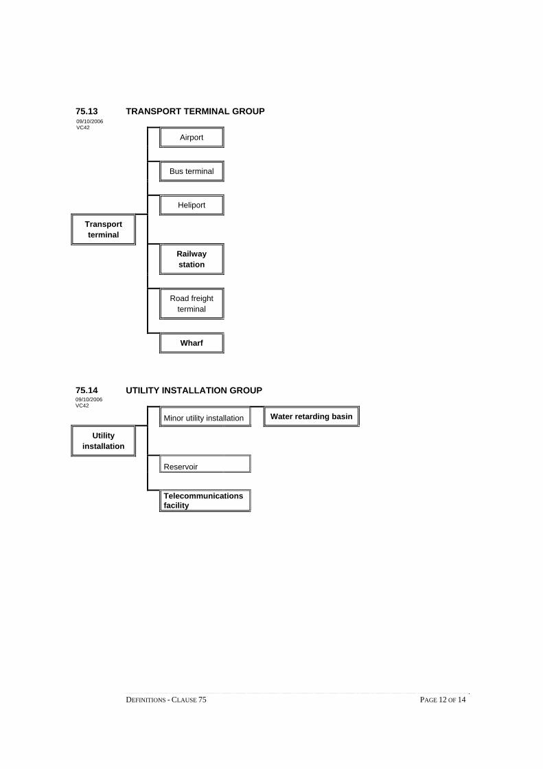
DEFINITIONS - CLAUSE 75 PAGE 12 OF 14
75.13 TRANSPORT TERMINAL GROUP
Airport
Bus terminal
Heliport
Transport terminal
Railway station
Road freight terminal
Wharf
75.14 UTILITY INSTALLATION GROUP
Minor utility installation Water retarding basin
Utility installation
Reservoir
Telecommunications facility
09/10/2006 VC42
09/10/2006 VC42

DEFINITIONS - CLAUSE 75 PAGE 13 OF 14
75.15 WAREHOUSE GROUP
Commercial display area
Liquid fuel depot
Fuel depot
Solid fuel depot
Mail centre
Warehouse Milk depot
Boat and caravan storage
Freezing and cool storage
Store
Rural store
Shipping container storage
Vehicle store
09/10/2006 VC42

DEFINITIONS - CLAUSE 75 PAGE 14 OF 14
75.16 LAND USE TERMS THAT ARE NOT NESTED
Art and craft centre
Brothel
Car park
Cemetery
Cinema based entertainment facility
Crematorium
Display home
Emergency services facility
Freeway service centre
Funeral parlour
Home occupation
Hospital
Natural systems
Research centre
Saleyard
Service station
Tramway
Veterinary centre
Wind energy facility
Winery
09/10/2006 VC42

IncorporatedDocuments


INCORPORATED DOCUMENTS – CLAUSE 80 PAGE 1 OF 1
80 INCORPORATED DOCUMENTS
This section sets out the documents which are incorporated in this scheme. 19/01/2006 VC37

INCORPORATED DOCUMENTS - CLAUSE 81 PAGE 1 OF 1
81 DOCUMENTS INCORPORATED IN THIS SCHEME
The documents listed in the table and in the schedule to Clause 81.01 are incorporateddocuments under section 6(2)(j) of the Planning and Environment Act 1987.
If a document is not included in the table or the schedule, it is not an incorporateddocument.
19/01/2006VC37

81.01 Table of documents incorporated in this scheme
Table to Clause 81.01
NAME OF DOCUMENT
Code of Practice for Timber Production 2007
Victorian Code for Cattle Feedlots, August 1995
Guidelines for Environmental Management - Septic Tanks Code of Practice, Publication 891, Environment Protection Authority, March 2003
Private Tennis Court Development Code of Practice – Revision 1, March 1999
Code of Practice for Fire Management on Public Land (Department of Sustainability and Environment, Revision No. 1 2006)
Code of Practice, Piggeries, Department of Planning and Housing and Department of Food and Agriculture, 1992
Building in bushfire-prone areas - CSIRO & Standards Australia (SAA HB36-1993), May 1993
Local Government Planning Guide for Dry Land Salinity - Department Conservation and Natural Resources, 1995
Construction Techniques for Sediment Pollution Control, Environment Protection Authority May 1991
Apiary Code of Practice, May 1997
A ‘Good Neighbour’ Code of Practice for a Circus or Carnival, October 1997
A Code of Practice for Telecommunications Facilities in Victoria, July 2004
Australian Standard AS/NZS 2890.1:2004, Parking Facilities - Off-street car parking, Standards Australia 2004
Australian Standard AS2890.2-1989, Off-street parking Part 2: Commercial vehicle facilities, Standards Australia 1989
Australian Standard AS2890.5-1993, Parking Facilities Part 5: On-street parking. Standards Australia 1993
Australian Standard AS2890.3-1993, Parking Facilities Part 3: Bicycle parking facilities, Standards Australia 1993
Pavement Design - A Guide to the Structural Design of Road Pavements, Austroads, (AP-17/92)
Guide to Traffic Engineering Practice, Part 6 - Roundabouts, Austroads, 1993 (AP-11.6/93)
Guide to Traffic Engineering Practice, Part 13 - Pedestrians, Austroads, 1995 (AP-11.13/95)
Guide to Traffic Engineering Practice, Part 14 - Bicycles, Austroads 1999 (AP-11.14/99)
Design Vehicles and Turning Path Templates, Austroads, 1995 (AP-34/95)
17/09/2007 VC45
INCORPORATED DOCUMENTS - CLAUSE 81.01 PAGE 1 OF 2

NAME OF DOCUMENT
Australian Rainfall and Run-off - A guide to flood estimation, Volume 1, The Institution of Engineers, Australia, Reprinted edition 2001
Australian/New Zealand Standard AS/NZS1158.1.1:1997, Road lighting, Part 1.1: Vehicular traffic (Category V) lighting – Performance and installation design requirements. Standards Australia/Standards New Zealand 1997
Australian/New Zealand Standard AS/NZS1158.3.1:1999, Road lighting, Part 3.1: Pedestrian Area (Category P) lighting – Performance and installation design requirements. Standards Australia/Standards New Zealand 1999
Guide to Residential Streets and Paths, Cement and Concrete Association of Australia, 2004 (C&CCA T51-2004)
Victorian Code for Broiler Farms, September 2001
Policy and Planning Guidelines for Development of Wind Energy Facilities in Victoria, 2003
Victoria’s Native Vegetation Management – A Framework for Action, August 2002
Activity Centres and Principal Public Transport Network Plan, 2003
Growth Area Framework Plans, Department of Sustainability and Environment, September 2006
INCORPORATED DOCUMENTS - CLAUSE 81.01 PAGE 2 OF 2

List ofAmendments
to theVictoria Planning
Provisions
This section lists the amendments whichhave been made to the Victoria PlanningProvisions.

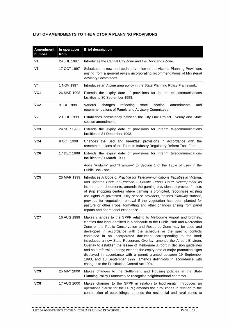
LIST OF AMENDMENTS TO THE VICTORIA PLANNING PROVISIONS PAGE 1 OF 6
LIST OF AMENDMENTS TO THE VICTORIA PLANNING PROVISIONS
Amendment
number
In operation
from
Brief description
V1 24 JUL 1997 Introduces the Capital City Zone and the Docklands Zone.
V3 17 OCT 1997 Substitutes a new and updated version of the Victoria Planning Provisionsarising from a general review incorporating recommendations of MinisterialAdvisory Committees.
V4 1 NOV 1997 Introduces an Alpine area policy in the State Planning Policy Framework.
VC1 26 MAR 1998 Extends the expiry date of provisions for interim telecommunicationsfacilities to 30 September 1998.
VC2 9 JUL 1998 Various changes reflecting state section amendments andrecommendations of Panels and Advisory Committees.
V2 23 JUL 1998 Establishes consistency between the City Link Project Overlay and Statesection amendments.
VC3 24 SEP 1998 Extends the expiry date of provisions for interim telecommunicationsfacilities to 31 December 1998.
VC4 8 OCT 1998 Changes the Bed and breakfast provisions in accordance with therecommendations of the Tourism Industry Regulatory Reform Task Force.
VC6 17 DEC 1998 Extends the expiry date of provisions for interim telecommunicationsfacilities to 31 March 1999.
Adds “Railway” and “Tramway” to Section 1 of the Table of uses in thePublic Use Zone.
VC5 25 MAR 1999 Introduces A Code of Practice for Telecommunications Facilities in Victoria,and updates Code of Practice – Private Tennis Court Development asincorporated documents, amends the gaming provisions to provide for listsof strip shopping centres where gaming is prohibited, recognises existinguse rights of privatised utility service providers, defines “Railway station”,provides for vegetation removal if the vegetation has been planted forpasture or other crops, formatting and other changes arising from panelreports and operational experience.
VC7 16 AUG 1999 Makes changes to the SPPF relating to Melbourne Airport and brothels;clarifies that land identified in a schedule to the Public Park and RecreationZone or the Public Conservation and Resource Zone may be used anddeveloped in accordance with the schedule or the specific controlscontained in an incorporated document corresponding to the land;introduces a new State Resources Overlay; amends the Airport EnvironsOverlay to establish the lessee of Melbourne Airport in decision guidelinesand as a referral authority; extends the expiry date of major promotion signsdisplayed in accordance with a permit granted between 19 September1993, and 18 September 1997; amends definitions in accordance withchanges to the Prostitution Control Act 1994.
VC9 25 MAY 2000 Makes changes to the Settlement and Housing policies in the StatePlanning Policy Framework to recognise neighbourhood character.
VC8 17 AUG 2000 Makes changes to the SPPF in relation to biodiversity; introduces anoperations clause for the LPPF; amends the rural zones in relation to theconstruction of outbuildings; amends the residential and rural zones to

LIST OF AMENDMENTS TO THE VICTORIA PLANNING PROVISIONS PAGE 2 OF 6
Amendment
number
In operation
from
Brief description
accommodate the keeping of pet racing dogs; amends the flooding zonesand overlays to require the incorporation of local floodplain developmentplans; amends subdivision and dwelling provisions in the RestructureOverlay; amends clause 52.01 to clarify its relationship with the SubdivisionAct 1988; amends clause 52.03 to enable the schedule to prohibit a use ordevelopment on specific sites; makes formatting and other changes arisingfrom panel reports and operational experience.
VC10 14 DEC 2000 Makes changes to the Table of uses in the Public Conservation andResource Zone relating to Utility installation and makes typographicalcorrections.
VC11 29 MAR 2001 Introduces ability to require permits for outbuildings larger than a specifiedsize in the Low Density Residential Zone; introduces ability to requirepermits for restaurants in specified areas in the Business 1 Zone; providesmore flexibility in the purpose of the Specific Sites and Exclusionsprovisions; simplifies the operation of the Advertising Signs provisions;reorganises and clarifies the Car Parking provisions; corrects the referralprovisions in Clause 66 relating to construction of building or works on landwithin 60 metres of a major electricity transmission line; introduces a newdefinition of Retirement village; and makes various formatting andtypographical corrections.
VC12 24 AUG 2001 Makes changes to the SPPF, LPPF, Zones, Overlays, Particular Provisions,Definitions and list of Incorporated documents based on the general reviewof residential development provisions and the recommendations of theResCode Advisory Committee. The changes include the introduction ofschedules to four residential zones, a Neighbourhood Character Overlay,new residential development provisions in Clauses 54, 55 and 56 fordwellings and subdivision, and transitional arrangements for subdivision,medium-density housing and residential buildings. Corrects aninconsistency between Amendment S74 and the VPP in relation to publicopen space contributions in subdivision. Clarifies the definition of Tradesupplies.
VC13 27 SEP 2001 Introduces Victorian Code for Broiler Farms as an incorporated document;amends the SPPF and the Rural Zone and introduces a new Particularprovision and definition relating to broiler farm; amends the Advertisingsigns provisions relating to major promotion signs, business logos andstreet numbers; includes domestic rainwater tanks as exempt buildings andworks except in the Heritage Overlay; updates references in theEnvironmental Audit Overlay to amended sections of the Environment
Protection Act 1970, following amendments to that Act; makes correctionsto the Residential 1 Zone and Business 1 Zone; and updates the UserGuide.
VC14 22 NOV 2001 Makes corrections to the Residential 1 Zone, Clause 54.04 and Clause55.04.
VC16 8 OCT 2002 Restructures Clauses 11, 12 and 13 of the State Planning PolicyFramework and amends zone maps of 17 Melbourne metropolitan fringeplanning schemes to introduce an Urban Growth Boundary and a legenddesignation for land outside the Urban Growth Boundary; introduces arenewable energy policy in Clause 15 of the SPPF; introduces a newParticular provision and Land use term for Wind energy facility; includesWind energy facility in the Table of uses in the Public Conservation andResource Zone; includes a temporary anemometer in the list of buildingsand works not requiring a permit; makes the Minister for Planning the

LIST OF AMENDMENTS TO THE VICTORIA PLANNING PROVISIONS PAGE 3 OF 6
Amendment
number
In operation
from
Brief description
responsible authority in planning schemes for considering Wind energyfacilities with a capacity greater than 30 megawatts; and introduces Policyand Planning Guidelines for Development of Wind Energy Facilities inVictoria, 2002 as an incorporated document in planning schemes; amendsClause 18 of the SPPF to require the design of transport routes to providefor grade separation at railways.
VC15 31 OCT 2002 Updates reference to tourism guidelines in SPPF; clarifies the nature of“school” in the SPPF and Clause 56.07 and in conditions opposite varioususes in the industrial and business zones; introduces a new Particularprovision and Land use term for Shipping container storage; includesShipping container storage in the Table of uses in the Industrial 1, Business3 and Business 4 Zones; exempts outdoor swimming pools associated withdwellings from permit requirements in the Design and Development Overlayand Neighbourhood Character Overlay; exempts removal of nativevegetation from permit requirements in the Heritage Overlay and PublicAcquisition Overlay if it presents an immediate risk of injury or damage;amends Clause 52.01 to establish consistency with the Subdivision Act
1988 and to clarify the Class 1 exemption for subdivision of residentialbuildings; extends the expiry date in Clause 52.04-3 for transitionalarrangements for residential development; amends Standard C21 in Clause56.06-4 to facilitate the use of building envelopes on lots in newsubdivisions; amends definitions of Wall height, Materials recycling andStore; and makes minor format changes.
VC17 24 DEC 2002 Provides permit exemption in the Public Acquisition Overlay for proposalsthat are consistent with the purpose for which the land was or is to beacquired; and provides permit exemptions and introduces an incorporateddocument for 3 Rail Infrastructure Projects (Rail Gauge StandardisationProject, Regional Fast Rail Project and Fibre Optic Project) in 23 planningschemes.
VC18 13 JUN 2003 Introduces Core Planning Provisions for Metropolitan green wedge land inClause 57 of the Particular provisions.
VC19 24 JUL 2003 Makes changes to the SPPF and various Overlays and Particular provisionsrelating to Government policies and strategies on native vegetationmanagement, coastal planning and management, highway managementand Development Contributions Plans; introduces a Particular provision forsatellite dishes; makes high rise residential development in residentialzones subject to car parking requirements in Clause 52.06; provides permitexemptions for direction signs to emergency facilities at hospitals andbuildings and works associated with a Dependent person’s unit; clarifiesthat permit exemption for subdivision applies to an authority acquiring landrather than generally to an acquiring authority; amends the definition ofShop to clarify that it includes the sale of bread and other products bakedon the premises; updates references to Ministers, Government departmentsand agencies; updates references to legislation and incorporateddocuments; and makes various formatting and typographical corrections.
VC21 9 OCT 2003 Corrects Clause 52.05-9 to restore provisions relating to High-wall signsdeleted in Amendment VC19.
VC22 24 NOV 2003 Introduces the Green Wedge Zone and the Rural Conservation Zone in theVPP and amends Clause 57 of 17 planning schemes.
VC20 11 DEC 2003 Makes changes to Clause 45.07 – City Link Project Overlay and updates

LIST OF AMENDMENTS TO THE VICTORIA PLANNING PROVISIONS PAGE 4 OF 6
Amendment
number
In operation
from
Brief description
the incorporated document within Clause 81.
VC23 19 MAY 2004 Introduces the Green Wedge A Zone and amends the Green Wedge Zoneand Rural Conservation Zone in the VPP and applies those zones, whereappropriate, to Metropolitan green wedge land in 16 planning schemes; andamends Clause 57 in the VPP and 17 planning schemes.
VC24 11 JUN 2004 Introduces the Farming Zone and Rural Activity Zone in the VPP andamends Clause 17.05 in the SPPF, the Low Density Residential Zone andthe Rural Living Zone.
VC25 1 JUL 2004 Removes reference to 4 Star energy rating in Standard B10, Clause 55.03-5 to ensure consistency between the VPP and the 5 Star energy rating inthe Building Regulations.
VC26 26 AUG 2004 Makes changes to the SPPF to implement recommendations of the LiveMusic Task Force; removes anomalies that allow dwellings to beconstructed or extended on common property and existing dwellings to beinternally altered and converted to multiple dwellings without permits;updates references to current transport legislation; makes corrections to theAdvertising sign provisions; amends the list of incorporated documents torefer to updated documents; restructures the list of incorporated documentsin Clause 81 and the Schedule to Clause 81.
V5 3 SEP 2004 Introduces the Priority Development Zone.
VC27 9 SEP 2004 Establishes all referral and notice requirements in Clause 66 and schedulesto Clause 66.
VC28 6 OCT 2004 Introduces a Particular provision, Clause 52.34, for Bicycle facilities.
VC29 4 NOV 2004 Makes a change to Clause 52.17 to clarify that the exemption from the needfor a planning permit for the removal, destruction or lopping of nativevegetation for farm structures does not include the establishment oroperation of a central pivot irrigation system.
VC31 25 NOV 2004 Introduces a new Residential 3 Zone; introduces a new Particular provisionand amends Clause 19 to require an urban context report and designresponse for residential development of four (4) or more storeys; includes areference to Design Guidelines for Higher Density Residential Development
in Clause 19; and amends the ResCode provisions at Clauses 54.03-2 and55.03-2 to give effect to residential height provisions.
VC32 23 DEC 2004 Makes changes to Clause 15.08 of the SPPF to refer to the land use anddevelopment polices expressed in the Great Ocean Road Region – A Land
Use and Transport Strategy.
VC33 1 SEP 2005 Removes the requirement for a Clause 54 assessment for Heritage Overlayapplications in a residential zone.
VC34 22 SEP 2005 Introduces a new Clause 12 with consequential changes to other clauses inthe SPPF, including Clauses 14, 15, 17, 18 & 19; includes reference toAlpine Resorts 2020 Strategy in Clause 15.13 and Activity Centre Design
Guidelines and Safer Design Guidelines in Clause 19.03-3; amendssubdivision requirements in Clauses 35.04, 35.05, 35.06; makes changes toprovisions in Clause 35.06 and Clause 57.01 regarding Wind energyfacilities; amends advertising sign controls along railway corridors in Clause36.01-7; amends Clauses 43.05-3, 55 & 56 to refer to the Residential 3Zone; amends Clause 44.05 to broaden the range of minor buildings andworks that do not require a permit; amends Clauses 44.01, 44.02, 44.03,

LIST OF AMENDMENTS TO THE VICTORIA PLANNING PROVISIONS PAGE 5 OF 6
Amendment
number
In operation
from
Brief description
44.04, 44.05, 45.01, 45.02 and 45.05 to introduce exemptions from noticeand review for permit applications; Clarifies requirements for extractiveindustry and private tennis courts in Clauses 52.09, 52.21 and 66.05;introduces definition for Metropolitan Melbourne in Clause 72; introduces a“Tramway” definition and deletes reference to “lightrail”; introduces a newincorporated document, Activity Centres and Principal Public Transport
Network Plan, 2003 in Clause 81.
VC35 15 DEC 2005 Includes a reference to the Planning Guidelines for Land Based
Aquaculture in Victoria in Clause 17; makes Education centre a prohibiteduse in green wedge areas; includes Emergency services facility as aSection 2 use in Clauses 35.06 and 35.07; makes Business identificationsigns permissible for private land owners in Clause 45.07; removes theneed to consider operational guidelines in Clause 52.17; amends the re-subdivision requirements in Clause 57.01-2; introduces an “Emergencyservices facility” definition.
VC36 22 DEC 2005 Amends Clause 62 to provide exemption from planning schemerequirements for events on public land.
VC37 19 JAN 2006 Amends the format of the Victoria Planning Provisions and all planningschemes to facilitate the ZAPP electronic amendment administrationsystem.
VC38 16 MAR 2006 Makes changes to Clauses 15.09, 52.17, 66.02 and 72 to provide for a newapproach to native vegetation management.
VC40 30 AUG 2006 Makes changes to the Clauses 32.01, 32.02, 32.04, 32.05, 32.06, 34.01,34.02, 34.03, 34.04, 34.05, 43.01, 44.02, 62, and 72 to exempt variousminor works from requiring a planning permit.
VC41 1 SEP 2006 Amends the metropolitan growth areas strategies in Clause 12 of the SPPFby introducing the Growth Area Framework Plans as an incorporateddocument.
VC42 9 OCT 2006 Introduces the Sustainable Neighbourhoods Provisions for residentialsubdivision, including changes to Clauses 19, 55.03 and 56 to 56.09;Introduces new transitional arrangements for subdivision at Clause 56.10;modifies subdivision application requirements in the residential zones;applies Clause 56 provisions as subdivision application requirements to theComprehensive Development Zone, Priority Development Zone,Incorporated Plan Overlay and Development Plan Overlay; Amend thecoastal areas policies in Clause 15.08 to give effect to the land use anddevelopment strategies of the Victorian Coastal Strategy 2002; Makeschanges to the VPP to provide for geothermal energy extraction in Clauses35.06, 35.07, 35.08, 42.01, 42.02, 42.03, 44.01, 44.02, 52.08, 52.17, 62,66, 74 and 75; Amends Clause 52.29 to introduce a decision guideline forroad network safety and efficiency regarding access to adjoining propertiesto respond to the Road Management Act 2004; Introduces a new ParticularProvision - Clause 52.36 that includes the Director of Public Transport as areferral authority; and Makes other administrative changes, updates andcorrections to the VPP.
VC39 18 OCT 2006 Amends the provisions relating to gaming in clauses 19.02, 52.28 and 72 toimplement Government policy and to accord with the Gambling RegulationAct 2003.
VC43 31 OCT 2006 Introduces provisions for the further protection of green wedges in Clauses35.04, 35.05 and 35.06; and clarifies the term ‘in conjunction with’ in Clause

LIST OF AMENDMENTS TO THE VICTORIA PLANNING PROVISIONS PAGE 6 OF 6
Amendment
number
In operation
from
Brief description
64. Amends SPPF Clauses 12 and 16 to introduce state-wide affordablehousing policies and makes other administrative corrections to the VPP andvarious planning schemes.
VC44 14 NOV 2006 Introduces additional exemptions in Clause 52.17 for the removal of nativevegetation near buildings used for Accommodation to manage risks to lifeand property from wildfire.
VC30 14 MAY 2007 Introduces the Melbourne Airport Environs Overlay (MAEO); amendsClause 18 to update reference to the Australian Noise Exposure Forecast
(ANEF) and relevant reference documents; removes the referralrequirements under the Schedule to Clause 45.02 and provides in Clause66.05 for notice of permit applications to be given to the airport lessee ofMelbourne airport.
VC45 17 SEP 2007 Amends Clauses 12, 15, 17, 19, 35.04, 35.05, 43.01, 52.09, 52.17, 52.18,52.32 & 57 to give effect to the operation of the Aboriginal Heritage Act2006; amends the schedule to Clause 61.01 to refer to Division 1A of Part4 of the Act; deletes reference to ‘local provisions page header’ in Clause61.03; updates reference to the Development Contribution Guidelines inClause 18.12; corrects reference to the Victorian Commission for GamblingRegulation in Clause 52.28; includes the document relating to RailInfrastructure Projects in Clause 81.01 of the Ballarat, Greater Geelongand Wyndham planning schemes; updates reference to the amendedMineral Resources (Sustainable Development) Act 1990 in Clauses 17,42.01, 42.02, 42.03, 44.01, 44.02, 52.08, 52.17 and 66.02; updates list ofreference documents relating to soil contamination under Clause 15.06;amends the definition for Restricted retail premises in Clause 74;introduces a new purpose in the Rural Activity Zone, which provides for aspecific purpose to be included in a schedule to the zone and amends theschedules in the Mansfield & Bass Coast Planning Schemes to includenew purpose statements; amends Clause 52.04 (satellite dish) to includereference to the R3Z; amends Clauses 17.07, 52.18 & 81.01 to reflect theupdated Timber Code; makes Veterinary centre a Section 2 use in theFarming Zone; includes new provisions for electronic billboard signage toClause 52.05, including making VicRoads a referral authority under Clause66.03 and a new definition in Clause 73; extending the expiry date formajor promotion signage from 18/09/07 to 18/09/08 under Clause 52.05;and makes other administrative changes, other minor updates andcorrections to the VPP and planning schemes.