natural hazard risk register - mckinlay.qld.gov.au
TRANSCRIPT
Annexure E – Natural Hazard Risk Register
Natural Hazard Risk Register Table 1: Natural Hazard Risk Register
Risk Descriptor – details the main component and provides an example of a risk(s) that may be attributable
What are the risks?
For each impact category, what are the immediate impacts, and what are the strategic impacts?
Are any locations more at risk than others?
Existing Controls
What are we doing to avoid the risk or reduce its effect?
What controls are in place to prevent or prepare for the event?
What controls are in place to respond to and recover from an event?
Current Risk Rating
Considering adequacy of
controls
Potentiial Risk Reduction Measures
What opportunities do we have to develop controls, or improve the effectiveness of existing controls, to further
reduce risk?
Comments
Description
Ad
equ
acy
/
Eff
ecti
ven
ess
Co
nse
qu
ence
Lik
elih
oo
d
Ris
k
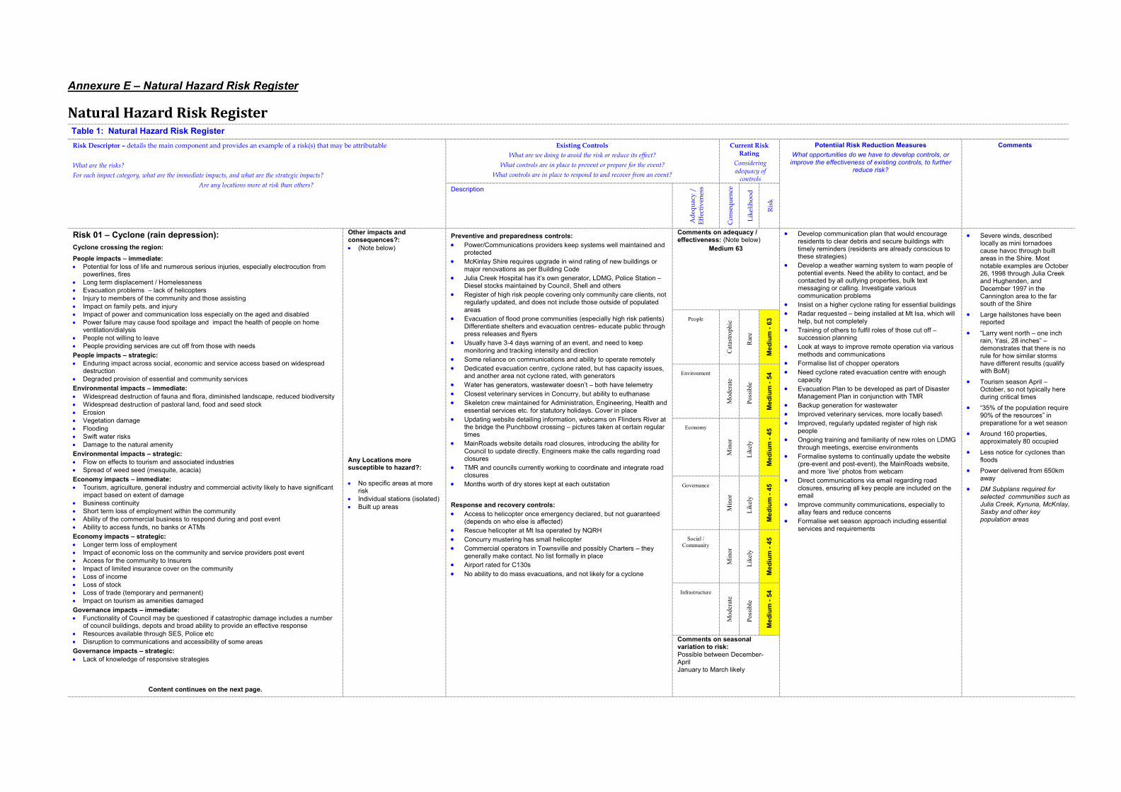
Risk 01 – Cyclone (rain depression):
Cyclone crossing the region:
People impacts – immediate:
� Potential for loss of life and numerous serious injuries, especially electrocution from powerlines, fires
� Long term displacement / Homelessness
� Evacuation problems – lack of helicopters
� Injury to members of the community and those assisting
� Impact on family pets, and injury
� Impact of power and communication loss especially on the aged and disabled
� Power failure may cause food spoilage and impact the health of people on home ventilation/dialysis
� People not willing to leave
� People providing services are cut off from those with needs
People impacts – strategic:
� Enduring impact across social, economic and service access based on widespread destruction
� Degraded provision of essential and community services
Environmental impacts – immediate:
� Widespread destruction of fauna and flora, diminished landscape, reduced biodiversity
� Widespread destruction of pastoral land, food and seed stock
� Erosion
� Vegetation damage
� Flooding
� Swift water risks
� Damage to the natural amenity
Environmental impacts – strategic:
� Flow on effects to tourism and associated industries
� Spread of weed seed (mesquite, acacia)
Economy impacts – immediate:
� Tourism, agriculture, general industry and commercial activity likely to have significant impact based on extent of damage
� Business continuity
� Short term loss of employment within the community
� Ability of the commercial business to respond during and post event
� Ability to access funds, no banks or ATMs
Economy impacts – strategic:
� Longer term loss of employment
� Impact of economic loss on the community and service providers post event
� Access for the community to Insurers
� Impact of limited insurance cover on the community
� Loss of income
� Loss of stock
� Loss of trade (temporary and permanent)
� Impact on tourism as amenities damaged
Governance impacts – immediate:
� Functionality of Council may be questioned if catastrophic damage includes a number of council buildings, depots and broad ability to provide an effective response
� Resources available through SES, Police etc
� Disruption to communications and accessibility of some areas
Governance impacts – strategic:
� Lack of knowledge of responsive strategies
Content continues on the next page.
Other impacts and consequences?:
� (Note below)
Any Locations more susceptible to hazard?:
� No specific areas at more risk
� Individual stations (isolated)
� Built up areas
Preventive and preparedness controls:
� Power/Communications providers keep systems well maintained and protected
� McKinlay Shire requires upgrade in wind rating of new buildings or major renovations as per Building Code
� Julia Creek Hospital has it’s own generator, LDMG, Police Station – Diesel stocks maintained by Council, Shell and others
� Register of high risk people covering only community care clients, not regularly updated, and does not include those outside of populated areas
� Evacuation of flood prone communities (especially high risk patients) Differentiate shelters and evacuation centres- educate public through press releases and flyers
� Usually have 3-4 days warning of an event, and need to keep monitoring and tracking intensity and direction
� Some reliance on communications and ability to operate remotely
� Dedicated evacuation centre, cyclone rated, but has capacity issues, and another area not cyclone rated, with generators
� Water has generators, wastewater doesn’t – both have telemetry
� Closest veterinary services in Concurry, but ability to euthanase
� Skeleton crew maintained for Administration, Engineering, Health and essential services etc. for statutory holidays. Cover in place
� Updating website detailing information, webcams on Flinders River at the bridge the Punchbowl crossing – pictures taken at certain regular times
� MainRoads website details road closures, introducing the ability for Council to update directly. Engineers make the calls regarding road closures
� TMR and councils currently working to coordinate and integrate road closures
� Months worth of dry stores kept at each outstation
Response and recovery controls:
� Access to helicopter once emergency declared, but not guaranteed (depends on who else is affected)
� Rescue helicopter at Mt Isa operated by NQRH
� Concurry mustering has small helicopter
� Commercial operators in Townsville and possibly Charters – they generally make contact. No list formally in place
� Airport rated for C130s
� No ability to do mass evacuations, and not likely for a cyclone
Comments on adequacy / effectiveness: (Note below)
Medium 63
� Develop communication plan that would encourage residents to clear debris and secure buildings with timely reminders (residents are already conscious to these strategies)
� Develop a weather warning system to warn people of potential events. Need the ability to contact, and be contacted by all outlying properties, bulk text messaging or calling. Investigate various communication problems
� Insist on a higher cyclone rating for essential buildings
� Radar requested – being installed at Mt Isa, which will help, but not completely
� Training of others to fulfil roles of those cut off – succession planning
� Look at ways to improve remote operation via various methods and communications
� Formalise list of chopper operators
� Need cyclone rated evacuation centre with enough capacity
� Evacuation Plan to be developed as part of Disaster Management Plan in conjunction with TMR
� Backup generation for wastewater
� Improved veterinary services, more locally based\
� Improved, regularly updated register of high risk people
� Ongoing training and familiarity of new roles on LDMG through meetings, exercise environments
� Formalise systems to continually update the website (pre-event and post-event), the MainRoads website, and more ‘live’ photos from webcam
� Direct communications via email regarding road closures, ensuring all key people are included on the email
� Improve community communications, especially to allay fears and reduce concerns
� Formalise wet season approach including essential services and requirements
� Severe winds, described locally as mini tornadoes cause havoc through built areas in the Shire. Most notable examples are October 26, 1998 through Julia Creek and Hughenden, and December 1997 in the Cannington area to the far south of the Shire
� Large hailstones have been reported
� “Larry went north – one inch rain, Yasi, 28 inches” – demonstrates that there is no rule for how similar storms have different results (qualify with BoM)
� Tourism season April – October, so not typically here during critical times
� “35% of the population require 90% of the resources” in preparatione for a wet season
� Around 160 properties, approximately 80 occupied
� Less notice for cyclones than floods
� Power delivered from 650km away
� DM Subplans required for selected communities such as Julia Creek, Kynuna, McKnlay, Saxby and other key population areas
People
Cat
astr
op
hic
Rar
e
Me
diu
m -
63
Environment
Moder
ate
Poss
ible
Me
diu
m -
54
Economy
Min
or
Lik
ely
Me
diu
m -
45
Governance
Min
or
Lik
ely
Me
diu
m -
45
Social /
Community
Min
or
Lik
ely
Me
diu
m -
45
Infrastructure
Moder
ate
Poss
ible
Me
diu
m -
54
Comments on seasonal variation to risk:Possible between December-April January to March likely
Table 1: Natural Hazard Risk Register
Risk Descriptor – details the main component and provides an example of a risk(s) that may be attributable
What are the risks?
For each impact category, what are the immediate impacts, and what are the strategic impacts?
Are any locations more at risk than others?
Existing Controls
What are we doing to avoid the risk or reduce its effect?
What controls are in place to prevent or prepare for the event?
What controls are in place to respond to and recover from an event?
Current Risk Rating
Considering adequacy of
controls
Potentiial Risk Reduction Measures
What opportunities do we have to develop controls, or
improve the effectiveness of existing controls, to further reduce risk?
Comments
Description
Ad
equ
acy
/
Eff
ecti
ven
ess
Co
nse
qu
ence
Lik
elih
oo
d
Ris
k
Risk 01 – Cyclone (rain depression): (cont.)
Social / Community impacts – immediate:
� Ability of health/hospital systems to cope with emergency situations
� Psychological factors on community scale
� Community services not functioning
� Panic/concern amongst the community, loss of confidence and trust
� Domestic violence
� Alcohol abuse
� Theft and presence of looters
� Inappropriate actions of tourists and sightseers
� Loss of services Social / Community impacts – strategic:
� Impact of limited insurance cover on the community
� Lack of preparedness of the community
� Health of the community
Infrastructure impacts – immediate:
� Building damages- Total destruction
� Infrastructure damaged or destroyed by fires
� Power infrastructure- major destruction,
� Impact on ability to provide telecommunications
� Impact on ability to provide potable water
� Roads blocked/homes damaged - vegetation
� Airports
� Requirements for emergency accommodation
� Impact of falling power lines and poles
� Ability of the utility services to function
� Impact of structural damage
Infrastructure impacts – strategic:
� Long term loss of services and recovery time
�
�
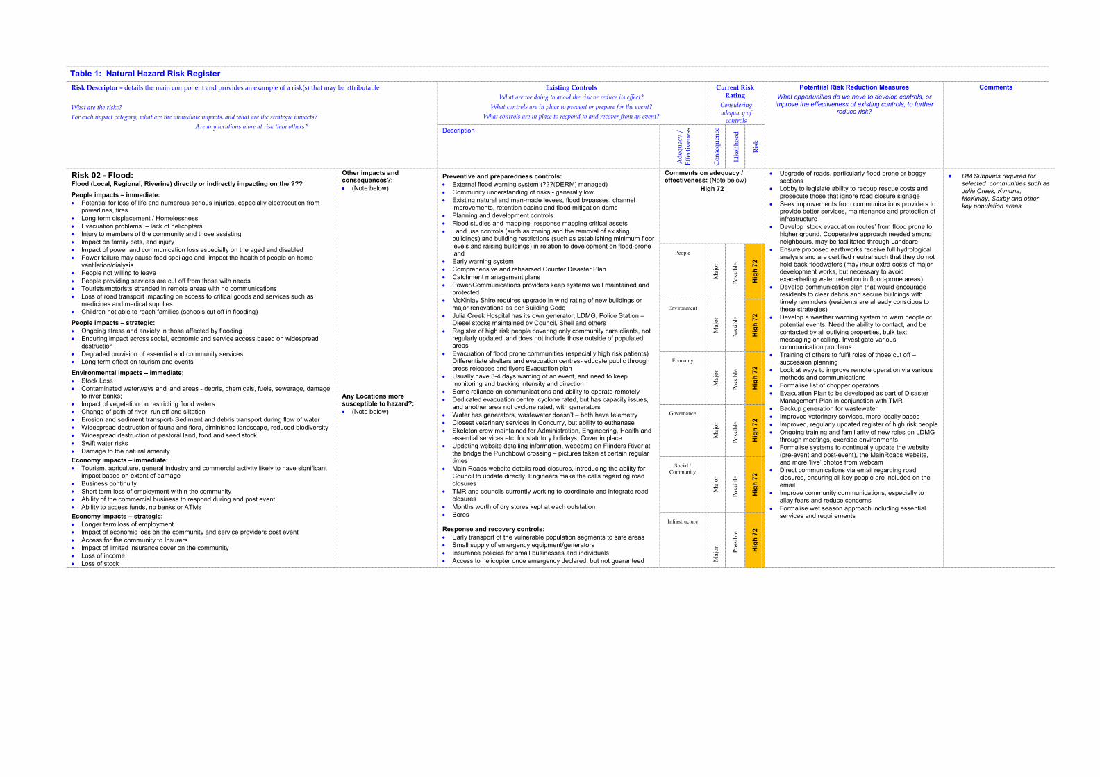
Table 1: Natural Hazard Risk Register
Risk Descriptor – details the main component and provides an example of a risk(s) that may be attributable
What are the risks?
For each impact category, what are the immediate impacts, and what are the strategic impacts?
Are any locations more at risk than others?
Existing Controls
What are we doing to avoid the risk or reduce its effect?
What controls are in place to prevent or prepare for the event?
What controls are in place to respond to and recover from an event?
Current Risk Rating
Considering adequacy of
controls
Potentiial Risk Reduction Measures
What opportunities do we have to develop controls, or improve the effectiveness of existing controls, to further
reduce risk?
Comments
Description
Ad
equ
acy
/
Eff
ecti
ven
ess
Co
nse
qu
ence
Lik
elih
oo
d
Ris
k
Risk 02 - Flood: Flood (Local, Regional, Riverine) directly or indirectly impacting on the ???
People impacts – immediate:
� Potential for loss of life and numerous serious injuries, especially electrocution from powerlines, fires
� Long term displacement / Homelessness
� Evacuation problems – lack of helicopters
� Injury to members of the community and those assisting
� Impact on family pets, and injury
� Impact of power and communication loss especially on the aged and disabled
� Power failure may cause food spoilage and impact the health of people on home ventilation/dialysis
� People not willing to leave
� People providing services are cut off from those with needs
� Tourists/motorists stranded in remote areas with no communications
� Loss of road transport impacting on access to critical goods and services such as medicines and medical supplies
� Children not able to reach families (schools cut off in flooding)
People impacts – strategic:
� Ongoing stress and anxiety in those affected by flooding
� Enduring impact across social, economic and service access based on widespread destruction
� Degraded provision of essential and community services
� Long term effect on tourism and events
Environmental impacts – immediate:
� Stock Loss
� Contaminated waterways and land areas - debris, chemicals, fuels, sewerage, damage to river banks;
� Impact of vegetation on restricting flood waters
� Change of path of river run off and siltation
� Erosion and sediment transport- Sediment and debris transport during flow of water
� Widespread destruction of fauna and flora, diminished landscape, reduced biodiversity
� Widespread destruction of pastoral land, food and seed stock
� Swift water risks
� Damage to the natural amenity
Economy impacts – immediate:
� Tourism, agriculture, general industry and commercial activity likely to have significant impact based on extent of damage
� Business continuity
� Short term loss of employment within the community
� Ability of the commercial business to respond during and post event
� Ability to access funds, no banks or ATMs
Economy impacts – strategic:
� Longer term loss of employment
� Impact of economic loss on the community and service providers post event
� Access for the community to Insurers
� Impact of limited insurance cover on the community
� Loss of income
� Loss of stock
Other impacts and consequences?:
� (Note below)
Any Locations more susceptible to hazard?:
� (Note below)
Preventive and preparedness controls:
� External flood warning system (???(DERM) managed)
� Community understanding of risks - generally low.
� Existing natural and man-made levees, flood bypasses, channel improvements, retention basins and flood mitigation dams
� Planning and development controls
� Flood studies and mapping- response mapping critical assets
� Land use controls (such as zoning and the removal of existing buildings) and building restrictions (such as establishing minimum floor levels and raising buildings) in relation to development on flood-prone land
� Early warning system
� Comprehensive and rehearsed Counter Disaster Plan
� Catchment management plans
� Power/Communications providers keep systems well maintained and protected
� McKinlay Shire requires upgrade in wind rating of new buildings or major renovations as per Building Code
� Julia Creek Hospital has its own generator, LDMG, Police Station – Diesel stocks maintained by Council, Shell and others
� Register of high risk people covering only community care clients, not regularly updated, and does not include those outside of populated areas
� Evacuation of flood prone communities (especially high risk patients) Differentiate shelters and evacuation centres- educate public through press releases and flyers Evacuation plan
� Usually have 3-4 days warning of an event, and need to keep monitoring and tracking intensity and direction
� Some reliance on communications and ability to operate remotely
� Dedicated evacuation centre, cyclone rated, but has capacity issues, and another area not cyclone rated, with generators
� Water has generators, wastewater doesn’t – both have telemetry
� Closest veterinary services in Concurry, but ability to euthanase
� Skeleton crew maintained for Administration, Engineering, Health and essential services etc. for statutory holidays. Cover in place
� Updating website detailing information, webcams on Flinders River at the bridge the Punchbowl crossing – pictures taken at certain regular times
� Main Roads website details road closures, introducing the ability for Council to update directly. Engineers make the calls regarding road closures
� TMR and councils currently working to coordinate and integrate road closures
� Months worth of dry stores kept at each outstation
� Bores
Response and recovery controls:
� Early transport of the vulnerable population segments to safe areas
� Small supply of emergency equipment/generators
� Insurance policies for small businesses and individuals
� Access to helicopter once emergency declared, but not guaranteed
Comments on adequacy / effectiveness: (Note below)
High 72
� Upgrade of roads, particularly flood prone or boggy sections
� Lobby to legislate ability to recoup rescue costs and prosecute those that ignore road closure signage
� Seek improvements from communications providers to provide better services, maintenance and protection of infrastructure
� Develop ‘stock evacuation routes’ from flood prone to higher ground. Cooperative approach needed among neighbours, may be facilitated through Landcare
� Ensure proposed earthworks receive full hydrological analysis and are certified neutral such that they do not hold back floodwaters (may incur extra costs of major development works, but necessary to avoid exacerbating water retention in flood-prone areas)
� Develop communication plan that would encourage residents to clear debris and secure buildings with timely reminders (residents are already conscious to these strategies)
� Develop a weather warning system to warn people of potential events. Need the ability to contact, and be contacted by all outlying properties, bulk text messaging or calling. Investigate various communication problems
� Training of others to fulfil roles of those cut off – succession planning
� Look at ways to improve remote operation via various methods and communications
� Formalise list of chopper operators
� Evacuation Plan to be developed as part of Disaster Management Plan in conjunction with TMR
� Backup generation for wastewater
� Improved veterinary services, more locally based
� Improved, regularly updated register of high risk people
� Ongoing training and familiarity of new roles on LDMG through meetings, exercise environments
� Formalise systems to continually update the website (pre-event and post-event), the MainRoads website, and more ‘live’ photos from webcam
� Direct communications via email regarding road closures, ensuring all key people are included on the email
� Improve community communications, especially to allay fears and reduce concerns
� Formalise wet season approach including essential services and requirements
� DM Subplans required for selected communities such as Julia Creek, Kynuna, McKinlay, Saxby and other key population areas
People
Maj
or
Poss
ible
Hig
h 7
2
Environment
Maj
or
Poss
ible
Hig
h 7
2
Economy
Maj
or
Poss
ible
Hig
h 7
2
Governance
Maj
or
Poss
ible
Hig
h 7
2
Social /
Community
Maj
or
Poss
ible
Hig
h 7
2
Infrastructure
Maj
or
Poss
ible
Hig
h 7
2
Table 1: Natural Hazard Risk Register
Risk Descriptor – details the main component and provides an example of a risk(s) that may be attributable
What are the risks?
For each impact category, what are the immediate impacts, and what are the strategic impacts?
Are any locations more at risk than others?
Existing Controls
What are we doing to avoid the risk or reduce its effect?
What controls are in place to prevent or prepare for the event?
What controls are in place to respond to and recover from an event?
Current Risk Rating
Considering adequacy of
controls
Potentiial Risk Reduction Measures
What opportunities do we have to develop controls, or improve the effectiveness of existing controls, to further
reduce risk?
Comments
Description
Ad
equ
acy
/
Eff
ecti
ven
ess
Co
nse
qu
ence
Lik
elih
oo
d
Ris
k
� Loss of trade (temporary and permanent)
� Impact on tourism as amenities damaged
Governance impacts – immediate:
� Functionality of Council may be questioned if catastrophic damage includes a number of council buildings, depots and broad ability to provide an effective response
� Resources available through SES, Police etc
� Disruption to communications and accessibility of some areas
Governance impacts – strategic:
� Lack of knowledge of responsive strategies
Social / Community impacts – immediate:
� Ability of health/hospital systems to cope with emergency situations
� Psychological factors on community scale
� Community services not functioning
� Panic/concern amongst the community, loss of confidence and trust
� Domestic violence
� Alcohol abuse
� Theft and presence of looters
� Inappropriate actions of tourists and sightseers
� Loss of services Social / Community impacts – strategic:
� Impact of limited insurance cover on the community
� Lack of preparedness of the community
� Health of the community
Infrastructure impacts – immediate:
� Substation disabled in Q100 event
� Physical damage to critical Infrastructure including buildings, power transmission, roads, railways, public transport networks, industrial areas
� Highway cut off
� Sewer Pump stations (secondary issue) can take a day or so to get up after event
� Building damage
� Impact on ability to provide telecommunications
� Impact on ability to provide potable water
� Roads blocked/homes damaged - vegetation
� Requirements for emergency accommodation
� Impact of falling power lines and poles
� Ability of the utility services to function
� Impact of structural damage Infrastructure impacts – strategic:
� Long term loss of services and recovery time
� Medium term strain on accommodation for affected people
(depends on who else is affected)
� Rescue helicopter at Mt Isa operated by NQRH
� Concurry mustering has small helicopter
� Commercial operators in Townsville and possibly Charters – they generally make contact. No list formally in place
� Airport rated for C130s
� No ability to do mass evacuations, and not likely for a cyclone
Comments on seasonal variation to risk: (Note below)

Table 1: Natural Hazard Risk Register
Risk Descriptor – details the main component and provides an example of a risk(s) that may be attributable
What are the risks?
For each impact category, what are the immediate impacts, and what are the strategic impacts?
Are any locations more at risk than others?
Existing Controls
What are we doing to avoid the risk or reduce its effect?
What controls are in place to prevent or prepare for the event?
What controls are in place to respond to and recover from an event?
Current Risk Rating
Considering adequacy of
controls
Potentiial Risk Reduction Measures
What opportunities do we have to develop controls, or improve the effectiveness of existing controls, to further
reduce risk?
Comments
Description
Ad
equ
acy
/
Eff
ecti
ven
ess
Co
nse
qu
ence
Lik
elih
oo
d
Ris
k
Risk 03 - Extreme Temperatures (>36 degrees, >2 days):
A prolonged period of excessive heat resulting in a significant increase in mortality
rates, degraded infrastructure assurance and health system pressures.
People impacts – immediate:
� Potential for multiple fatalities and serious sickness depending on duration of the heat event especially young and elderly
People impacts – strategic:
� Enduring social and emotional impacts on mental health
� Willingness to remain in area
Environmental impacts – immediate:
� Isolated impact on stock flora and fauna if acute shortage of above ground water (for stock) and extreme temperatures persist
Environmental impacts – strategic:
� None
Economy impacts – immediate:
� Immediate costs of damage to Infrastructure such as power transmission network overloads, melting roads etc
� Impact on small business if population decreases normal social and economic activity
� Damage to dependent essential services including energy, water treatment and supply, sewerage, telecommunications, food supply, medical services etc
Economy impacts – strategic:
� Long term effects of above, costs of repair
Governance impacts – immediate:
� Potential for some loss of confidence in Council preparation and response strategies
� Disruption to communications may impede governance activities in the short term
Governance impacts – strategic:
� Potential for positive impact if increased awareness and preparedness activities undertaken by the community
� Enhance profile of Emergency Services, LDMG and volunteer organisations
Social / Community impacts – immediate:
� Immediate impacts from loss of family/friends lives, degradation in community services and provision of health services
� Disruption to normal social activities (sporting events, markets, community celebrations etc)
� Disruption of access to community facilities (clubs, libraries, halls, open spaces) if closed due to power outages etc
Social / Community impacts – strategic:
� Residual collective mental health and social issues if numerous fatalities
� Potential positive impact through increased connectivity between community members from adversity and experiences
Infrastructure impacts – immediate:
� First order damage to critical and key infrastructure throughout the region
� Potential for second order effects of adjacent regions and infrastructure (eg. Flinders Highway damaged or closed, airport closed etc)
� Buckled railway lines affecting rail transport and increasing possibility of derailment
� Water usage increased
� Dependency on service providers to reduce impact on energy, water, telecommunications, transport infrastructure
Infrastructure impacts – strategic:
� Longer term recovery strategies required to guide priorities, capital expenditure etc
� Consideration of infrastructure locations and susceptibility to future disaster events - opportunity to improve resilience
Other impacts and consequences?:
� (Note below)
Any Locations more susceptible to hazard?:
� Delamination of bypass road
� Rail lines
� Substations
Preventive and preparedness controls:
� Power/Communications providers keep systems well maintained and protected
� WH&S policies in business
� School closure protocols for extreme temperatures
� Prepositioning of Emergency resources such as power supply (generators) for essential services (water treatment, hospitals, wastewater pump station etc)
� Pre-disaster season preparation of infrastructure sites
Response and recovery controls:
� >36 degrees public services and schools when aircon fails
� >40 degrees BoM mark for extreme temperature initiating community resilience plan, heat policy for outdoor staff
� >44 degrees initiates LDMG processes regarding awareness/ communication
� Community health nurse
� Resources available through emergency service organisations
� Business continuity plan activation by critical infrastructure owners and operators
� Emergency service support
� local services (medical clinics, hospitals, NWQ Allied Health)
� Mutual support between regions and districts if required (additional Police, SES crews etc)
� Flying padre
� Well trained full time and volunteer organisations (SES, etc)
� Existing social networks at neighbourhood and community levels
� LDCC resource allocation for the protection of priority infrastructure
Comments on adequacy / effectiveness: (Note below)
High 69
� Check redundancy of medical services
� Work with local business to make sure that high risk people get preferential priority for repairs
� Sort out privacy details such that details can be shared with other authorities
� Business continuity planning
� Develop Community Resilience Strategy
� Investigate social services / chaplaincy options
� Extreme temperature event would occur over the entire part of the country meaning that other Councils may need the same external resources simultaneously
� Known historical instances of people affected or dying from heat
� DM Subplans required for selected communities such as Julia Creek, Kynuna, McKinlay, Saxby and other key population areas
People
Moder
ate
Alm
ost
Cer
tain
Hig
h -
69
Environment
Min
or
Alm
ost
Cer
tain
Me
diu
m -
48
Economy
Insi
gnif
ican
t
Alm
ost
Cer
tain
Me
diu
m -
42
Governance
Min
or
Alm
ost
Cer
tain
Me
diu
m -
48
Social /
Community
Min
or
Alm
ost
Cer
tain
Me
diu
m -
48
Infrastructure
Moder
ate
Lik
ely
Hig
h -
66
Comments on seasonal variation to risk:
November – January Likely, possible to April
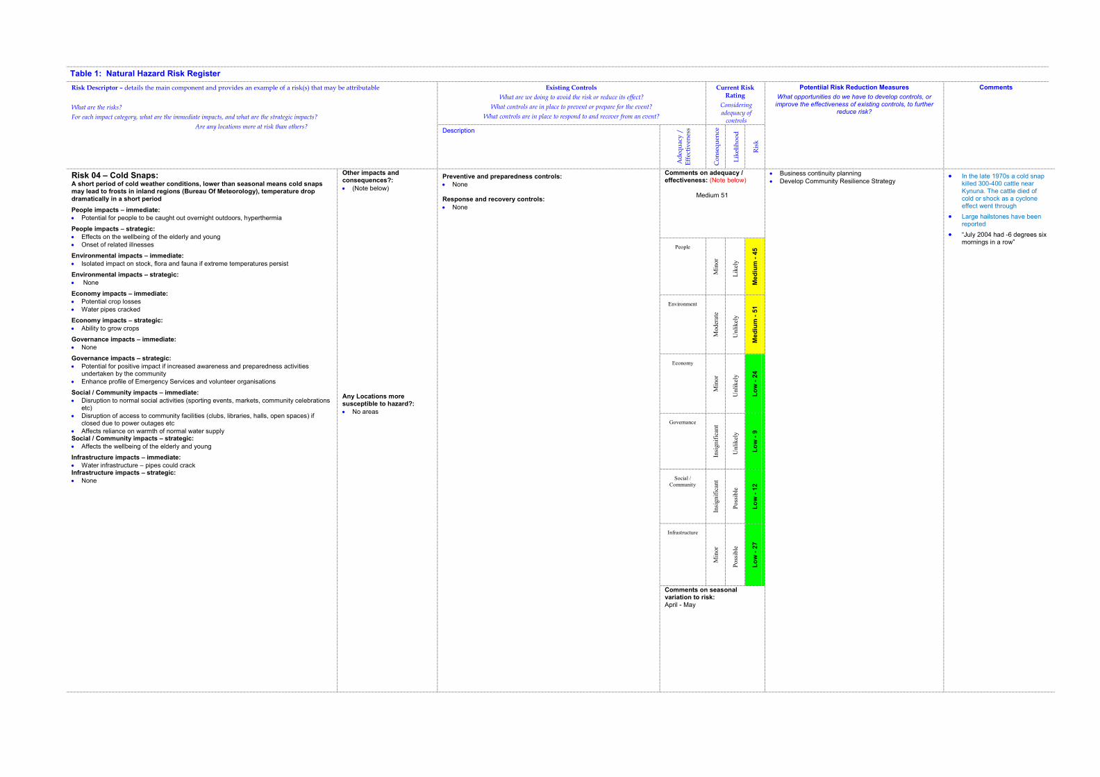
Table 1: Natural Hazard Risk Register
Risk Descriptor – details the main component and provides an example of a risk(s) that may be attributable
What are the risks?
For each impact category, what are the immediate impacts, and what are the strategic impacts?
Are any locations more at risk than others?
Existing Controls
What are we doing to avoid the risk or reduce its effect?
What controls are in place to prevent or prepare for the event?
What controls are in place to respond to and recover from an event?
Current Risk Rating
Considering adequacy of
controls
Potentiial Risk Reduction Measures
What opportunities do we have to develop controls, or improve the effectiveness of existing controls, to further
reduce risk?
Comments
Description
Ad
equ
acy
/
Eff
ecti
ven
ess
Co
nse
qu
ence
Lik
elih
oo
d
Ris
k
Risk 04 – Cold Snaps: A short period of cold weather conditions, lower than seasonal means cold snaps may lead to frosts in inland regions (Bureau Of Meteorology), temperature drop dramatically in a short period
People impacts – immediate:
� Potential for people to be caught out overnight outdoors, hyperthermia
People impacts – strategic:
� Effects on the wellbeing of the elderly and young
� Onset of related illnesses
Environmental impacts – immediate:
� Isolated impact on stock, flora and fauna if extreme temperatures persist
Environmental impacts – strategic:
� None
Economy impacts – immediate:
� Potential crop losses
� Water pipes cracked
Economy impacts – strategic:
� Ability to grow crops
Governance impacts – immediate:
� None
Governance impacts – strategic:
� Potential for positive impact if increased awareness and preparedness activities undertaken by the community
� Enhance profile of Emergency Services and volunteer organisations
Social / Community impacts – immediate:
� Disruption to normal social activities (sporting events, markets, community celebrations etc)
� Disruption of access to community facilities (clubs, libraries, halls, open spaces) if closed due to power outages etc
� Affects reliance on warmth of normal water supply Social / Community impacts – strategic:
� Affects the wellbeing of the elderly and young
Infrastructure impacts – immediate:
� Water infrastructure – pipes could crack Infrastructure impacts – strategic:
� None
Other impacts and consequences?:
� (Note below)
Any Locations more susceptible to hazard?:
� No areas
Preventive and preparedness controls:
� None
Response and recovery controls:
� None
Comments on adequacy / effectiveness: (Note below)
Medium 51
� Business continuity planning
� Develop Community Resilience Strategy � In the late 1970s a cold snap
killed 300-400 cattle near Kynuna. The cattle died of cold or shock as a cyclone effect went through
� Large hailstones have been reported
� “July 2004 had -6 degrees six mornings in a row”
People
Min
or
Lik
ely
Me
diu
m -
45
Environment
Moder
ate
Unli
kel
y
Me
diu
m -
51
Economy
Min
or
Unli
kel
y
Lo
w -
24
Governance
Insi
gnif
ican
t
Unli
kel
y
Lo
w -
9
Social /
Community
Insi
gnif
ican
t
Poss
ible
Lo
w -
12
Infrastructure
Min
or
Poss
ible
Lo
w -
27
Comments on seasonal variation to risk: April - May
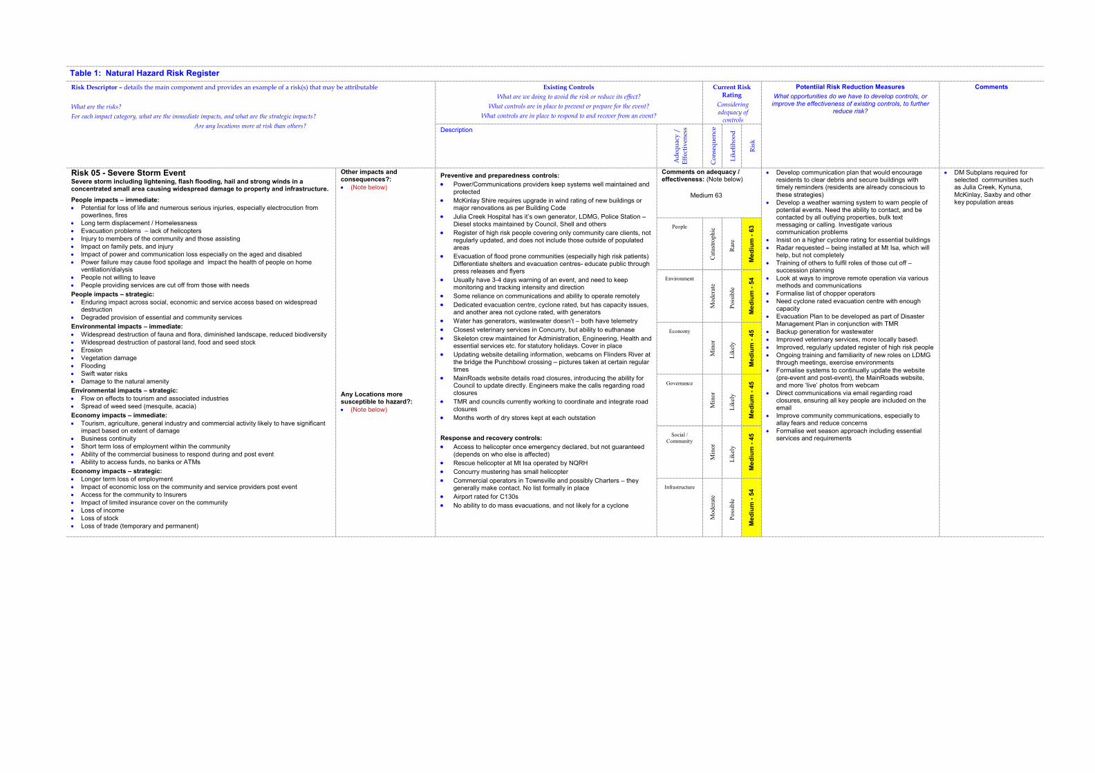
Table 1: Natural Hazard Risk Register
Risk Descriptor – details the main component and provides an example of a risk(s) that may be attributable
What are the risks?
For each impact category, what are the immediate impacts, and what are the strategic impacts?
Are any locations more at risk than others?
Existing Controls
What are we doing to avoid the risk or reduce its effect?
What controls are in place to prevent or prepare for the event?
What controls are in place to respond to and recover from an event?
Current Risk Rating
Considering adequacy of
controls
Potentiial Risk Reduction Measures
What opportunities do we have to develop controls, or improve the effectiveness of existing controls, to further
reduce risk?
Comments
Description
Ad
equ
acy
/
Eff
ecti
ven
ess
Co
nse
qu
ence
Lik
elih
oo
d
Ris
k
Risk 05 - Severe Storm EventSevere storm including lightening, flash flooding, hail and strong winds in a concentrated small area causing widespread damage to property and infrastructure.
People impacts – immediate:
� Potential for loss of life and numerous serious injuries, especially electrocution from powerlines, fires
� Long term displacement / Homelessness
� Evacuation problems – lack of helicopters
� Injury to members of the community and those assisting
� Impact on family pets, and injury
� Impact of power and communication loss especially on the aged and disabled
� Power failure may cause food spoilage and impact the health of people on home ventilation/dialysis
� People not willing to leave
� People providing services are cut off from those with needs
People impacts – strategic:
� Enduring impact across social, economic and service access based on widespread destruction
� Degraded provision of essential and community services
Environmental impacts – immediate:
� Widespread destruction of fauna and flora, diminished landscape, reduced biodiversity
� Widespread destruction of pastoral land, food and seed stock
� Erosion
� Vegetation damage
� Flooding
� Swift water risks
� Damage to the natural amenity
Environmental impacts – strategic:
� Flow on effects to tourism and associated industries
� Spread of weed seed (mesquite, acacia)
Economy impacts – immediate:
� Tourism, agriculture, general industry and commercial activity likely to have significant impact based on extent of damage
� Business continuity
� Short term loss of employment within the community
� Ability of the commercial business to respond during and post event
� Ability to access funds, no banks or ATMs
Economy impacts – strategic:
� Longer term loss of employment
� Impact of economic loss on the community and service providers post event
� Access for the community to Insurers
� Impact of limited insurance cover on the community
� Loss of income
� Loss of stock
� Loss of trade (temporary and permanent)
Other impacts and consequences?:
� (Note below)
Any Locations more susceptible to hazard?:
� (Note below)
Preventive and preparedness controls:
� Power/Communications providers keep systems well maintained and protected
� McKinlay Shire requires upgrade in wind rating of new buildings or major renovations as per Building Code
� Julia Creek Hospital has it’s own generator, LDMG, Police Station – Diesel stocks maintained by Council, Shell and others
� Register of high risk people covering only community care clients, not regularly updated, and does not include those outside of populated areas
� Evacuation of flood prone communities (especially high risk patients) Differentiate shelters and evacuation centres- educate public through press releases and flyers
� Usually have 3-4 days warning of an event, and need to keep monitoring and tracking intensity and direction
� Some reliance on communications and ability to operate remotely
� Dedicated evacuation centre, cyclone rated, but has capacity issues, and another area not cyclone rated, with generators
� Water has generators, wastewater doesn’t – both have telemetry
� Closest veterinary services in Concurry, but ability to euthanase
� Skeleton crew maintained for Administration, Engineering, Health and essential services etc. for statutory holidays. Cover in place
� Updating website detailing information, webcams on Flinders River at the bridge the Punchbowl crossing – pictures taken at certain regular times
� MainRoads website details road closures, introducing the ability for Council to update directly. Engineers make the calls regarding road closures
� TMR and councils currently working to coordinate and integrate road closures
� Months worth of dry stores kept at each outstation
Response and recovery controls:
� Access to helicopter once emergency declared, but not guaranteed (depends on who else is affected)
� Rescue helicopter at Mt Isa operated by NQRH
� Concurry mustering has small helicopter
� Commercial operators in Townsville and possibly Charters – they generally make contact. No list formally in place
� Airport rated for C130s
� No ability to do mass evacuations, and not likely for a cyclone
Comments on adequacy / effectiveness: (Note below)
Medium 63
� Develop communication plan that would encourage residents to clear debris and secure buildings with timely reminders (residents are already conscious to these strategies)
� Develop a weather warning system to warn people of potential events. Need the ability to contact, and be contacted by all outlying properties, bulk text messaging or calling. Investigate various communication problems
� Insist on a higher cyclone rating for essential buildings
� Radar requested – being installed at Mt Isa, which will help, but not completely
� Training of others to fulfil roles of those cut off – succession planning
� Look at ways to improve remote operation via various methods and communications
� Formalise list of chopper operators
� Need cyclone rated evacuation centre with enough capacity
� Evacuation Plan to be developed as part of Disaster Management Plan in conjunction with TMR
� Backup generation for wastewater
� Improved veterinary services, more locally based\
� Improved, regularly updated register of high risk people
� Ongoing training and familiarity of new roles on LDMG through meetings, exercise environments
� Formalise systems to continually update the website (pre-event and post-event), the MainRoads website, and more ‘live’ photos from webcam
� Direct communications via email regarding road closures, ensuring all key people are included on the email
� Improve community communications, especially to allay fears and reduce concerns
� Formalise wet season approach including essential services and requirements
� DM Subplans required for selected communities such as Julia Creek, Kynuna, McKinlay, Saxby and other key population areas
People
Cat
astr
op
hic
Rar
e
Me
diu
m -
63
Environment
Moder
ate
Poss
ible
Me
diu
m -
54
Economy
Min
or
Lik
ely
Me
diu
m -
45
Governance
Min
or
Lik
ely
Me
diu
m -
45
Social /
Community
Min
or
Lik
ely
Me
diu
m -
45
Infrastructure
Moder
ate
Poss
ible
Me
diu
m -
54
Table 1: Natural Hazard Risk Register
Risk Descriptor – details the main component and provides an example of a risk(s) that may be attributable
What are the risks?
For each impact category, what are the immediate impacts, and what are the strategic impacts?
Are any locations more at risk than others?
Existing Controls
What are we doing to avoid the risk or reduce its effect?
What controls are in place to prevent or prepare for the event?
What controls are in place to respond to and recover from an event?
Current Risk Rating
Considering adequacy of
controls
Potentiial Risk Reduction Measures
What opportunities do we have to develop controls, or
improve the effectiveness of existing controls, to further reduce risk?
Comments
Description
Ad
equ
acy
/
Eff
ecti
ven
ess
Co
nse
qu
ence
Lik
elih
oo
d
Ris
k
� Impact on tourism as amenities damaged
Governance impacts – immediate:
� Functionality of Council may be questioned if catastrophic damage includes a number of council buildings, depots and broad ability to provide an effective response
� Resources available through SES, Police etc � Disruption to communications and accessibility of some areas
Governance impacts – strategic:
� Lack of knowledge of responsive strategies
Social / Community impacts – immediate:
� Ability of health/hospital systems to cope with emergency situations
� Psychological factors on community scale � Community services not functioning � Panic/concern amongst the community, loss of confidence and trust � Domestic violence � Alcohol abuse � Theft and presence of looters � Inappropriate actions of tourists and sightseers � Loss of services Social / Community impacts – strategic:
� Impact of limited insurance cover on the community � Lack of preparedness of the community � Health of the community
Infrastructure impacts – immediate:
� Building damages- Total destruction � Infrastructure damaged or destroyed by fires � Power infrastructure- major destruction, � Impact on ability to provide telecommunications � Impact on ability to provide potable water � Roads blocked/homes damaged - vegetation � Airports � Requirements for emergency accommodation � Impact of falling power lines and poles � Ability of the utility services to function � Impact of structural damage
Infrastructure impacts – strategic:
� Long term loss of services and recovery time
Comments on seasonal variation to risk: (Note below)
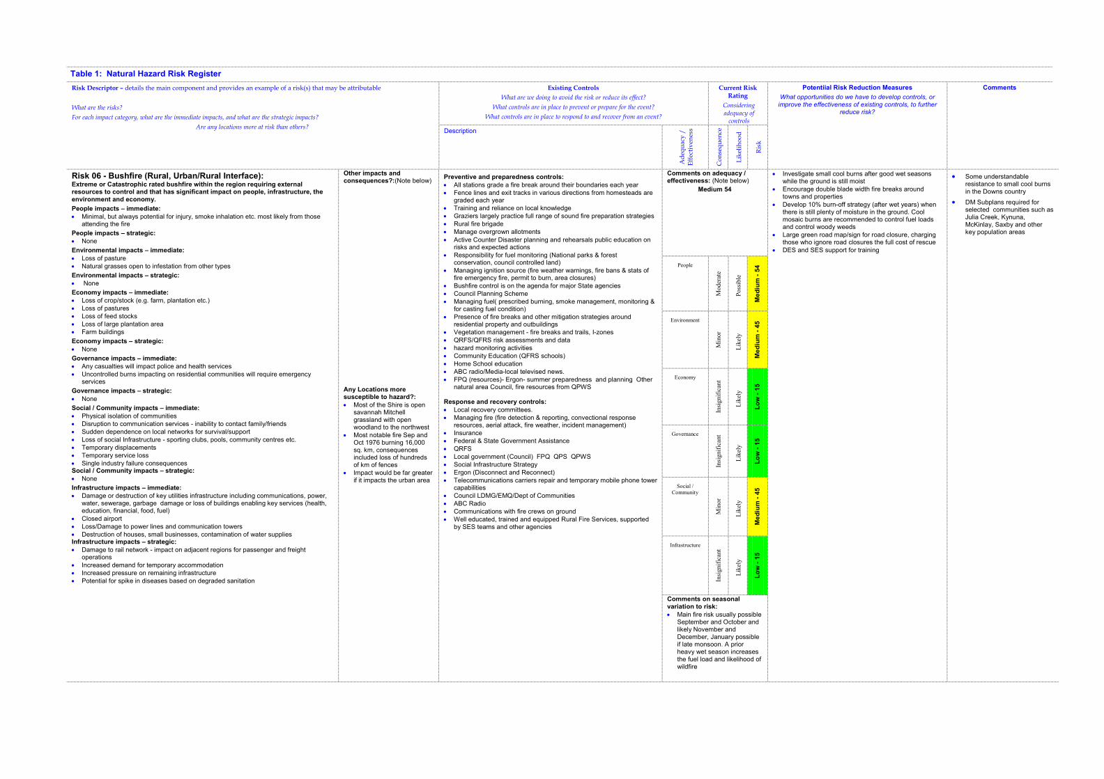
Table 1: Natural Hazard Risk Register
Risk Descriptor – details the main component and provides an example of a risk(s) that may be attributable
What are the risks?
For each impact category, what are the immediate impacts, and what are the strategic impacts?
Are any locations more at risk than others?
Existing Controls
What are we doing to avoid the risk or reduce its effect?
What controls are in place to prevent or prepare for the event?
What controls are in place to respond to and recover from an event?
Current Risk Rating
Considering adequacy of
controls
Potentiial Risk Reduction Measures
What opportunities do we have to develop controls, or
improve the effectiveness of existing controls, to further reduce risk?
Comments
Description
Ad
equ
acy
/
Eff
ecti
ven
ess
Co
nse
qu
ence
Lik
elih
oo
d
Ris
k
Risk 06 - Bushfire (Rural, Urban/Rural Interface): Extreme or Catastrophic rated bushfire within the region requiring external resources to control and that has significant impact on people, infrastructure, the environment and economy.
People impacts – immediate:
� Minimal, but always potential for injury, smoke inhalation etc. most likely from those attending the fire
People impacts – strategic:
� None
Environmental impacts – immediate:
� Loss of pasture � Natural grasses open to infestation from other types
Environmental impacts – strategic:
� None
Economy impacts – immediate:
� Loss of crop/stock (e.g. farm, plantation etc.) � Loss of pastures � Loss of feed stocks � Loss of large plantation area � Farm buildings
Economy impacts – strategic:
� None
Governance impacts – immediate:
� Any casualties will impact police and health services � Uncontrolled burns impacting on residential communities will require emergency
services
Governance impacts – strategic:
� None
Social / Community impacts – immediate:
� Physical isolation of communities � Disruption to communication services - inability to contact family/friends � Sudden dependence on local networks for survival/support � Loss of social Infrastructure - sporting clubs, pools, community centres etc. � Temporary displacements � Temporary service loss � Single industry failure consequences Social / Community impacts – strategic:
� None
Infrastructure impacts – immediate:
� Damage or destruction of key utilities infrastructure including communications, power, water, sewerage, garbage damage or loss of buildings enabling key services (health, education, financial, food, fuel)
� Closed airport � Loss/Damage to power lines and communication towers � Destruction of houses, small businesses, contamination of water supplies Infrastructure impacts – strategic:
� Damage to rail network - impact on adjacent regions for passenger and freight operations
� Increased demand for temporary accommodation � Increased pressure on remaining infrastructure � Potential for spike in diseases based on degraded sanitation
Other impacts and consequences?:(Note below)
Any Locations more susceptible to hazard?:
� Most of the Shire is open savannah Mitchell grassland with open woodland to the northwest
� Most notable fire Sep and Oct 1976 burning 16,000 sq. km, consequences included loss of hundreds of km of fences
� Impact would be far greater if it impacts the urban area
Preventive and preparedness controls:
� All stations grade a fire break around their boundaries each year � Fence lines and exit tracks in various directions from homesteads are
graded each year � Training and reliance on local knowledge � Graziers largely practice full range of sound fire preparation strategies � Rural fire brigade � Manage overgrown allotments
� Active Counter Disaster planning and rehearsals public education on risks and expected actions
� Responsibility for fuel monitoring (National parks & forest conservation, council controlled land)
� Managing ignition source (fire weather warnings, fire bans & stats of fire emergency fire, permit to burn, area closures)
� Bushfire control is on the agenda for major State agencies � Council Planning Scheme � Managing fuel( prescribed burning, smoke management, monitoring &
for casting fuel condition) � Presence of fire breaks and other mitigation strategies around
residential property and outbuildings � Vegetation management - fire breaks and trails, I-zones � QRFS/QFRS risk assessments and data � hazard monitoring activities � Community Education (QFRS schools) � Home School education � ABC radio/Media-local televised news. � FPQ (resources)- Ergon- summer preparedness and planning Other
natural area Council, fire resources from QPWS
Response and recovery controls:
� Local recovery committees. � Managing fire (fire detection & reporting, convectional response
resources, aerial attack, fire weather, incident management) � Insurance � Federal & State Government Assistance � QRFS � Local government (Council) FPQ QPS QPWS � Social Infrastructure Strategy � Ergon (Disconnect and Reconnect) � Telecommunications carriers repair and temporary mobile phone tower
capabilities � Council LDMG/EMQ/Dept of Communities � ABC Radio � Communications with fire crews on ground � Well educated, trained and equipped Rural Fire Services, supported
by SES teams and other agencies
Comments on adequacy / effectiveness: (Note below)
Medium 54
� Investigate small cool burns after good wet seasons while the ground is still moist
� Encourage double blade width fire breaks around towns and properties
� Develop 10% burn-off strategy (after wet years) when there is still plenty of moisture in the ground. Cool mosaic burns are recommended to control fuel loads and control woody weeds
� Large green road map/sign for road closure, charging those who ignore road closures the full cost of rescue
� DES and SES support for training
� Some understandable resistance to small cool burns in the Downs country
� DM Subplans required for selected communities such as Julia Creek, Kynuna, McKinlay, Saxby and other key population areas
People
Moder
ate
Poss
ible
Me
diu
m -
54
Environment
Min
or
Lik
ely
Me
diu
m -
45
Economy
Insi
gnif
ican
t
Lik
ely
Lo
w -
15
Governance
Insi
gnif
ican
t
Lik
ely
Lo
w -
15
Social /
Community
Min
or
Lik
ely
Me
diu
m -
45
Infrastructure
Insi
gnif
ican
t
Lik
ely
Lo
w -
15
Comments on seasonal variation to risk:
� Main fire risk usually possible September and October and likely November and December, January possible if late monsoon. A prior heavy wet season increases the fuel load and likelihood of wildfire
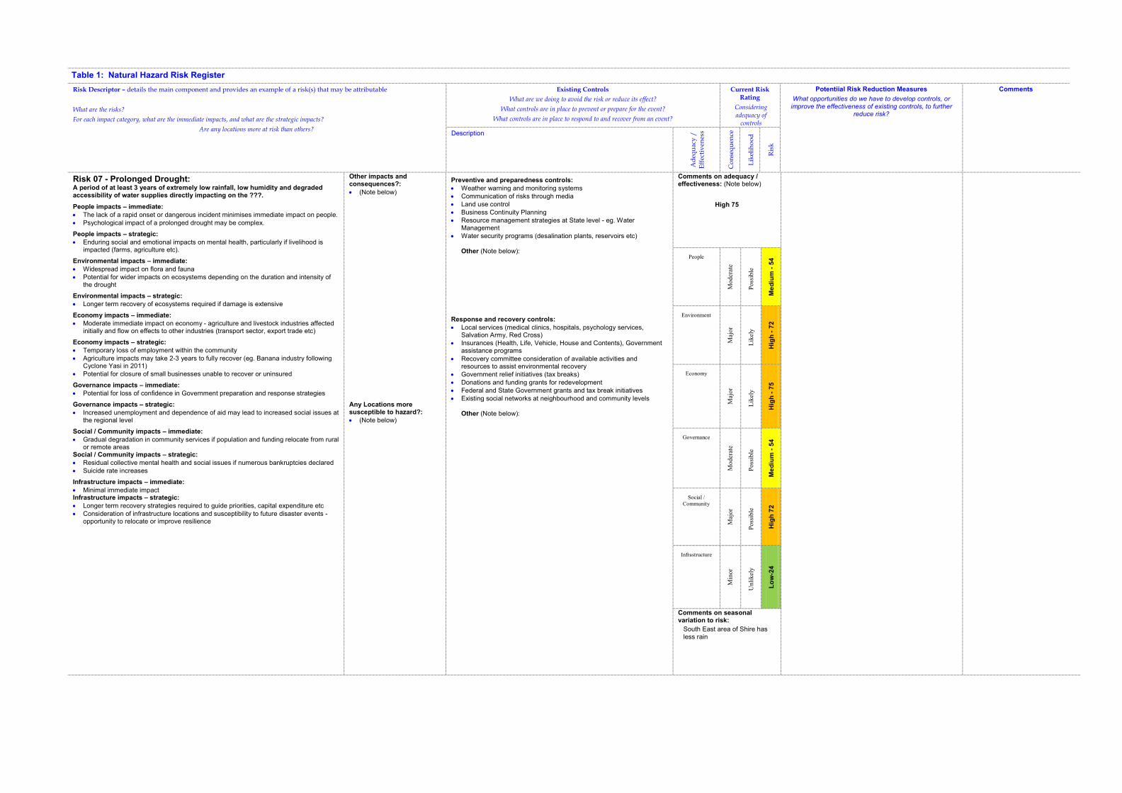
Table 1: Natural Hazard Risk Register
Risk Descriptor – details the main component and provides an example of a risk(s) that may be attributable
What are the risks?
For each impact category, what are the immediate impacts, and what are the strategic impacts?
Are any locations more at risk than others?
Existing Controls
What are we doing to avoid the risk or reduce its effect?
What controls are in place to prevent or prepare for the event?
What controls are in place to respond to and recover from an event?
Current Risk Rating
Considering adequacy of
controls
Potentiial Risk Reduction Measures
What opportunities do we have to develop controls, or
improve the effectiveness of existing controls, to further reduce risk?
Comments
Description
Ad
equ
acy
/
Eff
ecti
ven
ess
Co
nse
qu
ence
Lik
elih
oo
d
Ris
k
Risk 07 - Prolonged Drought: A period of at least 3 years of extremely low rainfall, low humidity and degraded accessibility of water supplies directly impacting on the ???.
People impacts – immediate:
� The lack of a rapid onset or dangerous incident minimises immediate impact on people. � Psychological impact of a prolonged drought may be complex.
People impacts – strategic:
� Enduring social and emotional impacts on mental health, particularly if livelihood is impacted (farms, agriculture etc).
Environmental impacts – immediate:
� Widespread impact on flora and fauna � Potential for wider impacts on ecosystems depending on the duration and intensity of
the drought
Environmental impacts – strategic:
� Longer term recovery of ecosystems required if damage is extensive
Economy impacts – immediate:
� Moderate immediate impact on economy - agriculture and livestock industries affected initially and flow on effects to other industries (transport sector, export trade etc)
Economy impacts – strategic:
� Temporary loss of employment within the community � Agriculture impacts may take 2-3 years to fully recover (eg. Banana industry following
Cyclone Yasi in 2011) � Potential for closure of small businesses unable to recover or uninsured
Governance impacts – immediate:
� Potential for loss of confidence in Government preparation and response strategies
Governance impacts – strategic:
� Increased unemployment and dependence of aid may lead to increased social issues at the regional level
Social / Community impacts – immediate:
� Gradual degradation in community services if population and funding relocate from rural or remote areas
Social / Community impacts – strategic:
� Residual collective mental health and social issues if numerous bankruptcies declared � Suicide rate increases
Infrastructure impacts – immediate:
� Minimal immediate impact Infrastructure impacts – strategic:
� Longer term recovery strategies required to guide priorities, capital expenditure etc � Consideration of infrastructure locations and susceptibility to future disaster events -
opportunity to relocate or improve resilience
Other impacts and consequences?:
� (Note below)
Any Locations more susceptible to hazard?:
� (Note below)
Preventive and preparedness controls:
� Weather warning and monitoring systems � Communication of risks through media � Land use control � Business Continuity Planning � Resource management strategies at State level - eg. Water
Management � Water security programs (desalination plants, reservoirs etc)
Other (Note below):
Response and recovery controls:
� Local services (medical clinics, hospitals, psychology services, Salvation Army, Red Cross)
� Insurances (Health, Life, Vehicle, House and Contents), Government assistance programs
� Recovery committee consideration of available activities and resources to assist environmental recovery
� Government relief initiatives (tax breaks) � Donations and funding grants for redevelopment � Federal and State Government grants and tax break initiatives � Existing social networks at neighbourhood and community levels
Other (Note below):
Comments on adequacy / effectiveness: (Note below)
High 75
People
Moder
ate
Poss
ible
Me
diu
m -
54
Environment
Maj
or
Lik
ely
Hig
h -
72
Economy
Maj
or
Lik
ely
Hig
h -
75
Governance
Moder
ate
Poss
ible
Me
diu
m -
54
Social /
Community
Maj
or
Poss
ible
Hig
h 7
2
Infrastructure
Min
or
Unli
kel
y
Lo
w-2
4
Comments on seasonal variation to risk:
South East area of Shire has less rain
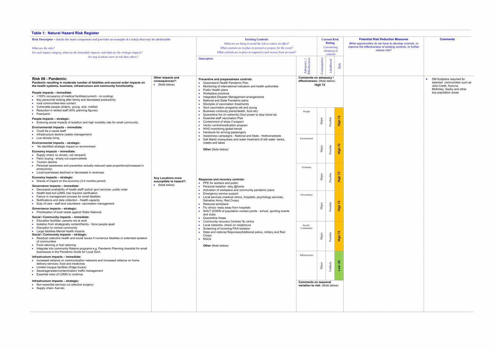
Table 1: Natural Hazard Risk Register
Risk Descriptor – details the main component and provides an example of a risk(s) that may be attributable
What are the risks?
For each impact category, what are the immediate impacts, and what are the strategic impacts?
Are any locations more at risk than others?
Existing Controls
What are we doing to avoid the risk or reduce its effect?
What controls are in place to prevent or prepare for the event?
What controls are in place to respond to and recover from an event?
Current Risk Rating
Considering adequacy of
controls
Potentiial Risk Reduction Measures
What opportunities do we have to develop controls, or
improve the effectiveness of existing controls, to further reduce risk?
Comments
Description
Ad
equ
acy
/
Eff
ecti
ven
ess
Co
nse
qu
ence
Lik
elih
oo
d
Ris
k
Risk 08 - Pandemic: Pandemic resulting in moderate number of fatalities and second order impacts on the health systems, business, infrastructure and community functionality.
People impacts – immediate:
� >100% occupancy of medical facilities(current) - no scaling) � Key personnel looking after family and decreased productivity � rural communities-less contact � Vulnerable people (elderly, young, sick- notified � Reduction in skilled staff (40% planning figures) � Fear/panic
People impacts – strategic:
� Enduring social impacts of isolation and high mortality rate for small community.
Environmental impacts – immediate:
� Could be a cause itself � Infrastructure decline (waste management) � Low density living
Environmental impacts – strategic:
� No identified strategic impact on environment
Economy impacts – immediate:
� Supply chain( no drivers, not rampant) � Panic buying - empty out supermarkets � Tourism decline � Personal awareness and prevention actually reduced case proportions(increased in
productivity) � Local businesses declined or decreased in revenues
Economy impacts – strategic:
� Waves of impact on the economy (3-4 months period)
Governance impacts – immediate:
� Decreased availability of health staff/ police/ govt services- public order � Health lead but LDMG role requires clarification � Failure in management process for small fatalities � Notifications and data collection - Health capacity � Duty of care - staff and volunteers- vaccination management
Governance impacts – strategic:
� Prioritisation of local needs against State/ National
Social / Community impacts – immediate:
� Education facilities- parents not at work � Isolation from strategically content/family - force people apart � Disruption to normal community � Large fatalities-Mental health impacts Social / Community impacts – strategic:
� Residual collective health and social issues if numerous fatalities or extended isolation of communities
� Food rationing or fuel rationing � Integrate into community Relieve programs e.g. Pandemic Planning checklist for small
businesses in the Pandemic Guide for Local Govt.
Infrastructure impacts – immediate:
� Increased reliance on communication networks and increased reliance on home delivery services- food and medicines
� Limited morgue facilities (fridge trucks) � Sewerage/water/contamination/ traffic management � Essential roles of LDMG to continue
Infrastructure impacts – strategic:
� Non-essential services cut (elective surgery) � Supply chain- fuel etc.
Other impacts and consequences?:
� (Note below)
Any Locations more susceptible to hazard?:
� (Note below)
Preventive and preparedness controls:
� Queensland Health Pandemic Plan � Monitoring of international indicators and health authorities � Public Health plans � Workplace practices � Integrated Disaster Management arrangements � National and State Pandemic plans � Stockpile of vaccination /treatments � Govt vaccination programs-old and young � Business continuity plans(Health, food etc) � Quarantine Act (in extremis) Govt power to stop travel etc � Essential staff vaccination Plan � Containment of ships if suspect � Vector control/eradication program � WHO monitoring global trends � Handouts for arriving passengers � Awareness campaigns - National and State - Hotline/website
� Salt Marsh mosquitoes and water treatment of still water -tanks, creeks and lakes
Other (Note below):
Response and recovery controls:
� PPE for workers and public � Personal isolation -stay @home � Activation of workplace and community pandemic plans � Emergency service support � Local services (medical clinics, hospitals, psychology services,
Salvation Army, Red Cross)
� Reduced workplace � Flu clinics- keep away from hospitals � SHUT DOWN of population contact points - school, sporting events
and clubs � Quarantine Areas � Community recovery Centres/ flu clinics � Local networks- check on neighbours � Screening of incoming PAX-isolation � State and national Reponses(Additional police, military and Red
Cross) � NGOs
Other (Note below):
Comments on adequacy / effectiveness: (Note below)
High 72
� DM Subplans required for selected communities such as Julia Creek, Kynuna, McKinlay, Saxby and other key population areas
People
Maj
or
Poss
ible
Hig
h 7
2
Environment
Maj
or
Poss
ible
Hig
h 7
2
Economy
Maj
or
Poss
ible
Hig
h 7
2
Governance
Maj
or
Poss
ible
Hig
h 7
2
Social /
Community
Maj
or
Poss
ible
Hig
h 7
2
Infrastructure
Min
or
Unli
kel
y
Lo
w -
24
Comments on seasonal variation to risk: (Note below)
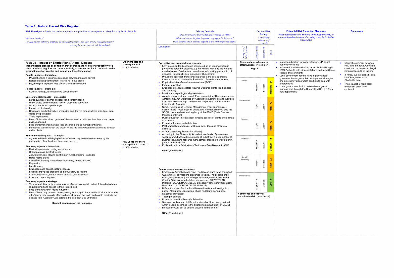
Table 1: Natural Hazard Risk Register
Risk Descriptor – details the main component and provides an example of a risk(s) that may be attributable
What are the risks?
For each impact category, what are the immediate impacts, and what are the strategic impacts?
Are any locations more at risk than others?
Existing Controls
What are we doing to avoid the risk or reduce its effect?
What controls are in place to prevent or prepare for the event?
What controls are in place to respond to and recover from an event?
Current Risk Rating
Considering adequacy of
controls
Potentiial Risk Reduction Measures
What opportunities do we have to develop controls, or
improve the effectiveness of existing controls, to further reduce risk?
Comments
Description
Ad
equ
acy
/
Eff
ecti
ven
ess
Co
nse
qu
ence
Lik
elih
oo
d
Ris
k
Risk 09 – Insect or Exotic Plant/Animal Disease: Transmissible disease or condition that degrades the health or productivity of a plant or animal (e.g. foot and mouth, fruit fly, screw worm). Rapid outbreak, wider ground impact on species and industries. Insect infestation
People impacts – immediate:
� Physical effects if transmission occurs between man and animal � Isolation/fencing/confinement to area-no move orders � Psychological impact of loss of stock/animals-livelihood
People impacts – strategic:
� Cultural heritage, recreation and social amenity
Environmental impacts – immediate:
� Large quantity of animal disposal- land contamination � Water tables and monitoring- loss of crops and agriculture � Widespread landscape damage � Impact on biodiversity � Decreased productivity (bee production and derived products from apiculture- crop
yields and pollination � Trade implications: � Loss of international recognition of disease freedom with resultant import and export
policies affected � Loss of international markets, loss of consumer and market confidence. � Introduced species which are grown for bio fuels may become invasive and threaten
native plants.
Environmental impacts – strategic:
� Agricultural lands with high productive values may be rendered useless by the proliferation of exotic plants becoming weeds.
Economy impacts – immediate:
� Restocking animals costing lots of money � Chickens-mass livestock death � Zoo, tourism, reef staying point(mainly rural/hinterland- trail rides � Horse racing Studs � Cattle/Pork industry - associated industries(cheese, milk etc) � Reputation � Local industry � Eradication and control costs to industry � Fruit flies may pose problems to the fruit growing regions � Community losses, human health affected (medical costs) � Increased unemployment
Economy impacts – strategic:
� Tourism and lifestyle industries may be affected to a certain extent if the affected area is quarantined and access to them is restricted.
� Loss of man power in racing industries � Loss of bees may prove to be very costly for the agricultural and horticultural industries
- the Varroa mite parasite affecting bees all around the world and cost to eradicate the disease from Australia/NZ is estimated to be about $ 55-70 million
Content continues on the next page.
Other impacts and consequences?:
� (Note below)
Any Locations more susceptible to hazard?:
� (Note below)
Preventive and preparedness controls:
� Early detection for diseases is considered as an important step in preventing spread of diseases.e.g the Hendra virus and the foot and mouth disease. Feral animal control may help to stop proliferation of diseases - responsibility of Biosecurity Queensland
� Preventive approach from concern parties is the best approach towards issues of biosecurity. Prevention of weeds and diseases
� Physical isolation-Australian-international (AQIS) � Federal legislation � Eradication measures (state required-Declared plants- land holders
and councils) � Monitor and reporting(local government); � Airport-organic material control. Emergency Animal Disease response
Agreement (EADRA) ratified by Australia's governments and livestock industries to ensure rapid and efficient response to animal disease incursions to Australia;
� QDMS (Queensland Disaster Management Plan) operating at 3 distinct levels - local, disaster district and state government. also the SDCG , the state level working body of the SDMG (State Disaster Management Plan).
� Public education- threats about invasive species of plants and animals at all levels;
� Education for refs- early detection � Pest eradication proposals- wild pigs, cats, dogs and other feral
animals; � Animal control regulations (Local laws); � According to the Biosecurity Australia three levels of government,
various committees, a diverse range of industries, a large number of
� Businesses, natural resource management groups, other community groups and individuals.
� Public education- Publication of fact sheets from Biosecurity QLD
Other (Note below):
Response and recovery controls:
� Emergency Animal disease (EAD) and its sub plans to be consulted. � Quarantine of animals and properties infected. The department of
Emergency Services (now Emergency Management Queensland (EMQ ). Other plans to be taken into account -AUSVETPLAN (National) QLDVETPLAN, BEOM-Biosecurity emergency Operations Manual and the AQUAVETPLAN (National).
� Different phases of action from Biosecurity officers- Investigation phase, Alert phase ,operational phase and Stand down phase
� Slaughter of livestock � Testing of animals � Population Health officers (QLD health) � Strategic involvement of different bodies should be clearly defined
within 5 years according to the Strategy plan 2009-2014 of DEEDI. � Biosecurity QLD Set up of local disease control centre
Other (Note below):
Comments on adequacy / effectiveness: (Note below)
High 72
� Increase education for early detection, DPI to act aggressively in this
� Increase formal surveillance, recent Federal Budget (2010?) should help with coastal and port surveillance (update this comment)
� Local government need to have in place a local government emergency risk management strategies and emergency plans which can help to deal with emergencies.
� Local government fits into national emergency management through the Queensland DPI & F (now new department)
� Informal movement between PNG and the north Australian coast, and movement of illegal immigrants could be factors
� In 1995, eye infections killed a lot of kangaroos in the Charleville area
� There is a lot of rapid stock movement across the continent
People
Mder
ate
Poss
ible
Me
diu
m -
54
Environment
Maj
or
Lik
ely
Hig
h -
72
Economy
Maj
or
Lik
ely
Hig
h -
72
Governance
Moder
ate
Poss
ible
Me
diu
m -
54
Social /
Community
Maj
or
Poss
ible
Hig
h -
72
Infrastructure
Insi
gnif
ican
t
Unli
kel
y
Lo
w -
9
Comments on seasonal variation to risk: (Note below)
Table 1: Natural Hazard Risk Register
Risk Descriptor – details the main component and provides an example of a risk(s) that may be attributable
What are the risks?
For each impact category, what are the immediate impacts, and what are the strategic impacts?
Are any locations more at risk than others?
Existing Controls
What are we doing to avoid the risk or reduce its effect?
What controls are in place to prevent or prepare for the event?
What controls are in place to respond to and recover from an event?
Current Risk Rating
Considering adequacy of
controls
Potentiial Risk Reduction Measures
What opportunities do we have to develop controls, or
improve the effectiveness of existing controls, to further reduce risk?
Comments
Description
Ad
equ
acy
/
Eff
ecti
ven
ess
Co
nse
qu
ence
Lik
elih
oo
d
Ris
k
Risk 09 – Insect or Exotic Plant/Animal Disease:(cont.)
Governance impacts – immediate:
� Enforcement of slaughters/isolation/aquaculture( and control)
� External political control and influence
� (DDMG/DPI)-Biosecurity Queensland/ State control links-different priorities
� Monitoring regime imposed by State/ national Authorities
� Examples of emergency animal diseases which the local Biosecurity and Local government need to tackle at earliest : Screwworm fly (exotic), Bovine spongiform encephalopathy (Mad Cow Disease- exotic, foot and mouth disease, highly pathogenic avian influenza-exotic, anthrax- endemic, Australian bat lyssavirus- endemic, rabies- exotic and Hendra virus.
Governance impacts – strategic:
� The Local Disease Control Centre (LDCC) requiring more labour to cope with emergency outbreaks in the local district (Biosecurity - decisions to be taken by the Chief Veterinary Officer on strategic approach and the number of staff required
� SDCHQ (State Disease Control Headquarters) established under the direction of the Chief Veterinary Officer - located at 80 Ann St,Brisbane.
Social / Community impacts – immediate:
� Pony Clubs/ recreational activities
� Isolation through quarantine(People and small groups)
� Impact on the loss of income
� Unemployment
� The Airport may become the entry point of exotic diseases and pests if the passengers coming via international airports are not screened properly upon their arrival. Also the visitors coming from other airports
� Loss of community spirit Social / Community impacts – strategic:
� Nil
Infrastructure impacts – immediate:
� Disruption to food chain-Higher impact to region/ shortage of key food
� Closure of strategic transport routes
� Less timber products on the market if forestry industry is hit by diseases affecting trees. Infrastructure impacts – strategic:
� Strategic industries and service industries like power, communication, shipping and water supplies may be affected