mtn (pty) ltd proposed marine telecommunications …
TRANSCRIPT
MTN (PTY) LTD
PROPOSED MARINE TELECOMMUNICATIONS SYSTEM (ACE CABLE SYSTEM) TO BE LANDED AT VAN RIEBEECKSTRAND ON
THE WEST COAST OF SOUTH AFRICA
FINAL SCOPING REPORT

MTN (PTY) LTD
PROPOSED MARINE TELECOMMUNICATIONS SYSTEM (ACE CABLE SYSTEM) TO BE LANDED AT VAN RIEBEECKSTRAND ON
THE WEST COAST OF SOUTH AFRICA
FINAL SCOPING REPORT
EIA REFERENCE 14/12/16/3/3/2/988
Prepared for: Prepared by: Mtn (Pty) Ltd. ACER (Africa) Environmental Consultants 216 - 14th Avenue, Fairland PO Box 503 Johannesburg Mtunzini 2195 3867
January 2017

MTN (PTY) LTD
DRAFT SCOPING REPORT DISTRIBUTION
The Draft Scoping Report was distributed for public review to key stakeholders at the following public venues in the project area for a period of 30 days.
Venue Street Contact Person and Number Koeberg Public Library Merchant Walk, Duynefontein, 7441 Ms. Roelda Brown
021 553 2514 Melkbosstrand Ratepayers’ Association
25 Jacobus Crescent, Duynefontein, 7441
Mrs. Smokie La Grange 073 357 6359
The Draft Scoping Report was also available on ACER’s web site (www.acerafrica.co.za) under the ‘Current Projects’ link. The following authorities were also sent hard copies of the Draft Scoping Report: 1. Department of Environmental Affairs
Ms Sindiswa Dlomo Email: [email protected]
2. Department of Environmental Affairs – Biodiversity Oceans and Coast Division Mr Alan Boyd Email: [email protected]
3. Department of Environmental Affairs and Development Planning, Western Cape Government Mrs Adri La Meyer Email: [email protected]
4. City of Cape Town (Energy, Environment and Spatial Planning Division) Ms Pat Titmuss Email: [email protected]
5. CapeNature (Theewaterskloof, Overstrand & Stellenbosch) Mr Rhett Smart Email: [email protected]
6. Department of Water Affairs & Sanitation Mr Warren Dreyer Email: [email protected]
7. Department of Agriculture, Forestry and Fisheries Mr Rob Leslie Email: [email protected]
PROPOSED MARINE TELECOMMUNICATIONS SYSTEM (ACE CABLE SYSTEM) TO BE LANDED AT VAN RIEBEECKSTRAND ON THE WEST COAST OF SOUTH AFRICA FINAL SCOPING REPORT
II

MTN (PTY) LTD
PREFACE
Over the past two years MTN (Pty) Ltd (MTN) has investigated various options of a submarine telecommunications cable, referred to as the Africa Coast to Europe (ACE) Cable System, linking South Africa, the West Coast of Africa and Europe with key international telecommunication hubs in Europe. Following installation of the proposed ACE cable system, MTN will be the first mobile operator to operate an international fibre-optic bandwidth with full landing in South Africa and along the West Coast of Africa. The proposed ACE Cable System requires Environmental Authorisation (EA) from the Department of Environmental Affairs (DEA) in terms of the 2014 Environmental Impact Assessment Regulations published under the National Environmental Management Act, 1998 (Act 107 of 1998) (NEMA). In this context, ACER (Africa) Environmental Consultants (ACER) has been appointed by MTN to take responsibility for the application for environmental authorisation for the construction of the ACE Cable System. This Scoping Report has been compiled in accordance with the requirements of NEMA, in particular, Government Notice Regulation 982, published on 4 December 2014, which outlines the requirements of Scoping for purposes of an Environmental Impact Assessment (EIA) undertaken to apply for environmental authorisation for activities listed in Government Notice Regulation R 983, 984 and 985 of 4 December 2014 under Section 24(5) read with Sections 24, 24D and 44 of the National Environmental Management Act, 1998 (Act No. 107 of 1998).
PROPOSED MARINE TELECOMMUNICATIONS SYSTEM (ACE CABLE SYSTEM) TO BE LANDED AT VAN RIEBEECKSTRAND ON THE WEST COAST OF SOUTH AFRICA FINAL SCOPING REPORT
III
MTN (PTY) LTD
EXECUTIVE SUMMARY Introduction Submarine telecommunication cables are important for international telecommunication networks as they transport almost 100% of the transoceanic Internet traffic throughout the world. It is widely recognised that access to affordable international bandwidth is key to economic development in every country. As such, the improvement in Africa’s information technology infrastructure via telecommunication cables will remove one of the current key inhibitors to development in Africa and support economic growth and opportunities on the continent.
MTN (Pty) Ltd (MTN) proposes installing a submarine telecommunications cable, referred to as the Africa Coast to Europe (ACE) Cable System, to link South Africa, the West Coast of Africa and Europe with key international telecommunication hubs in Europe. In doing so, the company will facilitate more affordable and effective transport of voice, data, Internet and television services.
Consistent with environmental best practice and environmental legislation, MTN has appointed ACER (Africa) Environmental Consultants as the Environmental Assessment Practitioner (EAP) to take responsibility for the EA requirements, including identifying environmental aspects relevant to the proposed telecommunications infrastructure and construction of the ACE Cable System.
Legal Requirements There are many legal requirements (National, Provincial and Local Government spheres) to which the project proponent must adhere for the proposed ACE Cable System. A review of this legislation and guidelines applicable to the proposed project are provided in Chapter 3 of this report.
In the case of the proposed ACE Cable System, environmental authorisation will be based on the current Environmental Impact Assessment Regulations, 2014, published in Government Notices R 982, 983, 984 and 985 of 4 December 2014 under Section 24(5) read with Sections 24, 24D and 44 of the National Environmental Management Act, 1998 (Act No. 107 of 1998). A list of all regulated activities potentially triggered by the proposed development is provided in Table 2 of the Final Scoping Report.
As the project involves the installation of an international telecommunications cable, the competent authority for this development is the national Department of Environmental Affairs (DEA) (in close consultation with the Western Cape Department of Environmental Affairs and Development Planning (DEADP)).
In addition to the environmental authorisation, the following permissions and licences will be required:
A Water Use Licence will be required from the Department of Water and Sanitation as a
wetland will be affected by the proposed development. Way leave and servitude agreements will be required from the City of Cape Town. Risk assessments and emergency evacuation plans will be required as the project takes
place within the Precautionary Action Zone (PAZ) of Koeberg Nuclear Power Station owned and operated by ESKOM.
PROPOSED MARINE TELECOMMUNICATIONS SYSTEM (ACE CABLE SYSTEM) TO BE LANDED AT VAN RIEBEECKSTRAND ON THE WEST COAST OF SOUTH AFRICA FINAL SCOPING REPORT
IV

MTN (PTY) LTD
Need and Desirability Submarine telecommunication cables are essential for international telecommunications as they currently transport almost 100% of transoceanic Internet traffic throughout the world. It is widely recognised that access to affordable international bandwidth is key to unlocking economic development in every country.
Today, Africa relies primarily on satellites with few marine cables to provide its international communications. Improvement in Africa’s information technology infrastructure via telecommunication cables will remove one of the current key inhibitors to development in Africa and support economic growth and opportunities on the continent. Following installation of the proposed ACE cable system, MTN will be the first mobile operator to operate an international fibre-optic bandwidth with full landing in South Africa and along the West Coast of Africa. In doing so, the company will facilitate more affordable and effective transport of voice, data, Internet and television services. Furthermore, the cable will support the objectives set out by the New Partnership for Africa’s Development (NEPAD), and provide a means of fulfilling the South African Government's requirements in terms of digital television broadcasting for the country.
By supplying increased bandwidth, the proposed ACE Cable System will support the following primary NEPAD objectives:
To eradicate poverty in Africa and to place African countries both individually and collectively
on a path of sustainable growth and development to thereby halt the marginalisation of Africa in the globalisation process.
Telecommunications is one of the fastest growing sectors of South Africa's economy which has been driven by rapid growth in the number of mobile phone users and their need for broadband connectivity. South African mobile companies are also making inroads internationally, with MTN now having well over 200 million subscribers in more than 20 countries in Africa, Asia and the Middle East. The proposed ACE Cable System will provide an opportunity to facilitate the growth of the telecommunications infrastructure in South Africa and promote sustainable growth and development within South Africa and Africa and the African continent as a whole.
Site Alternatives Alternatives are different means of achieving the purpose and need of a proposed development and include alternative sites, layouts or designs, technologies and the “no development” or “no go” alternative. To date, MTN and ACER have undertaken environmental screening to try and identify the best possible landing alternatives and cable alignments to reach the MTN Cable Landing Station (CLS) site in Duynefontein. Initially, five landing site alternatives were considered, viz. Yzerfontein Beach and four alternatives near Melkbosstrand. Of these alternatives, two were considered as fatally flawed due to environmental and operational factors, one was considered feasible but would have significant impacts on the biophysical and social environment and two were considered feasible with low expected impacts. These two beach landing alternatives and cable alignments to the CLS site were selected for further assessment in the environmental authorisation process. A detailed description of the alternatives is provided in Chapter 5 of this Final Scoping Report.
PROPOSED MARINE TELECOMMUNICATIONS SYSTEM (ACE CABLE SYSTEM) TO BE LANDED AT VAN RIEBEECKSTRAND ON THE WEST COAST OF SOUTH AFRICA FINAL SCOPING REPORT
V

MTN (PTY) LTD
Technical Description The section of the ACE Cable system which forms part of this EIA includes the section of cable from where it enters South Africa’s Exclusive Economic Zone (EEZ) (200 nautical miles from the sea shore) through South Africa’s Territorial Waters (TW) (12 nautical miles from the sea shore) and onto land until it reaches the MTN Cable Landing Station (CLS) at Duynefontein.
The ACE Cable System comprises the following project components from where it enters South Africa’s EEZ until it reaches the MTN CLS site in Duynefontein:
Marine Fibre Optic Cable (marine environment to the Beach Man Hole). Beach Man Hole (BMH) located behind the coastal dune cordon near Van Riebeeckstrand. Terrestrial Fibre Optic Cable (Beach Man Hole to the CLS site in Duynefontein).
A detailed description of the various project components and the proposed construction methods to be utilised to implement the proposed development are provided in Chapter 6 of this Final Scoping Report.
Details of the Public Participation Process The public participation process has been designed to comply with the requirements of the NEMA EIA 2014 Regulations. The process is described in Chapter 7 of this Final Scoping Report. Given the low level of interest in the proposed development since the project was advertised on the 7 September 2016 no public meeting was held during the 30 day public review period for the Draft Scoping Report. It must be noted, however, that key stakeholders were consulted independently to ensure that their concerns and issues were captured and addressed in the Final Scoping Report which will be submitted to the Department of Environmental Affairs. Key stakeholders who have been consulted to date include:
City of Cape Town. Western Cape Department of Environmental Affairs and Development Planning (DEADP). Heritage Western Cape. Department of Environmental Affairs – Oceans and Coasts. South African Deep Sea Trawling Industry Association. CapeNature
To date, the opportunity to participate in the EIA has been announced as follows:
Advertisements in local and provincial newspapers:
Table View Tygerburger (7 September 2016). Cape Times (7 September 2016).
A Background Information Document (BID) was compiled and emailed to all key stakeholders on the 7 September 2016. All I&APs who registered following the project announcement adverts were also sent the BID for their records. Hard copies of the BID were posted to all government departments and other relevant commenting authorities.
Notifications by telephone. Placement of on-site notice boards at the cable landing alternative sites and at bus stops
along Otto du Plessis Road and Atlantic Avenue (photos of the onsite notices are provided in Appendix 2).
PROPOSED MARINE TELECOMMUNICATIONS SYSTEM (ACE CABLE SYSTEM) TO BE LANDED AT VAN RIEBEECKSTRAND ON THE WEST COAST OF SOUTH AFRICA FINAL SCOPING REPORT
VI

MTN (PTY) LTD
The availability of the Draft Scoping Report for public comment was advertised as follows:
Advertisements in local and provincial newspapers: Table View Tygerburger (9 November 2016). Cape Times (8 November 2016).
All registered I&APs were notified in writing on the 7 November 2016 of the availability of the Draft Scoping Report for their review and comment.
The Draft Scoping Report was made available at the Koeberg Public Library and Melkbosstrand Ratepayers’ Association for public review
Issues raised to date by I&APs have been considered and incorporated into the impact assessment (as detailed in the Plan of Study for Impact Assessment). The Comments and Responses Report is provided in Appendix 3. Description of the Environment The proposed construction and operation of the ACE Cable System takes place within the marine and terrestrial environment, and, as such, a description of both of these environments is provided in Chapter 8 of this Final Scoping Report.
Within the marine environment, impacts on the biophysical environment are considered negligible; however, cognisance must be taken of the impact the proposed development may have on the fishing industry, in particular, the deep sea trawling fleet. Further investigations into the impacts on the fishing industry will be required during the impact assessment phase of environmental authorisation process.
The terrestrial component of the ACE Cable System is relatively small and incorporates approximately 1.5 km of land cable and the construction of the Beach Man Hole where the land cable and marine cable are joined. Much of the terrestrial environment has been transformed from its natural state through urban development at Van Riebeeckstrand and Duynefontein, and the management of storm water within and around these areas.
The proposed development will have an impact on the coastal dune cordon at Van Riebeeckstrand and the dune slack wetland located between the residential areas and the beach. Impacts on these environments are, however, not considered significant given the disturbance and ongoing storm water maintenance activities which have been undertaken in these areas. Vegetation within the study area is subject to ongoing disturbance, primarily through pedestrian traffic moving through the dune slack and frontal dune cordon to access the beach. In addition, the establishment of storm water infrastructure within the dune slack and clearance of vegetation has resulted in ongoing disturbance to the area. Fauna expected to be encountered within the project footprint is limited given the transformed nature of much of the terrestrial project footprint and the proximity of the project to urban areas. The proposed project site is located entirely within Ward 23 of the City of Cape Town. This ward exhibits higher levels of socio-economic development than the City of Cape Town, the Western Cape Province and South Africa as a whole. The proposed ACE Cable System makes landfall within the 5 km Precautionary Action Zone (PAZ) of the Koeberg Nuclear Power Station and, as such, must be compatible with the implementation of the municipality’s Nuclear Emergency Plan.
Environmental Issues and Potential Impacts The issues identified during Scoping have been formulated as seven key questions (See Chapter 9), within which potential impacts are identified and described:
PROPOSED MARINE TELECOMMUNICATIONS SYSTEM (ACE CABLE SYSTEM) TO BE LANDED AT VAN RIEBEECKSTRAND ON THE WEST COAST OF SOUTH AFRICA FINAL SCOPING REPORT
VII

MTN (PTY) LTD
What are the potential social and socio-economic impacts associated with the construction and operation of the proposed ACE Cable System?
What impact will the construction and operation of the ACE Cable System have on the terrestrial environment (flora and fauna)?
What impact will the construction and operation of the ACE Cable System have on the fishing industry?
What impact will the construction and operation of the ACE Cable System have on wetlands within the study area?
What impact will the construction and operation of the ACE Cable System have on the beach and dune cordon at Van Riebeeckstrand?
What impact will the construction of ACE Cable System have on cultural and heritage resources, including any paleontological resources (if any are identified during the study)?
What cumulative impacts will the construction of the ACE Cable System have? It is important to note that although these aspects have been raised as issues, it is not a given that the potential impacts will actually occur. However, these issues do need to be considered and investigated to inform decision-making and to enable the relevant parties to proactively address any impacts, if they do occur. The no-development option will also be considered and assessed as part of these issues. Plan of Study for Impact Assessment The Plan of Study for Impact Assessment contained in Chapter 10 outlines how these issues and potential impacts will be taken forward for further investigation.
A number of specialist studies will be commissioned. Specialists will be required to interact and discuss aspects in an integrated approach, in order to ensure a comprehensive understanding and assessment of the key issues. The proposed specialist studies are as follows: Wetland Specialist Study. Fauna and Flora (Ecology) Specialist Study. Social Specialist Study. Cultural Heritage Specialist Study. Fisheries Specialist Study Beach and Coastal Dune Specialist Study Project Schedule The current project schedule for this authorisation process is as follows:
Activity Anticipated Dates Project Announcement/Draft Scoping Report Public Review Period/Application to DEA
October/November 2016
Submit Final Scoping Report and Plan of Study for Impact Assessment to the Competent Authority
January 2017
Specialist Study Investigations January/February 2017 Preparation of Draft Environmental Impact Assessment Report January/February 2017 Draft Environmental Impact Assessment Report and Environmental Management Programme Public Review Period
March/April 2017
Submit Final Environmental Impact Assessment Report and Environmental Management Programme to the Competent Authority
June/July 2017
PROPOSED MARINE TELECOMMUNICATIONS SYSTEM (ACE CABLE SYSTEM) TO BE LANDED AT VAN RIEBEECKSTRAND ON THE WEST COAST OF SOUTH AFRICA FINAL SCOPING REPORT
VIII

MTN (PTY) LTD
Concluding Remarks The EAP is of the opinion that due environmental process has been followed during the undertaking of this scoping process and associated public participation programme. Following the comment period for the Scoping Report, the issues raised by stakeholders, together with those of technical specialists and the regulatory authorities, will be captured into a Final Scoping Report, which will be submitted to the Department of Environmental Affairs.
Potentially negative impacts have been identified and the significance of these impacts and possible mitigation measures need to be further investigated during the Impact Assessment phase (as outlined in the Plan of Study for Impact Assessment).
PROPOSED MARINE TELECOMMUNICATIONS SYSTEM (ACE CABLE SYSTEM) TO BE LANDED AT VAN RIEBEECKSTRAND ON THE WEST COAST OF SOUTH AFRICA FINAL SCOPING REPORT
IX

MTN (PTY) LTD
TABLE OF CONTENTS
DRAFT SCOPING REPORT DISTRIBUTION ......................................................................................... II
PREFACE ............................................................................................................................................... III
EXECUTIVE SUMMARY ........................................................................................................................IV
TABLE OF CONTENTS ...........................................................................................................................X
LIST OF FIGURES ................................................................................................................................XIII
LIST OF TABLES ................................................................................................................................. XIV
LIST OF PLATES ................................................................................................................................. XIV
ABBREVIATIONS AND ACRONYMS ................................................................................................... XV
AUTHORS ............................................................................................................................................ XVI
1. INTRODUCTION ............................................................................................................................ 21 1.1 Background ........................................................................................................................ 21 1.2 Qualifications and experience of the Environmental Assessment Practitioner ................. 22 1.3 Environmental assessment requirements and process .................................................... 23
2. SCOPING METHODOLOGY ......................................................................................................... 30 2.1 Pre-application meetings and discussions with commenting authorities .......................... 31 2.2 Environmental screening ................................................................................................... 32
3. LEGAL ASPECTS .......................................................................................................................... 33 3.1 Applicable legislation ......................................................................................................... 33
3.1.1 Constitution of the Republic of South Africa Act, 1996 (Act 108 of 1996) (as amended) .............................................................................................................. 33
3.1.2 National Environmental Management Act, 1998 (Act 107 of 1998) ..................... 34 3.1.3 The Environmental Impact Assessment Regulations, 2014 (as amended) ......... 34 3.1.4 National Water Act, 1998 (Act 36 of 1998) ........................................................... 35 3.1.5 National Heritage Resources Act, 1999 (Act 25 of 1999) ..................................... 35 3.1.6 National Forest Act, 1998 (Act 84 of 1998) .......................................................... 36 3.1.7 Hazardous Substance Act (No 15 of 1973) and Regulations ............................... 36 3.1.8 Conservation of Agricultural Resources Act, 1983 (Act 43 of 1983) .................... 36 3.1.9 National Environmental Management: Waste Act, 2008 (Act 59 of 2008) ........... 36 3.1.10 National Environmental Management: Biodiversity Act 10 of 2004 ..................... 37 3.1.11 Integrated Coastal Management Act (Act No. 24 of 2008) (ICMA) ...................... 37 3.1.12 The Marine Living Resources Act (Act No. 18 of 1998) ....................................... 38 3.1.13 Maritime Zones Act No. 15 of 1994 ...................................................................... 38 3.1.14 Telecommunications Act 103 of 1996 .................................................................. 38 3.1.15 Marine Traffic Act 2 of 1981 .................................................................................. 38
3.2 International Treaties, Conventions and Protocols ............................................................ 39 3.3 Commenting and relevant authorities ................................................................................ 40
3.3.1 Department of Environmental Affairs – Oceans and Coasts ................................ 40 3.3.2 National Ports Authority ........................................................................................ 41 3.3.3 The South African Maritime Safety Authority (SAMSA) ....................................... 41 3.3.4 Department of Agriculture Forestry and Fisheries (DAFF) ................................... 42
3.4 Summary ........................................................................................................................... 43
4. NEED AND DESIRABILITY ........................................................................................................... 44
PROPOSED MARINE TELECOMMUNICATIONS SYSTEM (ACE CABLE SYSTEM) TO BE LANDED AT VAN RIEBEECKSTRAND ON THE WEST COAST OF SOUTH AFRICA FINAL SCOPING REPORT
X

MTN (PTY) LTD
5. ALTERNATIVES............................................................................................................................. 45 5.1 Site alternatives (Landing Alternatives) ............................................................................. 45
5.1.1 Yzerfontein Landing Alternative ............................................................................ 45 5.2 Melkbosstrand and Van Riebeeckstrand Landing Alternatives ......................................... 46
5.2.1 Alternative Landing Site 1 ..................................................................................... 46 5.2.2 Alternative Landing Site 2 ..................................................................................... 50 5.2.3 Alternative Landing Site 3 ..................................................................................... 52 5.2.4 Alternative Landing Site 4 ..................................................................................... 53
5.3 Terrestrial cable alignment alternatives ............................................................................. 55 5.3.1 Landing Site 1 – Cable Alignment to the CLS in Duynefontein ............................ 56 5.3.2 Landing Site 2 – Cable Alignment to the CLS in Duynefontein ............................ 56
5.4 Marine cable alignment alternatives .................................................................................. 58 5.5 Technology Alternatives .................................................................................................... 60 5.6 No-Go Alternative .............................................................................................................. 60
6. PROJECT DESCRIPTION ............................................................................................................. 62 6.1 General description ........................................................................................................... 62 6.2 Marine components and installation methods ................................................................... 62
6.2.1 Marine Fibre Optic Cable ...................................................................................... 62 6.2.2 Marine Fibre Optic Cable Installation ................................................................... 64
6.3 Terrestrial components and installation methods .............................................................. 68 6.3.1 Beach Man Hole ................................................................................................... 68 6.3.2 Cable trenching ..................................................................................................... 71 6.3.3 Construction Programme ...................................................................................... 71 6.3.4 Project implementation ......................................................................................... 72
6.4 Existing services and project implementation ................................................................... 72 6.4.1 Water .................................................................................................................... 72 6.4.2 Sewage ................................................................................................................. 72 6.4.3 Roads, private property access and road reserves .............................................. 72 6.4.4 Storm water........................................................................................................... 73 6.4.5 Waste streams ...................................................................................................... 73 6.4.6 Decommissioning ................................................................................................. 73
7. PUBLIC PARTICIPATION PROCESS ........................................................................................... 74 7.1 Notification of the application ............................................................................................. 74 7.2 Identification and registration of Interested and Affected Parties (I&APs) ........................ 75 7.3 Project announcement ....................................................................................................... 75 7.4 Obtaining and dealing with comments from I&APs ........................................................... 76 7.5 Comments and Responses Report ................................................................................... 76 7.6 Draft Scoping Report ......................................................................................................... 76 7.7 Final Scoping Report ......................................................................................................... 77
8. DESCRIPTION OF THE RECEIVING ENVIRONMENT ................................................................ 78 8.1 Marine and Offshore Environment..................................................................................... 78
8.1.1 Biophysical Characteristics ................................................................................... 78 8.1.2 Biodiversity threats and Marine Protected Areas ................................................. 79 8.1.3 Marine Fauna ........................................................................................................ 81 8.1.4 Offshore Fishing Industry ...................................................................................... 85 8.1.5 Offshore Mining Concessions ............................................................................... 87 8.1.6 Offshore marine telecommunications infrastructure ............................................. 88
8.2 Beach and Terrestrial Environment ................................................................................... 88 8.2.1 Van Riebeeckstrand Beach and coastal dunes .................................................... 88 8.2.2 Vegetation ............................................................................................................. 89
PROPOSED MARINE TELECOMMUNICATIONS SYSTEM (ACE CABLE SYSTEM) TO BE LANDED AT VAN RIEBEECKSTRAND ON THE WEST COAST OF SOUTH AFRICA FINAL SCOPING REPORT
XI

MTN (PTY) LTD
8.3 Climate ............................................................................................................................... 92 8.4 Topography and geology ................................................................................................... 93 8.5 Socio-economic overview of the receiving environment ................................................... 93
9. ENVIRONMENTAL ISSUES AND POTENTIAL IMPACTS ........................................................... 99 9.1 What are the potential social impacts associated with the construction and operation
of the proposed ACE Cable System? ................................................................................ 99 9.2 What impacts will the construction and operation of the ACE Cable System have on
the natural environment (flora and fauna)? ..................................................................... 100 9.3 What impacts will the construction and operation of the ACE Cable System have on
the fishing industry? ......................................................................................................... 100 9.4 What impacts will the construction and operation of the ACE Cable System have on
the wetlands within the study area? ................................................................................ 101 9.5 What impact will the construction and operation of the ACE Cable System have on
the beach and dune cordon at Van Riebeeckstrand? ..................................................... 101 9.6 What effects will the construction of ACE Cable System have on cultural and
heritage resources, including any paleontological resources (if any are identified during the study)? ............................................................................................................ 102
9.7 What cumulative impacts will the construction of ACE Cable System have? ................. 102
10. PLAN OF STUDY FOR IMPACT ASSESSMENT ........................................................................ 103 10.1 Key tasks to be undertaken ............................................................................................. 103 10.2 Proposed specialist studies ............................................................................................. 104
10.2.1 Social Specialist Study ....................................................................................... 104 10.2.2 Vegetation and Ecological Specialist Study ....................................................... 105 10.2.3 Fisheries Specialist Study ................................................................................... 106 10.2.4 Wetlands Specialist Study .................................................................................. 107 10.2.5 Beach and Coastal Dune Dynamics Specialist Study ........................................ 108 10.2.6 Heritage Specialist Study .................................................................................... 109
10.3 Impact assessment conventions ..................................................................................... 110 10.4 Project schedule .............................................................................................................. 112
11. CONCLUDING REMARKS .......................................................................................................... 113
12. REFERENCES ............................................................................................................................. 114
APPENDIX 1: APPLICATION FOR AUTHORISATION ............................................................. 116
APPENDIX 2: PUBLIC PARTICIPATION DOCUMENTS .......................................................... 117
APPENDIX 3: COMMENTS AND RESPONSE REPORT ......................................................... 118
APPENDIX 4: PRE-APPLICATION MEETING MINUTES ......................................................... 119
APPENDIX 5: EAP CURRICULUM VITAE ................................................................................ 120
APPENDIX 6: PROPERTY DETAILS ........................................................................................ 121
APPENDIX 7: RISK ASSESSMENT AND EMERGENCY EVACUATION PLAN ...................... 122
APPENDIX 8: SUPPORTING MAPS ......................................................................................... 123
PROPOSED MARINE TELECOMMUNICATIONS SYSTEM (ACE CABLE SYSTEM) TO BE LANDED AT VAN RIEBEECKSTRAND ON THE WEST COAST OF SOUTH AFRICA FINAL SCOPING REPORT
XII

MTN (PTY) LTD
LIST OF FIGURES
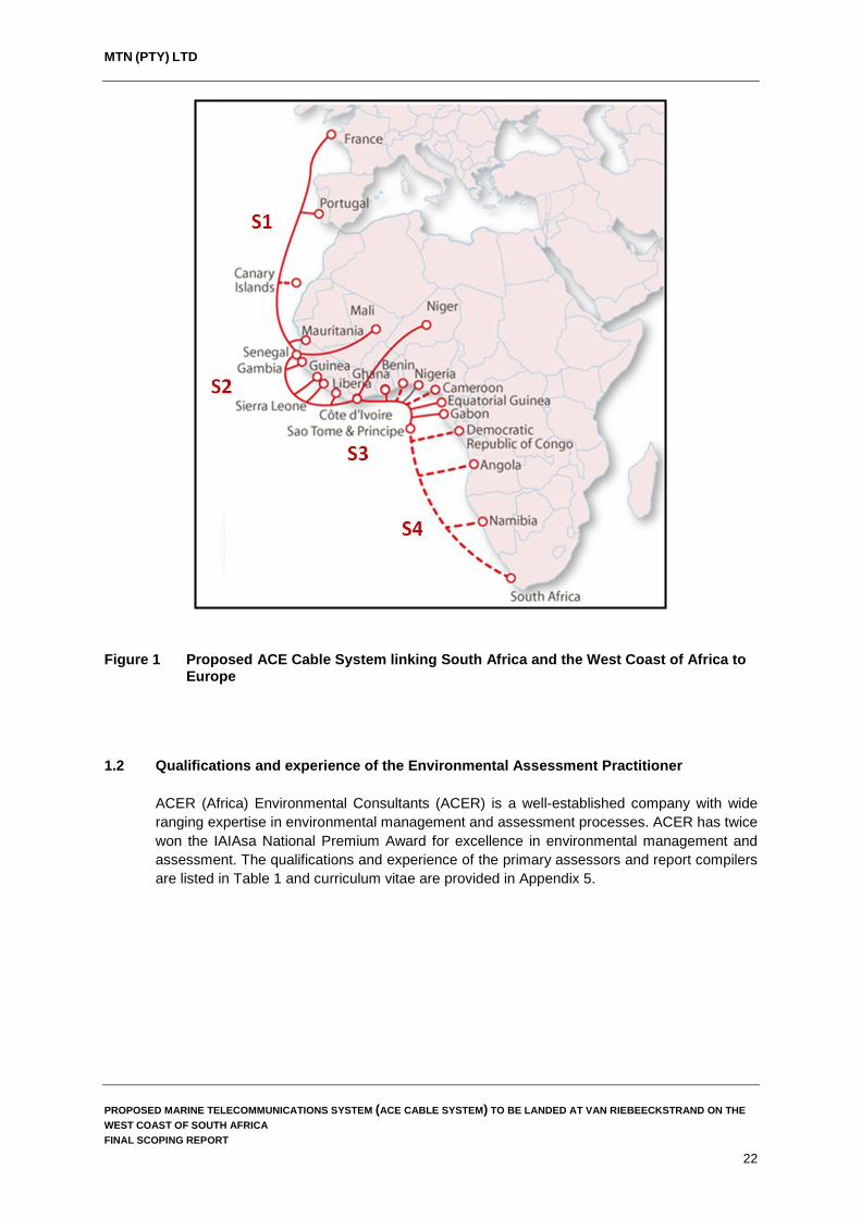
Figure 1 Proposed ACE Cable System linking South Africa and the West Coast of Africa to Europe .............................................................................................................................. 22
Figure 2 The phases of an environmental impact assessment ...................................................... 29 Figure 3 Assessment framework based on the concept of sustainability ....................................... 30 Figure 4 Landing alternatives considered during environmental screening near Van
Riebeeckstrand and Melkbosstrand ................................................................................. 47 Figure 5 Alternative Landing Site 1 and position of the proposed Beach Man Hole (Source
Google Earth 2016) .......................................................................................................... 48 Figure 6 Alternative Landing Site 2 and position of the proposed Beach Man Hole near Die
Bad Road (Source Google Earth 2016) ........................................................................... 50 Figure 7 Alternative Landing Site 3 and position of the proposed Beach Man Hole near the
beach parking area along Pelican Parade Road (Source Google Earth 2016) ............... 52 Figure 8 Alternative Landing Site 4 near the beach parking area on the corner of Beach Road
and 12th Avenue in Melkbosstrand (Source Google Earth 2016) .................................... 54 Figure 9 Proposed cable alignment from Alternative Landing Sites 1 and 2 to the CLS site in
Duynefontein ..................................................................................................................... 57 Figure 10 Overview of the ACE Cable System ................................................................................. 58 Figure 11 Alignment of the ACE Cable System in relation to existing telecommunication cable
systems landing along the Western Cape coastline......................................................... 59 Figure 12 The two shallow water alignments of the ACE Cable System surveyed starting 50 km
offshore ............................................................................................................................. 60 Figure 13 Types of grapnels used to clear the cable route of debris (Source:
https://coast.noaa.gov) ..................................................................................................... 65 Figure 14 Beach Man Hole location at the preferred landing alternative (Source: Google Earth,
2016) ................................................................................................................................. 69 Figure 15 Beach Man Hole location at the preferred landing alternative (Source: Google Earth,
2016) ................................................................................................................................. 69 Figure 16 Beach Man Hole building plans ........................................................................................ 70 Figure 17 Cross section of the terrestrial cable trenches ................................................................. 71 Figure 18 Proposed focus areas for offshore protection (Source: Sink et al., 2011)........................ 80 Figure 19 Spatial distribution of trawling efforts off the West Coast of South Africa in relation to
existing submarine cables as well as the proposed ACE cable route. Fishing effort is displayed at a 5’ x 5’ grid resolution showing the average number of trawl start positions per annum (2005 – 2014) .................................................................................. 86
Figure 20 Graphic representation of the cross section of Van Riebeeckstrand beach and dune cordon ............................................................................................................................... 89
Figure 21 Vegetation types within the study area ............................................................................. 90 Figure 22 Disturbance within the dune slack wetland within the study area .................................... 91 Figure 23 Average monthly rainfall and temperatures for Melkbosstrand (Source:
http://www.worldweatheronline.com) ................................................................................ 93 Figure 24 Monthly household income within the City of Cape Town and Ward 23 .......................... 94 Figure 25 Access to piped water in City of Cape Town and Ward 23 .............................................. 95 Figure 26 Access to sanitation in the City of Cape Town and Ward 23 ........................................... 95 Figure 27 Access to electricity in City of Cape Town and Ward 23 .................................................. 96 Figure 28 Koeberg 2 km Exclusion Zone .......................................................................................... 97
PROPOSED MARINE TELECOMMUNICATIONS SYSTEM (ACE CABLE SYSTEM) TO BE LANDED AT VAN RIEBEECKSTRAND ON THE WEST COAST OF SOUTH AFRICA FINAL SCOPING REPORT
XIII

MTN (PTY) LTD
LIST OF TABLES
Table 1 Qualifications and experience .......................................................................................... 23 Table 2 Listed activities potentially triggerd by the proposed ACE Cable System ........................ 24 Table 3 Sectors of society represented by I&APs on the direct mailing list .................................. 75 Table 4 List of public venues in the project area where the Draft Scoping Report was placed for
public review between the 7 November – 9 December 2016 ........................................... 77
LIST OF PLATES
Plate 1: Proposed landing Alternative at Yzerfontein which is constrained by the beach profile and existing WACS cable system ............................................................................................ 46
Plate 2: Proposed landing Alternative 1 near Dunker Street, Van Riebeeckstrand. This landing alternative is the preferred alternative .............................................................................. 49
Plate 3: Landing Alternative 2 near Die Bad Road, Van Riebeeckstrand. The Beach Man Hole will be located to the west of Die Bad Road ........................................................................... 51
Plate 4: Landing Alternative 3 near Pelican Parade Road. The Beach Man Hole would be located in the car park which is used by beach goers .................................................................. 53
Plate 5: Landing Alternative 4 near 12th Avenue Melkbosstrand. The Beach Man Hole would be located in the car park which is used by beach users ...................................................... 55
Plate 6: Cross section of a typical marine telecommunications cable ........................................... 63 Plate 7: Cable armouring and operational depths ......................................................................... 63 Plate 8: Sea plough to be used to bury the cable along sections of the cable alignment (less than
100 m deep) where conditions permit burial .................................................................... 66 Plate 9: Landing of the cable on shore. Similar works will be undertaken for the landing of the
ACE Cable System ........................................................................................................... 67 Plate 10: Bringing the cable to shore from the cable laying vessel. Cable is buoyed off and pulled
to shore with smaller vessels. ........................................................................................... 68 Plate 11: Some of the commercially targeted fish species on the West Coast of South Africa. ..... 82 Plate 12: Some of the commonly encountered marine bird species off the West Coast of South
Africa. ................................................................................................................................ 84
PROPOSED MARINE TELECOMMUNICATIONS SYSTEM (ACE CABLE SYSTEM) TO BE LANDED AT VAN RIEBEECKSTRAND ON THE WEST COAST OF SOUTH AFRICA FINAL SCOPING REPORT
XIV

MTN (PTY) LTD
ABBREVIATIONS AND ACRONYMS
ACE Africa Coast to Europe ACER ACER (Africa) Environmental Consultants BID Background Information Document BMH Beach Man Hole CA Competent Authority CLS Cable Landing Station CPTs Cone Penetrometer Tests CRR Comments and Responses Report DAFF Department of Agriculture, Forestry and Fisheries DEA Department Environmental Affairs (national) DEADP Western Cape Department of Environmental Affairs and Development Planning DSR Draft Scoping Report DWS Department of Water and Sanitation EAP Environmental Assessment Practitioner EIAR Environmental Impact Assessment Report EIS Ecological Importance and Sensitivity EMPr Environmental Management Programme Eskom Eskom Holdings (SOC) Limited EEZ Exclusive Economic Zone FSR Final Scoping Report GPS Global Positioning System HDPE High-density polyethylene I&APs Interested and Affected Parties ICMA Integrated Coastal Management Act (Act No. 24 of 2008) LWM Low Water Mark MPAs Marine Protected Areas MTN MTN (Pty) Ltd MBES Multi-beam echo sounder NEMA National Environmental Management Act NEPAD New Partnership for Africa’s Development NHRA National Heritage Resources Act NNR National Nuclear Regulator Nm Nautical Miles NWA National Water Act, 1998 (Act 36 of 1998) OC Department of Environmental Affairs – Oceans and Coasts PAZ Precautionary Action Zone PEB Public Exclusion Boundary PES Present Ecological State PLGR Pre-Lay Grapnel Run SAHRA South African Heritage Resources Association SAFE South Africa Far East Cable SADSTIA South African Deep Sea Trawling Industry Association SAHARA South African Heritage Resources Agency SAMSA South African Maritime Safety Authority SAT-3/WASC South Atlantic 3/West Africa Submarine Cable SARCA Southern African Reptile Conservation Assessment TNPA Transnet National Ports Authority TW Territorial Waters UNCLOS United Nations Convention on the Laws of the Sea WA National Environmental Management: Waste Act, 2008 (Act 59 of 2008) WACS West Africa Cable System WD Water Depth
PROPOSED MARINE TELECOMMUNICATIONS SYSTEM (ACE CABLE SYSTEM) TO BE LANDED AT VAN RIEBEECKSTRAND ON THE WEST COAST OF SOUTH AFRICA FINAL SCOPING REPORT
XV

MTN (PTY) LTD
AUTHORS The authors of this Final Scoping Report are Mr. G Churchill and Dr R-D Heinsohn (ACER (Africa) Environmental Consultants). An external review was conducted by Mr. P Scherzer (E&D Consulting Services).
PROPOSED MARINE TELECOMMUNICATIONS SYSTEM (ACE CABLE SYSTEM) TO BE LANDED AT VAN RIEBEECKSTRAND ON THE WEST COAST OF SOUTH AFRICA FINAL SCOPING REPORT
XVI

MTN (PTY) LTD
Adherence to Regulatory Requirements, Regulation No R. 982 published in terms of the National Environmental Management Act, 1998 (Act 107 of 1998) (as amended)
CONTENT OF SCOPING REPORT AS PER THE 2014 EIA REGULATIONS (APPENDIX 2)
RELEVANT SECTION WITHIN THE SCOPING
REPORT (a) Details of: -
(i) the EAP who prepared the report; and Section 1.2 (ii) the expertise of the EAP, including a curriculum vitae; Appendix 5
(b) The location of the activity, including: - (i) the 21 digit Surveyor General code of each cadastral land parcel; Appendix 6 (ii) where available, the physical address and farm name; Appendix 6 (iii) where the required information in items (i) and (ii) is not available,
the coordinates of the boundary of the property or properties; Appendix 6
(c) A plan which locates the activities applied for at an appropriate scale, or, if it is:
Figure 9 and Appendix 6
(i) a linear activity, a description and coordinates of the corridor in which the proposed activity or activities is to be undertaken; or
Appendix 6
(ii) on land where the property has not been defined, the coordinates within which the activity is to be undertaken;
Appendix 6
(d) A description of the scope of the proposed activity, including: Chapter 6 (i) all listed and specified activities triggered; Table 2 (ii) a description of the activities to be undertaken, including
associated structures and infrastructure; Chapter 6
(e) A description of the policy and legislative context within which the development is proposed including an identification of all legislation, policies, plans, guidelines, spatial tools, municipal development planning frameworks and instruments that are applicable to this activity and are to be considered in the assessment process;
Chapter 3
(f) A motivation for the need and desirability for the proposed development including the need and desirability of the activity in the context of the preferred location;
Chapter 4
(h) A full description of the process followed to reach the proposed preferred activity, site and location within the site, including:
Chapter 5
(i) details of all the alternatives considered; Chapter 5 (ii) details of the PPP undertaken in terms of regulation 41 of the
Regulations, including copies of the supporting documents and inputs;
Chapter 7 and Appendix 2
(iii) a summary of the issues raised by I&APs, and an indication of the manner in which the issues were incorporated, or the reasons for not including them;
Chapter 7 Section 7.5 and Appendix 3
(iv) the environmental attributes associated with the alternatives focusing on the geographical, physical, biological, social, economic, heritage and cultural aspects;
Chapter 8
(v) the impacts and risks identified for each alternative, including the nature, significance, consequence, extent, duration and probability of the impacts, including the degree to which these impacts: (aa) can be reversed;
(bb) may cause irreplaceable loss of resources; and
(cc) can be avoided, managed or mitigated;
Chapter 9
(vi) the methodology used in determining and ranking the nature, significance, consequences, extent, duration and probability of potential environmental impacts and risks associated with the alternatives;
Chapter 2,5 and Chapter 10 Section 10.3
PROPOSED MARINE TELECOMMUNICATIONS SYSTEM (ACE CABLE SYSTEM) TO BE LANDED AT VAN RIEBEECKSTRAND ON THE WEST COAST OF SOUTH AFRICA FINAL SCOPING REPORT
XVII

MTN (PTY) LTD
(vii) positive and negative impacts that the proposed activity and alternatives will have on the environment and on the community that may be affected focusing on the geographical, physical, biological, social, economic, heritage and cultural aspects;
Chapter 9 and 10
(viii) the possible mitigation measures that could be applied and level of residual risk;
Mitigation measures not included in DSR
(ix) the outcome of the site selection matrix; Section 4.1 (x) if no alternatives, including alternative locations for the activity were
investigated, the motivation for not considering such and Not Applicable alternatives were considered
(xi) a concluding statement indicating the preferred alternatives, including preferred location of the activity;
Chapter 5
(h) A of plan of study for undertaking the environmental impact assessment process, including:
Chapter 10
(i) A description of the alternatives to be considered and assessed within the preferred site, including the option of not proceeding with the activity;
Chapter 5
(ii) A description of the aspects to be assessed as part of the EIA process;
Chapter 10
(iii) Aspects to be assessed by specialists; Chapter 10 Section 10.1 – 10.5
(iv) A description of the proposed method of assessing the environmental aspects, including a description of the proposed method of assessing the environmental aspects including aspects to be assessed by specialists;
Chapter 2 & 10
(v) A description of the proposed method of assessing duration and significance;
Chapter 10 Section 10.3
(vi) An indication of the stages at which the competent authority will be consulted;
Figure 2 and Chapter 2
(vii) Particulars of the PPP that will be conducted during the EIA process;
Chapter 7
(viii) A description of the tasks that will be undertaken as part of the EIA process;
Chapter 7 & 10
(ix) Identify suitable measures to avoid, reverse, mitigate or manage identified impacts and to determine the extent of the residual risks that need to be managed and monitored.
Not Applicable this will take place during the Impact Assessment phase of the EIA
(i) An undertaking under oath or affirmation by the EAP in relation to: - (i) the correctness of the information provided in the report; Appendix 1 and 2 (ii) the inclusion of comments and inputs from stakeholders and
I&APs; Appendix 2
(iii) any information provided by the EAP to I&APs and any responses by the EAP to comments or inputs made by I&APs;
Appendix 2
(j) An undertaking under oath or affirmation by the EAP in relation to the level of agreement between the EAP and I&APs on the plan of study for undertaking the EIA;
Appendix 2
(k) Where applicable, any specific information required by the competent authority; and
Not currently applicable
(l) Any other matter required in terms of section 24(4)(a) and (b) of the Act. Not currently applicable
PROPOSED MARINE TELECOMMUNICATIONS SYSTEM (ACE CABLE SYSTEM) TO BE LANDED AT VAN RIEBEECKSTRAND ON THE WEST COAST OF SOUTH AFRICA FINAL SCOPING REPORT
XVIII
MTN (PTY) LTD
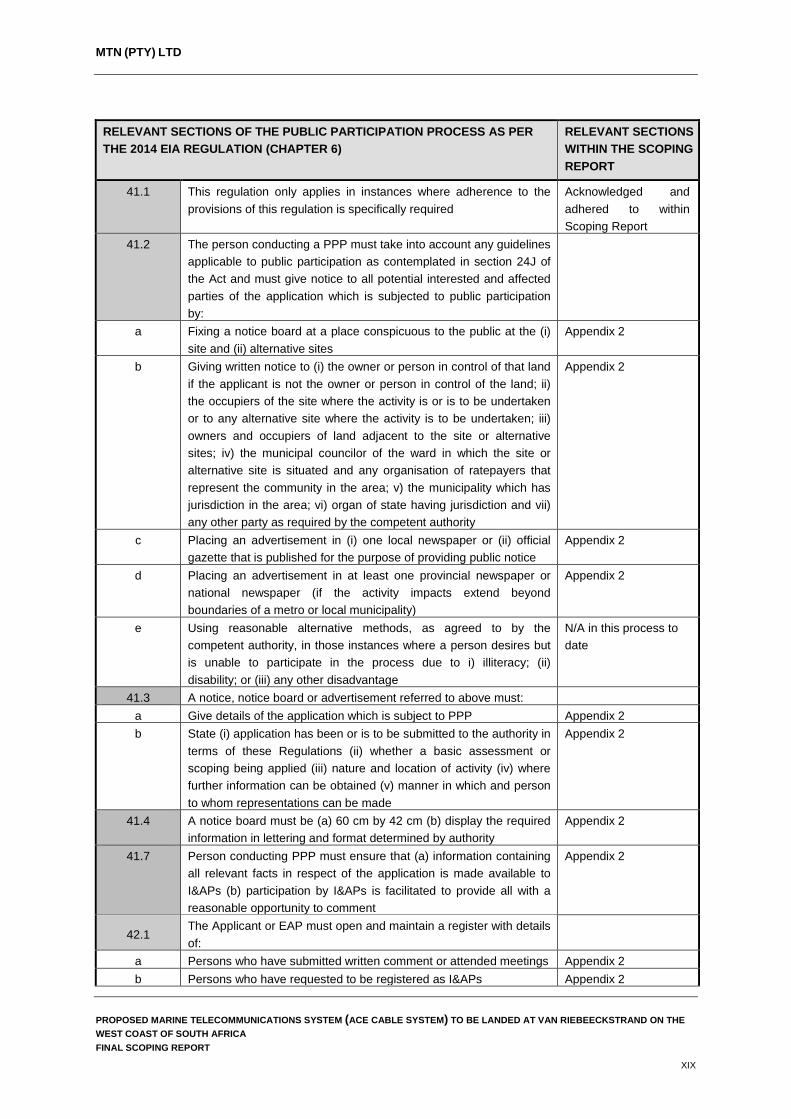
RELEVANT SECTIONS OF THE PUBLIC PARTICIPATION PROCESS AS PER THE 2014 EIA REGULATION (CHAPTER 6)
RELEVANT SECTIONS WITHIN THE SCOPING REPORT
41.1 This regulation only applies in instances where adherence to the provisions of this regulation is specifically required
Acknowledged and adhered to within Scoping Report
41.2 The person conducting a PPP must take into account any guidelines applicable to public participation as contemplated in section 24J of the Act and must give notice to all potential interested and affected parties of the application which is subjected to public participation by:
a Fixing a notice board at a place conspicuous to the public at the (i) site and (ii) alternative sites
Appendix 2
b Giving written notice to (i) the owner or person in control of that land if the applicant is not the owner or person in control of the land; ii) the occupiers of the site where the activity is or is to be undertaken or to any alternative site where the activity is to be undertaken; iii) owners and occupiers of land adjacent to the site or alternative sites; iv) the municipal councilor of the ward in which the site or alternative site is situated and any organisation of ratepayers that represent the community in the area; v) the municipality which has jurisdiction in the area; vi) organ of state having jurisdiction and vii) any other party as required by the competent authority
Appendix 2
c Placing an advertisement in (i) one local newspaper or (ii) official gazette that is published for the purpose of providing public notice
Appendix 2
d Placing an advertisement in at least one provincial newspaper or national newspaper (if the activity impacts extend beyond boundaries of a metro or local municipality)
Appendix 2
e Using reasonable alternative methods, as agreed to by the competent authority, in those instances where a person desires but is unable to participate in the process due to i) illiteracy; (ii) disability; or (iii) any other disadvantage
N/A in this process to date
41.3 A notice, notice board or advertisement referred to above must: a Give details of the application which is subject to PPP Appendix 2 b State (i) application has been or is to be submitted to the authority in
terms of these Regulations (ii) whether a basic assessment or scoping being applied (iii) nature and location of activity (iv) where further information can be obtained (v) manner in which and person to whom representations can be made
Appendix 2
41.4 A notice board must be (a) 60 cm by 42 cm (b) display the required information in lettering and format determined by authority
Appendix 2
41.7 Person conducting PPP must ensure that (a) information containing all relevant facts in respect of the application is made available to I&APs (b) participation by I&APs is facilitated to provide all with a reasonable opportunity to comment
Appendix 2
42.1 The Applicant or EAP must open and maintain a register with details of:
a Persons who have submitted written comment or attended meetings Appendix 2 b Persons who have requested to be registered as I&APs Appendix 2
PROPOSED MARINE TELECOMMUNICATIONS SYSTEM (ACE CABLE SYSTEM) TO BE LANDED AT VAN RIEBEECKSTRAND ON THE WEST COAST OF SOUTH AFRICA FINAL SCOPING REPORT
XIX
MTN (PTY) LTD
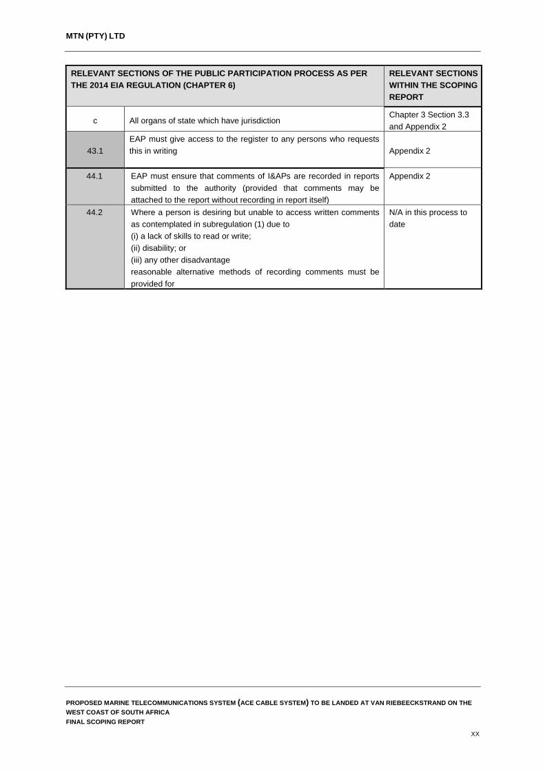
RELEVANT SECTIONS OF THE PUBLIC PARTICIPATION PROCESS AS PER THE 2014 EIA REGULATION (CHAPTER 6)
RELEVANT SECTIONS WITHIN THE SCOPING REPORT
c All organs of state which have jurisdiction Chapter 3 Section 3.3 and Appendix 2
43.1 EAP must give access to the register to any persons who requests this in writing
Appendix 2
44.1 EAP must ensure that comments of I&APs are recorded in reports submitted to the authority (provided that comments may be attached to the report without recording in report itself)
Appendix 2
44.2 Where a person is desiring but unable to access written comments as contemplated in subregulation (1) due to (i) a lack of skills to read or write; (ii) disability; or (iii) any other disadvantage reasonable alternative methods of recording comments must be provided for
N/A in this process to date
PROPOSED MARINE TELECOMMUNICATIONS SYSTEM (ACE CABLE SYSTEM) TO BE LANDED AT VAN RIEBEECKSTRAND ON THE WEST COAST OF SOUTH AFRICA FINAL SCOPING REPORT
XX

MTN (PTY) LTD
1. INTRODUCTION 1.1 Background
Submarine telecommunication cables are important for international telecommunication networks; they transport almost 100% of transoceanic Internet traffic throughout the world (www.iscpc.org). It is widely recognised that access to affordable international bandwidth is key to unlocking economic development in every country. Today, Africa still relies primarily on satellites with only few submarine cables to provide its international communications. Communication via submarine telecommunication cables generally allows for lower cost, better performance, and greater capacity (throughput) than that available via satellite. Improvement in Africa’s information technology infrastructure via telecommunication cables will remove one of the current key inhibitors to development in Africa and support economic growth and opportunities on the continent. MTN (Pty) Ltd (MTN) proposes installing a submarine telecommunications cable, referred to as the Africa Coast to Europe (ACE) Cable System, to link South Africa, the West Coast of Africa and Europe with key international telecommunication hubs in Europe (Figure 1). Following installation of the proposed ACE cable system, MTN will be the first mobile operator to operate an international fibre-optic bandwidth with full landing in South Africa and along the West Coast of Africa. In doing so, the company will facilitate more affordable and effective transport of voice, data, Internet and television services. Furthermore, the cable will support the objectives set out by NEPAD (New Partnership for Africa’s Development), and provide a means of fulfilling the South African Government's requirements in terms of digital television broadcasting for the country.
MTN South Africa aims to secure local landing permits to land the ACE Cable System as the designated Landing Partner of the Cable System in South Africa and has the required licences to operate an international telecommunication infrastructure in the country. The proposed ACE Cable System requires environmental authorisation from the Department of Environmental Affairs (DEA) in terms of the 2014 Environmental Impact Assessment Regulations published under the National Environmental Management Act, 1998 (Act 107 of 1998) (NEMA). In this context, ACER (Africa) Environmental Consultants (ACER) has been appointed by MTN to take responsibility for the application for environmental authorisation for the construction of the ACE Cable System. This Scoping Report has been compiled in accordance with the requirements of NEMA, in particular, Government Notice Regulation 982, published on 4 December 2014, which outlines the requirements of Scoping for purposes of an Environmental Impact Assessment (EIA) undertaken to apply for environmental authorisation for activities listed in Government Notice Regulation R 983, 984 and 985 of 4 December 2014 under Section 24(5) read with Sections 24, 24D and 44 of the National Environmental Management Act, 1998 (Act No. 107 of 1998).
PROPOSED MARINE TELECOMMUNICATIONS SYSTEM (ACE CABLE SYSTEM) TO BE LANDED AT VAN RIEBEECKSTRAND ON THE WEST COAST OF SOUTH AFRICA FINAL SCOPING REPORT
21
MTN (PTY) LTD
Figure 1 Proposed ACE Cable System linking South Africa and the West Coast of Africa to Europe
1.2 Qualifications and experience of the Environmental Assessment Practitioner ACER (Africa) Environmental Consultants (ACER) is a well-established company with wide ranging expertise in environmental management and assessment processes. ACER has twice won the IAIAsa National Premium Award for excellence in environmental management and assessment. The qualifications and experience of the primary assessors and report compilers are listed in Table 1 and curriculum vitae are provided in Appendix 5.
PROPOSED MARINE TELECOMMUNICATIONS SYSTEM (ACE CABLE SYSTEM) TO BE LANDED AT VAN RIEBEECKSTRAND ON THE WEST COAST OF SOUTH AFRICA FINAL SCOPING REPORT
22

MTN (PTY) LTD
Table 1 Qualifications and experience
EAP Academic Qualification
Relevant Work Experience
Dr Dieter Heinsohn (EAP and Co-author)
PhD More than 25 years experience in environmental management and impact assessments. He is registered with the South African Council for Natural Scientific Professions in the field of environmental science (Registration No 400442/04) and certified with the Interim Certification Board
Mr Giles Churchill (EAP and Co-author)
MSc 9.5 years experience in environmental management, impact assessments and the monitoring of compliance with specifications contained in Environmental Management Programmes
Mr P Scherzer (External Reviewer)
MA Food, Society and International Food Policy BSc (Agric)
Mr Scherzer has 19 years experience in environmental and social impact assessments, including numerous marine and cable related environmental assessments. He is a registered professional natural scientist and a certified Environmental Assessment Practitioner and has undertaken project work in seven other Southern and Central African countries.
1.3 Environmental assessment requirements and process
In terms of the current Environmental Impact Assessment Regulations, 2014, published in Government Notices R 982, 983, 984 and 985 of 4 December 2014 under Section 24(5) read with Sections 24, 24D and 44 of the National Environmental Management Act, 1998 (Act No. 107 of 1998), the proposed ACE Cable System includes activities that are listed in the current environmental regulations. As such, the project may not commence without environmental authorisation from the relevant competent authority, in this case, the national Department of Environmental Affairs (DEA)1 (in close consultation with the Western Cape Department of Environmental Affairs and Development Planning (DEADP)). In terms of the current regulations and environmental best practise, the potential impacts of the project on the environment (social, economic and biophysical) must be considered, investigated and assessed prior to implementation. In the case of the proposed ACE Cable System, environmental authorisation will be based on the current Environmental Impact Assessment Regulations, 2014, published in Government Notices R 982, 983, 984 and 985 of 4 December 2014 under Section 24(5) read with Sections 24, 24D and 44 of the National Environmental Management Act, 1998 (Act No. 107 of 1998). Given that the project triggers listed activities in these regulations (Table 2), the application for environmental authorisation requires a process of Scoping and Environmental Impact Assessment as outlined in Regulation R982 (as amended). The EIA process is currently in the Scoping Phase. This is the phase during which issues for further investigations are identified so that they can be considered for inclusion in the Specialist Studies that will be undertaken during the EIA, viz. the Impact Assessment Phase.
1 DEA is the authorising authority as the project crosses international boundaries and is of national importance.
PROPOSED MARINE TELECOMMUNICATIONS SYSTEM (ACE CABLE SYSTEM) TO BE LANDED AT VAN RIEBEECKSTRAND ON THE WEST COAST OF SOUTH AFRICA FINAL SCOPING REPORT
23

MTN (PTY) LTD
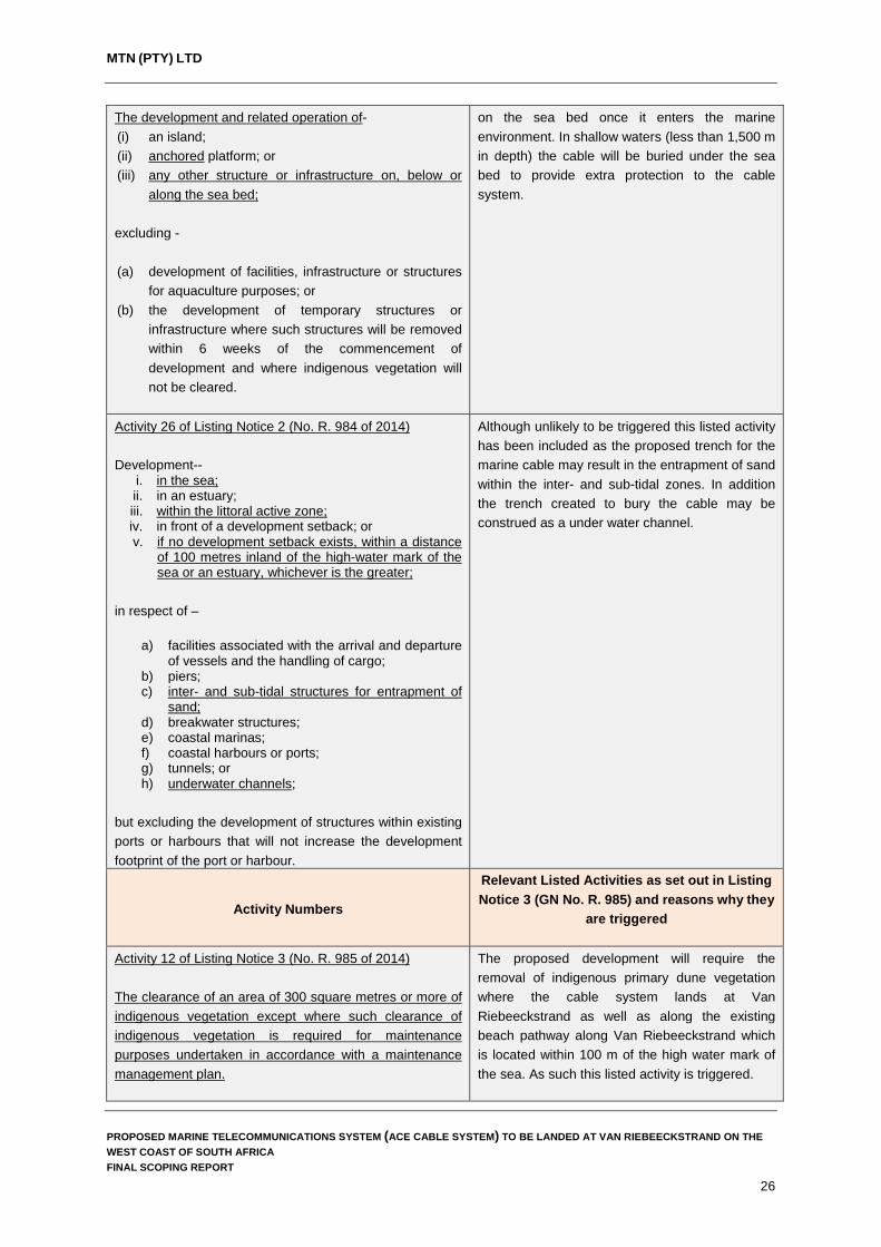
Table 2 Listed activities potentially triggerd by the proposed ACE Cable System
Activity Numbers
Relevant Listed Activities as set out in Listing Notice 1 (GN No. R. 983) and reasons why they are triggered
Activity 15 of Listing Notice 1 (No. R. 983 of 2014) The development of structures in the coastal public property where the development footprint is bigger than 50 square metres, excluding -
(i) the development of structures within existing ports or harbours that will not increase the development footprint of the port or harbour;
(ii) the development of a port or harbour, in which case activity 26 in Listing Notice 2 of 2014 applies;
(iii) the development of temporary structures within the beach zone where such structures will be removed within 6 weeks of the commencement of development and where indigenous vegetation will not be cleared; or
(iv) activities listed in activity 14 in Listing Notice 2 of 2014, in which case that activity applies.
The project will entail the landing of a marine telecommunications cable at Van Riebeeckstrand Beach. This will entail the digging of a trench down the beach (coastal public property) into the intertidal zone and the installation of the underground telecommunications cable.
Activity 17 of Listing Notice 1 (No. R. 983 of 2014) Development-
a. in the sea; b. in an estuary; c. within the littoral active zone; d. in front of a development setback; or e. if no development setback exists, within a distance
of 100 metres inland of the high- water mark of the sea or an estuary, whichever is the greater;
in respect of- i. fixed or floating jetties and slipways; ii. tidal pools; iii. embankments; iv. rock revetments or stabilising structures including
stabilising walls; v. buildings of 50 square metres or more; or vi. infrastructure with a development footprint of 50
square metres or more - but excluding- (aa) the development of infrastructure and structures
within existing ports or harbours that will not increase the development footprint of the port or harbour;
(bb) where such development is related to the development of a port or harbour, in which case activity 26 in Listing Notice 2 of 2014 applies;
(cc) the development of temporary infrastructure or structures where such structures will be removed within 6 weeks of the commencement of development and where indigenous vegetation will not be cleared; or
The project will entail the landing of a marine telecommunications cable at Van Riebeeckstrand Beach. This will entail the digging of a trench down the beach into the intertidal zone and the installation of the underground telecommunications cable.
PROPOSED MARINE TELECOMMUNICATIONS SYSTEM (ACE CABLE SYSTEM) TO BE LANDED AT VAN RIEBEECKSTRAND ON THE WEST COAST OF SOUTH AFRICA FINAL SCOPING REPORT
24

MTN (PTY) LTD
(dd) where such development occurs within an urban area.
Activity 18 of Listing Notice 1 (No. R. 983 of 2014) The planting of vegetation or placing of any material on dunes or exposed sand surfaces of more than 10 square metres, within the littoral active zone, for the purpose of preventing the free movement of sand, erosion or accretion, excluding where - (i) the planting of vegetation or placement of material
relates to restoration and maintenance of indigenous coastal vegetation undertaken in accordance with a maintenance management plan; or
(ii) (ii) such planting of vegetation or placing of material will occur behind a development setback.
The project will entail the rehabilitation of the primary dune belt along Van Riebeeckstrand Beach where construction activities associated with the laying of the underground telecommunications cable will disturb vegetation on the primary dune. In addition to the above, the project will involve the planting of vegetation and material to aid in dune rehabilitation once construction is complete. As such, this listed activity is triggered
Activity 19 of Listing Notice 1 (No. R. 983 of 2014) The infilling or depositing of any material of more than 5 cubic metres into, or the dredging, excavation, removal or moving of soil, sand, shells, shell grit, pebbles or rock of more than 5 cubic metres from- (i) a watercourse; (ii) the seashore; or (iii) the littoral active zone, an estuary or a distance of
100 metres inland of the high-water mark of the sea or an estuary, whichever distance is the greater
but excluding where such infilling, depositing , dredging, excavation, removal or moving-
(a) will occur behind a development setback; (b) is for maintenance purposes undertaken in
accordance with a maintenance management plan; or
(c) falls within the ambit of activity 21 in this Notice, in which case that activity applies.
The project will entail the excavation and deposition of more than 5 m3 of material within a 100 m of the high water mark of the sea when trenching for, and backfilling of, the marine telecommunications cable takes place as such, this listed activity is triggered.
Activity Numbers
Relevant Listed Activities as set out in Listing Notice 2 (GN No. R. 984) and reasons why they are triggered
Activity 10 of Listing Notice 2 (No. R. 984 of 2014) The development of facilities or infrastructure for marine telecommunication.
The proposed development involves the installation and landing of the ACE Cable System (marine telecommunications cable) by MTN near Van Riebeeckstrand in the Western Cape. As such, this listed activity is triggered by the proposed development.
Activity 14 of Listing Notice 2 (No. R. 984 of 2014)
The proposed development triggers this listed activity as the ACE Cable System will be placed
PROPOSED MARINE TELECOMMUNICATIONS SYSTEM (ACE CABLE SYSTEM) TO BE LANDED AT VAN RIEBEECKSTRAND ON THE WEST COAST OF SOUTH AFRICA FINAL SCOPING REPORT
25
MTN (PTY) LTD
The development and related operation of- (i) an island; (ii) anchored platform; or (iii) any other structure or infrastructure on, below or
along the sea bed; excluding - (a) development of facilities, infrastructure or structures
for aquaculture purposes; or (b) the development of temporary structures or
infrastructure where such structures will be removed within 6 weeks of the commencement of development and where indigenous vegetation will not be cleared.
on the sea bed once it enters the marine environment. In shallow waters (less than 1,500 m in depth) the cable will be buried under the sea bed to provide extra protection to the cable system.
Activity 26 of Listing Notice 2 (No. R. 984 of 2014) Development--
i. in the sea; ii. in an estuary; iii. within the littoral active zone; iv. in front of a development setback; or v. if no development setback exists, within a distance
of 100 metres inland of the high-water mark of the sea or an estuary, whichever is the greater;
in respect of –
a) facilities associated with the arrival and departure of vessels and the handling of cargo;
b) piers; c) inter- and sub-tidal structures for entrapment of
sand; d) breakwater structures; e) coastal marinas; f) coastal harbours or ports; g) tunnels; or h) underwater channels;
but excluding the development of structures within existing ports or harbours that will not increase the development footprint of the port or harbour.
Although unlikely to be triggered this listed activity has been included as the proposed trench for the marine cable may result in the entrapment of sand within the inter- and sub-tidal zones. In addition the trench created to bury the cable may be construed as a under water channel.
Activity Numbers
Relevant Listed Activities as set out in Listing Notice 3 (GN No. R. 985) and reasons why they
are triggered
Activity 12 of Listing Notice 3 (No. R. 985 of 2014) The clearance of an area of 300 square metres or more of indigenous vegetation except where such clearance of indigenous vegetation is required for maintenance purposes undertaken in accordance with a maintenance management plan.
The proposed development will require the removal of indigenous primary dune vegetation where the cable system lands at Van Riebeeckstrand as well as along the existing beach pathway along Van Riebeeckstrand which is located within 100 m of the high water mark of the sea. As such this listed activity is triggered.
PROPOSED MARINE TELECOMMUNICATIONS SYSTEM (ACE CABLE SYSTEM) TO BE LANDED AT VAN RIEBEECKSTRAND ON THE WEST COAST OF SOUTH AFRICA FINAL SCOPING REPORT
26

MTN (PTY) LTD
a) In Eastern Cape, Free State, Gauteng, Limpopo, North West and Western Cape provinces:
iii. Within the littoral active zone or 100 metres inland
from high water mark of the sea or an estuarine functional zone, whichever distance is the greater, excluding where such removal will occur behind the development setback line on erven in urban areas; or
iv. On land, where, at the time of the coming into effect of this Notice or thereafter such land was zoned open space, conservation or had an equivalent zoning.
Activity 15 of Listing Notice 3 (No. R. 985 of 2014) The transformation of land bigger than 1000 square metres in size, to residential, retail, commercial, industrial or institutional use, where, such land was zoned open space, conservation or had an equivalent zoning, on or after 02 August 2010. (c) In Western Cape:
i. Outside urban areas, or ii. Inside urban areas in:
(aa) Areas zoned for conservation use or equivalent
zoning, on or after 02 August 2010; (bb) A protected area identified in terms of NEMPAA,
excluding conservancies; or (cc) Sensitive areas as identified in an environmental
management framework as contemplated in chapter 5 of the Act as adopted by the competent authority.
The proposed development will require the trenching of approximately 900 m of trench through areas zoned as public open space and conservation near Van Riebeeckstrand. It is anticipated that servitudes will have to be registered with the City of Cape Town and as such this listed activity is potentially triggered.
Based on the current regulations, the EAP must complete Scoping and the Impact Assessment within 300 days of acceptance of the Application for Authorisation by the National Department of Environmental Affairs (DEA). It is also envisaged that a Water Use Licence will be required from the Department of Water and Sanitation in terms of Chapter 4 of the National Water Act, 1998 (Act No 36 of 1998), in particular, Section 40(4). It is important to note that timeframes in the 2014 regulations are based on calendar days and the following conditions apply:
15 December to 5 January are excluded from the calculation. No Public Participation between 15 December and 5 January unless justified by
exceptional circumstances. Organs of State to comment within 30 days from the date on which it was requested to
submit comments (2010 = within 40 days).
PROPOSED MARINE TELECOMMUNICATIONS SYSTEM (ACE CABLE SYSTEM) TO BE LANDED AT VAN RIEBEECKSTRAND ON THE WEST COAST OF SOUTH AFRICA FINAL SCOPING REPORT
27

MTN (PTY) LTD
For both BA & S&EIR: the Competent Authority (CA) must within 107 days issue a decision.
Notification of decision by CA within 5 days of date of decision (2010 = within 2 days).
The Department of Environmental Affairs (DEA) is the competent authority for the issuing of environmental authorisation for the proposed development due to the fact that the cable extends over international boundaries. ACER will fulfil the role and responsibilities of the Environmental Assessment Practitioner (EAP) to undertake the EIA and the associated public participation process, and to submit the required application and supporting documentation for consideration and decision-making. The main phases of the environmental impact assessment process and legislated time frames are shown in Figure 2.
PROPOSED MARINE TELECOMMUNICATIONS SYSTEM (ACE CABLE SYSTEM) TO BE LANDED AT VAN RIEBEECKSTRAND ON THE WEST COAST OF SOUTH AFRICA FINAL SCOPING REPORT
28

MTN (PTY) LTD
Figure 2 The phases of an environmental impact assessment PROPOSED MARINE TELECOMMUNICATIONS SYSTEM (ACE CABLE SYSTEM) TO BE LANDED AT VAN RIEBEECKSTRAND ON THE WEST COAST OF SOUTH AFRICA FINAL SCOPING REPORT
29

MTN (PTY) LTD
2. SCOPING METHODOLOGY Scoping is a process designed to define the limits of the assessment, to identify and elicit inputs from Interested and Affected Parties (I&APs), and to define an assessment framework with the purpose of focusing the scope of the assessment, thereby ensuring a focus on key issues and associated impacts. The framework (Figure 3) within which environmental aspects arising from or influencing the proposed project (and its alternatives) are considered has been undertaken using the following philosophy: The concept of sustainability, which considers the inter-related dimensions of the
environment, viz. the social, economic and biophysical dimensions, underpinned by a system of sound governance through the legal/statutory requirements of South Africa (in particular, NEMA).
Figure 3 Assessment framework based on the concept of sustainability
Issues and impacts were identified by way of interlinked technical and public participation processes (Chapter 7 details the public participation process). Information gathering focused on gaining an understanding of the interactions between the different dimensions of the environment in order to identify potentially significant issues and impacts. This involved site visits, reference to existing documentation and maps, liaison with the project proponent and technical team, as well as consideration and incorporation of the issues raised during the public participation process. Information was collated, integrated and evaluated, and potentially significant issues and impacts were identified. This enabled the Environmental Assessment Practitioner (EAP) to focus and tailor the scope of work for specialist studies and further detailed investigations to be taken forward to the Impact Assessment Phase.
PROPOSED MARINE TELECOMMUNICATIONS SYSTEM (ACE CABLE SYSTEM) TO BE LANDED AT VAN RIEBEECKSTRAND ON THE WEST COAST OF SOUTH AFRICA FINAL SCOPING REPORT
30

MTN (PTY) LTD
The information provided in the Scoping Report complies with the legal requirements of Regulation R982 (as amended) outlined on Page XI and XII and has been structured in the following manner: A broad perspective of applicable legislation and guidelines. A detailed description of the proposed activity, including an understanding of the
purpose and need for the proposed project. A discussion of the feasible and reasonable alternatives that have been identified and
assessed. A description of the environment and manner in which it may be affected. A description of environmental issues and potential impacts. An outline of the proposed methodology and specialist studies to be undertaken during
the impact assessment, including details of the public participation process. A plan of study for EIA and a description of the assessment methodology that will be
used.
The Scoping Report also contains appendices that present the following information:
Appendix 2: Public Participation Documentation. Appendix 3: Issues and Response Report.
The Draft Scoping Report was made available to Interested and Affected Parties (I&APs) between the 7 November 2016 and the 9 December 2016 (over 30 calendar days) to review and provide comments on the document. Following the period of public review, the Draft Scoping Report was updated and finalised into the Final Scoping Report (this document) which will be submitted to DEA for decision making. In addition to the requirement for Scoping and an Environmental Impact Assessment (as outlined in Regulation R982) a review of all legislation applicable to the proposed ACE Cable System was undertaken in order to establish what other licences and permits will be applicable to the project. Included in this review of legislation were the permit requirements of the Department of Water and Sanitation (DWS) (water use licences), the permit requirements of the Department of Environmental Affairs – Oceans and Coasts (OC) (in terms of the proposed cable laying activities and beach access), permit requirements from the Department of Agriculture, Forestry and Fisheries (DAFF) and the permit requirements of the Department of Environmental Affairs in terms of the Waste Act. Findings from this review of applicable legislation and the required licence and permits are included in Chapter 3 of this Final Scoping Report.
2.1 Pre-application meetings and discussions with commenting authorities Given the tight timeframes as legislated under the current environmental regulations, ACER and MTN approached the following commenting authorities prior to submission of the application for authorisation to DEA to discuss the proposed development and to identify alternatives which were feasible in terms of implementation to take forward into the EIA process: City of Cape Town – Planning and Environmental Department. Western Cape Department of Environmental Affairs and Development Planning.
PROPOSED MARINE TELECOMMUNICATIONS SYSTEM (ACE CABLE SYSTEM) TO BE LANDED AT VAN RIEBEECKSTRAND ON THE WEST COAST OF SOUTH AFRICA FINAL SCOPING REPORT
31

MTN (PTY) LTD
Department of Environmental Affairs – Oceans and Coasts. Department of Agriculture, Forestry and Fisheries.
Additional input was obtained from the pre-application meeting held with DEA on 7 June 2016
(see Appendix 4 for meeting minutes) to discuss the proposed plan of works for the EIA. The purpose of the meeting was for ACER and MTN to introduce the proposed project to DEA and to obtain guidance and clarification from DEA as to their requirements for EIAs for marine telecommunications cables, and the interpretation and implementation of the December 2014 EIA Regulations.
2.2 Environmental screening
At the onset of the project planning phase, MTN and their appointed service providers undertook a number of investigations to identify suitable cable landing points which could link to the MTN Cable Landing Station (CLS) located in Duynefontein on the West Coast of South Africa. Initially, two alternative landing locations were investigated, namely Yzerfontein and Melkbosstrand. These landing locations were selected following consideration of not only environmental issues, but also those associated with marine engineering (e.g. security of the route against external risks) and commercial aspects (e.g. proximity to national networks and their international access points). During these screening assessments a number of factors were considered, including the following: Presence of existing marine telecommunications systems. Profile of the beaches and primary dunes. Distance from the beach landing points to the CLS site at Duynefontein. Presence of electrical infrastructure (Eskom transmission and distribution lines). Current land use between the proposed landing points and the CLS site. Existing servitudes and future development corridors under consideration by the City of
Cape Town.
The two landing locations were then assessed in more detail with specific sites within the two locations proposed for further assessment. Findings from the initial screening of these landing alternatives are explained in detail in Chapter 5 of this report.
PROPOSED MARINE TELECOMMUNICATIONS SYSTEM (ACE CABLE SYSTEM) TO BE LANDED AT VAN RIEBEECKSTRAND ON THE WEST COAST OF SOUTH AFRICA FINAL SCOPING REPORT
32

MTN (PTY) LTD
3. LEGAL ASPECTS 3.1 Applicable legislation
There are a host of legal requirements (national, provincial and local government spheres) to which MTN must adhere for the construction and placement of the proposed ACE Cable System and related infrastructure. Fundamentally, MTN is required to include and integrate environmental principles and values into all planning and implementation procedures taken for development purposes. Underlying the above reasoning is the constitutional right that people have to environmental protection as set out in the Bill of Rights in the Constitution (Section 24). These rights have been interpreted and included into NEMA, which, together with other national and provincial legislation, governs the way environmental principles are incorporated into any form of development. Some of the key legislation that is applicable to this project is provided hereunder.
3.1.1 Constitution of the Republic of South Africa Act, 1996 (Act 108 of 1996) (as amended) The Constitution is the supreme law of South Africa, against which all other laws are measured. It sets out a number of fundamental environmental rights.
The Environmental Clause Section 24 of the Constitution outlines the basic framework for all environmental policy and legislation: It states: “Everyone has the right – a) to an environment that is not harmful to their health or well-being; and b) to have the environment protected, for the benefit of present and future generations,
through reasonable legislative and other measures that – i) prevent pollution and ecological degradation; ii) promote conservation; and iii) secure ecologically sustainable development and use of natural resources while
promoting justifiable economic and social development”.
Access to Information Section 32 of the Constitution provides that everyone has the right of access to any information held by the State or another juristic person, which is required for the exercise or protection of any rights. Fair Administrative Action Section 33 of the Constitution provides the right to lawful, reasonable and procedurally fair administrative action. Enforcement of Rights and Administrative Review Section 38 of the Constitution guarantees the right to approach a court of law and to seek legal relief in the case where any of the rights that are entrenched in the Bill of Rights are infringed or threatened.
PROPOSED MARINE TELECOMMUNICATIONS SYSTEM (ACE CABLE SYSTEM) TO BE LANDED AT VAN RIEBEECKSTRAND ON THE WEST COAST OF SOUTH AFRICA FINAL SCOPING REPORT
33

MTN (PTY) LTD
3.1.2 National Environmental Management Act, 1998 (Act 107 of 1998) NEMA is South Africa’s overarching environmental legislation. It provides the legislative framework for Integrated Environmental Management in South Africa. The Act gives meaning to the right to an environment that is not harmful to health or well-being, entrenched in Section 24 of the Constitution. In addition, NEMA provides for: equitable access to natural resources, environmental protection and the formulation of environmental management frameworks. The Act is underpinned by the global concept of sustainable development. Section 2 of NEMA provides a set of principles that apply to the actions of all organs of state that may significantly affect the environment. The interpretation, administration and application of NEMA are guided by fundamental principles of sustainable development, provided in Chapter 1 of the Act. “Development must be socially, environmentally and economically sustainable” and requires the consideration of all relevant factors, which are guided by eight sub-principles, including: The sustainability principle. The life-cycle, cradle-to-grave principle. The ‘polluter pays’ principle. The precautionary principle. The duty of care principle. Fair and transparent public consultation.
The concept of sustainability underpinning this assessment considers three inter-related dimensions of the environment, viz. the social, economic and biophysical dimensions (Figure 3). For an option or project to be sustainable, it needs to demonstrate economic growth, social acceptability and soundness, and ecological integrity within a framework of good governance.
3.1.3 The Environmental Impact Assessment Regulations, 2014 (as amended) The EIA Regulations contained in Government Notices R 982, R 983, R 984 and R 985 of 04 December 2014, published in terms of Section 24 of the NEMA, regulate environmental management in South Africa. Activities that require authorisation from the competent authority prior to their commencement are listed in Government Notices R 983, R 984 and R 985. The procedures dealing with the EIA Regulations are contained in GN R 982. The Listed Activities applicable to the proposed establishment of ACE Cable System are presented in Table 2 above. All potential impacts associated with these Listed Activities will be considered and adequately assessed in this EIA process. Environmental Authorisation obtained from this application will apply only to listed activities for which the application was made. Therefore a precautionary approach is followed when identifying listed activities that could potentially be triggered by the development.
PROPOSED MARINE TELECOMMUNICATIONS SYSTEM (ACE CABLE SYSTEM) TO BE LANDED AT VAN RIEBEECKSTRAND ON THE WEST COAST OF SOUTH AFRICA FINAL SCOPING REPORT
34

MTN (PTY) LTD
3.1.4 National Water Act, 1998 (Act 36 of 1998) The National Water Act, 1998 (Act 36 of 1998) (NWA) has various sections of relevance to the proposed project. The Department of Water and Sanitation (DWS) is the responsible authority with regard to matters affecting water resource management, including water quality. Added to this, certain provincial and local authority powers influence the regulation of water resources, including agriculture, the environment, health services, nature conservation, pollution control, regional planning and development, soil conservation, and water and sanitation services. The development or modification of water courses or wetlands in any form are governed by conditions provided in Chapter 4, Part 1 of the Act, which sets out general principles for regulating water use. In general, a water use must be licensed unless: It is listed in Schedule 1 of the Act. Is an existing lawful water use. It is permissible under a general authorisation. A responsible authority waives the need for a licence.
As development or modifications of watercourses or wetlands are not included in Schedule 1, a licence is required to carry out any activity involving modifications to watercourses or wetlands. This is relevant due to the fact that the proposed landing alternatives for the ACE Cable System will require the crossing of a wetland area located behind the primary dunes at Van Riebeeckstrand.
3.1.5 National Heritage Resources Act, 1999 (Act 25 of 1999) The National Heritage Resources Act (NHRA), 1999 (Act 25 of 1999) (NHRA) aims to promote an integrated system for the identification, assessment and management of the heritage resources of South Africa. Furthermore, it established the South African Heritage Resources Agency (SAHRA) to implement the Act. Section 38 (1) of the NHRA lists development activities that would require authorisation by the responsible heritage resources authority. Activities considered applicable to the proposed project include the following: (a) The construction of a road, wall, powerline, pipeline, canal or other similar form of linear
development or barrier exceeding 300 m in length. (c) Any development or other activity which will change the character of a site; and (i) exceeding 5 000 m² in extent.´ (d) The re-zoning of a site exceeding 10 000 m2 in extent. The NHRA requires that a person intending to undertake such an activity must notify the relevant national and provincial heritage authorities at the earliest stages of initiating such a development. The relevant heritage authority would then, in turn, notify the person whether a Heritage Impact Assessment Report should be submitted. It must be noted that SAHRA is the relevant heritage authority for all heritage resources located under the low water mark of the sea up to a distance of 24 Nautical miles seaward from the high water mark of the sea.
PROPOSED MARINE TELECOMMUNICATIONS SYSTEM (ACE CABLE SYSTEM) TO BE LANDED AT VAN RIEBEECKSTRAND ON THE WEST COAST OF SOUTH AFRICA FINAL SCOPING REPORT
35

MTN (PTY) LTD
3.1.6 National Forest Act, 1998 (Act 84 of 1998) In terms of the National Forests Act, 1998 (Act 84 of 1998), trees in natural forests or protected tree species (as listed in Government Gazette Notice 908 of 21 November 2014) may not be cut, disturbed, damaged, destroyed and their products may not be possessed, collected, removed, transported, exported, donated, purchased or sold, except under licence granted by the Department of Agriculture, Forestry and Fisheries (DAFF). Each application is evaluated on merit before a decision is taken whether or not to issue a licence (with or without conditions). Such decisions must be in line with national policy and guidelines. Whether the proposed project will affect natural forests or protected tree species will be determined during the specialist studies commissioned for the impact assessment phase of the EIA.
3.1.7 Hazardous Substance Act (No 15 of 1973) and Regulations
The purpose of the Act is: To provide for the control of substances which may cause injury or ill-health to or death
of human beings by reason of their toxic, corrosive, irritant, strongly sensitizing or flammable nature or the generation of pressure thereby in certain circumstances, and for the control of certain electronic products.
To provide for the division of such substances or products into groups in relation to the degree of danger.
To provide for the prohibition and control of the importation, manufacture, sale, use, operation, application, modification, disposal or dumping of such substances and products.
To provide for matters connected therewith.
Based on a review of the proposed materials and construction methods to be employed in the construction and installation of the ACE Cable System, it is unlikely that the conditions of this Act or its regulations will have any relevance to the proposed development.
3.1.8 Conservation of Agricultural Resources Act, 1983 (Act 43 of 1983)
The Conservation of Agricultural Resources Act, 1983 (Act 43 of 1983) states that no degradation of natural land is permitted. The Act requires the protection of land against soil erosion and the prevention of water logging and salinization of soils by means of suitable soil conservation works to be constructed and maintained. The utilisation of marshes, water sponges and watercourses are also addressed.
3.1.9 National Environmental Management: Waste Act, 2008 (Act 59 of 2008) The National Environmental Management: Waste Act, 2008 (Act 59 of 2008) (WA) has various sections of relevance to the proposed ACE Cable System. The aims of the Act are to provide laws regulating waste management in order to protect health and the environment by providing reasonable measures for the prevention of pollution and ecological degradation, and for securing ecologically sustainable development. In fulfilling the rights contained in Section 24 of the Constitution, the State, through the organs of state responsible for implementing this
PROPOSED MARINE TELECOMMUNICATIONS SYSTEM (ACE CABLE SYSTEM) TO BE LANDED AT VAN RIEBEECKSTRAND ON THE WEST COAST OF SOUTH AFRICA FINAL SCOPING REPORT
36

MTN (PTY) LTD
Act, must put in place uniform measures that seek to reduce the amount of waste that is generated and, where waste is generated, to ensure that waste is re-used, recycled and recovered in an environmentally sound manner before being safely treated and disposed. As such, the interpretation and application of the Act must be guided by the national environmental management principles set out in Section 2 of NEMA. Based on a review of the proposed materials and construction methods to be employed in the construction and installation of the ACE Cable System, it is unlikely that the conditions of this Act or its regulations will have any relevance to the proposed development.
3.1.10 National Environmental Management: Biodiversity Act 10 of 2004 This Act provides for the management and conservation of South Africa’s biodiversity, protects species and ecosystems, ensures sustainable use of indigenous biological resources, ensures fair and equitable sharing of benefits arising from the commercial use of these resources, and to establish a South African National Biodiversity Institute. The Act also covers alien and invasive species and genetically modified organisms that pose a threat to biodiversity. As such, it controls and regulates: Certain threatening activities occurring in identified ecosystems. Certain activities which may negatively impact on the survival of identified threatened or
protected species. Certain restricted activities involving alien or listed invasive species.
In accordance with the Biodiversity Act, specialist studies will be commissioned to ensure that sensitive vegetation is not detrimentally affected by the installation and construction activities associated with the terrestrial components of ACE Cable System.
3.1.11 Integrated Coastal Management Act (Act No. 24 of 2008) (ICMA) In general, ICMA promotes the use of defensible scientific information in conjunction with the principles of cooperative governance in order to achieve sustainable coastal development. The ICMA is a specific environmental management act under the umbrella of the National Environmental Management Act (NEMA) and due to the broad spectrum of issues covered by the ICMA it necessitates links to other legislation such as the Marine Living Resources Act (Act No. 18 of 1998). As such, the interpretation and understanding of the ICMA must be read in conjunction with other legislation to fully understand the responsibilities, regulations and objectives encompassed in this Act. It is important to note that the ICMA has been amended by the National Environmental Management: Integrated Coastal Management Amendment Act, 2014 (Act No. 36 of 2014). In terms of the proposed ACE Cable System, a number of sections of the ICMA are and will be relevant to the project. The most significant of these deal with the considerations which must be taken into account when authorities are considering whether to grant an environmental authorisation for any activity within the coastal zone and the construction of infrastructure on or in, coastal public properly.
PROPOSED MARINE TELECOMMUNICATIONS SYSTEM (ACE CABLE SYSTEM) TO BE LANDED AT VAN RIEBEECKSTRAND ON THE WEST COAST OF SOUTH AFRICA FINAL SCOPING REPORT
37

MTN (PTY) LTD
3.1.12 The Marine Living Resources Act (Act No. 18 of 1998) This Act provides for the conservation and management of the marine ecosystem, the long-term sustainable utilisation of marine living resources and equitable access to exploitation, utilisation and protection of certain marine living resources. In terms of the proposed ACE Cable System, this Act is applicable as the majority of the project occurs within the marine environment.
3.1.13 Maritime Zones Act No. 15 of 1994 This Act determines and defines the territorial sea, internal waters, Exclusive Economic Zone (EEZ) and continental shelf of South Africa. In compliance with the UN Law of the Sea, the Act declares the territorial sea of South Africa to be the sea within a distance of 12 nautical miles measured from the low water mark on the shore (baseline). The sea beyond the territorial waters but within 200 Nm of the baseline shall be the EEZ of South Africa. Within the EEZ, South Africa shall have the same rights and powers as it has in its territorial waters, in respect of all natural resources. The Act also states that all installations, which are defined to include telecommunications lines as defined in section 1 of the Post Office Act, 1958 (Act No. 44 of 1958), situated within internal waters, territorial waters or the EEZ or on or above the continental shelf must be constructed and operated within the current laws of South Africa.
3.1.14 Telecommunications Act 103 of 1996 This Act makes provision for the regulation of telecommunication activities other than broadcasting, and for the control of the radio frequency spectrum; and to establish an independent South African Telecommunications Regulatory Authority and a Universal Service Agency. It provides that no person may offer telecommunications services without a licence authorising them to do so. In terms of the proposed ACE Cable system, Section 36 of the Act applies as MTN is licensed to provide national long distance and international telecommunication services. Additionally, in terms of Section 75, a local authority may install a conduit pipe or other facilities for the installation of underground cables on any premises.
3.1.15 Marine Traffic Act 2 of 1981 The function of this Act is to regulate marine traffic in South African waters and matters incidental thereto. It is governed by the South African Maritime Safety Authority (SAMSA) established by Section 2 of the South African Maritime Safety Authority Act 5 of 1998, under the Department of Transport. Of particular importance to the proposed ACE Cable System is the stipulation that no ship may drop or drag anchor or fishing gear (bottom trawl nets) nearer than 0.5 Nm to a pipeline or a telecommunications line.
PROPOSED MARINE TELECOMMUNICATIONS SYSTEM (ACE CABLE SYSTEM) TO BE LANDED AT VAN RIEBEECKSTRAND ON THE WEST COAST OF SOUTH AFRICA FINAL SCOPING REPORT
38
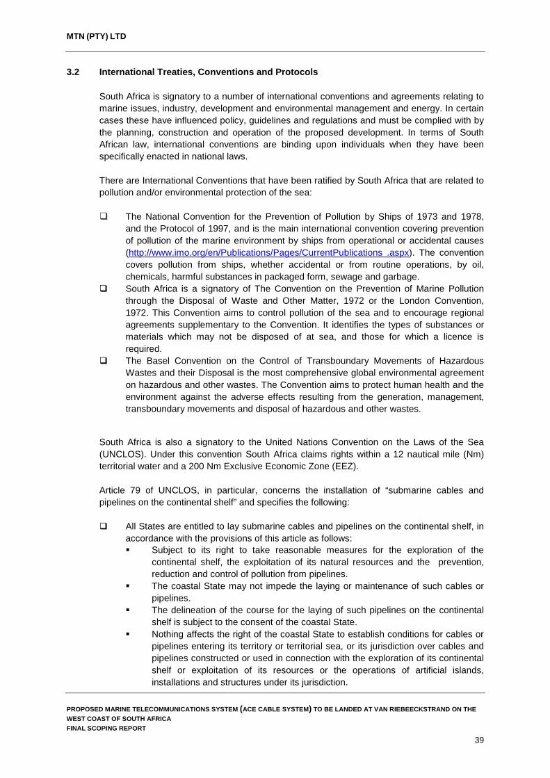
MTN (PTY) LTD
3.2 International Treaties, Conventions and Protocols South Africa is signatory to a number of international conventions and agreements relating to marine issues, industry, development and environmental management and energy. In certain cases these have influenced policy, guidelines and regulations and must be complied with by the planning, construction and operation of the proposed development. In terms of South African law, international conventions are binding upon individuals when they have been specifically enacted in national laws.
There are International Conventions that have been ratified by South Africa that are related to pollution and/or environmental protection of the sea: The National Convention for the Prevention of Pollution by Ships of 1973 and 1978,
and the Protocol of 1997, and is the main international convention covering prevention of pollution of the marine environment by ships from operational or accidental causes (http://www.imo.org/en/Publications/Pages/CurrentPublications .aspx). The convention covers pollution from ships, whether accidental or from routine operations, by oil, chemicals, harmful substances in packaged form, sewage and garbage.
South Africa is a signatory of The Convention on the Prevention of Marine Pollution through the Disposal of Waste and Other Matter, 1972 or the London Convention, 1972. This Convention aims to control pollution of the sea and to encourage regional agreements supplementary to the Convention. It identifies the types of substances or materials which may not be disposed of at sea, and those for which a licence is required.
The Basel Convention on the Control of Transboundary Movements of Hazardous Wastes and their Disposal is the most comprehensive global environmental agreement on hazardous and other wastes. The Convention aims to protect human health and the environment against the adverse effects resulting from the generation, management, transboundary movements and disposal of hazardous and other wastes.
South Africa is also a signatory to the United Nations Convention on the Laws of the Sea (UNCLOS). Under this convention South Africa claims rights within a 12 nautical mile (Nm) territorial water and a 200 Nm Exclusive Economic Zone (EEZ). Article 79 of UNCLOS, in particular, concerns the installation of “submarine cables and pipelines on the continental shelf” and specifies the following: All States are entitled to lay submarine cables and pipelines on the continental shelf, in
accordance with the provisions of this article as follows: Subject to its right to take reasonable measures for the exploration of the
continental shelf, the exploitation of its natural resources and the prevention, reduction and control of pollution from pipelines.
The coastal State may not impede the laying or maintenance of such cables or pipelines.
The delineation of the course for the laying of such pipelines on the continental shelf is subject to the consent of the coastal State.
Nothing affects the right of the coastal State to establish conditions for cables or pipelines entering its territory or territorial sea, or its jurisdiction over cables and pipelines constructed or used in connection with the exploration of its continental shelf or exploitation of its resources or the operations of artificial islands, installations and structures under its jurisdiction.
PROPOSED MARINE TELECOMMUNICATIONS SYSTEM (ACE CABLE SYSTEM) TO BE LANDED AT VAN RIEBEECKSTRAND ON THE WEST COAST OF SOUTH AFRICA FINAL SCOPING REPORT
39

MTN (PTY) LTD
When laying submarine cables or pipelines, due regard shall be taken of cables or pipelines already in position. In particular, possibilities of repairing existing cables or pipelines shall not be prejudiced. UNCLOS is enforced within the South African legal regime through the Marine Traffic Act and Maritime Zones Act (described previously).
(Source: http://www.un.org/depts/los/convention_agreements/texts/unclos/unclos_e.pdf)
3.3 Commenting and relevant authorities
Following a review of the legislation applicable to the proposed development, the following key authorities have been identified which have been consulted during the scoping process and whose comments will be taken into consideration during the impact assessment phase of the EIA.
3.3.1 Department of Environmental Affairs – Oceans and Coasts An integral part of the South African environment is undoubtedly the Oceans and Coasts along South Africa’s almost 2,500 km long coastline stretching from the border with Mozambique on the east coast to the border with Namibia on the west coast. The marine and coastal environments provide and sustain a wide range of economic, social and ecological services that are a foundation for the livelihoods of millions of South Africans. The DEA directorate, Oceans and Coasts (OC), is primarily focused on marine protection services and ocean governance, which entails the protection of the ocean environment from all illegal activities and promotion of its multiple socio-economic benefits.
Some of the main functions this directorate undertakes include the following:
The establishments of management frameworks and mechanisms for the ocean and coastal environment.
The strengthening of national science programmes for integrated oceans and coastal management.
The development of and contribution to effective knowledge and information management for the sector.
The participation and support to international agreements and bodies supportive of SA environmental and sustainable development priorities.
As a directorate of the DEA, the OC will provide comment and recommendations on all EIA documents submitted which are pertaining to the proposed ACE Cable System. As such, OC has been added as a key stakeholder (commenting authority) and has been consulted during the pre-application phase of the EIA to identify issues they feel should be addressed during the impact assessment phase of the EIA. It should be noted that OC is also directly involved with the Operation Phakisa initiative which includes the sustainable utilisation of the oceans around South Africa to meet government’s development targets. It is estimated that the oceans around South Africa have the potential to contribute up to 177 billion Rand to the gross domestic product (GDP) and create just over one million jobs by 2033 (http://www.operationphakisa.gov.za). Operation Phakisa consists of four critical areas to unlock the potential of our country’s vast coastline, namely:
PROPOSED MARINE TELECOMMUNICATIONS SYSTEM (ACE CABLE SYSTEM) TO BE LANDED AT VAN RIEBEECKSTRAND ON THE WEST COAST OF SOUTH AFRICA FINAL SCOPING REPORT
40

MTN (PTY) LTD
Marine Transport and Manufacturing. Offshore Oil and Gas Exploration. Aquaculture. Marine Protection Services and Ocean Governance.
Of particular relevance to the proposed ACE Cable System are the proposed Marine Protected Areas which are to be implemented as part of the programme in an attempt to ensure the sustainable utilisation of South Africa’s marine environments.
3.3.2 National Ports Authority Transnet National Ports Authority (TNPA) is one of five operating divisions of Transnet SOC Ltd and is responsible for the safe, effective and efficient economic functioning of South Africa’s ports (http://www.transnetnationalportsauthority.net). TNPA controls the eight commercial seaports in South Africa and operates within a legislative and regulatory environment created by the National Ports Act 2005 (Act No. 12 of 2005). In line with the provisions of the National Ports Act, the core functions of the national ports authority are as follows: To plan, provide, maintain and improve port infrastructure. To provide or arrange marine-related services. To ensure the provision of port services, including the management of port activities
and the port regulatory function at all South African ports and to provide aids to navigation and assistance to the maneuvering of vessels within port limits and along the coast.
The National Ports Act creates a dual role for the National Ports Authority whereby it is responsible for the port regulatory function at the ports - i.e. controlling the provision of port services through licensing or entering into agreements with port operators to ensure that efficient port services are provided.
As the proposed development involves the placement of a marine telecommunications cable through the coastal waters to the north of Cape Town, the TNPA (Cape Town Port) will be registered as an interested and affected party as information on the position of the ACE Cable System is important for commercial fishing and shipping industries operating within the region.
3.3.3 The South African Maritime Safety Authority (SAMSA) The South African Maritime Safety Authority (SAMSA) was established on 1 April 1998 in terms of the South African Maritime Safety Authority Act (Act 5 of 1998) as a juristic person. Accountable to the Minister of Transport, SAMSA is tasked with the following objectives in terms of the Act: To ensure safety of life and property at sea. To prevent and combat pollution of the marine environment by ships. To promote the Republic’s maritime interests.
PROPOSED MARINE TELECOMMUNICATIONS SYSTEM (ACE CABLE SYSTEM) TO BE LANDED AT VAN RIEBEECKSTRAND ON THE WEST COAST OF SOUTH AFRICA FINAL SCOPING REPORT
41

MTN (PTY) LTD
In terms of section 2 of the Act, SAMSA is responsible to administer the following pieces of legislation:
Merchant Shipping Act, 1951. Marine Traffic Act, 1981. Marine Pollution (Control and Civil Liability) Act, 1981. Carriage of Goods by Sea Act, 1986. Marine Pollution (Prevention of Pollution from Ships) Act, 1986. Marine Pollution (Intervention) Act, 1987. Maritime Zones Act, 1994. Wreck and Salvage Act, 1996. SAMSA Act, 1998. SAMSA Levies Act, 1998. Ship Registration Act, 1998.
(Source: http://www.samsa.org.za/sites/samsa.org.za/files/SAMSA%20Act%2C%201998.pdf) As the proposed development involves the placement of a marine telecommunications cable through the coastal waters to the north of Cape Town, SAMSA has been registered as an interested and affected party as they are ultimately responsible for the safety of vessels at sea and they are the respondents to any incidents which could occur during the installation and operation of the proposed ACE Cable System.
3.3.4 Department of Agriculture Forestry and Fisheries (DAFF) The Department of Agriculture, Forests and Fisheries (DAFF) as the custodian of fisheries resources in South Africa is responsible for the following: Fisheries administration. Fisheries research. Protection of marine resources, i.e. control and enforcement. Co-ordinating development.
The department promotes co-operation between management, scientists and all user and other interest groups, and the Chief Directorate of Sea Fisheries will be the instrument of implementation in carrying out these tasks, as appropriate. As custodian of fisheries and the marine environment, DAFF’s core responsibilities include the following: Undertake research on living marine resources and advise on and promote sustainable
resource utilisation, including commercial, recreational and small-scale fisheries. Apply an ecosystem approach to sustainable utilisation of living marine resources &
conservation of marine ecosystems. Advise on the development of under-utilised or new living marine resources and
rebuilding of depleted stocks where necessary. Undertake long-term monitoring of resources. Undertake environmental and climate change research relevant to fisheries. Promote the development of marine aquaculture through appropriate research. Understand the dynamics and functioning of the marine environment as they impact on
ecosystem variability.
PROPOSED MARINE TELECOMMUNICATIONS SYSTEM (ACE CABLE SYSTEM) TO BE LANDED AT VAN RIEBEECKSTRAND ON THE WEST COAST OF SOUTH AFRICA FINAL SCOPING REPORT
42
MTN (PTY) LTD
Provide decision-makers with the best scientific advice available, taking into account international best practice.
Build capacity in Fisheries and Marine Sciences within the Department, in government and in South Africa through collaboration with institutions within and outside of government.
Ensure that South Africa’s regional and international commitments with regard to Marine Science are effectively met.
DAFF is regarded as an interested and affected authority, given that they have a responsibility to protect the oceans and seabed, ensuring that all activities that have the potential to affect marine resources are undertaken in an environmentally responsible and sustainable manner.
3.4 Summary In summary, MTN has a number of legal obligations in terms of legislation, the pertinent obligations being: An obligation to undertake an EIA for activities that fall within the scope of Government
Notices R 982, R 983, R 984 and R 985 of 2014. An obligation to obtain permits in terms of other relevant environmental legislation (for
example, heritage, water and biodiversity). Adherence to the principles of sustainability.
PROPOSED MARINE TELECOMMUNICATIONS SYSTEM (ACE CABLE SYSTEM) TO BE LANDED AT VAN RIEBEECKSTRAND ON THE WEST COAST OF SOUTH AFRICA FINAL SCOPING REPORT
43

MTN (PTY) LTD
4. NEED AND DESIRABILITY Submarine telecommunication cables are important for international telecommunication networks as they transport almost 100% of transoceanic Internet traffic throughout the world (www.iscpc.org). It is widely recognised that access to affordable international bandwidth is key to economic development in every country. Today, Africa relies primarily on satellites with few submarine cables to provide its international communications. Communication via submarine telecommunication cables generally allows for lower cost, better performance, and greater capacity (throughput) than that available via satellite. Improvement in Africa’s information technology infrastructure via telecommunication cables will remove one of the current key inhibitors to overall development in Africa and support economic growth and opportunities on the continent. MTN (Pty) Ltd (MTN) proposes installing a submarine telecommunications cable, referred to as the Africa Coast to Europe (ACE) Cable System, to link South Africa, the West Coast of Africa and Europe with key international telecommunication hubs in Europe. Following installation of the proposed ACE cable system, MTN will be the first mobile operator to operate an international fibre-optic bandwidth with full landing in South Africa and along the West Coast of Africa. In doing so, the company will facilitate more affordable and effective transport of voice, data, Internet and television services. Furthermore, the cable will support the objectives set out by the New Partnership for Africa’s Development (NEPAD), and provide a means of fulfilling the South African Government's requirements in terms of digital television broadcasting for the country. By supplying increased bandwidths the proposed ACE Cable System will support the following primary NEPAD objectives: To eradicate poverty in Africa and to place African countries both individually and
collectively on a path of sustainable growth and development to thereby halt the marginalisation of Africa in the globalisation process.
At the core of the NEPAD process is its African ownership, which must be retained and strongly promoted, so as to meet the legitimate aspirations of the African people. (http://www.dirco.gov.za/au.nepad/nepad_overview.htm) Telecommunications is one of the fastest growing sectors of South Africa's economy which has been driven by rapid growth in the number of mobile phone users and their need for broadband connectivity. South African mobile companies are also making inroads internationally, with MTN now having well over 100 million subscribers in more than 20 countries in Africa, Asia and the Middle East (http://www.eversheds.com). The proposed ACE Cable System will provide an opportunity to facilitate the growth of the telecommunications infrastructure in South Africa and promote sustainable growth and development within South Africa and Africa as a whole. In the local context, the proposed development is in line with the Cape Town Spatial Development Framework (Key Strategy 1, Policy 2) which includes supporting the rollout of broadband technology and the use thereof.
PROPOSED MARINE TELECOMMUNICATIONS SYSTEM (ACE CABLE SYSTEM) TO BE LANDED AT VAN RIEBEECKSTRAND ON THE WEST COAST OF SOUTH AFRICA FINAL SCOPING REPORT
44

MTN (PTY) LTD
5. ALTERNATIVES Alternatives are different means of achieving the purpose and need of a proposed development and include alternative sites, layouts or designs, technologies and the “no development” or “no go” alternative. This chapter describes the various alternatives assessed for the proposed installation and operation of the ACE Cable System.
5.1 Site alternatives (Landing Alternatives) Findings from the initial screening exercises identified five possible landing sites for the ACE Cable System (one Alternative at Yzerfontein and four Alternatives to the north and south of Melkbosstrand) which were then assessed further to identify the most environmentally feasible alternatives to take through for detailed assessment during the EIA. The initial landing points near Melkbosstrand considered during screening are shown in Figure 4. The reasons for some of these alternative landing points being rejected from further assessment during the EIA process are provided below.
5.1.1 Yzerfontein Landing Alternative The proposed ACE Cable System would land at Yzerfontein beach, which is backed by brush-covered sand dunes and protected wooded coastal range within the West Coast National Park. Currently, the West Africa Cable System (WACS) lands at the Yzerfontein Beach which is also a high capacity network similar to the proposed ACE Cable System (Plate 1). The Yzerfontein alternative was rejected due to the following: The small beach stretch at Yzerfontein is the only place the ACE cable system could
land which is directly adjacent to the WACS. No other feasible landing sites exist in the Yzerfontein area.
The ACE cable system would have to follow the same land route as WACS. ACE and WACS are both high capacity networks with no other network in the country able to share the load of these networks should they fail. The common land route is considered to be a fatal flaw as should both these cable systems be damaged it would be catastrophic for South Africa.
The distance from Yzerfontein to the CLS site in Duynefontein is over 50 km. The land alignment of the cable would cross a number of major Eskom transmission
lines which will cause interference and reduce the capacity of the ACE Cable System. Environmental impacts associated with this alternative are much higher than the other
alternatives considered.
PROPOSED MARINE TELECOMMUNICATIONS SYSTEM (ACE CABLE SYSTEM) TO BE LANDED AT VAN RIEBEECKSTRAND ON THE WEST COAST OF SOUTH AFRICA FINAL SCOPING REPORT
45

MTN (PTY) LTD
Proposed landing site of the ACE Cable System at the Yzerfontein Beach
Conservation area on the primary dunes at the Yzerfontein Beach
Conservation area on the primary dunes at the Yzerfontein Beach
Primary dune at Yzerfontein Beach
Plate 1 Proposed landing Alternative at Yzerfontein which is constrained by the
beach profile and existing WACS cable system
5.2 Melkbosstrand and Van Riebeeckstrand Landing Alternatives Four possible landing alternatives were considered to the north and south of Melkbosstrand from Alternative 1 to the north of Melkbosstrand near Van Riebeeckstrand to Alternative 4 in the south near 12th Avenue in Melkbosstrand. Of the four alternatives considered, two alternatives were discarded during the screening phase for the reasons provided below.
5.2.1 Alternative Landing Site 1 The first landing site (Alternative 1) is located along the northern section of Van Riebeeckstrand Beach and is located close to the Safety Exclusion Zone of the Koeberg Nuclear Power Plant which is approximately 1.7 km north of the proposed landing site. The proposed site is accessible from the land along an existing maintenance road which is used by the City of Cape Town when cleaning out the stormwater drains located behind the primary dune cordon. From the suburb of Van Riebeeckstad, access to the site is from Dunker Street and then along the maintenance road (Figure 5).
PROPOSED MARINE TELECOMMUNICATIONS SYSTEM (ACE CABLE SYSTEM) TO BE LANDED AT VAN RIEBEECKSTRAND ON THE WEST COAST OF SOUTH AFRICA FINAL SCOPING REPORT
46

MTN (PTY) LTD
Figure 4 Landing alternatives considered during environmental screening near Van
Riebeeckstrand and Melkbosstrand
PROPOSED MARINE TELECOMMUNICATIONS SYSTEM (ACE CABLE SYSTEM) TO BE LANDED AT VAN RIEBEECKSTRAND ON THE WEST COAST OF SOUTH AFRICA FINAL SCOPING REPORT
47

MTN (PTY) LTD
Figure 5 Alternative Landing Site 1 and position of the proposed Beach Man Hole (Source Google Earth 2016)
Following environmental screening of all site alternatives, this site has been selected as the preferred landing alternative based on the following factors: The proposed Beach Man Hole is located directly adjacent to an existing services
corridor which runs from the edge of the residential stands near the beach up to Otto du Plessis Road (Plate 2). As such, there will be little impact on the residents within the area during construction.
The proposed landing site can be accessed along an existing maintenance road used by the City of Cape Town which limits the impact on the wetland area located between the primary dune cordon and the residential area (Plate 2).
The landing of the cable at this site has the least impact on the beach environment as the primary dune cordon is relatively narrow at this point and is sparsely vegetated.
The landing of the cable at this point on the beach would not necessitate the burying of cable along the beach parallel to the primary dunes as happened with previous telecommunications cables which land near Melkbosstrand.
Due to its location just south of the Koeberg Safety Exclusion Zone, the beach is not as well used by visitors and tourists compared to the beaches further south towards Melkbosstrand. Therefore, the landing and installation of the cable on this section of the beach is expected to have the least impact on beach goers and recreational users.
An existing beach storm water outlet is located directly to the south of the proposed cable landing point and, as such, this section of the beach is regularly disturbed through maintenance activities undertaken by the City of Cape Town to ensure that the storm water outlet remains open (Plate 2).
The wetland located between the primary dune cordon near the beach and residential areas inland is relatively disturbed with the City of Cape Town regularly cutting back vegetation to facilitate drainage of stormwater from the residential areas of Van Riebeeckstrand. The wetland has also been canalised to facilitate drainage of stormwater.
PROPOSED MARINE TELECOMMUNICATIONS SYSTEM (ACE CABLE SYSTEM) TO BE LANDED AT VAN RIEBEECKSTRAND ON THE WEST COAST OF SOUTH AFRICA FINAL SCOPING REPORT
48

MTN (PTY) LTD
Access road to the proposed BMH site
Existing services corridor near the proposed BMH
Maintenance of a storm water outlet to the south
of the proposed cable landing site
Access track from the residential area to the beach
Wetlands cleared by the City of Cape Town to facilitate storm water drainage
Signage on the beach demarcating the Koeberg Safety Exclusion Zone
Plate 2 Proposed landing Alternative 1 near Dunker Street, Van Riebeeckstrand. This landing alternative is the preferred alternative
PROPOSED MARINE TELECOMMUNICATIONS SYSTEM (ACE CABLE SYSTEM) TO BE LANDED AT VAN RIEBEECKSTRAND ON THE WEST COAST OF SOUTH AFRICA FINAL SCOPING REPORT
49

MTN (PTY) LTD
5.2.2 Alternative Landing Site 2 The second landing site considered is located along the northern section of Van Riebeeckstrand Beach and can be accessed from Die Bad Road. The proposed landing point is directly in front of the access track used by the City of Cape Town for storm water maintenance which runs from Die Bad Road towards the beach. The proposed location of the Beach Man Hole (BMH) will be directly adjacent to Die Bad Road where the cable from the marine environment will tie into the land cable which will connect to the MTN Cable Landing Station (CLS) in Duynefontein.
Figure 6 Alternative Landing Site 2 and position of the proposed Beach Man Hole near Die Bad Road (Source Google Earth 2016)
Following environmental screening of all site alternatives, this site has been selected as the alternative landing site (Alternative 2) to be assessed in the environmental authorisation process based on the following factors: The proposed Beach Man Hole is located directly adjacent to Die Bad Road and by
following the road, the land cable can connect to the existing services corridor at Site Alternative 1 which runs from the edge of the residential stands near the beach up to Otto du Plessis Road (Plate 3). As such, there will be little impact on the residents within the area during construction.
The proposed landing site can be accessed along an existing maintenance road used by the City of Cape Town which limits the impact on the wetland area located between the primary dune cordon and the residential area (Plate 3).
The landing of the cable at this site will have limited impact on the beach environment as the primary dune cordon is relatively narrow at this point. Unlike Alternative Landing Site 1, no stormwater outlets are located on the beach near this landing site and therefore disturbance to the beach and dunes at this site would be greater than at Site 1.
PROPOSED MARINE TELECOMMUNICATIONS SYSTEM (ACE CABLE SYSTEM) TO BE LANDED AT VAN RIEBEECKSTRAND ON THE WEST COAST OF SOUTH AFRICA FINAL SCOPING REPORT
50

MTN (PTY) LTD
As with Site 1, Landing Site 2 is also located just south of the Koeberg Safety Exclusion Zone and, as such, the beach is not as well used by visitors and tourists in comparison to the beaches further south towards Melkbosstrand.
As with Site 1, the wetland located between the primary dune cordon near the beach and residential areas inland is relatively disturbed with the City of Cape Town regularly cutting back vegetation to facilitate drainage of stormwater from the residential areas of Van Riebeeckstrand. The wetland has also been canalised to facilitate drainage of stormwater.
Die Bad Road to the south of the beach access track
Die Bad Road to the north of the beach access track. The BMH will be located on the sea side of
the road
Access track to the beach used by the City of Cape Town for storm water maintenance
Wetland cleared and trenched to aid in stormwater discharge
Primary dune cordon between the beach and wetland area inland of dune cordon
Beach at Landing Alternative 2
Plate 3 Landing Alternative 2 near Die Bad Road, Van Riebeeckstrand. The Beach Man Hole will be located to the west of Die Bad Road
PROPOSED MARINE TELECOMMUNICATIONS SYSTEM (ACE CABLE SYSTEM) TO BE LANDED AT VAN RIEBEECKSTRAND ON THE WEST COAST OF SOUTH AFRICA FINAL SCOPING REPORT
51

MTN (PTY) LTD
5.2.3 Alternative Landing Site 3 The third landing site considered is located in the centre of Van Riebeeckstrand Beach and can be accessed from Pelican Parade Road (Figure 7). This proposed landing site was rejected during screening primarily due to the fact that the proposed landing site would have a significant impact on relatively well preserved coastal dune vegetation and surrounding residents and beach users.
Figure 7 Alternative Landing Site 3 and position of the proposed Beach Man Hole near the beach parking area along Pelican Parade Road (Source Google Earth 2016)
Some of the other factors contributing to discarding Alternative 3 during screening include the following: Lack of feasible land alignments to get the ACE Cable System from the cable landing
point at Site 3 to the CLS site in Duynefontein. The construction of the Beach Man Hole at the beach parking area would effectively
prevent access to the beach from Pelican Parade Road for about one month. The landing of the cable at Site 3 would result in damage to surrounding properties. Landing of the ACE Cable System at this site would necessitate the crossing of the
existing SAFE Cable which is not recommended from an operational and risk perspective.
The landing of the cable at Site 3 will necessitate the cable passing through relatively undisturbed coastal dune vegetation and would have a greater impact on coastal vegetation than the other alternatives considered.
PROPOSED MARINE TELECOMMUNICATIONS SYSTEM (ACE CABLE SYSTEM) TO BE LANDED AT VAN RIEBEECKSTRAND ON THE WEST COAST OF SOUTH AFRICA FINAL SCOPING REPORT
52

MTN (PTY) LTD
Landing of the ACE Cable System at Site 3 would result in beach closures along a section of the Van Riebeeckstrand Beach which is well utilised by both residents and tourists.
Access path to the beach and relatively undisturbed coastal vegetation
View to the south of the beach parking area on Pelican Parade Road
Formalised access path for beach goers Resident preparing to access the beach and take their dog for a walk
Plate 4 Landing Alternative 3 near Pelican Parade Road. The Beach Man Hole would
be located in the car park which is used by beach goers
5.2.4 Alternative Landing Site 4 The fourth landing site considered is situated in Melkbosstrand near the beach parking at the intersection of Beach Road and 12th Avenue (Figure 8). This proposed land site was rejected during screening primarily due to the fact that the proposed landing site would have a significant impact on businesses and tourism within Melkbosstrand. In addition, the proposed landing site is also located very close to the existing SAFE and SAT-3 landing sites which increases the risk of cable breakages to both the existing cables and the proposed ACE Cable System during construction and operation. Some of the other factors contributing to discarding Alternative 4 during screening include the following:
The proximity of the Alternative Site 4 to existing marine telecommunications cables
landing near Melkbosstrand was considered a fatal flaw from an operational and risk perspective.
PROPOSED MARINE TELECOMMUNICATIONS SYSTEM (ACE CABLE SYSTEM) TO BE LANDED AT VAN RIEBEECKSTRAND ON THE WEST COAST OF SOUTH AFRICA FINAL SCOPING REPORT
53
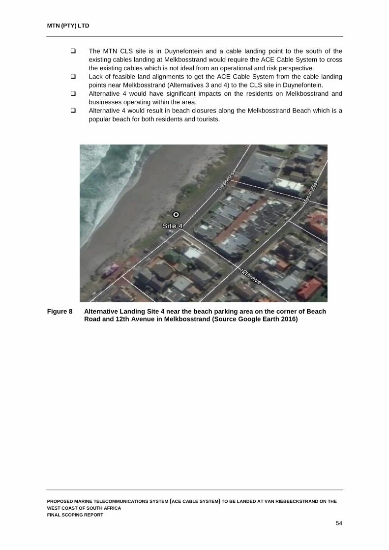
MTN (PTY) LTD
The MTN CLS site is in Duynefontein and a cable landing point to the south of the existing cables landing at Melkbosstrand would require the ACE Cable System to cross the existing cables which is not ideal from an operational and risk perspective.
Lack of feasible land alignments to get the ACE Cable System from the cable landing points near Melkbosstrand (Alternatives 3 and 4) to the CLS site in Duynefontein.
Alternative 4 would have significant impacts on the residents on Melkbosstrand and businesses operating within the area.
Alternative 4 would result in beach closures along the Melkbosstrand Beach which is a popular beach for both residents and tourists.
Figure 8 Alternative Landing Site 4 near the beach parking area on the corner of Beach Road and 12th Avenue in Melkbosstrand (Source Google Earth 2016)
PROPOSED MARINE TELECOMMUNICATIONS SYSTEM (ACE CABLE SYSTEM) TO BE LANDED AT VAN RIEBEECKSTRAND ON THE WEST COAST OF SOUTH AFRICA FINAL SCOPING REPORT
54
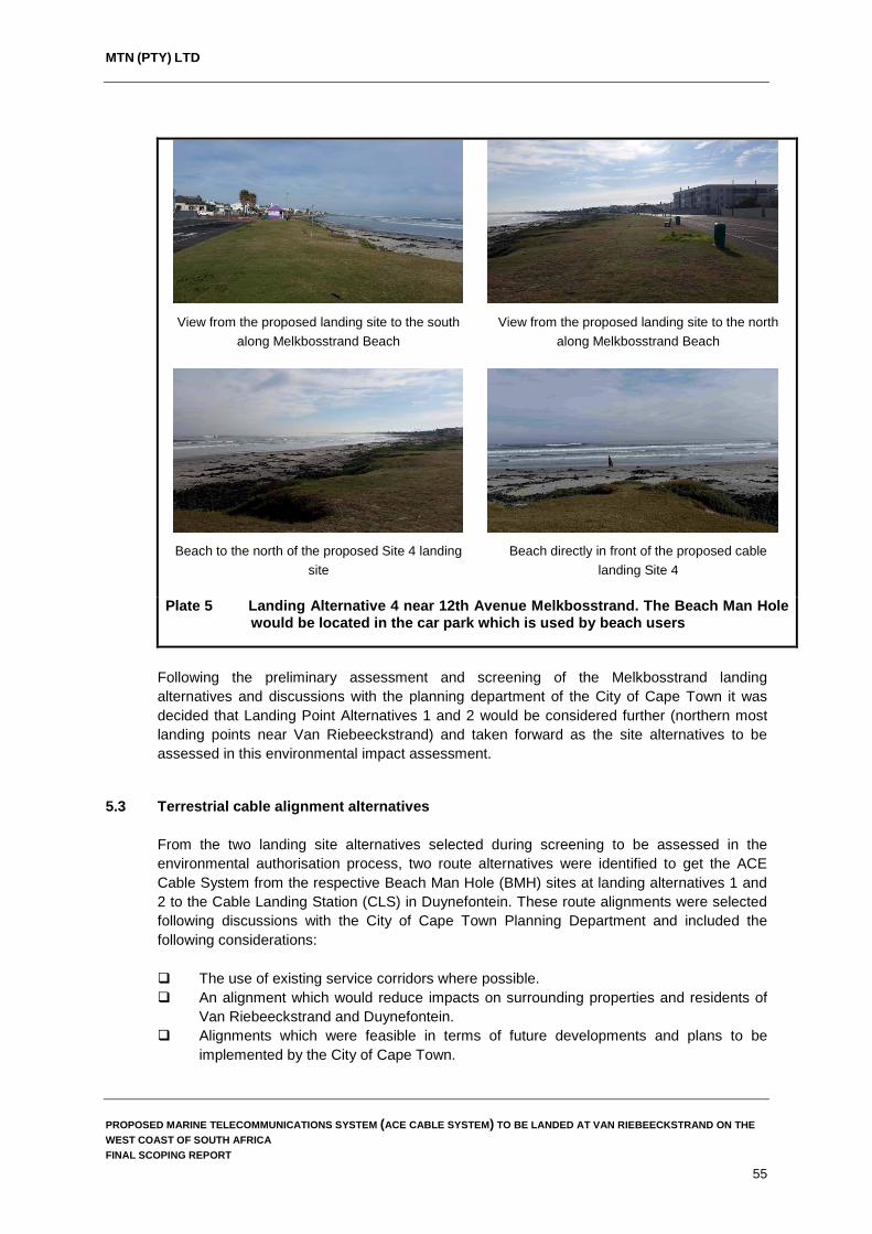
MTN (PTY) LTD
View from the proposed landing site to the south along Melkbosstrand Beach
View from the proposed landing site to the north along Melkbosstrand Beach
Beach to the north of the proposed Site 4 landing site
Beach directly in front of the proposed cable landing Site 4
Plate 5 Landing Alternative 4 near 12th Avenue Melkbosstrand. The Beach Man Hole
would be located in the car park which is used by beach users
Following the preliminary assessment and screening of the Melkbosstrand landing alternatives and discussions with the planning department of the City of Cape Town it was decided that Landing Point Alternatives 1 and 2 would be considered further (northern most landing points near Van Riebeeckstrand) and taken forward as the site alternatives to be assessed in this environmental impact assessment.
5.3 Terrestrial cable alignment alternatives
From the two landing site alternatives selected during screening to be assessed in the environmental authorisation process, two route alternatives were identified to get the ACE Cable System from the respective Beach Man Hole (BMH) sites at landing alternatives 1 and 2 to the Cable Landing Station (CLS) in Duynefontein. These route alignments were selected following discussions with the City of Cape Town Planning Department and included the following considerations: The use of existing service corridors where possible. An alignment which would reduce impacts on surrounding properties and residents of
Van Riebeeckstrand and Duynefontein. Alignments which were feasible in terms of future developments and plans to be
implemented by the City of Cape Town.
PROPOSED MARINE TELECOMMUNICATIONS SYSTEM (ACE CABLE SYSTEM) TO BE LANDED AT VAN RIEBEECKSTRAND ON THE WEST COAST OF SOUTH AFRICA FINAL SCOPING REPORT
55
MTN (PTY) LTD
Alignments which would minimise impacts on the terrestrial environment (vegetation specifically).
Alignments which were economically feasible and viable in terms of construction and operational costs.
It is important to note that the proposed route alternatives allow for some degree of flexibility in terms of the final alignment selected as both of the proposed route alternatives intersect at points and, therefore, the final alignment for the cable may make use of a combination of the alignments proposed from the two landing sites to the CLS site in Duynefontein.
5.3.1 Landing Site 1 – Cable Alignment to the CLS in Duynefontein From the preferred landing site Alternative 1 (A on Figure 9), the preferred terrestrial alignment of the ACE Cable System (Yellow line on Figure 9) is as follows: From the BMH, the cable would follow an existing service corridor to Otto du Plessis
Road where it will cross under the road to the eastern side of Otto du Plessis Road. From this point, the cable will follow Otto du Plessis Road going south passing under
Altantic Drive and continuing for another 250 m until the alignment reaches another service corridor which runs parallel to the residential area of Duynefontein in a north easterly direction.
From this point, the cable will follow an existing service corridor to the MTN CLS site in Duynefontein.
5.3.2 Landing Site 2 – Cable Alignment to the CLS in Duynefontein
From the alternative landing site Alternative 2 (B on Figure 9), the preferred terrestrial alignment of the ACE Cable System (Green line on Figure 9) is as follows: From the BMH at Landing Alternative 2, the cable would follow Die Bad Road in a
northerly direction until it reaches Dunker Street. From this point, the cable alignment follows Dunker Street until it reaches the
intersection with Otto du Plessis Road where it will pass under Otto du Plessis Road and intersect with the cable alignment from Alternative Landing Site 1.
If the cable alignment does not follow the proposed cable alignment from Landing Site 1, the cable will continue along the western side of Atlantic Drive up to the intersection with Napoleon Avenue where it will pass under Atlantic Drive and follow Napoleon Avenue to the MTN CLS site in Duynefontein.
PROPOSED MARINE TELECOMMUNICATIONS SYSTEM (ACE CABLE SYSTEM) TO BE LANDED AT VAN RIEBEECKSTRAND ON THE WEST COAST OF SOUTH AFRICA FINAL SCOPING REPORT
56

MTN (PTY) LTD
Figure 9 Proposed cable alignment from Alternative Landing Sites 1 and 2 to the CLS site in Duynefontein
PROPOSED MARINE TELECOMMUNICATIONS SYSTEM (ACE CABLE SYSTEM) TO BE LANDED AT VAN RIEBEECKSTRAND ON THE WEST COAST OF SOUTH AFRICA FINAL SCOPING REPORT
57
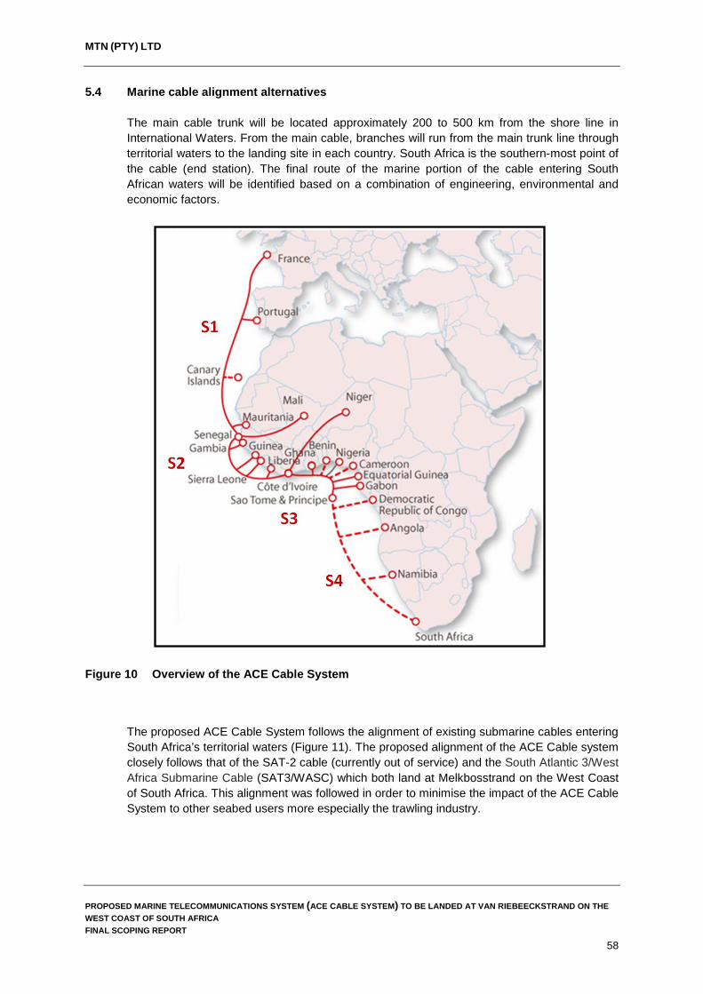
MTN (PTY) LTD
5.4 Marine cable alignment alternatives The main cable trunk will be located approximately 200 to 500 km from the shore line in International Waters. From the main cable, branches will run from the main trunk line through territorial waters to the landing site in each country. South Africa is the southern-most point of the cable (end station). The final route of the marine portion of the cable entering South African waters will be identified based on a combination of engineering, environmental and economic factors.
Figure 10 Overview of the ACE Cable System
The proposed ACE Cable System follows the alignment of existing submarine cables entering South Africa’s territorial waters (Figure 11). The proposed alignment of the ACE Cable system closely follows that of the SAT-2 cable (currently out of service) and the South Atlantic 3/West Africa Submarine Cable (SAT3/WASC) which both land at Melkbosstrand on the West Coast of South Africa. This alignment was followed in order to minimise the impact of the ACE Cable System to other seabed users more especially the trawling industry.
PROPOSED MARINE TELECOMMUNICATIONS SYSTEM (ACE CABLE SYSTEM) TO BE LANDED AT VAN RIEBEECKSTRAND ON THE WEST COAST OF SOUTH AFRICA FINAL SCOPING REPORT
58
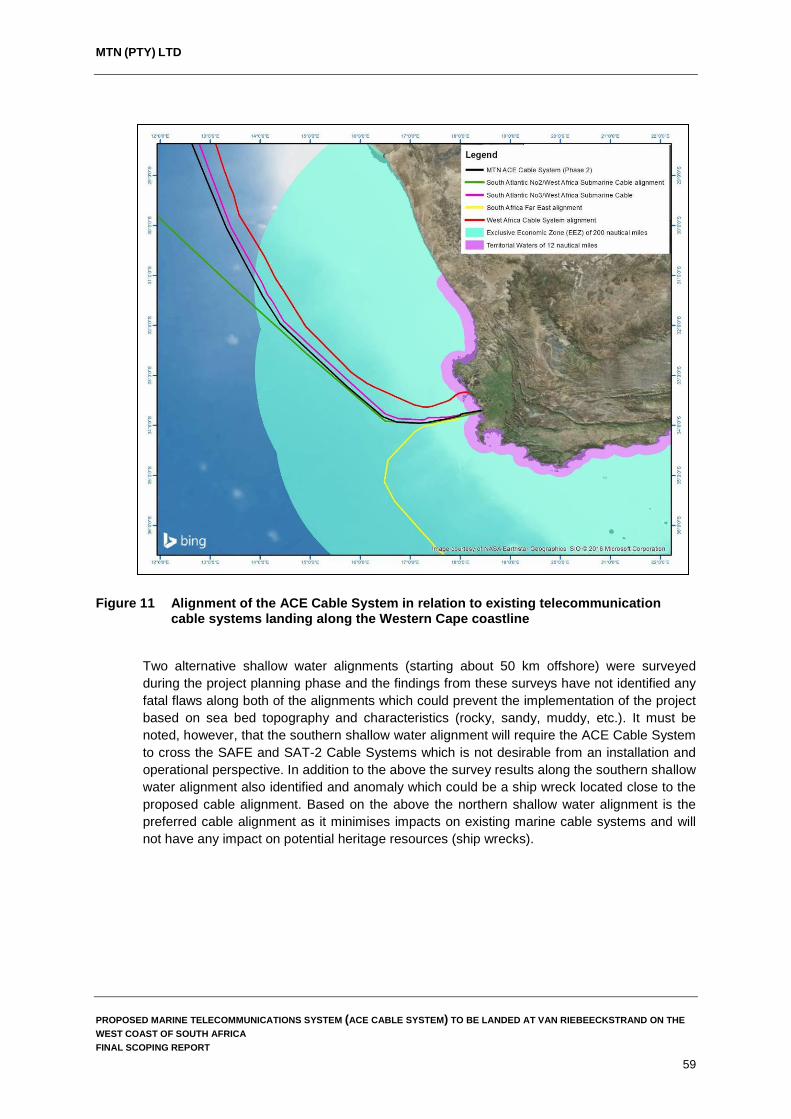
MTN (PTY) LTD
Figure 11 Alignment of the ACE Cable System in relation to existing telecommunication cable systems landing along the Western Cape coastline
Two alternative shallow water alignments (starting about 50 km offshore) were surveyed during the project planning phase and the findings from these surveys have not identified any fatal flaws along both of the alignments which could prevent the implementation of the project based on sea bed topography and characteristics (rocky, sandy, muddy, etc.). It must be noted, however, that the southern shallow water alignment will require the ACE Cable System to cross the SAFE and SAT-2 Cable Systems which is not desirable from an installation and operational perspective. In addition to the above the survey results along the southern shallow water alignment also identified and anomaly which could be a ship wreck located close to the proposed cable alignment. Based on the above the northern shallow water alignment is the preferred cable alignment as it minimises impacts on existing marine cable systems and will not have any impact on potential heritage resources (ship wrecks).
PROPOSED MARINE TELECOMMUNICATIONS SYSTEM (ACE CABLE SYSTEM) TO BE LANDED AT VAN RIEBEECKSTRAND ON THE WEST COAST OF SOUTH AFRICA FINAL SCOPING REPORT
59

MTN (PTY) LTD
Figure 12 The two shallow water alignments of the ACE Cable System surveyed starting 50
km offshore
5.5 Technology Alternatives
Although there are a number of available telecommunication mechanisms used world wide and in South Africa, the scale of customer demand and expectation of ever faster data transfer have made many of these inadequate or obsolete. Radio has largely been phased out due to restricted bandwidth and poor data transmission. Currently, Africa relies primarily on satellites with few submarine cables to provide its international communications. Satellite and microwave transmissions are unable to offer the capacity required for South Africa and other African countries to remain part of the global community in terms of communication services. Within South Africa, fibre optic networks are currently the only available technology that are able to transmit sufficiently high volumes of voice and data traffic, with higher security, reliability and at a lower cost. This is the current preferred technology for meeting demand for data and voice transmission on a global scale and is one of the main reasons why the ACE Cable System is based on a fibre optic network.
5.6 No-Go Alternative In the context of the proposed development, the No-Go alternative would involve MTN not installing the proposed ACE Cable System with the telecommunications system terminating in Namibia or worse, as parties would not consider implementing Segment 4 of the ACE network meaning that the ACE network would end in Sao Tome. Although impacts on the marine and terrestrial environment would not be avoided entirely, submarine telecommunication cables are important for international telecommunication networks and it is widely recognised that access to affordable international bandwidth is key to economic development in every country.
PROPOSED MARINE TELECOMMUNICATIONS SYSTEM (ACE CABLE SYSTEM) TO BE LANDED AT VAN RIEBEECKSTRAND ON THE WEST COAST OF SOUTH AFRICA FINAL SCOPING REPORT
60

MTN (PTY) LTD
Africa relies primarily on satellites with few submarine cables to provide its international communications. Communication via submarine telecommunication cables generally allows for lower cost, better performance, and greater capacity (throughput) than that available via satellite. If the No-Go alternative is selected, MTN and South Africa as a whole will be missing out on an opportunity to unlock economic development within the country. In addition, should the No-Go alternative be selected it would mean that MTN will not be able to operate an international fibre-optic bandwidth and they will be unable to facilitate more affordable and effective transport of voice, data, Internet and television services to South Africa’s population.
PROPOSED MARINE TELECOMMUNICATIONS SYSTEM (ACE CABLE SYSTEM) TO BE LANDED AT VAN RIEBEECKSTRAND ON THE WEST COAST OF SOUTH AFRICA FINAL SCOPING REPORT
61

MTN (PTY) LTD
6. PROJECT DESCRIPTION This chapter describes the infrastructure and operational aspects of the ACE Cable System. The aim of this chapter is to enable readers to gain a better understanding of how the cable system will be installed and maintained in order to understand the possible impacts the development may have on the receiving environment.
6.1 General description The section of the ACE Cable system which forms part of this environmental impact assessment includes the section of cable from when it enters South Africa’s EEZ (200 nautical miles from the sea shore) through South Africa’s territorial waters (12 nautical miles from the sea shore) and onto land until it reaches the MTN Cable Landing Station (CLS) at Duynefontein. In this context, the project description incorporates the materials comprising the ACE Cable System and the methods to be used to install the cable system in the marine and terrestrial environments. The ACE Cable System is comprised of the following project components from when it enters South Africa’s EEZ until it reaches the MTN CLS site in Duynefontein: Marine Fibre Optic Cable (marine environment to the Beach Man Hole). Beach Man Hole (BMH) located behind the coastal dune cordon near Van
Riebeeckstrand. Terrestrial Fibre Optic Cable (Beach Man Hole to the CLS site in Duynefontein)
6.2 Marine components and installation methods
6.2.1 Marine Fibre Optic Cable The proposed cable route will run down the West Coast of Africa (generally parallel to the coastline) and approach South African coastal waters from the north (i.e. from Namibian waters). Offshore, the cable is laid by a purpose-built cable-laying ship. Consistent with industry practice, the unarmoured cable (Plate 6 & 7) will rest on the seabed in water depths greater than 2,000 m, where the risk of inadvertent damage from human activities is negligible. As the cable route changes direction to approach the coastline of Van Riebeeckstrand, the cable will be buried beneath the sandy seabed of these shallower marine waters. This is typically achieved with the use of a specially designed plough which is submerged onto the seabed by the cable laying ship. The cable is then fed from the ship to the plough which effectively buries the cable to a depth of approximately 1.5 metres. This burial is intended to provide protection to the cable from the hazards posed by ships’ anchors, fishing trawls/lines and the like. The diameters of the marine fibre optic cables range in size from 17 mm diameter (cables installed at a water depth of between 7,000 – 1,500 m) to 37.5 mm diameter (rock armoured cable which is installed in shallow water depths (< 200 m).
PROPOSED MARINE TELECOMMUNICATIONS SYSTEM (ACE CABLE SYSTEM) TO BE LANDED AT VAN RIEBEECKSTRAND ON THE WEST COAST OF SOUTH AFRICA FINAL SCOPING REPORT
62

MTN (PTY) LTD
Plate 6 Cross section of a typical marine telecommunications cable
Plate 7 Cable armouring and operational depths
PROPOSED MARINE TELECOMMUNICATIONS SYSTEM (ACE CABLE SYSTEM) TO BE LANDED AT VAN RIEBEECKSTRAND ON THE WEST COAST OF SOUTH AFRICA FINAL SCOPING REPORT
63
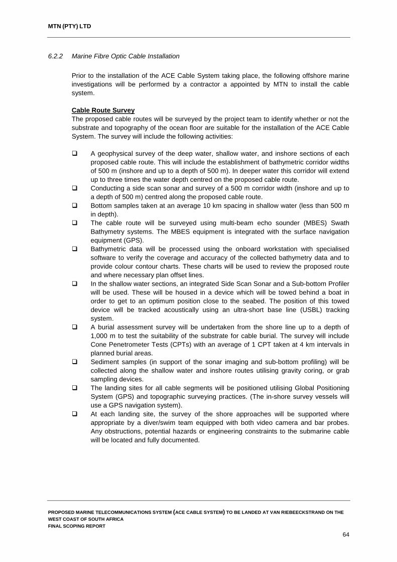
MTN (PTY) LTD
6.2.2 Marine Fibre Optic Cable Installation Prior to the installation of the ACE Cable System taking place, the following offshore marine investigations will be performed by a contractor a appointed by MTN to install the cable system. Cable Route Survey The proposed cable routes will be surveyed by the project team to identify whether or not the substrate and topography of the ocean floor are suitable for the installation of the ACE Cable System. The survey will include the following activities: A geophysical survey of the deep water, shallow water, and inshore sections of each
proposed cable route. This will include the establishment of bathymetric corridor widths of 500 m (inshore and up to a depth of 500 m). In deeper water this corridor will extend up to three times the water depth centred on the proposed cable route.
Conducting a side scan sonar and survey of a 500 m corridor width (inshore and up to a depth of 500 m) centred along the proposed cable route.
Bottom samples taken at an average 10 km spacing in shallow water (less than 500 m in depth).
The cable route will be surveyed using multi-beam echo sounder (MBES) Swath Bathymetry systems. The MBES equipment is integrated with the surface navigation equipment (GPS).
Bathymetric data will be processed using the onboard workstation with specialised software to verify the coverage and accuracy of the collected bathymetry data and to provide colour contour charts. These charts will be used to review the proposed route and where necessary plan offset lines.
In the shallow water sections, an integrated Side Scan Sonar and a Sub-bottom Profiler will be used. These will be housed in a device which will be towed behind a boat in order to get to an optimum position close to the seabed. The position of this towed device will be tracked acoustically using an ultra-short base line (USBL) tracking system.
A burial assessment survey will be undertaken from the shore line up to a depth of 1,000 m to test the suitability of the substrate for cable burial. The survey will include Cone Penetrometer Tests (CPTs) with an average of 1 CPT taken at 4 km intervals in planned burial areas.
Sediment samples (in support of the sonar imaging and sub-bottom profiling) will be collected along the shallow water and inshore routes utilising gravity coring, or grab sampling devices.
The landing sites for all cable segments will be positioned utilising Global Positioning System (GPS) and topographic surveying practices. (The in-shore survey vessels will use a GPS navigation system).
At each landing site, the survey of the shore approaches will be supported where appropriate by a diver/swim team equipped with both video camera and bar probes. Any obstructions, potential hazards or engineering constraints to the submarine cable will be located and fully documented.
PROPOSED MARINE TELECOMMUNICATIONS SYSTEM (ACE CABLE SYSTEM) TO BE LANDED AT VAN RIEBEECKSTRAND ON THE WEST COAST OF SOUTH AFRICA FINAL SCOPING REPORT
64

MTN (PTY) LTD
Cable Route Clearance Operations Prior to the installation of the ACE Cable System, route clearance operations will be conducted along those sections of the route where burial is to be performed to ensure that, as far as practically possible, the burial operation will not be hindered by out of service cables or discarded fishing gear. This route clearance operation is typically called the Pre-Lay Grapnel Run (PLGR). The objective of the PLGR operation is the clearance of any seabed debris, for example wires or hawsers, fishing equipment etc., which may have been deposited along the route. PLGR is undertaken by dragging grapnels (Figure 13) behind a ship along the proposed cable route in order to clear the route of debris. Different types of grapnels can be used depending on the seabed conditions (Gillford in rockier areas and Rennies and Flat Fish in softer sandy sediments). The PLGR operations are normally carried out by a vessel specifically fitted out with winches and grapnels, and capable of sustaining good slow speed positional control. The vessel will be equipped with navigation and positioning system to the same specification as the main lay vessel. Any debris recovered during these operations will be discharged ashore on completion of the operations and disposed in accordance with local regulations. If any debris cannot be recovered, then a local re-route of the ACE Cable System will be planned to avoid the debris.
Figure 13 Types of grapnels used to clear the cable route of debris (Source: https://coast.noaa.gov)
PROPOSED MARINE TELECOMMUNICATIONS SYSTEM (ACE CABLE SYSTEM) TO BE LANDED AT VAN RIEBEECKSTRAND ON THE WEST COAST OF SOUTH AFRICA FINAL SCOPING REPORT
65

MTN (PTY) LTD
Installation of the marine telecommunications cable The ACE Cable System will be installed using a purpose-built cable ship fully equipped with all the necessary equipment, tools and facilities to safely handle and install, join, test, and power the submerged plant, including simultaneous lay and plough burial. The vessel will have sufficient power and dynamic positioning capability to carry out the installation in the expected weather and current conditions. During cable laying an automatic log of all critical operational parameters will be kept including navigational data, speed, tension, slack, cable counter and plough data. Surface Laying Operations Surface laying implies that the cable will be laid on the surface of the seabed. The objective is to install the cable as close as possible to the planned route with the correct amount of cable slack to enable the cable to conform to the contours of the seabed without loops or suspensions. Plough Burial Operations The cable will be buried to a target depth as defined in the burial plan, and as determined by the cable route and burial assessment surveys. Burial depth will be controlled by adjusting the height of the plough’s front skids. The depth of burial achieved will be continuously recorded by the plough and logged with the ship’s data. In areas where plough burial is planned, the cable will be buried to a target depth of 1 m (Plate 8).
Plate 8 Sea plough to be used to bury the cable along sections of the cable alignment (less than 100 m deep) where conditions permit burial
PROPOSED MARINE TELECOMMUNICATIONS SYSTEM (ACE CABLE SYSTEM) TO BE LANDED AT VAN RIEBEECKSTRAND ON THE WEST COAST OF SOUTH AFRICA FINAL SCOPING REPORT
66

MTN (PTY) LTD
Shore End Operations Shore end operations refer to the installation of the cable through the shallow water near shore, through the intertidal zone and up onto the beach (Plates 9 and 10). All shore end landings will be performed directly from the main cable installation vessel except where shallow water conditions require the use of a small shallow draft vessel or barge, usually mobilised specifically for the task, and equipped with cable tanks, cable engines, cable handling gear and a suitable cable burial device. During cable landing near Van Riebeeckstrand Beach, the following activities will be performed by the appointed contractor: Preparation of a detailed operational plan, based on the findings of the survey, with site
visits as necessary. Provision of an advance party to establish the beach equipment and to prepare the
beach, cordon off a working area to protect the public, etc. The marking of any existing in-service cables at the shore end location (with the
assistance of the cable owners). Performance of the installation of the shore end section of the sea cable and support of
the cable vessel activity. Installation of cable slack at the beach, as required. Installation of a cable loop in the beach manhole to facilitate re-terminations. Securing the cable in the beach manhole by means of an armour wire anchor clamp. Burial of the cable from the Beach Man Hole to the Low Water Mark (LWM) to a depth
of 2 m (or to bedrock, if reached sooner). Reinstatement of the beach to the required standards. All testing, reporting, and accurate as-built records. Articulated pipe, where required across the beach up to the Beach Man Hole, will be
fixed to the beach manhole outside wall by means of a flange adapter.
Plate 9 Landing of the cable on shore. Similar works will be undertaken for the
landing of the ACE Cable System
PROPOSED MARINE TELECOMMUNICATIONS SYSTEM (ACE CABLE SYSTEM) TO BE LANDED AT VAN RIEBEECKSTRAND ON THE WEST COAST OF SOUTH AFRICA FINAL SCOPING REPORT
67
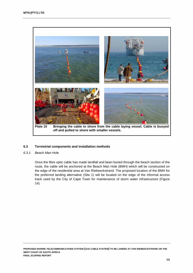
MTN (PTY) LTD
Plate 10 Bringing the cable to shore from the cable laying vessel. Cable is buoyed
off and pulled to shore with smaller vessels.
6.3 Terrestrial components and installation methods
6.3.1 Beach Man Hole Once the fibre optic cable has made landfall and been buried through the beach section of the route, the cable will be anchored at the Beach Man Hole (BMH) which will be constructed on the edge of the residential area at Van Riebeeckstrand. The proposed location of the BMH for the preferred landing alternative (Site 1) will be located on the edge of the informal access track used by the City of Cape Town for maintenance of storm water infrastructure (Figure 14).
PROPOSED MARINE TELECOMMUNICATIONS SYSTEM (ACE CABLE SYSTEM) TO BE LANDED AT VAN RIEBEECKSTRAND ON THE WEST COAST OF SOUTH AFRICA FINAL SCOPING REPORT
68

MTN (PTY) LTD
Figure 14 Beach Man Hole location at the preferred landing alternative (Source: Google Earth, 2016)
The proposed location of the BMH is located directly adjacent to the existing service corridor through which the cable will be laid. The BMH will be constructed underground and will have the following dimensions: length (approximately 4.0 m); breadth (approximately 2.0 m) and depth (approximately 2.0 m). The proposed location of the BMH at the alternative landing site (Site 2) is located directly adjacent to Die Bad Road (Figure 15). As with site 1, the BMH will be constructed underground and will have the same dimensions as those described above.
Figure 15 Beach Man Hole location at the preferred landing alternative (Source: Google Earth, 2016)
PROPOSED MARINE TELECOMMUNICATIONS SYSTEM (ACE CABLE SYSTEM) TO BE LANDED AT VAN RIEBEECKSTRAND ON THE WEST COAST OF SOUTH AFRICA FINAL SCOPING REPORT
69
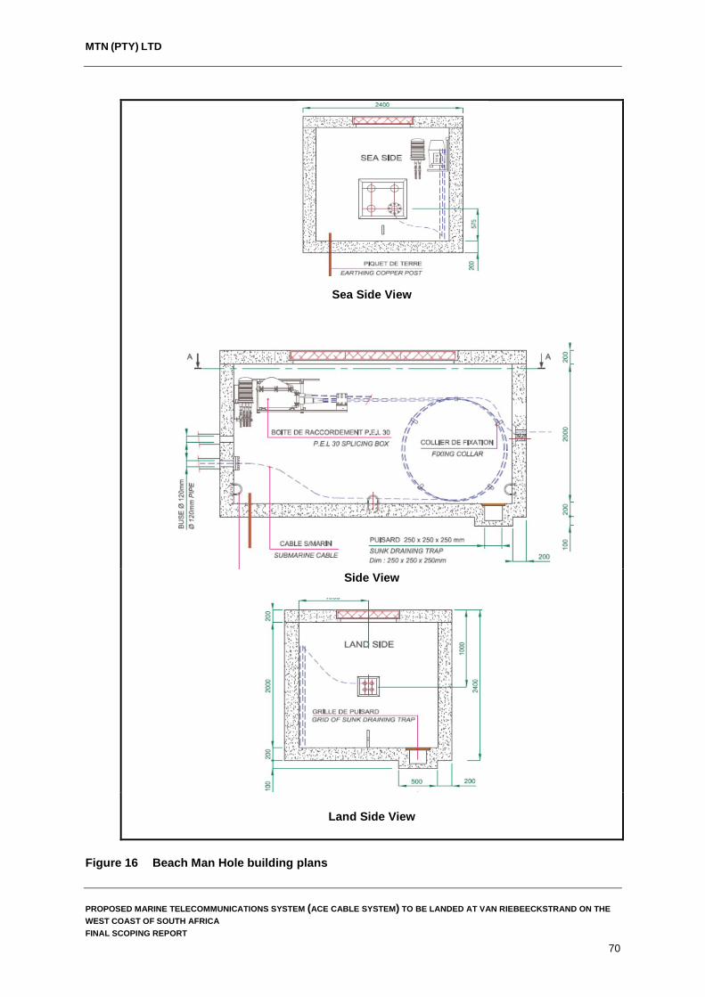
MTN (PTY) LTD
Sea Side View
Side View
Land Side View
Figure 16 Beach Man Hole building plans
PROPOSED MARINE TELECOMMUNICATIONS SYSTEM (ACE CABLE SYSTEM) TO BE LANDED AT VAN RIEBEECKSTRAND ON THE WEST COAST OF SOUTH AFRICA FINAL SCOPING REPORT
70

MTN (PTY) LTD
The BMH is expected to take approximately two months to construct and once complete the only visible sign of the structure will be the manhole covers and cement roof slab (Figure 16).
6.3.2 Cable trenching From the BMH, the land cable will be installed to the Cable Landing Station (CLS) located in Duynefontein. The final alignment of this cable is as yet unknown but two route alternatives are being considered to get the cable from the BMH positions at the preferred landing point (Site 1) and alternative landing point (Site 2) to the CLS site. The trench for the cable will be dug by both mechanical (TLB) and manual (spades) means depending on the alignment selected and the presence of other service infrastructure within the area. The trench will be excavated to a depth of 1 – 2 m before the cable is installed which will be housed within High-density polyethylene (HDPE) or PVC ducts (Figure 17). The width of the excavated trench is expected to be approximately 500 mm.
Figure 17 Cross section of the terrestrial cable trenches
6.3.3 Construction Programme Construction of the Beach Man Hole, and trenching from the beach man hole to the CLS site will take place prior to the landing of the marine cable so that all infrastructure required for the landing of the ACE Cable System (BMH, ducting for the cables, manholes, etc.) is in place prior to the landing of the marine cable. It is anticipated that construction of all infrastructure required for the landing of the ACE Cable System will not take longer than six months to complete. An outline of the preliminary construction programme is provided below:
PROPOSED MARINE TELECOMMUNICATIONS SYSTEM (ACE CABLE SYSTEM) TO BE LANDED AT VAN RIEBEECKSTRAND ON THE WEST COAST OF SOUTH AFRICA FINAL SCOPING REPORT
71

MTN (PTY) LTD
MTN is proposing to install four to six ducts (100 mm Ducts) within the trench dug from the BMH to the CLS site in Duynefontein and four ducts from the BMH to the sea across the dunes to an anchor stopper (buried cement block where the ducts terminate) on the beach. Additional ducts have been incorporated in the design to allow MTN the option of landing at least three more Cable Systems to the same landing site in future.
The BMH construction and seaward ducts construction will take between 4 – 8 weeks to complete.
The Land Route construction (trench from the BMH to the CLS) will take about 6 – 12 weeks to complete and will be done in stages. This means that sections of the proposed cable alignment will be excavated and then backfilled before opening the next section of trench along the proposed alignment.
6.3.4 Project implementation The landing of the cable is entirely dependent on receiving a positive Environmental Authorisation which will be issued by the Department of Environmental Affairs. Only once the environmental authorisation process is nearing its completion will the project proponent be able to realistically set dates for project implementation. MTN is hoping to have the ACE Cable System installed and operational buy the end of 2017.
6.4 Existing services and project implementation
During construction and installation of the ACE Cable System on land the following services will be utilised by the appointed service providers.
6.4.1 Water Water for construction purposes will be sourced from the closest municipal supply point and tankered to site when required. Water use during construction is however very limited and confined to the concrete works required for the construction of the BMH.
6.4.2 Sewage During construction and installation of the ACE Cable System on land, chemical toilets will be provided for construction workers. These chemical toilets will be routinely serviced by the appointed service providers and all waste will be disposed at a licensed waste treatment works within the area. Given the short construction period associated with this project, the impact associated with sewage is not expected to pose any significant risk.
6.4.3 Roads, private property access and road reserves During the construction and installation of the terrestrial section of the ACE Cable System some roads may be impacted locally due to trenching activities. Where major roads need to be crossed by the cable, directional drilling (commonly called horizontal directional drilling) may be employed to install the cable. This will allow the cable to be installed without disrupting traffic and road users. It is likely that directional drilling will be used to cross Otto du Plessis Road and Atlantic Avenue. If the cable alignment is installed within the road reserve, some impacts on private property and driveways are anticipated. Where possible, these will be avoided but if trenching results
PROPOSED MARINE TELECOMMUNICATIONS SYSTEM (ACE CABLE SYSTEM) TO BE LANDED AT VAN RIEBEECKSTRAND ON THE WEST COAST OF SOUTH AFRICA FINAL SCOPING REPORT
72

MTN (PTY) LTD
in damage to private properties along the cable alignment this damage will be recorded and the areas affected be reinstated to what is currently in place. Prior to construction commencing, the appointed contractor and MTN will notify all surrounding landowners of the construction activities to take place and the scheduling thereof.
6.4.4 Storm water The proposed development should not have any impact on storm water once construction is completed. During construction, however, the appointed contractor will take cognisance that the City of Cape Town does have storm water structures within the project area and these structures will be avoided during construction. While trenching of the cable alignment is underway, stockpiles of soil will be located outside any storm water drains to prevent the wash away of material and siltation of downstream habitats. This is of particular relevance in the dune slack wetland to where most of the stormwater from Van Riebeeckstrand is channelled.
6.4.5 Waste streams During the construction and installation of the terrestrial section of the ACE Cable System, little waste is expected to be generated on site and waste will be limited to litter, spoil from the trenching operations (where rubble or buried waste is unearthed) and material off cuts. It is envisaged that a skip will be hired for the duration of the construction period where all construction related waste will be stored and then disposed by an appointed service provider.
6.4.6 Decommissioning
Submarine Cables are designed to have a life-span of 25 years. Currently most of the installed cables are operating beyond this so decommissioning of the ACE Cable System in the near future is unlikely given the current growth in the telecommunications sector within South Africa. If and when decommissioning takes place, all activities would be subject to legislation relevant at the time.
PROPOSED MARINE TELECOMMUNICATIONS SYSTEM (ACE CABLE SYSTEM) TO BE LANDED AT VAN RIEBEECKSTRAND ON THE WEST COAST OF SOUTH AFRICA FINAL SCOPING REPORT
73

MTN (PTY) LTD
7. PUBLIC PARTICIPATION PROCESS
The public participation process has been designed to comply with the requirements of the EIA Regulations (Sections 41 to 44 of Regulation 982) and NEMA. The important elements relating to the public participation process that are required by the Regulations are the following:
The manner in which I&APs were notified of the application for environmental
authorisation. This includes on-site notice boards, giving written notice to landowners, letters, Background Information Documents (BID) and advertisements in the media (Section 41).
Opening and maintaining a register containing the names and addresses of I&APs. These include all persons who have submitted comments, attended meetings, and are organs of State who have jurisdiction in the assessment process, and all those who have requested that they be placed on the register as registered I&APs (Section 42).
Registered I&APs are entitled to comment, in writing, on all written submissions made to the competent authority by the applicant or the Environmental Assessment Practitioner managing the application, and to bring to the attention of the competent authority any issues, which that party believes may be of significance when the application is considered for authorisation (Section 43).
The comments of registered I&APs must be recorded and included in the reports submitted to the competent authority (Section 44).
The objectives of public participation in an EIA are to provide sufficient and accessible information to I&APs in an objective manner to assist them to:
During the Scoping Phase.
Identify issues of concern, and provide suggestions for enhanced benefits and alternatives.
Contribute local knowledge and experience. Verify that their issues have been considered.
During the Impact Assessment.
Verify that their issues have been considered either by the EIA Specialist Studies, or elsewhere.
Comment on the findings of the Environmental Impact Assessment Report (EIAR), including the measures that have been proposed to enhance positive impacts and reduce or avoid negative ones.
The key objective of public participation during Scoping is to assist define the scope of the technical specialist studies to be undertaken during the Impact Assessment.
7.1 Notification of the application
Stakeholders were informed of MTN’s intention to apply for environmental authorisation via a Background Information Document (BID), media advertisements and on-site notice board. The application was also posted on ACER’s website for stakeholder review.
PROPOSED MARINE TELECOMMUNICATIONS SYSTEM (ACE CABLE SYSTEM) TO BE LANDED AT VAN RIEBEECKSTRAND ON THE WEST COAST OF SOUTH AFRICA FINAL SCOPING REPORT
74
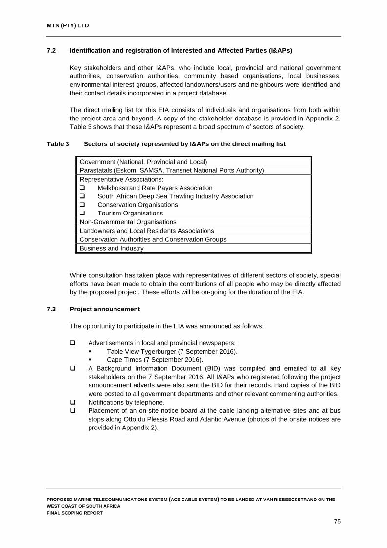
MTN (PTY) LTD
7.2 Identification and registration of Interested and Affected Parties (I&APs)
Key stakeholders and other I&APs, who include local, provincial and national government authorities, conservation authorities, community based organisations, local businesses, environmental interest groups, affected landowners/users and neighbours were identified and their contact details incorporated in a project database.
The direct mailing list for this EIA consists of individuals and organisations from both within the project area and beyond. A copy of the stakeholder database is provided in Appendix 2. Table 3 shows that these I&APs represent a broad spectrum of sectors of society.
Table 3 Sectors of society represented by I&APs on the direct mailing list
Government (National, Provincial and Local) Parastatals (Eskom, SAMSA, Transnet National Ports Authority) Representative Associations: Melkbosstrand Rate Payers Association South African Deep Sea Trawling Industry Association Conservation Organisations Tourism Organisations Non-Governmental Organisations Landowners and Local Residents Associations Conservation Authorities and Conservation Groups Business and Industry
While consultation has taken place with representatives of different sectors of society, special efforts have been made to obtain the contributions of all people who may be directly affected by the proposed project. These efforts will be on-going for the duration of the EIA.
7.3 Project announcement
The opportunity to participate in the EIA was announced as follows: Advertisements in local and provincial newspapers:
Table View Tygerburger (7 September 2016). Cape Times (7 September 2016).
A Background Information Document (BID) was compiled and emailed to all key stakeholders on the 7 September 2016. All I&APs who registered following the project announcement adverts were also sent the BID for their records. Hard copies of the BID were posted to all government departments and other relevant commenting authorities.
Notifications by telephone. Placement of an on-site notice board at the cable landing alternative sites and at bus
stops along Otto du Plessis Road and Atlantic Avenue (photos of the onsite notices are provided in Appendix 2).
PROPOSED MARINE TELECOMMUNICATIONS SYSTEM (ACE CABLE SYSTEM) TO BE LANDED AT VAN RIEBEECKSTRAND ON THE WEST COAST OF SOUTH AFRICA FINAL SCOPING REPORT
75
MTN (PTY) LTD
7.4 Obtaining and dealing with comments from I&APs
The following opportunities will be provided to I&APs during Scoping to contribute comments: Completing and returning Registration and Comment Sheets. Providing comments telephonically or by email. Should the need arise, a Public Open Day will be held during the DSR review period.
The primary aim of this open day will be to: Disseminate information regarding the proposed project to I&APs. Provide I&APs with an opportunity to interact with the EAP and relevant MTN
officials. Discuss the studies to be undertaken within the Environmental Impact
Assessment. Supply more information regarding the EIA process. Answer questions regarding the project and the EIA process. Receive input regarding the public participation process and the proposed
development. Provide I&APs not previously registered on the project database with an
opportunity to be formally registered and, therefore, be informed of progress for the remainder of the project.
Focus group meetings will be held with key stakeholders should the need arise to discuss the project and to address concerns raised by key stakeholders.
Public participation documentation is provided in Appendix 2.
7.5 Comments and Responses Report
Issues and concerns raised by I&APs will be captured in a Comments and Responses Report (CRR), which is appended to this report (Appendix 3). This report will be updated to include any additional inputs from I&APs that may be received as the EIA process proceeds, and as the findings of the EIA become available. To date, the comments received from I&APs and the relevant authorities following review of the Draft Scoping Report mainly relate to the following topics: Requests to be registered as I&APs. Support of the proposed development. The need to abide by the recommendations made by the International Cable Protection
Committee (ICPC). The protection of heritage resources.
7.6 Draft Scoping Report
The purpose of the Draft Scoping Report was to enable I&APs to verify that their contributions to date had been captured, understood and correctly interpreted. At the end of Scoping, the issues identified by I&APs and by the environmental technical specialists, will be used to define the terms of reference for the specialist studies that will be conducted during the Impact Assessment Phase of the EIA.
PROPOSED MARINE TELECOMMUNICATIONS SYSTEM (ACE CABLE SYSTEM) TO BE LANDED AT VAN RIEBEECKSTRAND ON THE WEST COAST OF SOUTH AFRICA FINAL SCOPING REPORT
76

MTN (PTY) LTD
The availability of the Draft Scoping Report for public comment was advertised as follows: Advertisements in local and provincial newspapers:
Table View Tygerburger (9 November 2016). Cape Times (8 November 2016).
All registered I&APs were notified in writing on the 7 November 2016 of the availability of the Draft Scoping Report for their review and comment.
The Draft Scoping Report was made available at the venues indicated in Table 4 for public review (with a 30-day comment period (7 November - 9 December 2016). Commenting authorities were also contacted by the EAP on the 5 December 2016 requesting that their respective departments provide comment on the Draft Scoping Report for inclusion in the Final Scoping Report.
Comments submitted during this period were taken into account when finalising the Scoping Report and are included in the Final Comments and Response Report that will be submitted to DEA with this Final Scoping Report (See Appendix 3).
Table 4 List of public venues in the project area where the Draft Scoping Report was
placed for public review between the 7 November – 9 December 2016
Venue Street Contact Person and Number Koeberg Public Library
Merchant Walk, Duynefontein, 7441 Ms. Roelda Brown 021 553 2514
Melkbosstrand Ratepayers Association
25 Jacobus Crescent, Duynefontein, 7441
Mrs. Smokie La Grange 073 357 6359
7.7 Final Scoping Report
Following the updating of the Draft Scoping Report with comments and issues raised by I&APs during the public review process, the Final Scoping Report will be submitted to DEA, with a request that the EIA can proceed to the next phase, viz. the Impact Assessment phase.
Once DEA has approved the Final Scoping Report and Plan of Study, the Impact Assessment Phase of the EIA will commence. This will comprise various specialist studies to assess the potential positive and negative impacts of the proposed project, and to recommend appropriate measures to enhance positive impacts and to avoid or reduce negative ones.
PROPOSED MARINE TELECOMMUNICATIONS SYSTEM (ACE CABLE SYSTEM) TO BE LANDED AT VAN RIEBEECKSTRAND ON THE WEST COAST OF SOUTH AFRICA FINAL SCOPING REPORT
77
MTN (PTY) LTD
8. DESCRIPTION OF THE RECEIVING ENVIRONMENT
This section describes relevant characteristics of the receiving environment that may affect or be affected by the proposed ACE Cable System development and associated infrastructure. The aim of this chapter is to enable the reader to understand the receiving environment in the context of the proposed development.
8.1 Marine and Offshore Environment
At each landing country associated with the ACE cable system, the proposed fibre-optic cable will transit coastal waters and be brought on shore using industry-standard installation methodologies. When selecting the route alignment for the ACE Cable System, the following criteria were taken into account by the engineering team in order to find the most practical and cost effective alignments: The placing of the cable close to and along existing alignments of submarine
telecommunications cables entering South Africa’s waters. Identification of a suitable landing beach that minimises on-shore environmental and
infrastructure constraints and enables the cable to be linked to the proposed cable station.
8.1.1 Biophysical Characteristics Prevailing currents The oceanographic regime around South Africa is dominated by two major current systems: the cold Benguela Current along the Atlantic coast to the west and the warm Agulhas Current along the Indian Ocean coast to the east. On the west coast, the Benguela Current has two main components namely the eastern limb of the South Atlantic Subtropical Gyre which has a broad, sluggish, equator ward flow of only 0.1–0.3 m s−1 and inshore of this, a coastal component which exhibits dynamic wind-driven upwelling. The inshore coastal component is mainly driven by local weather systems, resulting in short-term upwelling cycles with a periodicity of 5–10 days. Offshore, mean monthly sea surface temperatures range from 15.4°C to 20.1°C, but in the near shore upwelling region, variability is greater and temperatures range from 10°C to 18°C. These upwelling events along the west coast bring nutrient rich waters which result in high biological productivity, which in turn supports large fish stocks, including pilchard, anchovy, hake, and rock lobster, each forming the basis for lucrative commercial fisheries (Shannon et al., 1988). Bathymetry The continental shelf off Cape Town is relatively narrow, about 35 km, but widens northward to about 230 km at Alexander Bay. Based on results of the screening studies undertaken the following description of the bathymetry along the proposed ACE Cable System has been compiled from where the cable enters the EEZ of South Africa until it makes land fall at Van Riebeeckstrand: The proposed ACE Cable System enters South Africa’s EEZ at 30°32.930'S, 13°35.162'E at a Water Depth (WD) of 2,905 m and proceeds in a south-southeast direction over a gentle sloping seabed. A local seabed rise is passed by the route between 30°47.677'S, 13°42.989'E in 2,840 m WD and 30°54.564'S, 13°46.651'E with moderate to steep gradient observed along the sides. After that, the route runs over a gentle seabed with occasional moderate
PROPOSED MARINE TELECOMMUNICATIONS SYSTEM (ACE CABLE SYSTEM) TO BE LANDED AT VAN RIEBEECKSTRAND ON THE WEST COAST OF SOUTH AFRICA FINAL SCOPING REPORT
78

MTN (PTY) LTD
gradients for approximate 50 km until two scarps are encountered at approximately 31°19.930'S, 14°00.178'E in 2,911m WD and 31°21.304'S, 14°00.913'E in 3,008 m WD. Very steep scarps measured up to 28° can be observed along the proposed cable alignment. 31°22.601'S, 14°01.605'E in 3,054 m WD to 33°02.544'S, 15°32.596'E in 3,346 m WD
At the beginning of this section, the proposed route heads south-southeast and then alters gently to the southeast at 31°57.577'S, 14°23.411'E in 2,968 m WD. The seabed is gentle in general with occasional moderate gradients.
33°02.544'S, 15°32.596'E in 3,346 m WD to 33°49.140'S, 16°26.485'E in 2,642 m WD In this section, the seafloor rises to the southeast along the route. The seabed is gentle with localised moderate slope gradients and one scarp with moderate slope is crossed by the route at around 33°17.167'S, 15°48.720'E in 3,203 m WD.
33°49.140'S, 16°26.485'E in 2,642 m WD to 33°56.936'S, 17°15.551'E in 1,500 m WD (Offshore shallow water survey boundary) In this section, the route gradually alters course from the southeast to the east direction. Irregular seabed is present with scattered to numerous moderate to very steep slopes. The route crosses the SAT 2 cable at 33°55.540'S, 16°42.525'E in 2,794 m WD. At 33°56.936'S, 17°15.551'E the route reaches the burial limit of 1,500 m WD and continues eastwards climbing on the continental slope.
33°56.935'S, 17°15.551'E (KP1368.7) in 1500m WD to 33°54.892'S, 17°27.537'E (KP1387.6) in 520m WD In this section the route traverse to the east-northeast on a seabed with gentle to localised steep slope gradients. The seabed rises eastwards successively. The slope gradients are mainly gentle to moderate. Some local scarp or depressions can be observed on either side of the survey route. From 1,500 m WD (to the east), the seabed geology is characterised with thick sediment stratum. The results from gravity cores prove that the surface sediments mainly comprise of very soft to soft sandy silt over inter-bedded firm to stiff sandy silt and medium dense silty sand. A section of hard dense sediment was mapped between 33°56.877'S, 17°16.013'E in 1,456 m WD and 33°56.860'S, 17°16.150'E in 1,437 m WD.
After 33°56.445'S, 17°19.441'E in 1105m WD, the seabed sediment becomes denser with some medium to stiff clayey silt and coarser sediments.
After 33°55.486'S, 17°25.163'E in 665m WD, the shallow geology becomes intermittent veneers of soft to stiff sandy silt over medium dense to very dense silty sand until the end of this section. Beside the presence of shallow hard ground in the eastern part of this section, a total of eleven (11) sonar contacts attributed to debris were identified along the proposed cable alignment. A pre-lay grapnel run is recommended along this section of the ACE Cable alignment.
8.1.2 Biodiversity threats and Marine Protected Areas
South African marine biodiversity is under threat from a range of anthropogenic activities, the intensity and variety of which have increased significantly over the past hundred years. Direct exploitation of coastal resources ranges from traditional subsistence exploitation and recreational fishing to full-scale commercial activities.
PROPOSED MARINE TELECOMMUNICATIONS SYSTEM (ACE CABLE SYSTEM) TO BE LANDED AT VAN RIEBEECKSTRAND ON THE WEST COAST OF SOUTH AFRICA FINAL SCOPING REPORT
79

MTN (PTY) LTD
Currently, 23% of the South African coastline, but less than 1% of the country's EEZ, falls within Marine Protected Areas (MPAs). Spatial assessments of South African marine biodiversity noted fish fauna as the most exploited and threatened major component of the marine biota, while high-profile reefs and pinnacles, soft-bottom trawling grounds, and coastal and subtidal areas exposed to mining on the west coast were identified as the most threatened habitats (http://sanpcc.org.za/pssa/articles/includes/NSBA). Efforts are currently underway to increase the level of protection to South Africa’s marine environment with the Department of Environmental Affairs (DEA) recently publishing a draft notice (03 February 2016 in the Government Gazette No. 39646) and regulations to declare a network of 22 new proposed Marine Protected Areas (MPAs) as part of the Operation Phakisa Initiative.
The declaration of these new MPAs aims to create approximately 70 000 km2 of marine protected areas, bringing SA’s ocean protection within the South African Exclusive Economic Zone (EEZ) to more than 5% (Figure 18). It must be noted that the proposed alignment of the ACE Cable system does not pass through any of the areas identified for future MPAs (or current ones).
Figure 18 Proposed focus areas for offshore protection (Source: Sink et al., 2011)
PROPOSED MARINE TELECOMMUNICATIONS SYSTEM (ACE CABLE SYSTEM) TO BE LANDED AT VAN RIEBEECKSTRAND ON THE WEST COAST OF SOUTH AFRICA FINAL SCOPING REPORT
80
MTN (PTY) LTD
Marine telecommunications cables although having some direct negative impacts associated with the installation and operation of these cable systems, do offer protection to the marine benthic environment along their alignment through the implementation of the legislated buffer zone either side of the cable as defined in the Marine Traffic Act (Act No. 2 of 1981) read together with the Maritime Zones Act (Act No. 15 of 1994). This buffer zone effectively protects the benthos from bottom trawling and acts as a refuge for benthic fish species in this area.
8.1.3 Marine Fauna Fish Species The marine environment off the south-western coast of Africa with its nutrient rich waters supports large populations of pelagic, mid-water and demersal fish species as well and high numbers of bird and mammalian predators (Hutchings et al., 2009). Of particular relevance to the proposed ACE Cable System are the fish stocks occurring within oceans surrounding the proposed cable route and the fishing industry which targets these fish species. These fish species include the following commercially targeted species: Pelagic species Pilchard (Sardinops occelata). Anchovy (Family Engraulidae). Snoek (Thyrsites atun). Chub mackerel (Scomber japonicus). Yellowtail (Seriola lalandi/rivoliana). Tuna (numerous species). Demersal species Hake (Merluccius paradoxus/capensis). Kingklip (Genypterus capensis). Monkfish (Lophius americanus).
PROPOSED MARINE TELECOMMUNICATIONS SYSTEM (ACE CABLE SYSTEM) TO BE LANDED AT VAN RIEBEECKSTRAND ON THE WEST COAST OF SOUTH AFRICA FINAL SCOPING REPORT
81

MTN (PTY) LTD
Hake
Pilchard
Cape Snoek
Kingklip
Plate 11 Some of the commercially targeted fish species on the West Coast of South Africa
Marine Mammals There are a number of marine mammals which are known to occur on the West Coast of South Africa and within the project area. Included in these are the following species: Cape Fur Seal (Arctocephalus pusillus) - The Cape Fur Seal is the only seal species that breeds in South Africa; however, other seal species such as Elephant Seals, Sub-Antarctic Fur Seals and Leopard Seals are occasionally encountered along South Africa’s coastline. Cape Fur Seals have been protected in South Africa since 1893 but were commercially harvested up until the 1990s before a ban on the commercial harvesting seals was enforced. Dolphins – there are three dolphin species generally found off the West Coast of South Africa, namely the common (Delphinus delphis), bottlenose (Tursiops truncates) and the Heaviside's dolphins (Cephalorhynchus heavisidii). Although sightings of the Heaviside's dolphins are not uncommon off the Skeleton Coast of Namibia, they have been recorded as far south as the southern tip of South Africa. Sightings are often recorded from major population centres such as Cape Town. Whales – there are a number of whale species which are known to occur on the West Coast of South Africa the most common of which is the southern right whale (Eubalaena australis) and humpback whale (Megaptera novaeangliae). Whales are generally observed in the waters off Melkbosstrand and Yzerfontein between June and December when groups of between 8-10 whales are often observed. During this period, the cows calve in the calm coastal waters along the coastline.
PROPOSED MARINE TELECOMMUNICATIONS SYSTEM (ACE CABLE SYSTEM) TO BE LANDED AT VAN RIEBEECKSTRAND ON THE WEST COAST OF SOUTH AFRICA FINAL SCOPING REPORT
82

MTN (PTY) LTD
Birds
Birds are common and important components of coastal ecosystems, being top predators both in near shore and intertidal environments where near shore is defined as “the region extending from the low-water mark out to sea, approximately as far as the edge of the continental shelf” and the intertidal environment is defined as “that extending above the low-water spring mark to the limit of direct marine influence” (Hockey et al., 1983). The distribution patterns of birds are also highly dependent on food availability and suitable nesting sites. Seabirds feed at sea and breed on land and are, therefore, important redistributors of nutrients within these environments.
The near shore environment of Southern Africa supports large numbers of both breeding and non-breeding seabirds. Breeding seabirds are spatially restricted by the availability of safe nesting sites such as islands and mainland cliffs, but non-breeding species can theoretically occur throughout the region. The distribution of sea birds is also highly dependent on food availability and, as such, the upwelling of nutrient water in the Benguela Current often results in large numbers of seabirds congregating around large shoals of fish such as pilchards and smaller pelagic shoaling fish.
The three most abundant seabird species encountered within the project area are the Jackass Penguin (Spheniscus demersus), Cape Cormorant (Phalacrocorax capensis) and Cape Gannet (Morus capensis) (Plate 12). Seabird diversity varies seasonally within the project area with the area supporting a reduced diversity of species during the summer months.
PROPOSED MARINE TELECOMMUNICATIONS SYSTEM (ACE CABLE SYSTEM) TO BE LANDED AT VAN RIEBEECKSTRAND ON THE WEST COAST OF SOUTH AFRICA FINAL SCOPING REPORT
83
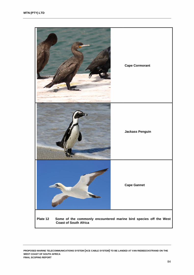
MTN (PTY) LTD
Cape Cormorant
Jackass Penguin
Cape Gannet
Plate 12 Some of the commonly encountered marine bird species off the West Coast of South Africa
PROPOSED MARINE TELECOMMUNICATIONS SYSTEM (ACE CABLE SYSTEM) TO BE LANDED AT VAN RIEBEECKSTRAND ON THE WEST COAST OF SOUTH AFRICA FINAL SCOPING REPORT
84

MTN (PTY) LTD
8.1.4 Offshore Fishing Industry
Approximately 14 different commercial fishery sectors currently operate within South African waters. In addition to commercial sectors, recreational fishing occurs along the coastline comprising shore angling and small, open boats (generally less than 10 m in length). The commercial and recreational fisheries are reported to catch over 250 marine species, although fewer than 5% of these are actively targeted by commercial fisheries, which comprise 90% of the landed catch. The primary fisheries in terms of highest economic value are the demersal (bottom) trawl and long-line fisheries targeting the Cape hakes (Merluccius paradoxus and M. capensis) and the purse-seine fishery targeting small pelagic species including pilchard (Sardinops ocellatus), anchovy (Engraulis encrasicolus) and red-eye round herring (Etrumeus whitheadii). Highly migratory tuna and tuna-like species are caught on the high seas and seasonally within the South African Exclusive Economic Zone (EEZ) by the pelagic long-line and pole fisheries. Targeted species include albacore (Thunnus alalunga), bigeye tuna (T. obesus), yellowfin tuna (T. albacares) and swordfish (Xiphias gladius). Offshore trawling is usually conducted along specific trawling lanes on “trawl friendly” substrate (flat, soft ground). The total trawl footprint within the South African EEZ is approximately 70,400 km2 of which offshore grounds amount to 57,420 km2 and inshore grounds 12,983 km2. On the West / South-West Coast, these grounds extend in a continuous band along the shelf edge between the 300 m and 1,000 m bathymetric contours2. The primary offshore fishing ground on the west coast is a sandy and muddy offshore ground that was first fished in the 1920s and continues to be a very important area for the offshore trawl fleet (Figure 19). Trawl nets are generally towed along depth contours (thereby maintaining a relatively constant depth), running parallel to the depth contours in a north-westerly or south-easterly direction. Trawlers also target fish aggregations around bathymetric features, in particular, seamounts and canyons (i.e. Cape Columbine and Cape Canyon), where there is an increase in seafloor slope. In these cases, the direction of trawls also follows the depth contours. Trawlers are prohibited from operating within five nautical miles of the coastline.
2 Trawling to these depths started in the mid 1990s for deep-water species such as orange roughy. PROPOSED MARINE TELECOMMUNICATIONS SYSTEM (ACE CABLE SYSTEM) TO BE LANDED AT VAN RIEBEECKSTRAND ON THE WEST COAST OF SOUTH AFRICA FINAL SCOPING REPORT
85

MTN (PTY) LTD
Figure 19 Spatial distribution of trawling efforts off the West Coast of South Africa in relation to existing submarine cables as well as the proposed ACE cable route. Fishing effort is displayed at a 5’ x 5’ grid resolution showing the average number of trawl start positions per annum (2005 – 2014)
PROPOSED MARINE TELECOMMUNICATIONS SYSTEM (ACE CABLE SYSTEM) TO BE LANDED AT VAN RIEBEECKSTRAND ON THE WEST COAST OF SOUTH AFRICA FINAL SCOPING REPORT
86

MTN (PTY) LTD
8.1.5 Offshore Mining Concessions
Approximately 98% of South Africa’s exclusive economic zone is subject to a right or lease for offshore oil and gas exploration or production. The Petroleum Agency of South Africa is responsible for the ‘promotion and regulation of offshore exploration and production’ and maintains a national database of petroleum exploration and production. Over the past decade (since 2006) this database has shown a rapid increase in the application and grant of offshore rights and leases. The South African government has also actively promoted offshore oil and gas exploration through Operation Phakisa which seeks to support the rapid development of the offshore oil and gas sector by “creating an environment that promotes exploration”. Recently there have also been an increasing number of applications for “unconventional” offshore oil and gas activities (hydraulic fracturing). Although impacts associated with fracking (hydraulic fracturing) in the marine environment are relatively unknown, the Department of Environmental Affairs recently granted PetroSA permission to include hydraulic fracturing in three of its gas field development wells near Mossel Bay. The granting of this permission is in contrast to the most recent iteration of the Petroleum Exploration and Production Regulations (technical regulations for fracking) which excludes offshore exploration and production from its scope (http://cer.org.za/safeguard-our-seabed/mineral-and-petroleum-extraction). As such, it appears that offshore exploration and production are currently unregulated and aggravated by little available knowledge of potential impacts on the marine ecosystem and existing marine uses, including fishing. The proposed ACE Cable System crosses five of these offshore oil and gas concessions from where it enters EEZ of South Africa until it makes landfall at Van Riebeeckstrand. Following investigations by the project team it appears that all of these concessions are currently inactive and. as such. No direct impacts on the concession holders are expected during the installation of the proposed telecommunications cable system. If the concession holders do decide to commence exploration at a later date, they will however have to abide by the legislated buffer zone either side of the cable as defined in the Marine Traffic Act (Act No. 2 of 1981) read together with the Maritime Zones Act (Act No. 15 of 1994). The proposed ACE Cable System enters and exits the following oil concession blocks along its proposed alignment which as indicated above, were found to be inactive:
Cable exits OCB 3013-OK Energy concession and enters OCB 3113-OK Energy
concession at the following co-ordinates: (S 13o 48.935 and E 30o 58.855).
Cable exits OCB 3113-OK Energy concession and enters OCB Orange Deep - Shell concession at the following co-ordinates: (S 13o 59.491 and E 31o 18.644).
Cable exits OCB Orange Deep - Shell concession and enters OCB 3315 – New Age concession at the following co-ordinates: (S 15o 28.965 and E 32o 59.155).
Cable exits OCB 3315 – New Age concession and enters OCB 05 06 – Anadarko concession at the following co-ordinates: (S 15o 59.101 and E 33o 26.000).
Cable exits OCB 05 06 – Anadarko concession and enters OCB 3318C – Rhino Oil and Gas Exploration South Africa (Pty) Ltd concession at the following co-ordinates: (S 17o 59.584 and E 33o 49.509).
PROPOSED MARINE TELECOMMUNICATIONS SYSTEM (ACE CABLE SYSTEM) TO BE LANDED AT VAN RIEBEECKSTRAND ON THE WEST COAST OF SOUTH AFRICA FINAL SCOPING REPORT
87

MTN (PTY) LTD
Rhino Oil and Gas has an application pending with DEA for inshore oil and gas exploration and have been added to the project database as an interested and affected party (See Appendix 8 for a map of the offshore concessions crossed by the proposed ACE Cable System).
8.1.6 Offshore marine telecommunications infrastructure Telkom SA, as one of the operators of other marine telecommunication cable systems running on the same west coast route (SAT-3/WASC/SAFE and WACS), has an interest in the proposed ACE cable system from an operational and risk perspective. MTN, like Telkom SA, is a member of the International Cable Protection Committee (ICPC) and, as such, there are a number of guidelines and standards to abide by to ensure that new cable systems do not negatively impact on existing marine telecommunications systems. Therefore, MTN must abide by the conditions stipulated by the ICPC to ensure no negative impacts are experienced by existing marine cable operators such as Telkom SA. As per the recommendations of the ICPC, MTN will engage directly with Telkom SA to reach a formal agreement with regards to the installation and operation of the ACE Cable System. However, Telkom SA’s support of the ACE Cable System must be noted as it will aid as a driver of Africa’s economic growth and supports NEPAD’s goals. In addition, Telkom SA welcomes an additional cable on the west coast of South Africa as it allows South Africa to maintain access to Europe should the WACS (operated by Telkom SA) fail.
8.2 Beach and Terrestrial Environment
The final section of the ACE Cable System which makes landfall in South Africa involves the installation of the cable through the intertidal zone, across the beach and then approximately 1.5 km of land cable until reaching the Cable Landing Station (CLS) site in Duynefontein. The following section of this report briefly describes the biophysical, social and economic environment.
8.2.1 Van Riebeeckstrand Beach and coastal dunes Van Riebeeckstrand Beach is a long, sandy beach between the southern border of the Koeberg Nuclear Power Station, and the mouth of the Kleine Zoute River (www.capetown.gov.za). The beach is predominantly used by local residents for walking, swimming, surfing and fishing, although kite surfers/wind surfers also frequent this beach as it has a left to right break with swells reaching up to 3 m at times. Van Riebeeckstrand Beach is backed by the suburbs of Duynefontein and Van Riebeeckstrand. There are numerous access points along its 2 km stretch and both of the proposed landing sites for the ACE Cable system are located near two of these access points to the beach. The dune cordon at Van Riebeeckstrand lies leeward of a wide dissipative beach. The cordon comprises of a number of dune structures and a wide, permanently wet dune cordon. Recent imagery indicates that previously stable portions of dune have become more transgressive in nature and that the dune slack is an important stabilizing feature within the area (Figure 20).
PROPOSED MARINE TELECOMMUNICATIONS SYSTEM (ACE CABLE SYSTEM) TO BE LANDED AT VAN RIEBEECKSTRAND ON THE WEST COAST OF SOUTH AFRICA FINAL SCOPING REPORT
88
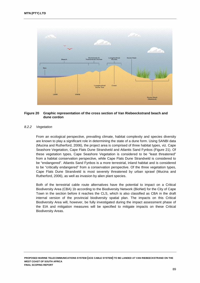
MTN (PTY) LTD
Figure 20 Graphic representation of the cross section of Van Riebeeckstrand beach and dune cordon
8.2.2 Vegetation From an ecological perspective, prevailing climate, habitat complexity and species diversity are known to play a significant role in determining the state of a dune form. Using SANBI data (Mucina and Rutherford, 2006), the project area is comprised of three habitat types, viz. Cape Seashore Vegetation, Cape Flats Dune Strandveld and Atlantis Sand Fynbos (Figure 21). Of these vegetation types, Cape Seashore Vegetation is considered to be “least threatened” from a habitat conservation perspective, while Cape Flats Dune Strandveld is considered to be “endangered”. Atlantis Sand Fynbos is a more terrestrial, inland habitat and is considered to be “critically endangered” from a conservation perspective. Of the three vegetation types, Cape Flats Dune Strandveld is most severely threatened by urban sprawl (Mucina and Rutherford, 2006), as well as invasion by alien plant species. Both of the terrestrial cable route alternatives have the potential to impact on a Critical Biodiversity Area (CBA) 1b according to the Biodiversity Network (BioNet) for the City of Cape Town in the section before it reaches the CLS, which is also classified as CBA in the draft internal version of the provincial biodiversity spatial plan. The impacts on this Critical Biodiversity Area will, however, be fully investigated during the impact assessment phase of the EIA and mitigation measures will be specified to mitigate impacts on these Critical Biodiversity Areas.
PROPOSED MARINE TELECOMMUNICATIONS SYSTEM (ACE CABLE SYSTEM) TO BE LANDED AT VAN RIEBEECKSTRAND ON THE WEST COAST OF SOUTH AFRICA FINAL SCOPING REPORT
89

MTN (PTY) LTD
Figure 21 Vegetation types within the study area
Vegetation on the primary dunes at Van Riebeeckstrand can be classed as the Cape Seashore Vegetation type and includes species such as Sporobolus virginicus and Ehrharta villosa, with Tertragonia decumbens and Didelta carnosa being common. Behind the primary dune cordon the wet dune slack gives rise to a habitat dominated by Typha capensis and Juncus kraussii. Where better drained soils occur, species typical of Cape Flats Dune Strandveld veld type are evident, in particular Chrysanthemoides monilifera and Dassispermum suffruticosum. Vegetation within the study area is subject to ongoing disturbance, primarily through pedestrian traffic moving through the dune slack and frontal dune cordon to access the beach. In addition, the establishment of storm water infrastructure within the dune slack and clearance of vegetation have resulted in ongoing disturbance to the area, the latter is evident where there are attempts within the slack to facilitate the flow of water (Figure 22). There is also evidence of informal attempts to stabilise the frontal dune cordon through ad hoc brush wood packing and occasional plantings.
PROPOSED MARINE TELECOMMUNICATIONS SYSTEM (ACE CABLE SYSTEM) TO BE LANDED AT VAN RIEBEECKSTRAND ON THE WEST COAST OF SOUTH AFRICA FINAL SCOPING REPORT
90
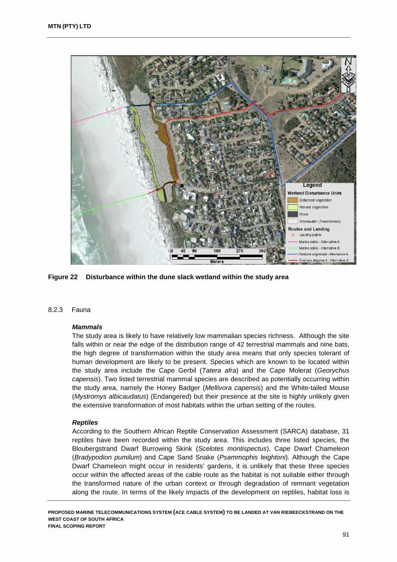
MTN (PTY) LTD
Figure 22 Disturbance within the dune slack wetland within the study area
8.2.3 Fauna
Mammals The study area is likely to have relatively low mammalian species richness. Although the site falls within or near the edge of the distribution range of 42 terrestrial mammals and nine bats, the high degree of transformation within the study area means that only species tolerant of human development are likely to be present. Species which are known to be located within the study area include the Cape Gerbil (Tatera afra) and the Cape Molerat (Georychus capensis). Two listed terrestrial mammal species are described as potentially occurring within the study area, namely the Honey Badger (Mellivora capensis) and the White-tailed Mouse (Mystromys albicaudatus) (Endangered) but their presence at the site is highly unlikely given the extensive transformation of most habitats within the urban setting of the routes. Reptiles According to the Southern African Reptile Conservation Assessment (SARCA) database, 31 reptiles have been recorded within the study area. This includes three listed species, the Bloubergstrand Dwarf Burrowing Skink (Scelotes montispectus), Cape Dwarf Chameleon (Bradypodion pumilum) and Cape Sand Snake (Psammophis leightoni). Although the Cape Dwarf Chameleon might occur in residents’ gardens, it is unlikely that these three species occur within the affected areas of the cable route as the habitat is not suitable either through the transformed nature of the urban context or through degradation of remnant vegetation along the route. In terms of the likely impacts of the development on reptiles, habitat loss is
PROPOSED MARINE TELECOMMUNICATIONS SYSTEM (ACE CABLE SYSTEM) TO BE LANDED AT VAN RIEBEECKSTRAND ON THE WEST COAST OF SOUTH AFRICA FINAL SCOPING REPORT
91

MTN (PTY) LTD
not likely to be highly significant as the cable alignment routes are not likely to create a large loss of habitat. Although the construction phase will generate some disturbance which may negatively impact reptiles, this would be temporary and in the long-term, impacts on reptiles are likely to be low. Amphibians The diversity of amphibians within the affected area is likely to be relatively low as there are given the low diversity of frogs in the project area and the small terrestrial footprint of the cable system. Impacts on amphibians are likely to be low and, if any, concentrated in the construction phase.
8.3 Climate The Western Cape has a semi-arid Mediterranean climate, which is strongly influenced by the cold Benguela Current and coastal winds. The Cape Town area is characterised by dry warm summer months (December to February) of hot, sunny weather, with an average temperature of around 26°C. This is the most popular time to visit Cape Town and tourists and residents usually enjoy approximately 11 hours of sunshine every day. During the winter months, the weather is characterised by cooler rainy weather with June-August being the coldest months having an average temperature of 19oC. Rainfall within the study area predominantly occurs during the winter months with the highest monthly rainfall occurring in July when it rains for approximately 18 days on average each year (http://www.worldweatheronline.com). Graphs depicting the average monthly temperatures and rainfall for Melkbosstrand are provided in Figure 23.
PROPOSED MARINE TELECOMMUNICATIONS SYSTEM (ACE CABLE SYSTEM) TO BE LANDED AT VAN RIEBEECKSTRAND ON THE WEST COAST OF SOUTH AFRICA FINAL SCOPING REPORT
92

MTN (PTY) LTD
Figure 23 Average monthly rainfall and temperatures for Melkbosstrand (Source:
http://www.worldweatheronline.com)
8.4 Topography and geology The project area and the settlement of Duynefontein are situated in close proximity to the R27 regional road and are surrounded by conservation areas such as Koeberg Nature Reserve and the Cape West Coast Biosphere Reserve, with the Blouberg Provincial Nature Reserve located to the south. The study area falls within the Southern Western Coastal Belt Aquatic Ecoregion. This ecoregion is characterised by plains and a moderate to low relief, with gentle slopes (<5% gradient) occurring over more than 80% of the region. The surface geology along the coast at Van Riebeekstrand is dominated by Quaternary sediments, overlying metasediments of the Tygerberg Group. The Quaternary sediments grade from those associated with the Langebaan Formation (consisting of limestone and calcrete, partially cross-bedded with calcified parabolic dune sand) immediately inland of the coastline to those associated with the Witzand Formation (consisting of unconsolidated calcareous sand of marine origin), with the more acidic light-grey to pale-red sandy soils of the Springfontyn Formation occurring further inland, to the east.
8.5 Socio-economic overview of the receiving environment
The proposed project is located in Ward 23 of the City of Cape Town. In order to identify, assess and place in context potential socio-economic impacts that the proposed project may have, the socio-economic dynamics of the receiving environment need to be understood. The following section provides an overview of the socio-economic characteristics of the project area.
PROPOSED MARINE TELECOMMUNICATIONS SYSTEM (ACE CABLE SYSTEM) TO BE LANDED AT VAN RIEBEECKSTRAND ON THE WEST COAST OF SOUTH AFRICA FINAL SCOPING REPORT
93

MTN (PTY) LTD
Population Ward 23 has a population of 33,448 which equates to 13,215 households with an average household size of 2.53 people which is below the municipal average of 3.5 people per household (StatsSA, 2012). The population within the ward is predominantly white (76%) which is in contrast to the municipal averages where 42% of the population is classified as coloured and 39% black (StatsSA, 2012). In terms of age structure the majority of the population (60.7%) fall between the ages of 25 and 64 years of age, higher than the municipal figure of 51.3% in the same age category (SatsSA, 2012). Access to education is also better within Ward 23 than the municipality as a whole, with 82% of the population over the age of 20 in Ward 23 having completed a Grade 12 or higher while only 46% of the population in the municipality have attained this level of education (StatsSA, 2012).
Economic profile In terms of income, 17% of households have a monthly income of R 3,200 or less within Ward 23 which is significantly lower than the 47% of households in the City of Cape Town reporting a monthly income of R 3,200 or less (StatsSA, 2012). Figure 24 below illustrates the higher level of income experienced by households within Ward 23 in comparison to the City of Cape Town as a whole.
Figure 24 Monthly household income within the City of Cape Town and Ward 23
Access to services Household access to piped water, sanitation and electricity is on average better in Ward 23 than it is for the City of Cape Town as a whole. This is particularly noticeable when looking at the percentage of households with access to piped water inside their dwelling and flush toilets connected to a formal sewerage system. Figures 25, 26 and 27 illustrate the differences in the level of access to services between Ward 23 and the rest of the City of Cape Town.
PROPOSED MARINE TELECOMMUNICATIONS SYSTEM (ACE CABLE SYSTEM) TO BE LANDED AT VAN RIEBEECKSTRAND ON THE WEST COAST OF SOUTH AFRICA FINAL SCOPING REPORT
94

MTN (PTY) LTD
Figure 25 Access to piped water in City of Cape Town and Ward 23
Figure 26 Access to sanitation in the City of Cape Town and Ward 23
PROPOSED MARINE TELECOMMUNICATIONS SYSTEM (ACE CABLE SYSTEM) TO BE LANDED AT VAN RIEBEECKSTRAND ON THE WEST COAST OF SOUTH AFRICA FINAL SCOPING REPORT
95

MTN (PTY) LTD
Figure 27 Access to electricity in City of Cape Town and Ward 23
The proposed project site is located entirely within Ward 23 of the City of Cape Town. While the ward includes agricultural areas as well as the Blaauwberg Nature Reserve, the area where the proposed ACE cable will land can be described as a middle to upper income suburban area. Ward 23 exhibits higher levels of socio-economic development than the City of Cape Town, the Western Cape Province and South Africa as a whole. Households within the study area have higher levels of income, better access to education and unemployment levels in the ward are significantly lower than municipal (24%), provincial (21.4%) and national averages (29.4%) (StatsSA, 2012). Koeberg Nuclear Power Station Koeberg is the only nuclear power station in Africa and ranks amongst the safest of the world's top ranking PWRs of its vintage and is the most reliable Eskom power station (http://www.eskom.co.za). Koeberg has operated safely for more than 20 years and has recently undergone a successful peer review by the World Association of Nuclear Operations. The power station is intended to have a further active life of 30 to 40 years, after which time it will be decommissioned in line with the requirements set out by the National Nuclear Regulator. Koeberg is surrounded by a 3,000 ha private game reserve owned by Eskom, containing more than 150 species of birds and half a dozen small mammal species. The power station was originally located outside the metropolitan area, whose but growth has far exceeded expectations in the intervening 20 years, so that the power station is now close to suburban housing (https:// en.wikipedia.org/wiki/Koeberg_Nuclear_Power_Station). Development is however prevented within the Public Exclusion Boundary (PEB) which, is an area within a 2 km radius from the nuclear facility (both on and offshore), and which is not accessible to the public. It should be noted that both the offshore alignments and on shore alignments of the proposed ACE Cable system fall outside of the PEB. The closest point of the proposed ACE Cable System alignment to the PEB is located approximately 1.8 km offshore as shown in Figure 28.
PROPOSED MARINE TELECOMMUNICATIONS SYSTEM (ACE CABLE SYSTEM) TO BE LANDED AT VAN RIEBEECKSTRAND ON THE WEST COAST OF SOUTH AFRICA FINAL SCOPING REPORT
96
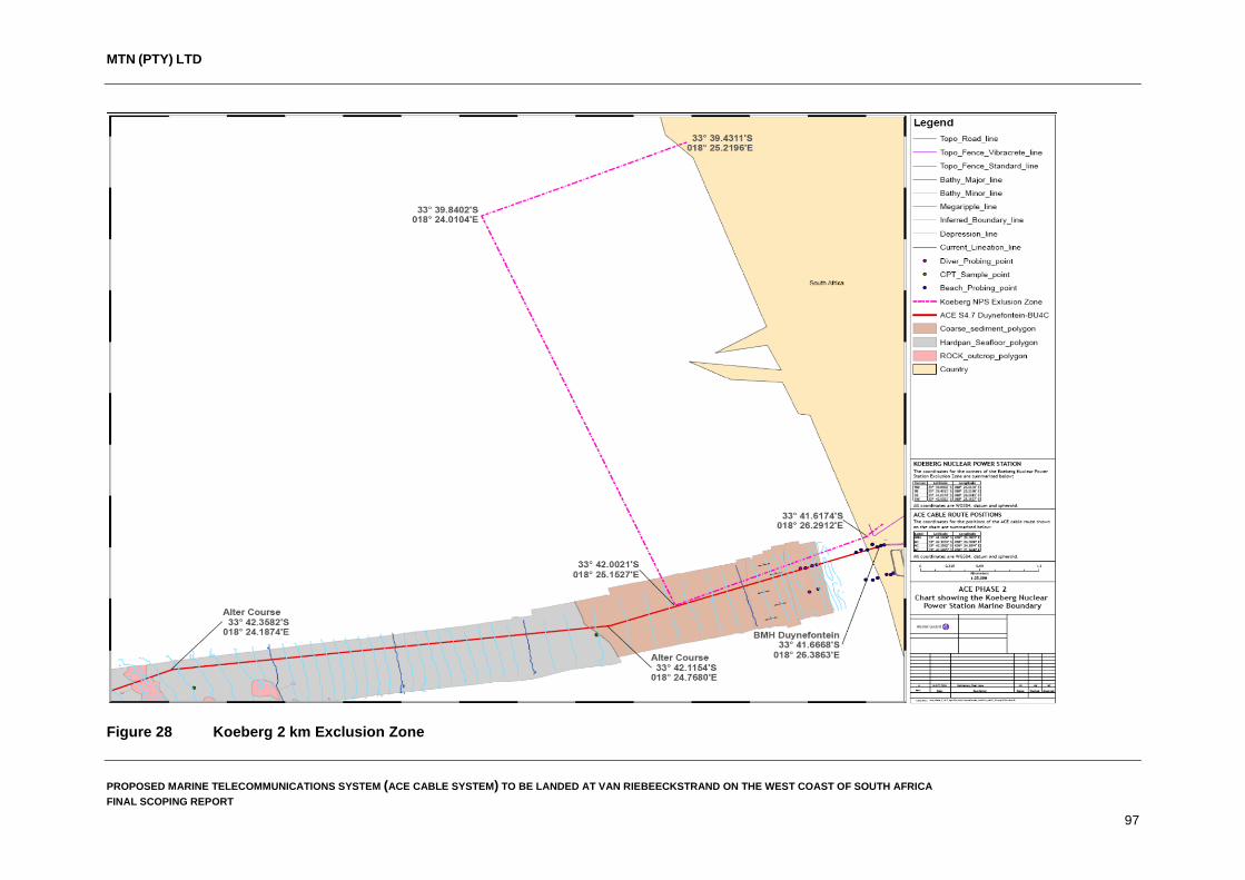
MTN (PTY) LTD
Figure 28 Koeberg 2 km Exclusion Zone
PROPOSED MARINE TELECOMMUNICATIONS SYSTEM (ACE CABLE SYSTEM) TO BE LANDED AT VAN RIEBEECKSTRAND ON THE WEST COAST OF SOUTH AFRICA FINAL SCOPING REPORT
97
MTN (PTY) LTD
In terms of the National Nuclear Regulator Act, 1999 and Government Notice No. 287, 2004, developments surrounding a nuclear installation must be assessed to demonstrate that the municipality’s Nuclear Emergency Plan can be effectively implemented. In light of this legislation, the National Nuclear Regulator (NNR) requested the City of Cape Town to develop their procedures and processes in order to comply (http://repository.up.ac.za/bitstream /handle/2263/5908/021.pdf;jsessionid=59B3CD6603074D1BF909C4A866B87414?sequence=1). As the proposed ACE Cable System makes landfall within the 5 km Precautionary Action Zone (PAZ) of the reactors, a risk assessment and emergency evacuation plan are required by the City of Cape Town for the proposed development during construction and operation. These plans are provided in Appendix 7 of this report and will be submitted to the City of Cape Town for review and signoff prior to project implementation if authorized. One of the key components of the plan must be to show that all staff or employees on the project must be capable of being evacuated from the area within four hours of an event.
PROPOSED MARINE TELECOMMUNICATIONS SYSTEM (ACE CABLE SYSTEM) TO BE LANDED AT VAN RIEBEECKSTRAND ON THE WEST COAST OF SOUTH AFRICA FINAL SCOPING REPORT
98

MTN (PTY) LTD
9. ENVIRONMENTAL ISSUES AND POTENTIAL IMPACTS
The information-gathering phase during scoping included obtaining input from the project proponent, the technical team, I&APs and guidelines and clarification obtained from DEA during the pre-application meeting. Information gathering focused on gaining an understanding of the environmental context and status in order to:
Identify the key issues of concern. Focus and tailor the scope of work for specialist studies, to address each issue of
concern identified during scoping.
The issues identified during Scoping have been formulated as seven key questions, within which potential impacts are identified and described: What are the potential social and socio-economic impacts associated with the
construction and operation of the proposed ACE Cable System? What impacts will the construction and operation of the ACE Cable System have on the
terrestrial environment (flora and fauna)? What impacts will the construction and operation of the ACE Cable System have on the
fishing industry? What impacts will the construction and operation of the ACE Cable System have on
wetlands within the study area? What impact will the construction and operation of the ACE Cable System have on the
beach and dune cordon at Van Riebeeckstrand? What impact will the construction of ACE Cable System have on cultural and heritage
resources, including any paleontological resources (if any are identified during the study)?
What cumulative impacts will the construction of the ACE Cable System have?
It is important to note that although these aspects have been raised as issues, it is not a given that potential impacts will actually occur. However, these issues do need to be considered and investigated to inform decision-making and to enable the relevant parties to proactively address any impacts, should they occur. The no-development option will be considered and assessed as part of these issues.
These key issues are elaborated hereunder. 9.1 What are the potential social impacts associated with the construction and operation of
the proposed ACE Cable System? Submarine telecommunication cables are important for international telecommunication networks as they transport almost 100% of transoceanic Internet traffic throughout the world (www.iscpc.org). It is widely recognised that access to affordable international bandwidth is key to economic development in every country. Although the national advantages of have submarine telecommunications cables is known, there are some potential social and socio-economic impacts related to the actual landing of the ACE Cable System. Although not considered significant, the EAP is of the opinion that further investigations are required into the direct impacts the proposed landing of the ACE Cable System at Van Riebeeckstrand will have on local residents, businesses within the area and the social environment.
PROPOSED MARINE TELECOMMUNICATIONS SYSTEM (ACE CABLE SYSTEM) TO BE LANDED AT VAN RIEBEECKSTRAND ON THE WEST COAST OF SOUTH AFRICA FINAL SCOPING REPORT
99

MTN (PTY) LTD
Social impacts associated with this proposed development will require further investigation to better understand the potential impacts associated with this development. A suitably qualified specialist will be appointed to assess and investigate these matters further.
9.2 What impacts will the construction and operation of the ACE Cable System have on the
natural environment (flora and fauna)? Marine Environment The proposed marine cable is expected to have some direct impact on flora (sea weeds, etc.) within the study area during construction of the cable system through cable burial activities. These impacts are, however, limited mainly to the seabed (benthos) and will be limited to the actual cable alignment (less than 5 m wide corridor). The long term impacts of the marine telecommunications cable on the benthic environment (both fauna and flora) is, however, expected to be positive due to the implementation of the legislated buffer zone (1 NM) as defined in the Marine Traffic Act (Act No. 2 of 1981) read together with the Maritime Zones Act (Act No. 15 of 1994). This buffer zone effectively protects this environment from disturbance due to bottom trawling activities, mineral exploration and the anchoring of vessels. Terrestrial Environment The study area has been extensively modified by anthropogenic impacts in the form of urban development. Much of the terrestrial environment within the study area falls within the residential settlements of Van Riebeeckstrand and Duynefontein, with a small section of the project footprint falling within a natural area between the coastline and the residential areas of Van Riebeeckstrand. Given that most of the study area occurs within the urban environment impacts on fauna and flora are expected to be low; however, it is the EAPs opinion that impacts on the natural area adjacent to the coastline should be investigated to ensure that the proposed development does not result in significant detrimental impacts to fauna and flora within this section of the project area. Based on the above, a suitably qualified specialist will be appointed to assess and investigate the impacts on flora and fauna.
9.3 What impacts will the construction and operation of the ACE Cable System have on the fishing industry? Demersal trawling in South Africa started in the 1890s and has developed into the country’s most important and mature fishing industry which is highly capital intensive and is further characterised by the high rate of employment per ton of fish landed. The fishery also has a high degree of value adding, established globally competitive brand names and the well organised local and international marketing and distribution networks (https://www.ru.ac.za/media/rhodesuniversity/content/envirofishafrica). The offshore alignment of the proposed ACE Cable System passes through the trawling grounds of the demersal trawling industry and may impact on the fishery through the restriction of fishing activities 500 m either side of the telecommunications cable (the requirement for a “no-fishing” (exclusion) zone on either side of submarine cables is defined in the Marine Traffic Act (Act No. 2 of 1981) read together with the Maritime Zones Act (Act No. 15 of 1994)). It must be noted that, although MTN has made every effort to follow existing cable alignments and their exclusion zones, the ACE Cable System will result in additional exclusion areas which will impact the fishing industry.
PROPOSED MARINE TELECOMMUNICATIONS SYSTEM (ACE CABLE SYSTEM) TO BE LANDED AT VAN RIEBEECKSTRAND ON THE WEST COAST OF SOUTH AFRICA FINAL SCOPING REPORT
100

MTN (PTY) LTD
An investigation into the possible impacts these additional exclusion zones will have on the demersal trawling industry must be undertaken in the form of a fisheries assessment during the impact assessment phase of this environmental authorisation process. Furthermore, the EAP recommends that the project proponent engage directly with the South African Deep Sea Trawling Industry Association (SADSTIA) to discuss the project in detail and to and identify SADSTIA concerns and issues pertaining to the proposed development.
9.4 What impacts will the construction and operation of the ACE Cable System have on the wetlands within the study area?
The proposed ACE Cable System will have an impact on one wetland within the terrestrial environment, namely the dune slack wetland between the beach and residential areas of Van Riebeeckstrand. Although this wetland has been extensively modified and impacted through urban development and the management of storm water, it still provides essential ecological services within the area. It is for this reason that a wetland assessment will be undertaken by a suitably qualified wetland specialist to assess and investigate the possible impacts the ACE Cable System may have on this wetland.
9.5 What impact will the construction and operation of the ACE Cable System have on the beach and dune cordon at Van Riebeeckstrand? The dune cordon at Van Riebeeckstrand lies leeward of a wide dissipative beach. The cordon comprises of a number of dune structures and a wide, permanently wet dune cordon. Recent imagery indicates that previously stable portions of dune have become more transgressive in nature and that the dune slack is an important stabilising feature within the area. Dunes are formed as a result of a number of drivers in the near shore and supra tidal environment which are driven by bio-physical processes. These processes are often interdependent and when changes in any one of following drivers occurs the morphology of the coastal dune cordon can change drastically: Wind and wave regimen. Climate state. Beach morphology. Vegetation cover. Due to the dynamic nature of dune systems and the numerous factors at play which influence the morphology and function of these dune systems, the construction of the ACE Cable System may have an impact on the dune cordon at Van Riebeeckstrand. However, impacts on the dune cordon are only expected to be temporary in nature, limited to the construction phase of the proposed development (less than 10 days to bury the cable through the dune cordon), and highly localised. Given the uncertainty of the impacts on the dune cordon a specialist study will be commissioned to assess and investigate possible impacts on the dune cordon in order to better understand the possible impacts associated with the proposed development.
PROPOSED MARINE TELECOMMUNICATIONS SYSTEM (ACE CABLE SYSTEM) TO BE LANDED AT VAN RIEBEECKSTRAND ON THE WEST COAST OF SOUTH AFRICA FINAL SCOPING REPORT
101
MTN (PTY) LTD
9.6 What effects will the construction of ACE Cable System have on cultural and heritage resources, including any paleontological resources (if any are identified during the study)? In terms of the National Heritage Act, it is necessary to appoint a heritage practitioner to determine if any cultural heritage resources occur along the proposed alignment of the ACE Cable System or if there are any in the vicinity which may need to be avoided by the cable alignment. If any heritage resources are identified on site, including buildings over 60 years of age, suitable mitigation measures acceptable to Heritage Western Cape will need to be identified and implemented.
9.7 What cumulative impacts will the construction of ACE Cable System have? A cumulative impact is an incremental impact upon the environment that results from the impact of a proposed action when added to past, existing and reasonably foreseeable future actions. Cumulative effects can be both positive and negative. The construction of the ACE Cable System will naturally add to any cumulative impacts already likely to occur from a wide range of development interventions, i.e. increased employment, increased investment, etc. The aim of this section is to focus on the key cumulative impacts raised as concerns by stakeholders and identified by the specialists, as well as those ones associated with the project that may trigger different development pathways. In this regard, one key cumulative impact has been identified to date which will require further investigation, namely: the combined impact of current and future marine telecommunication cable systems, on the deep sea trawling industry.
PROPOSED MARINE TELECOMMUNICATIONS SYSTEM (ACE CABLE SYSTEM) TO BE LANDED AT VAN RIEBEECKSTRAND ON THE WEST COAST OF SOUTH AFRICA FINAL SCOPING REPORT
102
MTN (PTY) LTD
10. PLAN OF STUDY FOR IMPACT ASSESSMENT This section outlines the Plan of Study for the EIA for the proposed construction and operation of the ACE Cable System and the associated infrastructure.
Potential impacts and issues of concern, as described in Section 9, need to be taken forward for further investigation. During the impact assessment phase, the significance of these potential impacts will be investigated and assessed in detail, by way of specialist studies and further input by other project team members, as required. The specialists will provide scientifically sound information in regard to the various issues raised and will not work in isolation but will be required to interact and discuss aspects during their investigations. An integrated approach will be adopted to consider direct, secondary and cumulative impacts. Thereafter, the findings will be integrated by the EAP to provide a comprehensive understanding of the issues and associated potential impacts. The technical and public participation processes will continue to interact at important stages to ensure that both processes build towards a comprehensive investigation of the issues identified. The integrated findings will be presented in an Environmental Impact Assessment Report (EIAR).
10.1 Key tasks to be undertaken
The main activities to be undertaken during this phase are consistent with NEMA requirements and the EIA Regulations of 2014 (as amended), and are as follows:
Take into consideration any comments from DEA with respect to the Final Scoping
Report and Plan of Study for EIA. Commission and undertake focused studies on the potentially significant issues
identified during Scoping. Maintain communication and interaction with stakeholders for the duration of the Impact
Assessment phase. Integrate the findings of the detailed studies into a comprehensive and objective EIAR,
inclusive of mitigation measures to ameliorate the affects of negative impacts and to optimise positive ones.
Prepare an Environmental Management Programme (EMPr). Distribute the draft EIAR and EMPr to registered stakeholders for review. Process and consider stakeholder review comments. Amend and finalise the draft EIAR and EMPr as required, incorporating review
comments, into a Final Comments and Responses Report. Submit the final EIAR and EMPr to DEA for consideration and decision-making. Notify registered stakeholders of the decision on the application for environmental
authorisation and of their right to appeal.
PROPOSED MARINE TELECOMMUNICATIONS SYSTEM (ACE CABLE SYSTEM) TO BE LANDED AT VAN RIEBEECKSTRAND ON THE WEST COAST OF SOUTH AFRICA FINAL SCOPING REPORT
103
MTN (PTY) LTD
10.2 Proposed specialist studies
Terms of reference for the specialist studies are outlined below. They will be undertaken by independent professionals regarded as specialists in their specific disciplines. There will be compliance with the requirements for specialist reports stipulated in the EIA Regulations 2014 (as amended). In addition, in terms of Appendix 6 of the EIA Regulations (2014) all specialist studies must contain:
Details of the person who prepared the report, and the expertise of that person to carry
out the specialist study or specialised process (in the form of a curriculum vitae attached as an appendix to the report).
A declaration that the person is independent. An introduction that presents a brief background to the study and an appreciation of the
requirements stated in the specific terms of reference for the study. The date and season of the site investigation, and the relevance of the season to the
outcome of the assessment. Details of the approach to the study where activities performed and methods used are
presented. The specific identified sensitivity of the site related to the activity and its associated
structures and infrastructure. An identification of any areas to be avoided, including buffers. A map superimposing the activity, including associated structures and infrastructure on
the environmental sensitivities of the site including areas to be avoided and buffers. A description of any assumptions made and any uncertainties or gaps in knowledge. A description of the affected environment and the study area to provide a context under
which the assessment took place. Description of proposed actions, and alternatives of development and operation of the
project that could affect the prevailing environment, and the risks that these actions and alternatives present.
A description of the findings and potential implications of such findings on the impact of the proposed activity, including identified alternatives, on the environment as well as the environment on the proposed development.
A reasoned opinion as to whether the proposed activity or portions thereof should be licensed, and if so; any avoidance, management actions, mitigation measures and monitoring recommendations.
A description of any consultation process that was undertaken during the course of carrying out the specialist study.
A summary and copies of any comments that were received during any consultation process.
A clear analysis as to how each recommended mitigation action would reduce negative impacts or enhance positive ones.
10.2.1 Social Specialist Study The appointed specialist must provide an assessment of the potential impact that the ACE Cable System and related infrastructure will have on the social environment within the area. With this in mind, the specialist study should identify and discuss the following key aspects.
PROPOSED MARINE TELECOMMUNICATIONS SYSTEM (ACE CABLE SYSTEM) TO BE LANDED AT VAN RIEBEECKSTRAND ON THE WEST COAST OF SOUTH AFRICA FINAL SCOPING REPORT
104
MTN (PTY) LTD
Describe the current social environment within the study area. Identify and discuss potential impacts (positive and negative, local and regional,
including cumulative impacts) of the proposed project on the social environment during construction, operation and decommissioning.
Identify aps in knowledge, data or information which may hamper the impact identification and evaluation process.
Quantify and describe, for each feasible alternative, identified potential social impacts (cumulative, direct and indirect).
Evaluate, using the agreed upon methodology, the significance of the identified potential social impacts.
The impact of the development must be assessed in terms of compliance with approved City of Cape Town: Environmental Management Framework’s3 (EMF) management priorities.
Conduct a comparative assessment of the identified alternatives. Make recommendations regarding mitigation and management measures for
unavoidable social impacts. Contribute in the preparation of an Environmental Management Program. Produce a specialist impact assessment report.
10.2.2 Vegetation and Ecological Specialist Study
The appointed specialist must provide an assessment of the potential impact that the ACE Cable System and related infrastructure will have on the ecology of the area (vegetation and terrestrial fauna). With this in mind, the specialist study should identify and discuss the following key aspects.
1. What are the potential impacts on vegetation arising from the proposed ACE Cable
System and associated construction activities?
Specifically, the Vegetation Assessment must address the following primary elements: Description of the vegetation present, the relevant and important characteristics and
components thereof, including ecological functioning, which may be affected by the proposed ACE Cable System or which may affect the proposed development during site establishment, construction, operation and maintenance and/or decommissioning.
The assessment must consider the terrestrial environment within the development footprint as well as the terrestrial environment directly adjacent to the proposed cable servitude and construction footprints.
Identification of species of conservation importance, including Red Data/CITES and TOPS species potentially affected by the proposed project.
The impact of the development must be assessed in terms of compliance with approved City of Cape Town: Environmental Management Framework’s (EMF) management priorities.
Identify and GPS significant sites that should be conserved, indicate on a suitable map, and motivate why they should be conserved.
3 The City of Cape Town: Environmental Management Framework, being a component of the Blaauwberg District Plan, was adopted by the Provincial Minister for Local Government, Environmental Affairs and Development Planning, in terms of Regulation 5(4) of the Environmental Framework Regulations (2010) (Government Notice 33306) on 26 August 2013 [P.N. 297/2013, 13 September 2013].
PROPOSED MARINE TELECOMMUNICATIONS SYSTEM (ACE CABLE SYSTEM) TO BE LANDED AT VAN RIEBEECKSTRAND ON THE WEST COAST OF SOUTH AFRICA FINAL SCOPING REPORT
105

MTN (PTY) LTD
Identify the likely risks and impacts (negative and/or positive, including cumulative impacts if relevant) and their significance, which the proposed activity/infrastructure may have on vegetation assemblages and vice versa during site establishment, construction, operation and maintenance and/or decommissioning. Recommend mitigation measures for enhancing positive impacts and avoiding or mitigating negative impacts and risks (to be implemented during the design, construction, operation and/or decommissioning phases), for inclusion in an Environmental Management Programme.
The identification of permit requirements as related to the removal and/or destruction of vegetation and specific plant species (all protected tree species within the proposed cable servitude must be counted and their position recorded to facilitate permit application processes).
Address specific issues and concerns raised by stakeholders during the public review phase of the EIA process (an Issues and Responses Report will be provided to specialists).
Discuss any other sensitivities and important issues from your specialist perspective that are not identified in these terms of reference.
2. What are the potential impacts on terrestrial fauna and ecology arising from the
proposed ACE Cable System and associated construction activities?
Animal species identification, including an indication of dominant species, rare and endangered species (Red Data species), and exotic and invader species.
Animal species and their habitats. Assessment of the habitat condition for the animals. Desktop study to determine the probability of occurrence of any fauna of concern within
these identified habitats. Determine the state of health of the ecosystem by taking into consideration all aspects
concerning the natural resources. Recommend mitigation measures to ameliorate the negative impacts of the proposed
development on the natural environment to be included in the Environmental Management Programme.
The impact of the development must be assessed in terms of compliance with approved City of Cape Town: Environmental Management Framework’s (EMF) management priorities.
Address specific issues and concerns raised by stakeholders during the public review phase of the EIA process (an Issues and Responses Report will be provided to specialists).
10.2.3 Fisheries Specialist Study
The appointed specialist must provide an assessment of the potential impact that the ACE Cable System and related infrastructure will have on the trawling industry based on the alignment selected. With this in mind, the specialist study should identify and discuss the following topics:
Determine the actual number of trawls (all types but more importantly bottom) per
annum over the proposed ACE Cable alignment and depict how and from what source of information this was calculated as well as the accuracy of the data.
Typically at what depths are the bottom trawls along the proposed ACE Cable alignment?
Provide details of un-trawlable seabed areas along the proposed ACE cable alignment.
PROPOSED MARINE TELECOMMUNICATIONS SYSTEM (ACE CABLE SYSTEM) TO BE LANDED AT VAN RIEBEECKSTRAND ON THE WEST COAST OF SOUTH AFRICA FINAL SCOPING REPORT
106

MTN (PTY) LTD
Provide a detailed explanation of the key methods of how trawls are recorded and clearly depict the accuracy of these recordings.
Assess the current trawling logs within the Cape Town area and investigate whether the existing cable alignments and their exclusion zones are avoided by trawling vessels specifically the SAT3/WASC, SAFE, WACS and SAT-2 (Out of Service) submarine cables.
Provide a brief comment on the impact of the proposed ACE Cable System alignment and its potential significance to the trawling industry/grounds and also propose an alternate solution with less impact if any. This comment on significance should cover aspects such as the relative percentage of the trawling grounds impacted and/or if the proposed alignment is likely to have any impact on trawling in terms of increased operational costs.
Address specific issues and concerns raised by relevant stakeholders during the public review phase of the EIA process (an Issues and Responses Report will be provided to all identified specialists).
Discuss any other sensitivities and important issues from a fisheries industry perspective that are not identified in these terms of reference.
In addition, the following maps should be generated and be included in the specialist report:
Provide a map of trawl data over the last five years showing trawls across the proposed
ACE cable alignment including the existing SAT3/WASC, SAFE, and SAT-2 (Out of Service) cables. The map legend should include trawl numbers for each year assessed and specific areas of catches.
Provide a similar map of trawl data for trawls over the existing WACS cable for the period five years prior to its installation and since its installation.
Establish the extent of trawling activities in between the cables with separation of surface and bottom trawls.
10.2.4 Wetlands Specialist Study The appointed specialist must provide an assessment of the potential impact that the ACE Cable System and associated infrastructure will have on wetlands within the project area. With this in mind, the specialist study should identify and discuss the following key aspects.
1. What are the potential impacts on wetlands arising from the proposed ACE Cable
System, associated infrastructure and construction activities?
The Wetland Delineation and Functional Assessment must identify and evaluate all wetlands within the proposed development footprint and within 500 m of the proposed development footprint. Specifically, the assignment must address the following primary elements:
The delineation of the outer edge of the temporary zone of wetlands in accordance
with: A practical field procedure for identification and delineation of wetlands and riparian areas (DWAF, 2006).
Determination of all wetland boundaries (viz. the edge of the temporary wetness zone in each case).
Determination of ecological buffers as stipulated by both National (DWS) and Provincial legislation.
Mapping of the wetlands and their respective buffer zones at an appropriate scale.
PROPOSED MARINE TELECOMMUNICATIONS SYSTEM (ACE CABLE SYSTEM) TO BE LANDED AT VAN RIEBEECKSTRAND ON THE WEST COAST OF SOUTH AFRICA FINAL SCOPING REPORT
107

MTN (PTY) LTD
The impact of the development must be assessed in terms of compliance with approved City of Cape Town: Environmental Management Framework’s (EMF) management priorities.
Functional assessment using methods outlined in Wet-Ecoservices (Kotze et al., 2005). This will comprise a desktop and infield assessment scoring the ecosystem services that the wetlands supply, which will allow for more informed planning and decision making.
Description of the current state of the wetlands and riparian zones (specifically focusing on Present Ecological State (PES) and Ecological Importance and Sensitivity (EIS)) using the Wet-Health tool (Macfarlane et al., 2007). In addition to the PES and EIS, the overall impact of all activities that affect hydrological, geomorphological or vegetation health must be calculated as this is a requirement for the water use licensing process.
Address specific issues and concerns raised by stakeholders during the public review phase of the EIA process (an Issues and Responses Report will be provided to specialists).
For wetlands that are not within the development footprint but are within 500 m of the proposed development, it is only necessary to assess the wetland if the proposed development will impact on one of the four main wetland drivers, viz. habitat, biota, flow and water quality.
10.2.5 Beach and Coastal Dune Dynamics Specialist Study The appointed specialist must provide an assessment of the potential impact that the ACE Cable System and related infrastructure will have on the Beach and Coastal Dune Dynamics within the project area. With this in mind, the specialist study should identify and discuss the following key aspects.
1. What are the potential impacts of the proposed ACE Cable System on the primary
dune, beach and beach dynamics, in particular, areas of sensitive vegetation, such as the primary dunes, beach access points and the beach/dune/wetland interface?
2. What measures can be applied to rehabilitate, mitigate and manage these impacts in order to optimise environmental integrity at the proposed cable landing points?
3. How should the dunes in question be rehabilitated and what measures are required to ensure dune stability and functionality (i.e. outline a specific action plan)?
The objectives of the dune and coastal dynamics specialist study are to:
Provide a description of the primary dunes and dune belt present at Van
Riebeeckstrand and the relevant and important characteristics and components thereof, including dune dynamics.
Identify and describe the components, characteristics and natural processes of the coastal environment that may be affected by the proposed development (during pre-construction, construction, operation, maintenance and/or decommissioning), from the perspective of coastal dynamics and dune stability.
Identify and describe the components of the development that may be affected by the environment (during pre-construction, construction, operation, maintenance and/or decommissioning), from the perspective of coastal dynamics and dune stability.
PROPOSED MARINE TELECOMMUNICATIONS SYSTEM (ACE CABLE SYSTEM) TO BE LANDED AT VAN RIEBEECKSTRAND ON THE WEST COAST OF SOUTH AFRICA FINAL SCOPING REPORT
108
MTN (PTY) LTD
The assessment must consider the ACE Cable System development footprint from the intertidal zone up to the BMH located approximately 80 m inland from the primary dunes. Particular attention should be paid to proposed development activities on the primary dunes and near the beach/dune interface.
Identify the likely risks and impacts (negative and/or positive, including cumulative impacts if relevant) and their significance, which the proposed activity/infrastructure may have on relevant environmental components and processes, and vice versa during site establishment, construction, operation and maintenance and/or decommissioning. Make recommendations on alternatives where additional alternatives could be implemented to avoid negative impacts.
Recommend mitigation measures for enhancing positive impacts and avoiding or mitigating negative impacts and risks (to be implemented during the design, construction, operation and/or decommissioning phases), for inclusion in an Environmental Management Programme (EMPr).
Identify key impacts that should be monitored as part of ongoing management of the site, and simple methods of monitoring these impacts.
Identify and delineate by GPS co-ordinates, significant areas that should be conserved or rehabilitated, indicate on a suitable map, and motivate why they should be conserved or rehabilitated.
The impact of the development must be assessed in terms of compliance with approved City of Cape Town: Environmental Management Framework’s (EMF) management priorities.
Discuss any other sensitivities and important issues from a specialist perspective that are not identified in these terms of reference.
Address specific issues and concerns raised by stakeholders during the public review phase of the EIA process (an Issues and Responses Report will be provided to specialists).
10.2.6 Heritage Specialist Study
The appointed specialist must provide an assessment of the potential impact that the ACE Cable System and related infrastructure will have on heritage resources within the area. With this in mind, the specialist study should identify and discuss the following key aspects.
1. What are the potential impacts on heritage resources arising from the proposed landing
of the ACE Cable System, and associated construction and operational activities?
Specifically, the Heritage Impact Assessment must address the following primary elements: The identification and assessment of potential impacts on cultural heritage resources,
including historical sites arising from the construction and operation of the proposed ACE Cable System.
The early identification of any red flag and fatal flaw issues or impacts. Information must be provided on the following:
Results of an overview survey of the project area, and the identification of cultural heritage resources that may be affected by the proposed project or which may affect the proposed project during construction and operation.
Recommended mitigation measures for enhancing positive impacts and avoiding or minimizing negative impacts and risks (to be implemented during design, construction and operation).
PROPOSED MARINE TELECOMMUNICATIONS SYSTEM (ACE CABLE SYSTEM) TO BE LANDED AT VAN RIEBEECKSTRAND ON THE WEST COAST OF SOUTH AFRICA FINAL SCOPING REPORT
109
MTN (PTY) LTD
Address specific issues and concerns raised by stakeholders during the public review phase of the EIA process (an Issues and Responses Report will be provided to specialists).
Formulation of a protocol to be followed by MTN for the identification, protection or recovery of cultural heritage resources during construction and operation, including a list of all necessary permit applications, which may be required.
The impact of the development must be assessed in terms of compliance with approved City of Cape Town: Environmental Management Framework’s (EMF) management priorities.
The identification and assessment of any paleontological aspects or findings arising from the construction and operation of proposed ACE Cable System.
The identification of mitigation measures for enhancing benefits and avoiding or mitigating negative impacts and risks (to be implemented during design, construction and operation of the proposed project).
In compliance with Section 38 of the National Heritage Resources Act 25 of 1999 (NHRA), a Phase 1 Heritage Impact Assessment (HIA) must address the following key aspects:
The identification and mapping of all heritage resources in the area affected. An assessment of the significance of such resources in terms of heritage assessment
criteria set out in the regulations. An assessment of the impact of the development on heritage resources. An evaluation of the impact of the development on heritage resources relative to the
sustainable social and economic benefits to be derived from the development. The results of consultation with communities affected by the proposed development
and other interested parties regarding the impact of the development on heritage resources.
If heritage resources will be adversely affected by the proposed development, the consideration of alternatives.
Plans for mitigation of any adverse effects during and after completion of the proposed development.
10.3 Impact assessment conventions
The following methodology has been applied to predict and assess the potential impacts associated with the proposed development: Direct impacts are impacts that are caused directly by the activity and generally occur
at the same time and at the place of the activity. These impacts are usually associated with the construction, operation or maintenance of an activity and are generally obvious and quantifiable.
Indirect impacts of an activity are indirect or induced changes that may occur as a result of the activity. These types of impacts include all the potential impacts that do not manifest immediately when the activity is undertaken or which occur at a different place as a result of the activity.
Cumulative impacts are impacts that result from the incremental impact of the
proposed activity on a common resource when added to the impacts of other past, present or reasonably foreseeable future activities. Cumulative impacts can occur from the collective impacts of individual minor actions over a period of time and can include both direct and indirect impacts.
PROPOSED MARINE TELECOMMUNICATIONS SYSTEM (ACE CABLE SYSTEM) TO BE LANDED AT VAN RIEBEECKSTRAND ON THE WEST COAST OF SOUTH AFRICA FINAL SCOPING REPORT
110

MTN (PTY) LTD
Nature – the evaluation of the nature of the impact. Most negative impacts will remain negative, however, after mitigation, significance should reduce: Positive. Negative.
Spatial extent – the size of the area that will be affected by the impact:
Site specific. Local (limited to the immediate areas around the site; <2 km from site). Regional (would include a major portion of an area; within 30 km of site). National or International.
Duration – the timeframe during which the impact will be experienced:
Short-term (0-3 years or confined to the period of construction). Medium-term (3-10 years). Long-term (the impact will only cease after the operational life of the activity). Permanent (beyond the anticipated lifetime of the project).
Intensity – this provides an order of magnitude of whether or not the intensity
(magnitude/size/frequency) of the impact would be negligible, low, medium or high): Negligible (inconsequential or no impact). Low (small alteration of systems, patterns or processes). Medium (noticeable alteration of systems, patterns or processes). High (severe alteration of systems, patterns or processes).
Frequency – this provides a description of any repetitive, continuous or time-linked
characteristics of the impact: Once off (occurring any time during construction). Intermittent (occurring from time to time, without specific periodicity). Periodic (occurring at more or less regular intervals). Continuous (without interruption).
Probability – the likelihood of the impact occurring:
Improbable (very low likelihood that the impact will occur). Probable (distinct possibility that the impact will occur). Highly probable (most likely that the impact will occur). Definite (the impact will occur).
Irreplaceability – of resource loss caused by impacts:
High irreplaceability of resources (the project will destroy unique resources that cannot be replaced).
Moderate irreplaceability of resources (the project will destroy resources, which can be replaced with effort).
Low irreplaceability of resources (the project will destroy resources, which are easily replaceable).
Reversibility – the degree to which the impact can be reversed/the ability of the impacted environment to return/be returned to its pre-impacted state (in the same or different location): Impacts are non-reversible (impact is permanent). Low reversibility. Moderate reversibility of impacts. High reversibility of impacts (impact is highly reversible at end of project life).
PROPOSED MARINE TELECOMMUNICATIONS SYSTEM (ACE CABLE SYSTEM) TO BE LANDED AT VAN RIEBEECKSTRAND ON THE WEST COAST OF SOUTH AFRICA FINAL SCOPING REPORT
111

MTN (PTY) LTD
Significance – the significance of the impact on components of the affected environment (and, where relevant, with respect to potential legal infringement) is described: Please note that this excludes positive impacts on the environment. In these cases, the level of significance should be denoted as Low**, Moderate** or High**. Low (the impact will not have a significant influence on the environment and,
thus, will not be required to be significantly accommodated in the project design). Medium (the impact will have an adverse effect or influence on the environment,
which will require modification of the project design, the implementation of mitigation measures or both).
High (the impact will have a serious effect on the environment to the extent that, regardless of mitigation measures, it could block the project from proceeding).
Confidence – the degree of confidence in predictions based on available information and specialist knowledge: Low. Medium. High.
10.4 Project schedule
Key activities and anticipated timeframes for the EIA are shown below. This programme takes into account the technical and public participation processes, and interaction between them. Activity Anticipated Dates Project Announcement/Draft Scoping Report Public Review Period/Application to DEA
October/November 2016
Submit Final Scoping Report and Plan of Study for Impact Assessment to the Competent Authority
January 2017
Specialist Study Investigations January/February 2017 Preparation of Draft Environmental Impact Assessment Report January/February 2017 Draft Environmental Impact Assessment Report and Environmental Management Programme Public Review Period
March/April 2017
Submit Final Environmental Impact Assessment Report and Environmental Management Programme to the Competent Authority
June/July 2017
PROPOSED MARINE TELECOMMUNICATIONS SYSTEM (ACE CABLE SYSTEM) TO BE LANDED AT VAN RIEBEECKSTRAND ON THE WEST COAST OF SOUTH AFRICA FINAL SCOPING REPORT
112

MTN (PTY) LTD
11. CONCLUDING REMARKS The EIA Team is of the opinion that due environmental process has been followed during the undertaking of this Scoping process and associated public participation programme. The analysis of key issues during Scoping suggests that there are no negative impacts that can be classified as fatal flaws. However, further investigation is required as part of the Impact Assessment phase to assess potentially significant issues, viz. social impacts, impacts on wetlands, impacts on vegetation, impacts on the coastal dune cordon and possible impacts on the trawling industry. A cultural heritage resources assessment will also be undertaken. Measures for mitigation and management will be identified for inclusion in an EMPr. Following the comment period for the Draft Scoping Report, the issues raised by stakeholders, together with those of technical specialists and the regulatory authorities, have been captured in this Final Scoping Report. This report will be submitted to DEA, for consideration and acceptance. Thereafter, if DEA accepts the report, the Impact Assessment phase will be undertaken.
PROPOSED MARINE TELECOMMUNICATIONS SYSTEM (ACE CABLE SYSTEM) TO BE LANDED AT VAN RIEBEECKSTRAND ON THE WEST COAST OF SOUTH AFRICA FINAL SCOPING REPORT
113

MTN (PTY) LTD
12. REFERENCES
Websites: https://www.iscpc.org/ International Cable Protection Committee. Date accessed 22 July 2016. http://www.transnetnationalportsauthority.net/AboutUS/Pages/Corporate-Profile.aspx Date accessed 22 July 2016. http://www.imo.org/en/Publications/Pages/CurrentPublications.aspx Date accessed 22 July 2016 http://www.un.org/depts/los/convention_agreements/texts/unclos/unclos_e.pdf United States Convention on the Law of the Sea. Date accessed 23 August 2016. http://www.samsa.org.za/sites/samsa.org.za/files/SAMSA%20Act%2C%201998.pdf SAMSA Act. Date accessed 3 August 2016. http://www.dirco.gov.za/au.nepad/nepad_overview.htm Date accessed 15 August 2016. http://www.eversheds.com/global/en/what/articles/index.page?ArticleID=en/tmt/Focused_on_South_Africa_090312 Telecommunications Infrastructure in South Africa. Date accessed 23 August 2016. http://www.worldweatheronline.com/van-riebeeckstrand-weather-averages/western-cape/za.aspx Date accessed 6 September 2016. https://www.capetown.gov.za/en/stats/2011CensusSuburbs/2011_Census_CT_Suburb_Melkbosstrand_Profile.pdf Date accessed 6 September 2016. https://www.capetown.gov.za/en/EnvironmentalResourceManagement/publications/Documents/CCT_Beaches_-_a_diversity_of_coastal_treasures_2009.pdf Date accessed 28 September 2016. https://coast.noaa.gov/czm/media/Oregon-PPR-Appendix-Part2.pdf Date accessed 8 September 2016. http://www.submarinecablesystems.com/default.asp.pg-marineservices Date accessed 8 September 2016. http://www.ncbi.nlm.nih.gov/pmc/articles/PMC2914023/pdf/pone.0012008.pdf Date accessed 20 September 2016. https://www.environment.gov.za/mediarelease/molewa_22newproposed_mpas Date accessed 20 September 2016. http://sanpcc.org.za/pssa/articles/includes/NSBA%20Summary%20Report%20Draft%20Oct%2004.pdf Marine component of the National Spatial Biodiversity Assessment for the development of South Africa's National Biodiversity Strategic and Action Plan. 2004. Date accessed 20 September 2016.
PROPOSED MARINE TELECOMMUNICATIONS SYSTEM (ACE CABLE SYSTEM) TO BE LANDED AT VAN RIEBEECKSTRAND ON THE WEST COAST OF SOUTH AFRICA FINAL SCOPING REPORT
114

MTN (PTY) LTD
http://www.statssa.gov.za/?page_id=4286&id=297 Date accessed 21 September 2016. http://cer.org.za/safeguard-our-seabed/mineral-and-petroleum-extraction Date accessed 21 September 2016. https://www.ru.ac.za/media/rhodesuniversity/content/envirofishafrica/documents/Vol1An%20Economic%20and%20Sectoral%20Study%20of%20the%20South%20African%20Fishing%20Industry-Results.pdf Date accessed 20 September 2016. https://www.ru.ac.za/media/rhodesuniversity/content/envirofishafrica/documents/Vol2An%20Economic%20and%20Sectoral%20Study%20of%20the%20South%20African%20Fishing%20Industry-Fishery%20profiles.pdf Date accessed 20 September 2016. http://repository.up.ac.za/bitstream/handle/2263/5908/021.pdf;jsessionid=59B3CD6603074D1BF909C4A866B87414?sequence=1 Date accessed 20 September 2016. https:// en.wikipedia.org/wiki/Koeberg_Nuclear_Power_Station Date accessed 20 September 2016. http://www.operationphakisa.gov.za/operations/oel/pages/default.aspx Date accessed 17 September 2016. Journal Papers: Hockey PAR, Cooper J, Duffy DC. The Roles of Coastal Birds in the Functioning of Marine
Ecosystems in Southern Africa. South African Journal of Science. 1983; Vol. 79 April Hutchings L, van der Lingen CG, Shannon LJ, Crawford RJM, Verheye HMS, Bartholomae
CH, van der Plas AK, Louw D, Kreiner A, Ostrowski M, Fidel Q, Barlow RG, Lamont T, Coetzee J, Shilllington, F, Veitch J, Currie JC and Monteiro PMS. The Benguela Current: An ecosystem of four components. 2009. Progress in Oceanography 83; Pg. 15-32.
Taunton-Clark J, Shannon LV. Annual and inter-annual variability in the South-East Atlantic
during the 20th century. South African Journal of Marine Science. 1988; Vol:6 Pg. 97–106.
Sink KJ, Attwood CG, Lombard AT, Grantham H, Leslie R, Samaai T, Kerwath S, Majiedt P,
Fairweather T, Hutchings L, vander Lingen C, Atkinson LJ, Wilkinson S, Holness S, Wolf T. 2011. Spatial planning to identify focus areas for offshore biodiversity protection in South Africa. Final Report for the Offshore Marine Protected Area Project. Cape Town: South African National Biodiversity Institute.
Statistics South Africa, 2012. Census 2011 Municipal report – Western Cape/ Statistics South
Africa. Pretoria: Statistics South Africa, 2012
PROPOSED MARINE TELECOMMUNICATIONS SYSTEM (ACE CABLE SYSTEM) TO BE LANDED AT VAN RIEBEECKSTRAND ON THE WEST COAST OF SOUTH AFRICA FINAL SCOPING REPORT
115
MTN (PTY) LTD
APPENDIX 1: APPLICATION FOR AUTHORISATION
PROPOSED MARINE TELECOMMUNICATIONS SYSTEM (ACE CABLE SYSTEM) TO BE LANDED AT VAN RIEBEECKSTRAND ON THE WEST COAST OF SOUTH AFRICA FINAL SCOPING REPORT
116

MTN (PTY) LTD
APPENDIX 2: PUBLIC PARTICIPATION DOCUMENTS
PROPOSED MARINE TELECOMMUNICATIONS SYSTEM (ACE CABLE SYSTEM) TO BE LANDED AT VAN RIEBEECKSTRAND ON THE WEST COAST OF SOUTH AFRICA FINAL SCOPING REPORT
117

MTN (PTY) LTD
APPENDIX 3: COMMENTS AND RESPONSE REPORT
PROPOSED MARINE TELECOMMUNICATIONS SYSTEM (ACE CABLE SYSTEM) TO BE LANDED AT VAN RIEBEECKSTRAND ON THE WEST COAST OF SOUTH AFRICA FINAL SCOPING REPORT
118
MTN (PTY) LTD
APPENDIX 4: PRE-APPLICATION MEETING MINUTES
PROPOSED MARINE TELECOMMUNICATIONS SYSTEM (ACE CABLE SYSTEM) TO BE LANDED AT VAN RIEBEECKSTRAND ON THE WEST COAST OF SOUTH AFRICA FINAL SCOPING REPORT
119

MTN (PTY) LTD
APPENDIX 5: EAP CURRICULUM VITAE
PROPOSED MARINE TELECOMMUNICATIONS SYSTEM (ACE CABLE SYSTEM) TO BE LANDED AT VAN RIEBEECKSTRAND ON THE WEST COAST OF SOUTH AFRICA FINAL SCOPING REPORT
120

MTN (PTY) LTD
APPENDIX 6: PROPERTY DETAILS
PROPOSED MARINE TELECOMMUNICATIONS SYSTEM (ACE CABLE SYSTEM) TO BE LANDED AT VAN RIEBEECKSTRAND ON THE WEST COAST OF SOUTH AFRICA FINAL SCOPING REPORT
121

MTN (PTY) LTD
APPENDIX 7: RISK ASSESSMENT AND EMERGENCY EVACUATION PLAN
PROPOSED MARINE TELECOMMUNICATIONS SYSTEM (ACE CABLE SYSTEM) TO BE LANDED AT VAN RIEBEECKSTRAND ON THE WEST COAST OF SOUTH AFRICA FINAL SCOPING REPORT
122

MTN (PTY) LTD
APPENDIX 8: SUPPORTING MAPS
PROPOSED MARINE TELECOMMUNICATIONS SYSTEM (ACE CABLE SYSTEM) TO BE LANDED AT VAN RIEBEECKSTRAND ON THE WEST COAST OF SOUTH AFRICA FINAL SCOPING REPORT
123