minnesota lake sherburne county - usgs · ba s inn awq tudy study are twin cities e tr op li an are...
TRANSCRIPT
ÛÛ94ÙÙ10
ÙÙ10
ÙÙ10
ÙÙ52
MONTICELLOMONTICELLOMONTICELLO
W R I G H T
C O U N T Y
S H E R B U R N E
C O U N T Y
BIGLAKEBIGLAKEBIGLAKE
BECKERBECKER
ALUS-5
ALUS-4
ALUS-3
ALUS-2
ALUS-1
ALUS-10
ALUS-11ALUS-15
ALUS-14
ALUS-13
ALUS-18
ALUS-19
ALUS-29
ALUS-28
ALUS-24ALUS-25
ALUS-23ALUS-22
ALUS-27
ALUS-26
ALUS-20ALUS-12
ALUS-21
ALUS-9
ALUS-16
ALUS-17
ALUS-7
ALUS-8
ALUS-6
BECKER
BigLakeBigLakeBigLake
EagleLake
EagleLake
EagleLake
ElkLakeElkLakeElkLake
Sn
ak
e Riv
er
Sn
ak
e Riv
er
Sn
ak
e Riv
er .R i scnarF .tS
.R iscnarF .tS
.R sc inar
F .tS
R iverRiverRiver
Elk R iver
Elk R iver
Miss iss ippi
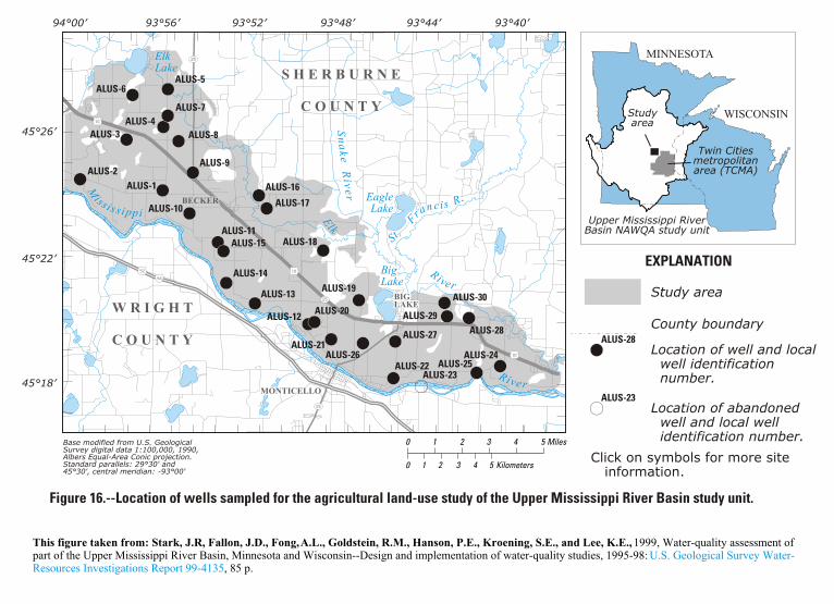
Figure 16.--Location of wells sampled for the agricultural land-use study of the Upper Mississippi River Basin study unit.
BB
BBBB
BBBB
BBBB
BB
BB
BB
BB
BB
BB
BB
BB
BB
BBBB
BB
BB
BBBB
BBBB
BBBB
BB BB
BBBB
25
25
25
ALUS-30
Elk R iver
45°26’
45°22’
45°18’
93°56’94°00’ 93°52’ 93°48’ 93°44’
Base modified from U.S. GeologicalSurvey digital data 1:100,000, 1990,Albers Equal-Area Conic projection.Standard parallels: 29°30' and45°30', central meridian: -93°00'
0 1 2 3 4 5 Miles
0 1 2 3 4 5 Kilometers
93°40’
Upper Mississippi RiverBasin NAWQA study unit
Studyarea
Twin Citiesmetropolitanarea (TCMA)
MINNESOTA
WISCONSIN
Study area
EXPLANATION
Location of well and local well identification number.
Location of abandoned well and local well identification number.
County boundaryALUS-28BB
ALUS-23BB
This figure taken from: Stark, J.R, Fallon, J.D., Fong, A.L., Goldstein, R.M., Hanson, P.E., Kroening, S.E., and Lee, K.E., 1999, Water-quality assessment of part of the Upper Mississippi River Basin, Minnesota and Wisconsin--Design and implementation of water-quality studies, 1995-98:
, 85 p. U.S. Geological Survey Water-
Resources Investigations Report 99-4135
Click on symbols for more site information.
����� ���0�&������ �
pth to bot-m of casing
(feet)
Water level (feet below land sur-
face)
Date measured
26.5 27.9 05/13/98
15.5 14.7 05/13/98
34.2 22 05/15/98
6.5 6.4 05/11/98
23 12.4 05/11/98
9.5 9.4 05/11/98
10.5 10.6 05/12/98
53 NA NA
NA NA NA
24 26.3 05/21/98
40 35 05/21/98
38 37.7 05/18/98
17.5 18.9 08/11/98
24 32.0 05/19/98
27 36.5 05/21/98
NA NA NA
13 14.1 05/14/98
21 20.7 05/14/98
19.2 20 05/19/98
44 37.4 05/18/98
30 29.7 08/18/98
14 13.8 05/19/98
15 12.5 05/27/98
6.8 6.8 05/27/98
25 25.2 05/27/98
18.2 18.2 05/26/98
58
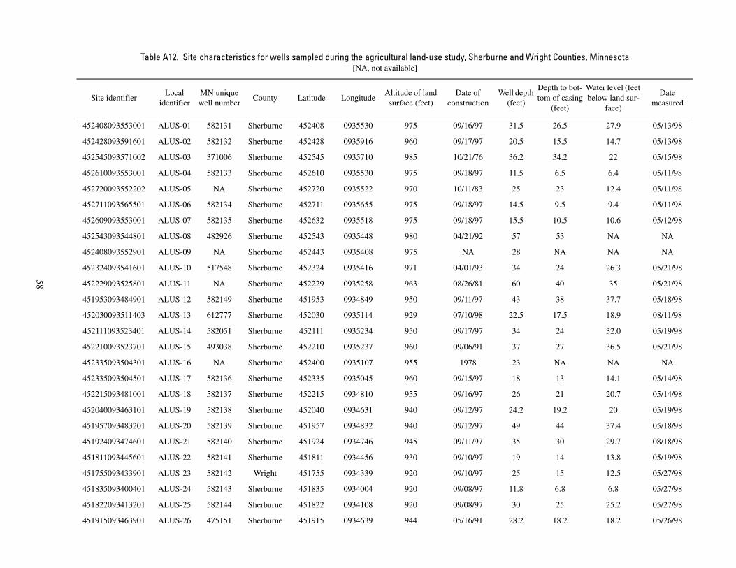
������������ �������� ���� ��������"�������������������� ���������� ��������������� ���0���������������/����[NA, not available]
Site identifierLocal
identifierMN unique well number
County Latitude LongitudeAltitude of land
surface (feet)Date of
constructionWell depth
(feet)
Deto
452408093553001 ALUS-01 582131 Sherburne 452408 0935530 975 09/16/97 31.5
452428093591601 ALUS-02 582132 Sherburne 452428 0935916 960 09/17/97 20.5
452545093571002 ALUS-03 371006 Sherburne 452545 0935710 985 10/21/76 36.2
452610093553001 ALUS-04 582133 Sherburne 452610 0935530 975 09/18/97 11.5
452720093552202 ALUS-05 NA Sherburne 452720 0935522 970 10/11/83 25
452711093565501 ALUS-06 582134 Sherburne 452711 0935655 975 09/18/97 14.5
452609093553001 ALUS-07 582135 Sherburne 452632 0935518 975 09/18/97 15.5
452543093544801 ALUS-08 482926 Sherburne 452543 0935448 980 04/21/92 57
452408093552901 ALUS-09 NA Sherburne 452443 0935408 975 NA 28
452324093541601 ALUS-10 517548 Sherburne 452324 0935416 971 04/01/93 34
452229093525801 ALUS-11 NA Sherburne 452229 0935258 963 08/26/81 60
451953093484901 ALUS-12 582149 Sherburne 451953 0934849 950 09/11/97 43
452030093511403 ALUS-13 612777 Sherburne 452030 0935114 929 07/10/98 22.5
452111093523401 ALUS-14 582051 Sherburne 452111 0935234 950 09/17/97 34
452210093523701 ALUS-15 493038 Sherburne 452210 0935237 960 09/06/91 37
452335093504301 ALUS-16 NA Sherburne 452400 0935107 955 1978 23
452335093504501 ALUS-17 582136 Sherburne 452335 0935045 960 09/15/97 18
452215093481001 ALUS-18 582137 Sherburne 452215 0934810 955 09/16/97 26
452040093463101 ALUS-19 582138 Sherburne 452040 0934631 940 09/12/97 24.2
451957093483201 ALUS-20 582139 Sherburne 451957 0934832 940 09/12/97 49
451924093474601 ALUS-21 582140 Sherburne 451924 0934746 945 09/11/97 35
451811093445601 ALUS-22 582141 Sherburne 451811 0934456 930 09/10/97 19
451755093433901 ALUS-23 582142 Wright 451755 0934339 920 09/10/97 25
451835093400401 ALUS-24 582143 Sherburne 451835 0934004 920 09/08/97 11.8
451822093413201 ALUS-25 582144 Sherburne 451822 0934108 920 09/08/97 30
451915093463901 ALUS-26 475151 Sherburne 451915 0934639 944 05/16/91 28.2

3 3.3 05/26/98
11 11.7 05/20/98
10 10.8 05/20/98
4 4.9 05/20/98
� ���0�&������ ������ �����
pth to bot-m of casing
(feet)
Water level (feet below land sur-
face)
Date measured
59
451921093445101 ALUS-27 582145 Sherburne 451921 0934451 930 09/10/97 8
452007093413001 ALUS-28 582146 Sherburne 452007 0934130 930 09/09/97 16
451730093423001 ALUS-29 582147 Sherburne 452010 0934230 930 09/09/97 15
452036093423701 ALUS-30 582148 Sherburne 452036 0934237 930 09/09/97 9
������������ �������� ���� ��������"�������������������� ���������� ��������������� ���0���������������/���� ����[NA, not available]
Site identifierLocal
identifierMN unique well number
County Latitude LongitudeAltitude of land
surface (feet)Date of
constructionWell depth
(feet)
Deto