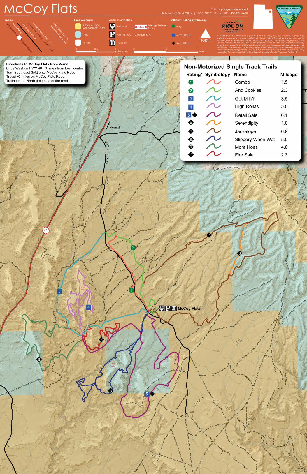
mccoy flats this map is geo-referenced€¦ · title: mccoy flats non-motorized trail system map...

1
McCoy Flats Mc Coy Flat s Ro ad 40 0.7 0.3 1.0 0.3 0.5 2.3 0.2 1.1 2.4 2.3 1.9 4.9 4.0 5 mi. loop 5 mi. loop 1.0 2.2 1.5 1.0 Directions to McCoy Flats from Vernal Drive West on HWY 40 ~6 miles from town center. Turn Southeast (left) onto McCoy Flats Road. Travel ~3 miles on McCoy Flats Road. Trailhead on North (left) side of the road. Vernal Asphalt Ridge McCoy Flat McCoy K n o lls 1 2 3 4 5 6 7 8 9 10 3.5 1.5 2.3 5.0 6.1 6.9 1.0 5.0 4.0 2.3 Combo Got Milk? Retail Sale Serendipity Jackalope High Rollas Slippery When Wet More Hoes Fire Sale And Cookies! Rating* Symbology Name Mileage 6 9 8 10 3 7 4 1 2 5 Non-Motorized Single Track Trails Trailhead Parking Area Restroom Mileage Between Points 1.5 mi. 0.5 1 0 Kilometers 0 0.5 1 Miles NORTH Bureau of Land Management (BLM) Private State Intermittent Stream Unrealiable Water Source Unimproved Surface, 4WD Improved Surface US Highway Roads Land Manager Visitor Information Difficulty Rating Symbology Contours 40 ft. BLM Vernal Field Office | 170 S. 500 E., Vernal, UT | 435-781-4400 This map is geo-referenced McCoy Flats * DISCLAIMER: This information is provided as a courtesy only, no warranty, expressed or implied, is made as to the current validity of this information. Trail ratings are only intended to serve as general overviews of difficulty levels, and may vary from the trail ratings in other areas you are familiar with. Weather events can quickly alter trail conditions and increase difficulty levels, be prepared for changing conditions at all times. Unsecured, abandoned mines may be present near the trails-for your safety, never enter abandoned mines. The BLM is not liable for any incidents arising from the use of the information presented here-each user is solely responsible for their own safety while enjoying their public lands. Produced April 2016. Easy More Difficult Very Difficult

Upload: nguyentuyen

Post on 27-Jul-2018

213 views

Category:

Documents


0 download

TRANSCRIPT

McCoy Flats

McC

oy Flats Road

40

0.7

0.3

1.0

0.3

0.5

2.3

0.2

1.1

2.4

2.3

1.9

4.9

4.0

5 mi.loop

5 mi.loop

1.0

2.2

1.5

1.0

Directions to McCoy Flats from VernalDrive West on HWY 40 ~6 miles from town center.Turn Southeast (left) onto McCoy Flats Road.Travel ~3 miles on McCoy Flats Road.Trailhead on North (left) side of the road.

Vernal

Asphalt

Ridge

McC

oy

Flat

McCoy Knolls

1

2

3

4

5

6

7

8

9

10

3.5

1.5

2.3

5.0

6.1

6.9

1.0

5.04.0

2.3

Combo

Got Milk?

Retail Sale

Serendipity

Jackalope

High Rollas

Slippery When WetMore Hoes

Fire Sale

And Cookies!

Rating* Symbology Name Mileage

6

98

10

3

7

4

1

2

5

Non-Motorized Single Track Trails

Trailhead

Parking Area

Restroom

Mileage BetweenPoints1.5 mi.

0.5 10Kilometers

0 0.5 1Miles

NORTH

Bureau of LandManagement (BLM)

Private

State

Intermittent Stream

Unrealiable Water Source

Unimproved Surface, 4W

D

Improved Surface

US Highway

Roads Land Manager Visitor Information Difficulty Rating Symbology

Contours 40 ft.

BLM Vernal Field Office | 170 S. 500 E., Vernal, UT | 435-781-4400This map is geo-referencedMcCoy Flats

* DISCLAIMER: This information is provided as a courtesy only, no warranty, expressed orimplied, is made as to the current validity of this information. Trail ratings are only intended to serve as general overviews of difficulty levels, and may vary from the trail ratings in other areas you are familiar with. Weather events can quickly alter trail conditions and increase difficulty levels, be prepared for changing conditions at all times. Unsecured, abandoned mines may be present near the trails-for your safety, never enter abandoned mines. The BLM is not liable for any incidents arising from the use of the information presented here-each user is solely responsible for their own safety while enjoying their public lands. Produced April 2016.

Easy

More Difficult

Very Difficult