massie vatnsmyri
DESCRIPTION
http://www.hugmyndasamkeppni.is/images/skjalasafn/oskjuhlid/ytargogn/Skipulag%20Vatnsm%C3%BDrar%201.ver%C3%B0laun%20-%20Massie%20tillaga/Massie-Vatnsmyri.pdfTRANSCRIPT

020568
RECIPROCITYthe shaping of a capital city

Contents
Introduction
Reciprocity
Strategies
Connections
Transport
Landscape and Ecology
Sustainability
Diversity
Lighting
Phasing
Urban Plan
Masterplan
Built Fabric
Typolgies
Sections A New Identity for Vatnsmyri
Appendices
Appendix 1: Floor Areas & Land Use
Appendix 2: Engineering Report
Appendix 3: Presentation Boards
4
6
8
10
14
16
18
19
22
23
29
31
32
34
35
37
2

Introduction
3

ReciprocityThe Shaping of a Capital City
The city of Reykjavik is flourishing. A strong economy combined with the vibrancy associated with the city leads to an influx of new workers. However, the low density of current urban expansion is unsustainable - economically, socially and environmentally - while pressure to develop the heart of the city raises the prospect of dramatically changing the face of the city’s most recognisable and characterful area. Informed by the intertwined relationships of urban fabric, lake, waterfront, hill and landmark, 101 is the global face of the city; however, the redevelopment of Vatnsmyri can further enhance the reputation and identity of Reykjavik as an international destination, attractive to residents, business and tourism.
To succeed it must be based on a framework which integrates with the existing infrastructure and built fabric, is wholly sustainable, removes development pressure from 101 and enhances the global reputation of the city.
We propose a solution which draws from 101 a reciprocal relationship between urban fabric, lake, waterfront, hill and landmark, creating a new district which is at once both recognisable and distinct: urban in character but intrinsically linked to the landscape.
4

Strategies
5

Airport Relocation
The premise of our proposals involves the relocation of the domestic airport. Both currently studied options for its relocation can be readily integrated.
Local AlternativeThe flexibility of the road network can accommodate a link between a new local airport and the city centre, with regular bus services departing from the transport hub. KeflavikA high-speed rail link can connect the existing international airport at Keflavik to the centrally located transport interchange at Vatnsmyri.
Connections to Neighbouring Districts
The central location of Vatnsmyri within Reykjavik is a positive attribute; however for the redevelopment of the area to succeed it must be fully connected and integrated with the surrounding areas. As well as infrastructural connections, social and cultural links must also be established.
Perhaps most importantly the proposals for Vatnsmyri must successfully integrate with, and compliment, the existing heart of the city - 101. In forming a dialogue with 101 a new city identity can be developed based on the duality of old and new.
Tracing History
Although the project anticipates the relocation of the existing domestic airport, a number of structures will be retained as a connection with the history of the site.
The WWII structures on the south coast will be retained and refurbished, while similarly, the original Airport Control Tower will be retained as an artifact in a new central garden, and could be rehabilitated for public use as a cafe. The alignment of the existing runways are replicated in the street network, determining both the main grid system and the principal diagonal connection between Vatnsmyri and 101.
Connections
6

Visual Links
Integral to the proposal is the retention of views to existing landmarks, such as the Pearl on Oskjuhlid Hill, Hallgrimskirkja Church, and to City Hall and the administrative heart of Reykjavik.
The particular spatial qualities of the Urban Plan frames distant and local views to these landmarks, and as such facilitates easy orientation within the new district.
In retaining and framing such views the project knits itself into the fabric and atmosphere of Reykjavik.
Neighbourhood Integration
Although the central grid is dense and urban, towards the western periphery in particular, the system adapts and merges back into the fabric of the city, accommodating a mix of typologies in response to adjacent and anticipated uses.The inclusive nature of the plan readiily accommodates diverse development, with neighbourhoods of distinct character.
Landscape, in the form of parks and lakes, is used as a mediating device, ensuring that conflicting building scales and uses are adequately separated.
Knowledge Axis
The proposed knowledge axis between the University of Iceland, the Science Park and the Hospital is formed around a landscape setting. Good pedestrian and public transport routes facilitate the links between these nodes.
An offshoot of this principal axis is further extended to link through the transport hub and convention centre to Reykjavik University.
7

Transport
Integrated Traffic Management
For the new proposals to be successful movement through, in and around Vatnsmyri must be diverse in nature, accommodating car, bus, cycle or foot. Safe, legible, and easily navigable routes must accommodate opportunities to pursue each form of movement.
To achieve this an integrated approach is essential which views all means of transport as equal, and in doing so does not prioritise the car.
Road Network
The main elements of infrastructure align with the existing runways and connect into the present principal road network. The new transport hub is located centrally with good connections to this principal network. New Hringbraut is tunnelled under the central park, establishing free movement from 101 to Vatnsmyri.
The secondary street network organises the new development into a central grid formation and at the edges connects back into the existing street layout. The streets are scaled to retain a balance between vehicles and pedestrians.
Car Parking
The car parking strategy is diverse in the nature of its provision, but in all cases is based on the premise that parking should be locally provided within each development block ensuring easy access is maintained throughout the site. This is particluarly important during periods of inclement weather.
In the central area, on-street parking is complimented by basement parking within the urban blocks, while the transport hub contains five levels of raised parking over a bus station. Further out from the centre the need for basement parking diminishes.
8

Public Transport
The transport hub forms the focus of an extended public transport network, principally utilising buses. The centrally located hub includes a terminus building and refuelling depot for hydrogen buses. The permeable nature of the road system allows for easy integration of public transport, however a loop route connecting Vatnsmyri with other key areas is essential.
Potentially, a high-speed rail link directly connecting the centre with Keflavik Airport can be accommodated under the transport hub and can connect to the terminus building.
Cycle Lanes
Clear systems of dedicated cycleways are proposed, linking Vatnsmyri with neighbouring areas, therefore encouraging both a healthier and more environmentally friendly lifestyle. The landscaping strategy allows a car-free, safe environment for cyclists stretching from 101 to the south coast.
Principal vehicular routes will also be designed to accommodate necessary dedicated cycleways providing safe routes into and through the more urban areas.
Pedestrian Links
The landscaping strategy embraces pedestrian movement in and around Vatnsmyri, as well as connecting back to 101, and encourages walking and outdoor recreation as part of a healthy lifestyle.
Within the more urban context, broad and expansive pavements provide a safe environment for pedestrians, while colonnaded arcades provide shelter from the weather.
9

Landscape and Ecology
The landscape plays a vital role in the organisation and cohesion of the newly enlarged city centre. It is a unifying element linking old and new, natural and man-made. In essence it is an extension of the existing park, though as it extends, its diversity will reflect its changing context. The sensitive wetlands are preserved and extended, preserving and enhancing their ecology.
A board-walk for pedestrians and cyclists extends from 101, past the new lakes to the southern waterfront. Running adjacent is a tree-lined boulevard along the route of the former runway.
At the southern waterfront the landscape responds to its coastal context through creation of a small park area - South Park. Within the park there is the potential to locate public amenities such as an aquarium, spa hotel and resort, and a museum. Bordering the park is wooded slope of Oskjuhlid Hill.
This evolving and diverse landscape serves as a device to wrap, support, and structure the subsequent developments within the masterplan.
Nine key landscapes are identified:
1. Hljomskalagardur Park and the Lake
2. Extension to Hljomskalagardur Park
3. Wetlands and Bird Sanctuary
4. Vatnsmyri Lakes
5. Central Gardens
6. Linear Park
7. Coastal Path
8. Waterfront
9. South Park
1
23
4
5
6
7
89
Green Axis connecting old and new
Vatnsmyri
101
10

1. Hljomskalagardur Park and the LakeHljomskalagardur Park and the lake is an integral element of central Reykjavik and a key component of the city’s identity. The park takes a traditional form and accommodates a diversity of flora. Similarly the lake provides an important habitat for wildlife. It is from the existing park that the new landscaping strategy begins. A simple tree-lined walkway progresses southwards to adaptively embrace diverse ecologies and the built environment.
2. Extension to Hljomskalagardur ParkThe expansion of the parkland surrounding the lake extends, retains and protects those qualities that make Hljomskalagardur Park distinctive and important to the city of Reykjavik as an ecologically secure natural environment. The extension of the park builds on the character of the existing park and accommodates space for recreational outdoor pursuits, while similarly extending natural habitats.
This important and fragile ecosystem is extended and protected, easing habitat pressure on migratory bird species such as the Pinkfooted and Greylag geese and the Common Scoter duck. It encourages the growth of wetland flora, rare lichens, mosses and vascular plants. The connecting boardwalk creates a responsible access to such a rich biodiversity, allowing appreciation and study. Here the atmosphere is quiet and tranquil, a place of retreat for nature and the population of Reykjavik.
3. Wetlands & Bird Sanctuary
11

4. Vatnsmyri Lakes 5. Central GardensThe double lakes of Vatnsmyri are a lively social space. Here the landscaping expands to accommodate a large open waterscape for recreation bordered by the continuation of the wide boardwalk. The double lakes also form part of a sustainable urban drainage strategy for the Vatnsmyri area, performing a role as attenuation pools for water run-off, reducing risk of flooding. The lakes will attract birdlife and further expand and enhance the variety of ecology of the area.
The Central Gardens are formed by the removal of a single block from the urban grid system, and will provide a valuable amenity space in the centre of the new district.. The gardens are planted with native tree species such as birch, willow and rowan, along with similarly native flower, shrub and heather species, endowing the space with a strong local quality. The cultivated gardens will provide a strong contrast with the natural qualities of Oskjuhlid Hill which is visible from within the space.
6. Linear ParkA large open space evocative of the Icelandic landscape will work with composite and varied landscaping to mediate betwen the larger urban blocks of Vatnsmyri and the low-rise single dwellings to the west. The park will sustain mosses and native grasses on tundra meadow and volcanic rockscape, and will create a vital breathing space for a diverse ecology of plants, insects, small birds and animals to thrive.
12
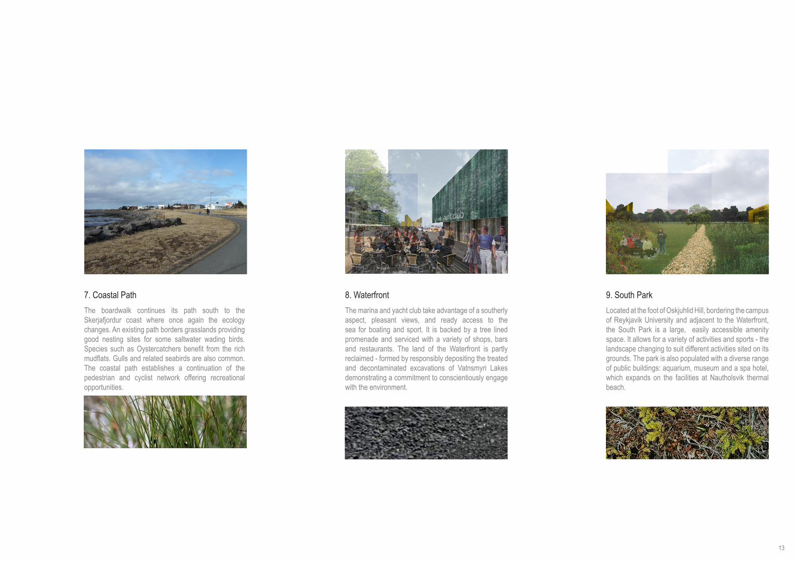
7. Coastal Path 8. Waterfront 9. South ParkThe boardwalk continues its path south to the Skerjafjordur coast where once again the ecology changes. An existing path borders grasslands providing good nesting sites for some saltwater wading birds. Species such as Oystercatchers benefit from the rich mudflats. Gulls and related seabirds are also common. The coastal path establishes a continuation of the pedestrian and cyclist network offering recreational opportunities.
The marina and yacht club take advantage of a southerly aspect, pleasant views, and ready access to the sea for boating and sport. It is backed by a tree lined promenade and serviced with a variety of shops, bars and restaurants. The land of the Waterfront is partly reclaimed - formed by responsibly depositing the treated and decontaminated excavations of Vatnsmyri Lakes demonstrating a commitment to conscientiously engage with the environment.
Located at the foot of Oskjuhlid Hill, bordering the campus of Reykjavik University and adjacent to the Waterfront, the South Park is a large, easily accessible amenity space. It allows for a variety of activities and sports - the landscape changing to suit different activities sited on its grounds. The park is also populated with a diverse range of public buildings: aquarium, museum and a spa hotel, which expands on the facilities at Nautholsvik thermal beach.
13

Sustainability
The urban plan has been designed to minimise the impacts of building on the environment. It is understood that Iceland is at the forefront of renewable energy research with the aim of becoming an energy-independent country and that great steps have already been taken towards this goal. Mindful of this the proposals for Vatnsmyri aim to take advantage of, and build upon, the continually developing infrastructure that exists in Reykjavik. Furthermore a broad range of initiatives, both urbanistic and infrastructural in nature, are integral to the framework. These initiatives are aimed at reducing the area’s resource consumption and help contribute to the provision of energy from renewable sources which, when implemented in tandem with further building-specific measures, will offer a range of environmental and economic benefits.
Make Use of Existing
Renewable energy has supplied over 70% of Iceland’s primary energy supply for almost a decade, proportionally more than any other country. This is possible largely due to geothermal energy sources that have been harnessed to almost meet the entirety of Iceland’s heating requirements. The proposals for Vatnsmyri assume heating to be principally derived from geothermal energy sources and provided as a large scale community energy system by Orkuveita Reykjavíkur. The plan includes a series of small heat generation facilities to supply local community energy to districts. These will also represent a visual symbol of the renewable energy production on site.
Abundant geothermal energy Geothermal power plant
Minimise Demand
Although Iceland is exemplary in its use of renewable energy sources, to avoid increasing the reliance on non-renewable resources to meet the inevitable increase in demand caused by expansion of the city a key strategy is the minimising of energy demand. Although this strategy will have most impact at the stage of design of individual buildings, the plan provides guidelines on floorplate depth to help ensure good levels of daylighting and the provision of natural ventilation.
Water is also treated as a valuable resource, with grey water being recycled where possible and rainwater collected for use, or attenuated through naturalistic features such as green-roofs, permeable paving and surface stores that form parts of the new landscape.
14

Contribute to Supply
The plan also offers the opportunity to contribute to the energy mix by meeting some of the demand through the provision of electricity generated by both wind turbines and energy from waste.
Energy from waste is the thermal treatment by incineration of municipal, clinical and some industrial solid waste under controlled conditions, recovering renewable energy in the form of electricity. This process, which could be undertaken at a small local plant thus limiting the distance waste is transported (and relieving the pressures on landfill sites) could provide an effective method of dealing with waste that can’t be recycled as part of the extended public waste recycling initiative.
Wide Ranging Benefits
The benefits associated with building in accordance the sustainable development strategy for Vatnsmyri, broadly speaking, fall into three categories: environmental, social, and economic.
Environmentally: the adoption of basic strategies will contribute to the landscape and may help improve the ecological diversity of the area. Socially: the occupants of the buildings will enjoy improved working or living conditions and better indoor air quality that is associated with improved public and occupant health. Economically: there are likely to be reduced operating costs as a result of using less energy and water, as well as increased productivity.
Meeting Targets
By establishing these simple basic principles as fundamental components of the urban plan for Vatnsmyri together with sustainable urban transport plans it should be possible to ensure that the new urban fabric works towards Iceland’s Ministry for the Environment’s target of achieving a 50-75% reduction of net emissions of greenhouse gases by 2050.
Furthermore, the additional established environmental, social and economic benefits of adopting these sustainable design principles should help contribute to the success of Reykjavik both nationally and internationally.
Urban Sustainability Strategy for Vatnsmyri : (left to right) Waste to Power Plant, Geothermal Energy, Household Recycling, Rainwater Harvesting & Greywater Recycling, SUDS (Sustainable Urban Drainage System) and Attenuation Lakes, Wind Power15

Diversity
Table of Floor Areas
Residences 461 300m2
Offices 360 100m2
Public / Cultural 99 950m2
Research 147 460m2
Retail / Commercial 220 900m2
Education 67 800m2
Transport 13 000m2
Total Floor Area (a) 1 370 110m2
Total Site Area within Calculation Boundary (b)
1 606 600m2
Urban Density (a/b) 0.85
Land Use Breakdown
Building Lots 701 160m2 43.6%Public / Green Space 502 860m2 31.3%Streets & Public Parking 402 580m2 25.1%
Total Site Area within Calculation Boundary 1 606 600m2 100%
Scale and Density
The urban plan is characterised by a dense and diverse urban core, defined by perimeter blocks of varying heights and of multiple uses, similar in scale to those found in Reykjavik 101. It will yield an overall density ratio of 0.85 built floor area / total land area offering a sustainable alternative to the low density suburban growth that characterises Reykjavik’s recent expansion. The urban quality of the busy centre is determined by a consistent base level of four stories for all perimeter blocks, with the opportunity to build taller. Towards the periphery of the urban plan the scale and density is modified and merges backs into the adjacent neighbourhoods.
Mixed Use
The structure of perimeter blocks within a responsive grid is zoned to accommodate the needs of individual stakeholders. It has the flexibility to react to local conditions ensuring a sustainable and prosperous urban growth.
A mixed-use development will accommodate commercial and public facilities at ground level, with offices and residential above. This diverse core will provide a focus for the Vatnsmyri community producing a busy urban environment ensuring safe and active streetscapes by generating activity throughout the day and evening.
16

Economic Flexibility
As each subsequent phase of the masterplan is implemented, the proportion of different programmes can be varied to relate to emerging local demand and economic forces. The nature of large urban blocks allows the flexibility and adaptability to respond to a changing financial and construction environment. Plot sizes within blocks can be varied and sub-divided to accommodate the needs of various stakeholders. Proceeding phases of development will make available appropriate amounts of amenity and public function space to meet the needs of the prospering area.
Distinct Communities
The initial implementation of the central landscaping elements will strongly influence the defining character of each individual district as the built form responds to the natural geology of Reykjavik and the differing ecologies nurtured by the landscape. The majority of stakeholders can build at their own pace and the independent nature of each neighbourhood allows for flexibility in the sequence of construction. Each district will begin to develop its own individual atmosphere based on scale and the prevalent typology, material responses and size of openings influenced by environment and purpose.
Social Inclusivity
The inclusive nature of the plan accommodates a dense and diverse development. The urban form of perimeter blocks allows for a comprehensive variation in tenure, catering for a broad spectrum of financial incomes through owned and rented housing. The blocks’ mixed core generates opportunities in trade and industry, from small independent businesses to large corporations. The landscape structure integrates built fabric with natural environment, embracing each neighbourhood as a resource for the whole city and creating easy access to parks and recreation areas. All inhabitants can enjoy a mix of live, work and play in the Vatnsmyri area.
17

Lighting
The effect of light in northerly latitudes such as that of Reykjavik has a profound impact on the quality of the life for inhabitants. The cycle of daylighting is extreme, with daylight throughout the night from May to August, but only 4-5 hours daylight at the winter solstice. At the same time these northerly latitudes are also witness to the natural light spectacle of the Aurora Borealis.
We propose lighting solutions which are appropriate to a city at this latitude: ensuring adequate daylighting when possible, and utilising innovative, low-energy artificial lighting techniques to create a vibrant city atmosphere.
Urban blocks are scaled to provide maximum levels of daylighting. Typically, city centre blocks are designed with 4/5 storeys, while the scale of building diminishes as the plan extends outwards.
In the mixed-use city centre, lighting is designed to provide relief during the long winter days, and to complement the Winter Lights Festival to which Reykjavik plays host. This encompasses three main strategies:
• key urban spaces, such as the lakefront and central gardens, are picked out in coloured light• key public buildings are floodlit in a complementary colour• colonnades are highlighted in a bright white light
Coloured lighting in city centre Illuminated colonnades within city centre
Buildings scaled for sunlight penetration
26 degrees sun angle : March - October
18

Phasing
Phase 1Phase 1 consists of the area of site currently outwith the boundaries of the existing domestic airport, and as such is available for development immediately. It will provide additional accommodation for the University and a new business park.
Phase 2Phase 2 will see the undertaking of preparatory work for the future phases of development. This will include the demolition of existing structures, and the decontamination of the soil and ground make-up.
Phase 3Phase 3 establishes key landscape infrastructures to provide a natural connection to the existing city centre. New building is dispersed and will include the northern commercial district and transport hub, detached housing to the west and potentially Reykjavik University.
19

Phase 4Phase 4 will see the undertaking of the major building works around the new lakes, forming a new mixed-use core to Vatnsmyri and research units associated with the University. At this stage the project develops a strong mix of uses: commercial, education, residential, leisure.
Phase 5Phase 5 wraps a further layer of accommodation around the mixed-use core. On the bottom reaches of Oskjuhlid Hill, strips of terraced housing follow the contours of the land, while to the south Reykjavik University expands along with associated research facilities.
Phase 6The final stages in the redevelopment will see the construction of a new high density residential district on the waterfront. Significant leisure and cultural facilities, as well as a potential bridge link to Kopavogur, complete the project.
20

Urban Plan
21

1
parliament building
town hall
hallgrimskirkja church
the pearl
WWII historic structures
control tower
mediatheque
culture house
transport hub & car park
convention centre
yavht club and casino hotel
museum
aquarium
high school
spa resort hotel
primary school
nordic house
primary school
Key Buildings
22

Responsive Grid
The Midtown is arranged by a responsive grid structure. In addition to the retention of key city-wide views to landmarks such as Hallgrimskirkja Church and the Pearl, the grid also traces the alignment of the two principal runways of the existing airport and connects into the existing road network.
Perimeter blocks define the street and so prioritise urban space over architectural object. To achieve an appropriately vibrant urban environment, mixed-use developments will be promoted with on-street and underground parking. Commercial space, cultural and leisure facilities will be provided at ground level, with offices and residential above. A central urban garden acts as a focus for the new developments.
In response to the harsh climatic conditions, colonnades around all central blocks provide continuous cover for pedestrians.
Materially, the Midtown area should be robust and urban; concrete, render, metals, ceramics and glass. Public buildings should be characterised by the use of high quality materials such as basalt and fine concrete.
Midtown Area
Midtown, Block Axonometric (1:2000)
Continuous colonnades provide cover
Built Fabric
23

Waterfront Living
The Waterfront neighbourhood takes advantage of the southerly aspect, pleasant views and ready access to the coastline in providing both a significant residential element and a new park with cultural amenities.
The infrastructure is formed by a continuation of the Midtown grid and terminates at a quayside with public facilities including marina, boathouse and casino hotel, as well as street level activities below the apartment buildings.
As a linking device the proposals unite the southern coastline, tying together new and existing structures through a carefully considered sequence of landscaping and public spaces.
The waterfront area should make use of robust, tactile materials to define its character; render, ceramics and timber.
Apartments with views over water to Kopavogur
Waterfront Housing, Block Axonometric (1:2000)
Waterfront District
24

Hillside Terraces
The proposals for this area respond to the natural beauty of Oskjuhlid Hill. Each street will be lined with coniferous trees, extending the natural attributes of the wooded hill into the neighbourhood below.
The street network which organises the area is an extrapolation of the Midtown grid. Traffic feeder roads give way to short cul-de-sacs, lined with low-rise terraced housing, with private gardens to the rear and off-road parking. Alternating between tree-lined pedestrian and vehicular routes, easy access to outdoor pursuits on the hill is achieved.
This terraced development will draw on the geology and ecology of Oskjuhlid to define its character, affording the neighbouhood a natural and arborous quality.
This residential neighbourhood should develop a character based on the natural tones of the adjacent landscape; brick and timber
Oskjuhlid Terraces
Oskjuhlid Terraces, Low-rise residential development
Terraced Housing, Block Axonometric (1:2000)
25

Urban Thinking
The proposals for the University of Iceland’s campus centralises facilities around the main building and a newly defined quadrangle. Additionally, an increase in building density and the rehabilitation of Sudurgata as a tree-lined boulevard unifies the east and west sides of the campus, while the new Students Union block forms a southern gateway to the university.
The new proximity of faculty buildings will encourage the sharing of knowledge across disciplines, greatly enriching the experience of learning, and create a definable sense of place.
New buildings and planting clarifies the hierarchical arrangement of public space and creates sheltered external courtyards suitable for recreation or car parking.
The University of Iceland should be defined by a character which is progressive, utilising materials which both contrast and complement the existing structures; rouighcast, quartz, glass and steel.
University of Iceland
University of Iceland, Sudurgata Street
University of Iceland, Block Axonometric (1:2000)
26

Natural Campus
Located at a prominent corner of the urban masterplan, Reykjavik University is placed to benefit from excellent links within the City’s knowledge community, and enjoys proximity to a new vibrant city district.
The campus is organised around a university square, a sheltered public space forming the hub of student and academic life. University departments are densely sited on campus with views of, and easy access to, the South Park and Oskjuhlid Hill. A new school is planned to share the campus grounds and recreational facilities.
As Reykjavik University matures, its culture of learning and education will profit greatly from a centralised and dense campus, encouraging an inter-disciplinary sharing of knowledge, and a prominent sense of identity in the new expanding city.
Reykjavik University should build on the material qualities of the proposed main building, to create a campus which is both closely linked to its natural surroundings yet also forward thinking; metals, timber and glass.
Reykjavik University
Reykjavik University, Tree-lined Avenues
Reykjavik University, Block Axonometric (1:2000)
27

Research Clusters
The Science Park is adjacent to the University of Iceland and near to the hospital, maximising mutual benefits within the Knowledge Axis.
The planned infrastructure forms excellent physical connections to 101 and the Midtown neighbourhood of Vatnsmyri, facilitating commuting and business links appropriate for the development of a hub for Iceland’s knowledge economy.
The ethos of the Science Park’s development centres on the creation of research clusters that define informal courtyards. This arrangement creates a visual permeability offering oblique views to the wider area, and also allows for the development of independent buildings which can vary in scale and respond directly to the needs of the individual occupiers.
The Science Park should be seen to be at the forefront of materials research, creating an atmosphere which is pioneering and challenging; metals, plastics, composites, fibres and glass.
Science Park
Courtyard with views to Lake and The Pearl
Science Park, Block Axonometric (1:2000)
28

Commercial Block Mixed-use Block
LOCATIONS
Residential Block University
TYPOLOGY
CAR PARKING
SUSTAINABILITYSTRATEGIES
EXTERNAL SPACECourtyards
Covered AtriaRaised Courtyards
ColonnadesRaised Courtyards
Roof TerracesQuadranglesColonnades
On Street ParkingBasement Parking
On Street ParkingBasement Parking
On Street ParkingCentral Covered Deck Parking
On Street ParkingSurface Parking
Natural ventilationMaximise daylight penetration
Heat recovery systemsGreywater recycling
Geothermally heated hot water supplyEnergy from Waste power supply
High levels of air tightnessHigh thermal mass
Natural ventilationMaximise daylight penetration
Greywater recycling Rainwater harvesting
Recycling facilitiesGeothermally heated hot water supply
Energy from Waste power supplyGreen roof technology
Natural ventilationMaximise daylight penetration
Greywater recycling Rainwater harvesting
Recycling facilitiesGeothermally heated hot water supply
Super-insulatedGreen roof technology
Maximise daylight penetrationHeat recovery systems
Greywater recycling Geothermally heated hot water supply
High levels of air tightnessModern Methods of Construction
High thermal massPermeable paving
Typologies
School
Raised CourtyardPerimeter Playgrounds
On Street ParkingSurface Parking
Natural ventilationMaximise daylight penetration
Heat recovery systemsGreywater recycling
Rainwater harvestingGeothermally heated hot water supply
Modern Methods of ConstructionPermeable paving
29

Public Building Research Unit
LOCATIONS
Terraced Housing Single Dwelling
TYPOLOGY
CAR PARKING
SUSTAINABILITYSTRATEGIES
EXTERNAL SPACEPublic Forecourts
Parks and Gardens Informal Courtyards Private Gardens Private Gardens
Heat recovery systemsGreywater recycling
Rainwater harvestingGeothermally heated hot water supply
High levels of air tightnessLocally sourced materials
Super-insulatedHigh thermal mass
Natural ventilationMaximise daylight penetration
Heat recovery systemsGreywater recycling
Rainwater harvestingGeothermally heated hot water supply
Wind turbine energy generationPermeable paving
Natural ventilationMaximise daylight penetration
Heat recovery systemsGreywater recycling Recycling facilities
Geothermally heated hot water supplyLocally sourced materials
Super-insulated
Natural ventilationMaximise daylight penetration
Heat recovery systemsGreywater recycling Recycling facilities
Geothermally heated hot water supplyLocally sourced materials
Super-insulated
On Street Parking Parking CourtyardsOff Street Parking
GaragesOff Street Parking
Garages
30

Retail
Office
Residential
Retail
Office
ResidentialCourtyard
Sections
Retail
Office
Residential
31

A New Identity for Vatnsmyri
32

Appendices
33
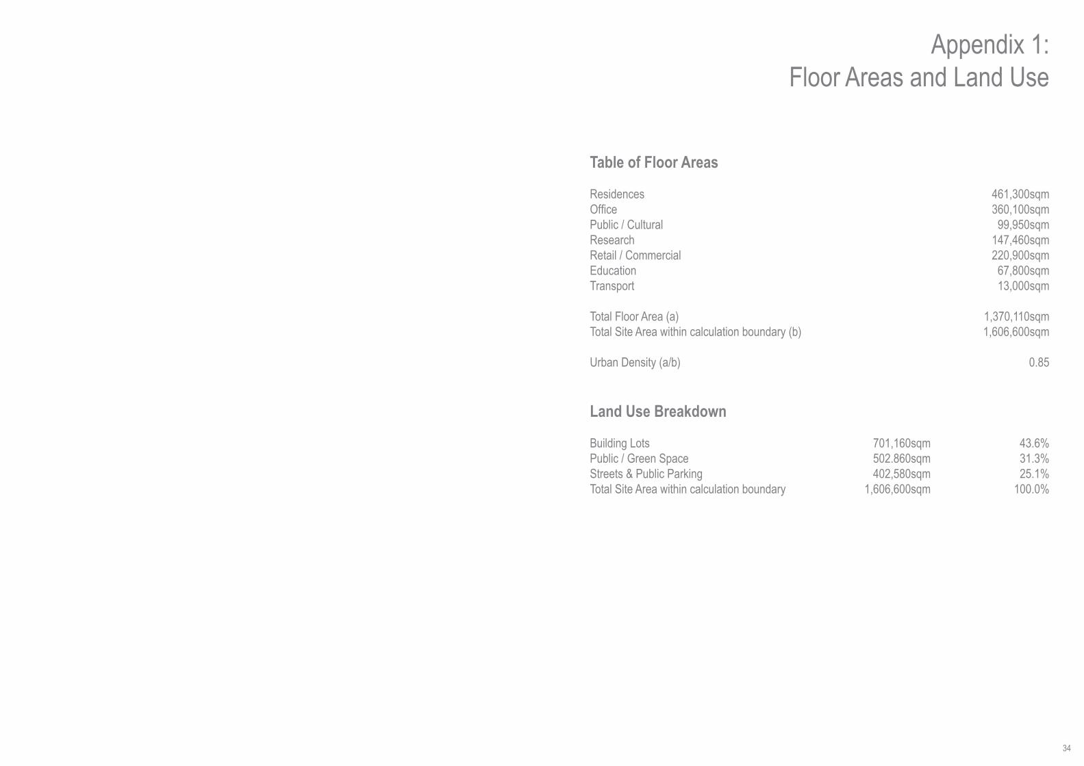
Table of Floor Areas
ResidencesOfficePublic / CulturalResearchRetail / CommercialEducationTransport Total Floor Area (a) Total Site Area within calculation boundary (b)
Urban Density (a/b)
Land Use Breakdown
Building LotsPublic / Green SpaceStreets & Public ParkingTotal Site Area within calculation boundary
Appendix 1:Floor Areas and Land Use
461,300sqm360,100sqm
99,950sqm147,460sqm220,900sqm
67,800sqm13,000sqm
1,370,110sqm1,606,600sqm
0.85
43.6%31.3%25.1%
100.0%
701,160sqm502.860sqm402,580sqm
1,606,600sqm
34

Appendix 2:Engineering Report
Sustainable Engineering Solutions
The proposed Vatnsmyri Masterplan for Reykjavik must consider engineering solutions that are sustainable. In this context sustainability will define a masterplan that offers considered design solutions that meet the needs of the present and affords social and economic growth without damaging the environment for future generations.
The regulatory context for the project is governed by Iceland’s Ministry of the Environment. The key features of the design will consider the environmental effect of development on the land, water, marine and atmosphere.
1.1 TransportandTrafficThe strategy for developing a coordinated transport masterplan for the site will focus on accessibility for all using sustainable modes of transport and will deliver services necessary for an efficient economy and a good quality of life.
It is specifically noted that noise and air pollution from aviation activities are important considerations for the quality of life near airports and the proximity of Reykjavik Airport to the city’s urban areas imposes an environmental obsta-cle on the future development of Iceland’s capital.
The role of Reykjavik Airport for aviation has diminished in importance because of the proximity of and facilities available at Keflavik Airport. Nevertheless, Reykjavik Airport still provides a function for the movement of domestic passenger and cargo in Iceland. However, these services can be re-configured at other locations so that the land at the airport can be used for other purposes. Any impact of the relocation should be evaluated against the benefits it would bring.
Relocation of aviation activities from Reykjavik Airport provides a unique opportunity to lay down a vision for the future of Iceland’s capital, ensuring Reykjavik has the space to develop for the needs of the future generations.
1.2 Floodingandsea/riverdefenceDue to the hydrological setting and the low lying nature of the site, it is essential that the proposed scheme is de-signed in such a way to minimise the risk of flooding from all sources including tidal, fluvial, overland flow, drainage systems and groundwater. The design has considered this by raising the levels of the site.
A flood risk assessment will be undertaken to confirm that the proposed development is appropriate for the degree of risk posed, and ensure that appropriate mitigation measures such as any necessary improvements to the cur-rent coastal defences, setting of suitable finished floor levels, flood storage areas, flood resilient design, appropriate drainage design and management are adopted as part of detailed design.
An allowance for climate change should be incorporated into design of the scheme, including provision for future raising of coastal defences, and an allowance for increased rainfall intensity and duration and within the drainage system.
Vatnsmyri Masterplan Reykjavik
1.3 SurfaceDrainageThe site drainage infrastructure will be designed to cope with storm intensity rainfall events. A sustainable drain-age strategy will adopt a combination of rainwater harvesting, attenuation and infiltration before discharging excess surface water to the sea via the surface water drainage system. The site is a low lying area which may be prone to flooding without suitable design considerations.
All surface water run off from industrial areas, roads and car parks will be treated before introduction to the surface water system. The lake in the centre of the site offers an opportunity to attenuate surface water while providing habitat and increasing biodiversity. All development will be encouraged to adopt rainwater harvesting.
1.4 FoulDrainageFoul drainage infrastructure for Reykjavik is operated by Orkuveita Reykjavíkur. The design considers that the pro-posed development will generate 4 million litres of waste water per day. The sewage infrastructure will be designed for adoption by Orkuveita Reykjavíkur. The objective of the design is to collect sewage and transfer it to a pump-ing and treatment station. This is likely to require collection chambers and pumped systems incorporated into the scheme.
1.5 WasteThe waste strategy will ensure that site impacts and waste can be minimized and recycling optimised within the demolition, construction and operational phases of the development. At all stages of the design process, it will be ensured that designs minimise the amount of waste produced and to minimise reliance on landfills in accordance with the waste hierarchy.
Key opportunities for waste minimisation during the demolition and construction phase include the re-use of site won demolition material i.e. soil arisings and concrete and brick, from the airport structures.
The strategy for the management of operational waste focuses on the aim to reduce current reliance on landfill for waste.
There is a limited recycling service in Reykjavik at the moment, and given the scale of the scheme, there is the op-portunity to increase the number of public collection points and potentially facilitate a kerbside collection service for recycling.
35

A key feature of the waste strategy for the site will be a high-profile re-use and recycle facility to engage directly with the public, to encourage and motivate local people, and to create a benchmark in the development of reuse, recycling and sustainability. Such a facility would accept unwanted household goods for reuse or recycling, but would also be used for educational purposes to raise awareness and promote waste minimisation techniques and showcase recycled products. It is hoped that it would assist with the national waste policies to reduce waste genera-tion and reliance on landfills, as well as providing a community facility.
Given the scale of the proposed development, there is the opportunity to incorporate a waste treatment station within the masterplan and attach an energy from waste plant alongside it. Such a scheme, could be linked to the surrounding neighbourhoods and bring wider benefits to the Reykjavik area The Reykjavik area houses approxi-mately 75,000 households and the proposed scheme is to introduce approximately a further 4,500 households. Based on our assumptions this will generate approx 80,000T of waste per year. If 50% is recycled and the remain-ing 50% can be used for energy production that gives 40,000T per year which may suit a small plant. This could generate 2.4MWh of electrical energy per year based on an efficiency of 20% with a proportion of the remainder provided as heat energy.
1.6 Water SupplyThe water supply is operated by Orkuveita Reykjavíkur. Water is generally supplied from cold water aquifers. The proposed scheme has been estimated to require 4 million litres of water per day and is presumed to use an expan-sion of the existing supply which will be agreed with Orkuveita Reykjavíkur.
1.7 EnergyIceland Ministry for the Environment are targeting a 50-75% reduction of net emissions of greenhouse gases by 2050.
The energy load required for heating and electricity for the proposed masterplan area is estimated per year. This assumes that approx 70% of energy for heating is provided by geothermal:Heating ElectricityMWh/year MWh/year145 230
1.7.1 HeatHeating is assumed to be principally derived from geothermal energy sources and provided as a large scale com-munity energy system by Orkuveita Reykjavíkur. The masterplan considers a series of small heat generation facili-ties to supply local community energy to districts. These will represent a visual symbol of the renewable energy production on site.
1.7.2 PowerOrkuveita Reykjavíkur provide electrical power to Reykjavik. This masterplan offer the opportunity to include an on-site produced energy mix comprising of wind turbines and energy from waste.
The waste management plan may allow the site to support an energy from waste incinerator. Energy from waste is the thermal treatment by incineration of municipal, clinical and some industrial solid waste under controlled condi-tions, recovering renewable energy in the form of electricity.
1.8 Ground ConditionsBased on the Geological Map of Iceland Sheet 3 and the Soil Investigation (1996) the ground conditions comprise peat over glacial moraine deposits over basalt including andesite. The excavation of basements will allow the soft peat to be removed to foundations on more competent moraine deposits. The excavated material may require lime or cement stabilisation during placement to raised ground levels.
1.9 EcologyThe site includes a wetland area in north of the masterplan site. The proposed scheme shows an expansion to this important habitat to offer the opportunity for enhanced ecological diversity.
1.10 ContaminationThe site is currently operated as the domestic airport for Reykjavik. During operation of the site there is the potential that the fuel storage tanks, refuelling areas, oil storage/maintenance areas may have contaminated shallow soils and groundwater which will need to be characterised, assessed and remediated as necessary. A watching brief and a programme of chemical testing will be implemented by an environmental engineer during demolition and construc-tion.
According to the degree of contamination, careful design will ensure protection of construction workers, further site user, ecological receptors and other environmental according to following hierarchy for managing environmental risks:
• Avoidance• Reduction• Compensation• Remediation• Enhancement• Remediation
1.11 MaterialsThe existing site levels will be relandscaped to form the proposed scheme. The masterplan will target balanced cut and fill on the site to avoid transport and disposal of material off site. This include soil stabilisation where soft ground is encountered.
There are substantial areas of hardstanding on the existing airport site which will be excavated and crushed to be reused for road sub-base and working platforms.
Selection of construction materials offers a valuable opportunity for investment in internal markets. The supply chain is understood to have shortfalls of availability which may need to be met from import of materials from abroad. The masterplan recognises this risk and aims to target wherever possible locally sourced materials that ensure sustainable supply.
36

Appendix 3:Presentation Boards
1
23
4
5
6
7
8
9
1
RECIPROCITYthe shaping of a capital city
1 020568
2 020568
3 020568
The landscape plays a vital role in the organisation and cohesion of the newly enlarged city centre. It is a unifying element linking old and new, natural and man-made. In essence it is an extension of the existing park, though as it extends, its diversity will reflect its changing context. The sensitive wetlands are retained and extended, preserving and enhancing their ecology.
A board-walk for pedestrians and cyclists extends from 101, past the new lakes to the southern waterfront. Running adjacent is a tree-lined boulevard along the route of a former runway.
At the southern waterfront the landscape responds to its coastal context through the creation of a major new park area - South Park. Within the park there is the potential to locate public amenities such as an aquarium, spa hotel and resort, and a museum. Bordering the park is the wooded slope of Oskjuhlid Hill.
This evolving and diverse landscape serves as a device to wrap, support, and structure the subsequent developments within the masterplan.
parliament building
town hall
hallgrimskirkja church
the pearl
WWII historic structures
control tower
mediatheque
culture house
transport hub & car park
convention centre
museum
yacht club and casino hotel
aquarium
high school
spa resort hotel
primary school
NaturalCampus
Located at a prominent corner of the urban masterplan, Reykjavik University is placed to benefit from excellent links within the City’s knowledge community, and enjoys proximity to a new vibrant city district.
The campus is organised around a university square, a sheltered public space forming the hub of student and academic life. University departments are densely sited on campus with views of, and easy access to, the South Park and Oskjuhlid Hill. A new school is planned to share the campus grounds and recreational facilities.
As Reykjavik University matures, its culture of learning and education will profit greatly from a centralised and dense campus, encouraging an inter-disciplinary sharing of knowledge, and a prominent sense of identity in the expanding city.
Reykjavik University should build on the material qualities of the proposed main building, to create a campus which is both closely linked to its natural surroundings yet also forward thinking; metals, timber and glass.
Reykjavik University
Reykjavik University, Tree-lined Avenues
The proposals for this area respond to the natural beauty of Oskjuhlid Hill. Each street will be lined with coniferous trees, extending the natural attributes of the wooded hill into the neighbourhood below.
The street network which organises the area is an extrapolation of the Midtown grid. Traffic feeder roads give way to short cul-de-sacs, lined with low-rise terraced housing, with private gardens to the rear and off-road parking. Alternating between tree-lined pedestrian and vehicular routes, easy access to outdoor pursuits on the hill is achieved.
This terraced development will draw on the geology and ecology of Oskjuhlid to define its character, affording the neighbourhood a natural and arborous quality.
This residential neighbourhood should develop a character based on the natural tones of the adjacent landscape; brick and timber
HillsideTerraces
Oskjuhlid Terraces
Oskjuhlid Terraces, Low-rise residential development
The proposals for the University of Iceland’s campus centralises facilities around the main building and a newly defined quadrangle. Additionally, an increase in building density and the rehabilitation of Sudurgata as a tree-lined boulevard unifies the east and west sides of the campus, while the new Students Union block forms a southern gateway to the university.
The new proximity of faculty buildings will encourage the sharing of knowledge across disciplines, greatly enriching the experience of learning, and create a defined sense of place.
New buildings and planting clarifies the hierarchical arrangement of public space and creates sheltered external courtyards suitable for recreation or car parking.
The University of Iceland should be defined by a character that is progressive, utilising materials which both contrast and complement the existing structures; roughcast, quartz, glass and steel.
UrbanThinking
University of Iceland
University of Iceland, Sudurgata Street
The Science Park is adjacent to the University of Iceland and near to the hospital, maximising mutual benefits within this Knowledge Axis.
The planned infrastructure forms excellent physical connections to 101 and the Midtown neighbourhood of Vatnsmyri, facilitating commuting and business links appropriate for the development of a hub for Iceland’s knowledge economy.
The ethos of the Science Park’s development centres on the creation of research clusters that define informal courtyards. This arrangement creates a visual permeability offering oblique views to the wider area and also allows for the development of independent buildings that can vary in scale and respond directly to the needs of the individual occupiers.
The Science Park should be seen as being at the forefront of materials research, creating an atmosphere which is pioneering and challenging; metals, plastics, composites, fibres and glass.
ResearchClusters
Science Park
Courtyard with views to lake and The Pearl
The city of Reykjavik is flourishing. A strong economy combined with the vibrancy associated with the city leads to an influx of new workers. However, the low density of current urban expansion is unsustainable - economically, socially and environmentally - while pressure to develop the heart of the city raises the prospect of dramatically changing the face of the city’s most recognisable and characterful area. Informed by the intertwined relationships of urban fabric, lake, waterfront, hill and landmark, 101 is the global face of the city; however, the redevelopment of Vatnsmyri can further enhance the reputation and identity of Reykjavik as an international destination, attractive to residents, business and tourism.
To succeed it must be based on a framework which integrates with the existing infrastructure and built fabric, is wholly sustainable, removes development pressure from 101 and enhances the global reputation of the city.
We propose a solution which draws from 101 a reciprocal relationship between urban fabric, lake, waterfront, hill and landmark, creating a new district which is at once both recognisable and distinct: urban in character but intrinsically linked to the landscape.
4 020568
5 020568
6 020568
Urban Plan
Built Fabric and Typologies Built Fabric and Typologies Built Fabric and Typologies
Strategies Strategies
Connections
Landscape and Ecology
Sustainability
Diversity
Lighting
Phasing
1. Hljomskalagardur Park and the Lake 3. Wetlands & Bird Sanctuary2. Extension to Hljomskalagardur Park 4. Vatnsmyri Lakes
6. Linear Park 7. Coastal Path 8. Waterfront 9. South Park
5. Central Gardens
Green Axis connecting old and new
Hljomskalagardur Park and the lake is an integral element of central Reykjavik and a key component of the city’s identity. The park takes a traditional form and accommodates a diversity of flora. Similarly the lake provides an important habitat for wildlife. It is from the existing park that the new landscaping strategy begins. A simple tree-lined walkway progresses southwards to adaptively embrace diverse ecologies and the built environment.
The expansion of the parkland surrounding the lake extends, retains and protects those qualities that make Hljomskalagardur Park distinctive and important to the city of Reykjavik as an ecologically secure natural environment. The extension of the park builds on the character of the existing park and accommodates space for recreational outdoor pursuits, while similarly extending natural habitats.
The double lakes of Vatnsmyri are a lively social space. Here the landscaping expands to accommodate a large open waterscape for recreation, bordered by the continuation of the wide boardwalk. The double lakes also form part of a Sustainable Urban Drainage Strategy for the Vatnsmyri area, performing a role as attenuation pools for water run-off, reducing risk of flooding. The lakes will attract birdlife and further expand and enhance the ecological variety of the area.
The Central Gardens are formed by the omission of a single block from the urban grid system, and will provide a valuable amenity space in the centre of the new district. The gardens are planted with native tree species such as Birch, Willow and Rowan, along with similarly native flower, shrub and heather species, endowing the space with a strong local quality. The cultivated gardens will provide a strong contrast with the natural qualities of Oskjuhlid Hill which is visible from within the space.
A large open space evocative of the Icelandic landscape will work with composite and varied landscaping to mediate between the larger urban blocks of Vatnsmyri and the low-rise single dwellings to the west. The park will sustain mosses and native grasses on tundra meadow and volcanic rockscape, and will create a vital breathing space for a diverse ecology of plants, insects, small birds and animals to thrive.
The boardwalk continues its path south to the Skerjafjordur coast where once again the ecology changes. An existing path borders grasslands providing good nesting sites for some saltwater wading birds. Species such as Oystercatchers benefit from the rich mudflats. Gulls and related seabirds are also common. The coastal path establishes a continuation of the pedestrian and cyclist network offering recreational opportunities.
The marina and yacht club take advantage of a southerly aspect, scenic views, and ready access to the sea for boating and sport. It is backed by a tree lined promenade and serviced with a variety of shops, bars and restaurants. The land of the Waterfront is partly reclaimed - formed by responsibly depositing the treated and decontaminated excavations of Vatnsmyri’s lakes, demonstrating a commitment to conscientiously engage with the environment.
Located at the foot of Oskjuhlid Hill, bordering the campus of Reykjavik University and adjacent to the Waterfront, the South Park is a large, easily accessible amenity space. It allows for a variety of activities and sports - the landscape changing to suit different activities sited on its grounds. The park is also populated with a diverse range of public buildings: aquarium, museum and a spa hotel, which expands on the facilities at Nautholsvik thermal beach.
Airport Relocation
The premise of our proposals involves the relocation of the domestic airport. Both currently studied options for its relocation can be readily integrated.
Local Alternative:The flexibility of the road network can accommodate a link between a new local airport and the city centre, with regular bus services departing from the transport hub. Keflavik:A high-speed rail link can connect the existing international airport at Keflavik to the centrally located transport interchange at Vatnsmyri.
Connections to Neighbouring Districts
The central location of Vatnsmyri within Reykjavik is a positive attribute; however for the redevelopment of the area to succeed it must be fully connected and integrated with the surrounding areas. As well as infrastructural connections, social and cultural links must also be established.
Perhaps most importantly the proposals for Vatnsmyri must successfully integrate with, and complement, the existing heart of the city - 101. In forming a dialogue with 101 a new city identity can be developed based on the duality of old and new.
The effect of light in northerly latitudes such as that of Reykjavik has a profound impact on the quality of the life for inhabitants. The cycle of daylighting is extreme, with daylight throughout the night from May to August, but only 4-5 hours daylight at the winter solstice. At the same time these northerly latitudes are also witness to the natural light spectacle of the Aurora Borealis.
We propose lighting solutions which are appropriate to a city at this latitude: ensuring adequate daylighting when possible, and utilising innovative, low-energy artificial lighting techniques to create a vibrant city atmosphere.
Aurora BorealisColoured lighting in city centre Illuminated colonnades within city centre
Urban blocks are scaled to provide maximum levels of daylighting. Typically, city centre blocks are designed with 4/5 storeys, while the scale of building diminishes as the plan extends outwards.
In the mixed-use city centre, lighting is designed to provide relief during the long winter days, and to complement the Winter Lights Festival to which Reykjavik plays host. This encompasses three main strategies:• key urban spaces, such as the lakefront and central gardens, are picked out in coloured light• key public buildings are floodlit in a complementary colour• colonnades are highlighted in a bright white light
Visual Links
Integral to the proposal is the retention of views to existing landmarks, such as The Pearl on Oskjuhlid Hill, Hallgrimskirkja Church, and to City Hall and the administrative heart of Reykjavik.
The particular spatial qualities of the Urban Plan frames distant and local views to these landmarks, and as such facilitates easy orientation within the new district.
In retaining and framing such views the project knits itself into the fabric and atmosphere of Reykjavik.
Road Network
The main elements of infrastructure align with the existing runways and connect into the present principal road network. The new transport hub is located centrally with good connections to this principal network. New Hringbraut is tunnelled under the central park, establishing free movement from 101 to Vatnsmyri.
The secondary street network organises the new development into a central grid formation and at the edges connects back into the existing street layout. The streets are scaled to retain a balance between vehicles and pedestrians.
Public Transport
The transport hub forms the focus of an extended public transport network, principally utilising buses. The centrally located hub includes a terminus building and refuelling depot for hydrogen buses. The permeable nature of the road system allows for easy integration of public transport, however a loop route connecting Vatnsmyri with other key areas is essential.
Potentially, a high-speed rail link directly connecting the centre with Keflavik Airport can be accommodated under the transport hub and can connect to the terminus building.
Cycle Lanes
Clear systems of dedicated cycleways are proposed, linking Vatnsmyri with neighbouring areas, therefore encouraging both a healthier and more environmentally friendly lifestyle. The landscaping strategy allows a car-free, safe environment for cyclists stretching from 101 to the south coast.
Principal vehicular routes will also be designed to accommodate necessary dedicated cycleways providing safe routes into and through the more urban areas.
Pedestrian Links
The landscaping strategy embraces pedestrian movement in and around Vatnsmyri, as well as connecting back to 101, and encourages walking and outdoor recreation as part of a healthy lifestyle.
Within the more urban context, broad and expansive pavements provide a safe environment for pedestrians, while colonnaded arcades provide shelter from the weather.
Neighbourhood Integration
Although the central grid is dense and urban, towards the western periphery in particular, the system adapts and merges back into the fabric of the existing city, accommodating a mix of typologies in response to adjacent and anticipated uses. The inclusive nature of the plan readily accommodates diverse development, with neighbourhoods of distinct character.
Landscape, in the form of parks and lakes, is used as a mediating device, ensuring that conflicting building scales and uses are adequately separated.
Downy Birch Rowan Dwarf Willow
Moss Grasses
Ducks Swans
Volcanic Gravel Juniper
WaterfrontLiving
The Waterfront neighbourhood takes advantage of the southerly aspect, scenic views and ready access to the coastline in providing both a significant residential element and a new park with cultural amenities.
The infrastructure is formed by a continuation of the Midtown grid and terminates at a quayside with public facilities including marina, boathouse and casino hotel, as well as street level activities below the apartment buildings.
As a linking device, the proposals unite the southern coastline, tying together new and existing structures through a carefully considered sequence of landscaping and public spaces.
The waterfront area should make use of robust, tactile materials to define its character; render, ceramics and timber.
Apartments with views over water to Kopavogur
Waterfront Housing, Block Axonometric (1:2000)Waterfront District
ResponsiveGrid
The Midtown is arranged as a responsive grid structure. In addition to the retention of key city-wide views to landmarks such as Hallgrimskirkja Church and the Pearl, the grid also traces the alignment of the two principal runways of the existing airport and connects into the existing road network.
Perimeter blocks define the street and so prioritise urban space over architectural object. To achieve an appropriately vibrant urban environment, mixed-use developments will be promoted with on-street and underground parking. Commercial space, cultural and leisure facilities will be provided at ground level, with offices and residential above. A central urban garden acts as a focus for the new developments.
In response to the harsh climatic conditions, colonnades around all central blocks provide continuous cover for pedestrians.
Materially, the Midtown area should be robust and urban; concrete, render, metals, ceramics and glass. Public buildings should be characterised by the use of high quality materials such as basalt and fine concrete.
Midtown Area Midtown, Block Axonometric (1:2000)
Phase 1Phase 1 consists of the area of site currently outside the boundaries of the existing domestic airport, and as such is available for development immediately. It will provide additional accommodation for the University and a new business park.
Phase 2Phase 2 will see the undertaking of preparatory work for the future phases of development. This will include the demolition of existing structures, and the decontamination of the soil and ground make-up.
Phase 3Phase 3 establishes key landscape infrastructures to provide a natural connection to the existing city centre. New building is dispersed and will include the northern commercial district and transport hub, detached housing to the west and potentially Reykjavik University.
Phase 4Phase 4 will see the undertaking of the major building works around the new lakes, forming a new mixed-use core to Vatnsmyri and research units associated with the University. At this stage the project develops a strong mix of uses: commercial, education, residential, leisure.
Phase 5Phase 5 wraps a further layer of accommodation around the mixed-use core. On the bottom reaches of Oskjuhlid Hill, strips of terraced housing follow the contours of the land, while to the south Reykjavik University expands along with associated research facilities.
Phase 6The final stages in the redevelopment will see the construction of a new high density residential district on the waterfront. Significant leisure and cultural facilities, as well as a potential bridge link to Kopavogur, complete the project.
nordic house
primary school
Reykjavik 101
Vatnsmyri
Buildings scaled for sunlight penetration
26 degrees sun angle : March - October
Continuous colonnades provide cover
Terraced Housing, Block Axonometric (1:2000) University of Iceland, Block Axonometric (1:2000) Reykjavik University, Block Axonometric (1:2000) Science Park, Block Axonometric (1:2000)
Commercial Block Mixed-Use Block Residential Block University School Public Building Research Unit Terraced Housing Single Dwellings
TYPOLOGY
CAR PARKING
SUSTAINABILITYSTRATEGIES
LOCATIONS
EXTERNAL SPACECourtyards
Covered AtriaRaised Courtyards
ColonnadesRaised Courtyards
Roof TerracesQuadranglesColonnades
Raised CourtyardPerimeter Playgrounds
Public ForecourtsParks and Gardens Informal Courtyards Private Gardens Private Gardens
On Street ParkingBasement Parking
On Street ParkingBasement Parking
On Street ParkingCentral Covered Deck Parking
On Street ParkingSurface Parking
On Street ParkingSurface Parking On Street Parking Parking Courtyards
Off Street ParkingGarages
Off Street ParkingGarages
Natural ventilationMaximise daylight penetration
Heat recovery systemsGreywater recycling
Geothermally heated hot water supplyEnergy from Waste power supply
High levels of air tightnessHigh thermal mass
Natural ventilationMaximise daylight penetration
Greywater recycling Rainwater harvesting
Recycling facilitiesGeothermally heated hot water supply
Energy from Waste power supplyGreen roof technology
Natural ventilationMaximise daylight penetration
Greywater recycling Rainwater harvesting
Recycling facilitiesGeothermally heated hot water supply
Super-insulatedGreen roof technology
Maximise daylight penetrationHeat recovery systems
Greywater recycling Geothermally heated hot water supply
High levels of air tightnessModern Methods of Construction
High thermal massPermeable paving
Natural ventilationMaximise daylight penetration
Heat recovery systemsGreywater recycling
Rainwater harvestingGeothermally heated hot water supply
Modern Methods of ConstructionPermeable paving
Heat recovery systemsGreywater recycling
Rainwater harvestingGeothermally heated hot water supply
High levels of air tightnessLocally sourced materials
Super-insulatedHigh thermal mass
Natural ventilationMaximise daylight penetration
Heat recovery systemsGreywater recycling
Rainwater harvestingGeothermally heated hot water supply
Wind turbine energy generationPermeable paving
Natural ventilationMaximise daylight penetration
Heat recovery systemsGreywater recycling Recycling facilities
Geothermally heated hot water supplyLocally sourced materials
Super-insulated
Natural ventilationMaximise daylight penetration
Heat recovery systemsGreywater recycling Recycling facilities
Geothermally heated hot water supplyLocally sourced materials
Super-insulated
Transport
Knowledge Axis
The proposed knowledge axis between the University of Iceland, the Science Park and the Hospital is formed around a landscape setting. Good pedestrian and public transport routes facilitate the links between these nodes.
An offshoot of this principal axis is further extended to link through the transport hub and convention centre to Reykjavik University.
Tracing History
Although the project anticipates the relocation of the existing domestic airport, a number of structures will be retained as a connection with the history of the site.
The WWII structures on the south coast will be retained and refurbished, while similarly the original Airport Control Tower will be retained as an artifact in a new central garden, and could be rehabilitated for public use as a cafe. The alignment of the existing runways are replicated in the street network, determining both the main grid system and the principal diagonal connection between Vatnsmyri and 101.
This important and fragile ecosystem is extended and protected, easing habitat pressure on migratory bird species such as the Pinkfooted and Greylag geese and the Common Scoter duck. It encourages the growth of wetland flora, rare lichens, mosses and vascular plants. The connecting boardwalk creates a responsible access to such a rich bio-diversity, allowing appreciation and study. Here the atmosphere is quiet and tranquil, a place of retreat for nature and the population of Reykjavik.
Integrated Traffic Management
For the new proposals to be successful movement through, in and around Vatnsmyri must be diverse in nature, accommodating car, bus, cycle or foot. Safe, legible, and easily navigable routes must accommodate opportunities to pursue each form of movement.
To achieve this an integrated approach is essential which views all means of transport as equal, and in doing so does not prioritise the car.
Car Parking
The car parking strategy is diverse in the nature of its provision, but in all cases is based on the premise that parking should be locally provided within each development block ensuring easy access is maintained throughout the site. This is particularly important during periods of inclement weather.
In the central area, on-street parking is complemented by basement parking within the urban blocks, while the transport hub contains five levels of raised parking above a bus station. Further out from the centre the need for basement parking diminishes.
The urban plan has been designed to minimise the impacts of building on the environment. It is understood that Iceland is at the forefront of renewable energy research with the aim of becoming an energy-independent country and that great steps have already been taken towards this goal. Mindful of this the proposals for Vatnsmyri aim to take advantage of, and build upon, the continually developing infrastructure that exists in Reykjavik. Furthermore a broad range of initiatives, both urbanistic and infrastructural in nature, are integral to the framework. These initiatives are aimed at reducing the area’s resource consumption and help contribute to the provision of energy from renewable sources which, when implemented in tandem with further building-specific measures, will offer a range of environmental and economic benefits.
Contribute to Supply
The plan also offers the opportunity to contribute to the energy mix by meeting some of the demand through the provision of electricity generated by both wind turbines and energy from waste.
Energy from waste is the thermal treatment by incineration of municipal, clinical and some industrial solid waste under controlled conditions, recovering renewable energy in the form of electricity. This process, which could be undertaken at a small local plant thus limiting the distance waste is transported (and relieving the pressures on landfill sites), could provide an effective method of dealing with waste that can’t be recycled as part of the extended public waste recycling initiative.
Make Use of Existing
Renewable energy has supplied over 70% of Iceland’s primary energy supply for almost a decade; proportionally more than any other country. This is possible largely due to geothermal energy sources that have been harnessed to almost meet the entirety of Iceland’s heating requirements. The proposals for Vatnsmyri assume heating to be principally derived from geothermal energy sources and provided as a large scale community energy system by Orkuveita Reykjavíkur. The plan includes a series of small heat generation facilities to supply local community energy to districts. These will also represent a visual symbol of the renewable energy production on site.
Minimise Demand
Although Iceland is exemplary in its use of renewable energy sources, to avoid increasing the reliance on non-renewable resources to meet the inevitable increase in demand caused by expansion of the city a key strategy is the minimising of energy demand. Although this strategy will have most impact at the stage of design of individual buildings, the urban plan provides guidelines on floorplate depth to help ensure good levels of daylighting and the provision of natural ventilation.
Water is also treated as a valuable resource, with grey water being recycled where possible and rainwater collected for use, or attenuated through naturalistic features such as green-roofs, permeable paving and surface stores that form parts of the new landscape.
Wide Ranging Benefits
The benefits associated with building in accordance with the sustainable development strategy for Vatnsmyri, broadly speaking, fall into three categories: environmental, social, and economic.
Environmentally: the adoption of basic strategies will contribute to the landscape and may help improve the ecological diversity of the area. Socially: the occupants of the buildings will enjoy improved working or living conditions and better indoor air quality that is associated with improved public and occupant health. Economically: there are likely to be reduced operating costs as a result of using less energy and water, as well as increased productivity.
Meeting Targets
By establishing these simple basic principles as fundamental components of the urban plan for Vatnsmyri together with sustainable urban transport plans it should be possible to ensure that the new urban fabric works towards Iceland’s Ministry for the Environment’s target of achieving a 50-75% reduction of net emissions of greenhouse gases by 2050.
Furthermore, the additional established environmental, social and economic benefits of adopting these sustainable design principles should help contribute to the success of Reykjavik both nationally and internationally.
Scale and Density
The urban plan is characterised by a dense and diverse urban core, defined by perimeter blocks of varying heights and of multiple uses, similar in scale to those found in Reykjavik 101. It will yield an overall density ratio of 0.85 built floor area / total land area offering a sustainable alternative to the low density suburban growth that characterises Reykjavik’s recent expansion. The urban quality of the busy centre is determined by a consistent base level of four stories for all perimeter blocks, with the opportunity to build taller. Towards the periphery of the urban plan the scale and density is modified and merges backs into the adjacent neighbourhoods.
Mixed Use
The structure of perimeter blocks within a responsive grid is zoned to accommodate the needs of individual stakeholders. It has the flexibility to react to local conditions ensuring a sustainable and prosperous urban growth.
A mixed-use development will accommodate commercial and public facilities at ground level, with offices and residential above. This diverse core will provide a focus for the Vatnsmyri community producing a busy urban environment ensuring safe and active streetscapes by generating activity throughout the day and evening.
Social Inclusivity
The inclusive nature of the plan accommodates a dense and diverse development. The urban form of perimeter blocks allows for a comprehensive variation in tenure, catering for a broad spectrum of financial incomes through owned and rented housing. The blocks’ mixed core generates opportunities in trade and industry, from small independent businesses to large corporations. The landscape structure integrates built fabric with natural environment, embracing each neighbourhood as a resource for the whole city and creating easy access to parks and recreation areas. All inhabitants can enjoy a mix of live, work and play in the Vatnsmyri area.
Distinct Communities
The initial implementation of the central landscaping elements will strongly influence the defining character of each individual district as the built form responds to the natural geology of Reykjavik and the differing ecologies nurtured by the landscape. The majority of stakeholders can build at their own pace and the independent nature of each neighbourhood allows for flexibility in the sequence of construction. Each district will begin to develop its own individual atmosphere based on scale and the prevalent typology, material responses and size of openings influenced by environment and purpose.
Economic Flexibility
As each subsequent phase of the masterplan is implemented, the proportion of different programmes can be varied to relate to emerging local demand and economic forces. The nature of large urban blocks allows the flexibility and adaptability to respond to a changing financial and construction environment. Plot sizes within blocks can be varied and sub-divided to accommodate the needs of various stakeholders. Proceeding phases of development will make available appropriate amounts of amenity and public function space to meet the needs of the prospering area.
Abundant geothermal energy Geothermal power plant Urban Sustainability Strategy for Vatnsmyri : (left to right) Waste to Power Plant, Geothermal Energy, Household Recycling, Rainwater Harvesting & Greywater Recycling, SUDS (Sustainable Urban Drainage System) and Attenuation Lakes, Wind Power
Commercial Commercial Commercial Transport Interchange Mixed-Use Mixed-Use Mixed-Use Central Gardens Mixed-Use Mixed-Use Mixed-Use Mixed-Use Mixed-Use Research Research Residential Residential Residential Residential Leisure
North - South Sections (1:1500 below, 1:500 above)
Office Atrium Office Courtyard Office
Transport Concourse Office
Bus Depot Retail
Office
Retail
Office
Residential
Retail
Office
Residential
Retail
Office
Residential
Retail
Office
Residential
Retail
Office
Residential
Retail
Office
Residential
Retail
Office
ResidentialCourtyard Courtyard Courtyard Courtyard
Table of Floor Areas
Residences 461 300m2
Offices 360 100m2
Public / Cultural 99 950m2
Research 147 460m2
Retail / Commercial 220 900m2
Education 67 800m2
Transport 13 000m2
Total Floor Area (a) 1 370 110m2
Total Site Area within Calculation Boundary (b)
1 606 600m2
Urban Density (a/b) 0.85
Land Use Breakdown
Building Lots 701 160m2 43.6%Public / Green Space 502 860m2 31.3%Streets & Public Parking 402 580m2 25.1%
Total Site Area within Calculation Boundary 1 606 600m2 100%
37
