martin luther king jr. boulevard/hammondville road
TRANSCRIPT


E750 0 750375
Feet
SW 3 STREET
MAP 2BROWARD COUNTY
TRAFFICWAYS PLAN AMENDMENTMARTIN LUTHER KING JR. BOULEVARD/HAMMONDVILLE ROAD
AERIAL PHOTOGRAPHPCTW 12-1
§̈¦95
MARTIN LUTHER KING JR. BOULEVARD/HAMMONDVILLE ROAD
POMPANOBEACH
ATLANTIC BOULEVARD
NW 6 STREET§̈¦95
FEC RA
ILROA
D
DIXIE H
IGHWA
YANDREWS AVENUE
RACE TRACK ROAD
DIXIE H
IGHWA
Y
Subject of Trafficway sPlan Amendment
Date of Flight: January 2012
Single-FamilyResidental
Single-FamilyResidental Retail
Vacant
ReligiousInsttuuon Vacant
TransitStatonCommunity
Facilites
Retail
RetailWarehouses
VacantVacant
Park
Park
E750 0 750375
Feet
SW 3 STREET
MAP 3BROWARD COUNTY
TRAFFICWAYS PLAN AMENDMENTMARTIN LUTHER KING JR. BOULEVARD/HAMMONDVILLE ROAD
BROWARD COUNTY LAND USE PLANFUTURE LAND USE DESIGNATIONS
PCTW 12-1
§̈¦95
MARTIN LUTHER KING JR. BOULEVARD/HAMMONDVILLE ROAD
POMPANOBEACH
ATLANTIC BOULEVARD
NW 6 STREET§̈¦95
FEC RA
ILROA
D
DIXIE H
IGHWA
YANDREWS AVENUE
RACE TRACK ROAD
NW 2 STREET
NW 8 STREET
NW 6 AVENUE
NW 4 STREET
NW 9 AVENUE
NW 7 AVENUE
NW 8 AVENUE
NW 10 AVENUE
NW 7 TERRACE
SW 2 STREET
DIXIE H
IGHWA
YNW 12 AVENUE
Low-Medium (10)ResidentalMedium (16)ResidentalMedium-High (25)Residental
Industrial
Commercial
CommunityFacilitesLocal Actvi tyCenter
Recreaton &Open SpaceUtliies
Transportaton
Water
Subject of Trafficway sPlan AmendmentProposed "TransitOriented Corridor"


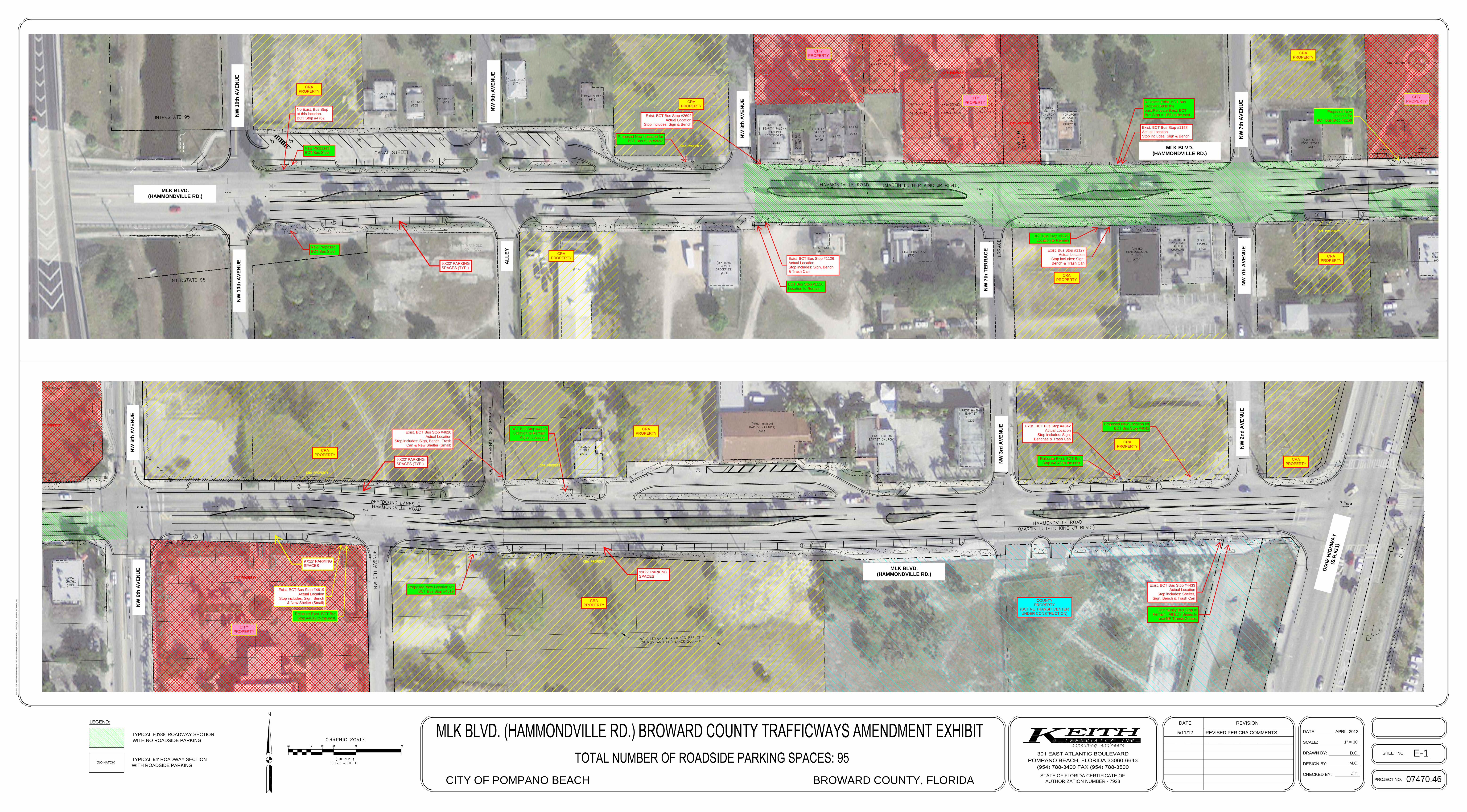
D.C.
M.C.
1" = 30'
DATE:
SCALE:
DRAWN BY:
DESIGN BY:
CHECKED BY:
J.T.
DATE
BROWARD COUNTY, FLORIDACITY OF POMPANO BEACH
APRIL 2012
REVISION
STATE OF FLORIDA CERTIFICATE OF
AUTHORIZATION NUMBER - 7928
PROJECT NO.
07470.46
SHEET NO.
E-1
N:\07'\07470.46 D
ow
ntow
n C
onnectivity P
lan - P
B C
RA
\E
ngineering\C
add\dw
g\x-m
lk-base - K
&A
W
ork (M
LK
) - R
oadside P
kg (exhibit).dw
g
LEGEND:
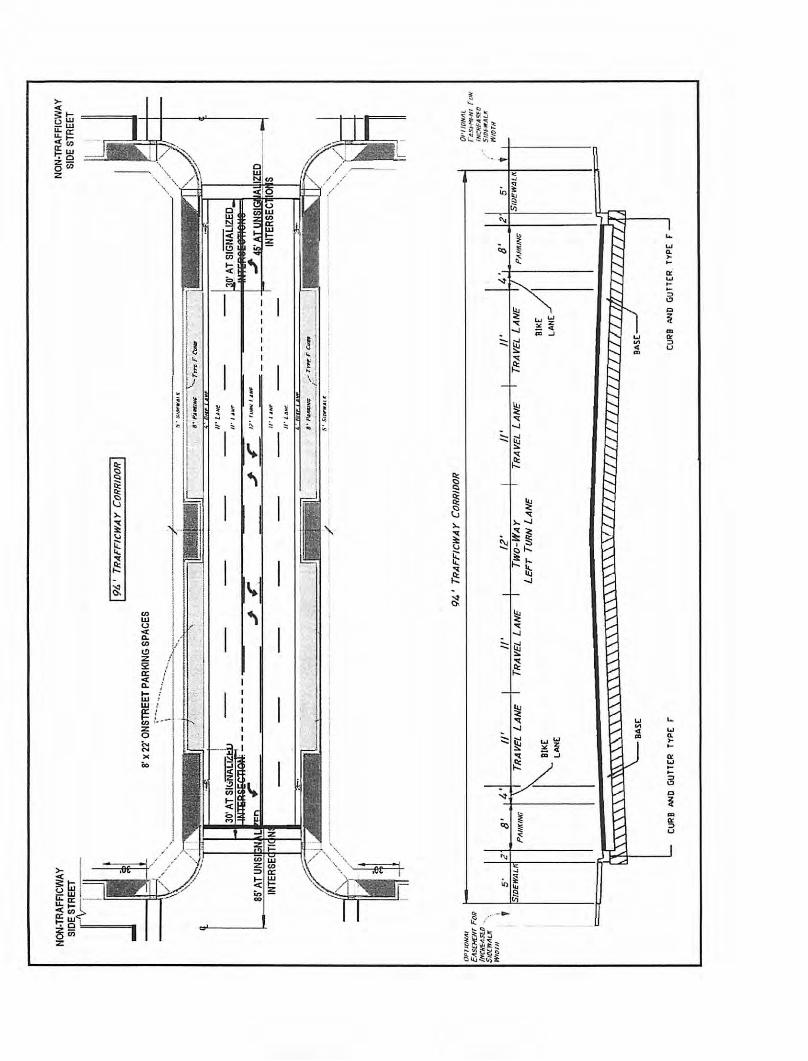
TYPICAL 80'/88' ROADWAY SECTION
WITH NO ROADSIDE PARKING
TYPICAL 94' ROADWAY SECTION
WITH ROADSIDE PARKING
(NO HATCH)
5/11/12 REVISED PER CRA COMMENTS
CRAPROPERTY
CRAPROPERTY
CRAPROPERTY
CRAPROPERTY
CRAPROPERTY
CRAPROPERTY
CITYPROPERTY
COUNTYPROPERTY
(BCT NE TRANSIT CENTERUNDER CONSTRUCTION)
CRAPROPERTY
CRAPROPERTY
CITYPROPERTY
CITYPROPERTY
CITYPROPERTY
CRAPROPERTY
CRAPROPERTY
CRAPROPERTY
9'X22' PARKINGSPACES (TYP.)
9'X22' PARKINGSPACES
9'X22' PARKINGSPACES
9'X22' PARKINGSPACES (TYP.)
Exist. BCT Bus Stop #1158Actual LocationStop includes: Sign & Bench
Exist. Bus Stop #1127Actual Location
Stop includes: Sign,Bench & Trash Can
No Exist. Bus Stopat this location. BCT Stop #4762
Exist. BCT Bus Stop #1126Actual LocationStop includes: Sign, Bench& Trash Can
Proposed New Location forBCT Bus Stop #2692
New ProposedBCT Bus Stop
New ProposedBCT Bus Stop
BCT Bus Stop #1126Location to Remain
BCT Bus Stop #1127Location to Remain
Proposed NewLocation for
BCT Bus Stop #1158
Relocate Exist. BCT BusStop #1158 to theeast.Relocate Exist. BCTBus Stop #1158 to the east.
Exist. BCT Bus Stop #4042Actual Location
Stop includes: Sign,Benches & Trash Can
Exist. BCT Bus Stop #4619Actual Location
Stop includes: Sign, Bench& New Shelter (Small)
Exist. BCT Bus Stop #4620Actual Location
Stop includes: Sign, Bench, TrashCan & New Shelter (Small)
BCT Bus Stop #4620Location to Remain.
Adjust Location.
Relocate Exist. BCT BusStop #4619 to the east.
Proposed New Location forBCT Bus Stop #4042
Exist. BCT Bus Stop #4433Actual Location
Stop includes: Shelter,Sign, Bench & Trash Can
Community Bus Stop toRemain. All BCT Buses to
use NE Transit Center.
Proposed New Location forBCT Bus Stop #4619
Relocate Exist. BCT BusStop #4042 to the east.
NW
10t
h A
VE
NU
EN
W 1
0th
AV
EN
UE AL
LE
Y
NW
9th
AV
EN
UE
NW
8th
AV
EN
UE
Exist. BCT Bus Stop #2692Actual Location
Stop includes: Sign & Bench
NW
7th
TE
RR
AC
E
NW
7th
AV
EN
UE
NW
7th
AV
EN
UE
NW
6th
AV
EN
UE
NW
6th
AV
EN
UE
NW
3rd
AV
EN
UE
NW
2n
d A
VE
NU
E
MLK BLVD.(HAMMONDVILLE RD.)
MLK BLVD.(HAMMONDVILLE RD.)
MLK BLVD.(HAMMONDVILLE RD.)
DIX
IE H
IGH
WA
Y(S
.R.8
11)
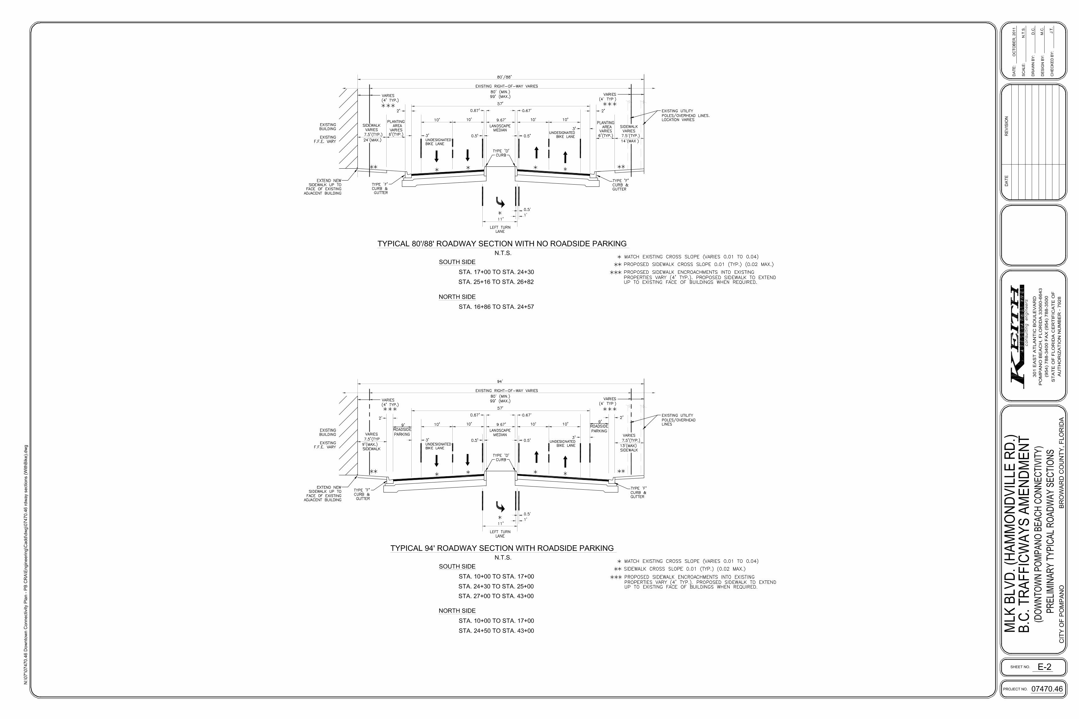

MARTIN LUTHER KING BLVD. (HAMMONDVILLE RD.) TRAFFICWAYS AMENDMENT
DESIGN CRITERIA FOR CONSTRUCTION OF STREETS
WITHIN TRAFFICWAY CORRIDORS
Trafficway Roadways
Design Factor Existing Trafficways Plan
Classification of MLK
Blvd.
4-Lane
Collector
Available “Context Sensitive
Corridor” Criteria for
Trafficway Roadways
7.
80-94 ROW (8) Urban Main
Street. OPTION B (5-Lane
undivided)
Requested / Adjusted “Specific
Context Sensitive Corridor”
Criteria for MLK Blvd.
80-94 ft. Urban Main Street (with
easements). 4-Lane Divided
Generalized
Volume (ADT)
9,600-24,300 9,600-24,300 9,600-24,300
Vehicular Access Pursuant to provisions o f
Sections 5-195(b)(11)
Pursuant to provisions of
Sections 5-195(b)(11)
Pursuant to provisions of
Sections 5-195(b)(11)
Design Speed 40 mph 25-30 mph 25-30 mph
Typical Streets
Spacing
Pursuant to provisions o f
Sections 5-195(b)(11)
Pursuant to provisions of
Sections 5-195(b)(11)
Pursuant to provisions of Sections
5-195(b)(11)
Minimum
Thru- Lane Width
11 ft 11ft 10ft
Pavement Width 48 – 56 ft.
Pavement
Markings
Thermoplastic Thermoplastic Thermoplastic
Driveway Design Street Type Street Type Street Type
On-Street Parking Prohibited Yes Yes
Median Width w/
Curb and Gutter
15.5-22 ft 11 ft (Center left turn lane) 11 ft (Center left turn lane)
Border Width 7-10 ft 8 ft >=8 ft (with sidewalk/landscape
easements)
Left Turn Lanes Yes Yes Yes
Exclusive right
turn lane
Required at
intersections &
driveways
Yes No No
Traffic Signal As Warranted As Warranted As Warranted
Pedestrian
Crossings
At intersections Only At intersections and at Mid-
block (Non-Peak) with special
treatment approved by
County
At intersections and at Mid-block
(Non-Peak) with special treatment
approved by County
Approach
Widening
(Intersection Imp.)
Yes No No
Right-of-Way As Required by the
Broward County
Trafficways Plan (80’)
80’ – 94’ 80’/88’ Typ. in segments with No
On-street Parking (w/ easements)
94’ Typ. in segments with
On-street Parking (w/ easements)
Design Vehicle SU and WB-50 SU and WB-50 SU and WB-50
Sidewalks Yes Yes (Min 11.5 ft with
easement)
Yes - 7.5 Typ. & 6’ Min. (with
easements)
Bikeways Yes 4/5 ft Yes 5 ft Yes 3 ft (undesignated)


18DRAFT 2/09/2012
W Atlantic Blvd
Dr Martin Luther King, Jr Blvd Dix
ie H
ighw
ay
W Atlantic Blvd
Flag
ler
Av
NE 1 St
SE 2 St
NE 4 St
NE 6 St
NE 8 St
NE 10 St
NW 6 Ct
NE 5 St
NW
10
Av
NW
9 A
v
NW
8 A
v
NW
7 T
err
NW
7 A
v
NW
6 A
v/B
lanc
he E
ly A
v
NE
1 A
v
Cyp
ress
Rd
NE
2 A
v
NE
3 A
v
NE
4 A
v
NE
5 A
vvvvvv
1
2
3
4
5
1/4 MILE
1/2 MILE
123
4
65
CIVIC CAMPUS
OLD POMPANO
CENTENNIAL PARK
TRANSIT VILLAGE
COLEMAN PARK
COMMERCE PARK
NEIGHBORHOOD STRUCTURE
6
NW CRA Massing and Zoning Analysis Report27
Urban Design Recommendations
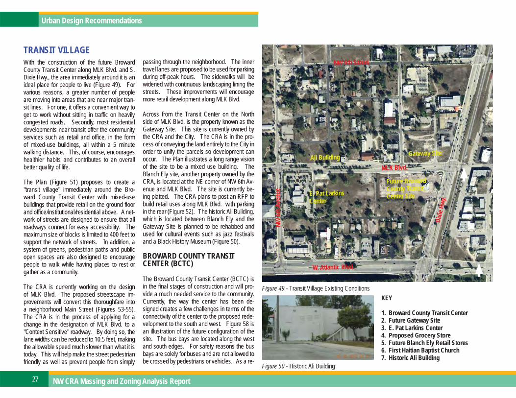
TRANSIT VILLAGEWith the construction of the future Broward County Transit Center along MLK Blvd. and S. Dixie Hwy., the area immediately around it is an ideal place for people to live (Figure 49). For various reasons, a greater number of people are moving into areas that are near major tran-sit lines. For one, it offers a convenient way to get to work without sitting in traffic on heavily congested roads. Secondly, most residential developments near transit offer the community services such as retail and office, in the form of mixed-use buildings, all within a 5 minute walking distance. This, of course, encourages healthier habits and contributes to an overall better quality of life.
The Plan (Figure 51) proposes to create a "transit village" immediately around the Bro-ward County Transit Center with mixed-use buildings that provide retail on the ground floor and office/institutional/residential above. A net-work of streets are designed to ensure that all roadways connect for easy accessibility. The maximum size of blocks is limited to 400 feet to support the network of streets. In addition, a system of greens, pedestrian paths and public open spaces are also designed to encourage people to walk while having places to rest or gather as a community.
The CRA is currently working on the design of MLK Blvd. The proposed streetscape im-provements will convert this thoroughfare into a neighborhood Main Street (Figures 53-55). The CRA is in the process of applying for a change in the designation of MLK Blvd. to a "Context Sensitive" roadway. By doing so, the lane widths can be reduced to 10.5 feet, making the allowable speed much slower than what it is today. This will help make the street pedestrian friendly as well as prevent people from simply
Figure 49 - Transit Village Existing Conditions
Figure 50 - Historic Ali Building
passing through the neighborhood. The inner travel lanes are proposed to be used for parking during off-peak hours. The sidewalks will be widened with continuous landscaping lining the streets. These improvements will encourage more retail development along MLK Blvd.
Across from the Transit Center on the North side of MLK Blvd. is the property known as the Gateway Site. This site is currently owned by the CRA and the City. The CRA is in the pro-cess of conveying the land entirely to the City in order to unify the parcels so development can occur. The Plan illustrates a long range vision of the site to be a mixed use building. The Blanch Ely site, another property owned by the CRA, is located at the NE corner of NW 6th Av-enue and MLK Blvd. The site is currently be-ing platted. The CRA plans to post an RFP to build retail uses along MLK Blvd. with parking in the rear (Figure 52). The historic Ali Building, which is located between Blanch Ely and the Gateway Site is planned to be rehabbed and used for cultural events such as jazz festivals and a Black History Museum (Figure 50).
BROWARD COUNTY TRANSIT CENTER (BCTC)
The Broward County Transit Center (BCTC) is in the final stages of construction and will pro-vide a much needed service to the community. Currently, the way the center has been de-signed creates a few challenges in terms of the connectivity of the center to the proposed rede-velopment to the south and west. Figure 58 is an illustration of the future configuration of the site. The bus bays are located along the west and south edges. For safety reasons the bus bays are solely for buses and are not allowed to be crossed by pedestrians or vehicles. As a re-
Dixie
Hwy
.
NW 6th Street
Future Broward County Transit Center Site
W. Atlantic Blvd.NW
6th A
venu
e
MLK Blvd.
Gateway SiteAli Building
E. Pat Larkins Center
KEY
1. Broward County Transit Center2. Future Gateway Site3. E. Pat Larkins Center4. Proposed Grocery Store5. Future Blanch Ely Retail Stores6. First Haitian Baptist Church7. Historic Ali Building

28DRAFT 2/09/2012
Figure 51 - Detail of proposed improvements to the Transit Village
Figure 55 - MLK Blvd. Proposed Streetscape Improvements and Ultimate BuildoutFigures 53-54 - MLK Blvd. Existing Conditions (left) & Prop. Landscape Improvements (above)
Figure 52 - View of Proposed Blanch Ely Retail Stores (rendering by Dorsky Yue Architects)
NE 6t
h Ave
nue
NE 6th Street
W. Atlantic Blvd.
Dixie
Hwy
.MLK Blvd..
1
27
3
4
56

NW CRA Massing and Zoning Analysis Report29
Urban Design Recommendations
sult, code requires the placement of a 6 foot high fence that surrounds the west and south sides of the site (Figure 57). Unfortunately, this creates an unfriendly environment for pedestrians. The visible and physical barrier discourages people from going to the retail businesses that are pro-posed to be around the transit center. The Plan proposes that a lower wall be constructed instead along the edge with lush landscaping and seating areas to soften the edge of the bus bays. In addi-tion, it proposes to construct a promenade on the development side that connects to the pedestrian cross points on MLK Blvd. and S. Dixie Hwy. The proposed mixed use buildings will front the transit center along all edges to encourage people to ac-cess the surrounding businesses while they wait for the bus (Figure 59). The Plan also proposes to reconfigure the patron parking lot within the site in order to create space for future retail build-ings on site and additional parking. Currently, the building houses only the ticketing facility. It would be advantageous to create opportunities for smaller convenient type retail stores such as flower shops, newspaper and magazine shops as well as a cafe. The revenue generated from the lease of the spaces can be utilized to maintain the facility and its grounds.
E. PAT LARKINS COMMUNITY CENTER
The design team analyzed ways to address the intersection of NW 6th Avenue and MLK Blvd. with respect to the E. Pat Larkins Center (Figure 56). Currently, the community center sits far away from MLK Blvd. The area in front of the building is currently all parking with the exception of the monument attributed to the memory of Mr. Lar-kins. The design team felt it was appropriate to reconfigure this site in order to create a significant entrance for this building. The Plan proposes to relocate the parking to the rear and east side of the building in order to free up the space along
Blanch Ely and MLK Blvd. for a proper civic plaza. This plaza is a perfect place for public art.
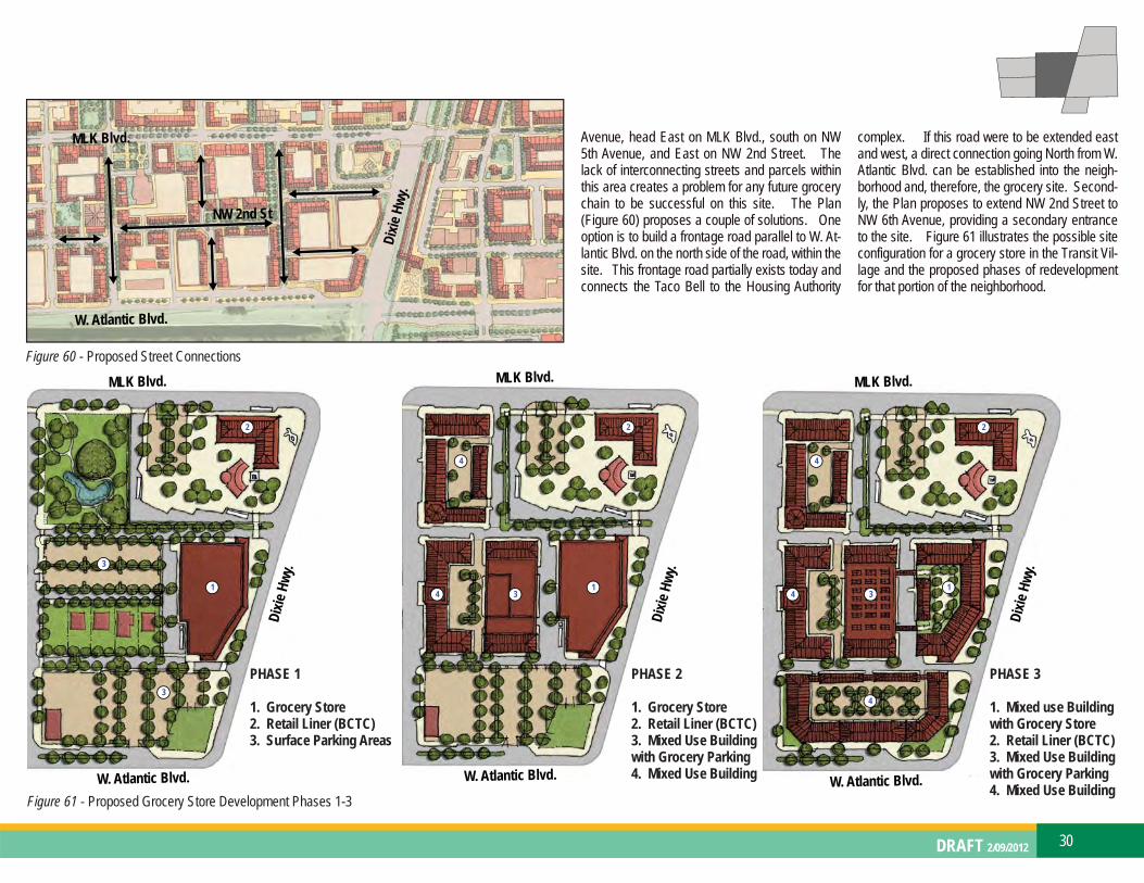
PROPOSED GROCERY STORE
The west side of the future DPTOC District would greatly benefit from a larger scale grocery store. The design team analyzed various locations with-in this area to determine the best site. The area with the best visibility from both W. Atlantic Blvd. and S. Dixie Hwy. as well as the most vacant land available is the future transit village. The Plan proposes a 30,000 sf grocery store along S. Dixie Hwy. While this site is ideal because of its vis-ibility from the main thoroughfares, it has a few constraints posing challenges with accessibility to the site. Currently, the only way to enter the site from W. Atlantic Blvd. is to turn onto NW 6th
Figure 57 - Existing Fence Figure 59 - View of proposed Improvements to the Broward County Transit Center and Transit Village
Figure 58 - Existing Site Configuration of Broward County Transit Center
Figure 56 - E. Pat Larkins Community Center
MLK Blvd.
Dixie
Hwy
.
30DRAFT 2/09/2012
Figure 60 - Proposed Street Connections
Avenue, head East on MLK Blvd., south on NW 5th Avenue, and East on NW 2nd Street. The lack of interconnecting streets and parcels within this area creates a problem for any future grocery chain to be successful on this site. The Plan (Figure 60) proposes a couple of solutions. One option is to build a frontage road parallel to W. At-lantic Blvd. on the north side of the road, within the site. This frontage road partially exists today and connects the Taco Bell to the Housing Authority
complex. If this road were to be extended east and west, a direct connection going North from W. Atlantic Blvd. can be established into the neigh-borhood and, therefore, the grocery site. Second-ly, the Plan proposes to extend NW 2nd Street to NW 6th Avenue, providing a secondary entrance to the site. Figure 61 illustrates the possible site configuration for a grocery store in the Transit Vil-lage and the proposed phases of redevelopment for that portion of the neighborhood.
Figure 61 - Proposed Grocery Store Development Phases 1-3
1
2
3
4
3
1
2
3
4
41
2
3
4
4
PHASE 1
1. Grocery Store2. Retail Liner (BCTC)3. Surface Parking Areas
PHASE 2
1. Grocery Store2. Retail Liner (BCTC)3. Mixed Use Buildingwith Grocery Parking 4. Mixed Use Building
PHASE 3
1. Mixed use Buildingwith Grocery Store2. Retail Liner (BCTC)3. Mixed Use Buildingwith Grocery Parking 4. Mixed Use Building
MLK Blvd.
Dixie
Hwy
.
W. Atlantic Blvd.
NW 2nd St
MLK Blvd.
Dixie
Hwy
.
W. Atlantic Blvd.
MLK Blvd.
Dixie
Hwy
.
W. Atlantic Blvd.
MLK Blvd.
Dixie
Hwy
.
W. Atlantic Blvd.