marin conservation league walk into (conservation) …€¦ · · 2016-01-26marin conservation...
TRANSCRIPT

175 N. Redwood Dr., Ste. 135, San Rafael, CA 94903 415.485.6257 marinconservationleague.org
David Marks/Flickr
Protecting Marin Since 1934
Marin Conservation League was founded in 1934 to preserve, protect and enhance the natural assets of Marin County.
Walk LeadersDavid Herlocker Naturalist, Marin County Parks Jean Berensmeier Co-founder, San Geronimo Valley Planning Group Former President, Marin Conservation LeagueNona Dennis Director, Marin Conservation League
Marin Conservation League Walk Into (Conservation) History # 18
ROY’S REDWOODSSunday, August 9, 2015
2
Today’s Walk
600
400
400
400
MO N T E Z U M A
SAN GERONIMO
No Access
TrailTRAIL
SPIRITROCKTRAIL
LOOP
TRAI
L
RIDGE TRAIL
ROY’S
TA M A R A C KR A I L R O A D AV E .
RoadsideParking
Stables
G o l fC o u r s e
No Access
San Geronimo ValleyCommunity Center
THORNER
SCHOOL TRAIL
BARNABE MOUNTAIN FIRE
PLEASE RESPECTPRIVATE PROPERTY
PLEASE RESPECTPRIVATE PROPERTY
ROAD
MEADOW TRAIL
REDWOODS
ROY’S REDWOODS LOOP TRAIL
DAVI
D HA
NSE
N TRAIL
DIX
ON
RI DGE
MO O N HIL
L
SYLV
ES TR I S
S I R F R A N C I S D R A K E B LV D .
S A N G E R O N I M O VA L L E Y D R.
M E A D O W WAY
LAG
UN
I TAS
SCHO OL RD .
WIL
D I
RI S
R
D.
N I C A S I O VA L LE Y R D .
to FairfaxWeekendParking
LagunitasSchoolto Lagunitas,
Samuel P. TaylorState Park,and Olema
to Nicasio
G o l f C o u r s e
W E S T N I C A S I O R D .
TOP F
LIGHT TRAIL
FRENCH RANCH FIRE ROAD
P
FIRE R
O AD
Private bridge(hikers allowed;no equestrians)
BARNABEMOUNTAINFIRE ROAD
Gary GiacominiOpen Space Preserve
French RanchOpen SpacePreserve
Roy’s RedwoodsOpen Space Preserve
Maurice ThornerMemorial OpenSpace Preserve
0 1.0Mile
1.00 KilometerContour Interval 80 Feet
marincountyparks.org
County Trail Easements
County Multiuse Pathways
Regional Trails
Major Road
Local RoadParking Lot
West Marin Stage
Gate
School
P
P
T
T
T
T
FRENCH RANCH, ROY’S REDWOODS,AND MAURICE THORNER MEMORIALOPEN SPACE PRESERVES
Adjacent Open Space PreserveOther Public Land
Featured Open Space PreserveCounty Parks
Multiuse Fire Road(Hikers, Bicyclists & Equestrians)
Multiuse Trail(Hikers, Bicyclists & Equestrians)
Trail (Hikers & Equestrians)
Hiking-only Trail
Bike Path
Pea
se P
ress
Car
togr
aphy
11/3
0/20
14
FOREST KNOLLS
WOODACREForestKnolls
Park
COUNTY OF MARIN
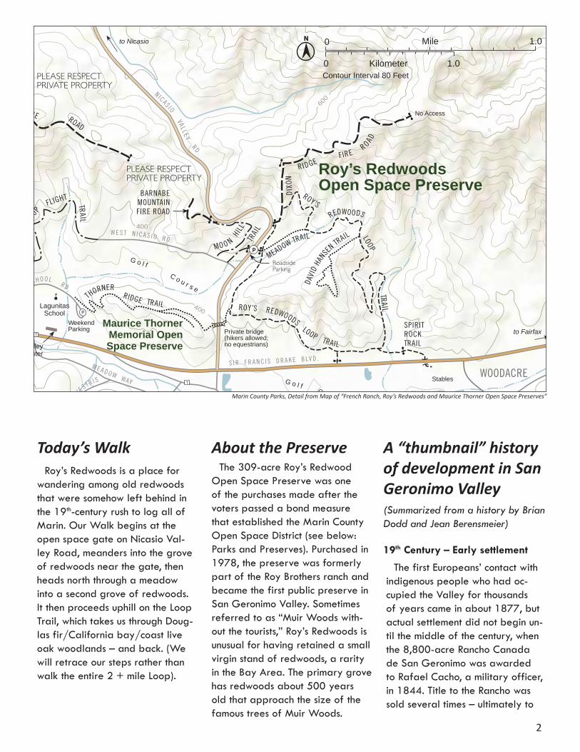
Roy’s Redwoods is a place for wandering among old redwoods that were somehow left behind in the 19th-century rush to log all of Marin. Our Walk begins at the open space gate on Nicasio Val-ley Road, meanders into the grove of redwoods near the gate, then heads north through a meadow into a second grove of redwoods. It then proceeds uphill on the Loop Trail, which takes us through Doug-las fir/California bay/coast live oak woodlands – and back. (We will retrace our steps rather than walk the entire 2 + mile Loop).
About the PreserveThe 309-acre Roy’s Redwood
Open Space Preserve was one of the purchases made after the voters passed a bond measure that established the Marin County Open Space District (see below: Parks and Preserves). Purchased in 1978, the preserve was formerly part of the Roy Brothers ranch and became the first public preserve in San Geronimo Valley. Sometimes referred to as “Muir Woods with-out the tourists,” Roy’s Redwoods is unusual for having retained a small virgin stand of redwoods, a rarity in the Bay Area. The primary grove has redwoods about 500 years old that approach the size of the famous trees of Muir Woods.
A “thumbnail” history of development in San Geronimo Valley (Summarized from a history by Brian Dodd and Jean Berensmeier)
19th Century – Early settlement
The first Europeans’ contact with indigenous people who had oc-cupied the Valley for thousands of years came in about 1877, but actual settlement did not begin un-til the middle of the century, when the 8,800-acre Rancho Canada de San Geronimo was awarded to Rafael Cacho, a military officer, in 1844. Title to the Rancho was sold several times – ultimately to
Marin County Parks, Detail from Map of “French Ranch, Roy’s Redwoods and Maurice Thorner Open Space Preserves”
Adolph Mailliard, who first lived in San Rafael, where he engaged in horse breeding and railroad con-struction, and then settled with his family in 1873 near Castle Rock in today’s Woodacre. (The home later became the Woodacre Improve-ment Club, which subsequently burned down.) Other than Mail-liard’s transferring title to tracts of approximately 400-600 acres each to James and Thomas Roy in San Geronimo, and to James Dick-son and Calvin Dickson in Wood-acre, there was little other division of the rancho through the end of the century, and settlement in the Valley was sparse.
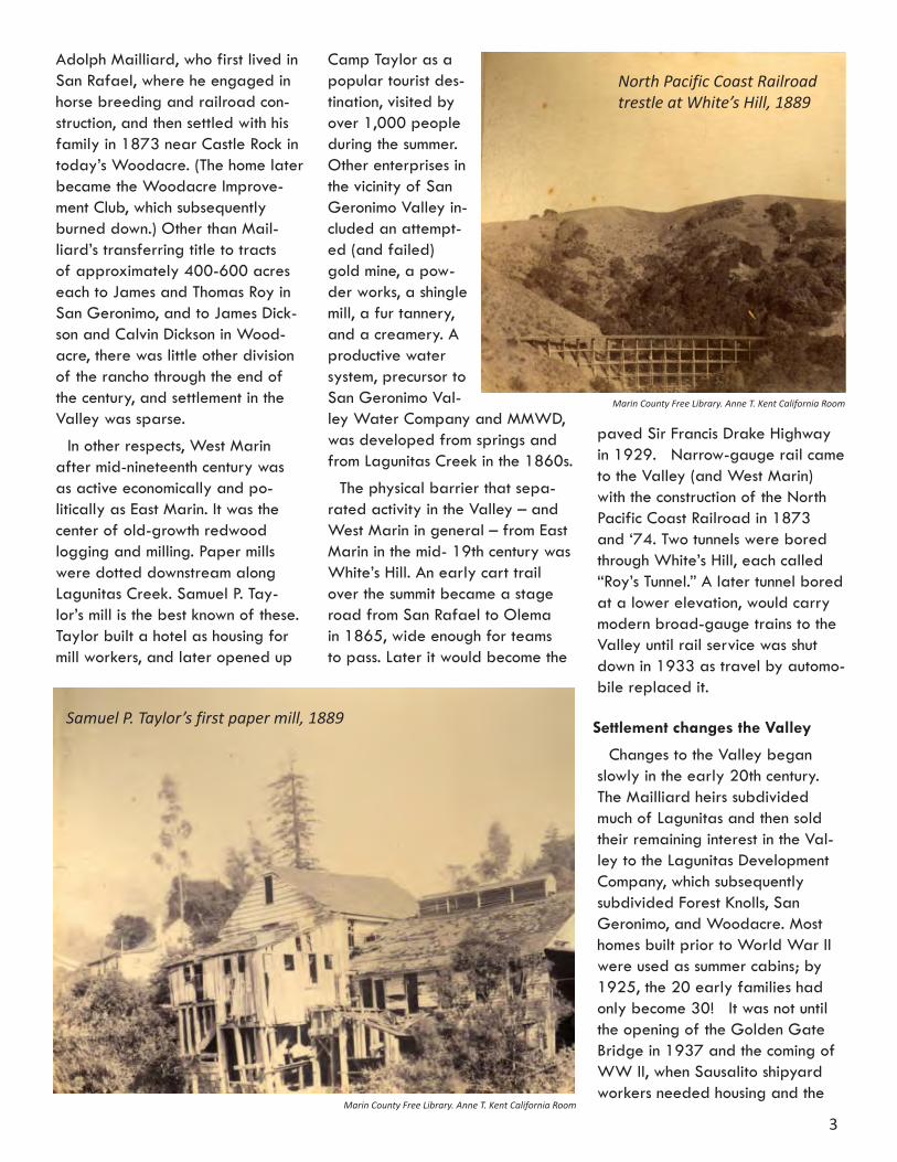
In other respects, West Marin after mid-nineteenth century was as active economically and po-litically as East Marin. It was the center of old-growth redwood logging and milling. Paper mills were dotted downstream along Lagunitas Creek. Samuel P. Tay-lor’s mill is the best known of these. Taylor built a hotel as housing for mill workers, and later opened up
3
Camp Taylor as a popular tourist des-tination, visited by over 1,000 people during the summer. Other enterprises in the vicinity of San Geronimo Valley in-cluded an attempt-ed (and failed) gold mine, a pow-der works, a shingle mill, a fur tannery, and a creamery. A productive water system, precursor to San Geronimo Val-ley Water Company and MMWD, was developed from springs and from Lagunitas Creek in the 1860s.
The physical barrier that sepa-rated activity in the Valley – and West Marin in general – from East Marin in the mid- 19th century was White’s Hill. An early cart trail over the summit became a stage road from San Rafael to Olema in 1865, wide enough for teams to pass. Later it would become the
paved Sir Francis Drake Highway in 1929. Narrow-gauge rail came to the Valley (and West Marin) with the construction of the North Pacific Coast Railroad in 1873 and ‘74. Two tunnels were bored through White’s Hill, each called “Roy’s Tunnel.” A later tunnel bored at a lower elevation, would carry modern broad-gauge trains to the Valley until rail service was shut down in 1933 as travel by automo-bile replaced it.
Settlement changes the Valley
Changes to the Valley began slowly in the early 20th century. The Mailliard heirs subdivided much of Lagunitas and then sold their remaining interest in the Val-ley to the Lagunitas Development Company, which subsequently subdivided Forest Knolls, San Geronimo, and Woodacre. Most homes built prior to World War II were used as summer cabins; by 1925, the 20 early families had only become 30! It was not until the opening of the Golden Gate Bridge in 1937 and the coming of WW II, when Sausalito shipyard workers needed housing and the
Samuel P. Taylor’s first paper mill, 1889
North Pacific Coast Railroad trestle at White’s Hill, 1889
Marin County Free Library. Anne T. Kent California Room
Marin County Free Library. Anne T. Kent California Room

4
bridge opened up access from San Francisco, that many summer cabins became permanent residences.
Still, little changed in the Val-ley until 1961, when the Board of Supervisors adopted a Master Plan for the Valley that envisioned 20,000 new residents, and 5,000 new homes that would cover the entire Valley planning area. The land around the present Spirit Rock would be the site for a shopping center, and multifamily residences. Even a heliport was planned! A freeway would proceed from San Anselmo over White’s Hill and through the center of the Valley, with an interchange that would cross Roy’s Redwoods on a diago-nal, go over the ridge and into Nicasio Valley. The only elements of this plan that were actually de-veloped were the golf course and 18 adjacent homes. In 1968, the Summer of Love turned the Valley into a magnet for “flower chil-dren,” who set up camps and other unconventional shelters, including hollowed-out redwoods.
When resident Jean Berensmeier heard about the 1961 Master
Plan, she organized a com-munity meeting to review the plan, and out of this embry-onic beginning, the Valley Planning Group was born. Fortunately, others in the county, observing the on-slaught of post-WW II devel-opment, took their concerns to the ballot box. The pro-devel-opment majority of supervi-sors was overturned. At the same time, the County pre-pared a report that changed the face of planning in Marin – “Can the Last Place Last.” It cautioned against the loss of Marin’s beautiful spaces to rampant development. Thus, the 1972 Countywide Plan adopted a more modest growth regimen for the entire county and established three “corridors” that continue to generally guide the county’s growth pattern. (A fourth corridor –“Baylands” – was added to the Plan in 2007.) In the spirit of the Countywide Plan, the Valley Planning Group worked to create the Valley’s first Community Plan, which defined the four villag-es and preserved the Valley’s rural character, ridgelines, and streams. 20-acre zoning was adopted to preserve open space and land for agricultural use out-side the village borders.
After the adoption of the Com-munity Plan, a major subdivision, Sky Ranch, was approved after five years of controversy. Several years later, due to lack of prop-erty sales and financial problems, the 130+ unit development that would have added homes to Woo-dacre, San Geronimo and Forest Knolls boundaries, was offered (almost 1,600 acres) and pur-
chased by the Open Space District. It is now known as the Gary Gia-comini Open Space Preserve. In the 1980s, a 411-acre parcel was purchased by Insight Meditation West to support a small Buddhist Center (Spirit Rock), in lieu of the 20 homes that zoning would allow. A portion of that land was dedi-cated to the Open Space District and added to Roy’s Redwoods (see below).
In recent years, development in the Valley was halted by a two-year moratorium, and progress on Jean Berensmeier
Above —1965 aerial view of the San Geronimo Golf Course and Roy’s Redwoods. Below—The golf course today.
Mar
in C
ount
y Fr
ee L
ibra
ry. A
nne
T. K
ent C
alifo
rnia
Roo
mJe
ff A
rche
r/Fl
ickr

5
a long-awaited Salmon Enhance-ment Plan also was halted. There continues to be potential for limited residential and remodeling devel-opment in the Valley.
Parks and Preserves in the Valley
About the same time as the first Countywide Plan – the early 1970s – the voters of Marin passed a bond measure that es-tablished the Marin County Open Space District. This opened the door to beginning the acquisition of lands that would become to-day’s 34 open space preserves, totaling 16,000 acres. These pre-serves separate and define Marin’s communities, protect special habi-tats, and preserve other treasured natural and cultural resources. They also provide opportunities for var-ied forms of recreation.
The Valley was already close to setting aside more public lands to add to those that had been acquired in earlier decades of the century, each with a story to tell: the watershed lands of Marin Municipal Water District in 1912, Samuel P. Taylor State Park ac-quired by the State in 1945 (with help from MCL) due to non-pay-ment of taxes, and farther west, Pt. Reyes National Seashore in 1962, also with the help of MCL. Over the ensuing years (from 1972), five open space preserves would be added to the County’s preserve system in the Valley: the 309-acre Roy’s Redwoods in 1978, formerly part of the Roy Ranch; the 30-acre Maurice Thorner Preserve, donated in 1982, with a trail link to Roy’s Redwoods; the 1,600 Gary Gia-comini Preserve that extends for five miles along the southern edge of the Valley and abuts lands of
MMWD, in 1995; and the 383-acre French Ranch Preserve, which was acquired through development process in 1999. Nearby are the 390-acre White’s Hill Preserve, which also abuts MMWD lands and links Giacomini OSP and Cascade Canyon Preserve with Loma Alta Preserve. Taken together, the public lands accessible within and from the Valley include a wealth of biological diversity in habitat types, wildlife, and plant species.
Keeping watch over these public lands, the Planning Group helped establish the Trails element in the updated 1984 Countywide Plan and contributed to a 2008 Stra-tegic Plan for the Open Space District. Their vigilance over the sensitive resources of these Pre-serves, which are very popular for recreational pursuits, will continue as the County’s recent Vegetation and Biodiversity Management Plan and the Road and Trail Manage-ment Plan are implemented on the ground.
Roy’s Redwoods (as summarized from the marinparks.org website)
Located in the heart of San Geronimo Valley, Roy’s Redwoods Preserve offers either a quick
escape on a warm day to meander in the deep shade of the redwood groves, or more strenuous hikes to higher elevations through Douglas fir and California bay. The Loop Trail leads to a side-trip on the David Hansen Trail, named for one of the district’s early and promi-nent open space planners who negotiated the purchase of Roy’s Redwoods. The Loop Trail continues on a contour through California bay, buckeye, and coast live oak, before descending to grassland for the 1-mile return to the entry gate. For a more strenuous excursion, climb up Dickson Ridge Fire road, which ends at 1,200 feet and af-fords expansive views that stretch from Mt. Tamalpais to the south, to Mt. Wittenberg on the Pt. Reyes Peninsula.
The county’s website tells more: “The primeval groves of bay and redwood were once the setting for a George Lucas movie, the Ewok Adventure. Prior to becoming an MCOSD preserve, a couple of the great rings of redwoods were inhabited by members of loosely organized communes in the late 1960s.” The redwoods here are among the largest remaining old-growth trees in the county. These
A movie theater lobby card for the 1984 film “Caravan of Courage: An Ewok Adventure”
6
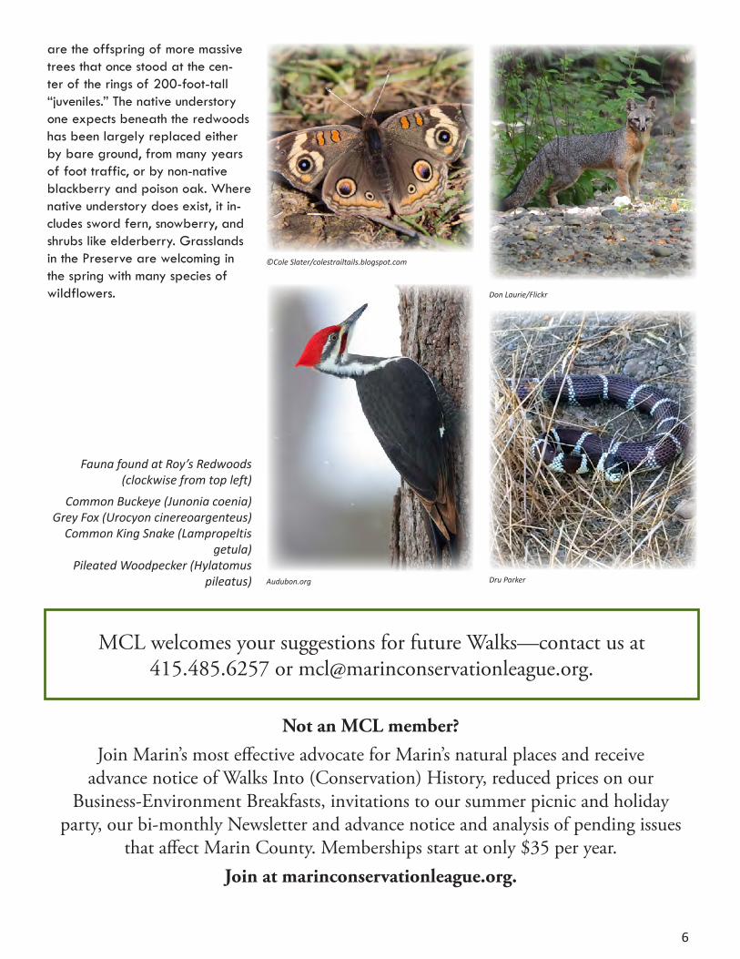
Fauna found at Roy’s Redwoods (clockwise from top left)
Common Buckeye (Junonia coenia)Grey Fox (Urocyon cinereoargenteus)
Common King Snake (Lampropeltis getula)
Pileated Woodpecker (Hylatomus pileatus)
Don Laurie/Flickr
Audubon.org Dru Parker
©Cole Slater/colestrailtails.blogspot.com
are the offspring of more massive trees that once stood at the cen-ter of the rings of 200-foot-tall “juveniles.” The native understory one expects beneath the redwoods has been largely replaced either by bare ground, from many years of foot traffic, or by non-native blackberry and poison oak. Where native understory does exist, it in-cludes sword fern, snowberry, and shrubs like elderberry. Grasslands in the Preserve are welcoming in the spring with many species of wildflowers.
MCL welcomes your suggestions for future Walks—contact us at 415.485.6257 or [email protected].
Not an MCL member? Join Marin’s most effective advocate for Marin’s natural places and receive
advance notice of Walks Into (Conservation) History, reduced prices on our Business-Environment Breakfasts, invitations to our summer picnic and holiday
party, our bi-monthly Newsletter and advance notice and analysis of pending issues that affect Marin County. Memberships start at only $35 per year.
Join at marinconservationleague.org.
MCL Walks into Conservation HistoryPermanent protection of land does not happen easily; every piece of
parkland and open space that the public can now enjoy in Marin came at a price in human effort and persistence as well as in funds from many different sources.
To commemorate its 75th Anniversary in 2009, Marin Conservation League initiated a series of Walks into the park and open space lands that have come to define almost 50 percent of Marin’s
landscape. This year is MCL’s 81st anniversary, and we continue to commemorate the visionaries who recognized many decades ago that Marin’s significant natural lands and waters and cultural heritage would not survive for future generations unless they were permanently protected.
Since its founding in 1934, MCL, working with many other organizations and thousands of individuals, has played a significant role in many of these stories. The Walks have been generously
funded by the following, who donated to MCL’s History Book Fund in 2009:
MOUNTAIN LION $2500 or moreBunker & Company
Ken Drexler & Sarah Leach
COOPER’S HAWK $1000— $2499The County of MarinMarin County Parks
Redwood Landfill, Inc.
Friends of Susan AdamsJanet Allen
Juliette AnthonyBartlett Tree Experts
Amy BelserBetsy & Dan Bikle
Derek & Tymber CavasianPhyllis Faber, in memory of Peter Behr Bruce Fullerton & Antonina Markoff
Ellen & Peter Obstler Ira Chin & Michelle Passero
Edith PiltchSeagate Properties, Inc.
Jean StarkweatherSusan & Brian Stompe
Judge Faye D’Opal & Wanden P. Treanor Julia Violich
Doug Wilson & Periann Wood
LUPINE $100—$249
BAY LAUREL $250 — $499
Bruce Dodge & Wendy WyseBarbara Ford
Jan Hamrin & Tim Rosenfeld
Paul HellikerKathy & Rick Lowrey
McPhail Fuel Co.
Barbara GeorgeJana Haehl
League of Women Voters of MarinJoan Lubamersky
Sue MacMillan, in memory of Alex MacMillan Marjorie MacrisMarin Fence Co.
Barbara & Bernie Meyers
Dudley & Sarah Allen Miller Dorothy & Roger Roberts
Grace & Larry Smith
Angel Island Association Bank of MarinNona Dennis
Cordy Hill, in memory of Robert Royston
ELK $500 — $999
Jack KrystalMarin Sanitary Service
Nardell Chitsaz & Associates
7

Notes
8