mapping the mars canal mania: cartographic projection and the
TRANSCRIPT
Mapping the Mars Canal Mania:
Cartographic Projection and the Creation of a Popular Icon
K. MARIA D. LANE
ABSTRACT: At the turn of the twentieth century, a popular mania developed around the idea that Mars was
inhabited by intelligent beings. This obsession was originally based in the science of the time, but it outlasted
astronomers’ certainty regarding the red planet’s conditions of habitability. Cartography was vital to the
popular construction of Mars as an inhabited world and created a powerful landscape icon that differed
significantly from the observations of astronomers. Acceptance of a Martian civilization began to wane only
when cartography’s status as an objective representational format was weakened by new photographic
technology in the early 1900s. Although the processes and formats of cartography are rarely considered
primary factors in the Mars mania, they were integral to the origin, development and expiration of the
conceptualization of Mars as a world that was possibly inhabited.
KEYWORDS: astronomical cartography, planetary photography, science popularization, Mars, Martian
canals, Giovanni Schiaparelli, Nathaniel Green, Percival Lowell, Eugene Antoniadi.
At the turn of the twentieth century, an extra-
ordinary popular mania developed around the idea
that Mars was inhabited by intelligent beings. The
idea originated in the 1880s, when several astron-
omers reported observing geometrical patterns on
the surface of the planet. Despite disagreement
among scientists regarding the accuracy of these
observations and reports, a few high-profile astron-
omers championed the existence of the patterns,
inducing widespread interest from popular audi-
ences by the mid-1890s. In both Europe and North
America, people gravitated toward the most sensa-
tional interpretation of the strangely regimented
Martian landscape: namely, that the intersecting
lines must indicate a canal system engineered by
intelligent beings as a desperate response to
increasing aridity. In newspapers, highbrow maga-
zines and penny pulps alike, writers enthusiasti-
cally took up the subject, usually accepting without
reserve the depiction of a fully managed Martian
landscape. Although professional astronomers had
largely dismissed this interpretation by 1910,
popular audiences maintained strong interest in it
for at least another decade, with a muted obsession
lingering in some quarters for much longer.1
Much of the scholarship addressing the Mars
craze has focused on the nature of science
popularization, the process of astronomy’s profes-
sionalization and the influence of astronomers’
individual personalities and philosophies. These
Imago Mundi Vol. 58, Part 2: 198–211
# 2006 Imago Mundi Ltd ISSN 0308-5694 print/1479-7801 online
DOI: 10.1080/03085690600687255
c Dr Maria Lane is an assistant instructor in the Department of Geography and the Environment, University of
Texas at Austin. Correspondence to: K. M. D. Lane, 1 University Station A3100, Austin, Texas 78712, USA. Tel: (1)
512 471 0748. Fax: (1) 512 471 5049. E-mail: ,[email protected]..
works have deepened our understanding of how
Mars science became enmeshed in wider intellec-
tual debates, particularly those concerning the
nature of evolution and the uniqueness of man.2
These studies have not, however, tackled the
fundamental role that maps played in shaping the
claims and their popular reception. I am arguing
here that cartography was a vital element in the
popular construction of Mars as an inhabited
world, and that it gave rise to a powerful landscape
icon that differed significantly from astronomers’
reported observations. I also show that acceptance
of the Martian civilization began to wane only
when the status of cartography as an objective
representational format was questioned and weak-
ened by new photographic technology in the early
1900s.
Cartography and Mars
Maps were instrumental in every phase of estab-
lishing inhabited-Mars claims as legitimate scien-
tific knowledge. When the Italian astronomer
Giovanni Schiaparelli first reported seeing lines,
or canali, in the Martian landscape in 1878, he
conveyed his findings in a map (Plate 6).3
Although this was not the first map of Mars nor
even the only map of Mars produced that year,
Schiaparelli shook the astronomical world with
his revolutionary depiction of the red planet.
Compared with cartographers of the preceding
decade, who had applied naturalistic shading and
subtle reddish-orange markings to render Earth’s
imperfectly seen neighbour, Schiaparelli used
hard-edged lines and a schematic blue shading to
represent a planet neatly divided into what he
presumed were innumerable islands and water-
ways. This depiction was drastically different from
another major Mars map produced in 1877, by the
English astronomer Nathaniel Green (Plate 7).4 Not
only did Schiaparelli’s map display significantly
more detail than Green’s or any prior map, it
demonstrated the new landforms with substan-
tially more clarity and definition. On the basis of
this convincing visual authority, Schiaparelli’s map
quickly thrust its maker into the spotlight, despite
the fact that he had never observed Mars before
1877.5
Once Schiaparelli’s canali were inscribed in the
map, the hunt for canals was on. No other
astronomers had seen any geometric forms on the
Martian surface, but the European astronomical
establishment reacted to Schiaparelli’s depiction by
working feverishly over the next decade to confirm
it. Although his canals went unconfirmed until
1886, Schiaparelli himself continued to augment
his map at every 26-month interval, when Mars
passed relatively close to Earth.6 As Schiaparelli’s
maps became more detailed, other astronomers’
reactions became more intense. Those who failed
to see the canals were divided in their reactions:
some maintained that Schiaparelli might have been
in error, while others merely lamented their own
poor luck, eyesight, instruments or location.7 In
1886, however, other astronomers confirmed
Schiaparelli’s observations, and it then became
more difficult to reject the canals inscribed on the
map.8 Within one decade of the confirmations,
an explosion of post-Schiaparelli canal sightings
had produced an exceedingly complex map, and
attention had turned to interpreting the curious
landscape.
Just as the visual certainty and perceived
objectivity of the map had helped Schiaparelli to
establish the legitimacy of his early claims, later
astronomers found that their authority as inter-
preters of the Martian landscape depended largely
on their own cartographic contributions. American
amateur astronomer Percival Lowell, who built his
own observatory and began mapping Mars in 1894,
quickly became one of the foremost authorities on
Mars by producing extremely detailed maps of the
red planet. Not only did he confirm all of
Schiaparelli’s original canals, but he also discov-
ered an additional 116 waterways in his first year
of observation. He went on to record even more
canals two years later, and his second major
map became increasingly abstract (Fig. 1). His
work attracted the attention of other astronomers,
many of whom were initially sceptical of his lack of
astronomical training. Despite reservations about
Lowell’s amateur status, however, several leading
astronomers had to acknowledge that he had made
a major contribution to Mars science through
cartography.9 Lowell’s success, attributed to the
superiority of his telescope and his advantageous
location in Flagstaff, Arizona, was thus both
reflected in and constructed by the vast complexity
of his maps.
Immediately upon making his first Mars obser-
vations in 1894, Lowell began to publish his theory
that the canals were evidence of an advanced
Martian civilization. Not only did he target scien-
tific journals, but he also set his sights on popular
magazines such as The Atlantic Monthly, Scientific
American and Century Magazine. In these periodicals,
Lowell argued that Mars must have been under-
going planetary aridification so severe that its
Imago Mundi 58:2 2006 Mapping the Mars Canal Mania 199
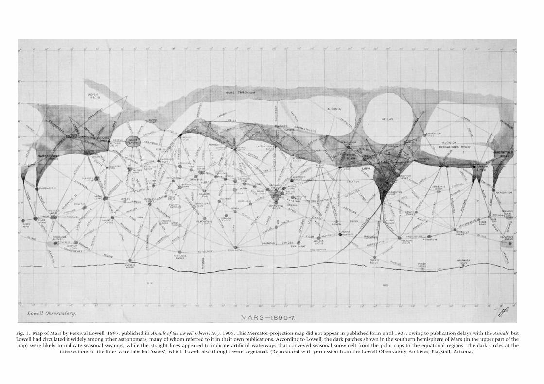
Fig. 1. Map of Mars by Percival Lowell, 1897, published in Annals of the Lowell Observatory, 1905. This Mercator-projection map did not appear in published form until 1905, owing to publication delays with the Annals, but
Lowell had circulated it widely among other astronomers, many of whom referred to it in their own publications. According to Lowell, the dark patches shown in the southern hemisphere of Mars (in the upper part of the
map) were likely to indicate seasonal swamps, while the straight lines appeared to indicate artificial waterways that conveyed seasonal snowmelt from the polar caps to the equatorial regions. The dark circles at the
intersections of the lines were labelled ‘oases’, which Lowell also thought were vegetated. (Reproduced with permission from the Lowell Observatory Archives, Flagstaff, Arizona.)
inhabitants had been forced to construct immense
canals to bring seasonal snowmelt from the polar
caps to the inhabited equatorial regions. When
doubtful astronomers balked at the certainty with
which Lowell delivered this sensationalist account
to popular audiences, he challenged them to come
up with a natural explanation for the geometrical
appearance of Mars. He also responded by increas-
ing his own publication activities, using maps and
other imagery liberally to present his case that the
Martian landforms were analogous to Earth’s man-
made structures, such as rail networks, irrigation
systems and street patterns. This cartographic
imagery quickly became standard fare in books
and articles intended for wide readership (Fig. 2).
By the early 1900s, Lowellian images of Mars
had become powerful icons. As his maps became
ubiquitous in popular magazines and newspapers,
they reinforced the certainty of life and civilization
on the red planet by presenting a landscape that
had no obvious natural explanation. Popular
Sunday newspapers frequently published geo-
metric images of Mars to accompany articles about
the most recent astronomical discoveries. Although
these images took on the general appearance of the
scientific canal maps, they were often unlabelled or
did not show any coordinates (Fig. 3). Such generic
abstraction indicates that this cartographic imagery
was meant to convey legitimacy for the inhabited-
Mars view, rather than information. As a simple
icon, the geometric image of Mars stood for
intelligence, civilization and advancement.
The Creative Power of the Maps
The strength of the Mars icon as a visual symbol
rested on more than a map’s powers of inscription,
authorization and legitimization. It was also sup-
ported at a fundamental level by the creative
power of the cartographic process which had
brought into existence a landscape that differed
greatly from what astronomers were seeing
through their telescopes.
Despite the widespread use of geometrical canal
imagery, in fact, no astronomer ever actually saw,
or claimed to see, an interlinked canal network
while sitting at the telescope. The cartographic
authority of the increasingly prominent Mars icon
concealed the fact that the canal ‘network’ was
invisible to the eye. From Earth, the surface of
Mars was (and still is) notoriously difficult to make
out. Even under excellent conditions for ‘seeing’,
Mars shimmered tantalizingly, allowing only
fleeting glimpses of its surface.10 Astronomers
constantly complained about their inability to hold
an image of Mars steadily in the telescope, and
therefore detail could only be glimpsed in flashes.
George R. Agassiz, an amateur American astron-
omer and philanthropist who actively championed
Lowell’s theory, commented that
It must not be imagined that any drawing represents
what the observer sees the moment he looks through
the telescope. Instants of exceptional seeing flash out,
here and there, at different spots on the planet. It is
not till the same phenomena repeat themselves in the
same way, in the same place, a great number of times,
that the observer learns to trust these impressions.
One has to keep one’s mind constantly at the highest
pitch to catch and retain what the eye sees.
It is like looking at a Swiss landscape from a high
Alp, with the summer clouds sweeping about one.
Now the mist rolls away, revealing a bit of the valley,
and shuts in again in a moment; while in some other
spot the clouds break away, and disclose a jagged
summit, or a portion of a shining glacier.11
In essence, then, the art of sketching Mars
consisted of waiting intently for a moment of still
air, then quickly recording an image before the
memory could fade. Given this difficulty, several
astronomers insisted that a given feature should be
seen, sketched and measured multiple times before
it could be definitely said to exist. Otherwise, the
opportunity for mistakes—of vision, memory or
depiction—was too great.
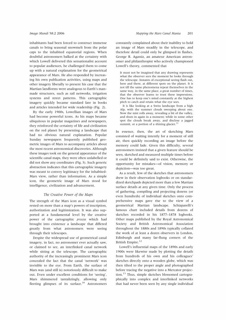
As a result, few of the sketches that astronomers
drew in their observation logbooks or on standar-
dized sketchpads depicted more than a few Martian
surface details at any given time. Only the process
of gathering, compiling and projecting dozens (or
even hundreds) of individual sketches onto com-
prehensive maps gave rise to the view of a
geometrical Martian landscape. Schiaparelli’s
famous chart included details from dozens of
sketches recorded in his 1877–1878 logbooks.
Other maps published by the Royal Astronomical
Society and British Astronomical Association
throughout the 1880s and 1890s typically collated
the work of at least a dozen observers in London,
Edinburgh and many far-flung corners of the
British Empire.12
Lowell’s influential maps of the 1890s and early
1900s were likewise made by plotting the details
from hundreds of his own and his colleagues’
sketches directly onto a wooden globe, which was
then tilted to the proper angle and photographed
before tracing the negative into a Mercator projec-
tion.13 Thus, simple sketches blossomed cartogra-
phically into complex and interlinked networks
that had never been seen by any single individual
Imago Mundi 58:2 2006 Mapping the Mars Canal Mania 201
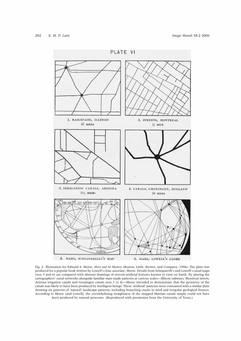
Fig. 2. Illustration for Edward S. Morse, Mars and Its Mystery (Boston, Little, Brown, and Company, 1906). The plate was
produced for a popular book written by Lowell’s close associate, Morse. Details from Schiaparelli’s and Lowell’s canal maps
(nos. 5 and 6) are compared with abstract drawings of several artificial features known to exist on Earth. By placing the
cartographers’ canal networks alongside familiar man-made patterns at various scales—Illinois railways, Montreal streets,
Arizona irrigation canals and Groningen canals (nos. 1 to 4)—Morse intended to demonstrate that the geometry of the
canals was likely to have been produced by intelligent beings. These ‘artificial’ patterns were contrasted with a similar plate
showing six patterns of ‘natural’ landscape patterns, including branching cracks in mud and irregular geological fissures.
According to Morse (and Lowell), the overwhelming straightness of the mapped Martian canals simply could not have
been produced by natural processes. (Reproduced with permission from the University of Texas.)
202 K. M. D. Lane Imago Mundi 58:2 2006
or on any single night (Fig. 4 and Plate 8). In truth,
then, the networked appearance of the canals
owed its existence more to the cartographic process
than to any reality on the Martian surface.
Although astronomers admitted that the maps
showed a landscape invisible to the eye, the
authority of the complex scientific map conveyed
an objectivity that outweighed the simplistic
sketches. Detractors who criticized the inhabited-
Mars theory on the basis of the difference between
what was seen on the maps and in the drawings
seem only to have cast suspicion on the simpler
drawings, rather than to have diminished the
legitimacy of the detailed maps.14 Even the
theory’s great champion, Lowell, acknowledged
that the process of cartographic projection created
an un-viewable view: ‘not a single piece of the
chart resembles the actual presentation of any part
of the planet at any time’.15 Although this
comment may have been intended primarily to
rebuff criticism from those who were unable to
confirm the map’s canals through their own
telescopes, Lowell seems also to have acknowl-
edged the more creative role of cartography in
bringing his populated ‘oases’ to life: ‘When they are
plotted upon a globe, they and their connecting
canals make a most curious network over all the
orange-ochre equatorial parts of the planet, a mass
of lines and knots’.16
Lowell’s one-time associate William Pickering
made a similar caveat: ‘The maps of Mars look very
artificial; but we must remember that they are
composites of many drawings. . . . All the canals
shown on the maps are not seen at once; on the
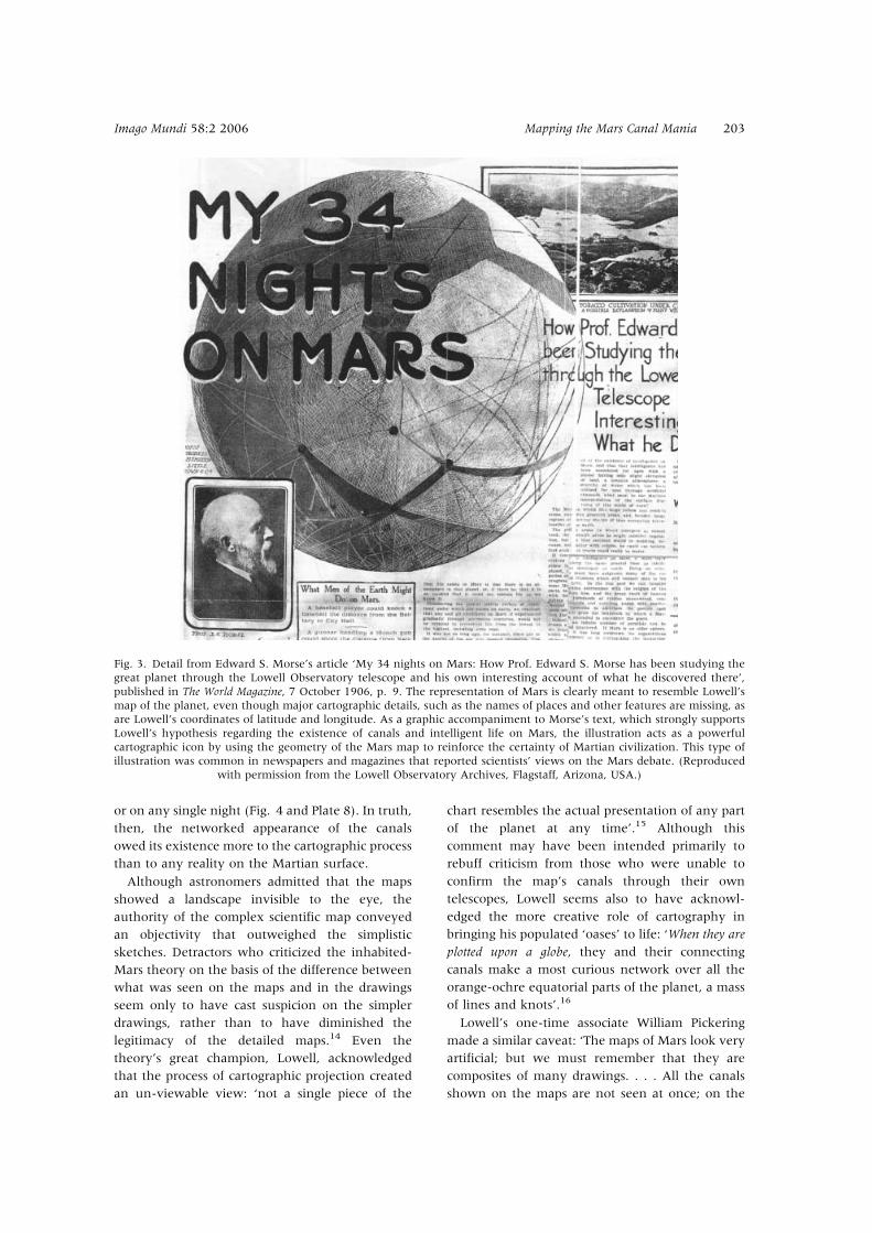
Fig. 3. Detail from Edward S. Morse’s article ‘My 34 nights on Mars: How Prof. Edward S. Morse has been studying the
great planet through the Lowell Observatory telescope and his own interesting account of what he discovered there’,
published in The World Magazine, 7 October 1906, p. 9. The representation of Mars is clearly meant to resemble Lowell’s
map of the planet, even though major cartographic details, such as the names of places and other features are missing, as
are Lowell’s coordinates of latitude and longitude. As a graphic accompaniment to Morse’s text, which strongly supports
Lowell’s hypothesis regarding the existence of canals and intelligent life on Mars, the illustration acts as a powerful
cartographic icon by using the geometry of the Mars map to reinforce the certainty of Martian civilization. This type of
illustration was common in newspapers and magazines that reported scientists’ views on the Mars debate. (Reproduced
with permission from the Lowell Observatory Archives, Flagstaff, Arizona, USA.)
Imago Mundi 58:2 2006 Mapping the Mars Canal Mania 203
contrary, only a very few of them are visible on the
same night’.17 The use of a coordinate grid,
however, implied exactness and scientific objectiv-
ity; the combination of multiple observations to
form a composite view conveyed unassailable
comprehensiveness. As an artefact of a map
projection, therefore, the iconic geometrical image
of Mars could not have existed or grown so
meaningful except through the format and pro-
cesses of cartography.
Decline of the Martian Map
The inhabited-Mars theory enjoyed widespread
support only as long as the cartography itself was
accepted as the most scientific representation of the
red planet. When doubts were cast on cartography
as an objective format, astronomers’ patience with
increasingly outlandish claims about Mars finally
began to dry up. At the same time, popular
enthusiasm for Mars began to show the first signs
of waning. Although it took much longer for
popular interest to die out (it arguably continued
with some audiences into the 1950s, if not to the
present day), the decreasing power of the map had
a marked effect on the confidence of both scientific
and popular audiences in the supposed Martian
inhabitants.
Having risen to prominence as the most eloquent
and active promoter of the inhabited-Mars hypoth-
esis, Lowell suffered most keenly from the decline
of the map. After a brief hiatus from his Mars
studies between 1898 and 1901 owing to illness,
Lowell had returned to work with a renewed
vigour. He published several new maps early in the
twentieth century, wrote three new books by
1909, conducted extensive lecture tours on the
American east coast and in Europe and dissemi-
nated his findings to the popular press at every
opportunity. As Lowell became more outspoken in
his claims about the landscape and civilization of
Mars, he also became more vicious toward the
doubters, prompting many of the most prominent
American astronomers and several professionals
and amateurs in Britain to turn against him. To
combat what they saw as Lowell’s wilful disregard
for scientific professionalism and standards of
proof, his detractors reacted with a sustained effort
to disrupt his popularity and undermine his
legitimacy.18
In Britain, Edward Maunder, a well-known
astronomer from the Royal Observatory,
Greenwich, began to write extensively about the
likelihood that Lowell’s maps were based on
nothing more than optical illusion, provoking
significant doubt among those astronomers who
had never seen the canals clearly in the first place.
At a June 1903 meeting of the British Astronomical
Association, for instance, a member commented
that Maunder ‘had really cut away the ground
from under the feet of those who thought they had
been able to prove that there were canals. The onus
of proof now lay upon those who thought the
canals were there’.19 In the United States, the elite
academic astronomers acted in concert to isolate
Lowell from the scientific community, cast doubt
on his claims and minimized his publishing
opportunities.20 Following Maunder, several
American astronomers questioned whether
Lowell’s maps and sketches were not in fact
distorted by optical illusion.21
Lowell turned to photography to counter the
many charges being levelled against him. After
Maunder’s first attacks in 1903, Lowell helped to
Fig. 4. Sketch of Mars by Percival Lowell, published in
Mars as the Abode of Life (New York, Macmillan, 1909). The
image shows the amount of surface detail that typically
could be contained in a single sketch in an astronomer’s
observation logbook. Depending on atmospheric condi-
tions, an astronomer could record at most a small number
of such sketches in a single evening, each of which might
show only a few canals. Lowell reproduced this particular
sketch in Mars as the Abode of Life to show that a dark band
sometimes appeared along the edge of the polar cap. He
suggested that this ‘dark belt’ was a shallow, temporary
sea that had formed as ice melted along the edge of the
polar cap. This effect is now thought to have been an
optical illusion. (Reproduced with permission from the
University of Texas.)
204 K. M. D. Lane Imago Mundi 58:2 2006
pioneer a new method of planetary photography
that could capture a clear image with only a short
time exposure.22 When his assistant Carl O.
Lampland succeeded in photographing Mars in
1905, Lowell quickly began publishing and circu-
lating the images to rescue his reputation. For a
time, this strategy worked. Despite being small and
grainy, the photographs indeed contained some
dark markings in areas where Lowell’s maps
depicted canals, indicating a confirmation. At a
June 1906 meeting of the British Astronomical
Association, the President A. C. D. Crommelin
stated that Lowell’s photographs proved the
‘objective reality of the canals’, reviving belief
within the British astronomical community.23
In 1907, however, new optical illusion experi-
ments carried out in the United States immediately
produced a reverse sway in scientific opinion
concerning the reality of the canals.24 While
relentlessly rebutting the illusion research, Lowell
clearly determined that he needed to shore up the
authority of his claims regarding the objective
reality of the canals.25 In the face of what he
perceived as an onslaught, Lowell mounted a high-
profile photographic expedition to South America
for the 1907 planetary opposition,26 essentially
staking his reputation on the new imaging techni-
ques that Lampland had developed since 1905. As
British and American magazines and newspapers
hyped the expedition, scientific and popular
anticipation mounted.27 When Lowell’s photogra-
pher finally returned from the Andes with the
negatives, however, the images proved a general
disappointment.
Lowell claimed that the 1907 photographs
dispelled all doubt regarding the existence of the
Martian canals. Paradoxically, however, they con-
tributed to his further loss of credibility. With each
photographic image of Mars typically measuring
less than half an inch in diameter on the negatives,
the photographs showed far less detail than any
of Lowell’s elaborate maps (Fig. 5). Although the
photographs could be said to confirm Lowell’s
simple sketches, showing some isolated lines on the
on the surface of Mars, they did not show a
definitive canal network.
On top of that, the photographs were incredibly
difficult to reproduce: their original size was too
small to show any significant detail, yet they
became excessively grainy when enlarged. Lowell
agonized over the proper presentation of his
photographs in the Century Magazine, even asking
that they be ‘retouched’ to show the canals
better.28 Having paid a substantial sum for the
copyright of the images, however, the editor was in
no mood to delay publication of the long-promised
Martian canal photographs: ‘There is no time to
retouch the photographic plates and we should
consider it a calamity to do so, as it would entirely
spoil the autographic value of the photographs
themselves. There would always be somebody to
say that the results were from the brains of the
retoucher’.29
To counteract his expectation that the unedited
photographs would reproduce poorly, Lowell
began sending negatives and prints to select
astronomers in Britain in the calculated hope that
these men would vouch for the photographed
canals in their own publications and presenta-
tions.30 This strategy produced some desirable
results. Crommelin reported that when he exam-
ined Lowell’s images he had seen twenty-two
canals.31 Likewise, the director of the British
Astronomical Association’s Mars Section commen-
ted in his report on the 1907 opposition that,
‘Regarding the objectivity of the canals of Mars,
there seems no necessity or room for doubt after
the truly splendid photographic results obtained by
Messrs. Lowell and Lampland’.32
Despite such personal opinions, however, the
fact remained that Lowell’s photographs were not
convincing in any of the formats available for mass
distribution. They appeared too small, too blurry or
too dark to match the certainty levels that had
been inscribed in the maps. Wherever the much-
vaunted photographs were published, Lowell
usually insisted that they were to be accompanied
by a disclaimer. In the 1907 Century Magazine
exclusive, for instance, Lowell alerted readers that
the printed images were three steps removed from
the original negative as a result of the processes of
photographic printing, half-toning and press print-
ing. He also warned that use of a magnifying glass
would only increase the grain size without reveal-
ing more details. Lowell was thus obliged to make a
delicate argument. On the one hand he asserted
that ‘to the camera no evasion of the fact avails.
They [the canals] are there, and the film refuses to
report them other than they are’, while on the
other hand he was forced to qualify the photo-
graphs as ‘handicapped’, claiming the canals’
‘straightness is more pronounced than appears from
the photographic print’.33
Perhaps more damaging than the inadequate
reproduction of the tiny photographs was the fact
that after 1907 photography began to supplant
cartography as the proper standard of proof for
features discernible on Mars. The build-up of
Imago Mundi 58:2 2006 Mapping the Mars Canal Mania 205
expectations regarding Lowell’s 1905 and 1907
photographs focused on their objective quality and
ability to resolve long-standing disputes among
astronomers over the existence of the canals. Once
the early grainy photographs had become avail-
able, Lowell’s elaborate maps—the basis of his
reputation, credibility and hypothesis—became
essentially obsolete as scientific images. In 1907,
Hugh Chisholm, the editor of the tenth edition of
the Encyclopaedia Britannica, wrote to Simon
Newcomb saying that that he did not want to
publish Lowell’s hand-drawn maps as illustrations
for Newcomb’s article on Mars:
I think that only a half-tone reproduction of Lowell’s
photographs would be scientific. . . . The whole thing in
fact is so much bound up with the Lowell photographs
that I shrink from showing anything but the originals
(which are decidedly difficult for us to reproduce, and
had better be therefore referred to only in their
source). . . . I don’t in any case like the idea of mere
drawings, which must inevitably ‘fake’ to some extent
the ‘canals’.34
In the end, Chisholm decided he would publish the
Mars entry without any image at all, rather than
use maps instead of ‘scientific’ photographs.
Many editors seem to have come to similar
conclusions after the 1907 expedition, since
Lowell’s maps rarely appeared in scientific pub-
lications after that year. Photography had provided
a new standard of objective representation that
made the diverse maps of astronomers appear
positively subjective in comparison. The fact that
the photographs were blurry and grainy did not
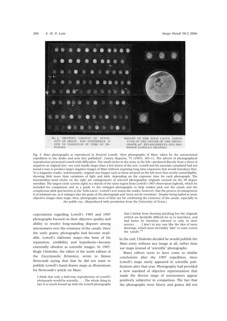
Fig. 5. Mars photographs as reproduced in Percival Lowell, ‘New photographs of Mars: taken by the astronomical
expedition to the Andes and now first published’, Century Magazine, 75 (1907): 303–11. The advent of photographical
reproduction presented Lowell with difficulties. The small circles in the array at the left—produced directly from a sheet of
negatives at original size—are each hardly larger than a few letters of the text. Lowell and his associate Lampland had not
found a way to produce larger negative images of Mars without requiring long time-exposures that would introduce blur.
To a magazine reader, unfortunately, original-size images such as those arrayed on the left were thus nearly unintelligible,
showing little more than variations of light and dark, depending on the exposure time for each photograph. The
intermediate-sized circles on the right are enlargements of selected photographic originals centred on the 90 degree
meridian. The largest circle (centre right) is a sketch of the same region from Lowell’s 1907 observation logbook, which he
included for comparison and as a guide to the enlarged photographs to help readers pick out the canals and the
conspicuous dark spot known as the ‘Solis Lacus’. Lowell’s text warns the reader, however, that the process of enlargement
is of minimal use, as it enlarges also the grain of the photograph and ‘must not be overdone’. Despite being hailed as more
objective images than maps, then, photographs were of little use for confirming the existence of the canals, especially in
the public eye. (Reproduced with permission from the University of Texas.)
206 K. M. D. Lane Imago Mundi 58:2 2006
diminish their perceived objectivity. It did, how-
ever, diminish the certainty of the canals that had
been inscribed in the maps by Lowell and others.
A Scientific End for the Canals
The final blow to Lowell’s scientific credibility came
in 1909–1910, when he became embroiled in a
debate with the French astronomer Eugene
Antoniadi over the best way to represent Mars.
With the authority of his map weakened by the
new photographs, Lowell’s personal credibility also
became vulnerable. Whereas he had earlier been
able to maintain a spirited defence against all
criticisms, he was left after 1907 to argue from a
much weaker position. Those astronomers who
had long wanted to dismiss his theories and
speculations regarding Martian life suddenly found
the proposition much easier.
During the planetary opposition in 1909,
Antoniadi observed Mars at the celebrated 33-inch
Meudon Observatory telescope, the largest in
Europe.35 Although he observed for only nine
nights during a month-long stay in Paris, he
reported seeing Mars so clearly at times that the
linear appearance of the canals dissolved into an
intricate mess of smaller, irregular details, and he
noted that ‘the geometrical ‘‘canal’’ network is an
optical illusion; and in its place the great refractor
shows myriads of marbled and chequered objec-
tive fields, which no artist could ever think of
drawing’.36
Antoniadi, an accomplished draftsman,
attempted to represent the complex markings he
had seen. He sent five sketches to Lowell with a
letter describing his perfect certainty that they
represented an objective view of Mars’ surface.
Lowell had cautioned Antoniadi in an earlier letter
about the danger that such a large telescope as
Meudon’s might actually show diminished detail
(by allowing excess light to overwhelm subtle
features),37 but Antoniadi reported,
the tremendous difficulty was not to see the detail, but
accurately to represent it. Here, my experience in
drawing proved of immense assistance, as, after my
excitement, at the bewildering amount of detail
visible, was over, I sat down and drew correctly, both
with regard to form and intensity, all the markings
visible.38
Lowell tried to discredit Antoniadi’s claims but to
no avail. Upon the occasion of Schiaparelli’s death
in 1910, Lowell wrote an eloquent obituary
praising the Italian’s canal discoveries, while also
blasting his own opponents for not accepting the
reality of the canals.39 It was, however, to be the
last time he actively defended the inhabited-Mars
hypothesis in a scientific publication, showing that
the tide had finally turned. Antoniadi, on the other
hand, wrote more than a dozen well-received
scientific articles in 1909 and 1910, most of them
directly refuting Lowell’s hypotheses. In his official
reports for the British Astronomical Association,
Antoniadi wrote with confidence and finality of the
artificial canals’ demise:
We thus see in the so-called ‘canals’ a work of Nature,
not of Intellect; the spots relieving the gloom of a
wilderness, and not the Titanic productions of super-
natural beings. To account for their various phenom-
ena, we need only invoke the natural agencies of
vegetation, water, cloud, and inevitable differences of
colour in a desert region.40
To understand how Antoniadi’s nine nights of
Mars observations succeeded in discrediting
Lowell, who had a fifteen-year record of contin-
uous observation and publication, we must con-
sider the visual authority of Antoniadi’s new claims
in 1909. Upon completion of his stay at the
Meudon Observatory, Antoniadi immediately
began circulating his sketches to colleagues within
the British astronomical community. At the same
time, he wrote a series of articles about his and
others’ Mars observations in the Journal of the
British Astronomical Association. In most of these
publications and letters, he emphasized the fact
that his drawings showed more detail than Lowell’s
maps by revealing intricate features in places
where Lowell showed mere lines. He referred to a
‘vast and incredible amount of detail’,41 claiming
that ‘the fact that no straight lines could be held
steadily when much more delicate detail was continually
visible constitutes a fatal objection to their crum-
bling existence’.42 Antoniadi and his ally Maunder
(still an active critic of Lowell) also pointed out that
the new naturalistic, shaded sketches bore a
striking resemblance to the latest photographs of
Mars.43 Antoniadi’s 1909 sketches thus appeared
more objective than Lowell’s in their similarity
with the new photographic imagery.
Finally, it must be noted that Antoniadi’s
personal authority as a long-standing Lowell
supporter made him an especially effective critic.
Antoniadi himself had reported seeing canals on
numerous occasions and had drawn dozens of
them on maps he compiled for the British
Astronomical Association in his capacity as the
Mars Section director since 1896.44 Furthermore,
Antoniadi had championed the evidentiary quality
of Lowell’s 1905 and 1907 photographs. In an
Imago Mundi 58:2 2006 Mapping the Mars Canal Mania 207
analysis published for the Royal Astronomical
Society in 1908, for instance, Antoniadi commen-
ted that ‘the amount of detail shown on [Lowell’s]
photographs is very considerable’ and noted that
he could count seventeen canals as ‘more or less
discernible on the images’.45 Antoniadi thus could
not be dismissed as a feeble observer who rejected
the canals because he could not see them himself.
In the end, Antoniadi brought about a complete
reversal of the 1877–1878 verdict, since his subtle,
naturalistic shading more closely resembled the
appearance of Green’s 1877 map than anything
that had been produced in the intervening thirty
years, yet it won substantial approval from
the astronomical communities in Europe and
North America, relegating Lowell’s hard-edged
Schiaparellian-style maps to a weakened status as
‘startling theories’.46 Maunder claimed at a meet-
ing of the British Astronomical Association that the
canals had been irrevocably put to rest:
There never was any real ground for supposing that in
the markings observed upon Mars they had any
evidence of artificial action. Had it not been a
sensational idea which lent itself to sensational writing
in the daily press he [Maunder] did not believe they
would ever have heard of it. He considered it was all
the better for science that the idea was now completely
disposed of. They need not occupy their minds with
the idea that there were miraculous engineers at work
on Mars, and they might sleep quietly in their beds
without fear of invasion by the Martians after the
fashion that Mr. H. G. Wells had so vividly described.47
Although his pronouncement was somewhat
premature, given that the public did not let go of
the canals as quickly as the scientists, Maunder
accurately recorded a definitive reversal in scien-
tific considerations of the geography of Mars.
The reasons for this reversal include both the rise of
photography as a standard of proof and Antoniadi’s
claim that his few sketches showed more detail than
Lowell’s many maps. Visually supported by the
photographs—the new scientific imagery of truth—
Antoniadi’s sketches trumped Lowell’s maps. After a
long assault on the logic of Lowell’s theory and the
authority of his methods, it was the dismantling of his
maps that finally diminished the scientific commu-
nity’s willingness to seriously entertain further talk of
Mars’ inhabitants.
Throughout the period of the popular Mars mania,
maps were the principal means of disseminating
scientific information regarding the geography of
the planet. The present-day analyst can see that
little value can be gained by assessing which maps
were ‘right’ or ‘wrong’ in terms of their faithfulness
to modern-day imagery of the Martian surface.
Maps produced at the turn of the twentieth
century are much more valuable for what they
reveal about the processes of conferring authority
for a knowledge claim and legitimization of certain
landscape views.
The sharp rise of the inhabited-Mars theory in
the late nineteenth century was intimately tied to
the perceived objectivity of scientific cartography,
the visual authority of specific maps and the
personal authority of various mapmakers. The
competition to add more and more canals to the
map of Mars eventually produced a powerful iconic
image that transcended the boundary between
science and popular culture. This icon—showing a
geometrical canal network on the planet—came to
represent an advanced intelligence and civilization
on Mars. In the process, the image of Mars
assumed a mantle of scientific objectivity despite
admissions that no one had ever actually seen the
canal network as a whole. As the functions of the
cartographic process were erased in the visual
aspect of the map, the geometrical map of Mars
became a convincing piece of evidence for advo-
cates of the inhabited-Mars theory.
Because this theory was so keenly linked with
the visual authority of the map, it was dependent
on the map’s legitimacy. When the perceived
objectivity of cartography faltered in the early
1900s in comparison with new photographic
technologies, belief in the supposed inhabitants of
Mars lost considerable ground as well. The waning
credibility of the maps further weakened the
position of astronomers like Lowell, whose stature
as advocates of the inhabited-Mars theory was built
on the foundation of their maps. By 1910, the
astronomical communities of Europe and North
America had largely abandoned their thirty-year
flirtation with the idea of an inhabited Mars and
returned to a naturalistic mapping style that closely
resembled the pre-1877–1878 maps. Cartography
was thus integral to the origin, development and
expiration of the scientific conceptualization of
Mars as a world possibly inhabited.
Acknowledgements: Research for this essay was funded by a
Mellon Dissertation Fellowship awarded by the Council
on Library and Information Resources. I also gratefully
acknowledge skilful research assistance provided by the
Lowell Observatory Library (Flagstaff, Arizona), the Royal
Astronomical Society (London) and La Biblioteca
dell’Osservatorio Astronomico di Brera (Milan). Finally,
I would like to thank Roger Hart and Ian Manners for
helpful comments on early drafts of this essay.
208 K. M. D. Lane Imago Mundi 58:2 2006
A version of this paper was presented at the 21st InternationalConference on the History of Cartography, Budapest, July 2005.Revised text received October 2005.
NOTES AND REFERENCES
1. The reportedly geometrical appearance of the surface
of Mars is now thought to have been an illusory effect of
optical perception (Thomas A. Dobbins and William
Sheehan, ‘The canals of Mars revisited’, Sky & Telescope
107:3 (2004): 114–17). For a succinct overview of the
turn-of-the-century Mars mania, see William Sheehan,
The Planet Mars: A History of Observation and Discovery
(Tucson, University of Arizona Press, 1996).
2. See especially David Strauss, Percival Lowell: The
Culture and Science of a Boston Brahmin (Cambridge,
Mass., Harvard University Press, 2001), for a thorough
contextualization of the work of Percival Lowell, who was
the most influential advocate of the inhabited-Mars
hypothesis. For comprehensive treatments of the place
of the Mars mania in intellectual history, see Steven J.
Dick, The Biological Universe: The Twentieth-Century
Extraterrestrial Life Debate and the Limits of Science
(Cambridge, Cambridge University Press, 1996); Michael
J. Crowe, The Extraterrestrial Life Debate 1750–1900: The
Idea of a Plurality of Worlds from Kant to Lowell (Cambridge,
Cambridge University Press, 1986); and Karl S. Guthke,
The Last Frontier: Imagining Other Worlds, from the
Copernican Revolution to Modern Science Fiction (Ithaca and
London, Cornell University Press, 1983). For discussions
of the popularization of Mars science, see William
Sheehan, Planets and Perception (Tucson, University of
Arizona Press, 1988); and William Graves Hoyt, Lowell
and Mars (Tucson, University of Arizona Press, 1976).
Regarding the fraught professionalization of astronomy,
see Noriss S. Hetherington, ‘Percival Lowell: scientist or
interloper?’ Journal of the History of Ideas 42:1 (1981): 159–
61; and Noriss S. Hetherington, ‘Amateur versus profes-
sional: the British Astronomical Association and the
controversy over canals on Mars’, Journal of the British
Astronomical Association 86 (1976): 303–8.
3. Giovanni Virginio Schiaparelli, ‘Osservazioni astro-
nomiche e fisiche sull’asse di rotazione e sulla topografia
del pianeta Marte fatte nella reale specola di Brera in
Milano coll’equatoreale di Merz durante l’opposizione del
1877: memoria del socio G. V. Schiaparelli’, Atti della Reale
Accademia dei Lincei: Memorie della Classe di scienze
fisiche, matematiche e naturali 3:2 (1877–1878): 3–136.
Schiaparelli’s term canali was widely translated in English
as ‘canals’.
4. Nathaniel E. Green, ‘Observations of Mars, at
Madeira, in August and September 1877’, Memoirs of the
Royal Astronomical Society 44 (1879): 123–40.
5. For a detailed discussion of the early Mars maps and
their role in establishing the authority of individual
astronomers, see K. Maria D. Lane, ‘Geographers of Mars:
cartographic inscription and exploration narrative in late
Victorian representations of the red planet’, Isis 96 (2005):
477–506.
6. See the increasingly detailed maps in G. V.
Schiaparelli, ‘Osservazioni astronomiche e fisiche sull’asse
di rotazione e sulla topografia del pianeta Marte fatte
nella reale specola di Brera in Milano coll’equatoreale di
Merz: memoria seconda del socio G. V. Schiaparelli’, Atti
della Reale Accademia dei Lincei: Memorie della classe di scienze
fisiche, matematiche e naturali 3 (1880–1881): 3–109; G. V.
Schiaparelli, ‘Osservazioni astronomiche e fisiche sull’asse
di rotazione e sulla topografia del pianeta Marte fatte
nella reale specola di Brera in Milano coll’equatoreale di
Merz: memoria terza del socio G. V. Schiaparelli
(opposizione 1881–1882)’, ibid. 4 (1886): 281–373; G.
V. Schiaparelli, ‘Osservazioni astronomiche e fisiche
sull’asse di rotazione e sulla topografia del pianeta
Marte fatte nella reale specola di Brera in Milano
coll’equatoreale di Merz: memoria quarta del socio G. V.
Schiaparelli (opposizione 1883–84)’, ibid. 5 (1895–1896):
183–240.
7. See, for example, C. E. Burton ‘Notes on the aspects
of Mars in 1882’, Scientific Transactions of the Royal Dublin
Society 1 (1883): 301–5. Burton regularly lamented the
‘unfortunate climate’ of the British Isles, which he felt
prevented British and Irish astronomers from making
meaningful contributions to the study of Mars.
8. The Belgian astronomer Francois Terby and the
French astronomer Joseph Perrotin both reported seeing
canals in 1886: ‘The canals on Mars’, Astronomical Register
24 (1886): 268, reported Terby’s findings; J. Perrotin,
‘Observation des canaux de Mars faite a l’Observatoire
de Nice’, Observatory 9 (1886): 364–65. The sketches by
these astronomers, however, were less detailed than
Schiaparelli’s maps, which showed more and more canals
with every iteration after 1877.
9. Simon Newcomb, director of the United States
Nautical Almanac and a noted Lowell antagonist, wrote
to Lowell in 1905 to request a map for an encyclopedia
article he was then preparing: ‘I would like a good map of
Mars to accompany the article. For this I know no better
source than the publication of your observatory’ (Simon
Newcomb to Percival Lowell, 30 October 1905, in
Washington, D.C., Library of Congress, Manuscript
Division, Simon Newcomb Papers). The editor of Popular
Astronomy, W. W. Payne, likewise commented in 1904
that Lowell’s maps were ‘pieces of astronomical work that
are now classical in astronomy . . . because they were
made by the very best means and methods now known to
that science’ (W. W. Payne, ‘The ‘‘canals’’ of Mars’,
Popular Astronomy 12:6 (1904): 365–75).
10. In astronomical terms, ‘seeing’ is a measure of the
stillness and clarity of Earth’s atmosphere. Fred W. Price,
‘The atmosphere and seeing’, in The Planet Observer’s
Handbook, 2nd ed. (Cambridge, Cambridge University
Press, 2000).
11. G. R. Agassiz, ‘Mars as seen in the Lowell refractor’,
Popular Science Monthly 71 (1907): 275–82, reference on
281.
12. See, for example, Nathaniel E. Green, ‘The northern
hemisphere of Mars’, Monthly Notices of the Royal
Astronomical Society 46:8 (1886): 445–47; E. Walter
Maunder, ‘Section for the observation of Mars: report of
the Section, 1892’, Memoirs of the British Astronomical
Association 2 (1895): 157–98; Eugene M. Antoniadi,
‘Section for the observation of Mars: report of the
Section, 1896’, ibid. 6 (1898): 55–102.
13. Percival Lowell, Mars (Boston and New York,
Houghton, Mifflin, 1895).
14. For a typical critique, see Edwin Holmes, ‘Notes re
Mars’, Journal of the British Astronomical Association 1:5
(1891): 256–59.
15. Percival Lowell, ‘Mars’, Popular Astronomy 2:1
(1894): 1–8, reference on 8.
16. Percival Lowell, ‘Mars: oases’, Popular Astronomy 2:8
(1895): 343–48, reference on 346, emphasis added.
17. William H. Pickering, ‘The planet Mars’, Technical
World Magazine (1906): 459–71, reference on 469–70.
18. Strauss, Percival Lowell (see note 2), provides the
most comprehensive analysis of the manoeuvring
Imago Mundi 58:2 2006 Mapping the Mars Canal Mania 209
between Lowell and his opponents in the astronomical
establishment.
19. ‘Report of the meeting of the association, held on
June 24 1903, at Sion College, Victoria Embankment’,
Journal of the British Astronomical Association 13:9 (1903):
331–40, reference on 338.
20. See, again, Strauss, Percival Lowell (note 2), for a
detailed discussion of this effort.
21. See, for example, a series of letters which Simon
Newcomb wrote to Percival Lowell in March 1903 (Simon
Newcomb Papers (note 9)).
22. For a detailed discussion of how Lowell manoeuvred
to validate this method and cultivate supporters, see
Jennifer Tucker, ‘Science Illustrated: Photographic
Evidence and Social Practice in England, 1870–1920’
(doctoral dissertation, The Johns Hopkins University,
Baltimore, MD, 1996).
23. ‘Report of the meeting of the association, held on
June 20, 1906, at Sion College, Victoria Embankment’,
Journal of the British Astronomical Association 16:9 (1906):
333.
24. Simon Newcomb, ‘The optical and psychological
principles involved in the interpretation of the so-called
canals of Mars’, Astrophysical Journal 26:1 (1907): 1–17.
25. For his animated rebuttals, see especially Lowell’s
personal correspondence with Simon Newcomb and
Walter Maunder, for example, letter from Lowell to
Simon Newcomb, 15 March 1903; Lowell to Newcomb,
15 May 1907 (Simon Newcomb Papers (note 9)). See also
Lowell to E. Walter Maunder, 28 November 1903
(Percival Lowell Correspondence, Lowell Observatory
Archive, Flagstaff, Arizona).
26. An ‘opposition’ occurs when two planets pass one
another in their respective orbits, forming a line as seen
from the sun. During such an event (which occurs every
26 months in the case of Earth and Mars), the planets are
not only relatively closer to one another than at any other
time, but the disk of the outer planet (in this case, Mars) is
also fully illuminated by the sun, as seen from the inner
planet.
27. See Tucker, ‘Science Illustrated’ (note 22), for a
discussion of the media’s coverage of the expedition.
28. Lowell asked an associate in New York, George R.
Agassiz, to intercede with Century’s editor, R.U. Johnson,
on his behalf. Letter from R. U. Johnson to Lowell, 24
September 1907, from George R. Agassiz to Lowell, 27
September 1907, and from George R. Agassiz to Lowell,
14 October 1907 (Percival Lowell Correspondence (see
note 25)).
29. Letter from R. U. Johnson to Lowell, 8 October 1907
(Percival Lowell Correspondence (see note 25)).
30. See Tucker, ‘Science Illustrated’ (note 22), for a
detailed treatment of this episode.
31. A. C. D. Crommelin, ‘Martian photography’, The
Observatory 30:387 (1907): 365.
32. E. M. Antoniadi, ‘Mars Section interim report on the
Australian observations, 1907’, Journal of the British
Astronomical Association 18:10 (1908): 398–401, reference
on 401.
33. Percival Lowell, ‘New photographs of Mars: taken
by the astronomical expedition to the Andes and now first
published’, Century Magazine 75 (1907): 303–11, reference
on 309–10, emphasis added.
34. Letter from Hugh Chisholm to Simon Newcomb, 5
February 1907 (Simon Newcomb Papers (see note 9),
emphasis in original).
35. See Richard McKim, ‘The life and times of E. M.
Antoniadi, 1870–1944. Part 1: an astronomer in the
making’, Journal of the British Astronomical Association
103:4 (1993): 164–70; Richard McKim, ‘The life and
times of E. M. Antoniadi, 1870–1944. Part 2: the Meudon
years’, ibid., 103:5 (1993): 219–27, for a detailed
discussion of Antoniadi’s long involvement in the Mars
debate.
36. E. M. Antoniadi, ‘Mars Section third interim report
for 1909, dealing with the nature of the so-called ‘‘canals’’
of Mars’, Journal of the British Astronomical Association 20:1
(1909): 25–28, reference on 28.
37. Letter from Lowell to E. M. Antoniadi, 26 September
1909 (Percival Lowell Correspondence (see note 25)).
38. Letter from E. M. Antoniadi to Lowell, 9 October
1909 (Percival Lowell Correspondence (see note 25),
emphasis in original).
39. Percival Lowell, ‘Schiaparelli’, Popular Astronomy
18:8 (1910): 456–67.
40. E. M. Antoniadi, ‘On the possibility of explaining on
a geomorphic basis the phenomena presented by the
planet Mars’, Journal of the British Astronomical Association
20:2 (1909): 89–94, reference on 93.
41. E. M. Antoniadi, ‘Mars Section fourth interim report
for the apparition of 1909, dealing with the appearance of
the planet Mars between September 20 and October 23 in
the great refractor of the Meudon Observatory’, Journal of
the British Astronomical Association 20:2 (1909): 78–81,
reference on 79.
42. E. M. Antoniadi, ‘Mars Section fifth interim report
for 1909, dealing with the fact revealed by observation
that Prof. Schiaparelli’s ‘‘canal’’ network is the optical
product of the irregular minor details diversifying the
Martian surface’, Journal of the British Astronomical
Association 20:3 (1909–1910): 136–41, reference on 141,
emphasis in original.
43. The staff of the Mount Wilson Observatory in
California, using the world’s largest telescope (with a
60-inch refractor), had taken a series of photographs in
1909 that far exceeded Lowell’s 1907 images in clarity
and detail. Once again, however, the celebrated
photographs failed to show any of the hard-edged
features that commonly appeared in Lowell’s drawings
and maps. ‘Report of the meeting of the association,
held on Wednesday, December 29, 1909, at Sion
College, Victoria Embankment, E.C.’, Journal of
the British Astronomical Association 20:3 (1909–1910):
119–28.
44. See, for example, Eugene Antoniadi, ‘Mars Section,
second interim report for 1898–99’, Journal of the British
Astronomical Association 9:8 (1899): 367–71.
45. E. M. Antoniadi, ‘Note on some photographic
images of Mars taken in 1907 by Professor Lowell’,
Monthly Notices of the Royal Astronomical Society 69:2 (1908):
110–14, references on 110 and 112.
46. Antoniadi, ‘Mars Section fifth interim report for
1909’ (see note 42), 141.
47. ‘Report of the meeting of the association, held on
Wednesday, December 29, 1909’ (see note 43), 123.
210 K. M. D. Lane Imago Mundi 58:2 2006
L’engouement pour la cartographie des canaux de Mars: projection cartographique et
creation d’une image populair
Au tournant du 20e siecle se repandit une lubie populaire qui voulait que Mars fut habitee par des etres
intelligents. Cette obsession se fondait au depart sur la science de l’epoque, mais elle survecut aux certitudes
des astronomes en ce qui concernait les conditions d’habitabilite de la planete rouge. La cartographie etait
essentielle dans cette construction populaire de la planete Mars comme monde habite et elle creait une
puissante icone paysagere qui s’ecartait sensiblement des observations faites par les astronomes. La croyance
en une civilisation martienne commenca a decliner lorsque le statut de la carte comme forme de
representation objective s’affaiblit en raison des nouvelles techniques photographiques du debut des annees
1900. Bien que les processus et les formes cartographiques aient ete rarement consideres comme des facteurs
essentiels dans la manie martienne, ils furent constitutifs de l’origine, du developpement et de l’effacement
du concept de Mars comme un monde eventuellement habite.
Karten zur Marskanale-Manie: Kartographische Projektion und die Entstehung eines popularen Bildes
An der Wende zum 20. Jahrhundert entwickelte sich eine weit verbreitete Manie um die Idee, der Mars sei
von intelligenten Lebewesen bewohnt. Diese uberzogenen Vorstellungen entstanden zwar im Rahmen der
zeitgenossischen naturwissenschaftlichen Forschung, hielten sich aber deutlich langer als die Erkenntnisse
der Astronomen uber die Bewohnbarkeit des Roten Planeten bei diesen selbst. Die Kartographie war bei der
Herausbildung popularer Konstruktionen des Mars als bewohnter Welt von zentraler Bedeutung und sie
erzeugte machtvolle Landschaftsvorstellungen, die deutlich von den Beobachtungen der Astronomen
abwichen. Die Akzeptanz der Mars-Zivilisation geriet erst ins Wanken, als in den fruhen Jahren des 20.
Jahrhunderts der Status der Kartographie als objektive Wiedergabetechnik durch das Aufkommen moderner
photographischer Verfahren geschwacht wurde. Obwohl die Methoden und Ausdrucksformen der
Kartographie selten als zentrale Faktoren der Mars-Manie gesehen werden, waren sie doch eng mit der
Entstehung, der Entwicklung und dem Ende des Konzepts der moglicherweise bewohnten Mars-Welt
verbunden.
Mapas de la ‘Marte manıa’: La proyeccion cartografica y la creacion de un icono popular
Al inicio del siglo XX una moda popular extendio la idea de que Marte estaba habitado por seres inteligentes.
Esta obsesion estaba originalmente basada en la ciencia del momento pero fundamentada en la certeza de los
astronomos sobre las condiciones de habitabilidad del planeta rojo. La cartografıa fue vital para la
construccion popular de Marte como un mundo habitado y creo un poderoso icono que diferıa
significativamente de las observaciones de los astronomos. La aceptacion de una civilizacion marciana solo
comenzo a disminuir cuando, en los primeros anos del siglo, el estatus cartografico como formato de
representacion, fue debilitado por una nueva tecnologıa fotografica. Aunque los procesos y formas de la
cartografıa son pocas veces considerados factores primarios en la ‘Marte manıa’, fueron parte integral en el
origen, desarrollo y ocaso de la conceptualizacion de Marte como un mundo probablemente habitado.
Imago Mundi 58:2 2006 Mapping the Mars Canal Mania 211
Plate 6. Map of Mars by Giovanni Virginio Schiaparelli, 1878. Published with his ‘Osservazioni astronomiche e fisiche
sull’asse di rotazione e sulla topografia del pianeta Marte fatte nella reale specola di Brera in Milano coll’equatoreale di
Merz durante l’opposizione del 1877: memoria del socio G. V. Schiaparelli’, Atti della Reale Accademia dei Lincei: Memorie della
Classe di scienze fisiche, matematiche e naturali 3:2 (1877–1878): 3–136. The map is drawn on the Mercator projection. The
northern hemisphere (shown in the lower half of the map following the standard convention of mapping celestial bodies as
they appear through the telescope, which inverts the image) is depicted as a detailed landscape of islands and peninsulas
divided by narrow blue waterways. (Reproduced with permission from l’Osservatorio Astronomico di Brera, Milan.) See
p. 199.
Plate 7. Map of Mars by Nathaniel E. Green, 1877. Published with his ‘Observations of Mars, at Madeira, in August and
September 1877’, Memoirs of the Royal Astronomical Society 44 (1879): 123–40. The map is drawn on the Mercator projection.
Insets above and below show the Martian north and south poles on planar polar projections. Unlike Schiaparelli, who had
opted for definitive dark lines and blue colour tones to indicate his certainty that the planet was largely covered with water
(see Plate 6), Green used reddish-orange colour tones and a naturalistic shading style to represent the planet as he observed
it through the telescope. Green followed the standard convention of bestowing astronomers’ surnames on Martian
features, while Schiaparelli created an entirely new system of place-names based on the classical and mythological
geography of the ancient Mediterranean world. (Reproduced with permission from the University of Texas.) See p. 199.
Plate 8. Colour rendering of Mars by Percival Lowell, prepared for possible publication and circulated to other astronomers
in 1905. This pencil and ink sketch, which apparently copies a photograph of a globe Lowell made in 1905, shows the
planet centred on the 270 degree meridian. The reddish areas were supposedly deserts, while the grey regions were
thought to be vegetation. The lines indicate canals and the dark circles indicate oases. Note that Lowell used place-names
derived from Schiaparelli’s Mediterranean nomenclature, which had become standard by the turn of the century.
(Reproduced with permission from the Lowell Observatory Archives, Flagstaff, Arizona.) See p. 203.