cartographic semiosis
TRANSCRIPT
Towards a Theory of Interpretation:Cartographic Semiosis
Emanuela CastiFaculty of foreign Language and Literature / Bergamo University / Bergamo / Italy
Abstract
Over the last 10 years a new theory in the interpretation of cartography has taken shape. In her overview of the variousinterpretative approaches that have variouslv contributed to the present critical approach, the author identifies semioticsas one of the trails principally worth pursuing. A semiotic approach, namely a theory of cartographic semiosis, effectivelyshifts the emphasis from maps intended as a mediation of territory to maps taken as agents, whereby actions to be carriedout on territory are determined. This perspective may be defined as cartographic hermeneutics, since it undermines thevery semiotic notion of map analysis: the study of maps relies not on autonomous semiosis but on a second level (or meta-semiotic) semiosis that is deeply rooted in and strictly related to first-level, territorial semiosis. In particular, the authorfocuses on two concepts: self-reference and iconization. The former, which constitutes the core of cartographiccommunication, is used to indicate the map's ability to be accepted as such (by its mere existence) and to communicateindependently of the intentions of the cartographer. The latter is the communicative process that results in circumstancesand contingencies being communicated as truths (thanks to the self-referential nature of the map). Hence, as a model, themap does not represent territory but replaces it. Iconization means that direct knowledge of the world is sidelined, withthe greater relevance being given to the knowledge generated by the map itself.
Keywords: cartographic semiosis, self-reference, iconization, J.B. Harley, C. Jacob, F. Farinelli, semiotics of territory, cartographiccommunicative systems, geography and cartography
Resume
Une nouvelle theoric relative a ['interpretation de la cartographic a ete elaboree au cours de la derniere decennle. Dansson survol des differentes methodes d'interpretation qui ont contribue a la methode critique actuelle, I'auteure indiqueque la semiotique est une des possibilites qui vaut vraiment la peine d'etre envisagee. Avec la methode semiotique, a savoirune theorie de la semiographie, les cartes, qui servaient auparavant pour la mediation du territoire, sont malntenantdevenues des agents qui determinent les actions a effectuer sur le territoire. Ce point de vue peut etre considere commede I'hermeneutique cartographique, puisqu'il ebranle la notion semiotique d'analyse de cartes: I'etude des cartes reposenon pas sur une semiotique autonome, mais sur une semiotique de deuxieme niveau (ou metasemiotique) qui estetroitement liee a une semiotique territoriale de premier niveau. Les auteurs se concentrent plus particulierement sur deuxconcepts: I'autoreference et la symbolisation. L'autoreference, qui constJtue le fondement de la communicationcartographique, fait reference a la capacite d'une carte d'etre acceptee telle quelle (par son existence meme) et detransmettre les donnees sans egard aux intentions du cartographe. La symbolisation est un processus de communicationqui represente diverses presomptions et eventualites qui sont diffusees comme s'il s'agissait de verites (en raison de lanature autoreferentielle de la carte). Par consequent, en tant que modele, la carte ne represente pas le territoire, mais ellele remplace. La symbolisation fait en sorte que la connaissance directe du monde devient secondaire, et qu'une plusgrande importance est accordee aux connaJssances generees par la carte elle-meme.
Mots des: semiographie, auto reference, symbolisation, J.B. Harley, C. Jacob, F. Farinelli, semiotique du territoire, systeme decommunication cartographique, geographie et cartographie
carfographica (volume 40, issue 3)

Emanuela Casti
1. Society and Cartography
Never has there been such a rich variety of approaches,techniques, and theories regarding the problematic natureof the relation between a geographical map and its socialrole. Focused on the theme of "Mapping the Elsewhere,"the last International Conference on the History ofCartography, held in Madrid, offered a good survey ofthe concepts scholars are now applying in an attempt toanalyse (1) the role of a map within the social group thatproduced it; (2) the ways in which a map reflects thespecific historical period to which it belongs; and (3) thepolicies or projects that may have been behind itscreation.
It is clear, therefore, that we have now moved far awayfrom those positivist histories of cartography that focusedsolely on the technical aspects of the construction ofmaps, and on the clarity and evidence of their content (inother words, on the map's supposed objectivity). With thejettisoning of the idea that maps are simply mirrors heldup to the world, cartography has been seen as an exercisein the intellectual appropriation of the world byhumankind aiming to achieve mastery over its surround-ings. This approach has led to a "rediscovery" ofthe dualnature ofthe map: (1) as a social product that can revealthe ways in which a given society constructs its ownspecific knowledge of territory; and (2) as a means ofcommunication that not only permits the circulation ofthat territorial knowledge but also plays an independentrole in that process of communication (functioning as anagent in its own right). The study of "cartography" nowembraces this duality with a whole range of interpretativeapproaches that aim to look at both the constructive andthe communicative processes at work in a map. In effect,the focus of attention has shifted from "how much realityis reproduced" to "what the map communicates withregard to the significance and meaning of territory."
The last decade, therefore, has seen maps studied usinga number of different methodologies and theoretical/critical approaches, none of which the history ofcartography can afford to ignore.
The aim of this article is to trace the phases in theemergence of this interpretive approach in order tounderline its most innovative features and to argue thatthere is now a clear epistemological framework to beadopted in the study of maps. At the same time, my aimis to bring out the crucial role played by geographicalstudies in the changes that have been brought about.In effect, such studies have not only highlighted the prob-lem of maps seen as exemplifying some sort of meta-geographical discourse, they have also revealed that themap is in fact a sophisticated "self-referential" instru-ment in the analysis of which semiosis - the generationof signs - plays a central role (as, by defmition,a "self-referential" system is capable of generating
meaning independently of the intentions of the personusing it).
Starting from these premises, therefore, I will now look atthe various interpretative approaches that, to differingdegrees, have made a contribution to the method ofcritical interpretation now being applied - approachesthat might be described as focusing on the study of themap-as-object, deconstruction, and semiotics.
2. The Study of the Map-as-Object
This is an important step beyond the positivist approachbecause, rejecting exactitude and closeness to reality as thesole criteria in the interpretation of a map, it looks at amap as a documentary source of knowledge. What isstudied, therefore, is not the clarity or evidence of theinformation the map contains but the social contextwithin which it is created. This change, of course, whichdates back to the first half of the twentieth century, haspaved the way to a re-evaluation of the import and themeaning of maps as records of the relationship betweenhuman beings and their surroundings.' It was at this timethat the first tentative steps were taken to promote mapsas tools that can effectively be applied to a variety of socialagendas. As a documentary source, a map will featureprominently in pedagogy and in politics, in the military,in public administration, in religion, and in science.Eventually maps may be perused as territorial recordseven as tbe main research thrust is aimed at inspectingtheir structural aspects. In the latter case, all aspects ofthe construction of a map are taken into consideration,including the sort of material on which it is drawn, thegraphic techniques used, the reason behind its creation,the body or person who commissioned it, the cartogra-pher's knowledge and ability to express that knowledge,the map's commercial circulation, and - in some cases -its role as a model or prototype for later cartographicworks. These studies, which refocus attention on therarity or interest of an individual document, alsoencouraged a new interest in the history of cartographyby antiquarians and collectors,^ with the result that well-known scholars of proven competence in the field of thehistory of cartography worked in such areas. However,with the exception of a few rare cases, no greatcontribution was made to critical reflection upon themap as such.''
During the same period, however, some scholars focusedon the social aspects of maps, which would lead toa substantial development in the critical discourseregarding cartography. In Italy, foremost among thesewas Roberto Almagia (1923), who considered that thevalue of the map-as-document lay not in its metricalrendition of reality but in the importance of its content.And "content" here was not just that information wewould nowadays refer to as "referential." It also included
cartographica (volume 40, issue 3)
Towards a Theory of Interpretation: Cartographic Semiosis
what we might call "social" information. Hence, theimportance of a map lies in the fact that it is a documentthat reveals the territorial praxis of a given society at agiven period in its history. This is why Almagiareintroduced into the critical discussion of cartographythose "territorial images" that had previously been deniedthe status of "geographical maps" - that is, administrativemaps and charts. Before this, such works had beenconsidered to be rather ingenuous sketches of territoryand nothing more. How could they be legitimatelydescribed as works of cartography when they were notbound by indications of scale or type of projection andwere often of uncertain authorship?^ Almagia, however,took them to be the greatest expression of the territorialpolicies that the states of the early modern period werebeginning to develop and apply. And his claim thatthey were works of cartography led him, in the first half ofthe twentieth century, to include them in the MonumentaCartographica, one of the greatest products of that newinterest in maps as an object of scholarly research.Designed to replace the often deficient nineteenth-centurycollections of maps/ these Monumenta were large-formatworks that reproduced the maps in such a way that theycould be combined with texts highlighting their impor-tance as documentary sources. The significance of thiswork becomes even clearer when we realize that thesevolumes are still widely used and consulted.**
And as the importance of maps was recognized, peoplebegan to reflect upon how maps function as a means ofcommunication and upon the ideological implicationsthat, as a social product, a map must inevitably contain.This critical evaluation of maps was first exemplified inthe studies of J.B. Harley, known to all historians ofcartography for his very valuable and extensive researchin this field."* And thus the second phase opens withinterpretation becoming deconstruction.
3. The Deconstruction of Maps
This approach marked a break with its predecessor, ratherthan developing upon it, as it focused on areas that hadpreviously been ignored. The idea that there was only oneway of studying a map was abandoned in favour of afocus on different areas of interpretation. Maps continuedto be interpreted as objects in order to throw light on theimplications of their mode of construction as well as ontheir significance as records of the relation betweenhuman beings and their environment.'" They were alsostudied as social products within the wider frameworkof reflections upon means of representation that wereemerging within the social sciences (see Harley 1988).This widening of the critical approach did, however, bringproblems with it, for while new disciplines contributedto the understanding of maps, they also led to a certainfragmentation. In fact, as approaches to the history ot
cartography began straddling different fields, their inter-nal cohesion dissolved into the specialized realms of eachdiscipline. In Italy, for instance, cartographic studiesseeped into the fields of history, architecture, and urbanplanning, which, of course, made circulation and cross-referencing harder. This is why cartographic inter-pretation tends to be experienced as a specializedsub-field, shaped by a scholar's mindset, rather than aself-contained, independent discipline. Specific areas ofstudy were delimited as determined either by the specificcharacteristics of a certain kind of cartography - studies ofhistorical cartography, of the modern map, and so on -or else by the range of disciplines brought to bear inreflection upon maps. Nevertheless, in spite of thisdrawback, the final result was the same: the involvementof a multiplicity of critical approaches in the study ofcartography, reflecting an attitude Harley put mostsuccinctly when he commented that "maps are too impor-tant to be left to cartographers alone" (Harley 1989, 2).
The figure who first broke new ground in thisdeconstruction of maps was J.B. Harley, whose theoreticalwork began in the 1980s. Looking at the communicativeresults of a map, he saw the need for an approach thatlaid the foundations for such deconstruction, that is, theexploration of various, perhaps conflicting, discoursesthat might raise new problems in cartographic interpreta-tion." Starting from the definition of the deconstructionof a literary text put forward by Jacques Derrida, that is,the exploration of the aporie (impasse) between rhetoricand thought/ideas, Harley aimed to achieve three ends:(1) to challenge the epistemological myth (created bycartographers) which argued that there was a cumulativeacquisition of objective knowledge created by strivingtowards greater similitude with reality; (2) to uncover thesocial role of maps and their power in consolidating anexisting order of the world; and (3) to allow cartographyto take its place in interdisciplinary studies of therepresentations and constructions of knowledge (Harley1988).
Harley did not reject the importance of map productiontechniques, only the idea that cartography could bereduced to the study of these techniques. His startingpoint was that such technical rules are influenced bya series of social factors whose presence one should beable to read within the finished map. He argued that agood part of the power of a map derives from these socialfactors disguised within an apparently neutral sciencethat supposedly exists outside society but that, at thesame time, serves to legitimize social order. For Harley,precision and accuracy in rendition were the newtalismans of power and its exercise - and the culminationof their talismanic authority was to be seen in the modern-day use of computers to draw maps (Harley 1988).
His insistence that the map embodies a language took upthree points; one arising from Jacques Bertin's studies of
cartographica (valume 40, issue 3)
Emanueia Casti
the semiotics of graphics, another from Erwin Panofsky'sstudies of iconology, and the third from the results ofthe sociology of knowledge. These would lead Harley toreiterate the idea of cartographic knowledge as a socialproduct linked to the interests of power, thus throwingnew light on the connection between cartography andideology (Harley 1988).'"
Harley's key contribution, however, was his intuition ofthe crucial relation between cartography and geography,highlighting the inexplicable rupture between the twodisciplines (inexplicable because, given that it takesterritory as its object of representation, the map mustnecessarily make reference to geography).
Harley hoped for the emergence of a social theory thatwould be a starting point for reflections on the hiddenimplications of cartography. And this is where thelimitations of this approach begin to emerge. For howcan a "social theory," understood in the most generalterms, not produce results that are equally general andgeneric on map interpretation? Perhaps the weak point inhis work is the failure to recognize that any such theory -while of course reflecting social issues - must bespecifically geographical in nature. J will have occasionlater to point out how, once one has such a theory, onecan achieve quite unexpected results.
Harley's approach would open the way for a number ofscholars. Here, perhaps, we should mention two scholars,Christian Jacob (1992) and Franco Farinelli (1992), whoboth focus on the question of the language of cartographyeven while pursuing different objectives.
Jacob's starting point is that the persuasive power of amap rests not only on socio-political factors but also onthe fact that the map meets a fundamental need of theindividual; that is, it serves as a tool of a "poetics ofspace," providing an image of how the world might be.Through his study of the architecture and the combina-tions of figurative codes used in cartography, Jacob arrivesat the conclusion that a map is less an object than afunction, an instance of social mediation that lends itselfto numerous interactive situations (construction work,project design, operations upon terrain, teaching, discur-sive exchange), and that this is why, even when itsdiffusion is subject to restriction or monopoly, it is asocial object, a strategic instrument of power {Jacob 1992,458). Jacob focuses on the complex dialectics at workwithin a map, which is anchored not in some generic"knowledge of territory" but in the socially consolidatedknowledge that makes up "geography." For our purposes,his most significant work is L'empire des cartes (1992),wherein he uses a synchronic structuralist approach to theentire history of cartography, taking it as a single wholein order to bring out the theoretical problems raised bymaps and their graphic components. Jacob also exploresthe various stages in the perception and interpretation ofcartographic works as such.
As a result of Jacob's studies, geographical maps are nolonger "obvious." His analysis of the various stages intheir history, of the different ways they are produced andthe intellectual choices behind their content and graphics,makes it clear that the nature and functions of "the map"are a legitimate area of study.
For his part, Farinelli follows in the footsteps of Harley toprovide a basis for a critique of geographical knowledgewith a particular emphasis on the ideology of maps. Hetraces the development of cartography from this view-point of ideology and thus comes to argue that thechanges within it are linked with those in the politicalorganization of the state. Firm in his conviction that mapshave been used as interpretative models for geography,Farinelli (1983) finds it necessary to examine how mapsaffect geographical epistemology. He looks into thecommunicative function of a map to show (1) thatwhat a map conveys is invariably subjected to ideologyand (2) that, once accepted uncritically, a map's messagemay deeply impinge on the very notion of territory,a notion geographers will inadvertently pick up. Farinellialso argues that the map has its most dangerous influenceon the very concept of "space." And through his studiesof geometrical cartography, he demonstrates that"bourgeois" geography arose only when the spatial logicimposed by the cartography of the previous period hadbeen abandoned (see Parinelli 1983). At that point,the world became a complex made up of individual,mappable, and, therefore, observable components. Thecartographic image was the decisive proof of the concreteexistence of an object (if it could be given a symbol and aname, its "reality" could not be doubted). Hence, humangeography as an act of knowledge rests not on conceptsbut on the simple act of representation.
4. For a Semiotic Study of Maps:
The Hermeneutical Approach
Unlike the deconstructive perspective, the hermeneuticalapproach elaborates on the idea of the map as a tool ofintervention between society and territory and concludesthat maps, in that type of relationship, play a crucial role.Hermeneutics focuses on the role of maps as agentscapable of deploying self-referential information toeffectively mould human intervention on territory. Inother words, maps handle a complex geographical spaceby reshaping it as a cartographic space on the basis ofwhich action is performed.
Before looking at the results this approach has achievedup to date, one should point out that it is just one of anumber of different forms of reflection upon cartographythat have set themselves a common aim: the applicationof semiotic sciences to the interpretation of maps. I needoniy mention here the North American studies of DenisWood and John Fels (1986J and, at a later date, of Alan
cartographica (volume 40, issue 3)
Towards a Theory of Interpretation: Cartographic Semiosis
MacEachren (1995). Both these approaches focus on thesemiotic functioning of maps, although from differentangles and with varying degrees of formalization. Theirspecialized field is, I think, worth endorsing because it iscurrently one of the most structured and most vibrantlines of research.'^ And while innovation, of necessity,implies testing and experimentation, we should not fail tonotice that formalized results have already been producedand subjected to critical scrutiny within the scientificcommunity.'''
Various discussions of cartographic semiosis haveemerged in recent years. These discussions define thistheory as a "hermeneutical approach" because it fallswithin the realm of semiotic studies while remainingin fact self-sufficient.'^ Unlike other approaches, carto-graphic semiosis claims that a semiotic study of mapscannot be set aside from a semiotic study of territory. Onthe assumption, borrowed from geographical theory, thatthe social significance of territory is to be found in itssemiotic setup,'^ this approach holds that maps relyon meta-semiosis (or second-level semiosis), since theirlanguage is moulded on territorial language (or first-levelsemiosis). Because of this, and for reasons I will discussbelow, two aspects of cartographic interpretation must bepointed out: (1) that the name given on the map is seennot as one sign among many others but as the onewhereby all cartographic information is arranged; and(2) that semiosis - the process whereby information isproduced and transmitted - takes place in the presence ofan interpreter, who has a double function as a territorialagent and as someone who communicates within a givensociety.
This theory has been tested within the specific context ofcartographic data collected in the West on both Europeanand colonial territories (Casti 2001a). That is preciselythe cultural milieu in which a map takes on distinctiverelevance both as an ideal tool of territorial conquestand as an instrument of self-confirmation of colonialistpolicies. Since this theory addresses the functioning ofterritorial symbolic systems taken all together, however,it can be applied to virtually any cultural context.
It bears repeating here that the present analysis aims atdeconstructing, de-locating, and re-encoding the theoret-ical consistency of geographical maps seen as powerfulmimetic tools that go beyond their intended ends andrise above the cultural issues that originally shaped them.Let us start, then, by outlining the theoretical cartographicassumptions on which cartographic semiosis is based.
4 . 1 MAPS AND THE PROCESS OF TERRITORIAUZATION
It should first be made clear that this approach sees"territory" not exclusively as an empirical given, but as aprocess through which a society transforms natural spaceand imbues it with man-made significance and meaning.
The multiplicity of procedures in action upon territorycan be broken down schematically into three largecategories that together make up the process that forthis reason is called territorialization: (1) denomination,(2) reification, and (3) structuralization.
The first of these, denomination, involves the control ofsymbols, that is, those operations aimed at the intellectualmodelling and appropriation of territory, namely theattribution of names to points on the surface of the earthwhich are thereby identified as places. Reification isthe exercise of material control, that is, the physicalconstruction and appropriation of "territory." Finally,structuralization involves the creation of operationalcontexts for the performance of social projects. Givenit's the relevance of denomination in the presentdiscourse, it should also be reiterated that when we usethis term we are referring to the attribution of names thatreflect the values of the society that performs them. Andthe cultural import of names used in this way is signalledby the fact that they are called "designators."'' Hence,designators are "abbreviations of descriptions" and, in amore or less clear-cut way, "agglomerates of concepts"that pinpoint on territory the cultural values on whichthe functioning of its society rehes. Denomination is acomplex process in which different meanings come intoplay, depending upon the type of designator used and onthe types of values it can convey. Using the categories ofdesignation proposed by Angelo Turco (1988), one mightsay that "referential" designators are intended to setreferential frameworks. That is to say, the map reader usesthem to orientate herself or to move around within thespace, as in the case, for instance, of the Grand Canyon,Colorado, or Fifth Avenue in New York. Albeit in timeencrusted with additional meanings, these designatorswere originally coined on account of their visual impactor the location they pinpointed in a series of references."Symbolic" designators convey socially produced mean-ings; in other words, they are strictly bound up with theideas and metaphysical values of the society that producedthem. They refer to sets of values that bear uponreligion (San Francisco, St. Lawrence, Mecca), history(New York), politics (Washington), or other fields.Furthermore, "performative" designators, like symbolicones, contain socially generated significance; but, unlikethem, they relate to what can be empirically ascertained astrue (Mount Soufriere, the Great Salt Lake, Hot SpringsMountain, or Reykjavik).'**
Using this schema, we can see that a designator containsall the qualities of the object to which it refers.Cartographic signification is, in fact, so condensed thatit can be understood only through a reading that is bothdenotative and connotative.'^ The first level of readingis that of the referential designator, which is explicitlycodified in order to create a referential framework, that isto say, an evident, superficial meaning. The second level
cartographica (volume 40, issue 3)
Emanuela Casti
of reading becomes necessary for symbolic and perfor-mative designators, because here we must recognize thesedimentations of cultural, technical, and "historic"values generated by a society, which can be understoodonly through a deeper level of investigation. Evidence ofthe social importance of connotation can be traced by thefact that place names are changed as soon as a society orits transformative projects is altered. For example. SaintPetersburg was renamed Leningrad after the CommunistParty came to power in Russia; Leopoldville becameKinshasa after independence restored the basic values ofthe Congolese state.^" And more recently, Iraq's SaddamHussein Airport was renamed Baghdad Airport by theAnglo-American coalition." Ultimately, a name echoes agiven social or political project. Once that project or thesociety it addresses changes, territory is renamed. What isbeyond doubt, then, is the fact that by using performativeand symbolic designators, societies attach their values toterritory. However, what I want to insist on here is anaspect of this process that has yet to be recognized.In such contexts the map, far from being merely anintellectual appropriation of territory, performs a centralrole as the means of representation whereby denomina-tion is put into effect. The crucial consequence thatemerges, therefore, is the symbiosis between denomina-tion and cartography, and thus, as I have already noted,the principal role of the name within cartographiccommunication. ' Hence, the map is not solely theplace within which one performs the intellectual appro-priation of territory. It is also a denominative projection,because it conveys the meaning(s) enclosed within thedesignator. To do this, it accompanies the designator withother codes, which - as we shall see - are calleddenominative surrogates because of the communicativefunction they play and which take on some of the values/meanings to be conveyed and communicate them assignificant.̂ "* The designator Chicago, for instance.
encompasses the meanings of the various functionsassociated with the city, such as a residential, political,economical, or educational space. One of these will behighlighted on the basis of the denominative surrogatesthat go with it. Its blueprint emphasizes its importanceas a living space. The conventional symbol refers to thenumber of inhabitants, marks its political—administrativerole, and so on.
In short, I am arguing not only that the map is a productof denomination, within which we can see at work thesame dynamics as those within designators, but also that,at the same time, the map itself is also a semiotic fieldwithin which the use of signs, different from those of thelexical code, triggers off a second process of semiosis. Themap, therefore, starts with geographical designators, butits mechanisms of communication involve the combina-tion of these with other codes.
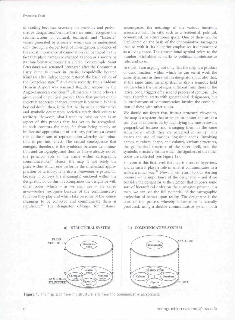
We should not forget that, from a structural viewpoint,the map is a system that attempts to master and order acomplex of information by identifying the most relevantgeographical features and arranging them in the samesequence in which they are perceived in reality. Thismeans the use of various linguistic codes (involvingnames, numbers, shape, and colour), various structures,the geometrical structure of the sheet itself, and thesymbolic structure within which the signifiers of the othercodes are collected (see Figure la).
So, even at this first level, the map is a sort of hypertext,and as such it plays a role in what it communicates in aself-referential way.''' Now, if we return to our startingpremise - the importance of the designator - and if weconsider the designator as the element that imposes somesort of hierarchical order on the surrogates present in amap, we can see the full potential of the cartographicprojection of names upon reality. The designator is thecrux of the process whereby information is actuallyproduced, using a double communicative system, both
a) STRUCTURAL SYSTEM b) COMMUNICATIVE SYSTEM
[ALOGIC
DIGITAL
Figure 1. The map seen from the structural and from the communicative perspectives.
cartographica (volume 40, issue 3)
Towards a Theory of Interpretation: Cartographic Semiosis
analogical and digital, which will be discussed shortly(see Figure lb).
4 . 2 THE MAP AS A LOCUS OF SEMIOSIS
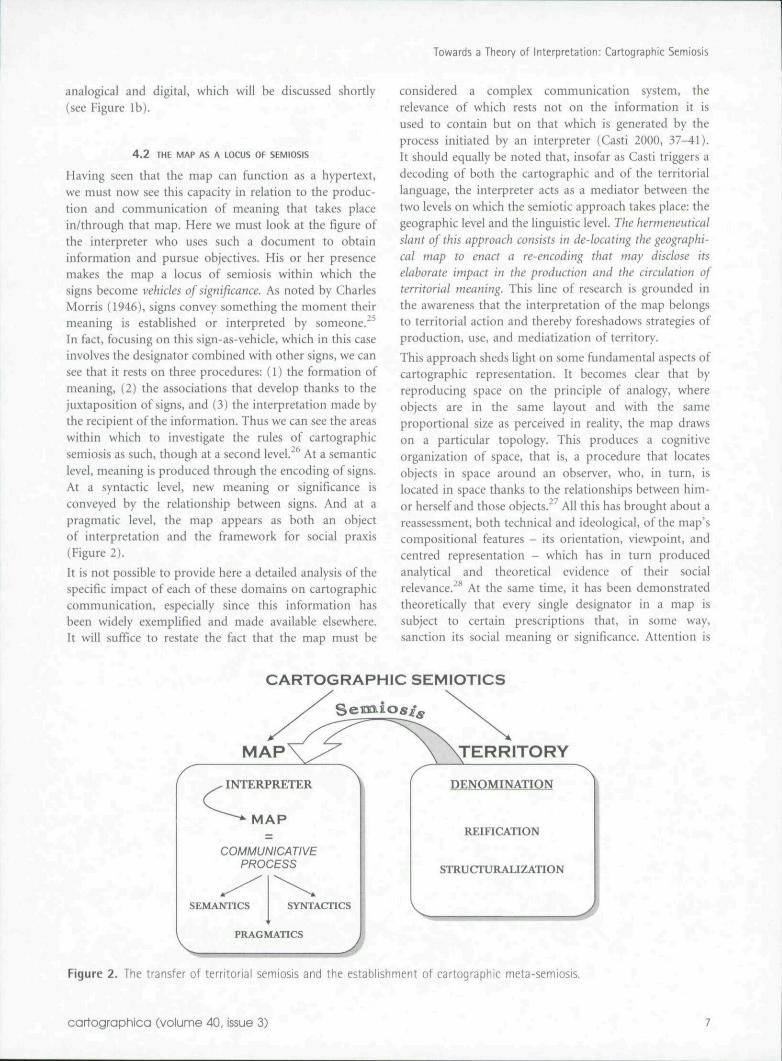
Having seen that the map can function as a hypertext,we must now see this capacity in relation to the produc-tion and communication of meaning that takes placein/through that map. Here we must look at the figure ofthe interpreter who uses such a document to obtaininformation and pursue objectives. His or her presencemakes the map a locus of semiosis within which thesigns become vehicles of significance. As noted by CharlesMorris (1946), signs convey something the moment theirmeaning is established or interpreted by someone.^^In fact, focusing on this sign-as-vehicle, which in this caseinvolves the designator combined with other signs, we cansee that it rests on three procedures: (1) the formation ofmeaning, (2) the associations that develop thanks to thejuxtaposition of signs, and (3} the interpretation made bythe recipient of the information. Thus we can see the areaswithin which to investigate the rules of cartographicsemiosis as such, though at a second level."*' At a semanticlevel, meaning is produced through the encoding of signs.At a syntactic level, new meaning or significance isconveyed by the relationship between signs. And at apragmatic level, the map appears as both an objectof interpretation and the framework for social praxis(Figure 2).
It is not possible to provide here a detailed analysis of thespecific impact of each of these domains on cartographiccommunication, especially since this information hasbeen widely exemplified and made available elsewhere.It will suffice to restate the fact that the map must be
considered a complex communication system, therelevance of which rests not on the information it isused to contain but on that which is generated by theprocess initiated by an interpreter (Casti 2000, 37-41).It should equally he noted that, insofar as Casti triggers adecoding of both the cartographic and of the territoriallanguage, the interpreter acts as a mediator between thetwo levels on which the semiotic approach takes place: thegeographic level and the linguistic level. The hermeneuticalslant of this approach consists in de-locating the geographi-cal map to enact a re-encoding that may disclose itselaborate impact in the production and the circulation ofterritorial meaning. This line of research is grounded inthe awareness that the interpretation of the map belongsto territorial action and thereby foreshadows strategies ofproduction, use, and mediatization of territory.
This approach sheds light on some fundamental aspects ofcartographic representation. It becomes clear that byreproducing space on the principle of analogy, whereobjects are in the same layout and with the sameproportional size as perceived in reality, the map drawson a particular topology. This produces a cognitiveorganization of space, that is, a procedure that locatesobjects in space around an observer, who, in turn, islocated in space thanks to the relationships between him-or herself and those objects."'' All this has brought about areassessment, both technical and ideological, of the map'scompositional features - its orientation, viewpoint, andcentred representation - which has in turn producedanalytical and theoretical evidence of their socialrelevance.̂ ** At the same time, it has been demonstratedtheoretically that every single designator in a map issubject to certain prescriptions that, in some way,sanction its social meaning or significance. Attention is
CARTOGRAPHIC SEMIOTICS
INTERPRETER
MAP
COMMUNICATIVEPROCESS
SEMANTICS SYNTACnCS
PRAGMATICS
DENOMINATION
REIFICATION
STRUCrURAUZATION
Figure 2. The transfer of territorial semiosis and the establishment of cartographic meta-semiosis.
cartographica (volume 40, issue 3)
Emanuela CastJ
focused on certain aspects rather than others byprocedures through which surrogates neutralize excessinformation and prescribe certain possible interpretationson the basis of what is included and what is excluded{Casti 2000, 151-73).
in effect, the real change in approach comes from the factthat the map is no longer seen solely as an importantinstrument in the intellectual appropriation of territory: italso serves as a crucial instrument in reinforcing the entireprocess of territorialization. In certain social-historicalcontexts, the map becomes the system whereby an entirecommunity posits its relations to the world. Let us think,for instance, of the maps drawn during the age ofdiscoveries and great explorations, where the progressiveexpansion of space went hand in hand with the accretionof geographical knowledge. The Mediterranean, featuredthroughout the fourteenth century as the one and onlysubject of maps, was gradually marginalized with respectto the ocean system following the discovery of America.Again, borders are delineated via maps, which setbeforehand the geographical features to be later detectedon territory, as in the case of rivers. Waterways areroughly mapped to demarcate borders, and if a fieldtrip reveals inconsistencies, map lines are privileged.Throughout the colonial era, maps served as mediationtools whereby projects were enforced and courses ofaction decided in theory over territory that was unknownexcept via the maps themselves. The project of territorialre-evaluation promoted by French colonialists in Africawas carried out on the ground with information gatheredfrom the thematic maps drawn with that specific intent(Casti 2001b, 429-50). Thus cartography seems to be theproduct of a culture that generates a culture. It takes thecognitive patrimony of a particular society and uses it toenrich territorial knowledge. It puts itself forward as anautonomous means of communication. It presents itselfas an innovative interpretation of the world generatedwithin the mechanisms of territorial or social controlestablished by the society that produces it.
4 . 3 THE CARTOGRAPHIC ICON
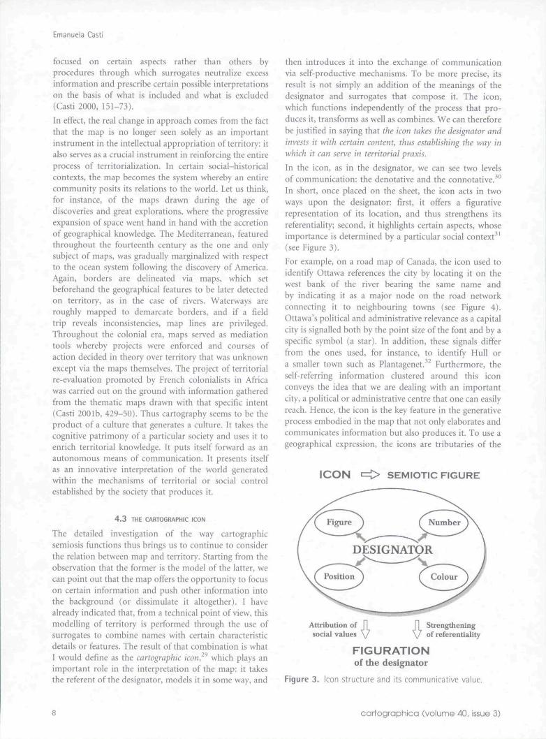
The detailed investigation of the way cartographicsemiosis functions thus brings us to continue to considerthe relation between map and territory. Starting from theobservation that the former is the model of the latter, wecan point out that the map offers the opportunity to focuson certain information and push other information intothe background (or dissimulate it altogether). I havealready indicated that, from a technical point of view, thismodelling of territory is performed through the use ofsurrogates to combine names with certain characteristicdetails or features. The result of that combination is whatI would define as the cartographic icon,^^ which plays animportant role in the interpretation of the map: it takesthe referent of the designator, models it in some way, and
then introduces it into the exchange of communicationvia self-productive mechanisms. To be more precise, itsresult is not simply an addition of the meanings of thedesignator and surrogates that compose it. The icon,which functions independently of the process that pro-duces it, transforms as well as combines. We can thereforebe justified in saying that the icon takes the designator andinvests it with certain content, thus establishing the way inwhich it can serve in territorial praxis.
In the icon, as in the designator, we can see two levelsof communication: the denotative and the connotative.'^"In short, once placed on the sheet, the icon acts in twoways upon the designator: first, it offers a figurativerepresentation of its location, and thus strengthens itsreferentiality; second, it highlights certain aspects, whoseimportance is determined by a particular social context'^'(see Figure 3).
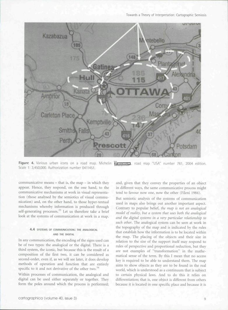
For example, on a road map of Canada, the icon used toidentify Ottawa references the city by locating it on thewest bank of the river bearing the same name andby indicating it as a major node on the road networkconnecting it to neighbouring towns (see Figure 4).Ottawa's political and administrative relevance as a capitalcity is signalled both by the point size of the font and by aspecific symbol (a star). In addition, these signals differfrom the ones used, for instance, to identify Hull ora smaiier town such as Plantagenet."*" Furthermore, theself-referring information clustered around this iconconveys the idea that we are dealing with an importantcity, a political or administrative centre that one can easilyreach. Hence, the icon is the key feature in the generativeprocess embodied in the map that not only elaborates andcommunicates information but also produces it. To use ageographical expression, the icons are tributaries of the
ICON i=C> SEMIOTIC FIGURE
DESIGNATOR
\ /^^ ~^Positioii I ( Colour
Attribution ofsocial values
Strengtheningof referentiality
FIGURATIONof the designator
Figure 3. Icon structure and its communicative value.
cartographica (volume 40, issue 3)
Towards a Theory of Interpretation: Cartographic Semiosis
OTTAW
Larleton Place(
SmithkFall
Figure 4. Various urban icons on a road map. MichelinScale 1: 3,450,000. Authorization number 0411451.
road map "USA" number 761, 2004 edition.
communicative means - tbat is, the map - in wbicb tbeyappear. Hence, they respond, on tbe one hand, to tbecommunicative mecbanisms at work in visual representa-tion (those analysed by the semiotics of visual commu-nication) and, on tbe other band, to those hyper-textualmechanisms whereby information is produced throughself-generating processes.^^ Let us therefore take a brieflook at tbe systems of communication at work in a map.
4 . 4 SYSTEMS OF COMMUNICATION: THE ANALOGICAL
AND T»E DIGITAL
In any communication, the encoding of tbe signs used canbe of two types: tbe analogical or the digital. Tbere is athird system, tbe iconic, but because this is the result of acomposition of the first two, it can be considered assecond-order, even if, as we will see later, it does developmethods ot operation and function that are entirelyspecific to it and not derivative of the other two.*'*
Witbin processes of communication, the analogical anddigital can be used either separately or together. Tbeyform the poles around which the process is performed;
and, given that tbey convey the properties of an objectin different ways, tbe same communicative process mighttend to favour now one, now the other (Fileni 1984).
But semiotic analysis of tbe systems of communicationused in maps also brings out another important aspect.Contrary to popular belief, the map is not an analogicalmodel of reality, hut a system that uses both the analogicaland the digital systems in a very particular relationship toeach other. The analogical system can be seen at work inthe topography of the map and is indicated by tbe rulesthat establish how the information is to be located witbinthe map. The placing of the objects and their size inrelation to the size of the support itself may respond torules of perspective and proportional reduction, but theyare not examples of "transformation" in the mathe-matical sense of tbe term. By this I mean that no accesskey is required to be able to understand them. Tbe mapaims to sbow objects as they are to be found in tbe realworld, which is understood as a continuum that is subjectto certain physical laws. And to do this it relies ondifferentiation; that is, one object is different from othersbecause it is located in one specific place and because it is
cartographica (volume 40, issue 3)
Emanuela Casti
sbown witb specific characteristics.'*'' For its part, thedigital system transmits information about a specificgeographical object through tbe use of various codes(colour, number, shape, etc.) that are intended to isolateonly certain aspects of tbe referent of tbe designator. Inother words, the digital system aims to create distinctionsin order to convey wbat makes an object tbat object andno other.
From tbe above it will be clear, however, that the relationbetween the digital and tbe analogical is not simplycontrastive/oppositional, although it can be so at times(Turco 1987, 123-33). Witbin a map, it is tbe analogicalsystem tbat constitutes tbe "context" for tbe operation oftbe digital system. Indeed, tbe analogical cannot even beseen in total isolation from the implications of a digitalsystem, because, as we bave already observed, the presenceof the two systems together can bring the third system,the iconic, into play. This third system organizes tbeinformation from another, implicitly cultural, point ofview. The icons do not show reality as it is; ratber, theyshow how it appears within a particular theory of theworld. It is through the action of icons that wbat isrepresented becomes conceptualized and is communi-cated through a dynamic process tbat offers a particularvision of the world. Hence, tbe iconic system draws on themap's ability to transmit the cultural values attributed toor invested in a specific territory. And, of course, it sbouldbe reiterated that such connotations perhaps do notactually belong to the territory itself but, rather, are theproducts of the map itself, as we shall observe in thesection devoted to iconization (section 4.6 below).
4 . 5 THE SELF-REFERENTIAL WORLD OF CARTOGRAPHY
The full weigbt of this last statement becomes moreobvious when we bring in one of the very first results ofcartographic semiosis: self-reference. In tbe course of thisdiscussion I bave repeatedly mentioned self-reference asone of tbe properties of maps. By "self-reference" I meanthe ability of a map to be accepted as such and, at thesame time, to play a role in communication that isindependent of tbe intentions of tbe cartographer whoproduced it. Because of cartographic self-reference, namesand symbols on a map do not merely replicate empiricaldata of a physical, natural, or anthropic kind. Rather, inaccordance witb tbeir own autonomous sets of rules, theyproduce additional meanings that affect the very percep-tion observers have of the places that fall under theircognitive scrutiny. This self-reference is the result of tbetype of communicative system used and of tbe action oftbe icon in developing denomination. Names, shapes, andcolours - in sbort, tbe entire language of the map - playa part in this "self-generating" mechanism. In effect,the map becomes self-referential because it sbows itselfcapable of conditioning information upon the things itdepicts. This means tbat, once created, the map is a system
of signs endowed with a life of its own; it developsindependently of what preceded it and of the intentionsbehind its original creation.
In addition to this "internal" aspect of cartographic self-reference, tbere is also an "external" one. The veryinterpretation of a map is bound up witb tbe stratificationof cartographic documents over time and tbe accumu-lated experience of tbe people called upon to read tbem.Such experience and stratification defines what consti-tutes "a map," influences tbe way it is perceived, andconstructs tbe "memory" of the people interpreting it,thereby broadening its scope of action/^
In effect, the map's ability to serve as a representationrests on its ability to regulate tbe complexity of the realworld by applying metrics that make it possible forinterpreters to perceive geographical as cartographicspace. It is this that makes it possible for the map todirect multiple courses of action determined on tbe basisof tbis "newly created reality." The final outcome is, as wewill see shortly, iconization, or tbe ability to establish howterritory should be conceived and experienced.
One can, in fact, invert the claim that "the map is not theterritory" and claim the very opposite: the map becomesterritory as sucb. And it is tbis paradox that leads to thefull development of a map's self-referential capacity. Themap does not offer itself as territory; it actually presentsitself as existing at a bigber level than brute reality. By wayof example, consider tbe map used by Italian armyofficials to approach tbe city of Adua in tbe course ofEthiopia's colonization. Having been drawn witb thisspecific aim, this map featured only those elements thatthe cartographer deemed essential for a swift approach tothe city. In fact, by featuring only mountains to be usedas signposts for tbe approach and neglecting surveymorphology, the map propagated the misconception thatplains must exist between those mountains. This infor-mation, self-referential in its kind, originated from thefact that the author of the map had used contour lines tomark mountain ranges. In accordance with topographicconvention, it was perfectly legitimate for others to inferthat the absence of contour lines identified fiatlands.Although challenged by real-world experience - the factthat the landscape looked completely mountainous - thisinformation induced army officials to proceed with theintent of reaching the plains supposedly marked onthe map and of launching an attack from there. TheAbyssinians were thus given a chance to attack, andeventually managed to defeat, the Italian army. Eventhough, in this case, cartographic self-reference playedinto the cartographer's mistake, it turned out to besuccessful because it was granted preference overterritory. To conclude, I will claim that maps turntheir point of weakness into their strong point. As amodel, they cannot duplicate reality, but they can
cartographica (volume 40, issue 3)
Towards a Theory of Interpretation: Cartographic Semiosis
substitute for it, and the primary outcome of thissubstitution is iconization.
4 . 6 ICONIZATION
Iconization marks the high point in the map's productionand conveyance of meaning and significance. It can bedefined as the communicative issue whereby the self-referential mechanisms of the map are used to conveyconjectures as truths.
In short, the message conveyed by the map can actuallyreplace reality. By instilling the information it generateswith relevance - as a real reflection of the characteristicsof territory - it can determine behaviour. This is becauseiconization takes the meaning generated by a mapand introduces it into a circuit of communication byexploiting the main functions of the map itself: descrip-tion and conceptualization. In looking at these twofunctions, we should recall that the map meets two basicneeds in the intellectual appropriation of reality. First,it offers a description that presents the features of theterritory that could be perceived through direct observa-tion of the real world; second, it offers a conceptualizationof the world, applying the categories of representation(which embody an interpretation) in order to say howthe world "works." It will then be possible for us todistinguish between maps that favour description as theircommunicative mode and maps that are instead elabo-rated on a worldview only partially adherent to estab-lished canons of real-world mimesis. Nonetheless, theimportant point here is the relationship between this andwhat has already been stated about the map's function inturning territory into discourse; the map causes a shift incommunication from the level of description to the levelof enunciation. It has been pointed out how the body ofcommunicative procedures used by the icon to "show"the statement conveyed in this discourse can be tracedback to the map's use of figurative rendition, the ultimateeffect of which is iconization/̂ ** The effect of iconization isto shift the communication from the level of descriptionto that of conceptualization. The message conveyednow contains a social meaning as well. This means thatregardless of whether the map intends to convey conceptsor "mere" descriptions, the very use of figuration resultsin the production of icons. The result is that the reliabilityattributed to the description is also attributed to theconcept. In other words, iconization promotes the use ofthe map as a theory one can rely on to assess all theinformation involved by activating a system in whichvarious pieces of information and concepts are made tocirculate endlessly and in different forms upon the doubleplane of cartographic communication: to describe and toconceptualize.
This is all the more evident when the map representsterritory removed from the society where the map is
drawn. Consider, for instance, a colonial map of Africareflecting typical Western values by mapping features inthe form of material achievements (e.g., a monument, abuilding) or in a layout based on geometry (urban layout,road network, borders). Such a map fails to account forother values, namely symbolic ones that underpin Africansociety. Consequently, insofar as they ignore the cosmo-logical value system on which African society is rootedand operated, cartographic documents obliterate itsvery functioning. Thus iconization produces two mainoutcomes: first, it denies these cosmological values andthereby African territorial layout; second, it ascribes toAfrican territory the unfamiliar, homogenizing values ofthe colonizing culture.
Many examples from colonial cartography illustrate thispoint.̂ "̂ Think, for instance, of the typical African village.in which the territorial layout relies on an internalhierarchy and a power structure conveyed by thearrangement of huts. In most cases this arrangementwas neglected by colonial cartographers, who perceivedit as a random and chaotic jumble and drew their mapsaccordingly. Self-reference qualifies the African village asa built-up area devoid of functional order. Furthermore,iconization adds force to the perception that it is lessimportant than a neatly laid out, functional, and fullyequipped colonial town. Similarly, the sacred area ofwooded land where relations between individuals wereestablished and where villagers performed their sacredrituals was represented as a mere feature of the naturallandscape that cartographic self-reference conveyed asirrelevant because of its small size. Iconization, in turn,came to obliterate the woods' social importance and fedthat social importance into the circuit of colonial interestsas a small group of trees. On a final note, we can considermountains that Africans associated with gods and thuswere excluded from appropriation - even giving names tothese mountains was not permitted. To Western carto-graphers, a mountain was simply yet another discovery; itwas named, using colonial designators, and surveyed justlike any other territorial feature. Iconization took overby ranking the mountain according to its elevation, inkeeping with colonial appraisals. All territory was thusrepresented on the basis of Western criteria and managedaccordingly.
Iconization can be found also in maps that representterritory within the society where the maps are produced.Let us consider a current tourist map of Death Valley,California. The valley's territorial layout is based on theroad network and on tourist and surveillance facilities,all of which provide a detailed and exact representation.Self-reference acts upon this description by extendingits informational layout to the whole desert, which,despite unfavourable natural conditions, is thus featuredas territory that has been fully - both physically andintellectually - appropriated.
cartographico (volume 40, issue 3) 11
Emanuela Casti
Intellectual appropriation takes control where material,anthropic intervention ceases and uses denomination toinduce syntactically the idea of a fully anthropomorphizedarea. Designators scattered over the entire desert serve tomark its complete subjection, and iconization takes over,first using all these data to convey the notion that the areais safe and then extending its value judgement to thewhole enterprise wherehy wilderness has been turned intoa social asset.
At this point, therefore, one might claim that the map isan operative mechanism that says the world must be of acertain type and that it must function in a certain way.The map itself is an icon, defining the term in its widestpossible sense to mean an instrument by means of whichone carries out a metamorphosis of the world. But themap also embodies a shift in perspective. The fact that it isa representational mechanism capable of mimesis meansthat it has greater communicative ability than bruteterritory itself, and thus it ends up taking the place of thatterritory. The map's effectiveness as a mimetic devicecomes from its implicit equation - map = territory - anequation that cannot possibly be defined objectively,unless as a potential tool whereby consistency in therelation between society and its space is claimed to beattainable and attained. This power of mimesis, ashighlighted by a semiotic analysis of cartography, iswhat enables a map to compromise and alter the meaningof territory.
5. Society, Cartography, and
Geographical Sciences
The above discussion of development in the theories ofcartographic interpretation now brings us to oneunavoidable question: What skills and abilities arerequired by the person interpreting a map? This questionarises from the fact that cartographic interpretation is oneof those specialist areas in which, I believe, the posses-sion of a certain "expertise" is necessary. Avoiding banalprescriptions as to the characteristics an interpreter musthave, I will limit myself here to what I consider the mostfruitful of the above-outlined approaches to cartographicinterpretation: the semiotic. Given that this approachmoves at a meta-geographical level and thus calls intoplay a second level of interpretation, it would seem that anecessary starting point is a thorough knowledge of thefirst level - that is, of geography itself
Obviously this does not mean that the interpreter mustbelong to one of a certain group of disciplines (geography,history, urban planning, etc.); rather, it means that heor she must possess the instruments suitable for suchcartographic analysis, instruments provided by knowledgeof territorial theories as such. And a more radical questionthat emerges from tbe positing of territory as a complexsystem is whether maps are capable of demonstrating that
complexity. Having freed maps from those beliefs thatsaw them as an instrument that merely registered reality,can we now say that maps are capable of conveying thedeep significance of territory?
Cartographic semiosis has shown not only that maps canconvey complex information but also that this informa-tion is always the product of iconization, and that it isconnected with reality hut cannot simply be super-imposed upon it. In short, it has been shown that, as amodel, a map replaces rather than represents territory.What is more, a study of maps reveals that the result ofthe communicative process they set in action is even moreradical. Maps ultimately call into question the materialsignificance of territory itself. Icons underline therelevance of what is created and imposed by the mapitself They shift aside the actual physical substance of thereal world.
And here another intriguing question arises, which,however, hes outside the scope of the present discussion.As a mechanism of mimesis, what role does the map playwithin the world of the Internet, which is by definitionconcerned with the creation of a non-material world?In spite of numerous attempts to master the role ofcartography on the World Wide Web, that question stillseems to be unanswered. More research and moretheoretical analysis are necessary for an adequate reply.Perhaps, once again, the solution lies in ftirther study ofthe various aspects of mimesis at work in a map.
Author Information
Emanuela Casti holds a tenured position in Geographyat the Faculty of Foreign Language and Literature ofBergamo University in Italy. She has conducted researchon complex communicative systems and developeda cartographic theory published in both Italian (1998)and English (2000). Recently, her contributions havebeen featured in international journals: Cahiers deGeographie du Quebec (2001) and Diskussionsbetraege zurKartosemiotik und zur Theorie der Kartographie (2001).
Notes
1. These approaches are still widely practiced and enjoyhigh standing in the history of cartography, as exemplifiedin the various volumes of The History of Cartography(Harley and Woodward 1987; Woodward and Lewis 1998).
2. For an overview of the dawning antiquarian interestin maps see Harvey (1999).
3. It should be reiterated, however, that these studiesanalysed and threw light upon the relations betweenprinting and cartography. As an example of such works, oneneeds only mention Woodward (1996).
4. Here one need only mention Almagia's investigationof various important documents - including the "Carta del
12 cartographica (volume 40, issue 3)
Towards a Theory of Interpretation: Cartographic Semiosis
territorio Veronese detta dell'Almagia" - which enabled himto date them and put them in social context. See Almagia(1923).
5. In most cases, these works were produced byunknown technicians and land surveyors who usedcartography as a tool for surveying projects commissionedby public or private bodies. But sometimes they wereproduced by great cartographers - or by men who would goon to become such - and, in these cases, the administrativemaps contained important innovations at both technicaland conceptual levels. For a recent discussion of this latterpoint regarding the administrative cartography of theVenetian Republic, see Casti (in press).
6. He produced the two collections: MonumentaItaliae Cartographica (Almagia 1929) and MonumentaCartographica Vaticana (Almagia 1944-1955). A laterwork, produced in collaboration with another scholar,Monumenta Cartographica vetustoris aevi (Almagia andDestombes 1964).
7. Among these, in the Italian context, one shouldmention Marinelli (1881). However, in spite of the fact thatMarinelli was one of the first to take a catalogue raisonr^eapproach, the absence of photographic reproductions(inevitable, given the date of publication) means that hisbook is now of little use as a work of reference.
8. These great collections, which began to appear atthe end of the nineteenth century, cover many regions,including Africa and Egypt (Kamal and Fauat 1926-1951);Portugal (Armando and Teixeira da Mota 1960); Japan(Kazutaka and others 1972); Yugoslavia (Skrivanic 1974);Germany (Meurer 1984); the Netherlands (Schilder andStopp 1986-2003); and Belgium (Watelet 1995).
9. Harley wrote 140 articles and contributed tonumerous books, including "The Map and the Developmentof the History of Cartogaphy" (Harley 1987).
10. 1 am referring to the focus of attention on certainaspects (filigree, heraldic devices, etc.), which are certainlyimportant in the interpretation of a map but should, I think,be left to specialists of certain antiquarian/artisticdisciplines.
11. For the radical position he took - and his belief inhis own ideas - see the debate published in Concepts inthe History of Cartography: A Review and Perspective(Blakemore and Harley 1980; also see Gutsell 1982). On thispoint also see Gould (1995).
12. On this point see also Belyea (1992).13. Though this analytic approach brings together a
limited number of researchers, its importance to theinterpretation of maps has in some way been officiallyrecognized by the creation of the Commission onTheoretical Cartography, a working group of theInternational Cartographic Association (ICA). It shouldalso be mentioned that the heads of that working grouphave set up a series of discussion papers entitledDiskussionsbeitra'ge zur Kartosemiotik und zur Teorie derKartographie. published in Dresden under the editorship of
Alexander Wolodtschenko and Hansgeorg Schlichtmann(respectively president and vice-president of the Commis-sion). All in all, the Commission brings together around 20scholars from all over the world. See the Web site of theCommission on Theoretical Cartography (http://rcswww.urz.ut-dresden.de/-wolodt/tc-com) for more information.
14. Among the many contributions posted on the ICAWeb site (www.icaci.org/), I would like to call attention toWolodtschenko (2003).
15. The full discussion on which this summary is basedcan be found in Casti (1998, 2000). Reviews of this workwere published in Revista Bibliogrdfica de Geograffa yCiencias Sociales (1999): 85; Rivista Geografica Italiana108 (2001): 145-46; and The Portolan 53 (2002): 64.
16. More precisely, reference is made to questions ofcomplexity (Turco 1988). It should be noted that thesestudies rely on findings in the fields of semiotics andlinguistics thanks to the work of scholars such as AlgirdasGreimas (1990) and Ferdinand de Saussure (1966), whoresist disciplinary classification. To a higher degree, this lineof research touches upon the two borderline disciplinesrelated to the philosophy of language and especially to theresearch of Charles Morris (1946). Morris's concepts havebeen elaborated with a view to formalizing a semiotictheory of territory that has proved fruitful and worthpursuing. See, for instance, Turco (1994b).
17. I deal specifically with "designators" rather than"toponyms" because my intent is to reclaim the socialimport of a name, well beyond etymological-linguisticconstraints. While toponymy is the science of place names,denomination goes back to a semiotics of territory. Morespecifically, denominational analysis addresses two issues:(1) the symbolization of a given place and (2) suggestionsas to how that place ought to be perceived and experiencedin society (see Turco 1999, 177-78).
18. The word "reykjavik" in Icelandic translates intoEnglish as "bay of smokes" or "bay of steam." Let us notforget that the distinction between designators is integralto the research on territorialization. Analogies with theterminology developed by J.L Austin and others (especiallyAustin 1962) as part of their speech act theory should beavoided.
19. In fact, the designator is an abbreviated descriptionof reality, a "concentrate" of meaning that includes all thequalities of the object thus identified (Turco 1988, 79-93).With regard to denotation and connotation. I draw uponthe classic semiotic distinction between denotative orprimary codification and connotative or secondary codifica-tion (see Turco 1994b, 372-73).
20.1 refer to the current capital city of the DemocraticRepublic of Congo. Towards the end of the nineteenthcentury, Kinshasa became an important trading post onthe Congo River. On the initiative of the Anglo-Americanexplorer Henry Morton Stanley, the city was renamedLeopoldville in honour of the Belgian King Leopold II. In1966, the designator Leopoldville, clearly a vehicle for
carfographica (volume 40, issue 3) 13
Emanuela Casti
European values, was replaced with the basic designatorKinshasa, corresponding to the name of the village locatedin that same place in the nineteenth century.
21. This was done to reaffirm the coalition's resolve toliberate the country from Saddam's dictatorship and returnit to the Iraqi people.
22. Important clues to be kept in mind in cartographicinterpretation are given not only by designative names but,more generally, by all the captions on a map that refer to therelation between society and territory and provide informa-tion about it.
23. A denominative surrogate can be any figure,number, colour, or even the position of the name itself onthe map, intended to make explicit the quality of the objectrepresented on the map. The term "surrogate" refers to thefact that 3 missing name is replaced with, or surrogated by,another sign (figure, number, colour, or even position onthe map). On the projection of names, see Casti [1998,65-96).
24. In fact, the use of various structures facilitates theconveyance of information, and the interrelation betweendifferent codes brings out what might remain obscured inone individual code. For the results in communication ofthe passage from a single-structure system to a multi-structural language, see Cassirer [1955, 1961).
25. Here I take up the model proposed in Morris (1946),which moves away from an analysis of the sign in itself andthus transcends the confines of logic semiotics (C.S. Peirce)or linguistic semiotics [Ferdinand de Saussure). Morrisadopts a functional, organic view of language gearedtowards pragmatics and reflects upon a sign's commu-nicative aspect and its nature as a sign-vehicle, that is tosay, for our purposes, as a designator that incorporatesinformation and conveys it in the presence of an interpreter.Let us not forget that cartographic semiosis proposes astudy of the geographical map as a symbolic operator and,as such, is not directly concerned with the analysis of theworkings of the sign in itself, as suggested by MacEachren(1995). What cartographic semiosis favours is a study ofhow the interpreter involved in the process of territo-rialization is affected by the study of the map itself.
26. What I am arguing here is that the presentanalytical approach aims at investigating meta-semiosis,which is rooted in territorial semiosis.
27. See Greimas and Courtes (1993, 358-59). On thespatial organization involved in creating a system ofterritorial reference, see Turco (1994a, 15-58).
28. It has been argued that the orientation of the mapdepends on the position of the viewer. It should also beremembered that, even though the viewer is positionedideally outside the real world, the properties of his or herperceptive, self-centred space are still assimilated andconveyed through a language that hinges on a designator inits referential function.
29. It is worth noting that I use the word "icon" in asense so far unknown in the context of cartographic
studies. "Icon" refers here to a semiotic figure that is, assuch, capable of producing information and processing it ina communicative sense. The word therefore carries adifferent meaning than when it is used by authors whohave focused on the semiotic analysis of maps. Drawingupon Peirce, for instance, MacEachren (1995, 222) claimsthat the icon is "a sign-vehicle that refers merely by virtueof characters of its own." Dealing in his turn withthe iconic code. Wood (1992, 117) holds that "it governsthe manner in which graphic expressions correspond withgeographic items, concrete or abstract, and their attendantattributes."
30. I am thinking here of the two levels as discussedin semiotics: see Eco (1986, 181-83) and Sonneson (1998,187-89).
31. ft is worth pointing out that the use of figurativeprocedures in the creation of such icons not only developsthe information communicated by the designators but alsointensifies it. Such procedures are spatial organization, inwhich topography serves to reinforce the referential natureof the map, thus working at a denotative level; figurationproper, in which visual codes are used to highlight thedistinctive features of the referent; and iconization, whichcombines the results of spatial organization and figurationand imbues the designator with social implications orvalues. The result is that the latter becomes symbolic and/orperformative (see Casti 1998, 70).
32. In order to underscore the city's role, the label forOttawa is printed in red on the coloured version of the map.Red is not used for labels of other cities.
33. On the semiotics of vision see Arnheim (1974).Rudolf Arnheim's work played a central role in the researchon the semiotics of vision while also promoting parallelstudies in art history and art experimentation (Hockney andStangos 1993). The studies of hyper-textual systems carriedout by Lotman [1985) and Greimas (1990) were followed bythose from the field of art history, such as Panofsky [1991),Arnheim (1974), and Gombrich [2000), which in turn gaverise to a separate branch classified as visual communicationscience. The aim of this discipline is to examine commu-nicative processes and their self-referential implications.See, among others, Bettetini (1991), Appiano [1993), andFontanille (1995).
34. The analogical and digital systems are also to beseen at work in the biological conveyance of informa-tion, which in certain ways might be considered as a"primary level of communication." However, in suchbiological "communication" iconization is totally absent,revealing the latter's purely cultural status [see Wilden1978, 601-95; see also Wilden 1980).
35 On. this subject, Bateson [1979, 110) takesup a phrase of Korzybski - "the map is not the territory"[1998) - and argues, "we see the map as some sort of effectsummating differences, organizing news of differences."
36. Memory means that the interpreters of a documentwork within codification that has already taken place.
14 cartographica (volume 40, issue 3)
Towards a Theory of Interpretation: Cartographic Semiosis
and sedimentation over time has consolidated the variousattributions of significance and meaning. In the same way,the connection between the signs obeys rules of visualperception. The information conveyed is not the sum ofthat conveyed by each icon but the result of the interac-tion between those pieces of information. In short, theinterpretation of a map relies on recognition of the waysin which a map defines itself as such (see Casti 2000,140-44).
37. For a thorough discussion of this instance see Casti[1996, 17-79).
38. See note 29 above.39. With respect to British colonial cartography, one
instance can be found in Brambilla (2004, 263-316).
References
Almagia, R. 1923. "Un'antica carta topografica del territorioVeronese." In Rendiconti delta Regia Accademio Nazionole delLincei, vol. 32, fasc. 5-6. Rome: RegIa Accademia Nazionaledei Lincei. 61-84,
-. 1929. Monumenta Italiae Cartographica. Florence:Istituto Geografico Militare.
. 1944-1955. Monumerita Cartographica Vaticana.4 vols. Vatican City: Biblioteca Apostolica Vaticana.
Almagia, R., and M. Destombes. 1964. MonumentaCartographica vetustoris aevi. Amsterdam: N, Israel.
Appiano, A. 1993. Comunicazione visivn. Apparenza, reaita,rappresentazione. Turin: UTET.
Armando, C, and A. Teixeira da Mota. 1960. PortugaliaeMonumenta Cartographica Lisbon: Imprensa National - Casade Moeda.
Arnheim, R. 1974. Art and Visual Perception. Berkeley:University of Califomia Press,
Austin. J.L 1962. How to Do Things with Words. Oxford:Oxford University Press,
Bateson, G, 1979, Mind and Nature: A Necessary Unity.New York: Dutton.
, 1984. Mente e natura, trans. G, Longo. Milan: Adelphi.
Belyea, B. 1992, "Images of Power: Derrida/Foucault/Harley."Cartographica 29J2: 1-9.
Bettetini, G, 1991, to simulazione visivo: inganno, finzione,poesia, computer graphics. Milan: Bompiani.
Blakemore, M,J,, and J.B. Harley eds. 1980. Concepts in theHistory of Cartography: A Review and Perspective.Cortagraphica 17/4: Monograph 26.
Brambilla, C. 2004. "Frontiere coloniall e identita africana: ilconfine orientale del Ghana e I'identita Ewe." In Luoghi eIdentita. ed. E. Casti and M. Corona. Bergamo: BergamoUniversity Press. 263-318.
Cassirer, E, 1955. The Philosophy of Symbolic Forms. NewHaven: Yale University Press,
. 1961, Filosofia delle forme simboliche, trans, E. Arnaud.Florence: La Nuova Italia,
Casti, E, 1996,"La mappa del Baratieri: !a sconfitta di Adua ela vittoria dell'autoreferenza cartografica." Terra d'Africa1996: 17-79.
. 1998. L'ordine del mondo e la sua rappresentazione.Semiosi cartografica e autoreferenza. Milan: Unicopli.
, 2000, Reality as Representation: The Semiotics ofCartography and the Generation of Meaning. Bergamo:Bergamo University Press.
, 2001a, "The Analogical and Digital Systems in EuclideanCartography: The Colonisation and Iconisation of Africa,"Diskussionsbetraege zur Kartosemiotik und zur Theorle derKartographie 4: 15-28.
. 2001b, "Mythologies africairies dans la cartographiefran^aise au tournant du XIX^'^' siecle." Cahiers degeographie du Quebec 46: 429-50.
. In press. "State, Cartography and Territory in theVenetian and Lombard Renaissance." In The History ofCartography, vol. 3, ed, D. Woodward, Chicago: Universityof Chicago Press.
Eco, U. 1986. "Oenotation/Connotation." In EncyclopedicDictionary of Semiotics, vol, 1, ed. T.A. Sebeok. Berlin:Mouton de Gruyter, 181-83.
Farinelli, F. 1983, "Alle origini della geografia politica'borghese.'" In Geografia politica: teorie per un progettosociate. ed. C. Raffestin. Milan: Unicopli, 21-38,
. 1992, / segni del mondo. Immagine cartografica ediscorso geografico in eta moderna. Florence: La Nuova Italia.
Fileni, F. 1984, Analogico e digitale. La cultura e lacomunicazione. Rome: Gangemi.
Fontanille, J. 1995. Semiotique du visible. Des mondes delumiere. Paris: Presses Universitaires de France.
Gombrich, E.H, 2000, The Uses of Images: Studies inthe Social Function of Art and Visual Imagery. London:Phaidon.
Gould, P. 1995. "Une predisposition a la controverse,"In Le pouvoir des cartes. Brian Harley et la cartographie.ed, P. Gould and A. Bailly. Paris: Anthropos, 53-58.
Greimas, A.J. 1990, The Social Sciences: A Semiotic View.Minneapolis: University of Minnesota Press.
Greimas, AJ., and J. Courtes, 1993. Semiotique,dictionnaire raisonne de la theorie de langage. Paris:Hachette,
Gutsell, B,V,, ed. 1982. "Cartographic Commentary."Cartographica 19/1: 66-96.
Harley, J.B. 1987. "The Map and the Development of theHistory of Cartography," In The History of Cartogrophy. vol. 1,ed. J.B. Hariey and D. Woodward. Chicago: University ofChicago Press. 1-42,
. 1988. "Maps, Knowledge and Power." In TheIconography of Landscape. Essoys on the SymbolicRepresentation, Design and Use of Past Environments.ed. D. Cosgrove and S. Daniels, Cambridge: CambridgeUniversity Press, 277-312.
-. 1989. "Deconstructing the Map." Cartographica 26/2:1-20.
cartographica (volume 40, issue 3) 15
Emanuela Casti
Harley, J.B., and D. Woodward, eds. 1987. The History ofCartography, vols, 1 and 2. Chicago: University of ChicagoPress.
Harvey, M. 1999. The Island of Lost Maps: A True Story ofCartographic Crime. New York: Broadway.
Hockney, 0., and N. Stangos. 1993. That's the Way I See ItSan Francisco: Chronicle.
Jacob, C. 1992. L'empire des cartes. Approche theoriquede la cartographie a travers I'histoire. Paris: AlbinMichel.
Kamal, Y., and S. Fauat. 1926-1951. MonumentaCartographica Africae et Aegypti. 5 vols. Cairo: Brill [privateedition for Prince Kamal]. Reprint: Institut fiir Geschichteder Arabisch-lslamischen Wissenschaften. 1987. MonumentaCartographica Africae et Aegypti. Frankfurt: JohannWolfgang Goethe Universitat.
Kazutaka, U., 0. Takeo, M. Nobuo, and N. Hiroshi. 1972.Monumenta Cartographica Japonica. Tokyo: KodanshaShowa,
Korzybski, A. 199B. Une carte n'est pas un territoire.Prolegomenes aux systemes_ non-aristote'liciens et a lase'mantique generate. Paris: L'Ectat.
Lotman, Y.M. 1985. La scmiosfera: I'asimmetria e il dlalogoddle strutture pensanti. Venice: Marsilio.
Marinelli, G. 1881. Saggio di cartografia della regione veneta.Venice: Naratobich.
MacEachren, A. 1995. How Maps Work: Representation,Visualization and Design. New York: Guilford.
Meurer, P.H. 1984. Monumenta Cartographica Rhenaniae.Monchengladbach, Germany: Stadtarchiv Monchengladbach.
Morris, C. 1946. Signs, Language and Behaviour. New York:Prentice Hall. [Italian edition: Morris, C. 1949. Linguaggioe comportamento, trans. 5, Ceccato.Milan: Longanesi.]
Panofsky, E. 1991. Perspective as Symbolic Form. New York:Zone.
de Saussure, F, 1966. Course in General Linguistics. New York:McGraw-Hill.
Schilder, G., and K. Stopp. 1986-2003. MonumentaCartographica Neerlandica. 1 vols. Alphenaan den Rijn,The Netherlands: Uitgeverij Canaletto/Repro.
Skrivanic, G.A. 1974. Monumenta Cartographica Jugoslaviae.Belgrade: Istorijski Institut.
Sonneson, G. 1998. "Denotation/Connotation." InEncyclopedia of Semiotics, ed. P. Bouissac. Oxford: OxfordUniversity Press. 187-89.
Turco, A. 1987. "Analogique et digital en geographie." In Leslangages des representation geographiques. ed. G. Zanetto.Venice: Universita degli Studi, Dipartimento di ScienzeEconomiche. 123-33.
. 1988. Verso una teoria geografica della complessitd.Milan: Unicopli.
. 1994a. "Dire ia terra: la costituzione referenzialedel territorio in Costa d'Avorio." Terra d'Africa 1994: 15-58.
. 1994b, "Semiotica del territorio: congetture, esplora-zioni, progetti." Rivista Geografica Italiana 101: 365-83.
, 1999. Terra eburnea, il mito, il luogo, la storia In Africa.Milan: Unicopli.
Watelet, M. 1995. Monumenta Cartographica Walloniae.Brussels: Editions Racine.
Wilden, A. 1978."Comunicazione." Enciclopedia. vol. 3. Turin:Einaudi. 601-95.
. 1980. System and Structure. New York: Tavistock.
Wolodtschenko, A., ed. 2003. The Selected Problems ofTheoretical Cartography, 2002. Dresden: ICA.
Wood, D. 1992. The Power of Maps. New York: Guilford,
Wood, D., and J. Fels. 1986. "Designs on Signs: Myth andMeaning in Maps." Cartographica 23/3: 54-103.
Woodward, D. 1996. Map Prints in the Italian Renaissance.London: British Library.
Woodward, D., and G.M. Lewis, eds. 1998. The History ofCartography, vol. 2, book 3. Chicago: University of ChicagoPress.
16 cartographica (volume 40, issue 3)