mapping and documentation of a historic african-american site
TRANSCRIPT

546
541.02
541.01
540
548
549549.01
549.02
549.03
514
539.05
539
539.04
539.03
539.02
539.01
533
536.05
536.04
536.03
536.02
536.01
537
538.01
538.02
532 531
530.03
530.02
530.01
534.02
534.01
535.02
535.01
515
516
517
518
519
553.02
522.02
522.01
523
526
527
528
528
525.03a
529.03b
525.03
525.01
569
568
572
573.01 573.02
573.03
573.04
583
570
571
566
574
582
575
576
587
586
585
584.03
584.02
584.01
591
588
589
597
598
599
595
596 600.01
600.02
600.03
600.04
600.05
602
601.01
601.02
604
603
605.02
605.01
608
613
609
627
626
616
615
614
618
619
620
621
629
630
631
642.04
642.03
642.02
642.01
645
642.04f3
644.02
644.01
646.03
646.02
646.01
1026.01
1026.02
1025
647.01
647.02
647.03
647.04
647.05
647.06
647.07
647.08
652
650
649
1095
1096
1096
648.04
648.05
648.03
648.02
648.01
653.02
653.01
654
594.03
594.02
594.01
1021
1022
1020
1019 593.06
593.05
593
593.03
593.04
593.01593.02
592.01
592.02
592.03
592.04
1018
562
561
560.01
365955
564
565
553.01
552
551.01
551
557.01
557.02
558
550.04
550.05 550.03
550.01
550.02
512513
549.04
511
509
508
510
506
507
487
486486.01
484
485
483
482
442
443
441
438
439
444406
407
403
405.02
405.01
404
398
399
400
401
396
395
397.01
397.02
147
149
393
394
445
449417 418
450
451
455
454
447
448
479.01
479.02
479.03
479.04
479.05 480
481
505.01
505.02
505.03
505.04
505.05
505.07
505.06
505.11
505.10
505.09
489488
491
490
492
504.04504.02
504.01
504.03
499
498
500
497.02
497.01
497.04
497.03
501
496
495
493
463
462
477
476
475
474
473
472
494.01
494.02
556
555
554
979.01
979.02
979.03
979.04
1012
1012
979.05
980 981
470
471
467
465
466
968.02
969
968.01
968.09
968.08
968.07
968.06
968.05
968.04
968.03
856
970.05
970.06
892
970
970.03
970.02
970.01
972
970.04
971
889
973977
978
978.03
978.02
978.01
1011
10051006
1007 1008
1009
468
900.02
900.01
899
904
898
897
896
895
902
901
903
974
975 976
890
891
862
863
861
860
859
853
854
855
858
864
1098
850849
847.08847.01
847.08f1
847.08f2
847.07
847.06
847.09
848
847.05
847.04
847.03
845
846.01846.02
434
436
433.03
433.02
433.01
432
431
429
428
423
424
426
425
427430.02
430.04
430
430.01
430.03
415
416414
413.02
413.01
412
140
411
141
144142
143.01
143.02
143.03
143.04
220
206
113.06
113.05
113.04
113.03
113.07
113.02
113.01
114
115
112.07
112.05 112.06f
112.04
112.03
112.02
112.01 123
124.01
142.02
124.03111110.04
110.03 110.05
125
110.02
110.01
126.02
126.01
126.03
127
128
129
130
132
131
138 139
137
136
135
134
133.02
133.01
133.05
133.04
133.03
437.08
437.07
437.03437.02
437.05
437.04
437
437.09
811
437.16
437.17
437.18
437.19
437.15
437.14
437.13
437.12
437.11
437.10
437.20
437.21
437.01
843
813
812
810
814
842
841
839
815
809
808
817
818
816
819
838836
837.01
837.02
832
833
834
835
867.02
867.01
865
866
829
830
831
869
868
878879
880.02
880.01
881
883884
888884f2
884f1
885
886
877
876
875
828
824
825
826
804
823
791
803
793
792
794
795
805
796
822
821
806
807
820
790.01
790.02
789
781
782
783
226
227
228
229
225
224
223
233
208
207
210
209
222
221
220
230
218.01
218.02
219
217
211
211.01
211.02
231
232
788
784.01
342.04
342.03
342.02
342.01
342.06
342.07
785
786
787
799.01
799799.02
799.03
800
100
101
56
53
50
4955
102
103
104105
5452
51
106.01
106.02
106.03
106.06
106.05
106.07106.04109.04
109.03
109.02
109.01
42
41.02
41
57.01
57.02
38
31.01
31.02
31.03
31.04
31.05
59
61.01
61.02
61.03
61.04
122.01
122.11
122.10
122.09
122.03
122.04
122.05
122.06
122.07
122.08122
121.04
121.01
121.03
118.01
119
117
1.02
1.01
1.03
657
686
658
3
4
7
9
10
24
23
14
15
2216
17
18
19
31.06
31.07
25
20
21
26
27
28
36
35
30
39
349
351
352
350
348
346
345
43 47 46
44
45
48
344
343.05
343.04
343.03
343.02
343.01
357.02
357.05
357.04
357.03
357.01
357.03
212
213
214
215.01
215.02
216.01
216.02
216.03
216.04
216.05
341.03
341.01
1063.01
1063.02
1063.03
1063.04
1063.05
1063.06
1063.07
1063.08
1063.09
1064.01
1064.02
1067
1094
1062.05
1068
1071
1069
1072
1062.01
1062.02
1062.03
1062.04
1062.06
1062.07
1061
1085
1086 1084
1087
1088
1077
1078
1089
1090
658
1091
1035
659
657
1081
1074
1073
1079
1080
1060
1059
1058
10551057
1083
660
1082
661.01
661.02
661.03
661.04
661.05 665
661.06
686
667
685
683
682
668
669
670
666
664
1054
1053
662.01
662.02
663665
1052
1056
1036.05
1036
1036.01
10501051
1048
10471049
1045
1046
1041
1038
1037 692
1039
10401042
1043
63
62.01
62.02
68
67
69
353
354
355
356
347
64.01
65
64.02
66.02
66.01
71
74
72
73 70
674
671
672
673
674675
676
677
681.03
681.02681.04
681.01
680
679
678
693
696.01
696.02 695
702
701
700
698
697.02
697.01
699
81
703
704.06
704.05
704.04
704.03
704.02
704.01
1099
706710
711
722
713
714
708
705
707
709
165
80
77.01
77.02
77.03
77.04
82.01
82.02
76
83
82.03
90
84
85
99
98150
151
163
8691
9287
88 89
93
94.01
94.0296
97
159
160152
161.02
161.01
162
164
166
167
168
169
181
157
158
95
153156
154
155
197
198
199
182
183
180
179
170
171
174
177
176
172
724
725
726173
720
715
716
718
721
719
723.01
723.02
723.03
723.04
723.05
733734
735
731
730
722
728
729
727175
739188
189
186
184
185
187
192
740
234
191
190
193
195
200
194201
205
202203
204.01
204.02
240
260
261
262
251
250
239
238
241
237
242
252
263
253.01
253.02
253.03
253.04
253.05318
317
265
264243
255
254 319
316
314
313
256
255.01
743
744
248
247
246
245
244
742.03
742.04742.07
742.08
742.06
742.05
742.02
742.01
236
235
741
742.05f1
742.05f2
737
738
745.03
745.02
326
327
328
329
330
331
332
334
336
337
338
339
340
779
776
775
766
767
768
778
777
771
774
773770
772 769
764
763
760
759
761
762
757
758
751324
748
749
750
747
746
323
321.03
321.02
321.01
259
258
255.02
320
320.06
320.05
320.04
320.03
320.02
320.01
300
303
304
305
306
307
308
309
301
299
298.05
298.04
298.03
298.02
298.01296
297
284
283
282
281
310
311
312 280
279.02
279.01
315
271
272
277
276
278
293
290
292
291
294288
270
269
268
2671099
266
273
274
275
358
359
369360
371
370368
363
362
361
365
366
367
364
376373
377
374375
375
295
289
287
286
285
302
949
950
951
952
948
378
379390
380389
381
388
382
383
384
387
386
385
392
391
956
967.05
967.04
967.03
967.02
967.01
966
965
964
963
962
961
960
944.01
944.02
944.03
943
942
922
959
958
957
955
954
953
945
946.06
946.05
946.04
946.03
946.02
946.01
935
934.02
939
938
937
936
947932
931.01
931.02
931.04
931.03
928.01928.03
928.02
929
930
927
919.01
919.02
919.03
919.04
918.02
918.03
918.01
918.04
917.04
917.05
917.03
917.02
917.01
926
925.04
925.05
925.06
925.07
925.08
925.01
925.02
925.03
925
916
924.03
924.02
924.01
923
912.01
912.02
912.03
912.04
912.05
912.06
915.02
915.01
915.03
915
914.05
914.06
914.04
914.03
914.02
914.01
913.01
913.02
913.03
913.04
911.04
911.03
911.03
911.01
909
910.02
910.01
910
992
995
988.02
988.03
988.04
988.05
988.06
988
987
982.02
982.01
982.04
983
982.03
984
985.01
985.02
986
985.03
985.04
985.05
1016
1013
1014
1015
1031.04
1031.03
1031.02
1031.01
989
989.05
989.04
989.03
989.02
989.01
990
1004.03
992.01
992.02
992.03
993 1002.03
1004.01
1003.06
1003.05
1004.021003.04
1003.031003
1003.02
1003.01
1002.07
1002.06
1002.05
1002.04
1002
1002.01
1002.02
997
998
999 994.04
994.03
994.02
994.01
1100
1000.03
1000.02
1000.01
1001.02
1001.01
1029
1017
988.01
538.01f
537f
523.03
523.02
523.01
525.03c
599.01
599.02
595.01
595f1
456
457
458
459
460
452
419
420.01
420.02
421
422
857
464
32
335
333
765
752
745.01
717
694
75
95
82.04
78
79
196
249
257
322
325
934.01
933
920
921
907
906
905
908
931.05
887
894
827
874
873
872
871
870
801 802
780
844
840
797
798
784.02
784.03
893
851 852
991
1030
978.04
972.01
972.02
640
641.01
641.02
641.03
642.04f1
642.04f2
1027
622
632
624
632.01
634
633
643
639
638
637 636
635
628
625
617
623610
651
607
606
611
612
655
593.07
1023
1024
1010
560.02
590
578
577
580
581579
567
1093
1066
1065
1070
1092
1036.02
1036.03
1036.06
1036.04
1032
1076
687
688
699
690
691
684
1034
1033
1044
2
5
6
10
11
12
13
120
116
121.02
122.12
122.02
60
58
33
34
37
40
29
659
107
108
146
145
148
656
402.02
402.01
408
410
409
469
502
503
479.06
479.07
479.08
461
453
446
440
524
525.02
529
520
521
541.01f
547
542
543
544545
RailroadRight-of-W
ay
372
753
754
755
736 732
178
478
341.02
1028
996
941.01
941.02
940.01
940.02
1075
435
505.08
534.03
882
847.02
Randolph Cemetery:Mapping and Documentation of a
Historic African-American Site
Columbia, South Carolina
Volume I


Randolph Cemetery: Mapping and Documentation of a Historic African-
American Site Columbia, South Carolina
Report submitted to: The Downtown Columbia Cemetery Task Force and
The Historic Columbia Foundation • 1601 Richland Street • Columbia, South Carolina 29201
Report prepared by: New South Associates • 1534 Leesburg Road • Columbia, South Carolina 29209
J. W. Joseph, PhD, RPA – Principal Investigator
Staci Richey – Historian and Co-Author Shawn Patch, RPA – Surveyor and Co-Author
J. W. Joseph, PhD, RPA – Principal Investigator and Co-Author Hugh Matternes, PhD, RPA – Mortuary Archaeologist and Co-Author
August 31, 2007 • Final Report New South Associates Technical Report #1497


Randolph Cemetery: Mapping and Documentation of a Historic African-American Site
iii
ABSTRACT
Randolph Cemetery is a historic African-American burial ground in Columbia, South Carolina. Established in 1872, the cemetery is named for Benjamin Franklin Randolph, a Reconstruction-era African-American senator who was assassinated in 1868. Randolph Cemetery was the most prominent African-American cemetery in Columbia from the late nineteenth century throughout much of the twentieth century, and it is the final resting place of many of Columbia's most notable African-American figures and families. In recognition of its significance to African-American history and culture, Randolph Cemetery was listed on the National Register of Historic Places in 1995. This approximately four-acre property is located adjacent to Elmwood Cemetery in the northwest corner of Columbia, South Carolina. Since 1973, the cemetery has been administered by the Committee for the Restoration and Beautification of Randolph Cemetery (CRBRC), which gained trustee administration of the cemetery in 1984. The CRBRC has been supported in their efforts through partnerships with local nonprofit organizations, including the Downtown Columbia Cemetery Task Force (DCCTF) and the Historic Columbia Foundation (HCF). In its efforts to assist the Committee for the Restoration and Beautification of Randolph Cemetery, the DCTFF, a group of non-profit organizations working to preserve cemeteries in the city center, has received grant support from the State of South Carolina and the South Carolina Department of Archives and History, which has funded a project to map and prepare a database of the burials and cemetery features within Randolph Cemetery. This grant was administered by the HCF. This report provides the results of this mapping and database project as well as recommendations for the future management and restoration of Randolph Cemetery.

iv
ACKNOWLEDGEMENTS
This project was administered by the DCCTF, CRBRC and HCF. DCCTF committee members Elaine Nicols of the South Carolina State Museum, Robin Waites, Executive Director of the HCF, and Frank Washington of the CRBRC oversaw the performance of this grant and New South Associates is grateful for the support, interest, and insight all provided. Elaine Nichols was an invaluable resource to this project. Ms. Nichols has conducted extensive research on African-American burial customs, and has also studied Randolph Cemetery, and she was able to provide a number of resources, historic sources, and interpretations that greatly benefited this study. Project funding was supported by a grant from the South Carolina Department of Archives and History and Brad Sauls has served as the grant administrator for the Department. Brad's perspectives and recommendations are also very much appreciated. Dr. Michael Trinkley of the Chicora Foundation prepared a historic overview of the Randolph Cemetery and we thank Dr. Trinkley and Chicora for providing us with a copy of that document.
At New South Associates, Shawn Patch conducted the survey using a TOPCON Total Station laser transit and Trimble Recon data recorder with the assistance of Jonathan Flood. Shawn also prepared the maps that accompany this report. Staci Richey conducted the burial survey, recording information on each grave and on cemetery features in a relational database developed by New South Associates using the Microsoft ACCESS software. Ms. Richey was assisted in the field by J. R. Fennell, a graduate student of the Public History Program at the University of South Carolina. Cemetery data was field recorded on Motion tablet PC computers; Sheryl George of New South Associates programmed this database following parameters established by Drs. Hugh Matternes and J. W. Joseph. Dr. Hugh "Matt" Matternes served as Mortuary Archaeologist and visited Randolph Cemetery with Ms. Richey to define grave and monument types as well as evidence of African-American burial practices. Dr. Matternes also reviewed and commented on the map and database. Dr. J. W. "Joe" Joseph served as Principal Investigator. Dr. Joseph oversaw the completion of the project, interacted with the Historic Columbia Foundation and South Carolina Department of Archives and History, and compiled this report. The graphics that appear within were expertly prepared by David Diener and Tom Quinn of New South Associates.
The activity that is the subject of this publication has been financed, in part, with Federal funds from the National Park Service, U.S. Department of the Interior. However, the contents and opinions do not necessarily reflect the views or policies of the Department of the Interior.
This program receives Federal financial assistance for identification and protection of historic properties. Under Title VI of the Civil Rights Act of 1964, Section 504 of the Rehabilitation Act of 1973, and the Age Discrimination Act of 1975, as amended, the U. S. Department of the Interior prohibits discrimination on the basis of race, color, national origin, disability or age in its federally assisted programs. If you believe you have been discriminated against in any program, activity, or facility as described above, or if you desire further information please write to: Office of Equal Opportunity, National Park Service, 1849 C Street, N.W., Washington DC 20240.

Randolph Cemetery: Mapping and Documentation of a Historic African-American Site
v
TABLE OF CONTENTS
ABSTRACT ................................................................................................................................... iii ACKNOWLEDGEMENTS ............................................................................................................... iv TABLE OF CONTENTS ................................................................................................................... v LIST OF FIGURES .......................................................................................................................... vi LIST OF TABLES ........................................................................................................................... vii I. INTRODUCTION ........................................................................................................................1 II. HISTORY ..................................................................................................................................5
Historic Context ..........................................................................................................................5 Randolph Cemetery History...........................................................................................................9
III. PHYSICAL DEVELOPMENT AND LANDSCAPE.............................................................................19
Landscape ...............................................................................................................................19 Development ............................................................................................................................19 Plots ........................................................................................................................................22 Gravestones .............................................................................................................................22
Gravestone Material...............................................................................................................23 Gravestone Style/Form...........................................................................................................26 Epitaphs ...............................................................................................................................27 Gender.................................................................................................................................28 Military Markers ....................................................................................................................30
Military Gravestone Material ................................................................................................32 Discussion ............................................................................................................................33
IV. CURRENT CONDITIONS .........................................................................................................35 V. RESTORATION RECOMMENDATIONS .......................................................................................41 VI. RANDOLPH CEMETERY DATABASE ...........................................................................................47 REFERENCES CITED ......................................................................................................................51 APPENDIX A: RANDOLPH CEMETERY BURIAL FORMS ......................................................................55

vi
LIST OF FIGURES
Figure 1. USGS Topographic Map Showing the Location of Randolph Cemetery...................................2 Figure 2. Drie's 1872 Birds Eye View of Columbia Showing Churches and Cemeteries...........................6 Figure 3. Drie's 1872 Birds Eye Showing Elmwood Cemetery and the Randolph Cemetery Location .........6 Figure 4. 1895 Map of Columbia Showing Elmwood Cemetery, Randolph Cemetery, and the Lower
"Negro" Cemetery.................................................................................................................10 Figure 5. Obelisk Monument Memorializing B. F. Randolph..............................................................12 Figure 6. 1949 Map of Columbia Depicting the Cemeteries Along Elmwood Avenue ...........................14 Figure 7. Examples of African-American Burial Traditions.................................................................16 Figure 8. Material Frequencies for all Gravestones ...........................................................................24 Figure 9. Material Frequencies for Non-Military Gravestones .............................................................25 Figure 10. Gravestone Form Through Time .....................................................................................27 Figure 11. Epitaph Frequencies for all Gravestones ..........................................................................28 Figure 12. Frequency Distributions for all Military and Non-Military Gravestones..................................31 Figure 13. Material Frequencies for all Military Markers ...................................................................32 Figure 14. Examples of Plot Boundaries..........................................................................................37 Figure 15. Examples of Markers....................................................................................................39 Figure 16. Examples of Grave Decorations.....................................................................................40 Figure 17. View of Randolph Cemetery ..........................................................................................44 Figure 18. Fallen Headstone with Carved Adornment .......................................................................48
Randolph Cemetery: Mapping and Documentation of a Historic African-American Site
vii
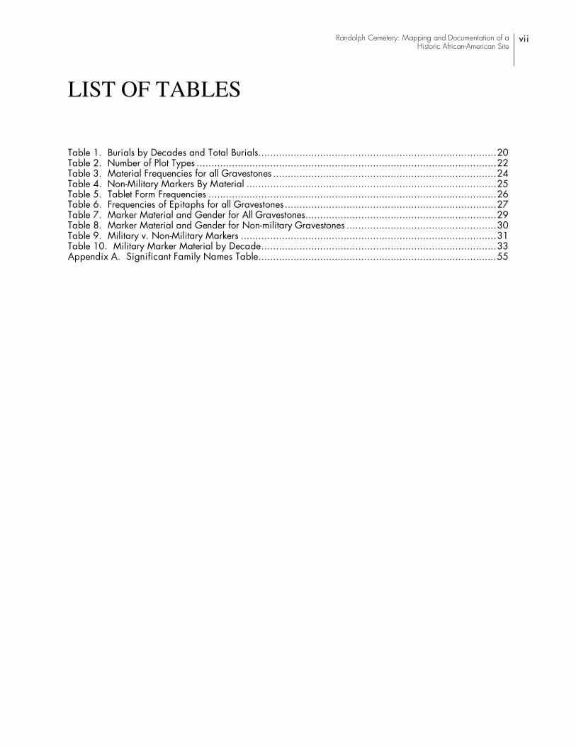
LIST OF TABLES
Table 1. Burials by Decades and Total Burials.................................................................................20 Table 2. Number of Plot Types ......................................................................................................22 Table 3. Material Frequencies for all Gravestones ............................................................................24 Table 4. Non-Military Markers By Material .....................................................................................25 Table 5. Tablet Form Frequencies ..................................................................................................26 Table 6. Frequencies of Epitaphs for all Gravestones........................................................................27 Table 7. Marker Material and Gender for All Gravestones.................................................................29 Table 8. Marker Material and Gender for Non-military Gravestones ...................................................30 Table 9. Military v. Non-Military Markers .......................................................................................31 Table 10. Military Marker Material by Decade................................................................................33 Appendix A. Significant Family Names Table.................................................................................55


Randolph Cemetery: Mapping and Documentation of a Historic African-American Site
1
I. INTRODUCTION
The Downtown Columbia Cemetery Task Force (DCCTF), through the Historic Columbia Foundation (HCF), has contracted with New South Associates, Inc. to map and document the historic Randolph Cemetery in Columbia, S.C. The Randolph Cemetery Association was created with a Board of Directors on August 11, 1871. On January 8, 1872, they purchased three acres from Elmwood Cemetery for an African-American cemetery. This cemetery was named Randolph Cemetery in honor of Reconstruction-era South Carolina Senator, Benjamin Franklin Randolph, who died at the hands of assassins in 1868. Eight African-American members of the South Carolina State Legislature from the same era are also buried here, making Randolph Cemetery a unique site within the state and perhaps the nation. Reflecting landscape, mortuary architecture, and customs important to African-American burial traditions, the cemetery is significant as a well-preserved expression of South Carolina’s African-American citizenry and their burial practices. Listed on the National Register of Historic Places in 1995, the cemetery has struggled with disrepair since at least the latter half of the twentieth century. The Committee for the Restoration and Beautification of Randolph Cemetery (CRBRC) was formed in 1973 and gained trusteeship of the cemetery by court order in 1984. Their continued efforts, along with a partnership among local nonprofits, formed the DCCTF in 2005, which has renewed interest and upkeep of the site. This current project is one of the first steps towards preservation and restoration of this significant site.
Located in the northwest corner of downtown Columbia, South Carolina, Randolph Cemetery is bounded on the south by Elmwood Avenue and the entrance to Highway 126, to the east and north by Elmwood Cemetery, and to the west by the Southern Railroad tracks (Figure 1). Located on the north side of Elmwood Avenue at its western end, Randolph Cemetery is composed of approximately four or more acres on a gently sloping landscape, descending steadily towards the west boundary at approximately 30 degrees, with the steepest descents in the upper right quarter and the sharp drop on the west to a lower terrace (Nickless 1994:Sec. 7, pg 5). With a busy urban environment to the south and a dense forest to the north, the cemetery is a unique blend of both an urban and rural setting, with the dead end of Elmwood Avenue preventing heavy traffic.
Over time, Randolph Cemetery has suffered from neglect, with portions of the cemetery being overtaken by secondary growth from the forest to the east, with vandals having damaged headstones, with the environment and time taking their toll on markers, and with the continued use of the cemetery as a burial ground resulting in the displacement of headstones and grave markers from their original locations. Since 2005, the DCCTF, working with the CRBRC, conducted periodic maintenance of the site and, in 2006, with funding from the Richland County Conservation Commission and the state of South Carolina, contracted with a local landscape firm to clear vegetation from the site in order to better define its boundaries. With the site edges clear and the graves along the boundaries identifiable, the current project was performed to map and record the cemetery as it presently exists, and to provide recommendations for its future maintenance and restoration. This effort was funded by a grant from the state of South Carolina, the South Carolina Department of Archives and History, and the National Park Service.

Figure 1.Aerial Photograph Showing Location of Randolph Cemetery
2
Randolph Cemetery

Randolph Cemetery: Mapping and Documentation of a Historic African-American Site
3
The mapping and survey project was conducted in April and May of 2007, resulting in a thorough map of the cemetery’s road, trees, topography, plot boundaries, known unmarked graves, and markers. Mapping was completed using a TOPCON Total Station and a Trimble TDC Recon data collected with sub-meter centimeter accuracy to record at least two points for every grave. The surveyors recorded the location of headstones, plot boundaries, fence posts, trees, and roads, using the information to create a map of the cemetery. Utilizing the map, two historians captured data for each obvious grave with digital photographs and in an Access database developed by New South Associates, Inc. Surveyors recorded the information in the field using Motion Tablet PC computers. Dr. Hugh B. Matternes also recorded graves during his three days on site, and used a probe to identify a number of unmarked graves throughout the cemetery. Dr. Matternes' efforts do not represent a comprehensive survey of unmarked burials, but were used to define areas where unmarked graves are prevalent. The areas are shown as shaded on the cemetery map. Dr. Matternes' field work and his and other's observations indicate that the cemetery is full and that there are no areas without graves were future burials could occur. The displacement of tombstones and other markers and the appearance of more recent burials in older areas of the cemetery, also indicate that it is likely that burials have been placed on top of, or very near, earlier graves. The exact number of unmarked graves cannot be determined without a ground-penetrating radar survey, but we estimate that there are between 30 and 60 unmarked graves in the cemetery that are not in the database as well as an unknown number of earlier graves that have been intruded on by later burials and whose markers have been removed.
Each recorded grave received a unique provenience number in the field, which relates to a number on the map and in the database. The completed database resulted in 1,959 records describing plots and graves, along with individual records for each marker. There are 1,593 graves recorded, with a description of any markers, the condition of markers and graves, and digital photographs of each grave. This report presents a summary of the project's results and recommendations as well as a printed copy of both the database and map. Electronic copies of the database and map have also been submitted to HCF on CD.
This report is organized in the following sections. Section II presents a history of Randolph Cemetery, drawn primarily from secondary sources as well as limited primary research. Section III discusses the cemetery's Physical Development, as interpreted from the current survey and other sources. Section IV presents the cemetery's current conditions, while Section V provides Restoration Recommendations. Section VI provides a Cemetery Census, with information on general population and mortuary trends and patterns within the Randolph Cemetery community. Section VII presents the format of the Randolph Cemetery Database for use in reviewing data records electronically and in print. Appendix A presents the information on the 1,593 graves recorded in the cemetery. Two copies of the Randolph Cemetery map, one showing the cemetery without numbering and a second with the provenience numbers assigned, are included in the back flap of this report. Electronic copes of the database and maps are also on file at HCF.

4

Randolph Cemetery: Mapping and Documentation of a Historic African-American Site
5
II. HISTORY
HISTORIC CONTEXT
Amidst the chaotic social, political, and economic agendas of the Reconstruction Era, African Americans created a world unlike any they had previously experienced in the South. Leaders in the African-American community found new positions of power and prominence, especially in the political realm, often using their newfound influence to promote racial equality. Even with these accomplishments in life, however, such leaders faced a further challenge at death: locating an appropriate burial place. In Columbia, South Carolina, a capital city that hosted statewide leaders in interracial legislative sessions, segregation excluded African Americans from the circa 1854 Elmwood Cemetery just north of town.
Although there were a number of cemeteries in downtown Columbia around 1871, the time of Benjamin Randolph’s reburial and the establishment of the Randolph Cemetery, they were limited to white churches, the Taylor family plot, the Hebrew Benevolent Society Cemetery, the old Potter’s Field on the southeast corner of Senate and Pulaski Streets, and of course Elmwood Cemetery, were restricted to whites. According to an 1872 Bird’s Eye map by C. Drie, there were three African-American churches at the time: the Colored Presbyterian Church, the Colored Baptist Church, and the African Methodist Episcopal Church. None of them are shown as having a graveyard attached to the building, while in contrast, several white churches, including the First Baptist Church, and the Presbyterian and Methodist churches on Marion Street, are depicted with accompanying cemeteries on the map. Figure 2 shows site 24 on the left side, which is the African Methodist Episcopal Church, site 20 in the center, which is the white Baptist Church, and site 17 on the right, which is the white Methodist Church. As is typical of African-American churches depicted on the map, there is no graveyard accompanying the African Methodist Episcopal Church. In contrast, sites 20 and 17, the white churches, have cemeteries adjacent to the structures. The map does not delineate between Randolph Cemetery and Elmwood Cemetery, at that date, as is evident in Figure 3 (C. Drie 1872). Elmwood Cemetery was denoted by the gate, chapel, and circular drive, while the future location of Randolph Cemetery, to the left, is shown as wooded.
Available city directories do not offer much assistance in determining the locations of cemeteries in the 1859, 1860, or 1868 editions. The 1875-76 edition, however, does make mention of both Elmwood Cemetery and the Hebrew Cemetery, but these are the only two cemeteries listed. African-American churches listed in this edition are the African Methodist Church, Calvary Baptist Church, Ladson Presbyterian Church, Methodist Episcopal Church, Mission Home Methodist, St. Luke’s Episcopal Church, and Zion Baptist Church. Five of the seven churches have addresses listed, and when located on the 1872 map, none of them show an associated graveyard. St. Luke’s Episcopal Church had an error in the address, but was listed between Taylor and Blanding Streets. There are no cemeteries between those parallel east to west streets except for the Hebrew Cemetery. Mission Home Methodist Church was “east side city limits” which may fall beyond the border of the map, as no church or graveyard is visible. This church did not appear in the next available city directory for 1879-80, although Calvary Baptist, Nazareth Baptist, the A.M.E. Church, Zion Baptist, Bethel

Figure 2.Drie’s 1872 Birds Eye View of Columbia Showing Churches and Cemeteries
6
Figure 3.Drie’s 1872 Birds Eye Showing Elmwood Cemetery and the Randolph Cemetery Location

Randolph Cemetery: Mapping and Documentation of a Historic African-American Site
7
Baptist, Ladson’s Chapel, Wesley Methodist Episcopal, and St. Luke’s Church do appear, all with addresses except for St. Luke’s. Those that were not on the 1875-76 list were located on the 1872 map, or at least their addresses were located, and no graveyards appear. The 1879-80 city directory is the only one of those researched to indicate an African-American “Randolph Lodge,” part of the Independent Order of Good Samaritans and Daughters of Samaria, which met every Wednesday. Sixteen members of the lodge appear in the directory, and when compared to the database of burials from Randolph Cemetery, only one person, Mary Rose (1837-1898), is currently recorded in the cemetery (Drie 1872; 1875-76 city directory; 1879-80 city directory). Her marble headstone is broken and in poor condition. Further city directory research in the 1883-84, 1885, and 1888 volumes does not reveal any further information regarding cemeteries in Columbia nor do they list the Randolph Lodge again, but they were also not consistent with listing lodges or African-American groups.
Columbia established its first public burying ground on December 16, 1797, although they did not prepare the site until the following year, and the General Assembly did not act on the plan until December of 1798. Reaching a population of 2,479 whites and1,451 African Americans by 1792, the city population and building density concentrated in the center of the grid pattern established in 1786. First Baptist Church erected a building in 1811, followed by the First Presbyterian Church by 1814, and it is likely that congregants claimed burial spots close to the church (Hennig 1936:374, 377). In the 1823 town ordinances for Columbia, the city designated a square bound by Senate, Pendleton, Gadsden, and Wayne Streets as a burying ground, “to prohibit any further burials in the town’s first cemetery, on the square now occupied by the First Presbyterian Church, for which provisions had been made by an act of the Assembly, December 21, 1798.” There is a Presbyterian Church indicated on the 1872 map on the northeast corner of Marion and Lady Streets, with a graveyard indicated to the east of the structure, and this is likely the site referenced. The new burial ground created in 1823 is likely the site shown in the Map of Columbia created around 1850, drawn by John B. Jackson, although the potters field is shown between Senate and Pendleton Streets and Pulaski and Wayne Streets, one block west of the site proposed. The block to the east, which was supposed to be the burial ground, joined with the three lots to the north, northeast, and east to create a large plot for the South Carolina Rail Road, and served as a major railroad hub for Columbia well into the twentieth century (Hennig 1936:70, 71; Tomlinson 1931).
J. F. Williams, in his 1929 Old and New Columbia, refers to the Potter's Field located west of Randolph Cemetery as “new” around the time of the Civil War. He states that soldiers were at first buried in Elmwood, but were eventually buried in the “new Potters Field, just next to the Greenville Railroad” (Williams 1929:102). Williams witnessed at least two hangings at the “old Potter’s Field,” one in 1857 and another in 1867, which was “the last public hanging to take place there.” He commented that the “Potter’s Field was the burying ground from the start of Columbia. All classes were buried there, from the high to the low; negroes and all, as there were only a few church burying grounds. Elmwood did not start for a good many years after that. Later the place was filled up so that you could hardly put a grave in there.” The Elmwood Cemetery Company formed in the early 1850s, purchasing a tract of the original Taylor tract, and sold the section “west of the Greenville Railroad to the city for a Potter’s Field.” They stopped burying in the old Potter’s Field around that time; the old potters field was located downtown on the corner of Senate and Pulaski.

8
Sources site 1854 or 1856 as the date Elmwood Cemetery was established. It appears that the Atlantic Coast Line built railroad lines on top of the old Potter’s Field, earning the statement from Williams that “Money corporations have no respect for the dead and very little for the living – only what they can grind out of them.” Although the old Potter’s Field appears as a wooded area in the 1872 Drie map, neither the old or new Potter’s Fields appear on Sanborn Fire Insurance Maps from 1884, 1888, 1898, 1904 or 1910, as they are outside the congested building area typically depicted in the Sanborn maps. The old Potter’s Field does appear in the 1919 map, covered almost entirely with railroad tracks (Williams 1929:47-48, 153; Moore 1993:504; Hennig 1936:384; Drie 1872; Sanborn map 1884, 1888, 1898, 1904, 1910, 1919).
As Columbia’s population pushed outward in the late nineteenth century, developing the city’s first suburbs further out from the traditional center of town, it is likely that the city created more pauper cemeteries. This may be why an 1895 Map of Columbia and Suburbs indicates the Potter’s Field west of Randolph as a “Negro Cemetery." It may have been in use exclusively for African Americans around the turn of the century, a period of intensifying segregation in Columbia due to the effects of Governor “Pitchfork” Ben Tillman’s racial policies. In 1903, the same descriptive “Negro Cemetery” is granted to the Potter’s Field. By 1933, however, the site is once again labeled “Potter’s Field” on a city map, which surprisingly does not label Randolph Cemetery, only Elmwood Cemetery. A circa 1949 map of the city retains the label of Potter's Field and labels Randolph Cemetery as well (Legare 1903; City Engineer 1949).
Newspaper research revealed no new information regarding the Randolph Cemetery. The Daily Phoenix ran an initial and follow-up story on the assassination of Randolph in 1868, but a review of papers from the early 1870s did not yield any information on Randolph's funeral. The articles mentioning the death indicated that Randolph was shot in the head, was buried in Columbia, and was a “persistent advocate of the social equality idea.” The newspaper author encouraged moderation in response to the assassination, hoping to discourage retribution for the murder. Likewise, research for 1872 in the Columbia Daily Union or the South Carolinian did not produce any new information. The Palmetto Leader, an African-American publication, was consulted for October of 1943, in hopes that a 75-year anniversary of Randolph’s death and burial would be mentioned. This newspaper consistently mentioned church programs in the local and surrounding areas, but there did not appear to be any references to Randolph. No volume for 1946 or 1947 existed for possible anniversaries of the reburial and purchase of land from Elmwood, and the search did not offer new information. A cursory review of indexes from the 1890s and early 1900s of The State, as well as of issues in 1968 and 1972, again offered no new information (Daily Phoenix Oct. 18, 1868).
There may be more information on Randolph Cemetery in the hands of a Mrs. Kyer. A reference in 1992 by Dr. C. Read Johnson, interviewed for a paper on Randolph Cemetery, suggests that she may be in possession of a map, which shows the location, boundaries, and owners of each plot, though “she has denied the existence of a map of the cemetery,” and “refused to be interviewed for the paper” (Kliner 1992:10). At present, the history of Randolph Cemetery is known largely from secondary sources.

Randolph Cemetery: Mapping and Documentation of a Historic African-American Site
9
RANDOLPH CEMETERY HISTORY
Seeking to commemorate Senator Benjamin Franklin Randolph's contributions, 19 men in Columbia’s African-American community created the Randolph Cemetery Association, purchasing a three-acre tract from Elmwood Cemetery by 1872 for $900 and an additional acre in 1899, also acquired from Elmwood Cemetery. The historically European-American Elmwood Cemetery followed the “rural cemetery” trend of winding streets and picturesque landscape (McGahee and Edmonds 1997:8). Although several sources date 1868 as the earliest burials in Randolph Cemetery, there are graves present that date as early as 1864, as well as burials from the periods of 1866-1868 and 1870-1871. This suggests that Elmwood Cemetery may have been allowing African-Americans to be interred in this area prior to establishment of the Randolph Cemetery Association and their purchase of the Randolph Cemetery property in 1872. Elmwood and Randolph cemeteries were technically just north of the city’s limits in the 1800s, which ran to Upper Street, now Elmwood Avenue, the southern border of the cemeteries. Their placement was in keeping with nineteenth-century concepts of creating cemeteries away from the dense city center. Although Randolph Cemetery does not appear to have a formal burial or landscape arrangement, besides a few rows of cypress, a plat map from 1874 and a city map from 1895 suggest a formal grid pattern for plots, and intersecting streets meeting at the center of the cemetery around a monument, presumably Benjamin Franklin Randolph’s obelisk on pedestal (Trinkley 2007:2, 5-7) (Figure 4).
The cemetery’s namesake, Benjamin F. Randolph, held the positions of South Carolina Senator, delegate to the state’s Constitutional Convention, a member of the executive committee of the state’s Republican Party, a Republican presidential elector in the election of 1868, and commissioner of Orangeburg, South Carolina schools. Born a free African-American in Kentucky in the 1820s, Randolph came to the state during the Civil War as a Methodist minister and chaplain of the Twenty-Sixth U.S. Colored Troops, remaining in South Carolina after the war to found one newspaper and edit another. He also served briefly with the Freedman’s Bureau, but his political prominence and ambition drew the ire of agitated whites and he lost his life to three bullets fired by a group of white assassins in Abbeville County while stepping down from a train on October 16, 1868. Randolph was buried in the Columbia vicinity after a procession from a church in downtown Columbia, although the exact location of his burial has yet to be determined. Elaine Nichol's informs us that in May of 1871, Mrs. Elise Booker wrote her daughter in North Carolina and told her that she had attended the reburial ceremony for B. F. Randolph. The Randolph Cemetery Association would be formed three months later, in August, 1871, and the cemetery lands would be purchased from Elmwood Cemetery in the following year. All of this suggests that this location had been used as a burial place for African Americans, but that B. F. Randolph's burial led to the formal acquisition and organization of the cemetery as a memorial.

10
Figu
re 4
.18
95 M
ap o
f Col
umbi
a Sh
owin
g El
mw
ood
Cem
eter
y, R
ando
lph
Cem
eter
y, a
nd th
e Lo
wer
“N
egro
Cem
eter
y”

Randolph Cemetery: Mapping and Documentation of a Historic African-American Site
11
A large obelisk monument stands in his memory today, although like many of the historic markers, it has suffered some weathering (Figure 5). It is unclear whether the obelisk marks Randolph's grave or whether it was placed in the cemetery as a cenotaph, a memorial not directly associated with a grave, however, since a burial marker for Randolph was not found during the survey, the monument presumably marks his grave. Probe survey of the area around it was inconclusive; one side is marked by a paved road, and could not be probed, while the soil in other locations was very compact. The monument's inscription reads:
IN MEMORIAM
B. F. RANDOLPH
LATE STATE SENATOR FROM ORANGEBURG COUNTY
AND CHAIRMAN REPUBLICAN
STATE CENTRAL COMMITTEE.
WHO DIED AT HODGES STATION
ABBEVILLE COUNTY
AT THE HANDS OF ASSASSINS
ON FRIDAY OCT 16
A.D. 1868
As noted above, the plan of Randolph Cemetery shown on the 1895 Map of Columbia and Suburbs (Figure 4) presents a different landscape than is present today, with two roads that intersect at right angles and a monument located in the center of their intersection that would have to be the Randolph Memorial. While this plan has previously been described as a stylized representation of the cemetery that was not based on its actual landscape at that time, there are indications that this plan existed when the cemetery was formed. The Randolph Monument is located out of alignment with other burial rows in this area and now sits alongside the paved road that loops through the cemetery. The monument is surrounded by an open buffer, approximately 15 feet in diameter. The only graves that are present within this buffer, burials 16 (unknown), 17 (1998), 18 (1977), 19 (1995), 20 (1995), 1037 (1999), and 1039 (1999) date later than 1895 and hence weren't present when the plan was made. The recent dates of these burials also indicates that this was historically an open space, as is shown on the 1895 map, that was not used for burials until a time when people forgot why the space existed, or no longer cared.

Figure 5.Obelisk Monument Memorializing B. F. Randolph
12

Randolph Cemetery: Mapping and Documentation of a Historic African-American Site
13
To the east of the marker, the location of a road or path can be seen on the map. Burials that now lie within this path include Burials 18 (1977), 19 (1995), 25 (1996), and 57 (undated). To the west, the Burial 1036 plot is located where the east-west route should have run. Burial 1036.01 is dated to 1902 while 1036.02 and 1036.03 are undated. This suggests this plot postdates 1895.
This review indicates that the landscape plan shown on the 1895 Map of Columbia exists and has been obscured by later burials, the majority of which date to the recent decade of the 1990s. The north-south path and Randolph monument are not as centrally located within the cemetery as shown on the 1895 map, however, as the 1895 map indicates, the acre of land that the cemetery obtained from Elmwood in 1899 is located on the east edge of the cemetery, meaning the monument and roads were in a more central location when the cemetery was established. An 1989 map prepared by Natalie Adams and Rick Affleck of the University of South Carolina illustrates the appearance of the moment and cemetery landscape before the placement of the 1990s burials.
A discussion of the history of Randolph Cemetery must include an explanation of its context as an African-American cemetery dating from the last quarter of the nineteenth century, with new burials every decade since its founding. Possessing some unique characteristics that can sometimes be traced to traditional African customs, African-American cemeteries are an important part of the historic landscape in many communities, not only for the information found on the markers, but also for the character of the site itself. For instance, some cemeteries were located on transitional property, or areas undesirable to European-Americans because of their landscape, which could include swampy conditions, slope, dense underbrush, or proximity to unfavorable neighbors. Michael Trinkley, in his history of Randolph Cemetery, suggests that it fits these characteristics. He notes that at the time of its creation, there was an African-American Lower Cemetery (the Potters Field) west of Randolph Cemetery and the railroad tracks and near the canal (known as the Negro Cemetery in 1903, this is the cemetery discussed above as the new Potter’s Field [Legare 1903; Figure 6]), as well as the Columbia Tannery to the south of the site. Trinkley suggests that both attributes would have diminished the appeal of the cemetery's location as a European-American burying ground (Trinkley 2007:4; Trinkley 1996).
While Trinkley sees attributes of Randolph's location as undesirable, it is worth noting that this part of Columbia was home to a number of cemeteries, including Elmwood, one of the cities' most prominent, which Randolph adjoins, St. Peters Catholic Cemetery, and the Potter's Field. While Randolph Cemetery's setting may have been less desirable than Elmwood Cemetery's hill top location, it was notably superior to the location of the Potter's Field to its immediate west. The latter is located in the floodplain of the Broad River in a setting that was cut-off from access from Columbia and threatened by flooding. Today, this area is heavily overgrown. According to a local informant, marked graves can be found in this area during the winter, however the vast majority of graves are unmarked. Randolph Cemetery, while located on slopes and bounded by the railroad track to the west, was nonetheless in a far better setting than the Lower Cemetery. Randolph Cemetery abutted the location of Elmwood Cemetery, although it appears that at the time of its establishment, Elmwood Cemetery had not extended to the edge of Randolph, as it does now, and the 1895 map shows a gap between the two. Regardless, Randolph Cemetery's location was associated with Elmwood by its location on the same road and proximity, as well as land ownership history. The presence of two African-American cemeteries in close proximity as well as Randolph's creation through a formal cemetery association and the burial of prominent members of

Figu
re 6
.19
49 M
ap D
epic
ting
the
Cem
eter
ies
Alo
ng E
lmw
ood
Ave
nue
14

Randolph Cemetery: Mapping and Documentation of a Historic African-American Site
15
Columbia's African-American community in Randolph Cemetery suggests that it was established as the burial place of the middle and upper class families in this community.
Another important tradition in African-American cemeteries is the placement of “offerings” on the graves. These can include pottery, cups, saucers, bowls, personal objects like toys, false teeth, or glasses, pitchers, spoons, shells and reflective items, clocks, lamps, and even bed frames. With roots in Kongo traditions, the placement of goods on the grave was once thought to ensure the spirit of the deceased would not roam back to this world in search of needed items. The goods may also be purposely broken or “killed,” in order to free its spirit for travel to its former owner in the other world (Trinkley 1996; Fenn 1989: 45, 48-49). A tradition similarly practiced in European-American cemeteries, the planting of trees or plants on a grave, holds a significantly different meaning in African-American graveyards. Although landscapes in African-American cemeteries are often left natural, some plantings on graves include trees, whose roots were believed to go down to the spirit world while the tree itself symbolizes the living spirit. White flowering plants such as yucca, dogwood, and cactus are often found and may have some connection with the West African association of the color white with death (Connor 1989:52; Vlach 1991:45). White flowers and white objects were popular because “the world of the dead was believed to be white and watery” (Nichols 1989:13). Some of these African-American traditions can be witnessed in Randolph Cemetery today, carrying on a legacy begun well over a century ago (Figure 7).
The original 19 founders of the cemetery named themselves the Randolph Cemetery Association. They were generally in their 30s or 40s, often the head of a family, with several of them owning real estate, likely their own homes, and working at a variety of professions. Carpenters, grocers, several barbers, school commissioners, an attorney, farmers, a trial justice, a minister, and several politicians formed the group, including William B. Nash, a prominent and active member of the South Carolina Senate from 1868-1877. Representing middle and upper class segments of the African-American community, the founders purchased acreage from the Elmwood Cemetery. Michael Trinkley suggests in his 2007 study A Small Sample of Burials at Randolph Cemetery: What Their Stories Tell us About the Cemetery and African American Life in Columbia, that the cemetery association was likely not an entrepreneurial venture. Known fees for plots ranged from $30 to $36, at a time when laborers earned about 10 cents an hour with talented carpenters earning as much as $1.25 per day. Trinkley thus indicates that African-American laborers would not have been able to afford a plot at Randolph Cemetery (Trinkley 2007:8-12). Given the fact that by 1890 African-Americans outnumbered European-Americans 8,790 to 6,563 in Columbia, and only 35 marked graves are from the entire decade of the 1890s in Randolph Cemetery, this suggests that Randolph was the burying place of many of Columbia's more affluent African-Americans, and that the Lower Cemetery/Potters Field and others received the majority of Columbia's African-American deceased (Moore 1993:277). It is well known that there are several prominent figures buried at Randolph Cemetery, including nine or ten African-American state legislators from the Reconstruction era: Senators Henry Cardozo (1830-1886), William Fabriel Myers (1850-1917), William Beverly Nash (1822?-1888), and Lucius Wimbush (1839-1872), along with Representatives Robert John Palmer (1849-1928), William H. Simons (d. 1878), Samuel Benjamin Thompson (1837-1909), and Charles McDuffie Wilder (d. 1902), and the namesake, Senator B. H. Randolph (ca. 1825-1868) are all known to be buried at Randolph, while Prince Rivers was reportedly buried there, but his grave was not identified by the survey.

Figure 7.Examples of African-American Burial Traditions
16
A. Gravel Covered Burial Plot Planted withYucca and Flatrock Phacelia
B. Dix Family Plot Incorporating Large White Quartz Boulders in Wall

Randolph Cemetery: Mapping and Documentation of a Historic African-American Site
17
By 1886, the Randolph Cemetery Association created a set of rules and regulations for burials and upkeep of the cemetery. Plot boundaries were to be no higher than a foot above the surface, trash was to be removed, the landscape well kept, and monuments and headstones could not be removed “without the consent of the President and Directors.” The regulations were still in effect by 1910 (Trinkley 2007:8). Despite its prominent residents, the cemetery reportedly fell into disrepair during the mid-twentieth century, and was even used at one point as a local dumping ground. City of Columbia construction in 1959 further damaged the site and by 1973, concerned citizens created the Committee for the Restoration and Beautification of Randolph Cemetery (CRBRC), although they did not win trusteeship through the courts until 1984. Some of the impetus behind their court battle stemmed from the sales of plots from Pearson Funeral Home without the consent of the CRBRC, an act that potentially disturbed older burials and garnered controversy over ownership of individual plots and oversight by the committee. The group continues to own and maintain the site and operates as a successor to the original Randolph Cemetery Association, although they are not formally organized as a non-profit group. A large clean up event in 1992 drew some local media attention, but without an ongoing maintenance schedule, the cemetery again fell into disrepair by 2000, when new burials damaged older ones and their markers and even drew a remark from Coroner Frank Barron, who suggested that no more graves should be sold in the cemetery, which was likely full. In fact, coffin hardware and bones have frequently been found on the ground, indicating continued intrusion into graves. This survey discovered one example of coffin hardware lying near a gravesite which had an older, broken headstone and a separate person listed on a new headstone nearby, suggesting disturbance in a historic grave. Continued interest in and upkeep of the cemetery in recent years has included fundraising and historic tours offered by Mrs. Minnie Simons Williams in 1987, the partial mapping of the cemetery in 1989 by Natalie Adams and Rick Affleck of the Anthropology Department at the University of South Carolina, an exhibit on African American funerary and mourning traditions at the South Carolina State Museum in 1989, a transcription of stones by the Columbia Chapter of the South Carolina Genealogical Society in 2002, as well as the recent study by Trinkley (Trinkley 2007:13-16). Elaine Nichols convened a group of individuals and non-profit organizations to look at the restoration and preservation of the cemetery in 2007, out of which developed the Downtown Columbia Cemetery Task Force and this project. The current survey is a positive step towards preservation and restoration of this significant site.


Randolph Cemetery: Mapping and Documentation of a Historic African-American Site
19
III. PHYSICAL DEVELOPMENT AND LANDSCAPE
LANDSCAPE
Randolph Cemetery lies on an approximately four-acre site adjacent and to the west of Elmwood Cemetery. The cemetery faces Elmwood Avenue, which provides its entry and access and which terminates at the cemetery; its common boundary with Elmwood Cemetery is marked by a row of fencing and trees. A series of concrete pillars, some standing, some not, mark the northern edge of the cemetery, beyond which is the tree line. Beyond this fence line, within the edge of the woods and northeast corner of the cemetery area are discarded piles of floors, vases and other grave offerings as well as demolition debris that may contain some tombstone fragments.
A roughly "U"-shaped road defines the center of the cemetery and its landscape. This road enters from Elmwood on the southeast edge of the cemetery, goes north and then veers northwest before turning to the west where it parallels Elmwood Avenue. The road then turns south and connects to Elmwood Avenue near its dead-end. The B. F. Randolph monument is located along this road, and the road makes a slight jog at the obelisk.
There is some evidence to suggest that the site plan shown on the 1895 City Map (Figure 4) may have been present in some form. As noted above, the current western road alignment bends around the Randolph Monument, and there is space around the monument that may reflect its placement in a center point at the intersections of the two right-angle roads. To the east of the monument, space between the burial plots may represent the old location of a road or path and where this space is interrupted, it is from twentieth century graves. A similar space does not appear to exist to the west, although the burials in this area date to the early 1900s and hence could have obscured a pathway from the cemetery's establishment.
Along the northern edge of the cemetery is a large gulch that has been used as a dumping ground for tree cuttings and cemetery refuse. Burials exist close to the edges of this gulch and it is possible that some burials may have eroded into it over time. On the western edge of the cemetery there is a steep drop to a shelf that abuts the railroad. Several burials are found along the northern edge of this shelf and others may be present that were not observed.
DEVELOPMENT
The cemetery has held burials for every decade since the 1860s. Table 1 provides the number of known burials by respective decades. The number of known males and females is also indicated, as is the range of known ages. For several burials, the date of death is recorded on a marker but not a birth date or age, making the age indeterminable. In every decade, adults far exceed the number of teenagers and infants, therefore the average adult age is determined by averaging the number of adults within an age date range from the oldest to the youngest adult’s age, which varied

20
from 18 to 35 years, depending on the decade. There are very few teenagers and generally children ranged from one day to twelve years old; the average age of only adults better represents the demographic found in Randolph Cemetery. The total burials is listed at 1,593, although there are several markers which serve as monuments describing three or more people with uncertain burial locations, and it is highly likely that there are unmarked graves throughout the cemetery.
Table 1. Burials by Decades and Total Burials
Decade of burial
Known burials
Known Males
Known Females
Age Range Avg. Adult Age (yrs)
Average age qualifiers
1860 6 2 4 10 mos. – 67yrs -- Only 4 known ages, two less than 6 yrs, 25 yrs, 67 yrs
1870 16 6 8 1 mo. – 70 yrs -- Only 10 adults, 6 of whom range 18-33, 3 range 60-70, 5 are children under age 12
1880 20 8 11 8 – 78 yrs. 49.2 For 15 adults age 20+
1890 36 17 16 5 mos. – 85 yrs 47.1 For 27 adults age 22+
1900 78 33 39 1 – 92 yrs 51.1 For 66 adults age 22+
1910 111 51 49 2 – 96 yrs 50.4 For 92 adults age 19+
1920 159 85 57 < 1 yr - 88 yrs 49.5 For 109 adults age 20+
1930 55 23 30 2 – 90 yrs 51.6 For 43 adults age 18+
1940 57 31 26 3 – 96 yrs 63.4 For 44 adults age 22+
1950 53 24 27 35 – 89 yrs 67.7 For 47 known adults
1960 54 23 28 5 days – 97 yrs 63.6 For 43 known adults age 35+
1970 97 57 37 < 1 day – 91 yrs 63.08 For 83 adults age 21+
1980 89 45 42 10 mos. – 102 yrs 70.3 For 85 adults age 20+, with 3 dating 100+
1990 196 102 83 1 mo. – 101 yrs 61.5 For 184 adults age 20+
2000 20 8 12 6 – 97 yrs 73.5 For 17 adults age 22+
Unknown 546 -- -- -- -- --
Total Burials
At least 1,592
1,593

Randolph Cemetery: Mapping and Documentation of a Historic African-American Site
21
Using the dated burials, the following trends can be recognized in the development of Randolph Cemetery. It should be noted that there are a large number of unmarked burials that cannot be assigned to a period. Some of these may be the product of the earlier decades in the cemetery's history and the decay of markers made of wood and other impermanent materials, however, others may simply reflect the family's lack of a need for a marker, especially in family plots whose association is well marked and established.
The 1860s mark the first period of burial, prior to the formal establishment of Randolph Cemetery, during which six burials were placed in the cemetery. The next period follows the cemetery's creation and extends from the 1870s through the end of the nineteenth century. This period is marked by a moderate frequency of burials by decade, ranging from 16 in the formative 1870s to 36 in the 1890s. An average of 24 burials were placed in the cemetery each decade during this period.
The next period witnessed a significant increase in the use of the cemetery, from 1900 through the 1920s. The number of burials per decade doubled in the 1900s, increasing from 36 to 78, and increased again in the 1910s from 78 to 111. The apex was reached in the 1920s when 159 burials were placed in the cemetery. By decade, an average of 116 burials were placed in the cemetery during this period, five times the number that has been interred in the previous period.
The reason for this increase in the use of Randolph Cemetery is unknown, but may be related to the use and management of the Potters Field, on the opposite side of the railroad tracks. Formed at the time of the Civil War as a Potters Field, by the late nineteenth century this was referred to as a "Negro Cemetery." At some point in the early twentieth century this cemetery was again designated as a Potters Field, a burying ground for unknown and indigent people. It is uncertain whether this designation was simply a linguistic device to indicate that this burying ground was not a formally designated cemetery, or if it reflected the acquisition and management of the cemetery by the City of Columbia as a formal potter's field. In the latter instance, use of this cemetery by Columbia's African-American community may have been restricted and Randolph Cemetery may have been turned to as a result.
The next period dates from the 1930s through the 1960s. The frequency of burials declines during this period, dropping from 159 in the 1920s to 55 in the 1930s. All of the decades in this period saw the number of burials in the 50s, with an average of 54.75 per decade.
Use of the cemetery increased from the 1970s through the end of the twentieth century. The 1970s saw 97 burials, while the 1990s would be the high-water mark for burials in Randolph Cemetery with 197. By decade, this period averaged 126.3 burials, making it the most active period in the cemetery's history. Not surprisingly, this period corresponds with the formation of the Committee for the Restoration and Beautification of Randolph Cemetery in 1973 and their efforts to restore the cemetery. The last period in the cemetery's history to date is the beginning of the twenty-first century. Only 20 burials have been placed in Randolph Cemetery since 2000, recognition of the fact that the cemetery has been largely filled.
The landscape of the cemetery also reflects these chronological periods. By plotting these distinct periods it is possible to determine at least a general understanding of the physical development of

22
the cemetery. During the period from the 1860s to 1899, all marked burials are in the southern half of the cemetery, generally framed by a semicircular drive with two entrances on the southern border of Elmwood Avenue. A single grave from this era rests further away in the southeast corner and a few are to the west of the driveway’s western border. The second period is from 1900 to 1929, the first era of rapid growth for the cemetery. Known burials dating to this era spread all over the cemetery, reaching along the borders of the acreage. A third era dating from 1930 to 1969 had relatively few burials and the number declined by decade, and there appears to be more burials from this era in the east half of the cemetery, although they infill spots all over the site and are not heavily concentrated in one area. The most recent period, dating from 1970 to the present, had a very high number of burials, increasing every decade with the 1990s witnessing the most burials of a single decade. While these burials also in-filled spots throughout the cemetery, they are more heavily concentrated in the very center of the site and increase in density towards the west boundary. With the first half of the 2000-decade over, and only 20 burials evident so far, it is safe to assume that the frequency of burials has dropped significantly since the 1990s.
PLOTS
A range of plot types is used at Randolph Cemetery. Table 2 depicts the types of plots and the number of each. The total number of plots exceeds the number of known graves because in many cases, single plots are recorded which are also within a larger family plot.
Table 2. Number of Plot Types
Plot Type Number surveyed Unmarked 231 Single, marked 1,218 Couple, marked 63 Family, marked 110 Mass 1 Unknown 47 Total 1,670
GRAVESTONES
Detailed study of cemeteries has been shown to reflect attitudes of the larger society (Dethlefsen 1981; Dethlefsen and Deetz 1966; Dethlefsen and Jensen 1977;). Gravestones, in particular, are sensitive to a wide variety of stylistic changes including material, form, and iconography. Because gravestones are dated directly they provide researchers with unique opportunities to address research questions that might otherwise not be possible.
The following quote from Dethlefsen (1981:137) reflects on the significance of cemeteries and their monuments for the understanding of historic communities:
A cemetery should reflect the local, historical flow of attitudes about community. It is, after all, a community of the dead, created, maintained, and preserved by the community of the living. In many ways it should be a “filtered” and modified reflection of the living

Randolph Cemetery: Mapping and Documentation of a Historic African-American Site
23
community, with an added dimension of controlled chronological depth. At least, the cemetery should have some hints for us about prevailing views of God, acceptable implications of life and death, intensity of status differentiation, and relative values of kin and other social-interactive relationships.
Using data from the current survey, several attributes are discussed below. These examples are not exhaustive, but are meant to provide some insight into behavioral and social attitudes at particular points in time. All of these data were exported from the database to an Excel spreadsheet for easier manipulation. They are displayed chronologically, by decade, and show some interesting trends regarding gravestone material, style/form, military affiliation, age, and gender. Also, the number of gravestones varies for each attribute discussed below because the information was either incomplete, missing entirely, or illegible in all cases. However, the results still accurately represent larger trends.
GRAVESTONE MATERIAL
In almost any cemetery throughout the country visitors can easily observe a range of materials including slate, marble, limestone, granite, concrete, and others. Some materials are characteristic of particular areas and their distribution may be restricted by availability (e.g. soapstone or slate).
When gravestone material is tabulated by decade an interesting pattern emerges (Table 3, Figure 8). Each material type has a clear peak in popularity. Marble is the dominant type from the 1860s through the 1920s. At that time granite and concrete began to occur in much higher numbers. In fact, from 1920-1929 marble, granite, and concrete occurred with almost the same frequency. By 1930 granite clearly was the preferred material and has remained so to the present. Beginning in the 1950s other materials grew in popularity, including alternative materials such as brick, aluminum, and plastic.
The choice of concrete and other materials has important implications regarding larger social issues. The pattern for concrete, in particular, is interesting because it corresponds to the Jim Crow era and Depression years. It is difficult to say with certainty what factors influenced the popularity of concrete during this period, although economics seems the most likely cause. Presumably concrete was an inexpensive alternative to both marble and granite. The survey team observed that many of these stones appear to have originally been painted white, perhaps in an effort to simulate marble. Although alternative materials began to appear as early as the 1950s they did not reach their peak until the current decade (2000-present), where they account for almost 40 percent of the total. This factor is more difficult to explain but probably represents greater diversity in terms of available materials and changing social values.
Looking at gravestone material with military markers filtered out produces a slightly different distribution (Figure 9, Table 4). The same patterns are present for concrete and other, but there are changes in both marble and granite. In fact, the trends appear even more regular, with a decreased frequency of marble and corresponding increase in granite. The distribution for these two materials represents classic popularity curves and mirror trends identified in other cemeteries (Dethlefsen 1981).

24
Table 3. Material Frequencies for all Gravestones
Decade Marble % Granite % Concrete % Other % Total 1860-1869 5 83.33 1 16.67 0 0 0 0 6 1870-1879 14 93.33 1 6.67 0 0 0 0 15 1880-1889 19 95.00 1 5 0 0 0 0 20 1890-1899 26 81.25 2 6.25 4 12.50 0 0 32 1900-1909 56 77.78 10 13.89 6 8.33 0 0 72 1910-1919 69 65.09 22 20.75 15 14.15 0 0 106 1920-1929 47 31.76 41 27.70 60 40.54 0 0 148 1930-1939 11 23.91 30 65.22 5 10.87 0 0 46 1940-1949 17 32.69 34 65.38 1 1.92 0 0 52 1950-1959 11 18.64 45 76.27 1 1.69 2 3.39 59 1960-1969 13 25 32 61.54 2 3.85 5 9.62 52 1970-1979 30 33.33 49 54.44 4 4.44 7 7.78 90 1980-1989 25 29.76 56 66.67 1 1.19 2 2.38 84 1990-1999 47 24.74 107 56.32 4 2.11 32 16.84 190 2000-2007 0 0 11 64.71 0 0 6 35.29 17 Total 390 442 103 54 989
Figure 8. Material Frequencies for all Gravestones

Randolph Cemetery: Mapping and Documentation of a Historic African-American Site
25
Figure 9. Material Frequencies for Non-Military Gravestones
Table 4. Non-Military Markers By Material
Decade Marble % Granite % Concrete % Other % Total 1860-1869 5 83.33 1 16.67 0 0 0 0 6 1870-1879 14 93.33 1 6.67 0 0 0 0 15 1880-1889 19 95 1 5 0 0 0 0 20 1890-1899 26 76.47 2 5.88 6 17.65 0 0 34 1900-1909 56 77.78 10 13.89 6 8.33 0 0 72 1910-1919 69 65.09 22 20.75 15 14.15 0 0 106 1920-1929 28 21.71 41 31.78 60 46.51 0 0 129 1930-1939 11 23.91 30 65.22 5 10.87 0 0 46 1940-1949 13 27.08 34 70.83 1 2.08 0 0 48 1950-1959 3 7.5 34 85 1 2.5 2 0 40 1960-1969 5 12.82 29 74.36 2 5.13 3 7.69 39 1970-1979 6 9.84 45 73.77 4 6.56 6 9.84 61 1980-1989 5 8.2 55 90.16 1 1.64 0 0 61 1990-1999 7 4.76 105 71.43 4 2.72 31 21.09 147 2000-2007 0 0 11 64.71 0 0 6 35.29 17
Total 267 421 105 48 841

26
GRAVESTONE STYLE/FORM
Most cemeteries also exhibit a range of gravestone shapes and forms including tablets, ledgers, tombs, vaults, obelisks, and government-issued markers. These, too, tend to vary in popularity through time. There is less variation in gravestone form for Randolph cemetery than expected (Table 5, Figure 10). However, some interesting trends are still apparent. The most common form is the tablet, with either rounded or rectangular tops. The presence of small numbers of several forms forced them to be lumped in the “other” class (obelisks, ledgers, etc). However, this is does not significantly affect the overall trends.
Table 5. Tablet Form Frequencies
Decade Roundtop % Rectangular % Other % Total 1860-1869 3 50.00 0 0 3 50.00 6 1870-1879 12 92.31 0 0 1 7.69 13 1880-1889 14 73.68 2 10.53 3 15.79 19 1890-1899 25 75.76 3 9.09 5 15.15 33 1900-1909 38 53.52 20 28.17 13 18.31 71 1910-1919 36 34.62 38 36.54 30 28.85 104 1920-1929 54 36.99 77 52.74 15 10.27 146 1930-1939 22 48.89 20 44.44 3 6.67 45 1940-1949 22 42.31 30 57.69 0 0 52 1950-1959 20 43.48 23 50.00 3 6.52 46 1960-1969 21 46.67 20 44.44 4 8.89 45 1970-1979 40 48.19 40 48.19 3 3.61 83 1980-1989 46 57.50 30 37.50 4 5.00 80 1990-1999 79 44.13 62 34.64 38 21.23 179 2000-2007 4 20.00 6 30.00 10 50.00 20
Total 436 371 135 942
Figure 10 is a graphic representation of gravestone form by decade. Again, clear patterns emerge, with changes in popularity for each style through time. Rounded tablets exhibit a clear peak from 1870-1900 before leveling off to relatively consistent percentages until 2000. Rectangular tablets begin to appear in the 1880s, reach their peak in the 1940s, and then slowly decline to the present. The “Other” class is a bit more erratic, but not surprising given that it includes numerous forms with low frequencies. There are essentially three peaks: the first in the 1860s, a second in the 1910s, and a third from 2000-present. In fact, by 2000 this class accounts for almost 50 percent of the total gravestones, reflecting a significant amount of diversity in styles. With a larger sample size additional patterns might be more easily detected.

Randolph Cemetery: Mapping and Documentation of a Historic African-American Site
27
Figure 10. Gravestone Form Through Time
EPITAPHS
Dethlefsen (1981) addresses the popularity of epitaphs in general terms. The Randolph data follow the same general pattern, with the presence of epitaphs generally decreasing through time (Table 6, Figure 11). By the 1950s approximately 50 percent of the gravestones had epitaphs and 50 percent did not. Although epitaphs are still used today, it is likely a result of cheaper technologies that allow for automated inscriptions rather than by hand. Not considered here is the type of epitaph, which also changes significantly through time.
Table 6. Frequencies of Epitaphs for all Gravestones
Decade Present % Absent % Total 1860-1869 6 100 0 0 6 1870-1879 13 81.25 3 18.75 16 1880-1889 19 95.00 1 5.00 20 1890-1899 28 77.77 8 22.22 36 1900-1909 58 74.36 20 25.64 78 1910-1919 88 79.28 23 20.72 111 1920-1929 115 72.78 43 27.21 158 1930-1939 31 56.36 24 43.63 55 1940-1949 37 64.91 20 35.09 57

28
Decade Present % Absent % Total 1950-1959 23 43.40 30 56.60 53 1960-1969 20 37.74 33 62.26 53 1970-1979 41 42.27 56 57.73 97 1980-1989 47 52.22 43 47.78 90 1990-1999 108 55.10 88 44.90 196 2000-2007 6 30.00 14 70.00 20 Total 640 406 1046
Figure 11. Epitaph Frequencies for all Gravestones
GENDER
In an effort to look at different aspects of changing social attitudes we wanted to test a simple hypothesis regarding gravestone raw material and gender. If there is no distinction between raw material and gender, then the distributions should be approximately equal. In other words, material selection should be independent of gender. Here are the statistical hypotheses:
HO: There is no difference in gravestone material and gender.
H1: There is a difference in gravestone material and gender.

Randolph Cemetery: Mapping and Documentation of a Historic African-American Site
29
Chi-square is a common statistical technique for hypothesis testing with nominal (categorical) data (Thomas 1986). As a non-parametric method, it has the unique advantage of not requiring data that are normally distributed and can be performed rather easily. It essentially tests whether or not the variation in a given contingency table can be attributed to the vagaries of random sampling. A region of rejection is thus defined to which the resulting value is then compared. If that value falls beyond this region, the null hypothesis is rejected and a statistically significant pattern is clear. In that case the observed variation cannot be attributed to sampling and other variables must be considered.
The chi-square contingency table shows observed and expected values as well as row and column totals for each variable. The chi-square value of 17.92 falls far beyond the region of rejection and results in an associated probability of less than 0.0003, and the null hypothesis is rejected. The test indicates that there are variations in gravestone materials by gender. Why? A close inspection of Table 7 shows a wider than expected range in both marble and granite.
Table 7. Marker Material and Gender for All Gravestones
Male Female Observed Expected Observed Expected Total Marble 255 222.10 157 189.900 412 Granite 209 231.265 222 197.735 431
Concrete 48 54.986 54 47.014 102 Other 27 29.649 27 25.351 54 Total 539 460 999
X2=17.92, df=3, p=0.0003
These results clearly indicate a significant difference in material selection for males and females, especially in marble and granite, which leads to more questions. What is the source of the variation? Are males and females regarded differently in terms of the type of material chosen for their gravestones?
It turns out that the variation is caused by the presence of military markers, which are primarily of marble and almost exclusively for males. The US government has standardized military markers since the 1860s and the preferred material has always been marble (Holt 1992).
Carrying this line of inquiry one step further the data were filtered to exclude military markers. The same hypotheses apply, but in this case the chi-square value of 0.79 generates an associated probability of 0.85, which does not fall beyond the region of rejection. Therefore, the null hypothesis is not rejected. The conclusion is that raw material is approximately evenly distributed across gender, as expected, when military markers are removed from the sample. In other words, there is no difference in material choice for males and females.

30
Table 8. Marker Material and Gender for Non-military Gravestones
Male Female Observed Expected Observed Expected Total Marble 123 129.05 156 149.96 279 Granite 200 195.19 222 226.81 422
Concrete 48 47.18 54 54.82 102 Other 24 23.59 27 27.41 51 Total 395 459 854
X2=0.79, df=3, p=0.85
MILITARY MARKERS
The effects of military markers on the overall trends were alluded to earlier. Because these markers are relatively common and uniform they provide a rather unique subset to the overall data. Figure 12 shows the frequency of military v. non-military markers through time. Several observations are worth noting. First, there are no military markers until the 1920s, none in the 1930s, and then a gradual increase to the present. Although we have no direct comparative data, this pattern seems to be quite different for observations made in other cemeteries.
The answer to this question can be found by considering the fact that Randolph Cemetery is almost exclusively African-American. With few exceptions, particularly in the South, African-Americans were systematically excluded from military service until World War II. However, information from epitaphs in the cemetery indicates a few examples of individuals who served in both the Spanish-American War and World War I. After World War II, as the US armed forces integrated, African-Americans assumed an increasingly important role in every major conflict. The peak years for military markers occurred from the 1950-1990s, representing World War II, Korea, and Vietnam. The selection of a military marker may also reflect an individual’s or community’s attitude toward the larger society. It is not surprising, then, that African-Americans, like any other veteran, would choose to express their military service.

Randolph Cemetery: Mapping and Documentation of a Historic African-American Site
31
Figure 12. Frequency Distributions for all Military and Non-Military Gravestones
Table 9. Military v. Non-Military Markers
Decade Non-Military % Military % Total 1860-1869 6 100 0 0.00 6 1870-1879 16 100 0 0.00 16 1880-1889 20 100 0 0.00 20 1890-1899 36 100 0 0.00 36 1900-1909 78 100 0 0.00 78 1910-1919 111 100 0 0.00 111 1920-1929 139 87.97 19 12.03 158 1930-1939 55 100 0 0.00 55 1940-1949 53 92.98 4 7.02 57 1950-1959 44 83.02 9 16.98 53 1960-1969 42 79.25 11 20.75 53 1970-1979 69 71.13 28 28.87 97 1980-1989 66 74.16 23 25.84 89 1990-1999 154 78.57 42 21.43 196 2000-2007 20 100 0 0.00 20 Total 909 136 1045

32
Military Gravestone Material
Anecdotal evidence also suggested some variance in material for specifically military markers. Even though the US government has standardized military markers, there is some variation in material (Figure 13, Table 10) (Holt 1992). Marble, of course, is by far the most common, clearly reflecting the government’s preferences. However, granite and bronze are also present, albeit in much lower frequencies.
Figure 13. Material Frequencies for all Military Markers
This pattern isn’t necessarily significant on its own, but might prove interesting when compared to other cemeteries. According to the US Department of Veteran’s Affairs (2007), flat markers in granite, bronze, and marble and upright headstones in granite and marble are available. When did the US government begin offering granite and bronze markers? At the national level, what are the percentages of different material? Also, military graves might be placed on a grave years after a burial at a higher rate than civilian graves. A detailed study of VA records might reveal the frequencies of requests for both different styles and material.

Randolph Cemetery: Mapping and Documentation of a Historic African-American Site
33
Table 10. Military Marker Material by Decade
Decade Marble % Granite % Bronze % Total 1860-1869 0 0.00 0 0.00 0 0.00 0 1870-1879 0 0.00 0 0.00 0 0.00 0 1880-1889 0 0.00 0 0.00 0 0.00 0 1890-1899 0 0.00 0 0.00 0 0.00 0 1900-1909 0 0.00 0 0.00 0 0.00 0 1910-1919 0 0.00 0 0.00 0 0.00 0 1920-1929 19 100 0 0.00 0 0.00 19 1930-1939 0 0.00 0 0.00 0 0.00 0 1940-1949 4 100 0 0.00 0 0.00 4 1950-1959 8 88.89 1 11.11 0 0.00 9 1960-1969 8 72.73 2 18.18 1 9.09 11 1970-1979 24 85.71 4 14.29 0 0.00 28 1980-1989 20 86.96 1 4.35 2 8.70 23 1990-1999 39 92.86 2 4.76 1 2.38 42 2000-2007 0 0.00 0 0.00 0 0.00 0 Total 122 10 4 136
DISCUSSION
Gravestones provide a unique perspective on changing community and social values and are a tremendous source of data for a wide range of questions. Using data generated from the gravestone survey for Randolph Cemetery, the preceding section has focused on a few attributes to illustrate their research potential.
Overall, the trends in gravestone form and material represent typical patterns found in other cemeteries (Dethlefsen 1981). However, there also appears to be a fair amount of internal variation, particularly during more recent decades. Without comparative gravestone data from similar cemeteries in the region, it is difficult to assess the extent of this variation. However, several questions emerge that could be addressed with future studies, including: how does Randolph compare to other historically African-American cemeteries? Are the patterns consistent from one to another? Are there differences between Randolph and historically Euro-American cemeteries? If so, what are they? What factors likely caused these differences? Does the pattern for material and gender apply to other cemeteries? What does the style and tone of epitaphs say about larger social attitudes at any given point in time? Do they represent changes in how communittes’ view death? How can gravestone data be used to chart the rate of culture change through time within a specific community? These questions can only be answered as more data is acquired from other African-American cemeteries.

34

Randolph Cemetery: Mapping and Documentation of a Historic African-American Site
35
IV. CURRENT CONDITIONS
As with any historic cemetery, the passage of time and years of exposure to the elements have undermined some of the fabric of the site, including the landscape, and the built elements such as border copings, graves, and markers. While each cemetery is unique in its level of upkeep, its design, materials, and its preservation goals, it is apparent that Randolph Cemetery has been particularly victimized by both natural and man-made challenges and requires a specific agenda for preservation and restoration. The following discussion of its current conditions will provide a summary of information from the database created during fieldwork and discuss some of challenges currently facing the site.
Historically, the cemetery’s landscape was natural with limited formal arrangement, which included planted rows of cypress trees and occasional hardwoods. A thin stand of trees along the north, west, and east boundaries serves as a tall, forested border to a generally open landscape. Approximately 56 trees still stand in the cemetery, but there are also about 36 tree stumps, almost all of which are located in the southern, central portion of the cemetery, the area with the oldest markers. The standing trees are usually tall and mature, and stumps, most often cypress, have a wide circumference, suggesting they were at least several decades old at the time of the tree felling. Currently, the stumps are somewhat unattractive, but they generally are cut very low and do not intrude on the landscape. Very few bushes, yucca plants, and cactus plants are found on graves and are not a prominent part of the cemetery’s setting, though they are significant as plantings rooted in African-American burial traditions. A thick blanket of grass covers much of the area, although along the northern and western boundaries there is some degree of erosion and a great deal of leaves and debris left from the nearby tree line and its recent clearing, which moved the tree line back 20 feet on the northern border and cleared out the large lower terrace along the western boundary. The east and north boundaries of the cemetery are delineated by a fence line, now composed of widely spaced octagonal, slender concrete posts, several of which are fallen over.
Other areas of concern in the landscape include the large dry gulch and the eastern entry. The dry gulch serves as a trash pile and is somewhat screened by short stands of bamboo, however, its eastern bank is piled with leaves and debris while its western bank is heavily eroded. Unmarked and marked graves on the eastern bank suffer from severe slumping and upheaval due to the unstable landscape, and it is possible that graves have eroded into this gulch in the past. Large trees shade the eastern entrance to the cemetery, but the areas flanking the entrance suffer from severe erosion, to the point of compromising the markers and graves nearby. There are a few grave plantings in the cemetery, and a sporadic population of ivy, primrose, and spiderwort, which is a small plant with purple blossoms, although these plants can also be located on specific graves. Yucca, Tropicana, Lilies, Daylilies, Cactus, and flowering trees are on some graves. African-American burial practices often dictate the use of prickly plants such as yucca or cactus, which “were planted to inhibit the spirit’s movement around the cemetery.” Plants used as memorials or grave markers included lilies and spring bulbs in many historic cemeteries, and they are sometimes spotted in Randolph (McGahee and Edmonds 1997:24).

36
Plot boundaries exist throughout the cemetery, and aside from individual markers, make up the most significant built feature of the landscape. Most often, plot borders are continuous, wrapping around four sides to create a popular rectangle shape and often having a formal entry, distinguished by short flanking pillars and a flat marble, granite, or concrete nameplate. Pillars with caps stand on corners as well. Boundaries are often the same stone of the most prominent or popular marker material in the plot, for example marble or granite. However, concrete and concrete block are also evident, along with brick, and occasionally scalloped concrete edging used often in residential landscaping creates some borders (Figure 14). All boundaries are short, varying in height from only a few inches to a foot or slightly more. Unfortunately, their limited height invites overgrowth or disturbance from grass and uneven ground, a problem compounded by slumping graves or tree roots. In fact, many boundaries have missing segments, some of which may lie just under the surface of the grass, and others that are likely lying in one of the trash piles along the northern fence line of the cemetery. Brick boundaries show the most surface and structural damage as failing stucco cracks and peels off or large sections of coursed brick fall away. Many of the family plots have gravel or rock covering, while a few have concrete. In several cases, grass and weeds overtake the gravel, which also threatens the boundary material. There are approximately 284 plot boundaries recorded in the database, although a small fraction of those is only “spatially discrete,” meaning there is a association between graves but no physical plot border. About 177, or 62 percent, of those boundaries have damage, which includes partial burial, missing pieces, crumbling, and large breaks in the material, among other examples. Since plots make up a significant part of the cemetery’s layout and appearance, the poor condition of well over half of the boundaries contributes heavily to the overall physical deterioration of the cemetery.
The current survey identified more than 230 unmarked graves, either by their depression or mound, or by probing. It is quite likely that more sophisticated equipment, such as ground penetrating radar or a penetrometer would reveal more unmarked graves. Ground Penetrating Radar (GPR) is a remote sensing technique that can detect subsurface features based on differences in electromagnetic properties. Its overall success depends on a variety of factors including soil types, surface obstacles, and presumed targets, but it has proven very successful in identifying grave shafts in cemetery settings. This technology is accurate, reliable, and efficient.
The large number of unknown persons leaves a large gap in the data about who is buried in the cemetery and when they were interred. It is possible that there were markers on some of the graves at some point that have been lost. There are currently 89 temporary funeral home markers, many of them from the 1990s, but some dating as early as 1957 and 1959. Many of the markers are weathered, and several are illegible, rendering the grave occupants nameless.
More substantial, permanent markers in the cemetery are most often-upright headstones, usually a rectangular or roundtop tablet, sometimes on a pedestal, or tombstones, which rest on the ground and have inscriptions facing up. A large majority are professionally made, and of 1,500 total markers, about 181 are concrete, 629 are granite, 583 are marble, four are concrete block, and the rest are either temporary metal markers, bronze, or obscure material such as stuccoed Styrofoam, pebbles, or field stone. As noted above, concrete markers most often date to the 1910s and 1920s and share similar characteristics, such as a rectangular tablet shape with pedestal and adornments of doves, lambs, and clasped hands. Several concrete markers have residue of white paint or a whitewash in the letters and crevices of the marker, suggesting that they were colored

Figure 14.Examples of Plot Boundaries
Randolph Cemetery: Mapping and Documentation of aAfrican-American Site 37

38
white originally, perhaps to make them appear as a more expensive material such as white marble. Some of these same concrete markers have a number of repeated misspellings, such as “forgotton” instead of “forgotten.” There are also three above-ground brick vaults and about three underground vaults with a rounded brick cap the length of the grave, covered with a thin layer of concrete.
Marble makes up an overwhelming majority of markers from the late nineteenth century and early 1900s, along with a handful of granite and concrete markers. Granite becomes somewhat more popular in the 1910s, but by the 1920s, concrete and granite compete evenly with marble as the prevalent material, a trend that continued into the 1930s, but with a drop in concrete. Granite and marble continued to compete in the 1940s and 1950s, with granite gaining more popularity among the recorded stones. By the 1960s and 1970s, granite surpassed marble, although new marker materials such as bronze were introduced. Concurrently, from the 1960s, into the 1970s 80s, and 90s, marble remained popular generally for military markers only, of which there are nearly one hundred and sixty. Granite remained the most prevalent marker material in the late twentieth and early twenty-first century in the cemetery. Approximately 30 markers are obviously vernacular in production, with another 48 markers indeterminate as to their make (Figure 15).
General weathering has affected many older stones in the cemetery, and approximately 552 markers are showing signs of weathering, are slumped over or sunken, and may even be partially buried. Another 30 markers are illegible, over 100 have fallen over, more than 125 are broken, and among those, several are displaced. With about 800 markers displaying signs of weathering or damage, or about 53 percent of the recorded markers, the cemetery has a very high rate of disrepair. In several cases, the marker is missing, leaving only a pedestal to mark a grave, which offers no information on the deceased. Surprisingly, there are stones from the 1970s to 1990s already showing signs of weathering and slumping. During the survey work, several stones were uncovered which lay just below a shallow covering of grass or debris, their slight sinking making them nearly even with the surrounding ground. Just as some graves are slumped, some markers have also slumped or even sunken several feet. For example, some military markers, which often stand at least 2 feet high, have sunken so deeply they only reveal the top 6-10 inches of the stone.
In Randolph Cemetery there is a dearth of historic grave goods, although a few whiteware sherds can be found near the east entrance, and at a marker on the eastern edge, which has an intact, modern coffee mug next to the tombstone. Unfortunately, it appears that well-meaning cleanup efforts over the past few years and decades may have inadvertently almost sterilized the cemetery of its historic grave offerings. Evidence of this is available along the western and southern borders of the dry gulch, and along the sharp drop to the lower terrace on the western border, in the form of whiteware sherds, broken glass, and various other materials. These artifacts are now far removed from their original placements on graves, but if dated, they would likely testify to the practice of offering grave goods from several decades past. The most popular, modern grave goods are plastic flowers, with a few stones, and a few toys for the graves of children (Figure 16).
Although the current conditions seem somewhat dire, the overall appearance of the cemetery is attractive and generally well maintained. Those factors mentioned here which require attention would serve to restore much of the site’s beauty and integrity, however, and fortify it for another century.

Figure 15.Examples of Markers
A. Weathered Marble Marker with Crossand Crown Adornment B. Granite Marker with Scrollwork and Flowers
C. Concrete Marker with White Paint Residue andDove and Lamb Adornments from the 1920’s
D. Vernacular Marker Made of Styrofoam andStucco with Grave Plantings and Plastic Flowersas Grave Goods
Randolph Cemetery: Mapping and Documentation of aAfrican-American Site 39

Figure 16.Example of Grave Decorations
Grave Goods for a Child and Photo Adornment on Marker with Attached Vase
40

Randolph Cemetery: Mapping and Documentation of a Historic African-American Site
41
V. RESTORATION RECOMMENDATIONS
Randolph Cemetery has benefited from recent clearings along the east, north, and western borders. While this effort has helped make the cemetery more welcoming, and cosmetic upkeep is recommended, the site would also benefit from a preservation and restoration plan. Preservation would entail limited changes to the property, generally for stabilization purposes, but restoration would entail repairs to damaged plot boundaries and markers. Creating a preservation or restoration plan for Randolph Cemetery requires research, surveys, goal setting, creating a scope of work and developing a master plan. These steps are thoroughly discussed in the booklet “South Carolina’s Historic Cemeteries: A Preservation Handbook,” created by Susan H. McGahee and Mary W. Edmonds with the South Carolina Department of Archives and History in 1997 with a 2007 update. What follows is a summation of their recommendations, along with specific suggestions for Randolph Cemetery.
The first step in restoring a historic site is to gather as much information about the site’s history and development as possible. Randolph Cemetery has been listed in the National Register of Historic Places, referred to in various essays, and researched by the CRBRC and the Chicora Foundation. Although these resources are helpful, they leave some questions unanswered, such as the sale of plots in the early years of the cemetery. Trinkley’s research on the formal layout of the cemetery roads and plots as found in historic maps introduces a question of whether or not the development followed the proposed layout, to what degree, and if not, why. Transporting the survey mapping data from the current project into GIS would allow the cemetery's landscape to be examined at various points in time, which could help determine the presence or absence of the 1895 plan, and its change over time.
As with many historic African-American sites, written records are scarce and sometimes difficult to locate. Randolph Cemetery would benefit from oral histories taken from descendents and members of the current ownership group and community. This would be especially helpful in determining the names of those graves lacking markers; during the current survey, a family member pointed out a grave with no marker and named the individual buried there to the surveyor. A thorough history would require oral histories and interviews with family descendants, funeral home employees, and even descendents of the founders and early owners, in an effort to discover archival material. Historic maps and records of plot sales would be a great resource for research. Trinkley’s 2007 study addresses this subject and introduces some interesting records about plot sales and a formal arrangement of the site. He also cites a reference to a historian for the cemetery, Minnie Williams, who reportedly located a good deal of information and left the materials to Emma Kyer upon her death in 1992. Mrs. Williams was interviewed by Elaine Nichols and her notes have been shared with Trinkley as well as with the current researchers. Mrs. Kyer and her sister, Henrietta Sweat, have additional information about the cemetery, however, to date they have declined to share this information with Ms. Nichols, Mrs. Ethel Johnson Berry, Mr. Frank Washington, Ms. Debi Hacker, and Dr. Trinkley, all of whom have requested access to their archival collections. The CRBRC should continue to seek access to this information, and if provided, these files should be scanned and archived with other cemetery documentation such as is included here. In combination, oral

42
history, additional primary research, and secondary sources should be used by the CRBRC to develop a history of the cemetery that would educate the public about the significance of Randolph Cemetery.
Placing the cemetery within its historic context is equally important as researching its history. As a burial site for prominent Reconstruction politicians, it holds a distinction among cemeteries in the state. However, in a local context, it is juxtaposed between a historically European-American cemetery and a Catholic cemetery to the east and the Potters Field/Lower Cemetery to the west, across from the Southern Railroad tracks. Historic research on the Potters Field/Lower Cemetery may contribute to the understanding of Randolph Cemetery and of the use of both by the African-American community. Some of the remains from this cemetery may have been relocated to the state-owned cemetery known as Tickleberry Hill, which is located to the north of Randolph Cemetery. Burials from the "east bank of the Broad River" were removed during the widening of I-26 and reburied at Tickleberry Hill (McDonald 1988). The South Carolina Department of Transportation may have information on the Potters Field/Lower Cemetery as a result. Any changes in the ownership and administration of the cemetery that might have occurred during the early twentieth century could explain the increase in the frequency of burials in Randolph Cemetery.
The second step in a cemetery preservation and restoration plan is identifying and recording features through photography, written descriptions, and a site map. The current survey accomplishes this task through digital photography, a database of each known grave and a written description of its attributes, and a map of the entire site, replete with indication of unmarked graves, headstones, footstones, trees and plot boundaries. This step is especially critical because it identifies the current state of the cemetery and provides an archival record to be referred to in the future and to use as a planning tool for preservation. The current database not only describes features in the cemetery but also their condition, making it a beneficial tool to target damaged areas and stones within the site and to gauge how extensive the restoration scope of work should be.
Step three in this process is setting goals for the cemetery. If preservation is the goal for Randolph Cemetery, then stabilization is required for crumbling plot boundaries and stones, and erosion control is necessary. However, if restoration is the goal, then a more determined effort to correct damage and repair broken features of the cemetery is necessary. Due to the extensive weathering and damage in Randolph Cemetery, it is recommended that restoration be the goal for the site. This would require an inventory of resource needs, so that project costs, available volunteers, and sustained maintenance can work to create a successful project. This inventory exists within the database, which can be searched to identify damaged graves and the types of damages affecting them. Grant money could be an option for this cemetery since it is listed on the National Register of Historic Places and may therefore qualify for competitive restoration funding.
Creating a scope of work is the fourth step in establishing a restoration plan. With goals in mind, it is easier to determine the stages of restoration, the amount of work to be done, associated costs, and available volunteer labor. A scope of work can also create a landscape plan to restore overgrown bushes and grass. Recommendations for this step include a general landscape plan, which would involve keeping the tree line subdued and controlling erosion and overgrown areas, clearing debris from the barren graves at the edges of the cemetery and the dry gulch, and potentially filling in sunken graves as long as some marker is erected to identify those that are

Randolph Cemetery: Mapping and Documentation of a Historic African-American Site
43
currently unmarked. A scope of work for the plot boundaries would include replacement of missing pieces, some of which may still be on the grounds in the trash piles, the cleaning of weathered material with gentle methods, the resetting of material upset by slumped graves or tree roots, the removal of overgrowth on borders, and repair of damaged material including missing and fallen bricks, missing stucco, and broken concrete. Mortar used in these repairs should be compatible with historic mortar in strength and color, as a high Portland cement compound will often damage historic brick and stone. There are only four metal fenced plots in the cemetery, and one has lost all of its fencing, leaving only the iron gate and one corner post. Its other three corner posts should be retrieved from the trash pile along the northern border and reset.
Markers obviously make up one of the most significant elements of the cemetery and require a great deal of attention for restoration. It is recommended that a gentle cleaning occur on those stones which are weathered and scaling, although this should be restricted to only granite or marble if volunteers are used, as the concrete material appears more fragile and easier to damage even with water and light pressure. Best practices for cleaning stones include running water and a soft bristle brush, with a non-ionic soap used for severe cases. This type of soap is found in photography stores and should be thoroughly washed off the stone, and of course, vegetation growing on the stones should be carefully removed. Those stones which require repair and resetting should be handled by a professional, as they are generally very heavy, often cracked, and fragile. Slumped markers should be reset, especially those that have sunken so far they are in danger of burial themselves. Resetting should also be guided or done by a professional, and sharp metal objects such as shovels should be kept from damaging the stone further. Broken stones that have pieces on the ground or that are entirely on the ground should not be moved until it is properly recorded and photographed, and if moved should only be set upright and repaired. If it is removed from its associated grave it is no longer a marker but a memorial and without a marker the grave is susceptible to damage from new digging. One resource which describes some basic repair techniques is the Graveyard Preservation Primer by Lynette Strangstad, with the Association for Gravestone Studies, available on their website (www.gravestonestudies.org). A cemetery restoration professional would be an ideal person to consult on the scope of work for landscape maintenance, and marker and border repair.
The final step in a cemetery preservation and restoration project is a maintenance plan. This will guide the schedule and duties of those responsible for the site’s upkeep and should be specific enough to protect significant features, such as grave plantings or plants used as memorials and markers. The mature trees and shrubs should be maintained and pruned carefully so as not to damage nearby markers. Tree roots that threaten a grave or marker should perhaps be cut down, depending on the severity of the case. The tree population in Randolph Cemetery has already been highly disturbed by the felling of over 30 trees; those that remain should be preserved when possible (Figure 17). This maintenance plan should also address the care of grave goods such as plastic flowers and personal objects around a grave, which may become scattered or weathered and appear unattractive. Workers should not disregard these objects or remove them from their graves, as they are an important aspect of the site’s burial practices. Modern machinery is also a potential threat during routine maintenance, as large mowers can run into upright stones, chipping the material, and the line from weedeaters can cut the soft stone of marble and even brick, creating irreparable damage to historic materials. The fence line along the north and east boundaries are

Figure 17.View of Randolph Cemetery
44

Randolph Cemetery: Mapping and Documentation of a Historic African-American Site
45
damaged and in need of repair, and the trash piles of stone pieces along the north boundary, as well as a small one on the west bank of the gully, should be carefully sorted and the pieces laid out in a manner better suited for their preservation and eventual restoration within the cemetery. Not only are they unattractive in their current state, but also the haphazard piles can damage stones and invite a careless attitude towards their proper care and handling. In a similar vein, the large dry gulch that serves as a trash dump is an unattractive feature for the cemetery. Although the bamboo helps to screen portions of it, a maintenance plan including control of its overgrowth and perhaps better screening may prevent it from detracting from the beauty of the cemetery landscape.
The culmination of the above steps results in a master plan, which can guide the restoration and maintenance of the cemetery for years to come. A unified goal and clear objectives may deflect future arguments and prioritize new challenges as they arise. While the recommendations mentioned here are important to follow if the cemetery is to be maintained and restored, it is ultimately up the owners to establish their own objectives and implement the suggestions. Restoration projects, however, also require certain guidelines to retain historic integrity of the site, such as avoiding the removal or alteration of “features and spaces that characterize the cemetery,” preserving distinctive features, repairing material rather than replacing it, using the gentlest cleaning methods possible, and avoiding the disturbance of existing graves (McGahee and Edmonds 2007).


Randolph Cemetery: Mapping and Documentation of a Historic African-American Site
47
VI. RANDOLPH CEMETERY DATABASE
A printed copy of the Randolph Cemetery database is presented in Appendix A, while the back sleeve of this report contains two copies of the survey map. The Access database created during this survey contains both a form view for ease of data entry and a table view, which is helpful for editing and overview of the information. Generally, each recorded site has the following data captured: type of grave, whether marked or unmarked, type of headstone, footstone, or monument, marker shape and material, deceased name and dates of birth and death if provided, age at death, gender, epithets, grave offerings or planting, and conditions of the surrounding vegetation, the marker, and the grave.
Since much of the cemetery is divided into multiple-grave plots, often with physical boundaries of brick or stone, the numbering system used in the database and on the map attempts to group multiple graves within a plot under a common number. For instance, a plot with three graves will be numbered “305 P” (to distinguish a plot record), with each grave receiving a unique number of “305.01,” “305.02,” and “305.03.” Monuments or markers not associated with an obvious grave within a multiple person plot may simply have the plot number of “305.” By grouping graves through this numbering system, it is hoped that their association as part of a grouped plot will be easily distinguished by anyone using the database. Plots have a unique record in the database, as do each unmarked grave, headstone and footstone, although the two often reference the same grave. Therefore, while there are 1,959 records in the database, there are approximately 1,593 recorded graves in the cemetery, with several large areas in the northeast corner and western boundary, which may contain a number of unmarked graves.
There are a number of markers which list two or more deceased people, often a couple, and the marker is recorded a single time, for example as site “306”, with a second record of “306a” listing only the second person’s information and no marker information. This system hopefully eliminates duplicate recordings of a single marker and reflects a more accurate number of markers in the cemetery. Likewise, if a grave has both a headstone and footstone, the footstone information is captured as unique marker, but information about the grave is not duplicated from the headstone record. The footstone is also indicated as such in the numbering system, with an “f” behind the site number; in this example, “307 f” indicates a footstone. Any initials of the deceased found on a footstone are recorded together in the field “Deceased Title/Nickname,” or “Epithet,” for example “A.E.M.” instead of dividing the initials among the fields for the last, first, and middle names, since they are often accompanied by a headstone with the full name.
Another important piece of information captured in the database is the presence of adornment on the marker, such as scrollwork, praying hands, lambs, doves, Masonic symbols, crosses, and others (Figure 18). Some adornments or symbols have general meanings, such as doves, symbolizing peace, however, some interesting symbols in Randolph Cemetery included three chain links, with “F.L.T.” representing the Independent Order of Oddfellows. Another is on the grave of a woman, which shows a hand holding a broken length of chain, while one unique stone has the word “Mother” surrounded by depictions of houses. They may also give insight into a popular

Figure 18.Fallen Headstone with Carved Adornment
48

Randolph Cemetery: Mapping and Documentation of a Historic African-American Site
49
style, for instance a large majority of the concrete headstones from the 1910s and 1920s have a repetitive motif, with a lamb at the top of the marker and a lamb or clasped hands, or both, at the bottom of the marker. At least three markers in the database have designs popularized in the Sears catalog at the turn of the twentieth century, featuring open gates with a crown and cross above. Rarely, there is a photograph of the deceased placed in the monument. The digital photographs of the markers would also be helpful to categorize adornments, as those from the mid twentieth century to present represent mechanized marker production, as opposed to the artistry of hand carved adornments from the late nineteenth and early twentieth centuries.
Epithets are another telling element of the markers, with those larger ones dating to the late 1800s and early 1900s replete with several verses extolling the work of the deceased, and others listing the various Masonic positions held, including references to the Knights of Pythias on several. Typical phrases repeated throughout the cemetery are “Gone but not forgotten,” “We loved thee but God loved thee best,” “At rest,” “Asleep in Jesus,” and often mentions of parents or spouses of the deceased. Many markers dating from the mid-twentieth century to present have very few extraneous epithets, restricting the information on the marker to the name and pertinent dates of the deceased.
The database can be a powerful tool for determining not only information on the deceased, but also their types of markers and the condition of their gravesite or surrounding plot border. Comments on the condition of each plot, marker, and grave can serve as an assessment of current deterioration and as impetus for establishing a restoration plan for the entire cemetery. With the information gathered during this survey, it is now possible to formulate a number of queries regarding the people and the materials that make up Randolph Cemetery. The work Trinkley began, by studying 75 people through census records and city directories, could be continued and even targeted to certain sections of the cemetery or to markers between specific dates, generating a more thorough study of the people buried here. The materials used and the types of damage and weathering they have sustained can be sorted out from the database and used to help guide the goals and restoration agenda of this important site. The newly generated map serves as a guide for organizing future maintenance and can serve a vital function for the public. Combined with the database, a person searching for the deceased can find their information and an associated map number and locate them in the cemetery. Since Randolph Cemetery does not have an office on site, it may be beneficial to give a copy of this material to the office staff at nearby Elmwood Cemetery. They receive a number of requests from people seeking out a grave in Randolph and have expressed interest in this material in order to be of assistance to the public.
Randolph Cemetery is a significant historic site. It holds men and women who are important not only for their accomplishments, but also because they are representatives of a hotly contested, yet often misunderstood period of American history. The true characterization of African-American leaders during this era, as persons of intelligence, education, and political acumen, has only been proposed in the last two decades. Although Eric Foner’s argument has gained popularity in the academic realm, the world of historic preservation has just recently begun to address sites related to the controversial era, and face challenges from the lingering beliefs that the Reconstruction government was corrupt and run by inept men (Nickless 1994:10). Therefore, it is perhaps even more important to recognize and restore the Randolph Cemetery, which is a final resting place for several significant leaders and a testament to the vision of 19 men who sought to create a dignified and attractive place of rest for their community.


Randolph Cemetery: Mapping and Documentation of a Historic African-American Site
51
REFERENCES CITED
City Engineer 1949 Map of Columbia, S.C. Office of City Engineer, Compliments of League of Women Voters
of Columbia, S.C. Available from the Richland County Public Library, Columbia.
Connor, Cynthia 1989 Archeological Analysis of African-American Mortuary Behavior. In The Last Miles of the
Way: African-American Homegoing Traditions, 1890—Present, edited by Elaine Nichols, pp. 51-55. Commissioners of the South Carolina State Museum, Columbia.
Dethlefsen, Edwin 1981 The Cemetery and Culture Change: Archaeological Focus and Ethnographic Perspective. In
Modern Material Culture: The Archaeology of Us, edited by Richard A. Gould and Michael B. Schiffer, pp. 137-160, Academic Press, New York.
Dethlefsen, Edwin and James Deetz 1966 Death’s Heads, Cherubs, and Willow Trees: Experimental Archaeology in Colonial
Cemeteries. American Antiquity 31(4): 502-510.
Dethlefsen, Edwin and Kenneth Jensen 1977 Social Commentary from the Cemetery. Natural History, November: 32-39.
Drie, C. 1872 “Bird’s Eye View of the City of Columbia, South Carolina, 1872.” Baltimore. Available
online at the American Memory Collection of the Library of Congress, http://memory.loc.gov, accessed August, 2007.
Fenn, Elizabeth 1989 Honoring the Ancestors: Kongo-American Graves in the American South. In The Last Miles
of the Way: African-American Homegoing Traditions, 1890—Present, edited by Elaine Nichols, pp. 44-49. Commissioners of the South Carolina State Museum, Columbia.
Hennig, Helen Kohn 1936 Columbia, Capital City of South Carolina 1786-1936. The Columbia Sesqui-Centennial
Commission, Columbia, S.C.
Holt, Dean W. 1992 American Military Cemeteries: A Comprehensive Illustrated Guide to Hallowed Grounds of
the United States, Including Cemeteries Overseas. McFarland and Company, Inc, Jefferson, North Carolina.

52
Klinar, Barbara Wilson 1992 “Randolph Cemetery: Its History and Preservation.” Available in the Manuscripts Division of
the South Caroliniana Library, University of South Carolina, Columbia.
Legare, T. Keith 1903 Map of Columbia, S.C. and Suburbs. Compiled by G.McD. Hampton, C.E., D.B. Miller,
City Engineer. Union Map and Atlas Co., Baltimore.
McDonald, Bill 1988 Pioneers, Convicts, Cadavers: They’re All Buried on Tickleberry Hill. The State. June 11,
1988.
McGahee, Susan H. and Mary W. Edmonds 1997 South Carolina’s Historic Cemeteries: A Preservation Handbook. South Carolina
Department of Archives and History, Columbia. Revised 2007.
Moore, John Hammond 1993 Columbia and Richland County: A South Carolina Community, 1740-1990. University of
South Carolina Press, Columbia.
Nichols, Elaine 1989 The Last Miles of the Way: African-American Homegoing Traditions, 1890—Present.
Commissioners of the South Carolina State Museum, Columbia.
Nickless, Karen 1994 “Randolph Cemetery.” National Register of Historic Places nomination form. Available at
the South Carolina Department of Archives and History, Columbia.
Sanborn Fire Insurance Company 1884 Columbia, South Carolina. Available at the South Caroliniana Library, University of South
Carolina, Columbia.
1888 Columbia, South Carolina. Available at the South Caroliniana Library, University of South Carolina, Columbia.
1898 Columbia, South Carolina. Available at the South Caroliniana Library, University of South Carolina, Columbia.
1904 Columbia, South Carolina. Available at the South Caroliniana Library, University of South Carolina, Columbia.
1910 Columbia, South Carolina. Available at the South Caroliniana Library, University of South Carolina, Columbia.
1919 Columbia, South Carolina. Available at the South Caroliniana Library, University of South Carolina, Columbia.

Randolph Cemetery: Mapping and Documentation of a Historic African-American Site
53
Thomas, David Hurst
1986 Refiguring Anthropology. Waveland Press, Inc, Prospect Heights, Illinois.
Tomlinson Engineering Co. 1931 “Map of Columbia, South Carolina.” From an actual survey by Mssrs. Arthur and Moore,
drawn by John B. Jackson around 1850. Tomlinson Engineering Co., Columbia, S.C.
Trinkley, Michael, Ph.D. and Debi Hacker 1996 Grave Matters: The Preservation of African-American Cemeteries. Chicora Foundation,
Columbia. Available online at http://sciway.net/hist/chicora, accessed June 19, 2007.
2007 A Small Sample of Burials at Randolph Cemetery: What Their Stories Tell Us About the Cemetery and African American Life in Columbia. Chicora Foundation, Columbia.
United States Department of Veteran’s Affairs 2007 http://www.cem.va.gov/cem/hm/hmgen.asp
Vlach, John Michael 1991 By the Work of Their Hands: Studies in African-American Folk Life. University Press of
Virginia, Charlottesville.
Williams, J. F. 1929 Old and New Columbia. Epworth Orphanage Press, Columbia, S.C.


APPENDIX A: RANDOLPH CEMETERY BURIAL FORMS
This appendix contains single page printouts of the survey forms for each burial at Randolph Cemetery. The forms are presented in numeric order. The back sleeve of this notebook also contains a printed copy of the cemetery map showing burial numbers and locations.
Two indices precede the survey forms. The first lists all of the forms in numerical number with information on the interred, where available. The second is organized alphabetically by the last names of recorded individuals within the cemetery.
The following families are well represented at Randolph Cemetery:
Significant Family Names Table
Family Name Number with name Anderson 10 Brown 29 Carroll 9 Davis 12 Goodwin 9 Green (also Greene) 9 (3) Jackson 11 Johnson 22 Jones 16 Reese 9 Richardson 12 Robinson 9 Smith 15 Thompson 21