major site development - stanwood, wa
TRANSCRIPT
Page 1 of 1
INSTRUCTIONS
Please submit the following with your permit application:
Land Use Application Form
Permit Submittal Requirements
Plan Sheet Requirements
CITY OF STANWOOD COMMUNITY DEVELOPMENT
CONTACT INFORMATION
Address: 10220 270th Street NW Stanwood, WA 98292
Phone Number: 360-629-2181Office Hours: Monday – Friday 9:00 am to 5:00 pmOnline Applications: http://www.ci.stanwood.wa.us/cd/page/land-use-permit-applications
MAJOR SITE DEVELOPMENT
COMMUNITY DEVELOPMENT 10220 270th Street NW Stanwood, WA 98292
Page 1 of 2
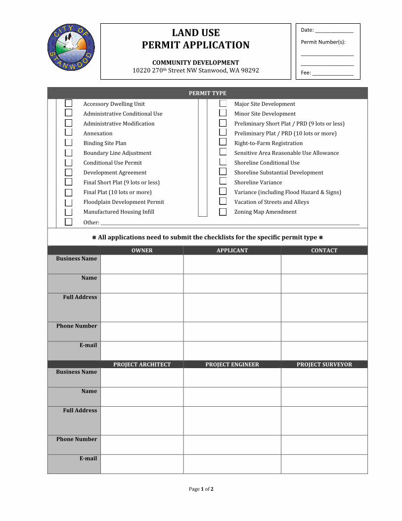
PERMIT TYPE
Accessory Dwelling Unit
Major Site Development
Administrative Conditional Use Minor Site Development Administrative Modification Preliminary Short Plat / PRD (9 lots or less) Annexation Preliminary Plat / PRD (10 lots or more)
Binding Site Plan Right-to-Farm Registration Boundary Line Adjustment Sensitive Area Reasonable Use Allowance Conditional Use Permit Shoreline Conditional Use Development Agreement Shoreline Substantial Development Final Short Plat (9 lots or less) Shoreline Variance Final Plat (10 lots or more) Variance (including Flood Hazard & Signs) Floodplain Development Permit Vacation of Streets and Alleys Manufactured Housing Infill Zoning Map Amendment Other: ______________________________________________________________________________________________________________________
⨳ All applications need to submit the checklists for the specific permit type ⨳
OWNER APPLICANT CONTACT Business Name
Name
Full Address
Phone Number
PROJECT ARCHITECT PROJECT ENGINEER PROJECT SURVEYOR Business Name
Name
Full Address
Phone Number
LAND USE PERMIT APPLICATION
COMMUNITY DEVELOPMENT
10220 270th Street NW Stanwood, WA 98292
Date: _____________
Permit Number(s):
__________________
__________________
Fee: ______________
Page 2 of 2
SITE INFORMATION
Project Address Tax Parcel ID Numbers
Acreage & Square Footage of Property
Zoning Classification
Comprehensive Plan Designation
Water Supply Current Proposed Sewer Supply Current Proposed
Existing Use of Property
Proposed Use of Property
On-Site Critical Areas? Yes No Critical Area Type
Does the Site have a Shoreline Designation? Yes No Shoreline Designation
Will the Site Be Logged as Part of This Project? Yes No DNR Permit Required? Yes No
Parking Spaces Provided Landscaping Area (square feet)
Building Footprint Area (square feet) Lot Building Coverage
Number of Proposed Units Building Height
APPLICANT CERTIFICATION I certify that I am the Owner or Owner’s authorized agent. If acting as an authorized agent, I further certify that I am authorized to act as the Owners agent regarding the property at the above referenced address for the purpose of filing applications for permits or review under the Stanwood Municipal Code and I have full power and authority to perform on behalf of the Owner all acts required to enable the City to process and review such applications. I do hereby declare under penalty of perjury under the laws of the State of Washington that I have familiarized myself with the rules and regulations with respect to preparing and filing this application and that the statements and information submitted herewith are in all respects true and correct to the best of my knowledge and belief.
Applicant’s Signature Date
Print Name
REAL PROPERTY OWNER CERTIFICATION I do hereby declare under penalty of perjury under the laws of the State of Washington that I am the owner of the subject property or an officer/member of the entity owning the subject property, that it is my desire to seek the subject land use permit, and that I will abide by any requirements and conditions that may be part of the approval of this request. I also hereby grant permission for City employees, agents of the City and/or other agency officials to enter the subject property, if necessary, for the purpose of site inspections.
Owner’s Signature Date
Print Name
For additional owners please supply each owners name, signature and date on a separate sheet.
Page 1 of 2
City of Stanwood 10220 270th Street NW
Stanwood, Washington 98292 (360) 629-2181
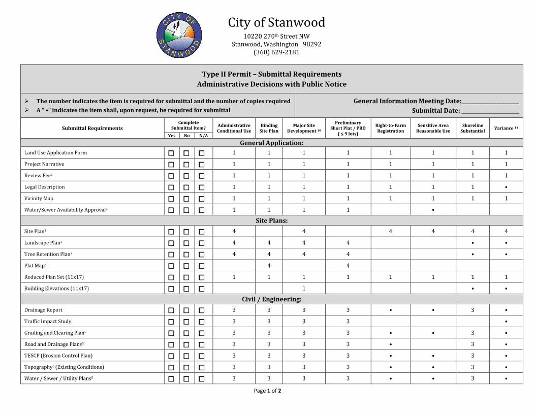
Type II Permit – Submittal Requirements Administrative Decisions with Public Notice
The number indicates the item is required for submittal and the number of copies required
A “ •” indicates the item shall, upon request, be required for submittal General Information Meeting Date:_______________________
Submittal Date: _______________________
Submittal Requirements Complete
Submittal Item? Administrative Conditional Use
Binding Site Plan
Major Site Development 10
Preliminary Short Plat / PRD
( ≤ 9 lots)
Right-to-Farm Registration
Sensitive Area Reasonable Use
Shoreline Substantial Variance 11
Yes No N/A
General Application:
Land Use Application Form ⧠ ⧠ ⧠ 1 1 1 1 1 1 1 1
Project Narrative ⧠ ⧠ ⧠ 1 1 1 1 1 1 1 1
Review Fee1 ⧠ ⧠ ⧠ 1 1 1 1 1 1 1 1
Legal Description ⧠ ⧠ ⧠ 1 1 1 1 1 1 1 •
Vicinity Map ⧠ ⧠ ⧠ 1 1 1 1 1 1 1 1
Water/Sewer Availability Approval2 ⧠ ⧠ ⧠ 1 1 1 1 •
Site Plans:
Site Plan3 ⧠ ⧠ ⧠ 4 4 4 4 4 4
Landscape Plan3 ⧠ ⧠ ⧠ 4 4 4 4 • •
Tree Retention Plan3 ⧠ ⧠ ⧠ 4 4 4 4 • •
Plat Map4 ⧠ ⧠ ⧠ 4 4
Reduced Plan Set (11x17) ⧠ ⧠ ⧠ 1 1 1 1 1 1 1 1
Building Elevations (11x17) ⧠ ⧠ ⧠ 1 • •
Civil / Engineering: Drainage Report ⧠ ⧠ ⧠ 3 3 3 3 • • 3 •
Traffic Impact Study ⧠ ⧠ ⧠ 3 3 3 3 •
Grading and Clearing Plan5 ⧠ ⧠ ⧠ 3 3 3 3 • • 3 •
Road and Drainage Plans5 ⧠ ⧠ ⧠ 3 3 3 3 • 3 •
TESCP (Erosion Control Plan) ⧠ ⧠ ⧠ 3 3 3 3 • • 3 •
Topography5 (Existing Conditions) ⧠ ⧠ ⧠ 3 3 3 3 • • 3 •
Water / Sewer / Utility Plans5 ⧠ ⧠ ⧠ 3 3 3 3 • • 3 •
Page 2 of 2
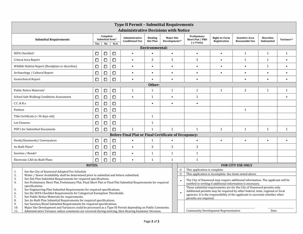
Type II Permit – Submittal Requirements Administrative Decisions with Notice
Submittal Requirements Complete
Submittal Item? Administrative Conditional Use
Binding Site Plan
Major Site Development10
Preliminary Short Plat / PRD
( ≤ 9 lots)
Right-to-Farm Registration
Sensitive Area Reasonable Use
Shoreline Substantial Variance11
Yes No N/A Environmental:
SEPA Checklist6 ⧠ ⧠ ⧠ • • • • • 1 1 1
Critical Area Report ⧠ ⧠ ⧠ • 3 3 3 • 1 1 •
Wildlife Habitat Report (floodplain or shoreline) ⧠ ⧠ ⧠ • • • • • • 1 •
Archaeology / Cultural Report ⧠ ⧠ ⧠ • • • • • • • •
Geotechnical Report ⧠ ⧠ ⧠ • • • • • • •
Other: Public Notice Materials7 ⧠ ⧠ ⧠ 1 1 1 1 1 2 1 1
School Safe Walking Conditions Assessment ⧠ ⧠ ⧠ • 1 • 1 •
C.C. & R.s ⧠ ⧠ ⧠ • • •
Petition ⧠ ⧠ ⧠ 1
Title Certificate (< 30 days old) ⧠ ⧠ ⧠ 1
Lot Closures ⧠ ⧠ ⧠ 1
PDF’s for Submitted Documents ⧠ ⧠ ⧠ 1 1 1 1 1 1 1 1 Before Final Plat or Final Certificate of Occupancy:
Deeds/Easements/ Conveyances ⧠ ⧠ ⧠ • 1 • • • • • •
As-Built Plans8 ⧠ ⧠ ⧠ • 3 3 3
Sureties / Bonds9 ⧠ ⧠ ⧠ • 1 1 1
Electronic CAD As-Built Plans ⧠ ⧠ ⧠ • 1 1 1 NOTES: FOR CITY USE ONLY
1. 2. 3. 4. 5. 6. 7. 8. 9. 10. 11.
See the City of Stanwood Adopted Fee Schedule Water / Sewer Availability shall be determined prior to submittal and letters submitted. See Site Plan Submittal Requirements for required specifications. See Preliminary Short Plat, Preliminary Plat, Final Short Plat or Final Plat Submittal Requirements for required specifications. See Engineering Plan Submittal Requirements for required specifications. See the SEPA Checklist Requirements for Categorical Exemption Thresholds. See Public Notice Materials for requirements. See As-Built Plan Submittal Requirements for required specifications. See Sureties/Bond Submittal Requirements for required specifications. Major Site Development and Variances could be processed as a Type III Permit depending on Public Comments. Administrative Variance unless comments are received during noticing, then Hearing Examiner Decision.
⧠ This application is complete. ⧠ This application is incomplete. See items noted above.
• The City of Stanwood may require additional information. The applicant will be notified in writing if additional information is necessary.
•
These submittal requirements are for the City of Stanwood permits only. Additional permits may be required by other federal, state, regional or local agencies. It is the responsibility of the applicant to ascertain whether other permits are required.
____________________________________________________________ _______________________ Community Development Representative Date
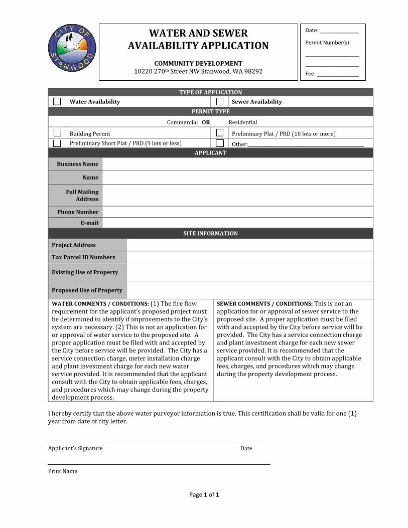
Page 1 of 1
TYPE OF APPLICATION
Water Availability Sewer Availability PERMIT TYPE
Commercial OR Residential
Building Permit Preliminary Plat / PRD (10 lots or more)
Preliminary Short Plat / PRD (9 lots or less) Other:____________________________________________________ APPLICANT
Business Name
Name
Full Mailing Address
Phone Number
SITE INFORMATION
Project Address
Tax Parcel ID Numbers
Existing Use of Property
Proposed Use of Property
WATER COMMENTS / CONDITIONS: (1) The fire flow requirement for the applicant’s proposed project must be determined to identify if improvements to the City’s system are necessary. (2) This is not an application for or approval of water service to the proposed site. A proper application must be filed with and accepted by the City before service will be provided. The City has a service connection charge, meter installation charge and plant investment charge for each new water service provided. It is recommended that the applicant consult with the City to obtain applicable fees, charges, and procedures which may change during the property development process.
SEWER COMMENTS / CONDITIONS: This is not an application for or approval of sewer service to the proposed site. A proper application must be filed with and accepted by the City before service will be provided. The City has a service connection charge and plant investment charge for each new sewer service provided. It is recommended that the applicant consult with the City to obtain applicable fees, charges, and procedures which may change during the property development process.
I hereby certify that the above water purveyor information is true. This certification shall be valid for one (1) year from date of city letter.
Applicant’s Signature Date
Print Name
WATER AND SEWER AVAILABILITY APPLICATION
COMMUNITY DEVELOPMENT
10220 270th Street NW Stanwood, WA 98292
Date: _____________
Permit Number(s):
__________________
__________________
Fee: ______________
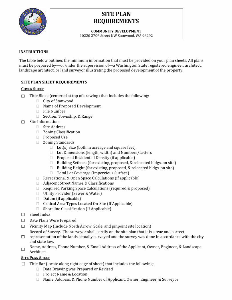
SITE PLAN REQUIREMENTS
COMMUNITY DEVELOPMENT
10220 270th Street NW Stanwood, WA 98292
INSTRUCTIONS
The table below outlines the minimum information that must be provided on your plan sheets. All plans must be prepared by—or under the supervision of—a Washington State registered engineer, architect, landscape architect, or land surveyor illustrating the proposed development of the property.
SITE PLAN SHEET REQUIREMENTS COVER SHEET
☐ Title Block (centered at top of drawing) that includes the following: � City of Stanwood � Name of Proposed Development � File Number � Section, Township, & Range
☐ Site Information: � Site Address � Zoning Classification � Proposed Use � Zoning Standards:
� Lot(s) Size (both in acreage and square feet) � Lot Dimensions (length, width) and Numbers/Letters � Proposed Residential Density (if applicable) � Building Setback (for existing, proposed, & relocated bldgs. on site) � Building Height (for existing, proposed, & relocated bldgs. on site) � Total Lot Coverage (Impervious Surface)
� Recreational & Open Space Calculations (if applicable) � Adjacent Street Names & Classifications � Required Parking Space Calculations (required & proposed) � Utility Provider (Sewer & Water) � Datum (if applicable) � Critical Area Types Located On-Site (If Applicable) � Shoreline Classification (If Applicable)
☐ Sheet Index ☐ Date Plans Were Prepared ☐ Vicinity Map (Include North Arrow, Scale, and pinpoint site location)
☐ Record of Survey. The surveyor shall certify on the site plan that it is a true and correct representation of the lands actually surveyed and the survey was done in accordance with the city and state law.
☐ Name, Address, Phone Number, & Email Address of the Applicant, Owner, Engineer, & Landscape Architect
SITE PLAN SHEET ☐ Title Bar (locate along right edge of sheet) that includes the following:
� Date Drawing was Prepared or Revised � Project Name & Location � Name, Address, & Phone Number of Applicant, Owner, Engineer, & Surveyor
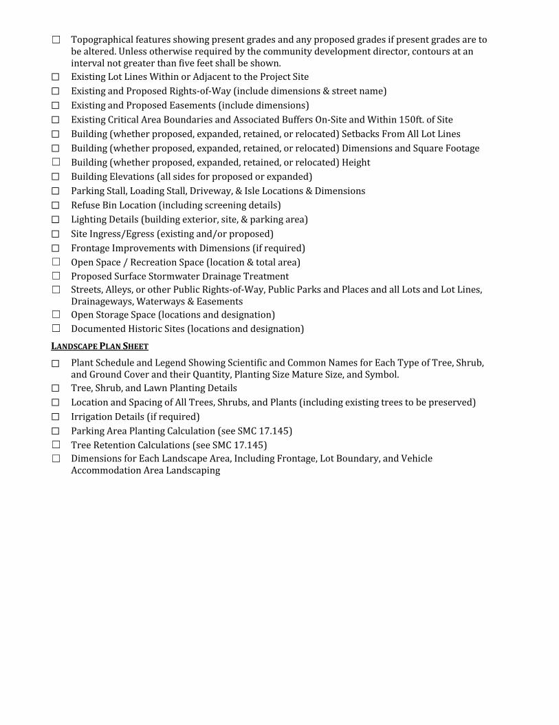
☐ Topographical features showing present grades and any proposed grades if present grades are to be altered. Unless otherwise required by the community development director, contours at an interval not greater than five feet shall be shown.
☐ Existing Lot Lines Within or Adjacent to the Project Site ☐ Existing and Proposed Rights-of-Way (include dimensions & street name) ☐ Existing and Proposed Easements (include dimensions) ☐ Existing Critical Area Boundaries and Associated Buffers On-Site and Within 150ft. of Site ☐ Building (whether proposed, expanded, retained, or relocated) Setbacks From All Lot Lines ☐ Building (whether proposed, expanded, retained, or relocated) Dimensions and Square Footage ☐ Building (whether proposed, expanded, retained, or relocated) Height ☐ Building Elevations (all sides for proposed or expanded) ☐ Parking Stall, Loading Stall, Driveway, & Isle Locations & Dimensions ☐ Refuse Bin Location (including screening details) ☐ Lighting Details (building exterior, site, & parking area) ☐ Site Ingress/Egress (existing and/or proposed) ☐ Frontage Improvements with Dimensions (if required) ☐ Open Space / Recreation Space (location & total area) ☐ Proposed Surface Stormwater Drainage Treatment ☐ Streets, Alleys, or other Public Rights-of-Way, Public Parks and Places and all Lots and Lot Lines,
Drainageways, Waterways & Easements ☐ Open Storage Space (locations and designation) ☐ Documented Historic Sites (locations and designation)
LANDSCAPE PLAN SHEET
☐ Plant Schedule and Legend Showing Scientific and Common Names for Each Type of Tree, Shrub, and Ground Cover and their Quantity, Planting Size Mature Size, and Symbol.
☐ Tree, Shrub, and Lawn Planting Details ☐ Location and Spacing of All Trees, Shrubs, and Plants (including existing trees to be preserved) ☐ Irrigation Details (if required) ☐ Parking Area Planting Calculation (see SMC 17.145) ☐ Tree Retention Calculations (see SMC 17.145) ☐ Dimensions for Each Landscape Area, Including Frontage, Lot Boundary, and Vehicle
Accommodation Area Landscaping
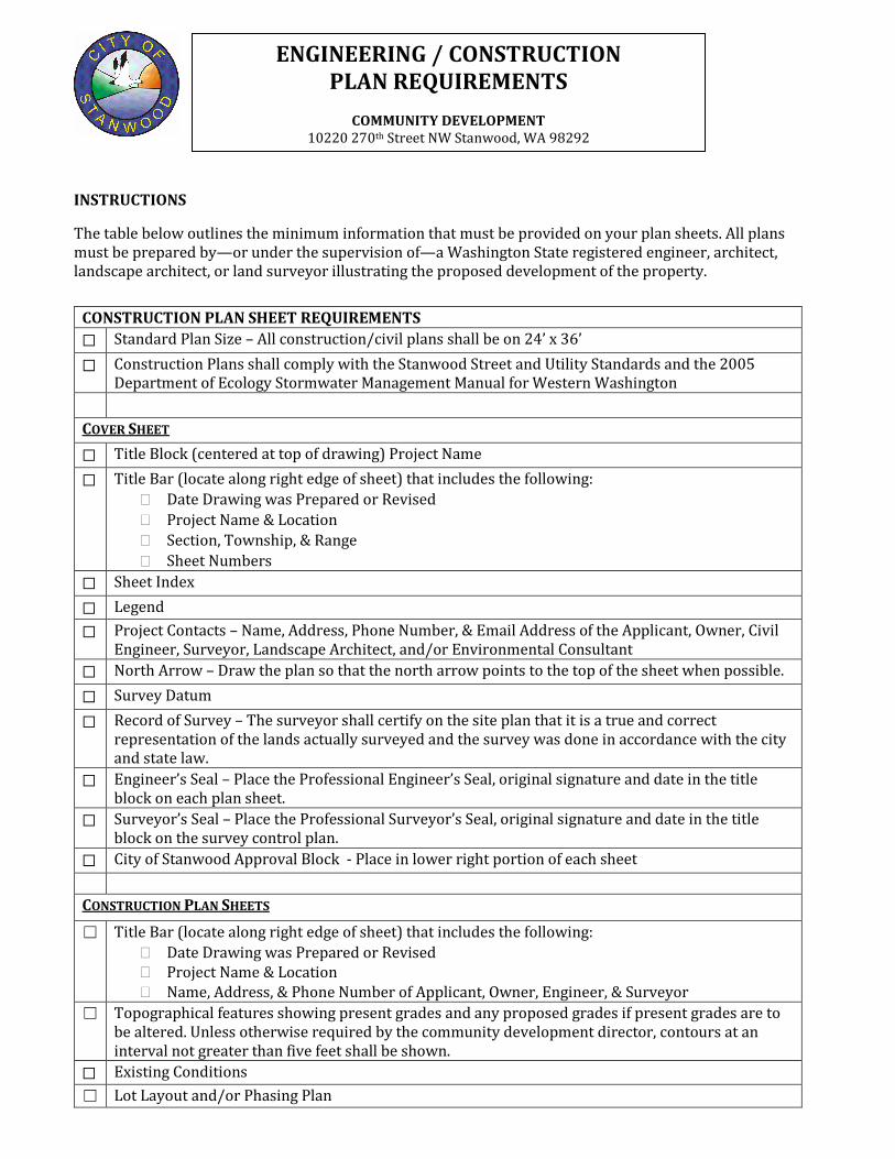
ENGINEERING / CONSTRUCTION PLAN REQUIREMENTS
COMMUNITY DEVELOPMENT
10220 270th Street NW Stanwood, WA 98292
INSTRUCTIONS
The table below outlines the minimum information that must be provided on your plan sheets. All plans must be prepared by—or under the supervision of—a Washington State registered engineer, architect, landscape architect, or land surveyor illustrating the proposed development of the property.
CONSTRUCTION PLAN SHEET REQUIREMENTS ☐ Standard Plan Size – All construction/civil plans shall be on 24’ x 36’
☐ Construction Plans shall comply with the Stanwood Street and Utility Standards and the 2005 Department of Ecology Stormwater Management Manual for Western Washington
COVER SHEET ☐ Title Block (centered at top of drawing) Project Name ☐ Title Bar (locate along right edge of sheet) that includes the following:
� Date Drawing was Prepared or Revised � Project Name & Location � Section, Township, & Range � Sheet Numbers
☐ Sheet Index ☐ Legend ☐ Project Contacts – Name, Address, Phone Number, & Email Address of the Applicant, Owner, Civil
Engineer, Surveyor, Landscape Architect, and/or Environmental Consultant ☐ North Arrow – Draw the plan so that the north arrow points to the top of the sheet when possible. ☐ Survey Datum ☐ Record of Survey – The surveyor shall certify on the site plan that it is a true and correct
representation of the lands actually surveyed and the survey was done in accordance with the city and state law.
☐ Engineer’s Seal – Place the Professional Engineer’s Seal, original signature and date in the title block on each plan sheet.
☐ Surveyor’s Seal – Place the Professional Surveyor’s Seal, original signature and date in the title block on the survey control plan.
☐ City of Stanwood Approval Block - Place in lower right portion of each sheet CONSTRUCTION PLAN SHEETS
☐ Title Bar (locate along right edge of sheet) that includes the following: � Date Drawing was Prepared or Revised � Project Name & Location � Name, Address, & Phone Number of Applicant, Owner, Engineer, & Surveyor
☐ Topographical features showing present grades and any proposed grades if present grades are to be altered. Unless otherwise required by the community development director, contours at an interval not greater than five feet shall be shown.
☐ Existing Conditions ☐ Lot Layout and/or Phasing Plan
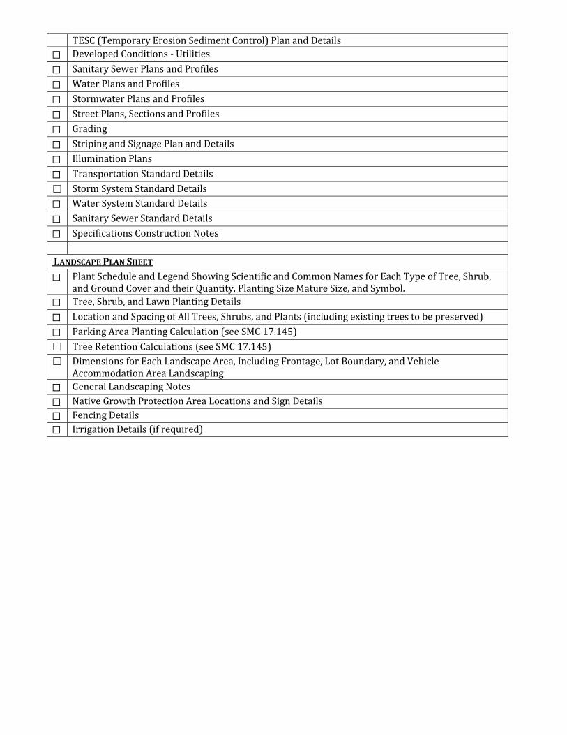
TESC (Temporary Erosion Sediment Control) Plan and Details ☐ Developed Conditions - Utilities ☐ Sanitary Sewer Plans and Profiles ☐ Water Plans and Profiles ☐ Stormwater Plans and Profiles ☐ Street Plans, Sections and Profiles ☐ Grading ☐ Striping and Signage Plan and Details ☐ Illumination Plans ☐ Transportation Standard Details ☐ Storm System Standard Details ☐ Water System Standard Details ☐ Sanitary Sewer Standard Details ☐ Specifications Construction Notes LANDSCAPE PLAN SHEET ☐ Plant Schedule and Legend Showing Scientific and Common Names for Each Type of Tree, Shrub,
and Ground Cover and their Quantity, Planting Size Mature Size, and Symbol. ☐ Tree, Shrub, and Lawn Planting Details ☐ Location and Spacing of All Trees, Shrubs, and Plants (including existing trees to be preserved) ☐ Parking Area Planting Calculation (see SMC 17.145) ☐ Tree Retention Calculations (see SMC 17.145) ☐ Dimensions for Each Landscape Area, Including Frontage, Lot Boundary, and Vehicle
Accommodation Area Landscaping ☐ General Landscaping Notes ☐ Native Growth Protection Area Locations and Sign Details ☐ Fencing Details ☐ Irrigation Details (if required)
Page 1 of 1
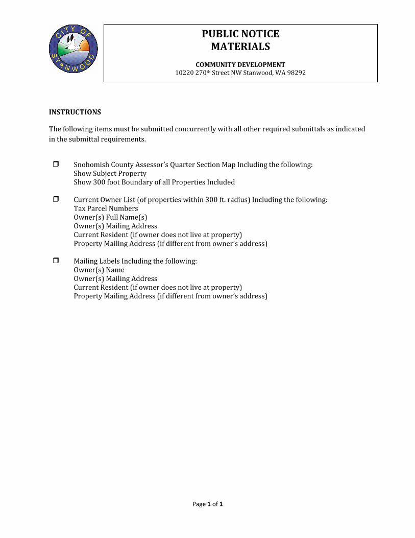
INSTRUCTIONS
The following items must be submitted concurrently with all other required submittals as indicated in the submittal requirements.
Snohomish County Assessor’s Quarter Section Map Including the following: Show Subject Property Show 300 foot Boundary of all Properties Included Current Owner List (of properties within 300 ft. radius) Including the following: Tax Parcel Numbers Owner(s) Full Name(s) Owner(s) Mailing Address Current Resident (if owner does not live at property) Property Mailing Address (if different from owner’s address) Mailing Labels Including the following: Owner(s) Name Owner(s) Mailing Address Current Resident (if owner does not live at property) Property Mailing Address (if different from owner’s address)
PUBLIC NOTICE MATERIALS
COMMUNITY DEVELOPMENT
10220 270th Street NW Stanwood, WA 98292

Bond Worksheet
Page 1 of 1
Bond Assignment of Funds Letter of Credit Surety
SITE INFORMATION
Project Name
Project Address
Type of Bond Performance Maintenance Public Improvements Landscape
CONTACT INFORMATION
Owner/Applicant
Address
Phone Number
PERFORMANCE BOND INFORMATION MAINTENANCE BOND INFORMATION
• A Performance Bond or Assignment of Funds needs to be on file with the City of Stanwood prior to Construction Permit issuance.
• The Performance Bond shall be 150% of the Construction Costs (including materials, labor and tax) for the following public improvements: Roads and Alleys, Stormwater Drainage/Detention Ponds, Grading, Utilities, Landscaping, Temporary Erosion and Sediment Control.
• A Maintenance Bond or Assignment of Funds needs to be on file with the City of Stanwood prior to Final Plat Approval or Certificate of Occupancy being issued.
• The Maintenance Bond shall be 25% of the Construction Cost (including materials, labor and tax) for the following public improvements: Roads and Alleys, Stormwater Drainage/Detention Ponds, Grading, Utilities, Landscaping, Temporary Erosion and Sediment Control.
BOND CALCULATIONS
Construction Cost (materials, labor and tax for public roads and alleys, public stormwater drainage and grading, public utilities, landscaping, public and private temporary erosion and sediment control) $ Performance Bond Amount (150% of Construction Cost) Construction Cost X 1.5 = $ Maintenance Bond Amount (25% of Construction Cost) Construction Cost X 0.25 = $
* Provide Engineer’s Estimated Cost of Construction and/or other documentation showing calculations CITY USE ONLY – ACCEPTED BY
City Staff Signature: __________________________________________________________________ Date:________________________________
SURETIES / BOND WORKSHEET
COMMUNITY DEVELOPMENT
10220 270th Street NW Stanwood, WA 98292