luas broombridge_eis_book_2_part_4_chapters_8-13).pdf
TRANSCRIPT

Dominick
Broadstone - DIT
Phibsborough
Grangegorman
Cabra
Parnell
Marlborough
O’ConnellUpper
O’Connell - GPO
Westmoreland
Trinity
Dawson
St. Stephen’s Green
Broombridge
BOOK 2 of 5
Luas BroombridgeSt. Stephen’s Green to Broombridge(Line BXD)
EnvironmentalImpactStatementArea 29St. Stephen’s Green to former Broadstone railway cuttingPart 4 - Chapters 8–13


Dominick
Broadstone - DIT
Phibsborough
Grangegorman
Cabra
Parnell
Marlborough
O’ConnellUpper
O’Connell - GPO
Westmoreland
Trinity
Dawson
St. Stephen’s Green
Broombridge
8 fLOrA ANd fAuNA 8.1 Introduction ...............................................................271
8.2 Study area ..................................................................271
8.3 Impact assessment methodology ...........................2718.3.1 Impact magnitude ........................................................2718.3.2 Impact significance ......................................................272
8.4 Impact assessment ..................................................2738.4.1 Impact identification ....................................................2738.4.2 Mitigation measures ....................................................2768.4.3 Assessment of residual impacts ..................................277
8.5 references .................................................................278
IMPACT ArEA 29


271 Environmental Impact Statement Luas Broombridge
fLOrA ANd fAuNA
8.1 INTrOduCTIONThis section of the Environmental Impact Statement (EIS) brings together the baseline flora and fauna characteristics and the construction and operation characteristics of the proposed scheme with the aim of ensuring that all likely significant impacts (positive or negative) are identified in Area 29. This chapter should be read in conjunction with the Flora and Fauna baseline chapter of this EIS (Book 1, Chapter 17), which has described and categorised the receiving environment according to the criteria contained within the National Roads Authority (NRA) “Guidelines for Assessment of Ecological Impacts of National Road Schemes”1. Each of the NRA categories has a corresponding baseline rating, which will be used in combination with an impact magnitude to help determine the significance of the impacts on flora and fauna.
8.2 STudy ArEAThe study area for this assessment was defined in the Flora and Fauna baseline chapter of this EIS (Book 1, Chapter 17) and is again outlined in Table 8.1. The assessment area has been defined with reference to the potential for impact from the proposed scheme and the availability of relevant information.
8.3 IMPACT ASSESSMENT METhOdOLOGyThe source and type of all potential impacts are described in Section 8.4.1. Mitigation measures to be put in place are defined in Section 8.4.2. Mitigation measures are defined for any adverse impacts that
are deemed to be of moderate or greater significance prior to mitigation. The extent to which mitigation is needed increases as the significance of the impact increases. The residual impact of each impact is then evaluated in Section 8.4.3 in terms of baseline rating, magnitude and significance and a summary is provided in Table 8.6.
8.3.1 Impact magnitudeThe criteria used to assess the different impacts associated with the proposed scheme are shown in Table 8.2. The criteria have been defined in consideration of the Environmental Protection Agency (EPA)2,3 and NRA1 methodology. Impact magnitude is determined based on the duration and extent of the potential impact. The magnitude variables of duration and extent are each divided into temporary or permanent and large or small, respectively, in accordance with the NRA1 methodology. This results in four possible permutations (temporary/small, temporary/large, permanent/small and permanent/large) as shown in Table 8.2, corresponding to four categories of impact magnitude ranging from low to very high.
Table 8.1 Study area
CrITErIA wIdTh Of STudy ArEA (ON BOTh SIdES Of ThE ALIGNMENT)
Designated sites 5km.
Habitats Phase 1 500m.
Badgers 150m (extended where appropriate).
Otter 150m upstream and downstream of watercourses.
Bats Within 500m where suitable habitat occurs.
Birds Within 500m where suitable habitat occurs.
Amphibians and reptiles Where suitable habitats occur within the Phase 1 survey limits.
Watercourses and fisheries Where suitable habitats occur within the Phase 1 survey limits.

Environmental Impact Statement Luas Broombridge 272
fLOrA ANd fAuNA
8.3.2 Impact significanceThe likely significance of all impacts is determined in consideration of the magnitude of the impact and the baseline rating of the resource upon which the impact has an effect.
Table 8.3 shows how the baseline rating and the impact magnitude are combined to give the likely significance of the impact prior to any mitigation
measures being implemented. The impact significance ranges are then defined using the following score: Imperceptible/Neutral (2–4); Slight/Minor (5–9); Moderate (10–12); Significant/Major (15–16); Profound/Severe (20–25). These correspond to the NRA impact categories of neutral, minor (negative/positive), moderate (negative/positive), major (negative/positive) and severe, respectively.
Table 8.3 Criteria for assessment of impact significance
IMPACT SIGNIfICANCE (+/-)*
Impact
Magnitude
(+/-)*
6Baseline Rating4
Very low
(1)
Low
(2)
Medium
(3)
High
(4)
Very high
(5)
Low Temporary/
small
(2)
Imperceptible/Neutral
(2–4)
Imperceptible/Neutral
(2–4)
Slight/Minor
(5–9)
Slight/Minor
(5–9)
Moderate
(10–12)
Medium
Temporary/large
(3)
Imperceptible/Neutral
(2–4)
Slight/Minor
(5–9)
Slight/Minor
(5–9)
Moderate
(10–12)
Significant Major
(15–16)
High
Permanent/small
(4)
Imperceptible/Neutral
(2–4)
Slight/Minor
(5–9)
Moderate
(10–12)
Significant Major
(15–16)
Profound/Severe
(20–25)
Very high
Permanent/large
(5)
Slight/Minor
(5–9)
Moderate
(10–12)
Significant Major
(15–16)
Profound/Severe
(20–25)
Profound/Severe
(20–25)
* Modified template matrix for determining impact significance based on NRA1 impact assessment matrix.
Table 8.2 Criteria for assessment of impact magnitude
CrITErIA IMPACT MAGNITudE
Permanent/large Very high
Permanent/small High
Temporary/large Medium
Temporary/small Low

273 Environmental Impact Statement Luas Broombridge
fLOrA ANd fAuNA
For example, if a habitat or ecological site has a baseline rating of very high and the magnitude of the impact is medium then this can be considered a significant/major impact. If an impact can be fully mitigated, or if the impact magnitude is neutral, the impact is considered not significant. If in an exceptional circumstance, an impact magnitude is unknown then the impact significance is unknown significance. These impact significance terms are in line with the “Guidelines on the Information to be Contained in Environmental Impact Statements” (EPA)2.
8.4 IMPACT ASSESSMENT 8.4.1 Impact identificationVarious elements of both the construction and operational phases have the potential to impact on the flora and fauna environment. The potential impacts for both construction and operation of the proposed scheme prior to mitigation are described in this section of the EIS. Potential sources and types of impact are set out in Table 8.4. The mitigation measures are described in Section 8.4.2 and the residual impacts after the proposed mitigation measures have been implemented are described in Section 8.4.3.
Table 8.4 Sources and types of potential impact
IMPACT SOurCE IMPACT
Construction phase
Temporary landtake.
Construction compounds.
Working areas along trackbed.
Permanent loss of habitat or species.
Temporary loss of habitat or species.
Fragmentation of habitat or severance of wildlife corridors between isolated habitats of ecological importance.
Creation of barriers to the movements of animals, especially mammals, amphibians and plants with limited powers of dispersal.
Impacts on designated sites.
Construction activities (e.g. runoff and other pollution, increase of suspended solids, alteration of hydraulic conditions, noise and dust emissions, lighting, movement of vehicles, presence of construction personnel).
Damage or alteration to adjacent habitats.
Disturbance to species in the vicinity of the proposed scheme.
Impacts on designated sites.
Introduction of invasive species.
Operational phase
Permanent landtake (e.g. stops, trackbed, substations, ancillary roads, etc.).
Permanent loss of habitat or species.
Permanent alteration to existing habitats.
Fragmentation of habitat or severance of wildlife corridors between isolated habitats of ecological importance.
Creation of barriers to the movements of mammals, amphibians and plants with limited powers of dispersal.
Impacts on designated sites.
Operation of rolling stock and maintenance of the track (e.g. runoff and other pollution, increase of suspended solids, noise and dust emissions, lighting, movement of vehicles, presence of maintenance personnel).
Disturbance to species in the vicinity of the proposed scheme.
Animal collisions.
Impacts on designated sites.

Environmental Impact Statement Luas Broombridge 274
fLOrA ANd fAuNA
8.4.1.1 Construction impactsConstruction impacts on designated sitesThere are no predicted impacts on designated sites during construction.
Construction impacts on rare and protected floraNo rare or protected plant species were identified within the proposed alignment. Therefore there are no predicted impacts on rare or protected plant species during construction.
Construction impacts on sites and habitatsSt. Stephen’s GreenThe construction of the proposed scheme in Area 29 will result in a temporary loss of a small area of treelines on the southern footpath of St. Stephen’s Green North, a site of medium baseline rating. The impact magnitude has been assessed as being low. This will result in an overall slight/minor negative impact according to the criteria for assessment of impact significance set out in Table 8.3.
river Liffey The proposed scheme will cross the River Liffey at two points: on the existing O’Connell Bridge and on the proposed Marlborough Street Public Transport Priority Bridge. The River Liffey has a baseline rating of high as it is considered to be nationally important.
The first crossing of the River Liffey is at O’Connell Bridge. Minor works may be required including waterproofing of the deck, refurbishment of the existing services subways and the possible provision of a floating track slab on an anti-vibration mat. It is anticipated that no in-stream works will be required in the River Liffey.
The second crossing between Marlborough Street and Hawkins Street was subject to a separate EIS (the Marlborough Street Public Transport Priority Bridge), undertaken by Dublin City Council (DCC). This structure is outside the scope of this EIS. The EIS for the Marlborough Street Public Transport Priority Bridge concluded that there would be no significant impact on the aquatic or terrestrial environment arising from the proposed crossing. This public transport bridge has received statutory approval from An Bord Pleanála (ABP).
Although construction of the Marlborough Street Public Transport Priority Bridge is outside the scope of this EIS, rails will be laid across this bridge during the construction of the proposed scheme and there will be no in-stream works required.
The proposed crossings will result in the temporary
loss of a small area of the buildings and artificial surfaces habitat type, which are considered to have a very low baseline rating. The impact magnitude has been assessed as low. This will result in an overall imperceptible/neutral impact according to the criteria for assessment of impact significance set out in Table 8.3. Other potential impacts on the aquatic environment are discussed below under protected aquatic species and fish.
Buildings and artificial surfacesThe majority of the proposed scheme in Area 29 is located on existing roads and hard surfaces. Construction will result in the temporary loss of a small area of this habitat type during track laying along the alignment and for construction compounds at St. Stephen’s Green North, Cathal Brugha Street, Western Way, Broadstone and Grangegorman. The baseline rating of this habitat type is very low. The impact magnitude has been assessed as being low. This will result in an overall imperceptible/neutral impact according to the criteria for assessment of impact significance set out in Table 8.3.
TreelinesThe proposed scheme will result in the temporary loss of a number of treelines with a baseline rating of low. The impact magnitude has been assessed as being high. This will result in an overall slight/minor negative impact according to the criteria for assessment of impact significance set out in Table 8.3. Table 8.5 identifies treelines lost during construction of the proposed scheme within Area 29.
A tree assessment along the proposed scheme was undertaken in 2009. The findings from the tree assessment is used as a data source for the Landscape and Visual baseline chapter as well as the Flora and Fauna baseline chapter of this EIS (Book 1, Chapters 22 and 17, respectively). The survey included an assessment of trees in accordance with the British Standard (BS) 58374: 2005 “Trees in Relation to Construction”. The findings of the tree surveys are summarised and presented in tabular format included in Annex L, Book 5, of this EIS.
Construction impacts on faunaBadgersThere is no suitable habitat for badgers within Area 29 as this is a highly urbanised environment with very limited green space for foraging or sett building. No evidence of badger activity was recorded during the mammal survey and no records of their occurrence were identified during consultation with the National Parks and Wildlife Service’s (NPWS). The findings of the badger survey are summarised in the Flora and

275 Environmental Impact Statement Luas Broombridge
fLOrA ANd fAuNA
Fauna baseline assessment chapter of this EIS (Book 1, Chapter 17). Consequently there are no predicted impacts on the species within the study area.
OtterDue to the highly modified habitats at the proposed crossings of the River Liffey, there is no potential for otter holts in this area. Otter are known to use the River Liffey for feeding. There is potential for some disturbance to otter as a result of construction works. However, as the works will be at a height above the water and as there is already a high level of activity in this area; the impact of additional works is considered to be not significant. Consequently there are no predicted impacts on the species within the study area.
BatsNo evidence of bat use was found in the surveyed structures, including derelict properties adjacent to the Broadstone building and structures within the Broadstone Bus Depot. Consequently there are no predicted impacts on bat species within the study area. Details of the bat survey are included within a separate report in Annex G, Book 5, of this EIS.
BirdsA wide range of common bird species, typically found in urban areas was observed throughout Area 29. The loss of semi-mature and mature trees within Area 29 will result in the loss of a small amount of nesting and foraging habitat for these species. This habitat is widespread in the landscape. Consequently there are no predicted impacts on bird species within the study area.
Annex I bird speciesThere is no suitable habitat for kingfisher along this stretch of the River Liffey. Consequently there are no predicted impacts on kingfisher within the study area.
Amphibians and reptilesThe ornamental ponds at St. Stephen’s Green provide suitable habitat for amphibians or reptiles, however, these species were not recorded in the area during the February or June 2009 surveys. The findings of the amphibian and reptilian survey are summarised in the Flora and Fauna baseline assessment chapter of this EIS (Book 1, Chapter 17). Moreover, there are no predicted impacts on the ponds as a result of this project. Consequently there are no predicted impacts on amphibians or reptiles within the study area.
Protected aquatic species and fishThe proposed alignment crosses the River Liffey at O’Connell Bridge and the proposed Marlborough Street Public Transport Bridge. The River Liffey represents a highly significant regional salmonid catchment and also supports a diversity of coarse fish. The River Liffey also supports protected lamprey species and white-clawed crayfish. Construction will be carried out on existing structures above the water. There will be no discharge to the watercourse and no in-stream structures. There is potential for contamination of the River Liffey as a result of adjacent construction activities associated with the proposed scheme. An accidental contamination event could adversely affect protected aquatic species and fish stocks. Consequently there is potential for a moderate negative impact on protected aquatic species and fish if mitigation measures are not fully implemented.
Table 8.5 Treelines lost during construction of the proposed scheme within Area 29*
TrEELINE NO. LOCATION dOMINANT SPECIES MATurITy
T1 St. Stephen’s Green Lime cultivar (Tilia cordata) Semi-mature
T2 Dawson Street London plane (Platanus x hispanica) Mature
T3 College Green London plane Mature
T4 College Street London plane Mature
T8 O’Connell StreetLime (Tilia spp.), Maple (Acer spp.), Rowan (Sorbus aucuparia), Birch (Betula spp.)
Young
T9 Parnell Street Lime Young
* Identification of individual trees lost during construction of the proposed scheme within Area 29 is indicated on the Railway
Order (RO) drawings attached to the RO application.

Environmental Impact Statement Luas Broombridge 276
fLOrA ANd fAuNA
8.4.1.2 OperationOperation impacts on designated sitesThere are no predicted impacts on designated sites during operation of the proposed scheme.
Operation impacts on rare and protected floraThere will be no operational impacts on rare or protected plant species.
Operation impacts on sites and habitatsThe construction of the proposed scheme will result in the permanent loss of habitat and potential impacts on species as identified in Section 8.4.1.1. There will be no additional impacts associated with the operation of the proposed scheme on sites within Area 29.
Operation impacts on faunaThere will be no additional operational impacts on fauna during operation.
8.4.2 Mitigation measuresThe mitigation measures necessary to avoid or reduce the significance of any adverse impacts on flora and fauna are outlined in this section. These measures are over and above those already incorporated into the scheme design, which has for example sought to avoid sensitive habitats by using existing bridges over watercourses (e.g. across the River Liffey).
8.4.2.1 during both construction and operation An Environmental Management System (EMS), in accordance with International Standards Organisation (ISO) 14001:2004, will be established and maintained by the contractors during the construction and operational phases of the proposed scheme. An Environmental Management Plan (EMP) will be required throughout all phases of the development (construction and operation) and will be monitored by a suitably qualified Environmental Coordinator, to be employed by the construction and operation contractor. The EMP will cover all potentially polluting activities and include an emergency response procedure. All personnel working on the site will be trained in its use.
8.4.2.2 Construction The following mitigation measures are required in order to protect the overall quality of ecological resources:
■■ Implementation of best practices will ensure that the risk of disturbance or damage to adjacent habitats is minimised
■■ Stockpiled sand, gravel and soil will be placed away from the River Liffey in areas of low conservation value, kept to minimum size, situated
well away from all watercourses and covered or seeded where appropriate
■■ Vegetation clearance will take place outside the breeding bird season (1st March–31st August inclusive) in order to avoid the risk of disturbing breeding birds (which is an offence under the Wildlife Act, 19765 (as amended)). If work has to be undertaken within the breeding bird season, buildings, scrub and other vegetation will be checked for nesting birds before removal using methods agreed with the NPWS
■■ Where habitats are directly lost as a result of the proposed scheme, new alternative habitats will be created where feasible. Temporary works areas will be restored as soon as is reasonably practicable
■■ Tree loss during construction of the proposed scheme will be compensated for by tree planting along the alignment as described in the Landscape and Visual impact assessment chapter of this EIS (Books 2 and 3, Chapter 13). Mitigation planting will, where feasible, use species appropriate to the urban setting
■■ All trees suitable for retention will be protected from future site developments by the recommended methodologies as set out in BS 58374 “Trees in Relation to Construction”. Guidelines for these trees will be set out prior to any works on site. The “Guidelines for the Protection and Preservation of Trees, Hedgerows and Scrub Prior to, During and Post Construction of National Road Schemes” (NRA)6 will be followed in areas where these habitats will be impacted upon or are in close proximity to the proposed scheme
■■ The surface water drainage network is designed in full cognisance of the recommendations of the Greater Dublin Strategic Drainage Study (GDSDS). Sustainable Urban Drainage Systems (SUDS) are to be incorporated into the design of all storm control areas, using best practice standards as detailed in the Surface Water impact assessment chapter of this EIS (Books 2 and 3, Chapter 11)
■■ Best site management practices will be adopted during construction to minimise the risk of secondary impacts on adjacent habitats. Such practices include fencing to clearly mark boundaries and prevent accidental entrance into adjacent habitats, drainage systems designed to prevent water pollution and dust suppression to avoid dust dispersion. Further information is

277 Environmental Impact Statement Luas Broombridge
fLOrA ANd fAuNA
provided as detailed in the Surface Water and Air and Climatic Factor impact assessment chapters of this EIS (Books 2 and 3, Chapters 11 and 12, respectively)
■■ Due to the sensitivity of watercourses containing salmonids and other protected aquatic species comprehensive surface water management and best practice mitigation measures will be implemented to avoid water pollution as described in the Surface Water impact assessment chapter of this EIS (Books 2 and 3, Chapter 11)
■■ The contractor will develop best practice construction procedures and method statements in consultation with the Eastern Regional Fisheries Board (ERFB) prior to the commencement of construction activities adjacent to watercourses
■■ Monitoring will be undertaken to confirm the effectiveness of mitigation measures during construction
8.4.2.3 OperationThe following mitigation measures are required during operation in order to protect the overall quality of ecological resources:
■■ Herbicides used during operation will be applied sparingly, as required and in compliance with suppliers’ guidance, and will be suitable for use in an environment in which sensitive receiving watercourses are present
8.4.3 Assessment of residual impactsThis section describes any residual impacts resulting from construction and operation of the proposed scheme assuming that all the mitigation measures are successfully implemented.
8.4.3.1 Constructionresidual impacts on designated sitesThere will be no residual impact on designated sites.
residual impacts on sites and habitats The construction of the proposed scheme in Area 29 will result in the temporary loss of a small area of treelines at St. Stephen’s Green resulting in a slight/minor negative impact. Following mitigation and the reinstatement of trees the slight/negative impact will diminish over time and become an imperceptible/neutral residual impact.
TreelinesThe proposed scheme will result in the loss of a number of trees along the alignment resulting in a
slight/minor negative impact. Following mitigation and the reinstatement of trees the slight/negative impact will diminish over time and become an imperceptible/neutral residual impact.
Construction impacts on faunaImpacts on protected species such as Atlantic salmon that occur within the River Liffey will be avoided once the mitigation set out to protect the aquatic environment is fully implemented. There will be no predicted residual impacts on aquatic species or their habitat.
8.4.3.2 OperationThere will be no residual impacts associated with the operation of the proposed scheme.
8.4.3.3 Summary of residual impactsA summary of the residual impacts associated with the proposed scheme and affecting this area is provided in Table 8.6.

Environmental Impact Statement Luas Broombridge 278
fLOrA ANd fAuNA
8.5 rEfErENCES1 National Roads Authority (2008a) Guidelines for
Assessment of Ecological Impacts of National Road Schemes. 2nd Edition. Dublin: National Roads Authority.
2 Environmental Protection Agency (2002) Guidelines on the Information to be Contained in Environmental Impact Statements. Wexford: Environmental Protection Agency.
3 Environmental Protection Agency (2003) Advice Notes on Current Practice (in the Preparation of Environmental Impact Statements). Wexford: Environmental Protection Agency.
4 British Standard Institution (2005) BS 5837: Trees in Relation to Construction – Recommendations. London: British Standards Institute.
5 Wildlife Act (1976) Wildlife Act, Ireland, 22 December 1976, No. 39 of 1976.
6 National Roads Authority (2006c) Guidelines for the Protection and Preservation of Trees, Hedgerows and Scrub Prior to, During and Post Construction of National Road Schemes. Dublin: National Roads Authority.
Table 8.6 Summary of residual impacts
BASELINE rATING
IMPACTIMPACT
MAGNITudE
IMPACT SIGNIfICANCE
PrIOr TO MITIGATION
MITIGATION MEASurE
rESIduAL IMPACT
SIGNIfICANCE
Location: St. Stephen’s Green
MediumLoss of kerbside trees comprising 11 semi-mature trees.
LowSlight/minor negative impact.
Treeline reinstatement
Imperceptible/neutral residual impact.
Location: River Liffey (habitat at crossing)
Very lowTemporary loss of buildings and artificial habitat.
LowImperceptible/neutral impact.
Reinstatement
Imperceptible/neutral residual impact.
Location: River Liffey (aquatic environment)
High
Potential run off from site leading to contamination of the aquatic environment.
Medium
Potential for moderate negative impact.
Ensure comprehensive surface water management and best practice mitigation measures will be implemented.
No predicted residual impacts.

Dominick
Broadstone - DIT
Phibsborough
Grangegorman
Cabra
Parnell
Marlborough
O’ConnellUpper
O’Connell - GPO
Westmoreland
Trinity
Dawson
St. Stephen’s Green
Broombridge
9 SOIL ANd GEOLOGy9.1 Introduction ...............................................................281
9.2 Study area ..................................................................281
9.3 Impact assessment methodology ...........................2819.3.1 Impact magnitude ........................................................2819.3.2 Impact significance ......................................................283
9.4 Impact assessment ..................................................2839.4.1 Impact identification ....................................................2839.4.2 Impact mitigation measures ........................................2889.4.3 Assessment of residual impacts ..................................290
9.5 references .................................................................292
IMPACT ArEA 29


281 Environmental Impact Statement Luas Broombridge
SOIL ANd GEOLOGy
9.1 INTrOduCTIONThis section of the Environmental Impact Statement (EIS) brings together the baseline soil and geology characteristics and the construction and operation characteristics of the proposed scheme with the aim of ensuring that all likely significant impacts (positive or negative) are identified in Area 29. This chapter should be read in conjunction with the Soil and Geology baseline chapter of this EIS (Book 1, Chapter 18) which has described the receiving environment and assigned a baseline rating to soil and geology across the study area. These baseline ratings will be used in combination with an impact magnitude to help determine the significance of the impacts on soil and geology.
9.2 STudy ArEAThe study area for this assessment was defined in the Soil and Geology baseline chapter of this EIS (Book 1, Chapter 18) and is again outlined in Table 9.1. The assessment area has been defined with reference to the potential for impact from the proposed scheme and the availability of relevant information.
9.3 IMPACT ASSESSMENT METhOdOLOGyThe source and type of all potential impacts is described in Section 9.4.1. Mitigation measures to be put in place are defined in Section 9.4.2. At a minimum, mitigation measures are defined for any adverse impacts that are deemed to be of moderate or greater significance prior to mitigation. The extent to which mitigation is needed increases as the significance of the impact increases. The residual impact of each impact is then evaluated in Section 9.4.3 in terms of magnitude and significance.
9.3.1 Impact magnitudeThe criteria used to assess the different impacts associated with the proposed scheme are shown in Tables 9.2 and 9.3. The criteria have been defined in consideration of the “Guidelines on the Information to be Contained in Environmental Impact Statements” (Environmental Protection Agency (EPA))1.
The duration of impacts is defined as per EPA guidance (EPA)1, shown in Table 9.3.
Table 9.1 Study area
CrITErIA wIdTh Of STudy ArEA (ON BOTh SIdES Of ThE ALIGNMENT)
Soils 500m
Quarternary geology (subsoil) 500m
Solid geology (bedrock) 500m
Landuse 100m
Table 9.2 Criteria for assessment of impact magnitude
CrITErIA IMPACT MAGNITudE
Complete loss of soil function, quality and/or fertility.
Complete destruction of geological characteristics of subsoil or rock.
Complete destruction of geological heritage feature.
Construction or operation of the proposed scheme presents a very high risk of soil contamination incident(s).
Permanent sterilisation of >1 million tonnes of aggregate reserves.
Geohazard poses unacceptable risk of injury/death or damage to property.
Very high

Environmental Impact Statement Luas Broombridge 282
SOIL ANd GEOLOGy
CrITErIA IMPACT MAGNITudE
Major degradation of soil function, quality and/or fertility.
Major degradation of geological characteristics of subsoil or rock.
Loss or degradation of a signficant proportion of geological heritage feature.
Construction or operation of the proposed scheme presents a high risk of soil contamination incident(s).
Permanent sterilisation of >0.5 million tonnes of aggregate reserves.
Geohazard poses a major risk of injury/death or damage to property.
High
Moderate degradation of soil function, quality and/or fertility.
Moderate degradation of geological characteristics of subsoil or rock.
Loss or degradation of a moderate proportion of geological heritage feature.
Construction or operation of the proposed scheme presents a moderate risk of soil contamination incident(s).
Permanent sterilisation of >0.25 million tonnes of aggregate reserves.
Geohazard poses a moderate risk of injury/death or damage to property.
Medium
Minor degradation of soil function, quality and/or fertility.
Minor degradation of geological characteristics of subsoil or rock.
Loss or degradation of a small proportion of geological heritage feature.
Construction or operation of the proposed scheme presents a low risk of soil contamination incident(s).
Permanent sterilisation of >0.15 million tonnes of aggregate reserves.
Geohazard poses a minor risk of injury/death or damage to property.
Low
Very minor degradation of soil function, quality and/or fertility.
Very minor degradation of geological characteristics of subsoil or rock.
Loss or degradation of a very small proportion of geological heritage feature.
Construction or operation of the proposed scheme presents a very low risk of soil contamination incident(s).
Permanent sterilisation of >0.05 million tonnes of aggregate reserves.
Geohazard poses a minor risk of injury/death or damage to property.
Very low
Table 9.3 Definition of duration criteria
IMPACT dESCrIPTION dEfINITION
Temporary impact Impact lasting for 1 year or less.
Short-term impact Impact lasting 1–7 years.
Medium-term impact Impact lasting 7–15 years.
Long-term impact Impact lasting 15–60 years.
Permanent impact Impact lasting for over 60 years.
Table 9.2 Continued

283 Environmental Impact Statement Luas Broombridge
SOIL ANd GEOLOGy
9.3.2 Impact significanceThe likely significance of all impacts is determined in consideration of the magnitude of the impact and the baseline rating of the soil, subsoil or bedrock upon which the impact has an effect. The baseline rating of all soil and geology resources is set out in the Soil and Geology baseline chapter of this EIS (Book 1, Chapter 18). As discussed in that chapter, all areas were assigned a baseline rating based on a number of criteria including: importance, sensitivity and existing adverse effects. Impact magnitude can have a maximum of six categories, ranging from neutral to very high. Baseline ratings are scored on a scale of 1–5 from very low to very high. Significance rating is determined by multiplying the baseline rating by the magnitude. Table 9.4 shows how the baseline rating and the impact magnitude are combined to give the likely significance of the impact prior to any mitigation measures being implemented. The impact significance ranges are then defined using the following score: Imperceptible (1–2); Slight (3–5); Moderate (6–10); Significant (11–19); Profound (20–25).
For example, if a location has a baseline rating of very high and the magnitude of the impact is medium then this can be considered a significant impact. If an impact can be fully mitigated, or if the impact magnitude is neutral, the impact is considered not significant. If in an exceptional circumstance, an impact magnitude is unknown then the impact significance is unknown significance.
9.4 IMPACT ASSESSMENT 9.4.1 Impact identificationVarious elements of both the construction and operational phases have the potential to impact on the soil and geology environment. The likely potential impacts for both construction and operation of the proposed scheme prior to mitigation are described in this section of the EIS. The mitigation measures are described in Section 9.4.2 and the residual impacts after the proposed mitigation measures have been implemented are described in Section 9.4.3.
Table 9.4 Criteria for assessment of impact significance
IMPACT SIGNIfICANCE (+/-)*
Impact
Magnitude
(+/-)*
6Baseline Rating4
Neutral
(0)
Very low
(1)
Low
(2)
Medium
(3)
High
(4)
Very high
(5)
Very low
(1)
Imperceptible
(1)
Imperceptible
(2)
Slight
(3)
Slight
(4)
Slight
(5)
Low
(2)
Imperceptible
(2)
Slight
(4)
Moderate
(6)
Moderate
(8)
Moderate
(10)
Medium
(3)
Slight
(3)
Moderate
(6)
Moderate
(9)
Significant
(12)
Significant
(15)
High
(4)
Slight
(4)
Moderate
(8)
Significant
(12)
Significant
(16)
Profound
(20)
Very high
(5)
Slight
(5)
Moderate
(10)
Significant
(15)
Profound
(20)
Profound
(25)
* Impacts can be positive (+) or negative (-) and therefore can be scored as +/-5 with respect to impact magnitude.

Environmental Impact Statement Luas Broombridge 284
SOIL ANd GEOLOGy
9.4.1.1 Construction impactsThe key soil and geology impacts arising during the construction phase of the proposed scheme are associated with the excavation, handling, storage, processing, transport and re-use of Made Ground and subsoil. Impacts also arise from the construction of building foundations and earth retaining structures.
An estimate of the volume of cut and fill earthworks and the volume of track foundation materials required along Area 29, based on the Railway Order (RO) design of the proposed scheme, is detailed in the Description of the Scheme chapter of this EIS (Book 1, Chapter 7).
Across Area 29, with the exception of the excavation for the stop platform and underpass at the Broadstone Bus Depot, construction works will involve excavating to maximum depths of 1.5m for trackbed construction and 2m for utility diversions below the existing ground surface. The total volume of material to be excavated along Area 29 is approximately 198,000 tonnes, while the total volume of replacement fill is approximately 250,000 tonnes.
A number of potentially negative environmental impacts for soil and geology arise as a result of the construction phase activities. These impacts can arise directly, as a result of site excavations, utility diversions and foundation or track construction, or indirectly, due to the transfer of excavated material to off-site locations.
At construction stage, potential impacts are associated with:
■■ Erosion and degradation of soil, subsoil and/or Made Ground
■■ Contamination of soil, subsoil and/or Made Ground
■■ Management of excavated materials at off-site locations
■■ Reduction in volume of proven aggregate reserves
■■ Waste management
These impacts are discussed in more detail in the following sections.
Erosion and degradationConstruction of the proposed scheme requires excavation of existing pavement and underlying foundation materials (Made Ground and subsoil), diversion of utilities and replacing excavated materials with a similar volume of concrete trackbed and
hardcore foundation materials in accordance with an engineering specification.
Construction activities often give rise to physical or chemical damage to soil, principally through increased compaction and the loss of soil structure and fertility. As no undisturbed organic soil cover exists across Area 29, there is no risk of erosion or degradation of soil due to compaction by construction plant and stockpiling or handling activities.
Where existing Made Ground or subsoil is disturbed, excavated and/or stored for re-use during construction, it is prone to erosion by surface water runoff. In the absence of active management of surface water runoff during the construction phase of the proposed scheme, there is potential for localised erosion and discharge of sediment laden surface water runoff to local streets or urban drainage systems. These impacts, which could arise throughout Area 29, would generally be of temporary to short-term duration.
Existing in situ Made Ground and subsoil across Area 29 is generally of low baseline rating. Locally, around the Broadstone Bus Depot however, they are deemed to be of very low baseline rating on account of potential contamination by historical landuse.
The overall magnitude of Made Ground and subsoil erosion across much of Area 29 will generally be low during the construction phase as:
■■ The available urban space in which to stockpile or process excavated Made Ground and subsoil is limited
■■ The proposed scheme runs across urban streets and/or transport corridors which have existing drainage infrastructure in place which can capture much of the surface water runoff
■■ The scale and depth of construction excavations will generally be limited to between 1.5 and 2m in depth
The magnitude of the impact will increase locally to medium around the Broadstone Bus Depot, where excavations for the stop platform and underpass will be undertaken in an off-street area and will be at least 8m deep.
Applying the impact ratings matrix in Table 9.4 indicates that the potential significance of this construction stage impact on Made Ground and subsoil quality across Area 29, prior to implementation of mitigation measures, will be of slight significance.

285 Environmental Impact Statement Luas Broombridge
SOIL ANd GEOLOGy
ContaminationWere contaminated Made Ground or in situ subsoil is to be encountered during the construction phase, the associated excavation, handling, transport and/or processing of this material could result in mobilisation of contaminants, increasing the extent or degree of contamination in the surrounding ground. These impacts could be of short- to long-term duration, depending on the hydrogeological regime at the affected location.
Where contamination levels are in excess of soil guideline values (SGVs), excavation and disturbance of contaminated Made Ground or subsoil during construction could present a potential short-term increase in the risk to human health, particularly as a result of:
■■ Construction workers coming into physical contact with it
■■ A release of toxic vapours (known as volatile or semi-volatile organic compounds) to the atmosphere
The available data on the quality of Made Ground and subsoil across the city centre section (from the Metro North ground investigation) suggests that slightly elevated concentrations of polyaromatic hydrocarbons (PAHs) and total petrol hydrocarbons (TPHs) are likely to be encountered within excavated Made Ground or subsoil.
Ground investigation data which is currently available indicates that there may be hydrocarbon contamination of subsoil at approximately 8m depth in this area. Other ground investigation data around the Broadstone Bus Depot indicates that the near surface Made Ground in this area is slightly contaminated, with elevated PAH and metal concentrations.
In light of the available soil quality data, it is inferred that the excavated Made Ground and subsoil across Area 29 is likely to be substantially inert and/or lightly contaminated. Localised pockets of more contaminated Made Ground or subsoil are likely to be encountered by the deeper excavation at Broadstone.
Across Area 29, the magnitude of potential impacts associated with the mobilisation and/or release of in situ contaminants in Made Ground and subsoil during the construction phase will generally be medium given:
■■ The limited degree of existing Made Ground and/or subsoil contamination
■■ The implications of its excavation and disturbance on human health
The scale of the potential impact is locally assessed as medium to high in the vicinity of the proposed excavation for the stop platform and underpass at Broadstone.
The storage and handling of fuels and lubricants for plant and machinery and non-hazardous or hazardous liquid and solid wastes during the construction phase of the proposed scheme will increase the risk of a potential accident, spill or leak. This increases the risk of contamination for Made Ground or the underlying in situ subsoil everywhere across Area 29, but particularly at the Broadstone and Grangegorman construction compounds where the bulk of storage will take place. The increased risk level is likely to exist for the duration of the construction works and to be of temporary to short-term duration. These potential impacts are discussed further in the Groundwater and Surface Water impact assessment chapters (Books 2 and 3, Chapters 10 and 11, respectively).
Across Area 29, the magnitude of these potential impacts on existing Made Ground and/or subsoil quality is likely to vary from medium to very high, depending primarily on the location, size, extent and infiltration of any spill or leak.
Applying the rating matrix in Table 9.4, indicates that the potential significance of these construction stage impacts on Made Ground and subsoil quality on existing Made Ground or subsoil quality across Area 29, prior to implementation of mitigation measures, varies from slightly to moderately negative, depending on the location, extent and degree of any in situ contamination or accidental spill or leakage.
Management of excavated materials at off-site locationsGiven the logistical difficulties of working in a restricted space within an urban environment, it will be necessary to temporarily stockpile Made Ground and subsoil excavated during the utility diversion works and track foundation construction at an off-site location, pending potential recovery or re-use within the proposed scheme. The temporary storage and recovery of excavated Made Ground and subsoil at an off-site location is classified as a waste activity under national waste management legislation.
Although much of the Made Ground, subsoil and/or bedrock remaining in situ will generally provide a competent foundation for the proposed scheme, localised pockets of uncompacted Made Ground or

Environmental Impact Statement Luas Broombridge 286
SOIL ANd GEOLOGy
water softened mineral subsoil will require excavation and replacement, where encountered. These excavated materials will also have to be transferred for temporary stockpiling and/or recovery at an off-site location.
Excavated Made Ground or subsoil, if loosely placed and left unmanaged, will be prone to erosion by rainfall and/or surface water runoff. If runoff with high levels of suspended solids is discharged to adjoining local watercourses, it may also have adverse impacts on water quality. These impacts, were they to arise, would most likely be of temporary to medium-term duration.
Across Area 29, it is estimated that a gross volume of approximately 198,000 tonnes of Made Ground and subsoil will be excavated along the proposed scheme. It is intended for impact assessment purposes that all of this material will be removed to off-site locations for temporary storage, recycling (processing) and recovery (land restoration). It is intended that some of the excavated material can be recycled and re-used as backfill for excavations and construction of track foundations. Any excavated material not used for this purpose will remain off-site.
Assuming most utility diversions and foundation construction is undertaken over a 3-year period, the quantity of excavated Made Ground and/or subsoil to be managed on this project is approximately 66,000 tonnes per annum. This accounts for a relatively small proportion of the construction and demolition waste generated in Dublin city and county annually and either recovered or disposed of at licensed or permitted construction and demolition waste facilities.
Available ground investigation data on Made Ground and/or subsoil quality across Area 29 indicates that the quality of any excavated materials transferred off-site for recovery or disposal is likely to present a low to medium level of environmental risk. Consequently, the magnitude of any potential impact on soil and subsoil quality at off-site locations is likely to vary from low to medium.
The baseline rating of soil and/or subsoil at off-site locations to which excavated materials might be transferred could vary from very low to high, depending on their historical and/or existing landuse. Applying the impact rating matrix in Table 9.4, indicates that the overall potential significance of this indirect impact on soil and subsoil quality at off-site locations could vary from imperceptible to significantly negative.
reduction in volume of proven aggregate reservesNo sand and gravel pits or quarries are located along
or in the immediate vicinity of the proposed scheme. As such, it will have no direct impact on established extractive industry or on proven/existing geological resources.
Across Area 29, construction of the proposed scheme will generate a demand for approximately 250,000 tonnes of construction materials, principally aggregate in capping, sub-base, concrete, asphalt and drainage stone. Where possible a reasonable level of recycling and re-use of excavated sub-base and capping materials, construction of the proposed scheme across Area 29 will only generate a requirement for a relatively small volume of virgin aggregate for production of construction materials. Construction of the proposed scheme will therefore have an imperceptible indirect impact on the volume of proven aggregate resources at local pits and quarries.
waste managementDuring the construction phase of the proposed scheme, as discussed previously, various activities will result in the generation of waste material and the management of this waste will impact on the study area. It is expected that the majority of wastes will arise from the construction enabling works, with the removal of existing paving and overburden.
The total volume of material to be excavated within the study area is estimated at 198,000 tonnes and it is estimated that a portion of this material will ultimately be unsuitable for re-use within the proposed scheme and will require removal and disposal off-site.
Works activities along the proposed scheme will lead to the generation of waste by-products for activities such as:
■■ Vegetation clearance – vegetation has been identified within the study area that will be removed during the construction phase
■■ Demolition works – the removal of derelict buildings; a number of structures within the Broadstone Bus Depot and the removal of the existing petrol filling station on Constitution Hill will produce demolition spoil
■■ Utilities works – the excavation of trenches for the diversion of existing utilities along the proposed route will produce excavated soil and hardstanding. The excavated material which cannot be re-used or re-instated will require disposal or recovery off-site
■■ Track Infrastructure – this phase of construction will produce waste in the form of excavated

287 Environmental Impact Statement Luas Broombridge
SOIL ANd GEOLOGy
hardstanding, rejected materials from the construction and excess materials and infrastructure not suitable for use elsewhere in the proposed scheme
■■ Construction compounds – the compounds at St. Stephen’s Green North, Cathal Brugha Street, Western Way, Grangegorman and Broadstone will hold general mixed municipal waste and will be used for storage of construction and demolition waste prior to removal off-site
It is possible that unexpected wastes will be encountered during the construction phase that has not been anticipated during the design of the proposed scheme. All waste will be dealt with in accordance with the appropriate waste management legislation and policy. Hazardous wastes encountered during this phase have the potential to lead to soil or groundwater contamination if not properly planned for, stored, transported and disposed of.
There is a potential for litter to arise on-site or during the transport of wastes off-site from the construction compounds. There is a potential for waste that is not contained properly on-site to cause nuisance such as odour and dust or to potentially contaminate water bodies or groundwater should it produce contaminated runoff.
In the absence of appropriate mitigation measures, the impacts identified above for waste management could have a medium magnitude and thus the significance of the impact may be moderate.
9.4.1.2 Operation impactsDuring the operational phase of the proposed scheme, potential soil and geology impacts are associated with:
■■ Loss of soil
■■ Erosion of Made Ground and/or subsoil
■■ Contamination of Made Ground and/or subsoil
■■ Existing geohazards
■■ Waste management
Loss of soilDevelopment activities often result in the complete loss of organic soil cover, either as a result of building directly over it or by excavating and removing it off-site. The entire length of the proposed scheme across Area 29 traverses existing urban streets and sealed road pavement from which soil has previously been
removed. When operational therefore, the proposed scheme will not result in any long-term loss or degradation of any existing soil cover.
One of the valued functions of soil is to absorb rainfall and naturally attenuate overground flow to drains and/or surface watercourses, thereby reducing flood risks within the river catchments and sub-catchments in which they occur. The effectiveness with which soil or subsoil performs this function varies and depends on a number of variables including moisture content and permeability.
As the entire length of the proposed scheme across Area 29 runs over sealed ground, there will be no related impact on surface runoff characteristics. This is discussed in more detail in the Surface Water impact assessment chapter of this EIS (Books 2 and 3, Chapter 11).
ErosionAcross Area 29, the entire length of the proposed scheme runs over existing paved surfaces. As a result, there will be no increase in the area of sealed ground or in the volume and rate of surface water runoff across the area during the operational phase. Across Area 29 therefore, operation of the proposed scheme will not give rise to any increase in erosion of Made Ground or subsoil or any increase in sediment discharge to urban drainage systems.
ContaminationIn the unlikely event that hydraulic fluid in the tram rolling stock is accidentally released or leaked, it will run over a sealed (i.e. paved) ground surface and be captured by the existing urban drainage network. As such, there will be no infiltration of contaminants into the underlying Made Ground or subsoil. Across Area 29 therefore, operation of the proposed scheme will not give rise to any increase in the risk of Made Ground or subsoil contamination.

Environmental Impact Statement Luas Broombridge 288
SOIL ANd GEOLOGy
GeohazardsArea 29 is not located within an area identified as a “high radon area” by the Radiological Protection Institute of Ireland (RPII) and consequently, the risk that high levels of naturally occurring radioactive radon gas may accumulate in building sub-structures is deemed to be low. The potential health impact is discussed in the Human Health chapter of this EIS (Book 1, Chapter 9).
No record of pre-existing or former landslip sites has been identified along or in the immediate vicinity of the proposed scheme across Area 29.
waste managementIt is expected that there will be minimal waste arisings during the operational phase of the proposed scheme generated by users and/or maintenance of the scheme.
In the absence of mitigation, the impact of the operational phase of the proposed scheme from the point of view of waste management could have a medium impact and would thus be of moderate significance.
9.4.2 Impact mitigation measuresThere are a range of methods which are available to mitigate impacts on the baseline soil and geology environment. This section describes the measures to mitigate or ameliorate the significant adverse impacts at both the construction and operational phases of the proposed scheme.
9.4.2.1 Construction impact mitigation measuresErosion and degradationIn order to minimise potential erosion and sediment discharge, it is envisaged that the following measures will be implemented during the construction phase of the proposed scheme:
■■ Leaving Made Ground and/or subsoil undisturbed in situ for as long as possible prior to excavation
■■ Minimising excavation and stockpiling activities during wet weather periods
■■ Shaping stockpiles of excavated Made Ground and/or subsoil so as to shed water
■■ Interception and channelling of surface water runoff over exposed Made Ground or subsoil surfaces to sumps, silt traps or settlement ponds where practicable prior to discharge to existing drains
■■ Diversion of surface water runoff from open excavations
■■ Placing of granular materials over exposed clayey Made Ground and/or subsoil to prevent erosion of fines and rutting by site traffic
Implementation of these measures during the construction phase will reduce potential impacts across Area 29 and will ensure that the magnitude of resultant impacts on quality and function of Made Ground and subsoil will generally be very low to low.
Further discussion on management of surface water runoff during the construction phase is provided in the Surface Water impact assessment chapter of this EIS (Books 2 and 3, Chapter 11).
ContaminationIn order to reduce any potential increase in subsoil contamination or adverse human health impacts arising from mobilisation of contaminants during excavation and handling of contaminated Made Ground and/or subsoil, a number of measures will be implemented during the construction phase of the proposed scheme including, but not limited to, the following:
■■ Prior identification and delineation of extent of Made Ground and/or subsoil contamination by ground investigation and quality testing
■■ Capture and containment of any rainfall, surface water runoff or groundwater inflows in contact with contaminated Made Ground and/or subsoil around open excavations in order to limit contaminant transfer. There is further discussion on these measures in the Groundwater and Surface Water impact assessment chapters of this EIS (Books 2 and 3, Chapters 10 and 11, respectively)
■■ Development of an excavation and handling strategy as part of an overall Construction Waste Management Plan for the project. This plan will ensure all contaminated materials encountered along the proposed scheme are excavated, stored, moved, disposed of or recovered in accordance with the requirements of the Waste Management Acts and Regulations2 and the Best Practice Guidelines on the Preparation of Waste Management Plans for Construction and Demolition Projects (Department of the Environment, Heritage and Local Government (DoEHLG))3
In order to reduce the risk of Made Ground and/or subsoil contamination arising as a result of spills or leakages, a number of measures will be implemented during the construction phase of the proposed scheme to control the storage and handling of fuels,

289 Environmental Impact Statement Luas Broombridge
SOIL ANd GEOLOGy
lubricants and waste. These measures include, but are not limited to, the following:
■■ Storing fuels, soils, chemicals, liquid and solid wastes on impermeable surfaces
■■ Undertaking refuelling of plant, equipment and vehicles on impermeable surfaces
■■ Ensuring all tanks and drums are bunded in accordance with established best practice guidelines
■■ Provision of spill kits at high risk sites
■■ Development and implementation of a Construction Waste Management Plan to minimise waste and ensure correct handling and disposal of construction waste streams, most notably wet concrete and asphalt
Implementation of these mitigation measures during the construction phase should ensure that the magnitude of resultant impacts on the quality of Made Ground and subsoil across Area 29 will generally be low.
Management of excavated materials at off-site locationsIf it is not feasible to immediately incorporate excavated Made Ground or subsoil into the permanent works, the appointed construction contractor will be required, as part of the construction contract, to dispose of or recover any excess earthworks materials at an appropriately permitted or licensed off-site waste management facility, in accordance with the requirements of the Waste Management Acts and Regulations2. This restriction will ensure that potential indirect impacts on soil and geology at off-site locations, particularly in respect of erosion and contamination, will be subject to adequate environmental control and monitoring.
Subject to local planning and environmental controls, consideration could also be given to re-use of excess earthworks materials for agricultural, ecological or landscape improvement works, at marginal, derelict or abandoned sites (including worked-out quarries). This measure could further ensure that no indirect loss or degradation of high-quality soil could occur at an off-site location during the construction of the proposed scheme.
Where practicable, excess earthworks materials could also be temporarily stored at appropriately permitted facilities, pending processing or re-use on future public works and/or private development projects.
Implementation of these mitigation measures during the construction phase will ensure that all excavated materials generated by site construction activities will be directed to waste recovery or disposal facilities, where the existing baseline rating of soil and subsoil baseline is generally low or very low and the level of protection provided to the environment is appropriate to the risks involved.
waste managementImpacts from the generation of waste during the construction phase of the proposed scheme will be avoided in so far as possible by implementing best practices on-site and at the construction compounds. These will include, but are not limited to, the following:
■■ The proposed scheme will be designed in a manner to ensure that only waste arisings which are unavoidable are generated. The detailed design of the proposed scheme will aim to maximise the amount of excavated soil which can be re-used for cut and fill operations or landscaping for the scheme
■■ A preliminary Construction and Demolition Waste Management Plan has been prepared for the construction phase of the proposed scheme and is included in Annex I, Book 5, of this EIS. This plan will be developed prior to commencement of the construction phase and maintained and updated, where necessary, throughout this phase of the proposed scheme. The plan will be developed in consultation with the designers of the proposed scheme and the construction contractor will be responsible for its implementation. This plan will outline details of the waste prevention and minimisation policies to be implemented, the waste handling procedures to be employed and the methods proposed for the re-use of waste during the construction phase

Environmental Impact Statement Luas Broombridge 290
SOIL ANd GEOLOGy
■■ All waste arisings from the proposed scheme will be handled by an approved waste contractor holding a current waste collection permit. All waste arisings from the proposed scheme requiring disposal off-site will be disposed of at a facility holding the appropriate licence or permit
■■ Written records will be maintained by the construction contractor detailing the waste arisings throughout the construction phase, the classification of each waste type, the contact details and waste permit number of all waste contactors who handle waste from the site and the end destination and waste facility permit or licence number for all waste removed and disposed off-site
■■ There is the potential for contaminated Made Ground and subsoil to arise in deep excavation at Broadstone. It is proposed to excavate out the extent of the contamination, once established by detailed ground investigations, and to dispose of or recover the excavated material off-site. The excavated soil will be analysed and classified as either a non-hazardous or hazardous waste and managed accordingly. A detailed method statement will be developed for the excavation, handling, storage, transport and disposal of this waste prior to commencing work at this site
■■ Mixed municipal waste generated at the construction compounds will be managed by a waste management contractor appointed by the construction contractor. Dedicated waste containers will be provided for the segregation of waste into mixed dry recyclables and non-recyclable residual waste. Dedicated bunded storage containers will be provided for hazardous wastes such as batteries, waste paints and oils, etc. All staff using the facilities at the compounds will be made aware of the requirements for the segregation and appropriate disposal of mixed waste. Littering within and in the vicinity of the compounds will not be permitted. The waste management contractor assigned for the collection and disposal of waste from the compounds will hold a valid waste collection permit
With the implementation of the above mitigation measures, the impact of the construction phase of the proposed scheme in terms of waste management will be reduced to very low and thus the significance of the impact is deemed to be slight.
9.4.2.2 Operation impact mitigation measuresLoss of soilThe proposed scheme could, in theory, offer an
opportunity to re-establish soil cover in areas where it is currently absent. Across Area 29, however, there is little or no scope to re-establish soil cover within the existing urban environment as a significant majority of the proposed scheme runs over an existing sealed pavement.
waste management Mixed municipal waste generated along the proposed scheme will be managed by a waste management contractor appointed by the operating contractor (the “Operator”). Appropriate receptacles for passenger litter will be provided at each of the stops along the proposed scheme. The Operator of the proposed scheme will comply fully with the policy outlined in the Litter Management Plan for Dublin City4 and any other relevant national and local policies regarding minimisation and/or control of waste.
A preliminary Operational Waste Management Strategy has been developed and is included in Annex I, Book 5, of this EIS. This will be updated upon completion of the construction phase of the proposed scheme and as required throughout the operational phase.
With the implementation of the above mitigation measures, the impact magnitude of the operational phase of the proposed scheme in terms of waste management is deemed to be very low and thus the significance of the impact is predicted to be slight.
9.4.3 Assessment of residual impactsThis section describes any residual impacts that continue to exist when the mitigation measures have been put in place. The initial impact significance is determined taking the baseline rating of the location and magnitude of the impact into account as shown in Table 9.4. The significance of the impact after mitigation (residual impact) is determined using professional judgement. If an impact can be fully mitigated, the significance of the impact after mitigation is considered not significant, otherwise it is given a significance from imperceptible to profound, similar to Table 9.4.
9.4.3.1 Construction residual impactsErosion and degradationImplementation of the proposed mitigation measures to address potential soil erosion and degradation during the construction phase, outlined in Section 9.4.2.1, will ensure that the magnitude of resultant impacts on the quality and function of Made Ground and subsoil will generally be very low to low.

291 Environmental Impact Statement Luas Broombridge
SOIL ANd GEOLOGy
Reapplying the rating matrix in Table 9.4 indicates that across Area 29, the residual significance of construction stage erosion of Made Ground and subsoil will be imperceptible.
ContaminationImplementation of the proposed mitigation measures, outlined in Section 9.4.2.1, to manage the risk of increased in situ contamination arising during the construction phase will ensure that the magnitude of resultant impacts on the quality of existing Made Ground and subsoil quality will generally be low.
Reapplying the impact rating matrix in Table 9.4 indicates that the overall residual significance of Made Ground or subsoil contamination across Area 29 will be imperceptible to slightly negative.
Management of excavated materials at off-site locationsImplementation of the proposed mitigation measures, outlined in Section 9.4.2.1, will ensure that all excavated materials generated by site construction activities will be directed to waste recovery or disposal facilities, where the baseline rating of existing soil and subsoil is generally low or very low and the level of protection provided to the environment is appropriate to the risks involved.
Reapplying the rating matrix in Table 9.4 indicates that the overall residual significance of disposal or recovery activities on soil quality at off-site locations is imperceptible to moderately negative.
waste managementProvided that the impact mitigation measures outlined in Section 9.4.2.1 are put in place, it is considered that the impacts of the construction phase on waste management in the study area can be fully mitigated. Thus the residual impact is considered not significant.
9.4.3.2 Operation residual impactswaste management residual impactProvided that the impact mitigation measures outlined in Section 9.4.2.2 are put in place, it is considered that the impacts of the operational phase on waste management in the study area can be fully mitigated. Thus the residual impact is considered not significant.
9.4.3.3 Summary of residual impactsA summary of the residual impacts associated with the proposed scheme and affecting Area 29 are shown in Table 9.5.

Environmental Impact Statement Luas Broombridge 292
SOIL ANd GEOLOGy
9.5 rEfErENCES1 Environment Protection Agency (2002)
Guidelines on the Information to be Contained in Environmental Impact Statements. Wexford: Environment Protection Agency.
2 Government Publications Office (1996–2008) Waste Management Acts and Regulations. Dublin: Government Publications Office.
3 Department of the Environment, Heritage and Local Government (DoEHLG) (2006) Best Practice Guidelines on the Preparation of Waste Management Plans for Construction and Demolition Projects. Dublin: Department of the Environment, Heritage and Local Government.
4 Dublin City Council (2008) Litter Management Plan 2008–2011. Dublin: Dublin City Council.
Table 9.5 Summary of residual impacts
BASELINE rATING
IMPACTIMPACT
MAGNITudE
IMPACT SIGNIfICANCE
PrIOr TO MITIGATION
MITIGATION MEASurE
rESIduAL IMPACT
SIGNIfICANCE
Location: Area 29 (Made Ground)
Very low and low
Potential increase in Made Ground/subsoil erosion due to temporary surface water runoff.
Low to medium
Slight, negative
Construction surface water management.
Imperceptible
Location: Area 29 (Made Ground)
Very low and low
Potential increased contamination of Made Ground and subsoil by mobilisation of in situ contaminants or fuel/chemical spill.
Medium to very high
Slight to moderate, negative
Manage contaminat-ed soil excavations, implement after han-dling procedures for fuel and chemicals.
Imperceptible to slight, negative
Location: Area 29 (Made Ground)
Very low to high
(depend-ing on-
site)
Potential degradation of soil/subsoil at off-site waste storage/recovery/disposal facilities.
Low to medium
Imperceptibe to significant,
negative
Transfer excavated Made Ground/soil to only licensed or permitted waste facilities.
Imperceptibe to moderate,
negative

Dominick
Broadstone - DIT
Phibsborough
Grangegorman
Cabra
Parnell
Marlborough
O’ConnellUpper
O’Connell - GPO
Westmoreland
Trinity
Dawson
St. Stephen’s Green
Broombridge
10 GrOuNdwATEr10.1 Introduction ...............................................................295
10.2 Study area ..................................................................295
10.3 Impact assessment methodology ...........................29510.3.1 Impact magnitude ........................................................29510.3.2 Impact significance ......................................................297
10.4 Impact assessment ...................................................29710.4.1 Impact identification ....................................................29710.4.2 Impact mitigation measures ........................................29910.4.3 Assessment of residual impacts ..................................301
10.5 references .................................................................303
IMPACT ArEA 29


295 Environmental Impact Statement Luas Broombridge
GrOuNdwATEr
10.1 INTrOduCTIONThis section of the Environmental Impact Statement (EIS) brings together the baseline groundwater characteristics and the construction and operation characteristics of the proposed scheme with the aim of ensuring that all likely significant impacts (positive or negative) are identified in Area 29. This chapter should be read in conjunction with the Groundwater baseline chapter of this EIS (Book 1, Chapter 19) which has described the receiving environment and assigned a baseline rating to locations within the study area. These baseline ratings will be used in combination with an impact magnitude to help determine the significance of the impacts on groundwater.
10.2 STudy ArEAThe study area for this assessment was defined in the Groundwater baseline chapter of this EIS (Book 1, Chapter 19) and is again outlined as shown in Table 10.1. The assessment area has been defined with the potential for impact from the proposed scheme and the availability of relevant information.
10.3 IMPACT ASSESSMENT METhOdOLOGyThe source and type of all potential impacts is described in Section 10.4.1. Mitigation measures to be put in place are defined in Section 10.4.2. At a minimum, mitigation measures are defined for any
adverse impacts that are deemed to be of moderate or greater significance prior to mitigation. The extent to which mitigation is considered necessary increases as the significance of the impact increases. The residual impacts are then evaluated in Section 10.4.3 in terms of magnitude and significance.
10.3.1 Impact magnitudeThe criteria used to assess the different impacts associated with the proposed scheme are shown in Table 10.2. The criteria have been defined in consideration of the “Guidelines on the Information to be Contained in Environmental Impact Statements” (Environmental Protection Agency (EPA))1. The magnitude of the impact is defined by the duration of the impact on the underlying groundwater aquifer. The duration (as defined in Table 10.3) is determined by the nature of the impact. In the case of an impact on groundwater quality, the likely duration of an impact is determined by the chemical properties of a pollutant accidentally released to groundwater, the amount of the pollutant released to groundwater and the capacity of the groundwater aquifer to handle the pollutant.
The durations of impacts are defined as shown in Table 10.3 as per EPA Guidance (EPA)1.
Table 10.1 Study area
ArEA dESCrIPTIONwIdTh Of STudy ArEA
(ON BOTh SIdES Of ThE ALIGNMENT)
Area 29St. Stephen’s Green to former Broadstone railway cutting
500m

Environmental Impact Statement Luas Broombridge 296
GrOuNdwATEr
Table 10.2 Criteria for assessment of impact magnitude
Table 10.3 Definition of duration criteria
CrITErIA IMPACT MAGNITudE
Permanent physical impact (e.g. alteration to the direction of groundwater flow in the underlying aquifer; depletion of underlying aquifer resources due to dewatering activity).
Permanent impact causing the deterioration of groundwater quality in the underlying aquifer.
Permanent impact reducing the recharge rate to the underlying aquifer.
Very high
Long-term physical impact (e.g. alteration to the direction of groundwater flow in the underlying aquifer; depletion of underlying aquifer resources due to dewatering activity).
Long-term impact causing the deterioration of groundwater quality in the underlying aquifer.
Long-term impact reducing the recharge rate to the underlying aquifer.
High
Medium-term physical impact (e.g. alteration to the direction of groundwater flow in the underlying aquifer; depletion of underlying aquifer resources due to dewatering activity).
Medium-term impact causing the deterioration of groundwater quality in the underlying aquifer.
Medium-term impact reducing the recharge rate to the underlying aquifer.
Medium
Short-term physical impact (e.g. alteration to the direction of groundwater flow in the underlying aquifer; depletion of underlying aquifer resources due to dewatering activity).
Short-term impact causing the deterioration of groundwater quality in the underlying aquifer.
Short-term impact reducing the recharge rate to the underlying aquifer.
Low
Temporary physical impact (e.g. alteration to the direction of groundwater flow in the underlying aquifer; depletion of underlying aquifer resources due to dewatering activity).
Temporary impact causing the deterioration of groundwater quality in the underlying aquifer.
Temporary impact reducing the recharge rate to the underlying aquifer.
Very low
IMPACT dESCrIPTION dEfINITION
Temporary impact Impact lasting for 1 year or less.
Short-term impact Impact lasting 1–7 years.
Medium-term impact Impact lasting 7–15 years.
Long-term impact Impact lasting 15–60 years.
Permanent impact Impact lasting over 60 years.

297 Environmental Impact Statement Luas Broombridge
GrOuNdwATEr
10.3.2 Impact significanceThe likely significance of all impacts is determined in consideration of the magnitude of the impact and the baseline rating of the area upon which the impact has an effect. The baseline rating of relevant groundwater resources within the study area is set out in the Groundwater baseline chapter of this EIS (Book 1, Chapter 19). As discussed in that chapter, all areas were assigned a baseline rating based on a number of criteria including: importance, sensitivity and existing adverse effects. Impact magnitude can have a maximum of six categories, ranging from neutral to very high. Baseline ratings are scored on a scale of 1–5, from very low to very high. Significance rating is determined by multiplying the baseline rating by the magnitude. Table 10.4 shows how the baseline rating and the impact magnitude are combined to give the likely significance of the impact prior to any mitigation measures being implemented. The impact significance ranges are then defined using the following score: Imperceptible (1–2); Slight (3–5); Moderate (6–10); Significant (11–19); Profound (20–25).
For example, if a location has a baseline rating of very high and the magnitude of the impact is medium then this can be considered a significant impact. If an impact can be fully mitigated, or if the impact magnitude is neutral, the magnitude of the impact is reduced to very low and the impact significance is then considered slight. If in an exceptional circumstance, an impact magnitude is unknown then the impact significance is unknown significance.
10.4 IMPACT ASSESSMENT10.4.1 Impact identificationVarious elements of both the construction and operational phases have the potential to impact on the groundwater environment. The likely potential impacts of both construction and operation of the proposed scheme in Area 29 prior to mitigation are described in this section of the EIS. The mitigation measures described in Section 10.4.2 and the residual impacts after the proposed mitigation measures have been implemented are described in Section 10.4.3.
Table 10.4 Criteria for assessment of impact significance
IMPACT SIGNIfICANCE (+/-)*
Impact
Magnitude
(+/-)*
6Baseline Rating4
Neutral
(0)
Very low
(1)
Low
(2)
Medium
(3)
High
(4)
Very high
(5)
Very low
(1)
Imperceptible
(1)
Imperceptible
(2)
Slight
(3)
Slight
(4)
Slight
(5)
Low
(2)
Imperceptible
(2)
Slight
(4)
Moderate
(6)
Moderate
(8)
Moderate
(10)
Medium
(3)
Slight
(3)
Moderate
(6)
Moderate
(9)
Significant
(12)
Significant
(15)
High
(4)
Slight
(4)
Moderate
(8)
Significant
(12)
Significant
(16)
Profound
(20)
Very high
(5)
Slight
(5)
Moderate
(10)
Significant
(15)
Profound
(20)
Profound
(25)
* Impacts can be positive (+) or negative (-) and therefore can be scored as +/-5 with respect to impact magnitude.

Environmental Impact Statement Luas Broombridge 298
GrOuNdwATEr
10.4.1.1 Construction impactsIn general, due to the fact that: (i) the study area is mostly underlain by Made Ground; (ii) the construction of the proposed scheme will involve excavating to maximum depths of 1.5m for trackbed construction and 2m for utility diversions; and (iii) the study area is mostly comprised of existing hard standing, the magnitude of likely impacts on groundwater identified for the construction phase of the proposed scheme in the study area is very low or low following mitigation.
During all phases of the construction of the proposed scheme, including enabling works such as utilities works through to the main construction works, certain activities have the potential to impact on the groundwater environment underlying the study area.
Depending on the depth of excavations required in certain cases the physical impacts on the aquifer could comprise alteration of groundwater flow due to the construction of the underpass at Broadstone and during any backfilling/reinstatement of the excavations. This may also lead to the temporary lowering of the groundwater table in the area if de-watering is required, although groundwater has only been encountered at a depth of over 9m below ground level (bgl) in this area so the likelihood of this impact is very low. Given the likelihood, this impact has been assigned a very low magnitude and given the medium baseline rating of the area, this impact is deemed to be of slight significance, in the absence of mitigation.
There is the potential for contaminated surface water runoff to arise from open excavations during the construction phase which if it enters groundwater could negatively impact on groundwater quality locally. Moreover, in the unlikely event that vehicles or fuels are stored in the city centre construction compounds at St. Stephen’s Green North, Cathal Brugha Street and Western Way, an accidental leak or spillage could have a negative impact on the groundwater quality in the study area. If such contaminated surface water runoff were accidentally discharged to groundwater, this could negatively impact on water quality within the study area. In the absence of mitigation, this impact would have a high magnitude and given the medium baseline rating assigned to groundwater in Area 29, this impact is deemed to be significant.
Within the main construction compounds in Area 29 at Broadstone and Grangegorman, potentially contaminated runoff may arise in the unlikely event of an accidental leak or spillage or runoff from material storage areas. Furthermore, wastewater discharges from welfare facilities provided at the compounds have the potential to contaminate groundwater should
they be accidentally leached to ground without prior treatment. In the absence of mitigation, this impact would have a high magnitude and thus be deemed significant.
As discussed in the Soil and Geology baseline chapter of this EIS (Book 1, Chapter 18), an area of existing hydrocarbon soil contamination has been identified during a ground investigation commissioned for the proposed scheme and carried out in the area to the front of the existing Broadstone building and west of the existing petrol filling station on Constitution Hill. The contamination has been identified at a depth of approximately 8m in one borehole. The depth to groundwater is estimated to be greater than 9m bgl in this area and it is likely that if this soil was left in situ for the construction phase, the construction of the underpass at Broadstone could provide pathways for the contamination to spread and infiltrate the underlying groundwater. The impact magnitude of this activity would be high and the impact would be significant in the absence of mitigation measures.
The sensitivity or vulnerability of an aquifer is determined by a number of factors, including the depth to groundwater, the thickness of the overburden, the nature of the overlying soils and existing groundwater quality. The removal of the overburden within Area 29 will increase the vulnerability of the underlying groundwater and increase the rate at which potential pollutants can enter the aquifer.
These potential pollutants can originate from:
■■ Leakages or spillages of fuels from construction vehicles
■■ Oil or other chemical spillages during refuelling or maintenance of construction vehicles
■■ Leakages or spillages from fuel or chemical storage areas or the inappropriate disposal of chemicals on-site
■■ Suspended solids or chemicals from overburden soils which have been exposed to erosion during construction activities
The magnitude of this impact will depend on the nature of the pollutant, depth to water table and the volume of the pollutant which is released to groundwater. Given its unlikely occurrence and the relatively shallow depths of most excavations, the magnitude has been assessed as medium in the absence of mitigation and thus the significance of the impact is moderate.

299 Environmental Impact Statement Luas Broombridge
GrOuNdwATEr
Equally, however, the construction of the proposed scheme may result in an improvement in the quality of the underlying aquifer in localised areas due to the removal of overlying contaminated material.
10.4.1.2 Operation impactsThe likelihood of groundwater contamination from the operation of a light rail system is considered low as the proposed scheme is electrically powered and will not increase the amount of hard standing in the study area. During the operational phase of the proposed scheme, the potential impacts on the groundwater environment in the study area comprise:
■■ Contamination of groundwater from contaminated surface water runoff originating from the use of herbicides at particular locations along the proposed scheme. The magnitude of this impact is deemed very low, thus resulting in a slight impact significance as herbicides will be used sparingly and any runoff will be captured by the drainage system
■■ It is unlikely that long-term alterations to the direction of groundwater flow in the area of the underpass at Broadstone will occur and thus is assigned a low magnitude rating
The area has been assigned a medium baseline rating and thus the impact significance of the operational phase is considered to be moderate in the absence of mitigation.
10.4.2 Impact mitigation measuresThere are a range of methods which are available to mitigate impacts on the baseline groundwater environment. This section describes the measures proposed to mitigate or ameliorate the significant adverse impacts at both the construction and operational phases of the proposed scheme.
10.4.2.1 during both construction and operationAn Environmental Management System (EMS), in accordance with International Standards Organisation (ISO) 14001:2004, will be established and maintained by the contractors during the construction and operational phases of the proposed scheme. An Environmental Management Plan (EMP) will be required throughout all phases of the development (construction and operation) and will be monitored by a suitably qualified Environmental Coordinator, to be employed by the construction and operation contractor. The EMP will cover all potentially polluting activities and include an emergency response procedure. All personnel working on the site will be trained in its use.
As a minimum, the EMP will consider the standard best international practice including but not limited to:
■■ Construction Industry Research and Information Association (CIRIA) Environmental Good Practice on Site (C650)2
■■ BPGCS005, Oil Storage Guidelines3
■■ Greater Dublin Strategic Drainage Study: Technical Documents of Regional Drainage Policies4
■■ Fisheries Protection Guidelines: Requirements for the Protection of Fisheries Habitat during Construction and Development Works at River Sites. Eastern Regional Fisheries Board (ERFB)5
■■ Greater Dublin Regional Code of Practice for Drainage Works, V6.06
■■ CIRIA Interim Code of Practice for Sustainable Drainage Systems (SUDS), National SUDS Working Group7
■■ CIRIA 697, The SUDS Manual8
■■ National Roads Authority (NRA), Guidelines for the Crossing of Watercourses during the Construction of National Road Schemes (NRA)9
■■ CIRIA, Control of Water Pollution from Linear Construction Projects. Technical Guidance (C648)10
■■ CIRIA, Control of Water Pollution from Construction Sites. Guidance for Consultants and Contractors (C532)11
■■ UK Pollution Prevention Guidelines (PPG)12
10.4.2.2 Construction impact mitigation measuresImpacts on the underlying groundwater aquifer will be mitigated where appropriate during the construction phase of the proposed scheme by implementing best practices on-site. These will include, but not limited to, the following:
■■ It is not intended that there will be any discharge to groundwater from the proposed scheme. All discharge will be subject to and in accordance with the requirements of any discharge licence that may be granted by Dublin City Council (DCC)
■■ Re-fuelling of construction equipment and the addition of hydraulic oil or lubricants to vehicles/equipment will take place in designated bunded areas within the main construction compound at

Environmental Impact Statement Luas Broombridge 300
GrOuNdwATEr
Broombridge in Area 30 to prevent discharge to groundwater. Re-fuelling will be avoided in so far as possible at the other construction compounds but where necessary will be carried out within appropriately bunded areas. The vehicles and equipment will not be left unattended during refuelling. As a precaution, a spill kit will be stored in the cab of each vehicle in case of localised hydrocarbon loss, such as a machine blowing a hydraulic hose
■■ Drainage from bunded areas will be diverted for safe disposal off-site. The integrity and water tightness of bunds and their resistance to penetration by water or other material stored therein will be confirmed by the contractor prior to use as a storage area and checked regularly
■■ Only emergency maintenance to the construction plant will be carried out on-site, and will be carried out at one of the main construction compounds at Broadstone or at Broombridge in Area 30, unless vehicles have broken down necessitating maintenance at the point of breakdown
■■ The contractor will be required to ensure that, at no time, any liquid or solid that is capable of giving off any inflammable or explosive gas or any acid, alkali or other substance which could cause corrosion to sewer pipes or the general integrity of the sewer is discharged or permitted to be discharged into the sewer network
■■ No concrete batching facility will be required at any site or compound. All concrete will be brought to site by truck. Wet concrete operations adjacent to watercourses will be avoided where possible. A suitable risk assessment for wet concreting will be completed prior to works being carried out. Measures to prevent discharge of alkaline wastewaters or contaminated storm water to groundwater will be outlined in a work method statement before commencement of works
■■ The contractor will be required to make provision for removal of any concrete washwaters, most likely by means of tankering off-site, and no such washwaters will be discharged to groundwater under any circumstances. A wheel wash will be maintained at the exit of the Broadstone construction compound and at the Grangegorman compound if necessary
■■ Any effluent generated by temporary on-site toilet facilities will be taken off-site for appropriate treatment. More permanent facilities will be
adequately designed and maintained to ensure all foul water is disposed of appropriately. No discharge to groundwater will be permitted
■■ To minimise the vulnerability of groundwater during the removal of the overburden during construction of the proposed scheme, all ground disturbances will be completed in a swift and appropriately managed manner. In the event that contaminated soils are encountered, such as in the area in front of the Broadstone Bus Depot, these will be excavated and removed off-site to an appropriate facility for treatment/disposal. It is proposed to excavate the extent of the contaminated soil in the area of the Broadstone Bus Depot and dispose of it off-site appropriately before construction of the scheme in this area commences thus mitigating the magnitude of the impact to very low. The impact is thus considered slight. Moreover, the construction of the proposed scheme may result in an improvement in the quality of the underlying aquifer in the area of the Broadstone - DIT Stop due to the removal of the contaminated material
■■ The generation of potentially contaminated runoff from stockpiles of Made Ground, excavated during construction along the proposed route, will be prevented by the installation of temporary bunds around the stockpile, by covering with an impermeable material (polythene or similar), by keeping the stockpile as small as possible and by removing the material off-site as soon as possible
In the absence of mitigation measures, some of the impacts identified for the construction phase of the proposed scheme have been classified as having a high impact magnitude, as discussed in Section 10.4.1.1. This is due to the fact that the impacts related to the discharge of contaminants to groundwater are likely to have long-term effects on the underlying groundwater, particularly at Broadstone. This area was assigned a medium baseline rating and thus the impact significance is considered to be significant in the absence of mitigation.
However, the implementation of the previous mitigation measures and of best practice operations and management at the site will ensure that there will be no discharge to groundwater during the construction phase of the proposed scheme. The groundwater environment along the proposed scheme will be protected, meaning that the magnitude of the impacts is predicted to be very low, and their significance is reduced to slight.

301 Environmental Impact Statement Luas Broombridge
GrOuNdwATEr
10.4.2.3 Operation impact mitigation measuresImpacts on the underlying groundwater aquifer in the study area will be mitigated where possible during the operational phase by implementing best practices in all areas along the proposed route. These will include, but not limited to, the following:
■■ The potential for the release of pollutants to groundwater such as oils, lubricants or hydrocarbons used in vehicle maintenance will be prevented. Potentially polluting substances will only be used in the depot located at Broombridge in Area 30, used only by fully trained personnel and not used excessively, stored in appropriately labelled and sealed containers and appropriately secured when not in use
■■ Vehicles that require maintenance will be removed to the proposed Broombridge Depot in Area 30 or the existing Sandyford or Red Cow Depots before any work is carried out. Light maintenance including sanding and washing will be undertaken at Broombridge. Vehicles requiring heavy maintenance such as repairs will be removed to the existing depot at Sandyford or Red Cow
■■ Storm water runoff generated during the operation of the proposed scheme will be managed on-site using a combination of SUDS techniques and conventional pipe drainage systems. The total discharge from the site will be restricted to the permissible limits in accordance with any discharge licence issued by DCC. All pervious and impervious surface areas as well as runoff from structures has been accounted for and assigned to the appropriate discharge point to the drainage network and no discharge to groundwater will be permitted
In the absence of mitigation measures, the impacts identified for the operational phase of the proposed scheme in the study area have been classified as having a low impact magnitude.
However, the implementation of the previous mitigation measures and of best practice operations and management at all areas along the proposed scheme will ensure that the groundwater environment is protected and there will be no discharge to groundwater from the proposed scheme. This will reduce the impact magnitude of the operational phase to very low, thus reducing the significance of the impact to slight.
10.4.3 Assessment of residual impactsThis section describes any residual impacts that continue to exist when the mitigation measures have been put in place. The initial impact significance is determined taking the baseline rating of the location and magnitude of the impact into account as shown in Table 10.4. The significance of the impact after mitigation (residual impact) is determined using professional judgement. If an impact can be fully mitigated, the significance of the impact after mitigation is considered not significant, otherwise it is given a significance from imperceptible to profound similar to Table 10.4.
10.4.3.1 Construction residual impactsAs stated previously, with the implementation of mitigation measures, the impact from spills or leaks to groundwater in the area of the Broadstone construction compound has been reduced to slight.
Provided that the impact mitigation measures outlined in Sections 10.4.2.1 and 10.4.2.2 are put in place, it is considered that all other impacts of the construction phase on groundwater within the study area can be mitigated, thus the residual impact is considered slight.
10.4.3.2 Operation residual impactsDischarge of surface water runoff can potentially impact the quality of receiving groundwater. However, the likelihood of contamination from surface water runoff from a light rail system is considered low as the proposed scheme is electrically powered, and while it uses hydrocarbon lubricants within the rail vehicles, the lubricants are contained within sealed units and the risk of leaks is therefore low.
Provided that the impact mitigation measures outlined in Sections 10.4.2.1 and 10.4.2.3 are put in place, it is considered that the impacts of the operational phase on groundwater within the study area can be mitigated, thus the residual impact is considered slight.
10.4.3.3 Summary of residual impactsA summary of the residual impacts associated with the proposed scheme and affecting the study area is shown in Table 10.5.
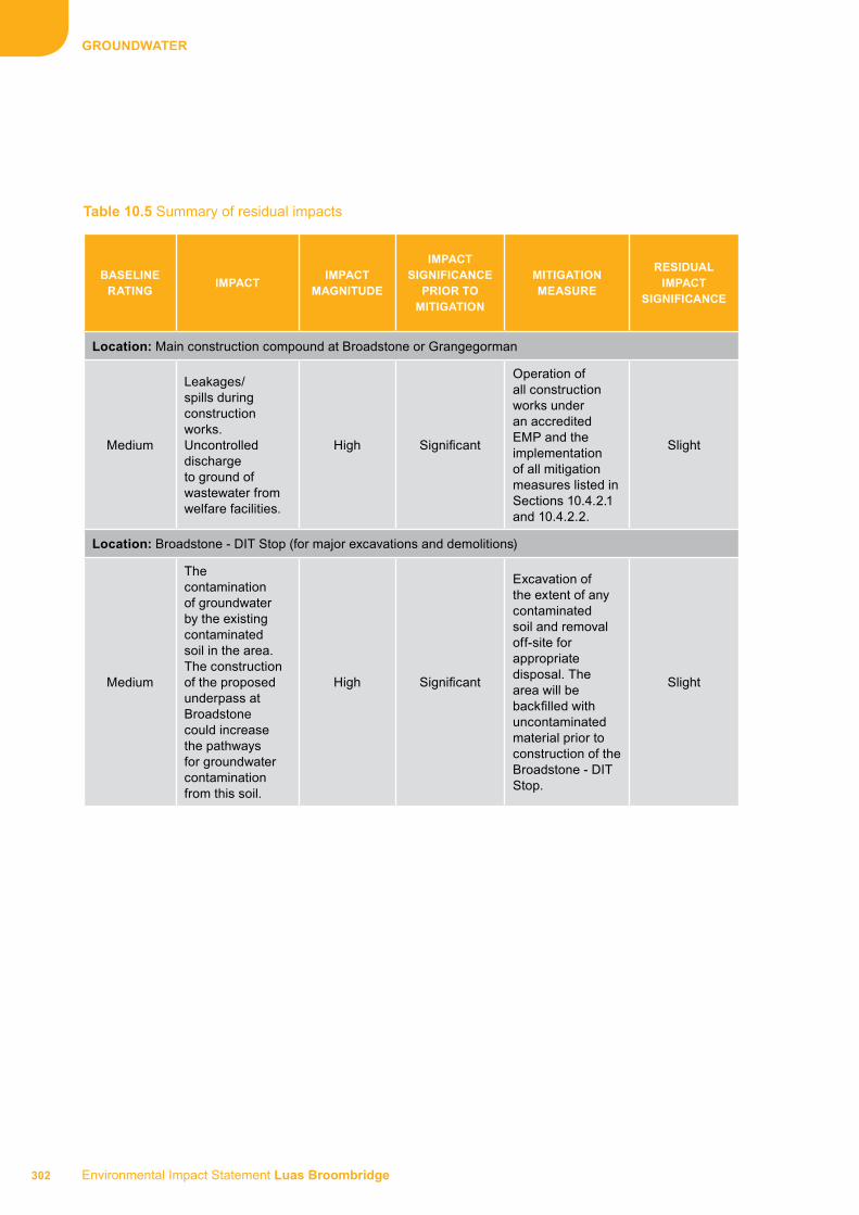
Environmental Impact Statement Luas Broombridge 302
GrOuNdwATEr
Table 10.5 Summary of residual impacts
BASELINE rATING
IMPACTIMPACT
MAGNITudE
IMPACT SIGNIfICANCE
PrIOr TO MITIGATION
MITIGATION MEASurE
rESIduAL IMPACT
SIGNIfICANCE
Location: Main construction compound at Broadstone or Grangegorman
Medium
Leakages/spills during construction works. Uncontrolled discharge to ground of wastewater from welfare facilities.
High Significant
Operation of all construction works under an accredited EMP and the implementation of all mitigation measures listed in Sections 10.4.2.1 and 10.4.2.2.
Slight
Location: Broadstone - DIT Stop (for major excavations and demolitions)
Medium
The contamination of groundwater by the existing contaminated soil in the area. The construction of the proposed underpass at Broadstone could increase the pathways for groundwater contamination from this soil.
High Significant
Excavation of the extent of any contaminated soil and removal off-site for appropriate disposal. The area will be backfilled with uncontaminated material prior to construction of the Broadstone - DIT Stop.
Slight

303 Environmental Impact Statement Luas Broombridge
GrOuNdwATEr
10.5 rEfErENCES1 Environmental Protection Agency (2002)
Guidelines on the Information to be Contained in Environmental Impact Statements. Wexford: Environmental Protection Agency.
2 Connolly, S. and Charles, P. (2005) Environmental Good Practice on Site (C650). UK: Construction Industry Research and Information Association.
3 Enterprise Ireland. Best Practice Guide (BPGCS005): Oil Storage Guidelines. Available from: <http://www.envirocentre.ie>.
4 Dublin City Council (2005) Greater Dublin Strategic Drainage Study: Technical Documents of Regional Drainage Policies. Dublin: Dublin City Council.
5 Eastern Regional Fisheries Board (2004) Requirements for the Protection of Fisheries Habitats during Construction and Development Works at River Sites. Dublin: Eastern Regional Fisheries Board.
6 Dublin City Council, Dún Laoghaire-Rathdown County Council, Fingal County Council, Kildare County Council, Meath County Council, South Dublin County Council, Wicklow County Council (2006) Greater Dublin Regional Code of Practice for Drainage Works, Version 6.0. Dublin: Dublin City Council.
7 Department for Environment Food and Rural Affairs (DEFRA), Welsh Assembly Government (WAG) (2004) Interim Code of Practice for Sustainable Drainage Systems (SUDS): National SUDS Working Group. UK: Construction Industry Research and Information Association.
8 Construction Industry Research and Information Association (2007) The SUDS Manual. UK: Construction Industry Research and Information Association.
9 National Roads Authority (2005) Guidelines for the Crossing of Watercourses during the Construction of National Road Schemes. Dublin: National Roads Authority.
10 Murnane, E., Heap, A. and Swain, A. (2006) Control of Water Pollution from Linear Construction Projects. Technical Guidance (C648). UK: Construction Industry Research and Information Association.
11 Masters-Williams, H., et al. (2001) Control of Water Pollution from Construction Sites: Guidance for Consultants and Contractors (C532). UK: Construction Industry Research and Information Association.
12 Environment Agency UK (2010) [Internet] UK Pollution Prevention Guidelines. Available from: <http://www.environment-agency.gov.uk> [Accessed from January 2009 to March 2010].

Environmental Impact Statement Luas Broombridge 304
GrOuNdwATEr

Dominick
Broadstone - DIT
Phibsborough
Grangegorman
Cabra
Parnell
Marlborough
O’ConnellUpper
O’Connell - GPO
Westmoreland
Trinity
Dawson
St. Stephen’s Green
Broombridge
11 SurfACE wATEr11.1 Introduction ...............................................................307
11.2 Study area ..................................................................307
11.3 Impact assessment methodology ...........................30711.3.1 Impact magnitude ........................................................30711.3.2 Impact significance ......................................................309
11.4 Impact assessment ...................................................30911.4.1 Impact identification ....................................................30911.4.2 Impact mitigation measures ........................................31111.4.3 Assessment of residual impacts ..................................314
11.5 references .................................................................315
IMPACT ArEA 29


307 Environmental Impact Statement Luas Broombridge
SurfACE wATEr
11.1 INTrOduCTIONThis section of the Environmental Impact Statement (EIS) brings together the baseline surface water characteristics and the construction and operation characteristics of the proposed scheme with the aim of ensuring that all likely significant impacts (positive or negative) are identified in Area 29. This chapter should be read in conjunction with the Surface Water baseline chapter of this EIS (Book 1, Chapter 20) which has described the receiving environment and assigned a baseline rating to locations within the study area. These baseline ratings will be used in combination with an impact magnitude to help determine the significance of the impacts on surface water.
11.2 STudy ArEAThe study area for this assessment was defined in the Surface Water baseline chapter of this EIS (Book 1, Chapter 20) and is again outlined in Table 11.1. The assessment area has been defined with reference to the potential for impact from the proposed scheme and the availability of relevant information.
11.3 IMPACT ASSESSMENT METhOdOLOGyThe source and type of all potential impacts is described in Section 11.4.1. Mitigation measures to be put in place are described in Section 11.4.2. At a
minimum, mitigation measures are defined for any adverse impacts that are deemed to be of moderate or greater significance prior to mitigation. The extent to which mitigation is needed increases as the significance of the impact increases. The residual impacts of each impact is then evaluated in Section 11.4.3 in terms of magnitude and significance.
11.3.1 Impact magnitudeThe criteria used to assess the different impacts associated with the proposed scheme are shown in Table 11.2. The criteria have been defined in consideration of the “Guidelines on the Information to be Contained in Environmental Impact Statements“ (Environmental Protection Agency (EPA))1. The magnitude of the impact is defined by the duration of the impact on the relevant water body. The duration (as defined in Table 11.3) is determined by the nature of the impact. In the case of an impact on surface water quality, the likely duration of an impact is determined by the chemical properties of a pollutant accidentally released to a water body, the amount of the pollutant released and the capacity of the water body to naturally attenuate the pollutant.
The durations of impacts are defined as set out in Table 11.3 as per EPA Guidance (EPA)1.
Table 11.1 Study area
ArEA dESCrIPTIONwIdTh Of STudy ArEA
(ON BOTh SIdES Of ThE ALIGNMENT)
Area 29St. Stephen’s Green to former Broadstone railway cutting
500m
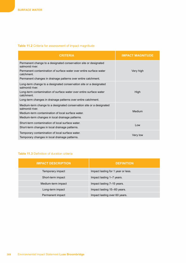
Environmental Impact Statement Luas Broombridge 308
SurfACE wATEr
Table 11.2 Criteria for assessment of impact magnitude
Table 11.3 Definition of duration criteria
CrITErIA IMPACT MAGNITudE
Permanent change to a designated conservation site or designated salmonid river.
Permanent contamination of surface water over entire surface water catchment.
Permanent changes in drainage patterns over entire catchment.
Very high
Long-term change to a designated conservation site or a designated salmonid river.
Long-term contamination of surface water over entire surface water catchment.
Long-term changes in drainage patterns over entire catchment.
High
Medium-term change to a designated conservation site or a designated salmonid river.
Medium-term contamination of local surface water.
Medium-term changes in local drainage patterns.
Medium
Short-term contamination of local surface water.
Short-term changes in local drainage patterns.Low
Temporary contamination of local surface water.
Temporary changes in local drainage patterns.Very low
IMPACT dESCrIPTION dEfINITION
Temporary impact Impact lasting for 1 year or less.
Short-term impact Impact lasting 1–7 years.
Medium-term impact Impact lasting 7–15 years.
Long-term impact Impact lasting 15–60 years.
Permanent impact Impact lasting over 60 years.

309 Environmental Impact Statement Luas Broombridge
SurfACE wATEr
11.3.2 Impact significanceThe likely significance of all impacts is determined in consideration of the magnitude of the impact and the baseline rating of the area upon which the impact has an effect. The baseline rating of relevant surface water resources is set out in the Surface Water baseline chapter of this EIS (Book 1, Chapter 20). As discussed in that chapter, all areas were assigned a baseline rating based on a number of criteria including: importance, sensitivity and existing adverse effects. Impact magnitude can have a maximum of six categories, ranging from neutral to very high. Baseline ratings are scored on a scale of 1–5 from very low to very high. Significance rating is determined by multiplying the baseline rating by the magnitude. Table 11.4 shows how the baseline rating and the impact magnitude are combined to give the likely significance of the impact prior to any mitigation measures being implemented. The impact significance ranges are then defined using the following score: Imperceptible (1–2); Slight (3–5); Moderate (6–10); Significant (11–19); Profound (20–25).
For example, if a location has a baseline rating of very high and the magnitude of the impact is medium then this can be considered a significant impact. If an impact can be fully mitigated, or if the impact magnitude is neutral, the impact is considered not significant. If in an exceptional circumstance, an impact magnitude is unknown then the impact significance is unknown significance.
11.4 IMPACT ASSESSMENT11.4.1 Impact identificationVarious elements of both the construction and operational phases have the potential to impact on the surface water environment. The likely potential impacts of both construction and operation of the proposed scheme prior to mitigation are described in this section of the EIS. The mitigation measures are described in Section 11.4.2 and the residual impacts after the proposed mitigation measures have been implemented are described in Section 11.4.3.
Table 11.4 Criteria for assessment of impact significance
IMPACT SIGNIfICANCE (+/-)*
Impact
Magnitude
(+/-)*
6Baseline Rating4
Neutral
(0)
Very low
(1)
Low
(2)
Medium
(3)
High
(4)
Very high
(5)
Very low
(1)
Imperceptible
(1)
Imperceptible
(2)
Slight
(3)
Slight
(4)
Slight
(5)
Low
(2)
Imperceptible
(2)
Slight
(4)
Moderate
(6)
Moderate
(8)
Moderate
(10)
Medium
(3)
Slight
(3)
Moderate
(6)
Moderate
(9)
Significant
(12)
Significant
(15)
High
(4)
Slight
(4)
Moderate
(8)
Significant
(12)
Significant
(16)
Profound
(20)
Very high
(5)
Slight
(5)
Moderate
(10)
Significant
(15)
Profound
(20)
Profound
(25)
* Impacts can be positive (+) or negative (-) and therefore can be scored as +/-5 with respect to impact magnitude.

Environmental Impact Statement Luas Broombridge 310
SurfACE wATEr
11.4.1.1 Construction impactsPotential impacts on hydrodynamics and floodingDuring all phases of the construction of the proposed scheme, including enabling works such as utilities works through to the main construction works, certain activities have the potential to result in increased surface water runoff and sediment loading which could potentially impact local drainage patterns, cause siltation of the existing drainage network and result in localised flooding. These activities could also lead to contaminated discharge to the River Liffey, the principal surface water body within the study area.
These include:
■■ The installation of surface water drainage discharge points to existing surface water/combined drains
■■ Removal of hardstanding to expose made ground and subsoil during utilities works and construction works
■■ Demolition works producing demolition spoil in the area in front of Broadstone during the removal of two derelict buildings and three structures within the bus depot
■■ Works producing potentially contaminated spoil for the removal of the existing petrol filling station on Constitution Hill
■■ Surface water runoff containing sediment draining from construction areas into drains
The impact magnitude of these impacts is assessed as low due to the fact that there would be a short-term impact in the study area. Given the medium baseline rating assigned to the River Liffey, which is the principal water body in this area, the impact significance would thus be moderate.
Further to an assessment undertaken to assess the need for strengthening works on O’Connell Bridge prior to laying tracks across, a number of relatively minor works may be required including waterproofing of the deck, refurbishment of the existing services subways and installation of the track slab on an anti-vibration mat. It is anticipated that no in-stream works will be required in the River Liffey.
The construction of the Marlborough Public Transport Priority Bridge will be carried out by Dublin City Council (DCC) and any impacts of this structure have been considered as part of a separate Environmental Impact Assessment (EIA) process. This public
transport bridge has received statutory approval from An Bord Pleanála (ABP).
Although construction of the Marlborough Street Public Transport Priority Bridge is outside the scope of this EIS, rails will be laid across this bridge during the construction of the proposed scheme. It is anticipated that no in-stream works will be required in the River Liffey.
Potential impacts on water qualityThere is the potential for contaminated surface water runoff to arise during the construction phase, particularly in the areas of open excavations close to the River Liffey. In particular, works for the strengthening of O’Connell Bridge could lead to the discharge of sediment to the River Liffey in the absence of mitigation measures. If this sediment-laden runoff accidentally enters the river, the impact magnitude would be high and given the medium baseline rating assigned to the River Liffey the impact would be significant.
The city centre construction compounds at St. Stephen’s Green North, Cathal Brugha Street, Western Way, Broadstone and Grangegorman are not located close to surface water and it is not intended that fuels or vehicles will be stored at these compounds. In the area of the main construction compounds in Area 29 at Broadstone and Grangegorman, potentially contaminated runoff may arise in the unlikely event of an accidental leak or spillage or from runoff from material storage areas. Wastewater discharges from welfare facilities provided at the compound would have the potential to contaminate surface water if they were accidentally discharged to the surface water drainage system without prior treatment. Uncontrolled spills or leakages of fuel or contaminated runoff from spoil could, if discharged, lead to the contamination of surface water bodies in the absence of appropriate mitigation. This impact would have a medium magnitude and thus have moderate significance.
Wet concrete operations carried out near surface water bodies could lead to discharge of alkaline wastewaters in the absence of mitigation measures and this is relevant in the case of the River Liffey. The discharge of a large volume of alkaline washwaters to the river could have a high impact magnitude and would be a significant impact.
St. Stephen’s Green ponds have been assigned a very low baseline rating and the Blessington Basin a high baseline rating but given their distance from the proposed scheme, any unlikely impacts on

311 Environmental Impact Statement Luas Broombridge
SurfACE wATEr
these water bodies have been classed as very low magnitude. Thus the impact significance is considered to be imperceptible and slight, respectively.
11.4.1.2 Operation impactsThe likelihood of surface water contamination from the operation of a light rail system is considered low as the scheme is electrically powered and the scheme will not increase the amount of hard-standing in the study area. During the operational phase of the proposed scheme, the potential impacts on the surface water environment in the study area comprise:
Potential impacts on hydrodynamics and floodingThe operation of drainage discharge points to the existing drainage network within the area has the potential to lead to localised flooding in areas with diminished capacity to handle the extra loading. This impact is unlikely and is thus assigned a very low magnitude rating and thus the impact is deemed to be slight.
Potential impacts on water qualityThe River Liffey has been assigned a medium baseline rating. The river is crossed at two locations by the proposed scheme. Any potential impacts during the operational phase have been classed as very low magnitude and thus impact significance is deemed slight.
The other surface water bodies in the area have been assigned a baseline rating of very low for the St. Stephen’s Green Ponds and high for the Blessington Basin but given their distance from the proposed scheme, any unlikely impacts on these water bodies from the operational phase of the proposed scheme have been classed as very low magnitude. Thus the impact significance is considered to be imperceptible and slight, respectively.
11.4.2 Impact mitigation measuresThere are a range of methods which are available to mitigate impacts on the baseline surface water environment. This section describes the measures proposed to mitigate or ameliorate the significant adverse impacts of both the construction and operational phases of the proposed scheme.
11.4.2.1 during both construction and operationAn Environmental Management System (EMS), will be established and maintained by the contractors during the construction and operational phases of the proposed scheme. An Environmental Management Plan (EMP) will be required throughout all phases of the development (construction and operation) and will be monitored by a suitably qualified Environmental
Coordinator, to be employed by the construction and operational contractor. The EMP will cover all potentially polluting activities and include an emergency response procedure. All personnel working on the site will be trained in its use. As a minimum, the EMP will be formulated in consideration of the standard best international practice including but not limited to:
■■ Environmental Good Practice on Site (C650)2
■■ Best Practice Guide (BPGCS005): Oil Storage Guidelines3
■■ Greater Dublin Strategic Drainage Study: Technical Documents of Regional Drainage Policies4
■■ Requirements for the Protection of Fisheries Habitats during Construction and Development Works at River Sites5
■■ Greater Dublin Regional Code of Practice for Drainage Works6
■■ National SUDS Working Group – Interim Code of Practice for Sustainable Urban Drainage Systems7
■■ The SUDS Manual (C697)8
■■ Guidelines for the Crossing of Watercourses during the Construction of National Road Schemes9
■■ Control of Water Pollution from Linear Construction Projects. Technical Guidance (C648)10
■■ Control of Water Pollution from Construction Sites. Guidance for Consultants and Contractors (C532)11
■■ UK Pollution Prevention Guidelines (PPGs)12
11.4.2.2 Construction impact mitigation measuresImpacts on the surface water environment in the study area will be mitigated where appropriate during the construction phase of the proposed scheme by implementing best practices on-site. These will include, but not be limited to, the following:
Measures to mitigate potential impacts on hydrodynamics and flooding:
■■ Cognisance will be taken of the National Roads Authority “Guidelines for the Crossing of Watercourses during the Construction of National Road Schemes”9 in the planning and implementation of the bridge strengthening works

Environmental Impact Statement Luas Broombridge 312
SurfACE wATEr
■■ During the entire construction phase, the works will be programmed and phased so that any blocking of the existing drainage network will be avoided so as to prevent localised flooding
Measures to mitigate potential impacts on water quality:
■■ Discharges arising from the construction phase of the proposed scheme entering the foul/surface water sewer network will be subject to and in accordance with the requirements of any discharge licence granted by DCC. It is not intended that there will be any discharge to surface water from the proposed scheme
■■ Treatment of water produced during the construction phase, e.g. from open excavations, will involve silt removal using a silt trap and hydrocarbon removal using a hydrocarbon interceptor
■■ Re-fuelling of construction equipment and the addition of hydraulic oil or lubricants to vehicles/equipment will take place in designated bunded areas within the main construction compound at Broombridge in Area 30. Re-fuelling will be avoided in so far as possible at the other construction compounds but where necessary will be carried out within appropriately bunded areas away from surface water gullies or drains. The vehicles and equipment will not be left unattended during refuelling. As a precaution, a spill kit will be stored in the cab of each vehicle in case of localised hydrocarbon loss, such as a machine blowing a hydraulic hose
■■ Drainage from bunded areas will be diverted for safe disposal off-site. The integrity and water tightness of bunds and their resistance to penetration by water or other material stored therein will be confirmed by the contractor prior to use as a storage area and checked regularly
■■ Only emergency maintenance to construction plant will be carried out on-site, and will preferably be carried out at the main construction compound at Broombridge, unless vehicles have broken down necessitating maintenance at the point of breakdown
■■ Any effluent generated by temporary on-site toilet facilities will be connected to the public foul/combined sewer network where possible or taken off-site for appropriate treatment. Permanent facilities will be adequately designed and maintained to ensure all foul water is disposed of appropriately
■■ No concrete batching facility will be required at any site or compound. All concrete will be brought to site by truck. Wet concrete operations adjacent to watercourses will be avoided where possible. A suitable risk assessment for wet concreting will be completed prior to works being carried out. Measures to prevent discharge of alkaline wastewaters or contaminated stormwater to watercourses will be outlined in a work method statement before commencement of works
■■ The contractor will be required to make provision for removal of any concrete washwaters and no such washwaters will be discharged to nearby water bodies under any circumstances
■■ Silt fences will be used during the possible bridge strengthening works at O’Connell Bridge to prevent contamination of the River Liffey with sediment
■■ Any hazardous waste residuals or potentially contaminated sludge from spill clean-up will be stored within appropriate metal or plastic containers in temporary bunded storage areas in the construction compounds prior to removal by an authorised waste management contractor for off-site treatment/recycling/disposal
■■ Exposed ground and soil stockpiles will be minimised through appropriate earthworks design and planning. If necessary, sediment control measures will be provided around any spoil heaps to filter sediment from excavated material. The proposals for the management of excavated material will be detailed in full in the EMP
■■ Relevant guidelines will be adhered to, thus ensuring that the impact on the water environment during the construction phase of the proposed scheme is minimised. The Eastern Regional Fisheries Board (ERFB) document5 in particular, which sets out methods for minimising the environmental risks associated with construction works will be referred to in the planning of any construction works in the vicinity of watercourses
Measures to prevent localised flooding will be implemented by proper design and maintenance of drainage and roadways. Measures will also be implemented to ensure that no chemical or sediment contamination of the river catchments results from construction activities. These will include design of diversion drainage ditches to divert any sediment-laden runoff, and ensuring all fuels and oils are kept in bunded containers on impervious surfaces. This reduces the impact magnitude in the study area to

313 Environmental Impact Statement Luas Broombridge
SurfACE wATEr
very low and the significance is thus predicted to be slight.
In the absence of mitigation measures, all of the potential impacts identified for the River Liffey for the construction phase of the proposed scheme in the study area were classified as having a medium or high impact magnitude due to the fact that the impacts would likely have medium- to long-term effects on the flow regime and water quality in the river. The River Liffey was assigned a medium baseline rating and thus the impact is predicted to be significant. However, the implementation of the above mitigation measures and of best practice operations and management during construction works close to the river will ensure that the River Liffey is protected. This will reduce the impact magnitude to very low, thus reducing the significance of the impact to slight for the River Liffey.
11.4.2.3 Operation impact mitigation measuresSome measures implemented in the construction period, e.g. the installation of interceptors at discharge points to the drainage network, will still be present in the operational period, when there is much less risk. Therefore, Sections 11.4.2.1 and 11.4.2.2 should be referred to for detail on common mitigation measures.
Potential impacts on the surface water environment in the study area will be mitigated where possible during the operation of the proposed scheme by implementing best practices in all areas along the proposed route. These will include, but not be limited to, the following:
Measures to mitigate potential impacts on hydrodynamics and flooding
■■ The operation of the proposed scheme will not increase the hard-standing area within the study area and as such it is predicted that there will be no changes in the hydrodynamics within Area 29
■■ All storm water runoff generated during the operation of the proposed scheme will be managed by a surface water collection system along the track which will feed into the existing street drainage. All pervious and impervious surface areas as well as runoff from structures have been accounted for and assigned to the appropriate discharge point to the drainage network. There will be no discharge to surface water bodies from the proposed scheme
■■ As stated above, the track drainage will be incorporated into the existing street drainage. Drainage will be collected from the track surface
and the carriageway surface and dispersed into the local area drainage network
■■ The surface water from stop platforms will be collected by means of linear drainage channels and connected to the track drainage network
■■ In relation to track and road drainage, all filter drains will be designed in accordance with Construction Industry Research and Information Association (CIRIA) 6978 and other Best Management Practice Guidelines to accommodate extreme rainfall events with an allowance for climate change
Measures to mitigate potential impacts on water quality:
■■ The potential for the release of pollutants to surface water such as oils, lubricants or hydrocarbons used in vehicle maintenance will be prevented. Potentially polluting substances will only be used in the depot located at Broombridge in Area 30, used only by fully trained personnel and not used excessively, stored in appropriately labelled and sealed containers and appropriately secured when not in use
■■ Any discharges arising from the operational phase of the proposed scheme entering the sewer network or surface water bodies will be subject to and in accordance with the requirements of any discharge licence granted by DCC
■■ All storm water runoff generated during the operation of the proposed scheme will be managed on-site using a combination of Sustainable Drainage System (SUDS) techniques and conventional pipe drainage systems. The total discharge from the site will be restricted to the permissible limits in accordance with any discharge licence issued by DCC, if deemed necessary
■■ Treatment of surface water runoff during the operation phase will involve silt removal using a silt trap
■■ Herbicides used during operation will be applied sparingly, as required and in compliance with suppliers’ guidance, and will be suitable for use in an environment in which sensitive receiving watercourses are present, in particular the River Liffey
In the absence of mitigation, the potential impacts on the water quality of the River Liffey from the

Environmental Impact Statement Luas Broombridge 314
SurfACE wATEr
operational phase of the proposed scheme were classed as having a medium magnitude due to the fact that the impacts would likely have medium-term effects on the flow regime and water quality in the river. The River Liffey was assigned a medium baseline rating and thus the impact is predicted to be moderate. However, the implementation of the above mitigation measures and of best practice operations and management during the operational phase of the scheme close to the river will ensure that the River Liffey is protected. This will reduce the impact magnitude to very low, thus reducing the significance of the impact to slight for the River Liffey.
11.4.3 Assessment of residual impactsThis section describes any residual impacts that continue to exist when the mitigation measures have been put in place. The initial impact significance is determined taking the baseline rating of the location and magnitude of the impact into account as outlined in Table 11.4. The significance of the impact after mitigation (residual impact) is determined using professional judgement. If an impact can be fully mitigated, the significance of the impact after mitigation is considered not significant, otherwise it is given a significance from imperceptible to profound similar to Table 11.4.
11.4.3.1 Construction residual impactsAs stated above, with the implementation of mitigation measures, the impact from spills or sediment discharge to the River Liffey has been reduced to slight.
Provided that the impact mitigation measures outlined in Sections 11.4.2.1 and 11.4.2.2 are put in place, it is considered that all other impacts of the construction phase on surface water within the study area can be mitigated, thus the residual impact is considered slight.
11.4.3.2 Operation residual impactsDischarge of surface water runoff can potentially impact the quality of receiving surface water. However, the likelihood of contamination from surface water runoff from a light rail system is considered low as the proposed scheme is electrically powered, and while it uses hydrocarbon lubricants within the rail vehicles, the lubricants are contained within sealed units and the risk of leaks is therefore low. Provided that the impact mitigation measures outlined in Sections 11.4.2.1 and 11.4.2.3 are put in place, it is considered that the impacts of the operational phase on surface water within the study area, in particular the River Liffey, can be mitigated, thus the residual impact is considered slight.
11.4.3.3 Summary of residual impactsThe main surface water features present in this area of the proposed scheme are the St. Stephen’s Green Ponds (which are fed by the Grand Canal), the River Liffey and the Blessington Basin with baseline ratings of very low, medium and high, respectively. Residual impacts due to the construction and operational phase are assessed as slight. A summary of the significance of the construction and operational effects on the watercourses of Area 29 is shown in Table 11.5.
Table 11.5 Summary of residual impacts
BASELINE rATING
IMPACTIMPACT
MAGNITudE
IMPACT SIGNIfICANCE
PrIOr TO MITIGATION
MITIGATION MEASurErESIduAL
IMPACT SIGNIfICANCE
Location: River Liffey
Medium
Uncontrolled leakage or spillage which results in contaminated discharge or sediment loading to the river during the construction phase.
High Significant
Operation of all construction works in compliance with the accredited EMP and the implementation of mitigation measures in Sections 11.4.2.1 and 11.4.2.2. There will be no discharge to the River Liffey from the proposed scheme.
Slight

315 Environmental Impact Statement Luas Broombridge
SurfACE wATEr
11.5 rEfErENCES1 Environmental Protection Agency (2002)
Guidelines on the Infomation to be Contained in Environmental Impact Statements. Wexford: Environmental Protection Agency.
2 Connolly, S. and Charles, P. (2005) Environmental Good Practice on Site (C650). UK: Construction Industry Research and Information Association.
3 Enterprise Ireland. Best Practice Guide (BPGCS005): Oil Storage Guidelines. Available from: <http://www.envirocentre.ie>.
4 Dublin City Council (2005) Greater Dublin Strategic Drainage Study: Technical Documents of Regional Drainage Policies. Dublin: Dublin City Council.
5 Eastern Regional Fisheries Board (2004) Requirements for the Protection of Fisheries Habitats during Construction and Development Works at River Sites. Dublin: Eastern Regional Fisheries Board.
6 Dublin City Council, Dún Laoghaire-Rathdown County Council, Fingal County Council, Kildare County Council, Meath County Council, South Dublin County Council, Wicklow County Council (2006) Greater Dublin Regional Code of Practice for Drainage Works, Version 6.0. Dublin: Dublin City Council.
7 Department for Environment, Food and Rural Affairs (DEFRA), Welsh Assembly Government (WAG) (2004) Interim Code of Practice for Sustainable Drainage Systems. UK: Construction Industry Research and Information Association.
8 Ballard, B.W., Kellagher, R., et al. (2007) The SUDS Manual. UK: Construction Industry Research and Information Association.
9 National Roads Authority (2005) Guidelines for the Crossing of Watercourses during the Construction of National Road Schemes. Dublin: National Roads Authority.
10 Murnane E., Heap A. and Swain A. (2006) Control of Water Pollution from Linear Construction Projects. Technical Guidance (C648). UK: Construction Industry Research and Information Association.
11 Masters-Williams H., et al. (2001) Control of Water Pollution from Construction Sites: Guidance for Consultants and Contractors (C532). UK: Construction Industry Research and Information Association.
12 Environment Agency UK (2010). Available from: <http://www.environment-agency.gov.uk> [Accessed from January 2009 to March 2010].

Environmental Impact Statement Luas Broombridge 316
SurfACE wATEr

Dominick
Broadstone - DIT
Phibsborough
Grangegorman
Cabra
Parnell
Marlborough
O’ConnellUpper
O’Connell - GPO
Westmoreland
Trinity
Dawson
St. Stephen’s Green
Broombridge
12 AIr ANd CLIMATIC fACTOrS12.1 Introduction ...............................................................319
12.2 Study area ..................................................................319
12.3 Impact assessment methodology ...........................31912.3.1 Air quality ....................................................................31912.3.2 Microclimate ................................................................32012.3.3 Climate change ...........................................................32012.3.4 Impact magnitude ........................................................32012.3.5 Impact significance ......................................................322
12.4 Impact assessment ..................................................32212.4.1 Impact identification ....................................................32212.4.2 Impact mitigation measures ........................................32712.4.3 Assessment of residual impacts ..................................328
12.5 references .................................................................331
IMPACT ArEA 29


319 Environmental Impact Statement Luas Broombridge
AIr ANd CLIMATIC fACTOrS
12.1 INTrOduCTIONThis section of the Environmental Impact Statement (EIS) brings together the baseline air and climatic factors and the construction and operation characteristics of the proposed scheme with the aim of ensuring that all likely significant impacts (positive or negative) in Area 29 are identified. This chapter should be read in conjunction with the Air and Climatic Factors baseline chapter of this EIS (Book 1, Chapter 21) which has described the receiving environment and assigned a baseline rating to locations within the study area. These baseline ratings will be used in combination with an impact magnitude to assist in determining the significance of the impacts on air and climatic factors.
12.2 STudy ArEAThe study area for this assessment was defined in the Air and Climatic Factors baseline chapter of this EIS (Book 1, Chapter 21) and is again outlined as shown in Table 12.1. The assessment area has been defined with reference to the potential for impact from the proposed scheme and the availability of relevant information.
12.3 IMPACT ASSESSMENT METhOdOLOGyThe source and type of all potential impacts are described in Section 12.4.1. Mitigation measures to be put in place are defined in Section 12.4.2. At a minimum, mitigation measures are defined for any adverse impacts that are deemed to be of moderate or greater significance prior to mitigation. The extent to which mitigation is needed increases as the significance of the impact increases. The residual impact of each impact is then evaluated in Section 12.4.3 in terms of magnitude and significance.
The impact that the proposed scheme will have on air quality and microclimate is assessed for the following scenarios:
■■ “Do-minimum” scenario (without the proposed scheme) for the opening year (2018)
■■ “Do-something” scenario (with the proposed scheme) for the opening year (2018)
■■ Impacts from the construction phase of the proposed scheme
Due to limitations in the modelling methodology as set out in the Design Manual for Roads and Bridges (DMRB) Volume 111 it is not possible to predict the background concentrations of pollutants beyond 2020. As a result an assessment for 2033, the horizon year of operation, cannot be made. It is considered; however, that improvements in technology over the years will reduce emissions from road transport and in this context the opening year of 2018 would represent a worse-case for background concentrations of air and climatic factors.
12.3.1 Air quality12.3.1.1 Assessment methodology for vehicle emissions and dustThe methodologies described in the DMRB Volume 111 and the Transport Analysis Guidance (TAG)2 developed by the UK Department of Transport have been used to assess the local air quality impacts of the proposed scheme for the pollutants related to road traffic. These pollutants are nitrogen dioxide (NO
2),
oxides of nitrogen (NOx) and particulate matter (PM
10
and PM2.5
) as well as the greenhouse gas carbon dioxide (CO
2).
To protect human health, vegetation and ecosystems, various standards, guidelines and objectives have been set down in law and details are included in Annex K.1, Book 5, of this EIS.
For the purpose of this study, dust is defined as all particulate matter up to 75 micrometres (μm) in diameter (according to British Standard BS ISO 42263).
There are no specific legal standards relating to the acceptability of dust, therefore in the absence of a formal criteria, a set of distance-based criteria has been developed, as shown in Table 12.2.
Table 12.1 Study area
CrITErIA wIdTh Of STudy ArEA (ON BOTh SIdES Of ThE ALIGNMENT)
Air quality 200m either side of the relevant traffic routes.
Dust 200m either side of the alignment and construction compounds.
Microclimate 200m either side of the alignment and construction compounds.

Environmental Impact Statement Luas Broombridge 320
AIr ANd CLIMATIC fACTOrS
12.3.2 Microclimate12.3.2.1 Assessment methodology for microclimate The impact to microclimate within the area of the proposed scheme can be classified into two assessments:
■■ The impacts of converting the vegetative surface to hardstanding and the associated Urban Heat Island (UHI) effect
■■ The potential impact of the physical structures upon climatic conditions such as wind speed, wind direction, temperature, and light availability
To assess the impacts of converting vegetative surfaces to hardstanding and its significance the amount of temporary and/or permanent landtake associated with the proposed scheme that will be converted to hardstanding is considered.
Buildings and structures can cause localised microclimate effects. In order to assess the impact of the proposed structures upon the microclimate, plans of the proposed scheme have been reviewed and a site visit has been conducted to evaluate structure height and location relevant to adjacent buildings.
12.3.3 Climate change12.3.3.1 Assessment methodology climate changeThe impact of the proposed scheme upon climate change is assessed through the consideration of the change in CO2
emissions that will occur due to the changes in traffic flow that occur in response to the proposed scheme. These calculations are carried out using the DMRB regional assessment methodology which requires traffic data input for all affected roads including: traffic flows, road speed, road length and traffic composition. The DMRB tool1 provides an output for tonnes of carbona emitted per year from road traffic.
12.3.4 Impact magnitudeThe criteria used to assess the different impacts associated with the proposed scheme are shown in Table 12.3. The criteria have been defined in consideration of the “Guidelines on the Information to be Contained in Environmental Impact Statements” (Environmental Protection Agency (EPA))4.
Table 12.2 Assessment criteria for dust from construction activities
SOurCE POTENTIAL dISTANCE frOM SOurCE fOr SIGNIfICANT EffECTS
SCALE dESCrIPTION SOILING PM10
vEGETATION
MajorLarge construction sites (>15,000m2), with major use of haul routes.
200m 100m 50m
ModerateModerate sized construction sites (1,000–15,000m2) with moderate use of haul routes.
100m 50m 25m
MinorMinor construction sites (<1,000m2), with limited use of haul routes.
50m 25m 25m
a Carbon relates to CO2, carbon monoxide (CO), hydrocarbons and particulate matter.

321 Environmental Impact Statement Luas Broombridge
AIr ANd CLIMATIC fACTOrS
Table 12.3 Criteria for assessment of impact magnitude
CrITErIA IMPACT MAGNITudE
Air quality (including vehicle emissions and dust):Increase/decrease of >20% in annual mean of NO
2/PM
10/PM
2.5 pollutants and where
the annual mean exceeds the Air Quality Standards (AQS)5 (details included in Annex K.1, Book 5, of this EIS).
Increase/decrease of >20 days in the number of days PM10
levels exceed 50μg/m3 and where the annual mean exceeds the limit values (details included in Annex K.1, Book 5, of this EIS).
Deposition of dust within 50m of site boundary lasting longer than 12 months.
Microclimate:Any substantial change in ground cover which may influence local air temperature or wind conditions.
Climate change:Increase/decrease of >20% in CO
2 emissions.
Very high
Air quality (including vehicle emissions and dust):Increase/decrease of 10–20% in annual mean of NO
2/PM
10/PM
2.5 pollutants and
where the annual mean exceeds the AQS (details included in Annex K.1, Book 5, of this EIS).
Increase/decrease of 10–20 days in the number of days PM10
levels exceed 50μg/m3 and where the annual mean exceeds the limit values (details included in Annex K.1, Book 5, of this EIS).
Deposition of dust within 100m of site boundary lasting longer than 12 months.
Microclimate:Any substantial change in ground cover which may influence local air temperature or wind conditions.
Climate change:Increase/decrease of 10–20% in CO
2 emissions.
High
Air quality (including vehicle emissions and dust):Increase/decrease of 5–10% in annual mean of NO
2/PM
10/PM
2.5 pollutants and
where the annual mean exceeds the AQS (details included in Annex K.1, Book 5, of this EIS).
Increase/decrease of 5–10 days in the number of days PM10
levels exceed 50μg/m3 (less than 10 microns) and where the annual mean exceeds the limit values (details included in Annex K.1, Book 5, of this EIS).
Deposition of dust within 100m of site boundary lasting longer than 6 months.
Microclimate:Any area where additional structures may result in an increase in shading.
A moderate change in ground cover which may influence local air temperature or wind conditions.
Climate change:Increase/decrease of 5–10% in CO
2 emissions.
Medium

Environmental Impact Statement Luas Broombridge 322
AIr ANd CLIMATIC fACTOrS
12.3.5 Impact significanceThe likely significance of all impacts is determined in consideration of the magnitude of the impact and the baseline rating of the area upon which the impact has an effect. The baseline rating of all resources is set out in the Air and Climatic Factors baseline chapter of this EIS (Book 1, Chapter 21). As discussed in that chapter, all areas were assigned a baseline rating based on a number of criteria including: importance, sensitivity and existing adverse effects. Impact magnitude can have a maximum of six categories, ranging from neutral to very high. Baseline ratings are scored on a scale of 1–5, from very low to very high. Significance rating is determined by multiplying the baseline rating by the magnitude. Table 12.4 shows how the baseline rating and the impact magnitude are combined to give the likely significance of the impact prior to any mitigation measures being implemented. The impact significance ranges are then defined using the following score: Imperceptible (1–2); Slight (3–5); Moderate (6–10); Significant (11–19); Profound (20–25). It should be noted that in order to maintain a uniformity of approach with other environmental topics, the same terms are adopted for impact significance. Accordingly, in respect of air quality and climatic effects, imperceptible is equivalent to not-measureable.
For example, if a location has a baseline rating of very high and the magnitude of the impact is medium then this can be considered a significant impact. If an impact can be fully mitigated, or if the impact magnitude is neutral, the impact is considered not significant. If in an exceptional circumstance, an impact magnitude is unknown then the impact significance is unknown significance.
12.4 IMPACT ASSESSMENT 12.4.1 Impact identificationVarious elements of both the construction and operational phases have the potential to impact on the air and climatic factors environment. The likely potential impacts for both construction and operation of the proposed scheme prior to mitigation are described in this section of the EIS. The mitigation measures are described in Section 12.4.2 and the residual impacts after the proposed mitigation measures have been implemented are described in Section 12.4.3.
12.4.1.1 Construction impacts Construction phase activities have the potential to impact on air quality and climatic factors as a result of:
Table 12.3 Continued
CrITErIA IMPACT MAGNITudE
Air quality (including vehicle emissions and dust):Increase/decrease of 1–5% in annual mean of NO
2/PM
10/PM
2.5 pollutants.
Increase/decrease of 1–5 days in the number of days PM10
levels exceed 50μg/m3.
Deposition of dust within 100m of site boundary lasting less than 6 months.
Microclimate:Any area where temporary structures may result in an increase in shading.
A minor change in ground cover which may influence local air temperature or wind conditions.
Climate change:Increase/decrease of 1–5% in CO
2 emissions.
Low
Air quality (including vehicle emissions and dust):Increase/decrease of <1% in annual mean of NO
2/PM
10/PM
2.5 pollutants. Increase/
decrease of <1 day in the number of days PM10
levels exceed 50μg/m3.
Deposition of dust within 200m of site boundary lasting less than 6 months.
Microclimate:Any landscaping changes, i.e. bunds, that may result in an increase in shading.
A very minor change in ground cover which may influence local air temperature or wind conditions.
Climate change:Increase/decrease of <1% in CO
2 emissions.
Very low

323 Environmental Impact Statement Luas Broombridge
AIr ANd CLIMATIC fACTOrS
■■ Changes to traffic flow and transport mode
■■ Site preparation
■■ Stockpiling materials at compounds
■■ Demolition of existing buildings
■■ Construction of structures and the line itself
Air quality – dustImpacts associated with dust are generally variable in nature and can be dependent on the type of construction activity, the ground conditions and meteorology at the time. The potential sources of dust emission from construction activities typical of the proposed scheme include the following:
■■ Paved roads: Impacts to the environment due to dust emissions from dirty or dusty paved roads
■■ Construction compounds: Blow-off from stockpiles at construction sites can lead to potential impacts due to emissions of dust
■■ Utility works: Installation/diversion of utility services will involve the excavation of made ground and soil, which can lead to blow-off from material before transportation
■■ Demolition: Fugitive dust emissions can arise from the demolition of buildings and the breaking of existing Hard Ground including pavements and concrete
■■ Unloading and loading of vehicles: Unloading and loading of aggregates and other potentially dusty material can be the source of significant dust emissions
■■ Earth moving operations including excavations: Fugitive dust emissions may arise from the earth moving operations and from areas of exposed soil arising from the operations. Such activities can be a significant source of emissions in dry conditions
Table 12.4 Criteria for assessment of impact significance
IMPACT SIGNIfICANCE (+/-)*
Impact
magnitude
(+/-)*
6Baseline Rating4
Neutral
(0)
Very low
(1)
Low
(2)
Medium
(3)
High
(4)
Very high
(5)
Very low
(1)
Imperceptible
(1)
Imperceptible
(2)
Slight
(3)
Slight
(4)
Slight
(5)
Low
(2)
Imperceptible
(2)
Slight
(4)
Moderate
(6)
Moderate
(8)
Moderate
(10)
Medium
(3)
Slight
(3)
Moderate
(6)
Moderate
(9)
Significant
(12)
Significant
(15)
High
(4)
Slight
(4)
Moderate
(8)
Significant
(12)
Significant
(16)
Profound
(20)
Very high
(5)
Slight
(5)
Moderate
(10)
Significant
(15)
Profound
(20)
Profound
(25)
* Impacts can be positive (+) or negative (-) and therefore can be scored as +/-5 with respect to impact magnitude.

Environmental Impact Statement Luas Broombridge 324
AIr ANd CLIMATIC fACTOrS
The main sources of dust will be the construction compounds, demolition, breaking of existing hard surfaces and cutting of stone. Five construction compounds will be used for the proposed scheme in Area 29. These are located at St. Stephen’s Green North, Cathal Brugha Street, Western Way, Broadstone and the Grangegorman compound which will be located to the south of Rosemount Road within Area 29.
Potential impacts prior to mitigation due to the proposed scheme could include the following:
■■ Dust emissions arising from construction activities may have the potential to cause nuisance both within the construction site and outside the site boundary
■■ Accumulation and settling of particles on surfaces close to the point of release may lead to the soiling of property, windows, cars or laundry. Such dust affects amenity
■■ For commercial premises dust can cause soiling of goods or the damage of equipment which may be sensitive to the build up of particulates, if present in sufficient quantities
■■ The generation of dust can also lead to increases in the levels of particulate matter which may have an impact on human health
Dust can impact upon a sensitive receptor up to 200m from the source. Potential receptors within 200m of the construction route/compounds are outlined in the baseline categorisation table detailed in the Air and Climatic Factors baseline chapter of this EIS (Book 1, Chapter 21).
It is also important to consider whether the dust has been generated through the disturbance of contaminated ground.
Prior to mitigation these impacts would be significant, short-term in duration, or temporary and intermittent in occurrence on within 50m of the proposed scheme.
Air quality – vehicle emissionsThe change in traffic flow due to diversion of traffic away from the construction sites associated with the proposed scheme will alter the concentration, duration and location of vehicle related emissions. Emissions from vehicles associated with construction sites can in some circumstances significantly add to levels of local air pollution. This includes diesel off-road vehicles and plant (known as non-road mobile machinery (NRMM)),
which is not currently subject to such stringent emission controls as road vehicles. It is difficult to quantify the exact increase in emissions during the construction phase; however, these circumstances are temporary in nature.
On some roads the road network currently caters for relatively large volumes of vehicular traffic throughout the day and accordingly any changes in pollutant concentrations during the construction will be insignificant and temporary in nature.
Emissions of NOx and particulate matter from NRMM
would not be significant.
MicroclimateAny change in surface during the construction phase is negligible and therefore there are no impacts anticipated. Construction compounds will be located on existing hardstanding.
Climate changeCO
2 will be released into the atmosphere as a result
of the movement of construction vehicles and use of plant; however, these additional vehicle movements and construction plant will not contribute to the long-term effects of climate change therefore there are no impacts associated with construction anticipated.
12.4.1.2 Operation impacts The proposed scheme is powered by electricity, which is seen as being more environmentally friendly than most other forms of transport which are fuelled by fossil fuels. The electricity to power the tram system is not generated in the immediate facility of the route of the proposed scheme and therefore emissions associated with the generation of electricity will not be considered within this report.
The factors during the operational phase of the proposed scheme which have the potential to impact on air quality and climatic factors are:
■■ Changes in traffic flow resulting from the use of the proposed scheme
■■ Changes in surface from vegetative to hardstanding
Air quality – dustThere are no impacts associated with dust as a result of the operation of the proposed scheme.

325 Environmental Impact Statement Luas Broombridge
AIr ANd CLIMATIC fACTOrS
Air quality – vehicle emissionsAs described in the Air and Climatic Factors baseline chapter of this EIS (Book 1, Chapter 21), the EPA monitoring stations within Dublin show potential breaches in regulatory limits of NO
2 at Coleraine
Street and Winetavern Street in future years. The baseline DMRB assessment across the proposed scheme shows that for 2009 the only road links with NO
2 concentrations close to the regulatory limits
are College Street/College Green, St. Stephen’s Green North/Dawson Street, Kildare Street and Westmoreland Street.
PM10
monitoring in Dublin shows that at all monitoring stations the recorded pollutant levels were below the limit value for annual mean and daily exceedance in 2008. Currently, there are no PM
2.5 monitoring
locations; however, using the ratio of 0.5 between PM
10 and PM
2.5 the concentration of PM
2.5 can be
predicted and details are included in Annex K, Book 5, of this EIS. The baseline DMRB assessment identified that there are no links which exceed 24μg/m3 for PM
10
and 10.5μg/m3 for PM2.5
which are significantly below the annual mean limit values of 40 and 25μg/m3, respectively.
Local emissions of NO2, PM
10 and PM
2.5 are directly
related to the number of vehicles using the local road network. Therefore, a change in vehicle numbers as a result of the proposed scheme will have an impact on the concentrations of these pollutants in areas where the traffic levels or composition changes. It is predicted that the proposed scheme will reduce the overall traffic flow within the study area which will have a direct positive impact on local air quality. The detailed predicted changes in traffic for the do-minimum and do-something scenarios are described in the Human Beings: Traffic impact assessment chapter of this EIS (Books 2 and 3, Chapter 7). The impact of vehicle related emissions can be described as permanent in duration and continuous in occurrence.
The DMRB assessment for the do-minimum and do-something scenarios for the operational year of 2018 identifies that the majority of the road links of the proposed route and the surrounding roads will experience a reduction in NO
2 and PM
10.
Figure 12.1 illustrates the change in NO2 and
particulate matter concentrations for each road link identified within the baseline assessment, as these pollutants are of greatest concern in relation to health (refer to the Air and Climatic Factors baseline chapter of this EIS (Book 1, Chapter 21)) upon introduction of the proposed scheme. Benzene and CO
2 are considerably below the AQS and changes in
concentrations are minimal. It should be noted that the future scenarios take into consideration the recent reduction in speed limit within Dublin city centre. The graph in Figure 12.1 illustrates that the greatest reduction in NO
2 will occur at Kildare Street which
will benefit from a 12% reduction, whilst Dominick Street will experience a 10% reduction and Dawson Street will experience almost a 5% reduction in PM
10/2.5
concentrations with the scheme in operation. In Area 29 the biggest increase in pollutant concentrations as a result of the proposed scheme will be experienced in Merrion Street, where a 5% increase in NO
2 will
occur and this will result in a low impact magnitude. Other links that will experience an increase in pollutant concentrations include: Nassau Street, Merrion Row and Gardiner Street Lower. The majority of impacts with the proposed scheme in place will be positive for pollution concentrations within Dublin. There will also be a positive effect on CO
2 emissions as a result
of the reduction in vehicle traffic. Detailed results are included in Annex K.2, Book 5, of this EIS.
Figure 12.1 also illustrates there are three links where there is no change in pollutant concentrations between the two scenarios; this is due to the insignificant changes in traffic flow along these links.

Environmental Impact Statement Luas Broombridge 326
AIr ANd CLIMATIC fACTOrS
MicroclimateA change to the microclimatic environment could occur primarily as a result of transforming a vegetative surface to hardstanding. As the existing surfacing within Area 29 along which the proposed scheme will traverse is of paved material, there will be no change to the microclimatic environment arising from this source.
There are no significant elevated structures above ground to be constructed under the proposed scheme in Area 29, therefore impacts associated with shading will not occur.
Based on existing operations and governing speed limits within the city centre, the maximum speed of the trams along the street network within Area 29 will vary between 30 and 50km/h. Generally, this speed is not high enough to cause any significant impacts on wind turbulence and thus microclimate.
In consideration of the foregoing there will be no impact on microclimate as a result of the proposed scheme in Area 29.
Climate changeTraffic-generated pollutant emissions are considered to be a significant source of CO
2 which is a major
greenhouse gas, along with methane (CH4)b, nitrous
oxide (N2O) and fluorinated gases. It is internationally
recognised that greenhouse gases contribute to the changing climate on a global scale and therefore the impact of CO
2 will be considered in this assessment.
The contribution that existing traffic makes to greenhouse gas emissions for the baseline situation across the entire scheme is estimated to be 16,236 tonnes of CO
2 per year, whilst the total emissions of
NOx per year are over 50,000kg. Table 12.5 shows the
greenhouse gas emissions for the 2018 do-minimum and 2018 do-something scenarios for all of the links utilised in the assessment of the proposed scheme.
figure 12.1 Percentage change in pollutant concentrations between 2018 do-minimum and 2018 do-something scenarios
b CH4, N
2O and fluorinated gases are not considered in this assessment as they are not covered by the DMRB methodology.

327 Environmental Impact Statement Luas Broombridge
AIr ANd CLIMATIC fACTOrS
It can be seen from Table 12.5 that the magnitude of change in CO
2 emissions in 2018 with the proposed
scheme in place will result in an overall predicted reduction in CO
2 for the entire scheme of 17%,
and there will be a 24% reduction in Area 29 which represents a significant reduction.
The decrease for Area 29 can be described as a very high positive impact magnitude.
The impact of the proposed scheme on climate change before mitigation would be described as positive, permanent in duration and continuous in occurrence.
12.4.2 Impact mitigation measuresThere are a range of methods which are available to mitigate impacts on the baseline air quality environment. This section describes the measures to mitigate or ameliorate the significant adverse impacts at both the construction and operational phases of the proposed scheme.
12.4.2.1 Construction impact mitigation measuresAir quality – dustThe following mitigation measures follow best practicable means to minimise dust emissions during construction:
■■ Paved roads: At the Broadstone site, wheels of vehicles will be washed before leaving the site. A mobile sprinkler system will be employed to clean internal and external roads around the sites.
■■ Stockpiles: The long-term use of stockpiles on-site will be avoided unless it performs the function of visual or noise screening. It is only at the Broadstone site compound that there is anticipated to be any significant stockpiling. Stockpiles will not be steep-sided and they will be located away from the site boundary, sensitive receptors, watercourses and surface drains. The stockpiles will be appropriately covered to prevent dust blow off and distribution by strong winds and will be removed off-site as soon as possible
■■ Demolition operations: Demolition works will be carried out in accordance with BS 6187: Code of Practice for Demolition6. Best practice in demolition includes screening the demolition site with suitable material to prevent dust dispersion; removal of materials from site as soon as possible; bag and remove any biological debris or damp down before demolition
■■ Unloading and loading of vehicles: When unloading and loading dusty materials, the height from which the material is dropped will be minimised
■■ Earth moving operations including excavations: To minimise dust disturbance as much as possible earthwork activities will be dampened down, especially during dry weather
The adoption of these mitigation measures will ensure that the resulting impact significance will be no greater than moderate
Air quality – vehicle emissionsThe measures to be taken to minimise the potential for traffic generation and congestion, and associated emissions of particulate matter and NO
2, are
described in the Human Beings: Traffic impact assessment chapter of this EIS (Books 2 and 3, Chapter 7).
Emissions from vehicles associated with construction sites can in some circumstances significantly add to levels of local air pollution, so it is important that best practical means of reducing vehicle emissions are adopted.
In addition to local air pollutants, CO2 is also emitted
from vehicle exhausts. As it is a key gas linked to climate change, the following mitigation measures will be put in place to limit emissions:
■■ No vehicles or plant to be left idling unnecessarily
■■ NRMM (vehicles and plant) will be well maintained. Should any emissions of dark smoke occur (except during start up) then the relevant machinery will
Table 12.5 Change in CO2 emissions from the proposed scheme in 2018
ArEAdO-MINIMuM
(TONNES/ANNuM)dO-SOMEThING
(TONNES/ANNuM)PErCENTAGE
ChANGE
Entire scheme (both Area 29 and Area 30)
14,267 11,836 -17
Area 29 9,423 7,113 -24

Environmental Impact Statement Luas Broombridge 328
AIr ANd CLIMATIC fACTOrS
be stopped immediately and any problem rectified before being used
■■ Engines and exhaust systems will be regularly serviced according to the manufacturer’s recommendations and maintained to meet statutory limits/opacity tests
■■ All vehicles will hold a current Department of Environment certificate where required. Vehicle exhausts will be directed away from the ground and positioned so they are not directed at site entrances
■■ Plant will be located away from the boundaries close to residential areas
■■ Where works on-site occur close to residential or other sensitive receptors near the site boundary, non-essential vehicles and machinery will not enter these areas
■■ Controlled queuing or parking of vehicles outside the site, both during and before the site opens
The adoption of these mitigation measures will ensure that the resulting impact significance would be no greater than moderate.
MicroclimateMitigation measures for microclimate are not considered as there are no impacts to microclimate anticipated (refer to Section 12.4.1.1).
Climate changeMitigation measures for climate change are not considered as there are no negative impacts to climate change anticipated (refer to Section 12.4.1.1).
12.4.2.2 Operation impact mitigation measuresAir quality – dustDuring the operational phase there are no dust related air quality impacts, therefore no mitigation measures are required.
Air quality – vehicle emissionsIt is predicted that the proposed scheme will reduce the overall traffic flow within the study area which will have a direct positive impact on local air quality. Therefore no mitigation measures are required.
MicroclimateIt is predicted that there will be no impact in relation to microclimate, therefore no mitigation measures are required.
Climate changeAs set out in Section 12.4.1 there is predicted to be a positive impact arising from implementation of the proposed scheme due to the anticipated reduction in CO2
emissions. Mitigation measures are therefore not required.
12.4.3 Assessment of residual impactsThis section describes any residual impacts that continue to exist when the mitigation measures have been put in place. The initial impact significance is determined taking the baseline rating of the location and magnitude of the impact into account as shown in Table 12.4. The significance of the impact after mitigation (residual impact) is determined using professional judgement. If an impact can be fully mitigated, the significance of the impact after mitigation is considered not significant; otherwise it is given significance from imperceptible to profound similar to Table 12.4.
12.4.3.1 Construction residual impactsAir quality – dustThe construction of the proposed scheme will give rise to generation of dust. The adoption of the mitigation measures outlined in Section 12.4.2.1 above will ensure that the resulting impact significance would be no greater than moderate.
Air quality – vehicle emissionsThe change in traffic flow due to diversion of traffic away from the construction sites associated with the proposed scheme will alter the concentration, duration and location of vehicle related emissions. The adoption of the mitigation measures outlined in Section 12.4.2.1 will ensure that the resulting impact significance will be no greater than moderate.
Microclimate As there are no impacts on microclimate anticipated in Area 29 there will be no residual impact in relation to microclimate
Climate change As outlined in Section 12.4.1.1 additional vehicle movements and construction plant will not contribute to the long-term effects of climate change and no impacts are anticipated.
12.4.3.2 Operation residual impactsThe modelled results for the first operational year of the proposed scheme, 2018, show a positive influence on the air quality compared to the do-minimum scenario.
The operational impacts of the proposed scheme show an 18% reduction in NOx
emissions for Area 29, and a 24% reduction in particulate matter for Area 29.

329 Environmental Impact Statement Luas Broombridge
AIr ANd CLIMATIC fACTOrS
Air quality – dustThere are no impacts associated with dust emissions during the operational phase of the proposed scheme and hence no residual impacts arise.
Air quality – vehicle emissionsIt is predicted that the proposed scheme will contribute towards a reduction in the overall traffic flow within the study area which will have a direct positive impact on local air quality.
Microclimate It is predicted that there will be no impact on microclimate as a result of the implementation of the proposed scheme.
Climate change The residual impact on climate change as a result of the introduction of the proposed scheme is predicted to be positive as a consequence of the overall reduction on CO
2 emissions.
12.4.3.3 Summary of residual impactsA summary of the residual impacts of the proposed scheme is shown in Table 12.6.
This summary table considers operational residual impacts recognising that the construction phase is of short-term duration.
Table 12.6 Summary of residual impacts: Area 29
BASELINE rATING
IMPACTIMPACT MAGNI-TudE
IMPACT SIGNIfICANCE
PrIOr TO MITIGATION
(+/- IMPACT)
MITIGATION MEASurE
rESIduAL IMPACT
SIGNIfICANCE
Location and use: Merrion Street (mixed use – including residential areas)
HighAir quality
(vehicle emissions)
Low Slight negativeNot required as
concentrations below air quality standards.
Slight negative
Location and use: Merrion Row (mixed use – including residential areas)
HighAir quality
(vehicle emissions)
Low Slight negativeNot required as
concentrations below air quality standards.
Slight negative
Location and use: Nassau Street (mixed use – including residential areas)
HighAir quality
(vehicle emissions)
Low Slight negativeNot required as
concentrations below air quality standards.
Slight negative
Location and use: St. Stephen’s Green West (recreational open space)
Very highAir quality
(vehicle emissions)
Low Moderate positive Not required Moderate positive
Location and use: St. Stephen’s Green – Parnell Street (offices and commercial premises)
LowAir quality
(vehicle emissions)
Low Slight positive Not required Slight positive

Environmental Impact Statement Luas Broombridge 330
AIr ANd CLIMATIC fACTOrS
Table 12.6 Continued
BASELINE rATING
IMPACTIMPACT MAGNI-TudE
IMPACT SIGNIfICANCE
PrIOr TO MITIGATION
(+/- IMPACT)
MITIGATION MEASurE
rESIduAL IMPACT
SIGNIfICANCE
Location and use: St. Stephen’s Green – Parnell Street (mixed use – including residential areas)
HighAir quality
(vehicle emissions)
Low Moderate positive Not required Moderate positive
Location and use: St. Stephen’s Green – O’Connell Street (hotels)
HighAir quality
(vehicle emissions)
Low Moderate positive Not required Moderate positive
Location and use: Parnell Square (Rotunda Hospital)
Very highAir quality
(vehicle emissions)
Low Moderate positive Not required Moderate positive
Location and use: Dominick Street Lower and Upper, Marlborough Court, Parnell Street, Constitution Hill (residential areas)
HighAir quality
(vehicle emissions)
Low Moderate positive Not required Moderate positive
Location and use: College Green, Cathal Brugha Street, Dominick Street Lower, King’s Inns Street (educational facilities)
HighAir quality
(vehicle emissions)
Low Moderate positive Not required Moderate positive
Location and use: Dawson Street, Cathal Brugha Street, Marlborough Street, Lower Abbey Street, Dominick Street Lower (religious facilities)
MediumAir quality
(vehicle emissions)
Low Moderate positive Not required Moderate positive
Location and use: St. Stephen’s Green – Parnell Street (theatres and cinemas)
HighAir quality
(vehicle emissions)
Low Moderate positive Not required Moderate positive
Location: Area 29
HighClimate change
Very high Profound positive Not required Profound

331 Environmental Impact Statement Luas Broombridge
AIr ANd CLIMATIC fACTOrS
12.5 rEfErENCES1 Highways Agency (2007) The Design Manual
for Roads and Bridges (DMRB) Air Quality Assessment. UK: Department of Transport.
2 Department of Transport (2004) The Transport Analysis Guidance (TAG). Available from: <http://www.dft.gov.uk/webtag/webdocuments/3_Expert/3_Environment_Objective/3.3.5.htm> [Accessed 22 May 2009].
3 British Standard (2007) BS ISO 4226: Air Quality. General Aspects. Units of Measurement. UK: British Standard.
4 Environmental Protection Agency (2002) Guidelines on the Information to be Contained in Environmental Impact Statements. Wexford: Environmental Protection Agency.
5 The European Parliament and the Council of the European Union (2008) “Directive on Ambient Air Quality and Cleaner Air for Europe (CAFE)”, Official Journal of the European Union, L 152/1.
6 British Standard (2000) BS 6187: Code of Practice for Demolition. UK: British Standard.
Heuston Stop on the Luas Red Line

Environmental Impact Statement Luas Broombridge 332
AIr ANd CLIMATIC fACTOrS

Dominick
Broadstone - DIT
Phibsborough
Grangegorman
Cabra
Parnell
Marlborough
O’ConnellUpper
O’Connell - GPO
Westmoreland
Trinity
Dawson
St. Stephen’s Green
Broombridge
IMPACT ArEA 29
13 LANdSCAPE ANd vISuAL 13.1 Introduction ...............................................................335
13.2 Study area ..................................................................336
13.3 Impact assessment methodology ...........................33613.3.1 Impact magnitude ........................................................33613.3.2 Impact significance ......................................................337
13.4 Impact assessment ...................................................33813.4.1 Impact identification ....................................................33813.4.2 Impact mitigation measures ........................................34513.4.3 Assessment of residual impacts ..................................349
13.5 references .................................................................375


335 Environmental Impact Statement Luas Broombridge
LANdSCAPE ANd vISuAL
13.1 INTrOduCTIONThis section of the Environmental Impact Statement (EIS) brings together the baseline landscape and visual characteristics and the construction and operation characteristics of the proposed scheme with the aim of ensuring that all likely significant impacts (positive or negative) are identified in Area 29. This chapter should be read in conjunction with the Landscape and Visual baseline chapter of this EIS (Book 1, Chapter 22) which has described the receiving environment and assigned a baseline rating to locations within the study area. These baseline ratings will be used in combination with an impact magnitude to help determine the significance of the impacts on landscape and visual.
Successful integration of the proposed scheme into the city is a challenge that needs to encompass the disciplines of urban design, landscape design, architecture and conservation in a holistic and integrated way. There is more required than mitigation of potentially negative effects; the design must make a positive contribution to the public realm of the city.
The Luas Broombridge Architecture Design Strategy chapter of this EIS (Book 1, Chapter 7A) sets out the architectural design strategy for accommodation of the permanent infrastructure associated with the proposed scheme within the city. The strategy is not simply mitigation of negative impacts, but rather, initiation of a broad design strategy which aims to fully integrate the new infrastructure within this particular urban context.
Strategic aims were developed for the proposed scheme early in the design stage and were carried through the design process.
These strategic aims embrace the need to:
■■ Preserve the historic fabric of Dublin city
■■ Integrate the infrastructure associated with the proposed scheme into the existing environment
■■ Place the urban design and development of the public realm at the heart of the design strategy
■■ Develop an iconography which gives expression to a 21st century mass transport system that is clean, modern and elegant
A series of guiding principles were established for the proposed scheme design development. At the outset the focus was on the identification of the key urban spaces which the proposed scheme will impact upon
together with their character and particularities and the need to retain and enhance key elements which create the character. In addition it was recognised that the modern intervention of the proposed scheme offered the opportunity to create new and develop existing urban spaces where appropriate. A further guiding principle centred on the development and enhancement of the public realm along the route of the proposed scheme and importantly, minimisation of the impact on the historic fabric of the city centre. This could be achieved through clearly distinguishing the new works from the historic fabric. Additional principles addressed the need to provide a design which is robust, modern and elegant and which, over time, will form a new contribution to the city’s heritage. A key aspect of this approach will be to facilitate and coordinate the design efforts of the proposed scheme with future development planned by others.
These principles have been taken into account and reflected in the Railway Order (RO) application drawings, and are further expanded upon in the Architecture Design Strategy chapter of this EIS (Book 1 Chapter 7A).
The term “landscape” is generally used throughout this chapter when referring to landscape resources and landscape character. This term “landscape” is replaced with the term “townscape” when referring to landscape in the context of a predominantly built-up area. The term “streetscape” is used when referring to the make up of the street, i.e. the surface finishes, building façades, street furniture, tree planting, etc.
Impact on the landscape arising from development has two distinct but closely related aspects. The first is impact in the form of change to the character of the landscape that arises from the insertion of the proposed scheme into the landscape. Such impacts on the character of the landscape will elicit responses the significance of which will be partially dependent on how people perceive a particular landscape as shown in Table 13.1, and how much the changes will matter in relation to other senses as experienced and valued by those concerned.
The second aspect, visual impact, in contrast to character impact, is less subjective. Visual impact relates to the changes that arise in the composition of available views as a result of changes to the landscape and public realm, to people’s responses to the changes, and to the overall impact with respect to visual amenity. Criteria for assessment of impact magnitude of change in visual amenity are shown in Table 13.2.

Environmental Impact Statement Luas Broombridge 336
LANdSCAPE ANd vISuAL
Visual obstruction is defined as the full or substantial blocking of a view by the development proposal or by constituent elements of the proposal.
Visual intrusion is concerned with the relative perception of visual impact based on the degree to which the proposed scheme impinges on a view without blocking it.
13.2 STudy ArEAThe study area for this assessment was defined in the Landscape and Visual baseline chapter of this EIS (Book 1, Chapter 22) and illustrated on maps (Baseline Landscape and Visual) included in Book 4 of this EIS. The study area corresponds to the potential zone of visual influence of the proposed scheme. The assessment area has been defined with reference to the potential for impact from the proposed scheme and the availability of relevant information.
13.3 IMPACT ASSESSMENT METhOdOLOGyThe source and type of all potential impacts is described in Section 13.4.1. Mitigation measures to be put in place are defined in Section 13.4.2. At a minimum mitigation measures are defined for any adverse impacts that are deemed to be of moderate or greater significance prior to mitigation. The extent to which mitigation is needed increases as the significance of the impact increases. The residual impact of each impact is then evaluated in Section 13.4.3 in terms of magnitude and significance.
13.3.1 Impact magnitudeThe magnitude of change affecting landscape or visual receptors depends on the nature, scale and duration of the particular change that is envisaged, the location in which it is proposed, and the overall effect on a particular view. This may be very small if the scheme is at some distance. In a landscape/townscape, the magnitude of change will depend on the loss or change in any important feature, or change in the backdrop to, or outlook from, a townscape/urban landscape. The angle of view, duration of view, distance from the scheme, degree of contrast with the existing view and the extent of visibility – all influence the magnitude of alteration in view.
The criteria used to assess the different landscape impacts associated with the proposed scheme are shown in Table 13.1. The criteria used to assess the different levels of magnitude of change associated with impacts on visual amenity are shown in Table 13.2. The criteria have been defined in consideration of the “Guidelines on the Information to be Contained in Environmental Impact Statements” (Environmental Protection Agency (EPA))1.
Table 13.1 Criteria for assessment of impact magnitude – landscape
CrITErIA IMPACT MAGNITudE
A clearly evident and frequent or continuous change in key landscape characteristics or components affecting an extensive area.
Very high
A clearly evident change either over a restricted area or frequently perceived, or a moderate change in key landscape characteristics or components, frequent or continuous and over a wide area.
High
A moderate change either over a restricted area or infrequently perceived, or a small change in key landscape characteristics or components over a wide area.
Medium
A barely or rarely perceptible change in key landscape characteristics or components.
Low
Imperceptible change in key landscape characteristics or components. Very low

337 Environmental Impact Statement Luas Broombridge
LANdSCAPE ANd vISuAL
13.3.2 Impact significanceThe likely significance of all impacts is determined in consideration of the magnitude of the impact and the baseline rating of the area upon which the impact has an effect. The baseline rating value of all landscape and visual resources is set out in the Landscape and Visual baseline chapter of this EIS (Book 1, Chapter 22). As discussed in that chapter, all areas were assigned a baseline rating based on a number of criteria including: landscape quality, character and value. Impact magnitude can have a maximum of six categories, ranging from neutral to very high. Baseline ratings are scored on a scale of 1–5, from very low to very high, respectively. Significance rating is determined by multiplying the baseline rating by the magnitude. Table 13.3 shows how the baseline rating and the impact magnitude are combined to give the likely significance of the impact prior to any mitigation measures being implemented. The impact significance ranges are then defined using the following score: Imperceptible (1–2); Slight (3–5); Moderate (6–10); Significant (11–19); Profound (20–25).
As can be seen sensitivity of landscape/viewpoint (baseline rating) is rated in five categories, from very low to very high, and impact magnitude is also rated from very low to very high. The impact significance is obtained by cross reference. For example, if a location has a landscape sensitivity of high and the magnitude of the impact is medium then this can be considered an impact of high significance. If an impact can be fully mitigated, or if the impact magnitude is neutral, the impact is considered not significant. If in an exceptional circumstance, an impact magnitude is unknown then the impact significance is unknown
significance. However, each case is assessed on its own merits as impact significance is not absolute and factors unique to each circumstance need to be considered. The general principles underpinning the evaluation of impact significance prior to mitigation are shown in Table 13.3.
Landscape and visual impacts may be:
■■ Positive: A change, which improves the quality of the environment (e.g. improvements in the quality of the streetscape, improving landscape diversity, removal of existing negative aspect, etc.)
■■ Neutral: A change, which does not affect the quality of the environment
■■ Negative: A change, which reduces the quality of the environment (e.g. the removal of important landscape elements without adequate replacement)
Table 13.2 Criteria for assessment of impact magnitude of change in visual amenity
CrITErIA IMPACT MAGNITudE
Major changes in view – such as at close distances, affecting a substantial part of the view, continuously visible for a long duration, or obstructing a substantial part or important elements of the view.
Very high
Clearly perceptible changes in views such as at intermediate distances; result in either a distinct new element in a significant part of the view; or a wider ranging, less concentrated, change across a wider area.
High
Moderate changes in views, such as from long distances, or visible for a short duration, perhaps at an oblique angle, or which blends to an extent with the existing view.
Medium
Change which is barely visible, such as at very long distances, or visible for a very short duration, perhaps at an oblique angle, or which blends with the existing view.
Low
Imperceptible change in views. Very low

Environmental Impact Statement Luas Broombridge 338
LANdSCAPE ANd vISuAL
13.4 IMPACT ASSESSMENTFor a description of the proposed scheme please refer to the Description of the Scheme chapter of this EIS (Book 1, Chapter 7).
13.4.1 Impact identificationVarious elements of both the construction and operational phases have the potential to impact on the landscape and visual environment.
Sources of impact on landscape and visual amenity will include:
■■ Construction disruption due to the presence of utility diversion and main infrastructure works
■■ Removal of existing vegetation
■■ Installation of above ground structures – including track sections, elevated structures such as an Overhead Conductor System (OCS), OCS poles, support cables and building fixings, roads and road alignments, buildings, earthworks, parking and set-down facilities, stops and associated
furniture, kerbs and surfacing, and any associated infrastructure
■■ Lighting both at the stop and in adjacent areas
■■ Insertion of new replacement vegetation and tree planting
These sources of impact will result in the following impact types.
■■ Loss of landscape elements, including permanent land loss, vegetation losses, loss of built elements (which are part of the existing landscape or townscape fabric)
■■ Changes in the physical environment (including changes to horizontal and vertical surfaces, levels, orientation, street furniture, etc.) resulting in a different design of the public realm
■■ Change to the character of a local landscape arising as a result of the visibility of the scheme
Table 13.3 Criteria for assessment of impact significance
IMPACT SIGNIfICANCE (+/-)*
Impact
magnitude
(+/-)*
6Baseline Rating4
Neutral
(0)
Very low
(1)
Low
(2)
Medium
(3)
High
(4)
Very high
(5)
Very low
(1)
Imperceptible
(1)
Imperceptible
(2)
Slight
(3)
Slight
(4)
Slight
(5)
Low
(2)
Imperceptible
(2)
Slight
(4)
Moderate
(6)
Moderate
(8)
Moderate
(10)
Medium
(3)
Slight
(3)
Moderate
(6)
Moderate
(9)
Significant
(12)
Significant
(15)
High
(4)
Slight
(4)
Moderate
(8)
Significant
(12)
Significant
(16)
Profound
(20)
Very high
(5)
Slight
(5)
Moderate
(10)
Significant
(15)
Profound
(20)
Profound
(25)
* Impacts can be positive (+) or negative (-) and therefore can be scored as +/-5 with respect to impact magnitude.

339 Environmental Impact Statement Luas Broombridge
LANdSCAPE ANd vISuAL
13.4.1.1 Construction impacts There will be landscape and visual impacts associated with the construction works of this development. The construction of the proposed scheme will require the diversion of underground utility services. The diversion works will be carried out before the commencement of the main infrastructure construction works. The works associated with the main infrastructure construction will include the insertion of embedded twin tracks, embedded single tracks, OCS and associated infrastructure, cable fixings and stop platforms.
The works will also require removal of existing trees (refer to RO Alignment details), removal to secure storage of street furniture, street lighting and paving, and the repositioning of certain elements/features in the streetscape (refer to Landscape Insertion Plans within this chapter).
The construction phase will involve the movement of machinery and goods, enclosure of temporary works and temporary vehicular and pedestrian traffic management. There is the potential for landscape and visual impacts due to:
■■ The installation of rails and associated infrastructure, erection and fixing of the OCS support and associated cabling. These are permanent impacts
■■ The presence of construction compounds and associated works including trenches and excavated material, building materials, site fencing/hoarding, temporary traffic signs and warning signage, plant and machinery and construction traffic. All of these are short-term or temporary impacts, some are intermittent, and will be controlled as part of the overall site management. They are all impacts that are a necessary feature of this type of construction in an urban setting
In the context of the proposed scheme within Area 29, the magnitude of the impacts will depend on the baseline rating, but will vary between slight and significant in terms of impact upon the landscape and visual environment.
The construction impacts for each of the Local Landscape Character Areas (LLCAs) are outlined in the following sections.
LLCA 1: St. Stephen’s Green west and entrance to St. Stephen’s Green parkThe proposed scheme will connect with the existing Luas Green Line at its current terminus at St. Stephen’s Green West, which is within this LLCA. The primary construction works in this area, which result in permanent visual impacts, will involve the extension of the existing platform, the installation of the embedded twin tracks, OCS and associated infrastructure, and removal of existing trees and lampstandards at the footpath which forms part of the St. Stephen’s Green National Monument, along with measures to accommodate increased activity at this stop. The works will include the installation of building fixings on the Stephen’s Green Shopping Centre and on the façades of the buildings at the junction of Grafton Street and St. Stephen’s Green North. This area has a high landscape and visual baseline rating sensitivity.
There will be landscape impacts due to the removal of trees, street furniture, paving, etc., resulting in the overall reduction of the landscape amenity value. The visual impact will be from visual intrusion caused by the presence of plant and machinery, site fencing, on-site work activities, etc.
Due to the high baseline rating and medium magnitude of change, it is considered that the magnitude of this construction impact, in particular on tourist and recreational visitors to the area, in landscape and visual terms will be significant and negative but short term.
LLCA 2: St. Stephen’s Green North (Grafton Street to dawson Street, including spur to east of dawson Street)The primary construction activity resulting in permanent visual impacts at this location will be associated with the insertion of the embedded twin tracks, OCS and associated infrastructure, in an area with a high landscape and visual baseline rating. There will be construction works associated with building fixings on the north side of St. Stephen’s Green North and the installation of OCS poles within the curtilage of the St. Stephen’s Green National Monuments.
There is the potential for visual intrusion associated with:
■■ The presence of a construction compound at St. Stephen’s Green North, with a possible duration of up to four years

Environmental Impact Statement Luas Broombridge 340
LANdSCAPE ANd vISuAL
■■ The presence of plant and machinery, site fencing, on-site work activities
Other works which will have a potential landscape and visual impact in this area are:
■■ The removal of the street trees along the edge of the footpath which forms part of the St. Stephen’s Green National Monument. These will be replanted in a slightly different configuration following construction
■■ The repositioning of the Lady Grattan monument and adjacent water troughs to align with Dawson Street
■■ The removal of street furniture, paving, etc., resulting in the overall reduction of the landscape amenity value
Due to the high baseline rating and medium magnitude of change on both landscape and visual receptors and in particular tourists and recreational users visiting the area, it is considered that the construction impact will be significant and negative but short term.
LLCA 3: dawson Street (St. Stephen’s Green to Nassau Street)The main construction activity resulting in permanent visual impacts at this location will be associated with the insertion of the embedded twin tracks and OCS along Dawson Street, which will primarily be supported by building fixings, together with the two stop platforms and associated infrastructure. The proposed works will take place in an area with a high landscape and visual baseline rating.
There will be a reduction of the landscape amenity value of the area due to the removal of four street trees along the eastern footpath and two along the western footpath, which will be replaced following the construction works. There will be the loss of one London plane (Platanus x hispanica) as a result of the works, as well as the removal of street furniture and paving.
The visual impact will be from visual intrusion due to the presence of plant and machinery, site fencing and on-site work activities.
Due to the high baseline rating and medium impact magnitude for both landscape and visual receptors, it is considered that the landscape and visual impacts during the construction phase, particularly for tourists and recreational visitors to this area, will be moderate and negative but short term.
LLCA 4: St. Patrick’s wellThe main construction activity resulting in permanent visual impacts at this location will be the insertion of the embedded twin tracks and OCS, in an area with a medium landscape and visual baseline rating.
There will be short-term landscape impacts due to the removal of street furniture and paving, resulting in the overall reduction of the landscape amenity value. Short-term visual impacts will be caused by the visual intrusion due to the presence of plant and machinery, site fencing and on-site work activities.
Taking account of the medium baseline rating of this area and the medium impact magnitude for both landscape and visual receptors, it is considered that the landscape and visual impacts during the construction phase will be moderate and negative but short term.
LLCA 5: Nassau Street (dawson Street to Grafton Street (lower))The main construction activity resulting in permanent visual impacts at this location will be associated with the insertion of the embedded twin tracks and OCS supported mainly on poles in an area with a medium landscape and visual baseline rating.
There will be both landscape and visual short-term impacts during the construction phase in this LLCA. The landscape impacts will be caused by the removal of trees, street furniture and paving, resulting in the overall reduction of the landscape amenity value. The visual impact will be from visual intrusion due to the presence of plant and machinery, site fencing and on-site work activities. Due to the medium baseline rating and medium impact magnitude for both landscape and visual receptors, it is considered that the landscape and visual impacts during the construction phase, particularly for tourists and recreational visitors to this area, will be moderate and negative but short term.
LLCA 6: Grafton Street (lower)The main construction activity resulting in permanent visual impacts at this location will be associated with the insertion of the embedded twin tracks and OCS in an area with a medium landscape and visual baseline rating. The OCS will be supported by both building fixings and poles in this area. The works will also include a slight repositioning of the Molly Malone statue on a permanent basis.
There will be short-term landscape impacts due to the removal of trees, street furniture and paving, resulting in the overall reduction of the landscape amenity value, as well as visual impacts due to the presence

341 Environmental Impact Statement Luas Broombridge
LANdSCAPE ANd vISuAL
of plant and machinery, site fencing and on-site work activities.
This area is of medium landscape and visual baseline rating and the impact magnitude is medium. However, given that this area is a prominent location for visitors and recreational users, the landscape and visual impacts during the construction stage are judged to be significant and negative but short term.
LLCA 7: College GreenThe main construction activity resulting in permanent visual impacts at this location will be associated with the insertion of two diverging lines of embedded single track and OCS in an area with a high landscape and visual baseline rating. The OCS will be supported on poles in this area which may also accommodate some of the street lighting (refer to the Architecture Design Strategy chapter of this EIS (Book 1, Chapter 7A)).
Construction of the proposed scheme in this area requires the removal of the surface features of the Victorian toilet block on the Thomas Moore island, four trees, three at College Green adjacent to the Thomas Moore statue and one at the junction with Dame Street. However, during construction, the possible retention of some of these trees will be assessed and they will be retained if possible. This is therefore a potentially permanent and high landscape and visual impact.
There will be landscape impacts due to the removal of street furniture and paving, resulting in the overall reduction of the landscape amenity value. The visual impact will be from visual intrusion due to the presence of plant and machinery, site fencing and on-site work activities.
The presence of high volumes of traffic volumes in this area reduces its landscape and visual baseline rating from very high to high, and the impact magnitude for both landscape and visual receptors is medium. This is an area that is a prominent location for visitors, tourists and recreational users. Therefore, the landscape and visual impacts during the construction stage are judged to be significant and negative but short term.
LLCA 8: westmoreland StreetThe main construction activity resulting in permanent visual impacts at this location will be associated with the stop structures as well as the insertion of the embedded single track, OCS supported on poles and other associated infrastructure in an area with a medium landscape and visual baseline rating.
There will be construction landscape impacts due to the removal of street furniture, lighting standards (where required) and paving, resulting in the overall reduction of the landscape amenity value during the works. The visual impact will be from visual intrusion due to the presence of plant and machinery, site fencing and on-site work activities.
The existing high volumes of traffic and street signage in this area lowers the landscape and visual amenity value of the street. Coupled with the low impact magnitude, it is judged that the landscape and visual impacts during the construction phase will be moderate and negative but short term.
LLCA 9: O’Connell BridgeThe main construction activity resulting in permanent visual impacts at this location will be associated with the insertion of the embedded single track, OCS and associated infrastructure as well as alterations to the historic kerb line, and some minor works to the bridge in an area with a high landscape and visual baseline rating.
There will be landscape impacts during the construction stage due to the removal to secure storage of street furniture, lighting standards (where required) and paving, resulting in the overall reduction of the landscape amenity value. There will be further visual impacts due to the presence of plant and machinery, site fencing and on-site work activities.
Due to the high baseline rating and medium impact magnitude, along with the high volume of tourist and recreational users in this area, it is judged that the landscape and visual impact during the construction phase will be significant and negative but short term.
LLCA 10: O’Connell StreetThe main construction activity resulting in permanent visual impacts at this location will be associated with the stop structures as well as the insertion of the embedded single track, the OCS, which will be supported primarily on poles but with a small number of building fixings (refer to the Architecture Design Strategy chapter of this EIS (Book 1, Chapter 7A)) and other associated infrastructure in an area with a high landscape and visual baseline rating.

Environmental Impact Statement Luas Broombridge 342
LANdSCAPE ANd vISuAL
There will be landscape impacts during the construction phase associated with the removal of trees, street furniture and paving, resulting in the overall reduction of the landscape amenity value. The visual impact will be from visual intrusion due to the presence of plant and machinery, site fencing and on-site work activities.
Sensitive receptors, both landscape and visual, will experience short-term impacts due to construction activity in this LLCA. Due to the high baseline rating, high impact magnitude and high volume of tourists and recreational visitors to this area, it is judged that the landscape and visual impact during the construction phase will be significant and negative but will be short term.
LLCA 11: Parnell StreetThe main construction activity resulting in permanent visual impacts at this location will be associated with the stop structure, the insertion of the embedded single track, OCS and associated infrastructure, in an area with a low landscape and visual baseline rating.
During the construction phase there will be landscape impacts due to the removal of street furniture, lighting standards and paving, resulting in the overall reduction of the landscape amenity value. There will be visual impacts due to the visual intrusion associated with the presence of plant and machinery, site fencing and on-site work activities.
The high volume of traffic, poor quality paving and areas of dereliction in this area, result in a low baseline rating which, coupled with the medium impact magnitude, will give rise to a moderate and negative but short-term impact.
LLCA 12: Marlborough StreetThe main construction activity resulting in permanent visual impacts at this location will be associated with the construction of the stop at the southern end of the street, the insertion of the embedded single track, OCS (primarily supported using building fixings) and other associated infrastructure work in an area with a low baseline rating.
There will be visual impacts during the construction phase associated with the Cathal Brugha construction compound and associated site offices will be located within the vicinity of this LLCA, with a possible duration of up to four years, as well as tree removal from the footpath adjacent to the Sean McDermott Street junction, which will be reinstated following construction.
There will be landscape impacts due to the removal of trees, street furniture, lighting standards (where required) and paving, resulting in the overall reduction of the landscape amenity value of the area. The visual impact will be from visual intrusion due to the presence of plant and machinery, site fencing and on-site work activities. The landscape and visual amenity value in this area is generally of low quality. The low baseline rating and the medium impact magnitude, result in a moderate and negative but short-term impact. Where existing street lighting needs to be decommissioned on a temporary or short-term basis, it will be replaced with temporary lighting to maintain the required street lighting standards.
LLCA 13: Eden quayThe proposed scheme will involve construction along Marlborough Street south towards Eden Quay where the track crosses the River Liffey on a new public transport priority bridge being developed by Dublin City Council (DCC), the impact of which has been dealt with in a separate EIS and planning application (An Bord Pleanála (ABP) Reg Ref. PL 29N.HA0022). The main construction activity at this location will be associated with the insertion of the embedded single track, OCS and associated infrastructure, in an area with a medium landscape and visual baseline rating.
The landscape impacts will be caused by the removal of street furniture, lighting standards (where required) and paving, resulting in the overall reduction of the landscape amenity value. The visual impact will be from visual intrusion due to the presence of plant and machinery, site fencing and on-site work activities. Where existing street lighting needs to be decommissioned on a temporary or short-term basis, it will be replaced with temporary lighting to maintain the required street lighting standards.
There will be both landscape and visual short-term impacts due to construction activity in this LLCA. Due to the medium baseline rating and medium impact magnitude and the presence of the river edge frontage in this area which offers wider views in towards the construction works, it is considered that the landscape and visual impacts during the construction phase, prior to the implementation of the proposed mitigation measures would be significant and negative but short term.
LLCA 14: hawkins StreetThe proposed scheme will involve the construction of the track across the proposed Marlborough Street Public Transport Priority Bridge onto the western side of Hawkins Street. The main construction activity at this location will be associated with the insertion of the

343 Environmental Impact Statement Luas Broombridge
LANdSCAPE ANd vISuAL
embedded single track, OCS supported on building fixings, and other associated infrastructure, in an area with a low landscape and visual baseline rating.
There will be landscape impacts due to the short-term removal of street paving and lighting standards (where required) resulting in the overall reduction of the landscape amenity value. The visual impact will be from visual intrusion due to the presence of plant and machinery, site fencing and on-site work activities. Given the low visual amenity value and landscape character in this area and prior to the implementation of the proposed mitigation measures, the landscape and visual impacts during the construction phase are judged to be moderate and negative but short term.
LLCA 15: College StreetThe proposed scheme will involve the construction of a stop outside Trinity College Dublin (TCD) on the southern side of College Street and the construction of an embedded single track, OCS primarily supported on poles and other associated infrastructure along the southern side of College Street. The works will also include removal and the reinstatement of the existing Long Stone sculpture to within a few metres of its existing location. The works will take place in an area with a high landscape and visual baseline rating.
The landscape impacts will be caused by the removal of trees, street furniture and paving, resulting in the overall reduction of the landscape amenity value. The visual impact will be from visual intrusion due to the presence of plant and machinery, site fencing and on-site work activities.
Given the high baseline rating and high impact magnitude, it is considered that, prior to the implementation of the proposed mitigation measures, the landscape and visual impacts during construction will be significant and negative but short term.
LLCA 16: Parnell Street (to the west of O’Connell Street)The proposed scheme will involve the construction of a two-way tram system turning west off O’Connell Street Upper onto Parnell Street and travelling towards Broadstone. The main construction activity will be associated with the insertion of the embedded twin tracks, OCS supported primarily on building fixings but with some pole fixings in front of the Rotunda Hospital, and other associated infrastructure, in an area of low landscape/townscape sensitivity. There will be three trees removed from the footpath adjacent to the Dominick Street Lower junction to allow for the track insertion and reconfiguration of the carriageway and median. The landscape impacts will be caused
by the removal of trees, street furniture, paving, etc., resulting in the overall reduction of the landscape amenity value. The visual impact will be from visual intrusion due to the presence of plant and machinery, site fencing and on-site work activities.
The baseline rating in this area is medium due to the high volumes of traffic, areas of dereliction and low quality paving and the impact magnitude is medium, resulting in a landscape and visual impact of moderate significance (negative) but short term in nature.
LLCA 17: dominick Street LowerThe proposed scheme in this area will involve the construction of a stop along the southern end of Dominick Street Lower and a two-way tram system turning north off Parnell Street and travelling towards Broadstone. The OCS will be supported mainly on building fixings with some poles used in certain locations.
There will be short-term landscape impacts due to the removal of lighting standards (where required) and paving resulting in the overall reduction of the landscape amenity value. The visual impact will be from visual intrusion due to the presence of plant and machinery, site fencing and on-site work activities.
This area has a low baseline rating due to the overall poor visual amenity value and low landscape character. This, coupled with a medium impact magnitude, results in a landscape and visual impact of moderate significance (negative) but short term in nature.
LLCA 18: dominick Street upperThe main construction activity at this location will be associated with the insertion of the embedded twin tracks, OCS supports using building fixings and other associated infrastructure, in an area of low landscape/townscape sensitivity.
The Western Way construction compound will be located within the vicinity of this LLCA, with a possible duration of up to four years.
There will be short-term landscape impacts due to the removal of lighting standards (where required) and paving resulting in the overall reduction of the landscape amenity value. The visual impact will be from visual intrusion due to the presence of the construction compound, plant and machinery, site fencing and on-site work activities.
Similar to Dominick Street Lower, this area has a low baseline rating due to the overall poor visual amenity

Environmental Impact Statement Luas Broombridge 344
LANdSCAPE ANd vISuAL
value and low landscape character. This, coupled with a medium impact magnitude, results in a landscape and visual impact of moderate significance (negative) but short term in nature.
LLCA 19: Constitution hill The main construction activity at this location will be associated with the insertion of the embedded twin tracks, OCS supported on poles and other associated infrastructure, in an area with a low landscape/and visual baseline rating. The track will impact upon the open space adjacent to Temple Cottages with the loss of eight trees which will be replaced by a new tree planting scheme. A revised road junction off Constitution Hill will be constructed to provide access to Temple Cottages. Sensitive receptors, both landscape and visual, will have short-term impacts due to construction activity in this LLCA.
There will be short-term landscape impacts due to the removal of trees, street furniture and paving, resulting in the overall reduction of the landscape amenity value. The visual impact will be from visual intrusion due to the presence of plant and machinery, site fencing and on-site work activities.
This area has a low baseline rating due to the overall poor visual amenity value and low landscape character. This, coupled with a high impact magnitude, results in a landscape and visual impact of moderate significance (negative) but short term in nature.
LLCA 20: BroadstoneThe proposed scheme will include the construction of a stop in an area of open cut to the front of the Broadstone Bus Depot building and the insertion of embedded twin tracks towards the former Broadstone railway cutting at the north end of the bus depot. There will be construction works and earthworks associated with the installation of the tracks where it crosses the northern portion of the Phibsborough Bus Garage via a proposed underpass and rising to continue at grade along the west side of the Broadstone Bus Depot where a possible future stop at Grangegorman may be constructed. There will also be a new above ground substation constructed on a portion of the land adjacent to the western boundary of the bus depot. The Grangegorman construction compound will be located within this LLCA in the northern corner of the Broadstone Bus Depot for a possible duration of up to four years. This will involve a storage compound, for works within the cutting, as well as site offices. There will also be a site compound set up in front of the Broadstone building to facilitate the construction of the underpass.
There will be short-term landscape and visual impacts due the construction activities. The area has a low landscape and visual baseline rating. This, coupled with a high impact magnitude, results in a landscape and visual impact of moderate significance (negative) but short term in nature.
13.4.1.2 Operation impactsOperation impacts are considered to be permanent effects on the landscape and visual environment. The impacts considered are landscape impacts (i.e. changes to the physical fabric of the landscape) and visual impacts (i.e. impacts that arise as a result of the changes to the landscape that affect a particular view).
The Luas Broombridge Architecture Design Strategy chapter of this EIS (Book 1, Chapter 7A) addresses the potential landscape and visual impacts of the proposed scheme on Dublin’s historic core. The Material Assets: Architectural Heritage impact assessment chapter of this EIS (Books 2 and 3, Chapter 15) assesses the impact of the proposed scheme on the buildings and structures of architectural heritage merit along the route, and should be read in conjunction with this chapter and the Luas Broombridge Architecture Design Strategy.
The residual impact on both landscape and visual amenity in the LLCAs, once the tramway is operational, is discussed in Section 13.4.3.2.
The impacts on the urban landscape and visual environment are described in terms of the direct physical changes that are predicted to occur, and indirect effects on the landscape character arising from the visibility of the proposed scheme. The visual impact assessment for a number of these LLCAs was undertaken with the aid of photomontages from specific viewpoint locations within the visual envelope of the proposed scheme as shown in Table 13.6. The following seven viewpoints were chosen to represent the areas considered to have the most significant visual and landscape impacts:
■■ View 1: LLCA 3 – Dawson Street adjacent to St. Ann’s Church looking south
■■ View 2: LLCA 7 – College Green looking north towards the Bank of Ireland building
■■ View 3: LLCA 10 – O’Connell Street Lower looking north towards the Spire
■■ View 4: LLCA 10 – North end of O’Connell Street Upper looking north towards the Parnell National Monument

345 Environmental Impact Statement Luas Broombridge
LANdSCAPE ANd vISuAL
■■ View 5: LLCA 12 – Marlborough Street looking north towards Parnell Street
■■ View 6: LLCA 15 – College Street looking southwest towards the Bank of Ireland building
■■ View 7: LLCA 19 – Constitution Hill looking north towards Broadstone Bus Depot
13.4.2 Impact mitigation measuresThis section outlines the mitigation measures that will be implemented to address any landscape and visual impacts as a result of the construction work. In addition, mitigation measures are proposed to reduce any permanent negative impacts resulting from the proposed scheme when it is in operation and in where, many cases, it will produce a positive impact on the urban environment.
The potential for permanent landscape and visual impacts was identified at an early stage in the environmental assessment process. Through an iterative process and the implementation of the strategic aims and guiding principles of the Luas Broombridge Architecture Design Strategy chapter of this EIS (Book 1, Chapter 7A) such permanent impacts were minimised through design and this is reflected in the RO design. Furthermore, the Landscape Insertion Plans presented later in this chapter set out the landscape mitigation measures proposed to mitigate the potential for adverse effects associated with the proposed scheme specific to Area 29.
13.4.2.1 Construction impact mitigation measures The proposed mitigation measures outlined in the following sections are shown in Table 13.4.
Landscape and visual impacts will be unavoidable in the construction phase due to the nature of the activities required to deliver the proposed scheme. For those short-term construction related impacts that could not be minimised through design, a range of measures have been adopted to mitigate such landscape and visual impacts. In order to ensure the appropriate management of such measures, a suitably qualified and experienced Landscape Architect will be appointed to the project team for the construction phase. The mitigation measures in the following sections will be applied throughout the construction phase to minimise landscape and visual impacts.
Site managementThe construction works will be carried out in phases along the street with the working area fenced off from the public domain and reinstated as works progress to the next phase. This will confine the landscape
and visual impacts along the street to those areas being worked on at that particular time. In addition, the following mitigation measures will be applied at all sites where appropriate:
■■ Fencing will be erected around temporary work sites where appropriate and materials kept within the confines of the fencing
■■ Materials and machinery will be stored tidily during the works and portable machinery will be stored behind fencing in compounds when not in use
■■ Roads providing access to site compounds and work areas will be maintained free of excessive dust and mud as far as is reasonably practical
■■ Lighting of compounds and work sites will be restricted to agreed working hours and that which is necessary for security
■■ Temporary fencing, barriers, traffic management and signage will be removed when no longer required
■■ On completion of construction, all remaining spoil and construction material will be removed and work sites and other land occupied temporarily will be reinstated
Street furniture, paving, light standardsIn general, the removal of street furniture, paving and lighting standards will be short term in duration to facilitate the construction works. Prior to the commencement of construction works the following mitigation measures will be implemented.
■■ All areas/features of identified historic or other significance will be salvaged based on an agreed method statement (e.g. swan neck lighting, historic granite kerbs and paving)
■■ A survey of existing historic paving, lamp standards and other significant street furniture will be undertaken. This will facilitate reinstatement of historic streetscape where possible
■■ Urban environment/streetscape areas affected during the construction stage or redesigned as part of the revised streetscape will be reinstated to a minimum of existing standard
■■ Where existing street lighting needs to be decommissioned on a temporary or short-term basis it will be replaced with temporary lighting to maintain the required street lighting standards

Environmental Impact Statement Luas Broombridge 346
LANdSCAPE ANd vISuAL
Trees Trees to be retained, temporarily removed, replaced or permanently removed have been identified and are shown on the RO Alignment and Structures details drawings. The Landscape Insertion Plans, presented later in this chapter, outline the landscape proposals for the proposed scheme. The following mitigation measures will be implemented as appropriate:
■■ All trees to be retained will be clearly marked on all contractors drawings
■■ A tree protection methodology will be prepared to ensure that trees being retained are protected during the works in accordance with BS 58372
■■ Work methods such as excavating material by “air-blown” procedures and hand digging are proposed to avoid root damage in certain locations. These work methods will be overseen on site by a specialist arboriculturist to ensure the works are carried out in the correct manner
■■ Where site conditions dictate that trees are to be removed, they will be replaced or relocated with similar or more appropriate tree species where feasible
■■ Certain trees have been identified to be temporarily removed and stored while the works are undertaken and replaced on completion of the works
■■ Original landscape elements will be recorded prior to commencement of construction so that specifications can be drawn up by the Landscape Architect for reinstatement works
■■ Existing soil resources will be carefully managed and stored for re-use
13.4.2.2 Operation impact mitigation measuresIn assessing the impact of the proposed scheme on the landscape and visual environment, account was taken of various measures to mitigate potential adverse impacts as shown in Table 13.4.
Mitigation measures that will apply to the overall proposed scheme include the following:
■■ Redesign and reinstatement of all streetscape elements including surfacing, trees and associated planting in order to improve and reinforce the public realm
■■ Consideration of the landscape character and context of the scheme in the preparation of the proposed scheme design and landscape design, while also considering the road user, the pedestrian and general urban and suburban uses. The scheme will retain and reinforce local identity where possible
■■ OCS will be supported using building fixings or poles where appropriate, in accordance with the Architecture Design Strategy chapter of this EIS (Book 1, Chapter 7A). The building fixings will be carried out with reference to best practice in conservation, particularly at sensitive sites
■■ Use of landscape planting treatments that require minimal long-term maintenance and whose species content match or enhance the character of the surrounding area
■■ A landscape management plan will be developed and implemented to ensure the establishment and maintenance of the proposed planting
For details of the mitigation measures in Table 13.4 and overall design and integration of the tramway, refer to the Architecture Design Strategy chapter of this EIS (Book 1, Chapter 7A), RO drawings and the Landscape Insertion Plans later in this chapter.

347 Environmental Impact Statement Luas Broombridge
LANdSCAPE ANd vISuAL
Table 13.4 Mitigation measures specific to Area 29
LANdSCAPE MITIGATION MEASurES
ISSuE rEquIrING MITIGATION dESCrIPTION Of MITIGATION
ArEA IN whICh
MITIGATION wILL BE PuT
IN PLACE
LM1Integration of stop surfacing.
Stop surfaces will integrate with the existing and proposed surface finishes on the streetscape. This is part of the design strategy of ensuring that a visually coherent surface treatment of the reinstated areas is achieved.
LLCA 3, LLCA 8, LLCA 10, LLCA 11, LLCA 12, LLCA 15, LLCA 18
LM2Light rail infrastructure on St. Stephen’s Green West and North.
Reconfiguration of existing trees, lampstandards and kerb at the footpath which forms part of the St. Stephen’s Green National Monument.
LLCA 1, LLCA 2
LM3OCS location at Dawson Street/Nassau Street (St. Patrick’s Well).
Sensitive placement of OCS pole in TCD grounds near existing ESB substation to minimise potential impact.
LLCA 4
LM4OCS impact on streetscape of Grafton Street (lower).
Use of cantilevered OCS poles on western side of Grafton Street (lower) to reduce impact on Provost’s House within the grounds at TCD.
LLCA 6
LM5 Design of public space.
Reconfiguration of Thomas Moore statue within traffic island at College Green. This aims to create a new urban space.
LLCA 7, LLCA 15
LM6OCS impact on streetscape at TCD/Dame Street.
OCS poles surrounding the entrance to TCD laid out systematically to reduce impact on the college.
LLCA 7
LM7
Treatment of the façade of Bank of Ireland (Parliament Building), College Green.
Position of poles to support the OCS in front of Bank of Ireland building. Placement to be sympathetic to existing façade. The use of poles as an alternative to building fixings was chosen to eliminate the need to make a permanent intervention in the building.
LLCA 7
LM8Intervention at O’Connell Bridge.
OCS poles and kerb lines have been reconfigured to accommodate revised traffic and tramway. The positions of OCS poles and existing lighting columns are proposed in a coherent manner and linked to the O’Connell Street design.
LLCA 9

Environmental Impact Statement Luas Broombridge 348
LANdSCAPE ANd vISuAL
Table 13.4 Continued
LANdSCAPE MITIGATION MEASurES
ISSuE rEquIrING MITIGATION dESCrIPTION Of MITIGATION
ArEA IN whICh
MITIGATION wILL BE PuT
IN PLACE
LM9
Integration of tramway and associated infrastructure into O’Connell Street.
Stop and street surfacing and elements have been integrated into the overall design and layout of O’Connell Street. A revised lighting layout including the use of OCS poles integrated with lighting columns and trees is presented to provide a coherent design and integration of the tramway.
LLCA 10
LM10Treatment at Parnell National Monument.
Parnell National Monument and surrounding bollards to be retained in situ.
LLCA 11, LLCA 16
LM11Treatment of the monument (The Stein).
Reinstatement of the existing Long Stone sculpture to within a few metres of its existing location and a reconfigured urban space.
LLCA 14, LLCA 15
LM12Integration of the tramway along TCD.
The boundary wall and railings to TCD adjacent to the proposed stop will not be disturbed.
LLCA 15
LM13Configuration of OCS poles at Rotunda Hospital.
OCS poles will be used at Rotunda Hospital to minimise the visual impact due to large span across the forecourt whilst building fixings are used on the south western corner.
LLCA 16
LM14Light rail infrastructure at Constitution Hill.
Reinstatement of green space and trees in residual lands at Constitution Hill.
LLCA 19
LM15Derelict area adjacent to Broadstone - DIT.
Design and enhancement of the area in front of Broadstone - DIT as a public open space.
LLCA 20
LM16
Boundary walls and integration with Grangegorman (St. Brendan’s Hospital/Dublin Institute of Technology (DIT) site).
Allowance for future connection to Grangegorman DIT future development. Appropriate treatment of historic boundary walls and canal structures.
LLCA 20

349 Environmental Impact Statement Luas Broombridge
LANdSCAPE ANd vISuAL
13.4.3 Assessment of residual impacts13.4.3.1 Construction residual impacts The assessment of residual construction impacts assumes that the mitigation measures described in Section 13.4.2.1 are implemented. The landscape will be returned, at a minimum, to the condition and quality it had prior to construction works and trees that are removed in the course of construction works will be replaced where feasible.
Short-term landscape and visual impacts are an unavoidable part of the construction works and will be reduced through the implementation of good site and environmental management practices.
The implementation of the proposed mitigation measures will assist in minimising the landscape and visual impacts. However, given the city centre location of the proposed scheme and the high volume of tourists and recreational visitors, the residual landscape and visual impact significance associated with the proposed scheme construction for each of the individual LLCAs ( LLCA 1–20 inclusive) remains the same as that prior to mitigation.
13.4.3.2 Operational residual impactsOperational residual impacts are shown in Table 13.5. The impact on both landscape and visual amenity in these LLCAs – once operational – are discussed in the following sections. The impacts on the landscape and visual environment are described in terms of the direct physical changes that are predicted to occur and indirect effects on the landscape character arising from the visibility of the proposed scheme. The visual
impact assessment for a number of these LLCAs was undertaken with the aid of photomontages from specific viewpoint locations within the visual envelope of the proposed scheme as shown in Table 13.6.
LLCA 1: St. Stephen’s Green west and entrance to St. Stephen’s Green parkThis LLCA has a high landscape and visual baseline rating.
Landscape impactsThere will be a landscape impact to the existing Luas Green Line terminus and to the streetscape at this location. There is a revised design of the streetscape for the perimeter of the National Monument, which proposes a revised layout for bollards, trees, lamps and OCS infrastructure, and other streetscape elements (refer to the Architecture Design Strategy of this EIS (Book 1, Chapter 7A)). The footpath at the perimeter of St. Stephen’s Green North is reduced within a redesigned urban space. The integrated design with the proposed Metro North scheme includes measures for the reduction and elimination of through traffic.
The increased platform length, tracks and OCS will be seen as an expected feature in an urban environment and an integral part of the transport system. The impact magnitude is deemed to be medium and following implementation of the relevant mitigation measures, including reinstatement of paving, street furniture and trees the residual landscape impact is judged to be slight.
Direct impacts on LLCA 1: St. Stephen’s Green West and entrance to St. Stephen’s Green park
ChANGES TO LOCAL LANdSCAPE ChArACTEr
Redesign and rearrangement of perimeter of St. Stephen’s Green, and the streetscape/urban realm.
ChANGES TO LANdSCAPE ELEMENTS ANd fEATurES
St. Stephen’s Green perimeter character is altered due to revised kerb line and extension of pedestrian areas.
Extension of stop, embedded twin tracks and OCS.
Impact of new structures on the townscape/landscape character.
Increase in the pedestrian zone.

Environmental Impact Statement Luas Broombridge 350
LANdSCAPE ANd vISuAL
visual impactsThe location, at the entrance to St. Stephen’s Green park, is prominent in terms of local pedestrian movement and the park itself along with the Fusiliers’ Arch marking its entrance is visited by tourists and recreational users alike. It is one of the key spaces along the proposed route that has been identified as having significance in terms of urban design. There is a proposal by DCC to have a clear civic space at this location. It is a busy area with high levels of vehicular and pedestrian movement, mainly attributed to the adjacent pedestrian retail area of Grafton Street and recreational area of the park. There will be changes to the views for pedestrians travelling through St. Stephen’s Green and Grafton Street in terms of changes to the streetscape and insertion of additional structures, particularly OCS at the turn onto St. Stephen’s Green North. The space adjacent to the Fusiliers’ Arch will be kept clear of all light rail OCS infrastructure apart from the OCS itself and the embedded rail tracks which will be flush with the paving. The OCS will have a visual impact on the entrance to the park and an image has been prepared looking from Grafton Street towards the park to assess this visual impact. This image is included in the Architecture Design Strategy of this EIS (Book 1, Chapter 7A). Views of passing trams will not be significant.
The infrastructural elements of the proposed scheme will be similar to the existing Luas Red and Green Line. There will be newly pedestrianised zones as a result of the development on St. Stephen’s Green North and West which will reduce the negative visual impact associated with existing volumes of traffic at this location.
The proposed scheme will be seen as a logical extension to the existing Luas Green Line. Tourists and recreational users in the vicinity of the development are more likely to be focused on the local environment associated with St. Stephen’s Green park. Taking account of the high baseline rating for this LLCA, the impact magnitude is deemed to be medium and following the implementation of the proposed mitigation measures, the residual visual impact is judged to be slight.
LLCA 2: St. Stephen’s Green North (Grafton Street to dawson Street, including spur to east of dawson Street)
This LLCA has a high landscape and visual baseline rating.
Landscape impactsThe works at this location, together with the realignment of the footpath, will lead to the loss of some trees within this LLCA. However these trees will be replaced to assist in restoring the existing street character around the park. A revised design of the streetscape has been prepared for this section of the perimeter of St. Stephen’s Green, which proposes a revised layout for bollards, trees, lamps and OCS infrastructure, and other streetscape elements (refer to the Architecture Design Strategy of this EIS (Book 1, Chapter 7A)). The Lady Grattan monument and the adjacent water troughs will be repositioned to form an axial relationship with Dawson Street.
The careful design and location of the trackbed, OCS and associated infrastructure, and the reinstatement of the streetscape with high quality paving and surface finishes throughout; as well as reinstatement of the historic landscape elements along with replacement and addition of trees will assist in minimising the impact of the development on the character of St. Stephen’s Green North and the adjacent streetscapes. The existing pattern of street lamps, trees and bollards will be rearranged in accordance with the overall design for the perimeter of St. Stephen’s Green. The impact magnitude is deemed to be medium and following implementation of the relevant mitigation measures, the residual landscape impact in this area is judged be slight.

351 Environmental Impact Statement Luas Broombridge
LANdSCAPE ANd vISuAL
visual impactsAn image located within this LLCA, is included in the Architecture Design Strategy of this EIS (Book 1, Chapter 7A). A description of the visual impacts that occur at this viewpoint location are shown in Table 13.6.
This location, alongside St. Stephen’s Green park, is prominent in terms of local pedestrian movement around the park and towards the Grafton Street retail area. Significant vehicular movements will be predominantly removed from this area. Therefore the main receptors will be pedestrian users of the park and Grafton Street (tourists, shoppers and workers alike) as well as motorists to a lesser degree. However, tourists and recreational users in the vicinity of the proposal are more likely to be focused on the local environment associated with St. Stephen’s Green.
The proposed scheme will be seen as an expected feature as part of the city centre’s transport system. The impact magnitude is deemed to be medium and, following implementation of the relevant mitigation measures, the residual visual impact in this area is judged to be slight.
LLCA 3: dawson StreetThis LLCA has a high landscape and visual baseline rating.
Landscape impactsImpacts will arise from the insertion of the proposed scheme and associated infrastructure within this LLCA, which will have a direct impact on the urban landscape character of the street.
There are a number of mature street trees, London Plane, along Dawson Street, some of which will need to be removed to allow for construction. These trees will be replaced on completion of the construction works to maintain the character of the street. There are various important features along the street such as the Scotts Arc lampstandards, historic paving, telephone box and bollards that make up the character of the street. If necessary, these features will be removed to secure storage for the duration of the construction works and reinstated once the works are complete.
There is a proposal by DCC to insert a civic space to the front of the Mansion House due to its considered importance. The proposed scheme will allow for this future proposal by the insertion of paving in this area to accommodate the future installation.
The alignment will have a direct impact on the landscape character of the street, but it will be seen as an expected part of the city centre’s transport system. The impact magnitude is deemed to be medium; following implementation of the relevant mitigation measures, the residual landscape impact is judged to be neutral at this location.
Direct impacts on LLCA 2: St. Stephen’s Green North (Grafton Street to Dawson Street)
ChANGES TO LOCAL LANdSCAPE ChArACTEr
Redesign and rearrangement of perimeter of St. Stephen’s Green, and streetscape/urban realm, including the junction with Dawson Street.
ChANGES TO LANdSCAPE ELEMENTS ANd fEATurES
St. Stephen’s Green perimeter character is altered due to revised kerb line and extension of pedestrian areas.
Insertion of embedded twin tracks and OCS.
Impact of new structures on townscape/landscape character.
Increase in pedestrian zone.
Rearrangement of junction at Dawson Street/St. Stephen’s Green.
Relocation of Lady Grattan monument and water troughs.
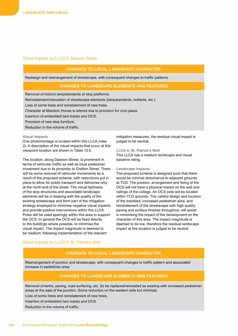
Environmental Impact Statement Luas Broombridge 352
LANdSCAPE ANd vISuAL
visual impactsOne photomontage is located within this LLCA (view 2). A description of the visual impacts that occur at this viewpoint location are shown in Table 13.6.
The location, along Dawson Street, is prominent in terms of vehicular traffic as well as local pedestrian movement due to its proximity to Grafton Street. There will be some removal of vehicular movements as a result of the proposed scheme, with restrictions put in place to allow for public transport and deliveries only at the north end of the street. The visual lightness of the stop structures and associated landscape elements will be in keeping with the quality of the existing streetscape and form part of the mitigation strategy employed to minimise negative visual impacts and provide positive interventions within this LLCA. Poles will be used sparingly within this area to support the OCS. In general the OCS will be fixed directly to the buildings where possible, to minimise the visual impact. The impact magnitude is deemed to be medium; following implementation of the relevant
mitigation measures, the residual visual impact is judged to be neutral.
LLCA 4: St. Patrick’s wellThis LLCA has a medium landscape and visual baseline rating.
Landscape impactsThe proposed scheme is designed such that there would be minimal disturbance to adjacent grounds at TCD. The position, arrangement and fixing of the OCS will not have a physical impact on the wall and railings of the college. An OCS pole will be located within TCD grounds. The careful design and location of the trackbed, increased pedestrian area, and reinstatement of the streetscape with high quality paving and surface finishes throughout, will assist in minimising the impact of the development on the character of this area. The impact magnitude is deemed to be low, therefore the residual landscape impact at this location is judged to be neutral.
Direct impacts on LLCA 3: Dawson Street
ChANGES TO LOCAL LANdSCAPE ChArACTEr
Redesign and rearrangement of streetscape, with consequent changes to traffic patterns.
ChANGES TO LANdSCAPE ELEMENTS ANd fEATurES
Removal of historic lampstandards at stop platforms.
Reinstatement/relocation of streetscape elements (lampstandards, bollards, etc.).
Loss of some trees and reinstatement of new trees.
Character at Mansion House is altered due to provision for civic plaza.
Insertion of embedded twin tracks and OCS.
Provision of new stop furniture.
Reduction in the volume of traffic.
Direct impacts on LLCA 4: St. Patrick’s Well
ChANGES TO LOCAL LANdSCAPE ChArACTEr
Rearrangement of junction and streetscape, with consequent changes to traffic pattern and associated increase in pedestrian area.
ChANGES TO LANdSCAPE ELEMENTS ANd fEATurES
Removal of kerbs, paving, road surfacing, etc. (to be replaced/reinstated as existing with increased pedestrian areas at the east of the junction. Some reduction on the western side but minimal).
Loss of some trees and reinstatement of new trees.
Insertion of embedded twin tracks and OCS.
Reduction in the volume of traffic.

353 Environmental Impact Statement Luas Broombridge
LANdSCAPE ANd vISuAL
visual impactsVisual impacts will arise from the insertion of the trackbed, OCS and associated infrastructure, and are likely to be of low to medium impact magnitude. The location, alongside TCD, is prominent in terms of vehicular and pedestrian movement, particularly at the entrance to the college on Nassau Street. The proposed scheme will reduce the volumes of vehicular traffic that exist at present. The views of passing trams will not be significant, therefore the impact magnitude is deemed to be low. Following the implementation of the proposed mitigation measures, the residual visual impact is neutral.
LLCA 5: Nassau Street (dawson Street to Grafton Street (lower)This LLCA has a medium landscape and visual baseline rating.
Landscape impactsThe design and location of the trackbed, and reinstatement of the streetscape with high quality paving and surface finishes throughout, will assist in minimising the impact of the proposal on the character of this area and adjacent grounds at TCD. The position, arrangement and fixing of the OCS will not have a physical impact on the wall, railing, and any other structures within the grounds of the college due to the location of the poles on the southside of the street. The impact magnitude is deemed to be low, following implementation of the relevant mitigation measures, therefore the residual landscape impact at this location is judged to be neutral.
visual impactsThe location of Nassau Street, alongside TCD, is prominent in terms of vehicular and pedestrian movement, with significant movement of pedestrians at the junction with Grafton Street. The proposed scheme will be viewed as an integral part of Dublin
city’s transport system. The views of passing trams will be in keeping with this and will not be significant. The impact magnitude is deemed to be low; following implementation of the relevant mitigation measures, the residual visual impact is judged to be neutral in this area.
LLCA 6: Lower Grafton StreetThis LLCA has a medium landscape and visual baseline rating.
Landscape impactsImpacts will arise from the insertion of the proposed scheme and associated infrastructure within this LLCA, which will have a direct impact on the urban landscape character of the street.
The proposed scheme will be designed for minimal disturbance to the adjacent grounds at TCD, with access to the Provost’s House in TCD to be maintained. As a consequence of the realigned kerb, there may be a marginal reduction in pathway widths; however there will be a significant increase in the width of the footpath to the east side of the street adjacent to the grounds at TCD. Cantilevered poles to be located on the western side of the street will be used to support the OCS to minimise the landscape and visual impact on this landmark. The iconic Molly Malone statue will be relocated close to its current position within the street. Existing London Plane (Platanus x hispanica) will be retained where possible. However, there will be a loss of at least one tree to allow for the insertion of the track. The impact magnitude is deemed to be medium; following implementation of the relevant mitigation measures, the residual landscape impact is judged to be neutral at this location.
Direct impacts on LLCA 5: Nassau Street (Dawson Street to Grafton Street (lower))
ChANGES TO LOCAL LANdSCAPE ChArACTEr
Rearrangement of streetscape,
ChANGES TO LANdSCAPE ELEMENTS ANd fEATurES
Reinstatement/relocation of streetscape elements (historic kerbs, paving and road surfacing).
Insertion of embedded twin tracks and associated overhead line equipment.
Reduction in the volume and type of traffic (public transport and deliveries only).

Environmental Impact Statement Luas Broombridge 354
LANdSCAPE ANd vISuAL
visual impactsThe location of Grafton Street (lower), alongside TCD, and at the entrance onto the pedestrianised section of Grafton Street, is itself prominent in terms of local vehicular and pedestrian movement. The proposed scheme will be viewed as an integral part of Dublin city’s transport system. The views of passing trams will be in keeping with this and will not be significant. The visual impact is deemed to be neutral, following implementation of the relevant mitigation measures.
LLCA 7: College GreenThis LLCA has a high landscape and visual baseline rating.
Landscape impactsThis area contains two of the finest buildings in the state: the former Parliament House, now Bank of Ireland, and the entrance façade to TCD. However, the high volumes of vehicular traffic, associated traffic camera poles and traffic infrastructure, and bus movement in the area reduce its baseline rating from very high to high. This area is also one of the key spaces in the Architecture Design Strategy of this EIS (Book 1, Chapter 7A) that has been identified as having significance in terms of urban design.
The proposed scheme is designed for minimal disturbance to the area, including design for minimal loss of trees. However, the removal of possibly one tree on the eastern side of College Green and three trees on the eastern side of College Green is required in order to accommodate the scheme. The trees will be assessed prior to the works to assess the possibility of retention.
Thomas Moore Island is subject to a modest reconfiguration as an urban space a description of which is outlined in more detail in the following section, “LLCA 15: College Street”. The footpath outside TCD will be reinstated to increase the pedestrian zone and accommodate the OCS poles which will be systematically located within this area. The other important space is at the Bank of Ireland building, with its dominant portico facing onto College Green. To avoid fixings to this important building, poles will be used to support the OCS at this location. The impact magnitude is deemed to be high; following implementation of the relevant mitigation measures, the residual landscape impact is judged to be moderate in this area.
Direct impacts on LLCA 6: Lower Grafton Street
ChANGES TO LOCAL LANdSCAPE ChArACTEr
Rearrangement of streetscape with consequent changes to traffic patterns.
ChANGES TO LANdSCAPE ELEMENTS ANd fEATurES
Rearrangement of historic and existing kerb lines to facilitate vehicular and pedestrian movements.
Insertion of embedded twin tracks and OCS.
Molly Malone statue (to be relocated within the street).
Possible loss of one London Plane tree on the median at Dame Street.
Reduction in the volume and type of traffic (public transport and deliveries only).
Direct impacts on LLCA 7: College Green
ChANGES TO LOCAL LANdSCAPE ChArACTEr
Rearrangement of streetscape, with consequent changes to traffic patterns.
Reconfiguration of Thomas Moore Island.
ChANGES TO LANdSCAPE ELEMENTS ANd fEATurES
Reinstatement/relocation of streetscape elements (existing and historic kerbs, paving and road surfacing).
Loss of some trees and reinstatement of new trees.
Insertion of embedded twin tracks and OCS.

355 Environmental Impact Statement Luas Broombridge
LANdSCAPE ANd vISuAL
visual impactsTwo photomontages are located within or with views into this LLCA (views 3 and 6). A description of the visual impacts that occur at these viewpoint locations is shown in Table 13.6.
This location, alongside TCD and the Bank of Ireland building, is prominent in terms of local vehicular and pedestrian movement. The OCS will be supported on poles in locations similar to the original tram system that operated through this area.
The impact magnitude is deemed to be medium, following implementation of the relevant mitigation measures. Taking account of the high visual amenity value in this area, the residual visual impact is judged to be moderate.
LLCA 8: westmoreland StreetThis LLCA has a medium landscape and visual baseline rating.
Landscape impactsThe careful design and location of the stop platform, single-line track, OCS and associated infrastructure on the eastern side of the street and reinstatement of the streetscape with high quality paving and surface finishes throughout, as well as reinstatement of any historic landscape elements, will assist in mitigating any impact of the development on the character of this area.
The street itself has a medium baseline rating given the amount of traffic and visual clutter from the street signage and volume of bus movement in the area. The impact magnitude is deemed to be low; following implementation of the relevant mitigation measures, the residual landscape impact is judged to be slight and positive.
visual impactsThe proposed scheme will be viewed as an integral part of Dublin city’s transport system. The views of passing trams will be in keeping with this and will not be significant. Given the existing high volumes of traffic in this area along with the visual clutter of the existing bus stops and street signage the residual visual impact, following the implementation of the proposed scheme and its associated mitigation measures, is judged to be positive.
LLCA 9: O’Connell BridgeLandscape impactsThe landscape/townscape character of this area has been judged as having a high baseline rating, given the historic nature of the bridge along with the decorative Victorian lamp standards and stone balustrades to the sides of the bridge. This is a key area identified in the Architecture Design Strategy of this EIS (Book 1, Chapter 7A).
The existing median on O’Connell Bridge will be widened to match the median along O’Connell Street Lower and a single-line track will be located west of the new central median. The widened median will improve the space available for pedestrian movement. Additional improvements to the pedestrian realm will arise from traffic calming at this location due to the removal of the right turn (turning east) onto Eden Quay, as proposed by DCC. The impact magnitude is deemed to be medium. Therefore, taking account of the proposed design and following the implementation of the proposed mitigation measures, the residual landscape impact will be neutral.
Direct impacts on LLCA 8: Westmoreland Street
ChANGES TO LOCAL LANdSCAPE ChArACTEr
Rearrangement of streetscape with consequent changes to traffic patterns.
ChANGES TO LANdSCAPE ELEMENTS ANd fEATurES
Reinstatement/relocation of streetscape elements including kerbs, paving, etc.
Insertion of embedded single track and OCS.
Provision of new stop furniture.
Increased pedestrian zone on western side of street.

Environmental Impact Statement Luas Broombridge 356
LANdSCAPE ANd vISuAL
visual impactsThe location of the proposed scheme along O’Connell Bridge is prominent in terms of local vehicular and pedestrian movement. The proposed scheme will be viewed as an integral part of Dublin city’s transport system the views of passing trams will be in keeping with this and will not be significant. The poles will be located in the central median to reduce the amount of overhead cabling. There will be a consistent relationship between the poles and the kerb edge which will carry through to the full length of O’Connell Street.
Therefore, taking account of the proposed design and following the implementation of the proposed mitigation measures, the residual visual impact will be positive due to the reduction in traffic and improvements to the public realm.
LLCA 10: O’Connell StreetLandscape impactsThe landscape/townscape character of this area has
been judged as having a high baseline rating. The impact magnitude is deemed to be high. There will be some tree loss to the central median along O’Connell Street due to the location of the stop platform; however these will be replaced in the new layout proposed for the median. The redesign of the median allows for a series of node points connected through an integrated pattern of trees, lamps and paving. The careful design and location of the trackbed, both along the carriageway and in the median (north of the Spire), and associated infrastructure, along with the reinstatement of the streetscape with high quality paving and surface finishes throughout and reinstatement of any historic landscape elements removed during construction, will assist in minimising the impact of the development on the character of this area.
Therefore, the residual landscape impact in this area is judged to be moderate.
Direct impacts on LLCA 9: O’Connell Bridge
ChANGES TO LOCAL LANdSCAPE ChArACTEr
Rearrangement of streetscape, with consequent changes to traffic patterns.
ChANGES TO LANdSCAPE ELEMENTS ANd fEATurES
Rearrangement of existing and historic kerbs and paving.
Insertion of embedded single track and OCS.
Reduction in the volume of traffic.
Direct impacts on LLCA 10: O’Connell Street
ChANGES TO LOCAL LANdSCAPE ChArACTEr
Redesign and rearrangement of streetscape in accordance with revised urban design scheme along length of street.
ChANGES TO LANdSCAPE ELEMENTS ANd fEATurES
Replacement of existing trees, lampstandards and other streetscape elements in median to accord with existing pavement pattern along edge of street.
Loss of some trees and reinstatement of new trees.
Character of median for length of street is altered (refer to the Architecture Design Strategy of this EIS (Book 1, Chapter 7A)).
Insertion of embedded single track and OCS.
Provision of new stop furniture at two stops in accordance with the Architecture Design Strategy of this EIS (Book 1, Chapter 7A).

357 Environmental Impact Statement Luas Broombridge
LANdSCAPE ANd vISuAL
visual impactsOne photomontage is located within this LLCA (view 4). A description of the visual impacts that occur at this viewpoint location are shown in Table 13.6. For each viewpoint, the visual baseline is presented as a brief description of the main components in the existing view. The mitigation measures to be employed at this location are shown in detail in the Landscape Insertion Plans. The evaluation of impacts described in Table 13.6 takes account of the sensitive design and the effects of the proposed mitigation measures.
The location of the proposed scheme along O’Connell Street is prominent in terms of local vehicular and pedestrian movement. The proposed design and associated mitigation measures will assist in reducing the visual impact of the proposed scheme which will be viewed as an integral part of Dublin city’s transport system. The views of passing trams will be in keeping with this and will not be significant The residual visual impact, therefore, will be neutral at this location.
LLCA 11: Parnell StreetLandscape impactsThe landscape/townscape character of this area has been judged as having a low baseline rating. However, there are important features located in this area that improve the townscape character, such as the Parnell National Monument and the Ambassador Theatre building. A photomontage has been prepared to assess the landscape and visual impact of the OCS on the Parnell National Monument. A description of the visual impacts that occur at this viewpoint location are shown in Table 13.6. The impact magnitude is deemed to be medium.
Taking account of the proposed design and associated mitigation measures, as well as the poor quality landscape character in this area, the residual landscape impact is judged to be positive.
visual impactsThe location of the proposed scheme along Parnell Street is prominent in terms of local vehicular and pedestrian movement. The primary visual impact will be the OCS across the junction with O’Connell Street.
Taking account of the proposed design and associated mitigation measures, as well as the existing low visual amenity value in the area, the residual visual impact is judged to be positive.
LLCA 12: Marlborough StreetThis LLCA has a low landscape and visual baseline rating.
Landscape impactsThe general townscape character in this area is of poor quality with the exception of the Department of Education building and St. Mary’s Pro-Cathedral. The proposed scheme will require the removal of six street trees adjacent to the junction with Cathal Brugha Street. However, these trees will be replaced with similar tree species following construction. It is envisaged that the introduction of the proposed scheme will assist in the regeneration of the street, increasing pedestrian movement in this area. The impact magnitude is deemed to be medium.
Taking account of the proposed design and associated mitigation measures in this area, the residual landscape impact is judged to be positive.
Direct impacts on LLCA 11: Parnell Street
ChANGES TO LOCAL LANdSCAPE ChArACTEr
Redesign and rearrangement of streetscape in accordance with strategy for O’Connell Street, south of Parnell National Monument.
Rearrangement of kerbs and paving to accommodate stop and pedestrian environment.
ChANGES TO LANdSCAPE ELEMENTS ANd fEATurES
Replacement of existing trees, lampstandards and other streetscape elements in median to accord with existing pavement pattern along edge of street south of Parnell National Monument.
Loss of some trees and reinstatement of new trees on O’Connell Street.
Reinstatement/relocation of streetscape elements (lampstandards, bollards, historic paving, kerbs, etc.).
Insertion of embedded single track and OCS.
Provision of new stop furniture.
Provision of OCS infrastructure taking account of position of Parnell National Monument.
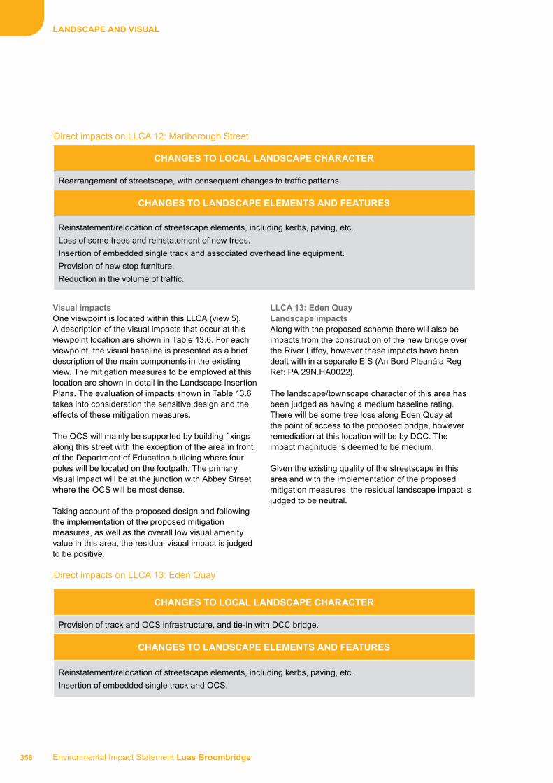
Environmental Impact Statement Luas Broombridge 358
LANdSCAPE ANd vISuAL
visual impactsOne viewpoint is located within this LLCA (view 5). A description of the visual impacts that occur at this viewpoint location are shown in Table 13.6. For each viewpoint, the visual baseline is presented as a brief description of the main components in the existing view. The mitigation measures to be employed at this location are shown in detail in the Landscape Insertion Plans. The evaluation of impacts shown in Table 13.6 takes into consideration the sensitive design and the effects of these mitigation measures.
The OCS will mainly be supported by building fixings along this street with the exception of the area in front of the Department of Education building where four poles will be located on the footpath. The primary visual impact will be at the junction with Abbey Street where the OCS will be most dense.
Taking account of the proposed design and following the implementation of the proposed mitigation measures, as well as the overall low visual amenity value in this area, the residual visual impact is judged to be positive.
LLCA 13: Eden quayLandscape impactsAlong with the proposed scheme there will also be impacts from the construction of the new bridge over the River Liffey, however these impacts have been dealt with in a separate EIS (An Bord Pleanála Reg Ref: PA 29N.HA0022).
The landscape/townscape character of this area has been judged as having a medium baseline rating. There will be some tree loss along Eden Quay at the point of access to the proposed bridge, however remediation at this location will be by DCC. The impact magnitude is deemed to be medium.
Given the existing quality of the streetscape in this area and with the implementation of the proposed mitigation measures, the residual landscape impact is judged to be neutral.
Direct impacts on LLCA 12: Marlborough Street
ChANGES TO LOCAL LANdSCAPE ChArACTEr
Rearrangement of streetscape, with consequent changes to traffic patterns.
ChANGES TO LANdSCAPE ELEMENTS ANd fEATurES
Reinstatement/relocation of streetscape elements, including kerbs, paving, etc.
Loss of some trees and reinstatement of new trees.
Insertion of embedded single track and associated overhead line equipment.
Provision of new stop furniture.
Reduction in the volume of traffic.
Direct impacts on LLCA 13: Eden Quay
ChANGES TO LOCAL LANdSCAPE ChArACTEr
Provision of track and OCS infrastructure, and tie-in with DCC bridge.
ChANGES TO LANdSCAPE ELEMENTS ANd fEATurES
Reinstatement/relocation of streetscape elements, including kerbs, paving, etc.
Insertion of embedded single track and OCS.

359 Environmental Impact Statement Luas Broombridge
LANdSCAPE ANd vISuAL
visual impactsThe location of the proposed scheme along Eden Quay is prominent in terms of local vehicular and pedestrian movement particularly that associated with Bus Átha Cliath (BAC).
Given the high volumes of traffic which lower the overall visual amenity value in this area and with the implementation of the proposed mitigation measures, the residual visual impact is judged to be neutral.
LLCA 14: hawkins StreetThis LLCA has a low landscape and visual baseline rating.
Landscape impactsThe overall landscape/townscape character of this area is of low quality. The street is mainly accessed by buses which stop and park along the eastern side of the street. The impact magnitude is deemed to be medium.
Given the overall low quality character at this location, the residual landscape impact is judged to be positive.
visual impactsThe main visual focus at the north end of this area is the Sheahan Monument. Reinstatement of this monument will be undertaken by DCC as part of the construction of the new bridge over the River Liffey.
There is a minor reconfiguration of the Long Stone sculpture within a revised public space at the junction with Pearse Street.
Taking account of the proposed design and following the implementation of the proposed mitigation measures, as well as the overall low visual amenity value in this area, the residual visual impact is judged to be positive.
LLCA 15: College StreetThis LLCA has a high landscape and visual baseline rating.
Landscape impactsThe landscape/townscape character of this area is generally of a medium quality given the high volumes of traffic in the area. The impact magnitude is deemed to be high. There will be some tree loss at Thomas Moore Island (refer to previous section LLCA 7) as a result of the proposed scheme but these will be reinstated as part of the proposed mitigation measures.
Direct impacts on LLCA 15: College Street
ChANGES TO LOCAL LANdSCAPE ChArACTEr
Provision of track, OCS and stop infrastructure, and tie-in with DCC bridge.
ChANGES TO LANdSCAPE ELEMENTS ANd fEATurES
Reinstatement/relocation of streetscape elements, including kerbs, paving, etc.Insertion of embedded single track and OCS.Provision of new stop furniture. Changes to Thomas Moore Island (refer to LLCA 7).
Direct impacts on LLCA 14: Hawkins Street
ChANGES TO LOCAL LANdSCAPE ChArACTEr
Provision of track and OCS infrastructure, and tie-in with DCC bridge.
ChANGES TO LANdSCAPE ELEMENTS ANd fEATurES
Reinstatement/relocation of streetscape elements, including kerbs, paving, etc.Insertion of embedded single track and OCS.Reinstatement of Long Stone sculpture and increase in size of traffic island along with the creation of a new urban space.Removal/reinstatement of Sheahan Monument (by DCC).

Environmental Impact Statement Luas Broombridge 360
LANdSCAPE ANd vISuAL
Given the high volumes of traffic which lower the general character of this area and with the proposed mitigation measures, the residual landscape impact is judged to be neutral.
visual impactsOne viewpoint is located within this LLCA (view 6). A description of the visual impacts that occur at this viewpoint location are shown in Table 13.6. For each viewpoint, the visual baseline is presented as a brief description of the main components in the existing view. The mitigation measures to be employed at this location are shown in detail in the Landscape Insertion Plans. The evaluation of impacts shown in Table 13.6 takes into consideration the effects of these mitigation measures.
The location of the proposed scheme along College Street is prominent in terms of local vehicular and pedestrian movement and its proximity to grounds at TCD. There is a stop at the southern boundary adjacent to TCD. The Thomas Moore statue on the traffic island is a prominent visual feature in this area and will be retained and realigned as part of the reconfiguration of this public space in accordance with the Architecture Design Strategy of this EIS (Book 1, Chapter 7A). The reconfiguration will require the removal of the Victorian toilet block and some of the trees. However, the proposed scheme will include the installation of new tree planting, seating and paving to enhance it as a public amenity space.
Taking account of the proposed design and following the implementation of the proposed mitigation measures, as well as the existing visual clutter of the vehicular traffic and street signage and the enhancement of the public space, the residual visual impact of the proposed scheme in this area is judged to be neutral.
LLCA 16: Parnell Street (to the west of O’Connell Street)Landscape impactsThe landscape/townscape character of this area has been judged as having a medium baseline rating. The overall streetscape is of poor quality with the exception of the intervention of some important buildings such as the Rotunda Hospital and the Allied Irish Bank (AIB) building. There will be the loss of at least three trees (possibly four) at the junction with Dominick Street Lower due to the realignment of the footpath, while the remaining street trees will require tree protection measures to be implemented during construction. The impact magnitude is deemed to be medium.
Taking account of the proposed design and following the implementation of the proposed mitigation measures, as well as the overall medium landscape quality in this area, the volumes of vehicular traffic and areas of dereliction the residual landscape impact is judged to be positive.
Direct impacts on LLCA 16: Parnell Street (to the west of O’Connell Street)
ChANGES TO LOCAL LANdSCAPE ChArACTEr
Provision of track and OCS infrastructure.
Acknowledgement of significance of formal setting of Rotunda Hospital.
ChANGES TO LANdSCAPE ELEMENTS ANd fEATurES
Reinstatement/relocation of streetscape elements, including kerbs, paving, etc.
Insertion of embedded twin track and OCS.
Provision of OCS infrastructure in accordance with the Architecture Design Strategy of this EIS (Book 1, Chapter 7A).
Loss of some trees.
Reinstatement/relocation of streetscape elements including kerbs, paving and road surfacing.
Upgrade and improvement of the pedestrian realm.

361 Environmental Impact Statement Luas Broombridge
LANdSCAPE ANd vISuAL
visual impactsThe location of the proposed scheme along Parnell Street to the west of O’Connell Street is prominent in terms of local vehicular and pedestrian movement. At the forecourt to the original Rotunda Hospital building, a cradle system will be used to support the OCS to minimise the number of poles required. In general, building fixings are used to support the OCS from the corner of Parnell Square and the southwest corner of the Rotunda Hospital to the junction with Dominick Street Lower.
Given the volumes of traffic, the general low visual amenity value in the area and following the implementation of the proposed mitigation measures, the residual visual impact is judged to be positive.
LLCA 17: dominick Street LowerThis LLCA has a low landscape and visual baseline rating.
Landscape impactsThe landscape/townscape character in this area is generally of low quality. Dominick Street Lower is a wide street and there will be removal and/or reduction of some traffic along the street as a result of the proposed scheme. Accommodation of the OCS has taken account of the important Protected Structures at the northern end of Dominick Street Lower. The impact magnitude is deemed to be medium.
Given the low quality townscape character together with the proposed mitigation measures, the residual landscape impact is judged to be positive.
visual impactsThe location of the proposed scheme along Dominick Street Lower is prominent in terms of local vehicular and pedestrian movement. Particular attention will be taken to minimise the visual impact of the OCS in the vicinity of St. Saviour’s Dominican Church and Priory grounds within this LLCA.
Given the poor visual amenity value in this area, the large amount of car parking on both sides of the street and following the implementation of the proposed mitigation measures, the residual visual impact in this area is judged to be positive.
LLCA 18: dominick Street upperThis LLCA has a low landscape and visual baseline rating.
Landscape impactsThe landscape/townscape character in this area is generally of low quality with a wide variety of paving finishes, mostly of poor quality. There will be removal and/or reduction of some traffic along Dominick Street Upper as a result of the proposed scheme. The impact magnitude is deemed to be medium.
Given the overall low townscape character of the street together with the implementation of the proposed mitigation measures, the residual landscape impact is judged to be positive.
Direct impacts on LLCA 17: Dominick Street Lower
ChANGES TO LOCAL LANdSCAPE ChArACTEr
Redesign and rearrangement of streetscape.
Rearrangement of kerbs and paving to accommodate stop and pedestrian environment.
ChANGES TO LANdSCAPE ELEMENTS ANd fEATurES
Insertion of embedded twin track and OCS.
Provision of new stop and associated furniture.
Removal/reduction of some traffic.
Removal of parking spaces along east side of street adjacent to the stop.
Upgrade and improvement of the pedestrian realm.
Environmental Impact Statement Luas Broombridge 362
LANdSCAPE ANd vISuAL
visual impactsThe location of the proposed scheme along Dominick Street Upper is prominent in terms of local vehicular and pedestrian movement. There are no visually important features along the street and the overall visual amenity value in this area is of low quality.
Taking account of the proposed design and associated mitigation measures in this area, the residual landscape impact is judged to be positive.
LLCA 19: Constitution hill This LLCA has a low landscape and visual baseline rating.
Landscape impactsThe landscape/townscape character of this area is generally of low quality. It is a heavily trafficked road carrying vehicles to and from the city centre from the north side of the city.
The proposed scheme will require disruption of the green space where there will be some loss of trees. However, these trees will be replaced with similar species along with additional tree planting to enhance the green space after construction. The current tree line on the south of this green space will be retained. The impact magnitude is deemed to be high.
Taking account of the proposed design and associated mitigation measures in this area, the residual landscape impact is judged to be positive.
visual impactsOne viewpoint is located within this LLCA (view 7). A description of the visual impacts that occur at this viewpoint location are shown in Table 13.6. For each viewpoint, the visual baseline is presented as a brief description of the main components in the existing view. The mitigation measures to be employed at this location are shown in detail in the Landscape Insertion Plans. The evaluation of impacts shown in Table 13.6 takes into consideration the effects of these mitigation measures.
Direct impacts on LLCA 18: Dominick Street Upper
ChANGES TO LOCAL LANdSCAPE ChArACTEr
Rearrangement of streetscape.
ChANGES TO LANdSCAPE ELEMENTS ANd fEATurES
Insertion of embedded twin track and OCS.
Revision of traffic flow.
Reinstatement/relocation of streetscape elements including kerbs, paving and road surfacing.
Direct impacts on LLCA 19
ChANGES TO LOCAL LANdSCAPE ChArACTEr
Redesign and rearrangement of streetscape, with consequent changes to traffic and pedestrian patterns.
ChANGES TO LANdSCAPE ELEMENTS ANd fEATurES
Reinstatement/relocation of existing and historic streetscape elements including kerbs, paving and road surfacing.
Loss of some trees and reinstatement of new trees.
Reduction of green space with some reduction in the area.
Changes to the local topography due to reconfiguration of road junctions and access arrangements.
Insertion of embedded twin track and OCS.

363 Environmental Impact Statement Luas Broombridge
LANdSCAPE ANd vISuAL
The location of the proposed scheme at Constitution Hill is prominent in terms of local vehicular and pedestrian movement and its proximity to the grounds at King’s Inns. Taking account of the proposed design and associated mitigation measures, as well as the high volumes of traffic in this area, the residual landscape impact is judged to be positive.
LLCA 20: BroadstoneThis LLCA has a low landscape and visual baseline rating.
Landscape impactsThe landscape/townscape character of this area is of low quality characterised by the concrete paved surfaces of varying quality, low quality warehouse/storage buildings (with the notable exception of the original Broadstone Station building), and the high volume of bus movement around the depot.
The site will be retained as a bus depot during the proposed scheme operation. There will be a new access for buses and new treatment to the boundary of the bus depot as a result of reconfiguring the entrance. The wall along the boundary of the adjacent lands at St. Brendan’s Hospital (future DIT campus) will be partially removed. The Broadstone - DIT Stop within this LLCA has been designed to create a new context for the old Broadstone Station with the provision of a stop and associated revised public open space. The configuration of the stop will require a revised road layout access to the Broadstone Bus Depot. There will be a short underpass for the alignment at this location which will continue along the western edge of the bus depot at grade (along the boundary with St. Brendan’s Hospital) before entering into the cutting (Area 30). The Grangegorman Gateway Development (future DIT campus) is
facilitated within the design for this stop and its environs.
There is a second stop within this LLCA. The possible future Grangegorman Stop, which is within the existing Broadstone Bus Depot, will require an upgrade to the access from the local Grangegorman area. This is noted in the RO Structures drawing for this possible future stop. The impact magnitude is deemed to be high.
Taking account of the proposed design and associated mitigation measures for this area of low quality landscape character, the residual landscape impact will be positive.
visual impactsThe location of the proposed scheme at the Broadstone Bus Depot is prominent in terms of public bus movement and car parking facilities. The primary visual focus in this area is the Broadstone Bus Depot building on the elevated bus depot. View to this building is enhanced as a result of the design of the stop area.
Given the low visual amenity value of this area, together with the implementation of the proposed improvements and mitigation measures the residual visual impact is judged to be positive.
13.4.3.3 Summary of residual impactsA summary of the residual impacts associated with the proposed scheme and affecting this area are shown in Table 13.5.
Direct impacts on LLCA 20 :Broadstone
ChANGES TO LOCAL LANdSCAPE ChArACTEr
Redesign and rearrangement of public realm with rearrangement of entrance to bus depot.
Accommodation of future design for Grangegorman Gateway Development (future DIT campus).
ChANGES TO LANdSCAPE ELEMENTS ANd fEATurES
Context of Broadstone building is altered as a result of redesign of public realm.
Insertion of embedded twin track and OCS.
Provision of new Broadstone - DIT Stop and associated infrastructure.
Provision for possible future stop at Grangegorman.
Loss of some trees and reinstatement of new trees in accordance with the Architecture Design Strategy of this EIS (Book 1, Chapter 7A).

Environmental Impact Statement Luas Broombridge 364
LANdSCAPE ANd vISuAL
Table 13.5 Summary of residual impacts on landscape
BASELINE rATING
IMPACTIMPACT
MAGNITudE
IMPACT SIGNIfICANCE
PrIOr TO MITIGATION
MITIGATION MEASurE
rESIduAL IMPACT
SIGNIfICANCE
Location: LLCA 1
High
Additional stop furniture.
Embedded twin tracks, OCS.
Reduction in footpath adjacent to St. Stephen’s Green park.
Loss of some trees.
Overall increase in pedestrian zone.
Medium Significant
Additional structures to be sympathetic to the existing landscape.
Use of building fixings where possible.
Replacement tree planting.
Slight negative
Location: LLCA 2
High
Embedded twin tracks, OCS.
Increased pedestrian zone.
Loss of some trees.
Medium Significant
Reinstated public realm sympathetic to the existing landscape.
Use of building fixings where possible.
Replacement tree planting.
Slight
negative
Location: LLCA 3
High
Location of stop.
Insertion of new elements into the landscape.
Embedded twin tracks, OCS.
Loss of some trees.
Medium Significant
Reinstated/improved public realm with high quality paving and surface finishes.
Stop surfaces will integrate with the overall surface treatment to ensure a visually coherent surface finish.
Use of building fixings where possible.
Replacement tree planting.
Neutral

365 Environmental Impact Statement Luas Broombridge
LANdSCAPE ANd vISuAL
Table 13.5 Continued
BASELINE rATING
IMPACTIMPACT
MAGNITudE
IMPACT SIGNIfICANCE
PrIOr TO MITIGATION
MITIGATION MEASurE
rESIduAL IMPACT
SIGNIfICANCE
Location: LLCA 4
Medium
Insertion of new elements into the landscape.
Embedded twin tracks, OCS.
Low Moderate
Reinstatement of the streetscape with high quality paving and surface finishes.
Use of building fixings where possible.
Placement of OCS pole in TCD grounds near existing ESB substation.
Neutral
Location: LLCA 5
Medium
Insertion of new elements into the landscape.
Embedded twin tracks, OCS.
Low Moderate
Reinstatement of the streetscape with high quality paving and surface finishes.
Use of building fixings where possible.
Neutral
Location: LLCA 6
Medium
Insertion of new elements into the landscape.
Embedded twin tracks, OCS.
Medium to high
Significant
Reinstatement of the streetscape with high quality paving and surface finishes – reinstatement of statue within the street.
Use of cantilevered OCS poles on western side of street to reduce impact on Provost’s House.
Neutral
Location: LLCA 7
High
Insertion of new elements into the landscape.
Embedded single track, OCS.
Medium to high
Significant
Reinstatement of the streetscape with high quality paving and surface finishes – reinstatement of statue within the traffic island.
Use of OCS poles laid out systematically to reduce impact on TCD and Bank of Ireland building.
Moderate

Environmental Impact Statement Luas Broombridge 366
LANdSCAPE ANd vISuAL
Table 13.5 Continued
BASELINE rATING
IMPACTIMPACT
MAGNITudE
IMPACT SIGNIfICANCE
PrIOr TO MITIGATION
MITIGATION MEASurE
rESIduAL IMPACT
SIGNIfICANCE
Location: LLCA 8
Medium
Location of stop.
Insertion of new elements into the landscape.
Stop and associated infrastructure.
Embedded single track, OCS.
Low Moderate
Reinstatement of the streetscape with high quality paving and surface finishes.
Stop surfaces will integrate with the overall surface treatment to ensure a visually coherent surface finish.
Use of cantilevered OCS poles on eastern side of street.
Slight positive
Location: LLCA 9
High
Insertion of new elements into the landscape.
Embedded single track, OCS.
Medium Significant
Reinstatement of the streetscape with high quality paving and surface finishes.
OCS poles and kerb lines reconfigured to accommodate revised traffic and tramway. The positions of OCS poles and existing lighting columns are proposed in a coherent manner and linked to the O’Connell Street design.
Neutral/slight positive
Location: LLCA 10
High
Location of stop.
Insertion of new elements into the landscape.
Stop and associated infrastructure.
Embedded single track OCS.
Loss of some trees.
High Significant
Reinstatement of the streetscape with high quality paving and surface finishes.
Stop surfaces will terminate at the tactile edge to ensure minimal disturbance.
OCS poles integrated with lighting columns to reduce visual clutter.
Replacement tree planting – new layout.
Moderate/neutral

367 Environmental Impact Statement Luas Broombridge
LANdSCAPE ANd vISuAL
Table 13.5 Continued
BASELINE rATING
IMPACTIMPACT
MAGNITudE
IMPACT SIGNIfICANCE
PrIOr TO MITIGATION
MITIGATION MEASurE
rESIduAL IMPACT
SIGNIfICANCE
Location: LLCA 11
Low
Location of stop.
Insertion of new elements into the landscape.
Stop and associated infrastructure.
Embedded single track, OCS.
Medium Moderate
Improvement to the existing streetscape with reinstatement of high quality paving and surface finishes.
Stop surfaces will integrate with the overall surface treatment to ensure a visually coherent surface finish.
Use of building fixings where possible.
OCS outside Ambassador Theatre not to block view from O’Connell Street.
Parnell National Monument and surrounding bollards not to be disturbed.
Positive
Location: LLCA 12
Low
Location of stop.
Insertion of new elements into the landscape.
Stop and associated infrastructure.
Embedded single track, OCS.
Medium Moderate
Improvement to the existing streetscape with reinstatement of high quality paving and surface finishes – high quality pavement outside St. Mary’s Pro-Cathedral, i.e. granite trackbed and carriageway.
Stop surfaces will integrate with the overall surface treatment to ensure a visually coherent surface finish.
Use of building fixings where possible – OCS poles to be located within open space fronting the Department of Education building.
Positive

Environmental Impact Statement Luas Broombridge 368
LANdSCAPE ANd vISuAL
Table 13.5 Continued
BASELINE rATING
IMPACTIMPACT
MAGNITudE
IMPACT SIGNIfICANCE
PrIOr TO MITIGATION
MITIGATION MEASurE
rESIduAL IMPACT
SIGNIfICANCE
Location: LLCA 13
Medium
Insertion of new elements into the landscape.
Embedded single track, OCS.
Bridge over River Liffey (impacts dealt with in separate EIS by DCC).
Tree removal (impacts of bridge construction – including tree loss dealt with in separate EIS by DCC).
Medium Moderate
Improvement to the existing streetscape with reinstatement of high quality paving and surface finishes.
Use of building fixings where possible.
Replacement tree planting to be dealt with by DCC mitigation measures for the bridge.
Neutral
Location: LLCA 14
Low
Insertion of new elements into the landscape.
Embedded single track, OCS.
Medium Slight
Improvement to the existing streetscape with reinstatement of high quality paving and surface finishes.
Use of building fixings where possible.
Reinstatement of the existing Long Stone sculpture to within a few metres of its existing location.
Reinstatement of the Sheahan Monument will be undertaken by DCC as in relation to the construction of the bridge.
Positive

369 Environmental Impact Statement Luas Broombridge
LANdSCAPE ANd vISuAL
Table 13.5 Continued
BASELINE rATING
IMPACTIMPACT
MAGNITudE
IMPACT SIGNIfICANCE
PrIOr TO MITIGATION
MITIGATION MEASurE
rESIduAL IMPACT
SIGNIfICANCE
Location: LLCA 15
High
Location of stop.
Insertion of new elements into the landscape.
Stop and associated infrastructure.
Embedded single track, OCS.
High Significant
Reinstatement of the existing streetscape with reinstatement of high quality paving and surface finishes.
Stop surfaces will integrate with the overall surface treatment to ensure a visually coherent surface finish.
Use of building fixings where possible.
The boundary wall and railings to TCD adjacent to the proposed stop will not be disturbed.
Trees to be removed during construction within the traffic island will be reinstated where possible – design for minimal loss.
Reinstatement of the Thomas Moore statue and plinth/steps within the traffic island.
Neutral
Location: LLCA 16
Medium
Insertion of new elements into the landscape.
Embedded twin track, OCS.
Medium Moderate
Improvement to the existing streetscape with reinstatement of high quality paving and surface finishes.
Use of building fixings where possible – OCS poles outside Rotunda Hospital due to large span.
Positive

Environmental Impact Statement Luas Broombridge 370
LANdSCAPE ANd vISuAL
Table 13.5 Continued
BASELINE rATING
IMPACTIMPACT
MAGNITudE
IMPACT SIGNIfICANCE
PrIOr TO MITIGATION
MITIGATION MEASurE
rESIduAL IMPACT
SIGNIfICANCE
Location: LLCA 17
Low
Location of stop.
Insertion of new elements into the landscape.
Stop and associated infrastructure.
Embedded twin track, OCS.
Medium Moderate
Improvement to the existing streetscape with reinstatement of high quality paving and surface finishes.
Improved pedestrian realm.
Use of building fixings where possible – particular attention will be taken to minimise the visual impact of the OCS in the vicinity of St. Saviour’s Dominican Church and Priory and grounds within this LLCA.
Positive
Location: LLCA 18
Low
Location of stop.
Insertion of new elements into the landscape.
Stop and associated infrastructure.
Embedded twin track, OCS.
Medium Moderate
Improvement to the existing streetscape with reinstatement of high quality paving and surface finishes.
Improved pedestrian realm.
Use of building fixings where possible.
Positive
Location: LLCA 19
Low
Insertion of new elements into the landscape.
Embedded twin track, OCS.
High Moderate
Improvement to the existing streetscape with reinstatement of high quality paving and surface finishes.
Improved pedestrian realm.
Reinstatement of green space and trees in residual lands as far as possible.
Retention of the existing significant tree line on the south of the green space.
Positive

371 Environmental Impact Statement Luas Broombridge
LANdSCAPE ANd vISuAL
Table 13.5 Continued
BASELINE rATING
IMPACTIMPACT
MAGNITudE
IMPACT SIGNIfICANCE
PrIOr TO MITIGATION
MITIGATION MEASurE
rESIduAL IMPACT
SIGNIfICANCE
Location: LLCA 20
Low
Location of stop.
Insertion of new elements into the landscape.
Stop and associated infrastructure.
Embedded twin track, OCS.
High Moderate
Improvement to the existing streetscape with reinstatement of high quality paving and surface finishes as well as respecting the context of this LLCA through the use of materials in keeping with the historic nature of the site such as retention of the canal structures and limestone walls and in keeping with the context of the entrances to the bus depot.
Pedestrian realm addressed.
Treatment of adjacent boundary to bus depot and St. Brendan’s Hospital.
Positive

Environmental Impact Statement Luas Broombridge 372
LANdSCAPE ANd vISuAL
Table 13.6 Summary of residual impacts on visual amenity at selected viewpoint locations*
vIEw POINT
Id
COMPONENTS Of ThE
ExISTING vIEw
MITIGATION MEASurES
dESCrIPTION Of PrOPOSEd
vIEw (wITh MITIGATION MEASurES)
SENSITIvITy (BASELINE
rATING)
MAGNITudE (POST
MITIGATION)
SIGNIfICANCE (POST
MITIGATION)
Location and viewer Type: LLCA 3 (C) (W)
1
Streetscape associated with Dawson Street – high quality streetscape fronting Mansion House.
Pedestrian and vehicular movement.
Street tree planting along either side of Dawson street adding to its character.
High quality street furniture and reinstated surfacing – high quality fronting Mansion House.
Building fixings for OCS where possible.
Replace trees.
OCS and trackbed will be new features in view.
Reinstated high quality pavement and surface finishes outside Mansion House. Improvement to the streetscape overall.
High Medium Neutral
Location and viewer Type: LLCA 7 (R) (C) (W)
2
Streetscape associated with College Green and nearby buildings such as Bank of Ireland building and TCD.
Pedestrian and vehicular movement.
Traffic island on College Street, including statue.
High quality street furniture and reinstated surfacing.
OCS poles at TCD and Bank of Ireland laid out in a systematic approach.
Replace trees lost (in traffic island).
OCS and trackbed will be new features in view.
Improved surface finishes.
High Significant Moderate

373 Environmental Impact Statement Luas Broombridge
LANdSCAPE ANd vISuAL
Table 13.6 Continued
vIEw POINT
Id
COMPONENTS Of ThE
ExISTING vIEw
MITIGATION MEASurES
dESCrIPTION Of PrOPOSEd
vIEw (wITh MITIGATION MEASurES)
SENSITIvITy (BASELINE
rATING)
MAGNITudE (POST
MITIGATION)
SIGNIfICANCE (POST
MITIGATION)
Location and viewer Type: LLCA 10 (R) (C) (W)
3
Streetscape associated with O’Connell Street.
Buildings along O’Connell Street including the General Post Office (GPO) and elements such as the Spire.
Pedestrian and vehicular movement.
High quality street furniture and reinstated surfacing.
Building fixings for overhead line equipment where possible.
Replace trees.
The stop, OCS and trackbed will be new features in view.
Reconfigured traffic median.
Trees replaced – new tree planting layout.
High Significant Slight
Location and viewer Type: LLCA 10 (R) (C) (W)
4
Streetscape associated with north end of O’Connell Street Upper with particular emphasis on the Parnell National Monument.
Parnell National Monument and surroundings bollards to be retained in situ.
The stop, OCS and trackbed will be new features in view.
Reconfigured traffic median.
Trees replaced – new tree planting layout.
High Significant Moderate
Location and viewer Type: LLCA 12 (C) (W)
5
Streetscape fronting the St. Mary’s Pro-Cathedral and open space fronting the Department of Education building.
Pedestrian and vehicular movement – bus parking.
Trees along the street.
High quality street furniture and reinstated surfacing.
Building fixings for OCS where possible.
OCS and trackbed will be new features in view.
Improved surface finishes.
Removal of buses along streetside.
Low Medium Positive

Environmental Impact Statement Luas Broombridge 374
LANdSCAPE ANd vISuAL
Table 13.6 Continued
vIEw POINT
Id
COMPONENTS Of ThE
ExISTING vIEw
MITIGATION MEASurES
dESCrIPTION Of PrOPOSEd
vIEw (wITh MITIGATION MEASurES)
SENSITIvITy (BASELINE
rATING)
MAGNITudE (POST
MITIGATION)
SIGNIfICANCE (POST
MITIGATION)
Location and viewer Type: LLCA 15 (R) (C) (W)
6
Streetscape associated with College Street and adjacent TCD boundary wall and tree planting.
Pedestrian and vehicular movement.
Road island on College Street including statue.
High quality street furniture and reinstated surfacing, etc.
Building fixings where possible.
Replace trees lost (in traffic island).
The stop outside TCD grounds, OCS and trackbed will be new features in view.
Improved surface finishes.
Reconfigured traffic island with replacement tree planting and reinstated statue.
High Medium Neutral
Location and viewer Type: LLCA 19 (H) (C) (W)
7
Streetscape and open space fronting the King’s Inns.
Busy traffic artery – main Phibsborough Road and entrance to Broadstone Bus Depot.
Improvement to the existing streetscape with reinstatement of high quality paving and surface finishes.
Improved pedestrian realm.
Reinstate green space and trees in residual lands as far as possible.
OCS and trackbed will be new features in view.
Improved surface finishes.
Reconfigured road layout with proposed scheme crossing at grade.
Reinstated green space and tree planting within residual lands.
Retention of the existing significant tree line on the south of the green space.
Low Medium Positive
* Viewer type: H, residents of dwellings; R, recreational users; C, commuters; and W, workers.

375 Environmental Impact Statement Luas Broombridge
LANdSCAPE ANd vISuAL
13.5 rEfErENCES1 Environmental Protection Agency (2002)
Guidelines on the Information to be Contained in Environmental Impact Statements. Wexford: Environmental Protection Agency.
2 British Standard Institution (2005) BS 5837: Trees in Relation to Construction – Recommendations. London: British Standards Institute.

Environmental Impact Statement Luas Broombridge 376
LANdSCAPE ANd vISuAL
Ph
oto
mo
nta
ge
13.1
Daw
son
Str
eet e
xist
ing

377 Environmental Impact Statement Luas Broombridge
LANdSCAPE ANd vISuAL
Ph
oto
mo
nta
ge
13.2
Daw
son
Str
eet Y
ear
1

Environmental Impact Statement Luas Broombridge 378
LANdSCAPE ANd vISuAL
Ph
oto
mo
nta
ge
13.3
Daw
son
Str
eet Y
ear
15

379 Environmental Impact Statement Luas Broombridge
LANdSCAPE ANd vISuAL
Ph
oto
mo
nta
ge
13.4
Col
lege
Gre
en e
xist
ing
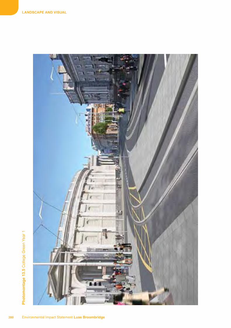
Environmental Impact Statement Luas Broombridge 380
LANdSCAPE ANd vISuAL
Ph
oto
mo
nta
ge
13.5
Col
lege
Gre
en Y
ear
1

381 Environmental Impact Statement Luas Broombridge
LANdSCAPE ANd vISuAL
Ph
oto
mo
nta
ge
13.6
Col
lege
Yea
r 15
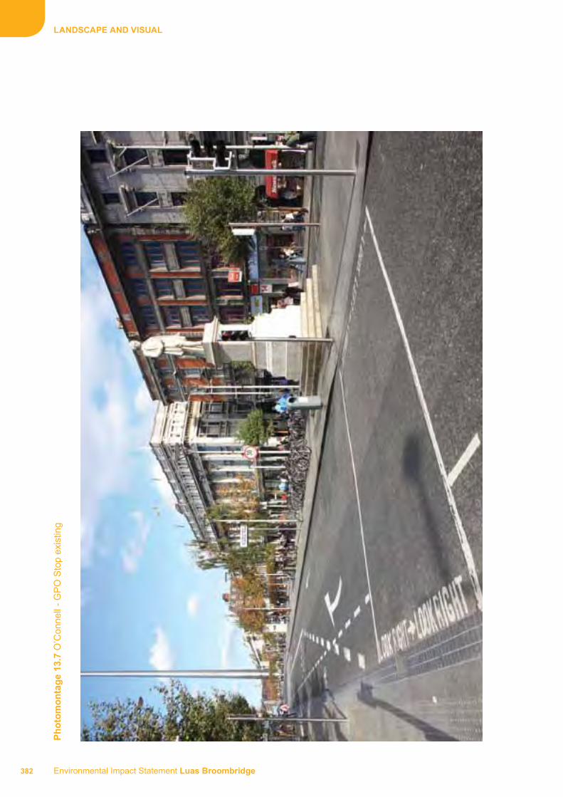
Environmental Impact Statement Luas Broombridge 382
LANdSCAPE ANd vISuAL
Ph
oto
mo
nta
ge
13.7
O’C
onne
ll -
GP
O S
top
exis
ting

383 Environmental Impact Statement Luas Broombridge
LANdSCAPE ANd vISuAL
Ph
oto
mo
nta
ge
13.8
O’C
onne
ll -
GP
O S
top
exis
ting
Yea
r 1

Environmental Impact Statement Luas Broombridge 384
LANdSCAPE ANd vISuAL
Ph
oto
mo
nta
ge
13.9
O’C
onne
ll -
GP
O S
top
exis
ting
15
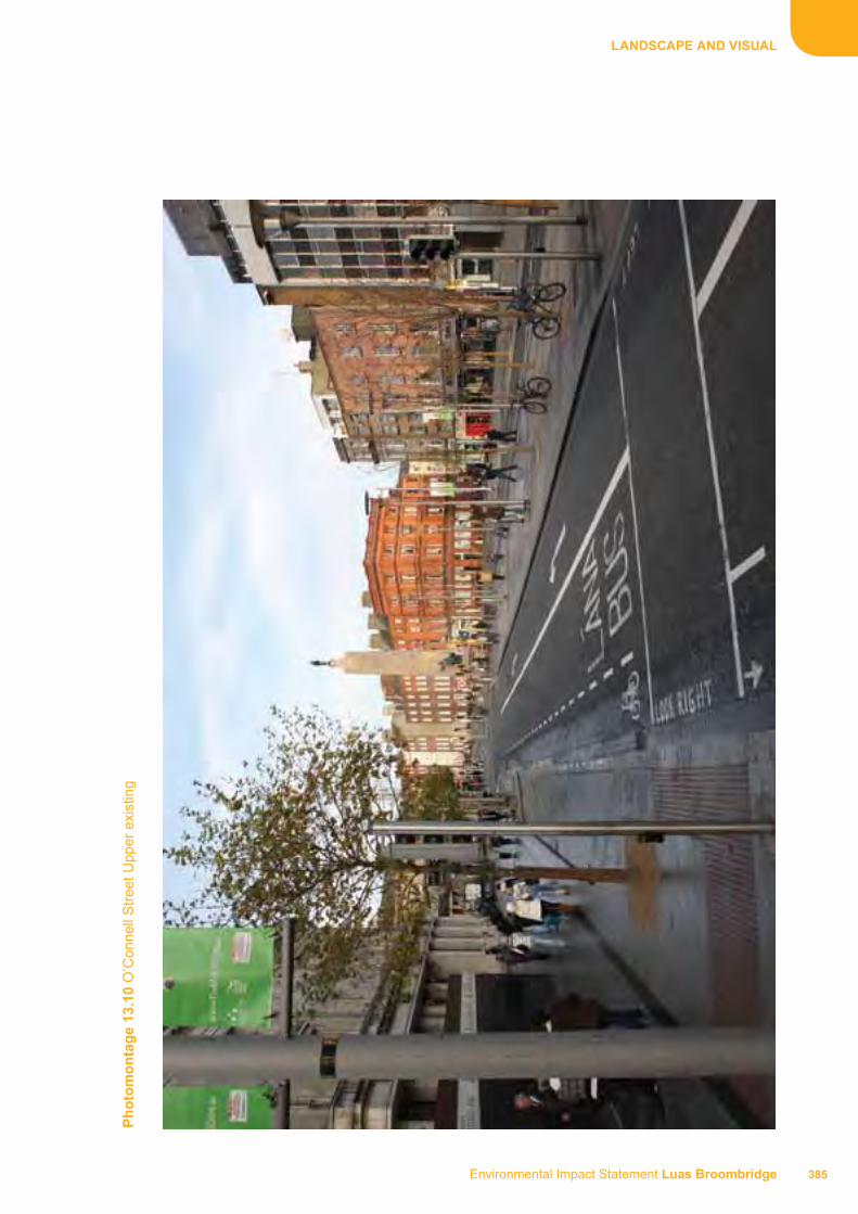
385 Environmental Impact Statement Luas Broombridge
LANdSCAPE ANd vISuAL
Ph
oto
mo
nta
ge
13.1
0 O
’Con
nell
Str
eet U
pper
exi
stin
g

Environmental Impact Statement Luas Broombridge 386
LANdSCAPE ANd vISuAL
Ph
oto
mo
nta
ge
13.1
1 O
’Con
nell
Str
eet U
pper
Yea
r 1

387 Environmental Impact Statement Luas Broombridge
LANdSCAPE ANd vISuAL
Ph
oto
mo
nta
ge
13.1
2 O
’Con
nell
Str
eet U
pper
Yea
r 15

Environmental Impact Statement Luas Broombridge 388
LANdSCAPE ANd vISuAL
Ph
oto
mo
nta
ge
13.1
3 M
arlb
orou
gh S
tree
t exi
stin
g

389 Environmental Impact Statement Luas Broombridge
LANdSCAPE ANd vISuAL
Ph
oto
mo
nta
ge
13.1
4 M
arlb
orou
gh S
tree
t Yea
r 1

Environmental Impact Statement Luas Broombridge 390
LANdSCAPE ANd vISuAL
Ph
oto
mo
nta
ge
13.1
5 M
arlb
orou
gh S
tree
t Yea
r 15

391 Environmental Impact Statement Luas Broombridge
LANdSCAPE ANd vISuAL
Ph
oto
mo
nta
ge
13.1
6 T
rinity
Sto
p ex
istin
g

Environmental Impact Statement Luas Broombridge 392
LANdSCAPE ANd vISuAL
Ph
oto
mo
nta
ge
13.1
7 T
rinity
Sto
p Y
ear
1

393 Environmental Impact Statement Luas Broombridge
LANdSCAPE ANd vISuAL
Ph
oto
mo
nta
ge
13.1
8 T
rinity
Sto
p Y
ear
15

Environmental Impact Statement Luas Broombridge 394
LANdSCAPE ANd vISuAL
Ph
oto
mo
nta
ge
13.1
9 B
road
ston
e ex
istin
g

395 Environmental Impact Statement Luas Broombridge
LANdSCAPE ANd vISuAL
Ph
oto
mo
nta
ge
13.2
0 B
road
ston
e Y
ear
1

Environmental Impact Statement Luas Broombridge 396
LANdSCAPE ANd vISuAL
Ph
oto
mo
nta
ge
13.2
1 B
road
ston
e Y
ear
15

397 Environmental Impact Statement Luas Broombridge
LANdSCAPE ANd vISuAL
LANdSCAPE BASELINE PLANS ANd LANdSCAPE INSErTION PLANS

397
LANdSCAPE ANd vISuAL
LANdSCAPE BASELINE PLANS
ST. STEPhEN’S GrEEN TO GrAfTON STrEET
398
fOLd OuT


Environmental Impact Statement Luas Broombridge
LANDSCAPE AND VISUAL
FOLD OUT
LANDSCAPE INSERTION PLANS
ST. STEPHEN’S GREEN TO GRAFTON STREET
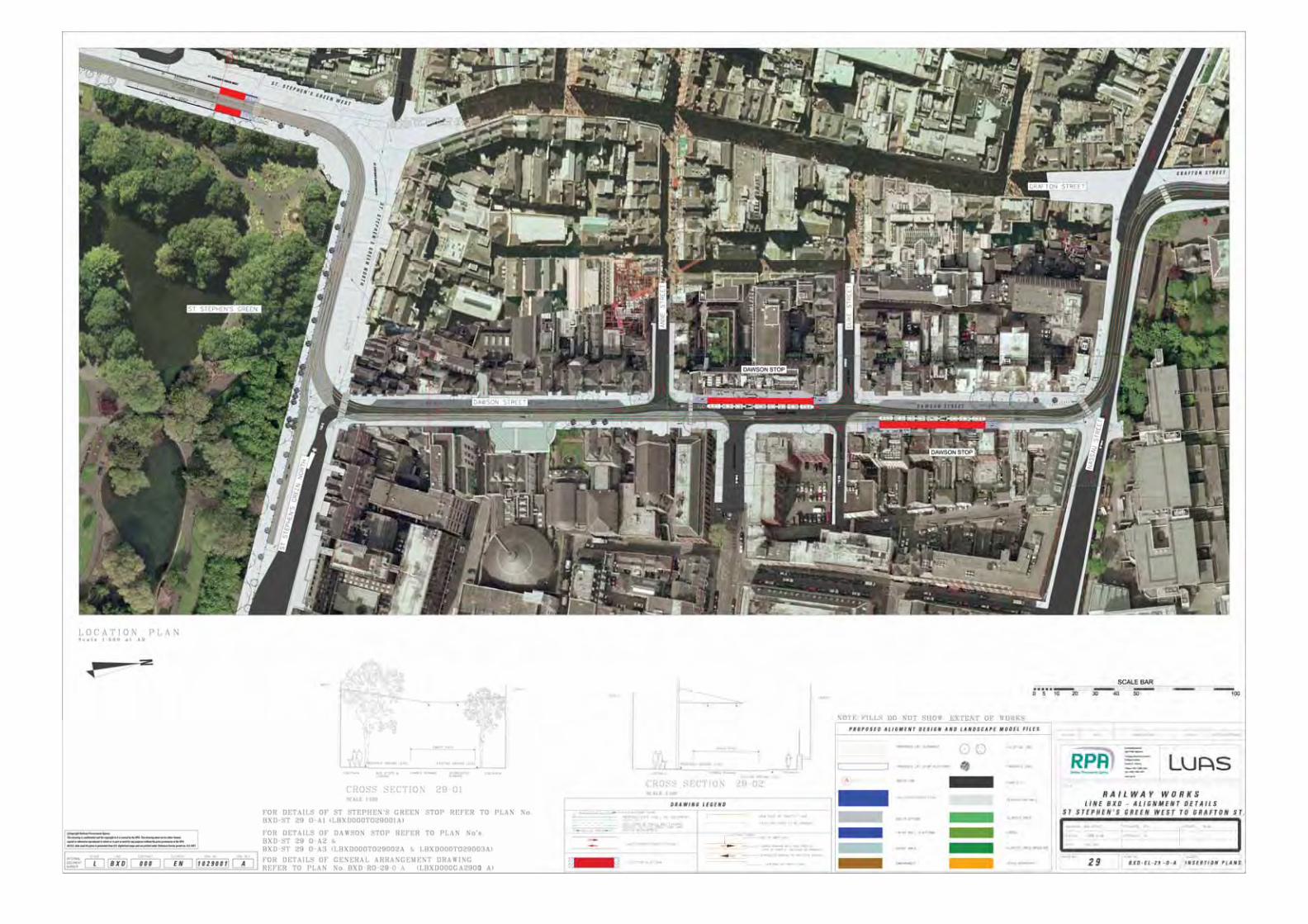

Environmental Impact Statement Luas Broombridge
LANDSCAPE AND VISUAL
LANDSCAPE BASELINE PLANS
GRAFTON STREET TO EDEN QUAY
FOLD OUT


Environmental Impact Statement Luas Broombridge
LANDSCAPE AND VISUAL
FOLD OUT
LANDSCAPE INSERTION PLANS
GRAFTON STREET TO EDEN QUAY


Environmental Impact Statement Luas Broombridge
LANDSCAPE AND VISUAL
LANDSCAPE BASELINE PLANS
EDEN QUAY TO CATHAL BRUGHA STREET
FOLD OUT


Environmental Impact Statement Luas Broombridge
LANDSCAPE AND VISUAL
FOLD OUT
LANDSCAPE INSERTION PLANS
EDEN QUAY TO CATHAL BRUGHA STREET


Environmental Impact Statement Luas Broombridge
LANDSCAPE AND VISUAL
LANDSCAPE BASELINE PLANS
CATHAL BRUGHA STREET TO DOMINICK STREET LOWER
FOLD OUT


Environmental Impact Statement Luas Broombridge
LANDSCAPE AND VISUAL
FOLD OUT
LANDSCAPE INSERTION PLANS
CATHAL BRUGHA STREET TO DOMINICK STREET LOWER


Environmental Impact Statement Luas Broombridge
LANDSCAPE AND VISUAL
LANDSCAPE BASELINE PLANS
DOMINICK STREET LOWER TO CONSTITUTION HILL
FOLD OUT


Environmental Impact Statement Luas Broombridge
LANDSCAPE AND VISUAL
FOLD OUT
LANDSCAPE INSERTION PLANS
DOMINICK STREET LOWER TO CONSTITUTION HILL


Environmental Impact Statement Luas Broombridge
LANDSCAPE AND VISUAL
LANDSCAPE BASELINE PLANS
CONSTITUTION HILL TO GREAT WESTERN SQUARE
FOLD OUT


Environmental Impact Statement Luas Broombridge
LANDSCAPE AND VISUAL
FOLD OUT
LANDSCAPE INSERTION PLANS
CONSTITUTION HILL TO GREAT WESTERN SQUARE