location-based services r&d roadmap
TRANSCRIPT
http://dx.doi.org/10.6028/NIST.TN.1883

Location-based Services R&D Roadmap
NIST Technical Note 1883
Location-Based Services R&D Roadmap
Ryan Felts
Marc Leh
Corner Alliance, Inc
Dereck Orr
Tracy A. McElvaney
Public Safety Communications Research Division
Communications Technology Laboratory
This publication is available free of charge from:
http://dx.doi.org/10.6028/NIST.TN.1883
May 2015
U.S. Department of Commerce Penny Pritzker, Secretary
National Institute of Standards and Technology
Willie May, Under Secretary of Commerce for Standards and Technology and Director

Location-based Services R&D Roadmap Copyright: US Government work not protected by US copyright. Disclaimer: Certain commercial entities, equipment, or materials may be identified in this document in order to describe an experimental procedure or concept adequately. Such identification is not intended to imply recommendation or endorsement by the National Institute of Standards and Technology, nor is it intended to imply that the entities, materials, or equipment are necessarily the best available for the purpose.
National Institute of Standards and Technology Technical Note 1883
Natl. Inst. Stand. Technol. Tech. Note 1883, NNN pages (May 2015)
CODEN: NTNOEF
This publication is available free of charge from:
http://dx.doi.org/10.6028/NIST.TN.1883
Location-based Services R&D Roadmap
Table of Contents
Executive Summary ....................................................................................................................................................................... 1
Purpose ......................................................................................................................................................................................... 4 Intended Roadmap Audiences .......................................................................................................................................................................................................................... 4 Roadmap Design Principles ............................................................................................................................................................................................................................... 5 Roadmap Research ................................................................................................................................................................................................................................................ 5 Roadmap Framework ........................................................................................................................................................................................................................................... 7 Stakeholder Involvement Strategy .................................................................................................................................................................................................................. 9
Introduction to PSCR Location-based Services Roadmap .............................................................................................................. 10
Trends & Drivers .......................................................................................................................................................................... 11 Trends & Drivers: Public Safety ...................................................................................................................................................................................................................... 12 Trends & Drivers: Public Safety Broadband .............................................................................................................................................................................................. 14 Trends & Drivers: Location Based Services ............................................................................................................................................................................................... 16
Software and Applications ........................................................................................................................................................... 18 Operational Objective: Optimized Common Operating Picture ........................................................................................................................................................ 20 Enabled Operational Capabilities/Technology Capabilities ............................................................................................................................................................... 20 Enabling Actions and Actors ............................................................................................................................................................................................................................ 21 Gaps and Barriers ................................................................................................................................................................................................................................................. 22 Public Safety R&D Opportunities ................................................................................................................................................................................................................... 22 Operational Objective: Data Interoperability Across Platforms and Jurisdictions ................................................................................................................... 24 Enabled Operational Capabilities/Technology Capabilities ............................................................................................................................................................... 24 Enabling Actions and Actors ............................................................................................................................................................................................................................ 25 Gaps and Barriers ................................................................................................................................................................................................................................................. 26 Public Safety R&D Opportunities ................................................................................................................................................................................................................... 26
Devices ........................................................................................................................................................................................ 29 Operational Objective: Device convergence supports greater mobility ........................................................................................................................................ 31 Enabled Operational Capabilities/Technology Capabilities ............................................................................................................................................................... 31 Enabling Actions and Actors ............................................................................................................................................................................................................................ 31 Gaps and Barriers ................................................................................................................................................................................................................................................. 32

Location-based Services R&D Roadmap Public Safety R&D Opportunities ................................................................................................................................................................................................................... 32 Operational Objective: Diversified approaches improve indoor accuracy positioning and situational awareness ................................................... 33 Enabled Operational Capabilities/Technology Capabilities ............................................................................................................................................................... 33 Enabling Actions and Actors ............................................................................................................................................................................................................................ 34 Gaps and Barriers ................................................................................................................................................................................................................................................. 34 Public Safety R&D Opportunities ................................................................................................................................................................................................................... 35
Networks .................................................................................................................................................................................... 38 Operational Objective: Increased Coverage .............................................................................................................................................................................................. 40 Enabled Operational Capabilities/Technology Capabilities ............................................................................................................................................................... 40 Enabling Actions and Actors ............................................................................................................................................................................................................................ 41 Gaps and Barriers ................................................................................................................................................................................................................................................. 41 Public Safety R&D Opportunities ................................................................................................................................................................................................................... 42 Operational Objective: Interoperability of Heterogeneous Networks Enables Efficient Delivery of LBS ....................................................................... 43 Enabled Operational Capabilities/Technology Capabilities ............................................................................................................................................................... 43 Enabling Actions and Actors ............................................................................................................................................................................................................................ 44 Gaps and Barriers ................................................................................................................................................................................................................................................. 44 Public Safety R&D Opportunities ................................................................................................................................................................................................................... 45
Conclusion ................................................................................................................................................................................... 48
Appendix A: PSCR Public Safety Broadband Research and Development Roadmap Workshop ...................................................... 49 Public Safety Scenarios ............................................................................................................................................................................................................................................... 49 Prioritizing R&D Efforts ............................................................................................................................................................................................................................................. 50
Bucket Prioritization by Layer ........................................................................................................................................................................................................................ 51 Software/Applications ................................................................................................................................................................................................................................................ 51 Network ............................................................................................................................................................................................................................................................................. 51 Devices ................................................................................................................................................................................................................................................................................ 51
Appendix B: Location-Based Services Working Group Members ................................................................................................... 52 Appendix C: References …………………………………………………………………………………………………............................................................. 57

1
Location-based Services R&D Roadmap
Public Safety Communications Research (PSCR) Program Location-based Services R&D Roadmap Report
Executive Summary The Public Safety community is in a period of great transition. Over the next 20 years, technology advancements will enable data, video, and eventually voice communications to migrate from disparate Land Mobile Radio (LMR) networks to a nationwide public safety Long Term Evolution (LTE) broadband network, the Nationwide Public Safety Broadband Network (NPSBN). Emerging technologies within this new infrastructure present opportunities and challenges for public safety, and the process of modernizing responder communications requires significant coordination and planning. To facilitate the transition from LMR to LTE, the Public Safety Communications Research (PSCR) program initiated a research and development (R&D) planning process to determine what technology investments are of highest priority to the public safety community. This document summarizes the results of PSCR’s Location-based Services R&D Roadmap. This Location-based Services (LBS) report is the first of several technology roadmaps that PSCR will develop over the next several years to better inform the investment decisions of R&D organizations supporting the public safety community. This report intends to outline the current state of location-based technologies, forecast the evolution of LBS capabilities and gaps, and identify potential R&D opportunities that would improve public safety’s use of LBS within operational settings. After conducting additional roadmaps in other priority technology areas, PSCR will identify the R&D project ideas that pose the greatest operational benefit to public safety, some of which PSCR will fund. Given the scope of technology under consideration and level of effort required to deliver enhanced LBS to public safety, PSCR hopes that these findings and recommendations will educate stakeholders across all levels of government, industry, and academia. PSCR commissioned Corner Alliance, Inc. to solicit input from LBS experts across government, public safety, industry, and academia and consolidate their ideas into the final roadmap report. This cross-disciplinary approach enabled PSCR to evaluate existing R&D efforts, potential partnerships, and future projects against public safety’s unique set of priorities, requirements and long-term goals. After reading this report, organizations will understand:
Public safety factors to consider when adopting LBS. The trends & drivers affecting public safety, public safety
broadband, and the Location-based Services technology domain.
The projected evolution of LBS Software, Applications, Devices and Networks over the next 20 years.
The enabled operational capabilities that public safety stands to gain by adopting the forecasted LBS technology capabilities.
The enabling actions and actors that are driving the evolution of LBS technologies.
Gaps and Barriers that need to be addressed before LBS can fully benefit public safety operations.
Potential R&D opportunities that would compliment existing LBS efforts and help transform this technology area into an asset for public safety operations.

2
Location-based Services R&D Roadmap Roadmap Approach and Framework PSCR has organized the bulk of its final Location-based Services R&D Roadmap report into three main sections: Software & Applications, Devices and Networks. Within each of these technology categories, PSCR discusses several operational objectives that surfaced as natural themes from the LBS working group’s collective input. These Operational Objectives are defined as feasible, impactful project outcomes that R&D investment targeted to LBS could deliver to the public safety community. These outcomes would allow public safety to fulfill its mission more efficiently and effectively. The Operational Objectives enabled by LBS discussed in this report include:
Report Section Operational Objective
Software & Applications
Creating an Optimized Common Operating Picture Promoting Data Interoperability Across Jurisdictions and Platforms
Devices Device Convergence Supporting Greater Mobility Diversified Approaches Improve Indoor Accuracy Positioning and Situational Awareness
Networks Increased Coverage Interoperability of Heterogeneous Networks Enables Efficient Delivery of LBS
To scope this report, the working group’s input relating to LBS Technology Capabilities & Gaps, Enabling Actions & Actors, and Enabled Operational Capabilities are embedded as supporting sections within the Operational Objectives. The report lists potential R&D opportunities relating to each Operational Objective. Recommended Public Safety R&D Opportunities The primary goal of this report was to provide the R&D community supporting public safety with a concise list of R&D opportunities that would provide added value to the public safety community. In total, PSCR and the working group identified 19 potential project ideas for the public safety R&D community to consider. These were identified within the context of environmental trends and drivers, anticipated technology evolution, and projects being pursued outside of the public safety space so that PSCR and other interested R&D organizations could complement – rather than duplicate – ongoing efforts in the broader location-based technology sector. Below is the list of the potential R&D investment opportunities discussed in this report. These R&D project ideas are not intended to be an exhaustive list of the ways in which Location-based Services technology needs to improve to better serve public safety. Rather, PSCR hopes that the readers of this report will recognize these opportunities as initial steps that would help make LBS more operationally viable for the public safety community.

3
Location-based Services R&D Roadmap
Report Section Recommended Public Safety R&D Opportunities
Software & Applications
Drive fundamental LBS technology research related to indoor route planning; location accuracy for x, y, and z coordinates; personnel group authorization and authentication; and contextual activity recognition
Explore potential collaborations with the "smart home" R&D community Conduct continuous LBS software market research Reach out to high-profile technology companies to further develop indoor maps or educate the public safety community on how to create their own maps Pilot use case program for wearables and augmented reality technologies Drive fundamental technology research related to prototyping LBS data and quality of service data standards; quantifying requirements for middleware transitioning legacy systems to IP/LTE architecture; tracking the progress of commercial investments in location API performance; and investigating battery and bandwidth consumption for LBS software Partner with Incident Command System sponsors, developers, and end users to explore the deployment of LBS standards at the federal, state, and local levels Encourage the development and integration of open LBS technologies Develop strong LBS data standards with a strong certification process
Devices
Conduct Integrated Device Testing
Conduct ongoing market research relating to battery efficiency, device interoperability, and the ruggedization of consumer electronics Create an LBS technology development and integration test bed to evaluate LBS standardization and the role of deployables in addressing coverage gaps Drive fundamental market research related to GPS modernization, Observed Time Difference of Arrival (OTDOA) deployment, indoor positioning standards, and terrestrial beacon commercialization Pilot an in-building positioning program Conduct short-range and terrestrial beacon use case testing
Networks
Create an LBS technology development and integration test bed to evaluate LBS standardization
Develop public-safety-specific algorithms, policies, and procedures that consider operational needs and cost constraints Identify and document public safety LBS requirements for Quality of Service (QOS) Create an integrated LBS network test bed measuring Quality of Service schema effectiveness, security authentication and authorization schemas; specifying standardized capabilities for deployables; and integrating disparate LBS data producers into the system with load and performance testing
Conclusion In addition to providing context and recommendations for future R&D investment, the report discusses PSCR’s process of designing the LBS roadmap, its stakeholder involvement strategy, and other priority areas that could become the subject of future technology roadmaps. For more information, please contact PSCR Division Chief Dereck Orr ([email protected]), or PSCR support staff Ryan Felts ([email protected]) and Marc Leh ([email protected]).

4
Location-based Services R&D Roadmap
Purpose Over the next 20 years, the public safety community will simultaneously face unprecedented challenges and be presented with paradigm-shifting technologies. In the face of these challenges and opportunities, the Public Safety Communications Research (PSCR) program initiated a deliberate research and development (R&D) planning effort in 2013 to determine what technology R&D investments are necessary to transition public safety data, video, and eventually voice communications from the Land Mobile Radio (LMR) environment to a nationwide Long Term Evolution (LTE) broadband network. In order to optimize its investment resources, PSCR solicited input from first responders, officials from all levels of government, industry leaders, and academia. By leveraging expertise from across its diverse stakeholder base, PSCR can more accurately map the current state of the public safety and communications industries, identify current and future technology gaps, and make better-informed decisions on where its R&D initiatives will create the greatest impact. Location-based Services (LBS) is the first of several roadmaps PSCR will develop over the next several years. PSCR began with LBS because it demonstrated high leveragability, feasibility, impact, and return on investment to the public safety community. More information on the process used to identify LBS as the first roadmap focus area can be found in Appendix A. After conducting the LBS and other roadmaps, PSCR will proceed to identify, prioritize, and launch formal R&D projects.
Intended Roadmap Audiences While PSCR has undertaken the process to create this LBS R&D Roadmap, PSCR is not the sole intended audience for this report. The level of effort, resources, and capabilities needed to deliver improved LBS capabilities to the public safety community, both in the short- and long-term, are well beyond the scope of PSCR’s ability to address alone. Therefore, this roadmap is intended to inform other R&D efforts undertaken at the federal level as well as within industry at large and the academic community. This report is also intended to educate decision makers at the federal, state, and local levels as well as the public safety community about the capabilities that LBS may provide in the future.
Figure 1: Intended Audiences of the PSCR LBS R&D Roadmap

5
Location-based Services R&D Roadmap
Roadmap Design Principles The following principles have guided the process as PSCR created the LBS R&D Roadmap: Build a vision of where the public safety community wants to go,
determine what technologies are needed to get there, and provide a route for achieving the vision.
Make R&D decisions based on priorities set by the public safety community.
Assume that public safety might have to adjust operations to fully realize the benefits of new technology.
Leverage ongoing efforts by other partners to develop and implement the roadmap. This approach will allow PSCR to focus resources to complement and not duplicate ongoing efforts.
Get far enough ahead of the technology development curve to influence commercial R&D and leverage economies of scale.
Enable public safety to meet generational and public expectations. Employ a cross-disciplinary approach to gather input and develop
R&D plans for PSCR initiatives.
Roadmap Research Initial roadmap research was conducted in 2013 in order to begin the design of a roadmap framework for PSCR’s efforts. Early research focused on several key documents and efforts, including Sandia National Laboratories’ Fundamentals of Technology Roadmappingi, Industry Canada’s Technology Roadmapping: Guide for Government Employeesii, and NASA’s roadmapping efforts, specifically the Launch Propulsion Systems Roadmapiii. Once LBS was identified as the first focus areas to be roadmapped, significant research was conducted in early 2014 to gather best practices from technology roadmapping efforts across various domains, disciplines, and countries. From this research, several key factors were identified, which drove the development of the LBS R&D Roadmap Framework: • “Cut and paste” doesn’t work in technology roadmapping – Each roadmapping effort is unique unto itself and cannot wholly copy a roadmap
framework or process from another effort. For example, the roadmap frameworks and processes used to create the Semiconductor Industry Roadmap or International Industrial Microsystems and Top-down Nanosystems Roadmap could not be entirely replicated for PSCR’s specific needs.
• It’s been done before, so don’t completely reinvent the wheel – While a wholesale “cut and paste” approach would not work for PSCR’s roadmaps, there was also no need to completely start from scratch. In fact, many best practices and approaches could be gleaned from other roadmapping efforts and adapted to meet PSCR’s roadmapping needs. The unique framework and process used for the LBS R&D roadmap is the result of in-depth research and analysis of many roadmapping efforts and a compilation of their frameworks and processes.
• Cross-disciplinary roadmap research led to the identification of critical roadmapping elements – In seeking best practices and roadmap framework models for PSCR’s LBS R&D roadmap, research was not limited to roadmaps from the communications or public safety industries. Rather, a cross-disciplinary research approach was taken to gain best practices from disparate roadmapping efforts. Research was conducted on roadmaps from the United Kingdom, Australia, and New Zealand; the automobile, rail, semiconductor, and micro and nano-technology industries; and U.S. government efforts within the Defense Advanced Research Projects Agency and the National Institutes of Health.

6
Location-based Services R&D Roadmap
• The need to create a roadmapping process that is repeatable, scalable, and enables focus on translational R&D priorities – PSCR is embarking upon a process that will eventually see the creation of multiple roadmaps. LBS was the first roadmap, but the public safety community will benefit from roadmaps in other technology focus areas, including analytics, user interface/user experience, and others. Because of the need for multiple roadmaps to be created in the near term, PSCR needed a roadmapping process that is repeatable and scalable. One focus of the roadmap research was to build a framework that could work across technology focus areas. Finally, PSCR’s roadmapping efforts should lead to capability improvements for multiple disciplines of the public safety community. Therefore, identifying these translational R&D priorities is a main objective of PSCR’s roadmapping efforts. The goal is to establish a set of R&D initiatives that have crosscutting positive impacts across technology focus areas (e.g., LBS, analytics) and benefit the whole public safety community (e.g., police, fire, emergency medical services, secondary responders).
A brief sample of the roadmap research conducted is listed below. A comprehensive list can be found in Appendix C. • Sandia National Laboratories
• Introduction to Technology Roadmappingiv • Fundamentals of Technology Roadmappingv • Knowledge Mappingvi
• Defense Advanced Research Projects Agency • Driving Technological Surprisevii
• Foresight Vehicle • Foresight Vehicle Technology Roadmap v 1.0viii • Foresight Vehicle Technology Roadmap v 2.0ix
• Institute of Electrical and Electronics Engineers Transactions on Engineering Management
• Science and Technology Roadmapsx • International Roadmap Committee
• International Technology Roadmap for Semiconductorsxi
• Micro and Nanotechnology Commercialization Education Foundation
• The International Industrial Microsystems and Top-Down Nanosystems Roadmapxii
• University of Cambridge – Centre for Technology Management • Technology Roadmapping—A planning framework for
evolution and revolutionxiii • National Institutes of Health
• Common Fund Strategic Planning Report, Program Areas, and Initiativesxiv
• Industry Canada • Technology Roadmapping: A Guide for Government
Employeesxv

7
Location-based Services R&D Roadmap
Roadmap Framework Based on the extensive roadmap research detailed above, a custom roadmap framework was created for PSCR’s LBS R&D roadmap. One key component of nearly every roadmap researched was the presence of a timeline to give context to the roadmap details and elements. While PSCR is heavily involved in the short-term planning, testing, and evaluation of current technologies, one key outcome of the roadmapping process is to identify technology gaps and opportunities in the medium- to long-term that PSCR can begin evaluating as potential R&D projects. For these purposes, the roadmap was divided into three time frames: short, medium, and long. These time frames were defined in the following manner: Short (0 to 5 years) – Straightforward extrapolation of current technology needs Medium (5 to 10 years) – Extension of current trends to their reasonable limits Long (10 to 20+ years) – Development of major new technologies needed to reach beyond capabilities of current approaches. Of course, the projected timeline may be expedited significantly if Public Safety leverages commercial technologies and targets R&D investment to critical-path technology gaps. Additionally, while not formally defined in the framework, the working group considered if any technology or opportunities operate in indoor or outdoor environments.
Figure 2: Location-based Services R&D Roadmap Framework

8
Location-based Services R&D Roadmap The LBS R&D Roadmap Framework contains four major sections: Trends & Drivers – PSCR acknowledges that technology is not developed in a vacuum, LBS are not unique to the public safety community, and
broader events impact the evolution of technology. For these reasons, among others, we needed to begin the roadmapping process by detailing the existing and anticipated trends and drivers within the public safety community, as well as those impacting public safety broadband, and finally, the LBS domain as a whole. The following questions were posed to LBS working group members:
1. What external factors influence the public safety community and how are these evolving? 2. What external factors influence public safety broadband and how are these evolving? 3. What external factors influence the LBS domain and how are these evolving?
The data gathered from these questions, LBS working group discussions, and data analysis can be found in the Trends & Drivers section (page 14).
Technology Capabilities & Gaps – One key element of technology roadmapping found in various other roadmaps was the detailed breakdown of technology capabilities and their evolution over time. In addition to mapping the evolution of technology capabilities, PSCR wanted to better understand gaps in technology capabilities that could potentially map to R&D project opportunities. The technology capabilities and gaps lane was broken down into three sub-lanes:
1. Software & Applications 2. Devices 3. Networks
For each sub-lane, the following questions were posed to LBS working group members: 1. Given the stated trends and drivers, what technology capabilities need to be developed? 2. What are the gaps and barriers that will prevent these technology capabilities from being realized?
The data gathered from these questions, LBS working group discussions, and data analysis can be found in sections corresponding to each sub-lane—Software & Applications (page 21), Devices (page 32), and Networks (page 41).
Enabling Actions/Actors – After establishing the technology capabilities and gaps, mapping them to the appropriate sub-lane, and plotting them against the roadmap timeline, LBS working group members were asked to identify relevant actors in these fields and specific projects/products that were underway that should inform PSCR’s efforts and eventual R&D projects. The following questions were posed to LBS working group members and mapped against each technology capability and gap that had been previously identified:
1. What’s being done? 2. Who’s doing it? 3. How will remaining gaps and barriers be addressed?
The data gathered from these questions, LBS working group discussions, and data analysis are discussed in each sub-lane of Technology Capabilities & Gaps (Software & Apps, Devices, and Networks).

9
Location-based Services R&D Roadmap
Enabled Operational Capabilities – A key challenge facing public safety personnel in describing how their operations might differ between now
and 20 years in the future is the difficulty in knowing how technology progression may incorporate new and previously unplanned capabilities into operational use. Because of this difficulty, the PSCR roadmapping process sought to first lay the foundation of how the LBS domain may progress over the next 20 years. From this foundation, LBS working group members were posed the question of how these specific technology changes may impact public safety operations. The LBS working group members were asked to provide examples of what public safety can now do given the progression of LBS technology.
The data gathered from this question, LBS working group discussions, and data analysis are discussed in each sub-lane of Technology Capabilities & Gaps (Software & Apps, Devices, and Networks).
Stakeholder Involvement Strategy In keeping with its practitioner-driven approach, PSCR encouraged stakeholder participation and input in every step of the LBS R&D roadmap. At the PSCR Stakeholder Conference in June 2014, PSCR officially kicked off the LBS R&D roadmap effort by inviting conference attendees to sign up to participate on the LBS working group. PSCR also sent out a formal invitation to its list of Cooperative Research and Development Agreement partners. From these efforts, more than 30 individuals representing public safety, state and local government, industry, and academia signed up for the LBS working group. PSCR is extremely grateful for their participation in this effort. A full list of LBS working group members can be found in Appendix B. To best facilitate input gathering from LBS working group members, the PSCR support team created a Wiki platform, which served as a central hub of working group communication, document sharing, and input collection. The Wiki Platform can be accessed at http://pscrroadmap.wikispaces.com/Location-Based+Services+Roadmap. The LBS working group met on a bi-weekly basis from mid-August through mid-December 2014. The working group spent 90 minutes on each call discussing the LBS R&D Roadmap and providing input to the development of this report. In addition to the bi-weekly 90-minute calls, working group members provided input via the Wiki or over email to the PSCR support team to further inform this report. Below is a nominal graphic of the Wiki.
Figure 3: LBS Wiki created to capture working group input

10
Location-based Services R&D Roadmap
Introduction to PSCR Location-based Services Roadmap Just as the research leading up to the roadmap design created a custom roadmap framework, PSCR researched and developed its own definition of LBS to frame the subject in proper context. LBS, as defined in this roadmap, refers to a broad range of applications, functions, and services based on or enhanced by information about the physical location of a user, device, or target of interest that provide added value to users. This definition allowed the LBS working group to consider not only services or applications that rely on geolocation information, but the underlying network and hardware technologies that support the collection, storage, and transmission of geolocation data as well. As a result, this roadmap forecasts the progression of technologies that provide geolocation data and the services that could transform this location information into a valuable commodity for public safety. Throughout this process, the LBS working group identified a long list of technology capabilities and gaps that represent potential R&D investment opportunities for the public safety community. Before prioritizing or launching a formal R&D project, we need to review the technologies evaluated in this document through the lens of public safety impact. The LBS working group identified six public safety-oriented factors to consider when adopting LBS: Staffing – Changes/advances in technology may require additional staffing (hours or personnel) to take on LBS implementation and support once
up and operational. Policy – For public safety’s best interests, standard operating procedures and policies will need to be created before LBS technologies can be
properly used. . Training – Adequate initial training and refresher training is needed to ensure users are familiar with new LBS technologies. Funding – Long-term planning is needed to adequately fund the local adoption and implementation of emerging LBS technologies. This is relevant
for both equipment purchases as well as increased staffing needs. Clear Benefit – While some LBS solutions may facilitate operational efficiencies, others may add responsibilities or undue burden onto already
busy public safety individuals and organizations. Clear benefit to public safety operations must be evident that outweighs the potential added responsibilities or burden to the public safety community.
Legal Authority – Sharing resources between public and private sectors or between different levels of government requires significant legal research on all levels of government to ensure that legislation is being followed and that it is not being violated. Legal agreements may need to be further researched or executed before launching collaborative LBS R&D projects or implementation initiatives.
11
Location-based Services R&D Roadmap
Trends & Drivers Key to PSCR’s roadmapping efforts is the contextual understanding of how technology capabilities evolve—not only in terms of the technology itself, but also the larger environment in which the technology evolution is taking place. Trends and drivers were identified by the LBS working group members across three specific focus areas:
1) Trends and drivers impacting public safety 2) Trends and drivers impacting public safety broadband 3) Trends and drivers impacting the LBS domain
While laying the foundation for this roadmapping process in 2013, PSCR worked with stakeholders to identify several key trends and drivers impacting all of these areas. They include:
Shrinking budgets at the federal, state, and local levels; A move toward regionalization of response; The impact of the secondary responder community in a more broadly defined public safety response role, and; The changing role of the public in emergency response through social media, mobile apps, and citizen reporting.
While not a primary focus of this report, security and privacy concerns were discussed given the potential impact they have on the application and use of LBS in public safety planning and response. In particular, while technology capabilities do and in the future will more precisely allow the tracking of personnel and resources, security and privacy issues must be addressed to ensure the appropriate use of these evolving capabilities. High-impact and particularly relevant trends and drivers are addressed in some depth below. In addition, the exhaustive list of trends and drivers identified by the LBS working group can be found in the trends and drivers graphics on pages 16, 18, and 20.

12
Location-based Services R&D Roadmap
Trends & Drivers: Public Safety
Short Term – 0 to 5 years (A straightforward extrapolation of current technology needs)
Wearables, Internet of Things, and contextual services In the short term, wearable technologies remain high sticker-price technologies that are still undergoing field and operational testing. Similarly, the application of the Internet of Things (IoT) is limited to sectors largely outside of the public safety community. This is also seen in contextual services, which are primarily driven by the commercial sector with limited utilization in the public safety environment.

13
Location-based Services R&D Roadmap
Challenges of collecting, analyzing and archiving data For early adopter agencies that are currently or will soon begin to collect, analyze, and archive big data, many challenges lie ahead. Challenges are present both on the operational side of how to train and equip personnel to manage and effectively use data collected from many sources, as well as on the technology side where processing algorithms have not matured to a point of extrapolating only pertinent data to public safety users.
Voice remains a priority method of communication Voice communications are the priority and primary method of communication for the public safety community now and likely will continue to be so through the short- and medium-term time frame.
Medium Term – 5 to 10 years (Extension of current trends to their reasonable limits)
Increase in adoption and use of wearables, IoT, and contextual services Advances in wearables, including better economies of scale in the commercial market as well as public-safety-grade applications drive an increase in the adoption of wearables in the public safety sector. Early adopters find a greater ability to leverage the IoT and seamlessly pull data from disparate sources. Contextual services driven by the commercial sector become more mainstream, including in the public safety arena.
Advancements in data collection abilities, but challenges with analytics remain The ability to collect and archive large amounts of data—including video—improves, driving further adoption and use of big data, but the full potential of these data sets are yet to be realized due to challenges with public-safety-specific and public-safety-grade analytical capabilities.
Long Term – 10 to 20+ years (Development of major new technologies needed to reach beyond the capabilities of current approaches) Convergence of wearables, IoT, and contextual services and effective operational deployment
As the digital and physical worlds become more interrelated, wearables and the IoT are fully integrated into public safety use and operations. Data collection from multiple sensor sources is a mainstream occurrence throughout the public safety sector and ubiquitous contextual services leads to optimal situational awareness.
Advancements in technology capabilities and operational practices enable greatest use of data collection and analytical capabilities In addition to the integration of wearables and contextual services, advancements in user interfaces and other technology capabilities, partnered with enhanced operational practices, enables the public safety community to realize the greatest benefit from its data collection and analytical capabilities.
Data prioritized in certain operational environments and geographical areas; eventually, data replaces voice as primary method of communications In the long term, data in certain operational environments and geographical areas (likely urban areas) will become the primary method of communication. Further into the long-term time frame, the mission-critical capabilities of data collection, analysis, and sharing lead to data replacing voice as the priority method of communications in additional operational environments and geographical areas.

14
Location-based Services R&D Roadmap
Trends & Drivers: Public Safety Broadband
Short Term – 0 to 5 years (A straightforward extrapolation of current technology needs) Spectrum auctions raise dedicated public safety R&D funds to enable greater public safety partnerships with private industry
The 2014/2015 Advanced Wireless Services (AWS-3) auctions raised more than $44 billion dollars. As legislated in the Middle Class Tax Relief and Job Creation Act of 2012, these auctions ensure that the National Institute of Standards and Technology receives $300 million dollars for public safety research. These funds will enable the continued strong partnership between the federal government, public safety community, academia, and private industry seeking to equip public safety with critical new technologies.
Medium Term – 5 to 10 years (Extension of current trends to their reasonable limits)
Coverage issues and discussion of role of deployables In the medium term, coverage issues will remain a challenge for the wide adoption of public safety broadband. To alleviate some coverage issues, the role of deployables will be determined. The eventual role deployables play in the public safety broadband environment could have significant implications for the use and adoption of LBS for the public safety community.
Non-mission-critical voice capabilities In the medium term, non-mission-critical voice capabilities will become a large driver of the use of the NPSBN. However, these capabilities will remain supplemental to the mission-critical LMR voice capabilities public safety will rely upon.

15
Location-based Services R&D Roadmap
Long Term – 10 to 20+ years (Development of major new technologies needed to reach beyond the capabilities of current approaches)
Coverage issues and defined role and lower cost of deployables enables greater coverage In the long term, coverage issues are addressed in geographically diverse areas such as canyons, mountains, deserts, and forests. Unique coverage issues found in urban and rural contexts are addressed as well. In part, the defined role for and lower cost of deployables enable these coverage issues to be addressed. Due to potential economies of scale realized by both urban and rural public safety agencies, these unique coverage issues may be resolved closer to the near or medium-term timeframe.
Standards-based mission-critical voice capabilities In the long-term time frame (if not sooner), standards-based mission-critical voice capabilities will be established for the NPSBN. These capabilities will drive widespread adoption and use of the NPSBN by the public safety community.

16
Location-based Services R&D Roadmap
Trends & Drivers: Location Based Services

17
Location-based Services R&D Roadmap
Short Term – 0 to 5 years (A straightforward extrapolation of current technology needs) LBS availability limited based on sufficient network coverage
LBS are effective and useful for public safety agencies when users and devices are in sufficient network coverage areas. Indoor, underground, rural, and extreme geographic settings all present challenges to LBS that render them less useful, if not ineffective, to public safety.
Timing of standards for LBS – impact on interoperability, adoption, and end-use analytical capabilities As the LBS domain as a whole matures and services extremely diverse end users, standards will become a critical component of successful implementation. This is especially true given standards’ impact on interoperability and end-use analytical capabilities. Public safety requirements must be fed into these standards processes to ensure interoperability can be built into LBS capabilities from the beginning. Lagging standards may force Public Safety to adopt heterogeneous or proprietary solutions, leading to interoperability concerns across jurisdictions.
Medium Term – 5 to 10 years (Extension of current trends to their reasonable limits) Greater LBS availability in in-building and rural environments. High resolution elevation information
In the medium term, LBS will become more widely available in in-building, underground, rural, and geographically difficult settings. Additionally, high-resolution elevation information (e.g., determining which floor of a multi-story building personnel are on) will become more widely available.
Leveraging R&D improvements from other sectors The public safety community and PSCR have a vested interest in leveraging LBS R&D from other sectors as a starting point for any LBS-related R&D that will focus specifically on the public safety community. This includes leveraging R&D from academia and other federal agencies where applicable as well.
Transition from simple to complex, advanced applications – applications default user to enabling LBS. Users must actively opt-out. Currently, some applications require users to “opt-in” to tracking or using their location. These applications mainly track and/or display the user’s location in relation to other users or data points. In the short to medium term, applications will increasingly default users to have LBS enabled, requiring them to actively “opt-out.” These applications will also become more advanced in their capabilities to send more accurate push notifications based on more precise user location information.
Long Term – 10 to 20+ years (Development of major new technologies needed to reach beyond the capabilities of current approaches)
Ubiquitous LBS availability in all environments (indoor, urban, canyon) In the long term, LBS are available in all environments—indoor, underground, rural, and extreme geographical settings. This ubiquitous availability spurs further innovation and application of LBS to further supplement and support public safety users.
Enhanced precision and analytics of LBS-enabled sensors to optimize situational awareness Along with the ubiquitous availability of LBS, enhanced precision (x, y, and z coordinate location capabilities) and enhanced analytics of LBS greatly improve public safety situational awareness.

18
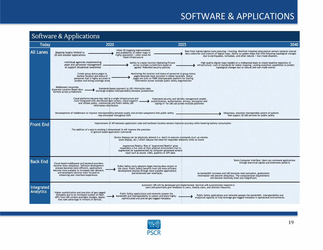
SOFTWARE & APPLICATIONS Software and Applications Today’s location-based software and applications have become increasingly sophisticated and precise over the last several years, performing a broad range of user tasks. Many of the investments used to drive increased performance and functionality have come from industry where companies are leveraging location-based marketing and outreach to target customers and collect improved business intelligence. While public safety’s intended use for LBS software departs greatly from that of industry, the community can benefit greatly from accounting for and leveraging commercial development to optimize responders’ common operating picture and ensure the interoperability of location-aware applications. Some of today’s most widely used LBS application categories such as those relating to navigation, mapping, inventory/fleet/personnel tracking, and mobile encryption, for instance, would provide clear value to public safety if deployed correctly. To account for the range and complexity of this domain, PSCR asked the LBS working group to forecast the evolution of LBS software capabilities and gaps that need to be considered in light of the trends and drivers identified earlier. Specifically, the working group evaluated the progression of three components of LBS software systems and how these evolving technologies would impact public safety operations. They included:
1. Front End (User Interface, User Experience) 2. Back End (Data Access, Data Management) 3. Integrated Analytics
As the LBS working group discussed the Software and Applications lane, several operational objectives surfaced as natural themes that captured the collective technology capabilities and enabled operational capabilities. For the purposes of this report, two operational objectives have been discussed in detail:
1. Optimized Common Operating Picture 2. Data Interoperability Across Platforms and Jurisdictions
19
SOFTWARE & APPLICATIONS

20
SOFTWARE & APPLICATIONS
Operational Objective: Optimized Common Operating Picture One goal of the National Incident Management System (NIMS) is defining “essential principles for a common operating picture and interoperability of communications and information management.”xvi According to NIMS, a common operating picture “is established and maintained by the gathering, collating, synthesizing, and disseminating of incident information to all appropriate parties involved in an incident.” “Achieving a common operating picture allows on-scene and off-scene personnel (e.g., those at the Incident Command Post, an Emergency Operations Center, or within a multiagency coordination group) to have the same information about the incident, including the availability and location of resources, personnel, and the status of requests for assistance.”xvii
Enabled Operational Capabilities/Technology Capabilities The LBS working group identified three main operational capabilities that benefit from R&D focused on optimizing the common operating picture through LBS:
1. Better situational awareness based on more timely information
2. Better/more efficient resource allocation 3. Streamlining of operator workflow and bandwidth
management based on pre-loaded LBS data such as terrain and static building maps.
Advancements such as more precise location tracking and routing would give public safety personnel superior perspective on individual and team positioning within structures and across jurisdictions. Sophisticated LBS would also facilitate better and more efficient allocation of resources such as personnel, vehicles, and federated data. However, the technology capabilities that precede these operational gains represent a significant undertaking from a financial and R&D perspective. LBS working group members identified improved 3-D visualization and mapping that allows for the monitoring of personnel at a dispatchable
location and indoors to a specific building floor as a key technology capability supporting an optimized common operating picture. Current mapping systems are effective at two-dimensional navigation in most outdoor environments, but there is a need to expand functionality to accommodate 3-D routing and visualization in all settings. Indoor route planning was mentioned as a particularly underserved market, yet is critical to improving responder situational awareness and enhancing the quality of their decision-making. To make digital maps and routing impactful on public safety operations, visualization software needs to respond to and eventually anticipate how a building’s floor plan might change due to natural or man-made disasters. Routing that accommodates real-time topological changes to fixed and temporary infrastructure requires a much-improved baseline understanding of “as-is” floor plan conditions and is likely at least 20 years away from realization. Despite the long-term development time frame, this capability would deliver tremendous value to first responders who could anticipate new hazards in a building and carry out responsibilities in a more timely and effective way. In addition to 3-D visualization and mapping improvements, the common operating picture can be built on the creation of public safety group status pages that monitor location (on the x-, y-, and z-axis) and status (e.g., body temperature, heart rate, O2 level). The LBS working group stated that ensuring local control of public safety information contributing to the common operating picture is a critical component of public safety use and adoption. Finally, in the long-term time frame, automatic location-based services will be developed and implemented to streamline workflow and enable better bandwidth management. Some automatic LBS may take the shape of augmented reality applications, giving responders a live view of their physical environment that is augmented by computer-generated sensory input such as sound, video, graphics, or GPS data.

21
SOFTWARE & APPLICATIONS
Enabling Actions and Actors This section is not intended to be an exhaustive review of all enabling actions and actors currently making location-based contributions to public safety’s common operating picture. Given the breadth of LBS technology capabilities needed to optimize public safety’s common operating picture, PSCR needs to leverage existing R&D efforts from industry, academia, and other government organizations. Continued market research will be necessary to ensure awareness for PSCR of current efforts and account for new actors in the LBS domain. Digital 3-D mapping – Several current projects seek to overcome the proprietary concerns and manual programming barriers that surround digital 3-D mapping. For example, Google’s Project Tango carries out real-time mapping via passive sensors and leverages an open application-programming interface (API) that includes floor plans in more than 10,000 locations. The Google/Android API also allows users to upload their own floor plans.
Autodesk’s AutoCAD® software provides access to geographic information system (GIS) and mapping data to support the planning and design of 3-D outdoor maps. Other entities working to improve 3-D mapping include: Boston University, the University of Melbourne Centre for Disaster Management and Public Safety, and the RoomScan iOS application developer Locometric. Public safety could begin leveraging these resources to pull information from other organizations’ centralized mapping repositories or potentially develop their own. Augmented Reality – Augmented reality gives responders a live view of their physical environment supplemented by sound, video, graphics or LBS data. The concept has received a great deal of attention and funding from industry and academic organizations in recent years. While augmented reality today is mainly an R&D prototype with limited commercial and consumer access, the technology could greatly raise the baseline of responder situational awareness if it were to be scaled throughout public safety. Augmented reality would help responders discover objects within their vicinity (e.g., an object generating heat or radiation), direct user actions (e.g., mechanical instructions during times of low visibility), or provide additional information about an object of interest (e.g., distance, size, level of danger). The following organizations and projects have already invested in augmented reality development, meaning that this capability could be available to public safety in the medium to long term (Note: list is not assumed to be inclusive nor complete): Google Glass Vuzix Smart Glasses Oculus Rift Telepathy One
Epiphany Eyewear GlassUp Recon Jet Meta Pro

22
SOFTWARE & APPLICATIONS
Gaps and Barriers The LBS working group identified several key technology gaps that need to be addressed before location-enabled technology can fully benefit public safety’s common operating picture. The following technology gaps were considered to be top priority areas for PSCR to consider: Undefined interoperability and bandwidth requirements for indoor
3-D routing Need to establish interoperability across jurisdictional maps Need for wider availability of digital floor plans for fixed
infrastructure Manual and automated data collection required for digitizing floor
plans is a significant undertaking Software for indoor route planning is currently an underserved
market/capability Creating policy based on accepted consensus in the public safety
community regarding how to distribute and authorize multi-entity response
Location accuracy is only good in outdoor environments, so group status page monitoring of indoor personnel may be limited
Need for a public safety answering point (PSAP) application or corresponding centralized database to facilitate 3-D mapping
LBS applications need to be updated to enhance user services to take advantage of high-accuracy z-level measurements
Accuracy of indoor location and z-axis measurements is poor in existing networks
Current wearable devices cannot interact with all environmental conditions in real time, which limits their ability to provide project instructions, status information, and other relevant data on a responder’s display
An automatic location-based tracking system requires trust from users that it will work while minimizing errors
Need to define location accuracy performance metrics and what constitutes performance errors
Public Safety R&D Opportunities Given the technology capabilities, gaps, and enabling actions and actors that are forecasted to impact the LBS domain over the next 20 years, the working group identified five potential R&D projects that would elevate the baseline common operating picture of public safety personnel. The R&D community supporting public safety should consider the following project ideas as it evaluates future investment opportunities:
1. Drive fundamental LBS technology research – A great deal of requirements gathering, application development, and testing within public safety environments is needed for indoor route planning; improved absolute location accuracy for x, y, and z coordinates; personnel group authentication and authorization schemas; and contextual activity recognition.
2. Explore potential collaborations with the "smart home" R&D community – The public safety and smart home communities share many end goals of low-power intelligent systems in indoor environments.
3. Conduct continuous LBS market research – A collaborator matrix summarizing available tools, including advantages, disadvantages, features, and benefits and to identify technology adoption and penetration for the public safety market is needed to conduct thorough LBS market research.
4. Reach out to high-profile technology companies to further develop indoor maps or educate the public safety community on how to create their own maps – Several LBS software and content providers (e.g., Google Person Finder) have shown a willingness to work with the public safety and disaster response communities. No single repository exists for digital maps today, and development of indoor maps is currently a time consuming activity and one that public safety organizations may not have the bandwidth or authority to pursue. Therefore, any R&D to reduce the time and complexity to generate maps at-scale would be beneficial.

23
SOFTWARE & APPLICATIONS
5. Pilot use case program for wearables featuring augmented reality – Wearables are a nascent technology on the horizon, and nobody knows if they will become widely successful and part of everyday life (e.g., smartphones) or become a niche technology (e.g., 3-D movies). Instead of directly investing in wearable technologies, PSCR should identify how current capabilities and gaps perform in unique response scenarios. For example, responders might not possess the capability to inspect a notification or message on their mobile device without interrupting their primary function. A heads-up display may assist the user without impacting their task. After identifying these capabilities and gaps, PSCR could test the deployment and user interface design of wearables featuring augmented reality with different organizations. This would be an extension of PSCR's historical role of testing communications technology. Since augmented reality is inherently sensitive to the data and context of an environment, a strict engineering and lab test would not be sufficient.
24
SOFTWARE & APPLICATIONS
Operational Objective: Data Interoperability Across Platforms and Jurisdictions Referring back to the NIMS definition of interoperability as “the ability of systems, personnel, and equipment to provide and receive functionality, data, information, and/or services to and from other systems, personnel, and equipment between both public and private agencies, departments, and other organizations, in a manner enabling them to operate effectively together.”xviii In the context of software and applications, the 2014 National Public Safety Telecommunications Council’s report, Defining Public Safety Grade Systems and Facilities, outlines a best practice that states: “Applications and user meta data SHALL adhere to relevant open industry standards that provide for interoperability at the protocol level. NPSBN shall publish an open standards-based API for its applications.” xix Data interoperability and its impact on public safety operational capabilities was a large topic of discussion and focus for the LBS working group as well.
Enabled Operational Capabilities/Technology Capabilities The LBS working group identified three main operational capabilities that benefit from R&D focused on data interoperability across platforms and jurisdictions through LBS:
1. Improved situational awareness through seamless location data exchange across heterogeneous systems and devices
2. Ability to coalesce multi-jurisdictional data producers and make data accessible to all user platforms
3. Better functionality, reliability, and analytical capability between legacy and next-generation systems
The LBS working group stated that ensuring interoperability largely depends on the development of location-based standards and that these standards need to be defined within the short-term time frame. Timely development, adoption, and certification of LBS standards will catalyze public safety’s utilization of LBS-equipped software and applications and likely lead to greater interoperability than what is currently experienced with LMR and Project 25 (P25) devices. More specific advancements like indoor positioning standards for interfacing with LTE networks would ensure interoperability in traditionally challenging settings such as high-density urban environments. Despite international efforts to define indoor location standards, they do not currently exist in the United States. Garnering public safety consensus and buy-in around these standards is critical and represents a significant requirements-gathering process for the community.
The development of middleware to improve the interoperability of public and private subsystems would allow responders to pull information they may encounter throughout a shift off of any network, regardless of ownership. Middleware could serve as a valuable transition path between LMR and LTE/Internet Protocol (IP) networks, protecting public safety’s significant investment in legacy systems. However, overreliance on these bridging technologies could potentially fragment or introduce unnecessary complexity to LBS software systems, leading to increased maintenance costs. Ideally, middleware would be deployed temporarily, eventually transitioning to a ubiquitous, seamless “system of systems” that supports 3-D LBS and greater situational awareness. The interoperability of LBS could also be improved as public safety organizations migrate to cloud-based platforms that are integrated with multi-jurisdictional data centers. Moving public safety applications to a distributed cloud would lead to more effective capacity planning and data monitoring and increase application speed and reliability. While this described “Backend-as-a-Service” model would yield better situational awareness and higher levels of trust with public safety end users, the community needs to agree on who will own and maintain the cloud infrastructure before it can be scaled across multiple state and local data centers.

25
SOFTWARE & APPLICATIONS The coded and geotagged data sets in conjunction with a consistent set of APIs will evolve to facilitate interoperability between emerging software applications and increasingly sophisticated devices and hardware. The working group anticipates that APIs that connect software code with location sensors and then store corresponding geolocation data will become more ubiquitous over the next 20 years. This would streamline the development of LBS applications, improve software interoperability, and lengthen the battery life of devices running LBS applications. Organizations that leverage location-aware APIs during software development and use would reap significant operational benefits. These advantages might
include the ability to identify optimal dispatch locations and patrol routes based on analyzing GIS and geotagged demographic data or improved human workflow management across jurisdictions. APIs that support LBS applications present a tremendous opportunity for public safety, but they need to be used as part of a standards-based approach to data formatting, sharing, and analytics to guarantee interoperability. Public Safety will also need to develop an Internet of Things (IoT) stack that is optimized for wireless interfaces. Doing so will facilitate secure, lightweight and operating system-independent software & applications optimized for the emerging IoT landscape.
Enabling Actions and Actors The LBS working group identified the following enabling actions and actors as making strides to advance data interoperability across platforms and jurisdictions. The organizations mentioned below represent a limited snapshot of broader commercial, academic, and government efforts, and the list is in no way intended to be comprehensive. Many of the projects highlighted correspond with the operational and technology capabilities described earlier in this document.
The Next Generation Incident Command System (NICS) leverages open standards developed by the Open Geospatial Consortium (OGC) to deliver GIS data to disparate entities. NICS, a joint venture between the Department of Homeland Security’s Science and Technology Directorate (DHS S&T) and the Massachusetts Institute of Technology Lincoln Laboratory (MIT LL), is a Web-based command and control system that facilitates interoperable communications and collaboration for responders across jurisdictional boundaries. To quote the NICS web-site, “it runs on any computer, any operating system, any browser (except Internet Explorer 8 and earlier)”xx. The open-source system is fully interoperable and integrates location data for resources, vehicles, and personnel in centralized applications that are available free of charge to the public safety community. Through NICS’s open-source data sharing interfaces, responders can share real-time, federated map data across interagency teams even if these teams process location data in disparate formats. A NICS Users’ Group was formed in 2012 and consists of 450+ organizations to support technological advancements and evolving CONOPS. There are currently organizations in 25+ states using or evaluating NICS. Additionally it has technology transferred to the State of Victoria, Australia for the Victorian Information Network for Emergencies (VINE). NICS represents a pioneering example of standards-based LBS systems deployed operationally at the state and local level. To overcome the ambiguity surrounding current LBS data formats and protocols, the OGC is developing standards and technical documents that detail interfaces or encodings to address interoperability issues that arise when developing LBS applications. Many of today’s location-based software developers use these documents to build open interfaces and encodings into their products and services, establishing the OGC as a leading LBS standards-making body.

26
SOFTWARE & APPLICATIONS Other standards-based approaches to improving LBS software and data interoperability include: British Association of Public-Safety Communications Officials (APCO): Through its Emergency Responder Data Interoperability Network,
British APCO is working to provide a decentralized interoperability framework for first responder systems based on public metadata portals. British APCO’s Multi Agency Information Transfer projectxxi also supports interoperability through its work to develop a data transfer interface for public safety agencies.
NORTHCOM Situational Awareness Geospatial Enterprise (SAGE)xxii: This Web-based system delivers detailed geospatial data to users at North American Aerospace Defense Command and U.S. Northern Command.
U.S. Department of Defense, UK Ministry of Defense: These two organizations are beginning to define and maintain reusable systems-of-systems architecture and a fully interoperable open architecture for future software systems.
3rd Generation Partnership Project (3GPP)xxiii: 3GPP unites seven telecommunications standard development organizations and provides their members with a stable environment to produce reports and specifications that define 3GPP technologies. 3GPP currently has an active work program titled “Study on Indoor Positioning Enhancements for UTRA and LTE.”xxiv
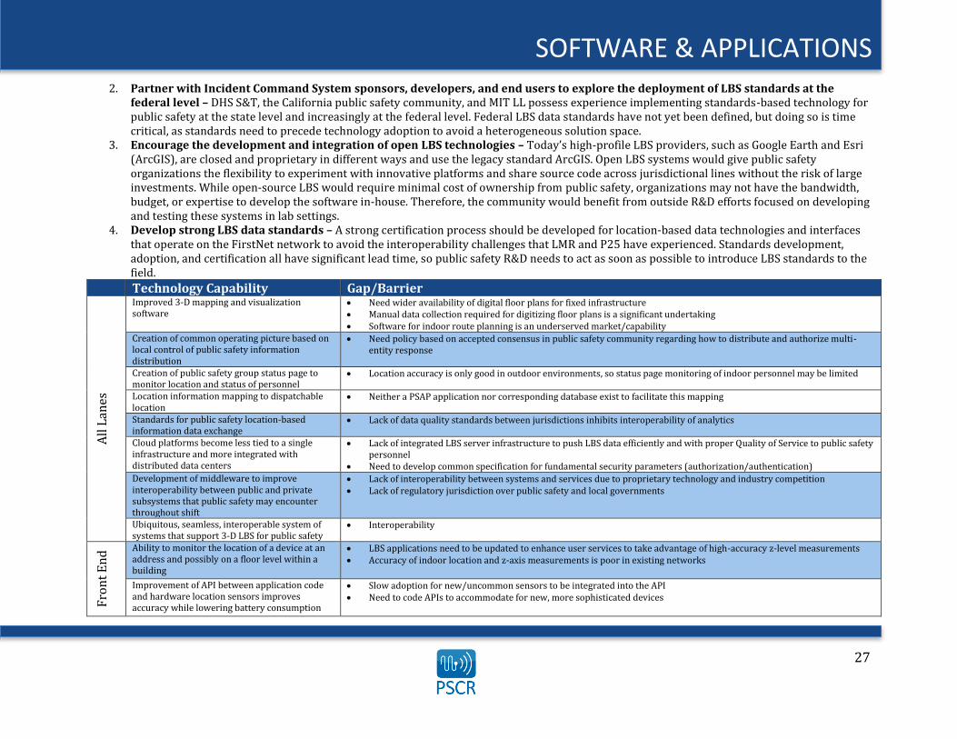
Gaps and Barriers The LBS working group identified several key technology gaps that need to be addressed before location-enabled technology can become truly interoperable for public safety. The following technology gaps were considered to be top priority areas for PSCR to consider: Lack of data quality standards between jurisdictions inhibits
interoperability of analytics Lack of integrated LBS server infrastructure to push LBS data
efficiently and with proper Quality of Service to public safety personnel
Need to develop common specifications for fundamental security parameters (authorization/authentication)
Lack of interoperability between systems and services due to proprietary technology and industry competition
Lack of regulatory jurisdiction over public safety and local governments
Slow adoption for new and uncommon sensors to be integrated into location-aware APIs
Need to code APIs to accommodate for new, more sophisticated devices
Need to develop standards that gauge the accuracy and precision of latitude, longitude, and elevation while considering bandwidth and data transfer requirements
Need for increased bandwidth, interoperability, and analytical capacity among current public safety applications and networks to clean, organize, and create models from the data
Public Safety R&D Opportunities Given the technology capabilities, gaps, and enabling actions and actors that are forecasted to impact the LBS domain over the next 20 years, the working group identified four potential R&D projects that would improve LBS software interoperability for public safety personnel. The R&D community supporting public safety should consider the following project ideas as it evaluates future investment opportunities:
1. Drive fundamental technology research – Innovations in public safety interoperability depend on several basic and applied research needs. These include integrated prototyping to scope LBS data and quality of service data standards, quantifying requirements for middleware designed to transition legacy public safety systems to IP/LTE architecture, tracking the progress of commercial investments in location API performance capabilities, and investigating battery and bandwidth consumption for LBS software across multiple market sectors.
27
SOFTWARE & APPLICATIONS 2. Partner with Incident Command System sponsors, developers, and end users to explore the deployment of LBS standards at the
federal level – DHS S&T, the California public safety community, and MIT LL possess experience implementing standards-based technology for public safety at the state level and increasingly at the federal level. Federal LBS data standards have not yet been defined, but doing so is time critical, as standards need to precede technology adoption to avoid a heterogeneous solution space.
3. Encourage the development and integration of open LBS technologies – Today’s high-profile LBS providers, such as Google Earth and Esri (ArcGIS), are closed and proprietary in different ways and use the legacy standard ArcGIS. Open LBS systems would give public safety organizations the flexibility to experiment with innovative platforms and share source code across jurisdictional lines without the risk of large investments. While open-source LBS would require minimal cost of ownership from public safety, organizations may not have the bandwidth, budget, or expertise to develop the software in-house. Therefore, the community would benefit from outside R&D efforts focused on developing and testing these systems in lab settings.
4. Develop strong LBS data standards – A strong certification process should be developed for location-based data technologies and interfaces that operate on the FirstNet network to avoid the interoperability challenges that LMR and P25 have experienced. Standards development, adoption, and certification all have significant lead time, so public safety R&D needs to act as soon as possible to introduce LBS standards to the field.
Technology Capability Gap/Barrier
All
Lan
es
Improved 3-D mapping and visualization software
Need wider availability of digital floor plans for fixed infrastructure Manual data collection required for digitizing floor plans is a significant undertaking Software for indoor route planning is an underserved market/capability
Creation of common operating picture based on local control of public safety information distribution
Need policy based on accepted consensus in public safety community regarding how to distribute and authorize multi-entity response
Creation of public safety group status page to monitor location and status of personnel
Location accuracy is only good in outdoor environments, so status page monitoring of indoor personnel may be limited
Location information mapping to dispatchable location
Neither a PSAP application nor corresponding database exist to facilitate this mapping
Standards for public safety location-based information data exchange
Lack of data quality standards between jurisdictions inhibits interoperability of analytics
Cloud platforms become less tied to a single infrastructure and more integrated with distributed data centers
Lack of integrated LBS server infrastructure to push LBS data efficiently and with proper Quality of Service to public safety personnel
Need to develop common specification for fundamental security parameters (authorization/authentication) Development of middleware to improve interoperability between public and private subsystems that public safety may encounter throughout shift
Lack of interoperability between systems and services due to proprietary technology and industry competition Lack of regulatory jurisdiction over public safety and local governments
Ubiquitous, seamless, interoperable system of systems that support 3-D LBS for public safety
Interoperability
Fro
nt
En
d Ability to monitor the location of a device at an
address and possibly on a floor level within a building
LBS applications need to be updated to enhance user services to take advantage of high-accuracy z-level measurements Accuracy of indoor location and z-axis measurements is poor in existing networks
Improvement of API between application code and hardware location sensors improves accuracy while lowering battery consumption
Slow adoption for new/uncommon sensors to be integrated into the API Need to code APIs to accommodate for new, more sophisticated devices

28
SOFTWARE & APPLICATIONS
Technology Capability Gap/Barrier
Fro
nt
En
d
The addition of z-axis to existing 2-D user interface will improve the precision of gesture-based application commands
Current sensors that capture gesture-based commands rely on dramatic motion and can fail to recognize more subtle movement
Device displays can be physically altered (e.g., bent) to execute commands (e.g., turn up volume, zoom display), which reduces the need for responder dexterity while on scene
Physical materials needed to produce these devices (e.g., bendable glass) are either unavailable or expensive to produce at the scale required by public safety
Rise of augmented reality gives responders a live view of their physical environment that is augmented (or supplemented) by computer-generated sensory input such as sound, video, graphics, or GPS data
Current wearable devices cannot interact with all environmental conditions in real time, which limits their ability to project instructions, status, and other relevant data onto the responder’s display
Bac
k E
nd
As cloud-based middleware and backend providers become more ubiquitous, the software development process becomes more efficient, applications become more scalable to increased user demand, and developers become focused on enhancing the user interface and experience
Public safety organizations may hesitate to host application data centers on the cloud because of sensitive information or security concerns
Difficult to define who owns cloud hosting when infrastructure is funded by multiple organizations
Brain-Computer Interface: Users can command applications through electrical signals and brainwave patterns
Difficult to map complex brainwaves to specific thoughts or commands Current thought-detection applications are primitive
As bandwidth increases and LBS becomes more prevalent, geolocation information will become ubiquitous. The computational requirements will become relatively small and insignificant.
Need to develop standards that gauge accuracy and precision of latitude, longitude, and elevation that consider bandwidth and data transfer requirements
Inte
grat
ed
An
aly
tics
Automatic LBS are developed and implemented An automatic system requires trust from users that it will work while minimizing errors
Higher sophistication and precision of geo-tagged metadata due to an increased number of open APIs from LBS content providers that take advantage of millions of device sensors
Current public safety applications and networks do not possess the bandwidth, interoperability, or analytical capacity to clean, organize, and create models from this data
29
DEVICES
Devices The public safety community has the opportunity to garner location information from the entire breadth of modern computing devices, such as employee badges, wearables, mobile handhelds, vehicles, public transit systems, tablets, desktops, and server infrastructure. These devices, if protected by proper authorization and authentication, have the potential to track objects and personnel, improve situational awareness, and display timely environmental conditions that would greatly enhance emergency response and management. Some of industry’s most significant R&D efforts are aimed at improving the speed, power efficiency, and availability of devices that can communicate seamlessly on disparate networks. Devices equipped with radio frequency identification (RFID), IoT, and Near Field Communications (NFC) capabilities that are widely introduced to the commercial sector must then undergo a process to meet public-safety-grade specifications before they can be considered for deployment on the NPSBN and potentially contribute to more accurate and reliable LBS for public safety. To account for the range and complexity of this domain, PSCR asked the LBS working group to forecast the evolution of LBS device capabilities and gaps that need to be considered in light of the trends and drivers identified earlier. Specifically, the working group evaluated the progression of four components of LBS devices and how these evolving technologies would impact public safety operations. They included:
1. Global Positioning System (GPS)/Global Navigation Satellite System (GNSS) 2. Cellular 3. Terrestrial Beacon 4. Short Range (e.g., WiFi, BTLE, RFID, NFC, IoT)
As the LBS working group discussed the devices lane, several operational objectives surfaced as natural themes that captured the collective technology capabilities and enabled operational capabilities. For the purposes of this report, two operational objectives have been discussed in detail:
1. Device Convergence Supports Greater Mobility 2. Diversified Approaches Improve Indoor Accuracy Positioning and Situational Awareness
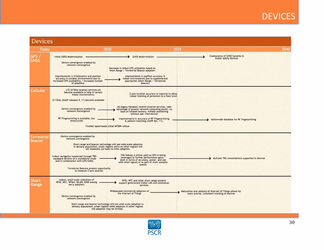
30
DEVICES
31
DEVICES
Operational Objective: Device convergence supports greater mobility
The convergence of the device and network technologies supporting today’s consumer telecommunications industry have enabled users to migrate multiple methods of communications—most notably voice, video, and data—into common interfaces on a single, handheld device. Many public safety organizations have yet to leverage the full scope of modern convergent services, which include Voice over IP (VoIP), handheld digital video broadcasting, and IoT. With targeted R&D investment, the public safety community could take advantage of convergent solutions in operational settings to support greater information mobility and increase the accuracy of positioning systems.
Enabled Operational Capabilities/Technology Capabilities The LBS working group identified three main operational advantages that could be realized by R&D leveraging the convergence of device technology:
1. Converged Content Enhancing Situational Awareness 2. Faster/More Accurate Responses 3. Greater Device and Network Mobility
As communications devices become increasingly capable of transmitting and receiving disparate data types, there is potential that users will eventually access all media content through a single smart device. As public safety begins to adopt devices that aggregate “converged content,” responders will be able to mix user-generated content (e.g., video captured on the scene) with classified data housed at a central command center. Such devices would improve situational awareness in real time and could be integrated with both fixed and temporary network infrastructure to support greater mobility. Other convergent devices could include vehicles that are connected with
mobile or IP architectures; location-aware proxies, towers, and handhelds; and devices that can command a building’s heating, ventilation, air conditioning, doors, and other infrastructure. The end result of convergent technology has several implications for public safety operations. First, convergence will enable more machines to leverage a seamless feedback loop of data exchange gathered from handheld devices, sensors, and other data sources within a scene. Data could be collected from and synced to multiple, integrated devices, thus allowing public safety to report on response conditions on the fly. If public safety personnel can carry a single device that supports all aspects of their job, they will be able to respond faster and more efficiently. Convergent services have already blurred the lines of what traditional consumer electronic devices are capable of doing, and public safety has the opportunity to incorporate these economies of scale into its own unique set of tools.
Enabling Actions and Actors Technology convergence is an international phenomenon with a long history in the commercial sector. As such, this section is not intended to be an exhaustive review of all enabling actions and actors involved, but instead should provide a brief overview of R&D efforts outside of the public safety sector that are representative of the partnerships that public safety R&D organizations could build. Continued market research will be necessary to create awareness of current efforts and account for new actors in these fields. Location Accuracy – More devices that share location information will provide LBS networks with more triangulation points within an area, which
will facilitate more precise tracking of resources and personnel. For example, LG and Qualcomm have developed smartphone sensors that provide a user’s indoor location information by leveraging a combination of GPS, Wi-Fi, and cloud servers.
32
DEVICES Minimizing Battery Consumption – The ubiquity of GPS-equipped phones and handhelds has enabled the continuous use of LBS to deliver
relevant positioning and “near-me” services to users. While these services have positive ramifications for public safety, they represent a high power drain on mobile devices. The Berlin University of Technologyxxv and the University of Aarhus in Denmarkxxvi have classified several techniques that aim to improve the energy efficiency of device LBS processing. Domestic industry has also demonstrated a strong incentive to optimize hardware battery life to accommodate LBS. For example, Apple and Google have invested significant resources into developing thinner, more efficient batteries to accommodate more sophisticated services without increasing the size of their handsets.
Gaps and Barriers The LBS working group identified several key technology gaps that need to be addressed before LBS can fully benefit from device convergence as detailed above. The following gaps were considered priority areas for public safety R&D organizations to consider: Battery Consumption – LBS is currently a significant power drain on mobile devices. Interference – Integration of radio technologies with mobile devices can negatively impact GNSS measurement due to signal interference. Requirements Gathering – Public safety needs to define performance metrics for integrated devices, including accuracy, speed, power, and
availability. Interoperability – Further definition is needed to determine how IoT devices will interact on the NPSBN.
Public Safety R&D Opportunities Given the evolution of device technologies over the next 20 years, the LBS working group identified two potential R&D efforts that would deliver enhanced LBS to the public safety community based on device convergence supporting greater mobility:
1. Conduct Integrated Device Testing – The public safety R&D community should conduct case studies of early adopters leveraging integrated device technology and apply these use cases to scenarios between regions. For example, an R&D lab could pilot an integrated test bed for how RFID tags, heterogeneous networks (HetNets), and IoT devices will access and process LBS data across the NPSBN. There is a need to demonstrate that integrated devices provide a clear benefit to responders and emergency managers so that state and local organizations will justify additional hardware investment.
2. Conduct Ongoing Market Research – Industry appears to be tackling many of the barriers that currently limit the use of integrated devices with public safety. Specific areas of device innovation that are particularly relevant to the public safety community include improvements in battery efficiency, interoperability between devices on disparate networks, and the ruggedization of consumer electronics.

33
DEVICES
Operational Objective: Diversified approaches improve indoor accuracy positioning and situational awareness
The LBS working group’s 20-year device technology forecast identified several approaches to improving indoor positioning accuracy. Currently, Incident Command Centers and dispatch systems rely on GPS systems to locate officers and other deployed resources. While existing GPS/GNSS infrastructure provides high precision in most outdoor environments, it fails to meet public safety requirements for indoor location accuracy. However, public safety’s ability to obtain highly accurate LBS in dense urban environments will likely not be addressed by GPS alone. Emerging technologies, such as terrestrial beacon systems and NFC, are better suited for indoor positioning and are expected to gain traction over the next 10 years. Thus, we are encouraged that industry, academia, and government organizations are developing a broad range of technologies to modernize and supplement the ubiquitous GPS architecture already in place.
Enabled Operational Capabilities/Technology Capabilities The LBS working group identified three main operational advantages that could be realized by R&D pursuing diversified approaches to improved indoor positioning accuracy:
1. Better Situational Awareness 2. Faster/More Accurate Responses 3. Greater Mobility
The number of GNSS constellations is expected to increase in the short term, leading to particularly significant improvements in yield and performance in positioning accuracy in rural and suburban environments. While less developed areas would show the biggest gains in accuracy from these additional, visible satellites, densely populated urban environments could see a decrease in GPS utilization due to the adoption of short-range and terrestrial beacon technologies. These supplemental approaches would improve position accuracy in urban and indoor environments and would allow public safety to take advantage of more precise “Location-Condition-Action” systems (e.g., Amber Alerts) and fence in smaller location perimeters on the fly. Within the next 10 years, the working group expects these supplemental approaches to indoor positioning will enable public safety to trigger push and pull notifications to other responders to report an action committed on a floor of a building. These technologies, including precise geo-fencing and energy-efficient beacons integrated with LTE architecture, will lead to much-improved situational awareness and faster, more accurate response. In addition to increased short range and terrestrial beacon adoption, public safety may see LTE
Observed Time Difference of Arrival (OTDOA) location services become available to support enhanced indoor positioning in the short to medium term. Improved cellular LBS could assist GPS by combining range estimates from satellite constellations, terrestrial beacons, cellular transmitters, and beacons within the building (if available). These technologies could potentially track indoor personnel to a floor level—thereby leading to greater situational awareness—but needs to account for physical, technological, and regulatory challenges (e.g., modern building materials, changing Leadership in Energy and Environmental Design [LEED] requirements, and converting altitude to floor level via indoor maps) for maximum utility. While short-range and terrestrial beacon technologies will likely see greatest initial adoption in urban regions, improved GNSS and cellular positioning could raise the baseline LBS experience across jurisdictions without accounting for population density. As cellular carriers increase bandwidth, they can help maintain a nationwide set of “core” LBS. To supplement this approach, LBS working group members detailed the likely progression of short-range and terrestrial beacon systems (TBS)-supported devices. Initially, indoor navigation is supported through short-range and TBS-supported devices on a standalone mode and in combination with GPS/GNSS. TBS and short-range capabilities would then be leveraged to further performance gains—in terms of accuracy, power, and use with other signals or as part of more complex systems. Eventually, LBS working group members foresee multiple GNSS and TBS constellations supported in devices, alongside cellular and short-range capabilities.

34
DEVICES Enabling Actions and Actors This section is intended to provide a brief overview of the range of efforts to improve indoor positioning accuracy that are currently underway in industry, academia, and government. In order to keep this summary accurate, we recommend that the public safety R&D community conduct continuous market research to account for new developments in this area. E911 Location Accuracy – The Federal Communications Commission recently adopted its 4th Report and Order (“4th R&O”) on the geolocation of
wireless 9-1-1calls. This order calls for the accurate location, whether via a semantic or coordinate-based, for 80% of all wireless 9-1-1 calls by 2021, and a z-axis requirement for the Top 50 CMAs by 2023. Incorporated, in part, in the 4th R&O is a roadmap for “achieving improved location accuracy for both outdoor and indoor 9-1-1 calls” negotiated among the National Emergency Number Association (“NENA”), APCO, AT&T, T-Mobile USA, Sprint, and Verizon. The roadmap outlines certain carrier commitments to develop dispatchable location solutions, latitude/longitude location solutions, and metrics for assessing the performance of positioning systems. In addition, a technology-neutral test-bed will be created by November 2015 to create a mechanism to test all 9-1-1 location technologies across multiple indoor environments. 9-1-1 performance will be evaluated by comparing test-bed performance to actual technology used on all 9-1-1 calls. The wireless carriers will be responsible for pro-active reporting in six “test markets”, but any PSAP can request the performance
Indoor Location Standardsxxvii –A variety of indoor location standards activities are underway, including a study-item in 3GPP Release 13 to investigate how enhancements to OTDOA and TBS will be deployed in public safety contexts. Other organizations supporting this development include 3GPP, FirstNet, the National Public Safety Telecommunications Council (NPSTC), the Open Mobile Alliance and 28 companies from the telecommunications industry. The North American 3GPP partner, ATIS, has recently formed several working groups to work towards standardization of elements of the Roadmap, especially for semantic location delivery in 9-1-1.
Indoor Positioning Beacons – Several commercial actors, including Apple, Gimbal, Native Instruments, Sensorberg, Signal360, PayPal, and Qualcomm, are developing indoor location sensors that can transmit user location data to other devices in close proximity. For example, Apple’s iBeacon provides contextual services to users through Bluetooth Low Energy technology. In its current state, iBeacon is primarily limited to “I’m Here” and in-store advertising applications, but possesses a significantly larger range (about 30 meters) than previous NFC devices.
Terrestrial Beacons – NextNav has recently published its Interface Control Document (“ICD”) with NPSTC, similar to the publication of the GPS ICD. Along with other standardization activities underway, this will lead to the deployment of multiple terrestrial beacon systems.
Gaps and Barriers The LBS working group identified several key technology gaps that need to be addressed before public safety can realize more precise indoor location accuracy. The following gaps were considered priority areas for public safety R&D organizations to consider: Future Role of GPS – The future of GPS use in certain geographical contexts may depend on advances in other LBS technologies. Short-term
advances in short-range and terrestrial beacon technologies may address challenges faced by GPS use in urban areas due to penetration issues. The importance of indoor tracking may create the need to incorporate these alternative approaches to supplement the otherwise ubiquitous nature of GPS.

35
DEVICES Indoor GPS/LTE Limitations – GNSS and LTE ODTOA provide low-accuracy z-axis location, which limits tracking of indoor personnel to a floor level.
New, more resilient building materials make it difficult for the low signal strength of GPS to penetrate indoor locations, especially structures of more than 3-stories, and retrofitting all buildings with indoor cellular capabilities is cost-prohibitive. LTE carriers also may not have sufficient spectrum bandwidth to deploy high-accuracy LTE positioning in densely populated metro areas. Despite these barriers, responders are expected to communicate and operate indoors as efficiently as they do outdoors.
Cellular Accuracy and Reliability – Indoor LTE positioning accuracy and coverage depends on the cellular network’s configuration, density, and resources, including spectrum allocated to position reference signal (PRS) and integration.
Device and Network Interoperability – Existing networks determine a user’s location information by computing device-based measurements, and public safety device sensors do not have a standardized method for capturing positioning data. Networks may also send positioning data back to the device in a different format, causing interoperability issues. To leverage LBS in operational settings, public safety devices need to be able to access geolocation content repositories across multiple applications and service frameworks seamlessly.
Education and Messaging – Public safety is faced with the challenge of explaining how short-range and terrestrial beacon technology differs from cellular and GPS technology and how the utility and performance of the two changes when deployed indoors. Terrestrial beacon networks in various stages of deployment were recently made available in 47 U.S. cellular market areas, but awareness of this technology remains limited.
Terrestrial Beacon Adoption and Network Availability – Device vendors must specify the capabilities required to support multiple TBS constellations in a single handheld device before networks can be deployed. Although TBS networks are expected to be widely available before ubiquitous device adoption, device turnover can take time in both the public safety and mass-market communities.
Public Safety R&D Opportunities Given the technology capabilities, gaps and barriers, and enabling actions and actors that are forecasted to impact the LBS domain over the next 20 years, the LBS working group identified four potential R&D efforts that would deliver enhanced indoor LBS to the public safety community. Public safety R&D organizations should consider the following project ideas as they prioritize upcoming investment opportunities:
1. Create an LBS technology development and integration test bed to evaluate LBS standardization and the role of deployables in addressing coverage gaps – This test bed would include measuring Quality of Service schema effectiveness, and security authentication and authorization schema, specifying standardized capabilities for public safety deployables, and integrating disparate LBS data producers into the system with load and performance testing.
2. Drive fundamental market research – Researchers need to publish market research summaries and monitor industry advances relating to GPS modernization, OTDOA deployment, indoor positioning standards, and terrestrial beacon commercialization.
3. Pilot an in-building positioning program – New structures are being built with increasingly resilient materials, which greatly inhibit indoor cell reception. One option to overcome the communication issues that arise due to new construction would be to design buildings to support local indoor positioning sensors that are integrated with external GPS, GNSS, and LTE networks.
4. Conduct short-range and terrestrial beacon use case testing – R&D organizations should test the ways in which different short-range positioning technologies track, store, and transmit location information; identify which options are best suited for public safety use and research how these devices integrate with wider area networks.

36
DEVICES
Technology Capabilities Gaps/Barriers G
PS/
GN
SS
GNSS modernization Low-accuracy z-axis location capabilities Unable to reliably track indoor personnel to floor level Limited ability for GPS to provide accurate LBS in dense urban environments
Device convergence enabled by network convergence LBS services are a big power drain on mobile devices Integration of radio technologies within mobile devices can negatively impact GNSS measurement Need to define performance metrics for public safety to include accuracy, speed, power, and availability
Decrease in urban GPS utilization based on short range/beacon adoption
Future of GPS use dependent upon advances in other LBS technologies
Improvements in trilateration and position accuracy in outdoor environments due to increased GNSS availability and increased number of satellites
Improvements in position accuracy in indoor environments due to supplemental approaches (short range/terrestrial beacon)
CE
LL
UL
AR
LTE OTDOA location service will become available to help in certain indoor environments
GNSS and LTE OTDOA provide low-accuracy z-axis location, which is unable to provide tracking of indoor personnel to a floor level
LTE network is not deployed for optimum indoor location performance Broad OTDOA availability for LBS may require network operational / configuration changes
OTDOA (Cellular Beaconing) will become available Accuracy and reliability depends on a cellular network’s configuration, density, and resources allocated to PRS beacon
Position is computed in network according to device-based measurements, but may be sent back to the device
Device convergence enabled by network convergence LBS services are a big power drain on mobile devices Integration of radio technologies within mobile devices can negatively impact GNSS measurement Need to define performance metrics for public safety to include accuracy, speed, power, and availability
Cellular angle of arrival (AOA): network-based, need directional antennas at cell towers, only two base stations required, may be good in rural regions, use of smart antennas in 3G, 4G may increase interest in AOA
Nationwide database for radio frequency fingerprinting Lack of nationwide implementation prevents the pursuit of RF fingerprint database FirstNet spearheads initial NPSBN rollout Need to demonstrate utility and cost-benefit of NPSBN
Need defined vision for use of deployables in rural areas
TE
RR
EST
RIA
L
BE
AC
ON
Device convergence enabled by network convergence LBS services are a big power drain on mobile devices Integration of radio technologies within mobile devices can negatively impact GNSS measurement Need to define performance metrics for public safety to include accuracy, speed, power, and availability
Terrestrial beacon technology will see adoption initially in densely populated, urban regions while adoption in other regions may be limited.
Requirements in less-dense areas are uncertain Designed to complement GNSS, and thus seamless coverage dependent upon GNSS integration Could require the use of deployables in extended rural environments
Indoor navigation supported through TBS-supported devices on a standalone mode and in combination with GPS/GNSS
TBS networks, in various stages of deployment, are available today in 47 U.S. cellular market areas, but are still in the early stages of development.
Device adoption – Device vendors are specifying the capability

37
DEVICES
Technology Capabilities Gaps/Barriers
Ter
rest
rial
B
eaco
n
TBS is leveraged to further performance gains—in terms of accuracy, power, and use with other signals or as part of more complex systems
TBS network availability – although this is expected to be filled before ubiquitous device adoption (networks can be deployed, but device turnover can take time in both the public safety and mass-market communities)
Device adoption – Device vendors are specifying the capability
Multiple TBS constellations supported in devices Device adoption – Device vendors are specifying the capability TBS network availability – although this is expected to be filled before ubiquitous device adoption
(networks can be deployed, but device turnover can take time in both the public safety and mass-market communities)
Terrestrial Beacons present opportunity for Public Safety to measure Z-axis location.
Sho
rt-R
ange
(W
ifi,
BT
LE
, R
FID
, NF
C, I
oT
)
Indoor, small-scale utilization of RFID, NFC, WPAN, WLAN, UWB among early adopters
Need to design distributed broadband infrastructure to accommodate LBS data access and identity management for authorized emergency personnel
Operational considerations – frequency support for small cells, power availability Potentially requires database (e.g., BTLE) or positioning server access (e.g., WLAN)
RFID, NFC, and other short-range systems support generalized indoor LBS and contextual services
High cost of scaling short-range technologies throughout a critical mass of buildings Interoperability challenges between pulling LBS information from in-building short range systems onto the
NPSBN Widespread commercial adoption of IoT IoT standards have the potential to evolve significantly in the coming years
High cost of scaling technologies that connect IoT devices (WPAN, WLAN, WAN) Maturation and ubiquity of IoT allows for more precise, consistent tracking of devices
Need to have citizens “opt-in” to location tracking
Device convergence enabled by network convergence LBS services are a big power drain on mobile devices Integration of radio technologies within mobile devices can negatively impact GNSS measurement Need to define performance metrics for public safety to include accuracy, speed, power, and availability
Short range and beacon technology will see wide-scale adoption in densely populated, urban regions while all other regions will see little to moderate (at best) adoption
Challenge of explaining how short range/beacon technology is different than cellular/GPS and how the utility changes

38
NETWORKS
Networks As the LBS working group set out to discuss the evolution of networks over the ensuing 20 years and beyond, it became clear that further definition of the networks lane was necessary. The networks lane was subdivided into the following sub-lanes with high-level descriptions of each sub-lane given for the purposes of LBS working group discussions and this LBS R&D Roadmap report:
1. Wide-area Network refers to more than 100 miles 2. Regional-area Network refers to 50 to 100 miles 3. Incident-area Network refers to less than 50 miles 4. Venue-based Network refers to 0.5 to 3 miles 5. Personal Network refers to on-body/wearable technologies within 0.5 miles
The foundation for this structure was born out of the 2004 SAFECOM Statement of Requirements for Public Safety Wireless Communications & Interoperability (SoR)xxviii. While the semantics used by the LBS working group differed slightly from the SAFECOM SoR document, the following table shows how these distinctions map to each other.
2004 SAFECOM SoR Network Distinctions 2014 LBS R&D Roadmap Network
Distinctions Extended-area Network Wide-area Network Jurisdiction-area Network Regional-area Network
Incident-area Network (IAN) Incident-area Network Venue-based Network
Personal-area Network Personal Network The LBS working group also created an additional sub-lane within IAN labeled the “Venue-based” network. The LBS working group reasoned that while incidents can begin very localized, they could spread and extend beyond an immediate area or building. Venue-based networks are higher precision than IANs and are tied specifically to a building or defined complex of buildings such as a sports complex. Some technology capabilities and related gaps and barriers were present across all network sub-lanes. These are depicted in the “All Lanes” section of the networks roadmap graphic on page 36. As the LBS working group discussed the networks lane, several operational objectives surfaced as natural themes that captured the collective technology capabilities and enabled operational capabilities. For the purposes of this report, two operational objectives have been discussed in detail:
1. Increased Coverage 2. Interoperability of Heterogeneous Networks Enables Efficient Delivery of LBS
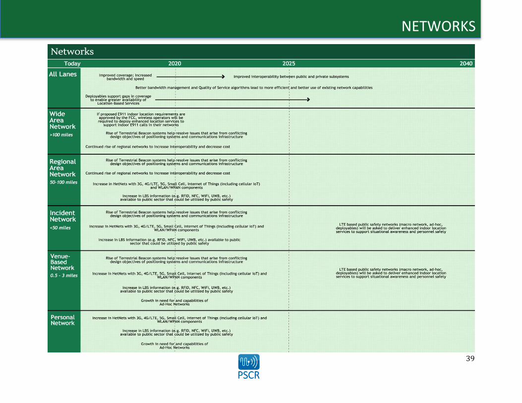
39
NETWORKS
40
NETWORKS
Operational Objective: Increased Coverage The public safety systems that transmit mission-critical and non-mission-critical voice and data face unique coverage challenges. According to the 2014 NPSTC Defining Public Safety Grade Systems and Facilitiesxxix report, public safety systems “must cover all areas that generate requests for service.” This is a challenge commercial carriers do not face, requiring public safety to develop novel approaches and solutions to deliver coverage to the greatest geographical extent feasible. The NPSTC report also states “areas such as a large high rise or other critical facility may need coverage even if it requires extra cost to provide that coverage.”
Enabled Operational Capabilities/Technology Capabilities The LBS working group identified improved coverage as a critical operational objective of future R&D to support the public safety community. Specific to LBS, the main enabled operational capabilities that arise from R&D directed at improving coverage include:
1. Enhanced capabilities of LBS and the potential to leverage more LBS concurrently. Better bandwidth management and Quality of Service will limit the risk of a single LBS overwhelming the network.
2. Users and LBS become less reliant on traditional cellular architectures, leading to deployment and optimization of LBS on deployables and users’ devices.
3. Increased robustness and reliability of LBS since they will not be as susceptible to infrastructure damage (such as cellular towers, which were damaged during Hurricane Sandy)
As coverage is built out and LTE matures with the introduction of spectral efficiency features, the potential exists for public safety and the LBS they leverage to benefit from increased bandwidth and speed. These capabilities will be driven not by an increase in additional bandwidth, but from improvements in bandwidth management and Quality of Service algorithms that will lead to the more efficient use of existing network capabilities. Key to the implementation of improved Quality of Service algorithms for public safety will be an in-depth understanding of public safety requirements and operational constraints. These improvements will reduce the risk of a single or small number of LBS overwhelming and disrupting network service to
public safety while ensuring the grade of service provided to public safety meets their needs. Likewise, key to ensuring Quality of Service is an understanding of how changes in LBS bandwidth limited or disrupted environments. To address the unique challenge presented to public safety of covering “all areas that generate requests for service,” deployables and repeater technology can be leveraged to support gaps in network coverage. The use of deployable technology will enable greater availability of LBS to the public safety end user, improving overall situational awareness and effectiveness in planning and response. One critical distinction raised by the LBS working group to be further explored is the difference between “100 percent network availability” and “100 percent network support of capabilities,” with the latter being a more robust description of the network. Finally, the LBS working group identified the need for ad-hoc networks as a key technology capability that will lead to overall improved coverage. Ad hoc networks were identified as a way for the public safety community to bring their own LBS to an event. While these networks are largely touted in the academic and research communities, public safety has little operational experience with these types of networks and therefore will need more definition of what is meant by and provided by ad hoc networks prior to full adoption.

41
NETWORKS
Enabling Actions and Actors This section is not intended to be an exhaustive review of all enabling actions and actors currently working on coverage-related LBS efforts. Rather, it is intended to provide a brief sample of R&D efforts outside of the public safety sector that represent the partnerships that public safety R&D organizations could build. Continued market research will be necessary to create awareness of current efforts and account for new actors in these fields. Bandwidth Management – The University of Portsmouth (United
Kingdom) in coordination with the Institute of Electrical and Electronics Engineers has developed a Dynamic Authentication Bandwidth Management System that allocates bandwidth dynamically to users as they authenticate with a wireless access point. As users log into and out of the system on an ad hoc basis, the bandwidth is dynamically redistributed with each event.
Quality of Service – FirstNet currently funds PSCR to actively test priority, preemption, and Quality of Service. While PSCR is working on Quality of Service features for the current 3GPP releases, future releases are anticipated to have additional features and functionalities that will require investigation and testing. Further investigation is also needed into LBS Quality of Service standards.
Deployable Technology – The State of New Jersey is building out a proof-of-concept LTE network for public safety. Called JerseyNet, the network is comprised entirely of deployable infrastructure. The network will include more than 30 cells on wheels and six systems on wheels according to a recent article in Urgent Communications
(http://urgentcomm.com/public-safety-broadbandfirstnet/vendor-team-outlines-features-all-deployable-public-safety-lte-netwo).
Ad Hoc Networks – The European Alliance for Innovation organizes the annual International Conference on Ad Hoc Networks. According to its website, (http://adhocnet.org/2015/show/home) “Ad hoc networks, which cover a variety of network paradigms for specific purposes, such as mobile ad hoc networks, sensor networks, vehicular networks, underwater networks, underground networks, personal area networks, and home networks, promise a broad range of applications in civilian, commercial, and military areas. The aim of the annual International Conference on Ad Hoc Networks (AdHocNets) is to provide a forum that brings together researchers from academia as well as practitioners from industry to meet and exchange ideas and recent research work on all aspects of ad hoc networks.”
Gaps and Barriers The LBS working group identified several key technology gaps that need to be addressed before location-based services can fully benefit from improved coverage. The following gaps were considered priority areas for public safety R&D organizations to consider: Current public safety procurements are used for systems for the
next 10 years or more. Supplemental funding for public safety agencies would greatly increase the speed and breadth of adoption of LBS-related technologies.
Quality of Service requirements and algorithms for commercial networks could be different than those needed for a public safety network. A detailed understanding of public safety Quality of Service requirements and operational constraints that could impact algorithm development is key. The LBS working group also noted the current lack of funding tied to developing public-safety-
specific algorithms as a significant hurdle hindering near-term capability advancements.
New algorithms may not be interoperable with current network capabilities. If new algorithms cannot be deployed in existing architectures, adoption will be greatly deterred.
Deployable technology needs to be considered more broadly than just in relation to the Evolved Node B (eNodeB). Any deployable solution needs to support all LBS.
Public safety may not buy into the potential of ad hoc networks.

42
NETWORKS
Public Safety R&D Opportunities Given the technology capabilities, gaps and barriers, and enabling actions and actors that are forecasted to impact the LBS domain over the next 20 years, the LBS working group identified three potential R&D efforts that would deliver enhanced LBS to the public safety community based on improved coverage. Public safety R&D organizations should consider the following project ideas as they prioritize upcoming investment opportunities:
1. Create an LBS technology development and integration test bed to evaluate LBS standardization – This test bed would include measuring Quality of Service schema effectiveness, and security authentication and authorization schemas, specifying standardized capabilities for public safety deployable technology, and integrating disparate LBS data producers into the system with load and performance testing.
2. Develop public-safety-specific algorithms – These algorithms should take into account public safety operational needs and requirements and cost structure constraints.
3. Identify and document public safety LBS requirements for Quality of Service.

43
NETWORKS
Operational Objective: Interoperability of Heterogeneous Networks Enables Efficient Delivery of LBS Public safety users depend on the reliability and redundancy of communications networks throughout their daily operations. The eventual build-out of the NPSBN will provide a macro network that will allow for a specific level of service and provide interoperability across jurisdictions. In addition to this macro network, additional heterogeneous networks (wide area, regional, incident, venue-based, and personal networks) will provide seamless interoperability between various multi-coverage protocols, enabling more robust capabilities, including the efficient delivery of LBS.
Enabled Operational Capabilities/Technology Capabilities The LBS working group identified four main operational capabilities that could be realized by R&D focused on enabling the efficient delivery of LBS through the interoperability of heterogeneous networks:
1. Seamless, ubiquitous interoperability across networks and across public and private subsystems leads to more efficient delivery of LBS.
2. Seamless interoperability across networks enables R&D funding to be applied to maximizing the utility of communications, determining what to communicate rather than how to communicate.
3. Regional networks and support will lead to a more common technology acquisition approach across multiple organizations within a region.
4. Improved indoor coverage enabled by diversified approaches to each network layer will increase the reliability and robustness of LBS.
A standards-based approach to network design and implementation at the national, regional, state, and local levels will lead to improved interoperability between public subsystems. Input gathered from the LBS working group indicates that this standards-based approach and improvements in technology and network interoperability will enable greater interoperability between public and private subsystems. This capability could be a paradigm-shifting advancement for public safety,
both in providing greater network redundancy as well as potential access to data within the networks with which they are able to interoperate. With the increase in various network components, issues will arise from the conflicting design objectives of communications infrastructure and positioning systems. Cellular networks are usually designed to maximize capacity while positioning systems are designed to minimize interference. The LBS working group believes that the rise of TBS will help resolve these issues. The move to IP-based networks and technology will allow public safety to more effectively plan technology migration and acquisition on a regional basis rather than at the agency or jurisdictional level. The continued rise of these regional networks will increase interoperability and decrease costs as regional approaches enable multiple jurisdictions to take advantage of economies of scale in technology acquisition. In addition to the increase in regional networks, the LBS working group foresees an increase in HetNets that span multiple protocols, including 3G, 4G/LTE, 5G, Small Cell, IoT, cellular IoT, and WLAN/WPAN components. As interoperability is enabled across these networks, public safety will greatly benefit from the increased capabilities of LBS.

44
NETWORKS
Enabling Actions and Actors This section is not intended to be an exhaustive review of all enabling actions and actors currently working on network-related LBS efforts. Rather, it is intended to provide a brief sample of R&D efforts that represent the technology capabilities discussed in the previous section. Continued market research will be necessary to create awareness of current efforts and account for new actors in these fields. Improved Interoperability between Public and Private Subsystems – SiRRAN Communications, in partnership with the Cebrowski Institute at
the Naval Postgraduate School, has posted a presentation focusing on public and private network interoperability, as well as tactical and secure communications over public and private networks. The presentation can be found at http://www.nps.edu/Academics/Institutes/Cebrowski/News-and-Events/Docs/BB_RobertKoldys_presentation%20.pdf.
Rise of Regional Networks to Increase Interoperability and Decrease Costs – The Northern Tier Regional Telecommunications Project replaced an aging 911 system of 10 counties (Cameron, Clarion, Clearfield, Crawford, Elk, Erie, Forest, Jefferson, McKean, and Warren) in Pennsylvania with the state’s first regional public safety network, which went live in 2013. By forming the regional network, the counties saved $2.3 million in up-front costs and more than $250,000 in annual maintenance costs according to a case study on the network. The case study can be found at http://airbus-dscomm.com/pdf/Northern-Tier-case-study.pdf.
Increase in Heterogeneous Networks – Nokia Networks, through the acquisition of a 3-D geolocation solution from NICE Systems, launched an effort to enable 3-D geolocation modeling for HetNets to increase the accuracy of network planning and optimization for multi-vendor mobile networks. Four use cases have been developed as a result: hot spot location identification, performance monitoring, radio frequency optimization, and drive and walk test reduction. More information on the solution can be found from RCR Wireless News at http://www.rcrwireless.com/20141204/europe/emea-nokia-enables-3d-geolocation-for-hetnets-tag11.
Gaps and Barriers The LBS working group identified several key technology gaps that need to be addressed before location-based services can fully benefit from network improvements as detailed above. The following gaps were considered priority areas for public safety R&D organizations to consider: Proprietary solutions hamper interoperability. Similarly, disparate
and legacy systems will present specific challenges to interoperability and may lack the ongoing support to be integrated into interoperable network solutions. Outdated systems at the end of life don’t interface with current or emerging technology.
Cellular network designs to maximize capacity fundamentally conflict with positioning systems that are designed to minimize interference.
Receiver technology and supporting silicon has not yet reached commercial scale.
If public safety can’t afford bridging technology to move from current network solutions to more interoperable solutions, bridging solutions won’t be adopted, creating or reinforcing network and communications silos.
There is a need for a standardized data format specification for LBS content to promote interoperability across different types of networks.
45
NETWORKS
Public Safety R&D Opportunities Given the technology capabilities, gaps and barriers, and enabling actions and actors that are forecasted to impact the LBS domain over the next 20 years, the LBS working group identified the following potential R&D effort that would deliver enhanced LBS to the public safety community based on network improvements. Public safety R&D organizations should consider the following project ideas as they prioritize upcoming investment opportunities:
1. Create an integrated, future-focused LBS network test bed – An integrated LBS network test bed could test applications to ensure operations function independent of network technology. This test bed would include measuring Quality of Service schema effectiveness, and security authentication and authorization schemas, specifying standardized capabilities for public safety deployable technology, and integrating disparate LBS data producers into the system with load and performance testing.

46
NETWORKS
Technology Capability Gap/Barrier A
LL
LA
NE
S
Improved coverage; increased bandwidth and speed Funding – Current procurements are used for systems for the next 10 years (or more) Improved interoperability between public and private subsystems
Proprietary issues Disparate and legacy systems offer no support or interoperability Outdated systems at the end of life don’t interface with current or emerging technology
Better bandwidth management and Quality of Service algorithms lead to more efficient and better use of existing network capabilities
Quality of Service requirements and algorithms for commercial networks could be different than those needed for a public safety network
Lack of funding to develop public-safety-specific algorithms New algorithms may not be interoperable with current network capabilities
Deployable technology supports gaps in coverage, enabling greater availability of LBS
Deployable technology needs to be considered more broadly than just in relation to the ENodeB
WID
E A
RE
A
FCC 4th R&O on Wireless E9-1-1 requires wireless operators to deploy enhanced location services to support indoor E911 calls in their networks
Poor indoor coverage for GPS and venue-based location services Poor elevation z-axis accuracy, which prevents locating E911 caller to the floor of a building Poor horizontal accuracy indoors from legacy cellular technologies New technologies required to be adopted and deployed to meet rules
Rise of TBS help resolve issues that arise from conflicting design objectives of positioning systems and communications infrastructure
Cellular network designs to maximize capacity fundamentally conflict with positioning systems that are designed to minimize interference
Receiver technology and supporting silicon has not yet reached commercial scale Continued rise of regional networks increases interoperability and decreases costs
If public safety can’t afford bridging technology, it won’t be adopted Bridging technology won’t be as necessary if P25 is made more interoperable by vendors
RE
GIO
NA
L A
RE
A
(50
-10
0 M
ILE
S)
Rise of TBS help resolve issues that arise from conflicting design objectives of positioning systems and communications infrastructure
Cellular network designs to maximize capacity fundamentally conflict with positioning systems that are designed to minimize interference
Receiver technology and supporting silicon has not yet reached commercial scale Continued rise of regional networks increases interoperability and decreases costs
If public safety can’t afford bridging technology, it won’t be adopted Bridging technology won’t be as necessary if P25 is made more interoperable by vendors
Increase in HetNets with 3G, 4G/LTE, 5G, Small Cell, IoT (including cellular IoT) and WLAN/WPAN components
Need standardized data format specification for LBS content to promote interoperability across different types of networks
Increase in LBS information (e.g., RFID, NFC, Wi-Fi, UWB) available to the public sector that could be utilized by public safety
Need standardized capability for LBS support in support of public safety (e.g., service delivery platform, framework)
INC
IDE
NT
Rise of TBS help resolve issues that arise from conflicting design objectives of positioning systems and communications infrastructure
Cellular network designs to maximize capacity fundamentally conflict with positioning systems that are designed to minimize interference
Receiver technology and supporting silicon has not yet reached commercial scale
Increase in HetNets with 3G, 4G/LTE, 5G, Small Cell, IoT (including cellular IoT) and WLAN/WPAN components
Need standardized data format specification for LBS content to promote interoperability across different types of networks
Increase in LBS information (e.g., RFID, NFC, Wi-Fi, UWB) available to the public sector that could be utilized by public safety
Need standardized capability for LBS support in support of public safety (e.g., service delivery platform, framework)
LTE-based public safety networks (macro network, ad hoc, deployables) will be asked to deliver enhanced indoor location services to support situational awareness and personnel safety
Current networks do not meet indoor location requirements. If wide-area networks are not able to solve indoor location requirements, then public safety may need to “bring their own location services” to incident location

47
NETWORKS
Technology Capability Gap/Barrier V
EN
UE
-BA
SED
Rise of TBS help resolve issues that arise from conflicting design objectives of positioning systems and communications infrastructure
Cellular network designs to maximize capacity fundamentally conflict with positioning systems that are designed to minimize interference
Receiver technology and supporting silicon has not yet reached commercial scale
Increase in HetNets with 3G, 4G/LTE, 5G, Small Cell, IoT (including cellular IoT) and WLAN/WPAN components
Need standardized data format specification for LBS content to promote interoperability across different types of networks
Increase in LBS information (e.g., RFID, NFC, Wi-Fi, UWB) available to the public sector that could be utilized by public safety
Need standardized capability for LBS support in support of public safety (e.g., service delivery platform, framework)
Growth in need for and capabilities of ad hoc networks Public safety might not buy into the potential of ad hoc networks LTE-based public safety networks (macro network, ad hoc, deployables) will be asked to deliver enhanced indoor location services to support situational awareness and personnel safety
Current networks do not meet indoor location requirements. If wide-area networks are not able to solve indoor location requirements, then public safety may need to “bring their own location services” to incident location
PE
RSO
NA
L
Increase in HetNets with 3G, 4G/LTE, 5G, Small Cell, IoT (including cellular IoT) and WLAN/WPAN components
Need standardized data format specification for LBS content to promote interoperability across different types of networks
Increase in LBS information (e.g., RFID, NFC, Wi-Fi, UWB) available to the public sector that could be utilized by public safety
Need standardized capability for LBS support in support of public safety (e.g., service delivery platform, framework)
Growth in need for and capabilities of ad hoc networks Public safety might not buy into the potential of ad hoc networks

48
Location-based Services R&D Roadmap
Conclusion The process by which this initial LBS R&D Roadmap was created generated a great deal of input, ideas, and opportunities for PSCR and other R&D-focused agencies, industry, and academia to consider. The potential impact on the public safety community can be tremendous given the appropriate and successful application of R&D funds to address some of the opportunities listed in this report. PSCR intends to continue updating the LBS R&D Roadmap as it identifies, vets, and plans R&D projects. Meanwhile, PSCR will launch additional road-mapping efforts to identify similar opportunities for technology advancement in the interest of equipping the public safety community with the most effective technologies possible to save lives and property. PSCR would again like to thank those who contributed to the completion of this roadmap; those who attended the June 2014 PSCR Stakeholder Conference in Westminster, Colorado; and particularly those who were members of the LBS working group.
For more information on PSCR and its programs, please visit www.pscr.gov.

49
Location-based Services R&D Roadmap
Appendix A: PSCR Public Safety Broadband Research and Development Roadmap Workshop PSCR hosted a Public Safety Broadband R&D Roadmap Workshop at the Department of Commerce Boulder Laboratories campus in Boulder, Colorado from November 13th – November 15th, 2013. Intended to provide an opportunity to envision public safety broadband R&D needs in the long-term (5-10+ years out), the workshop was designed as a highly interactive event, with participation limited to 150 people representing the Public safety community; state, local, and federal partners; industry representatives; international organizations and associations; and academia. Purpose: Engage stakeholders in developing PSCR’s Public Safety Broadband R&D Roadmap Outcomes:
Enhanced collaboration among the public safety, public sector, and vendor communities. Identification of R&D areas that need to be developed to support fulfillment of National Public Safety Broadband Network goals. Input from the stakeholder community on prioritization of R&D efforts. Understand current efforts related to future broadband capabilities.
Goals: 1. Highlight the needs for public safety broadband R&D beyond the short-term horizon (18-24 months). 2. Begin to identify research areas that need to be developed over the long-term (5-10+ years) in order for a public safety broadband network to
fulfill its ultimate goals. 3. Provide the PSCR with the information needed to plan and make investments in staff and equipment so that the program is prepared to target
its research towards public safety’s requirements in both the short and long term. 4. Develop the roadmap through a stakeholder-driven process that will take into account input from public safety, industry, government, and
academia; 5. Create the “community’s” roadmap. The roadmap will be a public document to be used by public safety, industry, and other government
agencies as they investigate and plan around the long-term future of public safety broadband communications. 6. Connect and collaborate with FirstNet.
a. PSCR is aligning with FirstNet activities and other key initiatives to ensure comprehensive input for the roadmap. b. FirstNet participated in the stakeholder workshop, and will continue to engage public safety and industry in discussions on how key
requirements identified by public safety may be addressed in the short-term (2-5 years).
Public Safety Scenarios Ten breakout groups were identified, comprised of a diverse mix of workshop participants to encourage stakeholder collaboration. Participants used discipline-specific scenarios from Fire, Law Enforcement, and EMS derived from the January 2006, SAFECOM Statement of Requirements1, which were
1http://www.pscr.gov/outreach/archive/safecom_archive/ps_sor/reqs/SoR1_v1.2_10182006.pdf

50
Location-based Services R&D Roadmap developed with broad input from members of the public safety community. These scenarios were slightly modified to reflect newer desired technology capabilities identified during interviews with stakeholders from the public safety community. Day 1: Identifying New Technology Capabilities The purpose of Day 1 was to review the discipline-specific scenarios and identify discrete actions from each scenario. After discrete actions were identified, each group identified new technology capabilities that would enable the accomplishment of the discrete actions and could be considered for future public safety broadband R&D. After the new technology capabilities were identified, each group mapped the specific technology capability to a corresponding technology layer (Device, Software/Applications, Network). These layers were adapted from the Open Systems Interconnection (OSI) model.2 Each group’s new technology capabilities mapped to the corresponding layers were compiled into a master inventory list that was used during Day 2 of the workshop. Day 2: Creating R&D Buckets Ten new breakout groups met to review the master inventory of data generated from Day 1. Breakout groups met in rooms dedicated to analyzing one of the three layers of data: (1) a Device Room containing three individual breakout groups, (2) a Software/Applications Room containing four individual breakout groups, and (3) a Network Room containing three individual breakout groups. The purpose of Day 2 was to analyze the data from Day 1 and group the new technology capabilities into buckets that were deemed similar enough that they could be part of a single public safety broadband R&D effort (e.g. location, analytics, etc.) After each individual breakout group identified their buckets, the rooms further analyzed the buckets to come up with a single list of buckets by layer. Once the single list of buckets by room was compiled, the room mapped the new technology capabilities to each of the buckets.
Prioritizing R&D Efforts TJ Kennedy, Deputy General Manager for FirstNet presented preliminary prioritization criteria that could be used to make decisions about where to focus public safety broadband R&D investments. The preliminary criteria included:
Leverage Feasibility Results/Rewards Cost Impact on Public Safety Processes
2 http://en.wikipedia.org/wiki/OSI_model
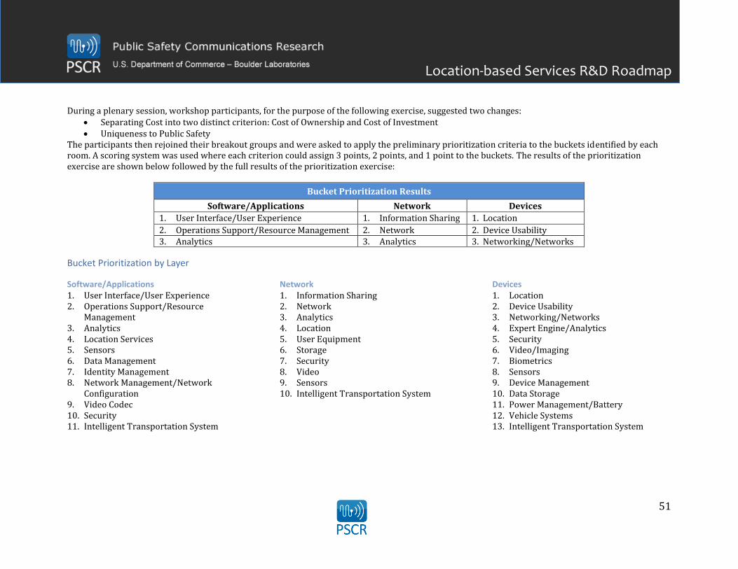
51
Location-based Services R&D Roadmap During a plenary session, workshop participants, for the purpose of the following exercise, suggested two changes:
Separating Cost into two distinct criterion: Cost of Ownership and Cost of Investment Uniqueness to Public Safety
The participants then rejoined their breakout groups and were asked to apply the preliminary prioritization criteria to the buckets identified by each room. A scoring system was used where each criterion could assign 3 points, 2 points, and 1 point to the buckets. The results of the prioritization exercise are shown below followed by the full results of the prioritization exercise:
Bucket Prioritization Results
Software/Applications Network Devices
1. User Interface/User Experience 1. Information Sharing 1. Location
2. Operations Support/Resource Management 2. Network 2. Device Usability 3. Analytics 3. Analytics 3. Networking/Networks
Bucket Prioritization by Layer
Software/Applications 1. User Interface/User Experience 2. Operations Support/Resource
Management 3. Analytics 4. Location Services 5. Sensors 6. Data Management 7. Identity Management 8. Network Management/Network
Configuration 9. Video Codec 10. Security 11. Intelligent Transportation System
Network 1. Information Sharing 2. Network 3. Analytics 4. Location 5. User Equipment 6. Storage 7. Security 8. Video 9. Sensors 10. Intelligent Transportation System
Devices 1. Location 2. Device Usability 3. Networking/Networks 4. Expert Engine/Analytics 5. Security 6. Video/Imaging 7. Biometrics 8. Sensors 9. Device Management 10. Data Storage 11. Power Management/Battery 12. Vehicle Systems 13. Intelligent Transportation System
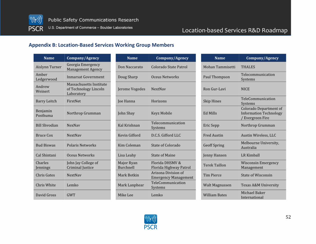
52
Location-based Services R&D Roadmap
Appendix B: Location-Based Services Working Group Members
Name Company/Agency Name Company/Agency Name Company/Agency
Aislynn Turner Georgia Emergency Management Agency
Don Naccarato Colorado State Patrol
Mohan Tammisetti THALES
Amber Ledgerwood
Inmarsat Government
Doug Sharp Oceus Networks
Paul Thompson Telecommunication Systems
Andrew Weinert
Massachusetts Institute of Technology Lincoln Laboratory
Jerome Vogedes NextNav
Ron Gur-Lavi NICE
Barry Leitch FirstNet
Joe Hanna Horizons
Skip Hines TeleCommunication Systems
Benjamin Posthuma
Northrop Grumman
John Shay Keyz Mobile
Ed Mills Colorado Department of Information Technology / Evergreen Fire
Bill Shvodian NexNav
Kal Krishnan Telecommunication Systems
Eric Sepp Northrop Grumman
Bruce Cox NextNav
Kevin Gifford D.C.S. Gifford LLC
Fred Austin Austin Wireless, LLC
Bud Biswas Polaris Networks
Kim Coleman State of Colorado
Geoff Spring Melbourne University, Australia
Cal Shintani Oceus Networks
Lisa Leahy State of Maine
Jenny Hansen LR Kimball
Charles Jennings
John Jay College of Criminal Justice
Major Ryan Burchnell
Florida DHSMV & Florida Highway Patrol
Terek Taillon
Wisconsin Emergency Management
Chris Gates NextNav
Mark Botkin Arizona Division of Emergency Management
Tim Pierce State of Wisconsin
Chris White Lemko
Mark Lanphear TeleCommunication Systems
Walt Magnussen Texas A&M University
David Gross GWT
Mike Lee Lemko
William Bates Michael Baker International

53
Location-based Services R&D Roadmap
Appendix D: References 1. i Garcia, M., & Bray, O. (1997, April 1). Fundamentals of Technology Roadmapping. Retrieved January 15, 2014, from
http://prod.sandia.gov/techlib/access-control.cgi/1997/970665.pdf 2. ii Technology Roadmapping: A Guide for Government Employees. (2003, February 23). Retrieved July 1, 2014, from
https://www.ic.gc.ca/eic/site/trm-crt.nsf/vwapj/guide_employees-guide_fonctionnaires_eng.pdf/$FILE/guide_employees-guide_fonctionnaires_eng.pdf
3. iii McConnaughey, P. (n.d.). DRAFT - Launch Propulsion Systems Roadmap. National Aeronautics & Space Administration. Retrieved March 1, 2014, from http://www.nasa.gov/pdf/500393main_TA01-LaunchPropulsion-DRAFT-Nov2010-A.pdf
4. iv Garcia, M. (1997, April 1). Introduction to technology roadmapping: The semiconductor industry association`s technology roadmapping process. Retrieved January 15, 2014, from http://www.osti.gov/scitech/biblio/471349
5. v Garcia, M., & Bray, O. (1997, April 1). Fundamentals of Technology Roadmapping. Retrieved January 15, 2014, from http://prod.sandia.gov/techlib/access-control.cgi/1997/970665.pdf
6. vi Beck, D., Boyack,, K., Siemens, W., & Bray, O. (1999, January 1). Bringing the Fuzzy Front End into Focus. Retrieved January 15, 2014, from http://pscrroadmap.wikispaces.com/file/view/Knowledge Mapping - VxInsight.pdf/515965176/Knowledge Mapping - VxInsight.pdf
7. vii Driving Technological Surprise: DARPA’s Mission in a Changing World. (2013, April 1). Retrieved February 1, 2014, from www.darpa.mil/workarea/downloadasset.aspx?id=2147486475
8. viii Foresight Vehicle Technology Roadmap 1.0: Technology and Research Directions for Future Road Vehicles (Version 1.0). (2004, January 1). Retrieved January 15, 2014.
9. ix Foresight Vehicle Technology Roadmap 2.0: Technology and Research Directions for Future Road Vehicles (Version 2.0). (2010, January 1). Retrieved February 1, 2014.
10. x Kostoff, R., & Schaller, R. (2002, August 7). Science & Technology Roadmaps - Transactions on Engineering Management. IEEE Xplore Digital Library. Retrieved March 15, 2014.
11. xi Garcia, M. (1997, April 1). Introduction to technology roadmapping: The semiconductor industry association`s technology roadmapping process. Retrieved January 15, 2014, from http://www.osti.gov/scitech/biblio/471349
12. xii Walsh, S. (2004). Technological Forecasting and Social Change. 71(1), 161-185(25). Retrieved March 1, 2014, from http://www.sciencedirect.com/science/article/pii/S004016250300129X
13. xiii Phaal, R., Farrukh, C., & Probert, D. (2003). Technology roadmapping—A planning framework for evolution and revolution. Science Direct - Technological Forecasting & Social Chang, 71, 5-26. Retrieved March 15, 2014, from http://www.alvarestech.com/temp/PDP2011/emc6605.ogliari.prof.ufsc.br/Restrito/PHAAL.pdf
14. xiv Common Fund Strategic Planning and Program Lifecycle. (2014, January 1). Retrieved May 1, 2014, from http://commonfund.nih.gov/planningactivities/overview-planning

54
Location-based Services R&D Roadmap
15. xv Technology Roadmapping: A Guide for Government Employees. (2003, February 23). Retrieved July 1, 2014, from https://www.ic.gc.ca/eic/site/trm-crt.nsf/vwapj/guide_employees-guide_fonctionnaires_eng.pdf/$FILE/guide_employees-guide_fonctionnaires_eng.pdf
16. xvi National Incident Management System, An Overview. Presentation from Al Fluman, Acting Director, Incident Management Systems Division (IMSD), National Integration Center. Retrieved January 13, 2015, from https://training.fema.gov/hiedu/07conf/presentation/monday%20-%20nims%20overview.ppt
17. xvii National Incident Management System, An Overview. Presentation from Al Fluman, Acting Director, IMSD (IMSD), National Integration Center. Retrieved January 13, 2015, from https://training.fema.gov/hiedu/07conf/presentation/monday%20-%20nims%20overview.ppt
18. xviii Defining Public Safety Grade Systems and Facilities. (2014, May 22). The National Public Safety Telecommunications Council. Retrieved January 21, 2015, from http://www.npstc.org/download.jsp?tableId=37&column=217&id=3066&file=Public_Safety_Grade_Report_140522.pdf
19. xix Defining Public Safety Grade Systems and Facilities. (2014, May 22). The National Public Safety Telecommunications Council. Retrieved January 21, 2015, from http://www.npstc.org/download.jsp?tableId=37&column=217&id=3066&file=Public_Safety_Grade_Report_140522.pdf
20. xx About NICS. (2011, October 1). The NICS Help Site. Massachusetts Institute of Technology - Lincoln Laboratory. Retrieved January 16, 2015, from https://public.nics.ll.mit.edu/nicshelp/articles/about.php
21. xxi Multi Agency Incident Transfer: Draft Schema for Your Comments. (2014, October 1). British Association of Public Safety Communications Officials. Retrieved January 21, 2015, from http://mait.org.uk/
22. xxii (2013, April 13). Retrieved January 21, 2015, from https://sageearth.northcom.mil/sageweb/ 23. xxiii About 3GGP. (2007, January 1). Retrieved January 21, 2015, from http://www.3gpp.org/about-3gpp 24. xxiv 3GPP active work programme. (2014, June 16). Retrieved January 26, 2015, from
http://www.3gpp.org/DynaReport/FeatureOrStudyItemFile-640018.htm
25. xxv Graf, T. (2012, January 1). Power-efficient Positioning Technologies for Mobile Devices. SNET Seminar 2011/2012. The Berlin University of Technology. Retrieved January 21, 2015, from https://www.snet.tu-berlin.de/fileadmin/fg220/courses/WS1112/snet-project/power-efficient-positioning-technologies_graf.pdf
26. xxvi Kjærgaard, M. (2011, December 26). Minimizing the Power Consumption of Location-Based Services on Mobile Phones. Retrieved January 15, 2015, from http://nsc.sharif.ir/courses/92-93/1/ce741-1/resources/root/Slides/Lec08-LocationingPowerMinimization-PervasiveComputing10.pdf
27. xxvii (2014, December 6). Indoor Positioning Standards Update. Lecture conducted from NextNav and the National Public Safety Telecommunications Council.
28. xxviii Statement of Requirements for Public Safety Communications & Interoperability (Version 1.1). (2006, January 26). Department of Homeland Security - SAFECOM Program. Retrieved January 20, 2015, from http://www.emsa.ca.gov/Media/Default/PDF/sorv1.pdf
29. xxix Defining Public Safety Grade Systems and Facilities. (2014, May 22). The National Public Safety Telecommunications Council. Retrieved January 21, 2015, from http://www.npstc.org/download.jsp?tableId=37&column=217&id=3066&file=Public_Safety_Grade_Report_140522.pdf