android location based services -...
TRANSCRIPT

Android Location Based Services
24
Victor MatosCleveland State University
Notes are based on: Android Developers
http://developer.android.com/index.html

222
24. Android - Location Services
Location Services
2
IntroductionA location-based service (LBS) is an information dissemination system that can be accessed by mobile devices through the mobile network. It is driven by the ability of the system to detect the geographical position of the mobile device.

333
24. Android - Location Services
Location Services
3
IntroductionLocation Based Services are used in a variety of situations, such as
commercial, entertainment, emergency, health, work, personal life, etc.
Examples:• Locate the nearest bank, restaurant, gas station, hotel, golf course,
hospital, police station, etc.
• Provide transportation information on how to go from ‘here’ to ‘there’.
• Social networking is used to locate and reach events, friends and family members.

444
24. Android - Location Services
Location Services
4
How the Global Positioning System (GPS) Works?
The Global Positioning System (GPS) consists of27 Earth-orbiting satellites (24 in operation and three extras in case one fails).
Developed by the USA as a military navigation system, but soon it opened to other civilian uses.
Each of these 3,000- to 4,000-pound solar-powered satellites circles the globe at about 12,000 miles (19,300 km), making two complete rotations every day.
The orbits are arranged so that at any time, anywhere on Earth, there are at least four satellites "visible" in the sky.
A GPS receiver's job is to locate three or more of these satellites, figure out the distance to each, and use this information to deduce its own location. This operation is based on a mathematical principle called trilateration.
Reference: http://electronics.howstuffworks.com/gadgets/travel/gps.htm

555
24. Android - Location Services
Location Services
5
How the Global Positioning System (GPS) Works?
2-D TrilaterationImagine you are somewhere in the United States and you are TOTALLY lost -- for whatever reason, you have absolutely no clue where you are. You find a friendly local and ask, "Where am I?" He says, "You are 625 miles from Boise, Idaho.“
You ask somebody else where you are, and she says, "You are 690 miles from Minneapolis, Minnesota." Now you have two circles that intersect. You now know that you must be at one of these two intersection points.
If a third person tells you that you are 615 miles from Tucson, Arizona, you can eliminate one of the possibilities. You now know exactly where you are -- Denver, Colorado.
This same concept works in three-dimensional space, as well, but you're dealing with spheres instead of circles.
Reference: http://electronics.howstuffworks.com/gadgets/travel/gps.htm

666
24. Android - Location Services
Location Services
6
How the Global Positioning System (GPS) Works? / Trilateration
--- Miami 1795 km--- Caracas 1874 km--- Bogota 1251 km
San Jose, CR

777
24. Android - Location Services
Location Services
7
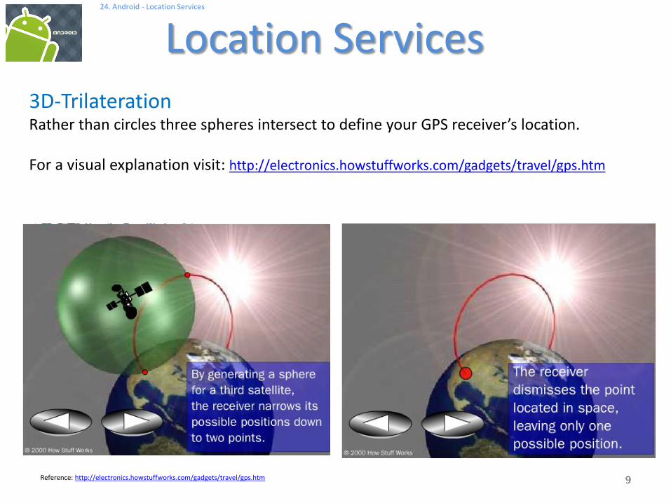
3D-TrilaterationRather than circles three spheres intersect to define your GPS receiver’s location.
For a visual explanation visit: http://electronics.howstuffworks.com/gadgets/travel/gps.htm
Reference: http://electronics.howstuffworks.com/gadgets/travel/gps.htm

888
24. Android - Location Services
Location Services
8
3D-TrilaterationRather than circles three spheres intersect to define your GPS receiver’s location.
For a visual explanation visit: http://electronics.howstuffworks.com/gadgets/travel/gps.htm
Reference: http://electronics.howstuffworks.com/gadgets/travel/gps.htm
999
24. Android - Location Services
Location Services
9
3D-TrilaterationRather than circles three spheres intersect to define your GPS receiver’s location.
For a visual explanation visit: http://electronics.howstuffworks.com/gadgets/travel/gps.htm
Reference: http://electronics.howstuffworks.com/gadgets/travel/gps.htm

101010
24. Android - Location Services
Location Services
10
Cell Tower TriangulationAn alternative method to determine the location of a cell phone is to estimate its distance to three nearby cell towers.
Distance of the phone to each antenna could be estimated based upon the lag time between the moment the tower sends a ping to the phone and receives the answering ping back.
Quite similar to the 2D-Trilateration Method.
Reference: http://searchengineland.com/cell-phone-triangulation-accuracy-is-all-over-the-map-14790

111111
24. Android - Location Services
Location Services
11
Latitude & LongitudeLatitude in GPS-Decimal notation: +90.00000 (North) to -90.000000 (South)Longitude GPS-Decimal notation: +180.000000 (East) to -180.000000 (West)

121212
24. Android - Location Services
Location Services
12
Android Location Classes
The Android API provides Location data based on a variety of methods including: Cell Tower Triangulation, and most commonly GPS chip readings.
GPS is the most common location provider on the Android based phones.
It offers the most accuracy.
Picture: Epson Infineon GPS (2.8 x 2.9mm)
Reference: http://gizmodo.com/5152146/
131313
24. Android - Location Services
Location Services
13
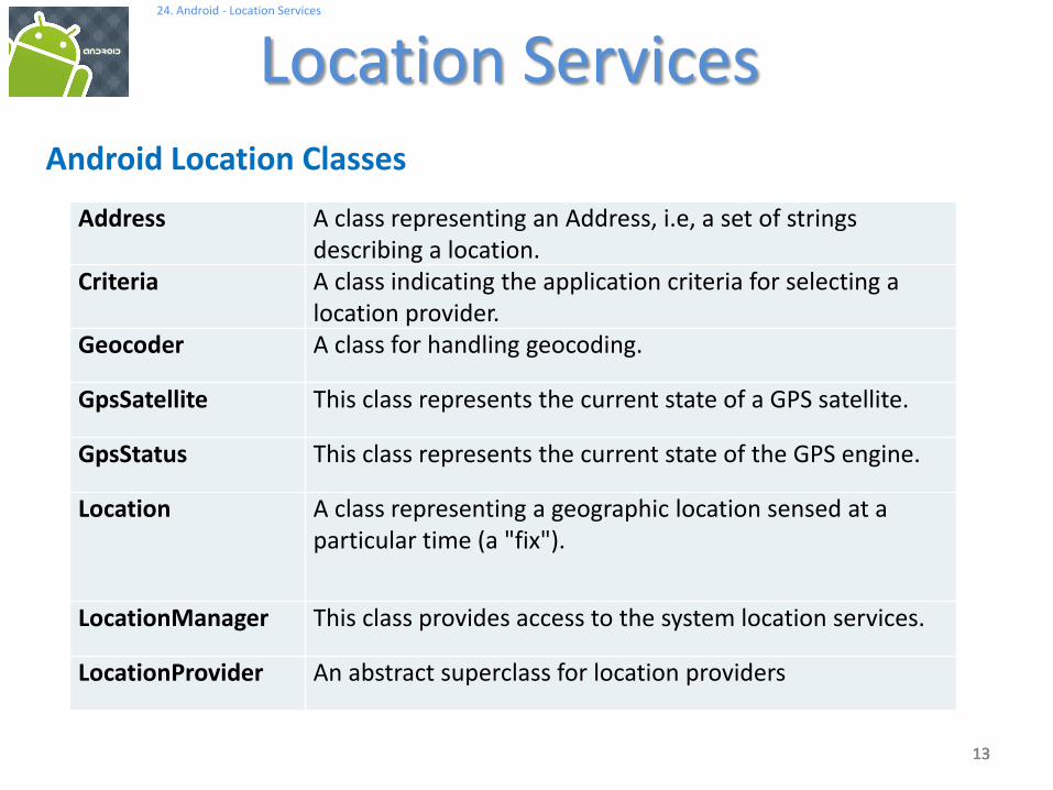
Android Location Classes
Address A class representing an Address, i.e, a set of strings describing a location.
Criteria A class indicating the application criteria for selecting a location provider.
Geocoder A class for handling geocoding.
GpsSatellite This class represents the current state of a GPS satellite.
GpsStatus This class represents the current state of the GPS engine.
Location A class representing a geographic location sensed at a particular time (a "fix").
LocationManager This class provides access to the system location services.
LocationProvider An abstract superclass for location providers

141414
24. Android - Location Services
Location Services
14
Android Location Interfaces
GpsStatus.Listener Used for receiving notifications when GPS status has changed.
GpsStatus.NmeaListener Used for receiving NMEA sentences from the GPS.
LocationListener Used for receiving notifications from the LocationManager when the location has changed.

151515
24. Android - Location Services
Location Services
15
Location Class• A class representing a geographic location sensed at a particular time (a
"fix"). • A location consists of a latitude and longitude, a UTC timestamp and
optionally information on altitude, speed, and bearing. • Information specific to a particular provider or class of providers may be
communicated to the application using getExtras, which returns a Bundle of key/value pairs.
• Each provider will only provide those entries for which information is available.
CONSTANTS
Location.FORMAT_DEGREES Constant used to specify formatting of a latitude or longitude in the form [+-]DDD.DDDDD where D
indicates degrees.
Location.FORMAT_MINUTES Constant used to specify formatting of a latitude or longitude in the form "[+-]DDD:MM.MMMMM" where
D indicates degrees and M indicates minutes of arc (1 minute = 1/60th of a degree).
Location.FORMAT_SECONDS Constant used to specify formatting of a latitude or longitude in the form “[+-] DDD:MM:SS.SSSSS"
where D indicates degrees, M indicates minutes of arc, and S indicates seconds of arc (1 minute = 1/60th
of a degree, 1 second = 1/3600th of a degree).

161616
24. Android - Location Services
Location Services
16
Location Class – Useful Methods
static
void
distanceBetween (double startLatitude, double startLongitude, double endLatitude, double endLongitude,
float[] results)
Computes the approximate distance in meters between two locations, and optionally the initial and final bearings of
the shortest path between them.
float getAccuracy ()
Returns the accuracy of the fix in meters.
double getAltitude ()
Returns the altitude of this fix.
float getBearing ()
Returns the direction of travel in degrees East of true North.
Bundle getExtras ()
Returns additional provider-specific information about the location fix as a Bundle.
double getLatitude ()
Returns the latitude of this fix.
double getLongitude ()
Returns the longitude of this fix.
String getProvider ()
Returns the name of the provider that generated this fix, or null if it is not associated with a provider.
float getSpeed ()
Returns the speed of the device over ground in meters/second.
long getTime ()
Returns the UTC time of this fix, in milliseconds since January 1, 1970.
171717
24. Android - Location Services
Location Services
17
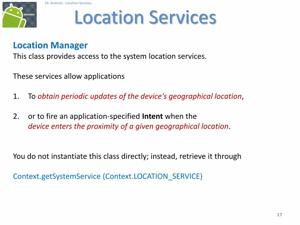
Location ManagerThis class provides access to the system location services.
These services allow applications
1. To obtain periodic updates of the device's geographical location,
2. or to fire an application-specified Intent when the device enters the proximity of a given geographical location.
You do not instantiate this class directly; instead, retrieve it through
Context.getSystemService (Context.LOCATION_SERVICE)

181818
24. Android - Location Services
Location Services
18
Location Manager – Useful Methodsvoid addProximityAlert (double latitude, double longitude, float radius, long expiration, PendingIntent intent)
Sets a proximity alert for the location given by the position (latitude, longitude) and the given radius.
String getBestProvider (Criteria criteria, boolean enabledOnly)
Returns the name of the provider that best meets the given criteria.
GpsStatus getGpsStatus (GpsStatus status)
Retrieves information about the current status of the GPS engine.
Location getLastKnownLocation (String provider)
Returns a Location indicating the data from the last known location fix obtained from the given provider.
LocationProvider getProvider (String name)
Returns information associated with the location provider of the given name, or null if no provider exists by that name.
List<String> getProviders (Criteria criteria, boolean enabledOnly)
Returns a list of the names of LocationProviders that satisfy the given criteria, or null if none do.
void requestLocationUpdates (String provider, long minTime, float minDistance, PendingIntent intent)
Registers the current activity to be notified periodically by the named provider.
void requestLocationUpdates (String provider, long minTime, float minDistance, LocationListener listener)
Registers the current activity to be notified periodically by the named provider.
void setTestProviderStatus (String provider, int status, Bundle extras, long updateTime)
Sets mock status values for the given provider.

191919
24. Android - Location Services
Location Services
19
LocationListener Class
Used for receiving notifications from the LocationManager when the locationhas changed.
These methods are called if the LocationListener has been registered with the location manager service using the method:
requestLocationUpdates (Provider, minTime, minDistance, LocationListener)

202020
24. Android - Location Services
Location Services
20
LocationListener Class – Useful Methods
abstract void onLocationChanged (Location location)
Called when the location has changed.
abstract void onProviderDisabled (String provider)
Called when the provider is disabled by the user.
abstract void onProviderEnabled (String provider)
Called when the provider is enabled by the user.
abstract void onStatusChanged (String provider, int status, Bundle extras)
Called when the provider status changes.
Public Methods
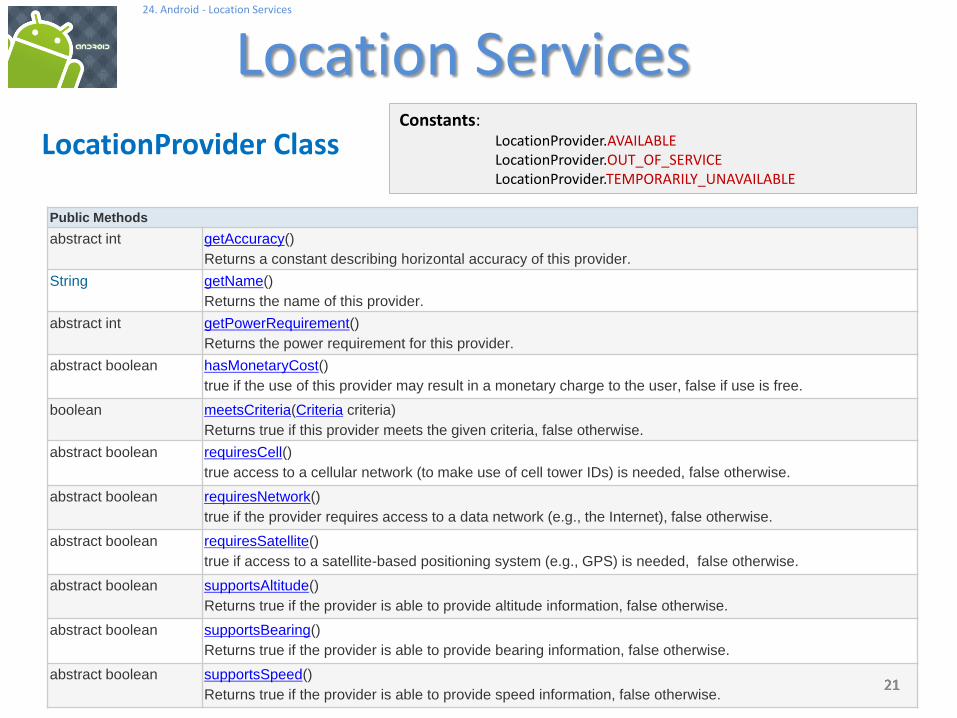
abstract int getAccuracy()
Returns a constant describing horizontal accuracy of this provider.
String getName()
Returns the name of this provider.
abstract int getPowerRequirement()
Returns the power requirement for this provider.
abstract boolean hasMonetaryCost()
true if the use of this provider may result in a monetary charge to the user, false if use is free.
boolean meetsCriteria(Criteria criteria)
Returns true if this provider meets the given criteria, false otherwise.
abstract boolean requiresCell()
true access to a cellular network (to make use of cell tower IDs) is needed, false otherwise.
abstract boolean requiresNetwork()
true if the provider requires access to a data network (e.g., the Internet), false otherwise.
abstract boolean requiresSatellite()
true if access to a satellite-based positioning system (e.g., GPS) is needed, false otherwise.
abstract boolean supportsAltitude()
Returns true if the provider is able to provide altitude information, false otherwise.
abstract boolean supportsBearing()
Returns true if the provider is able to provide bearing information, false otherwise.
abstract boolean supportsSpeed()
Returns true if the provider is able to provide speed information, false otherwise.21212121
24. Android - Location Services
Location Services
21
LocationProvider ClassConstants:
LocationProvider.AVAILABLELocationProvider.OUT_OF_SERVICELocationProvider.TEMPORARILY_UNAVAILABLE

22222222
24. Android - Location Services
Location Services
22
LocationProvider Class
An abstract superclass for location providers.
A location provider supplies periodic reports on the geographical location of the device.
Each provider has a set of criteria under which it may be used; for example, some providers require GPS hardware and visibility to a number of satellites; others require the use of the cellular radio, or access to a specific carrier's network, or access to the internet.
They may also have different battery consumption characteristics or monetary costs to the user.
The Criteria class allows providers to be selected based on user-specified criteria.

232323
24. Android - Location Services
Location Services
23
Example – Obtain Location from GPS .In this example we request GPS services and display latitude and longitudevalues on the UI. Additionally we deliver an SMS with this information.
Notes1. Observe the GPS chip is not a synchronous device that will immediately respond to a
“give me a GPS reading” call.
1. In order to engineer a good solution that takes into account the potential delays in obtaining location data we place the UI in the main activity and the request for location call in a background service.
2. Remember the service runs in the same process space as the main activity, therefore for the sake of responsiveness we must place the logic for location data request in a separate parallel thread.
3. A thread (unlike an Activity) needs the presence of a Looper control to manage IPC message sending. This implies and additional Looper.prepare and Looper.loop methods surrounding the locationUpdate method.

242424
24. Android - Location Services
Location Services
24
Example – Obtain Location from GPS

252525
24. Android - Location Services
Location Services
25
Example – Obtain Location from GPS .
Use the DDMS > Emulator Control panel to enter test data reflecting Latitudeand Longitude.
Select emulator 5554.
Press the ‘Send’ button to transmit the data.
A text message will be sent to a second emulator (5556)
5554
5556
262626
24. Android - Location Services
Location Services
26
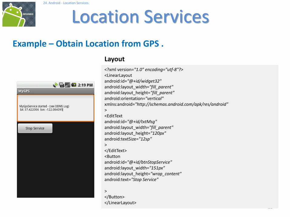
Example – Obtain Location from GPS .
<?xml version="1.0" encoding="utf-8"?><LinearLayoutandroid:id="@+id/widget32"android:layout_width="fill_parent"android:layout_height="fill_parent"android:orientation="vertical"xmlns:android="http://schemas.android.com/apk/res/android"><EditTextandroid:id="@+id/txtMsg"android:layout_width="fill_parent"android:layout_height="120px"android:textSize="12sp"></EditText><Buttonandroid:id="@+id/btnStopService"android:layout_width="151px"android:layout_height="wrap_content"android:text="Stop Service"
></Button></LinearLayout>
Layout

272727
24. Android - Location Services
Location Services
27
Example – Obtain Location from GPS .
<?xml version="1.0" encoding="utf-8"?>
<manifest xmlns:android="http://schemas.android.com/apk/res/android"
package="cis493.mappinggps"
android:versionCode="1"
android:versionName="1.0">
<application
android:icon="@drawable/icon"
android:label="@string/app_name"
android:debuggable="true" >
<activity android:name=".MyGPS"
android:label="@string/app_name">
<intent-filter>
<action android:name="android.intent.action.MAIN" />
<category android:name="android.intent.category.LAUNCHER" />
</intent-filter>
</activity>
<service
android:name="MyGpsService">
</service>
</application>
<uses-sdk android:minSdkVersion="2" />
<uses-permission android:name="android.permission.SEND_SMS" />
<uses-permission android:name="android.permission.ACCESS_FINE_LOCATION" />
</manifest>
Manifest

282828
24. Android - Location Services
Location Services
28
Example – Obtain Location from GPS .
// Request GPS location, show lat & long, deliver a text-message
// Application logic and its BroadcastReceiver in the same class
package cis493.mappinggps;
import android.app.Activity;
import android.os.Bundle;
import android.content.BroadcastReceiver;
import android.content.ComponentName;
import android.content.Context;
import android.content.Intent;
import android.content.IntentFilter;
import android.telephony.gsm.SmsManager;
import android.util.Log;
import android.view.View;
import android.view.View.OnClickListener;
import android.widget.*;
Main Activity: MyGPS

292929
24. Android - Location Services
Location Services
29
Example – Obtain Location from GPS .
public class MyGPS extends Activity {
Button btnStopService;
TextView txtMsg;
Intent intentMyService;
ComponentName service;
BroadcastReceiver receiver;
String GPS_FILTER = "cis493.action.GPS_LOCATION";
Main Activity: MyGPS

303030
24. Android - Location Services
Location Services
30
Example – Obtain Location from GPS .
@Override
public void onCreate(Bundle savedInstanceState) {
super.onCreate(savedInstanceState);
setContentView(R.layout.main);
txtMsg = (TextView) findViewById(R.id.txtMsg);
// initiate the service
intentMyService = new Intent(this, MyGpsService.class);
service = startService(intentMyService);
txtMsg.setText("MyGpsService started - (see DDMS Log)");
// register & define filter for local listener
IntentFilter mainFilter = new IntentFilter(GPS_FILTER);
receiver = new MyMainLocalReceiver();
registerReceiver(receiver, mainFilter);
Main Activity: MyGPS

313131
24. Android - Location Services
Location Services
31
Example – Obtain Location from GPS .
btnStopService = (Button) findViewById(R.id.btnStopService);
btnStopService.setOnClickListener(new OnClickListener() {
public void onClick(View v) {
try {
stopService(new Intent(intentMyService) );
txtMsg.setText("After stoping Service: \n" +
service.getClassName());
btnStopService.setText("Finished");
btnStopService.setClickable(false);
} catch (Exception e) {
Log.e("MYGPS", e.getMessage() );
}
}
});
}//onCreate
Main Activity: MyGPS

323232
24. Android - Location Services
Location Services
32
Example – Obtain Location from GPS .
////////////////////////////////////////////////////////////////////////
@Override
protected void onDestroy() {
super.onDestroy();
try {
stopService(intentMyService);
unregisterReceiver(receiver);
} catch (Exception e) {
Log.e ("MAIN-DESTROY>>>", e.getMessage() );
}
Log.e ("MAIN-DESTROY>>>" , "Adios" );
}// onDestroy
Main Activity: MyGPS

333333
24. Android - Location Services
Location Services
33
Example – Obtain Location from GPS .
//////////////////////////////////////////////////////////////////////
// local RECEIVER
private class MyMainLocalReceiver extends BroadcastReceiver {
@Override
public void onReceive(Context localContext, Intent callerIntent) {
double latitude = callerIntent.getDoubleExtra("latitude",-1);
double longitude = callerIntent.getDoubleExtra("longitude",-1);
Log.e ("MAIN>>>", Double.toString(latitude));
Log.e ("MAIN>>>", Double.toString(longitude));
String msg = " lat: " + Double.toString(latitude) + " "
+ " lon: " + Double.toString(longitude);
txtMsg.append("\n" + msg);
//testing the SMS-texting feature
texting(msg);
}
}//MyMainLocalReceiver
Main Activity: MyGPS

343434
24. Android - Location Services
Location Services
34
Example – Obtain Location from GPS .
//////////////////////////////////////////////////////////////
// sending a TEXT MESSAGE
private void texting(String msg){
try {
SmsManager smsMgr = SmsManager.getDefault();
// Parameter of sendTextMessage are:
// destinationAddress, senderAddress,
// text, sentIntent, deliveryIntent)
//----------------------------------------------------------
smsMgr.sendTextMessage("5556", "5551234",
"Please meet me at: " + msg,
null, null);
} catch (Exception e) {
Toast.makeText(this, "texting\n" + e.getMessage(), 1).show();
}
}// texting
}//MyGPS
Main Activity: MyGPS

353535
24. Android - Location Services
Location Services
35
Example – Obtain Location from GPS .
// This is the GPS service. Requests location updates
// in a parallel thread. sends broadcast using filter.
package cis493.mappinggps;
import android.app.Service;
import android.content.Context;
import android.content.Intent;
import android.location.Location;
import android.location.LocationListener;
import android.location.LocationManager;
import android.os.Bundle;
import android.os.IBinder;
import android.os.Looper;
import android.util.Log;
import android.widget.Toast;
public class MyGpsService extends Service {
String GPS_FILTER = "cis493.action.GPS_LOCATION";
Thread triggerService;
LocationManager lm;
GPSListener myLocationListener;
boolean isRunning = true;
Main Activity: MyGpsService

363636
24. Android - Location Services
Location Services
36
Example – Obtain Location from GPS .
@Override
public IBinder onBind(Intent arg0) {
return null;
}
@Override
public void onCreate() {
super.onCreate();
}
@Override
public void onStart(Intent intent, int startId) {
super.onStart(intent, startId);
Log.e("<<MyGpsService-onStart>>", "I am alive-GPS!");
// we place the slow work of the service in its own thread so the
// response we send our caller who run a "startService(...)" method
// gets a quick OK from us.
Main Activity: MyGpsService

373737
24. Android - Location Services
Location Services
37
Example – Obtain Location from GPS .
triggerService = new Thread(new Runnable() {
public void run() {
try {
Looper.prepare();
// try to get your GPS location using the LOCATION.SERVIVE provider
lm = (LocationManager) getSystemService(Context.LOCATION_SERVICE);
// This listener will catch and disseminate location updates
myLocationListener = new GPSListener();
long minTime = 10000; // frequency update: 10 seconds
float minDistance = 50; // frequency update: 50 meter
lm.requestLocationUpdates( //request GPS updates
LocationManager.GPS_PROVIDER,
minTime,
minDistance,
myLocationListener);
Looper.loop();
} catch (Exception e) {
Log.e("MYGPS", e.getMessage() );
}
}// run
});
triggerService.start();
}// onStart
Main Activity: MyGpsServive

383838
24. Android - Location Services
Location Services
38
Example – Obtain Location from GPS .
/////////////////////////////////////////////////////////////////////////
// location listener becomes aware of the GPS data and sends a broadcast
private class GPSListener implements LocationListener {
public void onLocationChanged(Location location) {
//capture location data sent by current provider
double latitude = location.getLatitude();
double longitude = location.getLongitude();
//assemble data bundle to be broadcasted
Intent myFilteredResponse = new Intent(GPS_FILTER);
myFilteredResponse.putExtra("latitude", latitude);
myFilteredResponse.putExtra("longitude", longitude);
Log.e(">>GPS_Service<<", "Lat:" + latitude + " lon:" + longitude);
//send the location data out
sendBroadcast(myFilteredResponse);
}
Main Activity: MyGpsServive

393939
24. Android - Location Services
Location Services
39
Example – Obtain Location from GPS .
public void onProviderDisabled(String provider) {
}
public void onProviderEnabled(String provider) {
}
public void onStatusChanged(String provider,
int status, Bundle extras) {
}
};//GPSListener class
}// MyService3
Main Activity: MyGpsServive
Part of the listener’s interface

404040
24. Android - Location Services
Location Services
40
GeoCoding: From Street-Address to Coordinates
Geocoder gc = new Geocoder (this);
// get decimal coordinates for up to 5 (best) matching locations
List<Address> lstFoundAddresses = gc.getFromLocationName (txtStreetAddress, 5);
TODOWhat is a GeoCoder?Explain example 25-GeoPoints

414141
24. Android - Location Services
Location Services
41
Reverse GeoCoding: From Coordinates to Street-Address
Geocoder gc = new Geocoder(context, Locale.US);
List<Address> streets = gc.getFromLocation (latitude, longitude, 1);
TODOExplain example 25-GeoCoordinates

424242
24. Android - Location Services
Location Services
42
Multiple Overlays – Normal & Long Tap
TODOExplain example 25-MapCleveland
4343
24. Android - Location Services
Location Services
43
JARGON:
Bearingis the angle (East-ward) between a line connecting two points (source, destination) and a north-
south line, or meridian.
NMEA (National Marine Electronics Association)The NMEA 2000 standard contains the requirements for the minimum implementation of a
serial-data communications network to interconnect marine electronic equipment onboard vessels. Equipment designed to this standard will have the ability to share data, including commands and status, with other compatible equipment over a single signaling channel. Reference: http://www.nmea.org/content/nmea_standards/white_papers.asp
UTC - Coordinated Universal TimeIs a time standard based on International Atomic Time (TAI) with leap seconds added at
irregular intervals to compensate for the Earth's slowing rotation.Visit: http://www.time.gov/timezone.cgi?Eastern/d/-5/java

4444
24. Android - Location Services
Location Services
44
Keyhole Markup LanguageUse Eclipse’s DDMS > Emulator Control > KML tab to provide location data to your emulator using a KML file.
Example: File my_location_data.kml contains the following set of placemarks
<?xml version="1.0" encoding="UTF-8"?><kml xmlns="http://earth.google.com/kml/2.2"><Placemark>
<name>Station 46027</name><description>Off the coast of Lake Earl</description><Point><coordinates>-124.38,41.85,0</coordinates></Point>
</Placemark><Placemark>
<name>Station 46020</name><description>Outside the Golden Gate</description><Point><coordinates>-122.83,37.75,0</coordinates></Point>
</Placemark><Placemark>
<name>Station 46222</name><description>San Pedro Channel</description><Point><coordinates>-118.31,33.61,0</coordinates></Point>
</Placemark></kml>
Example taken from:Unlocking Android by F. Ableson et al. Manning Publications 2009, ISBN 978-1-933988-67-

4545
24. Android - Location Services
Location Services
45
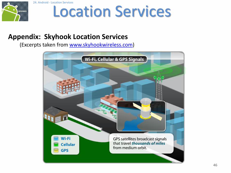
Appendix: Skyhook Location Services(Excerpts taken from www.skyhookwireless.com)
Skyhook's Core Engine is a software-only location system that quickly determines device location with 10 to 20 meter accuracy.
A mobile device with Skyhook's Core Engine collects raw data from each of the location sources (GPS, towers, wi-fi).
The Skyhook client then sends this data to the Location Server and a single location estimate is returned.
The client is optimized so that it communicates with the Location Server only when the location cannot be determined locally.
This behavior minimizes the user's data cost while maximizing battery life
4646
24. Android - Location Services
Location Services
46
Appendix: Skyhook Location Services(Excerpts taken from www.skyhookwireless.com)

4747
24. Android - Location Services
Location Services
47
Appendix: Skyhook Location Services(Excerpts taken from www.skyhookwireless.com)
Wi-Fi positioning performs best where GPS is weakest, in urban areas and indoors.
GPS provides highly accurate location results in "open sky" environments, like rural areas and on highways. But in urban areas and indoors, tall buildings and ceilings block GPS' view of satellites, resulting in serious performance deficiencies in time to first fix, accuracy and availability. GPS or A-GPS alone cannot provide fast and accurate location results in all environments.
Cell tower triangulation provides generalized location results with only 200 - 1000 meter accuracy. It serves as a coverage fallback when neither GPS nor Wi-Fi is available.
Skyhook maintains a worldwide database of cell tower locations, which increases Core Engine coverage area and helps improve GPS satellite acquisition time.

4848
24. Android - Location Services
Location Services
48
Appendix: Skyhook Location ServicesExample: Get coordinates and display a map showing current location.

4949
24. Android - Location Services
Location Services
49
Appendix: Skyhook Location ServicesExample: Get coordinates and display a map showing current location.
You need to download the Skyhook library WPSAPI.JARModify app path to include it

5050
24. Android - Location Services
Location Services
50
Appendix: Skyhook Location ServicesExample: Get coordinates and display a map showing current location.
<?xml version="1.0" encoding="utf-8"?>
<LinearLayout xmlns:android="http://schemas.android.com/apk/res/android"
android:id="@+id/linearLayout01"
android:orientation="vertical"
android:layout_width="fill_parent"
android:layout_height="fill_parent"
>
<EditText
android:id="@+id/txtBox"
android:layout_width="fill_parent"
android:layout_height="wrap_content"
android:text="Skyhooking... wait"
/>
<Button
android:text="Show Map"
android:id="@+id/btnMap"
android:layout_width="wrap_content"
android:layout_height="wrap_content"
android:padding="10px" />
</LinearLayout>
LAYOUT

5151
24. Android - Location Services
Location Services
51
Appendix: Skyhook Location ServicesExample: Get coordinates and display a map showing current location.
<?xml version="1.0" encoding="utf-8"?>
<manifest xmlns:android="http://schemas.android.com/apk/res/android"
package="cis493.skyhooklocation"
android:versionCode="1"
android:versionName="1.0">
<application android:icon="@drawable/sym_action_map2"
android:label="@string/app_name">
<activity android:name=".Skyhook_Location"
android:label="@string/app_name"
android:screenOrientation="portrait"
android:configChanges="orientation|keyboardHidden" >
<intent-filter>
<action android:name="android.intent.action.MAIN" />
<category android:name="android.intent.category.LAUNCHER" />
</intent-filter>
</activity>
</application>
<uses-sdk android:minSdkVersion="4" />
<!-- used to communicate with Skyhook's servers -->
<uses-permission android:name="android.permission.INTERNET" />
<!-- enables WiFi, if disabled, for the duration of a location request -->
<uses-permission android:name="android.permission.CHANGE_WIFI_STATE" />
<!-- used to obtain information about the WiFi environment -->
<uses-permission android:name="android.permission.ACCESS_WIFI_STATE" />
<!-- used to obtain cell tower ID -->
<uses-permission android:name="android.permission.ACCESS_COARSE_LOCATION" />
<uses-permission android:name="android.permission.ACCESS_COARSE_UPDATES" />
<!-- used to access GPS location, for XPS functionality -->
<uses-permission android:name="android.permission.ACCESS_FINE_LOCATION" />
<uses-permission android:name="android.permission.WAKE_LOCK" />
</manifest>
MANIFEST

5252
24. Android - Location Services
Location Services
52
Appendix: Skyhook Location ServicesExample: Get coordinates and display a map showing current location.// SKYHOOK_LOCATION.JAVA
// ------------------------------------------------------------------------
// Using the SKYHOOK system to 'quickly' get a GPS fix
// information available at: www.skyhookwireless.com
//
// Victor Matos - Nov 29, 2010
// ------------------------------------------------------------------------
package cis493.skyhooklocation;
import java.text.DateFormat;
import java.text.SimpleDateFormat;
import java.util.Date;
import java.util.TimeZone;
import android.app.Activity;
import android.app.ProgressDialog;
import android.content.Intent;
import android.content.res.Configuration;
import android.net.Uri;
import android.os.Bundle;
import android.os.Handler;
import android.os.Message;
import android.util.Log;
import android.view.MotionEvent;
import android.view.View;
import android.view.View.OnClickListener;
import android.view.View.OnTouchListener;
import android.widget.Button;
import android.widget.EditText;
import android.widget.Toast;
import com.skyhookwireless.wps.*;
Skyhook_Location

5353
24. Android - Location Services
Location Services
53
Appendix: Skyhook Location ServicesExample: Get coordinates and display a map showing current location.
public class Skyhook_Location extends Activity {
EditText txtBox;
Button btnShowMap;
ProgressDialog dialog;
double latitude, longitude, accuracy;
String time, address, ipAddress;
int nap, ncell;
String result;
IPLocation ipLocation;
WPSLocation wpsLocation;
IPLocationCallback ipCallback;
WPSLocationCallback wpsCallback;
// ------------------------------------------------------------------------------
// boolean usingEmulator = true; // generate code for the EMULATOR
boolean usingEmulator = true; // generate code for the DEVICE
// ------------------------------------------------------------------------------
// This handler receives messages sent by the asynchronous getIPLocation or
// getWPSLocation methods. The SKYHOOK callback method waits for the GPS hardware,
// tower triangulation method, or IP mapping to obtain location data. Finally
// the fix is placed in the handler's message queue.
// ------------------------------------------------------------------------------
Handler handler = new Handler(){
Skyhook_Location

5454
24. Android - Location Services
Location Services
54
Appendix: Skyhook Location ServicesExample: Get coordinates and display a map showing current location.
@Override
public void handleMessage(Message msg) {
super.handleMessage(msg);
if ((msg.arg1 > 360) && (msg.arg2 > 360)) {
// error situation
Toast.makeText(getApplicationContext(),
"Problem obtaining location\try agai...", 1).show();
finish();
}
result = "Skyhook Emulator:" + usingEmulator + "\n\n";
if (msg.obj.getClass().equals(IPLocation.class)) {
ipLocation = (IPLocation)msg.obj;
latitude = ipLocation.getLatitude();
longitude = ipLocation.getLongitude();
// showing results
result += "Latitude: " + latitude + "\n" +
"Longitude: " + longitude + "\n" +
"Time: " + beautify(ipLocation.getTime()) + "\n" +
"IP: " + ipLocation.getIP() + "\n";
}
else {
wpsLocation = (WPSLocation)msg.obj;
latitude = wpsLocation.getLatitude();
longitude = wpsLocation.getLongitude();
// showing results
result += "Latitude: " + latitude + "\n" +
"Longitude: " + longitude + "\n" +
"Time: " + beautify(wpsLocation.getTime()) + "\n" +
"Address: \n" + wpsLocation.getStreetAddress() + "\n" +
Skyhook_Location
5555
24. Android - Location Services
Location Services
55
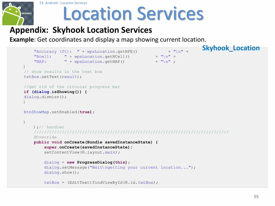
Appendix: Skyhook Location ServicesExample: Get coordinates and display a map showing current location.
"Accuracy (ft): " + wpsLocation.getHPE() + "\n" +
"Ncell: " + wpsLocation.getNCell() + "\n" +
"NAP: " + wpsLocation.getNAP() + "\n" ;
}
// show results in the text box
txtBox.setText(result);
//get rid of the circular progress bar
if (dialog.isShowing()) {
dialog.dismiss();
}
btnShowMap.setEnabled(true);
}
};// handler
/////////////////////////////////////////////////////////////////////////////
@Override
public void onCreate(Bundle savedInstanceState) {
super.onCreate(savedInstanceState);
setContentView(R.layout.main);
dialog = new ProgressDialog(this);
dialog.setMessage("Wait\ngetting your current location...");
dialog.show();
txtBox = (EditText)findViewById(R.id.txtBox);
Skyhook_Location

5656
24. Android - Location Services
Location Services
56
Appendix: Skyhook Location ServicesExample: Get coordinates and display a map showing current location.
txtBox.setOnTouchListener(new OnTouchListener() {
@Override
public boolean onTouch(View arg0, MotionEvent arg1) {
//TRUE to prevent virtual keyboard to be called
return true;
}
});
btnShowMap = (Button) findViewById(R.id.btnMap);
btnShowMap.setOnClickListener(new OnClickListener() {
@Override
public void onClick(View v) {
// show map centered around (latitude, longitude) just found
String geoPoint = "geo:" + latitude + "," + longitude + "?z=17";
Intent mapIntent = new Intent(Intent.ACTION_VIEW, Uri.parse(geoPoint));
startActivity(mapIntent);
}
});
btnShowMap.setEnabled(false);
//----------------------------------------------------------------------
// Create the authentication object
//----------------------------------------------------------------------
WPS wps = new WPS(getApplicationContext());
WPSAuthentication auth = new WPSAuthentication("v.matos", "csuohio");
Log.e("<<AUTHENTICATION>>", "after authentication...");
//----------------------------------------------------------------------
// Call the location function with a callback
// When using device G1 change to: getWPSLocation (usingEmulator = false)
// when using Emulator try: getIPLocation (usingEmulator = true)
//----------------------------------------------------------------------
Skyhook_Location

5757
24. Android - Location Services
Location Services
57
Appendix: Skyhook Location ServicesExample: Get coordinates and display a map showing current location.
if (usingEmulator) {
Log.e("<<MAIN GETLOCATION>>", "asking for IP services...");
ipCallback = (IPLocationCallback) new MyIPLocationCallback(handler);
wps.getIPLocation(auth,
WPSStreetAddressLookup.WPS_NO_STREET_ADDRESS_LOOKUP,
(IPLocationCallback) ipCallback);
}
else {
Log.e("<<MAIN GETLOCATION>>", "asking for WPS services...");
wpsCallback = (WPSLocationCallback) new MyWPSLocationCallback(handler);
wps.getLocation(auth,
//WPSStreetAddressLookup.WPS_NO_STREET_ADDRESS_LOOKUP,
WPSStreetAddressLookup.WPS_FULL_STREET_ADDRESS_LOOKUP,
(WPSLocationCallback) wpsCallback);
}
}//onCreate
Skyhook_Location

5858
24. Android - Location Services
Location Services
58
Appendix: Skyhook Location ServicesExample: Get coordinates and display a map showing current location.
// -----------------------------------------------------------------------------
private String beautify (double timeMillis){
String result = "";
DateFormat df = new SimpleDateFormat("HH ':' mm ':' ss ");
df.setTimeZone(TimeZone.getTimeZone("GMT-5"));
result = df.format(new Date((long) timeMillis));
int elapsed = (int) (System.currentTimeMillis() - timeMillis)/1000;
result += "\nElapsed Time: " + elapsed + " sec.";
return (result);
}
// -----------------------------------------------------------------------------
@Override
public void onConfigurationChanged(Configuration newConfig) {
super.onConfigurationChanged(newConfig);
// needed to stop restarting application when orientation
// changes (see manifest)
}
// -----------------------------------------------------------------------------
}//SkyhooDemo2
Skyhook_Location

5959
24. Android - Location Services
Location Services
59
Appendix: Skyhook Location ServicesExample: Get coordinates and display a map showing current location.
package cis493.skyhooklocation;
import android.os.Handler;import android.os.Message;import android.util.Log;import com.skyhookwireless.wps.WPSContinuation;import com.skyhookwireless.wps.WPSLocation;import com.skyhookwireless.wps.WPSReturnCode;
// working with a DEVICE such as G1 or NEXUS public class MyWPSLocationCallback implements com.skyhookwireless.wps.WPSLocationCallback{
Handler handler;public MyWPSLocationCallback (Handler handler){this.handler = handler;
}
// What the application should do after it's donepublic void done(){
// after done() returns, you can make more WPS calls.Log.e("<<DONE>>", "adios");
}
// What the application should do if an error occurspublic WPSContinuation handleError(WPSReturnCode error){
//handleWPSError(error); // you'll implement handleWPSError()Log.e("<<ERROR>>", "error in handleError " );
MyWPSLocationCallback

6060
24. Android - Location Services
Location Services
60
Appendix: Skyhook Location ServicesExample: Get coordinates and display a map showing current location.
Message msg = handler.obtainMessage();msg.arg1 = 777; //out of the range 0..360msg.arg2 = 888; //to be recognized as an errorhandler.sendMessage(msg);
// To retry the location call on error use WPS_CONTINUE,// otherwise return WPS_STOPreturn WPSContinuation.WPS_STOP;
}
// ----------------------------------------------------------------------public void handleWPSLocation(WPSLocation location) {
Log.e("<<WPS-LOCATION>>", "latitude: " + location.getLatitude());Log.e("<<WPS-LOCATION>>", "longitude: " + location.getLongitude());Log.e("<<WPS-LOCATION>>", "address: " + location.getStreetAddress());Log.e("<<WPS-LOCATION>>", "time: " + location.getTime() );Log.e("<<WPS-LOCATION>>", "altitude: " + location.getAltitude());Log.e("<<WPS-LOCATION>>", "Ncell: " + location.getNCell());Log.e("<<WPS-LOCATION>>", "accuracy: " + location.getHPE());
Message msg = handler.obtainMessage();msg.obj = (WPSLocation)location;handler.sendMessage(msg);}
};
MyWPSLocationCallback

6161
24. Android - Location Services
Location Services
61
Appendix: Skyhook Location ServicesExample: Get coordinates and display a map showing current location.
package cis493.skyhooklocation;
import android.os.Handler;import android.os.Message;import android.util.Log;import com.skyhookwireless.wps.IPLocation;import com.skyhookwireless.wps.WPSContinuation;import com.skyhookwireless.wps.WPSReturnCode;
// working with EMULATORpublic class MyIPLocationCallback implements com.skyhookwireless.wps.IPLocationCallback{
Handler handler;public MyIPLocationCallback (Handler handler){this.handler = handler;
}
// What the application should do after it's donepublic void done(){
// after done() returns, you can make more WPS calls.Log.e("<<DONE>>", "adios");
}
// What the application should do if an error occurspublic WPSContinuation handleError(WPSReturnCode error){
//handleWPSError(error); // you'll implement handleWPSError()Log.e("<<ERROR>>", "error in handleError " );
Message msg = handler.obtainMessage();
MyIPLocationCallback

6262
24. Android - Location Services
Location Services
62
Appendix: Skyhook Location ServicesExample: Get coordinates and display a map showing current location.
Message msg = handler.obtainMessage();msg.arg1 = 777; //out of the range 0..360msg.arg2 = 888; //to be recognized as an errorhandler.sendMessage(msg);
// To retry the location call on error use WPS_CONTINUE,// otherwise return WPS_STOPreturn WPSContinuation.WPS_STOP;
}
// ----------------------------------------------------------------------public void handleIPLocation(IPLocation location) {
Log.e("<<IP-LOCATION>>", "latitude: " + location.getLatitude());Log.e("<<IP-LOCATION>>", "longitude: " + location.getLongitude());Log.e("<<IP-LOCATION>>", "address: " + location.getStreetAddress());Log.e("<<IP-LOCATION>>", "time: " + location.getTime() );Log.e("<<IP-LOCATION>>", "altitude: " + location.getAltitude());Log.e("<<IP-LOCATION>>", "IP: " + location.getIP() );
Message msg = handler.obtainMessage();msg.obj = (IPLocation)location;handler.sendMessage(msg);}
};
MyIPLocationCallback