introduction · introduction this management area covers mona vale beach and basin beach, which are...
TRANSCRIPT

69
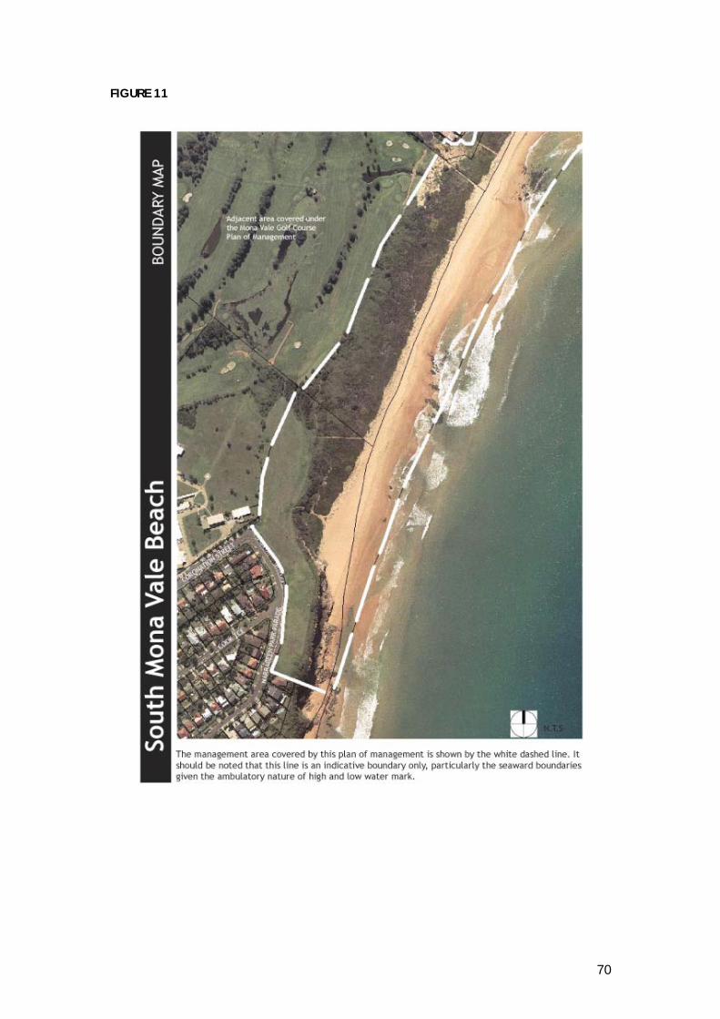
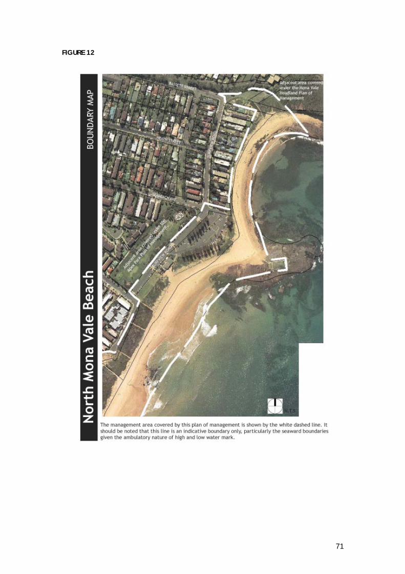
INTRODUCTION This management area covers Mona Vale Beach and Basin Beach, w hich are located along the coastal fringe of the southern Pittwater beachside suburb of Mona Vale. The northern boundary is Mona Vale Headland Reserve, w hich separates Basin Beach and Bungan Beach. The southern boundary is Mona Vale South Headland (Robert Dunn Reserve), w hich divides Mona Vale Beach from Warriewood Beach. Basin Beach is a small semi-circular beach at the northern end of the Mona Vale Beach and is utilised for a similar variety of recreational uses including swimming, surfing, snorkelling, w alking, and kite flying and is particularly popular with “body boarders”. Mona Vale Beach is one of Pittw ater’s most popular beaches given its prox imity to Mona Vale Road, a major arterial access from southern and western Sydney. Once adopted by Council, this plan of management will supersede the plan of management for Mona Vale Beach. Mona Vale Headland and Mona Vale South Headland (Robert Dunn Reserve) are managed by Pittw ater Council’s Natural Resources Unit and are covered by separate Plans of Management. The attached boundary maps (refer Figure 11 & 12) and the master plans for Mona Vale Beach show the area covered within this management area, illustrating the Reserve boundaries in relation to the surrounding locality and adjoining land uses. LAND TENURE, ADJOINING LANDHOLDINGS AND LAND CATEGORISATION Land Tenure The sand area of Mona Vale Beach and Basin Beach is vacant Crown Land reserved from sale or lease (Crown Sandy Beach including the rock pool). Mona Vale Beach and Basin Beach comprise both Crown and Council ow ned reserves:
- M ona Vale/Basin Beach Reserve (Reserve No. 130). Council Title (subject to Deed of Trust – DIPNR) Lot 5 DP 211456 Crow n Reserve know n as R45244, for which Council has been appointed trustee. Council ow ned land in Fee Simple Lot 104 DP 1066371 (92483) and Lot 3 DP 532435.
The road verges of Bassett Street, adjoining the Crow n Reserve R73168, known as Mona Vale Headland.
70
FIGURE 11
71
FIGURE 12

72
Adjoining Land Holdings The adjoining land uses are primarily open space. Two significant adjoining open spaces related to the Reserve are Apex Park and Mona Vale Golf Course, w hich are addressed in separate Plans of Management. Another major adjoining land holder/user is Mona Vale hospital, w hich is located off Coronation Street at the southern extent of the beach Reserve. Other land adjoining the beach Reserve is for residential use and roadways. Land Categorisation Refer to Figure 13, 14 & 15 for Categorisation Maps. General Community Use - covers the Mona Vale Beach Surf Club, the amenities block, the rock pool and the entire car park area. Park – This category has been applied to the areas of open space generally enjoyed for passive recreation. Natural Area (foreshore, escarpment) – These sub categories have been w idely applied to the beach and cliff face areas. CURRENT USES OF MONA VALE BEACH Building and Recreation Facilit ies The Mona Vale Beach Surf Life Saving Club is located on Mona Vale Beach and provides toilets, showers and change rooms. A separate amenities block, w hich is located in a prime beachfront location, also provides showers and toilets and is conveniently located for reserve users and serves the needs of the people accessing the rock pool, Basin Beach, the northern end of the main surfing beach, picnic facilities and adjacent grassed areas. Apex Park although not included in this plan of management services the beach area with BBQ facilities, picnic tables/chairs, covered children’s playground and children’s bike track. Located on the northern side of the amenities block, there are picnic benches with shelter, seating, outdoor showers, taps and bubblers available. Rock pool There is a 33-metre rock pool constructed on the rock platform, w hich separates Basin Beach from the main section of Mona Vale Beach. It consists of concrete walls and natural rock floor and uses the ex isting rock platform as an edge, making the pool somewhat unique in the Pittwater area. A children’s wading pool is adjacent to the main pool. A concrete path and handrail connects the pool to the beach area. Lighting is provided for night-time usage. Vehicular Access and parking There is a large sealed car parking area, w hich services the main surfing beach, the ocean rock pool, Basin Beach and Apex Park. At peak summer periods there is inadequate

73
space in the parking area, and visitors to the beach park their cars on adjacent local streets. Surfview Road is the main access road to the beachfront area, w hich includes the Surf Club area. The parking areas are subject to ‘Pay and Display’ vehicle parking payment system (Refer Section 5.3.2). This plan of management expressly authorises the charging of parking fees in accordance with Council’s Policy No. 18 – ‘Parking – Issue of Annual Permits’ (as determined by Council from time to time) by automated ticketed parking systems.

74
FIGURE 13

75
FIGURE 14

76
FIGURE 15
LEASES, LICENCES AND OTHER ESTATES Current

77
The only current lease on Mona Vale Beach is w ith the Mona Vale Surf Club commencing 19 July 1999 for a period of 21 years. Surf Schools are prohibited from the Basin area to the pool to the north of the Surf Club at Mona Vale Beach. However, there is a current licence agreement w ith two (2) surf schools, which are permitted to operate south of the rock pool at Mona vale and at Warriewood Beach only. Proposed This plan of management authorises the leasing, licensing or granting of any other estate over Mona Vale Beach and Basin Beach, the amenities building/clubhouse and the car park area for any commercial activity that results in a diverse range of recreational activities or an activity that is deemed to be of community benefit being provided in the area. This includes the following:
Mona Vale Surf Club Mona Vale Surf Club have approached Council on a number of occasions to upgrade the surf club and possibly include a restaurant ‘dining facility within the Surf Club Building. This would be subject to a commercial lease agreement between Council and the Surf Club and be consistent with Section 3.4 of this document.
Proposed Kiosk/Outdoor Eating Area This plan of management expressly authorises the future leasing of a proposed kiosk building, w hich accommodates the ex isting amenities and provides an outdoor eating area in conjunction w ith the ex isting commercial outlet adjacent to the reserve. Any lease agreement should be consistent with the Department of Land’s Policy on Food and Beverage Outlets on Crow n Reserves which states that “any proposal for the establishment of a food and beverage outlet on a public purpose reserve should be contained in a Plan of Management made under the Crow n Lands Act, 1989 to ensure that it is evaluated by the community and stakeholders and its scope defined by the plan.” All income received from the lease of the premises is to be expended upon the reserve for maintenance/capital works etc.
Permissible Uses Table The following table identifies the major leases, licences and other estates for facilities proposed to be developed at Mona vale Beach.

78
TABLE 9 MONA VALE PERMISSIBLE USES TABLE PERMISSIBLE USES NOT REQUIRING DEVELOPMENT CONSENT
(These may require approval under Part V of the EPA Act 1979) USE/ ACTIVITY POLICY DET AILS / EXAMPL ES
Advertising – temporary In accordance with Council’s DCP.
Alcohol-free zones r equiring consent of Council and consent of other relevant committees i.e. Traffic C ommittee Consumpti on of alcohol in alcohol-free zones (providing appropriate signposting e.g. “The consumption of alcohol is prohibited without the express permission of Pit twater Council” is in existence).
In accordance with Council Policy No. 93. ’Reserves, Beaches and Headlands Booking Policy’
Feral ani mal control and er adication
Filming and still photography In accordance with Council Policy No.96 ‘Fil m Per mit Policy and Conditions – Amended September 2005’.
Maintenance / minor wor ks Examples (including but not limited to the following): - Bush r egeneration (including weed r emoval) - Car par k maintenance – in accordance with the master plan - Dune s tabilisati on, erosion control and foreshore protecti on - Earthwor ks to construc t structures identified on the Master Plan,
including filling, levelling, grading and topdressing (e.g. ins tallation of seating as per master plan)
- Fencing including security, childpr oof, protecti ve and temporar y fencing
- Footpaths, boardwalks , minor bridges, multi-use pathways and tracks (other than for motor vehicles) – in accordance with the M aster Pl an
- Floodlighting of beach areas only for beach rel ated ac tiviti es - Fire hazard reduction acti vities - Land restoration wor ks, i ncludi ng mounding – in accordance with the
Master Plan - Landscaping – in accordance with the master plan - Lighting of reserve - Minor drainage, stor mwater, erosi on and sediment control wor ks - Minor wor ks to Surf Club building and surrounds – in accordance with
the mas ter pl an - Park furniture, such as seati ng, shade structures and shelters – i n
accordance with the Mas ter Pl an - Restoration wor ks to the r ock pool – in accordance with the master
plan Pay par king facilities In accordance with Council Policy No. 18 ‘Parking – Issue of Annual
Per mits – Waiving of Parking Fees’
Picnics and barbecues and associated facilities
Temporar y ac tiviti es (excluding Surf Club events and ocean swims), devel opments or events that meet the criteria outlined i n Section 4 of this POM and require a casual booking or permit from Council, or a lease or licence under the Crown Lands Act 1989, that do not exceed one of the followi ng criteria:
The number of participants and/or spectators on any one-day of an event does not exceed 3000.
Activiti es not occurring outsi de the period of 7.30am to 11.30pm.
Activiti es or temporar y facilities occur over a total of more than 7 continuous days.
In accordance with Council Policy No.88 ‘Beach and Rock pool Management’ and Council Policy No. 93 ’Reserves, Beaches and Headlands Booking Policy’.
Signage – compliance, directional, interpreti ve, identification
In accordance with Council Policy No. 129 ‘Signs – C ouncil’s Facilities’
Surf life saving acti vities & events, subject to r elevant appr ovals
In accordance with Council Policy No. 24 ‘Beach Inspec tor – Life Guard Service’ and Council Policy No. 88 ‘Beach and Rock pool Management’

79
Utility installations
Unleashed dog exercise / training area at Robert Dunn R eser ve
Vehicul ar access subject to Council approval
In accordance with Council Policy No.88 ‘Beach and Rock pool Management’
PERMISSIBLE USES REQUIRING DEVELOPMENT CONSENT
USE/ ACTIVITY POLICY DET AILS / EXAMPL ES
Major Wor ks In accordance with the Mas ter Pl an (including but not li mited to the followi ng): - - Drainage and stormwater wor ks (major, such as detenti on basin) - Kiosk/restaurant amenities and outdoor eating areas – i n accordance
with the master plan - Filling or cutting greater than 500mm in depth
Temporar y ac tiviti es (excluding Surf Club events and ocean swims), devel opments or events that meet the criteria outlined i n Section 4 of this Plan of Management and require a casual booking or permit from Council, or a lease or licence under the Crown Lands Ac t 1989, that exceed one of the followi ng criteria:
The number of participants and/or spectators on any one-day of an event exceeds 3000.
Activiti es occurring outside the period of 7.30am to 11.30pm.
Activiti es or temporar y facilities occur over a total of more than 7 continuous days.
In accordance with Council Policy No. 93 ’Reserves, Beaches and Headlands Booking Policy’.
PROHIBITED USES (Including but not limited to the following)
- Advertising – per manent - Agriculture - Animals on the beach with the exception of Guide Dogs for the visuall y i mpaired - Busking - Domestic drainage outlets - Equestrian acti vities - Extracti ve i ndus tries - Gami ng - Private alienation or encroachment - Recreational motor vehicles, incl uding four-wheel drivi ng, motorbi ke or tr ail bi ke riding, or similar, other than use
for surf life saving and filming on a short ter m basis - Residential - Showground - Storage of watercraft or equipment bel ow Mean High Water Mar k - Unauthorised dumping of refuse incl uding building materials, soil, fill, garden was tes and the li ke ( other than
importing of fill for per mitted wor ks) - Vegetation r emoval not i n accordance with Council’s Tree Preser vation and Management Order, or this POM

80
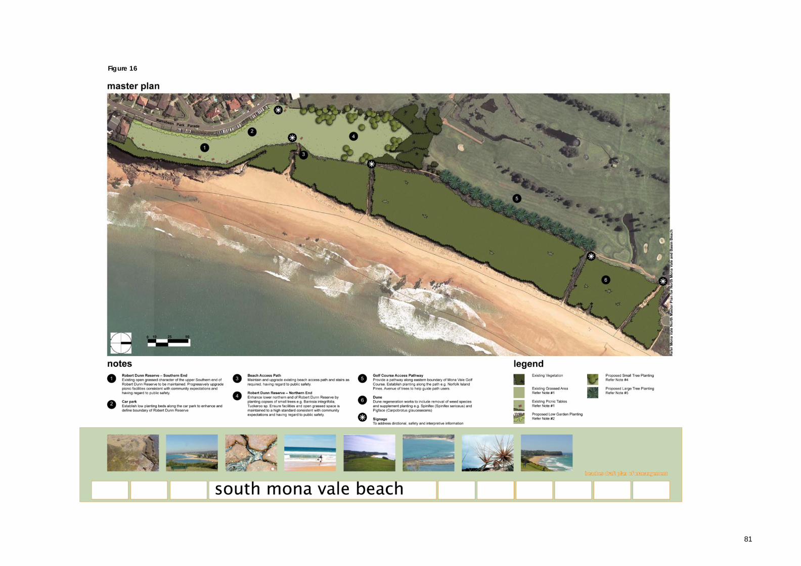
PROPOSED IMPROVEMENTS Master Plan The attached Master Plan for Mona Vale Beach and Basin Beach has been developed to illustrate the works and improvements to the beach and surrounds that are required to address key management issues and objectives. Works Programme for Mona Vale Beach and Basin Beach
Table 10 Item Cost South Mona Vale Beach 1 & 4 Robert Dunn Reserve upgrade works (refer master plan) $20,000 2 Low plating beds along car park boundary $5,000 3 Beach access pathways $5,000 5 Golf course access path way and tree planting $75,000 6 Dune Regeneration works $100,000
* Signage $10,000
North Mona Vale Beach 1 Dune regeneration works $15,000 2 Southern Esplanade Area $75,000 3 Investigate further traffic calming devices for Surfview Rd * 4 Mona Vale Surf Club maintenance $40,000 per year
based on 5 year period $200,000
5 Maintain beach access paths $10,000 6 Beach promenade $100,000 7 Mona Vale beach car park $25,000 8 Beach kiosk $500,000 9 Rock pool maintenance $20,000 per year based on 5
year period $100,000
* Signage $10,000
Basin Beach 10 Northern Reserve $20,000 11 Dune regeneration works/weed eradication and re
planting of native species $50,000
12 Reduce impact of stormwater on beach by suitable diversion.
$20,000
TOTAL $1,340,000
81
Figure 16

83
Figure 17