initiatives for earthquake disaster risk management in the kathmandu valley
DESCRIPTION
Research Paper earthquake disaster managementTRANSCRIPT

ORI GIN AL PA PER
Initiatives for earthquake disaster risk managementin the Kathmandu Valley
Amod Mani Dixit • Ryuichi Yatabe • Ranjan Kumar Dahal •
Netra Prakash Bhandary
Received: 8 May 2012 / Accepted: 12 May 2013 / Published online: 23 May 2013� Springer Science+Business Media Dordrecht 2013
Abstract Situated over the Himalayan tectonic zone, Kathmandu Valley as a lake in
geological past has a long history of destructive earthquakes. In recent years, the earth-
quake risk of the valley has significantly increased due mainly to uncontrolled develop-
ment, poor construction practices with no earthquake safety consideration, and lack of
awareness among the general public and government authorities. Implementation of land
use plan and building codes, strengthening of design and construction regulations, relo-
cation of communities in risky areas, and conduction of public awareness programs are
suitable means of earthquake disaster risk management practice. Kathmandu, the capital of
Nepal, is still lacking earthquake disaster risk management plans. So, this paper highlights
some initiatives adopted by both governmental and nongovernmental organizations of
Nepal to manage earthquake disaster risk in the Kathmandu Valley. It provides some
comprehensive information on recent initiatives of earthquake disaster risk management in
the valley and also highlights the outcomes and challenges.
A. M. Dixit (&)National Society for Earthquake Technology-Nepal (NSET), P.O. Box: 13775, Kathmandu, Nepale-mail: [email protected]
R. Yatabe � N. P. BhandaryDepartment of Civil and Environmental Engineering, Graduate School of Science and Engineering,Ehime University, 3 Bunkyo, Matsuyama 790-8577, Japane-mail: [email protected]
N. P. Bhandarye-mail: [email protected]
R. K. DahalDepartment of Geology, Tribhvuan University, Tri-Chandra Campus, Ghantaghar, Kathmandu, Nepale-mail: [email protected]
123
Nat Hazards (2013) 69:631–654DOI 10.1007/s11069-013-0732-9
Keywords Himalaya � Kathmandu Valley � Earthquake � Risk management �Hazard management
1 Introduction
Nepal lies in a very high seismic region and has a history of devastating earthquakes. The
major source of earthquakes in Nepal and the Himalayan region is the subduction of the
Indian plate underneath the Eurasian plate, which causes contraction and stress concen-
tration. Seismicity is considered to be high in this region based on the frequency and
intensity of the past earthquakes. Seismicity of the Himalayan region has been studied in
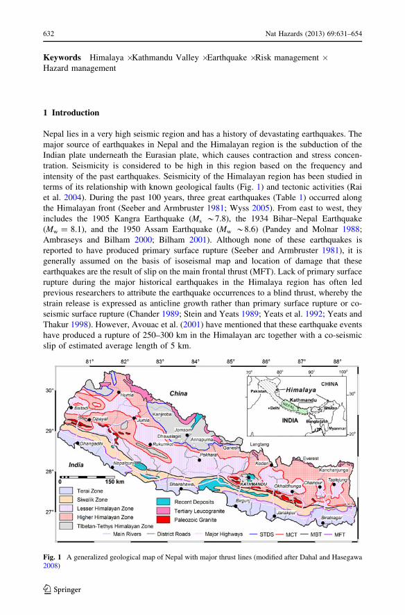
terms of its relationship with known geological faults (Fig. 1) and tectonic activities (Rai
et al. 2004). During the past 100 years, three great earthquakes (Table 1) occurred along
the Himalayan front (Seeber and Armbruster 1981; Wyss 2005). From east to west, they
includes the 1905 Kangra Earthquake (Ms *7.8), the 1934 Bihar–Nepal Earthquake
(Mw = 8.1), and the 1950 Assam Earthquake (Mw *8.6) (Pandey and Molnar 1988;
Ambraseys and Bilham 2000; Bilham 2001). Although none of these earthquakes is
reported to have produced primary surface rupture (Seeber and Armbruster 1981), it is
generally assumed on the basis of isoseismal map and location of damage that these
earthquakes are the result of slip on the main frontal thrust (MFT). Lack of primary surface
rupture during the major historical earthquakes in the Himalaya region has often led
previous researchers to attribute the earthquake occurrences to a blind thrust, whereby the
strain release is expressed as anticline growth rather than primary surface rupture or co-
seismic surface rupture (Chander 1989; Stein and Yeats 1989; Yeats et al. 1992; Yeats and
Thakur 1998). However, Avouac et al. (2001) have mentioned that these earthquake events
have produced a rupture of 250–300 km in the Himalayan arc together with a co-seismic
slip of estimated average length of 5 km.
Fig. 1 A generalized geological map of Nepal with major thrust lines (modified after Dahal and Hasegawa2008)
632 Nat Hazards (2013) 69:631–654
123

The recurrence time for these great earthquakes is determined on the basis of the rate of
slip of the Indian plate underneath the Eurasian continental mass, while these slip rates are
estimated on the basis of global plate motions (DeMets et al. 1990), from seismic pro-
ductivity and from the advance sediments on the northern Ganges plain (Bilham et al.
1997). In this endeavor, various global positioning system (GPS)-based geodetic survey
has been carried out in Nepal since 1991 so as to measure the rate of plate movement as a
part of collaboration between the Department of Mines and Geology (DGM) of Nepal and
various international organization/institutions, such as IRES (Colorodo University, USA)
and French Laboratories under the Centre National de la Recherche Scientifique. Plate
motion models and GPS measurements indicate that India-Eurasia convergence continues
today at a rate of about 40–50 mm per year (Demets et al. 1994), while the rate of
contraction across the Himalaya is estimated to be only 17.52 ± 2 mm per year (Bilham
et al. 1997). Armijo et al. (1986, 1989) and Avouac and Tapponnier (1993) mention that
the difference in these rates is absorbed by a combination of thrusting, crystal extension,
and strike-slip motion within the Eurasian plate.
As a Himalayan nation, Nepal has had a long history of destructive earthquakes. In last
one century alone, over 11,000 people were killed in four major earthquakes. A study of
the seismic record of the region suggests that earthquakes producing a shaking of MMI-IX
or more occur approximately every 75 years, while smaller earthquakes occur more fre-
quently. Earthquakes are thus a relatively frequent and disastrous natural event in Nepal,
and a major earthquake is likely in near future (Ambraseys and Bilham 2000; Bilham et al.
1997). The earthquake disaster risk of urban areas in Nepal, especially the capital area of
Kathmandu Valley, is ever increasing alarmingly due to rapid urbanization, poor con-
struction practice, and lack of disaster preparedness. In spite of the knowledge of historical
seismicity and earthquake disasters, public awareness on earthquake hazard and risk was
negligible until a few years ago. Many institutions apparently responsible for disaster
emergency response are largely focused on relief management. It was only after the
massive destruction and loss of 721 human lives in an earthquake in 1988 in the eastern
Nepal that a need of an organized approach toward earthquake risk management was
realized, and it led to the beginning of several innovative initiatives on earthquake risk
management in Nepal.
In the Kathmandu Valley, the increased earthquake disaster risk is mainly attributed to
uncontrolled and unplanned development, inadequate or no use of building code, lack of
earthquake safety considerations, and lack of awareness among the general public as well
as authorities. Implementation of land use and building codes, design and construction
regulations, relocation of communities from risky area, and use of public awareness pro-
grams are suitable means of earthquake risk management, but Kathmandu is still lacking
the programs intended for earthquake risk management.
Earthquakes have been found to cause fewer deaths but greater economic loss or heavy
fatal loss but little economic damage based on the development index of a nation (Chat-
elain et al. 1999; Erdik and Durukal 2008). The 1987 Loma Prieta Earthquake (USA)
Table 1 Magnitude–frequency data on earthquakes in Nepal and the surrounding region in the period of1911–1991 (modified after BCDP 1994)
Earthquakes of magnitudes in Richter scale 5–6 6–7 7–7.5 7.5–8 [8
No. of events 41 17 10 2 1
Approximate recurrence interval (years) 2 5 8 40 81
Nat Hazards (2013) 69:631–654 633
123

caused only 62 deaths in and around San Francisco but the economic loss was estimated to
be $4.7 billion, while a similar scale earthquake in Spitak (Armenia) killed over 20,000
people but the economic loss was only $570 million (Chatelain et al. 1999). So as an
underdeveloped nation, earthquake damage data in Nepal will be more terrible than
Armenia.
In this context, this paper highlights some of the initiatives taken by both governmental
and nongovernmental organizations of Nepal to mitigate earthquake disaster risk of the
Kathmandu Valley and also provides information on the achievements made out of the
earthquake disaster risk management initiatives in the valley.
2 Kathmandu Valley
2.1 Location and importance
Kathmandu Valley is situated almost in the middle of Nepal and is constituted of three
administrative districts, namely Kathmandu, Lalitpur (partly), and Bhaktapur (Fig. 1).
There are five municipalities in the valley: Kathmandu Metropolitan City (KMC), Lalitpur
Sub-metropolitan City (LSMC), Bhaktapur Municipality (BM), Madhyapur (Thimi)
Municipality (MM), and Kirtipur Municipality (KM). Additionally, there are 98 Village
Development Committees (VDC) in the valley, which are basically nonurban areas con-
sisting of several rural settlements (Fig. 2).
Urban services including water supply, telephony, electricity, and so on in whole Nepal
are usually managed by the central authorities, not by the municipalities or local author-
ities. On the other hand, urbanization is rapid throughout the valley, and all valley urban
settlements exhibit rapid growth around their periphery. Because of inadequate coordi-
nation between the central and local authorities, the above urban services are not well
managed, which has increased the risk of their failure during earthquake disasters.
While KMC is the largest municipality and hosts most of the central government
offices, the entire Kathmandu Valley is considered the capital of Nepal. Therefore, the term
‘‘Kathmandu’’ in this paper is supposed to represent the entire valley. Not only as the
administrative and economic capital, but Kathmandu also serves as a cultural asset of the
nation. Numerous historical monuments, national and international heritages including 8
World Heritage Sites are located in the valley.
2.2 Geology and earthquake damage risk
The Kathmandu Valley is an ancient lake filled up in recent geological times by the
sediments derived from rapid erosion of the surrounding hills and mountains. The lake-bed
sediments are up to 350 m thick (Sakai et al. 2001) and they consist mainly of soft and
weak organic silts and clays. The lake-bed also consists of fine sand, which is susceptible
to liquefaction. The thick, soft valley sediments are considered to have higher earthquake
wave amplification capacity, and this phenomenon could be accentuated by potential basin-
effect because the valley is roughly circular in shape with about 25 km diameter, and the
Bagmati River system exhibits a remarkable centripetal drainage pattern.
The valley was hit by numerous earthquakes in the last 100 years including four major
earthquakes of magnitude greater than M8.0 (Seeber et al. 1981; Molnar 1984). Cate-
gorically, major earthquake damages in the Kathmandu Valley were reported to have taken
place in the years 1255, 1408, 1681, 1803, 1810, 1833, and 1866 (Bilham et al. 1995;
634 Nat Hazards (2013) 69:631–654
123

Chitrakar and Pandey 1986; Gupta 1988; Pandey et al. 1995). The oldest recorded
earthquake event of 1255, which had an estimated intensity of at least MMI-X, was
reported to have damaged the valley very badly. In this earthquake, one-third of the
Kathmandu population (i.e., several thousands in number), including King Abhaya Malla,
were killed (ibid). The latest great earthquakes that significantly affected Nepal and the
Kathmandu Valley were 1833 Kathmandu Earthquake and 1934 Bihar–Nepal Earthquake.
Fig. 2 Location map of Kathmandu Valley and municipalities as well as surrounding village developmentcommittees. Tentative location of active faults and ground motion measurement sites are also shown in themap
Nat Hazards (2013) 69:631–654 635
123

The 1980 Chainpur Earthquake (ML = 6.6) and the 1988 Eastern Nepal (Udayapur)
Earthquake (ML = 6.5) also killed hundreds of people and extended a great infrastructural
loss in the epicenter areas. More recently, an earthquake in Sikkim–Nepal border
(ML = 6.9), which occurred on September 18, 2011, caused heavy damage in terms of
rural house collapses and partial destruction including landslides and rock slope failures at
numerous locations along the major road network in the eastern part of Nepal. Although
only 6 people were reported to have been killed in this earthquake, the total number of
completely or partially destroyed nonengineered houses was about 21,000.
Among the major earthquakes with recorded history, the Great Bihar–Nepal Earthquake
of 1934 (Ambraseys and Douglas 2004; Hough and Bilham 2008) with a maximum
intensity of X-MMI caused an extensive damage in the Kathmandu Valley (Dunn et al.
1939; Pandey and Molnar 1988). Of the total number of deaths in whole Nepal at 8,519
(Fig. 3), which was more than the number of deaths in Bihar (i.e., 7,188 deaths), 4,296
people died in the valley alone (Rana 1935; Pandey and Molnar 1988). This earthquake
reportedly destroyed about 19 % and damaged about 38 % of the valley buildings (Pandey
and Molnar 1988; Rana 1935). The level of destruction particularly in Bhaktapur City in
the eastern part of the valley and neighboring areas was found to be the highest (Pandey
and Molnar 1988; Rana 1935). Many historical temples and monuments also collapsed or
sustained severe damage (Tables 2, 3).
The time series record of earthquake generation points in the Nepal Himalaya indicates
that the strain energy in its central part has not been released for a long time. This state of
stress build-up in the area, which is often known as a seismic gap, indicates that it is the
most potential location for the next great earthquake in the Himalayas (Pandey et al. 1995;
Bilham et al. 1997). Although the historical record is inadequate to make an accurate
prediction of the recurrence period of great earthquakes in Nepal, the available data
indicate that an earthquake greater than M8.0 occurs at a 100-year interval. As it is already
about 80 years since the 1934 Bihar–Nepal Earthquake, the threat of a major earthquake in
the region, particularly in the Nepal Himalaya, is sharply increasing day by day.
0
100
200
300
400
500
600
700
800
900
1000
Kathmandu PatanKathmandu Outskirt of Patan Outskirt of Bhaktapur Outskirt of
Bhaktapur
Places
No
of
dea
d
Men
Women
Fig. 3 Casualties in the Kathmandu Valley due to the 1934 Bihar-Nepal Earthquake
636 Nat Hazards (2013) 69:631–654
123

Table 2 Past earthquakes and damage records (modified after BCDP 1994; JICA 2002)
Years Epicenter Magnitude Deaths Houses destroyed
1255 – – One-third of the populationof Kathmandu, includingKing Abhaya Malla, werekilled
A lot of damage to residentialbuildings and temples
1260 – – Many people died, famineafter the earthquake
A lot of damages to residentialbuildings and temples
1408 – – Many people died A lot of damages to residentialbuildings and temples, fissuresdeveloped in the ground
1681 – – Many people died A lot of damage to residentialbuildings
1767 – – No record of death No records of damage
1810 – – Some people diedparticularly in Bhaktapur
A lot of damage to residentialbuildings and temples
1823 – – No record of death Some damage to houses
1833 – 7.7 (ML) 414 people died in thevicinity of the KathmanduValley
About 4,000 houses destroyed inKathmandu, Bhaktapur, and Patanin the valley and adjoiningBanepa and a total of 18,000buildings damaged in the wholecountry
1834 – – No good record available Many buildings collapsed
1837 – – No good record available No damage in Nepal recorded butgreatly affected Patna and otherparts of Bihar, India
1869 – – No good record available No good record available
1897 – – No good record available No good record available
1917(1918?)
– – No good record available No good record available
1934 East Nepal 8.1 (MW) 8,519 people died out ofwhich 4,296 died inKathmandu Valley alone
Over 200,000 buildings andtemples, etc., damaged out ofwhich nearly 81,000 completelydestroyed in the country. About55,000 buildings affected inKathmandu Valley (12,397completely destroyed)
1936 Annapurna 7.0 (ML) No good record available No good record available
1954 Kaski 6.4 (ML) No good record available No good record available
1965 Taplejung 6.1 (ML) No good record available No good record available
1966 Bajhang 6.0 (ML) 24 6,544 houses damaged(1,300 collapsed)
1980 Chainpur 6.5 (ML) 103 25,086 buildings damaged(12,817 completely destroyed)
1988 Udayapur 6.5 (ML) 721 66,382 buildings damaged
2011 Sikkim/Nepalborder
6.9 (ML) 6 died and 30 injury (2 diedin Kathmandu Valleyalone)
14,544 house damaged(6,435 completely destroyed)
ML Richter magnitude, MW moment magnitude
Nat Hazards (2013) 69:631–654 637
123

Like many other urban areas particularly in developing nations, the earthquake disaster
risk of Kathmandu Valley has increased significantly since the last major earthquake. The
valley has a burgeoning population of almost 5 million, which goes in parallel with
uncontrolled development activities and poor construction practices. Practically, all con-
struction work goes without much input from an engineer and without considering the
seismic forces. Earthquake risk-related technical information in the Kathmandu Valley is
also incomplete and scattered among several governmental agencies. However, a more
important contributor to the region’s lack of earthquake preparedness was that the available
technical information was synthesized, was not applied to infrastructure planning and
design of the modern day Kathmandu Valley, and was not presented in a form the public
and government officials could accept.
Urbanization of outer parts of the compact historical city core area began in the nine-
teenth century, mainly during the Rana regime when large palace complexes were built
away from the city core, while a rapid urban growth started only after political changes of
1950. During this time, the city started to grow in the east, northeast, and north over easily
accessible well-drained highlands along the major arterial roads. The growth accelerated
further during the 1970s and 1980s, and especially after the construction of a circumfer-
ential road, known today as the Ring Road, more and more areas in the neighborhood of
this road were made accessible. The urban growth in the Kathmandu Valley today covers
most of the municipal areas including the low-lying flood plains.
3 Estimation of earthquake losses
The Seismological Center of the Department of Mines and Geology (DMG), Government
of Nepal monitors seismic activities in Nepal through its network of 21 seismograph
stations. The center has a capability of continuous recording of earthquakes equal to or
greater than M2.0 throughout Nepal and M5.0 worldwide. However, there are only two
strong ground motion recording stations in the country so far. One of them is located in
Kathmandu, while the other is placed in the northern periphery of the valley at the top of
the valley watershed.
In 1994, the National Building Code Development Project (BCDP 1994) carried out an
assessment of primary seismic hazard for the country and has prepared a consolidated
earthquake catalogue. The project also analyzed the identified active faults within Nepal
and its surroundings and derived the earthquake hazard spectra based on this knowledge as
well as using the commonly accepted seismotectonic model and attenuation relationships.
Table 3 Houses destroyed within the valley due to 1934 Bihar-Nepal Earthquake
Region Completely destroyed Much fractured Slightly fractured Total
Kathmandu 725 3,735 4,146 8,606
Outskirt of Kathmandu 2,892 4,062 4,267 11,221
Patan 1,000 4,170 3,860 9,030
Outskirt of Patan 3,977 9,492 1,598 15,067
Bhaktapur 2,359 2,263 1,425 6,047
Outskirt of Bhaktapur 1,444 1,986 2,388 5,818
Total 12,397 25,708 17,684 55,789
638 Nat Hazards (2013) 69:631–654
123

While it is necessary to continue conducting researches for detailing the geological,
seismic, and seismotectonic models, the existing knowledge was used for deriving the
design seismic forces required for seismic analysis of the structures. This analysis was used
by BCDP (1994) for the formulation of the Nepal National Building Code. BCDP (1994)
also prepared susceptibility maps for collateral seismic hazards such as landslides, lique-
faction, and fault rupture hazard for the Kathmandu Valley. The liquefaction hazard map of
the valley was prepared in combination with the intensity distribution map of the Bihar–
Nepal Earthquake of 1934 to estimate potential losses due to future earthquakes that could
result in MMI-IX level of shaking as was observed during the 1934 earthquake. During the
estimation of damage in this study, the location and vulnerability of the valley infra-
structures were determined through interviews with about thirty institutions. The infor-
mation collected through these interviews was combined with previously conducted
studies. It was accepted that these readily available models produced useful, conservative
results at a sensible cost, considering that the main aim of the project was to promote
mitigation action rather than to conduct a detailed scientific or technical research. Loss
estimates were conducted for the road system, water system, electricity system, telephone
system, and typical building structures. In addition, possible death and injury figures were
determined by looking at the statistics from previous comparable earthquakes from around
the world.
To understand possible earthquake losses in Kathmandu, a study was carried out and a
systematic assessment of earthquake disaster risk was conducted with the help of a few
data on buildings and experts opinions on building vulnerability. These data were used in
the empirical processing proposed by the Applied Technology Council (ATC 1984, 1985)
for the estimation of potential earthquake losses. In this paper, the probable worst scenario
earthquake, that is, level of shaking equal to or greater than intensity MMI-IX, was
selected to assess earthquake losses in Kathmandu. The estimated losses are summarized in
the following subheadings.
3.1 Possible damage in building and casualties
A rough estimation of damage to buildings was conducted using information about typical
construction types found in the Kathmandu Valley, which was collected and analyzed
while developing the Nepalese Building Code. As many as 60 % of the buildings in the
valley are likely to be damaged heavily and many beyond repair, Bhaktapur, which also
suffered the worst damage in the 1934 earthquake, has historically suffered more than the
rest of the valley in earthquakes, possibly because of its ground conditions, so as many as
75 % of the buildings in Bhaktapur are likely to be damaged heavily.
Death and injury expectations are equally shocking. Simply applying the percentage of
the population killed or injured in the 1934 earthquake to the population of the valley
today, it results in an estimate of 22,000 deaths and 25,000 injuries requiring hospital-
ization, while applying more recent earthquake casualty figures from cities comparable to
the Kathmandu Valley, it results in an estimate of 40,000 deaths and 95,000 injuries during
the next major earthquake in the Kathmandu Valley.
Additionally, estimated 600,000–900,000 residents of the Kathmandu Valley are
expected to be left homeless due to damaged buildings or a fear of being in their homes.
The existing government medical facilities in Kathmandu have a total of 2,200 beds, most
of which are full under nonemergency conditions. An additional 3,500 patients could be
accommodated on floors or outside space around the hospitals. In California and Japan, an
earthquake shaking of MMI-IX generally makes at least 50 % hospital beds unusable due
Nat Hazards (2013) 69:631–654 639
123

to structural problems (e.g., building collapse) or nonstructural problems (e.g., fallen
bookshelves or loss of electrical power). So, it is for sure that there will be a major shortage
of space for medical treatment in the Kathmandu Valley.
3.2 Urban building stock
The damage analysis of building stock in the Kathmandu Valley was based on a set of data
obtained from an inventory of 1,200 buildings. Buildings for the inventory were carefully
selected based primarily on a visual assessment of the typology distribution combined with
an inventory of critical facilities. The data set was then used in the analysis of damage to
building stock, public facilities, lifeline networks, and human casualty for different sce-
nario earthquakes hitting or affecting the Kathmandu Valley in a comprehensive earth-
quake disaster risk assessment project supported by Japan International Cooperation
Agency (JICA 2002). The main purpose of this project was to develop an earthquake
disaster mitigation plan in the Kathmandu Valley.
A subjective estimation was made during the development of the valley building
damage scenario, and it was found that 60 % of the buildings in the valley would collapse
in case of a scenario earthquake with shaking equal to what happened during the 1934
Bihar–Nepal Earthquake. The prevalence of large stock of old masonry buildings and
practice of unsafe building construction without considering seismic requirements was the
reason behind such estimation. It was also concluded that 54 % of the buildings would be
heavily damaged in a case of recurrence of the 1934 earthquake. About 1,200 buildings
from 69 sample sites were surveyed for over 100 items including details on owners,
location, age, usage, repair and extension history, past experiences of cracks, construction
materials and type of structure, number of stories, shape, layout, soil and topography.
3.3 Public school buildings
To understand issues behind earthquake disaster risk mitigation in the Kathmandu Valley,
school earthquake safety assessment was carried out during this study. The purpose of this
assessment was not to identify individual schools as vulnerable, but to quantify the risk
faced by the entire system. For this purpose, a questionnaire form was prepared and sent to
the target school principals for their responses. The questionnaire items were size of
buildings, density of students, year(s) of construction, whether or not an engineer was
involved in the building design or construction, and so on. Additionally, simple questions
about structural characteristics presented through illustrations and descriptions were also
asked. Altogether, 17 seminars were conducted with the school principals from about 65 %
of a total 643 public schools in the valley to teach them about earthquake disaster risk and
necessity of planning for earthquakes at their schools and at the same time to instruct them
how to fill out the questionnaire form. From the results of the questionnaire survey and
responses from a total of 430 schools, conclusions were extrapolated to the entire building
stock of the existing public schools of the Kathmandu Valley. The results of vulnerability
analysis are presented in Table 4.
3.4 Transportation system
The Kathmandu Valley is connected with other parts of the nation through two main road
systems, one leading to southern neighbor India and other to northern neighbor China.
640 Nat Hazards (2013) 69:631–654
123

More recently, the third but comparatively narrow road has been opened to traffic, which
also leads to India though eastern part of the valley. As all these road systems pass through
landslide-prone mountain slopes, there are enough chances that the road traffic through
these routes is disrupted for days and weeks leading to acute shortage of daily commodities
in the valley. Emergency international relief may also be delayed because of disrupted
operation of the Tribhuvan International Airport (TIA), the only international access to
Nepal. A closer look at seismic performance of the TIA has revealed that it will be
potentially dysfunctional after a big earthquake. The ground conditions of the airport area
including the runway indicate that there are possibilities of soil liquefaction and landsliding
during an earthquake. The airport area largely consists of sandy deposits, and the ground
water table below the runway, taxiways, and other airport facilities is close to critical level
from the surface. This confirms that there are greater possibilities of soil liquefaction
during an earthquake. In addition to liquefaction, loose and unsupported slopes of the
TIA’s slightly elevated runway ground and apron area are prone to liquefaction-induced
sliding failure. The TIA area is surrounded by two river systems in the valley, Bagmati and
Manohara, both of which have highly liquefiable banks according to the liquefaction map
prepared in 1994 during the Seismic Hazard Mapping and Risk Assessment study by
UNDP/UNCHS. If these low land areas subside due to liquefaction, there are high chances
of failure of marginal slopes in the TIA area. Therefore, a detailed geotechnical investi-
gation in the TIA area may be a primary concern of all stakeholders so as to accurately
assess the liquefaction and landslide potential in this area.
3.5 Other life line damages
In addition to the building damage, it was estimated that almost half of the bridges in the
valley could be impassable and that 10 % of the paved roads would sustain moderate
Table 4 Seismic vulnerability of public school buildings in Kathmandu Valley
Particulars Details Percentage
Total number of public schools/buildings 643/1,100 64.3
Typology of traditional school buildings Adobe (sun-dried bricks) or earthen buildings(mud cake buildings)
5
Stone/brick masonry in mud mortar 56
Rectangular block (brick or hollow concreteblock or semi-dressed stone in cement mortar)
28
Reinforced concrete frame (RC frame) 11
Existing condition (with extrapolationfor 643 schools)
Hazardous for use at present (pull-down andreconstruct)
10–15
Can be saved (with structural intervention,retrofit, repair, and maintain)
25
Good for vertical load (but not for lateralshaking), need retrofitting
65
Vulnerability assessment(for intensities IX)
Collapsed grade 66
Severe damage or partial collapse (notrepairable/not usable after shaking)
11
Repairable damage 23
Nat Hazards (2013) 69:631–654 641
123

damage, such as deep cracks or subsidence. Moreover, many narrow streets in the valley
would be blocked by the debris of collapsed buildings. The city of Bhaktapur may not be
accessible from Kathmandu or Lalitpur because of the road and bridge damages. The
bridges connecting Kathmandu and Lalitpur are also at risk of liquefaction-induced
damage. Tribhuvan International Airport is also surrounded by liquefaction prone areas,
which means that the airport may also be cut off from access limiting emergency aid from
outside.
Also, approximately 95 % of the water pipes and 50 % of other water system com-
ponents (such as pumping stations, treatment plants) could be damaged seriously. Almost
all telephone exchange buildings and 60 % of the telephone lines are likely to be
damaged, requiring significant to moderate repair to make them operational. Likewise,
approximately 40 % of the electric lines and all electric substations are likely to be
damaged. It may take as long as 1 month to repair the electricity and telephone utilities
and make them fully operational. Water system facilities, however, will require much
more time to repair. It was estimated that most areas of the valley would be cut off from
piped water supply for several months while many of them may lose the service for more
than a year.
A study for the assessment of seismic vulnerability of the drinking water supply
system of Kathmandu city was also undertaken in view of high level of earthquake risk.
A practical methodology for assessing the seismic vulnerability of the pipeline network
system, its components and institutional capacity was developed by adopting the Applied
Technology Council ATC-25-1 (ATC 1992) tool with appropriate adjustment for
Kathmandu. The assessment results in a form of network system damage for the scenario
earthquake were presented using geographical information system (GIS). Based on
possible maximum enhancement of the present intuitional capacity and spatial distri-
bution of the possible damage extent, optimum routes for speedy restoration of the water
supply services to meet a minimum level were identified under two different scenarios,
that is, in its present state and in an improved system. It was found that a large number
of pipeline breakages would take place mainly due to ground shaking. Very old stock of
the pipeline without adequate maintenance and almost no incorporation of earthquake
disaster risk in design and construction of water supply system are the main causes for
such consequences.
3.6 Health facility damage
Considering high seismic damage risk of the Kathmandu Valley estimated at more than
40,000 human casualties and about 100,000 serious injuries requiring hospitalization for a
scenario earthquake of maximum intensity of MMI-IX, high concerns are induced over the
health facilities. Despite being situated in a seismically active region, Nepal is yet to
practice effective application of earthquake-resistant construction standards and no special
guidelines have been considered for hospital facilities. Only two hospitals, Tribhuvan
University Teaching Hospital and Patan Hospital, are designed against seismic events. For
this reason, there are higher possibilities that many hospital buildings will not be functional
during a large seismic event.
Under such situations, two studies were undertaken; one to evaluate seismic perfor-
mance of 14 hospitals in the valley and other to assess quantitatively the state of one main
city hospital, known as Bir Hospital. The main purpose of these studies was to develop/
apply an appropriate methodology for the evaluation of earthquake vulnerability of the
medical facilities in general and to understand the actual situation of the reliability of the
642 Nat Hazards (2013) 69:631–654
123

medical facilities in the Kathmandu Valley in particular. After this assessment study, an
overall scenario of reliability of medical system in the Kathmandu Valley was revealed.
The result of this study that only 10 % of the hospitals will be functional after an MMI-IX
intensity earthquake reveals an urgent need of improving the earthquake resiliency of
existing medical facilities in the valley. The overall performance of the hospitals in dif-
ferent scenario earthquakes is presented in the chart of Fig. 4.
Moreover, the results show that about 80 % of the hospitals fall in unacceptable per-
formance category, while remaining 20 % are at life safety to collapse prevention per-
formance level. So, phase-wise priority recommendations were made for improving the
seismic performance of the different valley hospitals. In the first phase, securing of all
equipment and contents, strengthening of critical systems, training programs for hospital
personnel, and provisions of backup in critical systems were proposed for implementation,
while in the second phase, seismic retrofitting of hospital buildings, further strengthening
of critical systems, and provision of extra backup systems were proposed. Considering the
opportunity of immediate implementation of nonstructural measures of risk mitigation,
some examples of mitigation options were also developed during the study.
4 Initiatives for earthquake risk reduction
Action plans for earthquake risk management have been developed for Kathmandu Valley
in order to address the earthquake risk estimated from the earthquake scenario develop-
ment exercise under the different programs. The following subsections describe the current
level of action plan development and implementation.
4.1 Kathmandu Valley earthquake risk management action plan
This action plan was created through active participation of about 82 concerned institutions
of the Kathmandu Valley, including the main emergency response institutions and
Fig. 4 Overall performance of hospitals in different earthquakes in Kathmandu (risk matrix modified afterSEAOC 1995)
Nat Hazards (2013) 69:631–654 643
123
agencies. It was initiated for a process of systematically reducing the seismic risk over the
time. The action plan process was a logical continuation of the earthquake hazard evalu-
ation and risk assessment component (earthquake damage scenario development). Offi-
cially, the action plan was endorsed in the month of January in 1999, and the purpose was
to assist the Government of Nepal, concerned agencies, and the municipalities in Kath-
mandu Valley to reduce the valley earthquake risk over the time through coordination
among the agencies and focused risk management activities. Ten specific initiatives were
defined as high priority jobs. During the planning process, notably, (a) implementing
school earthquake safety program, (b) improving the safety of existing buildings by
propagating nonstructural vulnerability measures, and (c) awareness raising and assisting
the municipalities to implement seismic code for new buildings were considered as three
major plans.
The detailed study on earthquake disaster management in the Kathmandu Valley has
helped to generate implementation plan for earthquake disaster reduction at different levels
of the government. It was understood that individual disaster management plans should be
prepared at each level of government organizations and institutions through a method of
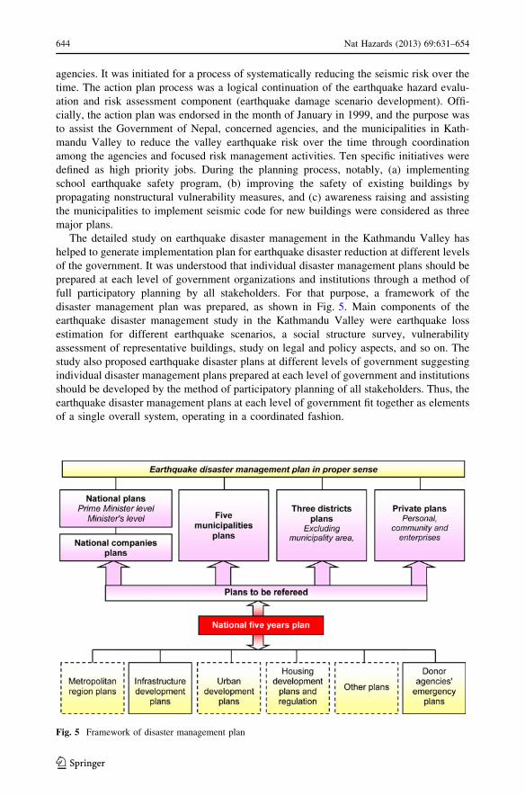
full participatory planning by all stakeholders. For that purpose, a framework of the
disaster management plan was prepared, as shown in Fig. 5. Main components of the
earthquake disaster management study in the Kathmandu Valley were earthquake loss
estimation for different earthquake scenarios, a social structure survey, vulnerability
assessment of representative buildings, study on legal and policy aspects, and so on. The
study also proposed earthquake disaster plans at different levels of government suggesting
individual disaster management plans prepared at each level of government and institutions
should be developed by the method of participatory planning of all stakeholders. Thus, the
earthquake disaster management plans at each level of government fit together as elements
of a single overall system, operating in a coordinated fashion.
Fig. 5 Framework of disaster management plan
644 Nat Hazards (2013) 69:631–654
123
As a consequence of the above plan, it is encouraging today to see that earthquake
vulnerability reduction (EVR) measures such as building code implementation, school
earthquake safety program, trainings for mason and petty-contractors for earthquake-
resistant construction, and awareness raising are common priority items in the action plans
of all municipalities of the valley.
Main objectives of Kathmandu Valley earthquake risk management plan were as fol-
lows: (1) evaluating the earthquake disaster risk of the Kathmandu Valley and prescribing
an action plan for managing the risk; (2) reducing the earthquake vulnerability of public
schools; (3) raising awareness among the public, government officials, international
community in the Kathmandu Valley, and international organizations; and (4) building
local institutions that can sustain the work which were included in the action plan.
The plan included a wide variety of activities aimed at beginning a self-sustaining
earthquake disaster risk management program for the Kathmandu Valley. The program
components were as follows: (1) development of an earthquake scenario and an action plan
for earthquake disaster risk management in the Kathmandu Valley, (2) a school earthquake
safety program, and (3) awareness raising and institutional strengthening.
The project was implemented through strong participation of national government
agencies, municipal authorities, professional societies, academic institutions, schools, and
international agencies in the Kathmandu Valley. These organizations serve the program
through their presence in advisory committees, various workshops, seminars, interviews,
and joint programs. The major accomplishment of the project is development of an
earthquake damage scenario and an action plan for reducing the earthquake disaster risk of
the valley. The action plan is a consensus document depicting roles and responsibilities of
all concerned institutions in managing the earthquake disaster risk of Kathmandu. School
Earthquake Safety Program was another major accomplishment, which established tech-
nical and social feasibility and affordability for seismic improvement of school buildings.
It has now been a well-established program, which not only helps to build the school
buildings stronger, but also serves as an awareness-raising tool that ultimately makes the
entire community safer against earthquakes. Training of masons in earthquake-safe con-
struction and disseminating the earthquake safety information to children, teachers, par-
ents, and community at large are the strongest parts of the School Earthquake Safety
Program, which is found as beginning of a self-replicating process. The Kathmandu Valley
earthquake risk management plan also helped institutionalize the earthquake safety con-
sideration with several policy shifts.
4.2 Preparedness programs
4.2.1 School earthquake safety programs
As the centers of social life, schools play a vital role in communities of a developing
country like Nepal. They can play an important role in raising awareness because any type
of message can reach the parents, their relatives, and the entire community through the
pupils and the teachers. Schools can also play a crucial role in helping a community to get
back on its feet after an earthquake. However, in Nepal, both the school buildings and their
occupants face extreme risk of earthquake disasters. A study was carried out in the
Kathmandu Valley, which revealed that more than 60 % of the buildings are highly vul-
nerable to earthquakes even in normal conditions. Therefore, vulnerability reduction
programs in schools were prompted with the following primary objectives.
Nat Hazards (2013) 69:631–654 645
123

(a) Seismic retrofitting or earthquake-resistant reconstruction of school buildings.
(b) Training of teachers, students, and parents on earthquake disaster risk mitigation and
preparedness.
(c) Training of local masons on earthquake-resistant building construction technology.
The program has been found successful in encouraging community participation in raising
earthquake awareness significantly. Masons trained in the program have now successfully
spread the technology of earthquake-resistant construction in their communities by repli-
cating it while constructing new buildings as well as providing hands-on training to other
masons. Effectiveness of the program as well as its sustainability has been demonstrated. The
experiences gained during the implementation of this program have been translated into a
technical manual for designers and builders with an aim to assist them with designing and
implementing earthquake-resistant school building construction practice. Furthermore, the
approach and methodology of this program is in process of being adopted by the Ministry of
Education and other educational institutions in their regular plans and programs.
4.2.2 Community-based risk management programs
Common people started to have an increased interest in earthquake issues and raised ques-
tions shortly after the implementation of Kathmandu Valley Earthquake Risk Management
Project (KVERMP). Many requests for conducting awareness-raising trainings have also
started to appear from many community-based organizations. In Nepal, for administrative or
political purposes, municipalities and VDCs are divided into number of small districts called
as ‘‘Wards.’’ The initiatives are being carried out through the Ward Level Disaster Man-
agement Committee with the support of the KVERMP along with other local, national, and
international institutions. Scope and effectiveness of the efforts have increased with the
participation of a wide range of society. Various disaster risk management activities have
been initiated in the valley, especially under the KVERMP. Annual programs have been
prepared for conducting household-level survey in municipality wards, implementation of
training programs for the ward residents, awareness-raising activities and mobilization and
training of young volunteers in earthquake disaster management issues and other activities.
Till date, several trainings, community meetings, and awareness-raising activities are orga-
nized annually. Although a systematic survey is yet to be carried out to assess the impacts,
there are many positive signs that indicate a positive impact of the community-based pro-
grams. Some of the indicators of the positive impact are as follows:
• The participants and volunteers interested and committed to work for disaster risk
reduction have significantly increased.
• Some wards of the KMC have been already replicating the approaches and activities
carried out in pilot program area in their wards and requesting the pilot program area to
assist in organizing community-level trainings.
• The experiences have been shared with the similar initiatives carried out in other
municipalities and districts.
4.2.3 Institutional strengthening programs for seismic code implementation
Toward promoting safer building construction, a partnering approach with other organi-
zations and stakeholders is stated in municipality level. Experts are supporting programs
for the integration of seismic resistance into the process of new construction, improving
646 Nat Hazards (2013) 69:631–654
123
seismic performance of the existing buildings, and in increasing the experts’ knowledge of
the earthquake phenomenon, vulnerability, consequences, and mitigation techniques. In
collaboration with various organizations, metropolis provide regular orientation programs
to house owners.
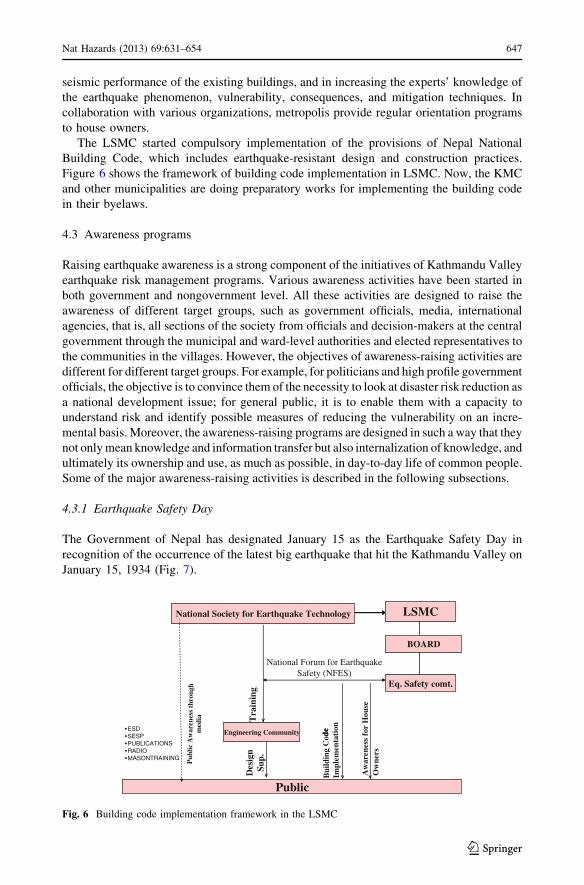
The LSMC started compulsory implementation of the provisions of Nepal National
Building Code, which includes earthquake-resistant design and construction practices.
Figure 6 shows the framework of building code implementation in LSMC. Now, the KMC
and other municipalities are doing preparatory works for implementing the building code
in their byelaws.
4.3 Awareness programs
Raising earthquake awareness is a strong component of the initiatives of Kathmandu Valley
earthquake risk management programs. Various awareness activities have been started in
both government and nongovernment level. All these activities are designed to raise the
awareness of different target groups, such as government officials, media, international
agencies, that is, all sections of the society from officials and decision-makers at the central
government through the municipal and ward-level authorities and elected representatives to
the communities in the villages. However, the objectives of awareness-raising activities are
different for different target groups. For example, for politicians and high profile government
officials, the objective is to convince them of the necessity to look at disaster risk reduction as
a national development issue; for general public, it is to enable them with a capacity to
understand risk and identify possible measures of reducing the vulnerability on an incre-
mental basis. Moreover, the awareness-raising programs are designed in such a way that they
not only mean knowledge and information transfer but also internalization of knowledge, and
ultimately its ownership and use, as much as possible, in day-to-day life of common people.
Some of the major awareness-raising activities is described in the following subsections.
4.3.1 Earthquake Safety Day
The Government of Nepal has designated January 15 as the Earthquake Safety Day in
recognition of the occurrence of the latest big earthquake that hit the Kathmandu Valley on
January 15, 1934 (Fig. 7).
ed
National Society for Earthquake Technology LSMC
BOARD
Eq. Safety comt.
Public
Pub
licA
war
e nes
sth
rou g
hm
edia
Aw
a ren
ess
for
Ho u
s eO
wne
rs
Bui
ldin
gC
oed
Impl
emen
tati
onEngineering Community
Tra
inin
gD
esig
nSu
p.
•ESD•SESP•PUBLICATIONS•RADIO•MASONTRAINING
National Forum for Earthquake Safety (NFES)
Fig. 6 Building code implementation framework in the LSMC
Nat Hazards (2013) 69:631–654 647
123

The Earthquake Safety Day has been designed to include two main activities, that is,
Earthquake Safety Exhibition and Symposium. Other associated events include public
broadcast of earthquake safety message by the Prime Minister, awareness rally in the
streets, national meeting with government ministers, shake-table demonstration of tradi-
tional building models with and without seismic safety elements, children’s essay/painting
competition, street drama on earthquake safety, and so on. Moreover, numerous publica-
tions such as information leaflets, calendars and earthquake-resistant construction posters
are distributed to the public.
4.3.2 Radio/TV programs
Several local radio and TV stations air earthquake safety and preparedness messages on a
regular basis using various earthquake-related publications as a basic guide for mass
education. Local FM radios in major cities of Nepal air weekly 30-min programs on
earthquake safety. The Kathmandu Municipality has also provided adequate time slot per
week on the nation-owned Nepal Television to broadcast a program series on earthquake
safety and earthquake-resistant construction targeting mainly the house owners.
4.3.3 Public talk programs and orientation programs
A number of public talk programs on earthquake safety have been organized in different
community gatherings, such as regular meetings of Rotary Clubs, Scout Jamborees and
trade association meetings. The number and regularity of such talk programs have sig-
nificantly increased, especially after the Nepalese professionals participated in study and
reconstruction activities after the Gujarat Earthquake of 2001. The experiences of Gujarat
have not only informed the public about the Kathmandu Valley’s earthquake risk, but have
also given important feedback on the concerns and perceptions of the public, which have
subsequently helped to tailor the public awareness campaigns. Likewise, in different
occasions of meetings of professional organizations, such as Nepal Engineers Associations,
Fig. 7 Celebration of Earthquake Safety Day on January 15. This has extensively helped to raise awarenessfor earthquake safety among the valley citizens
648 Nat Hazards (2013) 69:631–654
123

Society of Nepalese Architects and Nepal Geological Society, earthquake-related lectures
are frequently incorporated.
Similarly, some nongovernmental organizations have also started to organize free-of-
cost weekly orientation programs on retrofitting and earthquake-resistant construction
targeting the house owners. Similar programs are now also regularly conducted for the
contractors and builders, focusing mainly on the aspects of earthquake-resistant con-
struction methods. It has been found that a walkover through the municipal areas of the
Kathmandu Valley with the builders involved in major constructions and analysis of the
structural details together with them are an effective method to convince them of the
commonly practiced mistakes in construction method.
4.4 Improvement in policy
The awareness and preparedness program has now created an environment of influence on
the policy makers toward earthquake disaster risk mitigation in Nepal. Subsequently,
several policy improvement initiatives have also been formulated and implemented in the
country. These policies help create conducive environment for achieving disaster risk
reduction and emergency response. Some of the efforts and achievements in these areas are
described in the following subsections.
4.4.1 Mandatory implementation of building code
The Bureau of Standards and Metrology of Nepal has initiated a process to recognize the
draft building code as Nepal Standard. Several of the 22 documents that were prepared as
the National Building Code focusing primarily on seismic safety of building structures has
been accepted as Nepal Standard. Recently, the Council of Ministers has decreed that the
stipulations of the National Building Code should be made obligatory for the construction
of all government-owned buildings. It has also directed the municipal authorities to
strengthen the current building permit process so that code compliance becomes mandatory
for all new constructions in the urban areas of the Kathmandu Valley.
4.4.2 Disaster mitigation policy in National Plan
For the first time in Nepal, the document on the tenth year development plan incorporates
natural disaster management as one of the objectives of the government in order to contribute
toward making the national infrastructures durable, sustainable, and capable of providing the
intended service. Thus, the development plan of the country now encourages prevention and
mitigation as important activities toward disaster management. The policy statement in the
plan includes preparation of long-term disaster management action plan, incorporation of
disaster risk in infrastructure construction projects, conduction of public awareness programs
on disaster, establishment of central disaster management department and earthquake hazard
mapping. In the same spirit, the government has also allocated a nominal amount for building
code implementation under a separate heading in the national budget.
4.4.3 Local governance acts and policies
The recently promulgated Local Self Governance Act 1999 gives a fresh momentum to the
process of decentralization and devolution of authority. It empowers the local governments
Nat Hazards (2013) 69:631–654 649
123

to undertake disaster management activities. Techno-legal aspects of mitigation actions are
now considered within the jurisdiction of local governments. A separate act, notably, KMC
Act, is being formulated in order to provide a comprehensive legal and policy framework
for an effective governance of the capital city in the Kathmandu Valley.
5 Outcomes
The following are some of the important achievements of the earthquake risk management
plan in the Kathmandu Valley.
• There has been a remarkable change in terms of policies, especially in the area of
building code development and implementation.
• The level of public earthquake awareness has remarkably enhanced, especially in areas
where people and agencies were active in the past one decade. It indicates a very high
potential of bringing in changes in other parts of the country too.
• The demand for earthquake-resistant construction method is growing. House owners
have started to influence the municipal authorities for including seismic safety
measures in the building permit process. The importance of such change in peoples’
attitude toward earthquake safety becomes obvious when one considers that it is taking
place at a time when there has been no significant devastating earthquake in
Kathmandu in the past several decades.
• Nowadays, more and more institutions are implementing earthquake risk management
action as their regular agenda.
While these changes are very positive, they are still in beginning stage. A lot more
needs to be done and a number of challenges are yet to be met. Twenty years ago, the
concerned professionals and agencies were at their wit’s end, especially after the 1988
Udayapur Earthquake, but now, the same people and agencies know how things can be
improved, so they have implemented various programs that include disaster mitigation.
6 Challenges and further improvements
The achievements made by Nepal in the past 15 years in terms of successful implemen-
tation of earthquake risk reduction actions could be considered as a matter of pride and
satisfaction by those who are directly or indirectly involved in the process. The success
made is surprising, especially if one considers the fact that Nepal is one of the weakest
economies and it has not made any significant investment in disaster risk reduction, and
that the seismic risk of the country is one of the highest in the world if one considers
earthquake lethality as an indicator.
Such situation puts forward two main challenges to the concerned professionals and
agencies: (a) continue the work done so far to ensure continuity of the dividends from the
investments made so far and (b) assist the local institutions, central and local governments,
and nongovernmental organizations, to take up new and ever-widening responsibilities.
One has to understand that raising earthquake awareness of the community reduces the risk
significantly, but it also tremendously increases the demand for more and better knowl-
edge, technologies, management tools, institutional capabilities, and improved policy and
legal environment. Coping with such natural, expected, and desired outcome may become
650 Nat Hazards (2013) 69:631–654
123

a maddening trance for a disaster activist, especially if he/she or the institution fails to
receive necessary support or even a moral support.
In several occasions, the available methodologies of assessment as well as mitigation
may not be suitable in the context of the local environment, largely because of the dif-
ference in typologies of construction resulting from the preference of certain construction
materials by the local community. Appropriate methodologies need to be developed and
tested so that the local problems could be addressed properly. An example could be
assessing the available seismic resistance of typical Nepali buildings built in brick with
mud mortar, such as numerous historical monuments, old temples, and even residential
buildings that were constructed centuries ago. A careful understanding of the seismic
resistance of the traditional architectural styles needs to be developed so that there is
unison approach while trying to improve the seismic performance of existing traditional
buildings.
With these successful activities, however, the challenge now is to continue the
momentum so that the lessons learned could be utilized on a larger scale so as to improve
earthquake performance in many more number of urban and urbanizing settlements in
Nepal and adjacent areas. The problem is enormous given the rapid growth of the
urbanizing settlements in the country. In the existing settlements, such as the core areas of
Kathmandu, the problem appears to be almost hopeless. However, successful cases of
effective awareness-raising programs and achievement of positive changes in the mindset
of people provide certain level of optimism on the possibility of vulnerability reduction
even in old cities like Kathmandu. With these understandings, the following suggestions
are made for further improvements.
6.1 Improve formal and informal communication
People tend to shy away from earthquake risk reduction concepts because of the general
unfamiliarity with the phenomenon. This results generally in a lack of proper interest and
low level of buy-in. Communication with the stakeholders could be effective under such
situation only if the communication is frequent, repeated, persistent, and accompanied by
successful demonstrations. Focusing on implementation of earthquake risk reduction
activities, howsoever small, is therefore necessary.
6.2 Need a drastic improvement in capacity
The Nepalese institutions responsible for the disaster risk reduction and emergency
response do not generally have required capacity. Even the qualified civil engineers and
geoscientists in several occasions do not have enough exposure to elements of earthquake
engineering because many of them might have studied overseas where the earthquake
problems are insignificant. On the other hand, many municipal agencies do not even have
an adequate number of engineers and architects to ensure improved seismic safety of
buildings and institutions. A chronic problem is lack of adequate number of trained
building inspectors with the municipal corporations.
The following are seen as the major tasks that need to be addressed in the near future:
(A) Scale-up activities: Time is running out because the next expected big earthquake is
considered to be just a few steps behind the doorstep. It is therefore necessary to
scale-up implementation of methodologies and programs that have proven to be
replicable, in as wide geographical area as possible. Some of these successful
Nat Hazards (2013) 69:631–654 651
123

programs include hazard/risk assessment, action planning of earthquake risk
management, implementation of school earthquake safety program, mason training,
earthquake awareness, and so on.
(B) Make the approach comprehensive: Success in earthquake risk management cannot
be achieved on a piecemeal basis. The efforts should be comprehensive; it should tell
a common person how to construct a safer house, how to maintain it, how to
convince his/her neighbor on the benefits of earthquake vulnerability reduction, what
to do before, during, and after an earthquake, how to demand earthquake safety from
the state, etc.
(C) Emphasis on action-oriented implementation: It is clear at this stage that the School
Earthquake Safety Program has demonstrated that it works wonderfully in
developing countries. So, implementing similar initiatives immediately is imperative.
(D) Emphasis on grassroot-level works: The most vulnerable are the people at grassroot
level, and the most willing to implement earthquake vulnerability reduction are also
people at grassroot level.
(E) Publicize success stories: Given the low level of awareness and the complexity of
earthquake risk reduction measures, success stories should be publicized widely.
6.3 Methodologies for assessment and mitigation suitable for local problems
In many occasions, available methodologies of assessment and mitigation are not suitable
in local environment. So, appropriate methodologies need to be developed and tested so
that the local problems could be addressed properly. For example, there are several his-
torical buildings, monuments, and temples built of brick in mud mortar technology. Many
of these structures in the Kathmandu Valley have been standing for 100 of years and are
still in use. Obviously, they are strong enough to have resisted several of the devastating
earthquakes in Kathmandu and parts of Nepal.
7 Concluding remarks
As a moderately earthquake-threatened region, Nepal has suffered from a large number of
devastating earthquakes in the past. As such, the disaster record does not clearly indicate
any massive loss in historical earthquakes, but the latest great earthquake of 1934, which
hit Bihar state of India and the whole Nepal, has been comparatively well recorded as one
of the devastating earthquakes in Nepal. This earthquake extended a tremendous loss,
mainly in the capital area of Kathmandu Valley, which as a soft lake deposit is compar-
atively vulnerable to earthquake damages. The recorded earthquake history of Nepal
roughly indicates that an earthquake of 1934 scale is generated in about 100-year interval,
so on the basis of experts’ predictions, Nepal expects a big earthquake in next few decades.
Up until early 1980s, no one was worried much about mitigating the risk of earthquake
disasters in Nepal, but after the 1988 East Nepal Earthquake, the perception of earthquake
disaster risk in Nepal, especially in the Kathmandu Valley, started to change, which in
about two decades have encouragingly influenced the national policy and public awareness
level on earthquake disaster risk of the nation and the capital.
A large number of activities have been started for assessment and mitigation of the
earthquake disaster risk in the Kathmandu Valley. This paper has provided a compre-
hensive information about most of the activities and initiatives taken by the governmental
652 Nat Hazards (2013) 69:631–654
123

and nongovernmental organizations in Nepal for earthquake disaster risk management in
the Kathmandu Valley. Most of these activities are related to the assessment of risk,
awareness programs, institutional strengthening, and public participation; however, the
impact of initiatives and programs is worth mentioning and it creates drastic change in the
government and public attitude toward earthquake disaster in the valley. As a result, a
broader base of support for earthquake disaster risk management activities is already
consolidated. Similarly, through institutionalizing multiple organizations to manage
earthquake risk initiatives and earthquake risk management in the Kathmandu Valley is
planting the seeds for a locally driven and sustainable disaster risk management process in
the south Asian regions.
Acknowledgments This paper is an outcome of the last 20 years of work experience in the field ofearthquake risk management in the Kathmandu Valley, and it is largely based on the work done by NationalSociety for Earthquake Technology Nepal (NSET, Nepal). All research staffs of NSET are sincerelyacknowledged for their technical support during the preparation of this paper. Also, the comments providedby three anonymous reviewers have greatly enhanced the quality of this paper.
References
Ambraseys N, Bilham R (2000) A note on the Kangra Ms = 7.8 earthquake of 4 April 1905. Curr Sci79:45–50
Ambraseys N, Douglas J (2004) Magnitude calibration of north Indian earthquakes. Geophys J Int159(1):165–206
Armijo A, Tapponnier P, Mercier JL, Tonglin H (1986) Quaternary extension in southern Tibet. J GeophysRes 91(13):803–13872
Armijo A, Tapponnier P, Tonglin H (1989) Late Cenozoic right-lateral strike-slip faulting in southern Tibet.J Geophys Res 94:2787–2838
ATC (1984) Comparison of seismic design practices in the United States and Japan, Applied TechnologyCouncil Report (ATC-15 report), p 317
ATC (1985) Earthquake damage evaluation data for California, Applied Technology Council Report (ATC-13 report), p 492
ATC (1992) A model methodology for assessment of seismic vulnerability and impact of disruption of watersupply systems, Applied Technology Council Report (ATC-25-1 report), p 147
Avouac JP, Tapponnier P (1993) Kinematic model of active deformation in Central Asia. Geophys Res Lett20(10):895–898
Avouac JP, Bollinger L, Lave J, Cattin R, Flouzat M (2001) Le cycle sismique en Himalaya. C R Acad Sci333:513–529
BCDP (1994) Building Code Development Project: seismic hazard mapping and risk assessment for Nepal;UNDP/UNCHS (Habitat) Subproject: NEP/88/054/21.03. Min. Housing Phy. Planning, Kathmandu
Bilham R (2001) Slow tilt reversal of the Lesser Himalaya between 1862 and 1992 at 78 deg. E, and boundsto the southeast rupture of the 1905 Kangra earthquake. Geophys J Int 144:713–728
Bilham R, Bodin P, Jackson M (1995) Entertaining a great earthquake in western Nepal: historic inactivityand geodetic tests for the present state of strain. J Nepal Geol Soc 11(1):73–78
Bilham R, Larson KM, Freymueller J, PI Members (1997) GPS measurements of present day convergenceacross the Nepal Himalaya. Nature (London) 386(6620):61–64
Chander R (1989) Southern limits of major earthquake ruptures along the Himalaya between 15 deg. E and90 deg. E. Tectonophysics 170:115–123
Chatelain J-L, Tucker B, Guillier B, Kaneko F, Yepes H, Fernandez J, Valverde J, Hoefer G, Souris M,Duperier E, Yamada T, Bustamante G, Villacis C (1999) Earthquake risk management pilot project inQuito, Ecuador. GeoJournal 49:185–196
Chitrakar GR, Pandey MR (1986) Historical earthquakes of Nepal. Bull Geol Soc Nepal 4:7–8Dahal RK, Hasegawa S (2008) Representative rainfall thresholds for landslides in the Nepal Himalaya.
Geomorphology 100:429–443DeMets C, Gordon RG, Argus DF, Stein S (1990) Current plate motions. Geophys J Int 101:425–478DeMets C, Gordon RG, Argus DF, Stein S (1994) Effect of recent revisions to the geomagnetic reversal time
scale on current plate motions. Geophys Res Lett 21:2191–2194
Nat Hazards (2013) 69:631–654 653
123

Dunn JA, Auden JB, Gosh AMN, Roy SC (1939) The Bihar-Nepal earthquake of 1934. Mem Geol SurvIndia 73:391
Erdik M, Durukal E (2008) Earthquake risk and its mitigation in Istanbul. Nat Hazards 44:181–197Gupta SP (1988) Eastern Nepal earthquake 21 August 1988, damage and recommendations for repairs and
reconstruction. Asian Disaster Preparedness Center, Asian Institute of Technology, Bangkok, ThailandHough SE, Bilham R (2008) Site response of the Ganges basin inferred from re-evaluated macroseismic
observations from the 1897 Shillong, 1905 Kangra, and 1934 Nepal earthquakes. J Earth Syst Sci117(S2):773–782
JICA (2002) The study on Earthquake disaster mitigation in the Kathmandu Valley, Kingdom of Nepal,Japan International Cooperation Agency and the Ministry of Home Affairs of Nepal, Vol I, II, and III
Molnar P (1984) Structure and tectonics of the Himalaya: constraints and Implications of geophysical data.Ann Rev Earth Planet Sci 12:489–518
Pandey MR, Molnar P (1988) The distribution of intensity of the Bihar-Nepal earthquake 15 January 1934and bounds of the extent of the rupture zone. J Nepal Geol Soc 5:22–44
Pandey MR, Tandukar RP, Avouac JP, Lave J, Massot JP (1995) Interseismic strain accumulation on theHimalayan crustal ramp (Nepal). Geophys Res Lett 22(7):751–754
Rai SM, Upreti BN, Guillot S, Pecher A, Fort PL (2004) Mineral chemistry (biotite, muscovite, garnet, andplagioclase) in the Kathmandu and Gosainkund regions, central Nepal Himalaya. J Nepal Geol Soc30:55–66
Rana BJB (1935) Nepal Ko Maha Bhukampa (Great earthquake of Nepal). Jorganesh Press, KathmanduSakai H, Fujii R, Kuwahara Y, Upreti BN, Shrestha SD (2001) Core drilling of the basin-fill sediments in the
Kathmandu valley for paleoclimatic study: preliminary results. J Nepal Geol Soc 25(Sp):9–18SEAOC (1995) Vision 2000—A framework for performance based design. Structural Engineers Association
of California, USASeeber L, Armbruster J (1981) Great detachment earthquakes along the Himalaya arc and long-term
forecasting in earthquake prediction: an international review. Maurice Ewing Ser 4:259–279Seeber L, Armbruster JG, Quittmeyer RC (1981) Seismicity and continental subduction in the Himalayan
arc, in Zagros, Hindu-Kush, Himalaya, Geodynamic Evolution. Geodyn Ser 3:215–242Stein RS, Yeats RS (1989) Hidden earthquakes. Sci Am 260:48–57Wyss M (2005) Human losses expected in Himalayan earthquakes. Nat Hazards 34:305–314Yeats RS, Thakur VC (1998) Reassessment of earthquake hazard based on a fault bend fold model of the
Himalayan plate-boundary fault. Curr Sci 74:230–233Yeats RS, Nakata T, Farah A, Fort M, Mirza MA, Pandey MR, Stein RS (1992) The Himalayan frontal fault
system. Annales Tectonicae 6(Sp):85–98
654 Nat Hazards (2013) 69:631–654
123