indian ocean rising - stimson center · indian ocean rising: ... southwest indian ocean fisheries...
TRANSCRIPT

Indian Ocean Rising: Maritime Security and
Policy Challenges
Edited by David Michel and Russell Sticklor
JULY 2012


Indian Ocean Rising: Maritime Security and
Policy Challenges
Edited by David Michel and Russell Sticklor
JULY 2012

Copyright © 2012Stimson
ISBN: 978-0-9836674-6-9 All rights reserved. No part of this publication may be
reproduced or transmitted in any form or by any means without prior written consent from Stimson.
Stimson1111 19th Street, NW, 12th Floor
Washington, DC 20036Telephone: 202.223.5956
Fax: 202.238.9604www.stimson.org

Table of Contents
Chapter One Indian Ocean Rising: Maritime and Security Policy Challenges David Michel and Russell Sticklor . . . . . . . . . . . . . . . . . . . . . . . . . . . . . . . . . . . . . . . . . . . 9
Chapter Two Countering Piracy, Trafficking, and Terrorism: Ensuring Maritime Security in the Indian Ocean Rupert Herbert-Burns . . . . . . . . . . . . . . . . . . . . . . . . . . . . . . . . . . . . . . . . . . . . . . . . . . . . . 23
Chapter Three Naval Power in the Indian Ocean: Evolving Roles, Missions, and Capabilities Rupert Herbert-Burns . . . . . . . . . . . . . . . . . . . . . . . . . . . . . . . . . . . . . . . . . . . . . . . . . . . . . 41
Chapter Four New Capacities and Recurring Risks: Developments in the International Shipping Industry Rupert Herbert-Burns . . . . . . . . . . . . . . . . . . . . . . . . . . . . . . . . . . . . . . . . . . . . . . . . . . . . . 57
Chapter Five International Law and Order: The Indian Ocean and South China Sea Caitlyn Antrim . . . . . . . . . . . . . . . . . . . . . . . . . . . . . . . . . . . . . . . . . . . . . . . . . . . . . . . . . . 65
Chapter Six Energy in the Indian Ocean Region: Vital Features and New Frontiers Rupert Herbert-Burns . . . . . . . . . . . . . . . . . . . . . . . . . . . . . . . . . . . . . . . . . . . . . . . . . . . . . 87
Chapter Seven Natural Resources in the Indian Ocean: Fisheries and Minerals David Michel, Halae Fuller, and Lindsay Dolan . . . . . . . . . . . . . . . . . . . . . . . . . . . . 103
Chapter Eight Environmental Pressures in the Indian Ocean David Michel . . . . . . . . . . . . . . . . . . . . . . . . . . . . . . . . . . . . . . . . . . . . . . . . . . . . . . . . . . 113

Glossary
AAB . . . . . . . . . . Abdullah Azzam BrigadesABOT . . . . . . . . . Al Basra Oil TerminalAMISOM . . . . . . African Union Mission in SomaliaAPEC . . . . . . . . . Asia-Pacific Economic CooperationAPFIC . . . . . . . . Asia-Pacific Fishery CommissionASEAN . . . . . . . . Association of Southeast Asian NationsATS . . . . . . . . . . . Amphetamine-type stimulantsAQ-AP . . . . . . . . Al-Qaeda in the Arabian PeninsulaAQ-I . . . . . . . . . . Al-Qaeda in IraqArBL . . . . . . . . . . Archipelagic base linesBAB . . . . . . . . . . Bab al-MandebBIOT . . . . . . . . . British Indian Ocean TerritoryBMP-4 . . . . . . . . Best Management Practices Version 4BOBP-IGO . . . . Bay of Bengal Programs Intergovernmental OrganizationCBMs . . . . . . . . . Confidence-building measuresCENTCOM . . . . United States Central CommandCS . . . . . . . . . . . . Continental shelfCTF-151 . . . . . . . Combined Task Force 151EEZ . . . . . . . . . . . Exclusive economic zoneEIA . . . . . . . . . . . Energy Information Administration (US)E&P . . . . . . . . . . . Exploration and productionESMR . . . . . . . . . Evolving strategic maritime regionsEU NAVFOR . . . European Union Naval Task ForceFAO . . . . . . . . . . Food and Agriculture OrganizationFDI . . . . . . . . . . . Foreign direct investmentFPDA . . . . . . . . . Five Power Defense AgreementFSDS . . . . . . . . . . Far Sea Defense StrategyGCC . . . . . . . . . . Gulf Cooperation CouncilHMG . . . . . . . . . Heavy machine gunHRA . . . . . . . . . . High risk areaICZM . . . . . . . . . Integrated coastal zone managementIMO . . . . . . . . . . International Maritime OrganizationIOC . . . . . . . . . . . International oil companyIOR . . . . . . . . . . Indian Ocean Region

IRGCN . . . . . . . . Iranian Revolutionary Guard Corps NavyIRTC . . . . . . . . . . Internationally Recognized Transit CorridorISA . . . . . . . . . . . International Seabed AuthorityIUU . . . . . . . . . . . Illegal, unregulated, unreportedIWRM . . . . . . . . Integrated water resources managementLNG . . . . . . . . . . Liquid natural gasLOS . . . . . . . . . . . Law of the Sea (also see UNCLOS)MBD . . . . . . . . . . Million barrels per dayMCEs . . . . . . . . . Maritime centers of excellenceMDA . . . . . . . . . . Maritime domain awarenessMPA . . . . . . . . . . Maritime patrol aircraftMSC-HOA . . . . . Maritime Security Center – Horn of AfricaMSO . . . . . . . . . . Maritime security operationsNATO . . . . . . . . . North Atlantic Treaty OrganizationNOC . . . . . . . . . . National oil companyP&I . . . . . . . . . . . Protection and IndemnityPAG . . . . . . . . . . Piracy attack groupsPCASP . . . . . . . . Privately contracted armed security personnelPLAN . . . . . . . . . People’s Liberation Army Navy (China)PMSC . . . . . . . . . Private military security companySALW . . . . . . . . . Small arms and light weaponsSIOFA . . . . . . . . . South Indian Ocean Fisheries AgreementSNMG . . . . . . . . . Standing Naval Maritime GroupSOH . . . . . . . . . . Strait of HormuzSOLAS . . . . . . . . Convention on Safety of Life at SeaSPM . . . . . . . . . . Single point mooringSSBN . . . . . . . . . . Ballistic missile submarinesSTS . . . . . . . . . . . Ship-to-ship transferSUA . . . . . . . . . . . Suppression of Unlawful ActsSWIOFC . . . . . . Southwest Indian Ocean Fisheries CommissionTFG . . . . . . . . . . Transitional federal governmentTS . . . . . . . . . . . . Territorial seaTSA . . . . . . . . . . . Technical sharing agreementUAV . . . . . . . . . . Unmanned aerial vehicleUKMTO . . . . . . . United Kingdom Maritime Trade OperationsUNCLOS . . . . . . United Nations Convention on the Law of the SeaUNEP . . . . . . . . . United Nations Environment ProgrammeWBIED. . . . . . . . Water-borne implemented explosive deviceVBSS . . . . . . . . . . Vessel boarding, search, and seizureVLCC . . . . . . . . . Very-large crude carrier

Indian Ocean Rising: Maritime and Security Policy Challenges
David Michel and Russell Sticklor
Chapter One
The Indian Ocean represents an increasingly significant avenue for global trade and arena for global security. Rising prosperity in Asia, growing dependence on natural resource flows linking producers and consumers across the Middle East, Africa, and Asia, and globalized supply chains and distribution networks are knitting the region ever more closely together by sea. At the same time, emerging problems ranging from piracy and territorial disputes in the regional seas to global environmental pressures on coastal and marine resources pose significant governance challenges for maritime policymakers around the Indian Ocean region (IOR).
The Indian Ocean, the third largest ocean in the world (after the Pacific and the Atlantic), occupies approximately 20 percent of the Earth’s sea surface, covering a total area of 73.56 million square miles. It is bounded to the north by the Indian subcontinent; to the west and northwest by the east African coast and Arabian Peninsula, respectively; to the east by Thailand, the Malay Peninsula, Indonesia, and Australia; and to the south by the oceanic margin with the Southern Ocean at latitude 60°S, the northern limit of the area covered by the original Antarctic Treaty (1959). The western extremity of the Indian Ocean is delineated from the Atlantic Ocean in two places—at the Suez Canal, and at the meridian running south from Cape Agulhas in South Africa. At its easternmost extremity, the Indian Ocean touches the Pacific Ocean at the 147°E meridian, running south from South East Cape on Tasmania to 60°S latitude. The northernmost extent of the Indian Ocean is the Iranian port of Bandar Imam Khomeini in the Persian Gulf. In addition, the Indian Ocean encompasses several regional seas and sea areas: the Andaman Sea, the Arabian Sea, the Bay of Bengal, the Great Australian Bight, the Gulf of Aden, the Gulf of Mannar, the Gulf of Oman, the Laccadive Sea, the Mozambique Channel, the Persian Gulf, and the Red Sea.
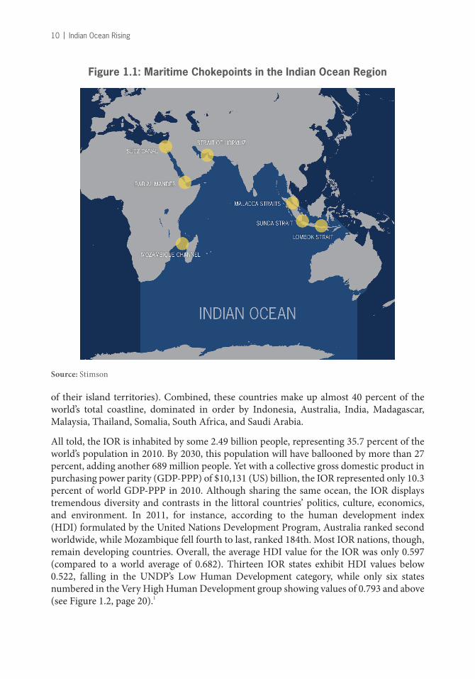
Travel across the Indian Ocean and passage from its waters into neighboring seas is both facilitated and potentially constrained by chokepoints. The seven key chokepoints in the IOR are the Mozambique Channel, the Bab el Mandeb, the Suez Canal, the Strait of Hormuz, the Malacca Straits, the Sunda Strait, and the Lombok Strait.
On land the IOR is bounded and variously influenced by 38 states: Australia, Bahrain, Bangladesh, Comoros, Djibouti, East Timor, Egypt, Eritrea, India, Indonesia, Iran, Iraq, Israel, Jordan, Kenya, Kuwait, Madagascar, Malaysia, Maldives, Mauritius, Mozambique, Myanmar, Oman, Pakistan, Qatar, Saudi Arabia, Seychelles, Singapore, Somalia, South Africa, Sri Lanka, Sudan, Tanzania, Thailand, United Arab Emirates, and Yemen. (France and the United Kingdom can also be counted among the Indian Ocean littoral states because
10 | Indian Ocean Rising
of their island territories). Combined, these countries make up almost 40 percent of the world’s total coastline, dominated in order by Indonesia, Australia, India, Madagascar, Malaysia, Thailand, Somalia, South Africa, and Saudi Arabia.
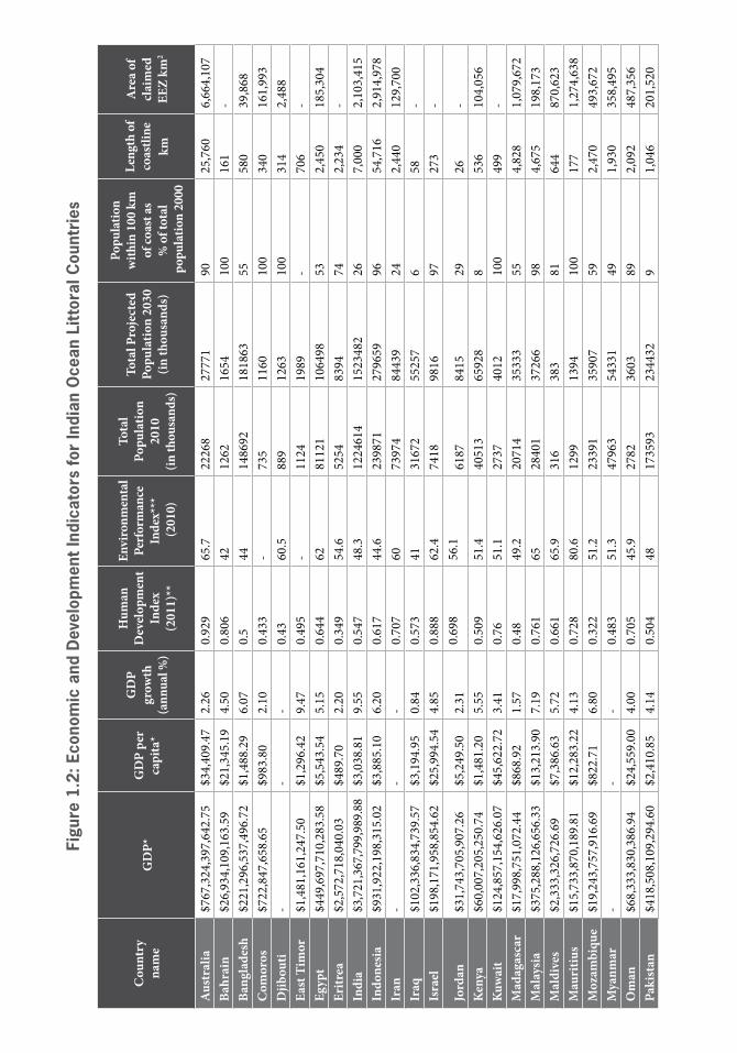
All told, the IOR is inhabited by some 2.49 billion people, representing 35.7 percent of the world’s population in 2010. By 2030, this population will have ballooned by more than 27 percent, adding another 689 million people. Yet with a collective gross domestic product in purchasing power parity (GDP-PPP) of $10,131 (US) billion, the IOR represented only 10.3 percent of world GDP-PPP in 2010. Although sharing the same ocean, the IOR displays tremendous diversity and contrasts in the littoral countries’ politics, culture, economics, and environment. In 2011, for instance, according to the human development index (HDI) formulated by the United Nations Development Program, Australia ranked second worldwide, while Mozambique fell fourth to last, ranked 184th. Most IOR nations, though, remain developing countries. Overall, the average HDI value for the IOR was only 0.597 (compared to a world average of 0.682). Thirteen IOR states exhibit HDI values below 0.522, falling in the UNDP’s Low Human Development category, while only six states numbered in the Very High Human Development group showing values of 0.793 and above (see Figure 1.2, page 20).1
Figure 1.1: Maritime Chokepoints in the Indian Ocean Region
Source: Stimson

Indian Ocean Rising: Maritime and Security Policy Challenges | 11
Despite its significant geographic span and its large and growing population, the Indian Ocean has long suffered a relative neglect in world geopolitics. For most of the 20th century the region’s role and importance were mostly overshadowed, considered subsidiary to super power rivalries largely enacted elsewhere and across other oceans. Today, however, the IOR has risen to the forefront of world geopolitics. Propelled by the world’s continuing reliance on Persian Gulf hydrocarbon resources, the growing significance of the Indian Ocean’s sea lanes of communication and chokepoints, as well as the turbulent regional socio-political environment (including America’s ongoing military operations in Iraq and Afghanistan), and the rise of China and India as global powers, the region is increasingly considered an area of crucial geostrategic importance.
While the IOR now features more prominently in the geopolitical interests and commercial calculations of extra-regional powers such as the US, the European Union nations, Japan, and China, regional states and non-state actors also increasingly influence regional and global affairs. Indeed, regional developments now reverberate far beyond the Indian Ocean’s shores. Overall, the IOR represents the most politically troubled and potentially combustible area of the world. In 2011, a total of 142 political conflicts were recorded in the IOR, representing more than a third of the 388 conflicts worldwide, including 12 of the world’s 20 wars, as well as an additional eight limited wars.2
At the same time, rising flows of commerce, investment, and people are linking the Indian Ocean nations to each other—and the IOR to the rest of the world—more closely. The decades since the 1970s, for example, have long since established the Indian Ocean as the primordial artery carrying oil from the Persian Gulf out to power the engines of the global economy. More recently, however, the Indian Ocean has become the principal conveyor belt for the international coal trade. The expanding economies of China and India are now the top two importers, shipping in 10 times more coal in 2010 than 2003. Meanwhile, South Africa, Indonesia, and Australia together account for more than half the world’s exports of thermal coal. Similarly, swelling labor flows and remittances are playing increasingly important parts in many regional economies. Migrant workers from South and Southeast Asia fill more than 90 percent of private sector jobs in most of the Gulf Cooperation Council Countries, while expatriates constitute 81 percent of the total population in the United Arab Emirates, 75 percent in Qatar, and 67 percent in Kuwait.3
History suggests that the Indian Ocean may be destined for substantially more intra-regional commercial connections. The IOR was once known as a “British lake.” The empire’s territorial possessions stretched from Cape Town to Calcutta, Singapore, and beyond. Studies tracing the economic implications of such socio-cultural legacies have found that two countries sharing a common language trade 42 percent more with each other than two otherwise identical nations lacking that linguistic tie. Countries that once shared an imperial bond trade with each other 188 percent more. Indeed, a common imperial heritage bolsters trade even more than sharing a common currency.4
For centuries past, the Indian Ocean was primarily an international through-route. It is now rapidly emerging as a major global intersection for geostrategic, economic, natural resource, and environmental issues. Multiple security, maritime policy, and governance challenges are driving regional and extra-regional players to focus increasing attention on

12 | Indian Ocean Rising
Indian Ocean issues within a complex geopolitical framework where foreign powers and local actors’ interests and objectives inextricably intermingle. The papers assembled in this publication represent conceptual building blocks for analyzing this transformation. They sketch the emerging socio-economic, security, commercial, and environmental trends that will shape the region in the coming decades and examine their implications for decision-makers and stakeholders.
In this publication’s second chapter, Rupert Herbert-Burns assesses the variety of sources of insecurity that afflict the region, ranging from insurgent conflict, terrorism, and political instability to illicit trafficking and piracy. These security threats exist within one of the world’s most important strategic and commercial spaces, with the Persian Gulf serving as the world market’s most significant source of crude oil and the northern Indian Ocean rim constituting a critical sector of the globe’s east-west-east trading belt. Taken together, the myriad security threats facing the region may exceed the international and regional community’s capacity to effectively manage such challenges. Indeed, without policy coherence, creative thinking, longevity of participation, and significant resources, there is a likelihood that the various security threats facing the region will further increase in 2012 and beyond, contributing to the area’s geopolitical fragility.
Piracy and armed robbery at sea—particularly off the Somali coast—remain top maritime security concerns in the IOR. Despite the efforts of a multinational coalition to patrol the waters off east Africa, the area impacted by Somali piracy remains enormous at approximately 2.5 million square miles, with pirates’ use of mother ships enabling Piracy Attack Groups (PAGs) to stage vessel hijackings at great distances from the coast. To date, even an international naval presence combining the resources of the European Union, NATO, and the US Navy has had great difficulty in securing such a wide swath of ocean. As a result, many merchant vessels transiting through the western Indian Ocean have implemented their own anti-piracy measures, including the hiring of private-armed security teams.
While piracy has earned the greatest share of headlines in terms of security threats in the Indian Ocean, other security issues abound. Trafficking of illicit narcotics, weapons, and people within and via the Indian Ocean will likely continue in the medium- to long term because there are numerous sources of high-volume supply for all three commodities, a sufficiently large number of points of export that suffer from chronic insecurity, and a wide array of sea transportation available to service all the necessary sites of demand and consumption.
Maritime terrorism also poses a potentially serious danger to the region. Although there has been little in the way of seaborne terrorist attacks in the IOR over the past decade, extremist groups affiliated with Al-Qaeda (particularly Al-Qaeda in the Arabian Peninsula) have expressed a continuing interest in closing down strategic maritime chokepoints, such as the Bab al-Mandeb that separates Yemen from Djibouti. While the ability of Al-Qaeda-affiliated groups to successfully execute attacks on commercial vessels in the area remains the source of much speculation, there exists little doubt about these groups’ intentions.
Growing energy exploration in the western Indian Ocean provides an intriguing opportunity to bolster maritime security in the region, however. Oil experts increasingly view the waters off the eastern African coast as one of the world’s last remaining major

Indian Ocean Rising: Maritime and Security Policy Challenges | 13
petroleum frontiers, stretching from Somalia in the north to Mozambique in the south. As offshore surveying and drilling activity increases in the region, energy companies may likely utilize their considerable financial resources to deploy security personnel to protect drilling operations. It is conceivable that increasing numbers of private maritime security assets in the western Indian Ocean may potentially diminish PAGs’ ability to stage vessel hijackings. This security-bolstering process could be accelerated with some international assistance for additional coastal patrol vessels and training for the Kenyan, Tanzanian, and Mozambican navies and/or coast guards.
In the third chapter, Herbert-Burns considers the ongoing shift of the Cold War-centric geopolitical gravity from the Atlantic and Pacific Oceans to the Indian Ocean, as more world naval powers turn their attention and resources to the IOR. This shift has been driven by the astonishing economic growth of China, the steady rise of India’s trade and productivity, increasing exports of raw materials from developing countries, and rising exports of crude oil from the Middle East to Asia. When this economic and trade shift is fused with the reality of the numerous, serious ongoing security challenges in the IOR, it comes as no surprise that major naval powers and regional navies have placed the Indian Ocean as a priority area in current and future operations and strategic planning.
For the most part, the country with the biggest and more permanent presence in the IOR has been the United States. The very substantial US naval presence in the region has served several key purposes, including ensuring the freedom of navigation for vital crude exports from the region; conducting military operations during the wars in the Persian Gulf; monitoring Iranian military deployments and deterrence of aggression; and conducting maritime security operations (MSO), which include counter-terrorist, counter-trafficking, and counter-piracy missions. To a lesser extent, the larger European navies—principally the British Royal Navy and the French Navy—have maintained a presence in the IOR as well, and over the past three years, European Union navies have also provided a sustained contribution to the international effort to protect ships against attack from piracy in the Gulf of Aden and Horn of Africa. However, in light of deep spending cuts being made by some major EU states, there is growing concern that large-scale multilateral naval operations may not be sustainable through 2012 and beyond.
Maritime security in the IOR in the short-to-medium term is going to be founded upon the robust and sustained naval presence of the larger extra-regional navies and the large regional powers, with the latter group consisting primarily of Australia, Egypt, India, Indonesia, Iran, Israel, Malaysia, Pakistan, Singapore, and Thailand. However, in looking to the longer-term future security of this vital maritime space, the increased naval and/or coast guard capabilities of the smaller forces—such as the Gulf Cooperation Council (GCC) states, Kenya, Tanzania, the Comoros, Madagascar, the Maldives, Mauritius, Mozambique, and the Seychelles—will be crucial in the fight to counter piracy and armed robbery, illicit fishing, and trafficking by sea in high-risk areas.
Nevertheless, some commentators would argue that the rise of Indian and Chinese naval power and deployment in the Indian Ocean constitute the most important aspect of 21st century naval and maritime security developments in the IOR. For China, the primary concern is securing extensive sea lines of communication (SLOCs) that traverse the Indian

14 | Indian Ocean Rising
Ocean and western Pacific, linking the Persian Gulf crude exporters and China’s main oil terminals and coastal refineries. Beijing is in the midst of several ambitious projects to expand its naval power projection capabilities well beyond its littoral—and indeed well beyond the South China Sea, over large parts of which China is claiming sovereign rights. Aside from the clear worry to India and other Asian states, the evolution of China’s maritime power—or what Beijing has labelled its ‘Far Sea Defense’—is also of increasing concern to the US.
Finally, for India, an increasing reliance on imported oil and natural gas to fuel its economic expansion has led the government to view the Indian Ocean as New Delhi’s backyard, and as a maritime territory for the Indian navy to dominate and police. India’s dependence on the security of the Indian Ocean, combined with its need to monitor and, if necessary, check the naval activity of other powers, means that the country is compelled to reach out deep into the ocean—far beyond its own littoral—to enable more expansive maritime domain awareness.
The Indian Ocean represents a significant commercial artery as well as a global security arena. The 2008-09 global economic crisis has left the world’s maritime shipping industry in a fragile state, although signs of recovery abound. While world seaborne trade dropped by 4.5 percent in 2009, the sustained positive economic performance of China, India, Brazil, and other key developing economies during the crisis helped maintain some semblance of stability in the global shipping industry. Continuing economic activity in those countries has since fuelled the industry’s ongoing recovery. However, slow economic recoveries in the European Union, United States, and Russia have continued to damper the industry’s growth prospects in the short-term, as Herbert-Burns shows in the publication’s fourth chapter.
The world’s merchant fleet is comprised primarily of bulk carriers (36 percent), oil tankers (35 percent), container vessels (13 percent), and general cargo ships (9 percent). While the global fleet’s cumulative deadweight tonnage (DWT) increased by 7 percent over the course of the crisis, such growth actually reflected the delivery of new ships ordered prior to the downturn. The resulting oversupply in world tonnage has meant that many ships have remained idle in major anchorages. There have not been any significant new orders for bulk carriers or tankers since 2008, although orders for new container vessels have rebounded impressively since 2010.
A survey of fleet ownership data in early 2010 revealed that while firms and individuals in Greece and Japan own the most world tonnage, China has surpassed Germany as the world’s third-largest ship-owning company. This achievement speaks to Beijing’s ongoing campaign to control and flag more shipping as a means of bolstering the country’s economic security and improving growth prospects.
In terms of new vessel construction in recent years, activity has been concentrated primarily in South Korean, Chinese, and Japanese shipyards. Rising oil prices and ongoing concerns about the shipping industry’s greenhouse gas emissions have combined to drive innovative ship design that prioritizes economy of scale, energy efficiency, and environmental sustainability. However, some of these new larger ships will be unable to use any port in the Americas, or pass through the Panama Canal. Instead, these vessels have been designed specifically to service trade routes connecting Europe with Asia via the Indian Ocean,

Indian Ocean Rising: Maritime and Security Policy Challenges | 15
using the Suez Canal and Singapore Straits as key transit points. The industry trend of commissioning new ships customized to travel through waters of the IOR is based largely on the projected growth of exported Chinese manufactured goods over the coming years.
Although the international shipping industry continues a gradual recovery in the wake of the 2008-09 economic crisis, many of the world’s primary container liner trades continued to struggle through 2011 to 2012. This situation has raised concerns that maritime trade could be hit hard in the event of a second major economic downturn. Still, despite the economic losses experienced by some container companies over the past year, shipping companies in general are faring far better in 2012 than in 2009.
For all of their interactions and exchange across the maritime space, the nations bordering the Indian Ocean and South China Sea rely upon international law and intergovernmental organizations to provide a fair and stable ocean regime that supports national security, economic development, and sustainable use of the maritime resources and services upon which their populations and industries depend. As Caitlin Antrim discusses in the fifth chapter, ocean governance in the Indian Ocean and South China Sea must address various groupings of countries, specialized agreements, and the diverse geologic and biologic resources of the region.
The Law of the Sea (LOS) Convention recognizes national authority over vast tracts of the sea and seafloor. With few exceptions, this national authority over sea- and seafloor resources has not been matched by the development of planning, administrative, regulatory, or enforcement capabilities to oversee the exploitation of this great increase in countries’ patrimony. This problem is most apparent in the seas off Somalia, where piracy and armed robbery at sea have become serious threats to international commerce. Other problems are expected to surface as coastal states’ efforts to extend their respective maritime jurisdictions—coupled with their failure to apply the resources needed to regulate activities in those jurisdictions—may increase the likelihood of resource-management issues, diplomatic disputes, or even outright conflict.
Over the coming decades, one of the most pressing issues will be that while the living resources of the sea will remain essential to regional economies and food security, few states have the capability, resources, and maritime infrastructure to manage these resources effectively. Increasing the capability of coastal states to manage and regulate fishing in their EEZs—and reduce illegal, unreported, and unregulated fishing on the high seas—will be a critical maritime issue for all states bordering the Indian Ocean and South China Sea.
A second key issue is that overlapping claims by China and several ASEAN states in the South China Sea—driven in part by the economic potential of oil and gas resources—could lead to serious armed conflict. While a protracted period of jurisdictional disputes punctuated by small confrontations seems most likely, China’s designation of the South China Sea as a “core interest”—and the increasing prospects for the use of armed force to displace Vietnamese and Philippine presence in the islands of the South China Sea—raises the possibility of more serious armed conflict.
While not as attention-grabbing as the threat of armed conflict, the eroding balance between coastal state authority and foreign state freedom of navigation in the territorial sea and EEZ

16 | Indian Ocean Rising
is a serious concern for US naval mobility and civilian commerce. Coastal states’ efforts to increase their maritime jurisdiction constitute a continuing and cumulative threat. For example, China’s efforts to limit military activities in its EEZ, and India’s requirements for permits before allowing repair and maintenance of submarine cables on the floor of its EEZ, could erode the military and civilian interests of maritime states if not contested both diplomatically and operationally.
As long as the US remains outside the LOS Convention, Antrim argues, its ability to demand respect for its rights as enumerated in the Convention will be weakened. Should the US fail to join the Convention, this situation can be expected to continue. Additionally, by staying outside the Convention, the US provides legitimacy should any state that feels constrained by the Convention—such as China—decide to reject the Convention’s restrictions by leaving its membership. Given the recent efforts of China and India (among others) to expand coastal state jurisdiction over maritime activities off their coasts, US failure to join the LOS Convention will likely lead to increased regional maritime challenges and confrontations.
In the sixth chapter, Rupert Herbert-Burns turns from the international laws governing the sea to the energy resources lying under the ocean, distinguishing between three major sectors of the industry—upstream, midstream, and downstream. Within the IOR, the vital components of the three sectors are represented respectively by the existing primary and evolving secondary locations of oil and gas production; the transportation of crude, refined products, and liquefied gases via SLOCs and pipelines; and the primary refining, storage, and re-distribution nodes that are vital to the region’s economic productivity.
In the upstream sector, one key area of focus in the IOR involves the planned expansion of oil production in Iraq. Although foreign petroleum companies have been denied access to many of the Persian Gulf ’s sizeable reserves due to long-standing nationalization of oil and gas deposits and industries, access to Iraq’s upstream sector looks far more promising. However, the level of foreign participation will depend entirely on a stable symbiotic relationship between international oil companies (IOCs), national oil companies (NOCs), and the fledgling Iraqi government. Meanwhile, elsewhere in the IOR upstream sector, competition is heating up between China and India over access to Myanmar’s offshore gas fields—an intriguing situation that could have potentially far-reaching implications for the energy security of Asia’s two rising powers.
In the midstream sector of the IOR, there is no more important single factor (from the perspective of Asia’s major oil-consuming powers) than the unimpeded export of crude oil from Iran, Iraq, Kuwait, Saudi Arabia, and the United Arab Emirates (UAE). However, continuing security issues involving petroleum shipping and the Persian Gulf ’s primary export terminals potentially threaten the eastward flow of energy supplies across the IOR. Such vulnerabilities are one of the reasons why a planned crude-oil pipeline across the UAE from Habshan to Fujairah could have a significant strategic impact, by offering an export alternative to tanker shipments through the Strait of Hormuz.
Finally, in the downstream sector of the IOR, Singapore appears poised to continue serving as a strategic petroleum gateway, given the country’s location at the junction of the Indian and Pacific Oceans, amidst the seas that link Australasia with Southeast Asia. Nevertheless, Singapore’s long-held and continued primacy as a strategic petroleum processing node and

Indian Ocean Rising: Maritime and Security Policy Challenges | 17
conveyance gateway may be eroded in the future by the potential development of the Kra Isthmus Canal, which would effectively constitute a ‘Malacca by-pass’ for petroleum trade from the Indian Ocean to the Pacific.
In addition to its energy resources, the Indian Ocean also harbors an array of non-energy renewable and non-renewable resources. Various political, technological, and environmental factors affect the economic potential for developing these resources. Fisheries and minerals constitute the most commercially viable industries, though bio-prospecting the ocean’s genetic resources may lead to valuable new products and applications. However, as Michel, Fuller, and Dolan show in the seventh chapter, over-exploitation and environmental pressures risk undermining important ecosystem services—in the form of food security and biodiversity, for example—that the ocean provides.
Polymetallic nodules and polymetallic massive sulphides are the two mineral resources of primary interest to developers in the Indian Ocean. Polymetallic nodules are golf-to-tennis-ball-sized nodules containing nickel, cobalt, iron, and manganese that form over millions of years on the sediment of the seafloor. Polymetallic massive sulphides contain gold and greater copper, fueling more recent commercial efforts. Yet seafloor deposits tend to be much smaller and exhibit lesser mineral content than those onshore, while their local concentration makes finding them particularly difficult. Exploration for seabed minerals remains a major hurdle. Only 2-3 percent of the global sea floor has been properly mapped, and just 0.0001 percent has been scientifically investigated. Other minerals in the Indian Ocean include coastal sediments containing titanium and zirconium off South Africa and Mozambique, tin placer deposits off of Myanmar, Thailand, and Indonesia, and zinc and copper ore in heavy mud in the Red Sea.
Marine life arguably offers just as much, if not more, economic value than the mineral resources that surround these species. Indian Ocean countries account for a significant proportion of world fisheries. The east Indian Ocean alone is home to 45 percent of the world’s fishers and brings in 20 percent of the total world fish production. Total Indian Ocean fish production increased dramatically from 861,000 tons in 1950 to 10.2 million tons in 2006. The FAO judges that, in certain areas, the Indian Ocean’s resources could nevertheless sustain increased production.
Pollution and environmental stresses, however, increasingly threaten Indian Ocean biodiversity and marine resources. Fisheries are vulnerable to agricultural run-off, sewage, invasive species, and “ghost fishing” (fish ensnared by discarded fishing gear). Continued depletion of Indian Ocean fish stocks could compromise regional and global food security, given that more than a billion people worldwide rely on fish as their main source of protein. Yet one recent study has projected that the world’s fisheries will collapse by 2048 if catch rates continue unabated. Marine organisms also maintain the ocean ecosystem in ways that facilitate human use of ocean resources, generating nutrients that sustain fisheries, absorbing carbon during photosynthesis (which helps to regulate the climate), or assimilating waste materials that pollute the seas.
Several regional and international agreements exist to promote the sustainable management of the Indian Ocean’s resources, such as the FAO Code of Conduct for Responsible Fisheries. The effectiveness of fisheries legislation is limited by high levels of non-compliance,

18 | Indian Ocean Rising
however. The UN Convention on the Law of the Sea established an International Seabed Authority to oversee the prospecting, exploration, and mining of marine resources. Yet the lack of detailed scientific information on the environmental effects of ocean mining has delayed the development of certain legal mechanisms.
Indeed, the countries on the Indian Ocean rim are particularly susceptible to increasing environmental pressures, especially to the prospective repercussions of global climate change on coastal regions and marine resources, as David Michel explains in this publication’s concluding paper. Projected impacts from global warming include rising sea levels, stronger tropical cyclones, larger storm surges, increasing sea surface temperatures, and—as the oceans absorb more of the carbon dioxide that human activities emit into the atmosphere—growing acidification of surface waters. For coastal ecosystems and communities, the potential consequences could be considerable, threatening the livelihoods, health, and welfare of millions of people. More frequent and severe storms can inundate low-lying coastal zones, destroying infrastructure, and displacing populations. Meanwhile, higher water levels and larger wave surges can contribute to accelerated shoreline erosion and retreat, while also exacerbating saltwater intrusion into the rivers and aquifers that furnish freshwater to coastal settlements. Finally, warmer water temperatures and acidifying oceans can degrade the ecology of coral reefs and threaten the artisanal and commercial fisheries that nourish many seaboard communities.
Indian Ocean nations represent six of the 10 most vulnerable states worldwide, ranked by total population living in low-lying coastal settlements. A 2009 World Bank paper examining the dangers to developing nations from potential storm-surge disasters concluded that Indian Ocean littoral states constitute five of the 10 countries with the greatest percentage of coastal population at risk; four of the 10 countries with the highest percentage of coastal GDP at risk; and six of the 10 countries with the highest proportion of coastal urban areas at risk. Climate pressures especially endanger small or low-lying islands like the Maldives, Mauritius, and Seychelles. Major infrastructure in these countries—including roads, airports, seaports, and towns—is situated almost exclusively along the coasts. With little space to retreat from rising seas, local populations might be forced to abandon certain islands, or even evacuate their territory altogether. Such population displacements would engender multiple and tangled questions for the countries of origin (including issues of sovereignty and control of EEZs), destination countries, and the migrants themselves.
Human exposure to such hazards will almost certainly increase with ongoing coastal development. Under Intergovernmental Panel on Climate Change (IPCC) scenarios, the world’s coastal population could grow from 1.2 billion in 1990 to anywhere from 1.8 to 5.2 billion people by the 2080s. Yet policymakers across the region frequently lack the financial, institutional, and information resources necessary to devise and deploy effective national response strategies, much less targeted local measures. Worldwide, financing climate change adaptation measures in coastal zones could require additional annual investment flows of $10-30 billion per year by 2030. In the end, all the countries of the Indian Ocean will have to take action to address global climate change. However, though the individual countries of the region struggle with many of the same issues, they lack a common regional policy framework for addressing their shared problems.

Indian Ocean Rising: Maritime and Security Policy Challenges | 19
Like the seven straits and channels leading into the Indian Ocean from different points of the compass, the following seven chapters provide distinct vantages for viewing maritime and security policy challenges in the region from differing perspectives. However, as a whole, the chapters consistently illuminate both the specific contexts framing particular policy challenges and the complex overlaps and intersections between multiple issue areas, despite their various angles of approach. Combating piracy, for example, requires policymakers to consider a range of issues from naval power capabilities, private shipping practices and interests, international legal regimes, to coastal state development strategies and governance capacities, among other questions.
No longer relegated to the wings of global politics, the Indian Ocean has clearly moved to a more central position. Its strategic energy and natural resources, the growing importance of its ports and shipping lanes, the rise of China and India as significant regional and global players, the deep and broad engagement of the United States (and other Western powers) in the region, and the mounting environmental risks to coastal economies and communities across the Indian Ocean ensure that the IOR will continue to play a key role in global politics in the coming decades.
Notes1 UNDP, Human Development Report 2011 - Sustainability and Equity: A Better Future for All (New York:
UNDP, 2011).2 Heidelberg Institute for International Conflict Research, Conflict Barometer 2011 (Heidelberg, Germany:
HIIK, 2011).3 Two previous Stimson Center studies explored the growth of maritime commerce and international
migration around the Indian Ocean in depth. See Amit Pandya and Rupert Herbert-Burns with Junko Kobayashi, Maritime Commerce and Security: The Indian Ocean (Washington, DC: Stimson, February 2011; Ellen Laipson and Amit Pandya eds., On the Move: Migration Challenges in the Indian Ocean Littoral (Washington, DC: Stimson, 2010).
4 Pankaj Ghemawat, Redefining Global Strategy: Crossing Borders in a World Where Differences Still Matter (Cambridge: Harvard Business School Publishing, 2007).
Cou
ntry
na
me
GD
P*
GD
P pe
r ca
pita
*
GD
P gr
owth
(a
nnua
l %)
Hum
an
Dev
elop
men
t In
dex
(2
011)
**
Envi
ronm
enta
l Pe
rfor
man
ce
Inde
x***
(2
010)
Tota
l Po
pula
tion
20
10
(in th
ousa
nds)
Tota
l Pro
ject
ed
Popu
latio
n 20
30
(in th
ousa
nds)
Popu
latio
n
with
in 1
00 k
m
of co
ast a
s %
of t
otal
p
opul
atio
n 20
00
Leng
th o
f co
astli
ne
km
Are
a of
cl
aim
ed
EEZ
km2
Aus
tral
ia$7
67,3
24,3
97,6
42.7
5$3
4,40
9.47
2.26
0.92
965
.722
268
2777
190
25,7
606,
664,
107
Bahr
ain
$26,
934,
109,
163.
59$2
1,34
5.19
4.50
0.80
642
1262
1654
100
161
-Ba
ngla
desh
$221
,296
,537
,496
.72
$1,4
88.2
96.
070.
544
1486
9218
1863
5558
039
,868
Com
oros
$722
,847
,658
.65
$983
.80
2.10
0.43
3-
735
1160
100
340
161,
993
Djib
outi
--
-0.
4360
.588
912
6310
031
42,
488
East
Tim
or$1
,481
,161
,247
.50
$1,2
96.4
29.
470.
495
-11
2419
89-
706
-Eg
ypt
$449
,697
,710
,283
.58
$5,5
43.5
45.
150.
644
6281
121
1064
9853
2,45
018
5,30
4Er
itrea
$2,5
72,7
18,0
40.0
3$4
89.7
02.
200.
349
54.6
5254
8394
742,
234
-In
dia
$3,7
21,3
67,7
99,9
89.8
8$3
,038
.81
9.55
0.54
748
.312
2461
415
2348
226
7,00
02,
103,
415
Indo
nesi
a$9
31,9
22,1
98,3
15.0
2$3
,885
.10
6.20
0.61
744
.623
9871
2796
5996
54,7
162,
914,
978
Iran
--
-0.
707
6073
974
8443
924
2,44
012
9,70
0Ir
aq$1
02,3
36,8
34,7
39.5
7$3
,194
.95
0.84
0.57
341
3167
255
257
658
-Is
rael
$198
,171
,958
,854
.62
$25,
994.
544.
850.
888
62.4
7418
9816
9727
3-
Jord
an$3
1,74
3,70
5,90
7.26
$5,2
49.5
02.
310.
698
56.1
6187
8415
2926
-K
enya
$60,
007,
205,
250.
74$1
,481
.20
5.55
0.50
951
.440
513
6592
88
536
104,
056
Kuw
ait
$124
,857
,154
,626
.07
$45,
622.
723.
410.
7651
.127
3740
1210
049
9-
Mad
agas
car
$17,
998,
751,
072.
44$8
68.9
21.
570.
4849
.220
714
3533
355
4,82
81,
079,
672
Mal
aysi
a$3
75,2
88,1
26,6
56.3
3$1
3,21
3.90
7.19
0.76
165
2840
137
266
984,
675
198,
173
Mal
dive
s$2
,333
,326
,726
.69
$7,3
86.6
35.
720.
661
65.9
316
383
8164
487
0,62
3M
auri
tius
$15,
733,
870,
189.
81$1
2,28
3.22
4.13
0.72
880
.612
9913
9410
017
71,
274,
638
Moz
ambi
que
$19,
243,
757,
916.
69$8
22.7
16.
800.
322
51.2
2339
135
907
592,
470
493,
672
Mya
nmar
--
-0.
483
51.3
4796
354
331
491,
930
358,
495
Om
an$6
8,33
3,83
0,38
6.94
$24,
559.
004.
000.
705
45.9
2782
3603
892,
092
487,
356
Paki
stan
$418
,508
,109
,294
.60
$2,4
10.8
54.
140.
504
4817
3593
2344
329
1,04
620
1,52
0
Figu
re 1
.2: E
cono
mic
and
Dev
elop
men
t Ind
icat
ors
for
Indi
an O
cean
Lit
tora
l Cou
ntri
es

Cou
ntry
na
me
GD
P*
GD
P pe
r ca
pita
*
GD
P gr
owth
(a
nnua
l %)
Hum
an
Dev
elop
men
t In
dex
(2
011)
**
Envi
ronm
enta
l Pe
rfor
man
ce
Inde
x***
(2
010)
Tota
l Po
pula
tion
20
10
(in th
ousa
nds)
Tota
l Pro
ject
ed
Popu
latio
n 20
30
(in th
ousa
nds)
Popu
latio
n
with
in 1
00 k
m
of co
ast a
s %
of t
otal
p
opul
atio
n 20
00
Leng
th o
f co
astli
ne
km
Are
a of
cl
aim
ed
EEZ
km2
Qat
ar$1
22,7
60,1
29,6
23.7
5$6
9,79
7.94
16.6
00.
831
48.9
1759
2371
100
563
-Sa
udi A
rabi
a$5
63,6
31,8
92,5
53.1
5$2
0,53
4.47
4.64
0.77
55.3
2744
838
481
302,
640
-Se
yche
lles
$1,8
98,8
04,1
89.5
0$2
1,94
5.15
6.71
0.77
3-
8792
100
491
1,28
8,64
3Si
ngap
ore
$264
,851
,231
,244
.99
$52,
169.
9614
.76
0.86
669
.650
8659
7810
019
3-
Som
alia
--
--
-93
3116
360
553,
025
-So
uth
Afr
ica
$474
,761
,314
,373
.16
$9,4
96.8
82.
890.
619
50.8
5013
354
711
392,
798
-Sr
i Lan
ka$9
5,02
1,83
0,68
4.39
$4,6
00.8
78.
020.
691
63.7
2086
023
094
100
1,34
050
0,75
0Su
dan
$88,
125,
220,
303.
82$2
,023
.45
4.45
0.40
847
.143
552
6685
63
853
-Ta
nzan
ia$5
6,27
2,89
2,52
0.40
$1,2
93.0
87.
040.
466
47.9
4484
181
852
211,
424
204,
294
Thai
land
$530
,367
,086
,844
.91
$7,6
72.8
97.
810.
682
62.2
6912
273
321
393,
219
176,
540
Uni
ted
Ara
b Em
irat
es$3
18,1
42,3
05,9
81.8
0$4
2,35
2.96
1.43
0.84
640
.775
1210
489
851,
318
21,2
00Ye
men
$57,
076,
171,
503.
55$2
,372
.98
7.70
0.46
248
.324
053
4134
264
1,90
646
4,96
6
Not
es:
* GD
P at
Pur
chas
ing
Pow
er P
arity
in c
onst
ant 2
005
inte
rnat
iona
l US
dolla
rs fo
r 201
0**
The
Hum
an D
evel
opm
ent I
ndex
(HD
I) is
a su
mm
ary
mea
sure
of h
uman
dev
elop
men
t. It
mea
sure
s the
ave
rage
ach
ieve
men
ts in
a c
ount
ry in
thre
e ba
sic d
imen
sions
of h
uman
de
velo
pmen
t: a
long
and
hea
lthy
life
(hea
lth),
acce
ss to
kno
wle
dge
(edu
catio
n) a
nd a
dec
ent s
tand
ard
of li
ving
(inc
ome)
. Dat
a av
aila
bilit
y de
term
ines
HD
I cou
ntry
cov
erag
e. T
o en
able
cro
ss-c
ount
ry c
ompa
riso
ns, t
he H
DI i
s, to
the
exte
nt p
ossib
le, c
alcu
late
d ba
sed
on d
ata
from
lead
ing
inte
rnat
iona
l dat
a ag
enci
es a
nd o
ther
cre
dibl
e da
ta so
urce
s ava
ilabl
e at
the
time
of w
ritin
g.
***T
he E
nvir
onm
enta
l Per
form
ance
Inde
x (E
PI) r
anks
cou
ntri
es o
n 25
per
form
ance
indi
cato
rs tr
acke
d ac
ross
10
polic
y ca
tego
ries
that
cov
er b
oth
envi
ronm
enta
l pub
lic h
ealth
an
d ec
osys
tem
vita
lity.
Thes
e in
dica
tors
pro
vide
a g
auge
at a
nat
iona
l gov
ernm
ent s
cale
of h
ow c
lose
cou
ntri
es a
re to
est
ablis
hed
envi
ronm
enta
l pol
icy
goal
s. So
urce
: Wor
ld B
ank,
Wor
ld D
evel
opm
ent I
ndic
ator
s; U
ND
P, H
uman
Dev
elop
men
t Rep
ort 2
011
- Sus
tain
abili
ty a
nd E
quity
: A B
ette
r Fut
ure
for A
ll (N
ew Y
ork:
UN
DP,
201
1);
UN
, Wor
ld P
opul
atio
n: T
he 2
010
Revi
sion
Dat
a O
nlin
e; D
on H
inri
chse
n, T
he A
tlas o
f Coa
sts a
nd O
cean
s: Ec
osys
tem
s, Th
reat
ened
Res
ourc
es, M
arin
e C
onse
rvat
ion
(Chi
cago
: U
nive
rsity
of C
hica
go P
ress
, 201
1).

Cover Photo Credits: (Top to bottom) Only Truth via Wikimedia; Caitlyn Antrim/Stimson; US Navy via Wikimedia; National Oceanic and Atmospheric Administration; Department of Defense; Jim and Becca Wicks via Wikimedia; Steven Straiton via Flickr.

1111 19th Street NW, 12th FloorWashington, DC 20036p 202.223.5956 | f 202.238.9604www.stimson.org