improvement of cadastral maps in croatia · 2018-04-16 · document for non-commercial purposes by...
TRANSCRIPT

IMPROVEMENT of cadastral maps in CROATIA
JERONIM MOHARIĆ 1, JOZO KATIĆ
2, ANTONIO ŠUSTIĆ
2, DAMIR ŠANTEK
2
1 GEO-GAUSS Ltd., Čakovec, Croatia
2 State Geodetic Administration, Zagreb, Croatia
Paper prepared for presentation at the
“2018 WORLD BANK CONFERENCE ON LAND AND POVERTY”
The World Bank - Washington DC, March 19-23, 2018
Copyright 2018 by author(s). All rights reserved. Readers may make verbatim copies of this
document for non-commercial purposes by any means, provided that this copyright notice
appears on all such copies.

1
Abstract
About the homogenization as a method for cadastral maps of graphic survey improvement in the Republic
of Croatia several projects and studies has been conducted, a lot of expert papers were published, but the
implementation of the improvement has not yet occurred.
In this project based on the analyses carried out, it was necessary to fulfill the existing methodology and
create needed technical solutions.
The final solution of the new homogenization methodology uses three types of transformation parameters,
and these are: the identical points for homogenization, measured points from existing geodetic records,
and the boundaries of isolated areas at places of discontinuity of spatial data (constraints).
The results of new approach are much better as expected and they are strong reason to begin the
implementation of the homogenization process as a systematic process.
Key Words: analysis of DCM maintenance, homogenization, improvement of digital cadastral maps of
graphic survey, isolated areas, methodology of homogenization
2
Historical and geographical context of Repblic of Croatia
The Land administration is inseparably linked to the state history. The Republic of Croatia is an
independent democratic state, a member of the European Union and NATO alliance. Croatia is a small
country, but is recognizable by its natural beauty in the world as a tourist pearl in which 4.5 million
friendly inhabitants live.
For understanding of geographic and historical context of Croatia it is important to explain that is located
in Europe on the crossroads of the Roman and the Ottoman Empire, where history has often changed
borders. Croats are in its homeland from the 7th century where they arrived in the great seas of the
people. In the 10th century Croatia was independent and had its own Kingdom. From the 12th century it
joins the union with Hungary and they join together in the 16th century with Austria.
After the collapse of the Austro-Hungarian Monarchy in 1918, Croatia entered a new alliance, in the
Kingdom of Serbs, Croats and Slovenes, also called the Kingdom of Yugoslavia, and from 1945 to 1990
Croatia was one of the six federal states of Socialist Federal Yugoslavia.
After 10 centuries under the authority of another, the Republic of Croatia became again independent and
sovereign State in 1990, and since 2013 it is a full member of the European Union.
Land administration through history
Croatia has many historical monuments and documents about land registry and administration. The first
land records on Croatian soil are mentioned at the beginning of the 14th century on the territory of the
Dubrovnik Republic and Dalmatia. The Cadastre that exists today in Croatia was established at the
beginning of the 19th century with decree of Emperor Franjo I. known as "Patent on the introduction of a
stable cadastre" and served as basis for property tax.
Based on this decree in the first half of 19th century the whole territory of Croatia was surveyed with
graphical method and hereby Cadastre registers were established. Another decree in 1850 established land
registers based on the cadastral graphical data at the courts where the property, ownership and burdens
were recorded.
In the period from 1945 to 1990 during communist system, the Cadastre was main register where the
possessors as a taxpayer were registered, and the ownership registration in land registry was neglected.
Cadastral surveys in this period were mostly carried out only for urban areas of cities and settlements but

3
without the registration of land ownership. This resulted with significant disparities between these
registers.
After the independence of 1990, the Republic of Croatia passed the transition from the communist to the
capitalist system, thus changing the perception of ownership, and the records in the land registry became
more dominant than Cadastre records, although this registry was less matched to the factual state.
For these historical reasons, two separate registers exists in Croatia that are physically mostly at different
locations and under the jurisdiction of different institutions, and the data is unpaired.
Land Administration Reform
After the end of the war for independence in 1995, the renewal of the country began with building of the
infrastructure, but the situation in the land registry administration was a barrier for the investments. In this
time the changes on the cadastral maps were drawn manually on paper, and the registration of ownership
was handwritten in land register books. Many hundreds of thousands of backlogs of cases existed, so for
the recording and issuing of ownership data it has to be waited for months and years.
The Government of the Republic of Croatia initiated in 2003 the national Real Property Registration and
Cadastre Project. The main objective of the project was to modernize real estate registration and to build
an effective land management system thereby contributing to the development of a society and an
effective real estate market. The project was implemented by the Ministry of Justice and the State
Geodetic Administration, and was financed mainly by the World Bank loan, the European Union's
donations and its own budget funds.
From 2003 to 2010, the conversion of the cadastral maps into the digital form and the entry of the last
recorded state from the land register books into the electronic form was carried out, several systematic
cadastral surveys has been launched, as well as invested in infrastructure and education.
The World Bank has decided to continue supporting this very important reform. The Integrated Land
Administration System Project was started in 2011 along with the introduction of modern technologies
and business process development, and the Real Property Registration and Cadastre Joint Information
System (JIS) has been developed with the final goal of merging two historical records into one unified
database.

4
The World Bank and other donors assess the achievements as highly satisfactory but also point to the
activities that need to be accelerated. Today data are in digital form, needed processes and information
system have been developed and implemented, as well as infrastructure has been built, but the recorded
data often do not correspond to the actual state due to the historical reasons described above.
Within the Integrated Land Administration Implementation Project, currently in progress are the project
of improvement of the cadastral maps of graphic surveying (homogenization) as well as the project of the
digital geodetic record (SDGE) in development phase. These projects will enable the State Geodetic
Administration to solve most of the currently existing problems in the cadastral system. Other projects are
aimed at functional linkage of cadastral and land-registry data into one unified database of land data.
Improvement of cadastral maps (homogenization)
Cadastral maps originated from the 19th century are made by the graphing method on the geodetic table
and are far less accurate than required today, but these are still in official use on the 70% of the territory
of the Republic of Croatia. By overlapping such cadastral maps with the actual situation we come to the
problem, because larger or smaller position misalignments exist.
In such maps, the changes are most often drawn by the method of adjusting the measured data to the map.
The purpose of this project is the geometric improvement of the cadastral maps to the extent that the
changes can be drawn by the method of overlapping the measured data on the improved map.
Theoretically, improvement of old cadastral maps is a technical action that does not change the legal state
of the cadastral graphical data and cannot substitute the cadastral survey but will make possible to draw
changes based on the measured individual geodetic surveys in the official records by the overlap method
and properly represent the real position on the field.
At the beginning of this project an analysis of the data status was carried out and many other issues were
discussed which ultimately had an impact on the improving of the methodology and the final business
process. A lot of deformations, inhomogeneities and anomalies are recognized through the analysis. They
distort spatial data continuity. They are generated during graphical survey, during maintenance, upon
vectorization (most often at the places where the scanned sheets are joined), when outer parts are
incorporated into the maps, upon the georeferencing in the coordinate system while the approximate
parameters are used etc.

5
The challenge was to correct these deformations, inhomogeneities and anomalies, and at the same time
keep the parts of the cadastral maps that are already mapped by the geodetic records unaltered on their
position. Data analysis in the Joint Information System (JIS) indicated that there is no consistent state of
the attribute data, so the improvement process need include the attribute data treatment.
Methodology
The main objective and purpose of homogenization is the geometric improvement of the digital cadastral
maps (DCM) of the graphical survey to the extent that will be possible to map the newly surveyed detail
with the overlap method in the entire area of the homogenized DCM (unless exceptionally in fragments
where the field situation has so changed in relation to DCM that no kind of transformation of DCM is
possible).
At the same time the parts of the cadastral map that have already been mapped by the overlap method
must keep their position unchanged (by preserving the coordinates of the actual position of such points),
and possibly the points on the DCM for which the actual (measured) coordinates exists have to be brought
into their actual position.
Existing methodology and technical solutions did not include solving a number of anomalies, and
exchange protocols with JIS had to be developed as well.
Existing methodology and technical solutions cannot solve a number of anomalies on digital cadastral
maps of graphical survey, some of which were originally generated during graphical survey and most
during vectorization and maintenance (in analog and digital form). During the analysis many anomalies
and abnormalities have been identified. These are inhomogenities originated from graphical survey,
anomalies incurred during maintenance on analog maps, anomalies during incorrect map sheet
georeferencing (mostly on map sheet joining, insufficiently accurate parameters for georeferencing, etc.),
during incorrect maintenance in digital form, etc. Most of these abnormalities are commonly associated
with abrupt and sudden changes in spatial data continuity. An additional difficulty was the fact that all
digital maps migrated to the GIS based information system (JIS).
Therefore, the new methodology has been developed so that the homogenization process includes not
only the identical points for homogenization, but also adds the boundaries of the isolated areas and the
points from existing geodetic records into the transformation process.
6
This approach allows the areas of different (in)homogeneities to be transformed individually and at the
same time, the points from the geodetic records in the transformation process additionally affect the
improvement of the cadastral maps so that all points that are mapped by the overlap method protect the
position on the DCM, and the points that are mapped shifted are brought to the actual position also
improving their environment with limited impact. In addition, the attributes of points and cadastral parcels
are also improved.
Further enhancement was impact on changing the concept of maintenance in the JIS and as such it is
compatible with the further projects in development.
Developed methodology ensures negligible deformations of the buildings during transformation and the
anomalies can be improved correctly.
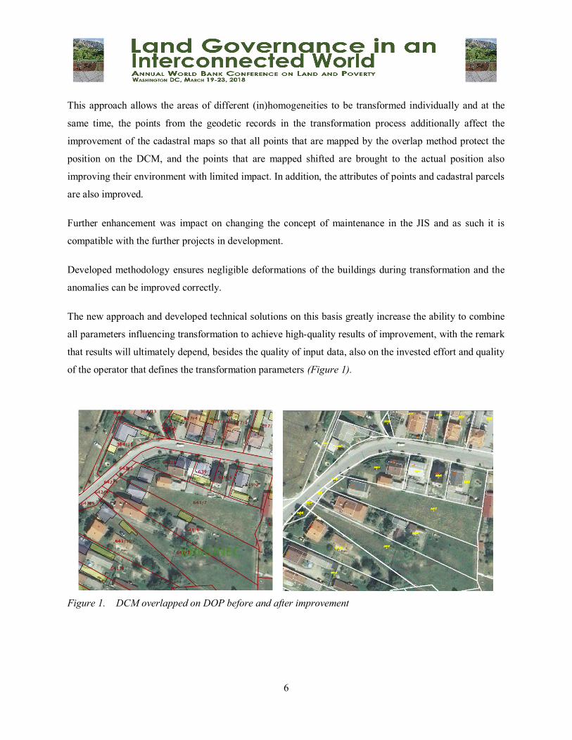
The new approach and developed technical solutions on this basis greatly increase the ability to combine
all parameters influencing transformation to achieve high-quality results of improvement, with the remark
that results will ultimately depend, besides the quality of input data, also on the invested effort and quality
of the operator that defines the transformation parameters (Figure 1).
Figure 1. DCM overlapped on DOP before and after improvement

7
Identical points
The base for the homogenization is the set of identical points. These are points that can be reliably
determined by the coordinates on the cadastral map and the coordinates of the actual position in the field,
and are to be defined from the best available data (from the existing geodetic records, reading from the
DOP etc.) according to the prescribed density and positioning.
Identical points for the homogenization is to be defined as vectors where the starting point of the vector is
the point on the cadastral map (the coordinates on the DCM), and the end point of the vector is the point
of the actual position (the coordinates (E, N) of the actual position in the field).
The defining of reliable identical points for the homogenization depends mostly on the experience of an
expert who knows the cadastral map and methods of its maintenance well. The defining of identical
points for the homogenization should be performed by experienced geodesic experts with many years of
experience.
Isolated areas
The digital cadastral map originated from old graphical survey of the entire cadastral municipality often
has parts of different quality incurred originally or through the maintenance during the long period. For
example, larger areas with a reliable position of the points which include parts of a new survey, stream
and river regulations, locally enhanced DCM, etc. and/or areas that differ significantly in terms of their
position from their environment, annexes, enclaves, islands, etc.
Such areas should not be homogenized (transformed) with the identical parameters defined for the
cadastral municipality as a whole. On the transition between these parts it was necessary to introduce the
breaks or constraints. These are areas that differ significantly in terms of their (in)homogeneity from their
immediate surroundings and the rest of the cadastral municipality.
Such an approach extends the possibilities of homogenization extensively, because each isolated
(bounded) area can:
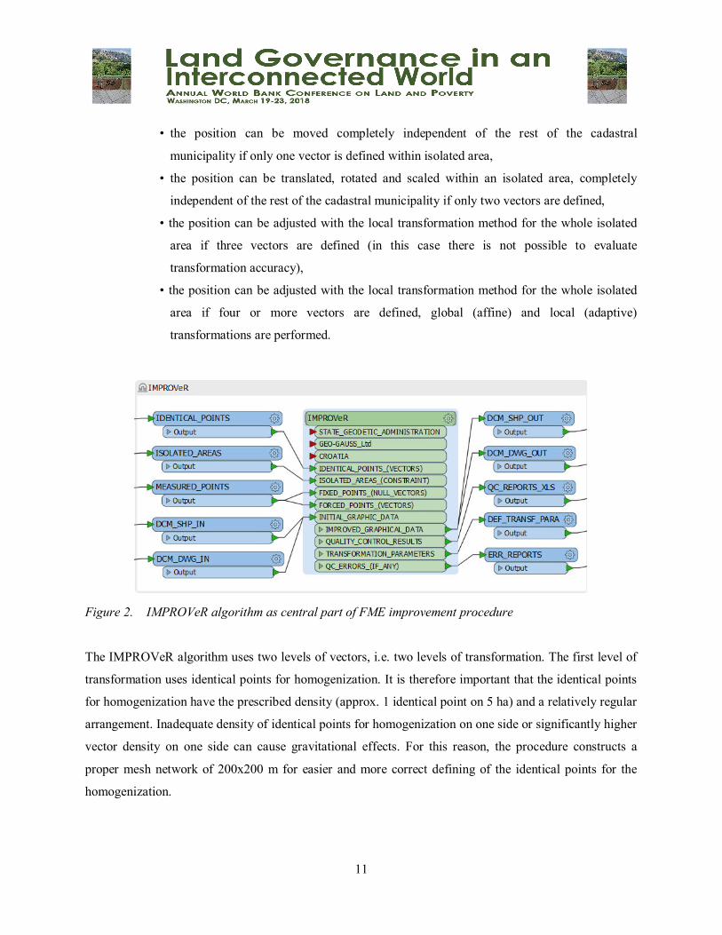
• Hold its position if no identical point for homogenization (vector) or one or more null vectors
are defined within the isolated area
• The whole block (isolated, bounded area) can be moved completely independently of the rest of
the cadastral municipality if only one vector is defined within the isolated area

8
• The whole block (isolated, bounded area) can be translated, rotated and scaled completely
independently of the rest of the cadastral municipality if only two vectors are defined
• If three vectors are defined, only a local (adaptive) transformation is performed for the whole
isolated area (in this case there is not possible to evaluate transformation accuracy).
• If four or more vectors are defined, the global (affine) and local (adaptive) transformation will
be performed for the whole isolated area (in this case an evaluation of transformation accuracy
will occur).
As explained, the identical points for the homogenization are defined as vectors. The vectors inside the
isolated area have no influence on the rest of the cadastral municipality, nor do the identical points outside
the isolated area affect the transformation within the isolated region.
The isolated area is defined by the closed polygon around the desired part (or detail on the map). This
method is practical for use when certain areas are to be kept in their position or a certain detail is to be
transformed independently of the rest of the cadastral municipality.
The size and number of isolated areas is not limited, so the isolated area can be defined around a larger
range of different scales, whole quarters, parts of quarters, whole or part of a parcel, or even around one
point.
The hierarchy between isolated areas does not exist, so if an isolated area is defined within other isolated
area, these are independent one from another. If only one isolated area is defined, the rest of the cadastral
municipality is automatically considered to be another isolated area. If no isolated area is defined, the
entire cadastral municipality is automatically considered to be one isolated area.
Points from the geodetic records
Existing points from the registered geodetic records (individual elaborates, roads, zones, etc.) are
necessary to be used in the homogenization process to keep the points that were mapped by the overlap
method on the real position and the points that are mapped shifted to be brought to the actual position and
also improve their environment.
The coordinates of these points is to be collected from the archive. For the preparation and selection of
points eligible for homogenization specific technical solution is developed as part of this project, as well
9
as the guidelines for collecting point files. This specific technical solution is named CeeSVE and is usable
for the highly automated processing of coordinate data files from the geodetic records.
In this CeeSVE solution, in the first step, the points from the files are loaded, the non-standard records are
standardized, the coordinate system is recognized and finally the points are written into the base of the
collected points. In the second step, all DCM points from JIS are loaded as reference points and only the
points recognized as points from the geodetic records will be written into the base of the collected points.
In the third step, started automatic processing on the basis of the collected points combine and recognize
eligible coordinates for automatic use in the homogenization process (snapping, eliminating duplicate (or
multiple) points within tolerance, etc.). Finally, in the fourth step, the remaining points are grouped into
those that are suitable for automatic use in homogenization. Other points are classified as free points for
possible manual use in the homogenization process.
The CeeSVE solution is tested on the pilot locations and it is determined that the whole process of
collection and processing of points does not last long.
Once again, the purpose of using the points from the geodetic records is therefore: (1) to protect the
position of the DCM points that are mapped by the overlap method, (2) to shift the shifted points to the
actual position on the map, (3) to enter the real coordinates in JIS for permanent marking of these points
as points with real coordinates in DCM, and (4) as possible identical points for homogenization.
IMPROVeR
The final solution of the improved homogenization methodology uses three types of transformation
parameters, and these are: the identical points for the homogenization that improve the cadastral map
globally; measured points from the existing geodetic records that protect the position of the recorded
points on the actual position; and the boundaries of isolated areas at places of discontinuity of spatial data
(constraints) to transform parts of different quality separately (larger areas with a reliable position, areas
that are significantly discontinued from its environment, annexes, enclaves, islands, etc.).
On the basis of the theoretically developed methodology, an FME (Feature Manipulation Engine)
procedure containing a transformation algorithm (IMPROVeR) for the homogenization of DCM was
made. This algorithm has embedded steps, which take place automatically one behind the other on the
basis of defined homogenization parameters:

10
1. Global transformation - affine transformation using all identical points for homogenization to
improve the general position of the DCM by removing the component of deformation (or
displacement of position) that is common or characteristic for the whole area. This transformation
is carried out using the FME transformer AffineWarper.
2. Local transformation - adaptive transformation using all identical points for homogenization to
improve and adjust DCM by removing the deformation component and inhomogenities locally.
This transformation is carried out using the FME RubberSheeter transformer by interpolation
method of inverse quadratic distances.
3. Fine transformation – second adaptive transformation using points from the geodetic records to
further improve the DCM where points that are mapped by the overlap method are retained in its
position and the points that are mapped shifted are forced to the actual position with further
enhancement to its environment. This transformation is carried out using the second FME
RubberSheeter transformer removing the remaining errors between the DCM position after the
local transformation performed in the previous step and the actual coordinates of the geodetic
records points. The impact is restricted and the range of influence is calculated on the basis of the
size of the remaining error from the local transformation using inverse quadratic distance method
for the purpose of minimizing the gravity effect.
4. Isolated area method - this part of the IMPROVeR algorithm uses all three steps of the
transformations described above within each isolated region. Transformations are performed
automatically within each isolated (bounded) area. The purpose of this method is the completely
independent transformation of the each isolated area from its environment. This approach is
necessary because of the parts of the DCM which are characterized by discontinuity and
(in)homogeneity from their environment and the rest of the DCM, which will not be properly
transformed by the unique transformation parameters for the entire area. Intelligent use of this
method ensures negligible deformations of the buildings and the anomalies can be improved
correctly. Depending on the number of the identical points for the homogenization (vectors)
within each isolated area:
• the position can be keep in place if no identical point (vector) or one or more null vectors
are defined within isolated area,
11
• the position can be moved completely independent of the rest of the cadastral
municipality if only one vector is defined within isolated area,
• the position can be translated, rotated and scaled within an isolated area, completely
independent of the rest of the cadastral municipality if only two vectors are defined,
• the position can be adjusted with the local transformation method for the whole isolated
area if three vectors are defined (in this case there is not possible to evaluate
transformation accuracy),
• the position can be adjusted with the local transformation method for the whole isolated
area if four or more vectors are defined, global (affine) and local (adaptive)
transformations are performed.
Figure 2. IMPROVeR algorithm as central part of FME improvement procedure
The IMPROVeR algorithm uses two levels of vectors, i.e. two levels of transformation. The first level of
transformation uses identical points for homogenization. It is therefore important that the identical points
for homogenization have the prescribed density (approx. 1 identical point on 5 ha) and a relatively regular
arrangement. Inadequate density of identical points for homogenization on one side or significantly higher
vector density on one side can cause gravitational effects. For this reason, the procedure constructs a
proper mesh network of 200x200 m for easier and more correct defining of the identical points for the
homogenization.

12
The second level of transformation uses the points from the geodetic records and also includes identical
points for homogenization. In this case, it uses the same local transformation method, but the impact of
points is limited for the minimizing the gravity effect because of the improper density points from the
geodetic records.
Identical points for homogenization (vectors) within the isolated area do not have any effect on the rest of
the cadastral municipality, nor do the identical points outside of the isolated area affect the transformation
within the isolated area.
The points from the geodetic records (if any) affect the environment only within the isolated area where
they are located.
This complex IMPROVeR algorithm is the central part of the FME procedure for the homogenization
procedure of the DCM. After starting, it performs all described transformation steps and methods
completely automatically (Figure 2).
The homogenization procedure has built-in components for transformation accuracy evaluation and
quality control.
Developed technical solution based on this methodology was tested on 40 cadastral municipalities and the
very good results can be achieved, much better as expected and they are strong reason to implement the
homogenization process on global area.
The homogenization process based on this methodology is now in implementation in Republic of Croatia.
The process will include 2500 cadastral municipalities. According to schedule, whole process will be
finished in year 2020.

13
Conclusion
Homogenization is a technical process of geometric improvement of cadastral maps of graphical survey.
The main objective and purpose of homogenization is the geometric improvement of the digital cadastral
maps of the graphical survey originated from the 19-th century.
Between year 2003 and 2010 vectorization was performed and homogenization process were prepared.
The improvement process is unavoidable as a technical precondition for the correct and regular
maintenance of the DCM, but the implementation of homogenization has not occurred on the right time.
During the maintenance new anomalies incurred daily, what makes the whole process now more complex
and demanding.
At the beginning of this project an analysis of the data status was carried out and many other issues were
discussed which ultimately had an impact on the improving of the methodology and the final business
process. A lot of deformations, inhomogeneities and anomalies are recognized through the analysis.
The challenge was to correct these deformations, inhomogeneities and anomalies, and at the same time
keep the parts of the cadastral maps that are already mapped by the geodetic records unaltered on their
position.
Existing methodology and technical solutions did not include solving a number of anomalies, and
exchange protocols with JIS had to be developed as well.
The State Geodetic Administration engaged an individual external consultant for the homogenization to
develop the business process and to prepare the homogenization project for implementation. Within these
preparations, a comprehensive analysis of the current situation, the existing methodology and technical
solutions was carried out, as well as in early 2017, the director of the State Geodetic Administration adds
an additional expert team for the preparation and implementation of the homogenization project.
Based on the analyses carried out, it was necessary to upgrade the methodology, to modify and create
technical solutions, and every single step of business process was tested at two locations on 40 cadastral
municipalities.
14
The final solution of the new homogenization methodology uses three types of transformation parameters,
and these are: the identical points that globally bring the cadastral map to the most probable location;
measured points from existing geodetic records that protect the position of recorded points on the actual
position; and the boundaries of isolated areas at places of discontinuity of spatial data (constraints) to
transform parts of different quality separately (larger areas with a reliable position, areas that are
significantly discontinued from its environment, annexes, enclaves, islands, etc.).
The authors hereby want to acquaint the expert public with the results of the project of improvement of
cadastral maps of graphic survey in Republic of Croatia as a systematic measure development and
implementation.

15
References
Borčić, B., Frančula, N. (1969): Stari koordinatni sustavi na području SR Hrvatske i njihova
transformacija u sustave Gauss-Krügerove projekcije, Faculty of Geodesy, Zagreb, Croatia.
Državna geodetska uprava (2011): Specifikacije za strukturu razmjenskog shape formata i migracija
podataka u ZIS (verzija 3.4. od 08.09.2011), State Geodetic Administration, Zagreb, Croatia.
Državna geodetska uprava (2012): Specifikacije za vektorizaciju katastarskih planova koji se izrađuju sa
CAD/GIS software-ima (verzija 2.9.5. od 17.09.2012), State Geodetic Administration, Zagreb,
Croatia.
Državna geodetska uprava (2013): Tehničke specifikacije za određivanje koordinata točaka u
koordinatnom sustavu Republike Hrvatske, State Geodetic Administration, Zagreb, Croatia.
Državna geodetska uprava (2013): Uputa vezana uz postupak izrade parcelacijskih i drugih geodetskih
elaborata kao tehničke osnove za održavanje katastarskog operata (digitalnog katastarskog plana),
State Geodetic Administration, Zagreb, Croatia.
Moharić, J., Katić, J. (2017): Poboljšanje katastarskih planova grafičke izmjere (homogenizacija),
Zbornik radova 10. simpozija ovlaštenih inženjera geodezije, Pages 117-122, Croatian Chamber
of Chartered Geodetic Engineers, Opatija, Croatia.
Roić, M., Kapović, Z., Mastelić Ivić, S., Matijević, H., Cetl, V., Ratkajec, M. (2001): Poboljšanje
katastarskog plana – smjernice, Faculty of Geodesy, State Geodetic Administration, Zagreb,
Croatia.
Roić, M., Cetl, V., Mađer, M., Stančić, B. (2008): Homogenizacija katastarskog plana I. faza, Faculty of
Geodesy, Zagreb, Croatia.
Roić, M., Cetl, V., Mađer, M., Tomić, H., Stančić, B. (2009): Homogenizacija katastarskog plana II. faza,
Faculty of Geodesy, Zagreb, Croatia.
Roić, M., Cetl, V., Mađer, M., Tomić, H., Stančić, B. (2009): Homogenizacija katastarskog plana –
tehničke specifikacije, Faculty of Geodesy, Zagreb, Croatia.
Zavod za fotogrametriju (2015): Tehničke specifikacije sa procedurama kontrole kvalitete za
homogenizaciju katastarskih planova, Institute for Photogrammetry, Zagreb, Croatia.