implementation of new levee strength modules for ... zwang_implementation new... · implementation...
TRANSCRIPT
317
Comprehensive Flood Risk Management – Klijn & Schweckendiek (eds)© 2013 Taylor & Francis Group, London, ISBN 978-0-415-62144-1
Implementation of new levee strength modules for continuous safety assessments
K.S. Lam, P.W. Gill & L.W.A. ZwangFugro GeoServices, Nieuwegein, The Netherlands
ABSTRACT: Levees provide safety against floods worldwide. This paper presents a system to examine levee strength continuous in space and time. Goal of the research is implementing a system for reliably predicting embankment strength during high intensity periods, enabling more effective safety measures. The research is part of the Flood Control 2015 program. The module REAL® developed by Fugro uses a 3D subsoil model and LIDAR height data to make safety assessments for different failure mechanisms. The module FEWS-DAM is developed by Deltares, it is a tool for automated assessment and design of levee. REAL® results for a 48 km dike ring situated in the east of The Netherlands were implemented in FEWS. In FEWS the Water Board can asses levee strength continuously in space and time for the whole study area, enabling better decision—and policy making. The pilot shows that implementation of both module is possible and valuable.
are designed, addressing the need for continuous probabilistic safety assessments.
1.3 Levee strength modules
This paper focuses on a suitable system for water boards to examine the levee strength continuous in space and time. Attention is given to the imple-mentation of this system in practice at a water board. Implementation of such a system will in the long run lead to better management and decision making during flood events.
1.4 Flood control 2015
The implementation of the new levee strength mod-ules for continuous safety assessments is part of the project Dike Control 2015, subproject experimen-tal garden dike ring 10 Mastenbroek. This project is part of the Flood Control 2015 program.
In a pilot program the implementation of a new levee strength module FEWS-DAM and REAL® has been carried out for dike ring Mastenbroek. The dike ring is situated in the eastern parts of The Netherlands and is managed by Water board Groot Salland.
The goal of this research project is the imple-mentation of a reliable prediction of the strength of the embankment during high intensity periods, which is necessary to take measures to reinforce or evacuate. FEWS-DAM delivers continuous probabilistic safety assessments of predefined cross sections. REAL® deals with continuous spa-tial safety assessment using a three dimensional
1 INTRODUCTION
1.1 Primary flood defence line
Strong levees provide safety against floods in The Netherlands but also in many other countries. In the wide range of flood defence measures available, levees are the primary and most impor-tant flood defence line. Understanding the actual levee strength is important for levee management in general, but also during flood events.
1.2 Strength of the defence line
In The Netherlands levee strength has to meet a statutory safety level. To examine the levee strength, safety assessments are made for repre-sentative levee profiles per levee section at norma-tive water level. Despite of the insights of the levee strength by these safety assessments, flood risk management cannot fully rely on safety assess-ments based on one normative water level and one representative levee profile per levee section.
For flood risk management, reliable real time prediction of levee strength is a precondition. Having an understanding of the continuous actual or predicted levee strength along a levee is necessary for locating weak spots and the size of the weak spots, this understanding is crucial for taking measures for flood defence or evacuations. To support decision making during periods of high river levels, probabilistic assessment of levee strength is required for flood hazard analysis and flood probabilities. New levee strength modules
318
subsoil model. Combining FEWS-DAM and the three dimensional subsoil model of REAL® makes it possible to perform the safety assessment on a semi continuous way in space by calculating a large number of cross sections near each other. The pilot should prove the implementation of FEWS-DAM and REAL® meets the described goal.
In this paper the results of the pilot program including lessons learned and future developments are discussed.
2 ASSESSMENT OF LEVEE STRENGTH IN THE NETHERLANDS
2.1 Set-up of the assessment
To understand the condition of the levee strength, levee assessments are made. In The Netherlands levees are statutory examined every five years. It is proposed by the Dutch government to decrease the frequency of this assessment to every twelve year, more than doubling the period before a re-assessment of the strength status of a levee is made.
For the assessment a levee is divided in levee sec-tions by geometry, subsoil, hydraulic load, etc. For each levee section one representative levee profile is examined. Only the normative hydraulic load is considered in the assessment. Each levee is classi-fied (good, bad or doubtful).
2.2 From coarse to fine
The assessment for primary levees is executed from coarse to fine, in accordance with the regu-lation Voorschrift Toetsen op Veiligheid Primaire Waterkeringen (Ministerie van Verkeer en Waterstaat, 2007). This means the assessment starts with coarse or simple assessment methods. In coarse assessment methods the levee is exam-ined by elementary information, such as the geom-etry of the levee or a rough sketch or structure of the subsoil. The levee is examined to meet safe geometry at normative situations.
By detailed assessment methods the function ‘safety’ of a levee will be examined by the precondi-tions using design methods and criteria as described in guidelines and technical reports of Expertise Net-work for Flood Protection (ENW). These assess-ment methods are characterized by the need for a required amount of reliable data with respect to the levee, the subsoil and the hydraulic conditions.
If general accepted methods are not satisfactory, advanced assessment methods use the most recent knowledge and insights to come to a well considered judgement about the hydraulic state of the levee.
This set-up has one drawback; the judgement of the levee assessment is possibly not mutually
comparable. The methodology does take the avail-able data in to account.
2.3 Practicability of the assessment results
The above mentioned set-up of the assessment gives insight into whether the levee strength per levee section meets the statutory safety level, but no insight into the levee strength under different circumstances and the possible over strength of the levee or lack of levee strength. The variation of the levee strength within a levee section is not known.
The need for the actual levee strength and the extent of the weak spots exist at water board man-agement during flood events and calamity. This need is enhanced by uncertainties in the assessments, like hydraulic load, strength parameters, etc.
Furthermore water managers want to know the levee strength even if the levee can not meet the statutory safety level. Reconstruction projects of levees take at least five to ten years. Therefore flood events or a calamity can occur in the time before strengthening of a levee is executed.
Thus a levee strength module which determines the levee strength continuously in time and space is needed. Such levee strength modules can also be used for other purposes, like general management, maintenance of the levee and making policy for the levee.
3 LEVEE STRENGTH MODULES FOR CONTINIOUS SAFETY ASSESSMENT
3.1 Module requirements
Levee strength modules should give an answer to the need for the levee strength in time and space. The levee strength should be determined qualita-tively and quantitatively c.q. the magnitude and the extent of the strength.
To continuously determine or predict the levee strength, a direct connection with the actual or predicted hydraulic load data is of added value.
Practically, the modules should connect together and be interchangeable since the level of detail of the assessment methodology can differ per mod-ule. Furthermore each module deals with differ-ent assessment methodologies for different failure mechanisms. The used guidelines or codes are also different between countries. Modules will have their specialism; it will not be realistic to assume that one module supports the determination of the levee strength.
It is important that the modules connect to exist-ing systems at a water board otherwise the module will become another complementary system to
319
provide information. That would not improve the approachability of the levee strength information and quick decision making during a flood event or calamity.
3.2 Flexibility of the modules
Since almost no standard formats exist in exchange of geotechnical or hydraulic data, levee strength modules should be flexible in handling different data formats and to provide data and results in general exchangeable data format, like ascii, xml or a mark-up language.
Levee strength is spatially distributed. Presenting the information in a GIS (Geographic Informa-tion System) places the levee strength in its spatial surroundings. Adding levee strength to a spatial overview increases the value of the overview for fast decision making. FEWS-DAM uses the embedded spatial overview in FEWS to present the results. But the results can also be exported to a shapefile for presentation in other GIS-software. REAL® is GIS-based; all data in REAL® can be presented in GIS-software.
3.3 Complementary levee strength modules
For the implementation of levee strength modules two modules are combined, namely REAL® and FEWS-DAM.
REAL® deals with the (failure) mechanisms overflow, uplift, piping and liquefaction by simple to detailed assessment methodology on a continu-ous grid based way. REAL® also consists of a 3D subsoil model.
FEWS-DAM deals with the failure mechanisms piping and slope stability by detailed assessment methodology on cross sections. FEWS-DAM runs directly on the FEWS platform. Real time hydraulic loads in FEWS can directly be accessed by DAM.
Both modules are complementary and can be combined in a bigger levee strength system to enhance the advantages of both modules.
In the next two chapters both modules will be discussed.
4 REAL® LEVEE STRENGTH MODULE
4.1 REAL® method
REAL® stands for Rapid Engineering Assessment of Levees. This module is developed by Fugro and is fully GIS based what means that all the data is presented and analysed in a spatial environment. REAL® is tested and used for several pilots and projects around the world to analysis levee strength (Woldringh, 2012).
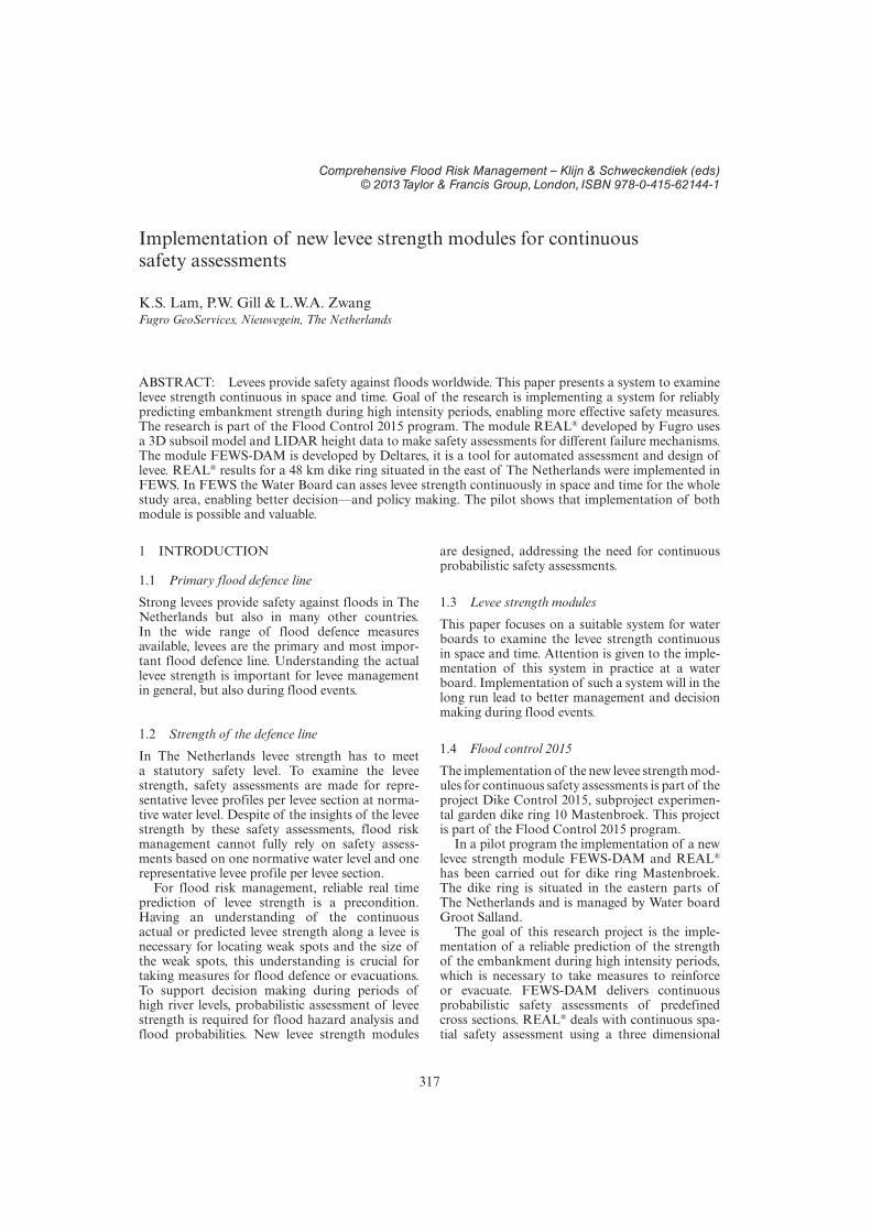
REAL® consists of tools modelling 3D subsoil models and 3D groundwater models from geo data (Fig. 1). The used geo data can be any geo data, but must include a detailed Digital Terrain Model (DTM) collected with LIDAR. Because of the variability of the terrain, detailed data of the ter-rain is needed to get a reliable 3D model. The most common other geo data are CPT and borehole data supplement with laboratory test data. For a 3D groundwater model groundwater and water pressure measurements are needed. Within GIS data is processed.
The 3D subsoil model is at the basis of the system. This makes it possible to take spatial variations into account. In regular levee safety assessments it is not possible to take these varia-tions into account. The quantity and availability of data influences the result, but doesn’t limit the use of REAL®. The quality of data forms the dif-ference between simple and detailed assessments.
3D modelling can also be executed in specialis-tic subsoil or groundwater modelling software. In that case REAL® provides the geo data exchange between REAL® and the external specialistic soft-ware (Fig. 2).
Once a 3D subsoil model is made, safety assess-ment can be made by spatial analyst tools within REAL® (Fig. 1). The spatial analyst can be exe-cuted for different failure mechanisms. The results are presented visually as safety charts or safety maps (Fig. 3). The safety charts clearly show the spatial shape and extent of weak spots. Also the relative strength of the different locations along the levee is explicitly shown. The levee strength is presented in its spatial environment and gives a direct relation of the strength with the spatial fac-tors which influence the strength. In Figure 3 the ditches behind the levee have a negative influence on the safety for piping.
Safety assessments based on 3D models can also be executed with specialistic analysis software, since advanced methods are not possible in REAL®. For that purpose it is possible to generate profiles out
Figure 1. Flow chart REAL®.

320
of the 3D-model. These profiles can be processed in geotechnical software (manually). This can be done by batch processing of using FEWS-DAM. The results will be imported in REAL® and are presented in safety charts.
4.2 Practicability
Unfortunately data (surface model and subsoil data) are not always continuously available.
In The Netherlands data is mostly restricted to 1 borehole or CPT per 200 meters. Since 2008 eleva-tion models (AHN2) have been constructed for large areas of The Netherlands using laser altim-etry data. In 2012 these datasets are available for the entire country.
The continuous safety assessments can be fit using detailed or advanced 2D analyses methods. The results of those 2D analyses can be presented in charts besides the results of REAL®. These can be evaluated using inspection data. These “soft” data can be used to improve the assessment method. In The Netherlands levees are inspected at least once a year (normal inspection). During critical situations the “dijkleger” (i.e. inspector of the water board) is mobilized and all critical levees are inspected. These data were analog in the past. However since a few years water boards are using systems like “Digispectie”. All digital inspection data is instantly accessible within the water board.
Not only failure mechanisms can be dealt in REAL® such as overtopping (HT), uplift (STOO), piping (STPH), macro stability (STBI) and lique-faction (STVL). It is also possible to evaluate the effects of objects on the levee. In The Netherlands there are numerous types of objects on levees. The objects are called “NWO” (non water retaining structures). A lot of levees are multifunctional, trees and buildings are situated on levees. There effects on failure mechanisms can also be dealt with in REAL® (Fig. 4).
Water board Brabantse Delta has assessed it’s NWO’s in the third round of safety assessments. More than 2000 objects were evaluated using the normative hydraulic load. Because of building this system it is possible to execute upcoming assess-ment with minimal efforts. In Figure 5 the results of the NWO safety assessment along a part of a levee is shown.
Uncertainties in the model can be dealt with using probabilistic modules. The results are probabilistic
Figure 2. 3D subsoil model made in Rockworks and used afterwards as model in REAL®.
Figure 3. Results from a safety assessment in REAL® for piping.
Figure 4. Principle of assessment of non-retaining structures or trees in REAL®.

321
failure for the different failure mechanisms. This makes a complete probabilistic flood analysis possible.
Although the core of the REAL® method is quit simple the huge amount of detailed data make the management of the data a challenge. That makes the performance of the analysis time consuming and this increases with the amount of variables. Future developments in the computing industry will deal with this minor drawback.
5 FEWS-DAM STRENGTH MODULE
FEWS-DAM is developed by Deltares. DAM stands for Dike Analysis Module and is a software tool for automated assessment and design of levees. DAM uses partly automated schematization from raw measurement data. DAM is based on the exist-ing geo-engineering software of Deltares Systems. DAM supports safety two dimensional detailed cross section analysis for slope stability and pip-ing. Automated assessment by DAM is executed by batch processing the cross section analysis for predefined cross sections.
DAM is also implemented in FEWS. FEWS is a state of the art hydrological forecast and warning system. FEWS-DAM makes it possible to give the levee strength for each predefined cross section in time for the actual or predicted water level. This makes FEWS-DAM a very strong tool for flood management purposes. The results of FEWS-DAM are presented in a GIS within FEWS.
FEWS-DAM strengths are: Levee strength calculations are detailed. Calculations take only a short time because profiles can be predefined. FEWS-DAM is embedded in FEWS making it
possible to directly link and process in FEWS. Water level is available in FEWS.
DAM deals with failure mechanisms uplift (STOO), piping (STPH) and macro stability (STBI). The calculation method is both deterministic and probabilistic.
6 COMBINING BOTH LEVEE STRENGTH MODULES
By combining both above mentioned levee strength modules the levee strength modules will enhance each other, as they are complementary to each other.
FEWS-DAM deals with detailed 2D analysis for discrete cross sections. In REAL® spatial analysis are made with elementary assessment methods. REAL® incorporates a spatial continued 3D subsoil model. The development of a tool REAL2DAM to freely choose cross sections in the 3D subsoil model of REAL® and exchange the cross section information as input for DAM, makes the combi-nation of REAL® with FEWS-DAM a very worth full levee strength system (Fig. 6).
Figure 5. Results from a safety assessment in REAL® for non-retaining structures or trees. Non-retaining structures or trees are coloured by the results of the assessment. A red colour means the non-retaining struc-ture or tree fails the assessment and a green colour means the non-retaining structure or tree is satisfactory.
Figure 6. The tool REAL2DAM provides the exchange of 3D subsoil data to 2D input for FEWS-DAM. In the upper figure a 3D overview of a 3D subsoil model is given. In the lower figure the result of the tool is given: a cross section of the subsoil in DGeoStabilty at the cho-sen location (green line in the upper figure).

322
The FEWS platform where FEWS-DAM already makes use of combines the levee strength modules with time dependent real time water lev-els. The developed levee strength system will give the levee strength continuously in space and time.
Since both levee strength modules are modular the combination of both modules and incorpora-tion in a flood fighting system is technically easy. Combining more complementary levee strength modules in the future is possible, as additional or future developed features of the levee strength modules REAL® and FEWS-DAM. Despite of the modular set up a remark has to be made, gearing the different modules into one system needs par-ticular attention, for example data format, storage and exchange.
The origin of the combination of the comple-mentary levee strength modules is to meet the need for continuously levee strength during flood events, but it can also be of value for other work areas of a water board. It can add value to policy making, management, maintenance, etc.
7 PILOT IMPLEMENTATION DIKE RING MASTENBROEK
7.1 Dike ring Mastenbroek
Dike ring Mastenbroek is situated in the east of The Netherlands in the management area of Water Board Groot Salland. Dike ring Mastenbroek is vulnerable for different sources or combinations of sources of a flood event. Northwest of Mastenbroek lies the lake IJsselmeer/Ketelmeer/Zwarte Meer, east of it the river Vecht flows by, in the southeast the river IJssel threatened the dike ring (Fig. 7).
The length of the levee around the dike ring is approximate 48 kilometres. The levee differs along the dike ring as the source of the threat as described above also differs along the dike ring. Parts of the levee have a foreshore, other parts lies direct next to the river. The levee protects mainly farmland, but several cities like Zwolle, Kampen and Genemuiden and a number of villages are located within dike ring Mastenbroek.
7.2 Requirements by water board groot salland
At first the Water Board Groot Salland will use the levee strength modules in a larger system for flood event management (Gooijer, 2012 Dashboard Flood Risk). In several consultations the requirements from the Water Board has been mapped out.
The requirements concern which levee strength information is needed during flood events and how the levee strength information is presented. This is important to enhance the approachability of the information and to prevent data overload.
7.3 Implemented levee strength modules
The platform FEWS is selected to implement both modules. FEWS-DAM is already implemented in FEWS. Implementing REAL® into FEWS is a log-ical choice since the actual and predicted hydrau-lic load is also available in FEWS. The hydraulic water level is measured and predicted at a few points along the levee and interpolated to all the locations along the levee (Fig. 8).
The implementation of REAL® consists of a card-index box with levee strength maps at differ-ent water levels. The system will show the corre-sponding levee strength map at a given water level. The levee strength maps are calculated in advance. This workaround is chosen because the real time
Figure 7. Dike ring 10 Mastenbroek and the division in tiles.
Figure 8. Flow chart implemented levee strength modules for dike ring 10 Mastenbroek.

323
grid calculation of a whole dike ring with approxi-mate 48 kilometres (over 20 million grid cells) takes some time and will challenge the storage system.
The preparation before implementation of REAL® in the system consists of decomposing the dike ring in up to 70 sub-sections or tiles (Fig. 7). This makes handling the data and the calcula-tions more efficient and conveniently arranged. Per tile a 3D subsoil model has been made based on the available geo data. Using the 3D subsoil model per tile the analysis has been carried out for each tile. Te results can be presented per tile (Lam, 2010).
Real time calculation of a smaller area or tile is already possible, but not implemented in this system. In the future real time calculation of a whole dike ring may very well be an option.
The levee strength maps of REAL® give a con-tinuous levee strength presented by a safety fac-tor per grid cell of 0.5 m × 0.5 m in space. These maps not only show the magnitude of strength in a high resolution but also the extent of the levee strength.
FEWS-DAM is implemented fully in the sys-tem. FEWS-DAM calculates the levee strength in real time on predefined locations along the levee.
7.4 Presentation of the levee strength
A well-organized presentation of the levee strength is of great importance for decision making during flood events.
FEWS-DAM results in coloured dots on a map. The colour range indicates the levee strength. For each failure mechanism a levee strength map can be presented. Levee strength maps of all failure mechanisms can also be combined to one sum-mary levee strength map. The FEWS-DAM results can be viewed in different zoom levels, since scale of the dots representing the levee strength can be adjusted to the zoom level in question.
REAL® results have a high resolution. When focusing on a particular area this high resolution stands out well (level 3). At a higher zoom level this high resolution gives to much detail. To present the REAL® levee strength on a higher zoom level like a whole dike ring the levee strength is summarized in tiles (level 1) and points (level 2).
In level 1 coloured tiles indicate the weighted levee strength within the tile. The tiles give at high zoom level realistic weighted levee strength of the levee in the tile while taking into account the extent of the levee strength within a tile (Figs. 9 and 10).
In level 2 the levee strength from REAL® is presented in dots (locations) along the levee with an interval of 250 meters (Fig. 11). As in level 1 coloured dots indicate the levee strength fac-tor at the locations. Advantage of this level is
Figure 9. Screen shot of the system for REAL® results on level 1 for uplift.
Figure 10. Screen shot of the system for REAL® results on level 1 for piping.
Figure 11. Locations along the levee for the Level 2 REAL® results.

324
the opportunity to present the curve of the levee strength combined with the water level in a graph (Fig. 12).
So at each of the locations in level 2 an overview in time can be generated in a graph for the levee strength.
In the most detailed level 3 the REAL® results are presented per tile. In this level the magni-tude and the extent of the strength can be seen (Figs. 13 and 14).
All the map results can be shown at different times. Since the actual water level or prediction of the water level is changing in time, the levee strength is also changing in time. With a slider on
a time bar the water levee and the corresponding levee strength can be presented in a map.
Results in a predefined location or cross sections in FEWS-DAM can be shown on a map and also be shown in graphs with the corresponding water level (Fig. 15). More detailed results per location, like slip circle, can be shown by clicking on the location dot.
7.5 Mutual enhancing by levee strength modules and existing levee information systems
For the optimal use of systems like FEWS-DAM and REAL® it is highly important that such sys-tems are imbedded in the existing information systems of the levee management. Setting up a stand alone system is discouraged, as a data system needs maintenance, and the opportunity for support for years decrease with the use of a stand alone system. Also the use of a system will increase when imbedded in the workflow of the water board.
Figure 12. Level 2 REAL® results for piping at location 165 with the curves of the water level and safety factor in time.
Figure 13. Screen shot of the system for REAL® results for tile 8 on level 3 for uplift.
Figure 14. Screen shot of the system for REAL® results for tile 8 on level 3 for piping.
Figure 15. Screen shot of the system for FEWS-DAM results for piping.
325
The results of the pilot can be improved by modelling the subsoil more precisely, but there are limits. The schematizing of the water pressures have also a great impact on the outcome and the assessment of the strength of the soil layers.
It is worth considering incorporating the water pressures in the system by real time monitoring. With this the offline data system becomes an online data system. For some years it is possible to gain real time insight in the levee strength due to the development of telemetric measurement systems.
Since all levee related systems use the same levee data, centrally storage and exchange of joint levee data is efficient and prevents mistakes. This makes it also easier to use the levee data for other work areas of the water board.
7.6 Future additions of the implementation
The implementation of the levee strength modules for the dike ring Mastenbroek consist of just basic features of the levee strength modules FEWS-DAM and REAL®. The real time levee strength system is already of great value. Since FEWS-DAM and REAL® have more features available and more fea-tures are developed, the water board can choose from these features the desired additions to the implemented system.
Some of the additional features and features in the near future of FEWS-DAM are:
– Probabilistic analysis;– Prediction of time dependent resistance against
piping through prediction of time dependent water pressure development in the levee;
– Data assimilation for the analysis of the failure mechanism piping;
– Prediction of time dependent slope stability through prediction of time dependent water pressure development in the levee;
Some of the additional features and features in the near future of REAL® are:
– Visualisation of the 3D-subsoil model and the assumptions, basic principles and input vari-ables in the implemented system to gain insight in the input data;
– Sensitivity analysis by changing assumptions, basic principles and input variables to gain insight in the impacts of the uncertainties;
– Probabilistic analysis through uncertainties addressed in 3D-subsoil model (ref. rapport FC2015 DIS);
– Real time grid calculations in stead of pre cal-culations. This will require faster computer cal-culation capacity, but will give more accurate results and opens new options like time depend-ent analysis.
– Extracting cross sections from the 3D subsoil model as input for FEWS-DAM. FEWS-DAM deals with schematised cross sections. REAL® incorporates an in space continues 3D subsoil model. Combining the data in REAL® with the detailed analysis of FEWS-DAM will give the flexibility to analysis the levee on every possible location along the levee with a detailed assess-ment method.
– Analysing 3D subsections
Besides the above mentioned additions the way of presenting the results and the user interfaces will face refinement by the wishes and needs of the water board to fit their optimal work process. User friendly, approachable and fast responding are the core requirements for flood fighters. The presenta-tion of the results has also met the different level of detail for the different work level of the flood fight-ing organisation as suitable for the public.
As mentioned earlier the availability and imple-mentation of more real time data will increase the value of the system. But also unlock the value of the real time data. A more precise 3D subsoil model and cross checks from past high water levels will increase the value too.
Better conversion opportunities in the system will make it easier to implement other complemen-tary levee strength modules.
8 CONCLUSIONS AND OUTLOOK
The successful implementation of the levee strength modules for the dike ring 10 Mastenbroek pilot show that a real time levee strength system is valuable for flood event management.
In spite of the implementation of only the basic features of both levee strength modules REAL® and FEWS-DAM the levee strength system give a good and actual insight in the levee strength contin-uous in time and space for actual water levels. The levee strength information from the system is much more detailed and therefore gives more insight in contrast with the levee strength information gained within a classical statutory assessment.
The combination of two complementary levee strength modules enhanced both modules. REAL® provides the spatial levee strength at different zoom levels, especially the magnitude and the extent of the strength. FEWS-DAM gives the detailed levee strength at predefined cross sections. Both level of detail and spatial presentation is worthfull for deci-sion making during a flood event.
The added value of the levee strength modules is greatest if the modules are combined together and implemented as one system at the water board. Tuning the system on the needs and workflow of
326
the water board during flood events is crucial. The approachability of the system has been proved by the pilots.
Although the implemented levee strength sys-tem increases available levee strength information tremendously there are several additional features available or in development to improve the system for flood control management.
REFERENCES
Gooijer, K., 2012. Dashboard Flood Risk Management, Delft, The Netherlands.
Lam, K.S., Leuvenink, K.L., Zwang, L.W.A. & Nicolai, R., 2010. Evaluatie van SUCCESS op dijkring schaal, Nieuwegein, The Netherlands.
Ministerie van Verkeer en Waterstaat, 2007. Voorschrift Toetsen op Veiligheid Primaire Waterkeringen, Delft, The Netherlands.
Woldringh, R.F., O’Banion, M., Dean, C. & Van der Meer, M.T., 2012. High-tech advances in levee modeling and evaluation tools for flood risk manage-ment, Sacramento, USA.