levee setback white paper
TRANSCRIPT

Levee Setback White Paper Randall L. Behm P.E., CFM
Behm Hazard Mitigation, LLC
(June 30, 2021)
Executive Summary
Humans have long grappled with the consequences of floods. River banks and floodplains have
always been thought to be the ideal locations for communities due to their relatively level
topography, abundant natural resources, and access to trade routes (prior to rail and interstate
vehicular roadway construction). But for all the ways rivers have supported people, life in
proximity to rivers has always been full of peril. Flooding, the very mechanism that supports the
abundant natural resources that sustain human societies, can also be destructive. Cultures
throughout the world have adapted to their rivers’ flood pulses in a variety of ways. In the post-
colonial United States, floodplain development and adaptation has had three primary strategies:
• Flood Control: A strategy that works to prevent floodwater from affecting people and
critical infrastructure. As a concept, it has its origins in the early 1800s Manifest Destiny,
which, as a matter of law, entitled colonists to migrate westward and develop land in a
fashion that often resulted in damage to natural resources and the creation of new public
health and safety issues. Colonists in the 1800s were encouraged to construct dam and
levee rivers and drain wetlands to promote the economy of the United States, which was
accelerated after the Civil War and again in the 1930s to stimulate economic growth in
response to national economic recessions.
• Flood Risk Management: A strategy that relocates people and critical infrastructure away
from flood sources. As a concept, this approach is an advancement on traditional methods
and grounded in the real-world experiences that flood control, as a strategy, was
somewhat ineffective at reducing flood risk and eliminating flood damages. This
approach emphasizes public and community safety and supports the conveyance of
floodwater while reducing the effects of flooding.
• Multi-Benefit Floodplain Development: A modern strategy that recognizes floodplains
are important ecological, economic, and social environments and seeks to balance public
safety needs with flood-compatible development that respects people, improves quality of
life and economic sustainability, enhances natural resources, and promotes equitable
outcomes for all floodplain communities.
According to the National Oceanic and Atmospheric Administration (NOAA) there have been
$33 billion dollars in flood events affecting the United States from 1980 to 2020.1 U.S. disaster
assistance programs have provided more funding for the prevention and management of flooding
than any other natural disaster (fire, earthquake, landslides, tornadoes, and blizzards), and yet
annual flood damages continue to increase. The frequency, intensity, and damages associated
with flood events are also increasing.
1 National Oceanic and Atmospheric Administration (2021) Billion-Dollar Weather and Climate Disasters:
Overview. Retrieved from NOAA website https://www.ncdc.noaa.gov/billions/
Levee construction throughout the United States – aimed to protect the human populations and
human infrastructure behind their walls from flooding – has left a legacy of historic floodplains
disconnected from their primary flood source, with many fish and wildlife species, including the
populations of iconic species such as the pallid sturgeon and the piping plover, being depleted to
critically low populations over time. In recent decades, severe flooding has affected areas
protected by levees that were once thought to be “permanently” protected from flooding.
While flood damages occur in all regions of the country, a significant amount of those damages
have taken place along heavily leveed systems, such as the Mississippi River Basin and lower
Missouri River Basin as well as in other areas that contain levees such as the Snake River Basin
located in the northwestern United States, or the San Joaquin River Basin located in central
California.
The dynamic characteristics of river systems can be affected by the physical changes that occur
due to levee construction and a river’s response to levee construction contribute to levee failure
through flanking, erosion, overtopping, and breaching. In regions across the country with levee
systems, communities, farmland, and infrastructure have been devastated by levee unforeseen
failures and associated flooding. Local and regional economies have suffered as flood events are
declared national disasters and once stable or thriving tax bases suffer through the arduous
process of recovery. A levee setback consists of the reparation of an existing levee which has
been significantly damaged by flooding and realigning the entire levee or a portion of the levee
and relocating it farther away from the river. A levee setback reconnects portions of the historic
floodplain to the river, allowing more floodwater storage, better conveyance, a reduction in flood
stages and increased flood resiliency. Levee setbacks can assist in the revitalization of fish and
wildlife habitat, and in some situations, levees are no longer required, and communities can
flourish through implementation of nonstructural measures such as elevation and floodproofing.
Unfortunately, current federal flood risk management and flood recovery programs and policies
do not easily support the implementation of levee setbacks. Changes will be required to
programs and policies to allow levee setbacks to be incorporated into a multi-benefit floodplain
development strategy. This paper seeks to identify potential opportunities to legislatively or
administratively advance the use of levee setbacks as it discusses:
• Flood risk management in the United States
• Natural, Nature-Based, and Nonstructural flood risk management solutions.
• The limitations and issues associated with existing levee systems
• The benefits associated with levee setbacks
• Barriers to the implementation of levee setbacks
• Recommendations for encouraging the implementation of setback levees
Purpose and Scope of White Paper
The purpose of this white paper is to identify legislative and/or administrative policy changes
which would support increased use of levee setbacks as a tool for managing flood risk and
supporting the return of key species of fish and wildlife and to demonstrate the benefits of levee
setbacks as an effective flood risk management and ecosystem restoration tool. This paper also

discusses the history of levee construction for flood protection across the United States and how
levees are becoming more vulnerable to major damage or failure during large flood events.
Furthermore, the white paper highlights the hurdles and barriers to the implementation of levee
setbacks.
Overview of Flood Risk Management in the United States
Rivers and streams provided the earliest modes of transportation for Native Americans as well as
for the European immigrants to a young country expanding westward. Commerce traveled the
natural waterways where villages located their mills and industries along the banks of the rivers.
As communities grew, the population became increasingly vulnerable to the risk of flooding. The
migration of European immigrants from the Atlantic shoreline, inland along rivers and streams,
had a major impact on the landscape and wildlife. Timber was harvested throughout each
watershed, resulting in increased runoff and significant erosion. Channels were choked full of
sediment, restricting the flow of floodwater, increasing the risk of flooding. Additionally, beaver
was trapped in such great numbers that the fluvial geomorphology of U.S. rivers changed.
Natural floodplain wetlands diminished with the removal of beaver, as wetlands were drained,
and channels straightened. The entire ecological balance was impacted as human migration and
development continued moving west.
Initial Focus of Flood Control
In the late 19th and early 20th centuries, the U.S. Congress initiated a number of actions focusing
on the economic vitality of a growing country and the threat of floods to local communities and
industry. The first significant federal flood control law was the Swamp Land Act of 1850.
A flood on the Mississippi River in 1874 led to the creation of the Mississippi River
Commission in 1879. Booming steamboat traffic on the Missouri River and a flood in 1881 led
to the creation of the Missouri River Commission in 1884, but it was abolished by the River and
Harbor Act of 1902. In 1917, Congress authorized the Sacramento Flood Control System
(SacFCS) to address the devastating flooding of 1902 and 1909 and to implement the first
comprehensive state flood control plan in the nation.
The great Mississippi River flood of 1927 resulted in the death of over 250 people, and 750,000
people were displaced for months. After this devastating flood event, which submerged an
estimated 23,000 square miles, Congress enacted the Flood Control Act (FCA) of 1928,
authorizing the U.S. Army Corps of Engineers (Corps) to design and construct flood control
projects along the Mississippi River, its tributaries, and the Sacramento River in California.2 This
Act was the catalyst for channel straightening and levee construction throughout the Mississippi
River Basin and the Central Valley of California. Figure 1 illustrates the channel modifications
incorporated into the Missouri River, downstream from Omaha, Nebraska, to narrow and
straighten the channel.
2 Pub. L. 106-53

Figure 1; Rock Bluff Bend, Missouri River Channel Straightening 1934 - 1983
Sadly, much of the manual labor utilized to straighten river channels and to construct federal
levees came from black sharecroppers in the South and immigrant labor in other regions of the
country who were exploited for lower wages. They were required to work grueling workdays,
often more than 14 hours per day. Due to the overcrowded and unsanitary living conditions
within the levee work camps, as illustrated in Figure 2, workers experienced outbreaks of
malaria, smallpox, and other diseases without the benefit of medical treatment. Work camps
were harsh environments, and the camps persisted during the brutal summer heat and bitter
winter cold, with laborers residing in canvas tents.
Figure 2: Mississippi River Delta Work Camp (Source: Center for Study of Southern Culture)
After enactment of the FCA 1928, Congress approved additional laws to further control the
effects of flooding. The Flood Control Act of 1944 (FCA 1944) authorized the construction of
dams and levees throughout the United States. In California, the FCA of 1944 authorized the
Social Injustice of Early Levee Construction
• Black sharecroppers and immigrant labor were forced to work and live-in inhumane conditions
• Unsanitary conditions resulted in the outbreak of disease, and a large number of deaths
• Wages were barely enough to cover the cost of food and water

Lower San Joaquin River and Tributaries Project, which aimed to improve flood storage and
consolidate river flows by authorizing dam construction and channel straightening projects.
Within the Missouri River Basin, the FCA 1944 resulted in the Pick-Sloan Plan for the
management of the Missouri River for flood control, hydropower, water supply, navigation,
recreation, irrigation, water quality, and fish and wildlife. The law authorized the Corps to
construct federal levees from St. Louis, Missouri, to Omaha, Nebraska3 The Act also states that
proposed floodway widths between levees would vary from a minimum of 3,000 feet from Sioux
City, Iowa, to Kansas City, Missouri, and 5,000 feet from Kansas City, Missouri, to the mouth.
The proposed floodway widths prevented the exchange of channel flows with the historic
floodplain, adversely impacting the natural ecological system. Upon full implementation of the
authorities under FCA 1944, the Corps had re-engineered the Missouri River, removing natural
meanders and straightening the Missouri River natural channel to shorten the total river length by
over 120 miles. The Bank Stabilization and Navigation Project (BSNP) then authorized the
Corps to harden the riverbanks with stone revetments to reduce erosion and to construct
hundreds of miles of earthen levees along the Missouri River to reduce flooding.
The most recent Flood Control Acts (1948, 1950, and 1965) authorized the Corps to design and
construct minor projects without Congressional approval and provided more authority to the
Corps in lieu of states and levee districts, which had been constructing their own flood protection
projects.
Emergence of Floodplain Management
Levee and dam construction through the federal government grew during the 1930s and 1940s,
then peaked during the 1960s. Despite these investments in flood control structures, flood losses
continued to rise. These losses, combined with a growing environmental ethic, resulted in a shift
toward a floodplain management approach that incorporated more nonstructural solutions.
Nonstructural Mitigation Techniques
• According to the Corps and FEMA, nonstructural flood risk management alternatives are
physical or nonphysical measures implemented to mitigate existing and future flood
damages. The most common physical nonstructural measures are acquisition, relocation,
elevation, basement/crawlspace abandonment, dry floodproofing and wet floodproofing.
These measures are accepted by the National Flood Insurance Program, and are generally
considered less detrimental to the floodplain or the environment.
• Several common nonphysical nonstructural measures are floodplain mapping, emergency
preparedness plans, land use regulations, zoning, flood warning, evacuation planning, and
risk communication. These measures address flood risk through regulation and best
management practices and can be considered separately or in combination with other
floodplain management programs and planning functions.
3 GEI Consultants (2017) The Origin and Evolution of the California State Plan of Flood Control Levee System. Retrieved from https://www.geiconsultants.com/wp-content/uploads/2017/10/The-Origin-and-Evolution-of-the-California-State-Plan-of-Flood-Control-Levee-System.pdf
Meanwhile, the 1960s ushered forward a series of landmark environmental laws, including the
National Environmental Policy Act (NEPA), requiring federal agencies to assess the
environmental impacts of their proposed actions prior to making decisions; the Clean Water Act
(CWA), establishing the framework for regulating discharges of pollutants into the waters of the
United States; and the Endangered Species Act with a goal of protecting and preserving native
species and their habitat.
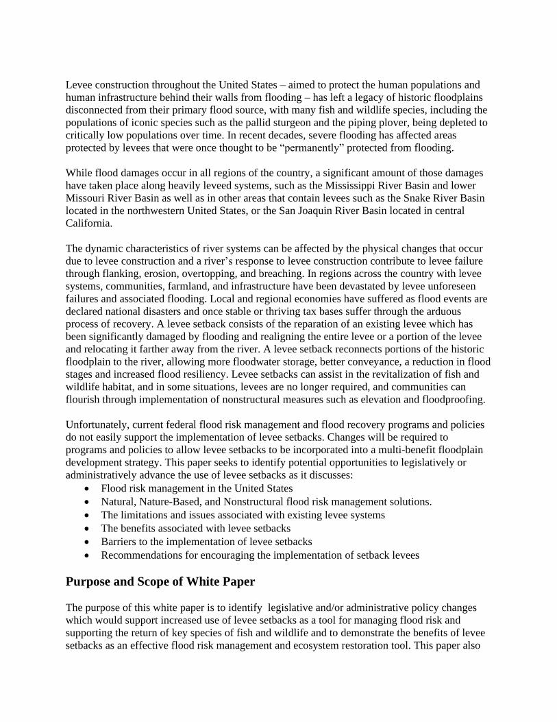
Structural flood protection, such as levee construction, was known to be one of the primary
activities threatening and endangering many native floodplain dependent species. Figure 3
illustrates the difference in size between salmon reared in the main channel versus salmon reared
in the shallow floodplain.
In 1966, the first Unified
National Program for Managing
Flood Losses report
recommended the creation of a
national flood insurance
program and integrated
floodplain management that
utilized structural and
nonstructural approaches.
Within two years, Congress had
passed the National Flood
Insurance Act of 1968 creating
the National Flood Insurance
Program and a floodplain
mapping program. Updates in
1973 added funding programs
for nonstructural mitigation.
Evolution of Nature-Based Flood Management
Executive Order 11988; Floodplain Management (EO 11988), signed in 1977, sought to avoid
negative impacts associated with modifying floodplains by federal agencies and federal-
sponsored resources to integrate floodplain management within floodplain ecosystem
management. Federal agencies were required to “take action to reduce the risk of flood loss, to
minimize the impact of floods on human safety, health and welfare, and to restore and preserve
the natural and beneficial values served by floodplains.”5 when purchasing or managing federal
land, constructing or providing the financing for projects, or carrying out federal programs or
4 Jeffres, C., J. Opperman and P. Moyle (2008), “Ephemeral floodplain habitats provide best growth conditions for juvenile Chinook salmon in a California river,” Environmental Biology of Fishes 83 (4): 449-458. Retrieved from http://ww.springerlink.com/content/e873456118pjl53 5 Environmental Protection Agency (1977) Floodplain Management (Executive Order 11988). Retrieved from https://www.epa.gov/cwa-404/floodplain-management-executive-order-11988
Figure 3; Juvenile Chinook Salmon Growth4
Floodplain-dependent species require access to floodplain
habitat for some part of their life cycle. For example, studies
have shown that Chinook salmon reared in the slower,
shallower water of floodplains are significantly larger in
size than salmon reared in the main channel.
actions.6 EO 11988 helped to reduce the impact of floodplain development, but it did not result
in widescale integration of programs.
The devastation caused by the Midwest Flood of 1993 along the Mississippi and Missouri Rivers
renewed the calls to reassess the country’s reliance on levees and to provide increased awareness
of the need for a holistic and integrated flood management strategy. The revised Unified
National Program for Floodplain Management published in 1994 recognized:
• good floodplain management aimed to achieve a reduction in the loss of life, disruption,
and damage caused by floods; and
• the preservation and restoration of the natural resources and functions of floodplains.7
However, no major programmatic changes were undertaken to align the nation’s flood
management programs to support these co-equal goals. In light of the challenges associated with
top-down coordination on a shared interagency vision of floodplain management, a new strategy
began to emerge in the 2010s: Expand the flood management toolbox to include nature-based
approaches along with structural and nonstructural approaches.8
Natural and Nature-Based Solutions
The most recent FCA was enacted in 1965. In 1974, Congress transitioned away from the FCA
and enacted Water Resources Development Acts (WRDA) to incorporate additional aspects of
water resources such as environmental, structural, nonstructural, navigational, and flood risk
management into the authorities of the US Army Corps of Engineers. In the mid-2010s,
Congress directed the Corps to consider the implementation of natural and nature-based features
(NNBF) for assisting in the management of flood risk. In Section 1184 of the Water Resources
Development Act (WRDA) of 2016, Congress defined a natural feature as a feature “created
through the action of physical, geological, biological, and chemical processes over time.”
Congress also defined a nature-based feature as “a feature that is created by human design,
engineering, and construction to provide risk reduction by acting in concert with natural
processes.”9 Examples of NNBFs include wetlands; oyster, mussel, and coral reefs; and dunes,
which are sometimes combined with hard components, such as rock gabions, stone toes, and
concrete reef balls.
In WRDA 2016, Congress also included language that required the Corps to consider natural,
nature-based, and nonstructural features in feasibility studies for flood-risk management,
hurricane and storm damage reduction, and ecosystem restoration projects, provided that the
non-federal partner consented to studying such alternatives. Section 1149 of WRDA 2018
updated that language, directing the Corps to consider natural infrastructure alternatives, alone or
6 U.S. Army Corps of Engineers (2015) Flood Plain Management Decision Making Process. Retrieved from https://Army Corps.contentdm.oclc.org/digital/collection/p16021coll11/id/364/ 7 Army Corps (2014) Scodari and Shabman. Review of Federal Reports on a Unified National Program for Floodplain Management, 1966-1994. https://www.iwr.usace.army.mil/Portals/70/docs/iwrreports/2014-R-02_AppendixB.pdf 8 Some of the key pieces of legislation and guidance documents related to the federal government’s use of natural, nature-based, and non-structural techniques for managing flood risk are listed in Appendix A. 9 Pub. L. 114–322, title I, §1184
in conjunction with traditional infrastructure, for flood risk management or hurricane and storm
damage risk reduction projects, where practicable. The 2018 law also requires the Corps to
consider at least one alternative with natural or nature-based features when carrying out a
feasibility study for an ecosystem restoration project.
In recent years, Congress has also amended the Flood Control and Coastal Emergencies (PL 84-
99) Program which provides rehabilitation assistance for repairs to flood-damaged levees, to add
natural and nature-based solutions such as levee setbacks and river and floodplain restoration to
be eligible for funding when enrolled levees are damaged during a flood.10 WRDA 2016 defined
“nonstructural alternatives” to include stream, wetlands, and coastal restoration efforts that help
reduce flood risk.11 Congress further amended the PL 84-99 program in WRDA 2018 by
specifying that “realigning” is an eligible activity under PL 84-99.12 Finally, in WRDA 2020, the
Corps was provided new authority “to study, design, and construct water resources projects for
communities that have experienced repetitive flooding events and have received emergency
flood fighting assistance.”13 The maximum Federal share for a project planned under this section
is $17.5 million, and the Corps is required to consider a community’s ability to pay in
determining whether to require a non-Federal cost share.14
Natural and Beneficial Functions of Floodplains
Floodplains and natural floodplain functions produce benefits for society and natural ecosystems.
In floodplain management this is referred to as the “natural and beneficial functions of
floodplains.” These functions and their resulting benefits are illustrated in Table 1.15
10 Army Corps (CITE) 11 Pub. L. 114–322, §1176 12 Pub. L. 115-270 §1160 13 House Transportation & Infrastructure Committee (2020) Water Resources Development Act of 2020: Section-by-Section Summary. Retrieved from https://transportation.house.gov/imo/media/doc/WRDA%202020%20Section%20by%20Section%20Final.pdf 14 P.L. 116-260 §119 15 The Department of Housing and Urban Development (2002) The Natural & Beneficial Functions of Floodplains – Reducing Flood Losses by Protecting and Restoring the Floodplain Environment. Retrieved from https://www.hud.gov/sites/documents/DOC_14217.PDF

Table 1; Natural Resources of Floodplains16,17 Water Resources Biologic Resources Societal Resources
Natural Flood and
Erosion Control
o Provides flood storage
and conveyance
o Reduces flood velocities
o Reduces peak floods
o Reduces sedimentation
Biological Productivity
o Supports high rate of
plant growth
o Maintains biodiversity
o Maintains integrity of
ecosystem
Harvest of Wild and Cultivated
Products
o Enhancement of
agricultural lands
o Provides sites for
aquaculture
o Restores and enhances
forest lands
Water Quality Maintenance
o Filters nutrients and
impurities from runoff
o Processes organic wastes
o Moderates temperature
fluctuations
Fish and Wildlife Habitats
o Provides breeding and
feeding grounds
o Provides and enhances
waterfowl habitat
o Protects habitats for
rare, threatened and
endangered species
Public Health/Welfare &
Recreational Opportunities
o Protection of drinking
water resources
o Provides areas of active
and passive use
o Provides open spaces
o Provides aesthetic pleasure
o Significant cultural and
historic value, particularly
for Tribal communities
Groundwater Recharge
o Promotes infiltration and
aquifer recharge
o Reduces frequency and
duration of low flows
Areas for Scientific
Study/Education
o Cultural resources
(historical/archaeological)
o Opportunities for
environmental, biological,
or other studies
Research has demonstrated that a fully functioning floodplain that can maximize the above
benefits to society requires four key attributes:
• Connectivity: The floodplain is physically accessible by water from its adjacent river
or stream to allow an exchange of water, nutrients, sediment and organisms.
• Variable Flow: The floodplain is inundated with flows that vary in timing, duration,
magnitude, and frequency that support native biota.
• Spatial Scale: The floodplain must have space to accommodate inundation and the
resulting habitat and landscape forming processes that occur.
16 American Rivers (2016) Reconnecting Rivers to Floodplains. Retrieved from https://www.americanrivers.org/wp-content/uploads/2016/06/ReconnectingFloodplains_WP_Final.pdf 17 The Natural & Beneficial Functions of Floodplains: A Report for Congress by the Task Force on the Natural and Beneficial Functions of the Floodplain (2002). https://www.hud.gov/sites/documents/DOC_14217.PDF

• Habitat and Structural Diversity: The floodplain has a diversity of sediment erosion
and deposition conditions, gradients of hydrologic connectivity, ecological succession
and natural accumulated debris to generate habitat supportive of terrestrial and aquatic
organisms.
Levees separate rivers and streams from their floodplain, thereby directly impacting connectivity
and disrupting the ability of flows to inundate the floodplain and perform the dynamic processes
necessary for a functioning floodplain.18 As a result, there is a reduction in floodplain
productivity, and a decrease in the fish, wildlife, and societal benefits the floodplain landscape
can provide.19,20
Levee Systems in the United States
Levees have been an essential component of the United States’ flood risk management for
decades. While the engineering analyses used for the basis of levee design have been developed
over years of research and review, there are limitations which could affect the level of flood
protection provided as levees age. According to the National Levee Database that is administered
by the Corps, there are over 7,700 levee systems located across the country, covering over
25,600 miles and the average age of these levees are 57 years.21
A balance between the reduction of flood damages and the protection of fish and wildlife is a
critical objective for this nation as it must increasingly deal with the effects of climate change,
which has led to increased annual flood damages. Many levees provide flood protection for
densely populated metropolitan areas, where significant development already exists. For these
situations, especially where there is a large tax base, levees and other structural measures, such
as floodwalls, interior ponding areas, and pump stations, may provide the most economically
feasible measure for providing flood protection.
However, in rural areas susceptible to flooding, particularly where there is a higher incident of
flood damages, either to a levee (ex. erosion, overtopping, or breaching), or to critical facilities,
buildings, and infrastructure, then measures such as levee setbacks may be the most effective
means of providing flood protection.
Levee Design & Dynamic Flood Conditions Versus Static Flood Protection Systems
The engineering analysis required for levee design depends upon hydrologic conditions. The
hydrology, or the flow of water through a watershed, is typically illustrated in terms of a
18 Opperman, Jeffrey & Luster, Ryan & McKenney, Bruce & Roberts, Michael & Meadows, Amanda. (2010). Ecologically Functional Floodplains: Connectivity, Flow Regime, and Scale1. JAWRA Journal of the American Water Resources Association. 46. 211 - 226. 10.1111/j.1752-1688.2010.00426.x. 19 The Association of State Wetland Managers (2011) Assessing the Natural and Beneficial Functions of Floodplains – Issues and Approaches; Future Directions. https://www.aswm.org/pdf_lib/nbf.pdf 20 Tockner, Klement & Stanford, Jack. (2002). Riverine Flood Plains: Present State and Future Trends. Environmental Conservation. 29. 308 - 330. 10.1017/S037689290200022X. 21 Army Corps of Engineers (2021) National Levee Database. Retrieved from https://levees.sec.Army Corps.army.mil/#/

discharge-frequency curve, where the peak discharge for an event (i.e., the 1-percent annual
chance exceedance flood event) is determined from a series of years of flow records for specific
locations along a river. The discharge-frequency data is used in the planning process to identify
the level of protection to be provided by a levee. Once the discharge-frequency curve for a river
has been established, it becomes static, unless continuously updated. Levees which are designed
and constructed according to a specific discharge-frequency curve become static, and the
dimensions of the levee do not change over time. However, climate is dynamic and the
hydrology within a watershed is continuously evolving. A levee which was designed decades ago
and provided protection against the 1-percent ACE may now offer significantly less protection
when compared to updated hydrology.
Additionally, floodwaters would have historically spread out across an open floodplain and lose
its energy, but some levees may constrict the floodwaters to a narrow conveyance area, resulting
in much greater erosive velocities and greater flood depths. This may cause the levees to become
damaged or fail, requiring significant financial investment from local communities and the
federal government in order to repair the levee system.
Negative Impact to the Environment
In the twentieth century, levees were constructed in a way that maximized the amount of land
protected and minimized infrastructure costs by locating the levee on top of the river bank. When
a levee is placed in the floodplain, the protected farmland behind the levee, for NRCS purposes,
is identified as “prime” farmland. Any farmland exposed to flooding would lose the “prime”
designation. This levee placement along the river banks allowed for the planting of vast acres of
new farmland in the fertile floodplain soil, with little or no regard for future flooding. Roads and
bridges took advantage of the levee placement with shorter bridge spans, minimizing
construction costs.
Unfortunately, isolation of the rivers from their historic floodplains impacted the natural
ecological functions and damaged the environment that fish and wildlife depend upon. The
Agricultural Research Service (ARS) of the U.S. Department of Agriculture (USDA) has
published several reports which illustrate the dynamic channel processes of natural rivers and
streams, as well as the potential problems when a channel is straightened, shortened, and locked
into place with stone revetments and streambank riprap. Figure 4 illustrates the natural evolution
of meanders in a river or stream.
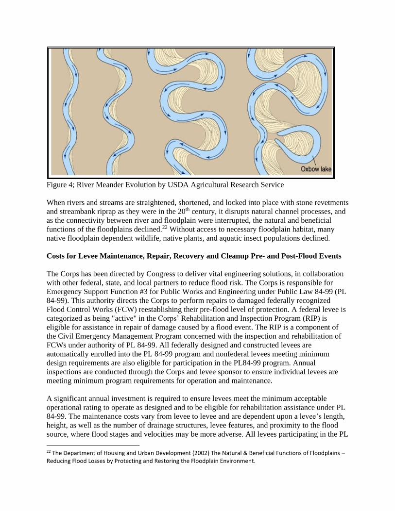
Figure 4; River Meander Evolution by USDA Agricultural Research Service
When rivers and streams are straightened, shortened, and locked into place with stone revetments
and streambank riprap as they were in the 20th century, it disrupts natural channel processes, and
as the connectivity between river and floodplain were interrupted, the natural and beneficial
functions of the floodplains declined.22 Without access to necessary floodplain habitat, many
native floodplain dependent wildlife, native plants, and aquatic insect populations declined.
Costs for Levee Maintenance, Repair, Recovery and Cleanup Pre- and Post-Flood Events
The Corps has been directed by Congress to deliver vital engineering solutions, in collaboration
with other federal, state, and local partners to reduce flood risk. The Corps is responsible for
Emergency Support Function #3 for Public Works and Engineering under Public Law 84-99 (PL
84-99). This authority directs the Corps to perform repairs to damaged federally recognized
Flood Control Works (FCW) reestablishing their pre-flood level of protection. A federal levee is
categorized as being "active" in the Corps’ Rehabilitation and Inspection Program (RIP) is
eligible for assistance in repair of damage caused by a flood event. The RIP is a component of
the Civil Emergency Management Program concerned with the inspection and rehabilitation of
FCWs under authority of PL 84-99. All federally designed and constructed levees are
automatically enrolled into the PL 84-99 program and nonfederal levees meeting minimum
design requirements are also eligible for participation in the PL84-99 program. Annual
inspections are conducted through the Corps and levee sponsor to ensure individual levees are
meeting minimum program requirements for operation and maintenance.
A significant annual investment is required to ensure levees meet the minimum acceptable
operational rating to operate as designed and to be eligible for rehabilitation assistance under PL
84-99. The maintenance costs vary from levee to levee and are dependent upon a levee’s length,
height, as well as the number of drainage structures, levee features, and proximity to the flood
source, where flood stages and velocities may be more adverse. All levees participating in the PL
22 The Department of Housing and Urban Development (2002) The Natural & Beneficial Functions of Floodplains – Reducing Flood Losses by Protecting and Restoring the Floodplain Environment.
84-99 program require annual maintenance which are the responsibility of the levee district, local
community, or regional entity. Maintenance is subject to the Corps’ review and typically consists
of mowing, removal of woody vegetation, rodent eradication, drainage structure, relief well
inspection and repair, levee crown resurfacing, and levee side slope erosion repair.
During a flood event, federal and state officials as well as levee district and local officials may
initiate and conduct levee surveillance in order to determine levee performance and to identify
potential problem areas. If a levee or levee system has encountered issues, the surveillance
intensifies throughout the flood event. If problem areas are identified along a levee, the Corps,
under the PL 84-99 program, may move additional personnel or other material resources (borrow
material, flood barriers, sandbags, pumps, etc.) for flood fighting purposes closer to the area of
threat. If the flood threat continues to increase and the levee is in jeopardy of failing, mandatory
evacuation orders may be issued for people protected by the levee.
After a flood event, the levee system and all drainage structures require detailed inspection. If the
levee was breached, overtopped, or the side slopes and toes have been damaged by erosion, there
could be extensive replacement and repair activities required. If flooding occurred landward of
the levee, then there could be significant cleanup required for residential, commercial, public,
and industrial development, infrastructure, and farmland since floodwaters and debris can
decimate buildings, their contents, and surrounding land. If flooding is catastrophic, then
complete recovery to pre-flood conditions of the levee may not be achievable.
Under the PL 84-99 program, the Corps will respond as soon as the flood waters have receded,
and unless a levee has been severely damaged, to the point of being destroyed, the Corps will
begin immediate repairs to the levee. The repairs are conducted as quickly as possible so that
completion occurs prior to the next flood season. Repairing the damaged levee is the highest
priority and the construction activities may not mesh well with the environment, potentially
causing additional harm and damage to an altered ecological system.
Living with Levees
• Flood Control Acts were enacted by Congress to prevent loss of life and property damage without
the consideration of the adverse effects on the environment and natural resources.
• The construction of levees has resulted in increased development occurring without regard for
floodplain management or potential flood risk located landward of the levee.
• People often do not realize that they live or work in areas protected by levees.
• As the climate continues to change and intense rainfall events become more common, the annual
cost for levee operation, maintenance, repair, and replacement will increase.
• In 1994, the Unified National Program for Floodplain Management Report was published, which
advocated for the need for increased floodplain management to modify human behavior to
flooding, modify the impacts of flooding, and to preserve and restore the natural resources of the
floodplain.
• Communities or neighborhoods having large minority populations frequently encounter difficulty
in achieving the economic benefits required to reinvest and secure measurable flood risk
reduction.
• There is often a disconnect between the management of the levee and the potential flood risk
associated with the land use located behind the levee (residential, commercial, industrial).

Flood Impact on Communities
Flooding can devastate communities of any size or economic standing, causing disruption to
residents, employers, and community services. When flood damages are exceedingly large, it
may be difficult for some communities to recover, and families may be forced to relocate away
from the area due to the damages sustained to their homes or the effect of flooding on local
businesses or major employers. For example, the community of Pacific Junction, Iowa was
devastated by flooding in 2019, and nearly a year after the flood, 75 percent of families had not
returned.23 In the case of Pacific Junction, many of those families will never return as they
accepted FEMA buyouts. When a buyout occurs, the property is no longer available for
development and must remain without being occupied. As families relocate, less property taxes
are collected, and business revenue can dwindle as fewer residents remain in the area. Since the
tax base provides funding for public services, schools, infrastructure, and salaries, a decrease in
the tax base could result in fewer services, school closings, less infrastructure maintenance, and
job loss.
Benefits of Levee Setbacks
As flooding increases across the country, and the damages to homes, businesses, industry,
infrastructure, and farmland continue to rise, there is an increasing awareness of the need to try
new approaches to flood risk management. These approaches include nonstructural, natural and
nature-based, as well as levee setbacks.
Defining a Levee Setback
A levee setback is defined as a realignment of an existing levee or construction of a new levee
away from the active river channel.24 The setback typically results in better flood water
conveyance, as well as a reduction in flood stages and flood
velocities. Levee setbacks are an example of combining a
structural element, the levee, with reconnection of the historic
floodplain, the environmental element, to reduce flood risk.
Modification of an existing levee can improve the upstream,
downstream, and adjacent flood conditions. Any modification
to a federal project requires approval from the Corps and must
meet all requirements under Section 14 of the Rivers and
Harbors Act of 1899.25
Setting a levee back from its original alignment, farther away
from the source of flooding, will result in a more resilient levee and can result in a wide range of
23 KETV 7 (2020) Pacific Junction still rebuilding after last year's catastrophic flooding. Retrieved https://www.ketv.com/article/pacific-junction-still-rebuilding-after-last-years-catastrophic-flooding/31141640# 24 Army Corps of Engineers (2017) Levee setbacks: An innovative, cost-effective, and sustainable solution for improved flood risk management. Retrieved from https://Army Corps.contentdm.oclc.org/digital/collection/p266001coll1/id/4239/ 25 Army Corps of Engineers. Section 408. Retrieved from https://www.Army Corps.army.mil/Missions/Civil-Works/Section408/
Levee Setback
A levee setback is the removal
and/or replacement of an entire
levee or substantial portion of an
existing levee and relocating it
onto a new alignment, resulting
in lower river stages and lower
velocities during a flood event.
The setback provides for the
reconnection of all of or a
portion of the historic floodplain.

economic and environmental benefits. Figure 5 illustrates a levee setback located along the
Missouri River in Atchison County, Missouri and Appendix A provides examples of levee
setback projects located across the country.
Figure 5; Illustration of L-536 Setback on the Missouri River in Atchison County, MO
Source: US Army Corps of Engineers
Decreased Risk of Levee Failure
Throughout the history of US flood protection and levee construction, there has always been a
desire to place levees near the riverbank, thereby ensuring the largest amount of flood-free
property landward of the levee system. During a flood event, the risk of levee overtopping or
failure increases as the water levels continue to rise. When a levee is setback from its original
location, it provides the river more room to flow, decreasing the risk of flooding to local
communities, infrastructure, and farmland.
Decreased Maintenance, Repair, and Operation Cost
Large flood events, such as the events we have seen over the last couple of decades within the
Missouri and Mississippi River Basins, have resulted in extensive damages to levees as well as to
levee features such as riverward and landward berms, crown material, interior drainage
structures, closures, and relief wells. If the levee is active in the PL 84-99 program, then the
majority, if not all of flood damages will be paid for by the federal government. Figure 6
illustrates the portfolio of levees maintained by the Corps.

Under PL 84-99, the federal government must allocate substantial annual funding for repairs, and
according to current Corps policy, the government will pay to repair a levee even if it has been
damaged during consecutive years of
flooding. Since a setback levee is located
farther back from the river or stream, it is
at a decreased risk of overtopping and
failure, resulting in lower annual costs for
levee maintenance, repair, and operation.
Since setting back a levee will decrease
the probability of damage or failure to the
levee, it will also likely reduce the need
for emergency response activities,
including extensive surveillance, cleanup
and recovery, that follow an event which
leads to levee failure, providing cost-
savings for local, state, and federal
agencies and ultimately, the American
taxpayers.
Potential Direct and Indirect Benefits on Flood and Crop Insurance
There are significant risks and costs associated with flooding to individuals and the local,
regional, state, and US economies. The federal government has enacted laws and programs for
the prevention of life loss and insurance for property damage to buildings and crop losses due to
flooding.
Some levees provide the federally determined minimum required level of protection in order to
be certified as providing flood protection to habitable
structures.
The federal standard is for protection from a 1-percent annual
chance exceedance (ACE) occurrence of flooding, typically
referred to as the 100-year flood, in order to waive the
requirements of flood insurance on every insurable building
located landward of the levee. Without the certified levee, all
insurable buildings would be required to carry flood insurance
or be mitigated via nonstructural techniques from sustaining flood damages up to and including
the 1-percent ACE flood event.
26 Army Corps of Engineers (2018) A Summary of Risks and Benefits Associated with the Army Corps Levee Portfolio. Retrieved from https://Army Corps.contentdm.oclc.org/utils/getfile/collection/p266001coll1/id/7167
Figure 6; Federal vs Nonfederal Levee Data
(Source; Corps’ Levee Portfolio Report)26
100-Year Flood
The 1-percent annual chance
flood event is also referred to
as the base flood or more
commonly, the 100-year flood
event. This flood has a 1-
percent chance of occurring
any given year.

Levee setbacks and restoration of natural floodplains can reduce flood insurance, crop insurance,
and disaster recovery costs.27 During this era of climate change, a levee setback has the potential
of being more resilient to flooding than the original levee and can provide direct as well as
indirect benefits to the local, regional, state, and US economies through loss avoidance.
The federal government reimburses some of the cost of property damage to a building owner
through the National Flood Insurance Program (NFIP), as administered by FEMA. Through the
NFIP, policy holders are insured against property loss through annual premiums which are based
on the vulnerability of their insurable buildings to flood risk. The greater the risk, the higher the
insurance premiums are to the building owner. If buildings are located landward of a levee which
has not been certified by FEMA to prevent flooding up to the 1% annual chance exceedance
flood event (typically referred to as the 100-year flood), then the building owners either purchase
flood insurance through the NFIP or take a chance that their property will not flood and continue
to function without the benefit of flood insurance. If a levee setback project is implemented for a
levee reach which has been identified as being particularly vulnerable to flooding, the setback
may be more resilient to flooding and the buildings located landward of the levee may be
deemed to have no risk or very low risk of flooding. The direct benefit to building owners for
having a more resilient levee is lower flood insurance premiums or that there is no requirement
for flood insurance, and the indirect benefit to taxpayers is that there is a significantly reduced
response and payout from the federal government after a flood event.
The USDA – Risk Management Agency (RMA) is the federal representative for crop insurance.
For the RMA, flooding to cropland is one of many potential risks associated with farming. If
agricultural land is determined to be vulnerable to flooding, then crop insurance would reflect
that vulnerability through premiums purchased annually by the landowner. The RMA reimburses
landowners for insured farmland after crops have been damaged from flooding. If a levee
setback is determined to be more resilient to flooding by the RMA, the landowners could achieve
a direct benefit through lower crop insurance premiums and there could be an indirect benefit to
taxpayers as crop insurance payouts and the federal response to flooding could be reduced.
Environmental Benefits of Levee Setbacks
Levee placement and construction has prevented the natural and beneficial ecological
functioning of floodplains. As described above, without a properly functioning floodplain,
communities can lose the flood storage and water filtration benefits provided by native
floodplains, among a multitude of other benefits. Fish and wildlife can also lose access to critical
habitat. Levee setbacks offer opportunities for increased environmental benefits through the
restoration and reconnection of the historic floodplain, which is critical for restoring natural
ecosystem function, slowing and storing floodwaters, and sustaining native fish and wildlife
habitat.
27 Freshwater Network. The Nature Conservancy (2019). Retrieved from https://freshwaternetwork.org/innovative-tools/floodplain-prioritization-tool/the-value-of-floodplains/
Benefits of Levee Setbacks
• Levee setbacks may result in increased flood resiliency due to decreased flood stages and lower
flood velocities which result in diminished chances of overtopping and erosion of the levee.
• Levee setbacks may result in lower annual operation and maintenance costs.
• If a setback meets the minimum federal requirements of the National Flood Insurance Program,
flood insurance would not be required for habitable structures located landward of the levee.
• If a setback is deemed more resilient to flooding, then crop insurance, as managed through the
USDA’s Risk Management Agency, may have lower premiums for cropland located landward of
the levee.
• Levee setbacks create opportunities for restoring natural ecosystem functions through
reconnection of the historic floodplain and allow the exchange of floodplain flows which are vital
to the propagation and sustainability of native flora and fauna.
Barriers to the Use of Levee Setbacks
Unfortunately, the process for implementing a federal levee setback can be complicated. Each
levee is unique in composition, the level of flood protection provided, vulnerability to flood
damage, and impact on the environment. Since the total cost to setback a Congressionally
authorized levee is high, it is unlikely that a setback could be implemented without the
occurrence of a major flood event significantly damaging the existing levee and the additional
benefits (as compared to costs) achieved from the enhanced flood risk management,
environmental, and recreational benefits associated with a levee setback project analysis. As
previously discussed, the Corps is authorized under PL 84-99 for the repair and/or replacement
of each Congressionally authorized levee at the federal government’s expense, but only after a
damaging flood event. Actions that can be taken following a flood event are primarily dependent
upon the severity of damage to the levee, and the economic feasibility of repairing the levee on
its existing alignment. To a certain extent, it is also dependent upon the desires of the levee
district which is responsible for the levee’s annual operation and maintenance.
Time Constraints
When a federal levee is severely damaged from flooding, the typical response is to conduct
repairs immediately in order to prevent additional flood damages from occurring landward of the
levee for the remainder of the current or next flood season. Without a prior levee setback
assessment in place, flood protection may be too time sensitive to allow for lengthy planning,
design, coordination, and construction activities to implement a setback prior to the next flood
event. One of the popular incentives of the PL 84-99 program is that the Corps will begin
considering repairs to a damaged levee as soon as the floodwaters recede. A levee setback can be
time consuming, with numerous tasks such as planning, design, coordination, real estate
determinations, identification of borrow material, and construction needing to take place in order
to achieve the pre-flood level of protection. The time required from concept to completion of a
levee setback is dependent upon the length of the setback and accomplishing all tasks. On
average, a levee setback may take one or more construction seasons to be completed.
Program Constraints and Agency Silos
Individual federal agency programs were created at different times, for different needs, and all
agencies are required to follow their specific programs as directed in their program
implementation language. Federal agencies operate independently from one another and often
their programs appear to oppose rather than support the same outcomes. As an example, NRCS
conservation easement programs restrict the placement of a federal setback levee onto an
existing conservation easement, even though the setback could result in reconnection of the
historic floodplain with a net increase in acres for environmental purposes.
Within the PL 84-99 program, the Corps is authorized to provide rehabilitation assistance for a
damaged levee, but the agency is required to only consider the least cost alternative for repairing
the levee. No resources are available under this program to conduct a levee setback assessment
prior to a flood event. There are additional programs managed by the Corps, which could
potentially be used to conduct levee setback assessments, but within those programs, a project
sponsor who provides 50 percent of the study costs and up to 50 percent of the project
implementation costs for an economically feasible project must be identified.
Additionally, federal agencies conduct business in accordance with their Congressional
mandates, and each agency’s programs are limited according to its jurisdiction, which creates
internal silos from which their programs are managed. However, a levee setback project requires
collaboration between agencies for the planning, design, construction, and real estate
requirements of the setback to be successful.
Mapping of Repetitively Damaged Levees and Conservation Easements
There are numerous digital mapping applications which illustrate all types of informative water
resources and levee data. However, there are no data layers which illustrate levees which have
incurred repetitive damages from prior flood events, or conservation easements associated with
federal or state programs which could be combined to illustrate conservation easements in the
vicinity of repetitively damaged levees. Appendix B provides several examples of useful
mapping tools.
Barriers to Levee Setback Implementation
• Time constraints in coordinating, planning, designing, acquiring real estate, and completing
construction in response to emergency recovery activities after a flood event.
• Programmatic silos within federal and state agencies preventing mutual cooperation.
• PL 84-99 program restriction on conducting levee setback assessments prior to flooding.
• Identifying a local sponsor for providing 50% of study costs and up to 50% of project
implementation costs for an economically feasible project under Corps directed programs.
• Mapping programs exist at the federal and state levels, but mapping is not currently available to
illustrate repetitively damaged levees or the conservation easements located in the vicinity of
these levee systems.

Recommendations to Encourage the Implementation of Levee Setbacks
Even as interest in levee setbacks continues to increase, there are federal regulations and policies
which must be modified to allow for the increased use of setback levees. These
recommendations include both policy changes that could be completed by the Corps and other
federal agencies as well as recommendations that would require Congressional action to change
existing regulations.
Require the Corps to Include Information on Repetitively Damaged Levees in the National
Levee Database. The National Levee Database (NLD), developed and administered by the
Corps, is the primary resource for comprehensive information about federal and nonfederal
levees. The database contains information related to flood risk, levee system evaluation for the
National Flood Insurance Program (NFIP), and levee system inspections; however, Congress
should require that the NLD include annual levee damages recorded by levee name, location, and
extent of damages. This will help determine if any federal or nonfederal levees are becoming or
have become susceptible to repetitive flood damages.
Update the Corps Engineering Regulation 500-1-1; Civil Emergency Management
Program (referred to as PL 84-99). PL 84-99 policy should be modified to include levee
setbacks as an integral component to the emergency response/post-disaster assistance of the
program. Rather than limiting post-disaster activities to only repairing (structural) or entirely
removing (nonstructural) the existing levee, incorporation of the consideration of a levee setback
into PL 84-99 policy would expand the array of mitigative actions to include repair, removal, or
realignment (setback). Inclusion of the levee setback alternative would result in a more flood
resilient levee system, elimination or significant reduction in levee repairs after flood events, and
restoration of diminished fish and wildlife habitat.
Modify the PL 84-99 Program to Provide the Corps with Acquisition Authority. Under
authority of the PL 84-99 program, the Corps is required to identify an economically feasible
least-cost alternative prior to initiating repairs to a damaged levee. Those repairs may consist of a
levee setback if the existing levee has incurred significant damage. Program regulations require
the levee sponsor to provide the real estate for levee repairs or a setback. While levee setbacks
have been shown to reduce flood risk, improve resiliency, and increase environmental benefits,
the ability of a project sponsor to raise the funds to provide compensation for the adjacent
landowner whose property would be located riverward of the setback levee is often a major
concern and obstacle to project implementation. The PL 84-99 program should be modified to
provide the Corps with real estate authority to acquire or lease this property for conservation
purposes.
Update Corps Guidance on the Section 408 Program. Section 408 provides that the Corps
may grant permission for another party to alter a federal levee if the agency determines that the
proposed alterations will not harm the public interest and will not impair the usefulness of the
project.28 Assigning a coordinator from the state, in addition to the Corps District Section 408
Coordinator, would help ensure timeliness and continuity of project modifications moving
28 Army Corps (2018) What is Section 408? Retrieved from https://www.saj.usace.army.mil/408/

through the Section 408 process. By being an effective point of contact for the Corps and serving
as an intermediator between the Corps and project sponsor, a state coordinator would also help
ensure the project is carried out in a way that is consistent with local requests through the Section
408 process.
Ensure Effective Implementation of the Principles, Requirements & Guidelines (PR&G).
The Principles, Requirements & Guidelines (PR&G) are the standards that the Corps uses to
evaluate the feasibility and effectiveness of civil works projects under authorities and
appropriations in WRDA. In WRDA 2020, Congress directed the Corps to issue final agency
procedures for the PR&G by June 2021. Congress should ensure the Corps carries out an
extensive public outreach as part of the development of final agency procedures, currently
delayed as the new administration continues to transition into leaderships roles within the Corps.
Further, the final agency guidance should fully account for the environmental and societal
benefits and costs of Corps sponsored projects. This shift toward a full accounting would
increase the likelihood that levee setbacks receive a more competitive benefit-cost ratio, with the
environmental and societal benefits of levee setbacks significantly outweighing the costs.
Additionally, the Corps’ Engineering Regulation 1110-2-100; Planning Guidance Notebook,
should be revised to incorporate water resources strategies which adhere to and advocate for the
PR&G, through stakeholder review and comment.
Incorporate Levee Setbacks into the Levee Safety Program Risk Assessment. The Corps
Levee Safety Program Engineering Circular 1165-2-218, establishes the policies for
implementing the Corps Levee Safety Program. 29 Although the program includes activities
(inspections, risk assessments, sharing information, inventorying data, operation, maintenance,
and repair) which require the collaboration of the Corps and levee sponsor, there is no mention
of levee setbacks, nor the potential for increasing resiliency and reducing flood risk via the
implementation of levee setbacks. It is recommended that in conjunction with levee risk
assessments, the Corps be directed to consider the feasibility of increasing resiliency by
conducting levee setback analyses on levees susceptible to repetitive damage or failure from
flooding.
Establish a Nature-Based Community of Practice within the Civil Works Program. The
Corps should consider nature-based flood risk management projects equitably with structural
projects. The Corps should establish a Community of Practice (CoP) within the Civil Works
Program. The CoP would be the center of expertise for coordinating nature-based activities
across the agency, would coordinate with the Engineering with Nature CoP, manage laboratory
needs, establish a library of resources, develop policy, and provide internal training to increase
the capacity of the Corps to engage in more nature-based projects.
Congress Should Direct Funding Toward Support for Setback Assessments and Design.
The Corps has the planning and engineering capabilities and expertise to evaluate the economic,
environmental, and flood resiliency benefits of potential levee setbacks. As the administrating
agency for the National Levee Database (NLD), the Corps maintains historical records (design,
29 Army Corps (2018) Circular No. 1165-2-220. Retrieved from https://www.publications.usace.army.mil/Portals/76/Publications/EngineerCirculars/EC_1165-2-220.pdf?ver=2018-09-07-115729-890
construction, annual inspections, and flood-related repairs) which are invaluable in the
assessment of potential levee setbacks. Annual funding should be provided to the Corps for their
collaboration with local, state and other federal agencies in the identification and assessment of
potential levee setback locations.
Utilize the Corps’ Silver Jackets and Floodplain Management Services Programs. The
objective of the Corps’ Silver Jacket (SJ) and Floodplain Management Services Program (FPMS)
are to develop collaborative, comprehensive, and sustainable multiagency teams and water
resources-related studies to improve life safety and reduce flood damages across the country.
The SJ and FPMS programs should be used to the fullest extent possible as a resource to bring
together other local, state, and federal agencies to leverage resources for analyzing and
implementing levee setbacks to decrease flood risk and increase environmental benefits.
Ensure USDA’s NRCS Conservation Easement Programs Support the Use of Land for
Setbacks. Congress has established two USDA NRCS conservation easement programs that
include authorities relevant to levee setbacks and providing landowners with recovery assistance
after a disaster —the Emergency Watershed Program Floodplain Easement (EWP-FPE) and the
Agricultural Conservation Easement Program Wetland Reserve Easement (ACEP-WRE). 30,31
While both programs are powerful tools for the conservation of wetlands and other natural
habitats on agricultural lands, Congressional changes to these existing conservation easement
programs may be required to allow the NRCS to more effectively and efficiently partner with
federal, state and local agencies and private landowners on levee setback projects. For example,
the EWP-FPE restricts activities that can occur on existing easement property, possibly
prohibiting the realignment of a levee setback or associated infrastructure. 32 Program
modifications should be considered to allow the NRCS to participate in projects reconnecting
historic floodplains. Opportunities for the NRCS to identify potential modifications for amending
existing conservation easements to incorporate the setback levee and associated infrastructure
should be explored. Further, alternatives such as replacement conservation acres in the vicinity
of the EWP-FPE acres to address impacts to existing easements from a levee footprint and utility
or roadway infrastructure need to be examined.
The Corps Should Utilize Pre-Flood Appraisals for Recovery Program Land Transactions.
Many landowners whose property is located in the vicinity of rivers invest significant sums of
money annually into the land in order to sustain crop productivity. Repetitive flooding can take a
toll on the land requiring more effort to remove sand and other debris transported by the
floodwaters and more application of herbicides and fertilizers to bring the land back to pre-flood
productivity. The Corps’ recovery programs would benefit if the agency were to purchase lands
at the pre-flood appraised value, similar to the NRCS’ valuation for conservation easements,
rather than the post-flood appraised value.
30 USDA (2021) Emergency Watershed Protection (EWP). Retrieved from https://www.nrcs.usda.gov/wps/portal/nrcs/main/national/programs/landscape/ewpp/ 31 USDA (2021) Agricultural Conservation Easement Program – Wetland Reserve Easements. Retrieved from https://www.nrcs.usda.gov/wps/portal/nrcs/detail/pia/programs/easements/acep/?cid=nrcseprd1448832 32 USDA (2021) Emergency Watershed Protection Program Assistance. https://www.nrcs.usda.gov/wps/portal/nrcs/detail/national/plantsanimals/pollinate/?cid=nrcs142p2_044223
Direct the U.S. Fish and Wildlife Service to Explore Opportunities to Use Levee Setbacks.
The U.S. Fish and Wildlife Service (FWS) oversees the National Wildlife Refuge System
(NWRS). There could be opportunities for levee setbacks within the land holdings of the NWRS,
which should be considered. Many wildlife refuges are located along major river systems near
federal levee systems and several refuges contain levees, under the FWS’ jurisdiction, which
have encountered repetitive damages from flooding in recent years. As an example, the Desoto
National Wildlife Refuge, located along the Missouri River, in Harrison County, Iowa maintains
an earthen levee which has been damaged repetitively during flood events over the past twenty
years. Rather than considering a levee setback which could possibly benefit the refuge and
surrounding landowners, the FWS continues to repair the levee, at great expense. The FWS
should be charged with identifying levee setback opportunities within the NWRS.
Direct the Federal Highway Administration to Explore Opportunities to Support Levee
Setbacks. Numerous interstate and highway transportation corridors are vulnerable to flooding
from the failure of levees, and the damages and extensive detours associated with levee failure
have led to public safety concerns and significant costs to local and regional economies. The
Federal Highway Administration (FHWA) provides funding to state Department of
Transportation (DOT) agencies for interstate and highway construction, maintenance, and repair.
Congress should direct FHWA. in coordination with state DOTs, to explore opportunities to
support levee setbacks. This would require FHWA to identify transportation corridors which
have been adversely impacted by flooding from levee failures and support levee setbacks and
other pre-disaster mitigation projects to reduce risk and increase flood resiliency for
transportation systems.
Modify or Develop Memorandums of Understanding Between Federal Agencies.
Common barriers to implementation of levee setbacks involve program conflicts between
agencies, typically where the Corps has responsibility for the levee and a different agency has a
conservation easement in place or oversees the land where the levee setback would ideally be
located. A Memorandum of Understanding (MOU), whether national or regional, could support
active partnering between agencies (i.e., Corps, FWS, NRCS, FHWA, and state agencies),
specifying a process to eliminate the programmatic issues which often arise between agencies.
Summary
While traditional flood risk management and infrastructure approaches will always have a role in
the Corps’ work, the utilization of new approaches, such as the use of levee setbacks, could help
increase the resiliency of communities, including communities along the Mississippi, Missouri,
Snake, and San Joaquin Rivers. The use of natural infrastructure approaches would also provide
co-benefits such as enhanced fish and wildlife habitat, improved outdoor recreation
opportunities, and decreased levee maintenance and repair costs. However, in order to allow for
such approaches, changes will need to be made to federal, state, and local laws and policies. The
potential solutions included above could help increase the opportunity for local communities to
use levee setbacks to meet their infrastructure needs while becoming more resilient to flooding.
Appendix A: Levee Setback Examples
The following are examples of levee setback projects which have already been designed and
implemented or are in the process of being implemented.
Missouri River Levee Setback Projects
Federal Levee L-575 Setback
This 5.9-mile-long levee setback is located in Fremont County, Iowa, along the Missouri River
near State Highway 2. It is the first of its type and size within the Missouri River watershed. The
setback was proposed after review of flooding through 2011, which indicated that the levee had
been significantly damaged on several occasions. During and following storm events in 2011,
Highway 2 across the Missouri River was closed to traffic for months due to flooding. All traffic
was routed to alternate highways in western Iowa and eastern Nebraska, resulting in longer
commute times. The heavy commercial vehicles re-routed from State Highway 2 also took a toll
on the alternate road surfaces and resulted in significant maintenance for the regional
transportation system.
The significant flooding and repeated breach of this section of levee was due to a major
constriction point in the system where Highway 2 crosses the Missouri River. At this location,
the river conveyance area (the distance between levees or the distance between levee and natural
high elevation) narrowed from 3,000 feet to 1,000 feet as the river flowed under the Highway 2
bridge. During large flood events, the constriction point caused an increase in stages and
velocities, resulting in overtopping and breaching of Federal Levee L-575. The levee failure in
turn caused significant flooding that resulted in negative impacts to local communities, farmland,
and critical infrastructure. Working with landowners, the levee district, local and state
governments, and NRCS, the Corps was able to set the levee back from the river and expand the
constriction point from 1,000 to 3,000 feet. Figure B1 illustrates the L-575 levee breach and the
resulting levee setback.
NRCS staff worked diligently to modify easement language and terms to support the location of
the levee setback. Additional box culverts, which increase conveyance of the river, were placed
into the Highway 2 bridge approach, resulting in an estimated stage decrease of two-feet during
the 1-percent ACE flood event. The levee setback and bridge re-design were tested during the
historic flood event of 2019, and the Federal Levee L-575 setback did not incur flood damages
as witnessed along the remainder of the Missouri River Levee System.33
33 Army Corps (2021) L575 Levee Restoration Information. Retrieved from https://www.nwo.usace.army.mil/Omaha-District-System-Restoration-Team/L575/

Figure B1; Missouri River Levee L-575 Breach Area and Setback Location
Federal Levee L-536 Setback
This federal levee was constructed in Atchison and Holt Counties (Missouri) during the 1950s.
The flood of 2019 caused the levee to breach in seven locations, resulting in the flooding of over
56,000 acres, including approximately 200 homes and businesses. Residents were forced to
evacuate for several months. The Atchison County Levee District, landowners, Missouri state
agencies, The Nature Conservancy, NRCS, the Corps, and numerous state agencies all worked
together on a proposal for the levee breach along L-536, and plans were developed to set the
levee back from the river.
The levee setback has an overall length of five miles and is projected to reduce the 1-percent
ACE flood stage by 0.8 feet. The project should provide lower O&M costs, and less frequent
need for flood-related emergency operations. It is also expected that more reliable flood
protection will be provided to landward homes, businesses, infrastructure, and farmland. The
levee setback resulted in over 1,000 acres of reconnected floodplain and the restoration of fish
and wildlife habitat. Congress appropriated funding for disaster recovery for the NRCS EWP-
FPE program for multiple states, including Missouri. The Missouri NRCS developed a ranking
process for eligible landowner applications for those funds. The ranking system was beneficial to
the L-536 levee setback as the levee setback lands ranked high.34 NRCS EWP-FPE funding was
a critical component of the L-536 project.
California Levee Setback Projects
Hamilton City, California Levee Setback and Habitat Restoration
Since 1983, six major flood events have occurred along the Sacramento River, resulting in
significant damage to the existing levee, flooding of adjacent farmland, buildings and
infrastructure, and the forced evacuation of area residents. In 2016, work began on a 6.8-mile
34 Army Corps of Engineers – Omaha District (2021) L536 Restoration Information. Retrieved from https://www.nwo.usace.army.mil/Omaha-District-System-Restoration-Team/L536/

levee setback that will increase resiliency and restore more than 1,400 acres of habitat.35 The
project involves Hamilton City, Reclamation District 2140, The Nature Conservancy, the CA
Department of Water Resources, and the Corps.36 The levee setback project will result in more
flood risk resiliency and ecological benefits for the Central Valley of California.
Lower Elkhorn Basin Levee Setback Project
This project consists of roughly 7 miles of setback levees in the Lower Elkhorn Basin. This levee
setback project will contribute to the Central Valley Flood Protection Plan goals of providing
improved public safety for approximately 780,000 people by reducing river stages in the
Sacramento River. The program will also increase the capacity of the Yolo and Sacramento
Bypasses, which are located close to Sacramento, West Sacramento, and the rural communities
of Woodland and Clarksburg.37 The project improves ecosystem functions by increasing
inundated floodplain habitat for fish rearing and improving the connection to the Sacramento
Bypass Wildlife Area. Construction is expected to be completed in 2025.38
Southport Sacramento River Levee Setback Project
The City of West Sacramento and West Sacramento Area Flood Control Agency (WSAFCA),
and the CA Dept. of Water Resources (DWR) Division of Flood Management are in the process
of developing a levee setback project to address the West Sacramento’s flood risk.39 If the
project is authorized and funded by Congress, four miles of levees would be set back and the
remaining two miles would be strengthened. The project includes the creation of 152 acres of
floodplain and riparian habitat that would provide critical habitat to native fish species.40
Lower Deer Creek Flood and Ecosystem Improvement Project - Tehama County
This levee setback project is currently in the planning phase and would involve the removal and
setting back of levees along the creek in order to protect and restore anadromous habitat.41 The
35 River Partners (2021) Construction Leveraged for Conservation. Retrieved from https://riverpartners.org/project/hamilton-city/ 36 Army Corps (2019) Hamilton City Flood Damage Reduction & Ecosystem Restoration. Retrieved from https://www.spk.usace.army.mil/Missions/Civil-Works/Hamilton-City/ 37 California Department of Water Resources (2020) Lower Elkhorn Basin Levee Setback Project. Retrieved from https://water.ca.gov/Programs/Flood-Management/Flood-Projects/Lower-Elkhorn-Basin 38 California Natural Resources Agency (2020) Project: Lower Elkhorn Basin Levee Setback. Retrieved from https://bondaccountability.resources.ca.gov/Project.aspx?ProjectPK=16327&PropositionPK=49 39 Army Corps (2016) West Sacramento General Reevaluation Report. Retrieved from https://www.spk.usace.army.mil/Missions/Civil-Works/West-Sacramento/ 40 California Eco Restore. Southport Setback Levee Project. Retrieved from https://resources.ca.gov/CNRALegacyFiles/docs/ecorestore/projects/Southport_Setback_Levee.pdf 41 Deer Creek Watershed Conservancy (2018) Lower Deer Creek Flood and Ecosystem Improvement Project – Phase 1. Retrieved from http://cvfpb.ca.gov/wp-content/uploads/2018/01/20180123_Lower-Deer-Creek-Flood-and-Ecosystem-Improvement-Project_OnePag....pdf

levee setbacks will reconnect the historic floodplain to the channel and enhance natural channel
processes to reduce maintenance.42
Washington Levee Setbacks
Lower Tolt River Floodplain Restoration - King County
The Lower Tolt River Floodplain Restoration Project set back roughly 2,500 feet of an existing
levee at an overall cost of $6.5 million. The project restored 50 acres of critical floodplain habitat
for salmon spawning and rearing, and increased the resiliency of the City of Carnation by
increasing the area’s floodwater storage capacity. Funding for the project was provided by the
City of Seattle, King County Department of Natural Resources and Parks, King County Flood
Control District, King Conservation District, Washington Salmon Recovery Funding Board,
Puget Sound Acquisition and Restoration Fund, and the Washington Aquatic Lands
Enhancement Account.43
Yakima River Gap to Gap Ecosystem Restoration Project - Yakima County
The Yakima River Gap to Gap Ecosystem Restoration Project is being implemented to set back
sections of the Yakima Federal Project Levee System and other levees constructed by local
Diking Improvement Districts. The levee system was originally authorized by Congress in 1937
and was constructed by the Army Corps in 1947, with major extension by local agencies in the
early 1970s. Other infrastructure (highway bridges, Wastewater Treatment Plant outfall, flood
gates and irrigation systems) have been reconfigured to allow setback to occur. Components of
the Federal Project Levee system have been set back using PL84-99 funding during and after
partial failure of those components. The Corps’ Section 1135 (ecosystem restoration) authority
has provided the majority of funding for ongoing setback/reconfiguration of the Federal Project
Levee which will help address negative environmental impacts caused by the Yakima Levee
System. Other project actions have been funded by additional programs including the
Washington State Department of Ecology’s Floodplains by Design program and the Yakima
Basin Integrated Plan. Floodplain land acquisitions for the restoration project have moved
forward via purchases by the Bureau of Reclamation or donations by the City of Yakima. Next
steps for the project include a series of actions to remove and setback portions of the existing
levee and restore floodplain function on approximately 1200 acres, thereby reducing future flood
stages and river velocity and increasing the resiliency of infrastructure to flooding. The project
will also revitalize 20 acres of side channel habitat and restore hydrologic connectivity to
approximately two miles of relic channel.
42 California Department of Fish and Wildlife (2020) Lower Deer Creek Flood and Ecosystem Improvement Project – Restoring Habitat with the California Department of Fish and Wildlife. Retrieved from https://storymaps.arcgis.com/stories/3a5fcdb0f02342aab8f2937f1c374080 43 King County (2016) Lower Tolt River Floodplain Restoration Project. Retrieved from https://kingcounty.gov/services/environment/animals-and-plants/restoration-projects/projects/tolt-restoration/project-schedule.aspx
Lower Russell Levee Setback – King County
The levee currently in place does not meet current engineering standards, and it was originally
created to protect agricultural lands. The area is now home to a residential development and a
commercial district and setting the levee back will provide enhanced flood protection for the
local community. The Lower Russell Levee Setback project will also improve fish and wildlife
habitat and provide better recreation opportunities. This 1.4-mile-long levee setback project is
considered a priority project under the 2005 WRIA Salmon Habitat Plan, and it also supports a
larger overall flood management strategy for the Lower Green River.44
44 King County (2021) Lower Russell Levee Setback. Retrieved from https://kingcounty.gov/depts/dnrp/wlr/sections-programs/river-floodplain-section/capital-projects/lower-russell-levee-setback.aspx
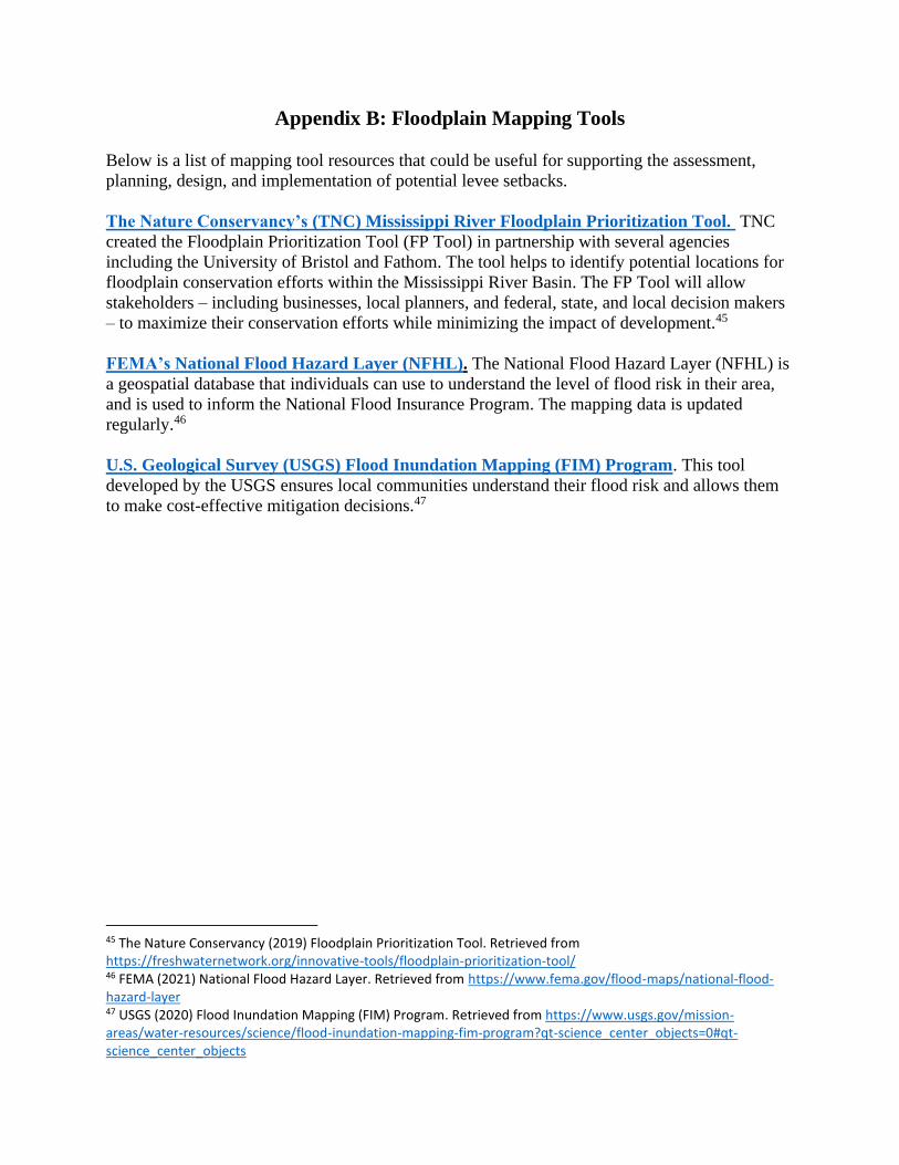
Appendix B: Floodplain Mapping Tools
Below is a list of mapping tool resources that could be useful for supporting the assessment,
planning, design, and implementation of potential levee setbacks.
The Nature Conservancy’s (TNC) Mississippi River Floodplain Prioritization Tool. TNC
created the Floodplain Prioritization Tool (FP Tool) in partnership with several agencies
including the University of Bristol and Fathom. The tool helps to identify potential locations for
floodplain conservation efforts within the Mississippi River Basin. The FP Tool will allow
stakeholders – including businesses, local planners, and federal, state, and local decision makers
– to maximize their conservation efforts while minimizing the impact of development.45
FEMA’s National Flood Hazard Layer (NFHL). The National Flood Hazard Layer (NFHL) is
a geospatial database that individuals can use to understand the level of flood risk in their area,
and is used to inform the National Flood Insurance Program. The mapping data is updated
regularly.46
U.S. Geological Survey (USGS) Flood Inundation Mapping (FIM) Program. This tool
developed by the USGS ensures local communities understand their flood risk and allows them
to make cost-effective mitigation decisions.47
45 The Nature Conservancy (2019) Floodplain Prioritization Tool. Retrieved from https://freshwaternetwork.org/innovative-tools/floodplain-prioritization-tool/ 46 FEMA (2021) National Flood Hazard Layer. Retrieved from https://www.fema.gov/flood-maps/national-flood-hazard-layer 47 USGS (2020) Flood Inundation Mapping (FIM) Program. Retrieved from https://www.usgs.gov/mission-areas/water-resources/science/flood-inundation-mapping-fim-program?qt-science_center_objects=0#qt-science_center_objects