ieq 02plate tectonics ii
TRANSCRIPT

8/6/2019 IEQ 02Plate Tectonics II
http://slidepdf.com/reader/full/ieq-02plate-tectonics-ii 1/21
Fig. 1 The schematic for different types of plate driving forces.
Fig. 2 Schematic of Ridge Push forces.
PLATE DRIVING FORCES
The forces actingon plates may bedivided into forcesthat act on their
bottom surfacesand forces that acton their
margins/boundaries. The bottom forces arise due to relative motion between thelithospheric plate and the viscous asthenosphere. For plate tectonics the importantfeature of mantle theology is that viscous flow in the upper mantle is possible.
a. Boundary Forces
A number of boundary forces have been postulated since the dawn of the tectonic theory,including ridge push, slab pull, trench suction, collisional resistance, and basal drag. Inthe following section, the basic physical properties of each of the main forces believed tobe involved in the total net motion of plates will be described and defined (fig. 1).
Ridge Push:
Figure 2 has been considered in two
different manners, as a body force and as aboundary force. As a body force, ridge pushhas been attributed to the cooling andthickening of the oceanic lithosphere withage. This type of force can be thought of ascreated by the horizontal pressure gradientattributable to the cooling and thickening of the oceanic lithosphere, and calculated asthis force integrated over the area of theoceanic portion of a given plate. In this respect, Ridge Push can be considered a bodyforce, rather than a boundary force acting over the oceanic part of a plate. When making
such a calculation however, one must take into account that oceanic lithosphere older than 90 Ma is no longer cooling significantly, and therefore not contributing to the effectiveridge push force.
The alternative, Ridge Push as a boundary force, is caused by the "gravity wedging"effect. This effect results from warm, buoyant mantle upwelling beneath the ridge crestwhich causes a topography-induced horizontal pressure gradient. Here the force wouldbe acting as a boundary force at the edge of the lithospheric plate, proportional to thelength of the ridge, and not as a body force over the entire oceanic portion of the plate. Inboth of the above cases Ridge Push would be amplified, by as much as a factor of twowhen hot spot activity is centered on a spreading ridge axis. This is important when
considering the effects of ridge push as a cumulative force acting on all the plates, andmust be taken into account in any net force calculations.
1
8/6/2019 IEQ 02Plate Tectonics II
http://slidepdf.com/reader/full/ieq-02plate-tectonics-ii 2/21
Fig. 3 Schematic of Slab Pull and Collisional Resistance forces.
Fig. 4 Schematic of trench suction and slab roll-back forces.
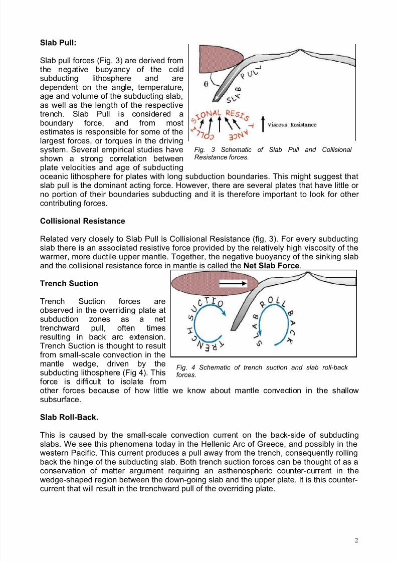
Slab Pull:
Slab pull forces (Fig. 3) are derived fromthe negative buoyancy of the coldsubducting lithosphere and aredependent on the angle, temperature,
age and volume of the subducting slab,as well as the length of the respectivetrench. Slab Pull is considered aboundary force, and from mostestimates is responsible for some of thelargest forces, or torques in the drivingsystem. Several empirical studies haveshown a strong correlation betweenplate velocities and age of subductingoceanic lithosphere for plates with long subduction boundaries. This might suggest thatslab pull is the dominant acting force. However, there are several plates that have little or
no portion of their boundaries subducting and it is therefore important to look for other contributing forces.
Collisional Resistance
Related very closely to Slab Pull is Collisional Resistance (fig. 3). For every subductingslab there is an associated resistive force provided by the relatively high viscosity of thewarmer, more ductile upper mantle. Together, the negative buoyancy of the sinking slaband the collisional resistance force in mantle is called the Net Slab Force.
Trench Suction
Trench Suction forces areobserved in the overriding plate atsubduction zones as a nettrenchward pull, often timesresulting in back arc extension.Trench Suction is thought to resultfrom small-scale convection in themantle wedge, driven by thesubducting lithosphere (Fig 4). Thisforce is difficult to isolate from
other forces because of how little we know about mantle convection in the shallowsubsurface.
Slab Roll-Back.
This is caused by the small-scale convection current on the back-side of subductingslabs. We see this phenomena today in the Hellenic Arc of Greece, and possibly in thewestern Pacific. This current produces a pull away from the trench, consequently rollingback the hinge of the subducting slab. Both trench suction forces can be thought of as aconservation of matter argument requiring an asthenospheric counter-current in thewedge-shaped region between the down-going slab and the upper plate. It is this counter-
current that will result in the trenchward pull of the overriding plate.
2

8/6/2019 IEQ 02Plate Tectonics II
http://slidepdf.com/reader/full/ieq-02plate-tectonics-ii 3/21
Fig. 5 Schematic of Plate Tectonic and Basal Shear TractionResistive forces.
Plate Tectonic Resistive
Plate Tectonic Resistiveforces (fig. 5) are exerted onthe overriding plate in asubduction zone at the
contact with the descendingslab. This force is thought toresult in a shear stress thatis distributed over thesubduction thrust interface,that dips in the direction of the plate's interior. However,tectonic resistive forces areconsidered equal and opposite in sign to the force exerted on the subducting plate, andtherefore do not contribute greatly to the net driving force for plate motion.
Basal Shear Traction
The last major force, Basal Shear Traction or Basal Drag (fig. 5) is important because of its relevance to the fundamental question of whether plate motions are active or passive.Basal Shear Traction is the resistance or dragging force associated with the interfacebetween the upper mantle and the lithosphere. Today this force is thought to be small, butuntil we know more about the coupling between the lithosphere and the mantle is better constrained, we cannot be certain how important it is. It is thought to have a smallmagnitude per unit area, but when spread over the entire under-surface of big plates canresult in a large cumulative resistance. The lack of good correlation between plate velocityand surface area has traditionally been used to argue against Basal Shear Traction (BST)
as an important driving force. In recent models researchers have considered BST apassive force, either driving or resisting plate motion, but not dominating plate motion.
The contribution of BST on the motion of plates depends on whether the flow pattern atthe lithosphere-mantle interface is radial or unidirectional and parallel or anti-parallel withrespect to the overlying plate motions. However, the mechanical nature of this interfaceand its flow pattern are unknown. Other researchers are advocates of drag forces playingan important role in driving plate motion, while the plates remain passive. In this case thelateral motion of the plates would be caused by the mantle's exertion of a drag force onthe overriding lithosphere, above warm upwellings, which would subsequently create adeviatoric stress regime.
3

8/6/2019 IEQ 02Plate Tectonics II
http://slidepdf.com/reader/full/ieq-02plate-tectonics-ii 4/21
Fig. 6 Schematic of whole mantle and layered mantle convection current
b. Bottom Forces (Convection Current)
The feasibility of mantle convectionis accepted butthere is still some
doubt as to theform it takes. Thisis in part due touncertainty as tothe role played bythe seismicdiscontinuities at400 km and 670km depth, whichbound the upper mantle transition
zone. Thediscontinuities arenot sharp, and areunderstood torepresent mineralphase changesrather thancompositionaldifferences (as, for example, thecrust-mantle and
core-mantleboundaries). Theupper discontinuity marks the olivine-spinel phase change, the lower one represents thephase change from spinel to perovskite structure, with accompanying changes in densityand elastic parameters. In principle, mass can be carried by convection currents acrossthese discontinuities. The 670 km discontinuity is close to the maximum depth of seismicity in subduction zones, and may be where the subducting plate is absorbed intothe mantle.
There are two main models of mantle convection, each with an interface at the 670 kmseismic discontinuity. An important change in viscosity occurs at this level. In whole -
mantle convection (Fig. 6a) the viscosity doubles from the upper mantle to the lower mantle and there is a net flow of material across the boundary. In this model, convectionensures that the entire mantle is well mixed mechanically, and the phase changes at 400and 670 km have only a small effect on the temperature gradient. This model agrees withmuch of the available evidence. The alternative layered convection model has distinctconvecting layers in the upper and lower mantle (Fig. 6b). There are two ways in whichthis can take place. The upper and lower convection patterns in a vertical section mayrepresent circulations in the same sense (e.g., both clockwise or both anticlockwise) or inopposite senses (e.g., one clockwise and the other anticlockwise). In each case theradial velocity is zero at 670 km depth and there is no mass transfer across thediscontinuity; the material in each flow pattern spreads out along the boundary. However
the models imply different types of coupling between the layers. Opposite senses of circulation in the layers would cause little or no shear between the tangential flows at theboundary, resulting in mechanical coupling between the layers. Cold material sinking inthe upper mantle would overlie hot material rising in the lower mantle. However, in the
4

8/6/2019 IEQ 02Plate Tectonics II
http://slidepdf.com/reader/full/ieq-02plate-tectonics-ii 5/21
layered flow patterns have the same sense of circulation (as in Fig. 6b), hot material risingin the upper mantle overlies hot material rising in the lower mantle, so that the flowregimes are coupled thermally. This model has a strong velocity shear across the 670 kmdiscontinuity, which requires a large and abrupt change in viscosity at this depth; viscosityin the lower mantle would need to be at least two orders of magnitude smaller than in theupper mantle. Estimates of mantle viscosity indicate the opposite: viscosity is higher in
the lower mantle than in the upper mantle.
A model of layered convection assumes that there is no mass transfer across thediscontinuity. The upper and lower mantles are well mixed individually, but the separationof the flow patterns at the discontinuity means that they may have distinct chemicalcomposition & Because there is no convective flow across it, heat can only cross theboundary by conduction. The 670 km discontinuity therefore acts as a thermal boundary,with a large temperature change of perhaps 500-1000 deg K across it. Thus, thetemperature profile in the lower mantle, although maintained adiabatic by the convection,would be 500-1000 deg K higher than in whole-mantle convection. This would result in asmaller temperature change across the CMB, a less-steep temperature gradient in the
D"-layer, and so a lower heat flux from the core. The long-term rate of cooling of theEarth would thereby be reduced. The problem of understanding mantle convection iscomplicated by the non-uniform structure and theology of the mantle. As yet, there is nocomplete picture of how the various factors that influence convection act together. Theconvection pattern depends strongly on what happens physically and thermodynamicallyat the 670 km discontinuity. This can only be inferred indirectly. Our understanding of thediscontinuity is incomplete, but it is essential to resolving the real pattern of mantleconvection.
5

8/6/2019 IEQ 02Plate Tectonics II
http://slidepdf.com/reader/full/ieq-02plate-tectonics-ii 6/21
Fig. 2 Map showing the Mid-Atlantic Ridge splitting Iceland and separating the North American and Eurasian Plates. The map alsoshows Reykjavik, the capital of Iceland, the Thingvellir area, and thelocations of some of Iceland's activevolcanoes (red triangles), including Krafla.
PLATE MARGINS AND SEISMICITY OF THE EARTH
There are three types of plate margins:
1. Constructive plate margin/Divergent boundaries - where new crust is generated asthe plates pull away from each other.
2. Destructive plate margin /Convergent boundaries - where crust is destroyed as oneplate dives under another.3. Conservative plate margin /Transform boundaries - where crust is neither produced nor destroyed as the plates slide horizontally past each other.
1. Divergent boundaries
Divergent boundaries occur along spreading centerswhere plates are moving apart and new crust iscreated by magma pushing up from the mantle. Theplace where new crust is formed in ocean due to the
divergence of plates is known as mid oceanic ridges.The vast majority of these boundaries are located inthe oceans, however it is evident that theseboundaries also exist in in continental regions.These areas of continental diverging boundaries areknown as rift zones. A good example is the EastAfrican rift valley. Places where mid oceanic ridgeshave been identified are: Atlantic, India , Antarctica,South Pacific oceans, Norwegian sea, Arctic basin(Fig.1 ).
Perhaps the best known of the divergent boundariesis the Mid-Atlantic Ridge. This submerged mountainrange, which extends from the Arctic Ocean tobeyond the southern tip of Africa, is but onesegment of the global mid-ocean ridge system thatencircles the Earth. The rate of spreading along theMid-Atlantic Ridge averages about 2.5 centimetersper year (cm/yr), or 25 km in a million years. Thisrate may seem slow by human standards, butbecause this process has been going on for millionsof years, it has resulted in plate movement of thousands of kilometers.
Seafloor spreading over the past 100 to 200 million years has caused the Atlantic Oceanto grow from a tiny inlet of water between the continents of Europe, Africa, and theAmericas into the vast ocean that exists today. The volcanic country of Iceland, whichstraddles the Mid-Atlantic Ridge, offers scientists a natural laboratory for studying on landthe processes also occurring along the submerged parts of a spreading ridge. Iceland issplitting along the spreading center between the North American and Eurasian Plates, asNorth America moves westward relative to Eurasia. The consequences of platemovement are easy to see around Krafla Volcano, in the northeastern part of Iceland (Fig.2). Here, existing ground cracks have widened and new ones appear every few months.
6

8/6/2019 IEQ 02Plate Tectonics II
http://slidepdf.com/reader/full/ieq-02plate-tectonics-ii 7/21
Fig. 1
From 1975 to 1984, numerous episodes of rifting (surface cracking) took place along theKrafla fissure zone. Some of these rifting events were accompanied by volcanic activity;the ground would gradually rise 1-2 m before abruptly dropping, signalling an impendingeruption.
Rift: Continental rifting occurs as a result of crustal extension and the associated thinning
of the continental crust leading, possibly to seafloor spreading and the consequentformation of oceanic basins. Rift systems are fairly common on the continental crust,because in the sea regions, the lithosphere tends to be under tensional stresses.
Presently active regions of continental extension include the East African Rift, the BaikalRift, the Rhine Graben, the Rio Grande Rift and the Basin and Range Province, however,the continental crust is riddled with extinct and failed rifts.
The majority of rift valleys originate along lines of relative crustal weakness (much of theEast African Rift follows intercratonic mobile belts), often generated by a relaxation of
compressive stresses after continental collision.
As a result, many rift valleys form approximately perpendicular to, and soon after theformation of major orogenic belts; for example the Baikal Rift in response to theHimalayan Orogeny, and the Rhine Graben after the Alpine Orogeny. Similarly,continental rifting forming the Bay of Biscay and other rift basins in the Atlantic Oceanregion (i.e. North Sea, English Channel, Rockall Trough) began soon after the cessationof plate collision in the earliest Permian, at the end of the Variscan Orogeny. When alithospheric slab of uniform thickness is moved over an area of anomalously hot mantle(i.e. a hot spot). Thermal uplift will produce a dome, which in turn will be subject toerosion, thus thinning the crust. Such rifts are associated with copious volcanism.
In East Africa, spreading processes have already torn Saudi Arabia away from the rest of the African continent, forming the Red Sea. The actively splitting African Plate and theArabian Plate meet in what geologists call a triple junction, where the Red Sea meets the
7

8/6/2019 IEQ 02Plate Tectonics II
http://slidepdf.com/reader/full/ieq-02plate-tectonics-ii 8/21
Fig. 3 Schematic of oceanic-continental convergence.
Gulf of Aden. A new spreading center may be developing under Africa along the EastAfrican Rift Zone. When the continental crust stretches beyond its limits, tension cracksbegin to appear on the Earth's surface. Magma rises and squeezes through the wideningcracks, sometimes to erupt and form volcanoes. The rising magma, whether or not iterupts, puts more pressure on the crust to produce additional fractures and, ultimately,the rift zone.
Earthquake Occurrences:The distribution of earthquakes defines a narrow band of seismic activity close to thecrest of an oceanic ridge. These earthquakes occur at shallow depths of a few km (2-8km) and are mostly small; magnitudes of 6 or greater are rare. The point is that thelithosphere is very thin and weak at these boundaries, so strain cannot build up enough tocause large earthquakes. Associated with this type of seismicity is the volcanic activityalong the axis of ridges. The seismic energy released at ridges is an insignificant part of the world-wide annual release. Analyses show that the earthquakes are associated withnormal faulting, implying extension away from the ridge axis.
2. Convergent boundaries:
The Earth's unchanging sizeimplies that the crust must bedestroyed at about the same rateas it is being created at thedivergence boundary, as HarryHess surmised. Such destruction(recycling) of crust takes placealong convergent boundaries
where plates are moving towardeach other, and sometimes oneplate sinks (is subducted ) under another. The location wheresinking of a plate occurs is called asubduction zone. The type of convergence -- called by some a very slow "collision" -- that takes place between platesdepends on the kind of lithosphere involved. Convergence can occur between an oceanicand a largely continental plate, or between two largely oceanic plates, or between twolargely continental plates.
a. Oceanic-continental convergence
The deepest parts of the ocean are found in arc-shaped depressions in the ocean floor known as trenches. If by magic we could pull a plug and drain the Pacific Ocean, wewould see a most amazing sight -- a number of long narrow, curving trenches thousandsof kilometers long and 8 to 10 km deep cutting into the ocean floor. Trenches are thedeepest parts of the ocean floor and are created by subduction. The arc shape resultsfrom the geometry of plate movement across the spherical earth, and the convex side of the arc points toward the open ocean. These trenches, because of the tectonic andvolcanic behavior associated with them, are often accompanied by arc-shaped bands of islands.
Off the coast of South America along the Peru-Chile trench, the oceanic Nazca Plate ispushing into and being subducted under the continental part of the South American Plate.
8

8/6/2019 IEQ 02Plate Tectonics II
http://slidepdf.com/reader/full/ieq-02plate-tectonics-ii 9/21
Fig. 4 Schematic of oceanic-oceanic convergence.
In turn, the overriding South American Plate is being lifted up, creating the toweringAndes mountains, the backbone of the continent. Strong, destructive earthquakes and therapid uplift of mountain ranges are common in this region. Even though the Nazca Plateas a whole is sinking smoothly and continuously into the trench, the deepest part of thesubducting plate breaks into smaller pieces that become locked in place for long periodsof time before suddenly moving to generate large earthquakes. Such earthquakes are
often accompanied by uplift of the land by as much as a few meters.
Oceanic-continental convergence also sustains many of the Earth's active volcanoes,such as those in the Andes and the Cascade Range in the Pacific Northwest. Theeruptive activity is clearly associated with subduction, but scientists vigorously debate thepossible sources of magma: Is magma generated by the partial melting of the subductedoceanic slab, or the overlying continental lithosphere, or both?
Oceanic-Continent Boundaries (Volcanic Mountains)--Oceanic plate subducts due to higher density
Range of earthquake depth and magnitude--Formation of continental margin volcanic chains
--Formation of subduction complex (cascade mountains)
b. Oceanic-oceanic convergence:
As with oceanic-continentalconvergence, when two oceanicplates converge, one is usuallysubducted under the other, and inthe process a trench is formed. TheMarianas Trench (paralleling theMariana Islands), for example,
marks where the fast-moving PacificPlate converges against the slower moving Philippine Plate. TheChallenger Deep, at the southernend of the Marianas Trench, plungesdeeper into the Earth's interior (nearly 11,000 m) than MountEverest, the world's tallest mountain, rises above sea level (about 8,854 m).
Subduction processes in oceanic-oceanic plate convergence also result in the formationof volcanoes. Over millions of years, the erupted lava and volcanic debris pile up on the
ocean floor until a submarine volcano rises above sea level to form an island volcano.Such volcanoes are typically strung out in chains called island arcs. As the name implies,volcanic island arcs, which closely parallel the trenches, are generally curved. Thetrenches are the key to understanding how island arcs such as the Marianas and theAleutian Islands have formed and why they experience numerous strong earthquakes.Magmas that form island arcs are produced by the partial melting of the descending plateand/or the overlying oceanic lithosphere. The descending plate also provides a source of stress as the two plates interact, leading to frequent moderate to strong earthquakes.
9

8/6/2019 IEQ 02Plate Tectonics II
http://slidepdf.com/reader/full/ieq-02plate-tectonics-ii 10/21
10

8/6/2019 IEQ 02Plate Tectonics II
http://slidepdf.com/reader/full/ieq-02plate-tectonics-ii 11/21
Fig. 6 Schematic of continental- continental convergence.
Fig. 7 Schematic of collision of Indian plate with Eurasin plate and upliftment of Himalaya.
c. Continental-continental convergence
The Himalayan mountain rangedramatically demonstrates one of the most visible and spectacular
consequences of plate tectonics.When two continents meet head-on, neither is subducted becausethe continental rocks are relativelylight and, like two collidingicebergs, resist downward motion.Instead, the crust tends to buckleand be pushed upward or sideways. The collision of Indiainto Asia 50 million years agocaused the Eurasian Plate to crumple up and override the Indian Plate.
After the collision, the slow continuous convergence of the two plates over millions of years pushed up the Himalayas and the Tibetan Plateau to their present heights. Most of this growth occurred during the past 10 million years. The Himalayas, towering as high as8,854 m above sea level, form the highest continental mountains in the world. Moreover,the neighboring TibetanPlateau, at an averageelevation of about 4,600 m,is higher than all the peaksin the Alps except for MontBlanc and Monte Rosa, and
is well above the summits of most mountains in theUnited States.
The seismicity at asubduction zone providesthe key to the processesactive there. Where oneplate is thrust over the other,the shear causes hazardousearthquakes at shallow
depths. Below this region,earthquakes aresystematically distributedwithin the subducting plate.They form an enclinedWadati-Benioff zone, which may extend several hundred kilometers in to the mantle.
11

8/6/2019 IEQ 02Plate Tectonics II
http://slidepdf.com/reader/full/ieq-02plate-tectonics-ii 12/21
10 Largest Earthquake in the World
Location Date UTC Magn. Coordinates
1. Chile 1960 05 22 9.5 Mw 38.2 S 72.6 W
2. Sumatra, Indonesia 2004 12 26 9.3 Mw 3.251 N 95.799 E
3. Prince William Sound, Alaska 1964 03 28 9.2 Mw 61.1 N 147.5 W
4.Andreanof Islands, AleutianIslands
1957 03 09 9.1 Mw 51.3 N 175.8 W
5. Kamchatka 1952 11 04 9.0 Mw 52.75 N 159.5 E
6. Off the Coast of Ecuador 1906 01 31 8.8 Mw 1.0 N 81.5 W
7. Rat Islands, Aleutian Islands 1965 02 04 8.7 Mw 51.3 N 178.6 E
8. India-China Border 1950 08 15 8.6 Mw 28.5 N 96.5 E
9. Kamchatka 1923 02 03 8.5 Mw 54.0 N 161.0 E
10.
Banda Sea, Indonesia 1938 02 01 8.5 Mw 5.25 S 130.5 E
12

8/6/2019 IEQ 02Plate Tectonics II
http://slidepdf.com/reader/full/ieq-02plate-tectonics-ii 13/21
Fig. 8 Schematic of transform boundary. The Blanco,Mendocino, Murray, and Molokai fracture zones aresome of the many fracture zones (transform faults) that scar the ocean floor and offset ridges. The San Andreas is one of the few transform faults exposed onland.
3. Transform boundaries
The zone between two plates slidinghorizontally past one another is called atransform-fault boundary, or simply a transformboundary. The concept of transform faults
originated with Canadian geophysicist J. TuzoWilson, who proposed that these large faults or fracture zones connect two spreading centers(divergent plate boundaries) or, less commonly,trenches (convergent plate boundaries). Mosttransform faults are found on the ocean floor.They commonly offset the active spreadingridges, producing zig-zag plate margins, andare generally defined by shallow earthquakes.
However, a few occur on land, for example the San Andreas fault zone in California. Thistransform fault connects the East Pacific Rise, a divergent boundary to the south, with theSouth Gorda -- Juan de Fuca -- Explorer Ridge, another divergent boundary to the north.The San Andreas fault zone, which is about 1,300 km long and in places tens of kilometers wide, slices through two thirds of the length of California. Along it, the Pacific
Plate has been grinding horizontally past the North American Plate for 10 million years, atan average rate of about 5 cm/yr. Land on the west side of the fault zone (on the PacificPlate) is moving in a northwesterly direction relative to the land on the east side of thefault zone (on the North American Plate). Other, transform boundaries are San AndreasFault, Anatolian Fault near Turky, St. Paul Fault and Alpine fault in New Zealands.
Earthquake Occurrances:
Along the transform boundaries, the earthquakes occur at shallow depth, unaccompaniedby volcanic activity. The friction between the plates can be so great that very large straincan built up before they are periodically relieved by large earthquakes. Neverthless,
activity does not always occur along the entire length of the fault during any oneearthquake. For instance, the 1906 San Francisco event was caaused by breakage onlyalong the northern end of the San Andreas Fault. 1994-North ridge earthquake, 1989-Lomaprita earthquake.
13

8/6/2019 IEQ 02Plate Tectonics II
http://slidepdf.com/reader/full/ieq-02plate-tectonics-ii 14/21
Fig. 9 Schematic crosssection through asubduction zone. Themost active region isthe zone of contact between the converging
plates at depth of 10-60 km. There may be a‘back-arc’ seismic zonein the overriding plate.Below about 70 kmdepth a Wadati-Benioff seismic zone isdescribed within thesubduction plate. (After,Isacks, 1989.)
WADATI-BENIOFF ZONE :
The seismicity at a subduction zone provides the key to the processes active there.Where one plate is thrusted over the other, the shear causes hazardous earthquakes atshallow depths. Below this region, earthquakes are systematically distributed within thesubducting plate. They form an inclined Wadati-Benioff seismic zone, which may extendfor several hundred kilometes into the mantle. The distributions of epicentral locations and
focal depths of intermediate and deep earthquakes give important evidence for theprocesses at a subduction zone. When the earthquake foci along a subduction zone areprojected onto a cross-section normal to the strike of the plate margin, they are seen todefine a zone of seismicity about 30-40 km thick in the upper part of the 80-100 km thicksubducting oceanic plate. The dip-angle of the zone varies between about 30' and 60',becoming steeper with increasing depth. It can extent to depth of several hundredkilometers into the earth. The deepest reliable located focal depth extent down to about670km. Important changes in the crystalline structure of mantle minerals occur below thisdepth.
For many years the inclined seismic zone was referred to in Western literature as aBenioff zone in recognition of the Californian scientist, Hugo Benioff (Fig. 9). In the yearsfollowing World War II Benioff carried out important pioneering studies that described thedistribution of deep earthquakes on steeply dipping surfaces of seismicity. Many
characteristics of the occurrence of deep earthquakes had been described in the late1920s by a Japanese seismologist, Kiyoo Wadati.
He discovered that the closer the epicenters of earthquakes lay to the Asian continent,the greater were their focal depths; the deep seismicity appeared to lie on an inclinedplane. It was Benioff, however, who in 1954 proposed as an explanation of thephenomenon that the ocean floor was being 'subducted' underneath the adjacent land.This was a bold proposal well in advance of the advent of plate tectonic theory. Todaythe zone of active seismicity is called a Wadati-Benioff zone in recognition of bothdiscoverers.
Studies of the focal mechanisms show that at shallow depths the downgoing plate is in astate of down-dip extension (Fig. 10a). Subducting lithosphere is colder and denser thanthe underlying asthenosphere. This gives it negative buoyancy, which causes it to sink,
pulling the plate downward. At greater depths the mantle is more rigid than theasthenosphere, and its strength resists penetration (Fig. 10b). While the upper part issinking, the bottom part is being partly supported by the deeper layers; this results in
14

8/6/2019 IEQ 02Plate Tectonics II
http://slidepdf.com/reader/full/ieq-02plate-tectonics-ii 15/21
Fig. 10 Stresses acting on a subducting lithospheric plate. Arrowsindicate shear where the underriding plate is bent downward.Solid and open circles within the descending slab denoteextension and compression, respectively; the size of the circlerepresents qualitatively the seismic activity.
In (a), (b) and (d) extensional stress in the upper part of the plateis due to the slab being pulled into low-strength asthenosphere. In(b) resistance of the more rigid layer under the asthenospherecauses compression within the lower part of the slab; if the platesinks far enough, (c), the stress becomes compressionalthroughout; in some cases, (d), the deep part of the lower slabmay break off (after Isacks and Molnar, 1969).
down-dipcompression in thelower part of thedescending slab anddown-dip extension inthe upper part. A gap
in the depthdistribution of seismicity may arisewhere the deviatoricstress changes fromextensional tocompressional. In avery deepsubduction zone theincrease of resistance with
depth causes down-dip compressionthroughout thedescending slab(Fig. 10c). In somecases part of theslab may break off and sink to great depths, where the earthquakes have compressional-type mechanisms(Fig. 10d); a gap in seismicity exists between the parts of the slab.
The movement of Indian plate:
Among the most dramatic and visible creations of plate-tectonic forces are the loftyHimalayas, which stretch 2,900 km along the border between India and Tibet. Thisimmense mountain range began to form between 40 and 50 million years ago, when twolarge landmasses, India and Eurasia, driven by plate movement, collided. Because boththese continental landmasses have about the same rock density, one plate could not besubducted under the other. The pressure of the impinging plates could only be relieved bythrusting skyward, contorting the collision zone, and forming the jagged Himalayan peaks.
About 225 million years ago, India was a large island still situated off the Australian coast,
and a vast ocean (called Tethys Sea) separated India from the Asian continent. WhenPangaea broke apart about 200 million years ago, India began to forge northward. Bystudying the history--and ultimately the closing--of the Tethys, scientists havereconstructed India's northward journey.
About 80 million years ago, India was located roughly 6,400 km south of the Asiancontinent, moving northward at a rate of about 9 m a century. When India rammed intoAsia about 40 to 50 million years ago, its northward advance slowed by about half. Thecollision and associated decrease in the rate of plate movement are interpreted to markthe beginning of the rapid uplift of the Himalayas.
15

8/6/2019 IEQ 02Plate Tectonics II
http://slidepdf.com/reader/full/ieq-02plate-tectonics-ii 16/21
In just 50 million years, peaks such as Mt.Everest have risen to heights of more than 9km. The impinging of the two landmasses hasyet to end. The Himalayas continue to rise
more than 1 cm a year -- a growth rate of 10km in a million years! If that is so, why aren'tthe Himalayas even higher? Scientists believethat the Eurasian Plate may now be stretchingout rather than thrusting up, and suchstretching would result in some subsidencedue to gravity.
After the collison both the Indian and Euracianplates are moving towards north. This wasverified on the basis of various evidences, one
of them is the plant & animal fossils found fiftykilometers north of Lhasa (the capital of Tibet).Scientists found layers of pink sandstonecontaining grains of magnetic minerals(magnetite) that have recorded the pattern of the Earth's flip-flopping magnetic field. Thesesandstones also contain plant and animalfossils that were deposited when the TethysSea periodically flooded the region. The studyof these fossils has revealed not only their geologic age but also the type of environment
and climate in which they formed. For example, such studies indicate that the fossilslived under a relatively mild, wet environmentabout 105 million years ago, when Tibet was closer to the equator. Today, Tibet's climateis much more arid, reflecting the region's uplift and northward shift of nearly 2,000 km.Fossils found in the sandstone layers offer dramatic evidence of the climate change in theTibetan region due to plate movement over the past 100 million years.
At present, the movement of India continues to put enormous pressure on the Asiancontinent, and Tibet in turn presses on the landmass to the north that is hemming it in.The net effect of plate-tectonics forces acting on this geologically complicated region is to
squeeze parts of Asia eastward toward the Pacific Ocean. One serious consequence of these processes is a deadly "domino" effect: tremendous stresses build up within theEarth's crust, which are relieved periodically by earthquakes along the numerous faultsthat scar the landscape. Some of the world's most destructive earthquakes in history arerelated to continuing tectonic processes that began some 50 million years ago when theIndian and Eurasian continents first met.
16

8/6/2019 IEQ 02Plate Tectonics II
http://slidepdf.com/reader/full/ieq-02plate-tectonics-ii 17/21
SEISMICITY OF THE EARTH
The epicenters of about 30,000 earthquakes are now reported annually by theInternational Seismological Center (ISC). A global map of seismicity, as shown in Figure4, reveals most of the actively deforming regions of the earth. The seismicity map isimportant evidence in support of the plate tectonic theory, and delineates the presently
active plate margins. The major plate boundaries and the diffuse bands of seismicityassociated with the distributed deformation zones such as the Alpine-Himalayan belt andthe Great Basin in the western United States can be traced out easily. The existence of seismicity thus can be used to deduce the tectonic activity of a region, particularly insubmarine regions and other areas that are otherwise inaccessible.
Earthquake epicenters are not uniformly distributed over the earth surface, but occur predominantly along narrow zones of interplate seismic activity. The circum-pacific zone,in which 75-80% of the annual release of seismic energy takes place, forms a girdle thatencompasses the mountain range on the west of the Americans and the island arcs alongthe east coast of Asia and Australia.
The Mediterranean-trans-asiatic zone, responsible for about 15-20% of the annual energyrelease, begins at the Azores triple juction in the Atlantic Ocean and extends along theAzores-Gibraltar ridge, after passing through North Africa it makes a loop through theItalian peninsula, the Alps and the Dinarides; it then runs through turkey, Iran, TheHimalayan mountain chain and the island arcs of the Southeast Asia, where it terminatesat the circum-pacific zone. The system of oceanic ridges and rises form the third mostactive zone of seismicity, with about 3-7% of the annually released seismic energy. Inaddition to their seismicity, each of these zones is also characterized by active volcanism.
The remainder of the Earth is considered to be aseismic. However, no region of the Earth
can be regarded as completely earthquake-free. About 1% of the global seismicity is dueto intraplat e earthquakes, which occur remote from the major seismic zones. These arenot necessarily insignificant: some very large and damaging earthquakes (e.g. the Koyna,1967; Latur, 1993 and Jabalpur, 1997 earthquakes of India) have been of the intraplatevariety.
Earthquakes can also be classified according to their focal depths. Earthquakes withshallow focal depths less than 70 km occur in all the seismically active zones; onlyshallow earthquakes occur on the oceanic ridge systems. The largest proportion (about85%) of the annual release of seismic energy is liberated in shallow-focus earthquakes.The remainder is set free by earthquakes with intermediate focal depths of 70-300 km
(about 12%) and by earthquakes with deep focal depths greater than 300 km (about 3%).These occur only in the circum-Pacific and Mediterranean-transasiatic seismic zones, andaccompany the process of plate subduction. Further, about 85% of the moment releaseoccurs at subduction zones.
Volcanic earthquakes also produce insignificant amounts of moment release. In theexamination of the seismotectonics of any region, one needs to keep an awareness of therelative moment released in different earthquakes and of that with respect to the momentrelease expected from the total deformation of the region. The common use of magnitudeoften obscures these differences because it is a logarithmic measure of moment andbecause, unless moment magnitude is used, it saturates for the earthquakes that
contribute the most to the moment release.
17

8/6/2019 IEQ 02Plate Tectonics II
http://slidepdf.com/reader/full/ieq-02plate-tectonics-ii 18/21
Fig. 1 Tectonic map showing the major geomorphologic features in India and adjoining regions. AR-Arravalli Ridge; ASR-Andaman Spreading Ridge; CB-Cuddapah Basin; CG-Cambay Graben; CHB-Chhatishgarh Basin; DG-Damodar Graben; DHR-Delhi Hardwar Ridge; FR-Faizabad Ridge; GBF-Great Boundary Fault; GG-Godavari graben; HK-Hindukush; KOF-KoynaFault; KR-Kutch Ridge; MG-Mahanadi Graben; MRDF-Moradabad Fault; MSR-Monghyr
Saharsa Ridge; NT-Naga Thrust; SGF-Sagaing Fault; SHF-Sumatra Fault; TST-Tien ShanThrust; WCF-West Coast Fault (after Khan, 2004).
SEISMOTECTONICS OF INDIA
18

8/6/2019 IEQ 02Plate Tectonics II
http://slidepdf.com/reader/full/ieq-02plate-tectonics-ii 19/21
Fig. 2 Seismicity map of India (after, IS:1893 (Pt. 1): 2002)
Seismotectonics of India can be divided in to four zones. Himalayan Zone: MFT, MBT, MCT &ISZ; Andaman Nicobar thrust best; Kutch region and Intra-continental tectonic activity.Himalayas is one of the tectonically most active belts of the World and one of the rare sites of active continent-continent collision. A major portion of the strain due to collision is taken up in thethrusting phenomenon along the Himalaya while the remaining strain is distributed north of it in awide area from Tibetan Plateau to Pamirs. The Himalayan zone evolved in two phases. The firstphase involved continent-continent collision of India and Asia and in the second phase thestretched Indian continental lithosphere subducted along the detachment (decollment) surface
forming intra-continental thrusts. This subduction to some extent is still continuing. The pushfrom the Asian side has given rise to compression from north producing gigantic thrustsprogressing from north to south.
19

8/6/2019 IEQ 02Plate Tectonics II
http://slidepdf.com/reader/full/ieq-02plate-tectonics-ii 20/21
The northward movement of the Indian plate and the continued convergence process along theHimalaya has transmitted large northerly compression in the Indian Peninsula, causing NEoriented faults. The other tectonic features like ENE trending Narmada Son graben and NWtrending Godavari and Mahanadi grabens are older. Sometimes the NW faults have beendisplaced by the younger NE faults. Present day tectonics as indicated by seismicity study showsstrike-slip faulting either along NE or NW trending faults by reactivation. Normal faults along
Narmada, Godavari and Koyna rifts are also reactivated occasionally. However, the faults inPeninsular India are small and so only moderate earthquakes have occurred except in Kutchregion. The source of stress responsible for tectonic activity in the Kutch region is not welldefined.
SEISMICITY OF INDIAEarthquakes have been occurring in the Indian subcontinent from the times immemorial butreliable historical records are available for the last 200 years ( Oldham, 1883 ). From thebeginning of this century; more than 700 earthquakes of magnitude 5 or more have beenrecorded and felt in India until 2002 as given in the catalogues prepared by US NationalOceanographic and Atmospheric Administration (NOAA)/USGS, India Meteorological Department(IMD), National Geophysical Research Institute (NGRI). Out of this, Peninsular India hasexperienced only about 100 earthquakes of magnitude 5 or more. The seismicity of India can bedivided in four groups, namely, Himalaya region, Andaman Nicobar, Kutch region and Peninsular India. Some of the damaging earthquake which have occurred in these four regions are listed inthe following table.
HIMALAYAN REGIONSN Name Location Year Magn. Death
1. Kashmir Earthquake Srinagar, j. k. 1885 --- 3,0002. Shillaong Earthquake Shillaong, Platau 1897 8.7 1,600
3. Kangra Earthquake Kangra, H.P. 1905 8.5 20,0004. Bihar-Nepal Earthquake Bihar-Nepal boarder
region
1934 8.3 10,000
5. Assam Earthquake Assam 1950 8.5 1,5266. Bihar-Nepal Earthquake Bihar-Nepal boarder
region1988 6.5 1,000
7. Indo-Burma Earthquake India-Burma Boarder 1988 7.3
8. Uttarkashi Earthquake Uttarkashi, U.A. 1991 7.0 768
9. Chamoli Earthquake Chamoli, U.A. 1999 6.8 54
ANDAMAN NICOBAR
1. Andaman-Nicobar Earthquake Andaman-Nicobar Trench 1941 8.1
KUTCH REGION
1. Samaji Earthquake Samaji, Delta of Indus 1668 X2. Kutch Earthquake Kutch , Gujarat 1819 8.0 2,0003. Anjar Earthquake Anjar, Gujrat 1956 6.1 115
4. Bhuj Earthquake Bachau, Gujarat 2001 6.9 20,000
PENINSULAR INDIA
1. Bombay-Surat Earthquake Bombay-Surat 1856 VII
2. Son Valley Earthquake Son Valley 1927 6.53. Satpura Earthquake Satpura 1938 6.3
4. Balaghat Earthquake Balaghat, M.P. 1957 5.5
5. Koyna Earthquake Koyna 1967 6.0 1776. Ongole Earthquake Ongole, Bhadrachalam 1967 5.4
7. Broach Earthquake Broach 1970 5.4 268. Latur Earthquake Latur, Maharashtra 1993 6.2 10,000
9. Jabalpur Earthquake Jabalpur, M.P. 1997 6.0 39
20

8/6/2019 IEQ 02Plate Tectonics II
http://slidepdf.com/reader/full/ieq-02plate-tectonics-ii 21/21