i welcome the reduction in the allocation of green belt ... · i welcome the reduction in the...
TRANSCRIPT

I welcome the reduction in the allocation of green belt land as future development land (safeguarded land) in respect of CS32. I propose that the land designated as the current CS32 should be removed from the plan for the following reasons. Additionally due to the suggestions in the consultation that CS32 should be extended to Chelford for development I have included reasons as to why this should not occur.
1. Green belt a. Green belt should ‘only be altered in exceptional circumstances.’
[section 83] (1) Protection of it is a core planning principle. [section 17] (1) These exceptional circumstances have not been provided by Cheshire East Council. The required housing for Cheshire East could be delivered through the use of Brownfield. Most of the required housing has already been delivered.
b. The requirement for exceptional circumstances was expounded by the secretary of State for Communities and Local Government (Mr Eric Pickles) ‘The green belt is an important protection against urban sprawl, providing a green lung around towns and cities. The National Planning Policy Framework delivers the coalition’s agreement to safeguard the green belt, and boundaries should only be altered in exceptional circumstances.’ (2)
c. Planning Minister Nick Boles confirmed this in July 2013. ‘NPPF Ch 9 states: As with previous green belt policy, inappropriate development is, by definition, harmful to the green belt and should not be approved except in very special circumstances. When considering any planning application, local planning authorities should ensure that substantial weight is given to any harm to the green belt. Very special circumstances will not exist unless the potential harm to the green belt…is clearly outweighed by other considerations’
d. This plan is in direct opposition to the meaning of sustainable as defined by Greg Clark MP Minister for Planning. (1)
e. In his statement on 1 July 2013 Local Government Minister Brandon Lewis issued a written statement to Parliament which said ‘Having considered recent planning decisions made by councils and the Planning Inspectorate, it has become apparent that the green belt is not always being given the sufficient protection that was the explicit policy intent of ministers. The Secretary of State wishes to make clear that …he considers the single issue of unmet demand….is unlikely to outweigh harm to the green belt and other harm to constitute the ‘very special circumstances’ justifying inappropriate development in the green belt’. The Pre Submission Core Strategy fails to define exceptional circumstances other than unmet demand.
f. The current plans for CS32 will cause the destruction of 45.5 hectares of green belt. At 30 houses per hectare this allows for the building of 1365 houses. Whilst the extended of CS32 version would allow for thousands more. This cannot be justified. This view was expressed by the Planning inspector in 1997 when a similar scheme was put forward in the Macclesfield Local Plan ‘I am not therefore satisfied with the loss of green belt here on this scale and therefore support the objections.’[para 6.23] (3)
g. ‘Openness and permanence’ is an essential characteristic of green belt with a function of preventing urban sprawl. [section 79] (1) The land between Chelford Road and Congleton Road has been farmed since medieval times and provides uninterrupted views towards Sutton Common and Crocker Hill.
h. The Green Belt Assessment evidence presented by the council is flawed. On the land between Congleton Road and Chelford Road consists of four parcels identified in the green belt assessment; the main three parcels were designated in Cheshire East’s Green Belt Assessment as having ‘significant contributions to the green belt’. Yet these parcels (MAC04, MAC05) were chosen for development as CS32 instead of numerous other sites that have lower assessment levels. Additionally some of the site descriptors when used for these sites should create designations as major contribution; when used elsewhere for other sites these statements are deemed to form a major contribution. The following table is an analysis of the Green Belt Assessment demonstrating its contradictions in interpretation of evidence and refers to parcels identified in the assessment, some of which are shown on the following map.
2 | P a g e
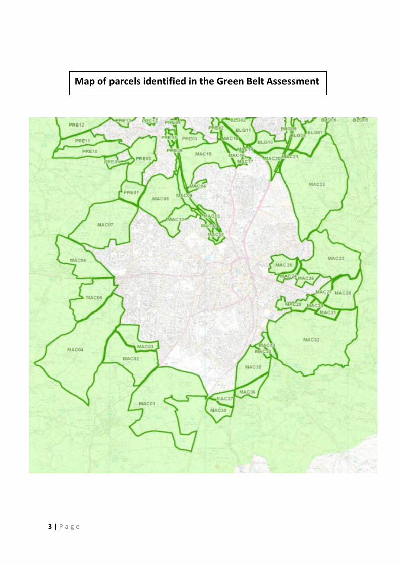
Map of parcels identified in the Green Belt Assessment
3 | P a g e
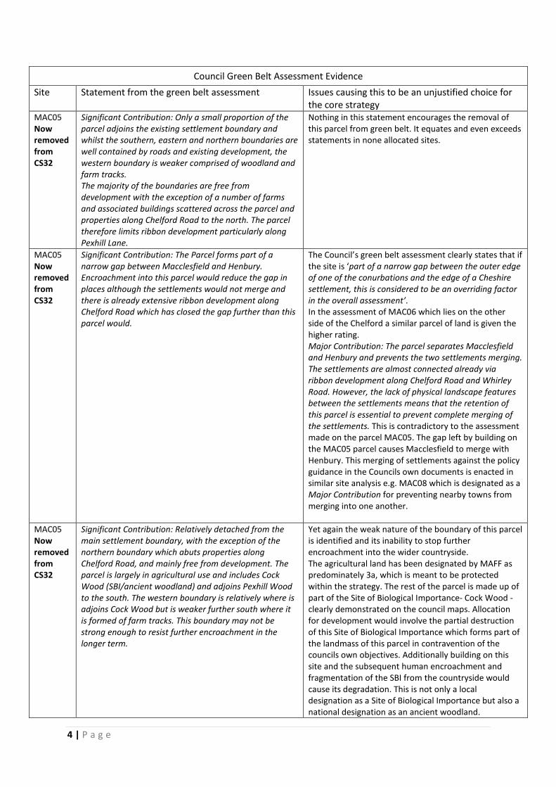
Council Green Belt Assessment Evidence Site Statement from the green belt assessment Issues causing this to be an unjustified choice for
the core strategy MAC05 Now removed from CS32
Significant Contribution: Only a small proportion of the parcel adjoins the existing settlement boundary and whilst the southern, eastern and northern boundaries are well contained by roads and existing development, the western boundary is weaker comprised of woodland and farm tracks. The majority of the boundaries are free from development with the exception of a number of farms and associated buildings scattered across the parcel and properties along Chelford Road to the north. The parcel therefore limits ribbon development particularly along Pexhill Lane.
Nothing in this statement encourages the removal of this parcel from green belt. It equates and even exceeds statements in none allocated sites.
MAC05 Now removed from CS32
Significant Contribution: The Parcel forms part of a narrow gap between Macclesfield and Henbury. Encroachment into this parcel would reduce the gap in places although the settlements would not merge and there is already extensive ribbon development along Chelford Road which has closed the gap further than this parcel would.
The Council’s green belt assessment clearly states that if the site is ‘part of a narrow gap between the outer edge of one of the conurbations and the edge of a Cheshire settlement, this is considered to be an overriding factor in the overall assessment’. In the assessment of MAC06 which lies on the other side of the Chelford a similar parcel of land is given the higher rating. Major Contribution: The parcel separates Macclesfield and Henbury and prevents the two settlements merging. The settlements are almost connected already via ribbon development along Chelford Road and Whirley Road. However, the lack of physical landscape features between the settlements means that the retention of this parcel is essential to prevent complete merging of the settlements. This is contradictory to the assessment made on the parcel MAC05. The gap left by building on the MAC05 parcel causes Macclesfield to merge with Henbury. This merging of settlements against the policy guidance in the Councils own documents is enacted in similar site analysis e.g. MAC08 which is designated as a Major Contribution for preventing nearby towns from merging into one another.
MAC05 Now removed from CS32
Significant Contribution: Relatively detached from the main settlement boundary, with the exception of the northern boundary which abuts properties along Chelford Road, and mainly free from development. The parcel is largely in agricultural use and includes Cock Wood (SBI/ancient woodland) and adjoins Pexhill Wood to the south. The western boundary is relatively where is adjoins Cock Wood but is weaker further south where it is formed of farm tracks. This boundary may not be strong enough to resist further encroachment in the longer term.
Yet again the weak nature of the boundary of this parcel is identified and its inability to stop further encroachment into the wider countryside. The agricultural land has been designated by MAFF as predominately 3a, which is meant to be protected within the strategy. The rest of the parcel is made up of part of the Site of Biological Importance- Cock Wood - clearly demonstrated on the council maps. Allocation for development would involve the partial destruction of this Site of Biological Importance which forms part of the landmass of this parcel in contravention of the councils own objectives. Additionally building on this site and the subsequent human encroachment and fragmentation of the SBI from the countryside would cause its degradation. This is not only a local designation as a Site of Biological Importance but also a national designation as an ancient woodland.
4 | P a g e

Council Green Belt Assessment Evidence
Site Statement from the green belt assessment Issues causing this to be an unjustified choice for the core strategy
MAC04 Now removed from CS32
The parcel itself is well contained by strong boundaries formed by Dark Lane to the south, Gawsworth Road to the east, Pexhill Road to the south and it is adjacent to the urban edge to the north. However, this parcel of land is extremely large and there are no features in the landscape which would prevent development from spreading all the way out to Dark Lane.
Yet in the allocation of site CS 32 the strategy draws a boundary through the middle of the parcel which has been identified as not having features that would stop the spread of development into the remaining countryside.
MAC04 Now removed from CS32
There are residential properties scattered around the edge of the parcel, which reduces the impact of the parcel in limiting sprawl.
These residential properties are old houses not modern dwellings and are part of the agricultural setting.
MAC04 Now removed from CS32
Major Contribution: Located to the south west of Macclesfield, the parcel is connected to the urban boundary along a narrow edge to the north. The remaining area is open countryside, in agricultural use and free from urbanising influences, with the exception of a number of properties located around the periphery. As such, any development would feel divorced from the urban edge and would lead to significant encroachment into the countryside, completely altering the existing settlement pattern.
Why is this statement ignored by the council in the choice of this site over others for the removal from green belt?
MAC04 Now removed from CS32
This is a very large parcel to the south west of Macclesfield. Mostly made up of agricultural fields, with a number of detached properties around the periphery. The parcel adjoins the settlement to the north and is contained by strong boundaries formed by Gawsworth Road, Dark Lane and Pexhill Road. Due to the size of the parcel, it has a significant role in preventing encroachment into the countryside.
This assessment is again ignored by the council in the allocation of this site for removal from green belt: creating a weak boundary to encroachment into the countryside and allocating pristine agricultural land for building development.
MAC04 Now removed from CS32
No description of the openness of this site is included.
This section of land provides open views from Macclesfield to the Crocker Hill and Sutton Common. Descriptions of openness are included to describe sites such as PRE10 and PRE11
MAC02 Part of what is now CS32
Part of the open countryside situated between Macclesfield and Gawsworth. Detached from the urban edge, the parcel is largely agricultural land. It is bounded by Congleton Road, Gawsworth Road and Pennington’s Lane, with a weak southern boundary formed by a farm track, which is unlikely to be sufficient in resisting development pressures long term, and could result in the settlements of Macclesfield and Gawsworth merging.
The Council’s green belt assessment clearly states that if the site is ‘part of a narrow gap between the outer edge of one of the conurbations and the edge of a Cheshire settlement, this is considered to be an overriding factor in the overall assessment’. This should not identify this site as one for removal from green belt but encourages its retention as green belt so that Macclesfield and Gawsworth do not merge.
5 | P a g e

i. The green belt assessment was dated September 2013 nine months after the area between Congleton Road and Chelford Road, was identified for removal from green belt and allocated for development in the original consultation. Hence choices on site allocation were made before any green belt assessment. Evidence should guide choices not be prepared and misconstrued at a later date to suit prior decisions.
j. The Non-preferred sites document (4) also highlights the contradictory nature of the council’s evidence supporting their choice of CS 32. The document demonstrates a lack of objective assessment. For example non-preferred site NPS 38 lies on the opposite side of Chelford Road to the northern parcel of CS32. NPS 38 is described as ‘having some connection to the urban edge of the settlement, and is currently located within the green belt. There are natural features within the site including ponds, hedgerows and protected trees although there are no designated sites of conservation interest. There are no heritage assets within the site although a number of Grade II Listed Buildings are located adjacent.’ CS 32 in the northern parcel (MAC05) has all the attributes of CS38. Additionally it has a Site of Biological Importance (ancient woodland) and is has far less connection with the urban fringe. This site description shows the northern parcel of CS32 to be even less desirable for removal from green belt than the non-preferred site NPS 38. This is not a justified choice based on objective interpretation of evidence.
k. Neither site should be removed from green belt. l. NPS 38 is said to ‘not relate well to the achievement of the Vision and
Strategic Priorities. Although it is located adjacent to the existing urban edge the site is at significant distance from services and would require high levels of investment in local services and infrastructure. The site is also subject to significant policy restraint (Green Belt). This area forms an important gap between Macclesfield and Henbury and development of this site could lead to Henbury being merged into the Macclesfield urban area.’ Site CS 32 is a mirror image of this non preferred site in the land between Chelford Road and Pexhill Road. It would equally, if not more so due to its more rural nature, require investment in local services and infrastructure. For example, houses on Pexhill Road (CS32) are off mains whereas those on Whirley Road are not (NPS 38). CS 32 would equally close the gap between
6 | P a g e
Macclesfield and Henbury. Site CS32 is also subject to significant policy restraint (Green Belt).
m. The presence of the Site of Biological Importance Cock Wood, a remnant of Ancient Woodland snakes across CS32 from the Chelford Road to Pexhill Road. The removal of this site from green belt and its allocation for development would immediately destroy a major section of this SBI. The negative effect of development located near SBIs is noted on other sites in the non-preferred sites document, for example NP66 ‘is adjacent to a Site of Biological Importance which would be sensitive to the impact of development’. Yet this is not a material consideration for the council when it comes to CS32.
n. The Council’s Green Belt Assessment clearly states that ‘if the site is ‘part of a narrow gap between the outer edge of one of the conurbations and the edge of a Cheshire settlement, this is considered to be an overriding factor in the overall assessment’. (5) An extended CS32 would be in close proximity to Henbury .
o. The decision to only review green belt on three of the required five criteria is flawed. The idea that Chester is the only historic town and that there is no variation in the ability of green belt to preserve the setting and special character of historic towns is wrong. Residents and it would seem Cheshire East Council regard Macclesfield as historic in several council documents. For example in 2003 Cheshire County Council and English nature jointly published an historic town survey covering This is in the councils own evidence base for the local plan. It identifies Macclesfield as an historic town and states: ‘Macclesfield was one of Cheshire’s most important medieval towns. The medieval borough, which was the product of 13th century town planning, was laid out around the Market Place, in a prominent position overlooking the River Bollin. The silk industry for which Macclesfield was internationally renowned in the late 18th and 19th centuries, developed to the south and east of the medieval area of the town on lower land by the River Bollin and its tributaries. Therefore, despite this intensive industrial development, the plan of the medieval town has largely survived’.
p. The review criteria - to assist in the urban regeneration by encouraging the recycling of derelict and other urban land - is identified as being equal throughout the county and so not reviewed but ignored. This is not true. In the description of Macclesfield in the green belt assessment document it states. ‘Given its industrial heritage, there are some brownfield sites in the urban area that are able to offer a contribution to meeting the town’s development needs.
7 | P a g e
However, there are a number of other sites that may be suitable for redevelopment, but where there is insufficient evidence that these sites will come forwards for development. These include sites such as the Barracks Mill site on Black Lane, where the constraints to development, costs in dealing with contamination and developer interest for retail purposes mean that the site cannot be considered as genuinely available for housing development. There are also a number of other smaller, slightly run-down and sometimes underused commercial / industrial areas’. This clearly identifies sites that will remain undeveloped in the face of allocation of cheaper and easier green belt sites if this safeguarded land is included in the core strategy. Developers will play the waiting game to make greater profits and land bank.
q. The current designation of Green Belt CS32 fulfils the purposes of Green Belt and hence should not be removed from this designation by Cheshire East council: • It checks the unrestricted sprawl of Macclesfield into Henbury
village and Gawsworth village. • It assists in safeguarding this prime section of Cheshire
countryside from the encroachment sub-urban sprawl. • It preserves the setting of Macclesfield as a historical market town
with medieval roots. • It assists in urban regeneration by encouraging the recycling of PDL in the
town. [section 80] (1)
8 | P a g e

2. Sustainable Development a. A sustainable pattern of development) is not delivered by building
dormitory towns 20 miles away from the city that they serve. [section 34] (1) It does not create a radical reduction in greenhouse gases but will lead to an increase in our carbon footprint. [sections 30, 93, 95] (1)
b. The sighting of this major development in the South West of Macclesfield away from the train and bus station does not follow the core planning principle of ‘making the fullest possible use of public transport, walking and cycling, and focus significant development in locations which are or can be made sustainable…’ [section 17, 35] (1) As such it is unsustainable and unjustified.
c. The green belt land between Congleton Road and Gawsworth Road allocation is justified in the pre submission document as it is ‘located to the south west of Macclesfield, the site is well connected to the existing urban edge of the settlement and well connected to the highways network in the southern part of the town’. Its location on the southern side of Macclesfield is not a positive aspect in terms of housing need, employment or road network.
d. The Local Plan should reflect the core planning principle of contributing ‘to conserving and enhancing the natural environment and reducing pollution. Allocations of land for development should prefer land of lesser environmental value…’ and yet does not in the allocation of this prime Cheshire countryside to housing and a road. [section 17] (1)
3. Biodiversity a. This Local Plan, in its designation of CS32, does not follow national
guidelines which states that ‘The planning system should contribute to and enhance the natural and local environment by:
● minimising impacts on biodiversity and providing net gains in biodiversity where possible, contributing to the Government’s commitment to halt the overall decline in biodiversity, including by establishing coherent ecological networks that are more resilient to current and future pressures…’[section109] (1)
b. ‘During the 20th century the United Kingdom lost over one hundred species of flora and fauna, and many more have been significantly reduced in number or habitat range. Reduction in biodiversity is often a result of a decrease in natural habitats, both in the land area they occupy and their variety.’ (6)
9 | P a g e

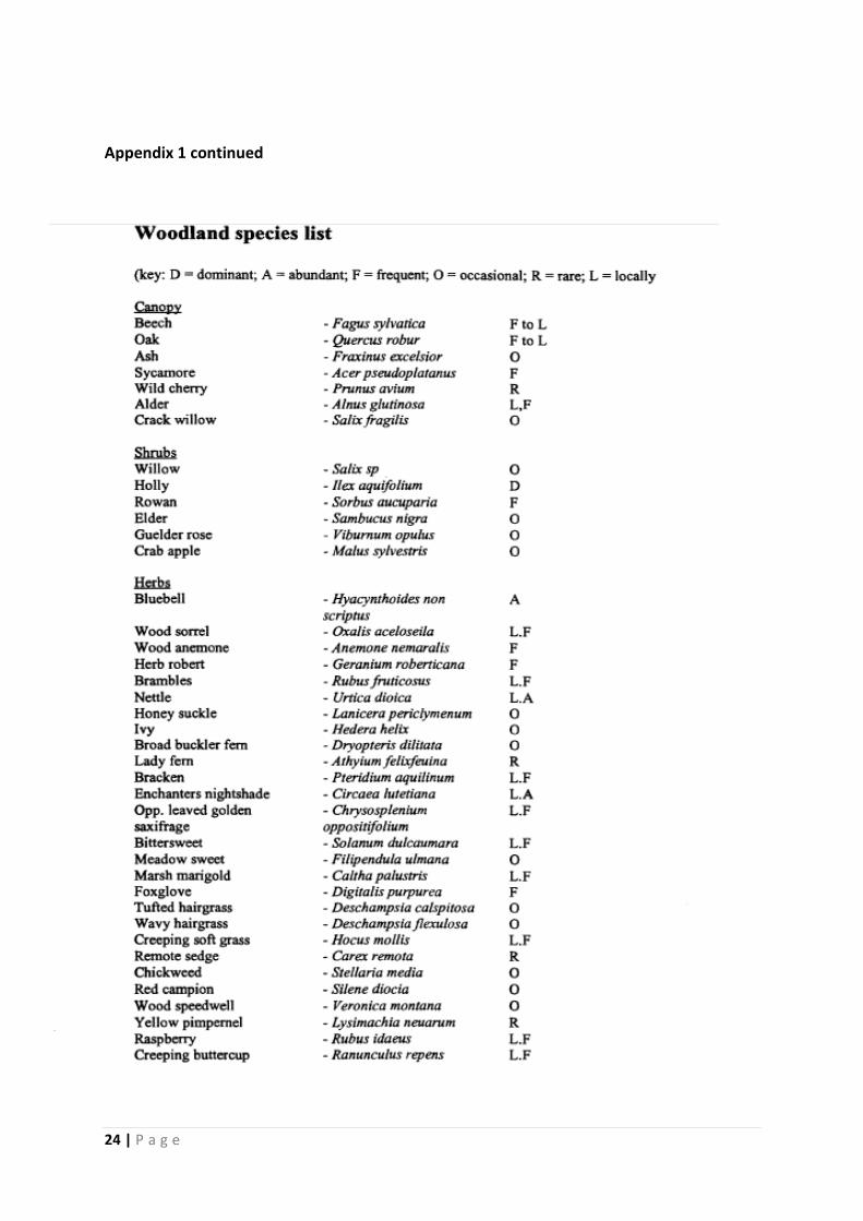
c. By returning the size of CS32 to its previous size it would include a Site of Biological Importance, the ancient woodland of Cock Wood. Appendix 1.
It is made up of woodland, grassland, ponds, mire and flush. It is particularly noteworthy for its birds and mammals. This is ancient woodland and as such dates back to at least before 1600 and possibly even to the post glacial woods. Cheshire is particularly poorly wooded [4%] and only 1700 hectare of identified ancient woodland. (7) The proposal for CS32 will directly destroy a section of this SBI and bisect the remainder. Ancient woodland is nationally important and Cheshire East should not plan to destroy it against national planning guidance. (1)
d. The important hedgerow system, containing veteran trees, forms vital wildlife corridors with high biodiversity levels and is essential to reducing the isolation and fragmentation of this section of Ancient Woodland.
e. The extended CS32 would have detrimental effects on the pockets of natural habitat that remains due to their fragmentation, isolation and decrease in size. This negative effect on biodiversity is well documented. ‘ Habitat loss and fragmentation impacts on the species diversity in the following ways:
• Populations are moved into smaller and smaller areas which, ultimately, are unable to support them.
• Populations become fragmented so that they become isolated into populations that are too small to be self-sustaining.
• Areas of habitats are so small that the ‘core area’ decreases to such an extent that they are influenced by negative edge effects.’ (8)
10 | P a g e

f. It is in opposition to the government views expressed by Greg Clark MP Minister for Planning ‘Our natural environment is essential to our wellbeing, and it can be better looked after than it has been. Habitats that have been degraded can be restored. Species that have been isolated can be reconnected. Green Belt land that has been depleted of diversity can be refilled by nature – and opened to people to experience it, to the benefit of body and soul.’ (1)
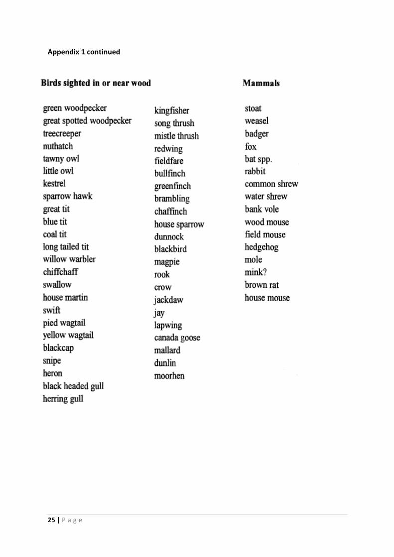
g. The site contains a rich diversity of birds. Those listed by Cheshire and Wirral Ornithological Society for CS32 and designated at risk are in Appendix 2. They include thirteen Red list species, twenty three Amber list species, six schedule 1 species, fifteen species listed in the UK Biodiversity Action Plan and seven identified in RSPB Conservation Targeting Projects. These assessments were agreed in a review by the UK’s leading governmental and non-governmental conservation organisations. The categories indicate the relative priority that should be given to each species and aim to help guide conservation efforts in the UK. Red list species are globally threatened their populations or ranges have declined rapidly in recent years (i.e. by more than 50% in 25 years), or which have declined historically and not recovered. Amber list species has declined moderately in recent years (by more than 25% but less than 50% in 25 years), those whose population has declined historically but recovered recently, rare breeders (fewer than 300 pairs), those with internationally important populations in the UK, those with localised populations, and those with an unfavourable conservation status in Europe. RSPB Conservation Targeting Projects species are scarce and declining farmland or woodland birds. Birds on these lists have most likely declined due to the effects of unsustainable methods of farming, deterioration in woodland habitat and changes in the urban environment. (9)
11 | P a g e

h. Additional records include Barn Owls (RSPB local records/Barn Owl Trust) a Schedule 1 species.
i. Other rare bird species are found in the attached species lists for Cock Wood appendix 1.
j. Rare species are present that are protected by the Wildlife and Countryside Act 1981 as well as European protected species covered by the Habitat Regulations such as Great Crested Newts, these are clearly relevant in reaching planning decisions. The proposed road would involve the infilling of ponds and the destruction of large areas of their habitat. The increased population size and the close proximity of these people would also lead to greater degradation of the remaining habitat.
k. Bats are present across the site including the rarer Daubentons. (10) They are protected under a number of pieces of legislation. See Appendix 4. They are a material planning consideration when determining planning application and as such should be considered when creating a Local Plan.
l. Badger populations are present on the site and are a material consideration within planning decisions and protected by The Wildlife and Countryside Act.
m. Such levels of biodiversity are protected in the planning process in a pursuit of sustainable development ‘moving from a net loss of bio-diversity to achieving net gains for nature’ [section 9] (1) The development being proposed for this site would not ‘promote the preservation, restoration and re-creation of priority habitats, ecological
12 | P a g e

networks and the protection and recovery of priority species populations…’ [section 117] (1). It would completely oppose this aim.
4. Loss of Agricultural Land
a. ‘The best and most versatile agricultural land should not be used.’ [section 112] (1) In the Cheshire East strategy document policy CS9 it states that one of the sustainable development principles is to avoid the permanent loss of areas of agricultural land quality 1, 2, or 3a. This section of countryside [CS32] is primarily composed of agricultural land quality 3a with some level 2. (11) See Appendix 5 for agricultural designation maps. This is also in opposition to the national planning policy. NPPF (1)
5. Landscape Value a. This Local Plan, in its designation of CS32 for housing, does not follow
national guidelines which states that ‘The planning system should contribute to and enhance the natural and local environment by:
● protecting and enhancing valued landscapes …. ● recognising the wider benefits of ecosystem services….’ [section109] (1)
b. Plans should allocate land with the least environmental or amenity use for development. [section 110, 123] (1) This is not the case in the choice of CS32.
13 | P a g e

c. The importance of landscape is identified by Natural England. ‘Landscape is important, not just as scenery but because it links culture with nature, and the past with the present. It has many values, not all of them tangible (such as sense of place); and it matters to people – it is
people who create and value landscape. Well-looked after and highly valued landscapes are essential to social well-being and an economically healthy society. We value our landscapes because of their inherent interest, their contribution to both our national identity and our local distinctiveness…’ (12) This is evidently true in the comments made in this and previous consultations.
d. This is traditional Cheshire farmland, dotted with ponds, crisscrossed with historical hedgerows and blanketed in a rich tapestry of fields. It is described in the Cheshire Landscape Character Assessment (13) as ‘Higher Farms and Woods.’ CS32 is described as ‘very rural’ with ‘dispersed farms connected by narrow country roads which rise and fall with the landform.’ It would be a tangible loss to the people of Macclesfield. ‘The intrinsic character and beauty of the countryside’ is a core planning principle. [section 17] (1)
14 | P a g e

e. The lack of inclusion of the land between Congleton Road and Chelford Road in the Cheshire East Local Landscape Designation (14) is objected to and should be rectified. This is an example of the council creating evidence months after they have chosen this site for removal from green belt and editing it out of their evidence base to suit this purpose. (15)
f. The issues that affect this type of landscape are detailed in the Cheshire
Landscape Character Assessment (13). They would be exacerbated by this Local Plan. They include, ‘Reduction, fragmentation and deterioration of habitats: Loss of ponds through drainage and in-fill
Cheshire Easts own map designating CS32 land as Higher Farms and Woods (13)
15 | P a g e

….Loss of historic field pattern due to decline in hedgerow management….Erosion of built environment character through incremental development…loss of …vernacular character;the suburbanisation of rural properties…..Standardisation of roads: Upgrading of lanes and minor roads leading to inceasingly suburban character of the countryside.’ (13)
g. This is an historical landscape the importance of which is described by English Heritage. ‘It provides a wide range of tangible and intangible benefits, including socio-economic benefits. For instance, it contributes to … local distinctiveness, and senses of place and of community. However, it is a non-renewable resource: once lost, it cannot be re-created.’ (12)
h. The site contains old greenways, for example the old Broken Cross to
Henbury Road which predates the current turnpike road built in the 1800s. There are various medieval and Victorian ridge and furrow fields that would be lost under housing estates.
i. Hedgerows that mark parish boundaries predating 1860 and dotted with veteran trees form a network across this CS32. The development of housing estates and a major road would destroy many of these features. The value of the remainder being further degraded by their permanent isolation from the landscape that sustains them.
16 | P a g e

j. The important hedgerow system across the site contains veteran trees. These Important Hedgerows, fulfilling the criteria in a number of ways [marking a pre-1850 parish boundary; pre-Parliamentary enclosure field system; containing certain species; containing the required number of associated features; running along bridleways etc.], are protected by the Hedgerow Regulations. (16) See appendix 1 for species list of hedgerows associated with Cock Wood.
k. In developing a Local Plan it is beholding on the council to take a more creative approach to the possibilities that the landscape holds and consider better how this countryside can serve the people of Cheshire East. Through continued farming, the creation of nature reserves and
amenity access it would be possible to ‘find ways to enhance and improve the places in which we live our lives’ as advised by Greg Clark MP Minister for Planning. (1) It would be a golden opportunity in CS32 to take this environmentally significant area and create a clear strategy to enhance its natural environment through a positive integrated management approach rather than use it for housing. [section 157] (1)
6. Safeguarded Land a. Contrary to the express guidance from government and the NPPF this
plan allots 260 hectares of safeguarded land in policy PG 4 stating that this is done so that- ‘there will be no need for a further review of
17 | P a g e

the Green Belt until at least 2050, or later if the identified Safeguarded Land is not required for development post-2030’.
b. This allocation of safeguarded land in CS32 is clearly in opposition to planning guidance. The Planning Minister Nick Boles in Parliament on 24 October 2013 in reply to a question from Macclesfield MP David Rutley said that, ‘there is nothing in the Localism Act 2011, in the NPPF or in any aspect of Government planning policy that requires someone to plan beyond 15 years. So, anybody who is suggesting that there is any requirement to safeguard land or wrap it up in wrapping paper and ribbons for the future development between 2030 and 2050 is getting it wrong. There is no reason for it and my honourable friend can knock that suggestion straight back to wherever it came from’.
c. In a letter dated 11th November from Adrian Fischer (Head of Strategic Planning and Economic Development’ to David Rutley MP he states ‘by providing safeguarded land, this will look to future years beyond 2030 and should ensure the Council a certain degree of flexibility and choice of sites when it reviews its plan...’. This is an opportunity for the council and developers to ‘cherry-pick’ from the green belt.
7. Mineral Deposits
a. Nationally important mineral deposits should not be sterilised by building development. [section 143,146] (1) Cheshire is an important source of silica sand. This site covers an area of sand deposits. The Gawsworth sand is suitable for use in construction whilst the Chelford sand is suitable for glass making. The level and type of deposits are hard to determine without drilling and proper evaluation. (17)
8. Flooding a. The urbanisation of this area will increase the risks of flooding. Both
Gawsworth Road and Pexhill Road have been closed on a number of occasions between 2011 and 2013 due to flooding.
b. The urbanisation of the areas surrounding Henbury will increase the risk of flooding. For the first time in living memory the fields and properties around Dark Lane in Henbury have flooded.
c. CS32 has a complex system of pools, ponds, ditches and pipework that drains and irrigates the land where needed, supporting wildlife and endangered species that the council has a legal obligation to protect.
18 | P a g e

d. There are areas within the site which act as flood plains taking surface water and excess from the water table and acting as a buffer with standing surface water often visible. There are a number of natural springs in CS32, which if terminated, will cause underground water issues and in the longer term flooding in both the proposed and existing developed areas. Hard landscaping and the construction of a major road will increase surface water levels. Building in these areas is inappropriate and not sustainable.
e. The NPPF states that local plans should ‘take account of climate change over the longer term, including factors such as flood risk…’ The Draft Plan statement that ‘the aim is the avoidance of high flood risk areas…..but
19 | P a g e
where CEC strives for continued growth this will not always be possible`, is inadequate and contrary to the NPPF.
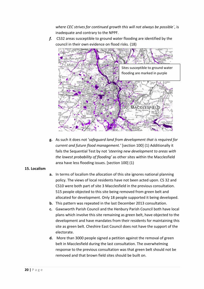
f. CS32 areas susceptible to ground water flooding are identified by the council in their own evidence on flood risks. (18)
g. As such it does not ‘safeguard land from development that is required for
current and future flood management.’ [section 100] (1) Additionally it fails the Sequential Test by not ‘steering new development to areas with the lowest probability of flooding’ as other sites within the Macclesfield area have less flooding issues. [section 100] (1)
15. Localism a. In terms of localism the allocation of this site ignores national planning
policy. The views of local residents have not been acted upon. CS 32 and CS10 were both part of site 3 Macclesfield in the previous consultation. 515 people objected to this site being removed from green belt and allocated for development. Only 18 people supported it being developed.
b. This pattern was repeated in the last December 2013 consultation. c. Gawsworth Parish Council and the Henbury Parish Council both have local
plans which involve this site remaining as green belt, have objected to the development and have mandates from their residents for maintaining this site as green belt. Cheshire East Council does not have the support of the electorate.
d. More than 3000 people signed a petition against the removal of green belt in Macclesfield during the last consultation. The overwhelming response to the previous consultation was that green belt should not be removed and that brown field sites should be built on.
Sites susceptible to ground water flooding are marked in purple
20 | P a g e

e. The views of the local people have not been addressed sufficiently in this strategy to consider that the council is acting upon its consultation; rather that it is being tokenistic and dismissive in its response. The core strategy justifies its removal of green belt for their projected demand and suggests that windfall brownfield sites will not occur in the plan period. Yet in their own Pre-Submission Core Strategy Preferred Sites Background Overview November 2013 they state – ‘The Kings School site on Cumberland Street is located in this area and could be suitable for residential development subject to a new site being found to consolidate the school’s Fence Avenue and Cumberland Street campuses onto a single site within Macclesfield’. Kings has publicised its intent to be on this new site by 2020. To suggest that there will be no other windfall brownfield sites between now and 2030 is reckless. Site SL4 Central Macclesfield should have a greater allocation of brownfield sites currently and take into account future windfall sites for the future.
16. Conclusion a. The inclusion of CS32 ignores national planning guidance on the
nature of exceptional circumstances and the horizon of the planning period.
b. The repeated consultations demonstrate a significant level of objection to CS32 being removed from Green Belt.
c. CS32 is prime green belt, rich in biodiversity, high grade farmland, historical and ecological landscape and important amenity use when compared to other sites.
d. Cheshire East can deliver its housing target by developing Brownfield sites and with “windfall” Brownfield sites expected in the future.
e. The inclusion of CS 32 undermines further development of Brownfield sites in the plan period and beyond.
f. The councils own evidence base does not support the inclusion of CS32.
g. Landscape and green belt evidence is incorrect. h. Development of this site will increase the carbon emissions more than
other choices and it is not the most sustainable option.
21 | P a g e

Appendix 1 Cock Wood Ancient Woodland and Site of Biological Importance
22 | P a g e

Appendix 1 continued
23 | P a g e
Appendix 1 continued
24 | P a g e
Appendix 1 continued
25 | P a g e

Appendix 1 continued
26 | P a g e

Appendix 1 continued
27 | P a g e
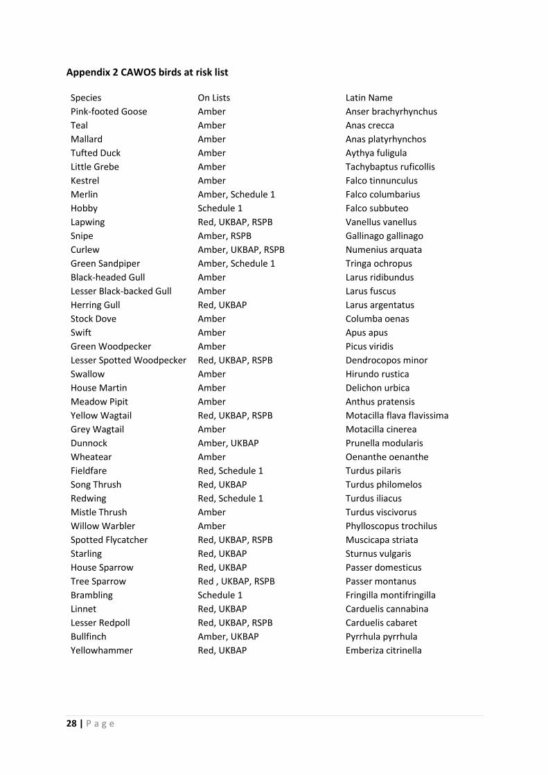
Appendix 2 CAWOS birds at risk list
Species On Lists Latin Name Pink-footed Goose Amber Anser brachyrhynchus Teal Amber Anas crecca Mallard Amber Anas platyrhynchos Tufted Duck Amber Aythya fuligula Little Grebe Amber Tachybaptus ruficollis Kestrel Amber Falco tinnunculus Merlin Amber, Schedule 1 Falco columbarius Hobby Schedule 1 Falco subbuteo Lapwing Red, UKBAP, RSPB Vanellus vanellus Snipe Amber, RSPB Gallinago gallinago Curlew Amber, UKBAP, RSPB Numenius arquata Green Sandpiper Amber, Schedule 1 Tringa ochropus Black-headed Gull Amber Larus ridibundus Lesser Black-backed Gull Amber Larus fuscus Herring Gull Red, UKBAP Larus argentatus Stock Dove Amber Columba oenas Swift Amber Apus apus Green Woodpecker Amber Picus viridis Lesser Spotted Woodpecker Red, UKBAP, RSPB Dendrocopos minor Swallow Amber Hirundo rustica House Martin Amber Delichon urbica Meadow Pipit Amber Anthus pratensis Yellow Wagtail Red, UKBAP, RSPB Motacilla flava flavissima Grey Wagtail Amber Motacilla cinerea Dunnock Amber, UKBAP Prunella modularis Wheatear Amber Oenanthe oenanthe Fieldfare Red, Schedule 1 Turdus pilaris Song Thrush Red, UKBAP Turdus philomelos Redwing Red, Schedule 1 Turdus iliacus Mistle Thrush Amber Turdus viscivorus Willow Warbler Amber Phylloscopus trochilus Spotted Flycatcher Red, UKBAP, RSPB Muscicapa striata Starling Red, UKBAP Sturnus vulgaris House Sparrow Red, UKBAP Passer domesticus Tree Sparrow Red , UKBAP, RSPB Passer montanus Brambling Schedule 1 Fringilla montifringilla Linnet Red, UKBAP Carduelis cannabina Lesser Redpoll Red, UKBAP, RSPB Carduelis cabaret Bullfinch Amber, UKBAP Pyrrhula pyrrhula Yellowhammer Red, UKBAP Emberiza citrinella
28 | P a g e

Appendix 3 has been removed as it is not relevant to this site.
Appendix 4 Bat Legislation
European.
• The Convention on the Conservation of European Wildlife and Natural Habitats (Bern, 1982)
• Agreement on the Conservation of Bats in Europe (1992) (Under the Bonn Convention on the Conservation of Migratory Species of Wild Animals)
• EC Directive 92/43/EEC on the Conservation of Natural Habitats and of Wild Fauna and Flora. (1992)
National. The following national legislation protects some or all species of bats:
• Wildlife and Countryside Act 1981. • The Conservation (Natural Habitats, &c.) Regulations (1994).
29 | P a g e

Appendix 5 Agricultural Designation Maps
30 | P a g e

Appendix 6 has been removed as it is not relevant to this site.
Appendix 7 Further Brownfield/Mixed sites in Macclesfield (not currently in SHLAA)
Lyme Green Cheshire East Land
Barracks Fabric factory near Garden Street
The Towers Building and car park, Parsonage Street
Tytherington Business Park
Gradus Mill and fire damaged building in Park Green
Flower Pot junction – land behind metal fencing
London Road – Derelict Mill and Public House near Byrons Lane
AstraZeneca Hurdsfield – Warehouse 2 and Hammer Head car park (currently offered for lease) – commercial development
Churchill Way – Sutton Castings site
Chestergate – Old Kings head and Three Pigeons Public Houses
Priory Lane – House and land opposite St Albans
Arighi Bianchi warehouse, Samuel Street
Old bank at Park Green
CEC Registery Office, Park Green
Waterside Mill, Waterside
31 | P a g e

Bibliography
1. Department for Communities and Local Government. National Planning Policy Framework. s.l. : The Crown, March 2012.
2. House of Commons Debate. 17th September 2012.
3. Planning Inspectors Report Macclesfield Local Plan. 1997.
4. Cheshire East. Pre-submission Cores Strategy Non-preferred Sites. s.l. : Cheshire East Council, 2013.
5. —. Cheshire Easy Local Plan Evidence Base - Green Belt Assessment. s.l. : Cheshire East, September 2013.
6. UK Governement. The Wildlife and Countryside Act. [Online] 1981.
7. Cheshire Wildlife Trust & Cheshire County Council. Cock Wood SBI. 1994.
8. Forest Research The reserach agency of the forestry Commission. Maximising biodiversity - Best practice in regeneration. forestry.gov.uk. [Online] 2013.
9. RSPB. http://www.rspbliverpool.org.uk/TRAFFIC%20LIGHTS.htm. RSPB . [Online]
10. Browne, Dr Simone. Henbury Parish Environmental Landscape Survey. s.l. : Henbury Parish Council, July 2009.
11. MAFF. Agricultural Land Classification (ALC) survey information . magic. [Online]
12. Natural England. Why is landscape important? naturalengland.org.uk. [Online] 2013.
13. Cheshire County Council. Cheshire Landscape Character Assessment . November 2008.
14. Cheshire East. Cheshire East Local Landscape Designation. May 2013.
15. LUC/Cheshire East. Local Landscape Designation. s.l. : Cheshire East, May 2013.
16. DEFRAA. Hedgerow Regulations. 1997.
17. British Geological Survey. MineraResource Information in Support of National, Regional and Local Planning - Cheshire. s.l. : Office of the Deputy Prime Minister, 2006.
18. Cheshire East Council. Preliminary Flood Risk Assessment. s.l. : Cheshire East, July 2011.
19. —. Shaping Our Future ADevelopment Strategyfor Jobs and Sustainable Communities. 2013.
20. Cheshire East. Local Transport Plan Final Strategy 2011 - 2026.
21. Balance, Green. Building in a small island? Why we still need the brownfield first approach. s.l. : Campaign to Protect Rural England, November 2011.
22. Cheshire and Wirral Ornithological Society. Birds in th tetrads covered by site 3l. 2013.
32 | P a g e
23. Government Office for the North West. North West of England Plan regional Spatial Strategy to 2012. s.l. : The Crown , 2008.
24. Consultant. Assessment of Cheshire East Local Plan. s.l. : Henbury Parish Council, 2013.
25. Cheshire East Council. Draft Macclesfield Town Strategy Consultation . 31/8/2012.
26. The Association of North Gawsworth Residents. Objections to the macclesfield Draft Local Plan. December 1994.
27. Rex Beach, Chairman. Henbury Society - Open letter to Henbury residents. 7 February 2013.
28. Hallam. Employment Land Report. 2012.
29. CBRE. Economic Master Plan and Delivery Plan:SMDA Final Report. s.l. : Cheshire East Council, 24/11/2010.
30. Cheshire East. Presubmission Core Strategy. s.l. : Cheshire east, November 2013.
31. —. Pre-submission Core Strategy. s.l. : Cheshire East, November 2013.
32. —. Cheshire East Local Plan Evidence Base- Pre-submission Core Strategy- Preferred Sites Background Overview. s.l. : Cheshire East, November 3013.
33 | P a g e